Embed Size (px)
Citation preview

Tea
Comprehensive Plan
2030
Prepared by the South Eastern Council of Governments at the direction of
the Planning and Zoning Commission and City Council of Tea, South Dakota

ACKNOWLEDGMENTS
This Comprehensive Plan is a compilation of effort by many people, organizations and governmententities. This document expresses the great civic pride that exists in the City of Tea. Through thepreparation and adoption of this document, the governing officials of Tea have expressed their desire fororderly and efficient growth and development in the community and surrounding area.
City Council
Mayor: John Lawler
Council Members: Brian Fowlds, Sidney Munson, Herman Otten, Joe Weis, Chuck Ortmeier,Nathan Peterson
Finance Officer: Dawn Murphy
Planning and Zoning Commission
Chairman: Delayne Parlet
Board Members: Stan Montileaux, Jan Clary, Rick Baker, Loren Speer
Planning and Zoning Administrator: Kevin Nissen
The South Eastern Council of Governments prepared this document under the direction of the Planningand Zoning Commission and City Council of Tea.

RESOLUTION NO. ___________
A RESOLUTION ADOPTING A COMPREHENSIVE PLAN FOR THE CITY OF TEA,AS PROVIDED FOR IN SDCL 11-6.
Whereas, Chapter 11-6-14 of South Dakota Codified Law has empowered the PlanningCommission and City Council of Tea to prepare a Comprehensive Plan for the development ofthe City and the surrounding area; and
Whereas, the Tea Planning Commission has developed a Comprehensive Plan through the year2030, has held the required Public Hearing, and has made a recommendation for adoption of thePlan to the City Council; and
Whereas, the Tea City Council has received the recommendation of the Planning Commissionand has held the required Public Hearing; and
Whereas, the adoption of the Comprehensive Plan would enhance the responsible developmentof Tea and the surrounding area.
Now therefore, be it resolved by the Tea City Council, that the Comprehensive Plan for the Cityof Tea through the year 2030 be hereby adopted and effective twenty (20) days after publicationof the Plan’s summary and notice of adoption.
Adopted this ______ day of ______________, 2009.
__________________________Signed: John LawlerMayor, City of Tea
ATTEST:
______________________________Dawn MurphyFinance Officer, City of Tea
Publication Date: __________________
Effective Date: ____________________
1
I. INTRODUCTION
A. PURPOSE, AUTHORIZATION AND ADOPTION
1. PURPOSE OF THE COMPREHENSIVE PLAN
There are three primary purposes of this document:
(1) To provide the Planning Commission and City Council with policies for futureplanning decisions and the methods and justification to control land use throughthe zoning and subdivision ordinance, the capital improvements program, andother enforcement controls.
(2) To provide some predictability about the potential land uses and timing ofdevelopment so that both public and private sectors can make informed decisionsin the area of real estate and capital investments; and
(3) To address the planning requirements of state law while also providing a soundand logical basis for city growth management strategies; and
Additionally, there are six supplemental purposes of this document:
(1) To improve the physical environment of the community as a setting for humanactivities; to make it more functional, beautiful, decent, healthful, interesting,efficient and to protect investments.
(2) To promote the public interest (the interest of the community at large) rather than theinterests of individuals or special interest groups within the community.
(3) To facilitate the democratic determination and implementation of community policieson physical development.
(4) To effect political and technical coordination in community development; to beeffective, coordination must occur across governmental jurisdictions (county, school,township, etc.).
(5) To inject long-range considerations into the determination of short-range actions.
(6) To bring professional and technical knowledge to bear on the making of politicaldecisions concerning the physical development of the community.
2. AUTHORIZATION UNDER STATE LAW
Under 11-6-14 of South Dakota Codified Laws, the planning commission of a municipality isdirected to “propose a plan for the physical development of the municipality… [to] include thegeneral location, character, layout and extent of community centers and neighborhood units…”

2
3. DEVELOPMENT AND ADOPTION
The Tea City Council has adopted this document in accordance with state law. In developingthis Comprehensive Plan, the Tea Planning Commission has used background research, detailedinventories and assessments, and discussion sessions at Planning Commission and City Councilmeetings and public hearings. This Comprehensive Plan is intended to guide the City in itsimplementation of zoning regulations, subdivision regulations, capital improvements plans andother related policies.
4. AREA OF PLANNING JURISDICTION
The City of Tea shall, under South Dakota statutes, have the authority to control developmentwithin the corporate limits of Tea.
B. INTERGOVERNMENTAL CONSIDERATIONS
A comprehensive plan affects not only those living in the study area, but also (to some extent)those living and working throughout the Tea area. As a result, the City Council has requestedinput from the Lincoln County Planning Commission, the Marv Skie-Lincoln County AirportManager, the Tea Economic Growth & Development, Inc. and the Tea School District.
C. APPROPRIATE USE OF THE COMPREHENSIVE PLAN
South Dakota laws require that zoning districts must be in accordance with the ComprehensivePlan. It is the intent of this document to show the most appropriate use of land within the studyarea, based on the potential for growth and development of the community.
D. PREVIOUS COMPREHENSIVE PLANNING ACTIVITIES
This document is meant to be an update to the Tea 2025: A Comprehensive Plan for CommunityDevelopment. The effective date of that document was September 2, 2003.

3
II. DEMOGRAPHIC CONDITIONS
A. GENERAL DEMOGRAPHY
Table 1. Population History (Source: U.S. Census Bureau)
Year Population % Increase
1960 188 NA1970 302 60.641980 729 141.391990 786 7.822000 1,742 121.632008 (Census Estimate) 3,761 115.90
Table 2. Current Demographic Statistics (Source: U.S. Census Bureau)
Tea Lincoln County South Dakota
1990Population
786 15,427 696,004
2000Population
1,742 24,131 754,844
% Change 121.63% 56.42% 8.45%
Median Age 28.2 33.2 35.6
Table 3. Population by Age (Source: U.S. Census Bureau)
0-19 20-54 55-74 75 & Over Total
2000 666 963 91 22 1,742
United States Census trends from 1970 to 2000 indicate a noticeable increase in the 0-19category (roughly 245%). In addition, Tea is becoming a “younger” community, with over two-thirds (68%) of the community being 34 years of age or younger. What follows are somehighlights regarding Tea’s phenomenal demographic trends.
38% of Tea residents are 19 or younger
Nearly ¼ (24.1%) of Tea’s residents are from 25 to 34 years of age (this is indicative ofan increase in the amount of young families)
Over half (55%) of Tea’s residents are between the ages of 20 and 54

4
B. POPULATION PROJECTIONS
Based upon current trends, a population projection through the study period indicates that theCity of Tea will have a population between 6,843 and 12,998 by the year 2030. The lowprojection would be achieved by the development of existing lots and some minorexpansion/annexation into the planned growth areas. The middle projection would be achievedby the development of the majority of the 2009-2016 planned growth areas. The high projectionwould be achieved with the full development of the 2009-2016 planned growth areas and minorexpansion into the 2025-2040 planned growth areas.
These population projections are primarily meant to guide the timing of infrastructure and assistdevelopers with land use decisions and should not be interpreted or used as a target or goal.These projections should be used as the foundation of the partnership between all stakeholders toaggressively undertake infrastructure expansion and continue the sustainable development ofTea. For purposes of land-use planning, the upper end of the population trend was utilized toensure adequate land was reserved and planned for future development.
Table 4. City of Tea Population Projection
Year Low Middle High
2010 4,152 4,489 4,738
2015 4,916 5,808 6,640
2020 5,727 6,988 8,644
2025 6,646 8,653 11,568
2030 6,843 10,507 12,998
0
2000
4000
6000
8000
10000
12000
14000
2010 2015 2020 2025 2030
Po
pu
lati
on
POPULATION PROJECTION 2010 - 2030
Low
Middle
High

5
III. ENVIRONMENTAL CONSTRAINTS
A. PHYSICAL GEOGRAPHY
Tea is located in northern Lincoln County in southeastern South Dakota. Tea itself is ongenerally level ground. The elevation ranges from 1,530 feet in the northeast part of the studyarea to 1460 feet in the southwest. Most of the City is at an elevation of between 1,480 and1,510.
B. DRAINAGE AND WETLANDS
Some small wetlands and potholes are found in the City’s growth areas. Wetlands and waterbodies are designated from base maps developed through the National Wetlands Inventory andother data sources. These natural resources provide a number of functions that are important tothe health and welfare of the community. They provide storage for storm water, help to controlflooding, provide wildlife habitat, improve water quality, and they provide recreationalopportunities. The wetlands and floodplains of the Tea area are shown on Map 1.

6

7
IV. INFRASTRUCTURE ASSESSMENT
A. TRANSPORTATION
Road Network
Street and highway improvements are a critical planning consideration because of the interactiverelationship between transportation and land use. Location choices for many land uses arefrequently made on the basis of access to major streets and highways. Without consideration foradequate capacity or maintenance, the transportation system cannot adequately accommodatedevelopment.
Arterial streets are designed to carry a large volume of traffic at higher speeds. Within the City,the function of arterials is to facilitate the movement of goods and people with few obstructions.These streets are generally adjacent to commercial uses.
Collector streets are designed to provide connectivity between arterials. They allow local traffican access onto the arterial system. Collector streets are normally spaced one-half mile apart andinclude two lanes of traffic with turn lanes at major intersections, limited on-street parking andmay be adjacent to either residential or commercial uses.
Local streets provide access from low-density residential developments to collector or arterialstreets. Because their function is based on development patterns, there are no spacingrequirements. Local streets operate at low speeds, with on-street parking and few traffic signals.The Major Street Plan has been developed as a part of the Comprehensive Plan (Map 2).
Goals for Collector Roadway Construction: Due to the increased cost of roadway constructionand the funding available to complete roadway projects, the City of Tea is investigating differentstrategies for this type of infrastructure funding. An alternative to existing practices would be torequire all collectors to be completely (100%) funded by the adjacent landowners/developers.This alternative would allow for street improvements to be completed in a timeframe moreacceptable to developers/landowners. A standard collector street cross section would be one lanein each direction with a center turn lane (41’ back of curb to back of curb) with a six (6) footboulevard and five (5) foot sidewalk. Also, all grading required within the right-of-way wouldbe the responsibility of the landowner/developer. Standard public utilities within a collectorstreet would be an eight (8) inch watermain and twelve (12) inch sanitary sewer and would beconsidered the responsibility of the landowner/developer. Storm sewer costs would becalculated based on the contributing drainage area and would be completely funded by thedeveloper. The design standards of the City of Tea outline the minimum requirements for eachroadway classification.
Goals for Arterial Roadway Construction: Due to the increased cost of roadway constructionand the funding available to complete roadway projects, the City of Tea is investigating differentstrategies for this type of infrastructure funding. An alternative to existing practices would be torequire the adjacent landowners/developers to participate up to the level of a collector street withthe City of Tea paying the additional costs to oversize the utilities and street section as desired.

8
By implementing the alternative concept, the City of Tea would better standardize its fundingapproach.
Other funding options include forming a special benefit district, or a Local Improvement District(LID). A LID is a special district formed by property owners or the local government to levyassessments on the value of property to raise money to finance new public facilities serving thatproperty. A LID can be applied whenever a public facility increases the value of nearbyproperties.
In order to better identify the City of Tea’s planned growth initiative, the following projects havebeen identified for consideration to be constructed by the year 2015.
Priority Project 1 - Urbanization of 469th Avenue from First Street to 271st Street. This projectwould include reconstructing the existing two-lane rural section roadway to a four-lane urbansection which may include a raised median. All public utilities would be installed with thisproject including sanitary sewer, watermain, storm sewer and lighting. This section of 469th
Street would be considered an arterial street.
Priority Project 2 - Urbanization of 272nd Street from 1,200 feet east of 469th Avenue toSundowner Avenue. This project would include reconstructing the existing gravel roadway to athree-lane urban section which would include a center turn lane. All public utilities would beinstalled with this project including sanitary sewer, watermain, storm sewer and lighting. Thissegment of 272nd Street would be considered an arterial street.
Priority Project 3 - Urbanization of 271st Street from 469th Avenue to Devon Street. This projectwould include reconstructing the existing two-lane rural section roadway to a four-lane urbansection which may include a raised median. All public utilities would be installed with thisproject including sanitary sewer, watermain, storm sewer and lighting. This segment of 271st
Street would be considered a collector street.
Priority Project 4 - Urbanization of 469th south to 9th Street. Urbanization of 469th Street from 1st
Street south to 9th Street. This project would include reconstructing the existing rural asphaltroadway to a three-lane urban section which would include a center turn lane. All public utilitieswould be installed with this project including sanitary sewer, watermain, storm sewer andlighting. This segment of 469th Street would be considered an arterial street.
Airport Service
The Marv Skie-Lincoln County Airport is located approximately 1.5 miles east of the existingTea corporate limits. Owned by Lincoln County, the airport’s primary function is to provide afacility for both recreational and business users. In regards to size, the airport encompassesapproximately one hundred thirty four acres of land. The airport is governed by the LincolnCounty Airport Advisory Board, in addition to oversight from the Lincoln County Commission,State Department of Transportation (Aeronautics) and the Federal Aviation Administration(FAA).

9
An updated Master Plan is in progress for the airport. Included in this plan are projections forfuture use, operation and expansion of the airport as well as associated goals and objectives. Ofparticular importance to the City of Tea is the fact that projected total aircraft for the year 2020 is148, which represents a 131% increase over the total aircraft in 2009.
Marv Skie-Lincoln County Airport is the fourth largest airport in South Dakota as far as thenumber of based aircraft and aircraft operations. Currently, there are approximately one hundredand twenty takeoffs/landings per day at the Marv Skie-Lincoln County Airport. This equates toroughly 43,300 takeoffs/landings per year. The airport consists of one runway, measuring 3,650feet in length. Additional land for the construction of approximately twenty hangars is availablefor future expansion.
Aircraft fuel tax funds, hangar land lease payments and FBO/hangar rents are used to fund theairport on an annual basis. Federal and state grant monies in addition to federal entitlementfunds and airport improvement program funding is used to pay for airport projects on a sharedbasis. Hangar property taxes are deposited in the Lincoln County general fund. Furtherinformation regarding this Master Plan can be obtained from the Lincoln County Courthouse inCanton, SD.
New Projects Planned: New runway construction in FY 2009/2010
B. WATER AND WASTEWATER FACILITIES
Wastewater Treatment Facilities
The City’s wastewater treatment facilities have historically provided adequate treatment forBOD and TSS removal. In 2003, the City undertook a project to construct an aerated cell as partof its treatment process. This was driven primarily by the need to control odors caused byincreased organic loading. Since completion of the project odor issues have subsided. Goingforward, the new aerated cell will provide for a portion of the required treatment of the City’swastewater.
As the population of Tea grows and with it, the overall volume of wastewater flows, thehydraulic capacity of the current system will be the first issue of concern. Recently the systemhas neared or reached its hydraulic capacity (180-day storage capacity). City staff has beenrequired to perform an extra discharge from the system each of the past two years. This ispartially due to higher than average precipitation, but indicates the system is near capacity.Discharges have continued to meet treatment criteria as specified in the City’s wastewaterdischarge permit. This is likely due in part to the new aeration system.
Although the original design life of the system after upgrades to expand the lagoon capacity in1997 was approximately 2015, population growth has exceeded original expectations. TheCity’s current wastewater discharge permit will be in place until 2013. As long as dischargescontinue to be within limits, continued operation under the current permit is not likely to be anissue.
10
Beyond the term of the current permit, it is possible that the State of South Dakota may imposeadditional treatment criteria. Specifically the removal of nutrients such as nitrogen andphosphorus from wastewater may be required. This would pose an issue due to the inability offacultative lagoon systems, such as the City of Tea’s, to provide for nutrient removal. Othercommunities in the area have already seen the addition of nutrient removal to their dischargepermits.
The addition of nutrient removal requirements to future discharge permits would require actionby the City. Some of the possible options for additional treatment include, construction of amore advanced treatment facility or utilizing new technology for lagoon treatment, working withone or more adjacent communities to develop a regional treatment system, or discharging to theCity of Sioux Falls. All of the aforementioned options would add cost to the treatment process.These additional costs will need to be considered.
The least cost option, should additional discharge criteria be added, would be use of an advancedlagoon system designed for the removal of ammonia and phosphorus. The ability to use such asystem would be dependent on the future limits imposed and approval by the South DakotaDepartment of Environment and Natural Resources. The second least cost option would bepumping partially treated effluent to Sioux Falls for final treatment. Capital costs for bothoptions are likely to be similar, but use of advanced lagoon technology would have lower annualoperational costs. Due to constantly changing environmental regulations and technology theCity will continue to monitor and evaluate options.
Water Distribution System
The City of Tea will continue to expand the water distribution system to service futuredevelopments within the City. The proposed trunk watermain alignments will be located withinthe collector and arterial roadway right-of-way on the section and quarter section lines formingloops around the quarter sections. As subdivisions grow within the quarter sections, the smallerwatermains within the subdivision can be connected to the trunk watermains.
In 2008, the City of Tea began receiving water through the Lewis and Clark EmergencyConnection pipeline. Until the Lewis and Clark Treatment Plant is completed in 2012, the Cityof Tea has contracts in place with the City of Sioux Falls to ensure water supply does not hinderits development potential. As a backup, the City also has agreements with Lincoln County RuralWater if the City exceeds its allocation from Sioux Falls. In 2012, the City will be receivingwater directly from Lewis and Clark. The City of Tea’s allocation will allow the City to supplyquality water to its residents and develop far beyond 2030.
Sanitary Sewer Collection System
The future sanitary sewer collection system is divided into four growth areas based ondevelopment trends within the Comprehensive Plan planned growth areas and the ability toservice gravity sewer to the developing areas. The four growth areas are categorized by theprojected year of development and are as follows (Map 7).

11
2009-2016 Growth Area
The proposed sanitary sewer collection system for the 2009-2016 Growth Area will serviceHagedorn Industrial Park, Kerslake Industrial Park, Zahn Addition, and Fritz Addition alongwith future subdivisions within the growth area. A proposed 24” sanitary sewer trunk line willbe installed north along 469th Avenue from 1st Street to the intersection of Highways 106 and111. The proposed trunk line will have additional sewer mains extending east to SundownerAvenue along 272nd Street, future Brian Street and Highway 106. A sewer main will also beextending west on 271st Street which connects to the existing Howling Ridge Addition.
The proposed sanitary sewer mains within this growth area are located along current or futurearterial and collector roadways. Construction of the sanitary sewer most likely will occur at thesame time as the urbanization of these major roadways; therefore, construction for these projectswon’t take place until funding has been secured for the roadway project as well.
One alternative to avoid accruing roadway construction costs with the construction of thesanitary sewer would be to construct the trunk sanitary sewer line east of 469th Avenue on thefuture Brian Street and extend the trunk sanitary sewer north at the quarter section line or at NineMile Creek. Since roadway costs would not be a factor in the overall construction, a costrecovery system could be implemented for this project. A cost recovery system is a systemwhere the City funds the original construction project and recovers the costs on a per acre fee tothe developers when they tie into the sewer system. One disadvantage with implementing a costrecovery project is that the City maintains debt on the project until all areas have been developedin the serviceable area of the sewer main. Additional research will need to be conducted toproject how long the City would maintain the construction debt on the project, and to verify thatsanitary sewer serviceability to areas like the Howling Ridge Addition are not impaired due tothe realignment of the trunk sanitary sewer system.
2016-2025 Growth Area
The 2016-2025 Growth Area encompasses the north and east limits of the Comprehensive Planarea. The growth area can be service by the City’s gravity sanitary sewer system. Gravitysanitary sewer mains will be extended north along 469th Avenue from Highway 106 to 85th
Street. Sanitary sewer mains will also be extended on the quarter section line between Highway106 and 85th Street.
The 2016-2025 Growth Area also encompasses the area adjacent to the corporate limits southand west of Tea. The growth area will be serviced with a gravity sanitary sewer main whichconnects at the lagoon lift station, extends south on 469th Avenue, extends west along the future9th Street, and extends north along 468th Street. The sanitary sewer main will connect to anexisting gravity sanitary sewer line at the intersection of 468th Street and 5th Street which willeliminate the need for the Prairie Trails Addition lift station

12
2025-2040 Growth Area
The 2025-2040 Growth Area encompasses two separate growth areas. The northwest growtharea is located in the High Point Lift Station service area. Approximately half of the northwestgrowth area is rural residential development which currently uses individual septic systems astheir sanitary sewer service. A sanitary sewer main will connect to the High Point Lift Stationand extend north along 468th Street to service this area.
The southeast growth area does not have the ability to be serviced with the current gravitysanitary sewer system. The City of Tea has identified a potential location for a future lift stationalong Sundowner Avenue at the quarter section line of Section 36 which will service the entiresoutheast growth area.
2040+ Growth Area
The 2040+ growth area does not have the ability to be serviced with the current gravity sanitarysewer system. Any development within this growth area will require a lift station to service thedevelopment with sanitary sewer.

13

14
V. SCHOOL PLANS AND PROJECTIONS
A. TEA PUBLIC SCHOOLS
The Tea Area School District is in its sixth year of existence. The District has grown from astudent population of 700 students on its first day, August 2003 to 1,185 students today. Duringthis time the District has built a new school building that serves grades 7-12 as well as 6th gradewhich uses temporary buildings. In December of 2008, the District approved a new intermediateschool for grades 4th through 6th which would be located south of the existing 7-12 building.
When communities experience rapid growth, they often experience challenges with serviceprovisions such as those previously discussed. School districts face similar challenges whenrapid growth occurs. Not only do they have to find ways to fund and construct adequatefacilities, but they also have to address the way the schools are zoned. It should be noted theterm zoning in this case refers to where children will attend school based on where they livewithin the school district. The northern half of the District will be one of the fastest growingareas in the region. The proposed Sanford Health Research Center will employ nearly 8,000people with a good percentage of them locating their families in the Tea School District. Futureelementary sites in the northern portions of the District need to be a joint planning effort with theCity of Sioux Falls and the City of Tea. As development occurs, the City and the District need towork together to ensure that new school locations and potential school sites are considered. Theboundaries of the Tea Area School District are shown on Map 3.
Housing diversity can help maintain growth and eliminate large peaks in enrollment.Communities which build out with an overabundance of single family homes (i.e. homestargeted to families with children) tend to have more pronounced peaks and valleys of schoolenrollment demand than communities which are comprised of a variety of housing types targetedto the full life-cycle. Below are the financial obligations of the District as well as projectedenrollments for the next few years.
Financial Obligations
The District has general obligation bonds totaling $9,950,000 for the construction of the MiddleSchool/High School building. This debt will be paid in full in 2029. The current annual milllevy for the debt is $2.28/$1,000.
The District recently received voter approval for an additional general obligation bond to buildan intermediate school building in Tea. The proposed bond for this building would be$9,935,000. The additional mill levy for this bond would be approximately $2.00/$1000 andwould mature in 2033.
Projected Enrollment
With the number of pending developments in the District as well as the pending Sanford HealthResearch Center, projecting growth for the District is a challenge. The growth numbers here arebased on a steady number of 120 new kindergarteners each year with no growth across the other

15
grade levels. For the first six years the District has seen classes of approximately 100 newkindergartners with a growth of (+ or -) 2% across the grade levels. The numbers show steady orlittle change in grade size once a class reaches junior high and high school. The increases arebased on the larger kindergarten classes coming in each year along with the smaller seniorclasses graduating each Spring. Also, as larger classes move through the system, the MiddleSchool and High School groups grow. These large percentage increases will be leveling off overthe next ten years.
In 2005 through 2008:
Kindergarten through 5th grade enrollment was 550 in the Fall of 2005. In the Fall of2008, K-5 enrollment is 630. This is a 12% increase over the three year period.
Sixth through eighth grade enrollment was 225 in the Fall of 2005. In the Fall of 2008,6th through 8th grade enrollment is 275. This is an 18% increase over the three yearperiod.
9th through 12th grade enrollment was 186 in the Fall of 2005. In the fall of 2008, 9th
through 12th grade enrollment is 269. This is an increase of 30%. The K-12 enrollment of 961 in the Fall of 2005 compared to the 1,185 in the Fall of 2008
is an overall increase of 19% over the three year period.
With a steady number of kindergarten classes coming in over the next seven years of 120 pupilsper kindergarten class the projected enrollment in the Fall of 2015:
K-8th would have 1,060 students. 9th-12th would have 420 students. Total enrollment of 1,480 students.
This would equal another 20% growth to the District over the seven year period. The growthcontinues however you can see it is slowing down over time.
Relevant Facts about the District
Tea Area Schools are building their new construction so it is easily and asinexpensive as possible to expand with new additions.
Tea Area Schools continue to strive to provide the very best educational opportunitiespossible for the students and citizens of the District.

16

17
VI. PARKS, OPEN SPACE AND OTHER PUBLIC USES
As plans are made to build, expand or relocate public facilities, they should be done inconjunction with the Comprehensive Plan and the Capital Improvements Plan. Potential areasfor future cooperative efforts should continue to be explored with other public entities.
A. CURRENT AND FUTURE PARK NEEDS
Neighborhood parks are generally between five and ten acres in size. The effective service areaof neighborhood parks is one mile, depending on location, facilities and accessibility.School/park sites also serve as neighborhood parks and include playground equipment inaddition to play fields, parking lots and multi-use paved areas for court games.
Community parks, because of their larger size, provide a much wider range of activities andfacilities than neighborhood parks. The land area requirements generally range from 20 to 40acres. Specialized facilities such as swimming pools, picnic areas and athletic complexes can beaccommodated in community parks. Community parks typically include areas for passive uses,nature conservation, pools/aquatic centers and athletic fields. Each of these four types of usesmight include other uses such as neighborhood playground space, but generally larger parks willfocus on one major type of activity.
Conservation and nature areas are specialized locations that preserve wildlife habitat, woodlandsand wetlands through open space development. Most commonly developed along streamcorridors and natural drainage ways are linear parks or greenways which provide a variety ofrecreational opportunities to adjacent neighborhoods. These activities easily accommodate thedevelopment of a bike trail system. The City of Tea will also work with the City of Sioux Fallsto connect bike trails and is an active participant in the Sioux Falls/MPO Bicycle Plan. A currentand future bike trail system is shown in Map 4.
The parks and open spaces on the Current and Future Land Use maps identify existing parkfacilities and proposed new facilities within the projected growth areas. The specificimprovements provided within the park facility should be tailored to meet the needs of thenearby population that it will primarily serve. In addition, potential combinations of detentionpond sites and neighborhood parks should be reviewed wherever feasible to allow more efficientland utilization and consolidation of maintenance costs.
The City of Tea will continue to look at financing sources through grants, building permits andland dedication by developers. Currently, the City requires a 5% donation or escrow towards acommunity park.
If new parks are to be provided at a reasonable cost and in proper locations, it is essential thatparkland acquisition take place prior to residential development. Integration of park and schoolsites will likewise be feasible only if land acquisition occurs well ahead of residentialdevelopment.

18
B. FIRE PROTECTION FACILITIES
The Tea Volunteer Fire Department is housed in a masonry building constructed in 2006. Thisfacility was built in conjunction with the Tea City Hall and meets the needs that the firedepartment currently has. The facility has adequate room for the larger apparatus, andequipment. There is a growing need for more office space, as the administrative duties becomelarger. Since the structure is made completely of precast concrete, it can be used as a commandcenter for disasters, and has been used on some occasions as a safe place for residents to beevacuated to.
The fire department’s call volume continues to increase. Call volume increases byapproximately thirteen percent every year. In 2007, the department responded to 207 calls.Eighty percent of those calls were medical emergencies. As of October 2008, the department hasresponded to 175 emergencies. Based on the large percentage of medical related emergencies, arural ambulance service should be examined as a means to improve emergency response times.
With the continuous increase in call volume, several changes will have to be made in the nextfive years. There is a current need for a part-time administrator. It takes a minimum of fifteenhours a week from the Tea Fire Chief alone, just to keep up with the current paper work, reports,and budgeting. In addition to this, the Treasurer of the department volunteers ten hours a weekas well to keep the department in financial order.
If the need should arise to have on call personnel living at the current facility, some changes inthe current facility would need to take place. A sleeping quarters and living area would need tobe constructed.
C. POLICE FACILITIES
The Tea Police Department is housed in a steel building constructed in 1978 and is located onMain Street; the facility’s dimensions are 100’ x 40’ x 12’. At the time the Police departmenttook over the facility, it was adequate to accommodate all equipment and personnel. Since thattime larger and more equipment, in addition to more personnel, have been added to support theneeds of the growing Tea community. In the future, the City should look at a new facility as partof a downtown revitalization project.
At present the Tea Police Department is comprised of five full-time officers; this numberincludes the Chief of Police, an Assistant Chief who assists with administrative duties in additionto patrol duties. Four additional certified officers are available for part-time work, which equatesto approximately twenty to fifty hours per month. This magnitude of manpower is designated tocover the City with a population of approximately 3,500 people. The Tea Police Department hassigned a “mutual assistance” agreement with Lincoln County Law Enforcement to help ease theburden of personnel, ensure adequate coverage and maintain a high level of officer safety whileperforming tasks within the law enforcement venue.
To maintain the highest level of public safety for Tea in the future it is imperative that thedepartment grows with the community and the security needs that accompany growth. By the

19
year 2015, the City should look at increasing to a minimum of eight full time certified patrolofficers and/or contracting with Lincoln County to allow for additional officers at designatedhigh activity times. Additional officers are necessary for anticipated population growth but theywould also enhance proactive community policing activities such as DARE and NeighborhoodWatch.

20

21
VII. NEIGHBORHOOD CONSERVATION
Blighted neighborhoods tend to grow into adjacent areas and invite additional deterioration.Visual deterioration gives the impression that nobody cares, creating an atmosphere which mayfoster crime, antisocial activities and further blight. Declining neighborhoods demand additionalhealth, social and public safety services, weaken the tax base and make activities to promote neweconomic development in the City more difficult.
Strategies to strengthen and preserve the older residential neighborhoods will maintain thesupply of safe, decent, affordable homes and limit the need for costly increases in public servicesand avoid the need for dramatic revitalization programs. The goals of affordability, variety,safety and preservation are emphasized.
A. LAND USE
Zoning changes to allow multi-family or commercial land uses into older neighborhoods shouldbe carefully analyzed. Conservation of existing single-family homes is encouraged.Commercial uses are ideally limited to businesses which service the neighborhood needs and thathave minimal impact on adjacent properties.
B. INFRASTRUCTURE
Streets, utilities and public facilities should be maintained and improved on an ongoing basis.Schools and parks contribute to neighborhood stability and should set an example for residentialareas in terms of maintenance and appearance.
C. PROPERTY MAINTENANCE
Inspections and enforcement of building and zoning codes, coupled with effective nuisanceabatement activities, assist in the prevention of neighborhood decline. Legal assistance throughthe City Attorney’s office is a key component for the effectiveness of these activities.

22
VIII. LAND USE PLAN
A. EVALUATION OF LAND USE IN TEA
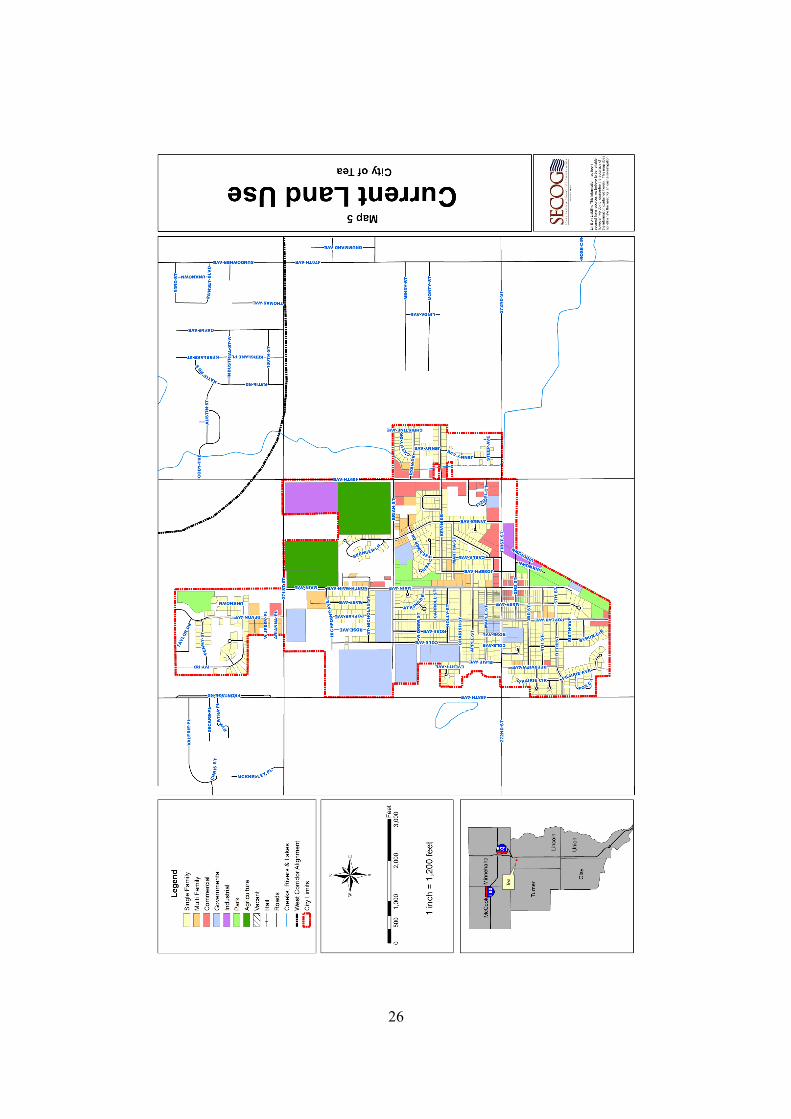
To simplify preparation of this plan, current land uses have been grouped into eight categoriesfor the City of Tea:
(1) Industrial: Includes manufacturing, warehouses and other similar uses.
(2) Commercial: Includes retail businesses, offices, etc.
(3) Single-Family Residential: Includes single-family residences, duplexes and twinhomes.
(4) Multi-Family Residential: Includes all apartments.
(5) Institutional & Governmental: Includes schools, libraries, churches, governmentoffices and similar uses.
(6) Vacant: Includes land not yet ready for development into one of the other listed landuses.
(7) Park and Recreation: Includes parks and athletic fields. Also included are areas thatshould be protected from development to facilitate movement of flood water andrunoff. Some types of development may be appropriate for such areas, as long as thedevelopment does not dramatically increase the incidence or severity of flood ordrainage problems.
(8) Agricultural: Includes areas that provide farming and agriculturally related uses.
Future land uses have been grouped into eight categories for the City of Tea:
(1) Residential: This category includes a variety of residential land uses including single-family residences, duplexes, townhomes and multi-family development. Thiscategory encourages a gradation of densities between single-family and multi-familyuses in order to achieve compatible development and also encourages designconsiderations among various land uses to help achieve compatibility. This categorymay also include supporting land uses such as civic, institutional, office,neighborhood business uses as well as parks, although such uses may not be depictedon the Future Land Use Map.
(2) Community Commercial: This category provides for areas that accommodate retail,professional office and service-oriented business activities that serve more than oneresidential neighborhood. These areas are typically configured as “nodes” of varyingscales at the intersection of arterial roads, or at the intersection of arterials and

23
collectors. They may also include churches, schools, parks and other communityfacilities.
(3) Regional Commercial: This category applies to large concentrations of commercialuses that serve or draw a regional market and that rely on convenient access frommajor transportation routes and highway interchanges.
(4) Mixed Use Community: This category is intended for large tracts of undevelopedland, which are appropriate for larger scale, planned development, where a mix ofresidential types and densities are complemented by supporting retail and small tomedium–scale office development.
(5) Mixed Use Neighborhood Center: This category applies to smaller areas of mixedcommercial use within existing and new neighborhoods. These areas abut roadwaycorridors or are located at key intersections. These smaller areas provide limitedretail goods and services to a local customer base, while having minimal impact onthe surrounding residential uses.
(6) Employment Center: This category is intended for larger scale employment andbusiness activities. Primary uses include offices, technology research anddevelopment, as well as environmentally friendly manufacturing. Industrial uses thatalready exist or are anticipated to continue for the foreseeable future are part of thisdesignation.
(7) Institutional: This category includes State, County and City facilities; public andprivate educational facilities; and religious facilities.
(8) Park/Recreation/Open Space: Includes City parks and recreational facilities, existingand proposed.

24
B. CURRENT LAND USE CONSUMPTION
C. FUTURE LAND USE ESTIMATES
Households and a projected demand of certain land use categories are listed in the tables below.
City of Tea
Household Projections
Persons per
PopulationHousehold
(assuming number remains constant) Households1980 729 NA NA1990 786 NA NA2000 1,742 2.95 590 (actual)
2010 4,738 2.95 1,606 (projected)2015 6,640 2.95 2,251 (projected)2020 8,644 2.95 2,930 (projected)2025 11,568 2.95 3,921 (projected)2030 12,998 2.95 4,406 (projected)
Households Added2000 to 2030
New Households 3,816
Land Use Acres Consumed
Single Family 256 acres
Multi Family 33 acres
Commercial 37 acres
Agriculture 71 acres
Government/Institutional 89 acres
Vacant 582 acres
Industrial 38 acres
Park and Recreation 36 acres

25
Land Use Consumption Needs – Housing
Residential - LowDensity
3 units per acre (low density) x 2.95persons per household (pph) = 8.85persons per acre (ppa) *
8.85 ppa x 2,765acres = 24,470additional people
Based upon the above referenced analysis, the City of Tea will be able to provide adequatehousing through the year 2030.
* Projections based upon low density single-family development
Future Land Use Available
Land Use Available Acres
Residential 2,765 acres
Community Commercial 96 acres
Regional Commercial 182 acres
Mixed Use Community 341 acres
Mixed Use Neighborhood Center 46 acres
Employment Center 788 acres
Institutional 310 acres
Park/Recreation/Open Space 414 acres
A review of the population projections and land use consumption needs should be reviewedevery five (5) years to ensure enough land is available for future land use needs.
A physical land use inventory was prepared by SECOG in May of 2002 and updated in 2009.Maps for the current and future land uses (Maps 5 and 6) in Tea and the planning area areincluded. Future land uses were determined by the Tea Planning Commission and SECOG,based on topographic features, compatibility with current land uses and existing infrastructure.
26

27

28
IX. GROWTH AREA ANALYSIS
The costs of extending water and sewer services are the primary considerations in designatingfuture growth. However, other factors must also be considered, which includes capacity of thetransportation system, environmental suitability and compatible land uses. The followinganalysis is intended to provide the City of Tea and Lincoln County with a guide to land usedecisions and direct implementation through the zoning and subdivision regulations. Map 7illustrates all growth areas by the anticipated annexation/infrastructure expansion date.
It is appropriate to note that rezoning requests (and other development approvals) for land usesnot consistent with the Future Land Use map (Map 6), except for previously established andapproved land uses, should not be considered until the Comprehensive Plan has been amended,as necessary, to provide for such land uses. In those cases where development requests are notconsistent with the Plan but represent a benefit to the community, the City should process suchrequests and Plan amendments concurrently and in a timely fashion. In addition, the FutureLand Use map is not the community's official zoning map. It is a guide for future land usepatterns. The Future Land Use element and all other aspects of the Comprehensive Plan areimplemented primarily through development regulations (e.g., zoning and subdivisionregulations). Text of the zoning regulations and its corresponding map determine which specificdevelopment requirements apply to a particular property.
DEVELOPMENT PATTERNS FOR FUTURE GROWTH
2009-2016 Growth Area
This Growth Area lies within the proposed alignment of the West Corridor, a proposedhigh speed, limited access arterial that will begin at Exit 73 of Interstate 29 and terminateat Interstate 90 to the north. Due to the eventual presence of a major roadway facility,primarily mixed–use and nodal development is proposed along roadway. The majority ofthe commercial development within this growth area ought to reflect an office typesetting wherein the amount of trips generated is minimal and corresponds with the theoryof quickly moving traffic throughout the corridor. The area designated as EmploymentCenter at the intersection of the proposed West Corridor and 93rd Street is intended to bea well planned business park.
Existing light industrial/commercial development is located in the northeast portion ofthe 2009-2016 Growth Area. Based on this development pattern feature, a significantarea of this portion has been designated as Employment Center. Due to the eventualpresence of a major roadway facility (West Corridor), a land use such as EmploymentCenter is particularly appropriate for this situation.
The central portion of the 2009-2016 Growth Area is designated as residential. Amajority of this portion is bounded by existing corporate limits and an existingcommercial and industrial type park. It is the intent of the City to not allow furtherdevelopment of solely a commercial or light industrial nature. The intent of the MixedUse Community designation for this growth area is to encourage appropriate mixed use

29
development and re-development that promotes the economic sustainability of thecommunity and offers a positive image/entrance into the City of Tea.
A separate portion for this growth area is located southeast of the existing corporatelimits. This area is designated primarily as residential and a portion of this area will bedeveloped as a municipal park.
2016-2025 Growth Area
The majority of this Growth Area is designated for residential development. The overallintent of this broad designation of residential is to allow future development to shape ortransition instead of limiting the densities of residential in a buffering pattern.
Nodal commercial development is anticipated at the existing and proposed Interstate 29exchanges. The designation of Mixed Use Community near the proposed Interstate 29exchange at 85th Street is intended to accommodate a mix of vertically integrated uses. Itis likely that the mix, density, organization and interaction of these uses will be governedby a planned development district. The southeast portion of this growth area isdesignated as Employment Center. Due to the location of the Marv Skie-Lincoln CountyAirport, along with several existing commercial and more intensive uses, theEmployment Center land use designation is appropriate in this area. The Mixed UseNeighborhood Center’s are intended to provide areas for small businesses that serve theday-to-day convenience needs of nearby households or other activities.
2025-2040 Growth Area
The majority of this growth area is designated for residential development and will alsoinclude the absorption of some existing rural density residential developments. Theextreme southeast portion of this growth area has been designated as commercial, dueprimarily to its proximity to Interstate 29. The area designated as an Employment Centerin the southeast portion of this Growth Area is intended to be a well planned businesspark.
The southern 2025-2040 Growth Area contains a portion of Nine Mile Creek. Apotential greenway is suggested for that portion of Nine Mile Creek running through thegrowth area.
2040+ Growth Area
Development within the 2040+ Growth Area shall not be allowed until such time that theproper utilities are installed according to City guidelines.
30
31
X. PLANNING POLICY FRAMEWORK
Tea has adopted this Comprehensive Plan to provide a framework for specific future land-useand growth management policies and recommendations. It is designed to be a dynamic andflexible process to accommodate the changing needs of a growing population, yet steady enoughto allow for reasonable long-term investment strategies by both public and private sectors. Tothe greatest extent possible, future planning for the City of Tea ought to involve the public, othergovernmental agencies and elected officials throughout the planning and implementation phases.
A. GROWTH MANAGEMENT STRATEGY
The following goals and policies are a detailed expression of the community’s aspirations for thefuture and can be considered the heart of the Comprehensive Plan. The goals and policiesprovide direction for future planning and municipal activities for the City of Tea and thecontiguous planning area.
Goal 1. Focus New Development within Existing City Limits Area
Objective 1 – Allow development within existing sanitary sewer and drainage basins as detailedby the future land use map and prescribed in Chapter IX (Growth Area Analysis).
Policy 1 – Determine growth areas most accessible to sewer hookups.
Policy 2 – Discourage growth in areas not suitable for sewer hookups.
Objective 2 – Allow compact and contiguous urban growth within corporate limits.
Policy 1 – Maintain the growth area boundary as the division between urban and ruraldensities and services, and encourage growth and development that will promote anefficient use of present and future public investments in roads, utilities and other services.
Policy 2 – Strip commercial development is discouraged. Commerce centers should notbe developed in a linear strip along a roadway nor be completely auto oriented. Avoidscattered or strip commercial and industrial development outside the urban service areaand direct such uses into existing developed locations where adequate services areavailable including major street access and proper water/sewer systems.
Policy 3 – Require that properties served by public utilities be located within the City.
Policy 4 – Maintain an addressing system that creates consistency for safety andconvenience of businesses, visitors and local citizens.
Policy 5 – Establish an area-wide approach to cooperatively manage future growthincluding municipal and county governments, school districts, townships and other publicutility providers.

32
Policy 6 – For newly developing areas, transitional uses (such as offices or commercialuses) should develop between industrial and residential uses. In redeveloping areas,lesser setbacks may be acceptable due to the existing conditions, as long as industrialzoning does not get closer to existing.
Policy 7 – Commerce Centers should develop as compact clusters or hubs withappropriate site design features to accommodate shared parking, ease of pedestrianmovement, minimize impacts on adjacent areas and possess a unique character.
Objective 3 – Enhance the character, identity and historic preservation of the community.
Policy 1 – Guide new development with urban design amenities that enhance communityaesthetics and local identity.
Policy 2 – Protect historic dwellings and other architecturally significant buildings fromincompatible development and encourage rehabilitation and reuse for the redevelopmentof historic buildings.
Policy 3 – Develop a downtown revitalization plan to include a lifestyle center with patioseating, landscaping, parking, lighting and art walk. Possibly create a TIF/BID district tohelp fund this project. Possible themes for the lifestyle center:
Lifestyle and wellness retail (wine and cheese store, health food store, etc.)Community gathering place businesses (tee, coffeehouse, etc.)Retailers that celebrate local (candy shops, etc.)Stores that entertain (museum, restaurant, etc.)Unique destination retailers (one-of-a-kind businesses, etc.)Stores that celebrate local arts (local products sold, etc.)
Goal 2. Direct New Growth Into Designated Future Growth Areas
Objective 1 – Establish development patterns/requirements for each of the described GrowthAreas.
Policy 1 – Review and revise, on an as needed basis, those specific development patternsestablished under Chapter IX – Growth Area Analysis.
Goal 3. Construct and Upgrade the Major Street System to Handle New Growth
Objective 1 – Enhance the current road system to provide optimum traffic mobility.
Policy 1 – Because road reconstructions, resurfacings and other related projects arefunded by a limited budget, it is incumbent upon the City Council to evaluate the need forvarious improvements and appropriate annual funds accordingly.
Policy 2 – Collector street development is the responsibility of the developer.

33
Policy 3 – Adopt a developer agreement to facilitate construction and formalize thedeveloper’s obligation to provide specified facilities.
Objective 2 – Minimize ingress and egress onto major roadways.
Policy 1 – Utilize driveway access points off of local roads rather than arterials wheneverfeasible so as to alleviate congestion from heavily traveled roads.
Objective 3 – Complete projects to enhance the safety of the transportation system
Policy 1 – Develop sidewalks in all areas of the community to create safe neighborhoodsby requiring developers to construct or assessing landowners at the directive of the City.
Policy 2 – Work with the City of Sioux Falls to develop a transit system that connectsretail centers and hospitals.
Objective 4 – Study the impacts of the West Side Corridor.
Policy 1 – Look at access points for traffic and future bike path connections.
Goal 4. Improve Community Services for All Residents of Tea
Objective 1 – Improve public services and buildings.
Policy 1 – Upgrade the City of Tea Police Department facility as part of a downtownrevitalization project.
Policy 2 – Increase the present number of full-time certified police officers to a total of atleast six within the next ten years.
Policy 3 – Construct a new recreation/community center.
Policy 4 – Construct a Teapot Museum to increase tourism.
Policy 5 – Investigate options to have an ambulance service based in the City of Tea.
Policy 6 – Develop an emergency response plan with Lincoln County EmergencyManagement, the City of Sioux Falls Fire & Rescue and local businesses.
Objective 2 – Improve park and recreation opportunities for all citizens
Policy 1 – Expand the existing ball diamonds to accommodate future recreationalopportunities for a growing population; consider the inclusion of soccer fields.
Policy 2 – Expand the existing bike path with consideration toward connection with theSioux Falls recreational system.

34
Policy 3 – Promote the planting of trees within corporate limits.
Policy 4 – Create a formal garden with an amphitheater for outdoor events.
Policy 5 – Consider the feasibility of establishing a city golf course.
Policy 6 – Increase the number of youth activities offered by the City.
Goal 5. Preserve the Function and Character of the Rural Area
Objective 1 – Encourage agriculture to remain the dominant land use activity.
Policy 1 – Only agricultural uses will be allowed in the city’s agricultural zones.
Objective 2 – Discourage scattered residential, commercial or industrial development .
Policy 1 – Work with Lincoln County to ensure all proposed development within Tea’sgrowth areas are annexed and serviced with municipal utilities.
Policy 2 – Discourage rezoning until municipal utilities are available.
Policy 3 – Submit a request to Lincoln County for sole zoning authority within the 2009-2016 Growth Area.
B. CAPITAL IMPROVEMENTS PLANNING
The purpose of capital improvements planning is to provide local government officials with aguide for budgeting major improvements that will benefit the community. Before futuredevelopment can be considered, the City must review current infrastructure and identify anydeficiencies that need to be corrected prior to the development. It is the intention of the City toupgrade portions of existing utilities and transportation routes on an ongoing basis.
C. LAND USE PLANNING STRATEGY
Goal 1. Ensure the Health and Safety of Citizens
Objective 1 – Separate structures for health and safety.
Policy 1 – Sideyard setbacks will comply with fire code separation for residential,commercial and industrial structures.
Policy 2 – Ensure buildings and structures do not encroach on residential building airspace.
Policy 3 – Ensure that all prescribed FAA regulations regarding structure heights in andaround airport approach zones are adhered to and enforced.

35
Objective 2 – Design lots and blocks to emphasize cost efficiency and community values.
Policy 1 – Review the lot and block designs based upon subdivision design standards.
Policy 2 – Utilize the zoning and subdivision regulations to protect residentialneighborhoods from encroachment of incompatible activities or land uses which mayhave a negative impact upon a residential living environment.
Policy 3 – In reviewing development proposals, the City should consider issues ofcommunity character, compatibility of land use, residents’ security and safety, andefficient service provision, particularly since these are all important qualities of thecommunity.
Policy 4 – Protect property values with proactive code enforcement.
Objective 3 – Provide adequate visibility at intersections and driveways for all streets.
Policy 1 – Ensure that structures and fences do not obstruct the view of intersectingtraffic.
Objective 4 – Design major streets to emphasize mobility and safety.
Policy 1 – Preserve adequate right-of-way for future arterial traffic routes and collectors.
Policy 2 – Maintain a policy of safe speed limits for all collectors and arterial roads; limitthe number of stop signs or stop lights to maintain an even traffic flow.
Policy 3 – Ensure single-family developments and other low intensity uses have drivewayaccess off local or collector streets and not off major streets; arterial streets should havelimited access.
Policy 4 – Require development of a consistent collector street system as indicated by theMajor Street Plan.
Goal 2. Protect Natural Resources
Objective 1 – Retain runoff with open natural drainage systems.
Policy 1 – Any development should be platted to incorporate as much natural drainage aspossible.
Policy 2 – Utilize open space such as parks or backyards to help naturally drain newdevelopments.
Objective 2 – Create greenways and linear open spaces within floodplain areas.

36
Policy 1 – Discourage residential, commercial and industrial development withinfloodplain areas as identified by the Federal Emergency Management Agency (FEMA).
Objective 3 – Design around significant wetlands.
Policy 1 – Encourage development to utilize and maintain wetlands as a part of thenatural drainage basin.
Objective 4 – Limit development in areas with poor soils and high water table.
Policy 1 – Require further investigation by the developer prior to allowing newdevelopment to occur in areas with soil limitations as identified by the Natural ResourcesConservation Service (NRCS).
Goal 3. Enhance the Visual Quality of the City
Objective 1 – Separate industrial and residential uses.
Policy 1 – Do not allow industrial development near residential developments.
Policy 2 – Encourage siting of industrial uses in incorporated areas.
Objective 2 – Soften the look of all uses to enhance the community’s image as an attractiveplace.
Policy 1 – Front and rear setbacks will provide reasonable separation for residentialliving.
Policy 2 – Encourage development to comply with land use location and design criterialocated in Appendix 1.
Policy 3 – Use landscaping to establish visual and physical boundaries between parkinglots and roads.
Objective 3 – Encourage the appropriate siting and concentration of uses and structures that canclutter the landscape.
Policy 1 – Allow manufactured homes to be placed in residential areas that areaesthetically consistent with site-built homes.
Policy 2 – Allow manufactured homes to be placed only in manufactured home parks thatdo not resemble a site-built home.
Policy 3 – Home occupations will be allowed as long as there is no substantial change inthe residential nature of the home.

37
Policy 4 – Allow appropriate fences that do not obscure peoples’ view.
Policy 5 – Allow signs of an appropriate size relative to the lot size and limit theirnumbers.
Objective 4 – Create a transition from commercial to residential areas.
Policy 1 – Require the use of berms, fences and additional setbacks as measures to createan appropriate transition to single-family uses.
Policy 2 – Increase architectural standards on all commercial buildings.
Policy 3 – Create a Highway Commercial Overlay District to maintain qualityarchitecture, landscaping and increased setbacks.
Goal 4. Enhance Tea’s Quality of Life
Objective 1 – Provide a community atmosphere that is family-friendly, diverse, and one thatcreates a sense of belonging and pride.
Policy 1 – Encourage development within Tea that creates and supports a healthy anddiverse community .
Policy 2 – Through policies and development regulations that are consistent with stateand federal laws, limit land uses and activities that may result in harmful secondaryeffects to the community, such as crime, vandalism or neighborhood deterioration.
Policy 3 – Increase participation in the Tea Neighborhood Watch Program.
Objective 2 – Provide assistance and support to the Tea School District.
Policy 1 – Maintain a positive and mutually beneficial working relationship with theschool district.
Policy 2 – Assist the school district in identifying and acquiring lands for future facilities.
Goal 5. Work Actively with Other Governmental Entities to Provide Cost Effective,Quality Services and Facilities
Objective 1 – Work with Lincoln County and the City of Sioux Falls on sustainable growthventures.
Policy 1 – Establish an agreement with Lincoln County to prevent development of landswithin the identified growth areas prior to annexation.

38
Policy 2 – Work with the City of Sioux Falls to develop a shared vision and acceptableboundary for both entities.
Policy 3 – Work with Lincoln County to supplement law enforcement activities withinthe City of Tea.

39
XI. PLAN IMPLEMENTATION
The best possible way to implement a comprehensive plan is to utilize all of the administrativetools available in order to influence development in a positive manner. There are many tools thatcan be utilized, including zoning regulations, subdivision regulations, policy plans, capitalimprovements plans, annexation studies and well-rounded community involvement.
Local Governing and Advisory Boards. The key players in the implementation of aComprehensive Plan are the Planning Commission and the City Council. It is the duty of thegoverning body of Tea to encourage progress by utilizing all of the tools available, so thatorderly growth and development can take place. With pubic input, the Planning Commissionand the City Council can create a balance between industry, commerce and housing, and canutilize all of the resources available to facilitate civic improvement.
Local Regulatory Tools. Perhaps the most widely utilized administrative tools are the zoningand subdivision regulations. It is essential to revise either or both of these documents when theyconflict with the Comprehensive Plan. It is especially important to create a cooperativeagreement between Lincoln County and the City of Tea to insure the Tea urban growth area isdeveloped as the Comprehensive Plan recommends.
Annexation. If the orderly growth of Tea is to continue over the planning period, it is essentialthe City continue an active annexation program. The boundaries for providing municipalservices should generally coincide with the corporate limits. Areas designated by the land useplan as future growth areas of the City should be annexed in advance of major development.This policy will assure that sufficient development land to accommodate the future growth of theurban areas is maintained. The City of Tea may also require pre-annexation agreements andassurances for the completion of minimum improvements prior to annexation.

APPENDIX 1
Land Use Location and Design Criteria
Residential
Low density (3 to 6 units/acre)
Access to local street system – avoid direct access to arterial streets Convenient to neighborhood school, park and commercial services Avoid environmentally sensitive areas such as wetlands and drainage ways
Medium density (6+ units/acre)
Access to major street system Well designed transition to adjacent land uses Provision of usable open space based on project size Transition between low-density neighborhood and major streets Adjacent to neighborhood commercial center
High density (12+ units/acre)
Adjacent to principal arterials near major commercial, institutional oremployment centers
Well designed transition to adjacent land use Provision of usable open space based on project size
Commercial
Highway oriented and regional centers
Adjacent to major streets and regional highways Controlled access to arterial streets Quality architecture and well designed transition to adjacent uses
Community centers
Intersection of arterial streets Mixed-use development including office, institutional or multi-family residences Well designed transition to adjacent uses
Neighborhood retail, office and convenience services
Convenient vehicular and pedestrian access to residential areas

Adjacent to major street intersections Design compatible with surrounding uses Well designed transition to adjacent uses Located within residential, employment or institutional centers
Downtown area
Pedestrian orientation Mixed uses including office, retail, institutional, cultural and entertainment Orientation to greenway where feasible Consolidate off-street parking areas Residential uses within walking distance of the downtown area
Employment
Light
Regional highway access located close to major arterial streets Buffered from residential and other adjacent land uses Development park setting with building design and landscape amenities
Intensive
Access to major streets Well designed buffer to adjacent land sues Minimize environmental impacts on surrounding properties
Mixed Use
Institutional, office and other mixed-use development
Convenient to intended market area Vehicular access to major streets Minimization of traffic impact on adjacent uses Orderly expansion of institutional uses near residential areas Design compatibility with adjacent uses Include retail, multi-family and business-technology land uses