Embed Size (px)
Citation preview

CountyAcreage:
Entry YearCompartment
Compartment Review Presentation Forest Management UnitGaylord
5205220191,490Antrim
Management Area: Jordan Valley
Legal Description:
Identified Planning Goals:
Soil and topography:
Ownership Patterns, Development, and Land Use in and Around the Compartment:
Unique Natural Features:
Archeological, Historical, and Cultural Features:
Special Management Designations or Considerations:
Watershed and Fisheries Considerations:
Antrim County: T31N R07W, Sections 1, 11, 12, 35, 36 Charlevoix County: T32N R07W, Sections 35 & 36
To provide for the protection, integrated management and responsible use of a healthy, productive and undiminished forest resource base for the social, recreational, environmental and economic benefit of the State of Michigan.
Soils are mostly poorly drained consisting of Pickford silty clay loam, Rudyard silt loam, Tawas Muck, and other loams. There are also a few areas of well-drained Emmet soils on scattered upland sites located in the southern block of this compartment. Topography is primarily level throughout the vast majority of Compartment 052. However, areas located in the "southern block" of the compartment do feature rolling hills. Some of these hills offer sudden elevation fluctuations with slopes ranging between 30-50%. These locations can quickly lead for an upland deciduous covertype into conifer dominated lowlands (and vice-versa).
Compartment 052 is almost exclusively surrounded by privately owned parcels. In some cases, private has the only viable access into remote areas of the compartment. Common usage activities in Compartment 052 include but are not limited to the following; boating and fishing access, river recreation, various forms of hunting, off trail meandering, and snowmobiling (Trail #4).
The Jordan River, which is a designated wild and scenic river, travels through part of Compartment 052. It is also classified under the Natural Rivers Act. The Jordan River, Bartholomew Creek, Bennett Creek, Todd Creek, and area(s) within 400ft of either side of these waterways are captured under the Natural Rivers Act. They are also High Conservation Value Areas (HCVA). River bottom and lowland forest and non-forested complexes present themselves within Compartment 052. Some locations are populated by species not commonly found in the region; including Silver Maple (Acer saccharinum), Bur Oak (Quercus macrocarpa), and musclewood (Carpinus caroliniana). Also, a significant portion of the compartment is being utilized for thermal cover protection by a variety of wildlife species.
Of note are the now abandoned railroad grades that travel along either side of the Jordan River. The complete history behind these grades is unclear to this examiner, but were probably utilized during Michigan's infamous "logging era". A significant portion of the grade east of the Jordan River is now Snowmobile Trail #4.
Special management designations and considerations do apply in this compartment. Specifically, they involve the water features captured under the Natural Rivers Act. Contact the DNR's natural rivers program specialist for further details. Compartment 052 unfortunately offers an opportunity to try and slow the aggressive spread of invasive shrubbery. Specifically; common buckthorn (Rhamnus cathartica) and several species of honeysuckle. Treatments involving several management techniques have been proposed. The goal is to slow the spread of these invasive plants and begin to restore more natural grass and shrub communities.
This compartment is in both the Jordan River and Intermediate River (Elk Lake) watershed. Many sections of the Intermediate River, Bartholomew Creek, Todd Creek, Bennett Creek, Seamon Creek, Jordan River, multiple small tributaries, and their adjacent lowlands are located within the proposed treatment areas. All of these streams are designated trout streams with naturally reproducing populations of brook trout and brown trout. Though none of the
Revision Date: 2017-04-21
Stand Examiner: John St. Pierre
05/16/2017 11:50:58 AM - Page 1 of 2 SWARTZN3

Wildlife Habitat Considerations:
Mineral Resource and Development Concerns and/or Restrictions
Vehicle Access:
Survey Needs:
Recreational Facilities and Opportunities:
Fire Protection:
Additional Compartment Information:
treatments proposed appear as though they will impact streams directly (buffers appear to be sufficient), the appropriate BMP’s and Natural Rivers buffers should be followed.
The vast majority of the compartment is within the Jordan Valley management zone. State minerals have been classified as non-leasable in this zone. The compartment is within the Antrim Shale gas play, and state minerals are actively being drained within the compartment by offset wells located on adjacent private property. There is no significant sand and gravel production in the area, but there does appear to be some potential within the compartment on the uplands.
Reliable vehicular access into most areas of Compartment 052 is nearly non-existent. Extensive lowland complexes and wet conditions are the primary reasons for poor access. The second is this compartments tendency to be "land-locked" by privately owned parcels. Aside from Snowmobile Trail #4 and the old railroad grade west of the Jordan River, access is an "on foot" adventure for those willing to try.
Proposed management activities may necessitate the need for survey work within Compartment 052. It should be noted that the vast majority of Compartment 052 is bordered by privately owned parcels. Previously established survey corners (by private and state) were located during inventory examination yet "exact ownership" discrepancies were discovered and still remain in areas of this compartment.
Direct access to the Jordan River is available within Compartment 052. The Alba Rd boating access site (off of Mt. Bliss Rd) has a few rustic amenities. It's also a location for the public to fish and put in small watercraft (canoes, kayaks, etc.). Although not located in Compartment 052, another Jordan River access site is available off of Webster Bridge Rd (in compartment 051). Snowmobile Trail #4 travels through the compartment as depicted on the map. Headquarters for the East Jordan Snowmobile Club is located just east of the Alba Rd boating access site, off of Mt. Bliss Rd.
Fire protection is provided by local VFD's and State owned resources originating out Bellaire, Gaylord, and possibly Indian River.
Forest health threats and pests are a continued reality across the landscape. Compartment 052 has, is, and will continue to play host to a variety of threats. Emerald ash borer (EAB) has affected nearly all of the ash component that was present in the compartment. Almost all ash observed was standing dead or is now down and dead. Beech bark disease (BBD) and associated beech scale was observed yet there is a very small component of the tree species present. Evidence of elm species formally being a strong component in this compartment is present. Now very few remain (Dutch elm disease) but are re-establishing themselves in areas. Remaining plant and tree species unaffected by the aforementioned threats face continued pressure from various agents. Such agents include but are not limited to the following; high deer population and heavy browsing pressure, beaver activity, hydrology fluctuations as a result of human and non-human events, and aggressively invasive shrubs (mainly common buckthorn & honeysuckle). All of these influences have, and will continue to shape and affect the natural processes occurring in and around Compartment 052.
The following reports from the Inventory are attached: Total Acres by Cover Type and Age Class Cover Type by Harvest Method Proposed Treatments – No Limiting Factors Proposed Treatments – With Limiting Factors Stand Details (Forested and Nonforested) Dedicated and Proposed Special Conservation Areas Site Condition Details
The following information is displayed, where pertinent, on the attached compartment maps: Base feature information, stand boundaries, cover types, and numbers Proposed treatments Site condition boundaries Details on the road access system
05/16/2017 11:50:58 AM - Page 2 of 2 SWARTZN3

Mud Lake
JordanRiver
"!(66
Toby
Rd
Webster Bridge Rd
E Old State Rd
Murphy Rd
Kramer Rd
Norw
egian
Rd
WilsonRd
Kidde
r Rd
Carso
n Rd
Utility
Ln
Utility
Ln
Bartholom
ew Rd
Murray Rd
Pesek R
d
Montg
omery
Rd
WebsterBridge BAS
BrennaLn
S Skinkle Rd
Airport Dr
Garner Rd
N Skinkle Rd
Moun
t Bliss
Rd
Kram
er Rd
CarsonStub Rd
Carson RdRainey Hills Rd
Vance Rd
Schroeder Rd
Kram
er Rd
Alba BAS
Bella
ire R
d
Woodland Shores Dr
Thors
enRiv
er Dr
Webs
ter Br
idge R
d
W Old State Rd
Lewis
Rd
Finkton Rd
22X0
27Z0
72X0
68X0
8X0
9X0
18U0
28H6
57C9
56L0
87X04
M9
63LM8
1L0
2Q9
3A9
5M9
10Q8
11L0
14LM6
15M9
16Q6
17A6
19Q6
20Q5
23L0
24U0
25U0
26E7
29U0
30M6 31
A3
34E945
U038P8
39P9
40E8
42L0
43W9
44L0
37P5
46P6
47A3
48L0
49LM8
50E4
51N0
59N0
61Q5
62U0
64L0
65P8
66L0
67E8
69LM4
70E6
71M6
75C8
404G0
405G0
414U0
422G0
425G0
426U0
439G0
462G0
79P7
81E8
41Q4
7L0
53L0
21Q6
12M9
35LM9
52L0
55Q5
36A9
78P8
58P9
73E4
60A9
84U0
74Q5
86L0
85M9
6A7
80N0
13M9
33C9
455L0
52052025-NF
52052045-NF
52052084-NF
52052439-NF
52052044-NF
52052462-NF
52052425-NF
52052426-NF
52052062-NF 52052024-NF
52052029-NF
Gaylord 512012
Gaylord 542010
Gaylord 532018
52051051-Cut
52053015-Cut
52051006-Cut
52051053-Cut
NF_52051019-NonFor
52053440-NF85°5'30"W85°6'0"W85°6'30"W85°7'0"W85°7'30"W85°8'0"W85°8'30"W85°9'0"W
45°7
'30"N
45°7
'0"N
45°6
'30"N
45°6
'0"N
45°5
'30"N
45°5
'0"N
45°4
'30"N
45°4
'0"N
45°3
'30"N
45°3
'0"N
45°2
'30"N
45°2
'0"N
0 10.5Miles
Miris CornersÓ Remonumented Section CornersXW Field Grade GPS Corners
Countiesf Culverte Airport"y Boating Access Site"i Parking Lot!F Hiking Trails!. Snowmobile Trails
Designated Snowmobile TrailsHighwayCounty Paved RoadsPaved RoadsCounty Gravel RoadsGravel RoadsCounty Poor Dirt RoadsPoor Dirt RoadsClosedStreamsLakes and Rivers All
\\\\\\\\PipelineA A Powerline
AirportsCitiesCompartment BoundaryTreatments with Site ConditionsOther Treatment - See Comments411 - Northern Hardwood413 - Aspen Types422 - Natural Pines430 - Upland Mixed Forest611 - Lowland Deciduous Forest612 - Lowland Coniferous Forest613 - Lowland Mixed Forest122 - Roads/Parking Lot310 - Herbaceous Openland320 - Upland Shrub330 - Low Density Trees500 - Water622 - Lowland Shrub623 - Emergent Wetland629 - Mixed non-forested wetland790 - Other Bare/Sparsely VegetatedLakes
"!(32
"!(75
"!(66"!(88 £¤131
£¤31
±
Cover Type &Treatments MapCompartment: 52T31N, R07W, Sec. 1, 11, 12, 35,36T32N, R07W, Sec. 35, 36County: Antrim and CharlevoixUnit: GaylordMgmt Area: Jordan ValleyYOE: 2019Acres: 1490 GIS CalculatedExaminer: John St. PierreMap Revised: 5/16/2017Map Phase: Review

PatriciaLake
JordanRiver
"!(32
"!(66
Webster Bridge Rd
Rogers Rd
Kidde
r Rd
Carso
n Rd
Utility
Ln
Vance Rd
Utility
Ln
Bartholomew Rd
Murray Rd
Pesek Rd
Sloop Rd
SchroederRd
Millp
ond
Rd
BrennaLn
Airport Dr
Garner Rd
Mount Bliss Rd
Carson Stub Rd
Carson RdRainey Hills Rd
Alba BAS
Bella
ire R
d
Woodland Shores Dr
Thors
enRiv
er Dr
Lewis Rd
Webs
ter Br
idge R
d
Patricia Dr
Gaylord 512012
22X0
27Z0
72X0
68X0
8X0
9X0
18U0
57C9
56L0
63LM8
9G0
16G0
5G0
6M9
18P6
1Q6
3Q5
2LM6 7
L0
23L0
24U0
25U0
26E7
29U0
30M6 31
A3
34E945
U038P8
39P9
40E8
42L0
43W9
44L0
37P5
46P6
48L0
49LM8
50E4
51N0
62U0
64L0
65P8
66L0
67E8
69LM4
70E6
75C8
425G0
426U0
439G0
462G0
79P7
81E8
41Q4
7L0
53L0
35LM9
52L0
36A9
78P8
58P9
73E4
84U0
6A7
80N0
33C9
455L0
52051006-Cut
52052025-NF
52052045-NF
52052084-NF
52052439-NF
52052044-NF
52052462-NF
52052425-NF
52052426-NF
52052062-NF 52052024-NF
52052029-NF
4X0
23Z0
15X0
85°6'0"W85°6'30"W85°7'0"W85°7'30"W85°8'0"W
45°8
'0"N
45°7
'30"N
45°7
'0"N
45°6
'30"N
45°6
'0"N
45°5
'30"N
45°5
'0"N
0 10.5Miles
Miris CornersÓ Remonumented Section CornersXW Field Grade GPS Corners
Countiesf Culvert"n Damse Airport"y Boating Access Site"i Parking Lot!. Snowmobile Trails
Designated Snowmobile TrailsHighwayCounty Paved RoadsPaved RoadsCounty Gravel RoadsGravel RoadsCounty Poor Dirt RoadsPoor Dirt RoadsStreamsLakes and Rivers AllAirportsCitiesCompartment BoundaryTreatments with Site ConditionsOther Treatment - See Comments411 - Northern Hardwood413 - Aspen Types422 - Natural Pines611 - Lowland Deciduous Forest612 - Lowland Coniferous Forest613 - Lowland Mixed Forest122 - Roads/Parking Lot310 - Herbaceous Openland320 - Upland Shrub500 - Water622 - Lowland Shrub623 - Emergent WetlandLakes
"!(32
"!(75
"!(66"!(88 £¤131
£¤31
±
Cover Type &Treatments MapCompartment: 52T31N, R07W, Sec. 1, 11, 12, 35,36T32N, R07W, Sec. 35, 36County: Antrim and CharlevoixUnit: GaylordMgmt Area: Jordan ValleyYOE: 2019Acres: 1490 GIS CalculatedExaminer: John St. PierreMap Revised: 5/16/2017Map Phase: Review

S Skinkle Rd
Lewis
Rd
S Skinkle Rd
Ritt Rd
N Skinkle Rd
W Old State Rd
Finkton Rd
71M6
422G0
28H6
87X0
4M9
412G0
440G0
401G0
10G0
418G0
411G0
29U0
7A6
8Q6
38M9
117M9
13M9
17M9
244M6
14M9
44M9
36A5
15MD9
24P5
18E8
34C6
16Q6
9L0
402G0
3M6
Gaylord 532018
1L0
2Q9
3A9
5M9
10Q8
11L0
15M9
16Q6
17A6
20Q5
59N0
61Q5
404G0
405G0
21Q6
12M9
55Q5
60A9
74Q5
86L0
85M9
52053418-NF
52053015-Cut
52053014-Cut
52053013-Cut
52053440-NF
52053412-NF
52053044-Cut52053401-NF
85°6'30"W85°7'0"W85°7'30"W85°8'0"W85°8'30"W
45°4
'0"N
45°3
'30"N
45°3
'0"N
45°2
'30"N
45°2
'0"N
45°1
'30"N
45°1
'0"N
0 10.5Miles
Miris CornersÓ Remonumented Section CornersXW Field Grade GPS Corners
CountiesCounty Paved RoadsCounty Gravel RoadsClosedStreamsLakes and Rivers All
\\\\\PipelineA APowerline
Compartment Boundary411 - Northern Hardwood413 - Aspen Types430 - Upland Mixed Forest612 - Lowland Coniferous Forest310 - Herbaceous Openland629 - Mixed non-forested wetland790 - Other Bare/Sparsely VegetatedLakes
"!(32
"!(75
"!(66"!(88 £¤131
£¤31
±
Cover Type &Treatments MapCompartment: 52T31N, R07W, Sec. 1, 11, 12, 35,36T32N, R07W, Sec. 35, 36County: Antrim and CharlevoixUnit: GaylordMgmt Area: Jordan ValleyYOE: 2019Acres: 1490 GIS CalculatedExaminer: John St. PierreMap Revised: 5/16/2017Map Phase: Review

Toby
Rd
S Skinkle Rd
Lewis
Rd
S Skinkle Rd
E Old State Rd
W Old State RdFinkton Rd
3A9
5M9
10Q8
11L0
14LM6
15M9
16Q6
17A6
19Q6
20Q5
47A3
59N0
61Q5
71M6
404G0
405G0
414U0
422G0
21Q6
12M9
55Q5
86L0
13M9
Gaylord 512012
Gaylord 532018
2Q9
28H6
87X0
74Q5
10G0
405G0
418G0
411G0
412G0
440G0
401G0
29U0
47M9
3M6
7A6
8Q6
1Q6
17M9
13M9
38M9
117M9
53M6
244M6
14M9
87M6
44M9
36A5
15MD9
24P5
18E8
76C6
68C5
63C6
34C6
16Q6
9L0
0
402G0
58G0
44X0
19M9
57C6
52051053-Cut
52053418-NF
52053014-Cut
52053013-Cut
52053440-NF
52053412-NF
52053015-Cut
52053044-Cut
52053401-NF85°6'0"W85°6'30"W85°7'0"W85°7'30"W85°8'0"W
45°4
'0"N
45°3
'30"N
45°3
'0"N
45°2
'30"N
45°2
'0"N
45°1
'30"N
45°1
'0"N
0 10.5Miles
Miris CornersÓ Remonumented Section CornersXW Field Grade GPS Corners
Countiesf Culvert
County Paved RoadsCounty Gravel RoadsPoor Dirt RoadsClosedStreamsLakes and Rivers All
\\\\\PipelineA APowerline
Compartment Boundary411 - Northern Hardwood413 - Aspen Types430 - Upland Mixed Forest612 - Lowland Coniferous Forest613 - Lowland Mixed Forest310 - Herbaceous Openland330 - Low Density Trees623 - Emergent Wetland629 - Mixed non-forested wetland790 - Other Bare/Sparsely VegetatedLakes
"!(32
"!(75
"!(66"!(88 £¤131
£¤31
±
Cover Type &Treatments MapCompartment: 52T31N, R07W, Sec. 1, 11, 12, 35,36T32N, R07W, Sec. 35, 36County: Antrim and CharlevoixUnit: GaylordMgmt Area: Jordan ValleyYOE: 2019Acres: 1490 GIS CalculatedExaminer: John St. PierreMap Revised: 5/16/2017Map Phase: Review

PatriciaLake
JordanRiver
"!(32
"!(66
Webster Bridge Rd
Rogers Rd
Kidde
r Rd
Carso
n Rd
Utility
Ln
Vance Rd
Utility
Ln
Bartholomew Rd
Murray Rd
Sloop Rd
Pesek Rd
SchroederRd
Millp
ond
Rd
WebsterBridge
BAS
BrennaLn
Airport Dr
Garner RdMoun
t Bliss
Rd
Carson Stub Rd
Carson RdRainey Hills Rd
AlbaBAS
Bella
ire R
d
Woodland Shores Dr
Lewis Rd
Thors
enRiv
er Dr
Webs
ter Br
idge R
d
Patricia Dr
22122 - X0
23622 - L0 26
6119 - E7
27500 - Z0 30
4119 - M6
386112 - P8
396112 - P9
4342200 - W9 46
6112 - P6
48622 - L0
66622 - L0
72122 - X0
796111 - P7
816113 - E8
416128 - Q4
68122 - X035
6132 - LM9
526229 - L0
8122 - X0
9122 - X0
183205 - U0
576120 - C9
56622 - L0
586112 - P9
64133 - A7
80623 - N0
636132 - LM8
4X0
23Z0
15X0
243205 - U0
253205 - U0
293205 - U0 31
4130 - A3
346113 - E9
45320 - U0
406118 - E8
426220 - L0
44622 - L0
376112 - P5
496132 - LM8
506117 - E4
516239 - N0
62320 - U0
64622 - L0
656112 - P8
676113 - E8
696132 - LM4
706113 - E6
756120 - C8
4253105 - G0
426320 - U0
4393102 - G0
462310 - G0
7622 - L0
536229 - L036
4130 - A9
786112 - P8
736117 - E4
84320 - U0
336120 - C9
4556229 - L0
9G0
16G0
5G0
6M9
18P6
1Q6
3Q5
2LM6 7
L0
85°6'0"W85°6'30"W85°7'0"W85°7'30"W85°8'0"W
45°8
'0"N
45°7
'30"N
45°7
'0"N
45°6
'30"N
45°6
'0"N
45°5
'30"N
45°5
'0"N
0 10.5Miles
Miris CornersÓ Remonumented Section CornersXW Field Grade GPS Corners
Countiesf Culvert"n Damse Airport"y Boating Access Site"i Parking Lot!. Snowmobile Trails
Designated Snowmobile TrailsHighwayCounty Paved RoadsPaved RoadsCounty Gravel RoadsGravel RoadsCounty Poor Dirt RoadsPoor Dirt RoadsStreamsLakes and Rivers AllAirportsCitiesCompartment BoundaryStand Boundaries411 - Northern Hardwood413 - Aspen Types422 - Natural Pines611 - Lowland Deciduous Forest612 - Lowland Coniferous Forest613 - Lowland Mixed Forest122 - Roads/Parking Lot310 - Herbaceous Openland320 - Upland Shrub500 - Water622 - Lowland Shrub623 - Emergent Wetland
"!(32
"!(75
"!(66"!(88 £¤131
£¤31
±
Stand BoundaryMapCompartment: 52T31N, R07W, Sec. 1, 11, 12, 35,36T32N, R07W, Sec. 35, 36County: Antrim and CharlevoixUnit: GaylordMgmt Area: Jordan ValleyYOE: 2019Acres: 1490 GIS CalculatedExaminer: John St. PierreMap Revised: 5/16/2017Map Phase: Review

S Skinkle Rd
Lewis
Rd
S Skinkle Rd
Ritt Rd
W Old State Rd
N Skinkle Rd
Finkton Rd
1629 - L0
26128 - Q9
34136 - A9 5
4119 - M9
106124 - Q8
11629 - L0
154110 - M9
166128 - Q6
174134 - A6
206128 - Q5
616128 - Q5
4053105 - G0
216129 - Q6
124110 - M9
556128 - Q5
746128 - Q5 59
623 - N0
714112 - M6
4043102 - G0
422310 - G0
284312 - H6
87790 - X0
604139 - A9
44119 - M9
86629 - L0
854112 - M9
412G0
440G0
401G0
10G0
418G0
411G0
29U0
7A6
8Q6
38M9
117M9
13M9
17M9
244M6
14M9
44M9
36A5
15MD9
24P5
18E8
34C6
16Q6
9L0
402G0
3M6
85°6'30"W85°7'0"W85°7'30"W85°8'0"W85°8'30"W
45°4
'0"N
45°3
'30"N
45°3
'0"N
45°2
'30"N
45°2
'0"N
45°1
'30"N
45°1
'0"N
0 10.5Miles
Miris CornersÓ Remonumented Section CornersXW Field Grade GPS Corners
CountiesCounty Paved RoadsCounty Gravel RoadsClosedStreamsLakes and Rivers All
\\\\\PipelineA APowerline
Compartment BoundaryStand Boundaries411 - Northern Hardwood413 - Aspen Types430 - Upland Mixed Forest612 - Lowland Coniferous Forest310 - Herbaceous Openland629 - Mixed non-forested wetland790 - Other Bare/Sparsely Vegetated
"!(32
"!(75
"!(66"!(88 £¤131
£¤31
±
Stand BoundaryMapCompartment: 52T31N, R07W, Sec. 1, 11, 12, 35,36T32N, R07W, Sec. 35, 36County: Antrim and CharlevoixUnit: GaylordMgmt Area: Jordan ValleyYOE: 2019Acres: 1490 GIS CalculatedExaminer: John St. PierreMap Revised: 5/16/2017Map Phase: Review

Toby
Rd
S Skinkle Rd
Lewis
Rd
S Skinkle Rd
E Old State Rd
W Old State RdFinkton Rd
0
402G0
58G0
44X0
19M9
57C6
26128 - Q9
59623 - N0
714112 - M6
4043102 - G0
284312 - H6
87790 - X0
746128 - Q5
134119 - M93
4136 - A9 54119 - M9
106124 - Q8
11629 - L0
146130 - LM6
154110 - M9
166128 - Q6
174134 - A6
196128 - Q6
206128 - Q5
474130 - A3
616128 - Q5
4053105 - G0
414330 - U0
422310 - G0
216129 - Q6
124110 - M9
556128 - Q5
86629 - L0
10G0
405G0
418G0
411G0
412G0
440G0
401G0
29U0
47M9
3M6
7A6
8Q6
1Q6
17M9
13M9
38M9
117M9
53M6
244M6
14M9
87M6
44M9
36A5
15MD9
24P5
18E8
76C6
68C5
63C6
34C6
16Q6
9L0
85°6'0"W85°6'30"W85°7'0"W85°7'30"W85°8'0"W
45°4
'0"N
45°3
'30"N
45°3
'0"N
45°2
'30"N
45°2
'0"N
45°1
'30"N
45°1
'0"N
0 10.5Miles
Miris CornersÓ Remonumented Section CornersXW Field Grade GPS Corners
Countiesf Culvert
County Paved RoadsCounty Gravel RoadsPoor Dirt RoadsClosedStreamsLakes and Rivers All
\\\\\PipelineA APowerline
Compartment BoundaryStand Boundaries411 - Northern Hardwood413 - Aspen Types430 - Upland Mixed Forest612 - Lowland Coniferous Forest613 - Lowland Mixed Forest310 - Herbaceous Openland330 - Low Density Trees623 - Emergent Wetland629 - Mixed non-forested wetland790 - Other Bare/Sparsely Vegetated
"!(32
"!(75
"!(66"!(88 £¤131
£¤31
±
Stand BoundaryMapCompartment: 52T31N, R07W, Sec. 1, 11, 12, 35,36T32N, R07W, Sec. 35, 36County: Antrim and CharlevoixUnit: GaylordMgmt Area: Jordan ValleyYOE: 2019Acres: 1490 GIS CalculatedExaminer: John St. PierreMap Revised: 5/16/2017Map Phase: Review

PatriciaLake
JordanRiver
"!(32
"!(66
WebsterBridge Rd
Rogers Rd
Kidde
r Rd
Carso
n Rd
Vance Rd
Utility
Ln
Utility
Ln
Bartholomew Rd
Sloop Rd
Murray Rd
Pesek Rd
SchroederRd
Millp
ond
Rd
WebsterBridge
BAS
BrennaLn
Airport Dr
Garner RdMoun
t Bliss
Rd
Carson Stub Rd
Carson RdRainey Hills Rd
AlbaBAS
Bella
ire R
d
Woodland Shores Dr
Lewis Rd
Thors
enRiv
er Dr
Webs
ter Br
idge R
d
Patricia Dr
2G - 9
2G - 9
4A - 26 4A - 26
2E - 27
4A - 31
243205 - U0
253205 - U0
293205 - U0 31
4130 - A3
346113 - E945
320 - U0
406118 - E8
426220 - L0
44622 - L0
376112 - P5
496132 - LM8
506117 - E4 51
6239 - N0
62320 - U0
64622 - L0
656112 - P8
676113 - E8
696132 - LM4
706113 - E6
756120 - C8
4253105 - G0
426320 - U0
4393102 - G0
462310 - G0
7622 - L0
536229 - L036
4130 - A9
786112 - P8
736117 - E4
84320 - U0
336120 - C9
4556229 - L0
5A - 18
5A - 18
5A - 18
2G - 19
2G - 20
1A - 22
1A - 22
2H - 232G - 24
2G - 28
2G - 29
2G - 29
2G - 30
2G - 32
2G - 33
2G - 33
2G - 342G - 34
2G - 35
2G - 36
2G - 372G - 37
22122 - X0
23622 - L0 26
6119 - E7
27500 - Z0 30
4119 - M6
386112 - P8
396112 - P9
4342200 - W9
466112 - P6
48622 - L0
66622 - L0
72122 - X0
796111 - P7
816113 - E8
416128 - Q4
68122 - X0
356132 - LM9
526229 - L0 8
122 - X0
9122 - X0
183205 - U0
576120 - C9
56622 - L0
586112 - P9
64133 - A7
80623 - N0
636132 - LM8
9G0
16G0
5G0
6M9
18P6
1Q6
3Q5
2LM6
7L0
4X0
23Z0
15X0
85°6'0"W85°6'30"W85°7'0"W85°7'30"W85°8'0"W
45°8
'0"N
45°7
'30"N
45°7
'0"N
45°6
'30"N
45°6
'0"N
45°5
'30"N
45°5
'0"N
0 10.5Miles
Miris CornersÓ Remonumented Section CornersXW Field Grade GPS Corners
Countiesf Culvert"n Damse Airport"y Boating Access Site"i Parking Lot!. Snowmobile Trails
Designated Snowmobile TrailsHighwayCounty Paved RoadsPaved RoadsCounty Gravel RoadsGravel RoadsCounty Poor Dirt RoadsPoor Dirt RoadsStreamsLakes and Rivers AllAirportsCitiesCompartment Boundary
\\ Available w/ Constraints\\ Unavailable
2E: Road needed4A: No Markets Available for theseForest Products1A: Federal/State/Local Law2G: Too wet (sensitive soils, does notinclude access issues)2H: Blocked by physical obstacle (e.g.upland stand in a lowland area)5A: Not able to obtain desirableregenerationStand BoundariesNatural Rivers Vegetative BufferNatural Rivers Zoning DistrictDedicated Management AreasCold Water StreamsCold Water LakesHigh Priority Trout Stream Buffer
"!(32
"!(75
"!(66"!(88 £¤131
£¤31
±
Special Conservation Areas& Site Conditions MapCompartment: 52T31N, R07W, Sec. 1, 11, 12, 35,36T32N, R07W, Sec. 35, 36County: Antrim and CharlevoixUnit: GaylordMgmt Area: Jordan ValleyYOE: 2019Acres: 1490 GIS CalculatedExaminer: John St. PierreMap Revised: 5/16/2017Map Phase: Review

S Skinkle Rd
Lewis
Rd
S Skinkle Rd
Ritt Rd
W Old State Rd
N Skinkle Rd
Finkton Rd
412G0
440G0
401G0
10G0
418G0
411G0
29U0
7A68
Q6
38M9
117M9
13M9
17M9
244M6
14M9
44M9
36A5
15MD9
24P5
18E8
34C6
16Q6
9L0
402G0
3M6
2G - 16
2G - 12
3J - 23
2A - 3
3J - 6
3J - 24
2A - 18
3J - 11
1629 - L0
26128 - Q9
34136 - A9
54119 - M9
106124 - Q8
11629 - L0
154110 - M9
166128 - Q6
174134 - A6
206128 - Q5
616128 - Q5
4053105 - G0
216129 - Q6
124110 - M9
556128 - Q5
746128 - Q5
59623 - N0
4043102 - G0
422310 - G0
284312 - H6
87790 - X0
604139 - A9
44119 - M9 86
629 - L0
854112 - M9
3J - 13J - 1
1C - 42G - 5
3J - 82H - 10
2G - 11
2G - 11
2G - 122G - 12
2H - 142H - 15
2B - 3
2B - 32B - 72B - 9
2B - 9
2B - 16
2B - 21
85°6'30"W85°7'0"W85°7'30"W85°8'0"W85°8'30"W
45°4
'0"N
45°3
'30"N
45°3
'0"N
45°2
'30"N
45°2
'0"N
45°1
'30"N
45°1
'0"N
0 10.5Miles
Miris CornersÓ Remonumented Section CornersXW Field Grade GPS Corners
CountiesCounty Paved RoadsCounty Gravel RoadsClosedStreamsLakes and Rivers All
\\\\\PipelineA APowerline
Compartment Boundary\\ Available w/ Constraints\\ Unavailable
2B: Unknown if access throughadjacent landowner(s) is possible1C: Other dept or div proc/practices2G: Too wet (sensitive soils, does notinclude access issues)2H: Blocked by physical obstacle (e.g.upland stand in a lowland area)3J: Water quality / BMPs (stream, river,or lake)Stand BoundariesNatural Rivers Zoning DistrictDedicated Management AreasCold Water StreamsHigh Priority Trout Stream Buffer
"!(32
"!(75
"!(66"!(88 £¤131
£¤31
±
Special Conservation Areas& Site Conditions MapCompartment: 52T31N, R07W, Sec. 1, 11, 12, 35,36T32N, R07W, Sec. 35, 36County: Antrim and CharlevoixUnit: GaylordMgmt Area: Jordan ValleyYOE: 2019Acres: 1490 GIS CalculatedExaminer: John St. PierreMap Revised: 5/16/2017Map Phase: Review

Toby
Rd
S Skinkle Rd
Lewis
Rd
S Skinkle Rd
E Old State Rd
W Old State RdFinkton Rd
2B - 32B - 3
5C - 6
5C - 6
5C - 6
2B - 72B - 92B - 9
2B - 17
34136 - A9
54119 - M9
106124 - Q8
11629 - L0
146130 - LM6
154110 - M9
166128 - Q6
174134 - A6 19
6128 - Q6
206128 - Q5
474130 - A3
616128 - Q5
4053105 - G0
414330 - U0
422310 - G0
216129 - Q6
124110 - M9
556128 - Q5
86629 - L0
26128 - Q9
59623 - N0
714112 - M6
4043102 - G0
284312 - H6
87790 - X0
746128 - Q5
134119 - M9
3J - 13J - 1
2G - 2
1C - 4
2G - 5
3J - 82H - 10
2G - 11
2G - 11
2G - 12
2G - 13
2H - 14
10G0
405G0
418G0
411G0
412G0
440G0
401G0
29U0
47M9
3M6
7A6
8Q6
1Q6
17M9
13M9
38M9
117M9
53M6
244M6
14M9
87M6
44M9
36A5
15MD9
24P5
18E8
76C6
68C5
63C6
34C6
16Q6
9L0
0
402G0
58G0
44X0
19M9
57C6
2A - 19
2G - 16
2G - 12
3J - 23
2F - 2
2H - 15
2A - 3
3J - 6
3J - 24
2A - 18
3J - 11
85°6'0"W85°6'30"W85°7'0"W85°7'30"W85°8'0"W
45°4
'0"N
45°3
'30"N
45°3
'0"N
45°2
'30"N
45°2
'0"N
45°1
'30"N
45°1
'0"N
0 10.5Miles
Miris CornersÓ Remonumented Section CornersXW Field Grade GPS Corners
Countiesf Culvert
County Paved RoadsCounty Gravel RoadsPoor Dirt RoadsClosedStreamsLakes and Rivers All
\\\\\PipelineA APowerline
Compartment Boundary\\ Available w/ Constraints\\ Unavailable
2B: Unknown if access throughadjacent landowner(s) is possible5C: Delay treatment for age/size classdiversity or exceptional site quality1C: Other dept or div proc/practices2G: Too wet (sensitive soils, does notinclude access issues)2H: Blocked by physical obstacle (e.g.upland stand in a lowland area)3J: Water quality / BMPs (stream, river,or lake)Stand BoundariesNatural Rivers Vegetative BufferNatural Rivers Zoning DistrictDedicated Management AreasCold Water StreamsHigh Priority Trout Stream Buffer
"!(32
"!(75
"!(66"!(88 £¤131
£¤31
±
Special Conservation Areas& Site Conditions MapCompartment: 52T31N, R07W, Sec. 1, 11, 12, 35,36T32N, R07W, Sec. 35, 36County: Antrim and CharlevoixUnit: GaylordMgmt Area: Jordan ValleyYOE: 2019Acres: 1490 GIS CalculatedExaminer: John St. PierreMap Revised: 5/16/2017Map Phase: Review

Report 1 – Total Acres by Cover Type and Age ClassCompartmentMgt. Unit
10-1
9
20-2
9
30-3
9
40-4
9
50-5
9
60-6
9
70-7
9
80-8
9
Tota
l
Year of Entry
Age Class
90-9
9
100-
109
110-
119
0-9
: Examiner
Non-F
ores
t
120-
129
130-
139
140-
149
150+
Unev
en-A
ged
Gaylord
John St. Pierre
52 2019
0 0 5406001010900190 0 0 0 0 0Aspen14 0 1400000000000 0 0 0 0 0Bare/Sparsely Vegetated0 58 8620000000000 0 0 0 0 27Cedar0 0 220000000000 0 0 0 0 0Hemlock
137 0 13700000000000 0 0 0 0 0Herbaceous Openland11 0 1100000000000 0 0 0 0 0Low-Density Trees0 0 570017033800000 0 0 0 0 0Lowland Aspen/Balsam Poplar0 20 360100021989000000 17 14 0 0 0Lowland Conifers0 10 10817030270200000 0 6 0 0 16Lowland Deciduous0 0 904780196000000 0 0 0 0 10Lowland Mixed Forest
362 0 36200000000000 0 0 0 0 0Lowland Shrub10 0 1000000000000 0 0 0 0 0Marsh0 0 513315030000000 0 0 0 0 0Northern Hardwood
131 0 13100000000000 0 0 0 0 0Upland Shrub7 0 700000000000 0 0 0 0 0Urban8 0 800000000000 0 0 0 0 0Water0 0 400040000000 0 0 0 0 0White Pine
5300680 1492201294958209019 00 251 201788Total
05/16/2017 11:48:17 AM - Page 1 of 1 SWARTZN3
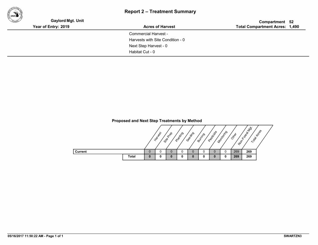
Report 2 – Treatment Summary
CompartmentMgt. UnitTotal Compartment Acres:Acres of HarvestYear of Entry:
Gaylord2019
521,490
Commercial Harvest -
Habitat Cut - 0
Harvests with Site Condition - 0Next Step Harvest - 0
Proposed and Next Step Treatments by Method
Total
Acre
s
Other
Non-
Fore
st Mgt
.
Monito
ring
Pesti
cide
Burn
ing
Seed
ing
Plan
ting
Site
Prep
Harve
st
000 26926900000Current000 269269000Total 00
05/16/2017 11:50:22 AM - Page 1 of 1 SWARTZN3

TreatmentName
Acres StandAge
Cover TypeObjective
SizeDensity
TreatmentType
TreatmentMethod
Stand CoverType
Mgt. Unit Report 3 -- Treatments Compartment:Year of Entry:S
tand
Approval Status
BA Range
Gaylord 522019
Age Structure
52052024-NF Nonstocked 310 - Herbaceous
Openland
NonForestMgt Other - Specify
Remove invasive common buckthorn and any other invasive through mechanical and/or chemical means or prescribe fire. Restore native species and grasses, and prescribe burn to maintain. Possibly work with NGO's to accomplish.
OtherComment:
PrescriptionSpecs:
24 3205 - Mixed Upland Shrub
Acceptable Regen:
Site Condition:
ProposalUnspecified
Proposed Start Date: 10/01/2018
49.7
Next Step Treatments:
Habitat Cut: No
52052025-NF Nonstocked 310 - Herbaceous
Openland
NonForestMgt Other - Specify
Remove invasive common buckthorn and any other invasive through mechanical and/or chemical means or prescribe fire. Restore native species and grasses, and prescribe burn to maintain. Possibly work with NGO's to accomplish.
OtherComment:
PrescriptionSpecs:
25 3205 - Mixed Upland Shrub
Acceptable Regen:
Site Condition:
ProposalUnspecified
Proposed Start Date: 10/01/2018
9.1
Next Step Treatments:
Habitat Cut: No
52052029-NF Nonstocked 310 - Herbaceous
Openland
NonForestMgt Other - Specify
Remove invasive common buckthorn and any other invasive through mechanical and/or chemical means or prescribe fire. Restore native species and grasses, and prescribe burn to maintain. Possibly work with NGO's to accomplish.
OtherComment:
PrescriptionSpecs:
29 3205 - Mixed Upland Shrub
Acceptable Regen:
Site Condition:
ProposalUnspecified
Proposed Start Date: 10/01/2018
12.5
Next Step Treatments:
Habitat Cut: No
52052044-NF Nonstocked 622 - Lowland Shrub
NonForestMgt Other - Specify
Remove invasive common buckthorn and any other invasive through mechanical and/or chemical means or prescribe fire. Restore native species and grasses, and prescribe burn to maintain. Possibly work with NGO's to accomplish.
OtherComment:
PrescriptionSpecs:
44 622 - Lowland Shrub
Acceptable Regen:
Site Condition:
ProposalUnspecified
Proposed Start Date: 10/01/2018
29.7
Next Step Treatments:
Habitat Cut: No
05/16/2017 11:49:44 AM - Page 1 of 3 SWARTZN3

TreatmentName
Acres StandAge
Cover TypeObjective
SizeDensity
TreatmentType
TreatmentMethod
Stand CoverType
Mgt. Unit Report 3 -- Treatments Compartment:Year of Entry:S
tand
Approval Status
BA Range
Gaylord 522019
Age Structure
52052045-NF Nonstocked 310 - Herbaceous
Openland
NonForestMgt Other - Specify
Remove invasive common buckthorn and any other invasive through mechanical and/or chemical means or prescribe fire. Restore native species and grasses, and prescribe burn to maintain. Possibly work with NGO's to accomplish.
OtherComment:
PrescriptionSpecs:
45 320 - Upland Shrub
Acceptable Regen:
Site Condition: Federal/State/Local Law
ProposalUnspecified
Proposed Start Date: 10/01/2018
6.5
Next Step Treatments:
Habitat Cut: No
52052062-NF Nonstocked 310 - Herbaceous
Openland
NonForestMgt Other - Specify
Remove invasive common buckthorn and any other invasive through mechanical and/or chemical means or prescribe fire. Restore native species and grasses, and prescribe burn to maintain. Possibly work with NGO's to accomplish.
OtherComment:
PrescriptionSpecs:
62 320 - Upland Shrub
Acceptable Regen:
Site Condition:
ProposalUnspecified
Proposed Start Date: 10/01/2018
6.6
Next Step Treatments:
Habitat Cut: No
52052084-NF Nonstocked 310 - Herbaceous
Openland
NonForestMgt Other - Specify
Remove invasive common buckthorn and any other invasive through mechanical and/or chemical means or prescribe fire. Restore native species and grasses, and prescribe burn to maintain. Possibly work with NGO's to accomplish.
OtherComment:
PrescriptionSpecs:
84 320 - Upland Shrub
Acceptable Regen:
Site Condition:
ProposalUnspecified
Proposed Start Date: 10/01/2018
17.7
Next Step Treatments:
Habitat Cut: No
52052425-NF Nonstocked 310 - Herbaceous
Openland
NonForestMgt Other - Specify
Remove invasive common buckthorn and any other invasive through mechanical and/or chemical means or prescribe fire. Restore native species and grasses, and prescribe burn to maintain. Possibly work with NGO's to accomplish.
OtherComment:
PrescriptionSpecs:
425 3105 - Mixed Upland Herbaceous
Acceptable Regen:
Site Condition: Federal/State/Local Law
ProposalUnspecified
Proposed Start Date: 10/01/2018
22.4
Next Step Treatments:
Habitat Cut: No
05/16/2017 11:49:44 AM - Page 2 of 3 SWARTZN3

TreatmentName
Acres StandAge
Cover TypeObjective
SizeDensity
TreatmentType
TreatmentMethod
Stand CoverType
Mgt. Unit Report 3 -- Treatments Compartment:Year of Entry:S
tand
Approval Status
BA Range
Gaylord 522019
Age Structure
52052426-NF Nonstocked 310 - Herbaceous
Openland
NonForestMgt Other - Specify
Remove invasive common buckthorn and any other invasive through mechanical and/or chemical means or prescribe fire. Restore native species and grasses, and prescribe burn to maintain. Possibly work with NGO's to accomplish.
OtherComment:
PrescriptionSpecs:
426 320 - Upland Shrub
Acceptable Regen:
Site Condition:
ProposalUnspecified
Proposed Start Date: 10/01/2018
28.5
Next Step Treatments:
Habitat Cut: No
52052439-NF Nonstocked 310 - Herbaceous
Openland
NonForestMgt Other - Specify
Remove invasive common buckthorn and any other invasive through mechanical and/or chemical means or prescribe fire. Restore native species and grasses, and prescribe burn to maintain. Possibly work with NGO's to accomplish.
OtherComment:
PrescriptionSpecs:
439 3102 - Grass
Acceptable Regen:
Site Condition:
ProposalUnspecified
Proposed Start Date: 10/01/2018
79.5
Next Step Treatments:
Habitat Cut: No
52052462-NF Nonstocked 310 - Herbaceous
Openland
NonForestMgt Other - Specify
Remove invasive common buckthorn and any other invasive through mechanical and/or chemical means or prescribe fire. Restore native species and grasses, and prescribe burn to maintain. Possibly work with NGO's to accomplish.
OtherComment:
PrescriptionSpecs:
462 310 - Herbaceous Openland
Acceptable Regen:
Site Condition: Federal/State/Local Law
ProposalUnspecified
Proposed Start Date: 10/01/2018
7.0
Next Step Treatments:
Habitat Cut: No
269.2Total Treatment Acreage Proposed:
05/16/2017 11:49:44 AM - Page 3 of 3 SWARTZN3

Report 4 – Site ConditionsCompartment:Mgt. UnitYear of Entry:: Examiner
Gaylord
John St. Pierre
522019
*Due to limitations in the current Site Conditions Analysis tool, all nonforested acres are considered available. Future development will enable analysis of nonforested types.
Dominant Site Condition AcresSiteNo. Other Site Condition Other Site Condition Other Site Condition Other Site Condition
Dominant Site Cond Availability
1 3J: Water quality / BMPs (stream, river, or lake)
2G: Too wet (sensitive soils, does not include
access issues)
43
300ft buffer applied to the Intermediate River dissects a portion of Stand 20 & 21 (turn on Ref.Lines). All "Other Site Conditions" provided above apply as well.
2H: Blocked by physical obstacle (e.g. upland
stand in a lowland area)
2E: Road needed Unspecified
Comments:
Unavailable
2B
Dominant Site Conditions4A 5C 1A 1C 2G 2H 3J 5A2E
16Aspen 10 2 0 600Bare/Sparsely Vegetated 2
5Cedar 73 92Hemlock
0Herbaceous Openland 7Low-Density Trees
36Lowland Aspen/Balsam Poplar 4 17570241Lowland Conifers 0 60
53Lowland Deciduous 4 39 832Lowland Mixed Forest 50 80Lowland Shrub 56 78
Marsh 305Northern Hardwood 31 11
0Upland Shrub 6Urban 3Water 8
White Pine572336741 4 6 11 261 25145Total Forested Acres
Relative Percent
Availability for ManagementAcres Acres AvailTotal
Available With ConditionAcres
Acres
Not Available
19 1254 2213 014 20 086 860 02 2
130 0137 711 011 00 457 532 0361 3593 4107 1000 090 90
229 0362 1337 09 33 4251 5
125 0131 64 07 30 08 84 04 0
549 621,490
4%37%87959%
05/16/2017 11:50:44 AM - Page 1 of 8 SWARTZN3

Report 4 – Site ConditionsCompartment:Mgt. UnitYear of Entry:: Examiner
Gaylord
John St. Pierre
522019
2 2G: Too wet (sensitive soils, does not include
access issues)
2H: Blocked by physical obstacle (e.g. upland
stand in a lowland area)
54
Saturated wet soils and no logical/good access option(s).
2E: Road needed Unspecified Unspecified
Comments:
Unavailable
3 2B: Unknown if access through adjacent
landowner(s) is possible
2I: Survey needed5
Unable to locate corners, although might be present.
Unspecified Unspecified Unspecified
Comments:
Available
4 1C: Other dept or div proc/practices
3J: Water quality / BMPs (stream, river, or lake)
146
"High Priority Trout Stream" is the dominant site condition and is represented by a 300ft strip on either side of the Intermediate River. The "other site conditions" listed above apply throughout depending upon stand & location. Several other conditions appropriate as well but can't list all.
2G: Too wet (sensitive soils, does not include
access issues)
2H: Blocked by physical obstacle (e.g. upland
stand in a lowland area)
Unspecified
Comments:
Unavailable
5 2G: Too wet (sensitive soils, does not include
access issues)
2H: Blocked by physical obstacle (e.g. upland
stand in a lowland area)
18
May also qualify for quasi potential old growth. Entire stand would need to be explored but very old/large/tall spruce, tamarack, and fir present.
Unspecified Unspecified Unspecified
Comments:
Unavailable
6 5C: Delay treatment for age/size class diversity or
exceptional site quality
Unspecified12
Small acreage and is composed of five separate polygons. The largest being ~3-acres. All five polygons feature either steeper slopes, flowing water/seeps, or areas with sensitive soils. Consider treating some portions when Stand 47 again reaches maturity.
Unspecified Unspecified Unspecified
Comments:
Available
05/16/2017 11:50:44 AM - Page 2 of 8 SWARTZN3

Report 4 – Site ConditionsCompartment:Mgt. UnitYear of Entry:: Examiner
Gaylord
John St. Pierre
522019
7 2B: Unknown if access through adjacent
landowner(s) is possible
Unspecified15
Primary limitation to accessing this stand are surrounding physical obstacles. Access from north through PVT might be possible but haven't verified yet.
Unspecified Unspecified Unspecified
Comments:
Available
8 3J: Water quality / BMPs (stream, river, or lake)
2G: Too wet (sensitive soils, does not include
access issues)
14
All of the above present, plus limited volume & merchantability.
2F: Too steep Unspecified Unspecified
Comments:
Unavailable
9 2B: Unknown if access through adjacent
landowner(s) is possible
2I: Survey needed11
Unable to locate corners, although might be present.
Unspecified Unspecified Unspecified
Comments:
Available
10 2H: Blocked by physical obstacle (e.g. upland
stand in a lowland area)
2B: Unknown if access through adjacent
landowner(s) is possible
12
Some steep slopes present in areas as well.
2E: Road needed Unspecified Unspecified
Comments:
Unavailable
11 2G: Too wet (sensitive soils, does not include
access issues)
2H: Blocked by physical obstacle (e.g. upland
stand in a lowland area)
162
Limited merchantability on top of all of what's listed above.
3J: Water quality / BMPs (stream, river, or lake)
2B: Unknown if access through adjacent
landowner(s) is possible
2E: Road needed
Comments:
Unavailable
05/16/2017 11:50:44 AM - Page 3 of 8 SWARTZN3

Report 4 – Site ConditionsCompartment:Mgt. UnitYear of Entry:: Examiner
Gaylord
John St. Pierre
522019
12 2G: Too wet (sensitive soils, does not include
access issues)
3J: Water quality / BMPs (stream, river, or lake)
6
Wet sensitive soils, low merchantability, Seamon Creek is the northern boundary.
2H: Blocked by physical obstacle (e.g. upland
stand in a lowland area)
Unspecified Unspecified
Comments:
Unavailable
13 2G: Too wet (sensitive soils, does not include
access issues)
3J: Water quality / BMPs (stream, river, or lake)
6
Water course corridor with a defined stream bed. Being fed by seeps as well as water being funneled from hills/slopes to north and south.
Unspecified Unspecified Unspecified
Comments:
Unavailable
14 2H: Blocked by physical obstacle (e.g. upland
stand in a lowland area)
5B: Maintain for regeneration purposes
2
Small stand, primarily dominated by hemlock. Steeper slope present as well.
Unspecified Unspecified Unspecified
Comments:
Unavailable
15 2H: Blocked by physical obstacle (e.g. upland
stand in a lowland area)
2E: Road needed2
Unreliable access, powerline clearing is lowland. Small acreage as well.
Unspecified Unspecified Unspecified
Comments:
Unavailable
16 2B: Unknown if access through adjacent
landowner(s) is possible
Unspecified2
Very small upland island of northern hardwood. Surrounded by lowland on 3 sides.
Unspecified Unspecified Unspecified
Comments:
Available
05/16/2017 11:50:44 AM - Page 4 of 8 SWARTZN3

Report 4 – Site ConditionsCompartment:Mgt. UnitYear of Entry:: Examiner
Gaylord
John St. Pierre
522019
17 2B: Unknown if access through adjacent
landowner(s) is possible
5C: Delay treatment for age/size class diversity
or exceptional site quality
4
Difficult access, small operable area, steep slopes present, and smaller DBH size classes present.
Unspecified Unspecified Unspecified
Comments:
Available
18 5A: Not able to obtain desirable regeneration
5F: Evaluated for Forest Health Considerations
25
Majority of area covered by 5A was proposed for harvest in 2017. Decided that management would likely release the heavy common buckthorn understory limiting success of any regeneration. Didn't want to transport invasives to other areas too (equipment). Deer browse issues and difficult low/wet growing conditions to boot.
Unspecified Unspecified Unspecified
Comments:
Unavailable
19 2G: Too wet (sensitive soils, does not include
access issues)
Unspecified11
This stand was previously prescribed for a non-commercial harvest that never occurred. Very difficult to access and very wet with sensitive soils.
Unspecified Unspecified Unspecified
Comments:
Unavailable
20 2G: Too wet (sensitive soils, does not include
access issues)
4A: No Markets Available for these
Forest Products
26
Developing into an extensive beaver flooding with high mortality/low to no merchantability. Areas that are still alive found atop wet/sensitive soils. Poor to no viable access.
2E: Road needed Unspecified Unspecified
Comments:
Unavailable
21 2B: Unknown if access through adjacent
landowner(s) is possible
2I: Survey needed4
Private to north denied access last during 2007 YOE. North corner found. South corner not found and if present is in/very close to Intermediate River.
Unspecified Unspecified Unspecified
Comments:
Available
05/16/2017 11:50:44 AM - Page 5 of 8 SWARTZN3

Report 4 – Site ConditionsCompartment:Mgt. UnitYear of Entry:: Examiner
Gaylord
John St. Pierre
522019
22 1A: Federal/State/Local Law
Unspecified261
Natural Rivers Act and HCVA capturing the Jordan River, Bartholomew Creek, Bennett Creek, and Todd Creek. Extends 400ft on either side of these features. Contact the Natural Rivers Specialist for further details.
Unspecified Unspecified Unspecified
Comments:
Unavailable
23 2H: Blocked by physical obstacle (e.g. upland
stand in a lowland area)
2E: Road needed8
Access to stand is main limiting factor (wet clay soil in Non-Forest Std.44). This stand was set-up and went no bid 3-times (Erroneous Aspen). Terminated in 2014. Spreading invasive common buckthorn found in Std44 a concern as well if treated.
4A: No Markets Available for these
Forest Products
Unspecified Unspecified
Comments:
Unavailable
24 2G: Too wet (sensitive soils, does not include
access issues)
2H: Blocked by physical obstacle (e.g. upland
stand in a lowland area)
14
Considered treating portions of this stand with Std36 but dropped Rx. The majority of stand is to wet with limited merchantability. Stand 44's wet clay soils don't provide good access and pose invasive spread concerns.
Unspecified Unspecified Unspecified
Comments:
Unavailable
26 4A: No Markets Available for these Forest Products
Unspecified4
Populated with a large component of standing dead ash. Some merchantable deciduous and conifer present yet not worth chasing at this time. Invasive common buckthorn in sub-can. Saturated sensitive soils present during inventory (March '17).
Unspecified Unspecified Unspecified
Comments:
Available
27 2E: Road needed 2B: Unknown if access through adjacent
landowner(s) is possible
4 Unspecified Unspecified Unspecified
Comments:
Available
05/16/2017 11:50:44 AM - Page 6 of 8 SWARTZN3

Report 4 – Site ConditionsCompartment:Mgt. UnitYear of Entry:: Examiner
Gaylord
John St. Pierre
522019
28 2G: Too wet (sensitive soils, does not include
access issues)
Unspecified2 Unspecified Unspecified Unspecified
Comments:
Unavailable
29 2G: Too wet (sensitive soils, does not include
access issues)
4A: No Markets Available for these
Forest Products
28
Primarily to wet. Areas of high mortality, low merchantability, and viable access isn't present. Did observe old red line in Std.73.
2B: Unknown if access through adjacent
landowner(s) is possible
Unspecified Unspecified
Comments:
Unavailable
30 2G: Too wet (sensitive soils, does not include
access issues)
Unspecified2
Saturated sensitive soils and no viable access into.
Unspecified Unspecified Unspecified
Comments:
Unavailable
31 4A: No Markets Available for these Forest Products
Unspecified2
Scattered clones, limited merchantability, small acreage. Access into is difficult at best.
Unspecified Unspecified Unspecified
Comments:
Available
32 2G: Too wet (sensitive soils, does not include
access issues)
2E: Road needed8 Unspecified Unspecified Unspecified
Comments:
Unavailable
33 2G: Too wet (sensitive soils, does not include
access issues)
4A: No Markets Available for these
Forest Products
10
Saturated sensitive soils and widespread ash mortality. Stand will probably rebound but this will take some time to accomplish.
Unspecified Unspecified Unspecified
Comments:
Unavailable
05/16/2017 11:50:44 AM - Page 7 of 8 SWARTZN3

Report 4 – Site ConditionsCompartment:Mgt. UnitYear of Entry:: Examiner
Gaylord
John St. Pierre
522019
34 2G: Too wet (sensitive soils, does not include
access issues)
2E: Road needed2
Saturated sensitive soils present. Small acreage and no viable access into as of now.
Unspecified Unspecified Unspecified
Comments:
Unavailable
35 2G: Too wet (sensitive soils, does not include
access issues)
2H: Blocked by physical obstacle (e.g. upland
stand in a lowland area)
3
Difficult to access due to flooding caused by beaver activity. Saturated sensitive soils present.
2E: Road needed Unspecified Unspecified
Comments:
Unavailable
36 2G: Too wet (sensitive soils, does not include
access issues)
Unspecified6
Saturated sensitive soils with areas of high mortality and low merchantability. Beaver activity causing additional flooding in areas.
Unspecified Unspecified Unspecified
Comments:
Unavailable
37 2G: Too wet (sensitive soils, does not include
access issues)
2B: Unknown if access through adjacent
landowner(s) is possible
10
Flood plain forest, intermittent stream present. Heavy to Silver maple. Snowmobile Trail/RR Grade does provide access but PVT on either side and no where for equip to turn around. Grade narrow and I don not think we actually own it (per Kim's comments).
2E: Road needed Unspecified Unspecified
Comments:
Unavailable
05/16/2017 11:50:44 AM - Page 8 of 8 SWARTZN3

SCA Category Acres
Mgt. Unit
Report 5 – PROPOSED SPECIAL CONSERVATION AREA* (SCA) DETAILS
Compartment:
Recommendation
* This is a partial list of SCAs for this compartment. Not included are those areas identified under other Department initiatives (Natural Rivers, Deer Wintering Areas, etc.). Those will be identified in separate, future map and report products.
Year of Entry:
SCA Name Detail Type
Gaylord 0522019
12
This area no longer meets the criteria to be classified as a Special Conservation Area. Stand is already an HCVA - Natural Rivers Corridor.
Potential Old Growth SCA RemovalComments
16
This area no longer meets the criteria to be classified as a Special Conservation Area. Stand is already an HCVA - Natural Rivers Corridor.
Other SCA SCA RemovalComments
37
This area no longer meets the criteria to be classified as a Special Conservation Area. Stand is already an HCVA - Natural Rivers Corridor.
Potential Old Growth SCA RemovalComments
95
This area no longer meets the criteria to be classified as a Special Conservation Area. Stand is already an HCVA - Natural Rivers Corridor.
Potential Old Growth SCA RemovalComments
145
This area no longer meets the criteria to be classified as a Special Conservation Area. Stand is already an HCVA - Natural Rivers Corridor.
Potential Old Growth SCA RemovalComments
05/16/2017 11:48:41 AM - Page 1 of 1 SWARTZN3

Type
Mgt. Unit Compartment:
Description
* This is a list of SCA's for this compartment along with a 1/4 mile buffer surrounding the compartment. Refer to the Special Conservation Area Map for locations of the below listed Conservation Areas.
Report 6 – EXISTING SPECIAL CONSERVATION AREA DETAILS
Conservation Area SCA = Special Conservation Area
HCVA = High Conservation Value AreaERA = Ecological Reference Area
Year of EntryGaylord 52
2019
A coldwater stream has temperature and dissolved oxygen conditions that allow naturally-reproduced or stocked trout populations and those of other coldwater fish species (e.g., slimy sculpin) to persist from year to year. Coldwater streams in Michigan typically provide these conditions due to substantial contributions of groundwater to their stream flows. Such streams are established by Director's action and designated as trout resources by Fisheries Order 210.
Cold Water Stream
SCA
A transitional area between aquatic and terrestrial ecosystems in which the terrestrial ecosystem influences the aquatic ecosystem and vice-versa. Because of the unique conditions adjacent to lakes, streams and open water wetlands, riparian areas harbor a high diversity of plants and wildlife. Riparian communities are ecologically and socially significant in their effects on water quality and quantity, as well as aesthetics, habitat, bank stability, timber production, and their contribution to overall biodiversity.
Riparian AreaSCA
Such areas are dedicated by the DNR Director for specific management uses through the promulgation of rules, as governed by Part 5, Department of Natural Resources, of the NREPA (MCL 324.502(2) and 324.504). Section 38 of the Administrative Procedures Act (MCL 24.238) provides for public requests for the promulgation of rules. This is an active program, with one proposed site currently under review by the DNR.
Dedicated Management
Areas
HCVA
There are two Natural Rivers datasets which are derived from spatial buffers set from an established and approved distance from the river centerlines. The Natural Rivers Zoning District is a 400 foot buffer for most Natural Rivers. The Vegetative Buffer ranges from 25 to 100 feet. To view specific Zoning Districts and Vegetative Buffers for each Natural River see the table located on the I:\Documentation\GDSE data folder.
Natural RiversHCVA
05/16/2017 11:48:29 AM - Page 1 of 1

Level 4 Cover Type Acres
StandAge
SizeDensity
BA Range
Mgt. Unit Report 7 – Forested Stands Compartment:Stand
GeneralComments:
Year of Entry:Gaylord
201952
2 6128 - Lowland Coniferous, Mixed
Deciduous
Sawtimber Well
17.3 127 111-140 Lowland conifer (NWC/Hem) mixed decid corridor stand that follows the Intermediate River. Variable between Log and Pole dominated. Can be straight log dominated in areas, then pole,
and a mix of both. Log seemed to be more dominant yet not at a high stocking level. Saw both sides of southern half. Did not see
the northern half.
3 4136 - Aspen, Mixed Conifer
Sawtimber Well
10.0 64 111-140 Originally had Std's 3&60 separate, then merged, then separated again. Std.60 BTA is much larger than what's
commonly found in this stand. Some XLog BTA in very north (a continuation of Std.60). Cored a sound BTA found in xlog area and got ~90yrs (difficult to count rings). Aspen DBH's decrease
as you travel south (before p-line) and you begin to pick up more species mixing. South of p-line lower has more QA/BF.
NHD and lowland species common components within.
OPIC - FMD: Remote aspen stand with no access to conduct a commercial harvest.
4 4119 - Mixed Northern Hardwoods
Sawtimber Well
1.7 106 111-140 Large red maple log tends to dominate, but are scattered about and/or in clumps. Strong pole component. Ground appeared
mostly dry, yet pooled water present and most of stand is surrounded by lowland. Strong yellow birch and musclewood
component in sub-can.
5 4119 - Mixed Northern Hardwoods
Sawtimber Well
10.8 101 111-140 Located on rolling terrain with steeper draws in areas. Log tends to dominate yet areas heavier to pole common (mainly SM).
Scattered large standing dead Wht.Ash. Blk. Cherry and some living elm present. Overall quality is marginal to "ok". One draw had a flowing, likely intermittent, stream. A seep was observed
nearby too. Flows S/SE through ~center of G0 Std.405 (lowland shrub water course visible on imagery). Variable stocking levels
throughout causing sporadic BA swings.
OPIC - FMD: HILLY TERRAIN WITH SEMI-OPEN AREAS THROUGHOUT HARDWOOD.
6 4133 - Aspen, Mixed Pine
Sawtimber Poor
2.2 59 51-80 Aspen clones with scattered white pine logs. Trace apple. Buckthorn, wild raising, and more honeysuckle associated with lowland (northeast). Old barbed wire on south perimeter (PVT
boundary). T-posts from survey present as well.
10 6124 - Lowland Spruce-Fir
Sawtimber Medium
20.1 112 81-110 Just made it into the northern portion. Some very large/tall "stuff" where I was. Measured 18.5", 17.5", and 17.9" Tamaracks. A
20.3" White Spruce. And cored a 13.2" and 7.5" Balsam Fir. Log more dominant where I was yet not at a high stocking level.
Open wet areas of low shrub, some I couldn't I.D. Strong pole Fir component where I was. Imagery suggests stocking levels
decrease and low shrub probably increase in southern areas of the stand.
12 4110 - Sugar Maple Association
Sawtimber Well
3.2 92 111-140 Small yet quite different from the stand it was originally part of (Std.17). Basswood (log) mainly dominates with sugar maple being quite common. Scattered large wht.spruce and some
larger BF present. Line of hemlock at bottom of east boundary. Atop rolling hills, some areas steep.
05/16/2017 11:48:56 AM - Page 1 of 9 SWARTZN3

Level 4 Cover Type Acres
StandAge
SizeDensity
BA Range
Mgt. Unit Report 7 – Forested Stands Compartment:Stand
GeneralComments:
Year of Entry:Gaylord
201952
13 4119 - Mixed Northern Hardwoods
Sawtimber Well
11.5 91 141-170 NW POLY: Beginning along northern boundary, DBH's larger on top of rolling hill closer to PVT field. Traveling south, hill moves
somewhat quickly downslope toward a creek/seep corridor. DBH's decrease too, moving into mostly stump-sprout poles.
One ~0.2ac xlog BTA clump, scat dead stding Wht.Ash, and a few hemlock present. 3SW/WestLine POLYS: DBH's generally
larger. 2-Polys on west line were wetter, seeps/flowing water, with some associated "low" species (hemlock, cedar, YB). All on
or part of rolling hills in area. SE POLY: Areas of this poly on the steeper upslope within this forty. DBH distribution similar to
NW Poly. Captures some scat conifer (hem, WP, fir) and a handful of QA. Overall quality is poorest here. TAKE HOME:
This stand is what resulted after Std.47 was harvested in ~2001. What remains are NHD dominated hills/slopes that are
seasonally wet/seepy in areas. Overall quality is ok/average.
OPIC - FMD: Northern hardwood sawtimber on rolling, hilly terrain. Limited factored due to wetland trail road access, and
some seeps in stand.
14 6130 - Fir, Aspen, Maple
Poletimber Well
6.1 66 111-140 Water course fed by seeps and drainage from hills/slopes to north and south of this stand. GPS'ed one seep (see OFS), but is being fed by more. Defined creek course begins on east end and flows west. Water runs underground in some areas (could hear, not see it). Can. closure is 75-100% where forested, but drainage course itself is generally non-forested with areas to
cattail. 2-track leading to PVT 40 to south also doubled as skid route (I think) when Std.47 was cut. It skirts drainage for a bit
and is soft/wet, a bit rutted, and has one culvert while in Std.47. Small upland inclusions consist of low stocked WP, Tamarack, semi-opening along south boundary and areas heavier to NHD
along northern boundary.
15 4110 - Sugar Maple Association
Sawtimber Well
14.9 106 111-140 Log sizes account for 30% or more of canopy yet poles abundant & dominant in areas. Sloping terrain (interior) with steep slopes (30-50% +-) along entire perimeter. Internment stream bed/seeps at bottom on sloping pinch point that leads
into finger along western boundary. Poor (or no) access from all directions. If accomplished, would have to be from North through
a lot of PVT (p-line is swamp, stream/steep slopes through Std.16). Despite being somewhat old, the stand is doing quite
well on its own.
OPIC - FMD: HARDWOOD ON STEEP HILLS. DIFFICULT ACCESS DUE TO INTERMEDIATE RIVER, ITS ASSOCIATED
WETLANDS, AND PRIVATE.
16 6128 - Lowland Coniferous, Mixed
Deciduous
Poletimber Well
14.3 138 81-110 Flowing stream travels through and a water catch for surrounding steep slopes/topo. Variable canopy closure (areas
of heavy ash mortality) with lower end of 75-100% most common. Included hemlock dominated upland slopes into this
stand. Cedar primarily dominates yet quite a diverse mix depending on location in stand. OPIC - FMD: Lowland
hardwood with swamp conifer component. This stand has lots of standing water.
17 4134 - Aspen, Spruce/Fir
Poletimber Well
8.6 46 111-140 Primarily an Up w/Low A6 stand with a strong fir (some spruce) component. Terrain is a series of rolling hills w/some steep
draws that extend into low at bottom. BTA more common when "up", QA more common when "low". Fir dominates towards
"low".
05/16/2017 11:48:57 AM - Page 2 of 9 SWARTZN3

Level 4 Cover Type Acres
StandAge
SizeDensity
BA Range
Mgt. Unit Report 7 – Forested Stands Compartment:Stand
GeneralComments:
Year of Entry:Gaylord
201952
19 6128 - Lowland Coniferous, Mixed
Deciduous
Poletimber Well
53.6 78 171-200 More travel conditions when inventoried (thaw, snow/mud, post-holing). Saw northern third though. Fairly dense, pole sized, with
areas heavier to NWC and others heavier to BFir. Spruce (wht&blk) mixed in throughout along with some deciduous. Saw
one flowing stream and fairly sure more are present (flowing toward Intermediate Riv.). Scattered tip-ups & blow downs
present yet didn't see "large events" like in Std.55. OPIC - FMD: Swamp conifer stand with scattered white pine in
overstory.
20 6128 - Lowland Coniferous, Mixed
Deciduous
Poletimber Medium
43.4 79 Unspecified OPIC - FMD: Swamp conifer with overtopping Balm of Gilead.
21 6129 - Mixed Coniferous Lowland
Forest
Poletimber Well
28.1 79 Unspecified
26 6119 - Mixed Lowland Deciduous Forest
Sawtimber Poor
5.7 133 111-140 Two-aged with L/XL species in overstory and a pole/sap re-initiation layer VERY heavy to Blk.Ash that is now mostly dead. This leaves L/XL species dominant yet not accounting for much can. closure (higher end of 25-50%). Still calling "forested" yet
lower stocking when imagining without standing dead ash present. FULL Buckthorn in understory. Silver maple present,
although difficult to clearly discern exact component (I.D. features out of reach).
OPIC - FMD: M9 stand with a low volume & value of old relic sugar maple logs. Also, an E6 component. Wet soils and poor access make this stand undesirable to manage commercially.
Nominated for a SCA as part of the Natural River Corridor.
28 4312 - Hemlock, Mixed Deciduous
Poletimber Well
2.1 104 171-200 Located atop the series of rolling hills that extend across p-line in areas. Primarily dominated by pole hemlock, with NWC and red maple as common associates. Broad mixing of both conifer and deciduous throughout. Draws (some steep) extend down
into lower/wet areas. A bit heavier to NHD in eastern most "blob".
30 4119 - Mixed Northern Hardwoods
Poletimber Well
3.2 73 81-110 Primarily pole dominated with inclusion "clumps" of log/xlog size BW. More clumps found along northern boundary. BlkAsh and
Am.Elm pole/saps still alive in areas. High/full BThorn. On transitional ground that seemed a bit more "Up", yet low areas throughout. NE small poly is a log/xlog dominated Silver/Red
maple clump residing in standing water (on 4/10/17). This stand is basically the result of what wasn't cut when Std.31 was
harvested.
OPIC - FMD: Basswood, scrub black cherry, elm, quaking aspen, & ironwood. Some elm mortality. Lots of hawthorne.
Low timber volume & value. No commercial cut recommended on wet soils.
05/16/2017 11:48:57 AM - Page 3 of 9 SWARTZN3

Level 4 Cover Type Acres
StandAge
SizeDensity
BA Range
Mgt. Unit Report 7 – Forested Stands Compartment:Stand
GeneralComments:
Year of Entry:Gaylord
201952
31 4130 - Aspen Sapling Well 7.0 15 Immature What a nightmare. A great example of how Buckthorn/invasives respond to disturbance. Stem density for Buckthorn is > or = to QA saps. QA crowns are now generally above Buckthorns 15-
20ft crown height. Thorn is still/and will continue to occupy growing space. Difficult to go anywhere in this still because of Bthorn density. I'd except a 50-75% can.closure as this stand
develops over time. Cut in 2002. Quite wet when present. Scattered residual no cut conifer species present. Some
pole/log residual QA observed too. OPIC - FMD: Aspen was final harvested in 2002 by Wilfred Emond. Quaking aspen
regenerated well with mixed viburnum & wild raisin shrubbery. Wet soils. Any conifer such as cedar & balsam fir was left
uncut. Note: Small M9 inclusion less than a 1/2 acre left uncut
33 6120 - Lowland Cedar Sawtimber Well
57.9 118 141-170 Primarily N.W. Cedar dominated when west of snowmobile trail. The "globs" east of snow trail has a higher prevalence of lowland deciduous mixing in w/conifer (cedar, spruce, fir).
Buckthorn common throughout in understory but shade hasn't made it overly dense. Blk. ash saps common in east "globs" and stding dead ash (L/P/XL) common throughout. Flowing stream
cuts through, originates from culvert under Mt. Bliss Rd and empties into J.River.
OPIC - FMD: Stand is located along the Jordan River which nominates it for a HCVA.
34 6113 - Lowland Maple Sawtimber Well
17.1 102 111-140 North poly and western portion of south poly were heavier to L/XL red/silver maple. Avg DBH decreases quite drastically in center of south poly and becomes more sap/pole dominated
(trees/&shrubs). A prominent clump of cedar in ~center of south poly. Eastern area closer to Mt. Bliss Rd picks back up with L/XL
species of Red/Silv.Maple, BW, SM, and scat NWC. Standing dead Blk.Ash (mainly pole) common throughout. Silver maple present, although difficult to clearly discern exact component
(I.D. features out of reach).
OPIC - FMD: Lowland hardwoods on wet soils with poor access along a designated snowmobile trail. Nominated for a SCA as
part of the Natural River Corridor.
35 6132 - Mixed Lowland Forest with Cedar
Sawtimber Well
8.1 95 111-140 Variable canopy closer due to blk.ash mortality. Low end of 75-100% more common. Fairly wet when observed. Does have the
appearance of being dry at some point (basswood presence too). Most/quite a few species present were log/larger log size
and still quite young (given ages in surrding stands). Makes me believe species present have had somewhat better growing
conditions (i.e. drier). Poly north of Mt. Bliss Rd included into, yet this area was very wet/not quite the same composition as
south poly.
OPIC - FMD: Stand is located along the Jordan River which nominates it for a HCVA.
36 4130 - Aspen Sawtimber Well
7.6 56 81-110 Seasonally wet areas; potentially sensitive soils, especially in the south and along the edges. One scotch pine (sap). Much
less conifer, more shrubs in southern half - much wetter. Trace grape, elm, willow, black ash in these areas. Sensitive fern also
in south along with a couple dense pockets of musclewood. OPIC - FMD: Aspen stand that has reached maturity. Aspen logs are defective, & final harvest prescribed prior to future
volume loss. Best access from M-66 across open, brushy field. Sale prepared & advertised 3 times. No bidders, sale closed in
March, 2014.
05/16/2017 11:48:57 AM - Page 4 of 9 SWARTZN3

Level 4 Cover Type Acres
StandAge
SizeDensity
BA Range
Mgt. Unit Report 7 – Forested Stands Compartment:Stand
GeneralComments:
Year of Entry:Gaylord
201952
37 6112 - Lowland Aspen Poletimber Medium
14.0 62 51-80 Low basal area, 40-70; ~75% canopy closure, areas with more or less. Ash and elm mortality throughout stand. Southern edge, west half, is more upland. Far southwest is a 1/2 ac+ inclusion of
upland bur oak, log/pole/sap.
38 6112 - Lowland Aspen Sawtimber Medium
2.8 53 51-80 Beaver activity. Dense black ash regeneration in areas. A lot of dead standing pole black ash. One balsam fir sapling. Small bit
of upland in an otherwise flooded (likely seasonally) stand. OPIC - FMD: Quaking aspen stand adjacent to E5 with standing water. Logging could be disastrous with BMP concerns even in
the winter. Aspen logs dying out.
39 6112 - Lowland Aspen Sawtimber Well
10.5 69 51-80 Railroad grade (built up) has a nice inclusion of upland species. Trace paper birch on south edge. Trace white pine, BAM,
beech, green ash, white cedar in canopy. Some horsetail. Black ash, white ash, green ash, American elm all present. Small
lowland hardwood inclusion in center, wide area. OPIC - FMD: Small aspen clone along railroad grade that is not snowmobiled,
rather grown over with trees. Prescribed for final harvest with limiting factors due to adjacent wetlands. Consult with wildlife
regarding a non-commercial cut.
40 6118 - Lowland Deciduous with Cedar
Sawtimber Medium
15.8 72 51-80 Trace amounts of silver maple, red maple, ironwood, American elm, bur oak, and paper birch in canopy. Significant ash
mortality. Lowland located along the Jordan River. Stand nominated for a HCVA.
41 6128 - Lowland Coniferous, Mixed
Deciduous
Poletimber Poor
2.0 82 Unspecified Area surrounding this stand was flooded. Unable to visit in person but could see while on RR Grade to north (in Std.50). Appeared that most deciduous was standing dead. Could still see living cedar although it not in abundance. Flooding/beaver activity will probably kill the few remaining cedar before to long.
OPIC - FMD: Small island of swamp conifer Q6, provides good deer cover.
43 42200 - Natural White Pine
Sawtimber Well
4.3 73 81-110 Quite a bit of pole white pine present. One yellow birch, 3". Buckthorn is much more prevalent in north half, especially around stream. Less canopy closure, somewhat smaller
diameters in north half also. Some lowland characteristics in northeast; more hawthorn too. Trace red maple, sugar maple -
poles. One basswood. One sickly looking juniper.
46 6112 - Lowland Aspen Poletimber Well
4.3 69 81-110 Stand could possibly go log, 10" QA. Around 75% canopy closure. Trace cedar along cedar perimeter. East portion around
cedar island is log and fairly open - and very, very wet. Some log black ash. Recent beaver damage.
One willow (log); one ironwood; trace paper birch.
47 4130 - Aspen Sapling Well 12.4 17 Immature Some perimeter/interior locations are either wet/low or abut low ground. 3-4" DBH common, with some areas ~just beginning to
transition to pole size. OPIC - FMD: Young aspen developing. Vigorous, healthy stand. Minor component of
balsam fir & white cedar left uncut.
05/16/2017 11:48:57 AM - Page 5 of 9 SWARTZN3
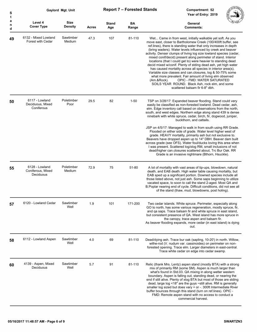
Level 4 Cover Type Acres
StandAge
SizeDensity
BA Range
Mgt. Unit Report 7 – Forested Stands Compartment:Stand
GeneralComments:
Year of Entry:Gaylord
201952
49 6132 - Mixed Lowland Forest with Cedar
Sawtimber Medium
47.3 107 81-110 Wet... Came in from west, initially walkable yet soft. As you move east, closer to Bartholomew Creek (100/400ft buffer, see ref.lines), there is standing water that only increases in depth (bring waders). Water levels influenced by creek and beaver
activity. Denser clumps of living log size lowland species (cedar, mixed conif/decid) present along perimeter of stand. Interior locations (that I could get to) were heavier to standing dead
decid mixed w/conif. Plenty of stding dead ash, yet high water has caused mortality across all species in interior area(s).
Variable size classes and can.closures, log & 50-75% some what more prevalent. Fair amount of living elm observed
(Am.&Rock). OPIC - FMD: WATER SATURATED SOILS YEAR ROUND. Black Ash, rock elm, and some
scattered balsam fir 6-8" dbh.
50 6117 - Lowland Deciduous, Mixed
Coniferous
Poletimber Poor
29.5 82 1-50 TSP on 3/28/17: Expanded beaver flooding. Stand could very easily be classified as non-forested lowland. Dead cedar, ash, elm. Edge inventory call based on observations from the north,
south, and west edges. Northern edge along stand 439 is dense ninebark with white spruce, cedar, birch, fir, dogwood, juniper,
buckthorn, and cattails.
JSP on 4/5/17: Managed to walk in from south using RR Grade. Flooded on either side of grade. Water level higher west of grade. HEAVY mortality, primarily ash but not exclusive to.
Beavers have dropped aspen up to 14" DBH. Beaver dam built across grade (see OFS). Water foul/ducks loving this area when
I was present. Scattered log/xlog RM, small inclusions of not dead/higher can.closures scattered about, Trc Bur Oak. RR
Grade is an invasive nightmare (Bthorn, Hsuckle).
55 6128 - Lowland Coniferous, Mixed
Deciduous
Poletimber Medium
72.9 75 51-80 A lot of mortality with vast areas of tip-ups, blowdown, natural death, and EAB death. High water table causing mortality, but EAB sped up a significant portion. Downed species include all those listed above, not just ash. Some saps beginning to utilize vacated space, to soon to call the stand 2-aged. Most QA and
B.Poplar nearing end of cycle. Difficult conditions, did not see all of the stand (thaw, mud, blowdowns, post holing).
57 6120 - Lowland Cedar Sawtimber Well
1.9 101 171-200 Two cedar islands. White spruce. Perimeter, especially along GO to north, has some various regeneration, mostly spruce, fir, and qa saps. Trace balsam fir and white spruce in east island, but consistent presence of QA. West island has more spruce in
the canopy, trace aspen and balsam fir.As beaver flooding expands, more cedar (in east island) is dying
out.
58 6112 - Lowland Aspen Sawtimber Well
4.0 69 81-110 Dead/dying ash. Trace bur oak (sapling, 10-20') in north. Willow, withe-rod (V. nudum var. cassinoides) on perimeter on non-
forested opening. Trace elm. Larger diameters in east-central. Trace white cedar on edge into cedar swamp.
60 4139 - Aspen, Mixed Deciduous
Sawtimber Well
5.7 91 81-110 Relic (thank Mrs. Lentz) aspen stand (mostly BTA) with a strong mix of primarily RM (some SM). Aspen is much larger than what's found in Std.03. QA mixing in along wetter western
boundary. Aspen is falling out, standing dead, or nearing the end if still alive. Plenty of xlog BTA but most of those are stding dead, large log <18" are the guys ~still alive. RM is generally
smaller log sized but does vary + or -. 300ft Intermediate River buffer bounces through this stand (turn on ref.lines). OPIC -
FMD: Remote aspen stand with no access to conduct a commercial harvest.
05/16/2017 11:48:57 AM - Page 6 of 9 SWARTZN3

Level 4 Cover Type Acres
StandAge
SizeDensity
BA Range
Mgt. Unit Report 7 – Forested Stands Compartment:Stand
GeneralComments:
Year of Entry:Gaylord
201952
61 6128 - Lowland Coniferous, Mixed
Deciduous
Poletimber Medium
99.6 100 81-110 Similar to Std.55, yet didn't observe quite the same amount of areas with "vast" blow-downs/tip-ups. A significant amount of
Blk. Ash mortality in canopy/sub-can. High water table causing the usual mortality of species too. Differing size classes
dominate (pole most common) depending upon where you go. That said, wasn't able to venture to far into (thaw/post-holing). Some upland near p-line. Chop line along State/PVT interface
running south of p-line (what?). Did not find a corner though (no detector & heavy snow/water in chop line).
OPIC - FMD: Swamp conifer predominant with mixed aspen, red maple, hemlock. Hold, heavy deer winter yard.
63 6132 - Mixed Lowland Forest with Cedar
Sawtimber Medium
9.9 117 81-110 Winter deer yard with heavy browsing pressure. Sporadic beaver activity. Canopy closure is around 75%. Soft transition between this and the adjacent L0 stand. North half is a mix of
cedar clumps and aspen clones with BAM and basswood mixing in, also some ash and elm. South half is largely dominated by cedar with areas (especially further away from river) heavy to basswood with some aspen clones. Trace amounts of balsam
fir, hemlock, red maple, and larch in canopy. More alder, honeysuckle, and ninebark in the north. JSP: Inventoried north of drainage ditch TSP: South of ditch OPIC - FMD: Stand is located along the Jordan River which nominates it for a HCVA.
65 6112 - Lowland Aspen Sawtimber Medium
7.9 86 1-50 Trace balsam fir, bur oak, black cherry, american elm, and white ash in canopy. White cedar present in P/L/S. Transitional strip of
aspen adjacent to conifers and Jordan River. Nominated for a HCVA. Only access is across water saturated fields & a railroad
grade.
67 6113 - Lowland Maple Sawtimber Medium
9.8 116 51-80 Trace black cherry, basswood along railroad grade, along with a mix of upland types (iw, sm, bc, musclewood, hawthorn, balsam fir). Standing water, BMP concerns. Nominated for HCVA since stand is located along Bartholemew Creek which is a tributary of
the Jordan River.
69 6132 - Mixed Lowland Forest with Cedar
Poletimber Poor
18.6 76 Unspecified Very wet with tip-ups/blowdown. Standing dead and downed ash everywhere. Wasn't able to venture very far into, didn't see east 1/2. Looks like a cedar swamp that was clearcut in past (stumps and next to old R.R. grade). Then came back strong to Blk. Ash. Now overstory ash has died/falling out causing flush of saps (a lot of ash but other species mixing too). Suppressed species
that remained after ash death account for the mainly pole dominated canopy (~25-50%). Southwest portion, <5ac, west of SnowTrail is heavier to log sized RM, BW, and Cedar. OPIC -
FMD: Lowland hardwood with wet soils. A strip of this stand borders Jordan River which qualifies as an HCVA.
05/16/2017 11:48:57 AM - Page 7 of 9 SWARTZN3

Level 4 Cover Type Acres
StandAge
SizeDensity
BA Range
Mgt. Unit Report 7 – Forested Stands Compartment:Stand
GeneralComments:
Year of Entry:Gaylord
201952
70 6113 - Lowland Maple Poletimber Well
16.0 75 111-140 Very wet, natural rivers buffer present (see Ref.Lines). The next forester won't agree, but here's my take on this stand.
Calling 2-aged (MIFi won't let me accurately depict separate category of XL/log Maple in this stand, bummer). RM & some
Silv.Maple stump sprouts abound in P/L/S and/or P/S/L. A prominent and separate size class of RM&Silver XL/Log
present, yet not overly abundant. Pole maple cored aged at 72&75yrs. 17.5" RM cored aged 117yrs. Appears a HEAVY
thin/clearcut w/residual trees occurred 70-75yrs ago. The larger and separate XL/Log size class occurs south of RR Grade and
prevalence increases closer to J.River (difficult to operate in, left more trees?). That's my theory.
Elsewhere, scattered pockets of NWC in south poly. North poly is somewhat of an inclusion featuring more NWC yet still retains
maple component. Diameters decrease 1-3 chains on either side of RR Grade/SnowTrail (remain mostly pole though). Water has no where to go there. Flowing stream cuts through western area of south poly. Was flowing N/NW away from J.River and
then onto PVT.
71 4112 - Maple, Beech, Cherry Association
Poletimber Well
3.6 106 111-140 Atop a prominent hill/ridge. Areas heavier to log sizes (north end/south end) but poles are more prevalent. Could still see
faint blue line on State side of PVT/State interface (east boundary). Prominent band of Hemlock in south. OPIC -
FMD: HILLY TERRAIN. DIFFICULT ACCESS.
73 6117 - Lowland Deciduous, Mixed
Coniferous
Poletimber Poor
11.1 75 1-50 OPIC - FMD: WATER SATURATED SOILS YEAR ROUND. Red pine around parts of stand. DED, EAB. Lot of ash mortality.
Trace basswood, pole. Stand will most likely convert to lowland shrub/low density trees
without prolonged droughty conditions to establish deciduous/coniferous regeneration.
74 6128 - Lowland Coniferous, Mixed
Deciduous
Poletimber Medium
9.3 61 1-50 ~Living portion of what was formally part of Stand 1. Still a lot of dead Black Ash (stding&down dead). Canopy closure is on the low side of 50-75% (+ - in areas). Northern boundary follows
what I believe to be Seamon Creek. Cedar more common along creek. Musclewood prevalent and finally a stand with minimal Buckthorn. A wall of Black Ash seed/saps south of power line that have been browsed to an even 4.5ft. It was revolting and
astonishing at the same time.
75 6120 - Lowland Cedar Sawtimber Medium
26.5 147 81-110 Winter deer yard with heavy browsing pressure. Sporadic beaver activity, especially along L0 stand 36. "Supercanopy" QA with scattered dense white cedar, otherwise, cedar is consistent but less dense and mixed with lowland hardwood, aspen, and balsam fir. Cedar is most consistent along stream and north
third of stand. Cored a 24" cedar that was 112 at 6", then rotten.
Areas more distant from the stream become more dominated by aspen, lowland hardwood, and fir. Pockets of dead black ash
with sap/pole ash, elm, RM, cedar. Trace scattered paper birch, hemlock. Notable OFS points. OPIC - FMD: Stand is located
along the Jordan River which nominates it for a HCVA.
78 6112 - Lowland Aspen Sawtimber Medium
9.0 84 1-50 Lot of dead standing ash. Poles coming up. Trace cedar. Small lowland opening in center of stand. Pockets of more densely
stocked aspen in south with higher BAs. Hydrology affected by beaver - not a fun place to be. Stand nominated for a HCVA.
05/16/2017 11:48:57 AM - Page 8 of 9 SWARTZN3

Level 4 Cover Type Acres
StandAge
SizeDensity
BA Range
Mgt. Unit Report 7 – Forested Stands Compartment:Stand
GeneralComments:
Year of Entry:Gaylord
201952
79 6111 - Lowland Balsam Poplar
Sawtimber Poor
4.5 55 51-80 Could call non-forested through different eyes. If the various clumps were "squished" together, it appears 25% (or more)
canopy closure is achieved. Full/High buckhorn present, some nearly pole size. Might be more Up/Low, made Low/Up call
based upon canopy species and proximity to J.River.
81 6113 - Lowland Maple Sawtimber Medium
2.0 56 1-50 DED, EAB affected elm and ash, respectively. Nominated for a HCVA. Only access is across water saturated fields & a railroad
grade.
85 4112 - Maple, Beech, Cherry Association
Sawtimber Well
1.8 102 141-170 Small upland northern hardwood stand dominated by red maple. Hemlock along west&north perimeter. Surrounded by lowland. My brain wouldn't allow me to call this an inclusion with any of the surrounding stands. GPS record of a corner present, saw
trees w/nails, didn't stumble upon it however. OPIC - FMD: Small upland inclusion with red maple logs in southwest corner.
05/16/2017 11:48:57 AM - Page 9 of 9 SWARTZN3

Cover Type Acres
Mgt. Unit Report 8 – Nonforested Stands Compartment:
Stand General Comments:
Year of Entry:
Managed Site
Gaylord 522019
1 47.1 Did not see all of this stand. Saw southern and eastern portions. Vast area of primarily dead standing/some downed Black Ash. The dead is variable between P/S
and S/P ash. Scattered fir/some NWC still living. Musclewood common. Flush of seed/sap sized Blk.Ash trying to give it another go (should we tell them?).
Pooled/standing water in areas I visited. Northern areas might still be forested.
629 - Mixed non-forested wetland No
7 36.7 Old railroad grade divides stand, SE-NW.North half is wet throughout the year. South half (south of the grade) appears to be
seasonally wet. Ash, oak, maple, and quaking aspen in small clump along south (pvt) perimeter. Private has a neat clump of rock elm, bur oak, siver maple, pussy
willow, red osier dogwood, and musclewood just over the boundary. QA present in P/L/S; Scotch pine is S/P; BA is P/S; cedar is P/S.
622 - Lowland Shrub No
8 1.8 Mt. Bliss Rd.122 - Road/Parking Lot No
9 3.0 Old R.R. Grade and Snowmobile Trail #4. Numerous culverts present (see OFS layer if necessary).
122 - Road/Parking Lot No
11 148.4 Expansive marshy flooding as a result of the Intermediate River. Lots of dead timber due to high water table. Small black spruce 1"dbh scattered, cattails, tag alder.
629 - Mixed non-forested wetland No
18 0.3 Old R.R. Grade (not part of Snowmobile Trail #4). Wooden ties still visible in areas.3205 - Mixed Upland Shrub No
22 0.5 Old R.R. Grade and Snowmobile Trail #4.122 - Road/Parking Lot No
23 4.1 Standing water in south, drainage flowing through stand. Viburnum is Withe-rod (V. nudum), medium density.
622 - Lowland Shrub No
24 49.7 Heavily dominated by Common Buckthorn and Honeysuckle. Some grassier openings and lower stocked Bthorn areas present. Generally unpleasant to walk
through and most Buckthorn was 10-20+ft tall. Some scattered/clumps of the tree species listed above. NWCedar regen (saps) fairly thick in S.E. edge close to
Mt.Bliss Rd. Old R.R. Grade and active Snowmobile Trail present. Area(s) near snowmobile trail/closer to J.River appeared lower/wetter.
OPIC - FMD: Upland brush with wildlife shrubbery. Lots of hawthorn. This stand is nearby the Jordan River access site and lamprey weir.
3205 - Mixed Upland Shrub No
25 9.1 Upland shrub/grass opening with scattered trees (conifer&decid). Perimeter of stand offers more lowland shrub species and softer ground.
3205 - Mixed Upland Shrub No
27 8.3 OPIC - FMD: Jordan River which is a designated Wild & Scenic River. All the stands that are located within 400' of the Jordan River or its tributaries are
considered a HCVA.
500 - Water No
29 12.5 Dominated by Buckthorn. Most large (DBH) and tall and has the appearance of a young apple orchard from a distance. Areas where Bthorn is very dense/unpleasant,
other areas where you can walk through/under. Sct. juniper, some E.red cedar. Mostly "Up" but fingers that extend into Stds.30/31 were "Low", acting as water
courses. OPIC - FMD: Open field planted with fruiting wildlife shrubbery. Lots of 6-7' hawthorne (It's not hawthorne, JSP)
3205 - Mixed Upland Shrub No
05/16/2017 11:49:12 AM - Page 1 of 4 SWARTZN3

Cover Type Acres
Mgt. Unit Report 8 – Nonforested Stands Compartment:
Stand General Comments:
Year of Entry:
Managed Site
Gaylord 522019
42 6.5 Some white willow, log >20'. Western more upland ground is dominated by ninebark. Beaver flooding; dam present. Dead standing cedar.
Water table likely fluctuates seasonally.
6220 - Alder/willow No
44 29.7 Occasional small bird nest. Stand is occupied by invasive common buckthorn (Rhamnus cathartica). While there is wildlife value in the covertype and fruit, an
effort could be made to restore this to native species. Nannyberry present in trace amounts.
Clump of viburnum with bur oak saplings on southeast edge. QA encroaching (trace, sap, variable) on SE perimeter.
622 - Lowland Shrub No
45 6.5 Stand is influenced by seasonal flooding. South end is more open and lowland, with dogwood, willow, and buckthorn scattered. North half is more heavily vegetated by
lowland/intermediately-tolerant shrubs.
320 - Upland Shrub No
48 5.1 Heavily browsed dogwood, occasionally 5-10', but mostly <5'. Sensitive fern present. Lowland brush with cattails. Wetland drainage with no merchantable trees, except a
handful on the perimeter. Note: At the south end of this stand there is a 1/4 ac. upland brush type that is not mapped out separately.
622 - Lowland Shrub No
51 5.8 Borderline forested/non-forest. Prominent strip of P/L Q.Aspen runs right through center. East of strip is probably dry at some point in the year. West of strip has standing water and observed a beaver house. Saw four Blue Herons perched in
single tree west of this stand (perhaps in Std.50/57?). However, did not observe a possible rookery in that direction.
OPIC - FMD: Upland brush opening with some young black spruce, q.aspen, & white birch developing.
6239 - Mixed Emergent Wetland No
52 3.0 Wet/lowland shrubs with low density stump-sprout XL/L Red/Silv.Maple and SM. Buckthorn and honeysuckle quite prolific. Shrub more dominant than low density
trees.
6229 - Mixed lowland shrub No
53 13.0 Bartholomew Creek travels through this lowland shrub before empty into J.River. Beaver slides across RR Grade. Grade full of BThorn and HSuckle. Scattered
conifer and deciduous.
6229 - Mixed lowland shrub No
56 1.3 Stand is occupied by dead ash (canopy) with moderately stocked shrub understory. Small stream flows in from southwest but dissipates, spreading into more of a
flooding, throughout this stand.Low to medium stocking of musclewood.
Trace elderberry.
622 - Lowland Shrub No
59 1.1 A cool little opening. Small stream snakes its way through.623 - Emergent Wetland No
62 6.6 Trace scotch pine, white cedar on southeast edge of lowland. 320 - Upland Shrub No
05/16/2017 11:49:12 AM - Page 2 of 4 SWARTZN3

Cover Type Acres
Mgt. Unit Report 8 – Nonforested Stands Compartment:
Stand General Comments:
Year of Entry:
Managed Site
Gaylord 522019
64 21.0 Lowland shrub complex built up around water courses that feed into the Jordan River. Many species (notably red osier dogwood) were HEAVILY browsed.
Prominent clump (~1.5ac) of P/L quaking aspen present in center of stand. Ditch drains into River corridor and floodplain. Area south of ditch is lacking in willow,
cedar, elm, and aspen, but heavy to buckthorn, dogwood, and wild raisin. JSP: Inventoried north of drainage ditch
TSP: South of ditch
OPIC - FMD: Brush with a few scattered apple trees. A strip of this stand borders the Jordan River & qualifies as a HCVA. April, 2007: In pre-review, Wildlife
Biologist recommended opening maintenance by burning or mechanical methods.
622 - Lowland Shrub No
66 16.4 Notably more honeysuckle, ninebark, tag alder, and black ash in the north half of the stand. South half has some elderberry, hawthorn, grape, and wild raisin. Scattered pole/log trees transitioning into forested stand to the east. Species include quaking aspen (L/P/X), Black Cherry (pole), cedar (L/P), black ash (P/L), elm (P/L), silver
maple (L/P/X), and basswood (L/P). Stand is currently inundated, but could dry up in the summer months. JSP: Inventoried north of drainage ditch TSP: South of
ditch
622 - Lowland Shrub No
68 0.6 Mt. Bliss Rd.122 - Road/Parking Lot No
72 1.0 Alba Rd leading to the Jordan River access site.122 - Road/Parking Lot No
80 2.6 Unsure how to classify this stand. Ash and elm mortality have left this stand all but devoid of any woody vegetation. Beaver activity and flooding will inhibit the
establishment of future trees and shrubs. Flowing water and rather hummocky grass.
623 - Emergent Wetland No
84 17.8 Trace alternate leaved dogwood, trace red maple (XL), trace scotch pine (sap); trace autumn olive. Far east narrow leg has dense buckthorn, trace quaking aspen saps. South tip if far east narrow leg has clumpy honeysuckle. Rest of stand is dominated
by cherry brush, save a pocket of dense musclewood in the north. Old railroad grade runs through stand, SE-NW.
320 - Upland Shrub No
86 2.7 Wish we had a Lowland Low Density Tree for Non-Forested. This stand is lowland. Heavy ash mortality, natural open/wet locations, scattered conifer (hemlock, fir,
some spruce). High to Full Black Ash seeds/saps, HEAVILY BROWSED.
629 - Mixed non-forested wetland No
87 14.1 OPIC - FMD: STAND CONSISTS OF POWERLINE TRAVERSING SEC 36 , T31N, R7W. Most of this powerline is wetland with standing water that does not provide
access to the adjacent state owned timber.
790 - Other Bare/Sparsely Vegetate No
404 1.7 Scattered deciduous and conifer present. Elaborate/permanent cedar blind just east of stand (found in Std.5). Well/gas pad just onto private. PVT to north is accessing
this portion of State with their ORV/vehicles.
OPIC - FMD: Small, narrow opening in low valley with hilly hardwood on east boundary. Leave open.
3102 - Grass No
05/16/2017 11:49:12 AM - Page 3 of 4 SWARTZN3

Cover Type Acres
Mgt. Unit Report 8 – Nonforested Stands Compartment:
Stand General Comments:
Year of Entry:
Managed Site
Gaylord 522019
405 11.6 Three permanent blinds present (2 were very nicely appointed, hmm) along perimeter north of p-line. A fourth tucked into Std.5 but the shot is into Std.404. See OFS points. Intermittent drainage flows from PVT, south into this stand then across
p-line. Drainage "shrubbery" can be seen on imagery.
OPIC - FMD: Open, hilly grass area. Knapweed & some pin cherry brush.
3105 - Mixed Upland Herbaceous No
414 10.8 A little bit of everything, all generally in multiply scattered clumps. Including but not limited to: Apple P/L, Balsam Pop S/P, BassW Log, BTA L/P, Blk/Pin Cherry S/P, Crabapple P/S, E.Red Cedar Sap, Hawthorne Sap, Honeysuckle shrub, Lilac, QA
P/S, Tamarack S/P, Wht.Spruce Sap, and Wild Plum P/S. Southern perimeter sneaks into lower/wet areas and seeps. Met Virgil Lavanway, a producer still felling
by hand. Nice guy. OPIC - FMD: Open field on rolling terrain adjacent to Virgil Lavanway's house & land. A few scattered white pine in southeast corner. Aspen
encrouching on edges.
330 - Low-Density Trees No
422 14.4 OPIC - FMD: Expansive, open grassy area on a plateau that is adjacent to Green River Ranch.
310 - Herbaceous Openland No
425 22.4 Primarily upland grass but heavier to shrub (of lowland variety) in eastern 1/4 and along perimeter with Std.64. Ninebark, redOdogwood, some honeysuckle, and tag
common along perimeter. OPIC - FMD: Open field with some upland brush developing. April, 2007: In pre-review, Wildlife Biologist recommended opening
maintenance by burning or mechanical methods.
3105 - Mixed Upland Herbaceous No
426 28.5 Barbed wire fence, variable in direction and continuity, present throughout stand. Areas in east and south with very dense buckthorn; lower pockets around cedar.
Concentration of white pine, scotch pine, apple in south-southeast. April, 2007: In pre-review, Wildlife Biologist recommended opening maintenance by
burning or mechanical methods.
320 - Upland Shrub No
439 79.5 Seasonally [very] wet; some hummocks (old stumps?) in southeast. Trace amounts of pole scotch pine, white spruce (sap), QA (sap), elm (sap/pole). Trace white
spruce and cedar on perimeter.
3102 - Grass No
455 27.1 A bit of everything here. Primarily lowland grass/some shrub (willow and such). Some higher ground closer to M66 with Scotch Pine/White Pine. Water courses
throughout from Bartholomew Creek and drainage culverts that travel underneath M66.
OPIC - FMD: STAND IS WET. 2007: Some planted Austrian Pine along M-66 & scattered pine in field.
6229 - Mixed lowland shrub No
462 7.0 Sapling size species (all@low density) along east perimeter include QA, ninebark, buckthorn, Wht.Spruce, and juniper. Field appeared feral/not being used for ag.
purposes. OPIC - FMD: Open, grassy area. Access strip 33' wide leads east to the Jordan River. New acquisition in 1995.
310 - Herbaceous Openland No
05/16/2017 11:49:12 AM - Page 4 of 4 SWARTZN3