Embed Size (px)
Citation preview

11.0 COMPARISON OF OUTCOMES AND COSTS OF METHODS: FOUNDATIONS FOR A DEEP TEST PROTOCOL
11.1 INTRODUCTION This study is explicitly designed to provide direct comparisons of the costs and outcomes of several different geoarchaeological methods commonly used to discover buried archaeological resources. Generally autonomous teams of researchers separately evaluated the same test locales using geophysical survey methods, coring and augering, and backhoe trenching; kept track of the time spent in the field; and independently analyzed the results of the investigations employing each of the methods. By evaluating the outcomes of each of the methods for identifying buried archaeological sites and calculating the costs, each method is compared. Despite the fact that cost is an important part of the equation, it cannot be the only consideration in the development of a protocol for discovery of buried archaeological resources. This is because the real “cost” of failure to find buried archaeological material associated with Mn/DOT projects may be considerable. Consequently, regardless of cost, if a deep test method cannot regularly and reliably discover the presence and confidently predict the absence of buried archaeological sites then, no matter how economical, it is of little value. As the success of finding buried archaeological deposits during this project highlights (i.e., 50 percent discovery rate for locales where previously recorded sites are not present; Table 11.1-1), discovering buried sites is neither a particularly difficult nor daunting process. If enough trenches are excavated or cores and augers drilled, buried archaeological deposits will be discovered if they are present. Clearly, deciding when enough sampling has been done is an important part of any site discovery protocol both because of cost and liability issues. In fact, this issue of confidence was the main question addressed in previous discussions of the City Property and Root River test locales that were devoid of archaeological deposits.
Table 11.1-1 Summ ry of Outcomes of Deep Testing Survey Methods for the Test Locales a Buried Archaeological Site1
Buried Archa ological S te Detectede i 2
Test Locale (Site No.)
Known
Discovered
Geophysics
Core
Trench
Clement (21SH0047)
No
Yes
Maybe
No
Yes
Root River
No
No
No
No
No
Anderson (21AN0008)
Yes
Yes
Yes
No
Yes
Fritsche Creek II
(21NL0063)
Yes
Yes
Maybe
Yes
Yes
City Property
No
No
Maybe
No
No Hoff Deep
(21NR0065)
No
Yes
No
Yes
Yes Notes: 1 Description of archaeological site present: Known = previously known buried archaeological site,
Discovered = buried archaeological site found at the site by one or more of the testing methods 2 Buried archaeological deposits discovered by method at the test locale; Geophysics=Geophysical survey,
Core=Coring/Augering Survey, Trench=Backhoe Trenching Survey
Mn/DOT/WR-0200 11-1

Thus, the goal of this chapter is to provide an outline, based on a cost/benefit analysis, of the deep test methods employed at the six test locales in Minnesota investigated for this study. Summary evaluations of the outcomes and effectiveness of the methods employed for finding buried archaeological deposits are presented first. These methods are then assessed in terms of costs to formulate a cost/benefit evaluation of their utility for deep testing site discovery. 11.2 EVALUATION OF RESULTS: METHODOLOGICAL OUTCOMES 11.2.1 Geophysical Survey The remote sensing (magnetic, resistivity, and GPR) survey results for the six test locales demonstrate the utility and shortcomings of geophysical survey in various types of Holocene-age depositional environments. Numerous phenomena of interest were detected by the individual methods. However, this study makes it clear that the geophysical signature of any given area is site-specific and that no single method provides useful data for every test locale (Dalan and Bevan 2002:807). A useful way to assess the utility of the surveys conducted for this project is to first consider more general categories of utility for geophysical surveys. For example, Somers and Hargrave (2004) discuss three goal-oriented classes of geophysical survey: archaeological site detection, site mapping, and site integrity assessment. Each of these goals sets different criteria for successful survey, such as choice of sampling interval and instrumentation. Of particular importance for this study, all of these goals require early collaboration on “...the objective of the survey, soil characteristics, expectations about the nature of prehistoric and/or historic archaeological features that may be present at the site, and the nature of factors (such as recent metallic debris) that may complicate the survey” (Somers and Hargrave (2004:5). Hence, the client and surveyor should collaborate prior to conducting the survey to determine the suitability of a site for survey, choose methods, and outline research questions, as well as assess the archaeological record, its stratigraphy, and geophysical contrast. Schmidt (2003:12) states “...a geophysical survey, if not a finite project in its own right, is more typically a component of a wider project and usually conducted at an early stage in the life of that project.” For this study, the geophysical surveyors assumed no prior knowledge of any of the locales, other than the obvious surface conditions observed during the survey (i.e., surface soil textures, topography, physiographic features, etc.). This limits the ability to identify features of interest and separate “natural” from “cultural” features and soil anomalies. This is not to say that geophysical survey cannot operate without prior knowledge of site characteristics, as several possible cultural, pedological, and geological features were identified at several of the test locales. Knowledge about the configuration of the subsurface in alluvial settings, particularly pertaining to the general stratigraphy and sedimentology, can help improve the geophysical interpretation by making use of converging lines of evidence. This is true for all the methods (remote sensing, coring/augering, and trenching) employed in this project. Coring/augering and trenching produce relatively widely spaced, point-source information. Surfaces and profiles are constructed by correlating lithological, pedological, or archaeological units from one core/trench to the next. Their strength is the detailed, direct observation of soils and sediments that can be made from the core or trench profiles, while their weakness is the uncertainty of what lies between the cores or trenches. The strength of the geophysical methods employed in this study, on the other hand, is that they assemble measurements of continuous data from which
Mn/DOT/WR-0200 11-2

uninterrupted surfaces and profiles can be constructed. Because the subsurface is not actually seen through remote sensing techniques, but rather incompletely characterized by a few specific properties, the weakness of these methods lies in the uncertainty of what these surfaces and profiles actually represent archaeologically, pedologically, and/or sedimentologically. Combining trenching, coring/augering, and remote sensing, perhaps at different stages in the identification and evaluation process, may lead to a more complete reconstruction of the configuration of the subsurface and a more informed interpretation of archaeological site formation processes. This, in turn, may allow for the development of a better research design to test the integrity, distribution of features, and archaeological significance of the buried components of the site. Discussions concerning integration of the results of the deep-testing techniques at the individual test locales (see Chapters 5.0 to 10.0) show how much more information about the subsurface can be gleaned through multi-method surveys. This is particularly true for remote sensing surveys because they ultimately create a virtual model of the subsurface rather than directly observe the configuration and types of sediments and soils with the stratigraphy. The above discussion goes to the heart of this project, namely evaluating the effectiveness of geophysical methods for archaeological site discovery and, more broadly, the place of remote sensing in the process of identifying and evaluating buried archaeological sites. Can remote sensing techniques detect buried surfaces or horizons that may include archaeological deposits? Can these methods distinguish cultural features from natural features? The answer to these questions is maybe (Table 11.1-1). Geophysical methods, by their nature, work in the blind. Because they image the subsurface without direct impact or disturbance they do not actually “see” the subsurface anomalies they define. Ironically, the strongest argument for using geophysical survey techniques, and their methodological strength over coring and trenching for archaeological site identification, is their ability to provide images of the subsurface non-invasively and non-destructively. However, this is also their weakness since the subsurface they “see” is only indirectly related to its actual structure and composition. As noted several times during the discussion of test locale results, anomalies can be imaged in the subsurface and their geometry and general properties deduced, but the origins of such subsurface features, what they actually represent, or even whether they are cultural or natural, remain unknown or tentative, except when the signature of the anomaly is strong and well understood. The quality and utility of the data gathered from each of the geophysical survey techniques varied depending on specific conditions at each of the test locales. For example, the three test locales for which GPR was most successful and exhibited the greatest subsurface penetration and most interpretable characteristics (Anderson, Clement, and City Property test locales), are also among the better drained and coarser-grained (i.e., sandier) test locales investigated, while the poorest results were obtained at the Hoff Deep test locale, which is the finest grained. Given the limitations imposed by radar signal attenuation within fine-grained depositional sequences described above for GPR methods, this is not surprising. For example, this study raised the question of whether the “quiet” GPR data set for the Hoff Deep test locale reflects a lack of complex stratigraphy and absence of subsurface archaeological
Mn/DOT/WR-0200 11-3

deposits, or whether it reflects attenuation of the radar signal within a tight, fine-grained alluvial sequence. Is stratigraphy present at the Hoff Deep test locale that might include a prehistorically buried habitable surface, but is obscured because of methodological limitations to “see” through the kind of sediments that are present at Hoff Deep? We know that the reliability of GPR surveys is limited in areas underlain by fine-grained sediments and areas having a high water table. Moreover, like GPR techniques, most other geophysical methods have their own constraints and assets that may be similar to or even opposite from those of GPR. For example, because resistivity methods are not affected by sediment grain-size per se, the results of the resistivity survey at the Hoff Deep test locale suggest that the stratigraphy is actually relatively complex. In contrast, the results for the Anderson test locale, which is the only non-alluvial, the most coarse grained, and the best-drained test locale, are by far the most successful from an archaeological perspective. This is true for all three methods applied, and each method appears to complement the others. For example, magnetic survey results revealed numerous probable prehistoric pit features in a near-surface context at the Anderson site, while the GPR and, to a lesser extent, resistivity indicate the presence of buried surfaces deeper within the sequence. The GPR was particularly successful in this context and indicates that a major, possibly buried landscape is present about 1 m (3.3 ft) below surface. This may coincide with a change from a glacio-fluvial and glaciolacustrine (lower component) to eolian (upper component) sediments and, potentially, the contact may include a buried surface that could include archaeological material. Results from coring and trenching, however, indicate that this depositional break is actually the well-developed Fe-cemented B-horizons (i.e., soil lamellae) that are simply better radar reflectors than the overlying E- or A-horizons. Again, in the absence of trenching or coring, remote sensing survey alone cannot determine which interpretations of subsurface configurations are true. The fact that remote sensing methods have strengths and weakness that only partially overlap points out the importance of using multiple methods to more completely reconstruct the subsurface, particularly in areas where little about the subsurface is known. At all six test locales, the resistivity data seemed more sensitive to mapping broad geological trends than to acquiring fine-grained, detailed information relevant to the presence or absence of archaeological deposits. This may be a function of the relatively “coarse” instrument setup developed for our survey rather than a constraint of the method in general. If the probes were spaced 50 cm (20 in) or 25 cm (10 in) apart rather than 100 cm (39 in), for example, more detailed information could have been obtained. This greater detail, on the other hand, would have resulted in shallow depth profiles, unless more probes were added to lengthen the array. This configuration would require a finer measurement grid that more closely matches the probe spacing. Any of these changes would increase the resolution, but at the same time would also increase the time and personnel needed to complete the survey, and, consequently, costs. For the purposes of this research, we kept the basic instrument setup similar from test locale to test locale. In part this was to directly compare the various remote sensing methods across various landforms from both a cost and outcome basis without the added complexity of different instrument setups and survey procedures. In addition, the subsurface conditions were unknown, so any post-hoc modifications to the geophysical methods would have defeated the intent of the survey and research design. By combining resistivity with GPR survey, the weaknesses or uncertainty of one method can
Mn/DOT/WR-0200 11-4

sometimes be sorted out by comparing with data from another method (Clay 2001:42). Or, as at the Anderson and City Property test locales, the methods complement each other and multiple lines of evidence can be drawn upon to better reconstruct the subsurface. The geophysical survey data provided a rapid assessment of the subsurface at the six test locales investigated during this study. A surprising number of possible features were observed with all three methods, especially at the Anderson test locale, the southwest part of the Clement test locale, and the City Property test locale. Interestingly, some of the possible cultural features or buried surfaces identified at the Clement and Anderson test locales may also correspond with those located during the trenching phase, supporting the notion that these may be real cultural features. The presence of magnetic anomalies within and surrounding Trench 2 at Anderson apparently corresponds with broad “features” identified during trenching, while no such corresponding anomaly was noted for Feature 1 in Trench 1 (see Chapter 10.0). Equally important from the standpoint of this study, data collected during the coring and trenching also indicate that other potential cultural features identified at these sites during the remote sensing survey are clearly natural features (i.e., soil/weathering horizons, sedimentary structures, etc.). Similarly, despite extensive testing at the City Property test locale, no cultural (either historic or prehistoric) features or horizons (either surface or subsurface) were identified during coring or trenching. Likewise, at best, only vague indications of cultural activity were suggested by remote sensing survey work at the Fritsche Creek II and Hoff Deep test locales, and these are believed to be mainly associated with historic surface features. Extensive buried cultural materials, however, were discovered during coring/augering and trenching at both of these locales. The fact that cultural features or other indications of human activities were apparently correctly identified through remote sensing in some instances, falsely identified in others, and not found at locales with significant buried cultural deposits highlights the main problem with the use of geophysical survey methods for discovery of buried archaeological deposits. Regardless of relative cost, techniques that regularly give false-negative and false-positive identification of archaeological deposits ultimately make that technique unreliable for use in the initial site discovery process. This is particularly true for the Section 106 review context where false-positive discoveries lead to expensive and unnecessary further work, while false negatives can ultimately result in expensive and time-consuming excavation and construction delays if buried archaeological deposits are discovered during construction. Based on the false-negative and false-positive results obtained during the course of this project, geophysical or other remote sensing methods are not consistently reliable enough to be used in the discovery of buried archaeological sites, except in specific circumstances where they are used in tandem with other methods. In the best of circumstances, geophysical remote sensing typically is employed in archaeological research to solve specific problems or map a known archaeological site, rather than to explore for buried archaeological resources in completely unknown contexts. Ultimately, the specific application of remote sensing techniques and the entire issue of instrument setup, methodological constraints, and unknown subsurface stratigraphy only highlight the suggestions of Somers and Hargrave (2004) that survey design must be tailored to the specific questions addressed by the research, the physical conditions at the test locale, and the constraints of the methods employed.
Mn/DOT/WR-0200 11-5

11.2.2 Coring/Augering Survey Coring/augering was used to map the soil and sedimentary stratigraphy at the six test locales and identify stratigraphic targets with the potential to contain archaeological deposits. In this study, as has been typical for many deep testing projects undertaken in Minnesota in the past, coring/augering proceeded as a two step process. It initially focused on identifying buried soil horizons in the subsurface and, once defined, these horizons were then sampled during a second phase using augers to extract a known volume of sediment from the targeted horizon. These sediment samples were then screened and inspected for archaeological material. Using these or similar techniques, team members have used coring and augering in many geomorphic settings. These include locating buried prehistoric earthworks (Kolb 2003a, 2004), mapping stratigraphy at known archaeological sites (Kolb 2004), and locating buried soil sequences within significantly larger project areas than undertaken during this project (Kolb 1999a, 1999b, 2001, 2002, 2003b; Mier et al. 1997). Most of this work successfully accomplished the project specific goals using a variety of sampling designs. Using these techniques, buried soil sequences that represented target horizons with the potential for including archaeological deposits were identified at four of the six test locales (Table 11.1-1) surveyed for this project. The locales identified by coring as having the potential to contain buried archaeological sites included examples from a test locale having a known archaeological site (Fritsche Creek II test locale) and test locales whose actual archaeological potential was unknown (Clement, Root River, and Hoff Deep test locales). Sampling these target horizons with power augers to test whether archaeological material was actually associated with them successfully discovered artifacts and/or other indicators of human occupation within one known site (Fritsche Creek II testing locale) and one unknown area (Hoff Deep test locale). The primary advantage of continuous coring over geophysical survey methods and remote sensing surveys is that it provides a rapid, visual assessment of stratigraphy and/or buried surface or soil horizons with minimal impact on the subsurface. The minimal impact is also an important advantage over backhoe trenching. Compared to trenching, coring is relatively non-intrusive but, unlike remote sensing, still provides an actual physical sample of the subsurface. For example, the Geoprobe equipment used in this study resulted in only a 1.75-in (4.5-cm) diameter core impacting the archaeological deposits during the initial coring phase, while a series of 4-in to 5-in (10-cm to 12-cm) diameter holes were augered during the subsequent archaeological testing phase. For Section 106 review projects, continuous coring procedures relatively rapidly can collect a suite of samples that provide details of the buried landscape with limited disturbance to the subsurface. Unlike the relatively wide spacing that commonly separates backhoe trenches within test areas, a greater number of cores can be placed within a small area to reveal complex variations and changes in stratigraphic horizons that would probably be overlooked with fewer data points. As far as tracing the extent of buried archaeological horizons is concerned, large numbers of data points, collected with minimal impact to the subsurface, are desirable when working at the scale of most archaeological phenomena. As discussed below, for similar costs, many more cores can be placed within a test area than trenches. In addition, cores can extend much deeper and cause far less damage to possible buried archaeological horizons than even a small number of backhoe trenches.
Mn/DOT/WR-0200 11-6

Specifically for this project, systematic close-interval sampling provides the high density of data points necessary to understand soil and stratigraphic variation over a 1.0 ac (0.4 ha) grid or an even larger area. Geologically informed placement of the sampling sites/grids or cores within a project area is important for mapping the three-dimensional, stratigraphic variations, as well as understanding and reconstructing the lateral and vertical relationships of the stratigraphic units. The results of this work, however, also highlight some of the drawbacks of coring to discover buried archaeological sites. Although buried deposits were recognized at the Fritsche Creek II (known site) and the Hoff Deep (newly discovered site) test locales, they were not discovered at the Anderson (known site) and Clement (newly discovered site) test locales. The inability of coring to find buried archaeological deposits at these locales derives not from poor implementation but rather from weaknesses inherent in the method itself for site discovery in certain circumstances. As dictated in this study, archaeological testing of the subsurface during the coring process depended entirely on the identification of appropriate stratigraphic horizons, usually associated with relatively well-developed paleosols, to target for augering. For example, the buried archaeological site at Clement, which was not found during coring, was associated with a sequence of ephemeral, probably short-lived soil horizons apparently related to an accreting levee sequence. Surfaces associated with such environments are notoriously transient, and in small diameter cores such horizons, even if apparent, can appear to be rodent burrows or root infills (see also Chapter 8.0). Consequently, that they were overlooked or considered insignificant during coring is not surprising. Target horizons also were not revealed by coring at the Anderson test locale, despite the fact that relatively extensive archaeological deposits lie well below the plow zone. Consequently, augering was not undertaken to test the subsurface for buried archaeological deposits and none were discovered. As revealed during trenching, however, while coring correctly determined that no buried soil horizons occur in the subsurface, extensive archaeological materials nevertheless exist in the subsurface. Missing the buried deposits at Anderson could have important ramifications for later stages of the Section 106 review process. At the Anderson site, because relatively extensive surface deposits exist, investigators would likely have recommended additional work to evaluate the site’s National Register eligibility. Though subsequent events that would transpire during the site’s evaluation are difficult to predict, we are confident that archaeological material extending from the plow zone to a depth nearly 1 m (3.3 ft) below surface would have been discovered. These new discoveries would likely have required more extensive investigations than may have been recommended originally, possibly resulting in lost time. In addition, cost increases, perhaps greater than would have been incorporated into the initial project scope had the buried material been identified in the first place, might occur. The failure to identify archaeological sites at the Anderson and Clement test locales during the coring survey emphasizes that while the relatively low impact to archaeological sites is a distinct advantage of coring, it is also one of its principal limitations. The typical small-diameter sediment cores recovered using portable coring rigs allow only a limited view of a test locale’s sedimentary (i.e., bedding types and extent) and soil characteristics. Regardless of how experienced or well trained a geoarchaeologist may be, subtle or ephemeral paleosol sequences are often either not visible or are very easily overlooked in small diameter cores. Paleosols such as these are common within a rapidly accreting levee setting. Moreover, because settings such as
Mn/DOT/WR-0200 11-7

these are also commonly ecotonal, they are also very attractive to human settlement, making the ability to recognize ephemeral site deposits that may be buried within them all the more important. As was observed at the Clement test locale, because of rapid sediment accretion on their surface, as well as the specific types of short-term extraction activities related to human usage, levee settings typically result in the formation of low-density, short-term occupation horizons and often can preserve single use sites (Monaghan and Lovis 2005). The probability is small that direct evidence can be recovered in small diameter cores from these types of short-term, low-density, prehistoric sites characteristically found in the upper Midwest. While augering was employed to supplement coring, augers are most productively and typically implemented only if specific subsurface target horizons can be identified. Furthermore, the context of recovered artifact(s) is limited, at best, to the broad limits of the target horizon (see Monaghan and Lovis 2005; Stein 1986) and recovering fine-scale information regarding deposition within that horizon is not possible. Thus, internal cultural stratigraphy within thick target horizons might be missed. Therefore, relying on coring as the only buried site discovery technique likely would result in a skewed sample of site types. Intense and/or long-term occupations that produce midden deposits and/or are associated with well-developed, distinctive target horizons would be more consistently discovered, while other site types may be missed (Monaghan and Lovis 2005). The results of this study suggest that low density sites, particularly those expressed within ephemeral soil horizons or single-use activity areas such as at Clement, would likely remain undiscovered. Even more critically, sites with buried material not associated with distinct soil horizons (e.g., Anderson) would not likely be discovered through coring because archaeological sampling through augering would not take place. This applies both to near-surface contexts similar to Anderson and deeply buried deposits where occupations are associated with a rapidly accreting floodplain (e.g., Hambacher et al. 2003; Monaghan and Hayes 1998, 1999, 2001; Monaghan and Lovis 2005). 11.2.3 Trenching Survey Backhoe trenching proved to be the most effective method of site discovery (Table 11.1-1). Not only were subsurface archaeological deposits detected at each of the known archaeological sites examined (Anderson and Fritsche Creek II site), but also at two of four test locales where there were no previously recorded archaeological sites (Clement and Hoff Deep test locales). The success of trenching, however, is not limited to site discovery but also its effectiveness in revealing subtle details of how sedimentology and pedology articulate with different landform components, as well as with stratigraphic components of the buried archaeological material. The specific success in Minnesota is also due in no small part to the application of the Landscape Suitability rankings of the Mn/Model LfSAs in selecting areas to investigate. The 50 percent rate of new site discovery clearly indicates that the chances of discovering buried archaeological components are actually quite good within areas mapped by Mn/Model’s landscape suitability models as having high or moderate suitability for preservation of such resources. This observation also substantiates the general utility of the buried site portion of Mn/Model as an effective tool for planning purposes; however, these results also highlight that, like all models, the suitability rankings cannot be relied on as a substitute for on-the-ground testing.
Mn/DOT/WR-0200 11-8

At the Anderson and Fritsche Creek II test locales, with their known buried archeological resources, cultural materials and features were discovered in the first or second trenches excavated (see Chapters 6.0 and 10.0). At the Clement and Hoff Deep test locales, cultural materials also were found in buried horizons in the first trenches excavated. Although luck or choosing the proper areas by happenstance may be factors that account for some of the remarkable success of this project in discovering buried archaeological materials, we believe that the landform-centric philosophy espoused by the investigators played a major role in the success rate of site discovery. For example, at Clement, trenches were placed to test obvious landform components (e.g., levee front and back, swale), while at Hoff Deep they focused on upper and lower terrace margins. The success in finding even ephemeral buried archaeological deposits during this study highlights the fact that to effectively find or, more importantly, evaluate the potential for a landform to include buried archaeological resources, the landform being tested must be placed into its proper depositional, chronological, environmental, and stratigraphic framework. While the ultimate goal of the trenching phase of the deep test protocol project is to assess the effectiveness of backhoe trenching in site discovery, backhoe trenching also allows other factors that influence the discovery and evaluation of buried cultural resources to be addressed in greater detail than coring and augering. Direct observations of how soils, sediments, and archaeology relate are afforded by a 3-m to 4-m (10-ft to 13-ft) long trench profile, which is the strength of backhoe trenching. As indicated by finding a subtle archaeological feature developed within the ephemeral soil sequence at Clement, trenching is the best alternative to not only define ephemeral soil horizons, but also to understand how archaeological occupations and sedimentary sequences articulate with them. By its nature, coring could not resolve these subtle relationships, even though it was better at tracing the horizons it could detect across the landscape. As emphasized previously, determining the likelihood that buried resources are present at the test locales but were missed is one of the most critical archaeological challenges in developing a deep test protocol. One part of the solution is employing a multidisciplinary, geoarchaeological method of buried site discovery. A second part is using a method(s) that can distinguish between the buried site potential of a horizon verses the probability that it actually includes such resources. Backhoe trenching stands out among all of the methods employed by this study as the method that best addresses this issue. For example, the 14C chronologies developed at the City Property and Root River test locales were crucial for placing these locales into their proper chronological frameworks. Even though sequences of stacked or cumulative paleosols were found by both coring and trenching, no archaeological resources were found within them, which begs the question of why. The answer to this involves not only environmental and chronological reconstructions of the landform but also an understanding that while horizons may have the potential for including buried archaeological resources, because of their age or landform position such horizons may be unlikely to actually include them. The distinction between potential and probability of inclusion of cultural deposits may help explain the lack of buried archaeological sequences at the Root River and City Property test locales. As discussed previously (Chapters 7.0 and 9.0), the 14C ages of the sequences at these locales indicate that they were available for human occupation for a relatively short period of time and/or the landform was not well suited to human occupation (e.g., wetland).
Mn/DOT/WR-0200 11-9

The work at the Root River and City Property test locales also shows the importance of developing a chronology to facilitate the accurate assessment of archaeological potential. Placing landforms in their proper chronologic setting(s) is a critical element of a reliable protocol that can assess the potential of landforms to include buried archaeological resources. Without the application of 14C age determinations to the stratigraphic sequences at these locales, which depends on the ability to collect datable material of appropriate stratigraphic contexts, drawing the conclusions reached about the potential for buried cultural resources would not have been possible. The detailed examination of site stratigraphy afforded by trench profiles, which also expose a much greater sample area than do small diameter cores, is the best context from which to collect samples and place multiple horizons into their proper environmental and stratigraphic frameworks. Moreover, trenching is the most reliable way to insure that datable organic samples are collected from clearly undisturbed cultural or depositional contexts because natural disturbances such as krotovena, rodent burrows, and roots, which may also include charcoal, can usually be distinguished from cultural or sedimentological features in trench walls. Although the above discussion certainly indicates that backhoe trenching should play a central role in the deep test protocol established for Mn/DOT, trenching may be a poor choice in certain circumstances. For example, even large excavation equipment has limitations to the maximum depths that it can practically dig. Experience of the authors, as well as discussions with heavy machinery operators, suggest 3 m to 4 m (10 ft to 13 ft) depths are the realistic limit that backhoes or all but the largest excavators can dig. Consequently, if alluvial sequences with the potential for including archaeological deposits extend deeper, then coring should be employed. Another concern is that safety regulations require that, once the trench depth approaches 2 m (6.6 ft), it must be expanded to allow safe entry. For example, depending on sediment type, Occupation Safety and Health Administration (OSHA) standards generally dictate that open trenches be stepped back one unit for every unit of depth beyond a depth of 4 ft to 5 ft (1.2 m to 1.5 m). This not only complicates excavation of trenches, it also results in greater impacts to archaeological deposits, if present. However, even if the trench is not stepped and cannot be entered, the relatively long profile still provides a more complete view of the subsurface than afforded by small diameter cores. For most conditions common to the relatively immature stream systems of the upper Midwest, these limitations are seldom an issue. However, for some floodplains associated with particularly large river systems, such as the lower Mississippi Valley (i.e., downstream from St. Paul or areas such as the mouths of the St. Croix and Root Rivers), or certain types of depositional environments, such as relatively extensive alluvial fans, trenching will probably not adequately sample the deepest deposits. For such locales, a combination of methods, including coring, may yield better or more complete evaluations. Regardless, even if deeper parts of the sequence must be investigated by coring, the upper part of the sequence is best carefully inspected from backhoe trench profiles, as these contexts often have a higher potential for occupation and site formation. Coring, while useful in such settings, cannot replace trenching.
Mn/DOT/WR-0200 11-10

11.3 COST/BENEFIT ANALYSIS 11.3.1 Cost Analysis The analysis of costs for this project is shown on Tables 11.3.1-1, 11.3.1-2, and 11.3.1-3 (geophysical, coring, and trenching surveys, respectively). Each table is based on the time spent by each team of researchers, as well as the actual costs incurred for use of equipment to collect the data in the field, and is broken down into two general categories. The first category presents the actual costs and time required to implement the survey. Expenses and time that were not part of this category of the analysis include such things as travel time to and from the test locales, preparation time to set up the grids, cutting and removal of crops from fields, lodging, and per-diem, and all other similar pre and post-field costs. These other types of field expenses were excluded from consideration either because they were one-time expenses that could be applied to all methods (i.e., grid establishment and crop cutting) or were so variable depending of distances traveled (i.e., from Indiana for geophysical surveys, from Wisconsin and Michigan for coring, and from Wisconsin, Michigan, Indiana, and Virginia for trenching) or motels selected that they would not be a fair or accurate assessment of costs. This said, however, these field costs should be considered because each of these methods involved a different mix of skill levels and numbers of personnel. Estimates for such logistical costs have been included in the tables, but were generalized for comparative purposes, as described below. For the purpose of cost comparisons between methods, estimates of the implementation and logistical costs were made based on the number of days required to complete certain tasks related to the deep test procedures (i.e., geophysical surveys, coring, augering, backhoe trenching, and archaeological test-unit excavations) rather than actual costs. As mentioned above, the actual costs vary greatly between methods because of the time during which the field work was carried out and because of different institutional polices. For example, a round of field work was carried out in August for the geophysical survey and coring/augering procedure, while for the same site visits, trenching was performed in September. The costs of hotels were significantly different between these times because of demand. In addition, various summer festivals were ongoing during some of the testing and not during others, which affected room availability and costs. Because the geophysical survey crews shared rooms (i.e., double occupancy), while the archaeological, coring, and trenching crews only used single occupancy rooms, direct lodging and meal expenses would not be directly comparable between methods. The estimated expenses for logistical costs (meals and lodging) shown in Tables 11.3.1-1, 11.3.1-2 and 11.3.1-3 reflect only the field time required to implement the particular deep test procedure and do not include transportation costs or any necessary travel days to and from the various testing locales. They are also based on the assumption of single occupancy hotel rooms averaging $70/day and per-diem meal expenses of $30/day and, consequently, they are a realistic, although generalized, assessment of logistical costs to implement the procedures. These costs are included to allow comparisons on procedures that require several technicians, such as geophysical survey, versus those that require fewer but more highly trained and experienced scientists. All figures used in the calculations are normalized as per acre averages. Test locale sizes are rounded to the nearest tenth of an acre. The City Property test locale is the only one that did not round to 1.0 acres; the total area investigated is 1.2 ac (0.5 ha). Thus, total acreage is 6.2 ac (2.5 ha).
Mn/DOT/WR-0200 11-11

Table 11.3.1-1 Costs for the Geophysical Survey
GPR Resistivity Magnetic Equip.1 hrs2 #pr3
Totalhrs Equip.1 hrs2 #pr3
Totalhrs Equip.1 hrs2 #pr3
TotalHrs
Field Days4
Clement $200 14.8 2 29.6 $250 20.0 3 60.0 $200 12.0 2 24.0 3.0Fritsche Creek II $200 12.5 2 25.0 $200 15.0 3 45.0 $200 11.0 2 22.0 2.5
City Property $150 9.3 2 18.6 $200 12.5 3 37.5 $200 9.5 2 19.0 2.0
Anderson $150 10.0 2 20.0 $150 11.0 3 33.0 $200 10.2 2 20.4 2.0Hoff $100 7.0 2 14.0 $200 12.5 3 37.5 $200 7.5 2 15.0 2.0
Root River $100 7.5 2 15.0 $200 13.0 3 39.0 $200 9.5 1 9.5 2.0Total for all
locales $900 12 122.2 $1,200 18 252.0 $1,200 11 109.9 13.5
Average/acre $145 2 19.7 $194 3 40.7 $194 2 17.7 2.3
Implementation5 Logistical6
Hours/acre Cost Person days CostEquipment $533
Senior Archaeo-Geophysicist (rate $33.25/hour) 13.9 $462 2.3 $230Geophysicist Tech (rate $19.95/hour) 66.1 $1,319 13.2 $1,320
Summary break-down of average costs/acre
Total per acre cost $2,314 $1,550 Total per acre cost $3,864
Notes: 1 Equipment based on daily rate actually paid on this project (in dollars). 2 Number of hours required to complete survey (as configured for this study). 3 Number of persons required to undertake survey (as configured for this study). 4 “Field days” based on estimated number of days actually required to complete task and is basis for logistical cost
estimates (see note 6, below). 5 Cost for wages based on the actual loaded (i.e., raw hourly rate plus benefits and overhead) hourly rates paid on this
project (shown in dollars after personnel categories). Equipment cost shown as per acre average cost for geophysical survey equipment for this project.
6 Cost for logistical based on estimated number of days to complete task and an assumed rate of $100 per person day (i.e., $70 lodging and $30 meals) rather than on the actual cost incurred on this project (shown in dollars).
Mn/DOT/WR-0200 11-12

Table 11.3.1-2 Costs for the Coring/Augering Survey
Coring1 Augering2
Equipment3 Hours4 Field Days Equipment3 Hours4 Field Days
Total Equipment
Clement $525 10.2 1.5 n.a. 0.85 0.55 $525 Fritsche Creek II $700 14.4 2.0 $525 10.3 1.5 $1,225
City Property $525 9.4 1.5 n.a. n.a. 0.0 $525 Anderson $350 8.3 1.5 n.a. n.a. 0.0 $350 Hoff Deep $700 11.8 2.0 $700 15.6 2.5 $1,400
Root River $350 8.3 1.5 $350 5.0 1.0 $700 Total $3,150 62.4 10 $1,575 30.9 5.0 $4,725
Average/acre $508 10.1 1.6 $254 5.0 0.9 $762
Implementation6 Logistical7
Hours/acre Costs Person Days/acre Costs
Equipment $762 Senior Geoarchaeologist ($60/hour) 10.1 $606 1.6 $160
Geoarchaeologist Tech ($40/hour) 15.1 $604 2.5 $250 Senior Archaeologist ($46.24/hour) 15.1 $698 2.5 $250
Summary break-down of average costs/acre
for coring and augering
Average per acre cost $2,670 $660
Geoarch Archaeo Equipment Total8 Logistical7 Total9
Coring&Augering (all test locales) $1,210 $698 $762 $2,670 $660 $3,330
Coring (no augering) $1,010 $467 $508 $1,985 $480 $2,465 Augering (target horizons;
all test locales) $200 $231 $254 $685 $180 $865
Augering10 (target horizons; @ 3 selected test locales) $412 $476 $525 $1,413 $340 $1,753
Summary cost/acre by test
component
Coring&Augering11
(@ 3 selected test locales) $1,562 $1,008 $1,108 $3,678 $860 $4,538
Notes: 1 Cost related to coring (geoarchaeology) part of process (i.e., the collection of solid earth cores/identification of
“target” horizons only). “Field days” based on estimate number of days actually required to complete task and is basis for logistical cost estimates (see note 6, below).
2 Cost related to augering (archaeological testing) part of process (i.e., testing of “target” horizons for archaeological material by augering). “Field days” based on estimate number of days actually required to complete task and is basis for logistical cost estimates (see note 6, below).
3 Cost for equipment based on hourly rate actually paid on this project (in dollars). 4 Number of hours required to carry out operation. 5 Augering demonstration costs not included in calculations. 6 Cost for wages based on the actual loaded (i.e., raw hourly rate plus benefits and overhead) hourly rates paid on this
project (show in dollars after personnel categories). Equipment cost actual per acre average cost for excavation equipment used.
7 Cost for logistical based on estimated number of days to complete task and an assumed rate of $100 per person day (i.e., $70 lodging and $30 meals) rather than on the actual cost incurred on this project (shown in dollars).
8 Total per acre cost for implementing the survey (in dollars; does not include logistical costs). 9 Total per acre cost for implementation and logistical costs of the survey (in dollars). 10 Average per acre cost from test locales where significant augering (>1 hour) was performed (Fritsche Creek II, Hoff
Deep, and Root River test locales). 11 Same as note 9 except includes both coring and augering processes (in dollars).
Mn/DOT/WR-0200 11-13

Table 11.3.1-3 Costs for the Trenching Survey
Equipment Trench2
(hours) Field3 Days
Test Unit4
(hours) Field3 Days
Total Hours
Clement $1,050 12.0 2.0 16.5 2.5 28.5 Fritsche Creek II $1,321 14.0 2.0 14.0 2.0 28.0
City Property $1,105 12.0 2.0 16.0 2.0 28.0 Anderson $958 12.0 2.0 18.0 2.5 30.0
Hoff $2,403 15.0 2.0 15.0 2.0 30.0 Root River $1,418 14.0 2.0 20.0 3.0 34.0
Total $8,255 79.0 12 99.5 14 178.5 Average/acre $1,332 12.7 1.9 16.1 2.3 28.8
Implementation5 Logistical6
Hours/acre Costs Person Days/acre Costs
Equipment $1,332 Senior Geoarchaeologist ($38.88/hour) 12.7 $494 1.9 $190
Geoarchaeologist Tech ($50/hour) 12.7 $635 1.9 $190 Senior Archaeologist ($46.24/hour) 16.1 $745 2.3 $230
Archaeologist Tech ($23.56/hour) 16.1 $379 2.3 $230
Summary break-down of average
costs/acre for trenching and test unit excavations
Total per acre cost $3,585 $840
Geoarch Archaeo7 Equipment Total8 Logistical6 Total9
Geoarchaeological10 & Archaeological $1,129 $1,124 $1,332 $3,585 $840 $4,425
Geoarchaeological (trenching only) $1,129 $587 $1,332 $3,048 $570 $3,369
Summary cost/acre by
test component
Archaeological (test unit excavations) $1,124 $1,124 $460 $1,584
Notes: 1 Costs for equipment (in dollars; archaeological and geological use lumped together). 2 Hours required to complete trenching and geoarchaeological descriptions. 3 “Field days” based on estimated number of days actually required to complete task and is basis for logistical
cost estimates (see note 6, below). 4 Hours required to complete 50 cm x 50 cm (20 in x 20 in) test unit excavations of designated “target” horizons
adjacent to the geological trenches. 5 Cost for wages based on the actual loaded (i.e., raw hourly rate plus benefits and overhead) hourly rates paid on
this project (show in dollars after personal categories). Equipment cost shown as actual per acre average cost for excavation equipment for this project.
6 Cost for logistical based on estimated number of days to complete task and an assumed rate of $100 per person-day (i.e., $70 lodging and $30 meals) rather than on the actual cost incurred on this project (shown in dollars).
7 Archaeological cost estimated for archaeological input during Geoarchaeological portion of work based on the assumption that one senior archaeologist is required to be on site during trenching and their time would be the same as the geoarchaeologist staff. Actual time of the archaeological staff for this project devoted to excavation of the 50 cm x 50 cm test units comprises the Archaeological row of this portion of the table.
8 Total per acre cost for implementing the survey (in dollars; does not include logistical costs). 9 Total per acre cost for implementation and logistical costs of the survey (in dollars). 10Cost breakdown for entire trenching process (backhoe trench and archaeological test unit excavations).
Mn/DOT/WR-0200 11-14

Clearly, the logistical costs related to support of field personnel reflect the number of persons involved in the fieldwork and the number of days it takes to carry out the deep test procedure. These “field days” are presented in the cost-comparison tables (11.3.1-1, 11.3.1-2, and 11.3.1-3) for each site and were used to estimate the number of person days (rounded to the nearest half day) required for each deep test procedure. On this basis the logistical costs for coring and trenching are similar ($660 and $840, respectively), but were considerably more for the remote sensing methods ($1,550). These costs indicate that logistical expenses can greatly affect the actual cost of deep testing, serving to balance potential savings that might otherwise be achieved by procedures that use several low paid technicians, because the cost of putting personnel in the field is the same regardless of individual wages paid. For example, the geophysical surveys involved several technicians but only one senior staff, resulting in considerably lower wages but relatively high costs to put these individuals in the field (i.e., transportation, meals, lodging, etc.). When only wages are considered for comparative purposes in this study, and not field expenses, the geophysical methods appear to be less expensive than they actually are. In fact, the logistical costs actually added about 66 percent more to the remote sensing expenses while only adding about 25 percent to the coring/augering and backhoe trenching costs (11.3.1-1, 11.3.1-2, and 11.3.1-3). Post field expenses, such as report preparation, were not included in the analysis. In part, such time was excluded because a certain non-measurable portion of reporting on the specific results of each method also involved preparing the overall report. Also excluded was time spent in formal and informal meetings with Mn/DOT personnel, the steering committee assembled for the project, and other visiting professional archaeologists, geologists, and non-professional, interested parties. For example, Mn/DOT staff arranged a “professional day” to allow other professionals to visit the Root River test locale during trenching. Time spent and equipment costs incurred during this visit were not counted toward the cost analysis for backhoe trenching. Similarly, Steering Committee visits to discuss results and observe the methods in action were only counted as part of costs if work was actually ongoing. Presentations and group discussions during these visits were considered non-field work time and were not part of the cost analysis. The actual time spent to complete the various aspects of each of the deep test methods has been broken down into person hours for two categories of personnel: senior professional staff (i.e., advanced degree in earth science and/or archaeology) and technical staff (i.e., field assistants without advanced degree requirement but with adequate experience). This breakdown was maintained for both the archaeological and geoarchaeological aspects of the research. For coring and trenching, one senior geoarchaeologist was required to undertake the deep testing process and a technical staff geoarchaeologist was also included as an assistant. The coring survey, which was broken into coring (i.e., geological and stratigraphic data collection) and augering (i.e., archaeological testing) phases, required only that a technical staff geoarchaeologist and a senior staff archaeologist be present during the augering phase to test for the presence of archaeological material in target horizons identified during coring. Additionally, because it focused only on defining target horizons, no archaeological staff needed to be present during the coring at the site, though some overlap occurred for logistical reasons. Furthermore, at sites where no target horizons were identified and no augering took place (Clement, City Property, Anderson), no equipment costs are assessed since the same power equipment is used for augering and coring and both the coring and the augering attachments are part of the equipment
Mn/DOT/WR-0200 11-15

carried to every site. If no target horizons are defined, the personnel merely load up and go to the next job and incur no cost. Accounting for costs of the trenching survey is made more complex by the test unit excavations. Because we wanted to determine if test unit excavation was a necessary component of the trenching survey, costs were itemized for test unit excavations and calculated separately from the cost for a senior archaeologist to be present during the trenching that did not include test unit excavation. Thus, in Table 11.3.1-3 the cost for the senior archaeologist is calculated using the same number of hours (12.7 hours per acre) and field days (1.9 person days per acre) as the senior geoarchaeologist. In contrast, the actual field time spent excavating the test units by one senior archaeologist (16.1 hours and 2.3 person days per acre) plus one technical staff archaeologist (another 16.1 hours and 2.3 person days per acre) is used in the calculation for the cost estimate for test unit excavation. The additional time spent by the senior archaeologist examining trenches was minimal, as much of that time was completed concurrently with the test unit excavations. Thus, the cost for the archaeological component of trenching without test unit excavation is $777 ($587 Implementation, $190 Logistical), while that for test unit excavation is $1,584 ($1,124 Implementation, $460 Logistical). Because no ground was disturbed during the geophysical surveys, no archaeological staff was present. Geophysical staff requirements included an experienced senior staff member to direct the fieldwork, as well as several technical staff members to help perform the survey by moving equipment or grid lines. For the survey setup used in this study, two persons were needed to undertake the magnetometry and GPR surveys while three persons were needed to perform the resistivity survey. Because these surveys were completed concurrently with one another, only one senior staff member, who also participated in carrying out the surveys, was required to be on site during the geophysical survey. If, on the other hand, each of these surveys was conducted separately, then more hours would have to be devoted to senior staff time than are shown on Table 11.3.2-1. Salary costs for these categories of personnel are shown in the cost analysis tables and are based on actual hourly rates paid on this project. In an attempt to more realistically compare costs, the hourly rates were calculated based on “loaded” wages (i.e., raw hourly rate plus fringe benefits [i.e., retirement, FICA, insurance, etc.] and overhead). Consequently, although useful from a comparative standpoint, these costs are project- and company-specific and may not reflect the actual costs if another team undertook this research. To facilitate more detailed comparisons of the deep test methods, costs and time have been compiled in Tables 11.3.1-1, 11.3.1-2, and 11.3.1-3 for each of the six deep test locales included in this study. As discussed above, logistical costs have also been included, but these expenses were tallied separately from time expenditures. Where appropriate, individual tallies for time are presented for the various phases carried out during data collection. For example, costs for each of the geophysical survey techniques are listed and summarized separately. Because coring and augering are two separate phases of work for the coring survey, costs associated with these have been complied separately. Augering was associated primarily with archaeological testing, so the archaeological costs for coring are essentially part of this phase. Similarly, the time and costs associated with archaeological test excavations during the backhoe trenching phase also have
Mn/DOT/WR-0200 11-16
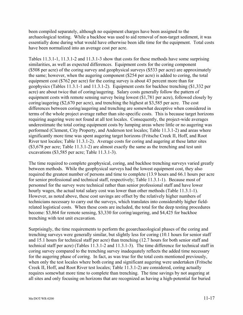
been compiled separately, although no equipment charges have been assigned to the archaeological testing. While a backhoe was used to aid removal of non-target sediment, it was essentially done during what would have otherwise been idle time for the equipment. Total costs have been normalized into an average cost per acre. Tables 11.3.1-1, 11.3.1-2 and 11.3.1-3 show that costs for these methods have some surprising similarities, as well as expected differences. Equipment costs for the coring component ($508 per acre) of the coring survey and geophysical surveys ($533 per acre) are approximately the same; however, when the augering component ($254 per acre) is added to coring, the total equipment cost ($762 per acre) for the coring survey is about 43 percent more than for geophysics (Tables 11.3.1-1 and 11.3.1-2). Equipment costs for backhoe trenching ($1,332 per acre) are about twice that of coring/augering. Salary costs generally follow the pattern of equipment costs with remote sensing survey being lowest ($1,781 per acre), followed closely by coring/augering ($2,670 per acre), and trenching the highest at $3,585 per acre. The cost differences between coring/augering and trenching are somewhat deceptive when considered in terms of the whole project average rather than site-specific costs. This is because target horizons requiring augering were not found at all test locales. Consequently, the project-wide averages underestimate the total coring equipment costs by lumping areas where little or no augering was performed (Clement, City Property, and Anderson test locales; Table 11.3.1-2) and areas where significantly more time was spent augering target horizons (Fritsche Creek II, Hoff, and Root River test locales; Table 11.3.1-2). Average costs for coring and augering at these latter sites ($3,678 per acre; Table 11.3.1-2) are almost exactly the same as the trenching and test unit excavations ($3,585 per acre; Table 11.3.1-3). The time required to complete geophysical, coring, and backhoe trenching surveys varied greatly between methods. While the geophysical surveys had the lowest equipment cost, they also required the greatest number of persons and time to complete (13.9 hours and 66.1 hours per acre for senior professional and technical staff, respectively; Table 11.3.1-1). Because most of personnel for the survey were technical rather than senior professional staff and have lower hourly wages, the actual total salary cost was lower than other methods (Table 11.3.1-1). However, as noted above, these cost savings are offset by the relatively higher numbers of technicians necessary to carry out the surveys, which translates into considerably higher field-related logistical costs. When these costs are included, the total for the deep testing procedures become: $3,864 for remote sensing, $3,330 for coring/augering, and $4,425 for backhoe trenching with test unit excavation. Surprisingly, the time requirements to perform the geoarchaeological phases of the coring and trenching surveys were generally similar, but slightly less for coring (10.1 hours for senior staff and 15.1 hours for technical staff per acre) than trenching (12.7 hours for both senior staff and technical staff per acre) (Tables 11.3.1-2 and 11.3.1-3). The time difference for technical staff in coring survey compared to the trenching survey inadequately reflects the added time necessary for the augering phase of coring. In fact, as was true for the total costs mentioned previously, when only the test locales where both coring and significant augering were undertaken (Fritsche Creek II, Hoff, and Root River test locales; Table 11.3.1-2) are considered, coring actually requires somewhat more time to complete than trenching. The time savings by not augering at all sites and only focusing on horizons that are recognized as having a high-potential for buried
Mn/DOT/WR-0200 11-17

cultural material are a direct consequence of the design of the coring/augering procedure. However, as discussed previously, augering only defined target horizons, while efficient, also can (and did) result in a lower effectiveness of the process because subtle soil horizons that included low density archaeological deposits were missed at the Clement locale (Chapter 8.0). The cost results clearly show that augering target horizons to test for the presence of archaeological materials is an expensive part of the process. It is, however, also essential to the method if buried archaeological deposits are to be found because, as discussed previously, the probability of finding archaeological material within a small diameter core alone, particularly from relatively low-density archaeological deposits, is quite small. For both the trenching and coring, archaeological testing is labor intensive and adds considerable time and cost. Although testing of target horizons is a requirement and cannot be eliminated from the coring process, formal excavation of archaeological test units adjacent to the backhoe trenches is not necessarily integral to the trenching process. In fact, more time was spent excavating the test units during the trenching procedure than was put into establishing the geomorphology, sedimentology, pedology, or other parts of the geoarchaeological framework. While this may seem appropriate given that the primary goal of deep testing is to discover evidence of a buried archaeological site, such expenditure can be justified only if significantly more archaeological information related either to site age, integrity, or formation processes is gained by excavating test units. The results of this study demonstrate that comparatively little archaeologically significant information is gained through the excavation of formal 50 cm × 50 cm (20 in × 20 in) archaeological test units. Even the more ambitious goal of placing the archeological deposits into their proper stratigraphic, chronological, and environmental framework is not improved by the test unit data. Yet, increasing the size of the test units to gain more information would increase labor costs exponentially. If the goal of deep testing is primarily to discover whether buried archaeological deposits occur within a project area, then test units are unnecessary. In all instances in which archaeological materials were identified in this study, artifacts (bone, fire-cracked rock, lithics, and/or ceramics) and contextual information concerning the articulation of archaeological horizons with the local stratigraphy and sedimentology were recovered directly through careful inspection of the trench profile walls or by carefully peeling-back thin layers of sediment from stratigraphic horizons. While additional materials were recovered from the test units, their stratigraphic relationship was not always clearly defined in plan view and, because they represent a point based sample, at times test units failed to recover archaeological material in addition to that observed in the trench profile(s) (e.g., Clement site). Therefore, sampling directly from the trench walls, where stratigraphic relationships and a broader spatial sample are available, affords a greater amount of archaeological information at lower cost. The above discussion does not imply that archaeological input is neither necessary nor desirable during trenching, but rather that traditional archaeological testing methods simply do not add much beyond increased costs to the deep test site identification process. Even if archaeological test units were not excavated during the trenching process, an archaeological presence is crucial to maintain the multidisciplinary perspective integral to successful deep testing. The archaeologist’s time, however, is probably better spent working closely with the geoarchaeologists in examining and reconstructing archaeological information from the trench
Mn/DOT/WR-0200 11-18

wall profiles. Eliminating the formal test units from the process will reduce field costs because an archaeological field technician will not be required. Nevertheless, a senior staff archaeologist should be part of the trenching team. Costs for archaeological field time will probably be approximately that shown for the geoarchaeologists (Table 11.3.1-3). 11.3.2 Summary The costs of the deep test procedures employed in this study are summarized in Table 11.3.2-1. It clearly shows that, from a cost standpoint only, limited differences exist between the methods. This is particularly true when comparing the costs of trenching without test unit excavations ($3,699) with coring/augering, which falls somewhere between the average cost for all test locales ($3,330) and the average cost for test locales where augering was actually performed ($4,538). While geophysical survey was least expensive to implement in the field, it has high logistical costs, which ultimately negate the relatively low price of implementation ($3,864). Table 11.3.2-1 Summary Costs for Deep Test Methods
Implementation4
Cost/acre Logistical5 Cost/acre
Total6 Cost/acre
Geophysical Survey(average of all locales; see Table 11.3.1-1 ) $2,314 $1,550 $3,864
Coring/augering/screening(average of all locales; see Table 11.3.1-2) $2,670 $660 $3,330
Coring/augering/screening2
(average at 3 selected sites; see Table 11.3.1-2) $3,678 $860 $4,538
Coring only (without augering/screening)3
(average of all locales; see Table 11.3.1-2 ) $1,985 $480 $2,465
Augering only (without coring)3
(average of all locales; see Table 11.3.1-2 ) $685 $180 $865
Trenching and test unit excavation
(average of all locales; see Table 11.3.1-3) $3,585 $840 $4,425
Trenching with on-site archaeologist but no test unit excavation1
(average of all locales; see Table 11.3.1-3) $3,048 $570 $3,699
Notes: 1 Costs/acre includes trenching only, excluding test unit excavation. 2 Costs/acre based on estimates from test locales where significant augering (>1 hour) was performed (Fritsche
Creek II, Hoff Deep, and Root River test locales). 3 Same as Note 2. Costs/acre reflect only the augering and screening processes. Costs related to coring removed
from estimates. 4 Per acre cost to implement survey (excludes field expenses; in dollars). 5 Per acre cost for lodging and meals needed to implement survey (in dollars). 6 Total per acre cost for implementation and logistical costs of the survey (in dollars) Given the negligible cost differences, then effectiveness at 1) finding sites and 2) explaining why a site is present (or absent) are the primary considerations for the development of a deep test protocol. This research has shown that while geophysical survey methods can be effective in mapping archaeological features, they also regularly give false-negative and false-positive identification of archaeological features. This issue, coupled with the site-specific environmental constraints of each of the geophysical survey methods tested, makes remote sensing inappropriate as a reliable and regular component in the site discovery process. However, geophysical survey methods do have an important role to play in the non-destructive mapping of
Mn/DOT/WR-0200 11-19

known buried deposits across a site, evaluation of subsurface conditions, and finding and mapping near-surface cultural features. This study also demonstrates that coring and trenching are the most reliable techniques for discovering and evaluating buried archaeological sites, and each has its own strengths and weaknesses. Coring better maps the extent of buried horizons, particularly if well-developed, across the landscape, with minimal impact to archaeological deposits. However, it is less able to find subtle soil and sedimentary horizons. In contrast, the relatively long profiles afforded by backhoe trenching are ideal to uncover many of the subtle soil and sedimentary horizons typical in accreting alluvial landforms, as well as reveal any related cultural material and features. From a practical standpoint trenching is limited to maximum depths of 3 m to 4 m (10 ft to 13 ft), and detailed study of profiles deeper than about 2 m (6.6 ft) is also substantially more complicated because of safety regulations. In these cases, coring has an advantage. Nevertheless, the critical fact that buried deposits/target horizons were discovered during the trenching at Clement and Anderson but were not found during coring help establish the roles that trenching and coring should have in the deep test protocol described in detail and discussed in Chapter 12.0 below. 11.4 EVALUATING THE EFFECTIVENESS OF ALTERNATIVE DEEP TEST
METHODS The above discussion and the cost analysis conclude that backhoe trenching is the best method for discovering buried archaeological sites under most circumstances, as only trenching was effective in identifying buried archaeological deposits associated with ephemeral soil and depositional horizons. Both coring/augering and trenching, however, were more reliable than remote sensing methods, which simply left too many unanswered questions concerning possible buried archaeological deposits. The central position advocated in our proposed deep-test protocol is the emphasis on multidisplinary approaches to buried site discovery and evaluation. However, some may argue that such an approach goes beyond the reasonable and good faith efforts stipulated by federal and state historic preservation legal mandates. The methods typically proposed as alternatives to the mechanized, technologically sophisticated deep test methods applied to this study (i.e., mechanical coring/augering, backhoe trenching, and remote sensing survey) typically are divorced from geoarchaeology and include ostensibly cheaper techniques such as hand or power augering assessments, hand excavation of measured test units, or sometimes even just deep shovel tests using bucket augers with extensions. Except for hand-excavated deep test units, these methods mimic shovel testing coverage and are subject to the same critiques and limitations that constrain the density of coverage, placement, and effectiveness of shovel tests (e.g., Kintigh 1988; Krakker et al. 1983; McManamon 1984; Nance and Ball 1986, 1989; Shott 1985, 1989). Although we have focused on evaluating the costs and outcomes of deep testing with methodologies that are consciously multidisplinary, some elements of the methods employed also provide insight into the relative costs related to alternative testing techniques. For example, by separating the augering phase of the coring procedure, the relative costs associated with simple subsurface testing for archaeological material using only power-augering equipment and without any geoarchaeological input can be calculated. A breakdown of the costs to conduct field work (report and analysis costs are not included) is shown in Table 11.4-1. It is based on a
Mn/DOT/WR-0200 11-20

calculated “minute per meter” (vertical) cost for augering and screening sediment at the test locales (Fritsche Creek II, Hoff Deep, Root River) where augering and screening of target horizons took place (Table 11.3.1-2). Estimates shown on the table assume a 3-m (9.8-ft) thick alluvial sequence will be augered with one auger excavated and screened at each grid point on either a 10-m (32.8-ft) or 15-m (49.2-ft) interval grid.
Table 11.4-1 Projected Time and Cost for Augering and Screening Three Vertical Meters of Sediment Fritsche Creek II Hoff Deep Root River 10 m
Intervals(36/acre)
15 m Intervals(16/acre)
10 m Intervals (36/acre)
15 m Intervals (16/acre)
10 m Intervals (36/acre)
15 m Intervals (16/acre)
Rate to auger & screen (minutes/meter) 25 25 22 22 8 8 Total Hours projected for completion 45 20 39.6 17.6 14.43 6.4
Equipment costs ($43.75/hr) $1,969 $875 $1,732 $770 $630 $280 Operator costs ($40/hr) $1,800 $800 $1,584 $704 $576 $256
Senior Archaeologist costs ($46.24/hr) $2,081 $925 $1,831 $814 $666 $296 Logistical costs ($100/day) $1,120 $500 $990 $440 $360 $160
Total Costs Per Acre $6,970 $3,100 $6,138 $2,728 $2,332 $992
Summary of Average Costs Per Acre for 10-m and 15-m Interval Grids 10 m Intervals
15 m Intervals
Average cost per acre (3-m thick sequence) $5,146 $2,273 Average cost per acre (2-m thick sequence) $3,410 $1,510
For comparative purposes, the average per acre costs for the 3-m (9.8-ft) thick example and the 2-m (6.6-ft) thick example (calculations not shown) are shown at the bottom of the table. Moreover, because wages and equipment rates are based on those used throughout this project, augering and screening costs can be directly compared with the other methods used in this study. For example, per acre costs to auger and screen a 3-m (9.8-ft) thick alluvial sequence using a 10-m (32.8-ft) interval grid across one acre range from $6,970 to $2,332 and average $5,146 while costs for a 15-m (49.2-ft) interval grid range from $3,100 to $992 and average $2,273 (Table 12.2.2-1). Similarly, averages for a 2-m (6.6-ft) thick alluvial sequence are $3,410 for augers at 10 m (32.8 ft) intervals and $1,510 for augers at 15 m (49.2 ft) intervals (Table 11.4-1). These data appear to show that costs for augering at 15 m (49.2 ft) intervals are significantly less than the other methods employed in this study (Table 11.3.2-1). However, this efficacy is more apparent than real. The cost of grid-wise data collection by augering is controlled mainly by sampling density (i.e., grid spacing). Deep testing using the augering and screening methods can be considerably less expensive when using a sampling grid employing 15 m (49.2-ft) intervals than a 10-m (32.8-ft) interval grid because fewer data points are required (16 verses 36 data points, respectively). For example, the projected average cost for 3-m (9.8-ft) deep augers placed at 15 m (49.2 ft) intervals is $2,273 per acre while for 2-m (6.6-ft) deep augers it is only $1,510. While the apparent cost savings are considerable, data collected using such a spacing interval may not constitute a “reasonable and good faith” (36 CFR § 800.4[b][1]) deep testing effort. This is suggested based on the differences between the area of a standard 30-cm (12-in) diameter shovel
Mn/DOT/WR-0200 11-21

test (ca. 707 cm2) and that of a 4-in or 5-in (10-cm or 13-cm) flight auger (ca. 81 cm2 and 127 cm2, respectively). Statistically, the probability of intersecting an archaeological target of a specific size is directly related to the size of the sample area (Kintigh 1988; Krakker et al. 1983; Nance 1983; Nance and Ball 1986; Shott 1985, 1989) and, the larger the sample area, the more likely an archaeological target will be found. In order to apply the same probability statistics commonly used to determine shovel test spacing, each auger location (grid point) would have to be augered between five and six times (5.6 augers) with a 5-in (13-cm) flight auger and nearly nine time (8.7 augers) with a 4-in (10-in) flight auger. If the goal of applying the simpler alternative method is to reduce costs, however, even merely increasing the sample size to two augers at each grid location (32 total augers) to obtain 162 cm2 (4 in [10 in] auger) or 254 cm2 (5 in [13 cm] auger) of coverage at each grid point would cost $4,546 if a 3 m (9.8 ft) depth is augered. This negates all cost saving compared to trenching and to the average coring and augering costs at the three sites where significant augering and screening took place, the two most successful geoarchaeological methods employed in this study (Table 11.3.2-1). An even simpler sampling technique that is often advocated for deep testing is hand-coring and screening sediment samples collected using a standard 3-in (7.6-cm) or 4-in (10.2 cm) bucket auger. Such a technique has been advocated, as well as criticized, by many (e.g., Hoffman 1993; Howell 1993; McManamon 1984; Schuldenrein 1991; Stafford 1998; Stein 1986, 1991). Hand-augering is tantalizingly simple and ostensibly economical because it can be accomplished by one person and requires only inexpensive hand equipment. Although no hand augering was performed for this project, time can be approximated based on the rate of power augering and screening. For example, if the average rate of 20 minutes per meter for the power augering and screening process is assumed to be about twice as fast as hand augering, then per acre costs for the bucket auger techniques can be approximated and are shown on Table 11.4-2. The projected costs for hand (bucket) augering and screening is based on a rate of 40 minutes per vertical meter (i.e., twice as slow as the average rate of power augering methods shown in Table 11.4-1).
Table 11.4-2 Projected Cost Estimates for Hand Bucket Auger and Test Unit Excavations Projected Costs for Bucket Auger and Screening Projected Costs for Test Unit and Screening
10-m Interval Grid
15-m Interval Grid 1.0 m3
per day 0.5 m3
per day Average cost per acre
(3-m deep auger) $4,229 $1,880 Archaeologist (senior) $1,480 $2,959
Average cost per acre (2-m deep auger) $2,820 $1,255 Archaeologist (technicians) $3,769 $7,538
Average per acre costs (6 units per acre) $7,649 $15,297
Notes: 1) 10-m interval grid assumes 36 augers per acre and 15-m grid interval grid assumes 16 augers per acre. 2) Costs for bucket auger and screening include one senior archaeologist at $46.24/hour and logistical costs for food and lodging at $100/day. 3) Hand excavated test units assume 1 m x 1 m units that are 2 m deep and 6 units per acre; Test units excavated by 3 teams of 2 archeologists per team; senior archaeologist assumed a part of one excavation pair. 4) Costs for test unit and screening includes one senior archaeologist at $46.24/hour, five technicians at $23.56/hour each and logistical costs for food and lodging at $100/per person per day.
Mn/DOT/WR-0200 11-22
As was true for the “power augering and screening only” procedures (Table 11.4-1), costs for hand augering are calculated assuming that one auger is excavated and screened at each grid point on both 10-m (32.8-ft) and 15-m (49.2-ft) interval grids and 2-m (6.6-ft) and 3-m (9.8-ft) auger depths. Given that hand augering was not performed during this study and the projected costs are based on these broad assumptions, they should be considered estimates and probably reflect minimum times required for one person to hand-auger and screen a typical acre. Time would probably be considerably more within clay-rich deposits (such as Hoff Deep) but may be less within sandy dune deposits (such as Anderson). Variably textured deposits that commonly include rocky and cobble-rich horizons typical of alluvial and colluvial fans (such as Fritsche Creek) would probably also be greater because many auger holes may be not be able to penetrate the complete 2-m or 3-m (7-ft or 10-ft) profiles required to complete the testing. Even with these considerable caveats in mind, the projected cost and time estimates in Table 11.4-2 are still useful for comparative purposes. Ostensibly the least expensive procedure, projected costs for hand (bucket) augering are actually only slightly less than equivalent “power augering and screening only” costs. For example, costs for both techniques differ by about 17 percent for 3-m (6.6-ft) deep augers collected on a 10-m (32.3-ft) interval grid despite the differences in personnel and equipment (Tables 11.4-1 and 11.4-2). Similar differences separate the two methods from other sampling schemes. Compared to the backhoe trenching (without test unit excavation) and coring/augering procedures, which were deemed the most effective for buried site discovery in this study, the hand augering methods could potentially yield significant costs savings (i.e., up to 66 percent less than trenching without test unit excavation; compare Tables 11.3.2-1 and 11.4-2). This large discrepancy in cost between the two methods is only true if hand augering surveys collect subsurface information from the largest sampling interval and shallowest auger holes used for these projections (15-m [49.2-ft] interval grid and 2-m [6.6-ft] deep augers). As discussed previously, such a widely spaced sampling interval is probably inadequate for discovering buried deposits because of the small sample size (i.e., a 4-in [10.2-cm] with a sample area of 12.6 in2 [81 cm2] or a 3-in [7.6-cm] bucket auger with a sample area of 7.1 in2 [46 cm2]). To approximate the area of a standard 30-cm (12-in) diameter shovel test would require a ca. nine-fold to fifteen-fold increase in the number of auger samples at each node. Cost projections, however, indicate that even approximately doubling the number of auger samples again negates any real cost savings, because excavating bucket augers at 10 m (32.8 ft) intervals to a depth of 3 m (9.8 ft) exceeds the cost of backhoe trenching (Tables 11.3.2-1 and 11.4-2). Even beyond discussion of the adequacy of deep testing using bucket augers, these data indicate that real cost savings at best are minimal compared to the demonstrably efficient and highly effective backhoe trenching and coring/augering procedures employed for this project. Hand excavation of archaeological test units, which is sometimes suggested to test for buried archaeological deposits in deep testing locales, was actually a part of the trenching procedure in this study. It was included to study whether some level of site evaluation could be effectively performed as part of the trenching procedure, but was deemed not useful because little additional useful information was added by the procedure. Moreover, it is quite costly. Even with the aid of a backhoe to remove intermediate layers, just testing discrete target horizons took more time than all of the geoarchaeological evaluation of the trench itself. On average, over 32 person hours were spent in excavation of 50 cm × 50 cm (20 in × 20 in) test units and cost an average of
Mn/DOT/WR-0200 11-23

$1,124 per acre (Table 11.3.1-3). If these costs are projected to a per acre cost for 1 m × 1 m (3.3 ft × 3.3 ft) units (four times the area of 50 cm × 50 cm [20 in × 20 in] units) they would increase to just over $4,500, which far exceeds the cost of any other method investigated (Table 12.2.2-1). Even the $4,500 cost estimate likely vastly underestimates the full cost of testing for buried deposits using traditional archaeological test unit excavation methods because these test units only involved the excavation of selective, often less than 20-cm (8-in) thick, horizons. For example, two cost projections are included in Table 11.4-2. One is based on a productivity rate of one-half cubic meter per day for a team of two archaeologists, while the other assumes that units can be excavated at a rate of one cubic meter per day for a two-person dig team. Both scenarios, which assume six test units per acre (a ca. 25-m [82-ft] interval grid), are vastly more costly than any other method tested during this research. Hand excavation of archaeological test units is simply not efficient or cost effective for deep testing. Yet, throughout this report we have argued that cost cannot be the only criterion on which to base a deep test protocol. Suppose that hand augering and/or power augering are, in fact, demonstrably cost effective methods of deep testing. And, suppose that during a hypothetical project multiple augers prove to contain deeply buried archaeological materials. What would be the next step in this project? We contend that in the absence of contextual information about the stratigraphy and paleo-landscape, which augers cannot accurately provide, additional investigations would be recommended for most any buried site to evaluate its National Register eligibility. This would involve test unit excavation, backhoe trenching (or coring/augering), or a combination of both. And, unless the principal archaeologist leading the investigations was also highly trained in the geosciences, most archaeologists would choose to have a geoscientist involved in the evaluation. We ask, why postpone the inevitable? On the other hand, what if the augers found no artifacts or maybe one or two arguable pieces of fire-cracked rock or some small pieces of bone and charcoal among the 50 augers excavated? Interestingly, this scenario actually occurred at Fritsche Creek II test locale during this project, when only bone pieces and no lithic or ceramic artifacts were recovered from the cores and augers. It would be simple enough to write up the report and recommend no additional work in the absence of artifacts. Likewise, the arguable fire-cracked rock, bone, or charcoal could be dismissed by emphasizing their non-artifactual attributes and the lack of other artifacts. Yet, no other compelling evidence for the recommendation can be offered, and the risk of a false-negative result is high, as would have occurred at Fritsche Creek II. Conversely, if a “low” threshold for what would constitute further work at such ambiguous locale is maintained, then any savings that may accrue by augering would be either lost or minimal. In contrast to this more simplistic scenario, by using trenching or coring/augering in tandem with a multidisciplinary team of archaeologists and geoscientists, reliable scientific data can be obtained, analyzed, and used to explain why a site likely does or does not exist in a deeply buried context independent of artifactual evidence. While this may seem above and beyond the most basic Section 106 review requirements, for large agencies like Mn/DOT its regular application will be both more reliable and cost-effective over the long run. By having two independent lines of evidence, both the potential for obtaining a false-negative result as well as the need for an eleventh-hour unanticipated agreement to be implemented, as a result of construction-phase discovery, are minimized for the project. In addition, in the event of an unanticipated find, the
Mn/DOT/WR-0200 11-24

agency and project consultants can demonstrate that they have put forth a good-faith and legally and scientifically sound effort for site discovery.
Mn/DOT/WR-0200 11-25