Embed Size (px)
Citation preview
34 35
COMPARATIVE ANALYSIS OF THE USA/ USSR MARITIME BOUNDARY AGREEMENT OF 1990 AND TREATY BETWEEN NORWAY AND RUSSIA CONCERNING MARITIME DELIMITATION AND COOPERATION IN THE BARENTS SEA AND THE
ARCTIC OCEAN OF 2010
Boris I. Tkachenko
This article explores the problems of delimitation of maritime economic domain (economic zone and continental shelf) between Russia and the United States in the waters of the Arctic Ocean, the Chukchi and Bering seas and the Pacific as well as between Russia and Norway in the Barents Sea and adjacent waters of the Arctic Ocean; investigates different aspects of the Agreement between the USSR and the United States concerning the line of delimitation of the maritime area of 1990 and the Treaty between Russia and Norway on maritime delimitation and cooperation in the Barents Sea and the Arctic Ocean of 2010.
Keywords: maritime economic border, exclusive economic zone, continental shelf, Russian Federation, United States, Norway, Arctic regions, the Bering and Chukchi seas, the Barents Sea, international maritime law, the Svalbad (Spitsbergen) Treaty.
Separated in time by 20 years international agreements, concerning delimitation of maritime economic dominions (the economic zone and continental shelf) of the USSR and Russia with bordering countries in the East and West of the country, were signed with the USA and Nor-way which involved vast water areas of the Arctic Ocean (Arctic Zone) and also those of the Pacific Ocean. In this regard analysis of the gen-
Asia-Pacific Journal of Marine Science&Education, Vol. 2, No. 2, 2012, pp. 35-69

36 37
eral and particular is of a practical interest in delimitation of the Arctic Zone in these international agreements.
“The USA/USSR Maritime Boundary Agreement of 1990”[1] (herein after referred to as Agreement of 1990) was signed in Wash-ington on the 1st of June 1990 by the Order of the then President of the USSR M.Gorbachev, by E. Shevarnadze, the former Minister of Foreign Affairs of the USSR, during his state visit in the USA from the 30th of May to the 04th of June 1990. It was signed by Secretary of State of the USA James Baker on the part of the USA.
This Agreement demarcated the economic zone and continental shelf between the USSR and USA in water areas of the Arctic Ocean, the Chukchi and Barents Seas, and also the Pacific Ocean. The Agree-ment was in contradictions to national interests of the USSR and Russia because it stipulated a considerable cession of the economic dominions zone in favour of the USA on the part of the USSR in the region of the Bering Sea and Pacific Ocean, and also of the soviet economic zone in the Arctic Region.
There were two main problems during the process of preparation of the USA/USSR Maritime Boundary Agreement of 1990. First, the eco-nomic zones of the USSR and USA mutually overlapped each other in a number of maritime regions because the distance between their coasts is not less than 400 miles. In the Barents Sea the general square of their overlap was about 760 thousand square kilometers, and in the Chuk-chee Sea it was about 600 thousand square kilometers. Second, there was a considerable by size region of waters of the high seas surrounded by these zones from all sides, so called ‘a blue zone’, in a central part of the Bering Sea, outside the economic zones of the USSR and USA. The distance between the coasts of the USA and the USSR is more than 400 miles here, but less than 700 miles. Continental shelf in ‘a blue zone’ belonged both to the USSR and USA.
Therefore, a problem of delimitation arose between the USSR and USA in accordance with International Maritime Law of a disputable economic zone and disputable continental shelf outside the economic zones of both countries.
International Maritime Law (Convention of 1958 [2] and 1982 [3,504] years) stipulates the agreement of Parties, taking into account special cir-
Boris I. Tkachenko

36 37
cumstances and also a median line as a borderline while delimitating mari-time economic dominions between states with opposite or adjacent coasts.
In the Agreement signed by E. Shevarnadze and J. Baker (Articles 1 and 2) a line marked in the Russian-American Convention of 1867 concerning cession by Russia to the United States of America of its dominions in North America, including Alaska, the Aleutian and other Islands in the northern part of the Pacific Ocean and in the Arctic seas, was unlawfully taken as a basis of delimitation of the economic domin-ions in the water areas of the Pacific and Arctic Oceans as a special cir-cumstance, as a western borderline of dominions to be ceded, because this line did not determine a maritime boundary between both countries outside territorial waters but just demarcated the sea water areas within which dry land territories were to be ceded to the USA, namely, exclu-sively islands, no more than that, and also Alaska. Moreover, no official map of delimitation was attached to Convention of 1867, and there was no distinct unique description of this borderline concerning the Bering Sea in the text of Convention and only locations of three midpoints were fixed dividing Russian and American dominions of dry land ter-ritories in the Pacific Ocean and locating in the equal distance between them in the marked regions, namely, between Chukotka and Alaska in the Bering Strait, between Chukotka and Saint Lawrence Island in the Bering Sea, and also between the Komandorskie and Aleutian Islands. The coordinates of these midpoints were not fixed securely sufficiently as it is accepted in geodesy and cartography. Only their general location was determined but not the coordinates of concrete points formed by concurrence of lines of latitude and longitude. A general southern-west-ern direction of the boundary passage of Russian territories to be ceded in the Bering Sea, resulted from the text of Convention of 1867, at the same time three midpoints were fixed. On the contrary, according to Convention of 1867, the borderline of the territories to be ceded passed via the point in the Bering Strait in the Arctic Ocean and directed in the straight line to the north unlimitedly[4].
The use of the line of Convention of 1867 was clearly unprofitable for the USSR (and Russia) because this line considerably deviated to the west from the midpoint between the opposite territories of both countries dry land, namely, in the direction of the soviet (Russian) coast.
Comparative Analysis of the Arctic Maritime Boundary Agreements between USSR-USA and Russia-Norway in 1990 and 2010 Respectively

38 39
It is shown clearly in the attached map-scheme (Figure 1) performed in the general cartographic (conical) projection that the line, described in Article I of Convention of 1867 as ‘the western borderline of the do-minions to be ceded’ and determined by Clause 1 of Article 1 of 1990 Agreement as ‘ the maritime boundary between the USSR and USA’ with changes determined in Article 2 of the Agreement, namely, the de-marcation line of the economic zone and continental shelf between the USSR (Russia) and USA, graphically depicted by the solid broken line
“а–1–2–б–в–г–д–3–е”, deviates from the midpoint, graphically depict-ed by the dashed wavy line “и–1–2–к, л–м, н–3–о”. As a result, 70 % of the water area of the Bering Sea were under the jurisdiction of the USA.
Eventually, a lot of 200 miles Soviet economic zone in the Bering Sea (‘Eastern special region’), graphically depicted by the sector “в–г–к” (region “В”), was ceded to the United States of America. Its square is 7.7 square kilometers according to V. Zilanov’ data[5]. Such state of things is in contradiction to UN Convention on the Law of the Sea, laws of both the former USSR and today’s Russia, even laws of the USA themselves. Cession of the maritime region did economical damage to the interests of the USSR and Russia. While delimitating economic dominions in the Bering Sea, economically important resources (bio-logical, geological, chemical, energetic ones and others) of this consid-erable maritime region would have belonged to the USSR (and Russia) in accordance with standards of International Maritime Law (UN Con-vention on the Law of the Sea of 1982). Formerly it was a part of 200 miles economic zone of the USSR and was intensively used for fishing.
As opposed to the second large region of Soviet economic zone in the Arctic Regions, gifted to Americans, that is constantly covered with moving ice and therefore is of direct practical interest only in the long view, the sea surface in ‘Eastern special region’ of the Bering Sea does not freeze. This lot of the sea has favorable conditions for fishery and is one of the main traditional lots of work for Soviet Fishing Fleet. Here Soviet fishing vessels annually caught about 150 thousand tons of valu-able fish species, including: Alaska Pollack of about 120 thousand tons, herring of about 20 thousand tons, codfish and other species of about 10 thousand tons[6]. Besides, the ceded ‘Eastern special region’, located in the Bering Sea, is abundant not only with fish resources, but is also a
Boris I. Tkachenko

38 39
potentially, specially rich oil-bearing zone. Evaluation of its resources, according to American experts’ data, was about 200 million tons of oil and 200 billion cubic meters of gas[7].
Soviet party, having agreed to the proposal of American party con-cerning use of the line of Convention of 1867 as a special circumstanceto delimit fishing zones of both countries in the disputable (mutually overlapping) regions in 1977, chose a clearly unprofitable variant in the Bering Sea for the USSR.
Figure 1. Delimitation of the economic zone and continental shelf between Russia and the USA in the waters of the Arctic Ocean, the Chuckchee and the Bering Sea and the
Pacific Ocean under the Agreement of 1990 and along the median line.
Comparative Analysis of the Arctic Maritime Boundary Agreements between USSR-USA and Russia-Norway in 1990 and 2010 Respectively

40 41
As for free space in the central part of the Bering Sea “a blue zone“ of the square of about 175 thousand square kilometers, located outside 200-mile economic zones of the USSR and USA, but surrounded by these zones, only the USSR and USA can claim for resources of the continental shelf. The USSR received considerably less that it could have claimed for, according to Agreement of 1990, while demarcat-ing the continental shelf in ‘a blue zone’ by method of a median line, namely, a lot graphically depicted by a figure “д–т–н–с” to the west from the line of Convention of 1867, the square of only 4.6 thousand square kilometers (according to V. Zilanov’s evaluation) [8], and the USA received all the rest.
Concrete territorial and economic losses of our country due to con-clusion of this Agreement are in prospect to be evaluated. Specialists in the field of cartography will have to carry out calculations of demarca-tion lines and squares of maritime territories ceded by the Agreement, in comparison with the variant of delimitation as if it was carried out by method of a median line [9].
Numeric data concerning losses of maritime economic dominions (exclusive economic zone and continental shelf) of the USSR and Russia, referred to in various sources, are very much different from each other.
Even according to previous experts’ evaluations, 54.6 square kilo-meters of disputable territories in the economic zone which not only the USA but the USSR (Russia) could have claimed for, according to In-ternational Maritime Law, were ceded to the United Stated of America due to this agreement. The disputable regions are abundant with fish, oil and gas. Besides, the USSR received 74 thousand square kilometers of the continental shelf less than it could have been entitled for in case of a traditional demarcation by a median line.
Delimitation of the disputable maritime space, overlapped by 200-miles economic zones of both countries, and also of the continen-tal shelf outside their limits, by a median line while using optimally Russian-American Convention of 1867, Geneva Convention concern-ing continental shelf of 1958 and UN Convention on the Law of the Sea of 1982, would have provided the Russian Federation, according to estimates, with additional 100 thousand square kilometers of the con-tinental shelf [10], and in case of delimitation without taking account
Boris I. Tkachenko

40 41
small islands of both countries – Russia and the USA in the Bering Sea, that is admitted by International Maritime Law, it would have provided with much more. The question is about 40 thousand square miles (about 137 thousand square kilometers) of the ocean and sea bottom accord-ing to the resolution of the parliament of the State of Alaska (the USA) on Russian-American negotiations concerning maritime boundaries House Joint Resolution (HJR) 27, adopted in June 1999.
Such are territorial losses of Russia due to the signing of the Agree-ment of 1990 and its unlawful, early (before ratification) implementation.
One should point out that the provision of the Clause 1 of Article 2 of Agreement 1990 concerning the boundary of north-polar dominions (‘the maritime boundary goes to the north…on the Arctic Ocean as far as it is admitted by the international law’) restricts the rights of Russia in the Arctic Regions in comparison with the provision of Article 1 of Russian-American Convention of 1867 (‘the boundary of the territories to be ceded…is directed in the straight line unlimitedly to the north’). The latter provision allows to extend this boundary to North Pole as the extreme point of the north is North Pole, and that was done by Resolu-tion of Presidium of Central Executive Committee of the USSR of the 15th of April 1926 which determined the eastern boundary of Soviet sector in the Arctic Regions from the middle of Strait between Big Dio-mede Island and Little Diomede Island in the Bering Strait to North Pole[11]. Soviet-American Agreement of 1990 allows to do that in the distance within 350 kilometers from baselines at the coast of Russia, namely not to North Pole (90o of the north latitude), but approximately to 77o of the north latitude by meridian of 168 degrees 58 minutes 37 seconds of the western longitude, that is, it actually leads to refusal from Russian sector and Russian polar dominions in the Arctic Regions.
Consequently, the boundaries of the economic zone and continental shelf in the Arctic Regions must be determined along the line stated in Convention of 1867, but in accordance with modern standards of In-ternational Maritime Law according to UN Convention of 1982 taking into account Russian lands and islands.
On the contrary, it is said nowhere concerning ‘the boundary of the territories to be ceded’ as ‘a straight line’ or ‘a line’ in relation to the Ber-ing Sea in the final part of the last paragraph of Article I of Convention
Comparative Analysis of the Arctic Maritime Boundary Agreements between USSR-USA and Russia-Norway in 1990 and 2010 Respectively

42 43
of 1867 cited above. No demarcation map in the region of the Bering Sea was attached to Convention so that it could be used to interpret its text. One can say, to a certain extent, about location of three midpoints. Therefore, Convention of 1867 is not applicable to the section of the dis-putable economic zone and disputable continental shelf to the south of the Bering Strait, in the Bering Sea and the northern part of the Pacific Ocean. Moreover, it is not applicable to delimitate the economic zones of both states being under exclusive national jurisdiction (“Eastern spe-cial regions “ of the USSR and “Western special region” of the USA).
To delimitate the disputable economic zone and disputable conti-nental shelf to the south of the Bering Strait, only the median line be-tween opposite lots of dry land of the territories of both countries- Rus-sia and the USA, passing three midpoints, marked in Russian-American Convention of 1867, must be applied. In case of delimitation along the median line, national jurisdiction of the USSR and USA will be re-tained in the regions of 200-mile economic zones of both countries marked as “Eastern special regions” and “Western special region”, cre-ated artificially and belonged to them in accordance with standards of international law.
The data indirectly state, concerning economic importance of re-sources of the continental shelf in the disputable regions, as follows. It is known from geological science that shelf zones of Arctic and Far Eastern marginal seas (the Laptev Sea, the East Siberian Sea, the Chuk-chi Sea, the Bering Sea, the Sea of Okhotsk), taking space of more than 2 million square kilometers, continental slope and also adjacent to them bottom lots of the Arctic and Pacific Oceans, are the reservoir of enormous mineral resources and are especially perspective for oil and natural gas detection. According to geological science data, 4/5 of pos-sible oil-bearing basins are partially or totally located in the water areas in the Northern East, and forecast reserves of carbohydrates, according to data of Sakhalin complex Research and Development Establishment of Far Eastern Scientific Center of Academy of Science of the USSR as of 1980, of only perspective regions of Far Eastern shelf zones and con-tinental slope, were estimated as 44 billion tons of oil and 28.6 trillions of cubic meters of gas, amounting to 16 per cents of forecasted world resources. Besides oil and gas, at the bottom of the ocean in these wa-
Boris I. Tkachenko

42 43
ter areas there are ferro manganese ore nodes for the future. The main economic problem of delimitation of sovereign rights for resources of the economic zones and continental shelf, that is, distribution of rights for potentially oil-bearing regions, and also for mineral raw material resources of the ocean bottom, is solved in the Agreement.
One should keep in mind that the continental shelf at the sea bottom in the eastern part of free space of the Bering Sea, that is not overlapped by the economic zones of the USSR and USA, from which the USSR refused in favor of the USA, is fairly perspective for extraction of oil and gas, and reserves of oil-bearing raw materials here, according to specialists’ estimates, exceed in total the largest ones on the planet from open oil deposits in Kuwait [12]. Oil is the main goal for the USA in achieving the Agreement concerning the maritime boundary of 1990.
Article 3 of the Agreement of 1990 practically means refusal of the USSR and Russia from that part of the continental shelf outside 200-miles economic zones which could have fallen to its share, accord-ing to Article 76 of UN Convention on the Law of the Sea, and, conse-quently, refusal from mineral and other non-living natural resources of the sea bottom and its sub-soils, and also living organisms, relating to ‘sedentary species’ (first of all, crabs and shell fish).
The USSR and USA shared the sea bottom and its sub-soils on the whole space of the Bering Sea along the maritime boundary, determined in Appendix to the Agreement of 1990, including the sea bottom with its sub-soils in its central part, being the open sea. However, according to Article 89 of UN Convention on the Law of the Sea, ‘no state is entitled to claim for subjection of any part of the open sea to its sovereignty[3, 509]. The matter of limits of the continental shelf in the central part of the Bering Sea in accordance with distance criteria, established in Arti-cle 76 of UN Convention on the Law of the Sea, is subject to specialists’ investigation in the field of geomorphology of the sea bottom, geodesy and cartography. In case of the detailed investigation of this matter, one can be cleared out that there are lots, not being the continental shelf of both countries and being the bottom of seas and oceans outside national jurisdiction in the central part of the Bering Sea that is not overlapped by 200-miles economic zones of Russia and the USA. The point is that this, practically whole region, referred by the Agreement of 1990 to the USA
Comparative Analysis of the Arctic Maritime Boundary Agreements between USSR-USA and Russia-Norway in 1990 and 2010 Respectively

44 45
share, falls on the Aleutian trench by depth of from 3000 to 4000 meters.According to UN Convention on the Law of the Sea, resources (the
solid, liquid and gasiform ones including polymetallic nodules) in this region at the sea bottom or its sub-soils are the general humankind heri-tage (Article 136) [3, 523]. Therefore, the states concerned can argue the Agreement between the USSR and USA concerning the maritime boundary in this part exactly.
The text of the Agreement had not been coordinated before it was signed with the correspondent state authorities of RSFSR, though it directly involved the most important interests of this republic directly. The Agreement directly involves the determination of the maritime state boundary of RSFSR, being a sovereign state, according to the Constitution of the USSR 1977 and Constitution of RSFSR of 1978, and the boundary of the maritime economic dominions – the exclusive economic zone and continental shelf.
The Agreement was subject to ratification by the Supreme Soviet of the USSR. However, it was implemented since the 15th of June 1990 in circumvention of the acting legislation in the USSR by announce-ment, while its signing on the 01st of June 1990, of the concurrent note of Minister of Foreign Affairs E.Shevarnadze in answer to the note of Secretary of State of the USA J. Baker, namely, before ratification by legislative bodies and before its official implementation on the day of exchange of ratification instruments, that is in contradiction to Article 7 of the Agreement of 1990 concerning the procedure of implementation.
This Agreement could not have been implemented early (before rat-ification) by the note of Ministry of Foreign Affairs of the USSR even upon coordination with the government of the USSR because there was no special permit of the Supreme Soviet of the USSR. There was also no resolution of legislative authorities of the Russian Federation.
After the Agreement was signed, some matters arose in commis-sions of the Supreme Soviet of the USSR, which prepared ratification, and the agreement was not ratified during the period of existence of the Supreme Soviet of the USSR. The Russian Federation did not ratify this Agreement because of non-unique evaluation of its accordance with interests of Russia, including those in the field of fishing.
Boris I. Tkachenko
44 45
On the 7th of February 1997 the State Duma of the Russian Federation rejected by its resolution a project of Federal law ‘Concerning Prolonga-tion until the 30th of June 1997 of the Period of the Temporary Implemen-tation by the Russian Federation of the USA/USSR Maritime Boundary Agreement of 1990’ which had been brought in the order of legislative initiative by President of RF B.Eltsin. President of the Russian Federa-tion B.Eltsin was recommended to entrust Ministry of Foreign Affairs of the Russian Federation to perform procedures stipulated by Clause 3 of Article 23 of Federal Law ‘Concerning International Treaties of the Russian Federation’ in respect to this Agreement. Therefore, so far any legal basis to adhere to the agreement of 1990 by Russia has been absent.
Russia must inform the USA through the diplomatic channels about the fact that it does not intend to become a participant of the Agreement of 1990 and ceases its temporary implementation. Cessation of such a temporary implementation can be carried out after the date of service of the correspondent note to the government of the USA. In this case the temporary implementation of the Agreement of 1990, which becomes null and void, will cease in full, and Russia will get a possibility to start diplomatic negotiations with the USA concerning new delimitation of the exclusive economic zone and continental shelf in the correspondent water areas of the Pacific and Arctic Oceans taking into account its own national interests. Restoration of the outer boundary of Russian 200-miles economic zones will simultaneously take place in these regions.
According to experts’ estimates, joint losses of Russian fishing branch connected with implementation of the Agreement, as of 2001, amount-ed to 2.8 million tons of fish at the cost of 1.4 billion US Dollars[13].
Taking into account forecast reserves of oil, gas, ferromanganese nodules at the bottom of the ocean in these water areas, and also reserves of bioresources, one can calculate possible losses in perspective (when the development of these oceanic resources becomes possible and justi-fied) and at present. Implementation of this Agreement will deprive Rus-sia of the right to use enormous potential mineral resources in the future.
In view of all the above stated, it is necessary to make practical con-clusions to understand how not to admit mistakes again of the Soviet diplomacy by Russian diplomacy.
Comparative Analysis of the Arctic Maritime Boundary Agreements between USSR-USA and Russia-Norway in 1990 and 2010 Respectively

46 47
First, ten-years negotiations between the USSR and USA (1981—1990) in achieving the agreement concerning the delimitation of eco-nomic dominions in the maritime water areas in the region of the junc-tion of Far East of the USSR and Alaska of the USA, ended extremely infavorably for the Soviet part. Conclusion of a principally more profit-able agreement for us would have been quite real.
Second, an unfavorable result was received due to a dissatisfactory mechanism of making important state decisions in the sphere of foreign policy during the period of ‘perestroika’ by M.Gorbachev who oriented not to effective solution of the problem of international relations in the interests of people and state, but to ensure realization of a state ideo-logical doctrine proclaimed by M.Gorbachev as ‘a new political way of thinking for the whole world’. Subjection of interests of the USSR as a state to interests of political ideology, realized in the foreign politics by a group of M.Gorbachev in Political Bureau of Central Committee of CPSU, occurred. Soviet diplomats ceded a quite considerable, by square, region of oil-bearing shelf of the Bering Sea and the Chuk-chi Sea to the USA because of short-term vision of the higher politi-cal authority of the USSR. While achieving the USA/USSR Maritime Boundary Agreement of 1990, the Soviet party made the same strategic mistake in the process of negotiations with American party as Russian party had made in the process of negotiations concerning cessation to Northern American United States of its overseas territories in North America and Northern part of the Pacific ocean under Russian/Ameri-can Convention of 1867, expecting to achieve a favourable attitude of American party in the interests of ‘de-escalation of international ten-sions, international peace and agreement’ by way of cessation of mari-time economic dominions.
Third, American party defended state interests of the USA in the negotiations. Consequently, Soviet (and Russian) participants of the negotiation process had to defend interests of its own state in relation-ships with American party, using legal weakness in partners’ position during negotiations. Absence of political will, capability to solve mat-ters arisen creatively and flexibly in state interests, strive for achieving the agreement by way of concessions is accepted by foreign partners in international negotiations as weakness and unprofessionalism.
Boris I. Tkachenko

46 47
Fourth, delimitation of 200-miles economic zones as the fishing zones was not the main matter in the negotiations in achieving the USA/USSR Maritime Boundary Agreement of 1990. The main concessions were made not in respect of rights for development of fishing resources but in respect of rights for development of the continental shelf resourc-es (the sea bottom and its sub-soils) being both within 200-miles exclu-sive economic zones and outside them.
Fifth, one should admit that the USA/USSR Maritime Boundary Agreement of 1990 does not meet the long-term national economic and political interests of Russia. It contains evident territorial and economic damage for the interests of Russia as both at present (for fishing) and in the future (for exploitation of resources of the sea bottom and its sub-soils). The final conclusion concerning territorial (maritime economic domin-ions- the exclusive economic zone and continental shelf) and economic losses of Russia must be made by an independent competent commission of specialists in profile of the problem being considered. The commis-sion conclusions should be taken as a basis for decision by Parliament of Russia of the destiny of the signed but not ratified Agreement of 1990.
Sixth, to solve matters concerning delimitation of exclusive eco-nomic zones and continental shelf between Russia and the USA in the Chukchi Sea and the Arctic Regions as a special circumstance to de-limitate the overlapping zones of economic dominions, it is rational to keep the line established by Convention of 1867 in exact coordinates in these water areas. One should emanate from the alternative variant of delimitation in the Bering Sea-delimitation along the median line which does not contradict Convention of 1867 in part of establishment of three midpoints in the Bering Sea and standards of international mar-itime law and is often applied in practice to solve disputable matters of delimitation.
Seventh, it is necessary to solve the matter concerning the restora-tion in full of 200-miles Russian economic zone in that part of its water area where it was reduced under Agreement of 1990. To solve the mat-ter concerning the continental shelf in the central part of the Bering Sea it is desirable to carry out special joint Russian/American consultations including those regarding possible joint investigation, development and exploitation of natural resources of this region.
Comparative Analysis of the Arctic Maritime Boundary Agreements between USSR-USA and Russia-Norway in 1990 and 2010 Respectively

48 49
“Treaty between the Kingdom Of Norway and Russian Federation Concerning Maritime Delimitation and Cooperation in the Barents Sea and the Arctic Ocean”[14] was signed in Murmansk on the 15th of Sep-tember 2010 (hereinafter referred to as Treaty of 2010) by Ministry of Internal Affairs of Russia S. Lavrov and Minister of Foreign Affairs of Norway J. Styore in the presence and by Order of President of Russia D. Medvedev and Prime-Minister of Norway J. Stoltenberg. Norway ratified Treaty of 2010 on the 08th of February 2011, and Russia did on the 25th of March 2011.
This Treaty delimitated the economic zone and continental shelf be-tween Russia and Norway in water areas of the Barents Sea and the Arctic Ocean. The Treaty contradicted national interests because it stip-ulated a considerable cessation of the zone of economic dominions in fa-vour of Norway on the part of Russia in the region of Russian economic zone in the Arctic Regions, namely in the Barents Sea and Arctic Ocean.
There were three main problems in the process of preparation of Treaty between the Kingdom Of Norway and Russian Federation Con-cerning Maritime Delimitation and Cooperation in the Barents Sea and the Arctic Ocean of 2010.
First, economic zones and continental shelf of Russia and Norway mutually overlapped each other in a number of maritime regions as the distance between their coasts is less than 400 miles. The sector of com-mon unshared space formed the disputable economic zone and disput-able continental shelf of both countries.
Second, islands of the region of the Spitsbergen archipelago, that did not belong to anyone before, with coordinates between 10 and 35 degrees of the eastern longitude from Greenwich and between 74 and 81 degrees by the northern latitude in the western part of the Barents Sea, were adopted as being under sovereignty of Norway, outside eco-nomic zones of Russia and Norway by the Spitsbergen Agreement of 1920 ‘on terms stipulated by the present Agreement’ (Article 1 of the Agreement), so that ‘vessels and citizens of all High Contracting Parties (participants of the Agreement) could be admitted on the same grounds to exercise the right for fishing and hunting in places stated in Article 1 and their territorial waters; Norway shall be entitled to keep, take or proclaim measures able to ensure storage and, if it is necessary, resto-
Boris I. Tkachenko

48 49
ration of flora and fauna in the mentioned places and their territorial waters, provided that it is agreed that all these measures shall be always applied on the same grounds to citizens of all High Contracting Parties, without any exceptions, privileges and bonuses in favour of any one of them’ (Article 2 of the Agreement). Article 3 of Spitsbergen Agree-ment stipulated that ‘citizens of all High Contracting Parties shall have the same free access to any goal and task to waters, fiords and ports of locations, stated in Article 1, and the right of staying there; they can deal, without any preventions, upon condition of obeying local laws and resolutions, with all shipping, industrious, mining and trading op-erations on terms of full equality in them; they will be admitted, under the same conditions of equality, to shipping, industrious, mining and commercial business and its exploitation both on the dry land and in territorial waters, at the same time no monopoly can be created in rela-tion to any enterprise’. Therefore, the limited sovereignty of Norway with considerable drawbacks was admitted, namely, only on the dry land of Spitsbergen with adjacent islands within the mentioned geo-graphic boundaries (so called “Spitsbergen quadrate” — in mercator projection or in the form of a trapeze- in a usual cartographic, namely, conic projection). At the same time all participants of the Agreement had equal rights on the archipelago to deal with economic and other activity and in the adjacent waters to it but Norwegians did not have any advantages. Standards of Spitsbergen Agreement, taking into account other standards of international common and contractual law, form the basis of Norway law, to regulate legal relationships by local national legal enforceable enactments in the field of environment protection (of the dry land of archipelago), concerning which the countries, participat-ing in the Spitsbergen Agreement, admitted its sovereignty, and their territorial waters.
Spitsbergen archipelago, concerning which there is a special inter-national agreement, is qualified as a state territory of common use with a special status, and the rights of Norway for the archipelago are deriva-tive from consent for it of all acting participants of Spitsbergen Agree-ment of 1920 according to its provisions.
The USSR became a participant of Spitsbergen Agreement in 1936 and since that time it has acquired equal with Norway rights to deal
Comparative Analysis of the Arctic Maritime Boundary Agreements between USSR-USA and Russia-Norway in 1990 and 2010 Respectively

50 51
with economic or other activity in Spitsbergen region. At present, the participants of Agreement are more than 50 states including the USA, Great Britain, Germany, France, Japan, Netherlands, Denmark, Nor-way, Poland, Italy, Sweden and others. Parliament of Norway admitted in resolution of the 15th of February 1947 that the USSR is a state hav-ing special economic interests in Spitsbergen alongside with Norway.
Third, a system of Arctic sectors has been historically established on the basis of continuous actual delimitation of rights and interests of cor-respondent states of the Arctic Regions (the USSR, Canada, the USA, Denmark and Norway), recognizing their priority in research and de-velopment of various places of the Arctic Region. The Arctic Region is divided into five sectors according to this system, basis of which are the northern boundaries of the mentioned states, collateral borders are me-ridians, and the top is North Pole. All lands and islands located within each sector are included into territories of adjacent states, namely, sov-ereignty of this state is spread on them. By the beginning of XX century this delimitation had won general international recognition and fixation in international law. A common norm of the international law, stipulat-ing distribution of Arctic territories into sectors by principle of their inclination to coasts of subpolar states, had been finally established by 20-s years of XX century.
Rights of Russia for the islands in the Arctic Ocean resulting from the fact of discovery, long possession and development, were proclaimed in September 1916 and were actually recognized by the USA including but not limited to concerning Wrangel Island and Herald Island, by the note of the 20th of November of the same year to the Ambassador of Russia G. Bakhmetyev. The note of Ministry of Foreign Affairs of Rus-sian Empire of the 20th of September 1916 became the first document, determining the status of lands and islands located in Russian Arctic zone, adjacent to Arctic coast of Russia. A provision to include all the lands being the extension of Siberian continental highland, into the ter-ritory of Russian Empire, contained in this note.
These rights were confirmed in the note of People’s Commissariat of Foreign Affairs of the USSR of the 04th of November 1924 in con-nection with attempts of Canada and the USA to entrench themselves in Wrangel and Herald Islands. The Soviet Union confirmed the provi-
Boris I. Tkachenko
50 51
sions of the note of 1916 concerning ownership by Russia of all the lands and islands being the northern extension of Siberian continental highlands, in Memorandum of People’s Commissariat of Foreign Af-fairs of the USSR of the 04th of November 1924, directed by People’s Commissar G. Chicherin to all the states[15].
The importance of the note of MFA of Russian Empire of 1916 and Memorandum of People’s Commissariat of the USSR of 1924 was that they fixed ownership by Russia of the territories, lands and islands be-ing the direct extension of Siberian continental highlands, namely, only of the Asian part of the state.
The matter of Soviet Arctic zone was regulated later thoroughly in Ruling of the Presidium of CEC USSR ‘Concerning Proclamation as Territories of the Union of SSR of lands and islands, located in the Arctic Ocean’ of the 15th of April 1926. Ruling of CEC announced that ‘all both discovered and able to be discovered, in the future, lands and islands are territories of the Union of SSR which have not been, by the moment of publication of the present Ruling, the recognized by Government of the USSR territory of any foreign states located in the Arctic Ocean to the north from the coast of the Union SSR to North Pole within between the meridian 32 degrees 4 minutes 35 seconds of the eastern longitude of Greenwich passing along the eastern side of Vaitolahti via the triangular sign on the Cape Kekursky, and meridian 168 degrees 49 minutes 30 seconds of the western longitude of Green-wich passing the middle of the strait dividing the Big Diomede and Little Diomede Islands of the group of islands of Diomede in the Bering Strait’[16]. This provision of internal Soviet legislation regarding the eastern boundary of the polar dominions of the USSR, from the middle of the Bering Strait to North Pole, was based on bilateral international agreement between Russia and the USA –Convention of 1867, and also international historic practice. In 1935 the USSR officially joined Paris Agreement having established that the western boundary of polar do-minions passed along the meridian 32º 04’ 35”, doubling Spitsbergen archipelago from the east along the meridian 35º of the eastern longi-tude between 74º and 81º of the northern latitude. Ownership by Russia of these territories was not officially argued over a period of ten years by no subarctic countries.
Comparative Analysis of the Arctic Maritime Boundary Agreements between USSR-USA and Russia-Norway in 1990 and 2010 Respectively

52 53
The general square of the polar dominions of the USSR amounted to 5 842 million square kilometers within these limits. Potential of Arctic shelf in the boundaries of Russian polar dominions exceeds 88 billion tons of reference fuel. This exceeds 6 trillion dollars at the present level.
A purpose of sectoral division of the Arctic Regions became quite a grounded strive of subarctic states to give a special status to its coastal regions having the same geographic and climatic characteristics, hav-ing excluded them from effect of common standards of the international law. On the one hand, the Arctic Ocean can be considered as the open sea with the usual international and legal status. But, on the other hand, the Arctic Ocean represents uninterrupted ice surface, in its consider-able part, therefore it can be regarded as a special kind of the state ter-ritory of five subarctic countries of the world which divided this ocean into polar sectors, and all the lands and islands, and also ice surface being within the polar sector of one or another country are included into the state territory.
In the 20s of XX century the customary standard of international law was set stipulating distribution of Arctic territories into sectors by prin-ciple of their inclination to the coasts of subpolar states. This customary standard establishes that the sector is under jurisdiction of a subarctic state and sovereignty of this state is spread on the islands and lands locat-ing in this sector. The arctic sector of each of the states is space the basis of which is the coast of this state, and the lateral line is the meridians from North Pole to the eastern and western boundaries of this state[17].
No objections of non arctic states were expressed in the process of the sector division of the Arctic regions on the basis of national legal acts, that is, it was implicitly recognized and de facto admitted. There-fore, the sector division of the Arctic Regions became the legal standard of the customary international law as the legal custom. Though this sectoral division of the Arctic Region was not legally fixed as the stan-dard of international treaty law in UN Convention on the Law of the Sea of 1982, a peculiarity of Arctic spaces was noted in this Conven-tion. The provisions of Convention do not only deny sectoral division of the Arctic Regions, but stipulate special rights, by Article 234, of the coastal states ‘to take and ensure compliance with non discrimination laws and rules to prevent, reduce and keep under control pollution of
Boris I. Tkachenko

52 53
the marine environment from the vessels in the regions covered with ice within this exclusive economic zone…’[3, 571]. At the same time, lines demarcating lateral limits of polar sectors, are not recognized as the state boundaries from the point of view of the modern international law. Therefore, a contradiction occurred between standards of the cus-tomary and treaty international law concerning the Arctic zone.
The Arctic Regions were not an object of special consideration of III Conference on the Law of the Sea, because the legal regime of the Arc-tic Regions had been established long before Convention of 1982 was adopted, and the main point in the content of this regime is the general international law, its customary standards (international customs) that had been established as a result of consent of the international commu-nity with the practice, national legislation of arctic states.
Therefore, restriction of sovereignty of Norway concerning Spits-bergen zone (standards of treaty international law) and sectoral division of the Arctic Region (standards of the customary international law) are special circumstances which must be taken into account while dividing marine economic dominions of both countries.
In the 1970—1980s a problem of delimitation of the disputable eco-nomic zone and disputable continental shelf outside economic zones of both countries occurred between the USSR and Norway in the Barents Sea in accordance with the international maritime law.
Since 1970 bilateral negotiations between the USSR and Norway had been held in delimitation of the continental shelf in the Barents Sea. In 1975 Norway made a proposal to demarcate continental shelf by principle of equidistance from the correspondent nearest points at the coasts of continental and island territories, that is, along the median line, passing the eastern boundaries of polar dominions of the Soviet Union. Thereby Norway claimed for 155 thousand square kilometers of the water area of the Barents Sea being under jurisdiction of the USSR. The Soviet Union insisted on delimitation of the polar dominions of the USSR along the western boundary announced in 1926 and 1935.
In June of 1977 Norway unilaterally, by Royal Decree, established fish protected zone by width of 200 nautical miles in the region of Spits-bergen archipelago that was not recognized by the USSR and Russia. This Decree did not take into account provisions of Spitsbergen Agree-
Comparative Analysis of the Arctic Maritime Boundary Agreements between USSR-USA and Russia-Norway in 1990 and 2010 Respectively

54 55
ment. This Decree did not guarantee private persons and Companies of all the participants of the Agreement the same scope of rights in this fish protected zone adjacent to the archipelago as in its territorial wa-ters. Implementation of this national normative act represents the direct breach of the First paragraph of Article 3 of Paris Agreement of 1920, stipulating creation of the unified regime of economic activity for these persons in the whole effective zone of Spitsbergen Agreement.
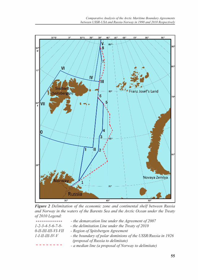
When institute of 200 miles was established in the 1970-80-s of the XX Сentury and UN Convention on the Law of the Sea was adopted in 1982, the subject of negotiation became delimitation of 200-miles exclusive economic zones in the disputable regions. The disputable ma-rine water area consists of two lots: the southern one and northern one with the configuration “1–5–6–II–I–1” and “III–8–IV–III” (marked on Figure 2 by the broken and dashed line) of the square of about 175 thousand square kilometers formed between the boundary of the polar dominions of the USSR of 1926 and ‘the median line’ of delimitation proposed by Norway. In the course of negotiations, the Norwegians were ready to agree to division of ‘the disputable region’ in proportion of 50:50, that was estimated as unjustified and unacceptable by govern-ment of the country in the past.
Principal agreement concerning division of ‘the disputable region’ (so called ‘a grey zone’) was equally achieved in the course of the state visit of the Russian delegation headed by President of Russia D. Med-vedev to Norway in April 2010.
The result of 40-years negotiations was the signing of “Treaty be-tween the Kingdom Of Norway and Russian Federation Concerning Maritime Delimitation and Cooperation in the Barents Sea and the Arc-tic Ocean” by Minister of Foreign Affairs of Russia S. Lavrov and Min-ister of Foreign Affairs of Norway J. Styore in the presence of President of Russia D. Medvedev and Prime-Minister of Norway J. Stoltenberg in Murmansk on September 15, 2010. Norway ratified the Treaty of 2010 on February 08, Russia did on March 25, 2011.
The Treaty of 2010 consists of Preamble showing the purposes, eight Articles and two Appendixes: Passing the Coordinates of the Maritime Delimitation Line (Articles 1 and 2); Status of the Special Region (Article 3); Basics of Cooperation in the Field of Fishing
Boris I. Tkachenko
54 55
Figure 2 Delimitation of the economic zone and continental shelf between Russia and Norway in the waters of the Barents Sea and the Arctic Ocean under the Treaty of 2010 Legend: - the demarcation line under the Agreement of 20071-2-3-4-5-6-7-8- - the delimitation Line under the Treaty of 20100-II-III-III-VI-VII - Region of Spitsbergen Agreement1-I-II-III-IV-V - the boundary of polar dominions of the USSR/Russia in 1926 (proposal of Russia to delimitate) - a median line (a proposal of Norway to delimitate)
Comparative Analysis of the Arctic Maritime Boundary Agreements between USSR-USA and Russia-Norway in 1990 and 2010 Respectively

56 57
(Article 4) and Hydrocarbons (Article 5); Correlation of the Treaty and Other International Documents (Article 6); Concerning Possibility to Make Changes in Appendix to the Treaty (Article 7); The Procedure of Implementation of the Treaty (Article 8); Appendixes Concerning Fishing (Appendix I) and Hydrocarbons (Appendix II) that are an integral part of the Treaty, but, alongside with that, changes may be made into them (Article 7). The map-scheme illustrating the maritime delimitation line, is attached to the Treaty of 2010.
Any deviation to the east from the sectoral line proposed by Russia before means withdrawal from the Russian position marked before, and in the region of Spitsbergen quadrate does breach of provisions of Spitsbergen Agreement of 1920.
As a result of conclusion of the Agreement of 2010, the broken line of the western boundary of Russian polar dominions in this space “1–I–II–III–IV–8” was moved to the east in a number of lots by the distance of 60-70 nautical miles becoming the broken delimitation line by the Treaty “1–2–3–4–5–6–7–8” (Figure 2), forming the marine region “1–2–3–4–5–6–II–I–1, III–7–8–IV–III” by square of more than 80 thousand square kilometers locating between a new Treaty delimitation line and the western boundary of polar dominions of the Russian Federation.
Legal and economical expertise of the Treaty 2010 [18], performed by scientists-lawyers, and also deputies of Murmansk oblast Duma in October and November of 2010, Fishers Union Association of the Northern and Western basins, shows that after entry into force of the Treaty:
- Russia has no grounds to take exception to 200-miles zone of Norway around Spitsbergen (and there were such grounds in accordance with Spitsbergen Agreement of 1920).
- Russia shall not have grounds to take exception to the continental shelf of Norway around Spitsbergen (and there were such grounds before the Treaty of 2010 in accordance with Spitsbergen Agreement of 1920);
- Russia shall not have grounds to take exception to the territorial sea of Norway around Spitsbergen (and there were such grounds before in accordance Spitsbergen Agreement of 1920).
- Any economic activity of Russia after implementation of the Treaty of 2010 becomes legally impossible in the maritime regions around Spitsbergen on the basis of Spitsbergen Agreement of 1920. Such
Boris I. Tkachenko

56 57
activity shall be possible only upon full submission to legislation of Norway concerning its territorial sea, 200-miles zone, continental shelf.
- As there is no reference to Spitsbergen Agreement in the Treaty of 2010 itself, it is in accordance with interests of Norway, but not of Russia. Besides, Russia hereby affects interest of other participants of Spitsbergen Agreement, and they include more than 40 countries, and first of all, original participants, namely, the USA, Denmark, France, Italy, Netherlands, Great Britain, Sweden and Japan.
- Provisions of the Treaty of 2010, after entry into force, actually cancel the western boundary of the polar dominions determined by Decree of the Presidium of Central Executive Committee of the USSR of 1926.
- The Treaty does not reflect in full interests of Russia in the Barents Sea and the Arctic Ocean.
- Up to 313 thousand tons of fish is caught in average per year in the western regions of the Barents Sea that are alienated to Norway under the signed Treaty, and there are only 211 thousand tons left of annual average catch of fish in Russian (eastern) part of the Barents Sea.
- There are no provisions in the Treaty regarding access of the Russian Fleet to carry out fishing in traditional western regions of the Barents Sea that are alienated under jurisdiction of Norway.
- For the first time the marine region, falling within the Spitsbergen Agreement of 1920, also passes under jurisdiction of Norway.
- ‘Note of Embassy of the USSR of June 15, 1977 concerning non-recognition by us of 200-miles fish protected zone’ of Norway around Spitsbergen archipelago and also provisions of Spitsbergen Agreement of 1920 concerning equal rights of its participants for fishing in this region become null and void after entry into force of the Treaty of 2010.
- Russian fishers shall lose the fishing region of the square of about 60 thousand square kilometers, located to the east of the boundary of polar dominions of Russia and that is alienated to Norway under the Agreement after entry into force of the Treaty of 2010 and completion of transition period of 2 years for ‘the Disputable region’ (coordinates of which are absent), as it is defined in Appendix I. Fishing in these regions shall be possible only upon permit of Norway authorities and under their terms.
- A large marine fishing region of the square of about 240 thousand square kilometers, falling within the Spitsbergen Agreement of 1920,
Comparative Analysis of the Arctic Maritime Boundary Agreements between USSR-USA and Russia-Norway in 1990 and 2010 Respectively

58 59
where fishing marine living resources shall be able only upon permit of Norway authorities and under their terms, shall be alienated under jurisdiction of Norway implicitly after entry into force of the Treaty of 2010.
Therefore, the Treaty of 2010 creates real threat of losses for Russian fishing in the western regions of the Barents Sea of the general square of about 300 thousand square kilometers where annual catch is 320-460 thousand tons (codfish, haddock, perch, halibut, catfish and other species); the cost of the products of the first item is estimated in 15-20 billion rubles depending on the range of the raw materials.
In addition, representatives of associations, Fishers Unions of the Northern and Western basins pay attention to absence of authenticity of texts of Russian and Norway variants of the Treaty that can lead to conflicts in perspective.
In addition to matters of fishing, the Treaty of 2010 also regulates matters of extraction of hydrocarbon resources in the shelf of the Barents Sea and Arctic Oceans. According to the Treaty of 2010, a number of fields of hydrocarbon resources in the southern part of the shelf of the Barents Sea near the coast, such as gas field – ‘Arch of Fedynsky’ located in the southern part of the ‘neighboring plot’, is divided by delimitation line approximately equally between Russia and Norway. And this division of resources, according to evaluation of Russian scientists, in the volume of 5.8 trillion cubic meters, is 2 trillion cubic meters more than Shtokmansky field. According to the latest data of ‘Arktikmorneftegasrazvedka’, the hydrocarbon resources in the region are calculated as 7 trillion 481 billion of standard fuel. Judging from provisions of the Treaty of 2010 (Appendix II. Transboundary fields of hydrocarbons), such transboundary fields must be developed on terms of cooperation by Russian and Norway Companies. In case of delimitation of the shelf along the boundary of the polar dominions, these largest fields of hydrocarbon resources would have been located in the Russian shelf of the Barents Sea that is free from ice all-the-year-round and is near the coast of Kola Peninsula.
As a conclusion we can state that in total there was a necessity of treaty and legal basis of delimitation of 200-miles economic zones and continental shelf in the Barents Sea and western part of the Arctic Ocean. However, the realized delimitation by the Agreement led
Boris I. Tkachenko

58 59
to unjustified cessions of Russia of squares of 200-miles economic zone and continental shelf in favour of Norway, refusal of Russia of rights provided by provisions of the Shpitsbergen Agreement of 1920, economic losses, first of all in the field of fishing.
Final refusal of Russia from sectoral delimitation of the Arctic Regions and acceptance of the provision that the boundary of the Arctic Regions of Russia in the North is defined in accordance with standards of international law according to Convention on the Law of the Sea of 1982 (200-miles exclusive economic zones plus continental shelf outside their limits), essentially deprives Russian Arctic policy of long-term legal basis allocating its Arctic sector to the country.
In this calculation the continental shelf of Russia in the Arctic Region locating outside national jurisdiction on the basis of provisions of UN Convention on the Law of the Sea of 1982, shall amount to only 4.1 million square kilometers, that is, Russia shall lose sovereign rights for 1.7 million square kilometers of its Arctic sector. The forecast resources of hydrocarbons on the left territory are estimated as 15-20 billion tons of standard fuel.
The USSR did not consider the high Arctic zone as an object of negotiations within the framework of III Conference of UN Convention on the Law of the Sea and object of international legal regulation in accordance with UN Convention on the Law of the Sea of 1982, as the legal status of the Arctic Region was historically established not on the basis of international treaty law, but on the basis and in virtue of the customary international law long before 1982, and was regulated during centuries by national legislations of the USSR and Canada having the same extended Arctic coast. Most interested states of the world stated the fact of forming the correspondent international custom on a no-objection basis to the conduct of national legislative regulation regarding economic activity in Arctic sectors of Russia and Canada, first of all, to protect environment, and concerning provision of performance of measures of such regulation.
Therefore, the boundaries of the economic zone and continental shelf in the west of the Arctic Regions (in the Barents Sea and to the north of it up to the North Pole in the northern and western part of the Arctic Ocean) must be established taking into account a special
Comparative Analysis of the Arctic Maritime Boundary Agreements between USSR-USA and Russia-Norway in 1990 and 2010 Respectively

60 61
circumstance set as a result of sectoral division of the Arctic Regions between five subarctic countries that is a standard of the customary international maritime law, but in accordance with modern standards of international maritime law according to Convention concerning the continental shelf of 1958 regarding arctic states (Article 1 – Concerning Absence of Limitations of Extension of the Continental Shelf and Article 6 - Concerning Delimitation of the shelf of the Arctic Ocean between them) which all Arctic states take part in, and Convention on the Law of the Sea of 1982 which the USA did not take part in.
International Law does not give a clear answer to the question which criteria one should be guided by while delimitating maritime economic dominions. Geneva Convention concerning the continental shelf of 1958 (Article 6) stipulates agreement of parties, taking into account special circumstances, a median line as a boundary by principle of equidistance while delimitating the continental shelf between states with the opposite or adjacent coasts. According to UN Convention on the Law of the Sea of 1982, delimitation of the economic zone and continental shelf between states with the opposite or adjacent coasts shall be carried out by way of Agreement of the states concerned (Articles 74 and 83). The fact of taking into account special circumstances and drawing a median line while delimitating the exclusive economic zone and continental shelf between states with opposite or adjacent coasts can be regarded as different variants of achieving an agreement of the states concerned.
One should keep in mind that UN Convention on the Law of the Sea of 1982 did not cancel Geneva Convention concerning the continental shelf of 1958 having entered into force in 1962. It is stated in Preamble of Convention of 1982, that ‘the matters not regulated by the present Convention shall be regulated by standards and principles of the general international law’[3, 475].
The term ‘the continental shelf’ is used in Article 1 of Geneva Convention concerning the continental shelf of 1958 ‘regarding the surface and subsoils of the sea bottom of submarine regions adjacent to the coast but being outside the zone of the territorial sea, up to the depth of 200 meters, or, outside this limit, up to the place which the depth of the covering waters allows the development of natural resources of these regions to, adjacent to the island coasts’ (usually not more that 500-
Boris I. Tkachenko

60 61
1500 meters). The depth of seas rarely exceeds 200 meters in relatively shallow Arctic Ocean and the width of the shelf reaches 1 500 kilometers.
Taking into account legal grounds stated above, the delimitation of the disputable marine space overlapped by 200-miles economic zones of both countries, and also of the continental shelf outside their limits up to the North Pole, upon mutual agreement between Arctic states of Russia and Norway, interested in prolongation of its continental shelf up to the North Pole on the basis of division of the Arctic Regions into polar sectors, must be done along the line of the western boundary of the Russian polar sector V–IV–III–II–I, except for territories of Spitsbergen quadrate, having a character of the zone of joint economy of the participants of Shpitsbergen Agreement of 1920 in relation to dry land resources of islands and territorial waters in it, and also of the sea bottom in this quadrate, as 200-miles economic zone and continental shelf can not be established from the territory of islands of Sptisbergen archipelago. Therefore, to obtain rights for the continental shelf outside 350 nautical miles from the sea coast of the continental part of Norway up to the North Pole, Norway should have declared boundaries of its Arctic sector through law that it withheld before from.
Delimitation of 200-miles economic zone and continental shelf between Russia and continental part of Norway in the disputable zone between a line “1–I–II” and a median line from the point 1 approximately to the point 2 in the southern part of the Barents Sea could have been carried out along the line of the western boundary of Russian polar sector “1–I–II” as a special circumstance while delimitating, taking into account the fact that this line was established earlier in 1926 and 1935 and did not arouse objections upon its announcement further. However, in the Treaty of 2010 the delimitation of this plot of the water area of the Barents Sea was carried out by a combined method – along the median line taking into account the western boundary of the Arctic sector marked in legislation of Russia.
Analysis of similarities and differences while delimitating the Arctic zone under international treaties with the USA and Norway shows that the Treaty with Norway of 2010 in a determinate sense represents a clone of the Agreement with the USA of 1990. There is an unjustified cession of marine economic dominions in favour of bordering states, the USA
Comparative Analysis of the Arctic Maritime Boundary Agreements between USSR-USA and Russia-Norway in 1990 and 2010 Respectively

62 63
and Norway, at the expense of interests of Russia in both Agreements.The question is delimitation of ‘marine spaces’ in both Agreements
while the international sea law operates categories of ‘territorial sea’, ‘exclusive economic zone’ and ‘continental shelf’.
No detailed maps showing delimitation of ‘territorial sea’, ‘exclusive economic zone’ and ‘continental shelf’ are attached to the texts of the Agreements. Only a map-scheme with an illustrating line of delimitation according to points 1, 2, 3, 4, 5, 6, 7, 8 enumerated in Clause 1 of Article 1 is attached to the Treaty with Norway. No map with the illustrative notation on it of the contractual line of the marine economic boundary as its integral compulsory part of high priority for international agreements concerning boundaries between states is attached to the Agreement with the USA and that is a serious drawback as it admits a possibility of its free-and-easy interpretation.
There is a digression from special circumstances available in both Agreements while delimitating maritime economic dominions in favour of the bordering states.
A peculiarity of delimitation with the USA in the Bering Sea under the Agreement of 1990 is digression in the favour of the line Baker-Shevarnadze from the special circumstance available, that is, Convention of 1867, from the text of which a general south-west direction of the boundary passage of Russian territories to be ceded in the Bering Sea resulted and in which three midpoints were marked – between Chukotka and Alaska in the Bering Sea, between Chukotka and Saint Lawrence Island in the Bering Strait and between Attu Island and Kupper Island, namely, between the Komandorskie and Aleutian Islands, allowing to draw a median line between territories of the USA and USSR in the Bering Sea.
A peculiarity of delimitation with Norway under the Treaty of 2010 is digression in favour of the median line from the special circumstances available, that is, Spitsbergen Agreement of 1920, binding Norway and other its participants as a standard of the international treaty law, and western boundary of the polar dominions of the USSR declared by Resolution of the Presidium of Central Executive Committee of the USSR of the 15th of April 1926 and recognized de-facto by all interested countries as a standard of the customary international law.
Boris I. Tkachenko

62 63
Summarizing the research conducted, we note that both the USA/USSR Maritime Boundary Agreement of 1990, and the Treaty between the Kingdom Of Norway and Russian Federation Concerning Maritime Delimitation and Cooperation in the Barents Sea and the Arctic Ocean of 2010 cause damage to economic and strategic interests of the Russian Federation in the correspondent water areas of the World Ocean.
PROPOSITIONS AND RECOMMENDATIONS
Tasks in the field of ensuring national interests of Russia in the Arctic Regions and Pacific Ocean regional direction:
- to ensure territorial integrity of the Russian Federation and nonadmission of economic losses connected with matters of delimitation of maritime economic dominions (exclusive economic zone and continental shelf), first of all, between Russia and the USA in water areas of the Arctic Ocean, the Chukchi and Bering Seas and the Pacific Ocean.
- To admit that delimitation of 200-miles economic zones as fishing zones was not a main question in the negotiations in achieving the USA/USSR Maritime Boundary Agreement of 1990. The main cessions were made not in relation to rights for development of fish resources, but in relation to rights for development of resources of the continental shelf (sea bottom and its subsoils) locating both within the 200-miles exclusive economic zones, and outside them.
- To admit that the USA/USSR Maritime Boundary Agreement of 1990 does not meet long-term national economic and political interests of Russia. It contains evident and economic damage for the interests of Russia both at present (for fishing) and in the future (for exploitation of the resources of the sea bottom and its subsoils). An independent competent Commission of specialists in the profile of the problem being considered must render a final conclusion concerning territorial (maritime economic dominions, that is, the exclusive economic zone and continental shelf) and economic losses of Russia. The conclusions of the Commission must be taken as a basis of the resolution by Parliament of Russia concerning the destiny of the signed but not ratified Agreement of 1990.
- To return to Resolution of the State Duma of the Russian Federation
Comparative Analysis of the Arctic Maritime Boundary Agreements between USSR-USA and Russia-Norway in 1990 and 2010 Respectively

64 65
of the 07th of February 1997 concerning rejection of the project of Federal Law ‘Concerning Prolongation until the 30th of June 1997 of the Period of Temporary Implementation by the Russian Federation of the United States of America/ the Union of Soviet Socialist Republics Maritime Boundary Agreement’ that was rendered in the procedure of legislative initiative by President of RF B. Eltsin, in which President of the Russian Federation B.Eltsin was recommended to order Ministry of Foreign Affairs of the Russian Federation to perform procedures, stipulated by Clause 3 of Article 23 of Federal Law ‘Concerning International Treaties of the Russian Federation’, as at present there is no legal basis to comply with the Agreement of 1990 by Russia.
- Ministry of Foreign Affairs of Russia must inform the USA through diplomatic channels that Russia does not intend to become a participant of the Agreement of 1990 and ceases its temporary implementation. The cessation of such temporary implementation can be carried out of the date of service of the correspondent note to the government of the USA. In this case the temporary implementation of the Agreement of 1990, that becomes null and void, will cease in full, and Russia will receive a possibility to start diplomatic negotiations with the USA concerning new delimitation of the exclusive economic zone and continental shelf in the correspondent water areas of the Pacific and Arctic Oceans taking into account its own national interests. Simultaneously the outer boundary of Russian 200-miles economic zone in these regions will be restored and the catch by Russian Fishing Companies of 150 thousand tons of precious species of fish (at present) and rights for extraction of oil, gas, ferromanganese nodules ( in the perspective) will be restored.
- To reconsider not ratified the USA/USSR Maritime Boundary Agreement of 1990 as the contradictory one to national interests of the USSR and Russia as it stipulated an essential cession of the zone of maritime economic dominions in favour of the USA on the part of the USSR/Russia in the region of the Bering Sea and Pacific Ocean, and also of the Soviet/Russian economic zone in the Arctic Regions.
- To solve the matters of delimitation of exclusive economic zones and continental shelf between Russia and the USA in the Chukchee Sea and the Arctic zone as a special circumstance for delimitation of the overlapped zones of marine economic dominions, it is necessary to keep
Boris I. Tkachenko

64 65
the line established in Convention of 1867 in the exact coordinates only in these water areas. One should emanate from the alternative variant of delimitation in the Bering Sea – delimitation along the median line that is not contradictory to the Convention of 1867 in the part of fixing three midpoints in the Bering Sea and standards of the international maritime law and is often implemented in practice while solving disputable matters of delimitation.
- It is also necessary to solve the matter concerning restoration in full of 200-miles Russian economic zone in that part of its water area where it was reduced under the Agreement of 1990. To solve the matter concerning the continental shelf in the central part of the Bering Sea, it is desirable to carry out special joint Russian-American consultations, including but not limited to possible joint investigation, development and exploitation of natural resources of this region.
The tasks in the field of ensuring national interests of Russian in the Arctic Regions and in the West regional direction:
- to consider the legal basis and mechanism of making resolutions by Executive Authorities regarding goals and control for their realization while carrying out international agreements of national importance including attraction and participation in this process of constituent units of the Russian Federation, business community, specialists, scientists and public at large.
- To carry out an independent linguistic expertise of Russian and Norway texts of the Treaty of 2010 attracting for this correspondent specialists mastering a special fishing terminology.
- To insist on implementation of the transition period of 15 years instead of two for ‘the neighboring plot’ of fishing formed in 1978, provision of the regime of the most preferential treatment for scientific research and monitoring for the raw materials of the fishing, taking the united rules, measures of regulating the fishing and harmonized control for examinations of the fishing vessels in the sea and measures of punishment by the flag state, access to traditional western regions of the fishing including the Spitsbergen region and a number of others to be introduced into Article 2 of Appendix I in accordance with estimation of the Treaty of 2010 by deputies of Murmansk oblast Duma, associations and Fishers Unions of the Northern and Western Basins. ‘The Matters
Comparative Analysis of the Arctic Maritime Boundary Agreements between USSR-USA and Russia-Norway in 1990 and 2010 Respectively

66 67
of Fishing of the Treaty of 2010’. These requirements of fishers were represented in correspondent federal executive authorities and they can be introduced into Appendix I ‘The Matters of Fishing of the Treaty of 2010’. Ability of amendments in Appendixes to the present Treaty is stipulated by Article 7 of the Treaty of 2010.
- To carry out analysis of the amendments to the Appendix I ‘The Matters of Fishing of the Treaty 2010’ proposed by Fishers Union and to order the correspondent institutions to coordinate them with the Norwegian party to introduce into the text of Appendix I The Matters of Fishing of the Treaty of 2010.
- To carry out cartographic mapping (in the correspondent coordinates) of the outer boundary of 200-miles exclusive economic zone and the outer boundary of the continental shelf of the Russian Federation in the Barents Sea and the western part of the Arctic Ocean proceeding from the relevant provisions of the Treaty 2010, normative legal documents of the Russian Federation on this matter which the captains of fishing vessels must be guided by while carrying out the fishing of living resources in the Barents Sea and in the region falling within the Spitsbergen Agreement of 1920.
- To carry out correspondent measures in the part of cancellation and adoption of normative legal documents under terms of entry into force of the Treaty 2010, ensuring a rhythmic work of the Russian Fleet in the western traditional regions of the Barents Sea and in the region of the Spitsbergen Agreement.
REFERENCES
1. Государственный визит Президента СССР М. Горбачева в Соединенные Штаты Америки, 30 мая - 4 июня 1990 г. Документы и материалы. М.: Политиздат, 1990. С. 279-284. (Russian). [Gosudarstvennyy vizit Prezidenta SSSR M. Gorbacheva v Soyedinennyye Shtaty Ameriki, 30 maya — 4 iyunya 1990 g. Dokumenty i materialy. M.: Politizdat, 1990. S. 279-284]. State visit of the President of the USSR M. Gorbachev in the United States, May 30 - June 4, 1990. (1990). Documents and materials. Moscow: Politizdat, pp.279-284.
Boris I. Tkachenko
66 67
2. Международное право в документах. М., 1969. С. 123. (Russian). [Mezhdunarodnoye pravo v dokumentakh. M., 1969. S. 123]. International law in documents. (1969). Moscow, p.123.
3. Международное право. Сборник документов. М.: Юридическая литература, 2000. (Russian). [Mezhdunarodnoye pravo. Sbornik dokumentov. M.: Yuridicheskaya literatura, 2000]. International law. Collection of documents. (2000). Moscow: Legal Literature.
4. Договор между Россией и США от 18/30 марта 1867 года // Полное собрание законов Российской империи. Собр. 2. Т. 42, отд. 1. 1867. № 44518. СПб., 1871. С. 421—424. (Russian). [Dogovor mezhdu Rossiyey i SSHA ot 18/30 marta 1867 goda // Polnoye sobraniye zakonov Rossiyskoy imperii. Sobr. 2. T. 42, otd. 1. 1867. № 44518. SPb., 1871. S. 421—424]. The agreement between Russia and the United States of March 18, 1867. (1871). Complete Collection of Laws of the Russian Empire, Coll. 2, Vol. 42, Dep. 1, 1867. Nr. 44518. St. Petersburg, pp.421-424.
5. Зиланов В. А после Аляски еще одна клякса // Российская газета. 1997. 14 января. С. 3. (Russian). [Zilanov V. A posle Alyaski yeshche odna klyaksa// Rossiyskaya gazeta. 1997, 14 yanvarya. S. 3]. Zilanov, V. (1997, January 14). And after Alaska is another blot. Rossiyskaya Gazeta, p.3.
6. Бекяшев К. Что же приобрели и что потеряли // Советская Россия. 1991. 22 марта, № 58. С. 4. (Russian). [Bekyashev K. Chto zhe priobreli i chto poteryali // Sovetskaya Rossiya. 1991. 22 marta, № 58. S. 4]. Bekyashev, K. (1991, March 22) What is gained and what is lost. Soviet Russia, (58), p.4.
7. Катасонов Ю. Тайны Берингова моря// Советская Россия. 1991. 7 февраля, № 27. С. 3. (Russian). [Katasonov Yu. Tayny Beringova morya // Sovetskaya Rossiya. 1991. 7 fevralya, № 27. S. 3]. Katasonov, Yu. (1991, February 7). Secrets of the Bering Sea. Soviet Russia, (27), p.3.
8. Зиланов В. А после Аляски еще одна клякса// Российская газета. 1997. 14 января. С. 3. (Russian). [Zilanov V. A posle Alyaski yeshche odna klyaksa// Rossiyskaya gazeta. 1997. 14 yanvarya. S. 3]. Zilanov, V. (1997, January 14). And after Alaska another blot. Rossiyskaya Gazeta, p.3.
9. Мышкин О. Кусок Берингова моря разделил участь Аляски// Коммерсант. 1991. 16—23 сентября, № 38. С. 11.(Russian).[ Myshkin O. Kusok Beringova morya razdelil uchast’ Alyaski // Kommersant. 1991. 16—23 sentyabrya, № 38. S. 11]. Mishkin, O. (1991, September 16-23). A piece of the Bering sea shared the fate of Alaska. Kommersant, (38), 11.
10. Поликарпов А. Переговоры — это всегда торг// Советская Россия. 1991. 22 марта, № 58. С. 4. (Russian). [Polikarpov A. Peregovory - eto vsegda torg// Sovetskaya Rossiya. 1991. 22 marta, № 58. S. 4]. Polikarpov, A. (1991, March 22).Negotiation it is always bargain. Soviet Russia, (58), p.4.
11. Постановление Президиума Центрального Исполнительного Комитета “Об объявлении территорией Союза ССР земель и островов, расположенных в
Comparative Analysis of the Arctic Maritime Boundary Agreements between USSR-USA and Russia-Norway in 1990 and 2010 Respectively

68 69
Северном Ледовитом океане” от 15 апреля 1926 года // Сборник законов СССР. Отдел 1. М., 1926. № 32. Ст. 203. С. 586. (Russian). [Postanovleniye Prezidiuma Tsentral’nogo Ispolnitel’nogo Komiteta “Ob ob”yavlenii territoriyey Soyuza SSR zemel’ i ostrovov, raspolozhennykh v Severnom Ledovitom okeane” ot 15 aprelya 1926 goda // Sbornik zakonov SSSR. Otdel 1. M., 1926. № 32. St. 203. S. 586]. Resolution of the Presidium of the Central Executive Committee “On the declaration of the territory of the USSR lands and islands in the Arctic Ocean” from April 15, 1926. (1926). Collection of Laws of the USSR. Division 1. Moscow, Number 32. Art. 203. p. 586.
12. Россия теряет, Штаты находят // Юридическая газета. 1994. № 13—14. С. 3.(Russian). [Rossiya teryayet, Shtaty nakhodyat // Yuridicheskaya gazeta. 1994. № 13—14. S. 3]. Russia losing, States finding. (1994). Juridicheskaya Gazeta, (13-14), p. 3.
13. Постановление Государственной Думы Федерального Собрания РФ от 14 июня 2002 г. № 2880-III ГД “О последствиях применения Соглашения между Союзом Советских Социалистических Республик и Соединёнными Штатами Америки о линии разграничения морских пространств 1990 года для национальных интересов Российской Федерации” // Законы России : правовой интернет-сайт. URL: http://www.lawrussia.ru/texts/legal_767/doc767a314x769.htm (Russian). [Postanovleniye Gosudarstvennoy Dumy Federalnogo Sobraniya RF ot 14 iyunya 2002 g. № 2880-III GD “O posledstviyakh primeneniya Soglasheniya mezhdu Soyuzom Sovetskikh Sotsialisticheskikh Respublik i Soyedinonnymi Shtatami Ameriki o linii razgranicheniya morskikh prostranstv 1990 goda dlya natsional’nykh interesov Rossiyskoy Federatsii” // Zakony Rossii : pravovoy internet-sayt. URL: http://www.lawrussia.ru/texts/legal_767/doc767a314x769.htm]. On the impact of the application of the Agreement between the Union of Soviet Socialist Republics and the United States of America on the maritime boundary in 1990 to the national interests of the Russian Federation. (2002, June 14). Resolution of the State Duma of the Federal Assembly of the Russian Federation 2880-III DG. Retrieved from http://www.lawrussia.ru/texts/legal_767/doc767a314x769.htm
14. Договор между Российской Федерацией и Королевством Норвегия о разграничении морских пространств и сотрудничестве в Баренцевом море и Северном Ледовитом океане. URL: http://www.norge.ru/maritime_delimitation/ (Russian). [Dogovor mezhdu Rossiyskoy Federatsiyey i Korolevstvom Norvegiya o razgranichenii morskikh prostranstv i sotrudnichestve v Barentsevom more i Severnom Ledovitom okeane. URL: http://www.norge.ru/maritime_delimitation/]. Treaty between the Russian Federation and the Kingdom of Norway on maritime delimitation and cooperation in the Barents Sea and the Arctic Ocean. Retrieved from http://www.norge.ru/maritime_delimitation/
15. Нотификация правительства Союза ССР о принадлежности Союзу ССР островов в Северном Ледовитом океане, переданная Народным Комиссаром по Иностранным Делам Союза ССР Чичериным всем правительствам 4 ноября
Boris I. Tkachenko

68 69
1924 г. // Ключников Ю. В., Сабинин А. В. Международная политика новейшего времени в договорах, нотах и декларациях. Ч. 3. Вып. 1. № 166. М., 1928. С. 331. (Russian). [Notifikatsiya pravitel’stva Soyuza SSR o prinadlezhnosti Soyuzu SSR ostrovov v Severnom Ledovitom okeane, peredannaya Narodnym Komissarom po Inostrannym Delam Soyuza SSR Chicherinym vsem pravitel’stvam 4 noyabrya 1924 g. // Klyuchnikov YU. V., Sabinin A. V. Mezhdunarodnaya politika noveyshego vremeni v dogovorakh, notakh i deklaratsiyakh. CH. 3. Vyp. 1. № 166. M., 1928. S. 331]. Kluchnikov, Y.V., & Sabinin A.V. (1928). International policies of modern times in contracts, notes and declarations. Notification of the Government of the Union of Soviet Socialist Republic about the Union of Soviet Socialist Republic posession of islands in the Arctic Ocean, passed by the People’s Commissar for Foreign Affairs of the USSR Chicherin to all Governments on November 4, 1924. Moscow, part 3, vol.1, number 166, p. 331.
16. Постановление Президиума Центрального Исполнительного Комитета “Об объявлении территорией Союза ССР земель и островов, расположенных в Северном Ледовитом океане” от 15 апреля 1926 года // Сборник законов СССР. Отдел 1. М., 1926. № 32. Ст. 203. С. 586. (Russian). [Postanovleniye Prezidiuma Tsentral’nogo Ispolnitel’nogo Komiteta “Ob ob”yavlenii territoriyey Soyuza SSR zemel’ i ostrovov, raspolozhennykh v Severnom Ledovitom okeane” ot 15 aprelya 1926 goda // Sbornik zakonov SSSR. Otdel 1. M., 1926. № 32. St. 203. S. 586]. Resolution of the Presidium of the Central Executive Committee “On the declaration of the territory of the USSR lands and islands in the Arctic Ocean” from April 15, 1926. (1926). Collection of Laws of the USSR. Division 1. Moscow, number 32, art. 203. p. 586.
17. Арктика // Большая советская энциклопедия. 3-е изд. Т. 2. М.: Советская энциклопедия, 1970. С. 204. (Russian).[ Arktika // Bolshaya sovetskaya entsiklopediya. 3 izd. T. 2. M.: Sovetskaya entsiklopediya, 1970. S. 204]. The Arctic. (1970). The Great Soviet Encyclopedia. (3rd ed., vol. 2, p.204) Moscow: Soviet Encyclopedia.
18. Рекомендации “круглого стола” на тему: “О Договоре между Российской Федерацией и Королевством Норвегия о разграничении морских пространств и сотрудничестве в Баренцевом море и Северном Ледовитом океане”15 февраля 2011 г. г. Москва. URL: http://www.politpros.com/events/243/ (Russian). [Rekomendatsii “kruglogo stola” na temu: “O Dogovore mezhdu Rossiyskoy Federatsiyey i Korolevstvom Norvegiya o razgranichenii morskikh prostranstv i sotrudnichestve v Barentsevom more i Severnom Ledovitom okeane”15 fevralya 2011 g. Moskva. URL: http://www.politpros.com/events/243/]. Recommendations of the “round table” on the topic: “The Treaty between the Russian Federation and the Kingdom of Norway on maritime delimitation and cooperation in the Barents Sea and the Arctic Ocean,” on February 15, 2011 in Moscow. Retrieved from http://www.politpros.com/events/243/
Comparative Analysis of the Arctic Maritime Boundary Agreements between USSR-USA and Russia-Norway in 1990 and 2010 Respectively