Embed Size (px)
Citation preview

CAL FIRE/San Luis Obispo County Fire
July 10, 2013
DRAFT Last Updated July 10, 2013
Community Wildfire Protection Plan
Plan

PLAN AMENDMENTS
Date Section Updated Page Numbers
Updated Description of Update
Updated By

i CAL FIRE/San Luis Obispo County Community Wildfire Protection Plan
Signatures……………………………………………………………………………………………………. Executive Summary………………………………………………………………………………………
1 County Overview…………………………………………………………………………………………
A. County Description…………………………………………………………………………………..
Location Land Ownership Population and Housing Vegetation/Fuels Weather Terrain Fire History Ignition History Fire Threat
B. Wildland Fire Agencies within San Luis Obispo County………………………………
San Luis Obispo County Fire CAL FIRE/San Luis Obispo Unit U.S. Forest Service Bureau of Land Management Local Fire Departments
C. Agency Coordination……………………………………………………………………………….

ii CAL FIRE/San Luis Obispo County Community Wildfire Protection Plan
2 Collaboration……………………………………………………………………………………………
A. Community/Agencies/Fire Safe Council/Firewise Communities…………….
3 Values at Risk…………………………………………………………………………………………….
A. Planning Areas…………………………………………………………………………………………
Planning Area 1 (CAL Fire – Battalion 1) Planning Area 2 (CAL Fire – Battalion 2) Planning Area 3 (CAL Fire – Battalion 3) Planning Area 4 (CAL Fire – Battalion 4) Planning Area 5 (Left Intentionally Blank) Planning Area 6 (CAL Fire – Battalion 6) Planning Area 7 (Left Intentionally Blank) Planning Area 8 (Cambria CSD Fire Department) Planning Area 9 (City of Atascadero) Planning Area 10 (City of Morro Bay) Planning Area 11 (City of Paso Robles) Planning Area 12 (City of San Luis Obispo) Planning Area 13 (Five Cities Fire Authority) Planning Area 14 (Los Padres National Forest)
B. Assets………………………………………………………………………………………………………
C. Communities……………………………………………………………………………………………
D. Priority Communities……………………………………………………………………………….
4 Pre-Fire Management Strategies and Tactics…………………………………………….
A. Discussion………………………………………………………………………………………………….
Pre-Fire Planning Statutes and Regulations Fire Prevention Information and Education
B. Wildland Fire Jurisdictions Signatory To This Plan……………………………………
CAL Fire/SLO County Fire Department (Planning Areas 1-4 & 6) Cambria CSD Fire Department (Planning Area 8) City of Atascadero Fire Department (Planning Area 9) City of Morro Bay Fire Department (Planning Area 10)

iii CAL FIRE/San Luis Obispo County Community Wildfire Protection Plan
City of Paso Robles Dept. of Emergency Services (Planning Area 11) City of San Luis Obispo Fire Department (Planning Area 12) Five Cities Fire Authority (Planning Area 13) Los Padres National Forest (Planning Area 14)
C. Wildland Fire Jurisdictions Not Signatory To This Plan…………………………….
5 Plan Recommendations and Management………………………………………………….
A. Plan Recommendations…………………………………………………………………………….
Pre-Fire Planning Statutes and Regulations Fire Prevention Information and Education
B. Plan Management………………………………………………………………………………………
6 References………………………………………………………………………………………………………
Appendix……………………………………………………………………………………………………………..
Appendix A: Pre-Fire Projects……………………………………………………………………………..
Appendix B: Glossary…………………………………………………………………………………………..
Appendix C: Additional Signatories……………………………………………………………………..
Exhibits: Maps………………………………………………………………………………………………………
Supplement: 2012…………………………………………………………………………………………………

iv CAL FIRE/San Luis Obispo County Community Wildfire Protection Plan
SIGNATURES
Community Wildfire Protection Plan for San Luis Obispo County:
This Plan:
Was collaboratively developed. Interested parties, Federal, State, City, and County agencies within the County have been consulted and are listed in the plan.
Identifies and prioritizes pre fire and post fire management strategies and tactics meant to reduce the loss of values at risk within the County.
Is intended for use as a planning and assessment tool only. It is the responsibility of those implementing the projects to ensure that all environmental compliance and permitting processes are met as necessary.
This plan recommends measures to reduce the ignitability of structures throughout the area addressed by the Plan.
The Healthy Forests Restoration Act requires that the applicable local government, local fire department, and State agency responsible for forest management agree to the Community Wildfire Protection Plan. The undersigned have reviewed the CWPP for San Luis Obispo County and agree to this completed document.
San Luis Obispo Unit Chief, CAL FIRE Date
Fire Chief, San Luis Obispo County Fire
Department
Robert Lewin
President, San Luis Obispo County Fire Chiefs Date
Association
Name
Chairperson, San Luis Obispo County Board Date
of Supervisors
James Patterson

1 CAL FIRE/San Luis Obispo County Community Wildfire Protection Plan
EXECUTIVE SUMMARY
This Community Wildfire Protection Plan (Plan) covers San Luis Obispo County, California and was developed to collaboratively address fire protection planning efforts occurring in the County to minimize wildfire risk to communities, assets, firefighters, and the public. This Plan presents the County’s physical and social characteristics, identifies and evaluates landscape-scale fire hazard variables, utilizes Priority Landscape data sets for evaluating wildfire risk, identifies measures for reducing structural ignitability, and identifies potential fuel reduction projects and techniques for minimizing wildfire risk. The goal of this Plan is to provide a planning-level framework for hazardous fuel assessment and reduction within San Luis Obispo County so that structures and assets are provided additional protection, reducing the potential for wildfire-originated ignitions. This Plan is intended to be a living document managed and updated routinely by the San Luis Obispo County Fire Department with community and stakeholder input and involvement. As a key component of the Healthy Forest Restoration Act (HFRA) of 2003, a Community Wildfire Protection Plan (CWPP) serves as a mechanism for community input and identification of areas presenting high fire hazard risk as well as identification of fire hazards potential projects intended to mitigate such risk. Further, the CWPP process is intended to provide the community a forum for identifying values at risk from wildfire, which may include people, property, natural resources, cultural values, economic interests, and infrastructure. A CWPP must be collaboratively developed with input from interested parties, local, state, and federal agencies managing land within the County, and local government representatives. It must also identify and prioritize areas for hazardous fuel reduction treatments and recommend measures to reduce the ignitability of structures within wildland urban interface areas. CWPPs are intended to better protect communities from the threat of wildfires by promoting community-level fuel reduction projects. Development of this Plan was also intended to support the vision, goals, and objectives of the California Fire Plan, thereby creating a cohesive document which integrates the community-focused nature of a CWPP while simultaneously functioning as the CAL FIRE Unit Strategic Fire Plan, which also seeks to create a state that is more resistant and resilient to the damaging effects of catastrophic wildfire while recognizing fire’s beneficial aspects. With consistent goals of improving fire prevention and suppression efforts, reducing hazardous fuels, restoring fire-adapted ecosystems, and promoting community assistance, integrating these two plans was a logical step for fire planning efforts in San Luis Obispo County. The goals of this Plan include: improving the availability and use of information regarding hazard and risk assessment; providing guidance for land use planning efforts; promoting a shared vision among communities and multiple fire jurisdictions; establishing fire resistance in communities; prioritizing protection of communities and other high-priority watersheds; promoting collaboration between government agencies and a broad representation of stakeholders; improving fire suppression and prevention capabilities; promoting post-fire recovery efforts; and maintaining accountability through performance-based monitoring. This Plan utilizes the following strategies to accomplish its goals:
Collaborate with stakeholders and multiple fire jurisdictions
Conduct and refine risk assessments for wildland urban interface (WUI) areas
Develop high-hazard wildfire community pre-attack plans
Foster community involvement in pre-fire planning efforts
Monitor the effectiveness of programs, projects and initial attack success. This Plan, with the cooperation of key stakeholders, has been developed with the intention of meeting the goals set by community stakeholders and the California Fire Plan while integrating a community input-focused approach consistent with CWPP requirements. As a combined document, this Plan prioritizes

2 CAL FIRE/San Luis Obispo County Community Wildfire Protection Plan
protection of communities, natural resources, and the lives of the public and firefighters. This priority is shared among federal agencies, state and local governments, and other community stakeholders. Collaboration, priority setting, and accountability provide the framework for the guiding tactical principles of this Plan, which include:
Increase the safety to residents and firefighters during wildland fires
Reduce the costs and losses associated with wildland fires
Support implementation of WUI building standards through coordination and cooperation with local government planning departments
Support the implementation and maintenance of defensible space around structures
Support project work and planning efforts that encourage the development and/or maintenance of safe ingress and egress routes for emergency incidents
Promote cooperation between fire agencies in the County to minimize wildland fire damage through strategic fuel treatment projects
Utilize fire prevention efforts to reduce ignitions within the County
Conduct post-incident analysis to evaluate success in achieving the 95% threshold of keeping fires less than 10 acres in size
Promote public education efforts about wildland fire through the support of the San Luis Obispo County Community Fire Safe Council (SLOCCFSC) and Firewise community activities.
This Plan provides planning information at a County-wide scale and recognizes the variation in fuels, weather, topography, and community/agency priorities present in the County. It is intended to be a dynamic planning tool for promoting wildfire protection efforts in the County while recognizing that localized planning efforts being carried out at the City or Community level shall have priority and authority over the County-level recommendations included in this Plan. Additionally, this Plan is not intended to satisfy the California Environmental Quality Act (CEQA) or regulatory permitting requirements and any recommended projects or actions contained herein shall be subject to the appropriate permitting and environmental review for the jurisdiction in which they are proposed. Note: All text in BLUE is hyperlinked to external websites.

3 CAL FIRE/San Luis Obispo County Community Wildfire Protection Plan
SECTION I: COUNTY OVERVIEW
This Plan covers San Luis Obispo County, California. This section presents more detailed information about San Luis Obispo County, specifically, a description of factors affecting wildfire risk within the County. LOCATION San Luis Obispo County is situated on the Central Coast of California, approximately halfway between San Francisco and Los Angeles. San Luis Obispo County is bordered by Monterey County on the north, Kern County on the east, and Santa Barbara County on the south. San Luis Obispo County encompasses approximately 3,615 square miles, supports a population of approximately 270,000, and includes seven incorporated cities. Fire protection in the County is provided by numerous agencies, including the California Department of Forestry and Fire Protection (CAL FIRE), the San Luis Obispo County Fire Department, and eighteen local fire departments/districts providing fire protection for incorporated cities, communities, and facilities.
LAND OWNERSHIP Over 73 percent of the land within San Luis Obispo County is privately owned. Other significant ownership includes United States Forest Service (USFS) and Bureau of Land Management (BLM) lands. The Los Padres National Forest (LPF) covers a large land area in the central and southern portions of the County associated with the La Panza, Garcia, and Santa Lucia Ranges. BLM lands are concentrated primarily in the southeast portion of the County in the Carrizo Plains area. The current distribution of land ownership within San Luis Obispo County is presented in Table 1.
Table 1. Land Ownership Distribution in San Luis Obispo County
Ownership Agency/Type* Approximate Acreage Percentage
California Dept. of Fish and Game 40,706 1.92%
California Dept. of Parks and Recreation 20,085 0.95%
California State Lands Commission 2,238 0.11%
Local Government 22,247 1.05%
Non-Profit Conservancies and Trusts 2,653 0.12%
Other State Lands 4,129 0.19%
Private 1,570,746 73.95%
U.S. Bureau of Land Management 244,202 11.49%
U.S. Dept. of Defense 25,643 1.21%
U.S. Fish and Wildlife Service 2,610 0.12%
U.S. Forest Service 189,039 8.89% *Source: CalMapper 2012

4 CAL FIRE/San Luis Obispo County Community Wildfire Protection Plan
POPULATION AND HOUSING The estimated population of San Luis Obispo County is 269,637 people within 7 incorporated cities and unincorporated County lands. The County includes approximately 117,315 housing units. The largest population center is the City of San Luis Obispo, with approximately 45,119 people, followed by the cities of Paso Robles (29,793 people) and Atascadero (28,310 people). Table 2 presents the population distribution in the County within incorporated cities, unincorporated Census-designated places (CDP’s), and unincorporated rural portions of the County. TIGERweb 2010 (beta) is a web based application for viewing census based information. The distribution of the population in San Luis Obispo County creates several different conditions, each of which is unique to pre-fire planning. Urban areas are predominantly built-up environments with little or no exposure to wildland vegetation (fuels). The area where urban development abuts non-maintained wildland fuels is known as the wildland-urban interface (WUI). Rural areas, as defined in the NWCG Glossary of Wildland Fire Terminology are “Any area wherein residences and other developments are scattered and intermingled with forest, range, or farm land and native vegetation or cultivated crops”, More recently, “wildland-urban intermix” is a term being used to describe WUI areas where the density of housing units and structures is relatively low and the space between consists of wildland fuels capable of propagating fire. While often used interchangeably when discussing WUI issues, the difference between the terms “interface” and “intermix”, generally speaking, is that the boundary between rural and urban areas is typically much more distinct when referred to as an “interface”. The “interface” boundary is relatively easy to decipher and map, whereas the “intermix” boundary can be several miles wide and is often difficult to map precisely.
Table 2. Communities and Population Distribution in San Luis Obispo County
Community* Population Percentage
Incorporated Cities
Arroyo Grande 17,252 6.40%
Atascadero 28,310 10.50%
Paso Robles 29,793 11.05%
Grover Beach 13,156 4.88%
Morro Bay 10,234 3.80%
Pismo Beach 7,655 2.84%
San Luis Obispo 45,119 16.73%
Unincorporated Areas (Census-designated Places)
Avila Beach 1,627 0.60%
Callender (includes Woodlands) 1,838 0.68%
Cambria 6,032 2.24%
Cayucos 2,592 0.96%
Creston 94 0.03%
Edna (includes Los Ranchos) 1,670 0.62%
Garden Farms 386 0.14%
Lake Nacimiento (includes Oak Shores) 2,748 1.01%
Los Berros 641 0.24%
Los Osos (includes Baywood Park) 14,276 5.29%
Nipomo (includes Blacklake) 17,644 6.54%
Oceano 7,286 2.70%
San Miguel 2,336 0.87%
San Simeon 462 0.17%
Santa Margarita 1,259 0.47%
Shandon 1,295 0.48%
Templeton 7,674 2.85%
Whitley Gardens 285 0.11%
Unincorporated Communities (not Census-designated Places)
47,973 17.79%
*Source: U.S. Census Bureau 2010

5 CAL FIRE/San Luis Obispo County Community Wildfire Protection Plan
Wildland-Urban Interface
Wildland-urban interface areas are those within the
“vicinity” of wildland vegetation, typically with housing
density exceeding 1 house per 40 acres, but with
vegetation covering less than 50% of the parcel. In
addition WUI areas must be within 1.5 miles of an
area that has vegetative cover exceeding 75% to
ensure that small urban parks are not classified as
WUI. The California Fire Alliance (2001) defined
"vicinity" as all areas within 1.5 miles (2.4 km) of
wildland vegetation, the anticipated distance that
firebrands can be carried from a wildland fire to the
roof of a house.
The Healthy Forests Restoration Act of 2003 (HFRA) defines the term “Wildland-Urban Interface” to mean:
An area within or adjacent to an at-risk community that is identified in recommendations to the Secretary in a community wildfire protection plan; or in the case of any area for which a community wildfire protection plan is not in effect—
o An area extending ½-mile from the boundary of an at-risk community; o An area within 1½ miles of the boundary of an at-risk community, including any land that:
Has a sustained steep slope that creates the potential for wildfire behavior endangering the at-risk community;
Has a geographic feature that aids in creating an effective fire break, such as a road or ridge top; or
Is in condition class 3, as documented by the Secretary in the project-specific environmental analysis; and
An area that is adjacent to an evacuation route for an at-risk community that the Secretary determines, in cooperation with the at-risk community, requires hazardous fuel reduction to provide safer evacuation from the at-risk community.
The wildland fire risk associated with WUI areas includes propagation of fire throughout WUI communities via house-to-house fire spread, landscaping-to-house fire spread, or ember intrusion. Advantages and

6 CAL FIRE/San Luis Obispo County Community Wildfire Protection Plan
disadvantages associated with WUI areas include: WUI Advantages:
WUI areas often have community water supply systems
Many homes can be accessed by a single road
Emergency equipment can protect multiple assets at once
Houses usually only exposed to flammable fuels on one side
WUI Disadvantages:
High housing density
Roads can become congested during emergencies
Limited options if the community water systems fail
Wildland-Urban Intermix Wildland-urban intermix areas are those where housing and vegetation intermingle. In the Intermix, wildland vegetation is continuous and greater than 50% of the land area is vegetated with combustible fuels. The wildland fire risk associated with Intermix areas includes vegetation-to-house fire spread or ember intrusion. Advantages and disadvantages associated with Intermix areas include: Intermix Advantages:
Low housing density
Diversity in water supply systems Intermix Disadvantages:
Increased risk to firefighters
Emergency equipment can only protect single assets
Emergency equipment response times can be delayed due to:
o Rural Roads (single lane, windy, heavy fuel loading) o Long Driveways
Roads can become congested during emergencies
Diversity in water supply systems
Houses are surrounded by vegetation Intermix areas identified within San Luis Obispo County include portions of Cambria, Suey Creek, West Atascadero, and Parkhill.

7 CAL FIRE/San Luis Obispo County Community Wildfire Protection Plan
Population Flux Another important factor in evaluating the population in San Luis Obispo County is the temporal shift in population density, which has implications for firefighter or emergency response and fire risk reduction project planning. Temporal shifts in population can occur across multiple scales, including daily, weekly, seasonally, or annually. For example, the population at California Polytechnic State University, San Luis Obispo (Cal Poly) fluctuates on a daily basis during the academic year with an increased population of students, faculty, and staff during daytime hours. Additionally, the population at Cal Poly fluctuates on an annual basis, with peak populations occurring during the academic year between September and June and reduced populations during the summer months.
Other areas of the County are subject to population fluctuations at various scales, including an influx of tourists to coastal communities during summer months, increased populations during daytime/work hours in larger urban areas, and increased human presence in wildland areas during the summer months for recreation purposes. Millions of visitors from around the world are drawn to the County due to the combination of consistently mild weather and the variety of recreational opportunities provided by coastal areas and the numerous local, county, state, and federal parks.
Consideration of these temporal effects is important for planning strategic fuels treatment projects intended to protect communities or resources, allocating emergency response personnel, and reducing potential ignition sources.

8 CAL FIRE/San Luis Obispo County Community Wildfire Protection Plan
FIRE ENVIRONMENT The fire environment is defined as the “surrounding conditions, influences, and modifying forces that determine fire behavior”. The four components that affect fire behavior in this County are fuels, weather, topography, and human behavior. Understanding the relationship between these factors and their influence on fire behavior must be considered in order to plan the most effective strategies for reducing the threat of unwanted fire. Of the factors listed above, fuels (vegetation, buildings, etc.) are the component that is targeted most often since this factor is the most easily affected. For example, vegetation can be removed or manipulated in ways that will dramatically reduce the fire risk. Homes can be “hardened”, i.e. built with non-combustible or fire-resistant materials and maintained with adequate defensible space. While the weather cannot be controlled, it is important to understand what types of weather can occur that increase the fire hazard and what options there are for reducing this hazard. An example of this is limiting certain activities including open burning, welding, or mowing when weather conditions are hot and dry. As with the weather, topography, the terrain or lay of the land, cannot be significantly altered to reduce the fire hazard. Terrain, however, has a strong influence within the fire environment and should be carefully assessed when designing fire hazard reduction treatments. Aspect has a strong bearing on the type of vegetation present and the temperature and moisture regime of the soil and vegetation. Slope steepness (gradient) is important since fire behavior usually increases with steepness. Slope position (ridge, valley, saddle, draw, etc.) should be considered when planning fire prevention measures. For example, additional defensible space may be warranted where slopes are steep and if positioned on a warm southerly aspect and/or within a “chimney” (draw, saddle). “Full alignment” is a term used to describe the fire environment when all the conditions are conducive for increased fire activity. This occurs when fires burn in heavy fuels, during hot, dry weather with strong winds blowing up steep slopes and draws. Highest priority for fire prevention measures should be focused on areas where these types of conditions are known to occur or are considered likely. Additional discussion on fuels, weather and topography is below.

9 CAL FIRE/San Luis Obispo County Community Wildfire Protection Plan
Vegetation/Fuels
Due to the county’s varied climate and geography, there is a diverse population of plants. In fact, the Central Coast Bioregion is considered one of the most biologically diverse areas in North America and many species are found nowhere else in the world. Plants are categorized as native (naturally-occurring prior to European settlement, endemic) or non-native (introduced) which have been transported into San Luis Obispo County from other regions or ecosystems. All plants and vegetation types have a range of environmental conditions within which they can grow known as “limits of tolerance”. For plants, the limiting factors that determine the range of a species or plant community are
precipitation, temperature, solar radiation, soil structure, elevation, and disturbance regime. The California Wildlife Habitat Relationships System (CWHR) provides a classification system of existing vegetation types and hardwood habitats important to wildlife. The CWHR system was developed to recognize and categorize major vegetation types in California at a scale sufficient to predict wildlife-habitat relationships. Table 3 presents the CWHR vegetation types identified for San Luis Obispo County and includes acreages and percentage cover for the County. As discussed above, vegetation (or fuel) plays a major role in affecting fire behavior and shaping fire hazard potential. Vegetation distribution throughout the County varies by location and topography, with dramatic differences observed between the eastern, agricultural and ranching portions of the County and the more mountainous central and southern regions. Current land cover/surface fuels distribution within the County is characterized by 32 different vegetation types which have been classified into 14 different fuel models (FRAP 2012), as presented in Table 4. The most abundant vegetative cover within San Luis Obispo County is herbaceous (46.9%), or annual grassland, distributed primarily in the inland valley and plain areas east of the La Panza, Garcia, and Santa Lucia Ranges. While this fuel type can burn quickly under strong, dry wind patterns, it does not produce the high heat intensity and high flame lengths associated with scrub, chaparral, and forest fuel types. Other significant vegetative cover types include light brush (16.5%), pine/grass (12.1%), and hardwood/conifer litter (8.3%). These vegetation types are primarily associated
Table 3. Vegetation Types in San Luis Obispo County
Vegetation Type* Approximate
Acreage Percentage
Agriculture 120,908 5.69%
Alkali Desert Scrub 32,415 1.53%
Annual Grassland 991,331 46.66%
Barren 6,160 0.29%
Blue Oak Woodland 185,966 8.75%
Blue Oak-Foothill Pine 36,302 1.71%
Chamise-Redshank Chaparral 130,021 6.12%
Closed-Cone Pine-Cypress 3,121 0.15%
Coastal Oak Woodland 188,229 8.86%
Coastal Scrub 88,528 4.17%
Desert Scrub 670 0.03%
Desert Succulent Shrub 245 0.01%
Desert Wash 469 0.02%
Eucalyptus 10 0.00%
Freshwater Emergent Wetland
25 0.00%
Juniper 5,538 0.26%
Lacustrine 59 0.00%
Mixed Chaparral 158,147 7.44%
Montane Hardwood 28,521 1.34%
Montane Hardwood-Conifer 12,528 0.59%
Montane Riparian 252 0.01%
Pinyon-Juniper 5 0.00%
Ponderosa Pine 684 0.03%
Sagebrush 4,747 0.22%
Saline Emergent Wetland 294 0.01%
Unknown Conifer Type 1,240 0.06%
Unknown Shrub Type 44,753 2.11%
Urban 53,659 2.53%
Valley Foothill Riparian 3,264 0.15%
Valley Oak Woodland 11,120 0.52%
Water 15,170 0.71%
Wet Meadow 17 0.00%
*Source: FRAP 2012

10 CAL FIRE/San Luis Obispo County Community Wildfire Protection Plan
with the steeper, upland areas in the La Panza, Garcia, and Santa Lucia Ranges throughout the central portion of the County. Fire behavior in brush fuel types produces higher flame lengths than that in grassland, although spread rates are typically slower. Fire behavior in forests is variable, depending on surface fuel conditions and the presence of ladder fuels. Variations in vegetative cover type and species composition have a direct effect on fire behavior. Some vegetation types and their associated plant species have increased flammability based on plant physiology (resin content), biological function (flowering, retention of dead plant material), physical structure (leaf size, branching patterns), and overall fuel loading. For example, the native shrub species that compose chaparral vegetation types present a high potential hazard based on such criteria. As described, vegetation plays a significant role in fire behavior. A critical factor to consider is the dynamic nature of vegetation types. Fire presence and absence at varying cycles or regimes affects vegetation type succession. Succession of vegetation types, most notably the gradual conversion of scrublands to grasslands with high fire frequency and grasslands to scrublands with fire exclusion, is highly dependent on fire regime. Biomass and associated fuel loading will increase over time, assuming that disturbance or fuel reduction efforts are not implemented. Wildfire disturbances can also have dramatic impacts on plants and plant composition. Heat shock, accumulation of post-fire charred wood, and change in photoperiods due to removal of shrub canopies may all stimulate seed germination. The post-fire response for most species is vegetative reproduction and stimulation of flowering and fruiting. The combustion of aboveground biomass alters seedbeds and temporarily eliminates competition for moisture, nutrients, heat, and light. Species that can rapidly take advantage of the available resources will flourish. It is possible to alter successional pathways for different vegetation types through manual alteration. This concept is a key component in the overall establishment and maintenance of fuel reduction projects.
Table 4. Fuel Model Types in San Luis Obispo County
Fuel Model
Number* Description
Approximate Acreage
Percent Cover
1 Grass 997,984 46.98%
2 Pine/Grass 256,610 12.08%
4 Tall Chaparral 88,290 4.16%
5 Light Brush 349,780 16.46%
6 Intermediate Brush 3,103 0.15%
8 Hardwood/Conifer Litter 176,008 8.29%
9 Medium Conifer 242 0.01%
10 Heavy Conifer Litter w/ Understory 9,630 0.45%
12 Medium Slash 228 0.01%
15 Desert 545 0.03%
28 Urban 19,687 0.93%
97 Agriculture 220,097 10.36%
98 Water 1,726 0.08%
99 Barren 458 0.02%
*Source: FRAP 2012

11 CAL FIRE/San Luis Obispo County Community Wildfire Protection Plan
Sudden Oak Death
The moist climate in the Central Coast Region supports the Sudden Oak Death (SOD) pathogen. Although not currently documented as far south as San Luis Obispo County, many scientists agree that it is likely only a matter of time before this occurs. The SOD Map is a useful application that produces a kml file for viewing SOD locations and sample sites in Google Earth software. If this fungus spreads into this County, significant numbers of oaks and other susceptible species may be damaged or killed. This poses a potentially significant increase in the fire hazard within infected areas due to the increase in the amount of dead fuel available, the loss of tree canopy for shade and wind sheltering, and the likely increase in ground fuels, primarily shrub species that will follow. Aerial monitoring is conducted annually by agencies and universities to monitor the spread of the disease, and research is being conducted to determine potential abatement methods. Pine Pitch Canker
Primarily affecting Monterey pines (Pinus radiata), the disease-causing fungus (Fusarium subglutinans f. sp. Pini) affects a number of other pine species in the County including Bishop pine (Pinus muricata).
Pine pitch canker occurs in response to a fungal infection and is characterized by resinous cankers on the trunk, branches or roots accompanied by needle wilt, limb dieback and eventual tree mortality. The fungus is spread through distribution of the fungal spores by contact with infected material and by insect vectors including several species of bark, twig and cone beetles. The Pitch Canker Action Plan was approved in 1995 under the direction of the Pitch Canker Task Force and is intended to identify management, research and educational priorities to limit the spread of pine pitch canker in California. The short-term implication of these forest diseases and other insect infestations in relation to fire prevention and protection is the relatively rapid mortality that occurs, resulting in increased dead fuel loads. Standing dead fuels contribute to increased wildfire hazard and require treatment and/or removal, especially
within wildland urban interface areas. Further, care must be taken to avoid transportation of infected tools, chips, and trimmings/plant material into non-infected regions.

12 CAL FIRE/San Luis Obispo County Community Wildfire Protection Plan
Weather San Luis Obispo County is characterized by a Mediterranean climate with the majority of annual rainfall occurring during the cooler part of the year. However, the County experiences a great diversity in weather conditions ranging from a typically cool, damp condition along the coast in the northern portion of the County to an intensely hot and arid Cuyama Valley in the southeast portion of the County. Primary factors affecting the climate for San Luis Obispo County are the Pacific Ocean along the western edge of the County and the location and alignment of the La Panza, Garcia, Santa Lucia, and Caliente Ranges situated in the central portion of the County. Terrain contributes significantly to the weather in the County. For example, the terrain in the southern portion of the County can affect intensity of north and east wind events resulting in a light Sundowner effect on the coast side of the range. The area east of Nipomo is known by firefighters as an area of unpredictable wind changes, as the influence of the Pacific Ocean and the inland valleys converge. This area was the location of the tragic Spanish Ranch Fire, which killed 4 CAL FIRE firefighters in 1979, and where two near-tragedies occurred during the 1997 Logan Fire. A contributing factor on both these fires was “a sudden wind shift”. Although sundowners occur infrequently and usually only in the Nipomo area, the same high pressure inland conditions that produce Santa Ana winds in southern California often produce katabatic winds in this County that result in northeasterly off-shore wind conditions which are usually accompanied by warm temperatures, high wind speeds, and low humidity’s. These periods often produce the most “fire days” along the coast when the fire risk is elevated to the highest point of the entire year. The La Panza, Garcia, Santa Lucia, and Caliente Ranges intercept a large portion of the rain bearing clouds moving westward from the Pacific Ocean and therefore have the heaviest precipitation in the
County. These ranges also separate the cooler, moister marine-influenced areas from the arid inland areas during much of the summer. Strong, onshore sea breezes are common in the western portions of the County during the summer months as marine air is drawn inland by thermal low pressure. The entire area east of these ranges can be described as arid, with the driest areas in the southeast portion of the County receiving only 5 to 8 inches of rain annually. Another locally important characteristic affecting weather in the County is the frequency of summer fog
along the coast and winter fog in the inland valleys. These two fog conditions augment rainfall and provide moisture for plant growth and affect live and dead fuel moistures.

13 CAL FIRE/San Luis Obispo County Community Wildfire Protection Plan
San Luis Obispo County is broken into three weather zones. Using weather factors such as wind, humidity, and temperature, the three zones are ranked by their frequency of severe fire weather. These areas are ranked as moderate (severe fire weather occurring fewer than 26 days per year), high (severe fire weather occurring between 26 and 46 days per year), and very high (severe fire weather occurring more than 46 days per year). Some areas ranked as ‘very high’ can experience severe fire weather up to 88 days per year. Although weather conditions can reduce the number of days that a devastating fire can occur, all areas of the County regularly are subject to days or “windows” when severe burning conditions exist. The California National Fuel Moisture Database (NFMD) is a web-based query system that enables users to view sampled and measured live- and dead-fuel moisture information. The database is routinely updated by fuels specialists who monitor, sample and calculate live fuel moisture data.
Remote Automated Weather Stations A system of Remote Automated Weather Stations (RAWS) is used to acquire site specific weather data. The RAWS are self-contained weather stations which sample weather on a periodic basis and then transfer this information via satellite to a federal server. This weather data can then be used for emergency responses and project planning. There are currently five stations located within San Luis Obispo County. Three of these stations are owned and maintained by CAL FIRE/SLO and two are owned and maintained by the U.S. Forest Service. These stations have been strategically placed to provide maximum coverage for the most critical areas in the County. Station information and real-time weather data such as the current weather summary for the Los Angeles/Oxnard CWA is available from MesoWest and ROMAN.

14 CAL FIRE/San Luis Obispo County Community Wildfire Protection Plan
TOPOGRAPHY Topography is essentially the lay of the land and is commonly characterized by measurements of slope, elevation, and aspect. The topography of San Luis Obispo County is extremely variable and greatly affected by the La Panza, Garcia, and Santa Lucia Ranges situated in the central portion of the County and the Caliente Range in the southeastern portion of the County. Elevations in the County range from sea level along the western boundary of the County up to 5,106 feet above mean sea level (amsl) atop Caliente Peak in the Caliente Range in the southeast corner of the County. The Santa Lucia Range is a dominant topographic feature which extends almost the entire length of the western portion of the County. In the northern portion of the County, the Santa Lucia Range rises sharply up from the Pacific Ocean, while in the southern portion of the County it rises more gradually from the coastline. Another notable topographic feature is the Irish Hills, situated along the coastline between the communities of Los Osos to the north and Avila Beach to the south. Elevation affects temperature, humidity, wind speed, and the growing season of vegetation. Aspect affects the amount of solar radiation absorbed by plants. Southern aspects normally receive maximum solar radiation while northern aspects receive the least. Soil and plant moisture contents are the primary factor influenced by solar radiation. As southern aspects receive the most solar radiation, plants on south-facing slopes tend to be more drought tolerant than those adapted to northern aspects. Slope is the steepness of the land, calculated as the product of the change in elevation (rise) divided by the horizontal distance covered (run). Slope is typically presented in units of percent or degrees. Steeper slopes can have a significant effect on fire behavior as a fire moving uphill can preheat vegetation uphill from it and accelerate the rate of fire spread. The regional topographic conditions within San Luis Obispo County can have considerable effect on wildland fire behavior, as well as on the ability of firefighters to suppress those fires. Steep slopes and canyon alignments are conducive to channeling, deflecting, concentrating, or dispersing winds, and creating extremely erratic wildfire conditions, especially during wind-driven fire events.

15 CAL FIRE/San Luis Obispo County Community Wildfire Protection Plan
FIRE HISTORY
Fire history is an important component in understanding fire frequency, fire type, significant ignition sources, and vulnerable areas/communities. The topography, vegetation, and climatic condition associated with San Luis Obispo County combine to create a unique situation capable of supporting wildfires. A number of large, damaging wildfires have occurred in the County, notably the Weferling Fire (1960), the Las Pilitas Fire (1985), the Chispa Fire (1989), the Highway 41 (1994), the Highway 58 Fire (1996), and the Logan Fire (1997). The aforementioned fires burned approximately 350,000 acres, destroyed numerous structures, and cost millions of dollars to suppress. The fire with the most significant impact on the County was the Highway 41 Fire, which destroyed 42 residences, caused massive power outages, shut down two major highways for over 24 hours, and destroyed public radio, television and communication transmission facilities. Based on historical fire perimeter data (CalMapper 2012), repeated burning is observed within the County primarily in the Santa Lucia Range. Land ownership (US Forest Service) and fuel type (chaparral) appear to be significant factors affecting the geographic distribution of fires in San Luis Obispo County. Grass-dominated lands in the eastern portion of the County exhibit small, well-dispersed burn perimeters, while the heavier chaparral fuels in the central-southern portion of the County (Santa Lucia Range) exhibit a repeated burn pattern, larger fire perimeters, and a more concentrated distribution of fire perimeters. The average interval between large wildfires in excess of 20,000 acres burning within San Luis Obispo County is 7.3 years, with intervals as short as 1 year and as long as 17 years. Table 5 presents notable fires burning over 20,000 acres in San Luis Obispo County.
Table 5. Large Fire History in San Luis Obispo County (Fires Greater than 20,000 acres)
Fire Name* Year Approximate Acreage Burned
Avenales Fire 1917 21,242
Un-named Fire 1921 63,909
Un-named Fire 1922 25,637
Machesna Fire 1939 28,313
Pilitas #1 Fire 1950 22,844
Sam Jones Fire 1953 35,455
Big Dalton Fire 1953 67,701
Weferling Fire 1960 51,451
Buckeye Fire 1970 42,307
Las Pilitas Fire 1985 84,271
Highway 41 Fire 1994 50,729
Highway 58 Fire 1996 106,969
Logan Fire 1997 49,490 *Source: CalMapper 2012
16 CAL FIRE/San Luis Obispo County Community Wildfire Protection Plan
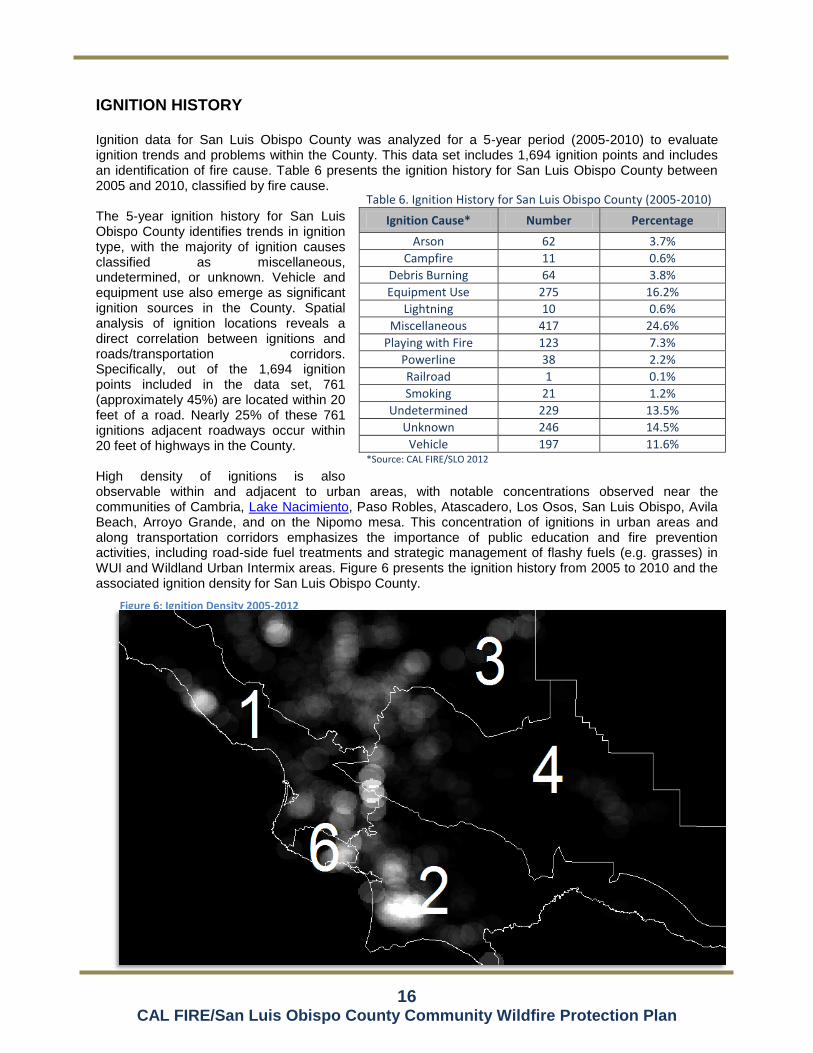
IGNITION HISTORY Ignition data for San Luis Obispo County was analyzed for a 5-year period (2005-2010) to evaluate ignition trends and problems within the County. This data set includes 1,694 ignition points and includes an identification of fire cause. Table 6 presents the ignition history for San Luis Obispo County between 2005 and 2010, classified by fire cause. The 5-year ignition history for San Luis Obispo County identifies trends in ignition type, with the majority of ignition causes classified as miscellaneous, undetermined, or unknown. Vehicle and equipment use also emerge as significant ignition sources in the County. Spatial analysis of ignition locations reveals a direct correlation between ignitions and roads/transportation corridors. Specifically, out of the 1,694 ignition points included in the data set, 761 (approximately 45%) are located within 20 feet of a road. Nearly 25% of these 761 ignitions adjacent roadways occur within 20 feet of highways in the County. High density of ignitions is also observable within and adjacent to urban areas, with notable concentrations observed near the communities of Cambria, Lake Nacimiento, Paso Robles, Atascadero, Los Osos, San Luis Obispo, Avila Beach, Arroyo Grande, and on the Nipomo mesa. This concentration of ignitions in urban areas and along transportation corridors emphasizes the importance of public education and fire prevention activities, including road-side fuel treatments and strategic management of flashy fuels (e.g. grasses) in WUI and Wildland Urban Intermix areas. Figure 6 presents the ignition history from 2005 to 2010 and the associated ignition density for San Luis Obispo County.
Table 6. Ignition History for San Luis Obispo County (2005-2010)
Ignition Cause* Number Percentage
Arson 62 3.7%
Campfire 11 0.6%
Debris Burning 64 3.8%
Equipment Use 275 16.2%
Lightning 10 0.6%
Miscellaneous 417 24.6%
Playing with Fire 123 7.3%
Powerline 38 2.2%
Railroad 1 0.1%
Smoking 21 1.2%
Undetermined 229 13.5%
Unknown 246 14.5%
Vehicle 197 11.6% *Source: CAL FIRE/SLO 2012
Figure 6: Ignition Density 2005-2012 100m

17 CAL FIRE/San Luis Obispo County Community Wildfire Protection Plan
FIRE THREAT As observed in the fire history data for San Luis Obispo County, land ownership and fuel type strongly influence the location and frequency of burning within the fire environment. The relative fire threat of any given area is influenced by a variety of factors such as fuel rank. For example, the location of the Los Padres National Forest (LPF) within the Santa Lucia Range presents a risk to adjacent communities based on its burn history due to expansive fuel beds, steep topography, and limited access. Additionally, wildfires originating on or burning through the LPNF have posed significant risk to communities in San Luis Obispo County. For example, the 1985 Las Pilitas Fire burned from the LPF into a portion of the City of San Luis Obispo and the 1994 Highway 41 Fire, after igniting on private land, burned from the LPF into the cities of Atascadero and San Luis Obispo. .
Another dominant factor affecting wildfire risk is the prevailing wind pattern in San Luis Obispo County. Specifically, on-shore winds from the northwest routinely pick up in the late morning hours increasing the risk of pushing a fire in a southeast direction if not extinguished by late-morning (approximately 10 am). This condition is observable in the shape of large fire burn perimeters in San Luis Obispo County. For example, prevailing winds contributed significantly to the extent of the 1994 Highway 41 Fire, which originated northwest of the City of San Luis Obispo and burned southwest toward the cities of San Luis Obispo and Atascadero. While no large fires are included in the fire history data set for the Irish Hills area in the County, the potential fire risk in this area is considered high. For example, a fire originating in the Los Osos area or at Diablo Canyon could be pushed by prevailing winds southeast toward the communities of Avila Beach and Pismo Beach. Another area with similar conditions where a large fire is considered likely is the Santa Rita Road area between Highway 41 and Highway 46 due to heavy fuels, prevailing wind patterns and steep terrain.
Fire Risk vs. Fire Hazard
The concept of risk vs. hazard can be confusing and these terms are often used interchangeably. The purpose of this Plan is to assist fire agencies with development of collaborative methods of reducing the fire ‘risk’ within their jurisdictions by using strategies and tactics that will reduce or eliminate one or more fire ‘hazards’. Examples of fire hazards include dense stands of decadent brush, faulty wiring, broken vehicle exhaust systems, and homes that are not built in accordance with fire code requirements. The fire risk (vulnerability) of a given area constantly rises and falls depending on conditions within the fire environment. Successful implementation of this Plan will result in the meaningful reduction of the fire risk in strategic portions of the County through identification and abatement of important fire hazards.

18 CAL FIRE/San Luis Obispo County Community Wildfire Protection Plan
SECTION II: COLLABORATION
COMMUNITY / AGENCIES / FIRE SAFE COUNCIL / FIREWISE COMMUNITIES
As a key component of the Healthy Forest Restoration Act (HFRA) of 2003, a Community Wildfire Protection Plan (CWPP) serves as a mechanism for community input and identification of areas presenting high fire risk as well as identification of fire hazards and potential projects intended to mitigate such risk. This Plan integrates the community-focused approach of the CWPP process and is intended to provide the community a forum for identifying assets and communities at risk from wildfire, which may include people, property, natural resources, cultural values, economic interests, and infrastructure. The identification of these assets or communities by the community strongly influences the potential wildfire hazard mitigation projects identified in this Plan. Representatives involved in the development of this Plan are included Table 7. Their organization and title are indicated below.
Table 7. Representatives Involved in Plan Development
Organization Title
CAL FIRE/SLO Unit Chief
Cambria CSD Fire Department Fire Chief
City of Atascadero Fire Department Fire Chief
City of Morro Bay Fire Department Fire Chief
City of Paso Robles Fire Department Fire Chief
City of San Luis Obispo Fire Department Fire Chief
Five Cities Fire Authority Fire Chief
Los Padres National Forest Forest Supervisor
Bureau of Land Management
San Luis Obispo County Community Fire Safe Council
President
San Luis Obispo County Fire Chiefs Association
President
To be updated following community meetings and coordination with local FD’s
1. Identify role that community played in the process 2. Identify community meetings, including dates, locations, and summary of meetings (projects,
concerns, etc.) 3. Identify coordination with local FD’s (meetings, concerns, input)
PROJECT SPONSORSHIP (i.e. project lead, project proponent)
PROJECT FUNDING (Grants, SRA Fee, General Fund, etc.)

19 CAL FIRE/San Luis Obispo County Community Wildfire Protection Plan
AGENCY COORDINATION The location and size of San Luis Obispo County dictate that local fire resources must be used effectively since these resources are limited, and additional resources could be several hours away. The diversity of available resources and fire-related problems mandate the cooperative use of fire service resources. Cooperative assistance is provided on reciprocal contributions without charge and may be provided in two forms:
Automatic Aid: a predetermined immediate joint response as a means to provide effective fire protection
Mutual Aid: responses to supplement the resources of any fire agency during a period of actual or potential need, including move-up and over assignments.
Mutual Aid is dependent on recognition that equipment and resources are expected to be provided only when dispatch of the resources will not unduly jeopardize local capabilities. This San Luis Obispo County Fire Services Mutual Aid Plan intends to provide the following:
Upon demand, provide the cost-effective use of the emergency resources of all jurisdictions
Achieve a balance over the long run between providing and receiving entities
Eliminate complex financial and legal agreements
Address all mutual aid responses and station coverage assignments required of the fire service, including but not limited to the following: ◦ Fire ◦ Rescue ◦ Hazardous Materials
◦ Earthquake ◦ Natural and Human-caused Disasters ◦ EMS/Mass Casualty Incidents
The following fire departments, districts, and agencies currently engage in Automatic/Mutual Aid agreements in San Luis Obispo County:
Atascadero Fire Department
Atascadero State Hospital Fire Department
Avila Beach Fire Department
CAL FIRE San Benito-Monterey Unit
Camp Roberts Fire Department
Cayucos Fire Protection District
CAL FIRE
Cambria Fire Protection District
California Men's Colony
CAL FIRE Fresno-Kings Ranger Unit
Five Cities Fire Authority
Guadalupe Fire Protection District
Hearst Castle Fire Department
Morro Bay Fire Department
Paso Robles Fire Department
Pismo Beach Fire Department
Santa Barbara County Fire Department
South Bay Fire Protection District
San Luis Obispo County Fire
San Luis Obispo City Fire Department
San Miguel Fire Protection District
Santa Maria Fire Protection District
Santa Margarita Fire Protection District
Templeton Fire Protection District
U.S. Forest Service (Los Padres National Forest)
In addition to the Automatic/Mutual Aide agreements identified above, dispatch agreements also exist between CAL FIRE/SLO, Cambria Community Services District, the Cayucos Fire Protection District, the Santa Margarita Fire Protection District, the San Miguel Community Services District, the Templeton Community Services District, and CALSTAR (private air ambulance). The California Master Cooperative Wildland Fire Management and Stafford Act Response Agreement (CFMA) requires an Annual Operating Plan to coordinate wildfire response efforts between State and Federal Agencies. For San Luis Obispo County, the Central Coast Operating Plan (CCOP) represents an agreement between CAL FIRE, BLM, USFS, and the U.S. Fish and Wildlife Service (USFWS) and provides the participating agencies with the guidelines and information necessary to properly execute the terms of the Agreement. The CCOP identifies fire protection elements, special management considerations, fire protection organization, maps, operational procedures, fire prevention activities, general procedures, and a list of relevant agency contacts.

20 CAL FIRE/San Luis Obispo County Community Wildfire Protection Plan
SECTION III: VALUES AT RISK
CAL FIRE’s Fire and Resource Assessment Program (FRAP) prepared the document entitled California’s Forests and Rangelands: 2010 Assessment
1. This document satisfies 2008 Federal Farm Bill provision
that each state conduct an assessment of forest resources, which is intended to identify key issues facing each state and requires the delineation of spatial areas called Priority Landscapes. Priority Landscapes are intended to focus investments and other programs to address issues identified in the assessment. Priority Landscape data sets related to fire include an evaluation of fire risk as related to carbon, community water, ecosystem health, forest economics, human infrastructure, range economics, recreation and open space, and wildlife. The fire/human infrastructure Priority Landscape developed by FRAP represents the convergence of areas with high wildfire threat and human infrastructure assets. Included in this assessment are communities and assets. Community areas include incorporated city boundaries and Census Designated Places for unincorporated communities while assets include residential and commercial structures, major roads, and transmission lines. Wildfire threat is the result of an analysis of fire frequency (likelihood of a given area burning) and potential fire behavior (fire hazard). For the purposes of this Plan, San Luis Obispo County has been divided into eleven Planning Areas to facilitate localized pre-fire planning efforts. The following provides a brief description of each Planning Area. Priority Landscapes and Planning Areas are also delineated in Figures 7A through 7F.
PLANNING AREAS Planning Area 1 (CAL FIRE – Battalion 1) Planning Area 1 encompasses approximately 277,000 acres and is situated along the Pacific Ocean from the Monterey County Boundary in the north to approximately Point Buchon in the south. Its eastern boundary runs along the ridge of the Santa Lucia Range and extends eastward to the City limits of Atascadero and southward to the boundary of the City of San Luis Obispo. The City of Morro Bay and the community of Cambria are located along the Pacific Ocean in the western portion of the Planning Area. Planning Area 2 includes the Priority Community of Baywod Park-Los Osos. Large fire history in the Planning Area includes the 1960 Weferling Fire and the 1994 Highway 41 Fire.
Planning Area 2 (CAL FIRE – Battalion 2) Planning Area 2 encompasses approximately 373,000 acres and is situated along the southern boundary of the County, adjacent the Cuyama River. Planning Area 3 stretches the entire length of the County, from Kern County in the east to the Pacific Ocean in the west and is bisected by the Los Padres National Forest (LPNF) in the central portion of the Planning Area. Its northern boundary runs along the boundary of the LPNF, adjacent the ridge of the Garcia and Caliente Ranges and extends northward to the City limits of San Luis Obispo. Planning Area 3 includes the Priority Community of Nipomo. Large fire history in the Planning Area includes the 1985 Las Pilitas Fire and the 1997 Logan Fire.
Planning Area 3 (CAL FIRE – Battalion 3) Planning Ares 3 encompasses approximately 538,000 acres and is situated along the northern edge of the County from the Kern County boundary in the east to the ridge of the Santa Lucia Range in the west. Its southern boundary extends roughly eastward from the City of Atascadero, but excludes the Santa Lucia Range. Planning Area 4 includes the Priority Communities of Adelaida, Lake Nacimiento, and San
1 http://frap.cdf.ca.gov/assessment2010.html

21 CAL FIRE/San Luis Obispo County Community Wildfire Protection Plan
Miguel. Large fire history in the Planning Area includes the 1960 Weferling Fire in the far western portion of the Planning Area.
Planning Area 4 (CAL FIRE – Battalion 4) Planning Area 4 encompasses approximately 670,000 acres and is situated in the central portion of the County between Planning Area 4 to the north and Planning Area 3 to the south and is bisected by the LPNF. Its eastern boundary abuts Kern County, and its western extends up to the City of Atascadero. Planning Area 5 includes the Priority Community of Santa Margarita. Large fire history in the Planning Area includes an un-named fire in 1939, the 1985 Las Pilitas Fire, and the eastern portion of the 1994 Highway 41 Fire.
Planning Area 5 (Left Intentionally Blank)
Planning Area 6 (CAL FIRE – Battalion 6) Planning Area 6 encompasses approximately 29,800 acres and is situated in the Irish Hills along the coast between approximately Point Buchon in the northwest to the eastern-most portion of the City of Pismo Beach in the southeast. Planning Area 6 includes the Priority Communities of Avila Beach and Pismo Beach. Fire history in the Planning Area is limited primarily to a few small fires adjacent Diablo Canyon Nuclear Power Plant.
Planning Area 7 (Left Intentionally Blank)
Planning Area 8 (Cambria CSD Fire Department) Planning Area 8 encompasses the Community of Cambria and is approximately 2,900 acres in size. The Cambria Community Services District (CSD) Fire Department is the Fire Authority Having Jurisdiction (FAHJ) for this Planning Area and Cambria is a Priority Community designated in this Plan. No fires included in the historical database (FRAP) have burned within the community, although several fires have burned in the immediate surroundings.
Planning Area 9 (City of Atascadero) Planning Area 9 encompasses the City of Atascadero and is approximately 16,800 acres in size. The Atascadero Fire Department is the Fire Authority Having Jurisdiction (FAHJ) for this Planning Area and Atascadero is a Priority Community designated in this Plan. An un-named fire burned the western portion of the Planning Area in 1931 and the Highway 41 Fire burned the southern portion of the City in 1994.
Planning Area 10 (City of Morro Bay) Planning Area 10 encompasses the City of Morro Bay and is approximately 3,750 acres in size. The Morro Bay Fire Department is the Fire Authority Having Jurisdiction (FAHJ) for this Planning Area and Morro Bay is a Priority Community designated in this Plan. No fires included in the historical database (FRAP) have burned within the City, although several smaller fires have burned in the immediate surroundings.
Planning Area 11 (City of Paso Robles) Planning Area 11 encompasses the City of Paso Robles and is approximately 12,600 acres in size. The Paso Robles Fire Department is the Fire Authority Having Jurisdiction (FAHJ) for this Planning Area. The City of Paso Robles is a Priority Communities designated in this Plan. No fires included in the historical database (FRAP) have burned within the City, although several smaller fires have burned in the immediate surroundings.
Planning Area 12 (City of San Luis Obispo) Planning Area 12 encompasses the City of San Luis Obispo and is approximately 8,350 acres in size. The San Luis Obispo City Fire Department is the Fire Authority Having Jurisdiction (FAHJ) for this Planning Area and San Luis Obispo is a Priority Community designated in this Plan. Fire history in the Planning Area includes the 1985 Las Pilitas Fire, which burned the eastern portion of the City and the 1994 Highway 41 Fire which burned within approximately 400 feet of the eastern boundary of the City.
22 CAL FIRE/San Luis Obispo County Community Wildfire Protection Plan
Planning Area 13 (Five Cities Fire Authority) Planning Area 13 encompasses the Cities of Arroyo Grande and Grover Beach and the community of Oceano and is approximately 6,450 acres in size. The Five Cities Fire Authority is the Fire Authority Having Jurisdiction (FAHJ) for this Planning Area and Arroyo Grande is a Priority Community designated in this Plan. No fires included in the historical database (FRAP) have burned within the City, although several smaller fires have burned in the immediate surroundings.
Planning Area 14 (Los Padres National Forest) Planning Area 14 encompasses the U.S. Forest Service (USFS) Los Padres National Forest extent within San Luis Obispo County and is approximately 187,000 acres in size. The USFS is responsible for wildland fire management on the LPNF. No Priority Communities are located within this Planning Area, although several are near enough to be affected by wildfire burning on the LPNF. Fire history on the LPNF is extensive, with the majority of fires in San Luis Obispo County burning on or within the Planning Area.
Planning Area 15 (Bureau of Land Management)

23 CAL FIRE/San Luis Obispo County Community Wildfire Protection Plan
ASSETS
For the purposes of this Plan, assets are those values that may be at risk from wildfire. Assets in San Luis Obispo County include power generation and transmission facilities, emergency communication facilities, transportation infrastructure, tourist and recreation areas, environmental areas, military installations, natural resource production facilities, and commercial fishing facilities. Table 8 presents the assets in San Luis Obispo County, by Planning Area.
Table 8. Assets in San Luis Obispo County, by Planning Area
Asset Planning Area
Trains/Rail System All
Transportation Corridors (Highways 166, 101, 46, 41, and 58) All
Diablo Canyon Power Lines 1, 2, 6
Communication System/Repeaters 1
ConocoPhillips Oil Refinery 2
Hearst Castle 1
Communication Sites 1
Los Padres FS Botanical Gardens 1
Bishop Peak Recreational Site 1, 12
San Luis Mountain Recreational Site 1
Montana De Oro State Park Campground 1
Whale Rock Reservoir 1
San Simeon State Park 1
San Luis V.O.R. 1
Chorro Regional Park 1
Hearst Castle 1
Camp San Luis Obispo (California National Guard) 1
San Luis Obispo County Airport 2
Lopez Lake Recreational Area 2
PG&E High Power Line NW of Atascadero 3
Oak Shores Campground 3
Santa Margarita Lake Recreational Area 4
Upper Highway 229 4
Port San Luis Obispo/Lighthouse 6
Diablo Canyon Nuclear Power Plant 6
Hartford Ocean Pier Complex 6

24 CAL FIRE/San Luis Obispo County Community Wildfire Protection Plan
COMMUNITIES AT RISK
Communities at Risk (CAR) from potential wildfire were identified at the federal level in the 2001 National Fire Plan (66 Fed. Reg. 753, January 4, 2001), which included only communities that were in the vicinity of federal lands. Recognizing that wildfire risk was not limited to areas near federal lands, CAL FIRE developed a more inclusive list of communities at risk for the State of California, which is managed by the California Fire Alliance. The communities identified in this Plan for San Luis Obispo County were derived from the Geographic Names Information System (GNIS) database and evaluated to ensure that all Communities at Risk were accounted for. The GNIS database of communities in the County was then consolidated to represent major communities in the County and historical places were excluded. For example, the community of Cambria includes the GNIS–identified communities of Cambria, Cambria Pines, East Village, Happy Hill, Harmony, Leimert, Lodge Hill, Marine Terrace, Park Hill, Tin City, and West Village. The communities for San Luis Obispo County are identified in Table 9. In addition, Table 9 identifies which Planning Area the community is within, if it is a Community at Risk (CAR), and if it is an incorporated city. Figures 7A through 7F present the location of communities in San Luis Obispo County. Table 9. Communities in San Luis Obispo County
Community* Planning
Area Community at
Risk** Incorporated City
Adelaida 3 X No
Arroyo Grande 13 X Yes
Atascadero 9 X Yes
Avila Beach 6 X No Baywood Park-Los Osos 1 X No Callender 2 No Cambria 8 X No Cayucos 1 X No Creston 4 X No Edna 2 No Garden Farms 4 No Grover Beach 13 Yes
Lake Nacimiento 3 X No Los Berros 2 No Morro Bay 10 X Yes
Nipomo 2 X No Oceano 13 X No Paso Robles 11 X Yes
Pismo Beach 6 X Yes
San Luis Obispo 12 X Yes
San Miguel 3 X No San Simeon 1 No Santa Margarita 4 X No Shandon 3 No Templeton 3 X No Whitley Gardens 3 No *Source: CalMapper 2012 **Communities listed as Communities at Risk on the California Fire Alliance website: http://www.cafirealliance.org/communities_at_risk/communities_at_risk_list

25 CAL FIRE/San Luis Obispo County Community Wildfire Protection Plan
PRIORITY COMMUNITIES
To evaluate Priority Communities in the State, FRAP analyzed the fire/human infrastructure Priority Landscape data set in combination with communities that include at least 500 people or 1,000 acres. Communities ranked as medium or high Priority Landscapes (for fire/human infrastructure) constitute Priority Communities. The intent of the Priority Community identification is to provide a way of identifying possible communities for outreach and further strategy development. The Priority Communities data set was utilized as a starting point for identifying and prioritizing communities in San Luis Obispo County where efforts can be focused to reduce wildfire threat. This data set was refined based on input from community stakeholders and based on an assessment of fire history, ignition history, land ownership, vegetation/fuel, or terrain. Priority Communities for San Luis Obispo County are identified in Table 10. Priority Communities are those in which pre-fire management activities, including hazardous fuel reduction and public education, should be focused. This list of communities is based on available fire hazard planning data from FRAP, augmented with a County-scale analysis of fire hazard variables and input from community stakeholders and should be routinely evaluated and updated, as necessary.
Table 10. Priority Communities in San Luis Obispo County
Community* Planning Area
Adelaida 3
Arroyo Grande 13
Atascadero 9
Avila Beach 6
Baywood Park-Los Osos 1
Cambria 8
Lake Nacimiento 3
Nipomo 2
Paso Robles 11
Pismo Beach 6
San Luis Obispo 12
San Miguel 3
Santa Margarita 4
Templeton 3 *Source: CalMapper 2012/FRAP 2012

26 CAL FIRE/San Luis Obispo County Community Wildfire Protection Plan
WILDLAND URBAN INTERFACE AREAS (WUI) Pre-fire planning efforts by CAL FIRE/SLO have identified the following priority WUI areas which would also benefit from fuel reduction or other pre-fire planning efforts intended to minimize ignitions and promote public and firefighter safety. The priority WUI areas are identified by Planning Area.
The information presented in this section is intended to be general in nature and has not been developed for a specific project. Should projects be identified for the purpose of reducing structural ignition or otherwise affecting wildland fire risk potential, evaluation and documentation of environmental effects will be required prior to implementation, which may include CEQA review. Additionally, project-related permits may be required. This level of assessment is typically conducted in the project planning phase once the scope of a project is identified.
Planning Area 1 (Corresponds with CAL FIRE Battalion 1) The identified priority WUI areas for Planning Area 1 include:
Cambria WUI
Cayucos WUI
Laguna West WUI
Los Osos WUI
Morro Bay WUI
Morro Toro WUI
Prefumo Canyon WUI
Ragged Point WUI
San Simeon Acres WUI
Santa Rita WUI
Planning Area 2 (Corresponds with CAL FIRE Battalion 2) The identified priority WUI areas for Planning Area 2 include:
Blue Fox WUI
East Arroyo Grande WUI
Edna Valley Foothills WUI
Huasna WUI
Nipomo Hills WUI
Nipomo Mesa/Dale WUI
Ranchita Estates WUI
Reservoir Canyon WUI
Suey Creek WUI
Upper Lopez Canyon WUI
Varian Ranch WUI
Planning Area 3 (Corresponds with CAL FIRE Battalion 3) The identified priority WUI areas for Planning Area 3 include:
Asuncion WUI
Bryson\Hesperia WUI
Cal Shasta Boat Club WUI
Christmas Cove WUI
Heritage Ranch WUI
Oak Shores WUI
Rancho Delargo WUI
Running Deer Ranch WUI
Rural West Paso Robles WUI
South Shore Village
South Templeton/Santa Rita WUI
Tri Counties Boat Club WUI
West Atascadero WUI
Planning Area 4 (Corresponds with CAL FIRE Battalion 4) The identified priority WUI areas for Planning Area 4 include:
Black Mountain WUI
Garden Farms WUI
Mount Lowe WUI
Parkhill WUI
Pozo WUI
Salinas River Drainage WUI
Tassajara WUI
Wilson Corner WUI

27 CAL FIRE/San Luis Obispo County Community Wildfire Protection Plan
Planning Area 5 (Left Intentionally Blank)
Planning Area 6 (Corresponds with CAL FIRE Battalion 6) The identified priority WUI areas for Planning Area 6 include:
Avila Beach WUI
Baron Canyon WUI
Davis Canyon WUI
Pismo Beach WUI
San Luis Obispo Bay Estates WUI
See Canyon WUI
Squire Canyon WUI

28 CAL FIRE/San Luis Obispo County Community Wildfire Protection Plan

29 CAL FIRE/San Luis Obispo County Community Wildfire Protection Plan
SECTION IV: PRE-FIRE MANAGEMENT STRATEGIES AND TACTICS
DISCUSSION The management strategies and tactics included in this section focus on pre-fire planning, statutes and regulations, fire prevention, and public education and outreach and are intended to meet the agency and community goals identified during the development of this Plan. Agency and community goals identified during the development of this Plan include increasing firefighter and public safety, reducing wildland fire costs and losses, implementing WUI building standards, implementing and maintaining defensible space around structures, supporting pre-fire and emergency planning, promoting inter-agency cooperation, reducing ignitions in the County, and promoting public education about wildfire. This Plan provides planning information and recommendations at a County-wide scale, while recognizing and supporting focused fire planning efforts that address specific needs at a city, community, or neighborhood level. The intent of this Plan is to act as an umbrella document and provide a guide for localized plans, which may be prepared to address site-specific constraints, fuels treatment options, specific vegetation prescriptions, refined or redefined community and WUI boundaries, emergency preparedness, and other issues important to community wildfire safety. Localized plans shall have priority and authority over the County-level recommendations included in this Plan. Further, it is anticipated that the findings, projects, and recommendations included in localized plans will be integrated into this Plan during routine maintenance and updates of the document.
WILDLAND FIRE JURISDICTIONS NOT SIGNATORY TO THIS PLAN
Due to their minimal exposure to WUI related wildfire issues, a number of fire jurisdictions listed here are not signatory to this Plan. However, most of these departments regularly participate with one or more of the signatory fire jurisdictions and their activities that contribute to this effort will be captured and documented by the other jurisdictions that deal directly with WUI fire issues. The following fire agencies and jurisdictions in San Luis Obispo County were consulted during the preparation of this Plan but are not signatories to the Plan:
BLM Wildland Fire Program
CMC Fire Department
Camp Roberts Fire Department
Camp San Luis Obispo
Cayucos Fire Protection District
Diablo Canyon Power Plant Fire Brigade
Hearst Castle Fire Department
Los Osos CSD Emergency Services
Pismo Beach Fire Department
Santa Margarita Fire Department
San Miguel Fire District
Templeton CSD Volunteer Fire Department
WILDLAND FIRE JURISDICTIONS SIGNATORY TO THIS PLAN This section presents the pre-fire management strategies and tactics identified and employed by the fire agencies in San Luis Obispo County that are signatories to this Plan.

30 CAL FIRE/San Luis Obispo County Community Wildfire Protection Plan
1. CAL FIRE/SLO County Fire Department (Planning Areas 1-4 &6)
UNIT PREPAREDNESS
CAL FIRE / San Luis Obispo Unit puts tremendous effort into maintaining the highest preparedness level
possible. This is a priority for each division and program. Each Division works with the intent to
accomplish the mission of CAL FIRE and the San Luis Obispo County Fire Department. The fire
administration and fire prevention divisions are fulltime functions that assist fire operations division before,
during and after an emergency event takes place. Additionally CAL FIRE / San Luis Obispo Unit presents
annual preparation events to assist in maintain its goal of keeping wildland fires at 10 acres or less. Below
is a brief outline of the preparation efforts of each division with in the San Luis Obispo Unit.
Fire Administration Division
Among the many tasks that revolve around managing unit policies, budgets and logistics.
Administrative staff also determines and implement staffing levels to achieve the county and state
fire mission. Additionally administrative staff prepare and maintain cooperative fire service
agreements and resource response plans, like the Central Coast Operating Plan, (CCOP). These
plans provide operations the preparedness and depth necessary for mission success.
Fire Operations Division
The operations division provides a professional level of service related to fire control and
suppression, rescue, advanced life support/emergency medical assistance, and the mitigation of
hazardous materials incidents. In the event of a major disasters, we are trained and equipped to
handle a county wide incident, including wildland and structural fires, earthquakes, tsunami, riots,
hazardous material incidents, nucular events and other major emergencies. In addition to
responding to emergency our training, fleet management and dispatch serve a critical role to our
efficiency and preparedness to repond.
Fire Prevention Bereau
Prevention staff spends a majority of their time supporting field mission preparedness and
preventing fires. It is divideved into four areas; law enforcement & education; planning &
engineering; pre-fire planning and resourse management. Each of these are full time staffed and
collectively work to support the efforts of operations. Prevention prepperation activities include
defensible space inspections, emergency evacuation planning, fire prevention education, incident
inteligance and mapping, implementation of the State Fire Plan and fire-related law enforcement
activities such as arson investigation. Other common projects include fire break construction and
fire fuel reduction activities that lessen the risk of wildfire to communities and evacuation routes.

31 CAL FIRE/San Luis Obispo County Community Wildfire Protection Plan
FIREFIGHTING CAPABILITIES
The fire service in San Luis Obispo (SLO) County is comprised of a cohesive and cooperative group of 17
agencies as described in Section . Services are provided by a combination of city, special district, county,
state, federal, and private agencies that operate 48 fire stations. These fire agencies have also developed
an automatic mutual aid program that provides for the closest fire engine to respond to a new emergency
regardless of the jurisdiction. This cooperative fire protection system gives each agency a depth and
weight of response to be successful in mitigating both large scale and simulatious emergency events
within the County.
California Department of Forestry and Fire Protection
San Luis Obispo Unit (SRA)
As a state agency, CAL FIRE is jurisdictionally responsible for providing wildland and watershed
fire protection to those portions of the unincorporated County area that meet the California Public
Resources Code definition of State Responsibility Area (SRA). All lands within the boundary of an
incorporated city and federally owned lands (US Department of Defense [DOD], USFS, BLM) are
specifically excluded from SRA. Other than the Los Padres National Forest, Carrizo Plains
National Monument and Camp Roberts, most of the unincorporated area in San Luis Obispo
County meets the SRA definition.
Structure fire protection, rescue, emergency medical services, and hazardous materials response
do not fall under CAL FIRE’s wildland fire jurisdictional responsibility—that responsibility is vested
with a local government agency. CAL FIRE has authority to respond to all types of fire/rescue
incidents in assistance to local government, but does not assume jurisdictional responsibility.
Where CAL FIRE’s SRA jurisdiction coincides with County jurisdiction, a shared responsibility
between the state and County exists. Some County unincorporated areas that meet the definition
of SRA area fall within the boundaries of fire districts or community services districts that provide
fire protection (including Cambria, San Miguel, Templeton, Santa Margarita, Avila Beach, and
Cayucos). In these instances, CAL FIRE and the special district share fire protection responsi-
bility and the County has no jurisdiction.
CAL FIRE’s wildland fire resources include a fire chief, deputy chief, division chiefs, battalion
chiefs and full-time and seasonal firefighters to staff ten fire stations during the peak wildland fire
season. Equipment and other staff resources include three fire bulldozers, five hand crews and
the Paso Robles Air Attack Base, which has an air tactical coordinator aircraft and two air tankers
assigned. The wildland fire season normally occurs from May 15 through November 15 each
year. These resources are available to respond automatic or mutual aid to emergencies
throughout the county. CAL FIRE operates a consolidated regional fire dispatch center that is
staffed 24/7.

32 CAL FIRE/San Luis Obispo County Community Wildfire Protection Plan
San Luis Obispo County Fire Department
Unincorporated County Area (LRA)
The County consolidated fire protection delivery with CAL FIRE in 1930 and jointly operates 18
fire stations for response (nine county-owned and nine CAL FIRE-owned). The CAL FIRE chief
also serves as the fire chief for the County. Fire stations are staffed with various configurations of
full-time, seasonal, paid call and reserve firefighters. A more complete description of the County
and CAL FIRE can be found in the 2012 Stratgic Plan. 2012 Service Level Analysis
San Luis Obispo County has prepared a Fire Service Strategic Plan (August 2012). The
Strategic Plan is intended to serve as a guide for the San Luis Obispo County Board of
Supervisors and other partners in the CAL FIRE / San Luis Obispo County Fire
consolidated fire protection program. It is intended to identify proper levels of service for
fire protection, make an assessment of the current delivery system and forecast
necessary changes to fire protection services. One of the Strategic Plan goals is to
provide a tool for making cost-effective decisions regarding changes in service levels. To
achieve this goal, the Strategic Plan describes and presents data regarding fire protection
in the County by using community demographics, service levels, staffing models,
governance and funding options.
The County of San Luis Obispo is responsible for fire protection services for buildings and other
improvements in unincorporated areas situated outside the boundaries of an independent fire
district or community services district that provides fire protection. Unlike cities, the County has no
legal obligation to provide fire protection in the unincorporated area; it is a discretionary service
policy decision. Where unincorporated areas lie within the boundaries of a special district that
chooses to provide fire protection (via a CSD or fire protection district), the responsibility and
authority is transferred from the Board of Supervisors to that special district governing board.
Federally owned lands (e.g. land managed by the US Forest Service [USFS] and Bureau of Land
Management [BLM]) located in the unincorporated portion of the county create a federal and
county dual-responsibility situation for fire and rescue.

33 CAL FIRE/San Luis Obispo County Community Wildfire Protection Plan
FIRE PREVENTION BUREAU The management strategies included in this section focus on the four efforts of the SLU / CAL FIRE Prevention Bureau; Fire Prevention Planning & Engineering; Fire Law Enforcement and Education, Pre-Fire Planning and Intelligence; Resource Management. The goals identified during the development of this Plan include increasing firefighter and public safety, reducing wildland fire costs and losses, implementing WUI building standards, implementing and maintaining defensible space around structures, supporting pre-fire and emergency planning, promoting inter-agency cooperation, reducing ignitions in the County, and promoting public education about wildfire.
Fire Prevention Planning & Engineering Fire Prevention Planning takes into account the best design, construction, and engineering practices for planning fire safe communities and homes. Engineering principles also apply in the safe use of industrial and recreational equipment; as well as event safety and inspections occurring in both county and state jurisdictions. The County Fire Marshal and Engineering Staff recommend and interpret laws and regulations covering wildland fire safety and assist homeowners, landowners, decision-makers, and local government planners in building and rebuilding fire safety into the communities we serve. Below are the
County Fire Codes San Luis Obispo County, as well as all other jurisdictions in the County, has adopted with amendments, the California Fire Code (CFC) and the California Building Code (CBC) into local ordinance. These regulations have many requirements for the protection of the citizens from WUI fires, including:
Water requirements
Minimum access road requirements
Roofing requirements
Construction requirements
Hazard abatement requirements
Turnaround requirements
Fire Works Regulation
Event Inspection and Safety Fire Engineering takes into account the best design, construction, and engineering practices for planning fire safe communities and homes. Engineering principles also apply in the safe use of industrial and recreational equipment. Fire Engineering staff recommend and interpret laws and regulations covering wildland fire safety and assist homeowners, landowners, decision-makers, and local government planners in building and rebuilding fire safety into California communities.
Office of the State Fire Marshal (OSFM) Fire and Resource Assessment Program (FRAP)
County General Plan The San Luis Obispo County General Plan and ordinances include provisions for access requirements, housing density, allowable occupancy use, community water system requirements, and property set back requirements. All development being reviewed by San Luis Obispo County Planning Staff is also reviewed by CAL FIRE/SLO to ensure the project is designed within the parameters of the County adopted General Plan. This review ensures the development has

34 CAL FIRE/San Luis Obispo County Community Wildfire Protection Plan
secondary access, proper water storage, defensible space around the development, and will use fire safe construction materials prior the subdivision of lands. County Municipal Code The San Luis Obispo County Code of Ordinances also includes requirements for fire prevention, included in Title 16. This Code section outlines burning restrictions and vegetation clearance requirements. Title 16 can be found at: http://library.municode.com/HTML/16608/level1/TIT16FIPR.html#TOPTITLE San Luis Obispo County does not currently have a weed abatement ordinance in place, however if a structure is located within a State Responsibility Area, then PRC 4291 is enforced by CAL FIRE/SLO.
Law Enforcement and Education Law Enforcement
Annually during the early spring and late summer in order to avoid the accumulation of hazardous fuels over time. Finally, the 4291 guidelines are specific to State Responsibility Areas (SRA), but may be applicable in Local Responsibility Areas (LRA), depending on local agency standards.
Code Enforcement
State Requirements (SRA Lands)
Public Resources Code 4290 – California Code of Regulations (CCR) CCR Chapter 1, Division 1.5 of Title 14 (PRC 4290) is the statute that requires emergency access, signing and building numbering, private water supply reserves for emergency fire use, and vegetation modification in areas designated as State Responsibility Area (SRA).
Public Resources Code 4291 (PRC 4291) The State of California Public Resource Code 4291 (PRC 4291) requires owners of property to create defensible space around structures on their property where firefighters can provide protection during a wildfire. PRC 4291 applies to areas of the state within the responsibility area of CAL FIRE (SRA) and includes:
“a building or structure in, upon, or adjoining any mountainous area, forest-covered lands, brush-covered lands, grass-covered lands, or any land that is covered with flammable material…”
The defensible space distance is measured along the grade from the perimeter or projection of the building or structure. Under PRC 4291, the defensible space distances require up to 100 feet, or to the property limit, whichever is closer; however, the amount of fuel modification necessary may extend beyond 100 feet depending on the flammability of the structure, topography, and fuels. The CAL FIRE Guidelines for Creating Defensible Space as outlined in PRC 4291 can be found here:
The hazard reduction inspection program (LE-100) is managed by CAL FIRE/SLO Battalion Chiefs. Engine companies are responsible for performing inspections within their initial attack areas and are typically performed during spring and summer months. Engine companies are directed to leave an inspection notice at all properties to inform the homeowner there has been an inspection. Engine companies are also instructed to leave notices at residences where access is blocked. During the inspection, engine company personnel review and educate the homeowner on fire prevention requirements.

35 CAL FIRE/San Luis Obispo County Community Wildfire Protection Plan
If there are violations, a notice is issued and the homeowner is instructed to mitigate the violation. The engine company then returns for a re-inspection and if the violation is not mitigated, a citation may be issued and/or turned over to fire prevention staff for enforcement.

36 CAL FIRE/San Luis Obispo County Community Wildfire Protection Plan
Fire Investigation / Cost Recovery The primary emphasis of the San Luis Obispo Unit’s law enforcement section is the enforcement of local and state fire laws as they apply to the missions of CAL FIRE, State Fire Marshal and the San Luis Obispo County Fire Department. Law enforcement officers are trained and certified in accordance with the California Commission on Peace Officer Standards and Training (POST). The officers are busy year round investigating fire causes, interviewing witnesses, issuing citations and setting up surveillance operations. Arson and negligently caused fires receive priority for law enforcement action, which typically results in criminal or civil proceedings against the responsible person(s). Such proceedings lead to fines, fire suppression cost collection, and enforcing burning regulations. Law enforcement action is a critical fire prevention tool. The CAL FIRE Arson Hotline is maintained by the Department's Sacramento Law Enforcement section, which also processes requests for payment of arson rewards. Rewards of up to $10,000 are available for information regarding wildland fires within State jurisdiction. Depending on the magnitude of the fire, enhanced rewards of up to $25,000 or higher may be available.
Since 2008, when CAL FIRE’s Civil Cost Recovery Program began, the state has recovered more than $93 million from folks whose wayward fires required suppression, investigation and follow-up by CAL FIRE Law Enforcement. Cost Recovery
Burn Permits Program
Where alternative means of vegetation disposal are not feasible, CAL FIRE encourages the safe and prudent use of burning during certain times of the year. Residential debris burning, hazard reduction burning, agricultural burning, development burning, and range improvement burning are commonly used methods that can be effective for removing excess vegetation and reducing the fire hazard.
Burn permits are also required for the following: • Public or industrial fire-fighting training. • Prevention of a fire hazard that cannot be abated by any other means. • The disposal of agricultural waste as specified by Rule 502. The agricultural waste must be produced and burned on site. • Levee, ditch and reservoir maintenance, or right-of-way clearing by a public entity or utility. • Developmental burning when there are no technically feasible alternatives. • Prescribed burning.
All burning permits listed above are issued by the Air Pollution Control District. The California Department of Forestry and Fire Prevention (CAL FIRE) also requires a permit for all types of burning during the fire hazard season.

37 CAL FIRE/San Luis Obispo County Community Wildfire Protection Plan
Fire Information & Education Programs Public outreach and education is an important component in community wildfire hazard reduction efforts and is a key component in reducing overall costs and losses attributed to wildland fires. Fire prevention education efforts being implemented by fire agencies in the County are intended to provide the public with fire safety education material so that the community can take an active role in fire prevention efforts. These efforts are detailed in section V and include school programs, parades, fairs, road signs, Smokey Bear programs, and numerous events, exhibits and displays throughout the year. In recent years, the use of the internet websites and social media is increasing our ability to provide fire information to a much larger audience quicker. Notable groups in the County with the mission of educating the public on the importance of fire prevention include the County Fire Prevention Association and the San Luis Obispo County Community FireSafe Council (SLOCCFSC). Fire agency involvement in the aforementioned associations is important in maintaining community relationships to further the goals of this Plan.
Public Information
Volunteers in Prevention Program (VIP) The Volunteers in Prevention (VIP) utilizes citizens and public service groups in non-salaried positions with the goal of reduce man-caused fires by 10 percent per 100,000 population.
Internet Resources CAL FIRE / San Luis Obispo County has experienced great success with providing public fire information and education messages through the use of its website and social media outlets. The website CALFIRESLO.ORG provides a medium in which to provide immediate emergency press releases as well as providing a place for the public to find information for themselves. It provides up to the minute Incident location information through the recently developed incident dashboard. It also provides the public and employees with information regarding our building and planning standards, upcoming training opportunities, job posting, and what to do to prepare for an emergency event. This site received over 2,000,000 visits last year and has increased in visits every year since inception.
Recently the unit has began providing public information and incident information through social media outlet Twitter and is receiving great feedback from both the public as well as the media
Media Outreach Providing the public with information that is accurate and up to date is a great tactic to provide department information as well as fire prevention messages intended to educate the public. The Unit is committed issuing press releases to the San Luis Obispo County media outlets on a regular basis. These releases are typically accompanied by television interviews. They are also published on the CALFIRESLO.ORG website.

38 CAL FIRE/San Luis Obispo County Community Wildfire Protection Plan
Through funding provided by the SLO FireSafe Council we are able to distribute the Creating Defensible Space DVD. This DVD ias also play in partnership with Charter Cable thru the on demand video selection. Residents can view the FireSafe produced video for free anytime. Printed Material Program Printed educational materials are available to the public at every fire station and online. Through funding from the SLO FireSafe council we are able to distribute the Living with Fire brochure that gives citizen the information on home preparation, Evacuation Plans that illustrate where evacuation routes are and where pre-determined safety areas exist along that route. Ready, Set, Go! These brochures assist residents when evacuation planning.
Billboard Sign Program A system of thirty billboard signs are strategically placed at ingress and egress points throughout San Luis Obispo County. These signs target community fire educations topics of creating defensible space, home preparations and the newly created “Read, Set Go” program. Sign topics a created through the use of the ten year Unit ignition history and then placed in “at risk” communities within CAL FIRE’s jurisdiction.

39 CAL FIRE/San Luis Obispo County Community Wildfire Protection Plan
Fire Education
School Programs (K-12th) Prevention staff as well as engine companies participate in school programs throughout the year providing life safety, fire prevention, and natural resource protection education. Through the use of Smokey and Friends, and the use of Teacher Tools, we are able to provide an age appropriate, standardized safety message countywide.
Public and Special Events Program The Unit Participates in numerous event throughout the year. At each of these events our prevention staff, Engine Companies and Volunteers in Prevention (VIP) speak to people sharing the message of fire prevention. The Special Olympics, Mid-State Fair. Earth Day, the San Luis Obispo Farmers Market are just a few of the many public events the Unit participates in annually. We encourage local agencies to participate with us in a effort to provide a broader message promoting fire safety.
Pre-Fire Planning and Intelligence CAL FIRE / San Luis Obispo County Fire understand that in order to be successful at firefighting and incident management, we will need comprehensive and collaborative plans. A tremendous effort is put into these annually. For the purpose of this Plan we will highlight the Plans that have strategic significance and separate them into three categories community planning, operational planning, and pre-attack planning. By placing the emphasis on what needs to be done long before the incident starts, these plans look to reduce cost and property losses, increase public and firefighter safety, and to contribute to the ecosystem health. San Luis Obispo County has prepared a Fire Service Strategic Plan (August 2012) The Strategic Plan is intended to serve as a guide for the San Luis Obispo County Board of Supervisors and other partners in the CAL FIRE/San Luis Obispo County Fire consolidated fire protection program. It is intended to identify proper levels of service for fire protection, make an assessment of the current delivery system and forecast necessary changes to fire protection services. One of the Strategic Plan goals is to provide a tool for making cost-effective decisions regarding changes in service levels. To achieve this goal, the Strategic Plan describes and presents data regarding fire protection in the County by using community demographics, service levels, staffing models, governance and funding options. CAL FIRE/SLO routinely prepares, updates, and maintains the following types of pre-fire planning documents (click on each item to be directed to the appropriate CAL FIRE/SLO website containing pre-plan documents and maps):
Wildland Fire Pre-Attack Plans
Evacuation Plans
Tsunami Plans
GIS Mapping Pre-fire planning efforts by CAL FIRE/SLO have identified the following priority WUI areas which would benefit from fuel reduction or other pre-fire planning efforts intended to minimize ignitions and promote public and firefighter safety. The priority WUI areas are identified by Planning Area.

40 CAL FIRE/San Luis Obispo County Community Wildfire Protection Plan
Community Planning
These plans are put together as a guiding document for fuel reduction. We work in collaboration with the community stake holders, FireSafe Council and the local fire authority to set the goals. Once the plan is completed the community typicaly seeks grant funding to achieve the goals of the plan. Each of these plans has been added as an appendices to the Unit Fire Plan.
San Luis Obispo County Community Wildfire Protection Plan (CWPP) Draft in progress Los Osos 5 Year Wildfire Fire Protection Plan (CWPP)
Operational Planning
Fire Danger Operating Plan
The National Fire Danger Rating System (NFDRS) is used by fire
management agencies to assess the current fire danger at the local
level. Using fire danger modeling applications to analyze weather
data and past fire occurrences, Fire Danger Operating Plans are
developed and used to set preparedness levels and assign
appropriate suppression resources based on pre-determined staffing
levels and response levels. The most familiar use of this tool is
“Smokey Bear Signs” which display the Adjective Fire Danger Rating
for the day. Pre-Attack Plans CAL FIRE / San Luis Obispo County Fire, through funding from the County Office of Emergency Services and the SLO FireSafe Council, have been creating localized disaster preplans. These plans come in the form of large, printed, foldout maps, (AAA style) which are distributed to engine companies, fire stations and chief officers within the County. These maps were produced with a collaborative effort with communities, Fire Departments, County OES, Law Enforcement, State Parks and Cal Poly Internship program. We are currently developing these plans in three categories. Wildland Fire Threat, Evacuation Planning and Tsunami.
Building Pre-Plans Each Fire Station is tasked to maintain pre-plans of the high target hazard buildings with in their response area. These plans provide first responders with information regarding hazardous materials storage, owner contact numbers, utility shut off locations and water supply information. Efforts are being made to store these plans online where incoming units can access them and enhance fire ground awareness prior to arrival to the incident.
Fire Safe Council (staff)
MDC
NICS
Infered
Incident Mapping
Data Management

41 CAL FIRE/San Luis Obispo County Community Wildfire Protection Plan
Resource Management
CAL FIRE / San Luis Obispo County Fire with private landowners, cooperating agencies, and county administer numerous programs which support the California Strategic Fire Plan. In the effort to make the vegetation management achievable this Plan has broken Vegetation Management into three strategic categories; defensible space fuel treatment; non-defensible space fuel treatment; vegetative management prescriptions. Environmental review must be conducted for all pre-fire management activities that could cause either direct or indirect changes to the natural or human environment. Fuels Management In addition to defensible space treatments required under PRC 4291, other fuel treatment projects in the County may be desirable to reduce overall wildfire threat to a community or asset. Such projects may occur on private or public land and are intended to act as a buffer between communities and/or assets and non-maintained wildland fuels. Treatments may include the following:
Strategies :
Fuel Breaks:
Fire Breaks
Road-side Fuel Treatments
Defensible Space
Fuel Reduction:
Tactics:
Manual/Hand Work Cut/Lop/Scatter Cut/Pile/Burn Cut/Chip Weedeating Pruning
Mechanical Mowing Mastication Piling/Crushing Plowing/Disking/Harrowing
Chemical Applications
Prescribed Burning Fuel Reduction Range Improvement Training Burns Weed Control Habitat Restoration
Animal (Prescribed Herbivory) Cattle Goats
Fuel Treatment Strategies
In addition to defensible space treatments required under PRC 4291, other fuel treatment projects in the County may be desirable to reduce overall wildfire threat to a community or asset. Such projects may occur on private or public land and are intended to act as a buffer between communities and/or assets and non-maintained wildland fuels. Non-defensible space treatments may include the following treatments:
Fuel Breaks: intended to modify fire behavior and spread by altering fuel beds in a linear alignment, typically situated along ridgetops and may include retained trees (shaded fuel breaks).

42 CAL FIRE/San Luis Obispo County Community Wildfire Protection Plan
Fire Break: Is an non-combustible fire barriers either natural or man made. (e.g. lake, game trail, road).
Road-side Fuel Treatments: intended to reduce the likelihood of ignition sources along roadways and maintain access/egress capabilities.
defensible Space: Fuel reduction around improvements, structures and critical infrastructure.
Fuel Reduction: intended to modify fire behavior by treating fuels over large areas in strategic locations or historic fire corridors; typically conducted on large expanses of federal or private land (e.g. Strategically Placed Area Treatments).
Fuel Treatment Tactics The following fuel treatment prescription strategies are provided as potential options for reducing vegetative fuel hazards in defensible and non-defensible space fuel treatment areas:
Manual/Hand Work Cut/Lop/Scatter Cut/Pile/Burn Cut/Chip Weedeating Pruning
Mechanical Mowing Mastication Piling/Crushing Plowing/Disking/Harrowing
Chemical Applications
Prescribed Burning Fuel Reduction Range Improvement Training Burns Weed Control Habitat Restoration
Animal (Prescribed Herbivory) Cattle Goats

43 CAL FIRE/San Luis Obispo County Community Wildfire Protection Plan
ENVIRONMENTAL REVIEW:
Environmental review must be conducted for all pre-fire management activities that could cause either
direct or indirect changes to the natural or human environment. Such projects carried out by or in
association with CAL FIRE must be conducted in accordance with policies and procedures established by
CAL FIRE’s Environmental Protection and Regulations Program (EPRP). Environmental review will be
conducted according to all applicable laws and regulations for all projects proposed under this Plan prior
to commencement of any activities that have potential to cause adverse environmental impacts. Unlike
incorporated cities and SLO County, CAL FIRE does not have a planning department and environmental
review is the responsibility of the Unit Environmental Coordinator (EC).
CEQA Review The California Environmental Quality Act (CEQA) is a statute that requires state and local agencies to identify the significant environmental impacts of their actions and to avoid or mitigate those impacts, if feasible. The statute (Public Resources Code Sections §21000–21177) and guidelines (California Code of Regulations, Title 14, Division 6, Chapter 3, Sections §15000–15387) are available from the California Law Website. The 2012 CEQA Handbook, an unofficial copy of the statute and guidelines, and the CEQA Flowchart are useful references for those performing CEQA review to ensure that all work is in accordance with the statute. The CEQA Handbook is provided by the California Environmental Resources Evaluation System (CERES) which is an information system developed by The Natural Resources Agency to assist with environmental analysis and planning. Locally, CAL FIRE has developed a [CEQA flowchart] used for projects where CAL FIRE is Lead Agency. Programmatic Environmental Impact Reports (PEIR) As shown in the CEQA flowchart, existing PEIRs can be used to fulfill the required environmental checklist component for projects where the proposed activities are consistent with the environmental analysis performed for the respective PEIR. These environmental checklists may be used as stand-alone support for certain projects; however, this method for conducting environmental review is most commonly used for projects carried out under CAL FIRE's fuels treatment programs including the California Forest Improvement Program (CFIP) and the Vegetation Management Program (VMP). Agency Involvement Certain types of activities may require involvement with other local, state, and/or federal agencies. Depending on the location, nature and timing of the proposed project, this can include formal or informal consultation, site visits, and permitting. This most often occurs as part of the CEQA review process. The agencies most frequently involved with pre-fire projects, particularly fuels treatment, are discussed below.
San Luis Obispo County Air Pollution Control District (APCD) - The San Luis Obispo APCD is one of 35 air districts located throughout California responsible for controlling air pollution at the local level. APCD enforces all local rules and regulations and is the primary agency responsible for achieving clean air standards established by the California Air Resources Board (ARB) and the U.S. Environmental Protection Agency (EPA) including the Bluebook and the Clean Air Act. Pre-fire projects proposing to use burning will require issuance of a burn permit from APCD. Larger burns, including prescribed burns, are addressed through the Smoke Management Program which requires preparation of a Smoke Management Plan (SMP) or submission of an application through the
44 CAL FIRE/San Luis Obispo County Community Wildfire Protection Plan
Prescribed Fire Information Reporting System (PFIRS). Burn permits are available at several locations throughout the County.
NOTE: Between May 1st and the end of fire season, CAL FIRE burn permits are also required.
San Luis Obispo County Planning & Building Department - Pre-fire projects that meet certain criteria may require permit processing through the Planning Department. Most types of land use permits are only required in association with construction; however, permits may be required for tree removal, removal of state/federal listed species, or removal of major vegetation within designated environmentally sensitive habitat areas (ESHA) or the Coastal Zone. Early in the planning phase, project proponents are encouraged to consult with staff to determine permitting requirements. In addition, County Planning provides helpful information including GIS maps, biological resources, geology, erosion control, archaeology, problematic plants, ordinances, CEQA and a variety of other information.
California Department of Fish & Wildlife (DFG) - San Luis Obispo County is within DFG Central Region #4. To determine DFG's role in CEQA, any type of activity that proposes ground or vegetation disturbance should be discussed early in the CEQA review process with the local DFG biologist or environmental scientist to determine if DFG's Environmental Review and Permitting Program is necessary to facilitate completion of the project. Early consultation with the proper DFG contact and use of DFG data and maps will help ensure that projects are conducted in the most environmentally responsible manner. Once CEQA review is completed, certain documents require payment of CEQA filing fees. Following informal consultation, the two most common situations requiring formal DFG involvement are:
o Projects that propose disturbance to plant and/or animal species protected under the California
Endangered Species Act (CESA). Projects where impacts to State-listed species cannot be avoided may require initiation of the Incidental Take Permit Process.
o Fish and Game Code (Section 1602) requires an entity to notify DFG of any proposed activity that may substantially modify a river, stream, or lake. Where necessary, a permit may be issued according to DFG's Lake or Streambed Alteration Program.
Regional Water Quality Control Board (RWQCB) – Central Coast Region #3 – Large scale projects or those that could potentially impact the waters of the State should be reviewed by local RWQCB staff (Water Board contacts) to determine if the proposed project should be modified to prevent impacts to water quality. The Water Boards are responsible to protect California’s waters and staff will provide input, usually through informal consultation, to ensure that projects do not impact water quality and are in accordance with laws and regulations such as the Porter Cologne Water Quality Control Act and the Federal Clean Water Act.
California Coastal Commission (CCC) – The California Coastal Act (CCA) serves as a comprehensive planning and regulatory program to manage conservation and development within the California coastal zone. California's coastal management program is carried out through a partnership between state and local governments. Implementation of Coastal Act policies is accomplished primarily through the preparation of local coastal programs (LCPs) that are required to be completed by each of the 15 counties and 60 cities located in whole or in part in the coastal zone. San Luis Obispo County and the cities of Morro Bay, Pismo Beach, and Grover Beach each have certified Local Coastal Programs (LCP) within the central coast area.
Pre-fire projects within the coastal zone that propose “development” as defined by PRC §30106 or occur within an ESHA (PRC §30107.5) may require issuance of a coastal development permit (CDP) through the LCP having jurisdiction. The coastal planner for each LCP will help determine the appropriate permitting process that must be followed. Typically, the CDP process is initiated near the end or immediately following completion of the CEQA review process.
California Department of Transportation (Caltrans) – Pre-fire projects such as brush removal proposed within the designated right-of-way of a State highway may require the project proponent to

45 CAL FIRE/San Luis Obispo County Community Wildfire Protection Plan
obtain an Encroachment Permit from the District 5 Encroachment Permit Branch. Information on this process is provided in the Encroachment Permits Manual.
U.S. Fish & Wildlife Service (USFWS) – San Luis Obispo County is within the area of responsibility of the Ventura F&W Office. Pre-fire projects, particularly those funded by federal agencies involving federally listed plant or animal species or designated critical habitat may require consultations with federal agencies to ensure compliance with the Endangered Species Act (ESA). Consultations most often occur as provided in ESA section 7. For non-federal activities where federally listed species occur, permits under ESA section 10 may be necessary such as an Incidental Take Permit for areas covered by an approved Habitat Conservation Plan (HCP).
Professional Forester’s Law (PFL) In California, PRC §750-783 requires that a Registered Professional Forester, commonly known as an RPF and licensed according to RPF regulations, be in charge of all pre-fire projects or activities defined as “forestry” (§753). Per §757, landowners are not subject to the PFL when working on their own property. Forestry, as used here, refers to pre-fire projects that occur on “forested landscapes” (§754) which is generally considered to be those areas where the canopies of native tree species occupy at least 10% of the landscape. To help determine the role of the RPF for a project, the Board of Forestry & Fire Protection (BOF) established the Professional Foresters Registration office to oversee policy statements and maintain the RPF roster. Guidance on the Certified Rangeland Manager (CRM) Program describes the types of rangeland management projects that may require the use of a person possessing this specialty certificate. A specialist from the CRM roster may be able to provide expertise and required oversight on projects in “forested landscapes” where the proposed activities focus specifically on rangeland management objectives. ?Forest Practice In California ?Projects With No “Lead Agency” In California

46 CAL FIRE/San Luis Obispo County Community Wildfire Protection Plan
STRUCTURAL IGNITABILITY A progressive process typically occurs as a structure is exposed to a wildland fire. First, ashes are cast in front of a fire by its smoke or convection column. In some instances, these ashes retain enough heat and/or flame that secondary ignitions are possible. Following the lighter ash, heavier embers/firebrands with more surface area and mass, and consequently, more heat, are blown in front of advancing flames and often provide sources of additional ignition to structures and vegetation. Finally, intrusion of a flame front and the associated radiant heat flux can expose combustible material outside of a building and the exterior of the structure itself to various levels of radiant heat. Studies reveal that the actual exposure of a building to a typical wildland flame front by the perimeter of a fire is usually less than six minutes. However, exposure to the other forms of ignition source materials can result in proliferation of secondary ignitions of structures or adjacent vegetation and a longer exposure, depending on wind, topography and fuel conditions. To enhance structural survivability, the primary focus must include first, providing sufficient measures to prevent the ignition of structural materials from objects (fire brands) that are cast in front of the fire and, second, reducing the likelihood that direct flame impingement will occur and preventing flames from penetrating into the building and resulting in an interior fire. There are considerable problems in achieving these objectives without the benefit of new construction subject to the latest building codes. All forms of fire protection are classified as either active or passive. Active fire protection includes implementing specific action to control a fire in some manner. Passive fire protection uses resistance to ignition or provides some form of warning that allows other action to be taken. These two classifications of self-defense mechanisms create different problems with regard to being accepted as alternatives for building construction. Furthermore, certain self-defense mechanisms must be incorporated during new construction, and others may only be capable of being added as a retrofit to existing structures. In the absence of ignition resistant construction, the focus for reducing structural ignitability shifts to landscaping and fuel treatment areas. Many of the residential structures within the San Luis Obispo County are not built to current building code standards, which have been implemented statewide and are based on intelligence gained from large wildfire events that included structure loss. It is not realistic to retrofit existing homes with enhanced ignition resistant construction, although the existing code can trigger upgrades to current code requirements for certain home additions. Based on the type of development within the County and the existing fuels and terrain, structural ignition reduction will primarily be realized through implementation of fuel modification as described in this Plan. Standard fuel treatment prescriptions are presented in the following sections. As previously noted, environmental review and permitting may be required prior to project implementation. This should be completed during the project planning phase once the project scope has been identified.

47 CAL FIRE/San Luis Obispo County Community Wildfire Protection Plan
2 . Atascadero City Fire Department (Planning Area 8)
A. Pre-Fire Management Strategies
This section to be completed by the appropriate agency Weed Abatement Ordinance: Atascadero The identified priority WUI areas for Planning Area 1 include:
B. Pre-Fire Management Tactics
This section to be completed by the appropriate agency
3. Cambria CSD Fire Department (Planning Area 7)
A. Pre-Fire Management Strategies
This section to be completed by the appropriate agency Weed Abatement Ordinance: Cambria The identified priority WUI areas for Planning Area 7 include:
B. Pre-Fire Management Tactics
This section to be completed by the appropriate agency
4. City of Atascadero Fire Department (Planning Area 8)
C. Pre-Fire Management Strategies
This section to be completed by the appropriate agency Weed Abatement Ordinance: Atascadero The identified priority WUI areas for Planning Area 1 include:
D. Pre-Fire Management Tactics
This section to be completed by the appropriate agency
5. City of Morro Bay Fire Department (Planning Area 9)
A. Pre-Fire Management Strategies
This section to be completed by the appropriate agency Morro Bay Fire Department – Strategic Plan Weed Abatement Ordinance: Morro Bay The identified priority WUI areas for Planning Area 10 include:
B. Pre-Fire Management Tactics
This section to be completed by the appropriate agency

48 CAL FIRE/San Luis Obispo County Community Wildfire Protection Plan
6. City of Paso Robles Dept. of Emergency Services (Planning Area 10)
A. Pre-Fire Management Strategies
This section to be completed by the appropriate agency Weed Abatement Ordinance: Paso Robles The identified priority WUI areas for Planning Area 11 include:
B. Pre-Fire Management Tactics
This section to be completed by the appropriate agency
7. City of San Luis Obispo Fire Department (Planning Area 11)
A. Pre-Fire Management Strategies
This section to be completed by the appropriate agency City of San Luis Obispo – Fire Master Plan Weed Abatement Ordinance: San Luis Obispo The identified priority WUI areas for Planning Area 12 include:
B. Pre-Fire Management Tactics
This section to be completed by the appropriate agency Active and proposed pre-fire projects are identified in Appendix A and are classified by Planning Area. Maps included as Figures 7A through 7F present the location of each Planning Area in San Luis Obispo County.
8. Five Cities Fire Authority (Planning Area 12)
A. Pre-Fire Management Strategies
This section to be completed by the appropriate agency Weed Abatement Ordinances: Arroyo Grande, Grover Beach, Oceano The identified priority WUI areas for Planning Area 8 include:
B. Pre-Fire Management Tactics
This section to be completed by the appropriate agency
9. Los Padres National Forest (Planning Area 13)
A. Pre-Fire Management Strategies
This section to be completed by the appropriate agency The identified priority WUI areas for Planning Area 9 include:
B. Pre-Fire Management Tactics
This section to be completed by the appropriate agency

49 CAL FIRE/San Luis Obispo County Community Wildfire Protection Plan
SECTION V: PLAN RECOMMENDATIONS AND MANAGEMENT
PLAN RECOMMENDATIONS The following recommendations have been developed based on stakeholder input and are intended to facilitate multi-agency cooperation for fire protection planning efforts in San Luis Obispo County:
1. PRE-FIRE PLANNING
Continue to maintain and update County-wide GIS data sets relevant to pre-fire planning
Maintain and strengthen coordination between fire agencies in the County to integrate GIS fire-related data sets
Develop an accessible database and/or GIS mapping interface to store and share multi-agency maps, data, plans, and pre-fire projects
Routinely update pre-fire and emergency plans, maps, and documents
Identify funding sources and opportunities for implementation of pre-fire planning efforts
Identify operational/response planning needs (e.g. wildfire response plans, evacuation areas, evacuation routes, shelter locations, fire equipment staging areas, control objectives, significant environmental areas, etc.).
2. STATUTES AND REGULATIONS
Standardize fuel reduction and weed abatement ordinances in the County to reduce confusion and streamline enforcement
Identify alternative inspection approaches to increase the quantity or properties inspected each year
Coordinate with County and local government staff to integrate Firewise approaches into planning documents and ordinances
Continue to support community chipper programs to encourage property-owner compliance with vegetation management requirements
Identify funding sources and opportunities for enforcement of regulations.
3. FIRE PREVENTION
Implement and maintain vegetation management projects along highly-traveled roadways throughout the County to minimize ignitions
Identify funding sources and opportunities for enforcement of regulations
Identify acceptable metrics of performance related to : o Quantity of homes in the WUI with need for roof and/or window retrofits o Quantity of defensible space inspections to be performed annually o Quantity of tons/area of material chipped annually o Quantity of citizens participating in the planning process
Implement vegetation management projects and ignition reduction projects in priority WUI areas in the County
Identify likely ignition areas, even if outside the WUI, where fuel treatment or other efforts (e.g. roadside ignition mats, replacement of flashy fuels with woody vegetation) can be employed to minimize ignition potential.

50 CAL FIRE/San Luis Obispo County Community Wildfire Protection Plan
4. INFORMATION AND EDUCATION
Continue inter-agency coordination with the SLOFSC to maintain a community presence and provide a resource for distributing public information regarding fuel reduction efforts throughout the County
Provide a public copy of this Plan on-line and post information about future updates to solicit public input into the planning process
Make specific pre-fire project descriptions available to the public
Provide and maintain an on-line list of local fuel reduction contractors and consultants
Develop printed educational materials for distribution
Conduct public outreach/education in communities where fuel reduction projects are proposed prior to initiation of work
Develop strategic partnerships and funding opportunities with local industry to support fuel reduction projects.
PLAN MANAGEMENT Fire and land management agencies and private landowners responsible for managing the vegetation in and surrounding the Priority Communities within San Luis Obispo County are encouraged to submit projects that provide for wildfire protection and reduce wildfire risk. The Pre-Fire Projects identified in Appendix A presents a current list of projects, as of the date of this Plan. CAL FIRE/SLO, along with local agency and community input, shall assess project progress annually and invite agencies, landowners, and involved citizens to submit projects that provide for community protection from wildfire. Project identification and implementation is an on-going process and additional projects will be presented annually in a supplement to be prepared by CAL FIRE/SLO. This Plan is intended to be a living document and has been created to allow for ongoing management, updates, and community input intended for reducing the risk associated with wildland fires in San Luis Obispo. The following sections discuss long-term management objectives intended to promote Firewise communities in the County. This Plan should be updated by CAL FIRE/SLO, with input from the community and local fire and land management agencies, at least every 5 years, or more frequently, as necessary. Annual updates should be completed via a supplement. The supplement shall summarize changes in the County that affect pre-fire planning and shall provide an updated pre-fire project list (Appendix A) identifying projects completed, in-process project status, and newly-identified or planned projects. Plan updates shall be conducted following update meetings which will be open to the public and all local fire and land management agencies. Meetings will include a discussion of the following: priorities, budgets, action items and necessary Plan modifications. Participating agencies will report on their respective projects, as necessary. Maintenance of the Plan will be described in detail during these meetings. Additionally, Plan updates shall also include updates to GIS data and mapping and a re-valuation of the County risk assessment and project priorities.

51 CAL FIRE/San Luis Obispo County Community Wildfire Protection Plan
SECTION VI: REFERENCES
Software
Google Earth
ArcGIS Explorer On-Line Mapping Resources
ArcGIS Explorer Online
DFG - IMAPS
SLOC Planning & Building Interactive GIS
Google Maps
Open Street Map
The National Map
National Atlas Mapmaker
Geo.Data.gov Pre-Fire Success Stories

52 CAL FIRE/San Luis Obispo County Community Wildfire Protection Plan
APPENDIX A: PRE- FIRE PROJECTS
Projects identified in this table may require compliance with the California Environmental Quality Act (CEQA). Additionally, regulatory agency review and permitting may be necessary. Agency and CEQA review shall take place during the project planning phase and prior to implementation.
Pla
nn
ing
Are
a
Project Number
Project Name Status Estimated
Completion Year
Project Type
Net Acres
1 121 Bridge Street Shaded Fuel Break A Fuel Break 48
1 121 Hearst Ranch P 80,859
1 112 West Atascadero Fuel Break A Fuel Break 61
1 108 Los Osos Fuel Reduction P Fuel Break 3,050
1 223 Vierra Training Sites A Rx Burn 480
1 116 North Ranch VMP A VMP 1,366
2 224 Nipomo Chipping Event M 2012 Chipping 21,418
2 101 Suey Creek Chipping Event M 2011 Chipping 5,840
2 110 Long Canyon/Pismo VMP A VMP 1,475
2 111 Hermreck M 2012 Rx Burn 920
2 115 Righetti A 2014 Rx Burn 245
2 106 Ranchita Estates Fuel Treatment Plan M 2010 Fuel Break 2,505
2 109 Alamo P VMP 1,503
2 119 Long Canyon P VMP 522
2 120 Long Canyon P VMP 1,664
3 105 Oak Shores VMP A VMP 490
3 111 Eagle Ranch P VMP 803
3 121 Bonnheim VMP P 2013 VMP 864
4 123 Parkhill Chipping A Chipping 27,535
4 102 Parkhill Chipping Event M 2011 Chipping 24,584
4 122 Taft Ranch A VMP 545
6 118 See Canyon #2 M 2012 Fuel Break 126
6 203 Pismo Heights Fuel Reduction M 2009 Fuel Reduction 321
6 117 Cave Landing M 2010 Fuel Reduction 5
6 106 Light House Road Fuel Break M 2010 Fuel Break 15
6 124 Ruda Road Clearance M 2012 Fuel Break 60
6 106 Squire Canyon Five Year Plan A Chipping 54
6 104 Squire/Barron Canyon Fuel Reduction Projects
A Fuel Reduction 1,885
6 104 James Way Fuel Reduction Project M 2009 Fuel Reduction 10
Status Guide: A = Active, P = Planning, M = Maintenance.

53 CAL FIRE/San Luis Obispo County Community Wildfire Protection Plan
APPENDIX B: GLOSSARY
Authority Having Jurisdiction (AHJ) – The organization, office, or individual responsible for approving equipment, materials, an installation, or a procedure (NFPA, NFPA 1144, 2002, p. 4). Aspect – Compass direction toward which a slope faces (NFPA, NFPA 1144, 2002, p. 4). Building – Any structure used or intended for supporting or sheltering any use or occupancy (NFPA, NFPA 1144, 2002, p. 4). Combustible – Any material that, in the form in which it is used and under the conditions anticipated will ignite and burn or will add appreciable heat to an ambient fire (NFPA, NFPA 1144, 2002, p. 5). Community Wildfire Protection Plan (CWPP) – Address issues such as wildfire response, hazard mitigation, community preparedness, or structure protection. The process of developing a CWPP can help communities clarify and refine their priorities for the protection of life, property, and critical infrastructure in the wildland-urban interface (Source: Preparing a Community Wildfire Protection Plan. March, 2004). Condition Class – Describes fire-related risk to ecosystems and relates current expected wildfires to their historic frequency and effects. Condition class ranks are defined as the relative risk of losing key components that define an ecosystem. Higher ranked areas present greater risk to ecosystem health. Condition class is a measure of the expected response of ecosystems to fire given current vegetation type and structure that often is far different from that historically present.
Class Departure from natural regimes
Vegetation composition, structure, fuels
Fire behavior, severity, pattern
Disturbance agents, native species, hydrologic functions
Increased smoke production
Low
Condition Class 1
None,
minimal Similar Similar
Within natural range of variation
Low
Moderate
Condition Class 2 Moderate
Moderately Altered
Uncharacteristic Outside historical range of variation
Moderate
High
Condition Class 3 High
Significantly different
Highly uncharacteristic
Substantially outside historical range of variation
High
(Source: CDF FRAP 2003 Forest and Range Assessment, p. 98)
Defensible Space – An area as defined by the AHJ (typically a width of 30 feet or more) between an improved property and a potential wildland fire where combustible materials and vegetation have been removed or modified to reduce the potential for fire on improved property spreading to wildland fuels or to provide a safe working area for fire fighters protecting life and improved property form wildland fire (NFPA, NFPA 1144, 2002, p. 5), or as defined by PRC 4291. Disaster – Disaster is characterized by the scope of an emergency. An emergency becomes a disaster when it exceeds the capability of the local resources to manage it. Disasters often result in great damage, loss, or destruction (Greene, R.W., Confronting Catastrophe, ESRI Press, 2002, p. 110). Dry Hydrant – An arrangement of pipe permanently connected to a water source other than a piped, pressurized water supply system that provides a ready means of water supply for fire-fighting purposes and that utilizes the drafting (suction) capability of fire department pumpers (NFPA, NFPA 1144, 2002, p. 5).
54 CAL FIRE/San Luis Obispo County Community Wildfire Protection Plan
Dwelling – One or more living units, each providing complete and independent living facilities for one or more persons, including permanent provisions for living, sleeping, eating, cooking, and sanitation (NFPA, NFPA 1144, 2002, p. 4). Emergency – A deviation from planned or expected behavior or course of events that endangers or adversely affects people, property, or the environment (Greene, R.W., Confronting Catastrophe, ESRI Press, 2002, p. 110). Evacuation/Escape Route – A route away from dangerous areas on a fire; should be preplanned (FIREWISE Communities, 2009, http://www.firewisewiki.org/main/index.php/Escape_Route) Fire Behavior – The manner in which a fire reacts to the influences of fuel, weather, and topography (FIREWISE Communities, 2009, http://www.firewisewiki.org/main/index.php/Fire_behavior). Fire Frequency – A broad measure of the rate of fire occurrence in a particular area. For historical analyses, fire frequency is often expressed using the fire return interval calculation. For modern-era analyses, where data on timing and size of fires are recorded, fire frequency is often best expressed using fire rotation (CDF FRAP 2003 Forest and Range Assessment, p. A-12). Fire Hazard – A fuel complex, defined by volume, type condition, arrangement, and location that determine the degree of ease of ignition and of resistance to control (FIREWISE Communities, 2009, http://www.firewisewiki.org/main/index.php/Fire_hazard). Fire Hydrant – A valved connection on a water supply system having one or more outlets and that is used to supply hose and fire department pumpers with water (NFPA, NFPA 1144, 2002, p. 5). Fire Lane – A means of access or other passageway designated and identified to provide access for emergency apparatus where parking is not allowed (NFPA, NFPA 1141, 1998, p. 4). Fire Protection – All measures taken to reduce the burden of fire on the quality of life. Fire protection includes measures such as fire prevention, fire suppression, built-in fire protection systems, and planning and building codes (NFPA, NFPA 1141, 1998, p. 4). Fire Protection System – Any fire alarm device or system or fire extinguishing device or system, or their combination, that is designed and installed for detecting, controlling, or extinguishing a fire or otherwise alerting occupants, or the fire department, or both, that a fire has occurred (NFPA, NFPA 1141, 1998, p. 4). Fire Threat – The combination of two factors: 1) fire frequency, or the likelihood of a given area burning, and 2) potential fire behavior (hazard). Components include surface fuels, topography, fire history, and weather conditions (Source: CDF FRAP, http://frap.cdf.ca.gov/frapgisdata/output/fthrt.txt, CDF FRAP 2003 Forest and Range Assessment, p. A-12, http://frap.cdf.ca.gov/assessment2003/). Fire Regime – A measure of the general pattern of fire frequency and severity typical to a particular area or type of landscape: The regime can include other metrics of the fire, including seasonality and typical fire size, as well as a measure of the pattern of variability in characteristics (CDF FRAP 2003 Forest and Range Assessment, p. A-12). Fire Rotation – An area-based average estimate of fire frequency, calculated as the length of time necessary for an area equal to the total area of interest to burn. Fire rotation is often applied to regionally stratified land groupings where individual fire-return interval across the variability of the strata (i.e., the fine scale pattern of variation in timing of fires) is unknown, but detailed information on fire size is known. Hence, fire rotation is a common estimate of fire frequency during periods of recorded fire sizes (CDF FRAP 2003 Forest and Range Assessment, p. A-12).

55 CAL FIRE/San Luis Obispo County Community Wildfire Protection Plan
Fire Weather – Weather conditions that influence fire starts, fire behavior or fire suppression (FIREWISE Communities, 2009, http://www.firewisewiki.org/main/index.php/Fire_weather). Firebreak – A natural or constructed barrier used to stop or check fires that may occur, or to provide a control line from which to work (FIREWISE Communities, 2009, http://www.firewisewiki.org/main/index.php/Firebreak). Fuelbreak – An area, strategically located for fighting anticipated fires, where the native vegetation has been permanently modified or replaced so that fires burning into it can be more easily controlled. Fuel breaks divide fire-prone areas into smaller areas for easier fire control and to provide access for firefighting (FIREWISE Communities, 2009, http://www.firewisewiki.org/main/index.php/Fuelbreak). Fuels – All combustible material within the wildland/urban interface or intermix, including vegetation and structures (FIREWISE Communities, 2009, http://www.firewisewiki.org/main/index.php/Fuels). Fuel Loading – The volume of fuel in a given area generally expressed in tons per acre (FIREWISE Communities, 2009, http://www.firewisewiki.org/main/index.php/Fuel_loading). Fuel Models – Description of the types of vegetative combustible material: Light Fuels – grasses, forbs Medium Fuels – short light brush and small trees Heavy Fuels – tall dense brush, timber and hardwoods Slash Fuels – logs, chunks, bark, branches, stumps, and broken understory trees and brush. Fuel Modification – Any manipulation or removal of fuels to reduce the likelihood of ignition or the resistance to fire control (FIREWISE Communities, 2009, http://www.firewisewiki.org/main/index.php/Fuel_modification). GIS - See Geographic Information Systems Geographic Information Systems – The combination of skilled persons, spatial and descriptive data, analytic methods, and computer software and hardware – all organized to automate, manage, and deliver information though geographic presentation (i.e., maps) (Zeiler, M., Modeling Our World, ESRI Press, 1999, p. 46). Ground Fuels – All combustible materials such as grass, duff, loose surface litter, tree or shrub roots, rotting wood, leaves, peat or sawdust that typically support combustion (FIREWISE Communities, 2009, http://www.firewisewiki.org/main/index.php/Ground_fuels). Hazard – Refers generally to physical characteristics that may cause an emergency. Earthquake faults, flood zones, and highly flammable brush fields are all examples of hazards (Greene, R.W., Confronting Catastrophe, ESRI Press, 2002, p. 110). Also see Fire Hazard. Healthy Forests Restoration Act (HFRA), 2003 – Gives incentives for communities to engage in comprehensive forest planning and prioritization. This legislation includes statutory incentives for the US Forest Service (USFS) and the Bureau of Land Management (BLM) to give consideration to the priorities of local communities as they develop and implement forest management and hazardous fuel reduction priorities. The Act emphasizes the need for federal agencies to work collaboratively with communities in developing hazardous fuel reduction projects, and it places priority on treatment areas identified by communities themselves in a CWPP (Source: Preparing a Community Wildfire Protection Plan. March, 2004). Improved Property – A piece of land or real estate upon which a structure has been placed, a marketable crop is growing (including timber), or other property improvement has been made (NFPA, NFPA 1144, 2002, p. 5).

56 CAL FIRE/San Luis Obispo County Community Wildfire Protection Plan
Intermix – An area where improved property and wildland fuels meet with no clearly defined boundary (NFPA, NFPA 1144, 2002, p. 5). Ladder Fuels – Fuels that provide vertical continuity allowing fire to carry from surface fuels in the crowns of trees or shrubs with relative ease (FIREWISE Communities, 2009, http://www.firewisewiki.org/main/index.php/Ladder_fuels). Mitigation – Action that moderates the severity of a fire or risk (NFPA, NFPA 1144, 2002, p. 5). National Fire Protection Association (NFPA) – An international nonprofit organization, established in 1896, to reduce the worldwide burden of fire and other hazards on the quality of life by providing and advocating consensus codes and standards, research, training, and education (NFPA, 2009, http://www.nfpa.org/categoryList.asp?categoryID=143&URL=About%20Us). NFPA-1144 Standard for Protection of life and Property from Wildfire – Standard developed by the NFPA to be used to provide minimum planning, construction, maintenance, education, and management elements for the protection of life, property, and other values that could be threatened by wildland fire. The standard shall be used to provide minimum requirements to parties responsible for fire protection, land use planning, property development, property maintenance, and others responsible for or interested in improving fire and life safety in areas where wildland fire could threaten lives, property, and other values (NFPA, NFPA 1144, 2002, p. 4). Noncombustible – Any material that, in the form in which it is used and under the conditions anticipated will not ignite and burn nor will add appreciable heat to an ambient fire (NFPA, NFPA 1144, 2002, p. 5). Overstory – That portion of the trees in a forest that forms the upper or uppermost layer (FIREWISE Communities, 2009, http://www.firewisewiki.org/main/index.php/Overstory). Risk – The potential or likelihood of an emergency to occur. For example, the risk of damage to a structure from wildfire is high if it is built upon, or adjacent to, a highly flammable brush field or other area deemed to have a high Fire Threat (Greene, R.W., Confronting Catastrophe, ESRI Press, 2002, p. 110). Safe Zone – An area cleared of flammable materials used for escape in the event the line is outflanked or in case a spot fire causes fuels outside the control line to render the line unsafe. In firing operations, crews progress so as to maintain a safety zone close at hand allowing the fuels inside the control line to be consumed before going ahead. Safety zones may also be constructed as integral parts of fuelbreaks; they are greatly enlarged areas which can be used with relative safety by firefighters and their equipment in the event of blowup in the vicinity (National Wildfire Coordinating Group, 2009, http://www.nwcg.gov/pms/pubs/glossary/s.htm). Slope – The variation of terrain from the horizontal; the number of feet rise or fall per 100 feet measured horizontally, expressed as a percentage (FIREWISE Communities, 2009, http://www.firewisewiki.org/main/index.php/Slope). Upward or downward incline or slant (NFPA, NFPA 1144, 2002, p. 5). Turnaround – A portion of a roadway, unobstructed by parking, that allows for a safe reversal of direction for emergency equipment (NFPA, NFPA 1144, 2002, p. 5). Turnouts – A widening in a travelway of sufficient length and width to allow vehicles to pass one another (NFPA, NFPA 1144, 2002, p. 5). Understory – Low-growing vegetation (herbaceous, brush or reproduction) growing under a stand of trees. Also, that portion of trees in a forest stand below the Overstory (FIREWISE Communities, 2009, http://www.firewisewiki.org/main/index.php/Understory). Water Supply – A source of water for fire-fighting activities (NFPA, NFPA 1144, 2002, p. 5).

57 CAL FIRE/San Luis Obispo County Community Wildfire Protection Plan
Wildfire – Any fire occurring on undeveloped land; the term specifies a fire occurring on a wildland area that does not meet management objectives and thus requires a suppression response. Wildland fire protection agencies use this term generally to indicate a vegetation fire. Wildfire often replaces such terms as forest fire, brush fire, range fire, and grass fire (CDF FRAP 2003 Forest and Range Assessment, p. A-17). Wildland – A region with minimal development as evidenced by few structures; transportation networks may traverse region. Region typically contains natural vegetation and may be used for recreational or agricultural purposes (CDF FRAP 2003 Forest and Range Assessment, p. A-17). Wildland-Urban Interface (WUI) – Commonly described as the zone where structures and other human development meet and intermingle with undeveloped wildland or vegetative fuels. In the absence of a CWPP, Section 101 (16) of the HFRA defines WUI as “ (I) an area extending ½ mile from the boundary of an at-risk community; (II) an area within 1 ½ miles of the boundary of an at-risk community, including any land that (1) has a sustained steep slope that creates the potential for wildfire behavior endangering the at-risk community; (2) has a geographic feature that aids in creating an effective fire break, such as a road or ridge top; or (3) is in condition class 3, as documented by the Secretary in the project-specific environmental analysis; (III) an area that is adjacent to an evacuation route for an at-risk community that the Secretary determines, in cooperation with the at-risk community, requires hazardous fuels reduction to provide safer evacuation from the at-risk community.” A CWPP offers the opportunity to establish a localized definition and boundary for the wildland-urban interface (Source: Preparing a Community Wildfire Protection Plan. March, 2004).

58 CAL FIRE/San Luis Obispo County Community Wildfire Protection Plan
APPENDIX C: ADDITIONAL SIGNATORIES
The undersigned have also reviewed the CWPP for San Luis Obispo County and agree to this completed document.
Fire Chief, Atascadero Fire Department Date
Kurt Stone
Fire Chief, Cambria CSD Fire Department Date
Mark Miller
Fire Chief, Five Cities Fire Authority Date
Joel Aranaz
Fire Chief, Morro Bay Fire Department Date
Mike Pond
Fire Chief, Paso Robles Fire Department Date
Ken Johnson
Fire Chief, San Luis Obispo Fire Department Date
Charlie Hines

59 CAL FIRE/San Luis Obispo Unit Strategic Fire Plan
APPENDIX D: Community Wildfire Protection Plans (CWPP) Community Fuel Reduction Plans (CFRP)
LOS OSOS (CWPP) The Los Osos Community Wildfire Protection Plan (CWPP) enables this community to plan how it will reduce the risk of wildfire. The plan identifies strategic sites and methods for fuel reduction projects across the landscape and jurisdictional boundaries. Benefits of having a CWPP include National Fire Plan funding priority for projects identified in a CWPP. The United States Forest Service and the Bureau of Land Management can expedite the implementation of fuel treatments, identified in a CWPP, through alternative environmental compliance options offered under the Healthy Forests Restoration Act.
BARON CANYON SQUIRE CANYON
OAK SHORES AVILA SEE CANYON

60 CAL FIRE/San Luis Obispo Unit Strategic Fire Plan
APPENDIX E: FIRE DANGER OPERATING PLAN
This plan is designed to help guide the application of National Fire Danger Rating
System (NFDRS) at the unit level. It will provide a framework for consistent thought
process to apply the Fire Danger Operating Plan for San Luis Obispo County for agency
administrators, fire managers, dispatchers, agency coordinators, and firefighters using
accurate and effective scientific methods and historical fire and weather data.
Management decisions dealing with dispatch levels and staffing levels will be assessed
based on vegetation, climate, and topography in conjunction with NFDRS modeling.
This operating plan is for San Luis Obispo County which encompasses two fire danger
rating areas including the Coastal FDRA and the Inland FDRA. These two geographic
regions are our focus of study because each is composed of a unique combination of
fuels, climate and topography.
This plan offers decision support and helps in quantifying elements that establish agency
planning and response levels. Additionally, procedures for developing seasonal risk
analysis and fire severity trigger points are outlined with the implementation and analysis
process of this plan.
http://calfireslo.org/Documents/Plans/FDOP/FDOP_13_1(reduced).pdf

61 CAL FIRE/San Luis Obispo Unit Strategic Fire Plan
EXHIBITS: MAPS
Figure 1. Land Ownership Distribution for San Luis Obispo County
Figure 2. Population Distribution for San Luis Obispo County
Figure 3. Fuels Distribution for San Luis Obispo County
Figure 4. Topography for San Luis Obispo County
Figure 5. Fire History for San Luis Obispo County
Figure 6. Ignition History for San Luis Obispo County
Figure 7 Rangeland Fire Threat
Figure 8 Fuels Distribution
Figure 9 Fire Threat to Ecosystem Health
Figure 10. Priority Landscapes, Key Map
Figure 10A. Priority Landscapes – Map Area 1
Figure 10B. Priority Landscapes – Map Area 2
Figure 10C. Priority Landscapes – Map Area 3
Figure 10D. Priority Landscapes – Map Area 4
Figure 10E. Priority Landscapes – Map Area 5
Figure 10F. Priority Landscapes – Map Area 6

62 CAL FIRE/San Luis Obispo Unit Strategic Fire Plan
SUPPLEMENT: 2012
Annual Report of Unit Accomplishments The San Luis Obispo Unit accomplished the following in 2011: CAL FIRE/SLO performed 16,163 state inspections, 515 of those inspections resulted in violations. CAL FIRE/SLO performed 8,738 local inspections, 554 of those inspections resulted in violations. Approximately 5,000 CAL FIRE/SLO personnel hours were dedicated to the inspection program. CAL FIRE/SLO conducted 10,031 fire prevention education programs for local schools and community groups. CAL FIRE/SLO prevention staff performed 1,181 inspections (including residential, commercial, Department of Social Services, State Fire Marshal, site and other visits). CAL FIRE/SLO prevention staff prepared 926 fire safety plans for new projects (including residential, commercial, development plans, minor use permits, parcel/tract maps, knox boxes). CAL FIRE/SLO assisted and preformed fire prevention programs with local agencies. CAL FIRE/SLO contacted 48,219 people at events or fire prevention activities. CAL FIRE/SLO has also been utilizing the Cal MAPPER program for collecting and managing data, tracking project progress, preparing fiscal reports, pre-planning emergency response, and planning fuel reduction activities. Currently the Unit has a total of 24 projects, 12 treatments areas, 55 activities, 9 funding sources, 7 ownership records and 23 stakeholders records entered in the Cal MAPPER database. The San Luis Obispo Unit is an active participant with the San Luis Obispo County Community FireSafe Council and has actively been working on projects related to fuel reduction, public safety, and public education. In addition, the San Luis Obispo Unit is in the process of developing a combined Unit Fire Plan and Community Wildfire Protection Plan which will provide a framework for fire protection planning at a County-wide scale while allowing opportunities for focused fire planning at a local scale.