Embed Size (px)
Citation preview

Page 1
Heʻeia Community Development District
Heʻeia Community Development District Master Plan Hawaiʻi Community Development Authority

Page 2
Heʻeia Community Development District
Manaʻo Hoʻokō (intent): Recognizing the value of ahupuaʻa management principles,
promote and cultivate ʻāina momona (abundance) for the lands of Heʻeia for present and future generations through culturally appropriate agriculture, education, and natural
resources restoration and management.

Page 3
Heʻeia Community Development District
Table of Contents: 1.0 Overview .............................................................................................................................................................. 5
1.1 Introduction ............................................................................................................................................. 5 1.2 Purpose and Legislative Intent ................................................................................................................ 8 1.3 Project Background ................................................................................................................................. 9
2.0 Context ................................................................................................................................................................. 9 2.1 Regional Setting ...................................................................................................................................... 9 2.2 Historic and Cultural Background .......................................................................................................... 9 2.3 Heʻeia Ahupuaʻa and Watershed ......................................................................................................... 12 2.4 Land Ownership ................................................................................................................................... 15 2.5 Population and Socio-economic Profile ............................................................................................... 17 2.6 Regional Plans and Policies ................................................................................................................ 17
2.6.1 State Land Use District ........................................................................................................... 17 2.6.2 Special Management Area ...................................................................................................... 17 2.6.3 Koʻolaupoko Sustainable Communities Plan .......................................................................... 17 2.6.4 Koʻolaupoko Watershed Management Plan ........................................................................... 19 2.6.5 Heʻeia National Estuarine Research Reserve ........................................................................ 19
3.0 Physical Environment ......................................................................................................................................... 20 3.1 Topography and Geology ..................................................................................................................... 20 3.2 Soils ...................................................................................................................................................... 20 3.3 Vegetation ............................................................................................................................................ 23 3.4 Hydrology ............................................................................................................................................. 25
3.4.1 Surface Water ......................................................................................................................... 25 3.4.2 Streams ................................................................................................................................... 25 3.4.3 Ground Water .......................................................................................................................... 25 3.4.4 Flooding .................................................................................................................................. 25 3.4.5 Water Quality .......................................................................................................................... 26
3.5 Protected Species and Habitat ............................................................................................................ 28 3.6 Climate Change ................................................................................................................................... 29 3.7 Archaeological and Historic Sites ......................................................................................................... 31
4.0 The Heʻeia Plan Principles ................................................................................................................................. 33 4.1 Restore the wetlands to support sustainable farming and food production, while protecting and
supporting native species habitat ......................................................................................................... 33 4.2 Protect the health of the Heʻeia Ahupuaʻa ........................................................................................... 33 4.3 Perpetuate Hawaiʻian culture to enrich the Heʻeia District and the broader district of Koʻolaupoko .... 34 4.4 Preserve significant archaeological, historic and cultural sites, to the extent practical ....................... 34 4.5 Promote economic and environmental sustainability ........................................................................... 34
4.5.1 Economic Sustainability .......................................................................................................... 34 4.5.2 Environmental Sustainability ................................................................................................... 34

Page 4
Heʻeia Community Development District
5.0 Land Use Plan and Guidelines........................................................................................................................... 34
5.1 Land Use Plan ....................................................................................................................................... 34 5.1.1 Wao Hoʻōla .............................................................................................................................. 35 5.1.2 Wao Kahua ............................................................................................................................. 35 5.1.3 Wao Loko iʻa Kalo ................................................................................................................... 35
6.0 Infrastructure Systems ....................................................................................................................................... 38 6.1 Alanui (Roadway) Plan.......................................................................................................................... 38 6.2 Water Supply ........................................................................................................................................ 40 6.3 Wastewater System .............................................................................................................................. 40 6.4 Electrical System and Telecommunications ........................................................................................ 41
7.0 Implementation ................................................................................................................................................... 43 Bibliography
List of Figures
Figure 1 Heʻeia CDD District Boundary ................................................................................................................. 7 Figure 2 Watershed Map ..................................................................................................................................... 14 Figure 3 Landownership Map .............................................................................................................................. 16 Figure 4 State Land Use District and SMA Boundary Map ................................................................................. 18 Figure 5 Soils Map .............................................................................................................................................. 22 Figure 6 Vegetation Map ..................................................................................................................................... 24 Figure 7 Flood Map ............................................................................................................................................. 27 Figure 8 Projected Marine Inundation ................................................................................................................. 30 Figure 9 Historic Sites Map ................................................................................................................................. 32 Figure 10 Land Use Plan ....................................................................................................................................... 37 Figure 11 Alanui (Roadway) Plan.......................................................................................................................... 39 Figure 12 Water and Sewer System ..................................................................................................................... 42
Page 5
Heʻeia Community Development District
The Heʻeia Community Development District Master Plan 1.0 Overview
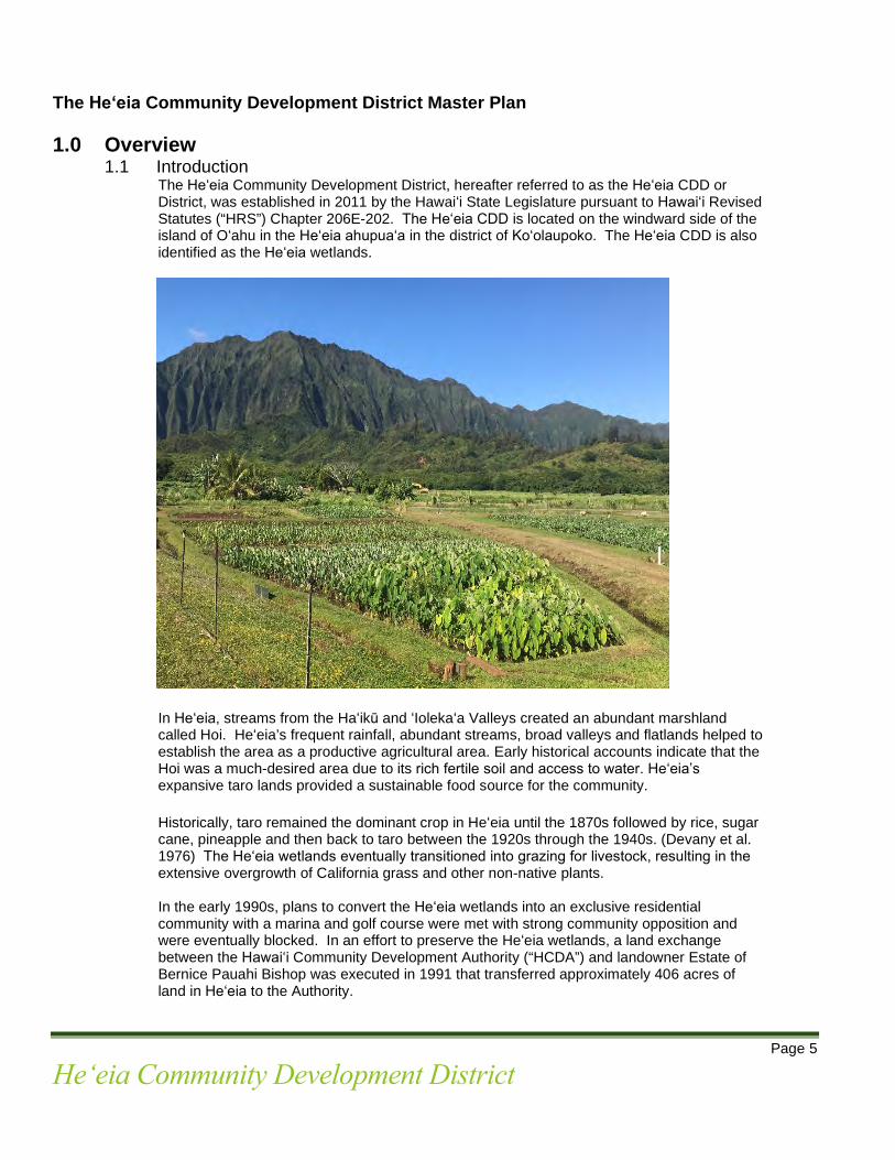
1.1 Introduction The Heʻeia Community Development District, hereafter referred to as the Heʻeia CDD or
District, was established in 2011 by the Hawaiʻi State Legislature pursuant to Hawaiʻi Revised Statutes (“HRS”) Chapter 206E-202. The Heʻeia CDD is located on the windward side of the island of Oʻahu in the Heʻeia ahupuaʻa in the district of Koʻolaupoko. The Heʻeia CDD is also identified as the Heʻeia wetlands.
In Heʻeia, streams from the Haʻikū and ʻIolekaʻa Valleys created an abundant marshland called Hoi. Heʻeia’s frequent rainfall, abundant streams, broad valleys and flatlands helped to establish the area as a productive agricultural area. Early historical accounts indicate that the Hoi was a much-desired area due to its rich fertile soil and access to water. Heʻeia’s expansive taro lands provided a sustainable food source for the community.
Historically, taro remained the dominant crop in Heʻeia until the 1870s followed by rice, sugar cane, pineapple and then back to taro between the 1920s through the 1940s. (Devany et al. 1976) The Heʻeia wetlands eventually transitioned into grazing for livestock, resulting in the extensive overgrowth of California grass and other non-native plants.
In the early 1990s, plans to convert the Heʻeia wetlands into an exclusive residential community with a marina and golf course were met with strong community opposition and were eventually blocked. In an effort to preserve the Heʻeia wetlands, a land exchange between the Hawaiʻi Community Development Authority (“HCDA”) and landowner Estate of Bernice Pauahi Bishop was executed in 1991 that transferred approximately 406 acres of land in Heʻeia to the Authority.
Page 6
Heʻeia Community Development District
At its meeting of July 1, 2009, the HCDA Board authorized the Executive Director to enter into a long-term lease with Kākoʻo ʻŌiwi, a community-based non-profit corporation. Kākoʻo ʻŌiwi’s primary mission, through its Māhuahua ʻAi o Hoi (Heʻeia Wetland Restoration Strategic Plan), is to restore the Heʻeia wetlands into a working agricultural and cultural district. The HCDA and Kākoʻo ʻŌiwi entered into a 38-year lease, effective January 1, 2010. Upon execution of the lease, Kākoʻo ʻŌiwi along with its partners has worked toward restoring the wetlands by converting fallow land into productive loʻi and agricultural gardens, planting fruit-bearing trees, renovating historic roads and kuaona, as well as removing invasive species such as the mangrove in the area. In addition, the construction of a poi mill and community area, capable of producing value added food products for resale, will be completed in 2021. On July 8, 2011, the Hawaiʻi State Legislature established the Heʻeia CDD. The HCDA was designated the local redevelopment authority of the district to facilitate culturally appropriate agriculture, education, and natural resource restoration and management of the Heʻeia wetlands. The Heʻeia CDD is identified as Tax Map Key Parcels: 1-4-6-16:001 and 1-4-6-16:002 (owned by the HCDA) and 1-4-6-16:004, 012, and 017 (owned by various owners of kuleana parcels).

Page 7
Heʻeia Community Development District
Figure 1: Heʻeia CDD District Boundary

Page 8
Heʻeia Community Development District
1.2 Purpose and Legislative Intent The purpose of the Heʻeia CDD Master Plan (“Heʻeia Plan”) is to fulfill the provisions of HRS Chapter 206E which requires that a master plan be developed following the establishment of the Heʻeia CDD. This Heʻeia Plan shall guide the restoration, development and the management of the District. The Heʻeia Plan establishes the vision and goals for the District; characterizes past and existing conditions of the District; establishes land uses for the District; and proposes strategies for achieving the District’s vision and goals. Development guidance policies were established by the State Legislature to govern the HCDA’s planning activities for the Heʻeia CDD. These policies are found in HRS Chapter 206E-203 and include the following: 1. Development shall be in accordance with the Heʻeia master plan, except as it
conflicts with the Hawaiʻi state constitution and the HRS; 2. With the approval of the governor, and in accordance with law, the authority, upon
the concurrence of a majority of its voting members, may modify and make changes to the Heʻeia master plan to respond to changing conditions; provided that prior to amending the Heʻeia master plan, the Authority shall conduct a public meeting pursuant to HRS Chapter 92 to inform the public of the proposed changes and receive public input;
3. The Authority shall provide, to the extent feasible, maximum opportunity for the
restoration and implementation of sustainable, culturally appropriate, biologically responsible, or agriculturally beneficial enterprises;
4. The Authority may engage in planning, design, and construction activities within
and outside the District; provided that activities outside the District shall relate to infrastructural development, area-wide drainage improvements and sediment transport mitigation, roadway realignments and improvements, and other activities the Authority deems necessary to carry out redevelopment of the district and implement this part. Studies or coordinating activities may be undertaken by the Authority in conjunction with the county and appropriate federal and state agencies and may address infrastructural systems, natural-resource systems, and other activities;
5. Planning, replanning, rehabilitation, development, redevelopment, and other
preparations for the restoration of cultural practices, education, natural resources, and agriculture related activities shall be pursued;
6. Hawaiʻian archaeological, historic, and cultural sites shall be preserved and
protected to the extent feasible while allowing for continued use of the property for cultural activities, education, agricultural and economic pursuits, and natural resource restoration;
7. Endangered species of flora and fauna shall be preserved and protected to the
extent feasible; 8. Land use and redevelopment activities within the district shall be coordinated with
and, to the extent possible, complement existing county and state policies, plans, and programs affecting the District;
9. Public facilities within the District shall be planned, located, and developed to
support the redevelopment policies established by this part for the district, the master plan approved by the Governor, and rules adopted pursuant to this chapter; and
Page 9
Heʻeia Community Development District
10. Special management area permit administration for the District shall continue to
be under the authority of the City and County of Honolulu.
1.3 Project Background Pursuant to HRS Chapter 206E-5(b), the HCDA embarked on a comprehensive community-based planning program to develop the Heʻeia Plan and Administrative Rules (“Plan and Rules”). Development of the Plan and Rules included background research and data collection; consultations with stakeholders, agencies and community members; as well as the evaluation and analysis of existing data and information pertaining to the District. Consultations included informal talk-story sessions, as well as formal community and stakeholder meetings. Participants included kūpuna, kamaʻāina, residents and landowners of Heʻeia, stakeholders and area farmers, non-profit organizations, government agencies, as well as experts in the fields of hydrology, flood control, and water quality. Approximately 140 individuals participated in consultations. Presentations were also made to the Kāneʻohe, Kailua, and Kahaluʻu Neighborhood Boards.
2.0 Context: 2.1 Regional Setting The Heʻeia CDD is located in the Heʻeia ahupuaʻa of the Koʻolaupoko region of Oʻahu. The
Heʻeia CDD is bounded by Kamehameha Highway on the east, the Crown Terrace subdivision on the south, Kahekili Highway to the west, and a private landowner and the City and County of Honolulu on the north. Heʻeia Fishpond and the Heʻeia State Park are located east of the Heʻeia CDD on the makai side of Kamehameha Highway.
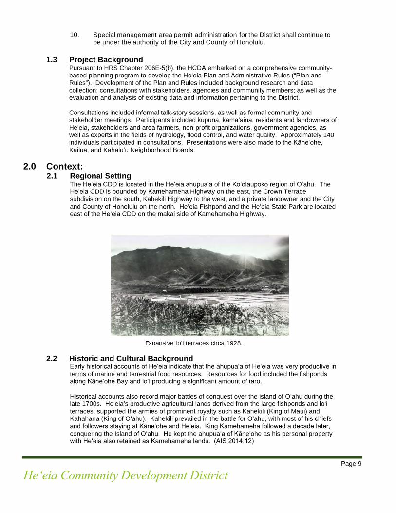
2.2 Historic and Cultural Background Early historical accounts of Heʻeia indicate that the ahupuaʻa of Heʻeia was very productive in terms of marine and terrestrial food resources. Resources for food included the fishponds along Kāneʻohe Bay and loʻi producing a significant amount of taro. Historical accounts also record major battles of conquest over the island of Oʻahu during the late 1700s. Heʻeia’s productive agricultural lands derived from the large fishponds and loʻi terraces, supported the armies of prominent royalty such as Kahekili (King of Maui) and Kahahana (King of Oʻahu). Kahekili prevailed in the battle for Oʻahu, with most of his chiefs and followers staying at Kāneʻohe and Heʻeia. King Kamehameha followed a decade later, conquering the Island of Oʻahu. He kept the ahupuaʻa of Kāneʻohe as his personal property with Heʻeia also retained as Kamehameha lands. (AIS 2014:12)
Expansive loʻi terraces circa 1928.

Page 10
Heʻeia Community Development District
Heʻeia remained under direct control of the Kamehameha dynasty until the Māhele. In 1848, as part of the Māhele, Abner Paki received the ahupuaʻa of Heʻeia as his personal property. He had been the konohiki (land agent/overseer) of Heʻeia from around 1830. The Catholic Mission also received large tracts of land within Heʻeia, that were a gift to the Mission by Kamehameha III. The Kuleana Act of 1850 allowed for private ownership of land by makaʻāiana, people and families who were living and working on the land to produce food. There were 28 Kuleana awards within and in close proximity to the District. Taro remained the dominant crop within the District until the 1870s. During this period, an influx of Chinese immigrants obtained leases to cultivate rice and then sugar into the 20th century. In 1878, the Heʻeia Sugar Plantation built the Heʻeia Sugar Mill and by 1880, the Heʻeia Rice Plantation was established and a rice mill was built within the District. By the 1890s, the cultivation of pineapple began in Heʻeia which replaced sugar and became the main industry in the area between 1910 to 1925.
Taro made a come-back in Heʻeia between 1920 and the 1940s which also coincided with declines in rice production. Much of the former loʻi lands were returned to taro production. Between the 1930s and 1940s, World War II brought U.S. military presence to Heʻeia and a Naval Reservation and Heʻeia Radio station was established along the coast where the Samuel Wilder King Intermediate School is now located. In the 1950s, Kāneʻohe transitioned into a suburban community during a residential shortage on the island of Oʻahu. From the 1960s through the 1980s, the wetlands were primarily used for pasture or became uncultivated land. In July 2010, upon execution of the lease with HCDA, Kākoʻo ʻŌiwi along with its partners has worked toward restoring the wetlands, eliminating invasive species, establishing an agricultural program and developing cultural and education programs that have become a valued part of the Kāneʻohe community.
Kūpuna Reflections on Heʻeia. Although the expansive loʻi terraces that once characterized the landscape of Heʻeia are no longer visible today, residents and lineal descendants of Heʻeia remember how it was before. Aunty Alice Hewett, a kūpuna of Heʻeia who grew up in the District in the 1930s and 1940s and whose ancestors lived in Heʻeia for more than two centuries, described the landscape of Heʻeia as a rural place where people worked the land and common practices included taro cultivation, cattle ranching, and raising livestock. “There was nothing there before,” she said, noting the many residential areas that have since developed adjacent to the Heʻeia CDD. People also accessed the ocean frequently to supplement their diet with fish.
Aunty Alice explained, “Everything was loʻi, pastures, and farms. There used to be all taro right up to the highway (Kamehameha) and up to the backside of Sears. All the way up was all taro. I don’t remember all the twenty different types, but I remember the purple taro. This place was full of loʻi.” There was also a cattle pasture with a dairy across the street from her house near the Heʻeia CDD. Below the pasture, a Japanese man grew taro all the way up to Kahekili Highway.

Page 11
Heʻeia Community Development District
“Taro was abundant,” she said. Taro was central to life in Heʻeia and poi, along with rice, was the main food staple. Breakfast often consisted of taro with cream and sugar. “We never had paʻiʻai (undiluted poi), when we didn’t have enough poi, we’d mix it with flour,” she said. There were four poi mills in the area in addition to her family’s poi mill near King Intermediate School. The mills were situated at: Haʻikū Road, Kāneʻohe, Waiāhole, and in the Heʻeia CDD. Her cousin opened a poi shop and though the building was not large, it produced “barrels and barrels” of poi that sold at $2 for 5 pounds. Despite the abundance and importance of poi, Aunty Alice described making poi as hard work.
Wai (fresh water) was also central to life in Heʻeia, not only for taro cultivation but also as an important habitat for many organisms including fish and crustaceans that supplemented the diet of the residents. The Heʻeia Stream began where the Haʻikū Stream meets ʻIolekaʻa Stream. Aunty Leialoha “Rocky” Kaluhiwa has fond memories of the streams of Heʻeia:
“There were streams everywhere. In Haʻikū, almost every house had a loʻi, a pig farm, and the stream would help. There were so many streams but building the roads took up many of the streams. We used to drink the water up at Haʻikū Valley. Now, cannot. We used to walk all along the side [of the Heʻeia Stream] and catch crayfish with the midrib of the coconut leaves. There were no ʻōpae there because the ʻōpae only live by the ocean. There were also ʻoʻopu in the streams. Meheanu, a kiaʻi (guardian) of Heʻeia Fishpond, also guards the Heʻeia Stream. There’s a time when she comes, and she comes in different forms,” she said. Aunty Rocky stressed the importance of keeping the stream open and flowing into the ocean.
The Heʻeia bridge is also mentioned by kūpuna in their memories of Heʻeia. “Before the bridge, there was a road that went down to the fishpond and the fishpond belonged to Bishop Estate. We used to go there every day to catch crab. The whitest crabs. That place had a beautiful white sand beach.” Aunty Rocky Kaluhiwa. Despite the many changes that time has brought to the District, taro has remained an important element in the identity and memories of its people. Kūpuna and lineal descendants of Heʻeia described the landscape of Heʻeia as a place where people worked the land and common practices consisted of taro cultivation, cattle ranching, and raising livestock. According to the kūpuna, Heʻeia was also made up of close-knit families where people grew up like brothers and sisters; it was viewed as beautiful, open and free.
Heʻeia Bridge
“Poi is a lot of work. When the taro is in the ground, it’s fine. It’s growing for months. But making poi is a lot of work. To make poi, we had to clean the taro before school and the boys would steam them at 1 AM. We also delivered poi but sometimes it was hard because people wouldn’t pay us.” Aunty Alice Hewett
Page 12
Heʻeia Community Development District
Deep aloha for Heʻeia is shared by kūpuna and the community; they are committed to creating a legacy of stewardship for future generations. Many expressed that they would like to see loʻi terraces fill the Heʻeia landscape once again, transforming the District into a center for kalo production and agriculture, bringing food abundance and security back to the region.
Wahi Pana (Place Names) and Moʻolelo (Stories). Heʻeia was named for the grandson of the demigod ʻOlopana, an uncle of Kamapuaʻa (Pukui et al. 1974). The child was adopted by the goddess Haumea, also the mother of Pele, who named him Heʻe-ia after a tidal event that, “washed (heʻeʻia) the[m] out to sea and back, after which they were victorious…[d]uring a battle with people from Leeward Oʻahu” (Pukui et al. 1974:44). Heʻeia grew into a handsome man who fell in love with Kaʻohelo, a younger sister of Pele and Hiʻiaka [Kahele 1918 - 1919, 5:576-582] (cited in Kelly 1975:2).
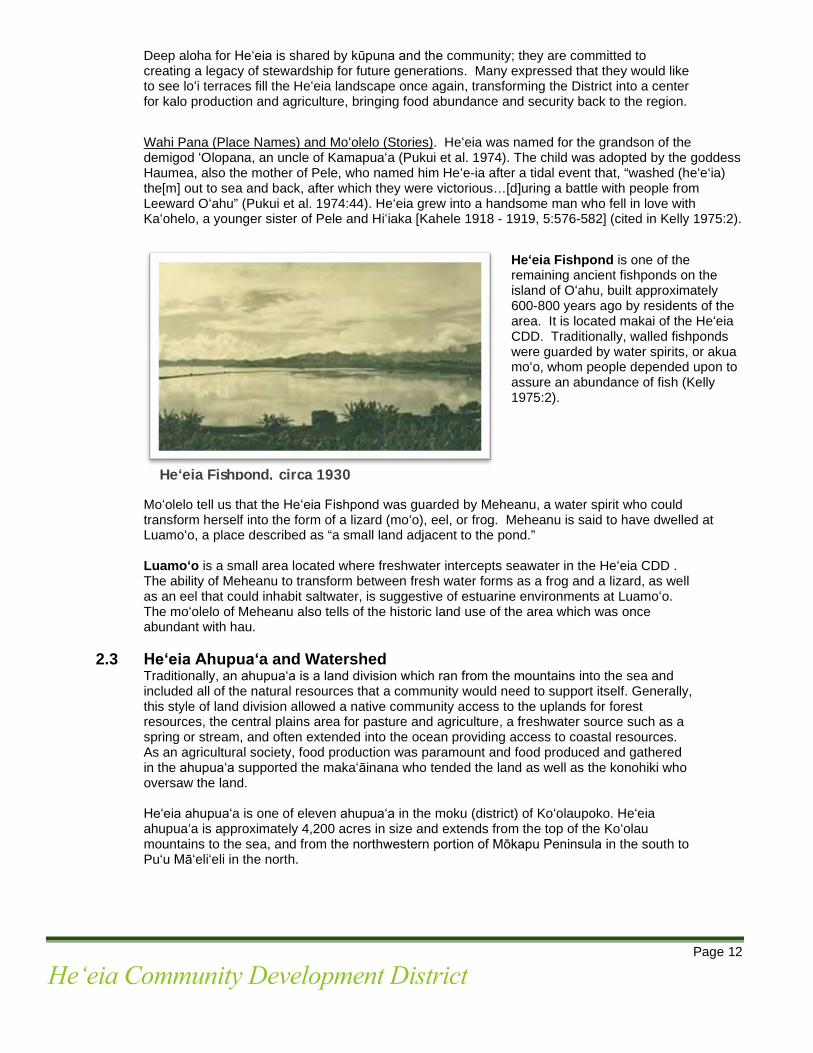
Heʻeia Fishpond is one of the remaining ancient fishponds on the island of Oʻahu, built approximately 600-800 years ago by residents of the area. It is located makai of the Heʻeia CDD. Traditionally, walled fishponds were guarded by water spirits, or akua moʻo, whom people depended upon to assure an abundance of fish (Kelly 1975:2).
Moʻolelo tell us that the Heʻeia Fishpond was guarded by Meheanu, a water spirit who could transform herself into the form of a lizard (moʻo), eel, or frog. Meheanu is said to have dwelled at Luamoʻo, a place described as “a small land adjacent to the pond.” Luamoʻo is a small area located where freshwater intercepts seawater in the Heʻeia CDD . The ability of Meheanu to transform between fresh water forms as a frog and a lizard, as well as an eel that could inhabit saltwater, is suggestive of estuarine environments at Luamoʻo. The moʻolelo of Meheanu also tells of the historic land use of the area which was once abundant with hau.
2.3 Heʻeia Ahupuaʻa and Watershed Traditionally, an ahupuaʻa is a land division which ran from the mountains into the sea and included all of the natural resources that a community would need to support itself. Generally, this style of land division allowed a native community access to the uplands for forest resources, the central plains area for pasture and agriculture, a freshwater source such as a spring or stream, and often extended into the ocean providing access to coastal resources. As an agricultural society, food production was paramount and food produced and gathered in the ahupuaʻa supported the makaʻāinana who tended the land as well as the konohiki who oversaw the land. Heʻeia ahupuaʻa is one of eleven ahupuaʻa in the moku (district) of Koʻolaupoko. Heʻeia ahupuaʻa is approximately 4,200 acres in size and extends from the top of the Koʻolau mountains to the sea, and from the northwestern portion of Mōkapu Peninsula in the south to Puʻu Māʻeliʻeli in the north.
Heʻeia Fishpond, circa 1930

Page 13
Heʻeia Community Development District
Historic accounts and documentation of the 1800s indicate that lands within the Heʻeia ahupuaʻa were extremely productive. (AIS CSH 2014, p. 13). Frequent rainfall, ample streams, broad valley bottoms, and flatlands between the mountains and the sea, provided ideal conditions for agriculture and aquaculture in Heʻeia. The richness of the region was attributed to a functioning water system that flowed throughout the ahupuaʻa from the valleys of Haʻikū and ʻIolekaʻa, through the wetlands of Heʻeia, to Kāneʻohe Bay. Because of its high productivity, the lands of Heʻeia ahupuaʻa were considered very valuable.
A watershed is defined as a drainage basin that catches, collects and stores water that travels toward the ocean via rivers, streams or through subterranean springs or seepages. The Heʻeia watershed is approximately 3.5 square miles in size and extends from the peaks of the Koʻolau mountains, including the valleys of Haʻikū and Heʻeia, to Kāneʻohe Bay. The Heʻeia CDD is centrally located within the Heʻeia ahupuaʻa and watershed. Given its significant location, the restoration, maintenance and future uses of the Heʻeia wetlands are key elements needed to maintain the overall health of the Heʻeia ahupuaʻa and watershed.
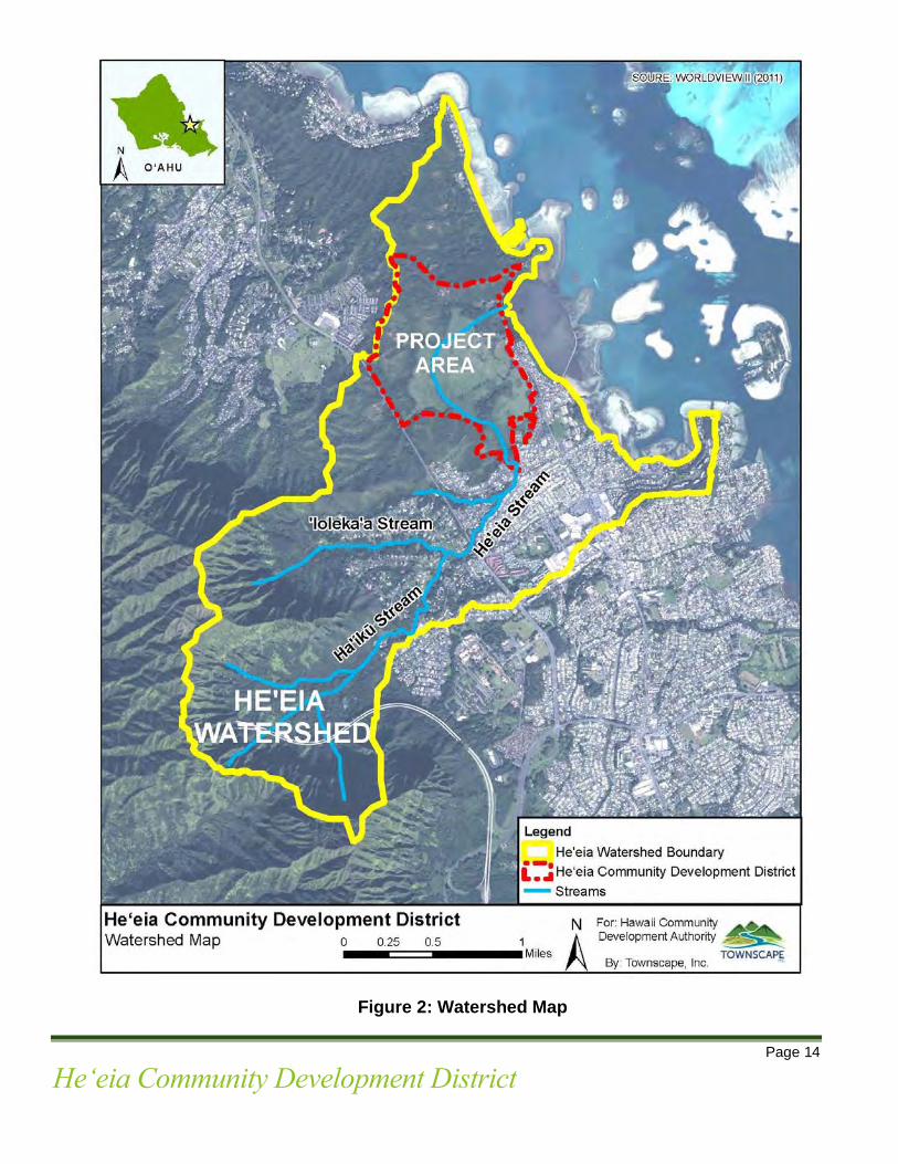
Page 14
Heʻeia Community Development District
Figure 2: Watershed Map

Page 15
Heʻeia Community Development District
2.4 Land Ownership Approximately 406 acres of land within the Heʻeia CDD is owned by the HCDA. In addition to HCDA, there are three privately-owned parcels of land within the District, totaling approximately 3 acres. The privately-owned parcels are identified as ‘kuleana’ parcels. Kuleana Lands. The Kuleana Act of 1850, initiated by King Kamehameha III, created Hawaiʻi's first system of private land ownership. Through the Kuleana Act, King Kamehameha III created a process that allowed the hoaʻāina (native tenants) to claim and obtain alloidal title to the land where their family homes were built and where they grew their food. As a result of the Kuleana Act, 93 kuleana or land commission awards (“LCA”), totaling 203 acres of land, were granted for property in Heʻeia. There were 28 LCA within and in close proximity to the Heʻeia CDD. LCA claims within the Heʻeia CDD indicate that the land at the time of the Kuleana Act was used primarily for loʻi cultivation and residences. (AIS CSH 2014 p.13).
Kuleana rights include reasonable access, agricultural rights, gathering rights, rights to a single-family dwelling, water rights and fishing rights. Kuleana rights included the following:
• Reasonable access to land-locked kuleana from major thoroughfares; • Agricultural uses, such as taro cultivation; • Traditional gathering rights in and around the ahupuaʻa; • A house lot, typically ¼ of an acre; • Sufficient water for drinking and irrigation of agricultural crops from nearby streams,
including traditionally established waterways such as ʻauwai; and • Fishing rights in the kunalu (the coastal region extending from beach to reef).
In addition to the HCDA, several major landowners own significant amounts of land in the area adjacent to the Heʻeia CDD. Major landowners include:
• Kamehameha Schools • The State of Hawaiʻi • The City and County of Honolulu

Page 16
Heʻeia Community Development District
Figure 3. Landownership Map

Page 17
Heʻeia Community Development District
2.5 Population and Socio-Economic Profile The U.S. Census designated area of Heʻeia encompasses approximately 3.1 square miles and includes Haʻikū Valley and Heʻeia Kea. Per U.S. Census data of 2017, Heʻeia’ s population was 4,811. The median age in Heʻeia was 50.6 years old with more than half (56%) of its population between 18 to 64 years of age. The average family size was 3.3. Approximately 97.5% of the Heʻeia population graduated from high school and about 43.4% of residents obtained a bachelor’s degree or higher. The median household income was approximately $123,750 which exceeded the State’s median household income of $74,923. Approximately 1.7 % of the Heʻeia population was below the poverty line. There were approximately 1,581 housing units with an occupancy rate of 98%. Of the 1,581 housing units, 91% were owner occupied and 97% were single unit structures. The median value of the owner-occupied housing units was $843,500.
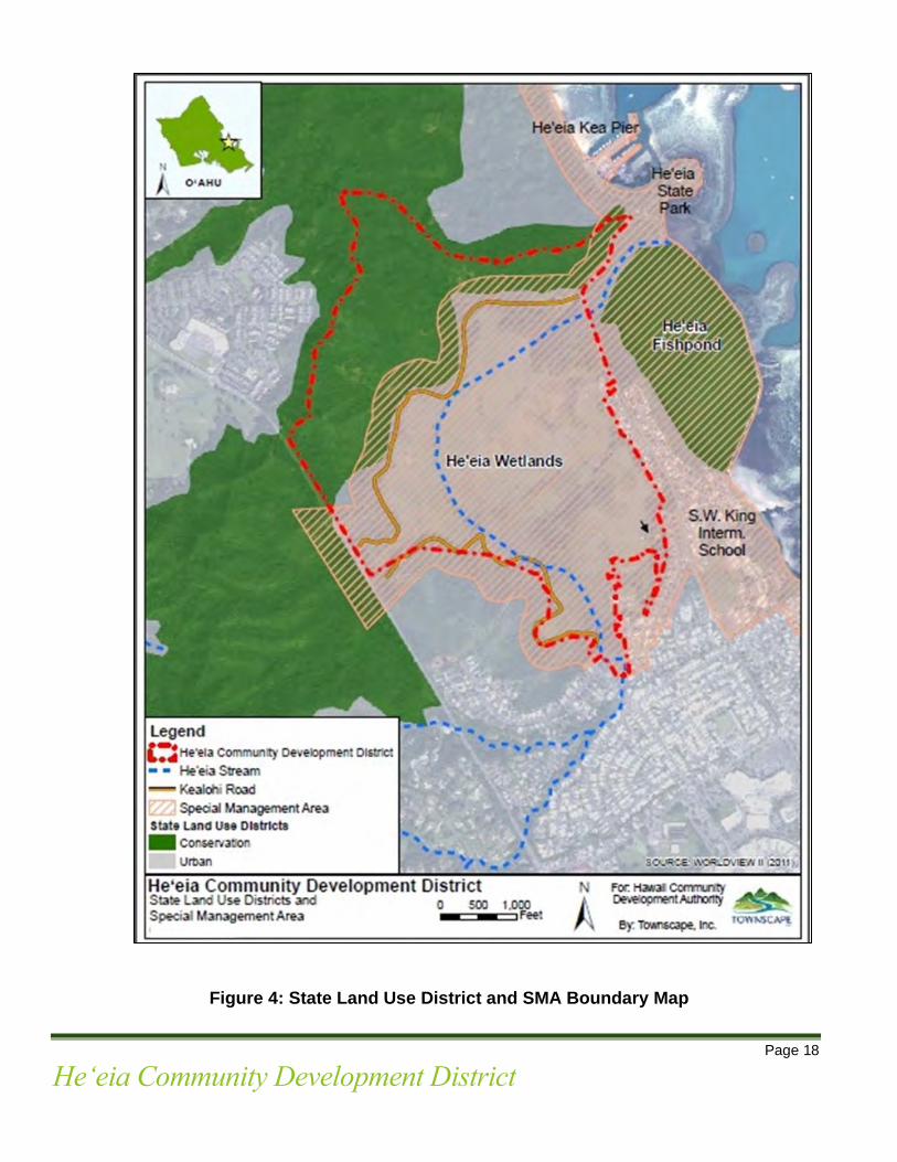
2.6 Regional Plans, Regulations and Policies: The Heʻeia CDD shall comply with the following applicable regional plans, regulations and policies: 2.6.1 State Land Use District
Approximately 272 acres of the Heʻeia CDD is located within the State Land Use District’s Urban District and the remaining portion of the District is in the Conservation District. See Figure 4. The portion of the District in the Conservation District is classified as “General”. Property within the Heʻeia CDD is subject to all applicable State Land Use District regulations.
2.6.2 Special Management Area (“SMA”)
The wetland area of the District is located within the boundaries of the SMA. Pursuant to HRS Chapter 206E-203, the administration of SMA permits for the District is under the jurisdiction of the City and County of Honolulu.
2.6.3 Koʻolau Poko Sustainable Communities Plan (“KPSCP”) The KPSCP is a long-range plan to guide public policy, land use, investment, and decision-making in Koʻolaupoko through 2035. The KPSCP is consistent with the City and County of Honolulu’s General Plan and envisions that by the year 2035, “Koʻolaupoko’s natural, cultural, historic, agricultural, and aqua-cultural/fishpond resources are protected and enhanced.” Key elements of the KPSCP include:
• Significant scenic views of ridges, upper valley slopes, shoreline areas from major public parks highways, coastal waters and hiking trails are protected;
• Access to shoreline areas and mountainous regions are improved and provided for all to use and enjoy;
• Cultural and historical resources are preserved through the protection of visual landmarks and significant views, protected access rights relating to traditional cultural practices, and the protection of significant historic, cultural, and archaeological features; and
• Koʻolau Poko contains productive and potentially productive agricultural lands that are preserved by adopted protective regulatory policies and implemented incentives and programs that promote active agricultural use of these lands.
The Heʻeia Plan supports and is consistent with the overall vision of the KPSCP by supporting agricultural use, preserving cultural and historical resources where applicable, and protecting scenic views of ridges, upper valley slopes and shoreline areas.
Page 18
Heʻeia Community Development District
Figure 4: State Land Use District and SMA Boundary Map

Page 19
Heʻeia Community Development District
2.6.4 Koʻolau Poko Watershed Management Plan (“KPWMP”) The KPWMP is a 20-year plan that seeks to formulate an environmentally holistic, community-based, and economically viable water management plan that will provide a balance between (1) the protection, preservation and management of Oʻahu’s watersheds; and (2) sustainable ground water and surface water use and development to serve present users and future generations. To achieve this goal, the KPWMP proposes five objectives which include:
• Promote sustainable watersheds; • Protect and enhance water quality and quantity; • Protect Native Hawaiʻian rights and traditional and customary practices; Facilitate public participation, education, and project implementation; and Meet future water demands at reasonable costs.
The KPWMP proposes more specific actions for Heʻeia which include: (1) a Heʻeia Stream Restoration Project; and (2) a projected, expanded supply of non-potable water for Koʻolau Poko from 11.434 million gallons per day (mg.) in 2000 to 14.271 mgs, in 2030. The increase in water demand is expected to account for possible future taro production in Heʻeia which could be met by an increase in the use of both stream water and ground water for agricultural irrigation. The Heʻeia Plan is consistent with the goals and objectives of the KPWMP. The Heʻeia Plan supports agricultural use and taro production in Heʻeia which may increase water demand for non-potable water for agricultural purposes in Koʻolau Poko by 2030, as projected in the KPWMP. The Heʻeia Plan also proposes the restoration of Heʻeia Stream, a key resource for anticipated agricultural activities within the District.
2.6.5 Heʻeia National Estuarine Research Reserve (“NERR”) The Heʻeia CDD is part of the Heʻeia NERR which is the nation’s 29th NERR, administered by the Hawaiʻi Institute of Marine Biology, as designated by the State of Hawaiʻi.
Heʻeia NERR Boundary Area

Page 20
Heʻeia Community Development District
The Heʻeia NERR seeks to practice and promote stewardship of coasts and estuaries through innovative research, education, and training using a place-based system of protected areas. The Heʻeia NERR consists of approximately 1,385 acres of land and includes Heʻeia State Park, Heʻeia Fishpond, the Heʻeia CDD, Moku o Loʻe Island, and the large expanse of waters and reefs of Kāneʻohe Bay. The goals and priorities of the Heʻeia NERR are as follows:
• Ensure a stable environment for research through long-term protection of NERR System resources;
• Address coastal management issues identified as significant through coordinated estuarine research within the system;
• Enhance public awareness and understanding of estuarine areas and provide suitable opportunities for public education and interpretation;
• Promote federal, state, public, and private use of one or more reserves within the system when such entities conduct estuarine research; and
• Conduct and coordinate estuarine research within the system, gathering and making available information necessary for improved understanding and management of estuarine areas.
Priority issues of the Heʻeia NERR include: invasive species, loss of natural habitats, erosion and sedimentation, nonpoint source pollution, urbanization and human activities in the area, water quality issues, agricultural development, and climate change impacts.
3.0 Physical Environment 3.1 Topography and Geology
The Heʻeia CDD generally consists of low-lying wetlands with portions of higher regions that extend to approximately 440 feet above sea level. Geologically, the district of Koʻolau Poko is part of the Koʻolau volcano, one of two extinct volcanos that make up the Island of Oʻahu. The geologic composition of the District consists of:
• Koʻolau Basalt (45.6%), • Older Alluvium (37.4%), • Alluvium (13.2%), • Honolulu Volcanics (3.1%), • Beach Deposit (0.5%) (Izuka et al., 1993; Stearns and Vaksvick, 1935).
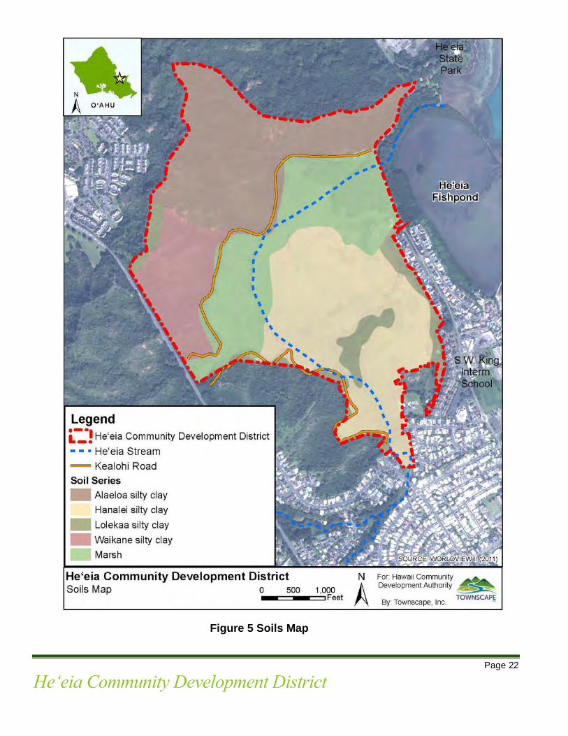
3.2 Soils
Majority of the wetland area consists of Hanalei silty clay (HnA), Lolekaa silty clay (LoB), and Marsh (MZ). The majority of the Kealohi road corridor lies above Alaeloa silty clay (AeE), and Marsh. A portion of the road corridor also lies directly alongside Waikane silty clay (WpE).
The Heʻeia CDD has had extensive fill deposited in the twentieth century and has partially been under taro cultivation but remains mostly in overgrown wetland vegetation. See Figure 5.
Page 21
Heʻeia Community Development District
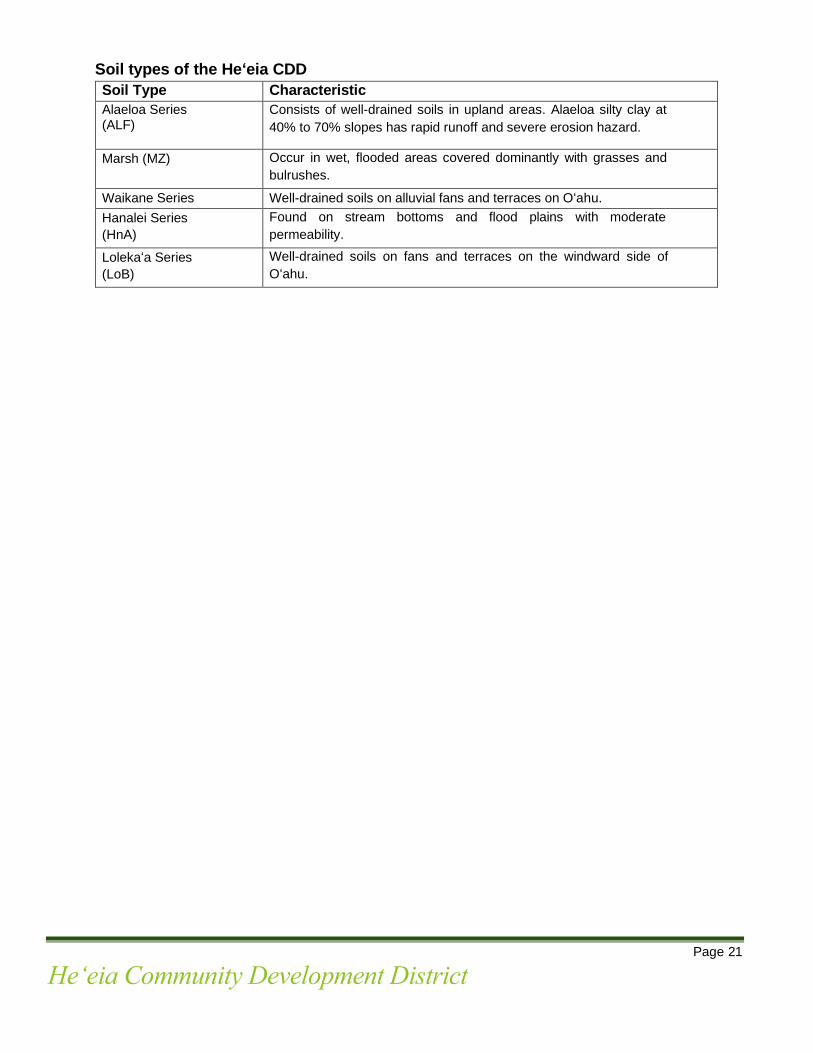
Soil types of the Heʻeia CDD
Soil Type Characteristic Alaeloa Series (ALF)
Consists of well-drained soils in upland areas. Alaeloa silty clay at 40% to 70% slopes has rapid runoff and severe erosion hazard.
Marsh (MZ) Occur in wet, flooded areas covered dominantly with grasses and bulrushes.
Waikane Series
Well-drained soils on alluvial fans and terraces on Oʻahu. Hanalei Series (HnA)
Found on stream bottoms and flood plains with moderate permeability.
Lolekaʻa Series (LoB)
Well-drained soils on fans and terraces on the windward side of Oʻahu.
Page 22
Heʻeia Community Development District
Figure 5 Soils Map
Page 23
Heʻeia Community Development District
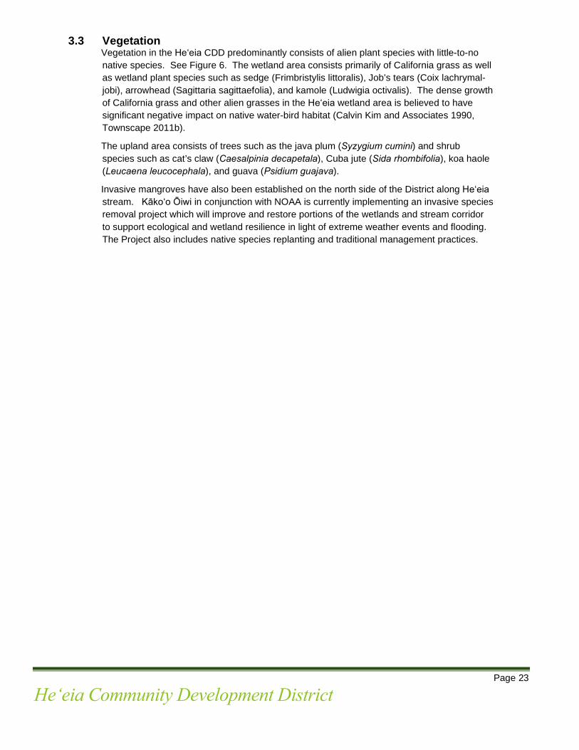
3.3 Vegetation Vegetation in the Heʻeia CDD predominantly consists of alien plant species with little-to-no native species. See Figure 6. The wetland area consists primarily of California grass as well as wetland plant species such as sedge (Frimbristylis littoralis), Job’s tears (Coix lachrymal-jobi), arrowhead (Sagittaria sagittaefolia), and kamole (Ludwigia octivalis). The dense growth of California grass and other alien grasses in the Heʻeia wetland area is believed to have significant negative impact on native water-bird habitat (Calvin Kim and Associates 1990, Townscape 2011b).
The upland area consists of trees such as the java plum (Syzygium cumini) and shrub species such as cat’s claw (Caesalpinia decapetala), Cuba jute (Sida rhombifolia), koa haole (Leucaena leucocephala), and guava (Psidium guajava).
Invasive mangroves have also been established on the north side of the District along Heʻeia stream. Kākoʻo Ōiwi in conjunction with NOAA is currently implementing an invasive species removal project which will improve and restore portions of the wetlands and stream corridor to support ecological and wetland resilience in light of extreme weather events and flooding. The Project also includes native species replanting and traditional management practices.
Page 24
Heʻeia Community Development District
Figure 6: Vegetation

Page 25
Heʻeia Community Development District
3.4 Hydrology Precipitation is the source of virtually all freshwater in the Heʻeia watershed, but its distribution is highly variable. Rainfall on land is taken up by plants, some water infiltrates the soil and moves vertically downward to the water table to become ground water (re-charge), some of it evaporates back into the atmosphere (evapotranspiration) and the rest flows over land as runoff, enters streams and other water features, and ultimately discharges into the ocean. Ground water moves both vertically and laterally within the ground-water system and some water may seep through the surface into streams, springs, and wetlands. Therefore, surface and ground water are highly interdependent on the supply and quality of the other.
Wetlands are surface water areas that are regularly wet or flooded throughout most of the year. Wetlands provide habitat for fish, birds, and other wildlife and provide natural places with recreational opportunities. Wetlands also serve two major hydrological functions: (1) intercept runoff and lessen the impact of flooding; and (2) absorb sediment and pollutants in runoff. Therefore, wetlands play an important role in flood control and improving water quality and are important attributes of a watershed. 3.4.1 Surface Water. Surface water in the Heʻeia CDD is found in Heʻeia Stream and its
tributaries, ponds, stream diversions, and springs that feed the Heʻeia Wetland. Fresh water in Heʻeia comes entirely from precipitation along the Koʻolau Mountain Range averaging about 84 inches per year (Streamstats 2012).
3.4.2 Streams. Heʻeia Stream is the primary stream that flows through the District. Its
water comes from rainfall, runoff, and ground water seepage. Approximately 87% of the average annual streamflow comes from groundwater and the remainder from runoff (Ghazal 2017). Stream water extends 7.1 miles from the upper reaches of the Koʻolau Mountains to the end of the stream mouth at Kāneʻohe Bay (Parham et al. 2008). Heʻeia stream begins where the Haʻikū Stream and ʻIolekaʻa Stream merge. Several smaller tributaries and contribute to the total flow of Heʻeia Stream which fan out to the wetland areas of the District and then to Heʻeia Fishpond. Approximately 1.3 miles of the stream is within the Heʻeia CDD. Heʻeia Stream and its tributaries feed most of the water in the Heʻeia Wetland, draining an area of 4.44 square miles. The stream’s average continuous main streamflow is 6,851 cubic meters per day with an average gradient of 11%. (Wilson, 2004-dissertation).
3.4.3 Ground water. In Hawaiʻi, rainfall fills dike compartments within its mountains’ rock
layers and as compartments fill up, water surfaces as springs or seepages. Groundwater recharge is generally greatest in the upper regions of the Koʻolau Mountains with annual recharge rates exceeding 3.81 meters (Shade and Nichols, 1996). Haʻikū Valley, which drains an area of about 1.57 square miles, receives recharge of 0.00492 meter per day. Ground water seepage into streams may take months or even decades from the original rainfall event. The Heʻeia CDD is within the Koʻolau Poko Aquifer System of the Windward Aquifer Sector.
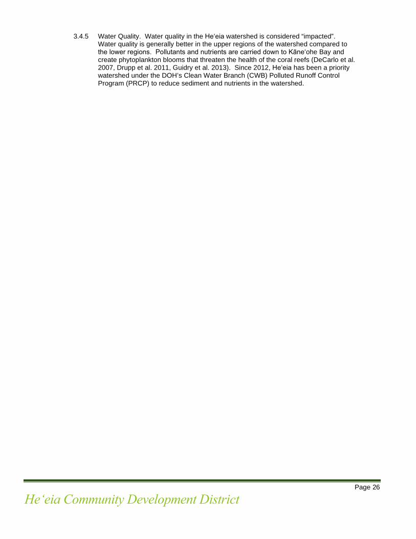
3.4.4 Flooding. The majority of the Heʻeia CDD is within the Special Flood Hazard Area,
also known as 100-year flood zone. See Figure 7. Moderate flood events in Heʻeia occur several times annually (Koonce, 2012). Flood peaks can be achieved within hours following the onset of precipitation. Similarly, the return to base flow can occur within a matter of hours. Much of the area makai of the Kahekili Highway including most of the Heʻeia CDD, surrounding residential subdivision, and area near Windward Mall Kāneʻohe Bay Shopping Center are in the 500-year flood zone. This area has a 1-in-500 or 0.2 percent chance of flooding in any given year.
Page 26
Heʻeia Community Development District
3.4.5 Water Quality. Water quality in the Heʻeia watershed is considered “impacted”.
Water quality is generally better in the upper regions of the watershed compared to the lower regions. Pollutants and nutrients are carried down to Kāneʻohe Bay and create phytoplankton blooms that threaten the health of the coral reefs (DeCarlo et al. 2007, Drupp et al. 2011, Guidry et al. 2013). Since 2012, Heʻeia has been a priority watershed under the DOH’s Clean Water Branch (CWB) Polluted Runoff Control Program (PRCP) to reduce sediment and nutrients in the watershed.
Page 27
Heʻeia Community Development District
Figure: 7 Flood Map
Page 28
Heʻeia Community Development District
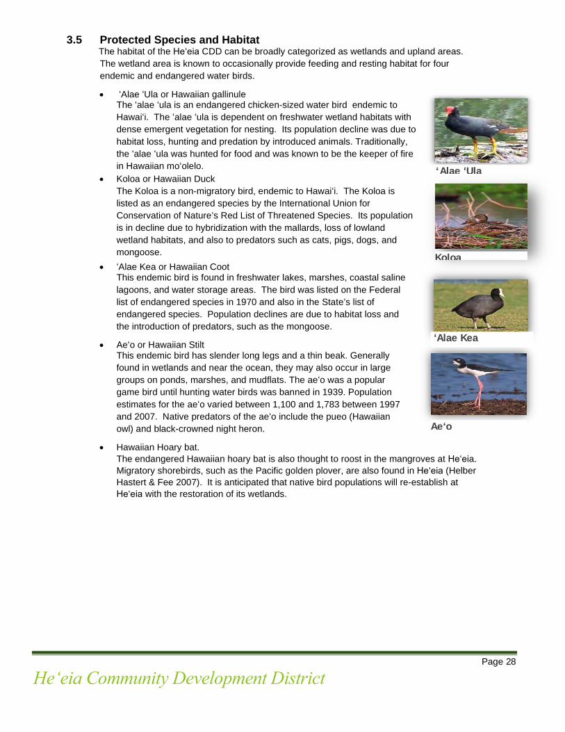
3.5 Protected Species and Habitat The habitat of the Heʻeia CDD can be broadly categorized as wetlands and upland areas. The wetland area is known to occasionally provide feeding and resting habitat for four endemic and endangered water birds.
• ʻAlae ʻUla or Hawaiian gallinule The ʻalae ʻula is an endangered chicken-sized water bird endemic to Hawaiʻi. The ʻalae ʻula is dependent on freshwater wetland habitats with dense emergent vegetation for nesting. Its population decline was due to habitat loss, hunting and predation by introduced animals. Traditionally, the ʻalae ʻula was hunted for food and was known to be the keeper of fire in Hawaiian moʻolelo.
• Koloa or Hawaiian Duck The Koloa is a non-migratory bird, endemic to Hawaiʻi. The Koloa is
listed as an endangered species by the International Union for Conservation of Nature’s Red List of Threatened Species. Its population is in decline due to hybridization with the mallards, loss of lowland wetland habitats, and also to predators such as cats, pigs, dogs, and mongoose.
• ʻAlae Kea or Hawaiian Coot This endemic bird is found in freshwater lakes, marshes, coastal saline lagoons, and water storage areas. The bird was listed on the Federal list of endangered species in 1970 and also in the State’s list of endangered species. Population declines are due to habitat loss and the introduction of predators, such as the mongoose.
• Aeʻo or Hawaiian Stilt This endemic bird has slender long legs and a thin beak. Generally found in wetlands and near the ocean, they may also occur in large groups on ponds, marshes, and mudflats. The aeʻo was a popular game bird until hunting water birds was banned in 1939. Population estimates for the aeʻo varied between 1,100 and 1,783 between 1997 and 2007. Native predators of the aeʻo include the pueo (Hawaiian owl) and black-crowned night heron.
• Hawaiian Hoary bat. The endangered Hawaiian hoary bat is also thought to roost in the mangroves at Heʻeia. Migratory shorebirds, such as the Pacific golden plover, are also found in Heʻeia (Helber Hastert & Fee 2007). It is anticipated that native bird populations will re-establish at Heʻeia with the restoration of its wetlands.
Koloa
Aeʻo
‘Alae ʻUla
ʻAlae Kea

Page 29
Heʻeia Community Development District
3.6 Climate Change Changes in global climate are expected to adversely impact Hawaiʻi in the long-term. The impacts include sea level rise, an overall reduction in rainfall, increasing temperatures, and an increase in storm frequency and intensity, leading to more flooding events. An overall reduction in annual rainfall would lead to a decline in the sustainability of groundwater sources (Burnett and Wada, 2014). Increasing temperatures will also drive evapo-transpiration or water loss from plants and other surfaces. In addition, increasing water demands from urban development and population growth, will further impact water supply in Hawaiʻi in the future (Engott et al., 2015). At Heʻeia, these scenarios translate into a potential reduction in overall rainfall, surface water, groundwater, and stream flow. Mitigative efforts to minimize the impacts of climate change are important, such as: (1) removing invasive vegetation which consume and transpire more water than native plants; and (2) prioritize the restoration of native plants.
Sea Level Rise (SLR). Global climate change is expected to result in sea level rise in the future that will impact the coastal areas of Hawaiʻi. Future impacts include (Bjerkie et al. (2012): • Rising groundwater levels • Formation of new wetlands and expansion of existing wetlands • Changes in surface drainage and soil saturation • Increase in sporadic flooding events that will intensify seasonally when high tide events
coincide with rainfall events • Saltwater intrusion will impact root zone of plants • Infrastructure damage in low-lying areas
Figure 8 shows four sea level rise scenarios, colored in yellow, in Heʻeia at 0.5 feet, 1.1 feet, 2 feet, and 3.2 feet. These projections are based on the anticipated rate of increase in sea levels to 3.2 feet by the year 2100 (IPCC 2014). Figure 8 suggests that sea level rise of 0.5 feet and 1.1 feet will mostly affect the Heʻeia fishpond makai of the Heʻeia CDD, and one low point inland that is located makai of Kahekili Highway on the mauka side of Heʻeia CDD. Sea level rise of 2 feet and 3.2 feet are expected to inundate the Heʻeia CDD along the mouth of Heʻeia Stream near Kamehameha Highway and will likely cover the highway. These findings are significant for long-range infrastructure planning for the Heʻeia CDD that would typically be constructed along or under roadways.

Page 30
Heʻeia Community Development District
Figure 8: Projected Marine Inundation
=0.5 ft SLR =1.1 ft SLR
LegendHeʻeia StreamKealohi RoadMajor paved roadsProject Area TMKsHeʻeia Community Development District
ZONE100-Yr Flood500-Yr FloodFloodway
= 2.0 ft SLR =3.2 ft SLR

Page 31
Heʻeia Community Development District
3.7 Archaeological and Historic Sites Pursuant the HAR § 13-284-6, an Archaeological Inventory Survey (“AIS”) was prepared for the Heʻeia CDD in 2017. As a result of fieldwork efforts and on-site inspections of the project area, archaeological sites were identified relating to pre-Contact traditional Hawaiʻian habitation, areas of agriculture and burial potential, post-Contact plantation-era agriculture and historic ranching animal husbandry enclosures. Seventeen historical properties were identified and evaluated for significance. Of the seventeen sites, four sites were deemed to ʻhave yielded, or is likely to yield information important for research on prehistory or historyʻ and ʻhave an important value to the Native Hawaiʻian people or to another ethnic group of the State due to associations with cultural practices once carried out, or still carried out, at the property or due to associations with traditional beliefs, events or oral history accounts – these associations being important to the groupʻs history and cultural identity.ʻ The four sites will be preserved in place as recommended by the AIS. See Figure 9.
A fifth site, Kealohi Road, SIHP #50-80-10-7521, is a post-contact earthen road corridor. Kealohi road is a plantation-era road which continues to serve as the primary access from Kamehameha Highway toward Kahekili Highway. Kealohi Road will also be preserved in place as recommended by the AIS.
Historic Properties at the Heʻeia Community Development District
Site #
Historic Site Description
1 SIHP # 50-80-10-
7522 Basalt Quarry
Likely for road grading and historic development in the area.
2 SIHP # 50-80-10-7523 Possible ʻŌkolehao distillery
Possibly an ʻōkolehao (ti root liquor) distillery.
3 SIHP # 50-80-10-7530 Basalt terrace complex
A traditional terrace complex likely for agriculture.
4 SIHP # 50-80-10-7535 Concrete platforms
This site consists of two concrete platforms believed to be a portion of the former rice mill foundation.

Page 32
Heʻeia Community Development District
Figure 9: Historic Sites Map
Page 33
Heʻeia Community Development District
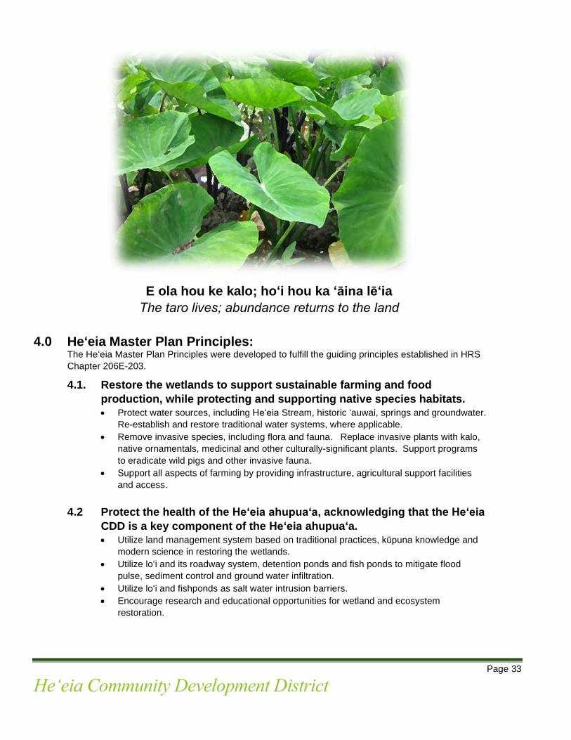
E ola hou ke kalo; hoʻi hou ka ʻāina lēʻia
The taro lives; abundance returns to the land
4.0 Heʻeia Master Plan Principles: The Heʻeia Master Plan Principles were developed to fulfill the guiding principles established in HRS
Chapter 206E-203.
4.1. Restore the wetlands to support sustainable farming and food production, while protecting and supporting native species habitats. • Protect water sources, including Heʻeia Stream, historic ʻauwai, springs and groundwater.
Re-establish and restore traditional water systems, where applicable. • Remove invasive species, including flora and fauna. Replace invasive plants with kalo,
native ornamentals, medicinal and other culturally-significant plants. Support programs to eradicate wild pigs and other invasive fauna.
• Support all aspects of farming by providing infrastructure, agricultural support facilities and access.
4.2 Protect the health of the Heʻeia ahupuaʻa, acknowledging that the Heʻeia
CDD is a key component of the Heʻeia ahupuaʻa. • Utilize land management system based on traditional practices, kūpuna knowledge and
modern science in restoring the wetlands. • Utilize loʻi and its roadway system, detention ponds and fish ponds to mitigate flood
pulse, sediment control and ground water infiltration. • Utilize loʻi and fishponds as salt water intrusion barriers. • Encourage research and educational opportunities for wetland and ecosystem
restoration.

Page 34
Heʻeia Community Development District
4.3 Perpetuate Hawaiʻian culture to enrich the Heʻeia District and the broader district of Koʻolaupoko. • Promote the development of educational and cultural facilities in the District. • Encourage the sharing of manaʻo by community members, cultural practitioners,
residents of Heʻeia and respective experts and authorities. • Respect the wisdom of kūpuna and lineal descendants while encouraging the next
generation to carry on the rich heritage of Heʻeia. • Restore and create a cultural connection between the District and the broader Heʻeia
community. • Acknowledge and support the kuleana parcels within the District.
4.4 Preserve significant archaeological, historic and cultural sites, to the
extent practical. • Preserve in place all significant archaeological, historical and cultural sites, to the extent
practical. • Restore and reclaim historic sites, to the extent practical. • Consult with lineal descendants, cultural practitioners and the State Historic Preservation
Division on issues pertaining to significant archaeological, historical and cultural sites.
4.5 Promote economic and environmental sustainability. 4.5.1. Economic Sustainability
• Support opportunities for enterprise that are consistent with the District’s manaʻo hoʻokō (intent).
• Support a venue for produce and products grown within the District. • Provide support facilities including, poi mill, agricultural processing centers,
commercial kitchens, and community areas. • Explore opportunities that promote economic sustainability that are consistent
with the District’s manaʻo hoʻokō (intent).
4.5.2. Environmental Sustainability • Utilize green building, alternative energy, and zero waste strategies where
applicable. • Account for climate change and sea level rise. • Pursue grants, funding, educational and research opportunities that promote
environmental sustainability. 5.0 Land Use Plan and Guidelines
5.1 Land Use Plan The Land Use Plan has been developed to create an agricultural, cultural and educational district which reflects the development guidance policies enacted by the State Legislature along with community input and manaʻo from kūpuna and lineal descendants.

Page 35
Heʻeia Community Development District
5.1.1 Wao Hoʻōla The Wao Hoʻōla zone is the upland or āʻina Makua area of the District and is envisioned as the area of restoration and respite. Non-native vegetation will be replaced with native and culturally significant vegetation. The Wao Hoʻōla zone provides an opportunity for dry-land agriculture as well as facilities that promote respite and healing. Significant historic sites including a basalt quarry and terrace will be preserved in place.
The Wao Hoʻōla zone extends from Kamehameha Highway on the northeastern boundary of the Heʻeia CDD, to Kahekili Highway on the southwestern boundary of the District. The Wao Hoʻōla zone is generally located outside the 100-year flood zone and is higher in elevation than other regions of the Heʻeia CDD, with highest elevations of up to 440 feet. The topography is steep in some areas with swales that could potentially flood during heavy rain events. Due to Heʻeiaʻs use as a military training area in the 1940s, an unexploded ordnance was found near the northern boundary of the District. Lessee Kakoʻo ʻŌiwi is aware of the protocol of ʻRecognize, Retreat, and Report to 911 should any unexploded ordnance be uncovered.
The Wao Hoʻōla zone is generally located within the State Land Use District Conservation “General” zone. Conservation-zoned lands are comprised primarily of forest and water reserve zones, lands subject to flooding and soil erosion, and areas necessary for protecting watersheds and water sources, scenic and historic areas, parks, wilderness, open space, recreational areas, habitats of endemic plants, fish and wildlife, and all submerged lands seaward of the shoreline. The Conservation District is administrated by the State Board of Land and Natural Resources and uses are governed by rules promulgated by the State Department of Land and Natural Resources (“DLNR”).
5.1.2 Wao Kahua
The Wao Kahua zone is envisioned as the area of strong foundation to establish educational, cultural and agricultural support facilities. Due to its elevation above the wetlands, facilities can be built to fulfill the agricultural, cultural and educational goals of the District. The Wao Kahua zone is envisioned to support a wide range of uses including: dryland agriculture, cultural practices, education and research, restoration and resource management. Majority of the educational and cultural facilities of the District will be located along Kealohi Road. It is envisioned that infrastructure will be provided along Kealohi Road to support the cultural and educational facilities.
The Wao Kahua zone is generally located within the State Land Use District Urban zone. Two of the three kuleana parcels are located within the Wao Kahua zone.
5.1.3 Wao Loko Iʻa Kalo The Wao Loko Iʻa Kalo zone is the wetland area of the District and is envisioned as the area of mahiʻai (cultivate food) and ʻāina momona (land that is abundant, food producing); it is the most vital food-producing component of the District. The Wao Loko Iʻa Kalo zone is the area of wetland and stream restoration, kalo and dryland cultivation, development of loko iʻa (fish and detention ponds), the practice of Hawaiian culture, education and arts, along with support structures and facilities for agricultural activities.

Page 36
Heʻeia Community Development District
Wao Loko Iʻa Kalo consists of approximately 176 acres and accounts for approximately 43 percent of the District. The Wao Loko Iʻa Kalo zone is a wetland, inundated by fresh water from Heʻeia Stream, springs, man-made ʻauwai, and salt water from Kāneʻohe Bay. Majority of the wetland is characterized as estuarine wetlands with a portion of palustrine wetlands.
The wetland area is regulated and protected by county, state, and federal laws and programs, including: the City and County of Honolulu - Coastal Zone Management Act; DLNR’s Commission on Water Resource Management; Department of Health, Water Quality Certification Process (Clean Water Act, Section 401); the U.S. Army Corps’ of Engineers (Clean Water Act, Section 404); and construction of structures, deposition of material or alteration to any navigable waters of the United States (Rivers and Harbors Act, Section 10).
There is one kuleana parcel located within the Wao Loko Iʻa Kalo zone.

Page 37
Heʻeia Community Development District
Figure 10: Land Use Plan

Page 38
Heʻeia Community Development District
6.0 Infrastructure Systems The proposed infrastructure systems for the District are intended to assist in the transformation of the wetlands into an agricultural, cultural and educational district. For the most part, there is no infrastructure within the Heʻeia CDD available to support the planned uses proposed in the Heʻeia Master Plan. Infrastructure will need to be installed and developed to meet the projected need of the future uses. All applicable utilities will be designed in accordance with appropriate City and County of Honolulu and utility company standards as well as established engineering principles. The estimated cost of infrastructure for the District is approximately $10 million. 6.1 Alanui (Roadway) Plan
The layout of the Alanui Plan is generally based on roadways shown in the 1928 aerial photo of the Hoi. The Alanui Plan is designed to support the agricultural, cultural and educational activities of the District. In addition to facilitating circulation and access, the Alanui Plan is designed to mitigate flood pulse and to provide sediment control. As with the 1928 roadway layout, Kealohi Road is the primary access to the future planned facilities along the Kealohi Road corridor. The planned roads and farm roads are not considered public rights-of-way and will not be open for public use.
Additionally, minor farm roads within the Wao Loko iʻa Kalo zone will be constructed to support agricultural activities. The location of the minor farm roads will be determined by the layout of the loi. Alanui within the wetland area will be supported by kuāuna (taro patch wall) planted with ground cover such as ʻākulikulu, ʻae ʻae, and makaloa to minimize erosion and restore the native habitat. See photo below.
Primary access into the District is from Kamehameha Highway at Kealohi Road and from the existing entrance just west of the pump station. Secondary access is proposed in the southern portion of the District. See Figure 11.
1928 Aerial Photo of Alanui Traditional farm alanui within the Hoi

Page 39
Heʻeia Community Development District
Figure 11 Alanui (Roadway) Plan
Page 40
Heʻeia Community Development District
6.2 Water Supply Existing potable water service to the area is supplied by the Honolulu Board of Water Supply (BWS). Two water mains are located within the Kamehameha Highway right-of-way. An 8-inch and 30-inch water main is shown in Figure 12. The 30-inch main, which is no longer in service, also appears to be located within the He`eia wetlands boundary along Kealohi Road. The 8-inch main will provide water service to Heʻeia wetlands. The source reservoir of this main is the Kapunahala 272’ Reservoir. Adequacy of the existing water system will be verified during the building permit application process for future facilities. A conceptual plan of the proposed water infrastructure is shown in Figure 12. The actual alignments and distribution of water will be determined during the project design phase. Generally, the BWS issues a single water meter for a given tax map key, therefore the conceptual water plan assumes this constraint. To provide service to all planned building sites, the proposed waterline will need to cross the wetlands and He`eia Stream. Fire protection will be provided to facilities in accordance with the State Fire Code and the latest BWS standards. The BWS 2002 Water System Standards (WSS) requires a minimum fire flow of 1000 gpm for 30 minutes and a maximum fire hydrant spacing of 700-feet for agricultural lands. The proposed water lines will be adequately sized for both fire protection and domestic water usage. The meter configuration will be coordinated with the BWS at the time of design. Domestic consumption for agriculture land, per the BWS WSS, is 4000 gal/acre. However, based on the type of agriculture, this amount of water consumption may not apply. Therefore, consumption requirements will be validated with the BWS at the time of a project’s design phase. Design requirements for the new waterlines and appurtenances will be in accordance with BWS WSS, Plumbing Code and any other applicable Federal, State, and County codes or requirements.
6.3 Wastewater System An existing City & County of Honolulu 8-inch gravity sewer main is located within an easement along Kamehameha Highway. This gravity main flows to the Alii Bluffs Sewer Pump Station (SPS). The wastewater is then pumped via a force main and eventually terminates at the Kailua Regional Wastewater Treatment Plant (WWTP). The adequacy of the regional sewer system will be verified during the design phase. Facilities within the vicinity of Kamehameha Highway, including the Poi Mill, will be connected to the municipal wastewater system. All other facilities will manage wastewater using on-site individual wastewater systems (IWS) or will connect to the municipal wastewater system through alternative low pressure sewer (LPS) systems, if feasible. The selection of an appropriate LPS or IWS shall be determined during design based on the demand and type of wastewater generation. Potential IWS systems include composting toilets, septic systems, and gray water systems. It is anticipated that septic systems, such as septic tanks and leach fields, will be feasible. The groundwater table will be investigated during design and elevation determined to verify any required vertical separation. Gray water systems may also be feasible but will be evaluated during the design phase. The close proximity to the wetlands will be considered for any and all wastewater systems. Design requirements for the wastewater and gray water systems will comply with the City and County of Honolulu Wastewater System Design Standards, Department of Health requirements, and any other Federal, State, and County requirements.

Page 41
Heʻeia Community Development District
6.4 Electrical System and Telecommunications Currently, there is nominal electricity available in the Heʻeia CDD. With the implementation of
the Heʻeia Master Plan, electrical and telecommunications needs will be assessed, installed and developed to meet the projected demand as agricultural, cultural and educational facilities are developed. Where possible, passive solar systems should be incorporated into the design of the respective facilities.

Page 42
Heʻeia Community Development District
Figure 12: Water and Sewer Plan

Page 43
Heʻeia Community Development District
7.0 Implementation The Heʻeia Plan is a long-range plan that fulfills the Manaʻo Hoʻokō of recognizing the value of ahupuaʻa management principles, promote and cultivate āʻina momona (abundance) for the lands of Heʻeia for present and future generations through culturally appropriate agriculture, education, and natural resources restoration and management. In general, implementation of the master plan will be primarily carried out by the lessee, Kākoʻo ʻŌiwi. Over the long term, the Authority will also have a key role in implementing the Heʻeia Plan. Heʻeia Rules: In conjunction with the adoption of the Heʻeia Plan, administrative rules will be established to carry out the objectives of HRS Chapter 206E. The Heʻeia Rules will contain specific definitions and standards for permitted uses within each land use zone, as well as procedures for reviewing and approving projects. Specifically, the Heʻeia Rules will include:
• Purpose and applicability • Definitions and standards for allowable uses • Land Use Plan • Procedures for permit approvals
In general, applicable permits for agricultural uses will be administratively approved. Permits for cultural and educational facilities will be approved by the Authority.
Easements: In addition to the Heʻeia Rules, the Authority should also consider opportunities that will preserve agricultural use and wetland restoration in the District. Tools such as easments should be considered.
• Agricultural Easements: The intent of Agricultural Land Easements is to protect the long-term viability of the nation’s food supply by preventing the conversion of productive working lands to non-agricultural uses. For the Heʻeia CDD, establishing an Agricultural Land Easement may be appropriate for a portion the Wao Loko iʻa Kalo zone to ensure and protect agricultural uses.
• Wetland Reserve Easements: Likewise, Wetland Reserve Easements can be implemented to protect the habitat for fish and wildlife, including threatened and endangered species, improve water quality by filtering sediments and chemicals, reduce flooding, recharge groundwater, protect biological diversity and provide opportunities for educational, scientific and limited recreational activities.
Infrastructure: Infrastructure will need to be installed and developed to meet the projected demand of the future facilities and uses. Infrastructure improvements can be divided into two categories: (1) infrastructure improvements or requirements for individual projects and (2) improvements which are necessary to service the District. Infrastructure for individual projects will be the responsibility of the respective applicant. Infrastructure improvements to service the District will be undertaken by the HCDA or the master lessee and provided through State Capital Improvement Project appropriations, funding from HCDA revenues, and/or private funds. Funding: It is anticipated that most facilities in the District will be initiated and developed by the community and non-profit organizations. All facilities will be approved by the Authority pursuant to the Heʻeia Rules and guidelines. Funding for these projects is assumed to be from private sources but may also include government support where deemed appropriate.

Page 44
Heʻeia Community Development District
The Hawaii Community Development Authority adopted the attached Heʻeia Community Development District Master Plan on June 23, 2021, following public hearings held on May 26, 2021 and June 23, 2021. Notices of the public hearings were published in the Honolulu Star Advertiser, Hawaii Tribune-Herald, The Maui News, West Hawaii Today, and The Garden Island, on April 26, 2021.
DEEPAK NEUPANE, P.E., AIA Executive Director Hawaii Community Development Authority MICHAEL McCARTNEY Director Department of Business, Economic Development, and Tourism DAVID IGE Governor State of Hawaii Date:

Page 45
Heʻeia Community Development District
Bibliography: Blane, D.W. and Christopher Chung 2000 The Ahupuaʻa a Traditional Hawaiian Resource Management Model for A Sustainable Coastal
Environment. Coasts at the Millennium: Proceedings of the 17th International Conference of the Coastal Society, Portland, OR. p.285-296.
Calvin Kim and Associates, Inc. 1990 Environmental Assessment: Heʻeia Wastewater Collection System. Honolulu, Hawaiʻi. Camvel, Donna S. Land Tenure in Heʻeʻia Uli, the Heʻeʻia Wetland DeCarlo, E. H., D. J. Hoover, C. W. Young, R. S. Hoover, F. T. Mackenzie 2007 Impact of storm runoff from tropical watersheds on coastal water quality and productivity. Applied
Geochemistry 22:1777–179. Drupp, P., E. H. DeCarlo, F. T. Mackenzie, P. Bienfang, and C. L. Sabine 2011 Nutrient inputs, phytoplankton response, and CO2 variations in a semi-enclosed subtropical
embayment, Kāneʻohe Bay, Hawaiʻi. Aquatic Geochemistry 17:473–498. Engilis, A., Jr., and M. Naughton 2004 U.S. Pacific Islands Regional Shorebird Conservation Plan. U.S. Shorebird Conservation Plan. U.S.
Department of the Interior, Fish and Wildlife Service, Portland, Oregon. Foote, D.E., E.L. Hill, S. Nakamura, and F. Stephens 1972 Soil Survey of the Islands of Kauaʻi, Oʻahu, Maui, Molokai, and Lanai, State of Hawaiʻi. USDA Soil
Conservation Service, GPO, Washington, DC Ghazal, K.A. 2017 Integrated Hydrological Modeling for Water Resources Management of Heeia Coastal Wetland in
Hawaii. (PhD Dissertation). University of Hawaiʻi at Mānoa. Giambelluca, T. W., Q. Chen, A. G. Frazier, J. P. Price, Y. -L. Chen, P. -S. Chu, J. K. Eischeid, and D. M.
Delparte 2013 Online rainfall atlas of Hawaiʻi. Bulletin of the American Meteorological Society 94:313–316. Guidry, M. W., D. Dumas, F. T. Mackenzie, and E. H. DeCarlo 2013 Land-Coastal Ocean Interactions in the Tropics and Subtropics: Hawaiʻi as an Example. Department
of Oceanography, University of Hawaiʻi at Mānoa, Honolulu. Handy, E.S. Craighill and Elizabeth G. Handy 1972 Native Planters in Old Hawaii: Their Life, Lore, and Environment. Bishop Museum Bulletin 233.
Bishop Museum Press, Honolulu. Hawaiʻi Office of Planning 2016 Heʻeia National Estuarine Research Reserve Management Plan. Prepared for the National Oceanic
and Atmospheric Administration. Honolulu, Hawaiʻi. Helber Hastert & Fee 2007 Heʻeia Fishpond Aquaculture Support Facilities: Final Environmental Assessment, Heʻeia, Koʻolaupoko
District. Oʻahu, Hawaiʻi. Inter Governmental Panel on Climate Change (IPCC) 2014 Climate Change 2014: Synthesis Report Contribution of Working Groups I, II and III to the Fifth
Assessment Report of the Intergovernmental Panel on Climate Change [Core Writing Team, R.K. Pachauri and L.A. Meyer (eds.)]. IPCC, Geneva, Switzerland, 151 pp
Izuka, S.K., Hill, B.R., Shade, P.J., and Tribble, G.W. 1993 Geohydrology and possible transport routes of polychlorinated biphenyls in Haiku Valley, Oahu, Hawaii:
U.S. Geological Survey Water-Resources Investigations Report 92-4168, 48 p. Kākoʻo ʻŌiwi 2010 Māhuahua ʻAi o Hoi, Heʻeia Wetland Restoration, Strategic Plan 2010-2015. Ke Kula o Samuel L Kamakau 2008 He Kaʻao no Hauwahine lāua ʻo Meheanu. A Tale of Hauwahine and Meheanu. Kamehameha
Publishing, Honolulu. Kelly, M. 1975 Loko Iʻa o Heʻeia: Heʻeia Fishpond. Bernice Pauahi Bishop Museum, Department of Anthropology 75
(2).
Page 46
Heʻeia Community Development District
Lau L-KS, Mink JF 2006 Hydrology of the Hawaiian Islands University of Hawaii Press Leta OT, El-Kadi AI, Dulai H, Ghazal KA 2016 Assessment of climate change impacts on water balance components of Heeia watershed in Hawaii.
Journal of Hydrology: Regional Studies 8: 182-197 DOI http://dx.doi.org/10.1016/j.ejrh.2016.09.006 McAllister, J. G. 1933 Archaeology of Oʻahu. Bishop Museum Bulletin 104. Bishop Museum Bulletin, Honolulu, Hawaiʻi. Parham, J. E., G. R. Higashi, E. K. Lapp, D. G. K. Kuamoʻo, R. T. Nishimoto, S. Hau, J. M. Fitzsimons,
D. A. Polhemus, and W. S. Devick 2008 Atlas of Hawaiian Watersheds & Their Aquatic Resources, Island of Oʻahu. Bishop Museum &
Division of Aquatic Resources. 672 p. Pukui, Mary Kawena 1983 ʻŌlelo Noʻeau: Hawaiian Proverbs and Poetical Sayings. Bishop Museum Special Publication No. 71.
Bishop Museum Press, Honolulu. Pukui, Mary Kawena, Samuel H. Elbert, and Esther Mookini 1974 Place Names of Hawaiʻi. Revised and expanded edition. University of Hawaii Press, Honolulu. Soltz, A.J., Lima, P., and Hammatt, H. 2017 Archaeological Inventory Survey for the Heʻeia Wetlands Project, Heʻeia Ahupuaʻa, Koʻolaupoko District,
Oʻahu TMKs: [1] 4-6-016:001, 002, 004, 011, 012, and 017. Prepared for Hawaiʻi Community Development Authority. Kailua, HI: Cultural Surveys Hawaiʻi, Inc.
Stearns HT, Vaksvik KN 1935 Geology and ground-water resources of the island of Oahu, Hawaii. Hawaii Div Hydrography, Bull 1:
536 TownCharts 2017 Heeia, Hawaii Demographic Data. Retrieved from:
http://www.towncharts.com/Hawaii/Demographics/Heeia-CDP-HI-Demographics-data.html Townscape, Inc. 2011 Kākoʻo ʻŌiwi Conservation Plan. Prepared for Kākoʻo ʻŌiwi 2012 Koʻolau Poko Watershed Management Plan. Prepared for Honolulu Board of Water Supply. Honolulu.
Hawaiʻi. Westervelt, William D. 1916 Hawaiian Legends of Volcanoes. Privately published, Boston.