Embed Size (px)
Citation preview
CommunicationsEcological Applications, 25(5), 2015, pp. 1167–1174� 2015 by the Ecological Society of America
Novel characterization of landscape-level variabilityin historical vegetation structure
BRANDON M. COLLINS,1,2,5 JAMIE M. LYDERSEN,1 RICHARD G. EVERETT,3 DANNY L. FRY,4 AND SCOTT L. STEPHENS4
1USDA Forest Service, Pacific Southwest Research Station, Davis, California 95618 USA2Center for Fire Research and Outreach, University of California, Berkeley, California 94720 USA
3Department of Natural Resources, Salish Kootenai College, 58138 Highway 93, P.O. Box 70, Pablo, Montana 59855 USA4Ecosystem Sciences Division, Department of Environmental Science, Policy, and Management, University of California, Berkeley,
California 94720 USA
Abstract. We analyzed historical timber inventory data collected systematically across alarge mixed-conifer-dominated landscape to gain insight into the interaction betweendisturbances and vegetation structure and composition prior to 20th century landmanagement practices. Using records from over 20 000 trees, we quantified historicalvegetation structure and composition for nine distinct vegetation groups. Our findingshighlight some key aspects of forest structure under an intact disturbance regime: (1) forestswere low density, with mean live basal area and tree density ranging from 8–30 m2 /ha and 25–79 trees/ha, respectively; (2) understory and overstory structure and composition variedconsiderably across the landscape; and (3) elevational gradients largely explained variability inforest structure over the landscape. Furthermore, the presence of large trees across most of thesurveyed area suggests that extensive stand-replacing disturbances were rare in these forests.The vegetation structure and composition characteristics we quantified, along with evidence oflargely elevational control on these characteristics, can provide guidance for restoration effortsin similar forests.
Key words: central Sierra Nevada, California, USA; fire severity; forest restoration; historical range ofvariability (HRV); mixed-conifer forest; timber inventories; vegetation classification; Yosemite NationalPark.
INTRODUCTION
Ecological restoration is one of the primary land
management goals for public lands throughout the
western and southern United States (USDA-FS 2012).
The rationale behind this is that many ecosystems are
presently degraded, and as a result, are not resilient to
contemporary and expected future disturbances and
stressors (Fule 2008, Stephens et al. 2013). Dry forest
types that historically experienced frequent, low- to
moderate-severity fire are receiving considerable atten-
tion for prioritizing restoration efforts (Franklin and
Johnson 2012). This is due to the widely documented
forest change at both the stand (i.e., tree densification,
shifts in species composition) and landscape scale (i.e.,
loss of heterogeneity) relative to pre-Euro-American
conditions (Fule et al. 1997, Hessburg et al. 2005, Brown
et al. 2008, Scholl and Taylor 2010, Hagmann et al.
2013, 2014). In the Sierra Nevada it is a common
assertion that this forest change, in conjunction with
increasing incidence of high to extreme fire weather
(Collins 2014), is leading to uncharacteristically large
stand-replacing fire patches (Mallek et al. 2013).
Accurate historical characterizations are paramount
to our understanding contemporary forest degrada-
tion, and thus the need for restoration (Swetnam et al.
1999, Safford et al. 2012). The problem is that
historical data sets are often incomplete and/or highly
localized (,100 ha), resulting in imperfect character-
izations of forest conditions prior to the dominant
change agents (i.e., widespread timber harvesting and
fire suppression/exclusion). This is particularly true for
larger landscapes (.10 000 ha), and as a result our
understanding of landscape-scale variability in forest
conditions is limited. In this study we address this
knowledge gap by using a unique historical data set on
Manuscript received 17 September 2014; revised 2February 2015; accepted 6 February 2015. CorrespondingEditor: C. H. Sieg.
5 E-mail: [email protected]
1167
MGMT 4(a)

vegetation structure across a large, predominantly
forested landscape. The data are from systematic
timber inventories conducted by the U.S. Forest
Service in 1911.
In an earlier effort we used a portion of this
historical data set to investigate change driven primar-
ily by 20th century fire exclusion and use policies
(Collins et al. 2011). Here, we were able to obtain
additional historical data in the same format for a
much larger area. This additional data allowed for
investigation into the controls on variability in
historical vegetation structure and composition across
a large landscape (16 800 ha). We had two primary
objectives: (1) identify relatively distinct vegetation
groups based on historical forest overstory and
understory structure and composition, and (2) explore
the extent to which topographic characteristics explain
the distribution of vegetation groups over the land-
scape. Given the detailed nature of the historical data
(20 700 individual tree observations) and its overall
extent, we believe this work can provide insight into the
interaction between disturbance and vegetation struc-
ture and composition prior to 20th century land
management practices.
METHODS
The historical timber inventory data used here spans
portions of the Stanislaus National Forest and Yosem-
ite National Park in the central Sierra Nevada (Fig. 1
inset). Elevation for inventoried areas ranges from
776–2140 m, with the forest area characterized as west-
slope Sierra Nevada pine–mixed-conifer forest consist-
ing of sugar pine (Pinus lambertiana), ponderosa pine
(Pinus ponderosa), white fir (Abies concolor), red fir
(Abies magnifica), incense-cedar (Calocedrus decurrens),
and Douglas-fir (Pseudotsuga menziesii). The climate is
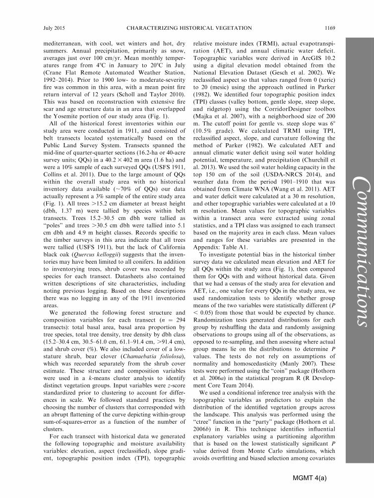
FIG. 1. Quarter-quarter sections (16.2 ha each) with archived data from a systematic timber inventory conducted in 1911.This inventory spanned portions of the Stanislaus National Forest (NF) and Yosemite National Park (NP) located in thecentral Sierra Nevada, California, United States (shown in inset; the boundary between Stanislaus NF and Yosemite NP withinthe study area is delineated by the black and white dashed line). The heavy white outline depicts the study area boundary.Colors correspond with vegetation structure groups that were identified by a cluster analysis using the tree and understoryvegetation inventory (see Methods). Vegetation group abbreviations are as follows: Basal area, BA; Abies concolor þ Abiesmagnifica, ABIES; Pinus ponderosa, PIPO; Chamaebatia foliolosa, CHFO; Calocedrus decurrens, CADE; Pseudotsuga menziesii,PSME.
BRANDON M. COLLINS ET AL.1168 Ecological ApplicationsVol. 25, No. 5
Com
munication
s
MGMT 4(a)
mediterranean, with cool, wet winters and hot, dry
summers. Annual precipitation, primarily as snow,
averages just over 100 cm/yr. Mean monthly temper-
atures range from 48C in January to 208C in July
(Crane Flat Remote Automated Weather Station,
1992–2014). Prior to 1900 low- to moderate-severity
fire was common in this area, with a mean point fire
return interval of 12 years (Scholl and Taylor 2010).
This was based on reconstruction with extensive fire
scar and age structure data in an area that overlapped
the Yosemite portion of our study area (Fig. 1).
All of the historical forest inventories within our
study area were conducted in 1911, and consisted of
belt transects located systematically based on the
Public Land Survey System. Transects spanned the
mid-line of quarter-quarter sections (16.2-ha or 40-acre
survey units; QQs) in a 40.2 3 402 m area (1.6 ha) and
were a 10% sample of each surveyed QQs (USFS 1911,
Collins et al. 2011). Due to the large amount of QQs
within the overall study area with no historical
inventory data available (;70% of QQs) our data
actually represent a 3% sample of the entire study area
(Fig. 1). All trees .15.2 cm diameter at breast height
(dbh, 1.37 m) were tallied by species within belt
transects. Trees 15.2–30.5 cm dbh were tallied as
‘‘poles’’ and trees .30.5 cm dbh were tallied into 5.1
cm dbh and 4.9 m height classes. Records specific to
the timber surveys in this area indicate that all trees
were tallied (USFS 1911), but the lack of California
black oak (Quercus kelloggii) suggests that the inven-
tories may have been limited to all conifers. In addition
to inventorying trees, shrub cover was recorded by
species for each transect. Datasheets also contained
written descriptions of site characteristics, including
noting previous logging. Based on these descriptions
there was no logging in any of the 1911 inventoried
areas.
We generated the following forest structure and
composition variables for each transect (n ¼ 294
transects): total basal area, basal area proportion by
tree species, total tree density, tree density by dbh class
(15.2–30.4 cm, 30.5–61.0 cm, 61.1–91.4 cm, .91.4 cm),
and shrub cover (%). We also included cover of a low-
stature shrub, bear clover (Chamaebatia foliolosa),
which was recorded separately from the shrub cover
estimate. These structure and composition variables
were used in a k-means cluster analysis to identify
distinct vegetation groups. Input variables were z-score
standardized prior to clustering to account for differ-
ences in scale. We followed standard practices by
choosing the number of clusters that corresponded with
an abrupt flattening of the curve depicting within-group
sum-of-squares-error as a function of the number of
clusters.
For each transect with historical data we generated
the following topographic and moisture availability
variables: elevation, aspect (reclassified), slope gradi-
ent, topographic position index (TPI), topographic
relative moisture index (TRMI), actual evapotranspi-
ration (AET), and annual climatic water deficit.
Topographic variables were derived in ArcGIS 10.2
using a digital elevation model obtained from the
National Elevation Dataset (Gesch et al. 2002). We
reclassified aspect so that values ranged from 0 (xeric)
to 20 (mesic) using the approach outlined in Parker
(1982). We identified four topographic position index
(TPI) classes (valley bottom, gentle slope, steep slope,
and ridgetop) using the CorridorDesigner toolbox
(Majka et al. 2007), with a neighborhood size of 200
m. The cutoff point for gentle vs. steep slope was 68
(10.5% grade). We calculated TRMI using TPI,
reclassified aspect, slope, and curvature following the
method of Parker (1982). We calculated AET and
annual climatic water deficit using soil water holding
potential, temperature, and precipitation (Churchill et
al. 2013). We used the soil water holding capacity in the
top 150 cm of the soil (USDA-NRCS 2014), and
weather data from the period 1901–1910 that was
obtained from Climate WNA (Wang et al. 2011). AET
and water deficit were calculated at a 30 m resolution,
and other topographic variables were calculated at a 10
m resolution. Mean values for topographic variables
within a transect area were extracted using zonal
statistics, and a TPI class was assigned to each transect
based on the majority area in each class. Mean values
and ranges for these variables are presented in the
Appendix: Table A1.
To investigate potential bias in the historical timber
survey data we calculated mean elevation and AET for
all QQs within the study area (Fig. 1), then compared
them for QQs with and without historical data. Given
that we had a census of the study area for elevation and
AET, i.e., one value for every QQs in the study area, we
used randomization tests to identify whether group
means of the two variables were statistically different (P
, 0.05) from those that would be expected by chance.
Randomization tests generated distributions for each
group by reshuffling the data and randomly assigning
observations to groups using all of the observations, as
opposed to re-sampling, and then assessing where actual
group means lie on the distributions to determine P
values. The tests do not rely on assumptions of
normality and homoscedasticity (Manly 2007). These
tests were performed using the ‘‘coin’’ package (Hothorn
et al. 2006a) in the statistical program R (R Develop-
ment Core Team 2014).
We used a conditional inference tree analysis with the
topographic variables as predictors to explain the
distribution of the identified vegetation groups across
the landscape. This analysis was performed using the
‘‘ctree’’ function in the ‘‘party’’ package (Hothorn et al.
2006b) in R. This technique identifies influential
explanatory variables using a partitioning algorithm
that is based on the lowest statistically significant P
value derived from Monte Carlo simulations, which
avoids overfitting and biased selection among covariates
July 2015 1169CHARACTERIZING HISTORICAL VEGETATION
Com
munica
tions
MGMT 4(a)

(Hothorn et al. 2006b). A significance level of 0.05 was
used in assessing all splits.
RESULTS
The k-means analysis resulted in nine distinct
vegetation structure groups. The groups tended to
separate based on three main characteristics: understo-
ry cover and composition, tree basal area (BA), and
dominant tree species composition (Table 1). The shrub
group was dominated by shrubs with almost no trees.
This group occurred primarily in a steep river canyon
in the northern part of the study area, and accounted
for 9% of the historical inventory transects (Fig. 1).
Two groups had low tree BA (8.1 and 9.9 m2/ha), but
differed considerably in shrub cover and small tree
density: low BA, high shrub; low BA, small trees. These
two groups comprised 27% of the inventoried transects.
There were three groups dominated by ponderosa pine
(PIPO), differing in BA (13.1, 16.8, and 21.5 m2/ha),
co-dominance with incense-cedar (CADE; 25–40% of
BA), and bear clover (CHFO) cover (18, 55, and 80%):
PIPO, low BA, high CHFO; PIPO, high BA, mod
CHFO; PIPO-CADE, low CHFO. These three groups
accounted for nearly half of the historical inventory
transects and were widely distributed across the
landscape (Fig. 1). The last three groups differed in
tree species composition and large tree density, and
collectively accounted for 15% of the historical
inventory area. One group was dominated by ponder-
osa pine and incense-cedar, but also included sugar
pine and white fir, and had the highest density of large
trees (20 trees/ha, dbh . 91 cm): mixed-conifer, large
trees. Another group was dominated by Douglas-fir
(PSME; 50% by BA), with lesser proportions of sugar
pine, incense cedar, and ponderosa pine, and had
moderately high shrub cover: PSME, mod shrub. The
final group was dominated by white and red fir and had
the second highest density of large trees (18 trees/ha,
dbh . 91 cm): ABIES, large trees. Estimated mean
canopy cover, based on tree lists, ranged from 9–28%,
for all tree-dominated groups (not including the shrub
group; Appendix: Table A2).
Randomization tests indicated that QQs with histor-
ical survey data available had similar AET values, but
tended to occur in lower elevations relative to QQs
without survey data (Appendix: Table A3). Condition-
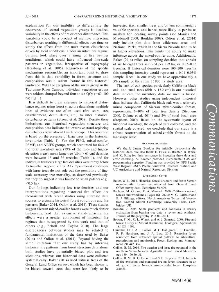
al inference tree results indicated strong elevational
control on the distribution of vegetation structure
groups across the landscape (Fig. 2). Moisture avail-
ability, as captured by AET, also exhibited some
control on vegetation group distribution. The shrub
group predominantly occurred at the lowest elevations
(,1048 m). The two low BA groups were divided
between a mid-elevation band (1277–1562 m), and
either a lower elevation band (1048–1277) low BA,
small trees, or low AET (,391 mm) low BA, high
shrub. The three PIPO-dominated groups and the
PSME, mod shrub occurred primarily at the mid-
elevation band (1277–1562 m). This elevation band
contained 60% of the historical inventory transects,
with no further differentiation by the conditional
inference tree. The mixed-conifer, large trees group
was mostly split between the mid-elevation band (1277–
1562 m) and the upper-mid-elevation band (1563–1840
m). The ABIES, large trees group that accounted for
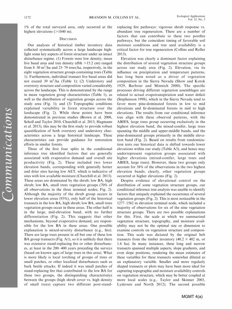
TABLE 1. Average structural characteristics for the nine historical vegetation groups identified from the k-means cluster analysis.
Characteristic ShrubLow BA,high shrub
Low BA,small trees
PIPO, low BA,high CHFO
n 27 48 31 44Understory cover (%)
CHFO 2.4 25 32.5 79.5Shrub 84.1 54.3 21.6 10.6
BA, by species (m2/ha)
ABCO 0 0.9 0.1 0ABMA 0 0 0 0CADE 0 2 4 3.4PILA 0 1.2 0.5 1.8PIPO 0 3.5 4.9 7.9PSME 0 0.5 0.4 0.8
Total live BA (m2/ha) 0.1 (0–2) 8.1 (2–19) 9.9 (2–16) 13.9 (6–22)Live tree density (no./ha) by dbh
15–30 cm 0.1 6.3 23.7 7.830–61 cm 0.1 9.6 14.2 12.161–91 cm 0.1 4.9 6 9.6.91 cm 0 4.2 4.9 8.2
Total live tree density (no./ha) 0.3 (0–5) 25.0 (6–47) 48.9 (31–93) 37.7 (11–54)
Notes: Ranges are reported in parentheses next to averages for total live basal area (BA) and tree density. Species codes are asfollows: Chamaebatia foliolosa, CHFO; Abies concolor, ABCO; Abies magnifica, ABMA; Abies concolor and Abies magnifica,ABIES; Calocedrus decurrens, CADE; Pinus lambertiana, PILA; Pinus ponderosa, PIPO; and Pseudotsuga menziesii, PSME.
� Does not include the shrub group in the reported averages.
BRANDON M. COLLINS ET AL.1170 Ecological ApplicationsVol. 25, No. 5
Com
munication
s
MGMT 4(a)

TABLE 1. Extended.
PIPO, high BA,mod CHFO
PIPO-CADE,low CHFO
Mixed-conifer,large trees
PSME,mod shrub
ABIES,large trees Average�
41 60 24 16 3 267
54.9 17.5 42.6 25.5 0 39.120.9 17.4 25.4 35.7 21.7 25.8
0.2 0.2 4.1 0 14.6 0.80 0 0 0 13.6 0.26.4 6.7 9.1 3.2 0 4.90.8 1.1 4.7 3.6 0.8 1.6
13.8 8.4 11.9 2.7 0.7 7.70.3 0.3 0.4 9.4 0 1
21.5 (13–31) 16.8 (9–23) 30.2 (23–39) 18.9 (11–28) 29.7 (25–33) 16.1 (2–39)
16.8 10.6 16.6 9.7 22.4 12.527.9 15.5 19.4 12.7 26.6 15.918.6 10.9 16.3 8.5 12.4 10.69.4 10.3 20 12.4 17.7 9.2
72.7 (53–107) 47.2 (28–73) 72.3 (53–121) 43.4 (22–70) 79.1 (59–111) 48.1 (3–121)
FIG. 2. Conditional inference tree output explaining the influence of elevation and actual evapotranspiration (AET) on thedistribution of vegetation structure groups (abbreviations are as in Fig. 1). Numbers in the table below indicate the number ofinventoried quarter-quarter sections in each terminal node, and their distribution among the nine vegetation structure groups.Numbers in bold emphasize the terminal node(s) where the majority of observations for each vegetation structure group lie.
July 2015 1171CHARACTERIZING HISTORICAL VEGETATION
Com
munica
tions
MGMT 4(a)
1% of the total surveyed area, only occurred at the
highest elevations (.1840 m).
DISCUSSION
Our analyses of historical timber inventory data
collected systematically across a large landscape high-
light some key aspects of forest structure under an intact
disturbance regime. (1) Forests were low density; mean
live basal area and tree density (dbh .15.2 cm) ranged
from 8–30 m2/ha and 25–79 trees/ha, respectively, in the
eight vegetation structure groups containing trees (Table
1). Furthermore, individual transect live basal areas did
not exceed 39 m2/ha (Table 1); (2) Understory and
overstory structure and composition varied considerably
across the landscape. This is demonstrated by the range
in mean vegetation group characteristics (Table 1), as
well as the distribution of vegetation groups across the
study area (Fig. 1); and (3) Topographic conditions
explained variability in forest structure over the
landscape (Fig. 2). While these points have been
demonstrated in previous studies (Brown et al. 2008,
Scholl and Taylor 2010, Churchill et al. 2013, Hagmann
et al. 2013), this may be the first study to provide robust
quantification of both overstory and understory char-
acteristics across a large historical landscape. These
characteristics can provide guidance for restoration
efforts in similar forests.
Three of the first four splits in the conditional
inference tree identified factors that are generally
associated with evaporative demand and overall site
productivity (Fig. 2). These included two lower
elevation bands, corresponding with generally hotter
and drier sites having low AET, which is indicative of
sites with low available moisture (Churchill et al. 2013).
These areas are dominated by the shrub; low BA, high
shrub; low BA, small trees vegetation groups (70% of
all observations in the three terminal nodes; Fig. 2).
Although the majority of the shrub group occurs in
lower elevation areas (93%), only half of the historical
transects in the low BA, high shrub; low BA, small trees
vegetation groups occur in these areas. The other half is
in the large, mid-elevation band, with no further
differentiation (Fig. 2). This suggests that other
mechanisms, beyond evaporative demand, are respon-
sible for the low BA in these areas. One possible
explanation is mixed-severity disturbance (e.g., fire).
There are large trees present in all but one of these low
BA group transects (Fig. A1), so it is unlikely that there
was extensive stand-replacing fire or other disturbanc-
es, at least in the 200–400 years preceding the surveys
(based on known ages of large trees in this area). What
is more likely is local torching of groups of trees or
small patches, or other localized disturbances such as
bark beetle attacks. If indeed it was small patches of
stand-replacing fire that contributed to the low BA for
these two groups, the distinguishing characteristics
between the groups (high shrub cover vs. high density
of small trees) capture two different post-stand-
replacing fire pathways: vigorous shrub response vs.
abundant tree regeneration. There are a number of
factors that can contribute to these two postfire
pathways, but the coincident timing of favorable soil
moisture conditions and tree seed availability is a
critical factor for tree regeneration (Collins and Roller
2013).
Elevation was clearly a dominant factor explaining
the distribution of several vegetation structure groups
across our study area (Fig. 2). Elevation, via its
influence on precipitation and temperature patterns,
has long been noted as a driver of vegetation
composition in the Sierra Nevada (Show and Kotok
1929, Barbour and Minnich 2000). The specific
processes driving different vegetation assemblages are
related to actual evapotranspiration and water deficit
(Stephenson 1998), which in the Sierra Nevada tend to
favor more pine-dominated forests in low to mid
elevations and fir-dominated forests in mid to high
elevations. The results from our conditional inference
tree align with these observed patterns, with the
ABIES, large trees group occurring exclusively in the
highest elevation band, the mixed-conifer, large trees
spanning the middle and upper-middle bands, and the
pine-dominated groups primarily in the middle eleva-
tion band (Fig. 2). Based on results from randomiza-
tion tests our historical data is shifted towards lower
elevations within our study (Table A3), and hence may
underrepresent vegetation groups associated with
higher elevations (mixed-conifer, large trees and
ABIES, large trees). However, these two groups only
account for 38% of the observations in the two highest
elevation bands; clearly, other vegetation groups
occurred at higher elevations (Fig. 2).
Despite evidence of elevational control on the
distribution of some vegetation structure groups, our
conditional inference tree analysis was unable to identify
factors that uniquely explained the occurrence of several
vegetation groups (Fig. 2). This is most noticeable in the
1277–1562 m elevation terminal node, which included a
majority of observations for six of the nine vegetation
structure groups. There are two possible explanations
for this. First, the scale at which we summarized
vegetation structure, topography, and moisture avail-
ability may not be the optimal size or dimension to
examine controls on vegetation structure and composi-
tion. This scale was dictated by the original belt
transects from the timber inventory (40.2 3 402 m, or
1.6 ha). In many instances, these long and narrow
transects spanned multiple aspects, slope gradients, and
even slope positions, rendering the mean estimates of
these variables for these transects somewhat diluted as
an explanatory variable. Smaller and more regularly
shaped transects or plots may have been more ideal for
capturing topographic and moisture availability controls
on vegetation structure, which may be better coupled at
more local scales (e.g., Taylor and Skinner 2003,
Lydersen and North 2012). The second possible
BRANDON M. COLLINS ET AL.1172 Ecological ApplicationsVol. 25, No. 5
Com
munication
s
MGMT 4(a)
explanation for our inability to differentiate the
occurrence of several vegetation groups is localized
variability in the effects of fire or other disturbance. This
variability could be a product of multiple interacting
disturbances resulting in differential effects over time, or
simply the effects from the most recent disturbance
driven by local conditions. Under an intact fire regime,
burning took place over a range of fire weather
conditions, which could have influenced fine-scale
patterns in vegetation, irrespective of topography
(Hessburg et al. 2005). Regardless of the specific
mechanisms responsible, an important point to draw
from this is that variability in forest structure and
composition was a salient feature in this historical
landscape. With the exception of the SHRUB group in the
Tuolumne River Canyon, individual vegetation groups
were seldom clumped beyond four to six QQs (;60–100
ha; Fig. 1).
It is difficult to draw inference to historical distur-
bance regimes using forest structure data alone; multiple
lines of evidence are often used (fire scars, tree
establishment, death dates, etc.) to infer historical
disturbance patterns (Brown et al. 2008). Despite these
limitations, our historical vegetation structure and
composition data indicate that extensive stand-replacing
disturbances were absent this landscape. This assertion
is based on the presence of large trees in the historical
inventories (Table 1). For the PIPO, mixed-conifer,
PSME, and ABIES groups, which accounted for 64% of
the total inventory area (79% of the mid- and higher-
elevation areas), mean large tree (dbh . 61 cm) densities
were between 15 and 36 trees/ha (Table 1), and for
individual transects large tree densities were rarely below
15 trees/ha (Appendix: Fig. A1). Open forest conditions
with large trees do not rule out the possibility of fine-
scale overstory tree mortality, as described previously,
but they do suggest it was limited to small patches (e.g.,
,0.5 ha).
Our findings indicating low tree densities and our
interpretations regarding historical fire effects are
inconsistent with recent studies using alternate data
sources to estimate historical forest conditions and fire
patterns (Baker 2014, Odion et al. 2014). These studies
suggest Sierran mixed-conifer forests were much denser
historically, and that extensive stand-replacing fire
effects were a greater component of historical fire
regimes than is suggested by this work and that of
others (e.g., Scholl and Taylor 2010). The large
discrepancies between studies may be related to
fundamental limitations of the data used by Baker
(2014) and Odion et al. (2014). Beyond having the
same limitation that our study has by inferring
historical fire patterns from forest structure data alone,
both studies have potentially biased plot and tree
selections, whereas our historical data were collected
systematically. Baker (2014) used witness trees of the
General Land Office survey, which has been shown to
be biased toward trees that were less likely to be
harvested (i.e., smaller trees and/or less commercially
valuable species), and hence, more likely to persist as
markers for locating survey points (see Manies and
Mladenoff 2000, Bouldin 2008). Odion et al. (2014)
only include plot data from wilderness areas and
National Parks, which in the Sierra Nevada tend to be
in higher elevations. This limits the ability to make
inference across the mixed-conifer zone. Additionally,
Baker (2014) relied on sampling densities that consist
of six to eight trees sampled per 259 ha, or 0.02–0.03
trees/ha. If historical densities were 100–200 trees/ha
this sampling intensity would represent a 0.01–0.03%
sample. Recall in our study we have approximately a
3% sample of the entire 16 800 ha study area.
The lack of oak species, particularly California black
oak, and small trees (dbh , 15.2 cm) in our historical
data indicate the inventory data we used is biased.
However, other studies using independent historical
data indicate that California black oak was a relatively
minor component of Sierran mixed-conifer forests,
representing 6–10% of total tree density (Stephens
2000, Dolanc et al. 2014) and 2% of total basal area
(Stephens 2000). Based on the systematic layout of
historical inventory, the depth of data collected, and the
spatial scale covered, we conclude that our study is a
robust reconstruction of mixed-conifer forests at the
landscape scale.
ACKNOWLEDGMENTS
We thank James Bouldin for initially discovering thehistorical data. We also thank E. Fales, C. Richter, B. Weise,and K. King for their assistance in inputting these data anderror checking. A. Kramer provided instrumental GIS andprogramming expertise. Funding was provided by NPS PacificWest Region, USFS Pacific Southwest Research Station, andUC Agriculture and Natural Resources Division.
LITERATURE CITED
Baker, W. L. 2014. Historical forest structure and fire in Sierranmixed-conifer forests reconstructed from General LandOffice survey data. Ecosphere 5:art79.
Barbour, M. G., and R. A. Minnich. 2000. California uplandforests and woodlands. Pages 161–202 in M. G. Barbour andB. J. Billings, editors. North American Terrestrial Vegeta-tion. Second edition Cambridge University Press, Cam-bridge, UK.
Bouldin, J. 2008. Some problems and solutions in densityestimation from bearing tree data: a review and synthesis.Journal of Biogeography 35:2000–2011.
Brown, P. M., C. L. Wienk, and A. J. Symstad. 2008. Fire andforest history at Mount Rushmore. Ecological Applications18:1984–1999.
Churchill, D. J., A. J. Larson, M. C. Dahlgreen, J. F. Franklin,P. F. Hessburg, and J. A. Lutz. 2013. Restoring forestresilience: from reference spatial patterns to silviculturalprescriptions and monitoring. Forest Ecology and Manage-ment 291:442–457.
Collins, B. M. 2014. Fire weather and large fire potential in thenorthern Sierra Nevada. Agricultural and Forest Meteorol-ogy 189–190:30–35.
Collins, B. M., R. G. Everett, and S. L. Stephens. 2011. Impactsof fire exclusion and managed fire on forest structure in anold growth Sierra Nevada mixed-conifer forest. Ecosphere2:art51.
July 2015 1173CHARACTERIZING HISTORICAL VEGETATION
Com
munica
tions
MGMT 4(a)

Collins, B. M., and G. B. Roller. 2013. Early forest dynamics instand-replacing fire patches in the northern Sierra Nevada,California, USA. Landscape Ecology 28:1801–1813.
Dolanc, C. R., H. D. Safford, S. Z. Dobroski, and J. H.Thorne. 2014. Twentieth century shifts in abundance andcomposition of vegetation types of the Sierra Nevada, CA,US. Applied Vegetation Science 17:442–455.
Franklin, J. F., and K. N. Johnson. 2012. A restorationframework for federal forests in the Pacific Northwest.Journal of Forestry 110:429–439.
Fule, P. Z. 2008. Does it make sense to restore wildland fire inchanging climate? Restoration Ecology 16:526–531.
Fule, P. Z., W. W. Covington, and M. M. Moore. 1997.Determining reference conditions for ecosystem managementof southwestern ponderosa pine forests. Ecological Applica-tions 7:895–908.
Gesch, D. B., M. Oimoen, S. Greenlee, C. Nelson, M. Steuck,and D. Tyler. 2002. The national elevation dataset. Photo-grammetric Engineering and Remote Sensing 68:5–32.
Hagmann, R. K., J. F. Franklin, and K. N. Johnson. 2013.Historical structure and composition of ponderosa pine andmixed-conifer forests in south-central Oregon. Forest Ecol-ogy and Management 304:492–504.
Hagmann, R. K., J. F. Franklin, and K. N. Johnson. 2014.Historical conditions in mixed-conifer forests on the easternslopes of the northern Oregon Cascade Range, USA. ForestEcology and Management 330:158–170.
Hessburg, P. F., J. K. Agee, and J. F. Franklin. 2005. Dryforests and wildland fires of the inland Northwest USA:contrasting the landscape ecology of the pre-settlement andmodern eras. Forest Ecology and Management 211:117–139.
Hothorn, T., K. Hornik, M. A. van de Wiel, and A. Zeileis.2006a. Lego system for conditional inference. The AmericanStatistician 60:257–263.
Hothorn, T., K. Hornik, and A. Zeileis. 2006b. Unbiasedrecursive partitioning: a conditional inference framework.Journal of Computational and Graphical Statistics 15:651–674.
Lydersen, J., and M. North. 2012. Topographic variation instructure of mixed-conifer forests under an active-fire regime.Ecosystems 15:1134–1146.
Majka, D., J. Jenness, and P. Beier. 2007. CorridorDesigner:ArcGIS tools for designing and evaluating corridors. http://corridordesign.org
Mallek, C., H. Safford, J. Viers, and J. Miller. 2013. Moderndepartures in fire severity and area vary by forest type, SierraNevada and southern Cascades, California, USA. Ecosphere4:art153.
Manies, K. L., and D. J. Mladenoff. 2000. Testing methods toproduce landscape-scale presettlement vegetation maps fromthe U.S. public land survey records. Landscape Ecology15:741–754.
Manly, B. F. J. 2007. Randomization, Bootstrap and MonteCarlo methods in biology. Third edition. Chapman & Hall/CRC, Boca Raton, FL, USA.
Odion, D. C., et al. 2014. Examining historical and currentmixed-severity fire regimes in ponderosa pine and mixed-
conifer forests of western North America. PLoS ONE9:e87852.
Parker, A. J. 1982. The topographic relative moisture index: anapproach to soil-moisture assessment in mountain terrain.Physical Geography 3:160–168.
R Development Core Team. 2014. R: a language andenvironment for statistical computing. Version 3.0.3. RFoundation for Statistical Computing, Vienna, Austria.www.r-project.org
Safford, H. D., G. D. Hayward, N. E. Heller, and J. A. Wiens.2012. Historical ecology, climate change, and resourcemanagement: can the past still inform the future? Pages46–62 in J. A. Wiens, G. D. Hayward, H. D. Safford, andC. M. Giffen, editors. Historical environmental variation inconservation and natural resource management. First edi-tion. John Wiley & Sons, West Sussex, UK.
Scholl, A. E., and A. H. Taylor. 2010. Fire regimes, forestchange, and self-organization in an old-growth mixed-coniferforest, Yosemite National Park, USA. Ecological Applica-tions 20:362–380.
Show, S. B., and E. I. Kotok. 1929. Cover type and fire controlin the National Forests of northern California. Bulletin No.1495. U. S. Department of Agriculture, Government PrintingOffice, Washington, D.C., USA.
Stephens, S. L. 2000. Mixed conifer and upper montane foreststructure and uses in 1899 from the central and northernSierra Nevada, CA. Madrono 47:43–52.
Stephens, S. L., J. K. Agee, P. Z. Fule, M. P. North, W. H.Romme, T. W. Swetnam, and M. G. Turner. 2013. Managingforests and fire in changing climates. Science 342:41–42.
Stephenson, N. L. 1998. Actual evapotranspiration and deficit:biologically meaningful correlates of vegetation distributionacross spatial scales. Journal of Biogeography 25:855–870.
Swetnam, T. W., C. D. Allen, and J. L. Betancourt. 1999.Applied historical ecology: using the past to manage for thefuture. Ecological Applications 9:1189–1206.
Taylor, A. H., and C. N. Skinner. 2003. Spatial patterns andcontrols on historical fire regimes and forest structure inthe Klamath Mountains. Ecological Applications 13:704–719.
USDA-FS. 2012. U.S. Department of Agriculture, ForestService National Forest System land management planningrule. Federal Register 77:21162–21260.
USDA-NRCS. 2014. U.S. Department of Agriculture, Natu-ral Resources Conservation Service, Web Soil Survey.http://websoilsurvey.nrcs.usda.gov/app/WebSoilSurvey.aspx.
USFS. 1911. United States Forest Service Timber Survey FieldNotes, Stanislaus National Forest. Obtained from NationalArchives and Records Administration, San Bruno, CA.Record number 095-93-45.
Wang, T., A. Hamann, D. L. Spittlehouse, and T. Q. Murdock.2011. ClimateWNA—high-resolution spatial climate data forwestern North America. Journal of Applied Meteorologyand Climatology 51:16–29.
SUPPLEMENTAL MATERIAL
Ecological Archives
The Appendix is available online: http://dx.doi.org/10.1890/14-1797.1.sm
Data Availability
Data associated with this paper have been deposited in the USDA Forest Service Research Data Archive: http://www.fs.usda.gov/rds/archive/
BRANDON M. COLLINS ET AL.1174 Ecological ApplicationsVol. 25, No. 5
Com
munication
s
MGMT 4(a)