Embed Size (px)
Citation preview

State of Colorado
Wildfire Hazard Mitigation Plan
Colorado Multi-Hazards
Mitigation Plan
July 2002 Update
For Fires in Calendar Years 2000 and 2001


Preface This 2001 Plan recognizes the validity and importance of the August 1995 Wildfire Hazard Mitigation Plan and its predecessors as foundation documents on which to build and judge progress in wildfire hazard mitigation. The text version of the 1995 Plan is included in its entirety as an addendum. The 2001 edition is composed of four sections. Section 1 includes the May 2001 Report to the Governor, Colorado Wildland Urban Interface; Section 2 includes the Hazard Mitigation Survey Team Report of the 2000 Fire Season Background and a summary of the 2001 Fire Season; Section 3 includes a status update of the accomplishments and implementation of the 1995 Plan Recommendations and other wildland fire data; Section 4 includes appendices. Together, these sections describe the status of the Wildland Urban Interface in Colorado; the hazards that exist; mitigation measures that are needed to lessen risk to people, property, and natural resources; and actions taken since 1996. The nature of Wildfire Hazard is dynamic, constantly changing as the variables that define it change. It is critical to view this plan as a blueprint and starting point for action. Public education, legislation and regulations, and funding are all needed to mitigate wildfire threats. Most importantly, all affected agencies, organizations, businesses and citizens must accept their responsibility and take wildfire mitigation action. The Governors Wildland Urban Interface Working Group Report and Fire Survey Team Report, whose works are incorporated in this plan, reaffirm that issues cited in the 1995 Wildfire Hazard Mitigation Plan are valid. Recommended actions in this plan compliment and reinforce the recommendations in previous plans. The original preparation and update of this document involved participatory efforts from all levels of governments throughout the state. Once again, Colorado is indebted for the concerned efforts of many people. This plan could not have been completed without their concern, patience, and assistance, once again showing the value of interagency partnerships and cooperation. Richard L. Homann Fire Division Supervisor Colorado State Forest Service

Table of Contents Section I.
Report to the Governor, Colorado Wildland Urban Interface...... 4
Section II. 2000 Fire Season Hazard Mitigation Survey Team Report......... 17 2001 Fire Season Summary ......................................................... 26
Section III.
Status Updates
Ø 1995 Mitigation Annex Recommendations ........................... 29 Ø .Colorado Red Zone.............................................................. 32 Ø Colorado Interface Communities .......................................... 33 Ø Mitigation Efforts (map) ...................................................... 35 Ø Success Stories .................................................................... 36 Ø .Fire Publications List ........................................................... 51 Ø .Wildfire Data....................................................................... 53 Ø Fire Department Locations ................................................... 54 Ø Fire Department Survey ....................................................... 55
Appendices
Ø 1995 Wildfire Hazard Mitigation Plan (text version) ............. 61 Ø CSFS District Offices .........................................................110 Ø Distribution of the 2001 Annex ...........................................113
4 of 112
Section 1
Report to the Governor, Colorado Wildland Urban Interface

5 of 112
Executive Summary The risk of wildfire in Colorado’s wildland-urban interface poses a daunting challenge to public safety, fiscal responsibility and natural resource integrity in the state. The 2000 fire season brought this challenge to the forefront of public attention when four wildland urban interface fires along Colorado’s Front Range destroyed 74 structures and threatened thousands more, interrupted utility service, and imp acted water and air quality. The cost to state coffers for suppressing these fires was a staggering $10.1 million, contributing to the most expensive wildfire season to date.
While these numbers are dramatic, they are not surprising. A century of aggressive fire suppression, combined with cycles of drought and changing land management practices, has left many of Colorado’s forests unnaturally dense and ready to burn. At the same time, the state’s record-setting growth has driven nearly a million people into the forested foothills of the Front Range and along the West Slope and central mountains – the same landscapes that are at highest risk for large-scale fire. This movement of urban and suburban residents into the wildland-urban interface (WUI) significantly increases the values -at-risk from wildland fire – the most critical of these being human life.
The cost of suppressing unnaturally large and destructive fires in the complicated environment of the WUI has pressed state and local resources beyond their capacity and has revealed complexities that are not adequately addressed by the existing system of interagency wildfire response. Governor Bill Owens, recognizing the urgent need to more effectively address the WUI situation in Colorado, appointed a diverse working group of
local, state, and federal leaders to explore the current situation, identify opportunities for improvement, and make recommendations for change. Over a six-month period, the Governor’s Interagency Wildland Urban Interface Working Group identified several areas of concern:
q Wildfire suppression in the interface stretches the capability of response personnel in terms of safety, training, and equipment and challenges the ability of local and state governments to cover related costs. Interface protection also demands a higher level of interagency communication and coordination than currently exists.
q Mitigation of hazardous fuels in the interface is not occurring on a landscape scale, across ownerships. The implementation of planned mitigation projects is complicated by costs to private landowners, availability of a trained work force, compliance with federal requirements, and the lack of options for utilizing removed materials.
q Efforts to combat wildfire risk are complicated by a lack of awareness and/or support from local communities and the urban public.

6 of 112
Out of the working group’s deliberations came the recognition that, in the wildland-urban interface, failure to prepare, communicate, and respond in an interagency manner could result in devastating consequences. The time is ripe for the State of Colorado to step forward and provide the kind of leadership and coordination needed to ensure the best possible wildfire protection for its citizens.
Recommendations The Governor’s working group identified a total of 15 recommendations within the categories of preparedness and suppression, hazard mitigation, and public awareness. Those recommendations are summarized as follows: 1. Strengthen Local Capacity in Wildland Fire Preparedness, Suppression, and Mitigation.
• Provide state-supported technical and cost-sharing assistance to counties for the development and implementation of expanded county Fire Management Plans.
• Institute a consistent annual appropriation to provide for wildland-urban interface management needs
and for a fuels mitigation cost-sharing program.
• Develop a statewide wildland-urban interface training program for local fire service personnel.
• Establish a mechanism for the state to contribute to the Emergency Fire Fund (EFF). 2. Enhance State Leadership and Coordination in Interagency Wildland Fire Response.
• Coordinate and fund the development and implementation of a statewide, county-by-county wildfire
risk assessment.
• Provide statutory clarification of wildland fire roles and responsibilities held by county sheriffs, fire protection districts, and related local response personnel.
• Clarify in the Colorado Interagency Cooperative Fire Protection Agreement (Master Agreement)
interagency roles and responsibilities for fire protection in the wildland urban interface.
• Provide state-level support for expanded state participation in zone dispatch centers and in the extended attack phase of wildfire suppression.
• Investigate and identify statewide protocols for radio communication across local, state, and federal
jurisdictions.
• Coordinate interagency implementation and allocation of funds related to the National Fire Plan, the Ten Year Comprehensive Strategy, and similar efforts.
3. Improve Statewide Public Awareness Regarding the Role of Fire in Colorado Landscapes and Tools
for Wildland Fire Prevention. • Provide state leadership in developing and delivering coordinated interagency wildland fire messages to
homeowners, landowners, land management agencies, the general public, and others.
• Encourage the development of a professional outreach and information campaign to targeted audiences within the state.
7 of 112
Governor’s Wildland-Urban Interface Working Group
Report
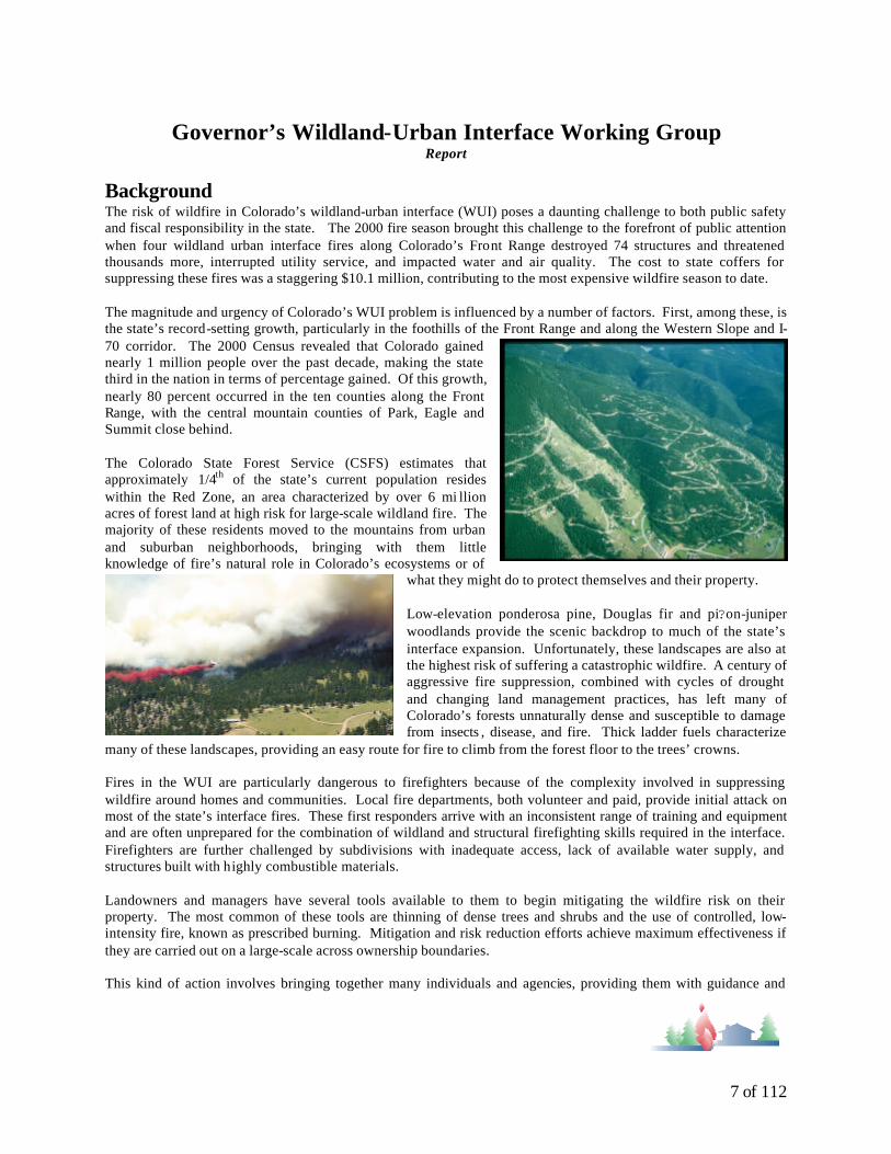
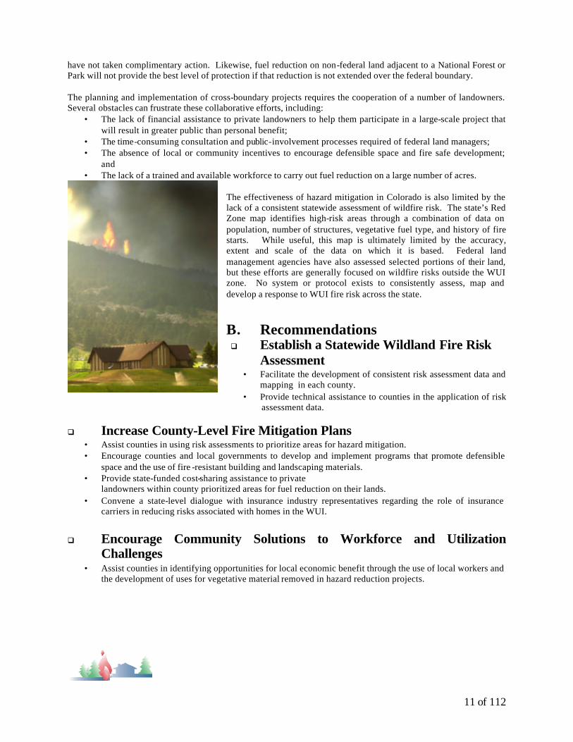
Background The risk of wildfire in Colorado’s wildland-urban interface (WUI) poses a daunting challenge to both public safety and fiscal responsibility in the state. The 2000 fire season brought this challenge to the forefront of public attention when four wildland urban interface fires along Colorado’s Front Range destroyed 74 structures and threatened thousands more, interrupted utility service, and impacted water and air quality. The cost to state coffers for suppressing these fires was a staggering $10.1 million, contributing to the most expensive wildfire season to date. The magnitude and urgency of Colorado’s WUI problem is influenced by a number of factors. First, among these, is the state’s record-setting growth, particularly in the foothills of the Front Range and along the Western Slope and I-70 corridor. The 2000 Census revealed that Colorado gained nearly 1 million people over the past decade, making the state third in the nation in terms of percentage gained. Of this growth, nearly 80 percent occurred in the ten counties along the Front Range, with the central mountain counties of Park, Eagle and Summit close behind. The Colorado State Forest Service (CSFS) estimates that approximately 1/4th of the state’s current population resides within the Red Zone, an area characterized by over 6 mi llion acres of forest land at high risk for large-scale wildland fire. The majority of these residents moved to the mountains from urban and suburban neighborhoods, bringing with them little knowledge of fire’s natural role in Colorado’s ecosystems or of
what they might do to protect themselves and their property. Low-elevation ponderosa pine, Douglas fir and pi?on-juniper woodlands provide the scenic backdrop to much of the state’s interface expansion. Unfortunately, these landscapes are also at the highest risk of suffering a catastrophic wildfire. A century of aggressive fire suppression, combined with cycles of drought and changing land management practices, has left many of Colorado’s forests unnaturally dense and susceptible to damage from insects , disease, and fire. Thick ladder fuels characterize
many of these landscapes, providing an easy route for fire to climb from the forest floor to the trees’ crowns. Fires in the WUI are particularly dangerous to firefighters because of the complexity involved in suppressing wildfire around homes and communities. Local fire departments, both volunteer and paid, provide initial attack on most of the state’s interface fires. These first responders arrive with an inconsistent range of training and equipment and are often unprepared for the combination of wildland and structural firefighting skills required in the interface. Firefighters are further challenged by subdivisions with inadequate access, lack of available water supply, and structures built with highly combustible materials. Landowners and managers have several tools available to them to begin mitigating the wildfire risk on their property. The most common of these tools are thinning of dense trees and shrubs and the use of controlled, low-intensity fire, known as prescribed burning. Mitigation and risk reduction efforts achieve maximum effectiveness if they are carried out on a large-scale across ownership boundaries. This kind of action involves bringing together many individuals and agencies, providing them with guidance and

8 of 112
incentives to act, and facilitating a governing environment conducive to change. Such action is particularly complicated in western states like Colorado which are characterized by a checkerboard pattern of federal and non-federal land ownership.
Working Group / State’s Role Governor Bill Owens recognized the urgent need for Colorado to respond to the WUI in a manner that would improve the safety of firefighters and residents, enhance protection of valuable natural resources, and ensure responsible allocation of taxpayer funds. In August of 2000, Gov. Owens issued an Executive Order charging a twelve member working group, consisting of local, state, and federal representatives, with the following mission: § Assess and make recommendations on fire policies and funding priorities for implementation in the
wildland urban interface; § Assess and make recommendations on how to increase cooperation and coordination in the use of land
management practices to mitigate fire danger in the interface; § Enhance the involvement of diverse stakeholders, professionals, and decision-makers on fire policy
matters; § Focus on awareness programs, land use development policies, cooperation between landowners, local
government and developers, and the sharing of knowledge and policies that increase public safety, reduce wildfire hazards, and achieve desired ecological goals in interface areas; and § Identify barriers to mitigating wildland urban interface fire hazards and recommend solutions to overcome
these barriers. The Governor’s Interagency Wildland-Urban Interface Working Group met from December 2000 through April 2001 to consider these and other issues central to interface protection in Colorado. The group identified several areas of concern in the state and developed recommendations, contained in this report, on those areas they felt would most benefit from the Governor’s leadership.
Wildland Fire Preparedness and Suppression A. Current Status Response to wildland fire consists of two equally important components: preparedness and suppression. Preparedness involves activities such as interagency planning; formation of cooperative agreements; training of personnel; equipment maintenance and positioning; and extensive communication. It means knowing what values are at risk to wildfire and having the resources necessary to combat that risk at all levels. Wildfire suppression is the mobilization of available resources in response to a wildland fire incident. The first phase of suppression, or initial attack, is generally provided by local fire departments, with back up from state or federal resources depending on where the incident occurs. If a wildfire escapes initial attack and continues burning over an extended period of time, personnel with specialized experience and training are called in to manage the fire. The effective transition of fire management from initial to extended attack is essential to both public and firefighter safety. Although the concepts of preparedness and suppression appear straightforward, a number of complications can arise in the course of an incident. In Colorado, state statute gives county sheriffs the responsibility for managing wildland fire on non-federal land. The sheriff may transfer this duty to the State Forester if he or she feels an incident has exceeded local capacity. Many communities have also formed fire protection districts (FPD) to respond to wildland fire within a smaller geographic area. Some of these communities believe the county sheriff only has jurisdiction over wildfires outside of FPDs. Most sheriffs disagree with this interpretation. Sorting out this local debate can be risky in the face of a fire.

9 of 112
Wildfire response in the state is coordinated through either local or interagency dispatch centers that track available personnel and resources and mobilize them to a site as needed. Complications arise when a fire in the interface requires people or resources equipped for both structural and wildland fire protection. Most firefighters are prepared for one or the other scenario, but not both. In addition, when structural personnel are called out for an interface fire, crews from other jurisdictions must be brought in to provide backfill protection in their city or area of protection. Some consensus on wildfire roles and responsibilities in the state is obtained through a chain of voluntary agreements. The state and federal agencies cooperate via a “master agreement” titled the Colorado Interagency Cooperative Fire Protection Agreement. The state also negotiates individual cooperative agreements with each county. Local fire departments may enter into mutual aid agreements, but there is no process in place to collect, track, or coordinate these local arrangements. Some counties and local departments also develop mobilization guides and/or Annual Operating Plans to supplement their fire response strategies. No counties currently have a comprehensive Fire Management Plan to bring all their wildfire-related activities and agreements together. This series of cooperative agreements functions well until an on-the-ground incident reveals areas of conflict that were not adequately resolved during preseason negotiations. The federal responsibility for interface protection is one such issue, as is the authority of the county sheriff to represent fire protection districts in agreement negotiations.
Another area with potential for conflict is the allocation of costs. Wildland-urban interface fires pose new challenges related to cost accountability and responsibility. They can become extraordinarily expensive because of the number and type of suppression resources required, and the values-at-risk. Suppression costs are generally shared by those responsible for the land on which the fire occurs. This distribution of financial responsibility is much less clear in the interface, where a variety of public and private values are threatened. The incompatibility of radio equipment and frequencies used by individual fire response entities imposes further limitations on the ability of firefighters, incident managers, and agency leaders to communicate with each other.
Limited financial assistance is available for counties and local fire departments to help defray both suppression and preparedness costs. The CSFS, for example, administers a federal Volunteer Fire Assistance cost-sharing program that helps local firefighters obtain badly needed training and equipment. Requests for this assistance usually far exceed available dollars. Counties provide for fire suppression costs that exceed local capacity through the Emergency Fire Fund (EFF). Participating counties pay an annual assessment to the fund, which covers the expenses of a member county once they have depleted their available suppression budget. The EFF is not adequate to cope with interface suppression costs and can be quickly depleted in a bad fire year. If the EFF is fully expended, additional costs are often covered by the State Emergency Disaster Fund or through an Executive Order. Currently, no direct state assistance is available to strengthen local fire planning or preparedness efforts.
Economic Impacts of Catastrophic Wildfire
1,067$1,369,664Eldorado
10,800$5,298,067Hi Meadow
10,599$3,330,992Bobcat
125$111,900Davis Ranch
AcresCost (estimates)
Fire

10 of 112
B. Recommendations
q Improve Wildland Fire Response Capability at the Local Level • Provide state-level technical and cost-sharing assistance to counties for the development and
implementation of county Fire Management Plans. • Require all relevant entities within a county, including fire departments and fire protection districts, to sign
an Annual Operating Plan (AOP).
q Clarify Roles and Responsibilities Related to WUI Response
• Provide statutory clarification regarding the fire protection responsibilities delegated to county sheriffs versus those held by local fire protection districts.
• Amend the statewide master agreement to include a clarification of interagency roles and responsibilities in the WUI.
• Provide statutory clarification regarding the state’s responsibility for reimbursing local suppression costs once the EFF is expended.
q Enhance Statewide Tracking and Mobilization of Resources • Expand state involvement in zone dispatch centers. • Clarify, in county Fire Management Plans, a process for backfilling of local firefighting personnel and
resources that have been dispatched out of their jurisdiction.
Hazard Mitigation
A. Current Status Fire needs oxygen, heat and fuel to spread across the landscape. The easiest of these factors to influence is the amount and distribution of vegetative fuels. The primary tools used by land managers to reduce hazardous fuels in the interface are thinning and removal of dense trees and shrubs and the use of controlled, low-intensity fire, known as prescribed burning. The USDA Forest Service estimates that every dollar invested in prevention and mitigation activities can save up to $7 in future wildfire suppression costs. Limited fuel mitigation projects have been implemented in Colorado by local, state, and federal land management agencies as well as private individuals. Boulder, Jefferson, Larimer, Summit, and Clear Creek Counties, for example, have wildfire mitigation programs that range from fuels reduction and prescribed burning on county-owned lands to assisting private landowners with similar actions on their own property. Some local governments have also adopted defensible space and emergency access requirements for new development in the interface. The CSFS also works with local government, other state agencies, the federal government and private individuals to plan and implement risk reduction projects across jurisdictional boundaries.
Unfortunately, the majority of hazard mitigation projects in Colorado are contained within specific ownership or jurisdictional boundaries. The isolated nature of these projects means that wildfire risk is not reduced on a scale large enough to provide meaningful protection across a landscape. A homeowner’s creation of defensible space will be less effective in the face of a raging fire if his or her neighbors
11 of 112
have not taken complimentary action. Likewise, fuel reduction on non-federal land adjacent to a National Forest or Park will not provide the best level of protection if that reduction is not extended over the federal boundary.
The planning and implementation of cross-boundary projects requires the cooperation of a number of landowners. Several obstacles can frustrate these collaborative efforts, including:
• The lack of financial assistance to private landowners to help them participate in a large-scale project that will result in greater public than personal benefit;
• The time-consuming consultation and public-involvement processes required of federal land managers; • The absence of local or community incentives to encourage defensible space and fire safe development;
and • The lack of a trained and available workforce to carry out fuel reduction on a large number of acres.
The effectiveness of hazard mitigation in Colorado is also limited by the lack of a consistent statewide assessment of wildfire risk. The state’s Red Zone map identifies high-risk areas through a combination of data on population, number of structures, vegetative fuel type, and history of fire starts. While useful, this map is ultimately limited by the accuracy, extent and scale of the data on which it is based. Federal land management agencies have also assessed selected portions of their land, but these efforts are generally focused on wildfire risks outside the WUI zone. No system or protocol exists to consistently assess, map and develop a response to WUI fire risk across the state.
B. Recommendations q Establish a Statewide Wildland Fire Risk
Assessment • Facilitate the development of consistent risk assessment data and
mapping in each county. • Provide technical assistance to counties in the application of risk
assessment data.
q Increase County-Level Fire Mitigation Plans • Assist counties in using risk assessments to prioritize areas for hazard mitigation. • Encourage counties and local governments to develop and implement programs that promote defensible
space and the use of fire -resistant building and landscaping materials. • Provide state-funded cost-sharing assistance to private
landowners within county prioritized areas for fuel reduction on their lands. • Convene a state-level dialogue with insurance industry representatives regarding the role of insurance
carriers in reducing risks associated with homes in the WUI. q Encourage Community Solutions to Workforce and Utilization
Challenges • Assist counties in identifying opportunities for local economic benefit through the use of local workers and
the development of uses for vegetative material removed in hazard reduction projects.
12 of 112
Public Awareness A. Current Status The public’s level of awareness regarding the causes and impacts of wildland fire can have a tremendous influence on the ultimate success of both suppression and mitigation efforts. If a local community understands and supports the need to reduce hazardous fuels, for example, projects are more likely to go forward in a timely and successful manner.
Support from local residents and government leaders can also facilitate increased individual and community action such as: creating defensible space around homes and structures; ensuring safe access for fire apparatus; establishing, training, and/or equipping of local fire departments; installing dry hydrants in subdivisions; or promoting the use of fire resistant building materials. All of these actions increase the chances that firefighters can safely control a wildland fire through initial attack and thereby limit damage to property and resources. The need for public awareness extends beyond local communities to Colorado’s urban area, for whom the wildland-urban interface is primarily a recreation zone. Actions taken to reduce wildfire risk on public lands, whether federal or non-federal, must have general concurrence and support from the public. It is also important for the public to understand that although mitigation efforts such as prescribed burning may have short-term impacts on visibility and air quality, they are designed to prevent the large-scale impacts that can result from a catastrophic wildland fire.
Many land management, fire protection, and/or disaster preparedness agencies in Colorado deliver some kind of fire awareness message. These education programs
are not generally coordinated between agencies or levels of government, however, and have the potential to generate more confusion than understanding.
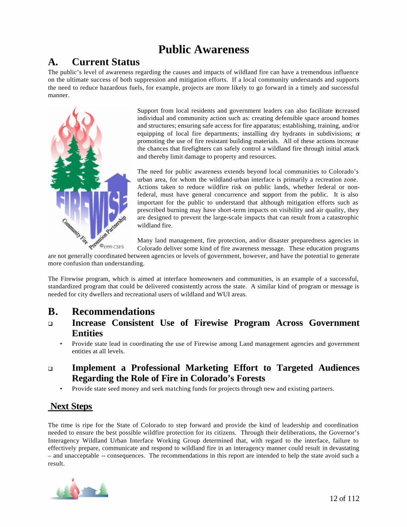
The Firewise program, which is aimed at interface homeowners and communities, is an example of a successful, standardized program that could be delivered consistently across the state. A similar kind of program or message is needed for city dwellers and recreational users of wildland and WUI areas.
B. Recommendations q Increase Consistent Use of Firewise Program Across Government
Entities • Provide state lead in coordinating the use of Firewise among Land management agencies and government
entities at all levels.
q Implement a Professional Marketing Effort to Targeted Audiences Regarding the Role of Fire in Colorado’s Forests
• Provide state seed money and seek matching funds for projects through new and existing partners. Next Steps The time is ripe for the State of Colorado to step forward and provide the kind of leadership and coordination needed to ensure the best possible wildfire protection for its citizens. Through their deliberations, the Governor’s Interagency Wildland Urban Interface Working Group determined that, with regard to the interface, failure to effectively prepare, communicate and respond to wildland fire in an interagency manner could result in devastating – and unacceptable -- consequences. The recommendations in this report are intended to help the state avoid such a result.

13 of 112
Due to the urgent nature of the interface situation, the Working Group advises that the Governor begin immediately to pursue implementation of this report. Many recommendations need further development and will require the active involvement of local, state, and federal agencies, as well as individual landowners and the public at large. Fire in the WUI threatens lives, livelihoods, and valuable natural resources. The State of Colorado must act quickly and effectively to mitigate this threat.
14 of 112
Glossary Annual Operating Plan: An annually updated document authorized by the appropriate officials for implementing the Interagency Cooperative Fire Protection Agreement in their respective areas of responsibilities.
Backfill (a.k.a. Move-up and Cover): Identifies a relocation of fire suppression resources from their established location to a temporary location to provide fire protection coverage for an initial attack response area.
Cooperator : Organized fire forces of other agencies, paid or volunteers, public or private, at the local, municipal, state, or federal level.
County: Employees, elected officials, and appointed officers of a county.
Emergency Fire Fund (EFF): A fund established and maintained through voluntary participation by counties, governed by a task force of county commissioners, sheriffs, and fire chiefs, administered and managed by the Colorado State Forest Service. EFF is funded by annual assessments to the participating counties. The fund provides financial assistance to participating counties at times when qualifying wildfires exceed the counties capacity.
Defensible Space: An area around homes or structures, either man-made or natural, where the vegetation is modified and maintained to slow the rate and intensity of an advancing wildland fire. Provides room for firefighters to work and helps protect the forest from becoming involved should a structure fire occur.
Dry Hydrant: A non-pressurized hydrant that provides a water source to firefighters. Requires equipment capable of drafting from the hydrant.
Fire Management: Activities and programs that include: the use of fire as a resource management tool, and protection of values from unwanted, uncontrolled wildfire.
Fire Management Plan: Statement, for a specific area, of fire policy, objective, and prescribed action; may include maps, charts, tables, and statistical data.
Fuels: combustible plant material, both living and dead, and combustible construction material that is capable of burning in a wildland situation.
ICS (Incident Command System): The common emergency incident management system used on any incident or event and tailored to fit the specific management needs of the incident/event. Includes "Colorado Incident Command System" at the local level.
Initial Attack Forces: Wildfire suppression resources of agencies initially dispatched to a fire in accordance with a pre-existing annual operating plan or mobilization guide.
Initial Attack Zone: An identified area in which predetermined resources would normally be the initial resource to respond to an incident.
Ladder Fuels: Fuels which provide vertical continuity between strata, thereby allowing fire to carry from surface fuels into the crowns of trees or shrubs with relative ease.
Mitigation: Actions taken that lessen the risk to people, property, and resources from wildfire.
Mutual Aid: Assistance provided by a Supporting Agency at no cost to the Protecting Agency. Mutual aid is limited to those initial attack resources or move-up and cover assignments that have been determined to be appropriate and as each may be able to furnish and are documented in Annual Operating Plans. Sometimes called Reciprocal Fire Protection.
Preparedness: Activities before fire occurrence to ensure effective suppression action. Includes training, planning, procuring and maintaining equipment, development of fire defense improvements, and maintaining cooperative arrangements with other agencies.
Prescribed Fire: The planned and/or permitted use of fire to accomplish specific land management objectives.

15 of 112
Prevention: Activities directed at reducing the number of human-caused fires, including such items as public education, law enforcement, dissemination of information, engineering, and the reduction of hazards.
Protection Boundaries: Mutually agreed upon boundaries which identify areas of direct fire protection responsibility and are shown on maps in the annual operating plans.
Resources: All personnel, items of equipment and aircraft available for assignment of tasks.
Structure Protection : Protecting a structure from an advancing wildfire is usually through treatment or removal of fuels from around a structure but may include application of retardants, foams, cooling agents, wraps, etc. to the exterior of a structure. Specific direction for an incident comes from the agency administrator or line officer.
Suppression: All the work of confining and extinguishing a fire beginning with its discovery through the conclusion of the incident.
Thinning: A cultural treatment made to reduce stand density
Values-at-Risk: Includes property, structures, physical improvements, natural and cultural resources, community infrastructure, and economic, environmental, and social values.
Wildfire: Uncontrolled fire burning in forest, brush, prairie, or cropland fuels, or conflagrations involving such fuels and structures.
Wildland: Lands with few or no permanent improvements.
Wildland Fire: Any non-structural fire that occurs on wildland.
Wildland Urban Interface (WUI): Defined as the line, area, or zone where structures and other human development meet or intermingle with undeveloped wildland or vegetative fuels.

16 of 112
Section 2
Hazard Mitigation Survey Team Report
17 of 112
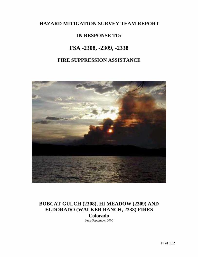
HAZARD MITIGATION SURVEY TEAM REPORT
IN RESPONSE TO:
FSA -2308, -2309, -2338
FIRE SUPPRESSION ASSISTANCE
BOBCAT GULCH (2308), HI MEADOW (2309) AND ELDORADO (WALKER RANCH, 2338) FIRES
Colorado June-September 2000
FIRE SUPPRESSION ASSISTANCE REPORT -COLORADO June 8, 2001
18 of 112
ACKNOWLEDGMENTS
The Federal Emergency Management Agency wishes to thank the individuals and the government or private entities they represent for their invaluable assistance and contributions to the mitigation survey team in preparation of this document.

19 of 112
Table of Contents Overview Purpose of Report Description of the Events . Description of Damages Jurisdiction Lessons Learned Issues Discussed Recommendations References Fire Suppression Survey Team Participants Acronyms Sources of Information on the Web

20 of 112
Overview
In June 2000, two fire assistance grants were awarded to the State of Colorado to support fire-fighting activit ies associated with containing the Bobcat Gulch and Hi Meadow Fires. Both fires began on June 12th 2000. A third fire assistance grant was awarded to the State of Colorado for the Eldorado/Walker Ranch (Eldorado) Fire that began on September 15th, 2000. All fires were in the foothills along the Front Range in Colorado. The Hazard Mitigation Survey Team (HMST) convened on February 8th, 2001 in Fort Collins, CO to review the fires and to analyze potential mitigation measures that could be implemented to prevent future damage at the urban interface. Attendees included the representatives from the Colorado State Forest Service, U.S. Forest Service (USFS) and Federal Emergency Management Agency (FEMA). The meeting was a joint HMST meeting for Colorado and Wyoming. Wyoming Emergency Management Agency (WEMA) and the Wyoming Assistant Forester were also present. A total of eight attendees from both states provided input and ‘lessons learned’ from the fires.
Purpose of Report
The purpose for this HMST Report is to meet the requirements of the Federal Emergency Management Agency (FEMA)/State agreement which was signed for the Bobcat Gulch, Hi Meadow and Eldorado fires. The agreement provided wildfire suppression assistance (FSA-2308, FSA-2309, FSA-2338) according to Public Law 93-288 as amended. The findings and recommendations in this report will be used to update the Wildfire Hazard Mitigation Annex for the State of Colorado. The Annex will be a sub-part of the State of Colorado's Multi-Hazard Mitigation Plan.
Description of the Events
The fire season began early in 2000. The Hi Meadow, Bobcat Gulch, and Eldorado were the three fires that resulted in Fire Suppression Assistance Grants. The Bobcat Gulch fire started on the morning of June 12th 2000. The cause of the fire was human error – an escaped campfire. The fire was located in Larimer County approximately one mile north of the Town of Drake with the affected acreage in Township 6 North and Ranges 70 and 71 West. The Bobcat Gulch fire burned in the Arapahoe-Roosevelt National Forest. Fuels included brush, ponderosa pine, spruce-fir, and lodge pole pine at higher elevations of the fire. The fire impacted the Cedar Park Subdivision where a total of 60 homes were evacuated. The fire threatened structures in an area from Eden Valley to Buckhorn Creek. The fire consumed 10,599 acres of grass, brush, and timber and destroyed a number of homes within the wildland interface. An estimated 1500 to 2000 residences were within easy reach of the fire. The Hi Meadow fire also started on June 12th. The Hi Meadow fire began in Jefferson and Park Counties. The location of the fire was about 35 miles southwest of Denver. It was caused by human activity. The Hi Meadow fire affected federal, state, and private lands and resulted in the evacuation of approximately 600 residents from two towns (Pine and Buffalo Creek), and 19 subdivisions in the area. The Hi Meadow Fire had 3000 structures in the interface that could have been affected. The control date for the Hi Meadow fire was on June 25th. The Eldorado fire began on September 15th 2000. The fire was located approximately 7 miles southwest of the City of Boulder. The fire is suspected to be human caused. The fire started on county administered open space called Walker Ranch Park. The fire affected County land, the Denver Water Board land, and private lands. The fire burned in mixed Douglas fir and ponderosa pine with interspersed open grasslands and shrubs. The blaze consumed over a thousand acres. It posed a threat to residents in the Pine Notch, Lake Shores and Juniper Heights subdivisions and forced the evacuation of over 200 residents from 125 homes. No residences or other structures were lost in the fire. Besides the homes, utilities, park facilities, historic structures, Denver Water Board lands with significant watersheds, and riparian and fisheries resources were also at risk.

21 of 112
Like most large fires, the three fires were weather driven-wind control. One of the biggest problems is a high fuel load within these areas. The areas’ steep terrain and high altitude made firefighting difficult. The State also dealt with a limited number of resources.
Description of Damages The following damages occurred from the Bobcat Gulch fire:
• A total of 10599 acres were lost.
• 18 dwellings were destroyed out of a total of 25 sites where property was reported as destroyed or damaged.
The following damages are reported from the Hi Meadow fire:
• A total of 10,800 acres were burned. A total of 5,623 acres were on federal land and 5,177 acres were on state or private land. A total of 10,592 acres were in Jefferson County and 208 acres in Park County.
• A total of 51 residences, six outbuildings, and one commercial building were lost.
The following damages are reported from the Eldorado fire:
• A total of 1,061 acres were burned.
• No loss of structures was reported.
There were no lives lost or serious injury reported from any of the fires.
Jurisdiction
Colorado’s system of responsibility starts with the County Sheriffs. They are the responsible party for control of the fire events. Below the Sheriff are the Fire Protection Districts. The Sheriff and others have statutorily identified responsibility to control the situation. The State Statute allows the Sheriff to turn over the fires to the State Forester by mutual consent. This is done before the State applies for FEMA suppression assistance. The State and Federal Agencies operate cooperative agreements and the State has agreements with each County. They tiered off on cooperative agreements with local fire agencies. There is a Master agreement with Federal Agencies. The Master agreement is to try to simplify relationships between federal, state, county and local entities. The State requires an operating plan for every county. At present, 47 out of 65 counties have annual operating plans (AOP). The plans together give the basis of fire-fighting protocol. Some prairie counties do not have an AOP in place, although the State still has agreements with them. If a county is part of the Emergency Fire Fighting (EFF) fund, they are eligible for an initial air attack agreement at a maximum of $5000 per year.
Lessons Learned
As discussed in the preceding section, the Sheriff and others have statutorily identified responsibility to control the situation. Some parties involved did not always understand these lines of authority. The lesson learned was that the State needs to reinforce the processes and authorities that all parties work under.

22 of 112
Both Bobcat Gulch and Hi Meadow were multi-jurisdictional fires involving federal agencies, state agencies, and others. The agencies enter into cost share agreements. Cost share agreements, when they change multiple times during the fire, become a problem when managers try to figure out reimbursements. There needs to be training for personnel (federal managers and state personnel) to negotiate these agreements.
During the Eldorado fire, there were communication problems and misunderstandings. It was felt that local fire departments might not understand the state process enough during a fire event. The lesson learned was 'never assume that agencies understand everything'.
At the time of the HMST meeting, the costs to the State for four fires was approaching $6.5-7 million dollars; a good portion of the money will be reimbursed by FEMA. A problem developed with reimbursement. Some fire departments did not check in during the fires. The State had no documentation to pay the fire departments. The State had to go back, after closeout, and meet with fire departments. They looked at dispatch logs and other records of response, conducted interviews, and re-documented through statements that the departments were at the fire. Then, the State could pay the departments. A lesson learned is that field people need to be more aggressive in coming in on the fire fighting to monitor situation and come in sooner.
Issues Discussed National Fire Plan (NFP): There is a problem with plugging into the plan and understanding what it means. Agencies have the plan, but the issue is getting direction. At this time, the agencies have no clear criteria or guidelines. It was noted that the NFP is a comprehensive plan involving land planning agencies, the state, etc. Interface Community: It was felt that there was not a definition of what an interface community is. NFP is tied to interface areas. Fires Spreading from Federal to Private Land: There are many communities with federal lands around them. Congress is emphasizing action on the Federal side to address the risk of fire coming off of federal lands. Fuel Loading on Private and Federal Land: Past management practices have affected the condition of forest -- there is a higher accumulation of vegetation (fuel)—both living and dead. Both fuels and weather are involved in wildfire. Environmental and NEPA: There was some discussion on environmental and regulatory barriers to mitigation. It was noted the barriers on federal lands include compliance with the Clean Air Act (CAA) and National Environmental Policy Act (NEPA). The ‘Process of a Fire Suppression Declaration’ was discussed: The following recommendations were made:
• Build face-to-face relationships between State Foresters, FEMA, other fire-related agencies
• Conduct a training workshop on FEMA Fire Suppression Process paperwork and administration
• Keep State informed on implementing changes in the new DMA 2000 • Provide additional training for USFS Principal Advisors and addition Advisors

23 of 112
Recommendations During the meeting it was agreed that all of the issues and recommendations in the present Colorado Wildfire Annex would be retained and updated versions would be rolled into the new annex.
References FEMA Region VIII Fire Suppression Assistance files for FSA 2308, FSA 2309, and FSA 2338. Colorado Interagency Cooperative Fire Protection Agreement. 13 pp. Rocky Mountain Incident Management Team. Eldorado Incident. Fire Narrative and Summary of Incident Management Operations 9-17 to 21, 2000. CO-BLX-P23830. Joe Hartman, Incident Commander. 23pp.

24 of 112
Fire Suppression Strategy Team Participants
Pat Bersie, SHMO State of Wyoming Wyoming Emergency Management Agency 5500 Bishop Boulevard Cheyenne WY 82009-3320 307-777-4917 Voice 307-635-6017 Fax [email protected]
Donna Boreck FEMA Region VIII DFC, Bldg 710 PO 25267 Denver, CO 80225-0267 303-235-4930 Voice 303-235-4849 Fax [email protected]
Mike Hillenburg FEMA Region VIII DFC, Bldg 710 PO 25267 Denver, CO 80225-0267 303-235-4875 Voice 303-235-4849 Fax [email protected]
Richard L. Homann, Fire Division Supervisor Colorado State Forest Service Colorado State University Fort Collins, CO 80523-5060 970-491-7538 Voice 970-491-7736 [email protected]
Scott Roscoe FEMA Region VIII DFC, Bldg 710 PO 25267 Denver, CO 80225-0267 303-235-4930 Voice 303-235-4849 Fax [email protected]
Glenn Snyder U.S. Forest Service Rocky Mountain Region P.O. Box 25127 Lakewood, CO 80225 303-275-5748 Voice 303-275-5754 Fax [email protected]
Ed Wallace State of Wyoming Wyoming Emergency Management Agency 5500 Bishop Boulevard Cheyenne WY 82009-3320 307-777-4916 Voice 307-635-6017 Fax [email protected]
Ray A. Weidenhaft Assistant State Forester, Fire Management State of Wyoming Office of State Lands and Investments -Division of Forestry 1100 West 22nd Street Cheyenne WY 82002 307-777-5842 Voice 307-777-5986 Fax [email protected]

25 of 112
Acronyms CAA Clean Air Act DEM Colorado Division of Emergency Management DMA Disaster Mitigation Act of 2000 FEMA Federal Emergency Management Agency FSA Fire Suppression Assistance Grant NEPA National Environmental Policy Act NFP National Fire Plan PA Principal Advisors USFS United States Forest Service
Sources of Information on the Web
Www.fema.gov Federal Emergency Management Agency. Provides information on wildfire mitigation.
Www.nifc.gov National Interagency Fire Center. Provides information on wild fire potential and nationwide ‘Sit’ reports.
Www.firewise.org Source of publications, videos, and a Wildfire forum. Information for homeowners and others to lessen risk of wildfire losses.
Wildfire.usgs.gov GEOMAC Wildland Fire Support—Geospatial Multi-Agency Coordination Group. A site for accessing online maps of current and past fire locations and perimeters, Requires either Netscape or Netscape Communicator 4.5, 4.6, or 4.7 or Microsoft Internet Explorer 4.0 or 5.0.

26 of 112
SUMMARY REPORT
IN RESPONSE TO:
FMA -2383
FIRE MANAGEMENT ASSISTANCE
Overview
In October, 2001, a fire management assistance grant was awarded to the State of Colorado to support fire- fighting activities associated with containing the Armageddon Fire. The fire began on October 31, 2001. The fire was in the foothills along the Front Range in Colorado.
Purpose of Report
The purpose for this summary is to meet the requirements of the Federal Emergency Management Agency (FEMA)/State agreement which was signed for the Armageddon fire. The agreement provided wildfire management assistance (FMA-2383) according to Public Law 93-288 as amended. The findings and recommendations in this report will be used to update the Wildfire Hazard Mitigation Annex for the State of Colorado. The Annex will be a sub-part of the State of Colorado's Multi-Hazard Mitigation Plan.
Description of the Events
The 2001fire season in Colorado was not as spectacular as the 2000 fire season. At 4022, the number of fires that started was above the 2000 year total of 3698 fires but the acreage burned (72,210) was significantly less than the 249,976 acres burned in 2000. The Armageddon Fire was the only fire that met the criteria for a Fire Management Assistance Grant. The Armageddon Fire began on October 31, 2001. The fire was located in Larimer County. The fire threatened approximately 100 homes in the Carter Lake area. The fire was a person caused fire, confirmed through investigatio by the Larimer County Sheriff’s Office and the Berthoud Fire Department. The fire originated on private land and expanded quickly, fanned by high winds. Initial response to the fire focused on evacuation and structure protection. The complexity of the fire led to the order for an Interagency Type 2 Incident Management Team. The fire was returned to local management on November 3, 2001. The final size of the fire was calculated at 1216 acres, all in private ownership. Like most large fires, the fire was weather driven-wind controlled. The biggest concerns were high winds, light flashy fuels, narrow roads with congested urban traffic and a private dump with unknown material in it.
27 of 112
Description of Damages The following damages occurred from the Armageddon fire:
• A total of 1216 acres were burned.
• No dwellings were destroyed.
There were no lives lost or serious injury reported from any of the fires.
Jurisdiction
Colorado’s system of responsibility starts with the County Sheriffs. They are the responsible party for control of the fire events. Below the Sheriff are the Fire Protection Districts. The Sheriff and others have statutorily identified responsibility to control the situation. The State Statute allows the Sheriff to turn over the fires to the State Forester by mutual consent. This is done before the State applies for FEMA suppression assistance. The State and Federal Agencies operate cooperative agreements and the State has agreements with each County. They tiered off on cooperative agreements with local fire agencies. There is a Master agreement with Federal Agencies. The Master agreement is to try to simplify relationships between federal, state, county and local entities. The State requires an operating plan for every county. At present, 46 out of 64 counties have annual operating plans (AOP). The plans together give the basis of fire-fighting protocol. Some prairie counties do not have an AOP in place, although the State still has agreements with them. If a county is part of the Emergency Fire Fighting (EFF) fund, they are eligible for an initial air attack agreement at a maximum of $5000 per year.

28 of 112
Section Three:
Status Updates

29 of 112
Education and Awareness 1995 Issue 2001 Status / Actions Taken
Issue A-1: Listing of Materials Available
Agencies maintaining internal lists. Project underway to build interagency listing. Much information is linked via Websites.
Issue A-2: Education of Elected Officials
CSFS Districts and State Office establish and maintain contacts at local, county, state, and federal levels.
Issue A-3: Dissemination of Wildfire Hazard Mitigation Information
Done via FireWise Handbooks and training sessions; Websites; newspaper inserts; local Prevention Partnerships.
Issue A-4: Child Awareness (Ages 5-8)
FireBox addition to Project Learning Tree; Woody D. Bris coloring book; Smoky presentations
Issue A-5: Public Awareness
Interface Committee (formerly Red Zone Communications Committee); Drought Task Force; OEM Mitigation Conference
Issue A-6: Public Awareness Study
Simpson Group – and other regional and national studies on public awareness have been reviewed.
Issue A-7: Mitigation Action Study Information from other studies. Issue A-8: Disclosure Law No action Issue A-9: Fire Protection Measures for New Construction
Booklet by Peter Slack published, incorporated in FireWise Program Binder; NFPA 299 and IFCI WUI Codes supported.
Legislation
1995 Issue 2001 Status / Actions Taken Issue B-1: Master Mutual Aid Agreement Discussed but not much movement Issue B-2: State Laws
Some action – more is recommended by Governor’s WUI Working Group. State Statute 30-11-124, County Fire Planning Authority was passed.
Issue B-3: Subdivision Requirements for Large Lots
Some Action at County level.
Issue B-4: Building Permits Some action at local/county level. Issue B-5: Proposed Developments Some action at local/county level. Issue B-6: Existing Vacant Lots Some action at local/county level. Issue B-7: Existing Developed Sites Some action at local/county level. Preparedness
1995 Issue 2001 Status / Actions Taken Issue C-1: Fire Agreements Multi-Agency Cooperative Fire Management
Agreement w/AOP outline developed and implemented.
Issue C-2: Fire Annexes for Local Emergency Operations Plans
Annual Operating Plans address this need.
Issue C-3: Public Information
Some movement toward consistent interagency messages.
1995 Mitigation Annex Recommendations – Actions Taken

30 of 112
Issue C-4: Evacuation Plans Local and County Actions. Issue C-5: Resident Warning and Evacuation Reverse 911 in some counties. Issue C-6: Incident Command System
Accepted in interagency wildland community.
Issue C-7: Cross Training of Firefighters
S-205 and Colorado Wildfire Academy, Great Plains Wildfire College, Colorado Wildfire and Mitigation Conference, and local/county sponsored training.
Issue C-8: Wildfire Hazard Identification
Red Zone and Mid-Level Assessments; some local assessments; landowner workbook available.
Issue C-9: Common GIS Database Some action on interagency basis, particularly in identifying hazard fuels reduction locations.
Issue C-10: Fuel Modification
In Progress through National Fire Plan funding, State mitigation projects.
Issue C-11: Defensible Space
FireWise; Living with Fire Inserts. NFPA and IFCI standards are promoted.
Issue C-12: Access to Dwellings FireWise; Living with Fire Inserts
Issue C-13: Access to Water FireWise; Living with Fire Inserts Issue C-14: Prison Conservation Work Crews Discussion phase for suppression; used currently on
fuels reduction projects . Issue C-15: Fire Engines
Yes; updating state fleet of FEPP property; more use of CAFS.
Issue C-16: Fire Weather Stations
Interagency support of Remote Access Weather Stations (RAWS)
Issue C-17: Wildfire Resource Coordination
Interagency support of 6 Dispatch Centers for wildland fire. Engaged in local, state, and regional MAC groups.
Issue C-18: Fire Resource Inventory
Yes. Available to Dispatch Centers, Equipment signed up annually.
Issue C-19: Emergency Information System Rocky Mountain Area Coordination Center Webpage.
Issue C-20: Fire Mitigation Staffing Colorado Interface Committee. Emergency Response
1995 Issue 2001 Status / Actions Taken Issue D-1: Radio Communications Infrastructure
Federal Agencies splitting frequencies, remain in the 150 –170 Mhz range in analog or digital format. State is supporting 800 Mhz trunk system. Counties/locals vary.
Issue D-2: Communications Equipment
CSFS, locals, and counties will be forced to carry both high band and 800Mhz systems in order to communicate with federal resources.
Issue D-3: State Radios
800 Mhz in implementation phase. CSFS supporting transfer of DOW trunk high band system to support FERNS channels. CSFS providing excess federal high band portables to fire departments.
Issue D-4: Aviation Resources
CSFS supports one SEAT under 120 contract. Other SEATs, large airtankers, and helicopters available

31 of 112
as Call When Needed resources. Issue D-5: Incident Status Information Flow Available on National, Regional, and local
Webpages daily. Issue D-6: Fire Suppression Funding
Emergency Fire Fund administered by CSFS, other State monies may be available through Governor Executive Order.
Secondary Hazards
1995 Issue 2001 Status / Actions Taken Issue E-1: Hydrological/Geotechnical Hazards
Fire areas assessed by BAER Teams. Rehabilitation, including re -vegetation, begins immediately.

2000 Wildfire Hazard Mitigation Annex Draft 0712.rtf Page 32 of 112

2000 Wildfire Hazard Mitigation Annex Draft 0712.rtf Page 33 of 112


2000 Wildfire Hazard Mitigation Annex Draft 0712.rtf Page 35 of 112

2000 Wildfire Hazard Mitigation Annex Draft 0712.rtf Page 36 of 112
National Fire Plan Success Stories – Colorado
Project Title: Perry Park Mitigation Project
Project Type: Hazard Fuel Reduction, Homeowner and
Community Action, Information and Education
Project ID: 01-7500-036
Project Lead: Keith Worley
CSFS Contact: Mike Bahm
Award Amount : $45,000
Total Project Cost: $211,921
Project Status: Complete
Accomplishment: Held informational meetings for the community; distributed educational materials; developed comprehensive mitigation plan; developed slash/mulch site for residents; identified and installed demonstration of defensible spaces; installed fire hydrant; identified fuel-break areas; inspected and rated hazard properties; hired contractor to work on defensible spaces and fuel breaks; completed hazard fuels reduction work on more than 20 acres; removed/treated 2,500 cubic yards of fuel (152 homeowners participated in the project) Congressional District: 5 Project Narrative : Perry Park is a classic wildland urban interface subdivision at risk for a major wildfire incident. By implementing identified project activities, significant portions of the subdivision will be protected from catastrophic loss by fire. Fuelbreaks will help compartmentalize large, continuous expanses of severe hazard fuels. Residents were informed of project concepts and were encouraged to participate to benefit the entire community. The ultimate goal is to be designated as a FireWise community. Defensible space demonstration projects allow residents to view what needs to be accomplished on the ground. Multiple positive outcomes were emphasized, including fuel hazard reduction, forest health, wildlife, and aesthetics.
Douglas County, Colorado

2000 Wildfire Hazard Mitigation Annex Draft 0712.rtf Page 37 of 112
National Fire Plan Success Stories – Colorado
Project Title: Mount Evans Fuelbreak Project
Project Type: Fuels Reduction
Project ID: 01-7500-020
Project Lead: CSFS-Golden District
CSFS Contact: Vaughn Jones
Award Amount : $34,900
Total Project Cost: $74,105
Project Status: Complete
Accomplishment: Sixty-one acres of shaded fuelbreak were completed on private and state land
Congressional District: 2
Project Narrative : These grant activities were a sub-project of the Mt. Evans Collaborative Stewardship Project. Sixty-one acres of shaded fuelbreak were completed on private and state land. The long-term goal for the site is to create a series of inter-connected treatment areas surrounding the Upper Bear Creek Basin on state, federal, and multiple private properties. This will aid in suppressing wildfires that move into or out of the basin. Values at risk that will benefit from this project include more than 400 homes in the Upper Bear Creek Basin, the watershed that provides the municipal water supply for Evergreen, crit ical big game habitat, and popular recreation sites for the Denver-metro area.
# USFS Land#
Private
#
Private
#
State Land
Roads4 WheelMainSecondary
CDOW Unit 1DCDOW Unit 1CCDOW Unit 1BCDOW Unit 1AEvans Unit 2A
N
Mt. Evans Collaborative Stewardship Project Completed Shaded Fuelbreak Areas 2001
Jefferson County
Before Treatment
After Treatment
2000 Wildfire Hazard Mitigation Annex Draft 0712.rtf Page 38 of 112
National Fire Plan Success Stories – Colorado
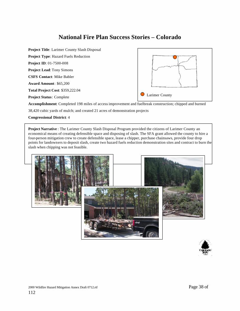
Project Title: Larimer County Slash Disposal
Project Type: Hazard Fuels Reduction
Project ID: 01-7500-008
Project Lead: Tony Simons
CSFS Contact: Mike Babler
Award Amount : $65,200
Total Project Cost: $359,222.04
Project Status: Complete
Accomplishment: Completed 198 miles of access improvement and fuelbreak construction; chipped and burned
38,420 cubic yards of mulch; and created 21 acres of demonstration projects
Congressional District: 4
Project Narrative : The Larimer County Slash Disposal Program provided the citizens of Larimer County an economical means of creating defensible space and disposing of slash. The SFA grant allowed the county to hire a four-person mitigation crew to create defensible space, lease a chipper, purchase chainsaws, provide four drop points for landowners to deposit slash, create two hazard fuels reduction demonstration sites and contract to burn the slash when chipping was not feasible.
Larimer County

2000 Wildfire Hazard Mitigation Annex Draft 0712.rtf Page 39 of 112
National Fire Plan Success Stories – Colorado
Project Title: Larimer County Wildfire Safety
Project Type: WUI Mitigation Planning/Implementation
Project ID: 01-7400-002
Project Lead: Tony Simons
CSFS Contact: Mike Babler
Award Amount : $25,000
Total Project Cost: $79,512
Project Status: Complete
Accomplishment: Completed initial wildfire inspections on 368 lots, 184 acres and final wildfire inspections on 357 lots; completed volunteer wildfire assessments on 26 lots, 26 acres; presented 15 Are You FireWise? educational programs to 1,146 people; coordinated slash disposal projects on three sites—Lehkuhl collection site, 350 cubic yards, 3 lots, 6 acres; Duy collection site, 700 cubic yards, 8 lots, more than 16 acres; Schaffer collection site, 850 cubic yards, 3 lots, 10 acres; conducted wildfire safety projects on 16.5 acres at Ramsey-Shokley Open Space and Horsetooth Mountain Park. Congressional District: 4
Project Narrative : The Larimer County Wildfire Safety Program filled the position of Wildfire Safety Technician to assist the Wildfire Safety Specialist with coordination of the 2001 Slash Disposal Program, conducting wildfire inspections, assisting with education presentations, and coordinating the construction of two FireWise demonstration sites. Conducted landowner education programs leading to FireWise decisions and removal of hazard fuels.
Larimer County, Colorado

2000 Wildfire Hazard Mitigation Annex Draft 0712.rtf Page 40 of 112
National Fire Plan Success Stories – Colorado
Project Title: Fire Box
Project Type: Education
Project ID: 01-7200-010
Project Lead: Shawna Crocker
CSFS Contact: Shawna Crocker
Award Amount : $11,005.52
Total Project Cost: $22,011.04
Project Status: Complete
Accomplishment: Completed curriculum for K-12 fire ecology education
Congressional Districts : All
Project Narrative : A curriculum writer who is knowledgeable about natural resources and learning theory completed K-12 curriculum for Colorado’s Fire Box. The Fire Box contains 12 hands-on activities to facilitate learners’ attitudes and behavior changes and promote understanding of wildfire in their communities.
Statewide

2000 Wildfire Hazard Mitigation Annex Draft 0712.rtf Page 41 of 112
National Fire Plan Success Stories – Colorado
Project Title: Living With Fire newspaper inserts
Project Type: Education
Project ID: 01-7200-005
Project Lead: Judy Serby
CSFS Contact: Judy Serby
Award Amount : $20,309.28
Total Project Cost: $40,618.56
Project Status: Complete
Accomplishment: Distributed 140,000 Living With Fire inserts through 24 interface newspapers statewide
Congressional District: All
Project Narrative : Distributed 140,000 Living With Fire newspaper inserts through 24 interface newspapers in Colorado in July and August of 2001. The inserts teach homeowners about hazard reduction and creation of defensible space.
Cover of Living with Fire insert
Statewide

2000 Wildfire Hazard Mitigation Annex Draft 0712.rtf Page 42 of 112
National Fire Plan Success Stories – Colorado
Project Title: Colorado Reader—Fire and Water
Project Type: Information and Education
Project ID: 01-7200-012
Project Lead: Shawna Crocker
CSFS Contact: Shawna Crocker
Award Amount : $9,775
Total Project Cost: $19,550
Project Status: Complete
Accomplishment: Fifty thousand copies of the Colorado Reader, “Fire and Water,” which included word searches,
crossword puzzles, and a teacher’s guide were published and distributed to 4th and 5th grade classes throughout
Colorado
Congressional Districts : All
Project Narrative : The February 2002 issue of the Colorado Reader, the single-topic news booklet produced by Colorado Agricultural Foundation’s Ag in the Classroom program, feautred “Fire and Water.” This classroom resource reaches 2,000 4th and 5th grade classrooms every year. Articles were writen by Colorado State Forest Service staff and specialists from partnering agencies and organizations.
Statewide

2000 Wildfire Hazard Mitigation Annex Draft 0712.rtf Page 43 of 112
National Fire Plan Success Stories – Colorado
Project Title: Volunteer Defensible Space Training
Project Type: Education
Project ID: 01-7200-006
Project Lead: Ann Randall
CSFS Contact: Ann Randall
Award Amount : $10,981.31
Total Project Cost: $24,733.23
Project Status: Complete
Accomplishment: Trained 42 volunteers in FireWise and defensible space; completed 9 defensible space projects
Congressional Districts : 2, 3, and 4
Project Narrative : Volunteers were trained in FireWise concepts and hazard reduction techniques. They completed nine defensible space projects from November 11, 2000, through 2001. This program utilizes CSFS-supervised volunteers to reduce wildfire hazards along Colorado’s Front Range.
Front Range Interface

2000 Wildfire Hazard Mitigation Annex Draft 0712.rtf Page 44 of 112
National Fire Plan Success Stories – Colorado
Project Title: Colorado Project Learning Tree
Project Type: Education
Project ID: 01-7200-011
Project Lead: Shawna Crocker
CSFS Contact: Shawna Crocker
Award Amount : $26,760.98
Total Project Cost: $67,694.98
Project Status: Complete
Accomplishment: More than 300 K-12 teachers and facilitators attended 23 workshops where they received
instruction on fire’s role in nature
Congressional District: Statewide
Project Narrative : This long-running and nationally recognized supplemental conservation education program was infused with a concentration on fire ecology and related activities. Every PLT participant received specific fire -related activities, videos, posters and CDs to use in their K-12 classrooms.
Statewide
2000 Wildfire Hazard Mitigation Annex Draft 0712.rtf Page 45 of 112
National Fire Plan Success Stories – Colorado
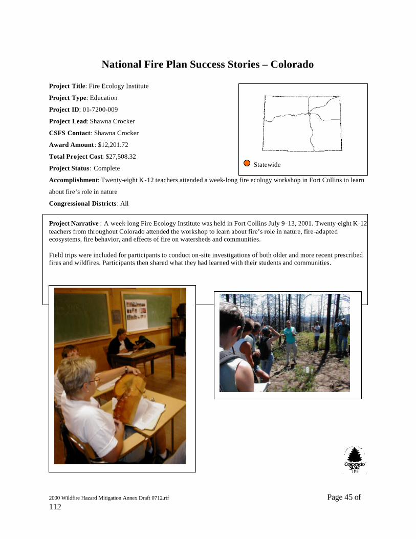
Project Title: Fire Ecology Institute
Project Type: Education
Project ID: 01-7200-009
Project Lead: Shawna Crocker
CSFS Contact: Shawna Crocker
Award Amount : $12,201.72
Total Project Cost: $27,508.32
Project Status: Complete
Accomplishment: Twenty-eight K-12 teachers attended a week-long fire ecology workshop in Fort Collins to learn
about fire’s role in nature
Congressional Districts : All
Project Narrative : A week-long Fire Ecology Institute was held in Fort Collins July 9-13, 2001. Twenty-eight K-12 teachers from throughout Colorado attended the workshop to learn about fire’s role in nature, fire-adapted ecosystems, fire behavior, and effects of fire on watersheds and communities. Field trips were included for participants to conduct on-site investigations of both older and more recent prescribed fires and wildfires. Participants then shared what they had learned with their students and communities.
Statewide
2000 Wildfire Hazard Mitigation Annex Draft 0712.rtf Page 46 of 112
National Fire Plan Success Stories – Colorado
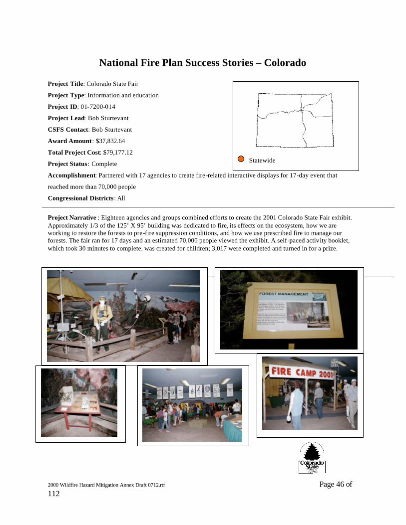
Project Title: Colorado State Fair
Project Type: Information and education
Project ID: 01-7200-014
Project Lead: Bob Sturtevant
CSFS Contact: Bob Sturtevant
Award Amount : $37,832.64
Total Project Cost: $79,177.12
Project Status: Complete
Accomplishment: Partnered with 17 agencies to create fire-related interactive displays for 17-day event that
reached more than 70,000 people
Congressional Districts : All
Project Narrative : Eighteen agencies and groups combined efforts to create the 2001 Colorado State Fair exhibit. Approximately 1/3 of the 125’ X 95’ building was dedicated to fire, its effects on the ecosystem, how we are working to restore the forests to pre-fire suppression conditions, and how we use prescribed fire to manage our forests. The fair ran for 17 days and an estimated 70,000 people viewed the exhibit. A self-paced activity booklet, which took 30 minutes to complete, was created for children; 3,017 were completed and turned in for a prize.
Statewide

2000 Wildfire Hazard Mitigation Annex Draft 0712.rtf Page 47 of 112
National Fire Plan Success Stories – Colorado
Project Title: Lee Springer
Project Type: Hazardous Fuels Reduction Incentives
Project ID: 001-7100-601
Project Lead: Lee Springer
CSFS Contact: Brian Ayers
Award Amount : $3,000
Total Project Cost: $6,000
Project Status: Complete
Accomplishment: Burned 63 acres, improving community safety through hazardous fuels reduction; national forest
land above the property was also burned
Congressional District: 3
Project Narrative : The Springer property was one of the highest fuel hazard locations in the Gunnison area where 84 homes were located nearby. A burn plan was written and approved in spring 2001. The landowner pruned lower limbs, moved slash and bladed control lines. Burning was also accomplished across boundary on national forest land. Partners included Lee Springer, Monarch Valley Ranch, Saguache County Sheriff, Gunnison Fire Department, the Colorado State Forest Service and USDA Forest Service.
Gunnison
2000 Wildfire Hazard Mitigation Annex Draft 0712.rtf Page 48 of 112
National Fire Plan Success Stories – Colorado
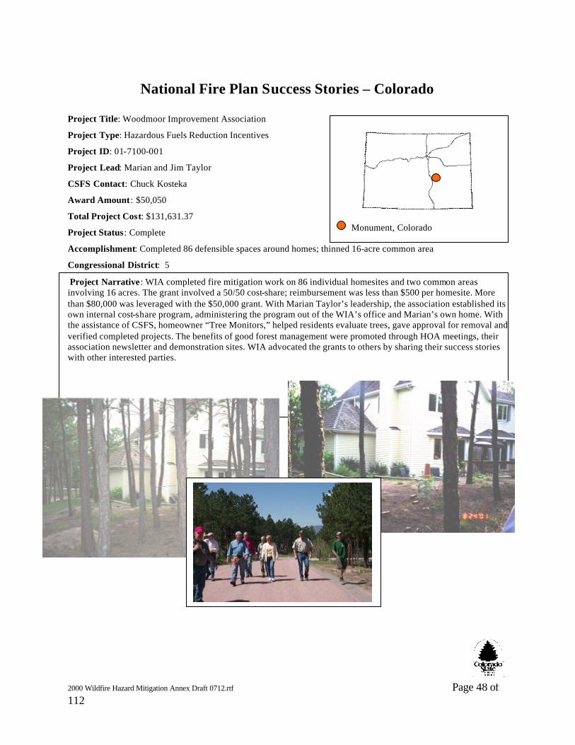
Project Title: Woodmoor Improvement Association
Project Type: Hazardous Fuels Reduction Incentives
Project ID: 01-7100-001
Project Lead: Marian and Jim Taylor
CSFS Contact: Chuck Kosteka
Award Amount : $50,050
Total Project Cost: $131,631.37
Project Status: Complete
Accomplishment: Completed 86 defensible spaces around homes; thinned 16-acre common area
Congressional District: 5
Project Narrative: WIA completed fire mitigation work on 86 individual homesites and two common areas involving 16 acres. The grant involved a 50/50 cost-share; reimbursement was less than $500 per homesite. More than $80,000 was leveraged with the $50,000 grant. With Marian Taylor’s leadership, the association established its own internal cost-share program, administering the program out of the WIA’s office and Marian’s own home. With the assistance of CSFS, homeowner “Tree Monitors,” helped residents evaluate trees, gave approval for removal and verified completed projects. The benefits of good forest management were promoted through HOA meetings, their association newsletter and demonstration sites. WIA advocated the grants to others by sharing their success stories with other interested parties.
Monument, Colorado

2000 Wildfire Hazard Mitigation Annex Draft 0712.rtf Page 49 of 112
National Fire Plan Success Stories – Colora do
Project Title: Basalt Rural FPD
Project Type: Hazardous Fuel Reduction Incentive/
Landowner Incentive
Project ID: 01-7100-201
Project Lead: Basalt FPD/Vonda Williams
CSFS Contact: Grand Junction District/John Denison
Award Amount : $6,920
Total Project Cost: $16,175.46
Project Status: Complete
Accomplishment: Completed five defensible space projects that concentrated on thinning and pruning vegetation
around home sites
Congressional District: 3
Project Narrative : The Basalt and Rural FPD encompasses 492 square miles in the mountains of central Colorado. The area includes various types of land use and ownerships. As a result of continued growth, people are building closer to public lands in the area we know as the Wildland Urban Interface (WUI). Many homeowners do not understand the potential hazards of the area they live in. There is a need for fuel reduction in all of the targeted subdivisions. Projects concentrated on thinning, pruning and creating defensible spaces around homesites. Since the 2000 fire season, there has been great support and willingness from landowners to participate.
Basalt

2000 Wildfire Hazard Mitigation Annex Draft 0712.rtf Page 50 of 112
National Fire Plan Success Stories – Colorado
Project Title: FireWise
Project Type: Education
Project ID: 01-7300-001
Project Lead: Judy Serby
CSFS Contact: Judy Serby
Award Amount : $80,620.65
Total Project Cost: $185,255.16
Project Status: Complete
Accomplishment: Approximately 300 participants attended 40 workshops throughout the state
Congressional Districts : All
Project Narrative : More than 40 Are You FireWise? workshops, have been held throughout Colorado. More than 300 participants—fire department personnel, land managers, county commissioners and planners, developers, insurance industry representatives and landowners—have been trained in FireWise concepts. Fourteen hundred FireWise notebooks have been assembled and disseminated. These “homeowner kits” provide private landowners with instructions on how to create defensible space, preparation and evacuation procedures in the event of a wildfire, information on FireWise construction materials and a video that explains the importance of being prepared. The Are You FireWise? Program was developed and piloted in Larimer County.
Statewide

2000 Wildfire Hazard Mitigation Annex Draft 0712.rtf Page 51 of 112
Fire Publications – Order Form Title Quantity Cost Each Total 1) Are You FireWise (notebook and videotape) $50.00 $ (includes one each # 2, 4, 7,8, 9, 10, 11) 2) Are You FireWise Videotape $10.00 $ 3) Firewise Construction, Design and Materials (booklet) $2.25 $
The following are free for single copies. However, any more than one constitutes bulk
orders and requires a minimum order of ten Bulk price (ea.) 4) Home Fire Protection in the Wildland Urban Interface (brochure) $0.30 $ 5) Prescribed Fire in Colorado (brochure) $0.30 $ 6) Is your home FireWise? (doorhanger) $0.10 $ 7) Your home has just been threatened (doorhanger) $0.10 $ 8) Creating Wildfire-Defensible Zones (Fact Sheet 6.302) $0.10 $ 9) Fire-Resistant Landscaping (Fact Sheet 6.303) $0.10 $ 10) Forest Home Fire Safety (Fact Sheet 6.304) $0.10 $ 11) FireWise Plant Materials (Fact Sheet 6.305) $0.20 $ 12) Grass Seed Mixes to Reduce Wildfire Hazard (Fact Sheet 6.306) $0.10 $ 13) Vegetative Recovery After Wildfire (Fact Sheet 6.307) $0.10 $ 14) Soil Erosion Control After Wildfire (Fact Sheet 6.308) $0.10 $ 15) Are You FireWise Bumper Sticker $0.20 $ 16) Woody DeBree coloring book $1.00 $ 17) Living With Fire newspaper insert $0.15 $ 18) FireWise seed packet $0.15 $

2000 Wildfire Hazard Mitigation Annex Draft 0712.rtf Page 52 of 112
19) Colorado Reader (4th and 5th grade) $0.10 $ TOTAL $ If you wish to receive single copies of publications 4 - 14 on the reverse side, please mark your preferences and fill in your mailing information below. We will send your request immediately. If you wish to order 1-3, or any of the publications in bulk, please fill out the reverse. We will mail the materials and an invoice. For further information on these materials, please contact: Judy Serby Colorado State Forest Service Colorado State University Fort Collins, CO 80523-5060 970.491.7559 [email protected] Name __________________________________________________________________ Affiliation ______________________________________ Phone ___________________ Address ________________________________________________________________ City _________________________________ State _______________ Zip ___________
2000 Wildfire Hazard Mitigation Annex Draft 0712.rtf Page 53 of 112

2000 Wildfire Hazard Mitigation Annex Draft 0712.rtf Page 54 of 112
o
o o
o o o o
o o o

2000 Wildfire Hazard Mitigation Annex Draft 0712.rtf Page 55 of 112
Background Colorado State Forest Service Districts surveyed Fire Departments, Fire Protection Districts, Sheriffs, and County Commissioners between January and May 2001. This report summarizes the responses of the Fire Departments and Fire Protection Districts. Summary reports of the Sheriff and County Commissioner Surveys will follow.
Response 305 Fire Departments or Fire Protection Districts completed survey forms. The results of the survey are tabulated below in a series of charts or graphs accompanied by narrative explanation. Reports summarizing the response by Colorado State Forest Service District will be provided at a later date.
State Wide Statistics
Area Protected The 305 Fire Departments responding to the survey indicated they provide protection on 47,136,123 acres. No distinction was made between private, county, or federal land. Operating Budget The Fire Departments reported a combined operating budget of $355,523,995. This must be taken in the context of the large range of fire department size and make-up (volunteer, volunteer and paid, municpal, and other combinations). Operating budgets ranged from $0.00 for small independent volunteer departments to $70,000,000.00 for large municipal departments.
Fire Response The Fire Departments reported responding to 29033 wildfires and 8533 smoke chases (false alarms) in the three year period of 1998, 1999, and 2000. These numbers vary greatly from the fire reports supplied to CSFS on a quarterly basis.
Summary ReportOctober 2001
Colorado Fire Department Survey
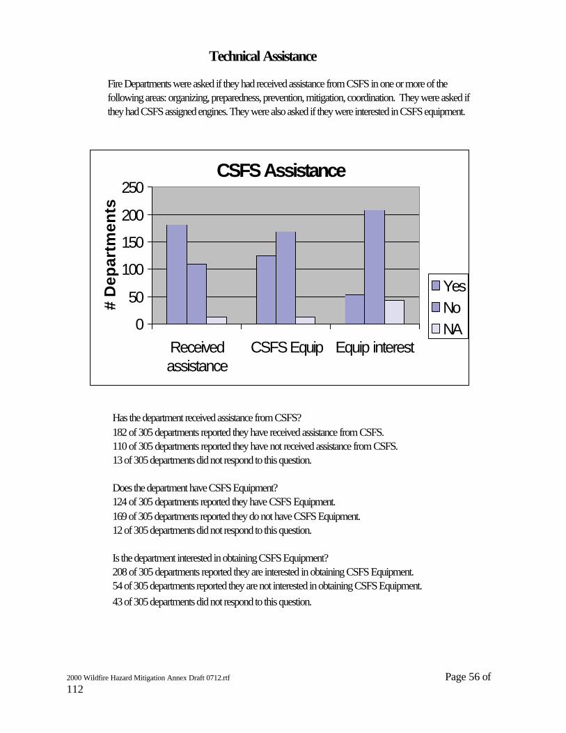
2000 Wildfire Hazard Mitigation Annex Draft 0712.rtf Page 56 of 112
Has the department received assistance from CSFS?182 of 305 departments reported they have received assistance from CSFS.110 of 305 departments reported they have not received assistance from CSFS.13 of 305 departments did not respond to this question. Does the department have CSFS Equipment?124 of 305 departments reported they have CSFS Equipment.169 of 305 departments reported they do not have CSFS Equipment.12 of 305 departments did not respond to this question.
Is the department interested in obtaining CSFS Equipment?208 of 305 departments reported they are interested in obtaining CSFS Equipment.54 of 305 departments reported they are not interested in obtaining CSFS Equipment.43 of 305 departments did not respond to this question.
Technical Assistance
Fire Departments were asked if they had received assistance from CSFS in one or more of the following areas: organizing, preparedness, prevention, mitigation, coordination. They were asked if they had CSFS assigned engines. They were also asked if they were interested in CSFS equipment.
CSFS Assistance
0
50
100
150
200
250
Receivedassistance
CSFS Equip Equip interest
# D
epar
tmen
ts
YesNo NA
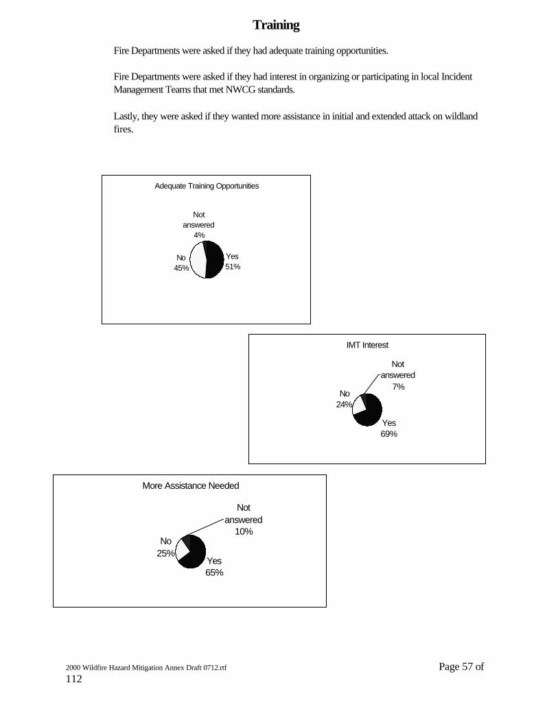
2000 Wildfire Hazard Mitigation Annex Draft 0712.rtf Page 57 of 112
Fire Departments were asked if they had adequate training opportunities.
Fire Departments were asked if they had interest in organizing or participating in local Incident Management Teams that met NWCG standards.
Lastly, they were asked if they wanted more assistance in initial and extended attack on wildland fires.
Training
Adequate Training Opportunities
Yes51%
No45%
Not answered
4%
IMT Interest
Yes69%
No24%
Not answered
7%
More Assistance Needed
Yes65%
No25%
Not answered
10%

2000 Wildfire Hazard Mitigation Annex Draft 0712.rtf Page 58 of 112
Equipment
124 Fire Departments responded that they had CSFS assigned engines. Those departments were asked if they were satisfied with the equipment; the agreement; if they wanted to continue, change, replace, or discontinue use of the assigned engines; and lastly, how many fire runs does the equipment respond to.
Departments With CSFS Equipment
Yes41%
No55%
NA4%
Of Those With Equipment, Satisfied
Yes77%
No23%
Of Those with CSFS Equipment,Fire Runs Per year
1--1012%
11--2011%
21 plus16%
NA61%
Of Those with Equipment,Current Agreement Serves Department Needs
Yes96%
No4%
Out of those responded: Fire Department Needs
Continue81%
Change2%
Replace16%
Discontinue1%
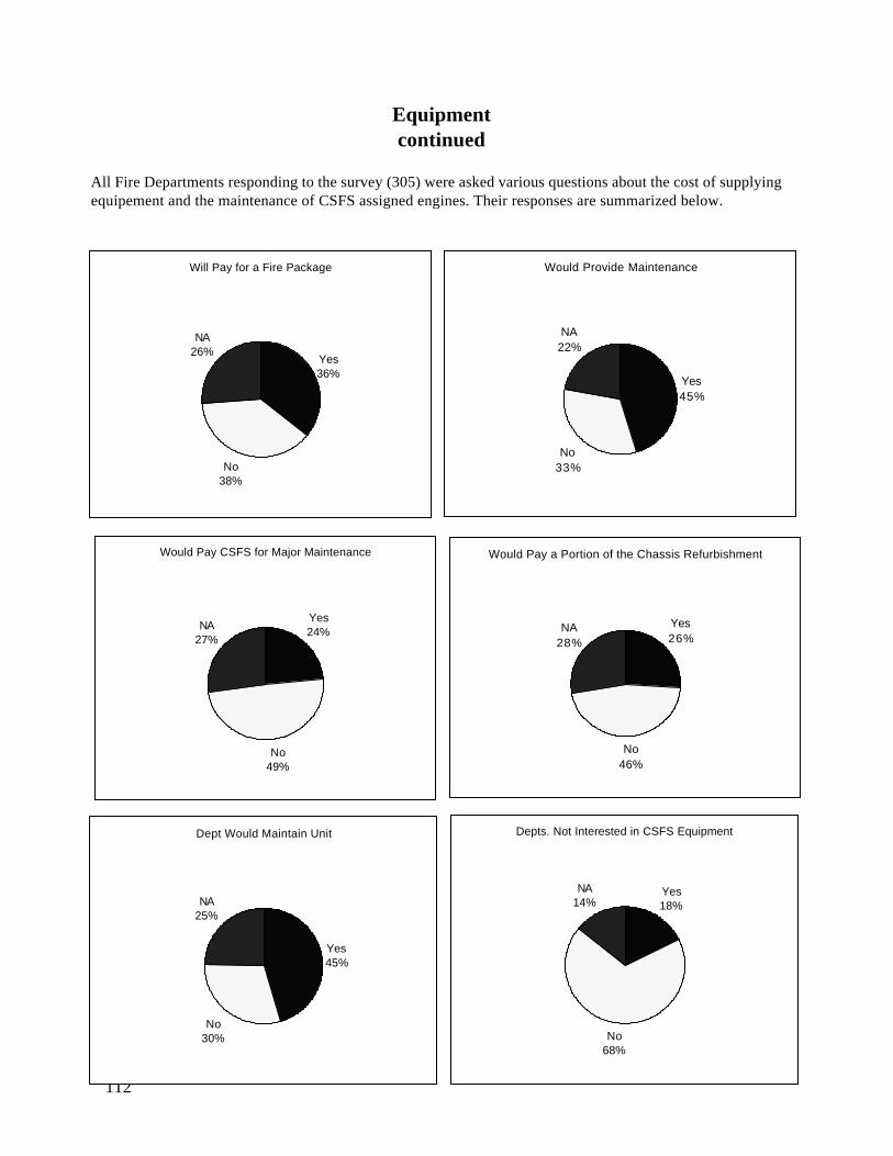
2000 Wildfire Hazard Mitigation Annex Draft 0712.rtf Page 59 of 112
Equipmentcontinued
All Fire Departments responding to the survey (305) were asked various questions about the cost of supplying equipement and the maintenance of CSFS assigned engines. Their responses are summarized below.
Will Pay for a Fire Package
Yes36%
No38%
NA26%
Would Provide Maintenance
Yes45%
No33%
NA22%
Would Pay CSFS for Major Maintenance
Yes24%
No49%
NA27%
Would Pay a Portion of the Chassis Refurbishment
Yes26%
No46%
NA28%
Dept Would Maintain Unit
Yes45%
No30%
NA25%
Depts. Not Interested in CSFS Equipment
Yes18%
No68%
NA14%

2000 Wildfire Hazard Mitigation Annex Draft 0712.rtf Page 60 of 112
Appendix
1995 Colorado Wildfire Mitigation Plan Annex I
Text Version

2000 Wildfire Hazard Mitigation Annex Draft 0712.rtf Page 61 of 112
Preface Once again in 1994, Colorado suffered another severe wildfire season. It was among the worst in recorded history. Numerous fires burned large areas of watershed and other valuable natural resources, destroyed homes and threatened scores more. Colorado's fire suppression forces were overwhelmed and reinforcements had to be brought from outside of Colorado. Worst of all were the tragic deaths of fourteen firefighters battling the South Canyon Fire near Glenwood Springs. Their deaths illustrate the threats wildfires pose and emphasize the need to mitigate those threats. The 1994 situation also helped re-focus attention on the serious problem of homes and developments in forests and brush lands. Fire officials must build upon this increased awareness and help citizens and elected officials take positive, corrective actions. 1994 again spotlighted the "who pays" question described in Chapter Two. The answer remains unclear in Colorado and nationwide. The core problems are obvious. Too often, people who use or live in forest, range, and brush lands are unaware of the wildfire threats they face, or the risks their careless actions pose to others and surrounding natural resources. Of those who are aware, too many apparently believe "it won't happen to me." The paradox of protecting lands from wildfires has allowed vegetation (fuel) to accumulate, increasing the intensity of wildfires that do start. Last, the under-management of Colorado's wildlands has also contributed to additional vegetation and natural fuels. Statements from forestry and fire officials in Colorado are shown in the left margins of this report. They express the dangers and their concerns about wildfires, and underscore the need for action. This 1995 edition updates the Wildfire Hazard Mitigation Plan of July 1990 and its Addendum No. 1 of February 1991 for the State of Colorado. It constitutes the Wildland/Urban Fire Annex to the Colorado Multi-Hazards Mitigation Plan. This plan identifies problems and presents recommendations for mitigating those wildfire problems near improvements. Implementation of the recommendations will be crit ical to Colorado's long-term economy and quality of life, and its reputation as a safe place to visit and to live. But this plan is only a blueprint. Public education, new legislation and regulations, and funding are all needed to mitigate the threats. Most importantly, all affected agencies, organizations, businesses and citizens must accept their responsibility and take wildfire mitigation action. The Fire Survey Teams who helped update this plan reaffirmed that all existing Issues in the 1990 Wildfire Ha zard Mitigation Plan are valid. Therefore, all previous Issues as well as new Issues have been combined into this updated plan. Recommended actions in this plan are even more important with the prospects of additional building and development across the state and the dry seasons that will repeatedly occur. The original preparation and update of this document involved participatory efforts from all levels of governments throughout the state. Once again, Colorado is indebted for the concerned efforts of many people, especially those listed in the Credits. This plan could not have been completed without their concern, patience and assistance. Ronald J. Zeleny Division Supervisor, Fire Colorado State Forest Service

2000 Wildfire Hazard Mitigation Annex Draft 0712.rtf Page 62 of 112
Table of Contents Chapter One: The Colorado Situation
1994 Wildfire Season--One of the Worst The Wildland/Urban Interface Reasons for the Interface The Fire Environment Areas of Greatest Problem/Threat Fire Protection Responsibilities
Chapter Two: Impacts and Costs Impacts of the Interface The Costs and Who Pays
Chapter Three: Mitigation Approaches Chapter Four: Major Problems Chapter Five : Hazard Mitigation Recommendations
Problem A: Education and Awareness Problem B: Legislation Problem C: Preparedness Problem D: Emergency Response Problem E: Secondary Hazards Table 1: Lead Responsibilities for Mitigation Work
Chapter Six: Plan Review, Evaluation and Updates Appendices
Appendix A: Plan Distribution Appendix B: Description of Disaster Wildfires Appendix C: Colorado Interface Areas Appendix D: Colorado Wildfire Data Appendix E: Past Mitigation Efforts in Colorado Appendix F: Credits

2000 Wildfire Hazard Mitigation Annex Draft 0712.rtf Page 63 of 112
Chapter One: The Colorado Situation 1994 Wildfire Season -- One of the Worst A disturbing pattern has emerged in Colorado. Large intense fires threaten or destroy homes, disrupt public facilities and utilities, and cause an increasing number of communities to be evacuated. The situation has progressively worsened over the last ten years. The 1994 wildfire season in Colorado was one of the worst on record. Never were so many communities threatened by wildfires. Never were so many lives lost trying to contain the wildfires. Never were so many dollars spent paying firefighting costs during a single year. And acreage burned was the worst in years. Excluding federal land ownerships, 1994 recorded: 3,158 wildfires reported to the State Forester. 52,125 burned acres reported to the State Forester. 17 homes and state buildings destroyed. A college campus heavily damaged by wildfire. Numerous outbuildings destroyed. Total exhaustion of emergency fire trust funds and the necessity for extra state funding. For federal, state and local fire agencies: 14 firefighters dead. Shortages of critical air and ground firefighting forces for new wildfires. Firefighting costs of more than 20 million dollars. Loss and damages to improvements and natural resources in uncounted millions of dollars. Wake Fire, South Canyon Fire and Roxborough Fire Complex (see Appendix B), the most threatening of the many 1994 wildfires, focused attention on the growing wildfire problem. The Wildland/Urban Interface The wildfire protection situation has been changing for the past 30 years. Now, the need to also protect structures and improvements as well as natural resources from wildfires is becoming widely recognized. Traditionally, wildfires have been suppressed by personnel from forestry, county or rural fire agencies accustomed to working in forest, brush or range wildlands. Strategic suppression options included use of natural barriers, burning out or backfiring additional acres of land or falling back to the next ridge to gain control. Distance and area could be sacrificed to fire to gain a control advantage. But the growing intrusion of structures and other improvements into wildlands has resulted in a condition some call the "wildland/urban interface." But the word "interface" does not describe Colorado's situation well. The development of highly intermingled private lands among public lands in the state has brought about more of an "intermix" -- a true random mixture of urban and wild lands. This intermix, however, will be referred to as "interface" for the remainder of this plan.

2000 Wildfire Hazard Mitigation Annex Draft 0712.rtf Page 64 of 112
The interface problem is everywhere and growing -- hunting cabins in Gunnison County, condominiums in Pitkin County, clusters of lakeside homes in La Plata County, ski resorts in Summit County, summer homes communities in Larimer County, subdivisions in Costilla County, residential developments in Jefferson County and city growth in El Paso County. "Interface" occurs in all areas -- from the brushlands of the foothills, to the piñon-juniper "deserts" in southern Colorado, to the pine forests in the Black Forest to lodgepole thickets in high elevations. Interface is even within the city limits of cities such as Breckenridge, Colorado Springs, Durango, Frisco and Vail. As development continues into wildlands, it adds new dimensions of difficulty to fire protection, increases costs and dollar losses and presents high fire threats to those improvements and to the public. Wildfire control in the interface has become a tactical exercise of moving from structure to structure on a case-by-case basis, often over inadequate access roads, with limited water supplies and inappropriate equipment. The interface also demands more rapid, costly fire attack from the air. Structural defense becomes primary thereby allowing fire perimeters to easily grow and threaten more improvements and natural resources. Reasons for the Interface Specific reasons for dwellings and buildings outside cities and towns vary with each site. General reasons for the wildland/urban interface in Colorado are: 1. Land ownership patterns Public and private lands in Colorado's forest and brush lands are highly mixed. Much of this is due to random early settlement, homesteading, mining claims, lands set aside during statehood and public lands managed by a variety of public agencies. Except for the highest elevations, few large forested tracts exist without some intermingled ownerships. These complex, intermingled ownership patterns also compound the fire protection problem. Each jurisdiction must respond to wildfires threatening its land. Duplication of fire responses easily results. 2. Escape to rural living Despite the state's pristine reputation, Colorado residents want to avoid the noise, pollution, crowds, rules, taxes and hectic pace of city lifestyles. They seek the serene and peaceful wildlands to raise their families and live out their retirement years. Colorado's mountains beckon in the distance, and land developers are busy providing the buyer with building sites. It is not uncommon for people to commute as much as one hour each way from their home in rural forest and brush areas to their jobs in the city. Urban residents and nonresidents want that "cabin" in the woods, to get away if only for a weekend. Increasing urbanization of outdoor recreation areas is now common and many of the "cabins" are condominiums and expensive homes -- built virtually under the boughs of the forest. These people believe the more hidden and inaccessible to the "outside world," the better. The result: motels, condominiums, summer camps, ski resorts, hunting retreats and residential subdivisions are located on natural resource wildlands and former ranchlands and more are being developed every year. 3. Economic growth For revenue-hungry rural jurisdictions development has been welcomed. Improvements and their attendant values provide much-needed sales for local businesses and tax revenues to governments. Rural economic growth is a state priority. 4. Land use legislation Unbridled growth and sprawl of the 1960s and early 1970s brought about much needed land use legislation by the state legislature. However, the proviso of exempting land divisions exceeding 35 acres per parcel from subdivision requirements has worsened the interface problem. Homes can now be found scattered over larger wildland tracts rather than being concentrated into fire-safe areas. Services, such as providing good road access, water systems and fire protection, critical for defending improvements against wildfire, are more costly and difficult to maintain.

2000 Wildfire Hazard Mitigation Annex Draft 0712.rtf Page 65 of 112
The Fire Environment "Wildfire" can be described as an open fire which spreads unconstrained through the environment. If not quickly controlled, the result can be a fire storm, often termed a "conflagration," which destroys large amounts of property and threatens lives. Since prehistoric times, wildfires (both large and small) have been a continuous and powerful natural force in shaping and changing Colorado's landscape. Many of the state's tree, brush and grass species have evolved into fire-dependent ecosystems. Some are so fire dependent that their flammability increases with age thus assuring renewal and continuation of the species after each re-occurring wildfire. So, wildfires will continue to occur as a natural process on a regular basis. While any vegetation can burn during drought, most fire -prone wildlands are generally found on drier sites at lower or middle elevations -- which are the same sites preferred by humans for development. Therefore, more conflagrations of the type experienced in the 1989 Black Tiger Fire and the many 1994 wildfires will occur in Colorado. Once ignited, wildfire behavior and spread are affected by three major factors: fuels, weather and topography. Traditionally, the fuel component consisted of grasses, brush, trees and accumulations of dead vegetation. "Interface" fuels now also contain homes, outbuildings, businesses and other valuable improvements which also serve as combustible fuels. Firewood piles, poor outdoor housekeeping and fire-prone construction add to the problem. In some cases, the fuel load of an interface area's vegetation and structures is equal to or greater than the original native vegetation before development. Ironically, improved fire protection coupled with decreased forest cutting and grazing has contributed to the fuel increase. Insect-killed trees and other forest health problems in interface areas also increase the ready-to-burn fuel situation. Natural conditions had periodic fires to burn the vegetation. Some fires would have burned with little change to the environment. Thicker forests and brush fields, now fire-prone due to elimination of fire, are ready to burn intensely and destructively. It is this same thick vegetation that appeals to people as a hideaway building site. Weather, the second major factor, is the rapidly changing variable It often determines size of a fire. High winds, hot days, low humidity and low moisture, so characteristic of Colorado, create favorable conditions for wildfires. Combined, these conditions can quickly transform small, "easy" fires into severe infernos. This is the norm during periods of extended drought. Because of weather, wildfires have occurred in all months of the year in Colorado. Topography or terrain, the third major factor, affects a fire's spread. Canyons and gullies channel winds and thereby channel fire spread. Because heat rises, fire naturally burns upslope. Therefore, homes built in a canyon or on steep slopes overlooking a view have less chance of escaping destruction by wildfire. Slope and terrain also hinder fire fighting efforts. Higher elevations reduce efficiency and power of engines and fire pumps. Rough topography naturally helps wildfire but hinders fire suppression efforts. Besides fuels, weather and topography, all that remains for a wildfire is a source of ignition. Area of Greatest Problem/Threat The greatest threat of public injury and property loss from wildfires are areas where wildfires are most frequent, inhabited developments are closely mixed with the natural fuels, and little is being done to mitigate the wildfire problem. The number of subdivisions and their acreage by county in 1990 are shown in Appendix C. Numbers of reported wildfires for 1989-1994 on non-federal lands are shown in Appendix D. In addition to this information, a 1992 survey was made by a Colorado State University graduate student for the Colorado State Forest Service. The survey examined rural population, interface areas, wildfire occurrence and wildfire mitigation activities, and ranks each county for wildland/urban interface fire threat. Fire Protection Responsibilities Confusing laws and a mixture of fire jurisdictions add yet another dimension to Colorado's "interface." Jurisdictions common in Colorado are:
• fire departments - responsible for all fires within city limits; wildfire capability varies greatly with each
2000 Wildfire Hazard Mitigation Annex Draft 0712.rtf Page 66 of 112
department. • Fire protection districts - special districts authorized to tax for protecting improvements from fire, but not
clearly responsible for wildfires; the fire departments funded by the districts usually respond to wildfires within the district or elsewhere at request; not all have wildfire capability.
• Fire departments outside fire district or city - authorities and responsibilities not recognized in state statutes; not tax supported; respond to fires in certain areas or for limited publics; wildfire capabilities vary greatly.
• County sheriffs - responsible by Colorado statute for controlling forest and prairie fires; no direct responsibility for fires inside structures, but can become involved in sending fire department forces to control any fire in the county.
• State forester - responsible by Colorado statute for "providing" wildfire protection, but clearly cannot usurp the sheriff's responsibility for controlling fires; state forester may assume fire control duty of the sheriff upon sheriff's concurrence; can become involved in defending structures from encroaching wildfires; no responsibility for fires inside structures; wildfire responsibility inside city limits not clear.
• Other state land agencies - responsibilities not stated or confusing with sheriff responsibilities. • Federal land management agencies - clearly responsible for controlling wildfires on federal lands; no
inside-structure fire responsibility or capability except for National Park Service. • Federal military areas - responsible for all fires within the base perimeter.
This variety of jurisdictions and responsibilities, coupled with Colorado's mixed land ownerships, often results in a duplicate response to the same fire, all at public expense. It may result in no response when each expects the other agency to respond. Figure 2 graphically portrays this protection complex. So it was with the 1994 fires and the 1989 Black Tiger Fire in the jumbled private-state-federal land ownership patterns. Fires become the simultaneous responsibility of the local fire chief, the county sheriff and any threatened federal land agency. The State Forester also becomes involved soon after whenever there is a possible need to assist in controlling wildfire. Chapter Two: Impacts and Costs Impacts of the Interface The natural and less complicated lifestyle people seek by building and living in wildland areas creates a dual fire threat: (1) endangerment of the surrounding lands with increased fire ignitions from human activities, and (2) the risk of losing their home and all their family possessions from encroaching wildfires. The 1989, 1990 and 1994 fires focused attention again and again on the interface fire problem. The 1989 Panorama Fire in Garfield and Eagle Counties demonstrated the problems resulting from the mixing of diverse land uses. A fire ignited inside an unoccupied house located in a brushy, flat area. Despite response from local fire forces, the structure totally burned. Winds quickly spread the fire into the surrounding, dry vegetation. Other homes in the development were soon threatened and needed protection. Residents had to be evacuated. A major fire fight ensued. Available forces had to be diverted from fighting the wildfire to defending the structures from the wildfire. The wildfire easily grew and required more forces from federal, state, county and other local fire agencies. Luckily, the threatened homes were saved from the 600-acre fire. But, the Panorama Fire is a prime example of how people and their structures create fire risks to brush/forest areas, the environment and to each other, and how they are at risk from uncontrolled wildfires. Several main impacts of fires in the interface include: People cause most of the fires. Out of the 3,158 wildfires on nonfederal lands in 1994, only 487 were started by lightning. The other 2,671 were caused by people. Most are caused by the resident or occupant doing debris burning. But not all who cause wildfires live in the area. Hikers, campers, sportsmen and machine operators--all who use the land--are contributors. Historically, 85.25 percent of wildfires on state and private lands in Colorado are human caused.

2000 Wildfire Hazard Mitigation Annex Draft 0712.rtf Page 67 of 112
Structure fires create risks to adjacent forest and brush lands. When buildings burn in these lands during dry months, there is great risk of fire spreading to adjacent vegetation to become a wildfire. Wildfires create risks to adjacent structures. During high temperature, low humidity and wind, wildfire creates extreme risk to anything in its path. This describes the summer of 1994. The presence of structures does not mean adequate fire protection exists. A fire department might protect the area. Where adequate fire equipment does exist, finding and keeping qualified firefighters, especially volunteers, is a serious problem in interface communities. Retirees can seldom perform the arduous work of firefighting. Younger residents are away at work much of the time. Moreover, time necessary to become trained and competent in interface fire suppression techniques is high for volunteers. The result: fire protection needs of rural interface areas easily outstrip the local fire protection capabilities. Structure fires create safety risks to wildland firefighters. Forestry and wildland firefighters are not equipped or trained to deal with fires in or near structures. Protecting themselves from poisonous smoke near burning buildings and protecting propane gas tanks from wildfire are two examples. Wildfire suppression costs are not fairly borne by those who create the risk in the intermix. When improvements are threatened, fire control costs are higher than similar fires with no structures. Aggressive air attack and extra forces are quickly committed because of the perceived high values of improvements at risk. Federal, state and county agencies who are not authorized or funded for structure fires are called to help and thereby find themselves paying much of the higher cost to defend structures, whether insured or not, from wildfires. Local fire departments responsible for structure fires cannot pay the high cost of extra resources needed to defend structures from wildfires. Homeowners who receive the benefit of the extra fire effort pay nothing extra. Threatened structures change wildfire suppression priorities. Fire situations in which improvements are threatened are high priority. Critically needed wildfire control forces funded for resource and watershed fire protection are often assigned to defend structures. Additional land area is often sacrificed to protect homes. Paradoxically, perimeter control becomes secondary to defending structures from fire, allows the fire to spread and thereby exposes more improvements to the fire's threat. Structure and wildland fire protection agencies must be closely coordinated. As homes and forest/brush become a mixture, wildfire and structure fire forces must work together. Fire force organization and tactics must meet the total need. Radio communications must exist and be matched to ensure understanding. Agencies with differing roles must work as a team. Although some coordination has been occurring, still more is needed. It is difficult to mobilize available fire resources from throughout the state. Structure fire protection forces are available, but are slow to form into effective teams. Hours have been required to assemble five fire engines and crews from different fire departments into an engine strike team with a leader. Then they must travel to the fire. Liability insurance issues, provincial attitudes of some fire departments, lack of trained personnel and absence of a statewide mutual aid plan or authority have also contributed to the delays. The Costs and Who Pays The wildland/urban interface puts significant fire protection costs on various segments of Colorado's population. At first glance, it might seem only the landowner is affected, but ultimately, the risks one person accepts eventually affect neighbors, surrounding natural resources and the public. Thus, "who pays?" intertwines many:

2000 Wildfire Hazard Mitigation Annex Draft 0712.rtf Page 68 of 112
Taxpayers: Where tax-supported fire districts exist, all taxpayers within the district pay regardless of their personal fire safety practices or fire losses. Because of statutory limits upon district tax rates and the 1992 Taxpayer Bill of Rights (TABOR) amendment to the state constitution, local fire districts are often unable to afford the much higher costs of defending structures against wildfires in interface areas. When extra help is needed, the local fire department calls upon other agencies for mutual aid. When other fire agencies respond to help in mutual aid, they do so at their own expense. Thus, taxpayers in distant fire districts not threatened also pay for fires in the interface. When county forces are necessary, all taxpayers within the county are paying. When wildfire overwhelms county fire forces, the State Emergency Fire Suppression Fund, a multi-county trust fund, may be activated by the State Forester to pay the extraordinary costs of interface fires. Therefore, every taxpayer of those counties participating in the Fund pays the additional cost, regardless of the fire's location. Virtually every state taxpayer pays to some degree when state resources are used. Approximately 66 percent of the Colorado State Forest Service fire protection budgets come from the general fund of the State of Colorado. When federal assistance is utilized to assist state or local fire forces, or to defend federal lands from an encroaching fire, all the nation's taxpayers pay through their federal taxes. Reliance on federal agencies or funding to handle nonfederal wildfire problems is unrealistic considering responsibilities, federal program cutbacks, and federal deficit reduction needs. Colorado taxpayers will have to pay for their state and local responsibilities. When forest and watershed fires burn unchecked, an important resource of Colorado is being destroyed. This eventually can result in loss of tax revenues. Again, all Coloradans pay. Landowners: Public forest and watershed land agencies have established funding and protection mechanisms to handle traditional wildfires. Private landowners do so through their general taxes. For those who depend upon their land for their income or property value, every tree and acre burned can be an immediate direct loss. When forest and watershed fire forces and funds are used to save buildings, the natural resource interests of landowners and the general public are abused or neglected. Fire Insurance: Fire insurance rates, excluding metropolitan areas, are mainly determined by three factors: 1. The type of materials and construction of the insured building. 2. The level of fire protection provided. 3. The overall fire losses experienced. Although the insurance industry is showing concern about interface fires, insurance premium rates do not yet consider the extra risk for buildings located in the interface. Insurance companies spread their fire losses among all other policyholders with similar protection. When structure fire losses go up, premiums are increased. All insured homeowners are affected. Furthermore, any wildfire safety measures by a homeowner do not yet result in lower premiums. Homeowners: Some homeowners in the interface may be protected from loss by fire insurance. For their recognized financial loss, they will be compensated according to their insurance policy. However, not all homeowners are fully insured. And financial reimbursement is not a total solution. Loss of family treasures, routines and traditions are overwhelming and detract from the quality of life that all seek. The loss of one's home or the surrounding area to fire has been compared to the loss of a family member -- irreplaceable. The Basic Issue: The risks and extra fire protection costs posed by homes in the wildland/ urban interface impacts all citizens of Colorado. The impact is by threats to public areas, unintentional shifts of scarce tax dollars, increased costs, damage to valuable watershed, or increased insurance premiums. The question is not whether to provide fire protection, but rather:

2000 Wildfire Hazard Mitigation Annex Draft 0712.rtf Page 69 of 112
Are the increased costs of protecting those who contribute most to the problem allocated fairly? Chapter Three: Mitigation Approaches Mitigation is defined as "any action taken to eliminate or reduce the long-term risk to human life and property from natural or technological hazards." Hazard mitigation actions can be accomplished by: 1. Acting on the hazard. Fire prevention actions upon fuels or ignition sources to eliminate the hazard or risk of ignition. Fast, effective fire control action to reduce the threat of a fire disaster. 2. Redirecting the hazard. Fire control actions to keep an encroaching wildfire away from improvements, more vulnerable areas or higher value areas. 3. Interacting with the hazard. Vegetation management, fuelbreaks or fire safety provisions incorporated into building codes or development regulations which result in an improvement being better able to survive a wildfire. 4. Avoiding the hazard. Greenbelt or open space projects which create beneficial land uses while restricting development of wildfire -prone areas. Because of the complexity of the wildland/urban interface fire problem, no single agency or level of government can provide all the solutions or funding. All levels of government and the private sector as well must be involved. The recommended mitigation measures in Chapter Five are directed toward independent governing agencies, special districts, business and individual citizens. Specific implementation will likely involve several agencies, business and/or individuals. No single, large source of mitigation funds exist. Some projects may have to wait for special funding. All parties must voluntarily work together to collectively fund and implement the mitigation measures. A unified effort is essential for success. Those which seem too costly might be implemented by pooling funds. The overall objective is to implement the recommendations. Management of specific projects, monitoring of statewide efforts and evaluation of results will be the responsibility of the lead entity(s) identified for each mitigation project. Chapter Four: Major Problems In February 1995, three Wildfire Hazard Mitigation Survey Teams were formed by the Federal Emergency Management Agency (FEMA) to examine the problems surrounding the 1994 FEMA Fire Suppression Assistance fires (Wake Fire in Delta County, South Canyon Fire in Garfield County and Roxborough Fire Complex in Douglas County). The Teams met February 21-24, 1995 in Delta, Glenwood Springs and Castle Rock to identify major problems and their issues, and to propose solutions for mitigating the fire problems associated with wildland/urban interface in their respective counties. All three 1995 Survey Teams found no new major problems. All issues of the existing 1990 Wildfire Mitigation Plan and its Addendum 1 were viewed as still valid. Several new issues were identified. All existing and new issues remain grouped into five major problem categories: Problem A: Education and Awareness

2000 Wildfire Hazard Mitigation Annex Draft 0712.rtf Page 70 of 112
Problem B: Legislation and Regulation Problem C: Preparedness Problem D: Emergency Response Problem E: Secondary Hazards Each of these problems contributes significantly to Colorado's overall wildfire hazard situation. They will continue to surface as the interface situation intensifies or as solutions are ignored or delayed. Issues, recommendations and responsibilities for helping to mitigate or resolve each of these problems are outlined in Chapter Five. The chapter is the accumulation of the 1989, 1990 and 1994 Wildfire Hazard Mitigation Survey Team findings, plus additional ones that have surfaced. Chapter Five: Hazard Mitigation Recommendations Numerous issues and recommendations have been identified to help solve Colorado's major interface fire protection problems (see Chapter Four). Responsibility for implementing these solutions falls upon a variety of entities from all levels of government, businesses and individual landowners. This chapter lists each specific Issue, provides brief background information and outlines the actions needed to help mitigate the major problem. Estimated project costs (in 1995 dollars), involvement and recommended implementation time frames are also included. The symbol * / * separates lead roles from support roles among the listed responsible "Agencies." Lead entities are to the left of the symbol, and support agencies are to the right of the symbol. The lead entity is responsible for coordinating the action in each issue, tracking progress, and reporting results. In some Issues, multiple leaders are identified. Implemenation funds are not the pre-requisite for a lead agency. A reference table of lead responsibilities for Issues by entity level is shown in Table 1 on page 40. Problem A: Education and Awareness Issue A-1: Listing of Materials Available Background: Federal, state, local and private entities have developed educational materials and programs to address the wildland/urban interface and wildfire hazard in general. Materials are useful in conducting awareness programs. Action Element: Update and republish each year the existing Urban/Wildland Interface Fire Resource Catalog of materials and training programs available for education/awareness activities. Incorporate the listings into the Emergency Information System database or other information systems to make it easily available. Agencies: Colorado State Forest Service, Office of Emergency Management */* National Fire Protection Association, Federal Emergency Management Agency. Estimated Cost: $1,000 per year Funding Sources : Current multi-agency funding pools or grants. Schedule: Ongoing each year. Issue A-2: Education of Elected Officials Background: Elected officials make the ultimate decisions about wildfire safety laws, regulations and emergency response funding. They must be aware of wildfire problems and possible solutions, including hazard disclosures outlined in Issue A-8. Lets Talk Fire briefings, videos and other materials which portray wildfire hazards do exist. Action Element: Continue to produce and update wildfire hazard awareness materials. Ensure that elected officials are fully educated about Colorado's wildfire hazards through personal contacts, presentation of materials and on-site tours. Agencies: Colorado State Forest Service, local fire departments */* local planning departments, local building departments, federal wildfire agencies. Estimated Costs: Up to $25 for purchase of existing public domain videos. Up to $50,000 for new video depending on production costs. Time and effort costs for briefing and workshops. Funding Sources: Existing budgets for video and materials purchases. Grant(s) for new video productions. Schedule: Annually for purchases and briefings.
2000 Wildfire Hazard Mitigation Annex Draft 0712.rtf Page 71 of 112
Issue A-3: Dissemination of Wildfire Hazard Mitigation Information Background: Many wildland/urban interface residents did not know they were in hazardous areas until a wildfire forced them to evacuate. They have no easy access to wildfire hazard mitigation information. Residents must know about wildfire hazards and participate in actions to better protect themselves. Videos and brochures are highly effective instructional tools. Videos and other publications can be checked out by individuals or groups. Public facilities such as libraries and fire stations are available to place such information. Action Element: Develop a public awareness campaign about protecting against wildfires in the interface using educational materials. Place available wildfire hazard mitigation videos and publications for residential areas in schools, public libraries and other public offices near interface communities on a free check-out basis. Provide handouts and home checklists to school children for sharing with their parents. Identify 50 locations and provide each with multiple sets of videos and publications on each topic. Advertise the availability and how to access the information. Update and replace as needed. Hold Lets Talk Fire awareness forums for communities to learn about wildfire risks, evacuation procedures and mitigation measures they can implement. Agencies: Local fire departments */* Office of Emergency Management, county emergency offices, public libraries, Colorado State Forest Service, Bureau of Land Management, US Forest Service, Federal Emergency Management Agency, National Fire Protection Association. Es timated Costs: $100 per information set. Nominal for educational forums. Funding Sources: Donations, costs shared among agencies and/or grants. Schedule: Ongoing. Issue A-4: Child Awareness (Ages 5-8) Background: Successful children's education programs such as Smokey Bear and Sesame Street are well known. Children are very receptive to family safety concepts. A cartoon book on wildland/urban interface fire safety specifically for children can provide basic information. The book could be taken home for family discussion. Action Element: Utilize existing wildland/urban interface fire safety cartoon booklet such as used in Utah for Colorado children. Booklet distribution be accomplished by local fire agencies as part of a wildfire hazard mitigation project in schools and youth organizations. Agencies: Booklet -- already available or develop locally. Distribution -- fire departments */* service clubs, counties, Colorado State Forest Service, Bureau of Land Management, US Forest Service. Estimated Costs: Printing costs. $10 per 50 booklets. Funding Sources: Local fire agencies and service clubs. Schedule: Begin immediately and ongoing thereafter. Issue A-5: Public Awareness Background: The individual property owner/occupant has the primary responsibility of fire safety in the wildland/urban interface. Only a limited number of individuals in the general public are aware of the wildfire threat. Information is available, but a coordinated approach to awareness and education is needed. Action Element: Continue efforts of the Education and Awareness Task Force of the state Wildfire Mitigation Committee to increase public awareness about wildland/urban interface fire threats. Agencies: Colorado State Forest Service */* US Forest Service, Bureau of Land Management, Colorado State University, counties, fire departments, fire insurance industry, news media. Estimated Costs: $5,000 annually. Funding Sources: Pooled entity funds; phase new projects into annual budgets. Schedule: Ongoing. Issue A-6: Publ ic Awareness Study Background: Except for fire professionals and emergency management personnel, most people do not understand the wildland/urban interface fire problems or solutions because they may be unaware of them.
2000 Wildfire Hazard Mitigation Annex Draft 0712.rtf Page 72 of 112
Action Element: Conduct a baseline study to define the level of awareness of the interface residents. Based on findings, develop materials required to increase citizen knowledge. Determine if education/awareness level has improved through a secondary survey. Agencies: Federal Emergency Management Agency */* Colorado State Forest Service, US Forest Service, Bureau of Land Management, counties, universities. Estimated Costs: $30,000. Funding Sources: Special grants. Schedule: Initiate study 1997; distribute results 1998. Issue A-7: Mitigation Action Study Background: It is not known what motivates landowners to take wildfire mitigation actions, or why they refuse to take such actions before a threatening wildfire occurs. Agencies have met with both high success and dismal failure in attracting audiences and having them take action. Because the reasons are unclear, trial-and-error approaches continue with less effective use of time and scarce public funds. A research project about the motivations for wildfire mitigation was proposed by the University of Colorado in 1990 but never implemented because of funding shortages. Motivational research results will help focus mitigation efforts on high-payoff actions. The results could have regional or national application. Action Element: Field research by a university about what factors (fear, incentives, penalty, economic, etc.) motivate interface landowners to take mitigation actions. Fire agencies should assist with project design. Results published and widely distributed. Agencies: Federal Emergency Management Agency, federal and state wildfire agencies */* state university, Office of Emergency Management, counties, fire departments. Estimated Cost: $20,000 for a local study, $45,000 for a statewide study. Funding Sources : Research grants from federal. state, local and/or private foundations. Schedule: Begin in 1996 or soon after as funding permits. Issue A-8: Disclosure Law Background: After disaster or emergency events, people impacted discover they did not know their property contained or was in the path of a hazard. Residents have said that if they had been told of the high potential for wildfires near their homes/property they would have taken mitigation measures prior to purchase, construction and/or occupancy to increase their long-term safety. Thus, it is important for property buyers to have information about hazards in areas they are considering purchasing or building on. Full disclosure will provide natural hazard information to prospective buyers. Action Element: A disclosure law and/or process is needed. All property sales should require lenders and/or sellers to disclose to potential buyers the possible natural hazards and their impacts before the sale is completed. The potential of natural hazards and their possible impact must be established through a current site evaluation by qualified private consultants, or state or local government officials. County multi-hazard GIS maps that include wildfire can help (see Issue C-8). Disclosure should include: 1. Determined hazards. 2. Historical impacts. 3. Potential impacts. Agencies: Department of Local Affairs */* financial institutions, county commissioners, Office of Emergency Management, Colorado State Forest Service, American Planning Association, Colorado Municipal League, Colorado Counties Inc. Estimated Costs: Low cost to enact; variable with each property for disclosure. Funding Sources: State for enactment. Landowner and building permits for disclosure. Schedule: Enacted by 1997. Disclosures ongoing. Issue A-9: Fire Protection Measures for New Construction Background: Low cost actions can be taken by homeowners during home construction to mitigate the effects of future wildfires. Action Element: Provide information to residents building in wildland or interface areas about fire protection

2000 Wildfire Hazard Mitigation Annex Draft 0712.rtf Page 73 of 112
measures they can incorporate during design, construction and landscaping phases. Agencies: Local building permit offices */* local fire departments, landscape contractors, National Fire Protection Association. Estimated Costs: Variable for costs of material, postage. Funding Sources: Local and/or county. Schedule: Ongoing. Problem B: Legislation Issue B-1: Master Mutual Aid Agreement Background: Mutual aid is a common and effective practice for handling overwhelming events. Mutual aid agreements are common among adjoining jurisdictions. Large incidents often require response forces from wide areas who are seldom linked by mutual aid agreements. Questions about liability exposures, costs and other concerns delay response. Colorado still does not have a statewide master mutual aid agreement. All emergency agencies in Colorado should be a party to a statewide master mutual aid agreement or resourcre sharing plan that addresses the questions. Action Element: Seek legislation to provide or authorize such a measure if deemed necessary. Prepare and obtain signatures on a statewide master mutual agreement or a resource sharing plan. Agencies: Office of Emergency Management */* Colorado Incident Command System Board. Estimated Costs: Staff time. Funding Sources: Existing program funds. Schedule: Ready for signatures September 1996 Issue B-2: State Laws Background: Wildland/urban interface fire issues have not been adequately addressed in Colorado statutes. There is a lack of comprehensive, consolidated state fire legislation. Some fire responsibilities are unclear or overlapping. Legislative action is necessary for some mitigation activities to proceed. Action Element: Update state legislation on the following issues: 1. Statewide fire incident reporting system. 2. Centralize and cross-reference existing fire statutes. 3. Define the fire roles of all agencies--federal, state, county, district, municipal and private. 4. Clarify issues about:
a. statewide mutual aid b. liability of responders c. worker's compensation for firefighters d. insurance incentives to homeowners for fire safety measures.
5. Simplify adoption and enforcement of standard fire codes by counties. 6. Establish tax incentives for fire-safe land management and/or monetary penalties for those individuals with
increased wildfire risks. 7. Create disclosure law to notify land buyers of hazards (see Issue A-8). 8. Establish the inmate conservation camp concept as legislative intent. Authorize Department of Corrections
and Colorado State Forest Service to implement the concept (see Issue C-14 ). 9. Identify who is to pay costs of suppressing wildfires in wildland/urban interface areas 10. Address problems of large lot exemptions from county subdivision regulations (see Issue B-3). Agencies: State legislature */* technical assistance from Colorado State Forest Service, Division of Fire Safety, Department of Corrections, counties, special districts, state chapter of the American Planners ' Association. Estimated Costs: None, but cost impacts vary by action element. Funding Sources : State and local funding.
2000 Wildfire Hazard Mitigation Annex Draft 0712.rtf Page 74 of 112
Schedule: 1996 -- 1999. Issue B-3: Subdivision Requirements for Large Lots Background: Colorado laws require county regulations for subdivisons with lots under 35 acres in size. But there are few requirements for lands subdivided into lots over 35 acres. Such large lots spread development over wide areas, increase public road costs and push development into fire-prone areas creating a danger to the resident and to the emergency responder. Counties remain powerless to impose needed safety regulations. Action Element: 1. State legislators address the problems of the 35 acre exemption from county subdivision requirements. 2. Create and adopt requirements for subdivision lots of 35 acres and larger. Agencies: State legislature */* county commissioners, planning departments. Estimated Costs: Staff time. Funding Sources : Existing land planning budgets. Schedule: 1996 and ongoing thereafter. Issue B-4: Building Permits Background: Building and occupancy permits for structures can be obtained from local government in fire -prone areas where there is no fire code or existing structural fire department coverage. When fires occur in such areas, responding wildfire agencies do not have the capability for structure fires. Rapid response structural fire department services do not exist for remote areas. Lack of a fire department or fire codes allow greater fire hazards and allow fires to spread faster. Action Element: Pass and enforce regulations which compel improvements that require building permits be within the coverage of organized structural fire departments. This could be accomplished via: 1. Changes to normal county building permit process. 2. County emergency resolution requirement for building permits to repair fire-damaged improvements. 3. Changes in state law. Agencies: Local governments, state legislature */* fire departments Estimated Costs: Variable depending on local need for: cost of changing fire protection district boundaries where reasonable protection exists; cost to provide structural fire services where no reasonable services exist. Funding Sources : Mill levy assessments to landowner by local government. Schedule: Immediate. Issue B-5: Proposed Developments Background: Raw land with no previous development approval is the easiest to address in mitigating potential wildfire hazards. Regulations exist, but may not specifically address interface issues. Wildfire hazard maps are outdated and cannot identify current conditions to help assess the degree of hazard (see Issue C-8). Action Element: 1. Develop and adopt ordinances with minimum standards for land use and building construction in the
wildlands. 2. Review existing county and city comprehensive plans, zoning resolutions, subdivision regulations and
building codes. Update them as necessary to better deal with wildland/urban interface issues. Consider the creation of a Wildfire Hazard Overlay Zoning District.
Agencies: County and city planning departments */* technical assistance from Colorado State Forest Service, local

2000 Wildfire Hazard Mitigation Annex Draft 0712.rtf Page 75 of 112
fire departments. Estimated Costs: Staff time. Funding Sources: Ongoing land use regulations review and update funds. Schedule: 1995 -- 1999. Issue B-6: Existing Vacant Lots Background: This is the second most difficult category of land for hazard mitigation. These properties are currently vacant, but are existing legal building sites entitled to building permits. For platted lands, infrastructures such as roads and water supplies cannot be required to be improved significantly. However, building on these lots will be subject to current zoning and building code requirements. Certain mitigation measures can be required at the time of construction. Wildfire hazard mitigation measures should be required for all interface areas as some counties are now doing. Action Element: Modify local zoning and building code requirements as necessary to address wildfire hazard mitigation. Included should at least be: setbacks from property lines, access, building materials, vegetation modification, defensible space and water supplies. Agencies: City or county land use planning and buildings departments */* local fire department, Colorado State Forest Service. Estimated Costs: Staff time. Funding Sources : Ongoing land use regulations review and update funds. Schedule: 1995 -- 1999. Issue B-7: Existing Developed Sites Background: Existing developed lands pose the most difficult problem for hazard mitigation efforts. Except for major remodeling, county building departments have no jurisdiction over existing structures. Few fire protection districts serving unincorporated areas have the resources to enforce fire codes (especially true for smaller fire districts). Except for NFPA 299, there is no nationally recognized fire prevention code currently available specifically dealing with the interface issue. Action Element: Seek compliance with hazard mitigation measures through public education and regulatory measures: 1. Education and awareness. 2. Fire codes and enforcement:
a. Work with other interested groups and agencies through the International Conference of Building Officials and the Western Fire Chiefs Association to expand Appendix II-A of the Uniform Fire Code to better address wildland/urban interface fire issues. b. Establish and use a County Fire Code Review Committee process to achieve consistent fire code adoption and enforcement. Enforcement by a single entity will require funding, possibly by a pooling of fire district funds. c. Facilitate the enforcement of a common fire code on a countywide basis
throughout the state. 3. Tie needed vegetative fuels modifications to building permits. Agencies:
Item 1 -- State Wildfire Mitigation Committee */* fire agencies, land management agencies, news media.
Item 2 -- Colorado Division of Fire Safety */* Fire Marshall's Association of Colorado, Colorado Chapter of International Conference of Building Officials, county planning departments, county firefighters' associations, county fire code review committees, county commissioners. Fire Marshall's Association of Colorado and Colorado Chapter of International Conference of Building Officials draft and promote the new Appendix II-A provisions.

2000 Wildfire Hazard Mitigation Annex Draft 0712.rtf Page 76 of 112
Item 3 -- county planning and building departments */* Colorado State Forest Service, wildfire consultants. Estimated Costs: Staff time. Enforcement time to be determined. Funding Sources: Local agency funds. Schedule: Item 1 -- ongoing.
Item 2 -- 1998 edition of Uniform Fire Code. Item 3 -- next county land use regulation update.
Problem C: Preparedness Issue C-1: Fire Agreements Background: Fire agreements among Colorado agencies have existed since the 1950s. To help link federal fire assistance to counties, Colorado State Forest Service signed a new cooperative fire agreement with the federal land management agencies in 1994. But not all counties have a basic fire agreement with Colorado State Forest Service to complete the linkage. Also, some of the basic state-county cooperative wildfire agreements are not consistent throughout Colorado. Annual Fire Operating Plans have been improved but do not exist in every county. Few meet the latest standards. Because of possible state involvement in mitigation and wildfire suppression, the State Forester should be involved in or a party to all federal and county fire agreements covering interface areas. Action Element: Review current wildfire agreements and determine need for new agreements. Execute standard, basic, state-county wildfire agreements and update as needed statewide. Update state-federal agreement as needed. Involve State Forester in federal or county fire agreements. Standardize Annual Fire Operating Plans to new formats in all counties with agreements. Agencies : Colorado State Forest Service, county sheriffs */* boards of county commissioners, federal land management agencies, local fire departments in the county. Estimated Costs: Staff time. Funding Sources: Existing budgets. Schedule: Review annually. Issue C-2: Fire Annexes for Local Emergency Operations Plans Background: All counties are required to have a local emergency operations plan. Such plans need a Fire Annex to specify responsibilities and procedures needed for each component of fire management. The Office of Emergency Management developed a model Fire Annex in 1993. Annual Fire Operating Plans exist in some counties for wildfire agreements and should be included in the Fire Annex. Action Element: Local entities include a Fire Annex in their required local emergency operations plans; Fire Annex should include: a. Fire suppression responsibilities. b. Procedures -- both standard and agency unique.
c. Warning and evacuation responsibilities. d. Sheltering responsibilities. e. Public information responsibilities. f. Fuels management responsibilities. g. Copy of current Annual Operating Plan for wildfires.
Agencies : County emergency office */* State Office of Emergency Management, sheriff, local fire chiefs, Colorado State Forest Service, federal wildfire agencies with lands in the county. Estimated Costs: Staff time. Funding Sources: Normal agency program funds.

2000 Wildfire Hazard Mitigation Annex Draft 0712.rtf Page 77 of 112
Schedule: Initiate immediately and update annually. Issue C-3: Public Information Background: Visitors to and residents of Colorado need to be aware of daily wildfire danger and where they can obtain more information about fire dangers. The National Weather Service provides all news media with daily statements from June through October about fire dangers in Colorado. Action Element: Increase use of messages to visitors and residents about fire danger information year-round as needed. Suggested fire safety information measures: 1. Designate a local 24-hour radio/TV station to disseminate fire danger information and special warning
messages. 2. Advertise stations the public should listen to for fire danger information and warnings. 3. Have brochures available in motels, hotels, chambers of commerce, visitor centers. 4. Print wildfire emergency information in local telephone books. 5. Print wildfire safety messages on local supermarket grocery bags during fire season. 6. Display wildfire danger messages on digital highway information signs. Agencies: City and county emergency services, fire departments */* National Weather Service, Colorado State Forest Service, Colorado Department of Transportation, Office of Emergency Management, chambers of commerce, federal land management agencies. Estimated Costs: Ranges from no cost to $7,000 per activity. Funding Sources: Local sources, news media, businesses. Schedule: Immediate and ongoing. Issue C-4: Evacuation Plans Background: Evacuation plans and procedures utilized during past wildfires were unclear. Hazardous wildfire areas exist in many counties. Action Element: Develop evacuation plans for each high hazard area in Colorado to address: 1. Methods of notification and evacuation. 2. Identification of shelters. 3. Identification of families of those firefighters participating in fire control activities; address their special needs. 4. Procedures to deal with residents who were gone at start of incident and are concerned about their families or property. 5. Procedures for re-entry into incident area by residents and emergency response personnel. 6. Coordination with issue C-5 (Resident Warnings). Agencies: County and city emergency offices, sheriffs */* Office of Emergency Management. Estimated Costs: Staff time. Funding Sources: Normal program funding. Schedule: Identification of high hazard areas -- six months from start.
Plan development -- one year from start. Issue C-5: Resident Warning and Evacuation

2000 Wildfire Hazard Mitigation Annex Draft 0712.rtf Page 78 of 112
Background: Evacuation continues to be a problem in the interface. Residents have relied upon second-hand information about status of threatening wildfires and the need to evacuate. They must have reliable, immediate warning and updated information about a nearby wildfire, evacuation procedures and routes. Warnings can be issued from mobile public address systems, NOAA weather radio, radio stations, Emergency Broadcast System and local warning systems. Action Element: 1. Develop local warning and evacuation systems and procedures, who will activate them and when.
Incorporate procedures and diagrams into local Emergency Operations Plans and sheriff's dispatch centers. Exercise and test warning system annually.
2. Educate area residents about warnings and procedures through utility mailers, boxholder notices, door hangers, service clubs, printing of basic evacuation guidelines in telephone books or other methods.
3. Develop subdivision evacuation diagrams. Post them as durable signs at development entrances. Post warning signs at entrances to all dead-end roads. Agencies:
Warning systems -- county emergency offices, county sheriffs */* fire departments, Office of Emergency Management.
Public education -- local emergency managers, fire departments, county sheriffs */* service clubs, utility companies.
Telephone book -- Office of Emergency Management */* Colorado State Forest Service
Diagrams and signs -- fire departments, road departments */* county sheriffs. Estimated Costs: Staff time plus signs or printing. Funding Sources: Local agency budgets; grants for special costs, local, state and federal emergency programs. Schedule: Immediate and ongoing. Issue C-6: Incident Command System Background: Successful command and firefighting activities requires integrated efforts of all forces. As wildfires grow and require more forces, structural fire departments are eager to help but may not know how to join with wildland forces for best results. Field operations deteriorate in the first five minutes if common procedures and a standard incident organization are not implemented. Without commonalities, it takes the remainder of the incident to catch up, if ever. The Incident Command System (ICS) has been developed as a common incident organization for command and control. ICS uses pre-established, standard incident procedures for a systematic course of action at any emergency scene. Major categories of procedures are needed for: 1. Common incident organization. 2. Transfer and assumption of command for single or multiple jurisdictions. 3. Delegation of functional duties. 4. A standard method for resource designators, procurement, check-in and status. 5. Communications. 6. Safety. 7. Guides for describing tactical priorities and needed support functions. 8. An outline of responsibilities of various responding units. ICS has been adopted by many fire and emergency response agencies but not all. Local procedures are not standardized. Action Element: 1. All fire agencies in Colorado adopt ICS. Apply ICS to all emergencies and use ICS in local incident
management actions. 2.. Write, produce and distribute common procedures for ICS and each ICS position, and develop a statewide
2000 Wildfire Hazard Mitigation Annex Draft 0712.rtf Page 79 of 112
listing of agency resource designators. 3. Train agency personnel in use of the Incident Command System. Agencies: Colorado Incident Command System Board, local emergency response agencies */* Office of Emergency Management, Colorado State Forest Service, Division of Fire Safety. Estimated Costs: None for adopting ICS. $300 per orientation session plus $10 per emergency worker for training. $3,000 for standard procedures and resource designators printing and distribution. Funding Sources: Combination of local, county, state and federal. Schedule: Immediate and ongoing. Issue C-7: Cross Training of Firefighters Background: As development continues in the rural areas of Colorado, fire departments are faced with a need to prepare for fires involving both structures and wildlands. Equipment, firefighter protective gear and tactics are not the same for the two types of fires. To respond appropriately, individual firefighters and fire officers must be trained to recognize wildland and structure fire differences. This includes training and equipping fire department personnel for wildland fire suppression, equipping and training forestry personnel for defending improvements from wildfires, and joint operations. Not enough local fire officers have received adequate training to manage complex interface indidents. Improper actions can result in injury, or loss of life, property and natural resources. The basic information exists and some cross-training occurs, but training delivery systems are insufficient. Action Element: A statewide fire training system is needed which will: 1. Determine firefighter training needs for all areas of the state. 2. Coordinate statewide training standards with federal and state wildfire agencies. 3. Use training standards for wildland and structure firefighting. 4. Provide qualified instructors for areas where local instructors are not available. 5. Establish direct contact with all fire departments to obtain commitment, follow-up and tap their expertise. 6. Hold regional academies for training in wildland and interface fire tactics. 7. Ensure incident command terminology is practiced among all firefighting agencies and departments. 8. Include radio discipline as an integral part of all fire training. Agencies: Division of Fire Safety, Colorado State Forest Service */* county sheriffs' departments, fire departments, federal wildfire agencies. Estimated Costs: $240,000 annually plus $60,000 from training fees. Funding Sources: State enhancement funding for Colorado State Forest Service and Division of Fire Safety; fire agency funds; training fees. Schedule: All items immediate and ongoing. Issue C-8: Wildfire Hazard Identification Background: Vegetation and its attendant wildfire hazards are constantly changing due to natural growth, mortality, fires and human activities. Colorado State Forest Service wildfire hazard maps are 15-20 years old and need to be updated. Such maps help local governments and landowners make good decisions about land use, vulnerability to wildfire and mitigation priorities. Several low-cost devices are also available to rate wildfire safety of a homesite. Technologies such as geographic information systems (GIS) are now available for hazard information. Action Element: 1. Update existing wildfire hazard area maps using modern technologies. Mapping performed by
contractors should meet Colorado State Forest Service standards. 2. Incorporate wildfire hazards and fuels information into any GIS being established for land use planning. 3. Distribute simple, inexpensive devices for homeowners, prospective buyers and fire departments to easily

2000 Wildfire Hazard Mitigation Annex Draft 0712.rtf Page 80 of 112
evaluate wildfire hazards of a specific homesite or development. Agencies : Mapping -- county */* contractors, Colorado State Forest Service.
GIS -- county, city */* Division of Local Government, Colorado State Forest Service Device -- local building departments, fire departments */* Colorado State Forest Service, US Forest Service, Bureau of Land Management.
Estimated Costs: Mapping -- $3,000 per USGS 7-1/2 quad to update.
GIS -- determine locally by data needs and hardware. Device -- $1.00 each.
Funding Sources: Mapping -- county funds.
GIS -- county funds and grants. Device -- agency budgets.
Schedule: Mapping -- complete updates by 1999. GIS -- as GIS is installed. Device -- ongoing.
Issue C-9: Common GIS Database Background: Geographic Information Systems (GIS) are now available to help map and describe features on the ground. GIS is being used in natural resource management and by some local governments for land use and mitigation planning and as a decision-making tool. However, there are many systems and methods for GIS. There is no common information database for Colorado; each entity must gather the data it needs for its current project. Data gathered is not always available to another entity or may not be compatible with another's data needs. The technology exists to share and utilize data from many sources; the Forest Sciences Department at Colorado State University has a GIS teaching lab and interest in a natural resources GIS library for Colorado. Action Element: Entities place their GIS data into a common data library for storage and sharing and agree upon common data needs for natural resource data updates. Build a GIS data "backbone system" to enable all incompatible data to be linked together and utilized by any agency for any natural resource need. Agencies: Colorado State University */* Colorado State Forest Service, Division of Local Government Cartography Office, federal natural resource agencies, county and city land use departments, GIS software companies. Estimated Costs: To be determined by data library needs assessment. Funding Sources: Grants and interested entities. Share cost for library hardware and data storage. Individual entity pays for gathering new data it needs. Schedule: Operational in 1998. Issue C-10: Fuel Modification Background: Wildfires have historically served as forest thinning agents. Later, logging and grazing also helped to reduce fuels. Control of wildfires, decreased logging and grazing, the subsequent vegetative growth and accumulation, and land developments have drastically increased the chances of catastrophic wildfires. Fuel hazard reduction projects have declined significantly over the last decade as funds and public interest have subsided. High turnover in private ownership of interface home areas has further decreased awareness of wildfire hazards and fuel modification alternatives. Action Element: Identify and prioritize fuel hazards within and adjacent to interface areas. Implement necessary interagency fuel hazard reduction measures including prescribed burning.
2000 Wildfire Hazard Mitigation Annex Draft 0712.rtf Page 81 of 112
Agencies: County planning departments, Colorado State Forest Service */* federal, state and local public land agencies, landowners. Estimated Costs: To be determined for each hazard area. Funding Sources: Agency funding for identification and prioritization of needs; landowner and matching grants for implementation. Schedule:
Inventory -- initiate immediately; ongoing as development continues. Implementation -- continue ongoing projects; begin new projects whenever interest is high.
Issue C-11: Defensible Space Background: Vegetation provides a flammable path to improvements, inhibits access by firefighting forces and reduces space available for fire defense. Imp rovements need open, defensible, accessible space to separate them from flammable vegetation. Property owners are responsible for providing and maintaining defensible space around their improvements to help protect them from fire. Fire departments, the State Forester and wildfire consultants can provide on-site advice for defensible space needs. Action Element: 1. Create statewide defensible space standards for developments. 2. Require implementation of standards for new construction. 3. Owners of homes and improvements implement defensible space concepts into their landscaping and
vegetation management. 4. Provide technical assistance and report progress as requested. Agencies: 1. Colorado State Forest Service */* federal wildfire agencies, fire departments. 2. City and county planning departments */* city councils, boards of county commissioners. 3. Landowners, tenants */* fire departments, Colorado State Forest Service. 4. Fire departments, Colorado State Forest Service */* . Estimated Costs: Variable with each situation; $500-$2,000 per defensible space installed. Funding Sources: State for standards. Agency budgets and/or landowners for cost of on-site recommendations. Landowners for cost of installation. Schedule: Immediate and ongoing. Issue C-12: Access to Dwellings Background: Not all dwellings are accessible by modern emergency vehicles. Accessibility problems include: road width, grade, sharp curves, small bridges, overhead clearances and turn-around areas. Counties have road standards, but not all roads meet standards for simultaneous emergency ingress and evacuation. Private roads and driveways are a special concern and often prohibit emergency vehicles. Motivation to improve substandard access is not universal. Homeowners may not be aware of the needs. Action Element: 1. Public awareness campaign about emergency access needs. 2. Driveways be made adequate for fire engine response. 3. Counties adopt road standards for simultaneous ingress/egress in the interface. County roads be upgraded
where needed to accommodate emergency vehicle ingress and public evacuation/egress, water tankers and bulldozer transport.
Agencies: 1. Fire departments */* county planning departments, Colorado State Forest Service, Division of Fire Safety.

2000 Wildfire Hazard Mitigation Annex Draft 0712.rtf Page 82 of 112
2. Private homeowners */* local fire departments. 3. Boards of county commissioners, county road departments */* local fire departments, Colorado State Forest Service. Estimated Costs: Determined locally. Funding Sources: Driveways -- landowners; county roads -- county. Schedule: Begin immediately and ongoing thereafter. Issue C-13: Access to Water Background: Getting water supply vehicles to refill points is sometimes difficult or impossible. It is paramount that water supply be planned and mutually agreed upon by landowners and fire agencies to be accessible for use in fire emergencies. This includes "dry hydrant" systems for inaccessible water sources. Action Element: 1. Local fire departments identify and evaluate access and locations of current and needed water refill sources. 2. Local fire agencies and landowners execute agreements in advance on how water supply will be accessed. 3. Construct or install access drives and/or dry hydrants to water sources for fire engines. Agencies: Local fire departments */* landowners, Colorado State Forest Service. Estimated Costs: Staff time for agreements; determine costs locally for dry hydrants or access construction. Funding Sources : Identification -- normal local program funding. Agreements -- normal local program funding. Installations -- landowners, agencies and/or grants. Schedule: Ongoing. Issue C-14: Prison Conservation Work Crews Background: Crews are needed daily in conservation work such as tree planting, fuel hazard reduction, erosion control, clean-up following fires and reinforcements to initial attack wildfire forces. Colorado prisons and county jails are overcrowded. Some offenders are given shortened or deferred sentences to relieve crowding. Many prisoners could serve sentences productively in conservation and wildfire protection work crews. Other western states are finding value in using inmate crews for conservation and wildfire control work. Colorado does not use this proven approach. The formation and use of prison conservation camps offers Colorado an opportunity to simultaneously solve institutional, social and conservation needs. Some inmate work activities occur in Colorado but much more is needed and can be done on a routine basis. Action Element: Develop programs to form, coordinate and utilize prison work crews using an interagency and work-camp approach. Plans be mutually developed by the State Forester and Department of Corrections with assistance from Department of Natural Resources. Emphasis be placed on state prisoners but also use county prisoners or individuals owing public service where feasible. Basic Concepts: Department of Corrections provides facilities and institutional care. State Forester provides work training, tools and work project supervision. Agencies: Colorado State Forest Service, Department of Corrections */* Department of Natural Resources, county sheriffs. Estimated Costs: Determined by number of crews and locations. Funding Sources: State appropriations to Colorado State Forest Service and Department of Corrections. Schedule: Planning for pilot project and coordination 1996; funding and field use 1997 and then ongoing. Issue C-15: Fire Engines Background: Federal excess equipment is re-fabricated and equipped by Colorado State Forest Service and loaned to counties and fire departments for wildfire control. This has been the backbone of state and local wildland firefighting effort since

2000 Wildfire Hazard Mitigation Annex Draft 0712.rtf Page 83 of 112
the 1950s. Approximately 150 state fire engines are in use. In 1988, the Colorado State Forest Service began a replacement program with newer and faster diesel-engine vehicles. With foam equipment, these state engines have good capability in interface fires but are too few in number for needed interface protection. Action Element: Upgrade and increase CSFS state fire engine fleet to further enhance local firefighting capability in interface areas. Develop and refine strike team procedures for both wildland and local structural fire engines. Agencies: Colorado State Forest Service */* local fire departments, Division of Fire Safety, US Forest Service. Estimated Costs: $250,000 annually for fire engine fleet upgrades; $10,000 annually for engine strike team training and coordination. Funding Sources: State general fund appropriations. Schedule: Ongoing each year. Issue C-16: Fire Weather Stations Background: Approximately 50 seasonal fire weather stations are currently supplying data about daily weather and fire danger in Colorado. The National Weather Service utilizes this data to provide fire weather forecasts. Twenty-six of the fire weather stations are manually operated, can be unreliable and do not provide round-the-clock information. Gaps in coverage occur in some remote areas. More automatic fire weather stations are needed. Action Element: Seek input from local/state/federal firefighting agencies and National Weather Service on specific location needs and install automatic fire weather stations. Provide uniform training of weather observers to assure manual readings are consistent and accurate, especially when fires are nearby. All stations be calibrated and maintained annually. Agencies:
Needs -- National Weather Service */* federal, state and local fire agencies. Installation -- US Forest Service, Bureau of Land Management, Colorado State Forest Service, counties */* National Weather Service. Training -- weather station owners */* National Weather Service.
Estimated Costs: $12,000 for each automatic station equipment plus installation and maintenance. Funding Sources: County, state or federal budgeted funds or special grants. Schedule: Ongoing for all actions. Issue C-17: Wildfire Resource Coordination Background: Lack of planning and agreements for automatic dispatch of air and ground forces allows fires to grow large before fire forces arrive. Large fires demand the use of resources not normally found at local levels. A method for coordination of resources among counties, state and federal agencies now exists for wildfires. Action Element: Continue fire dispatch centers for all state and federal wildfires. Expand dispatch centers for local and county incidents. Develop automatic mutual aid and air attack for rapid response to interface fires. Review in late autumn and annually update as necessary each winter. Agencies: Wildfire dispatch center directors */* sheriffs, local fire agencies, Office of Emergency Management, Division of Fire Safety. Estimated Costs: No change for continuation; determine locally for expansions. Funding Sources: Fire agencies. Schedule: Ongoing. Issue C-18: Fire Resource Inventory

2000 Wildfire Hazard Mitigation Annex Draft 0712.rtf Page 84 of 112
Background: To prepare effectively for an emergency, agencies must know which resources are available, under what conditions, their cost and how to activate or access them. Information for activation of resources must be available on a 24-hour basis. Fire resource information must also be updated on a regular basis. Interagency wildfire dispatch centers now exist that can gather, update and make available fire resource information. Action Element: Build and maintain fire resource lists for Colorado. Elements needed: 1. Inventory all fire aircraft, apparatus, equipment and crews in the state. 2. Develop a similar inventory of all fire support resources commonly needed during a fire emergency. 3. Assign standard classifications for each and enter into a data base. 4. Provide the information to local agencies, to other wildland fire dispatch centers and to Emergency Information System (Issue C-19) as completed.
2000 Wildfire Hazard Mitigation Annex Draft 0712.rtf Page 85 of 112
Agencies: Wildfire dis patch centers, Colorado State Forest Service */* Division of Fire Safety, Office of Emergency Management, sheriff's departments, fire organizations at all levels. Estimated Costs: $10,000 per year. Funding Sources: Fire agency budgets, pooled funds, grants. Schedule: Complete June 1997. Annually thereafter. Issue C-19: Emergency Information System Background: An information system is needed for emergency mutual aid resources. Each county will benefit from current information about available resources, fire weather and existing agreements. An Emergency Information System (EIS) is being developed statewide and is in place in some metro areas. Action Element: Develop standard computer software package and recommended hardware system, link agencies and fire dispatch centers into an integrated local/state/federal information system and identify other agencies that need to be included. Acquire hardware that will operate with statewide EIS software. Agencies: Office of Emergency Management */* Colorado counties, fire dispatch centers, state and federal agencies to be identified. Estimated Costs: $100,000 for software and state central hardware, $3,500 for each hardware terminal. $6,000 per county for annual operation and updates. Training costs are additional. Funding Sources: Special funding, grants and/or assistance from industry and business. Schedule: Begin summer 1997. Issue C-20: Fire Mitigation Staffing Background: More efforts are needed for mitigating the interface fire problem. Experience shows that full-time efforts are needed to coordinate fire prevention, fire safety and hazard mitigation measures. Experience also shows that full-time efforts achieve results. Most agencies do not have full-time coordinators for this work. Number of positions needed varies with the magnitude of the interface and needs. Such mitigation coordinators need to be multi-agency funded. Because Colorado State Forest Service employees have mitigation skills, work on private lands over wide areas and because the agency has good contracting capabilities, CSFS is seen by many as one to gather and hold multi-agency funds, and hire and supervise the coordinator positions. Action Element: Colorado State Forest Service enter into multi-agency contracts with federal, state and local agencies to coordinate/supervise wildfire prevention and hazard mitigation in the wildland/urban interface. Concepts are being pilot-tested in two counties and can soon be expanded to other areas. Agencies: Colorado State Forest Service, counties, municipalities */* boards of county commissioners, fire districts, US Forest Service, Bureau of Land Management, National Park Service, Bureau of Indian Affairs Estimated Costs: $35,000 annually per coordinator plus vehicle, operating and travel costs. Funding Sources: Agencies involved in the contract. Schedule: Pilot-testing 1995-1996. Expansion and renewal as needed each year thereafter. Problem D: Emergency Response Issue D-1: Radio Communications Infrastructure Background: On complex wildland/urban fire incidents, radio frequencies are overloaded by multi-purpose uses. Arriving fire forces cannot contact Command Post for assignments and other instructions. Insufficient common frequencies prevent optimal coordination among federal crews, aircraft, state, county and fire departments. Action Element: 1. Develop a state plan for acquisition and use of additional mutual aid and disaster radio frequencies.

2000 Wildfire Hazard Mitigation Annex Draft 0712.rtf Page 86 of 112
2. Designate a common frequency strictly for command and separate common frequencies for tactical coordination. 3. Designate a specific frequency common to all responding agencies (fire departments, federal, state,
medical, law enforcement, support services) at the Command Post for quick check-in and assignment. 4. Cooperating agencies obtain common radio frequencies or programmable radios. 5. Each county have rapid access to a cache of programmable radios and ability to rapidly program sufficient
channels for the incident. 6. Access to mobile repeater units for placement as needed for difficult terrain or use in case of a malfunction
at permanent radio repeater sites. Agencies: State Division of Communications, Office of Emergency Management */* counties, Colorado Incident Command System Board. Estimated Cost: To be determined by specific needs. Funding Sources : Study -- state. Programmable radios -- county, fire agencies. Repeaters -- state, county. Schedule: Radio frequency plan -- April 1997. Acquisition of programmable radios -- ongoing. Issue D-2: Communicati ons Equipment Background: "Inadequate communications" is always an issue after the fire. The lack of adequate equipment creates "dead spots" where critical links are needed. Absence of portable radios also creates potential for no communications. Sometimes, this issue can be resolved by use of cellular phones. Cell phones work well, but not all areas have cell coverage. Emergency communications vans exist. Action Element: Utilize cell phones where adequate cell coverage exists. Where cells are inadequate, rapidly dispatch communication vans to interface incidents that are requesting mutual aid reinforcements, based on priority in times of van scarcity. Agencies: County emergency managers */* Office of Emergency Management, Colorado State Patrol, Colorado National Guard, Federal Emergency Management Agency. Estimated Costs: Dependent upon incident needs. Funding Sources : Agency budgets. Schedule: Immediately. Issue D-3: State Radios Background: All Colorado State Forest Service state fire engines are subject to respond across jurisdictional lines anywhere in the state. Not all these engines have radios. Those that do have few common frequencies. Action Element: Acquire and maintain caches of programmable radios for Colorado State Forest Service fire engines assigned on incidents outside their home county. Install Fire Emergency Radio Network frequency 154.280 MHz where radios already exist. Agencies: Fire departments, Colorado State Forest Service */* Estimated Costs: $600 per programmable radio plus maintenance. Funding Sources: Fire departments. Schedule: Ongoing. Issue D-4: Aviation Resources Background:

2000 Wildfire Hazard Mitigation Annex Draft 0712.rtf Page 87 of 112
Aviation resources such as helicopters and fire retardant airtankers are invaluable for wildfires that threaten homes or special values as well as for fires in remote areas. Aircraft are most cost-effective during initial attack when fires are small. Federal aviation resources in Colorado may be committed elsewhere when needed. For remote fires, it is not reasonable to expect volunteer firefighters to leave their day job, drive as close as possible and then hike for an hour or more to attack a wildfire in its early stages. When aircraft are available, state and local funds may not exist to pay for the retardant chemicals or flight costs. In 1992, the state began use of single-engine air tankers (SEATs) as a lower cost alternative. SEATs have proven to be a cost-effective, accurate, rapid attack fire control tool in both remote and interface areas. These aircraft are most effective when fires are small and therefore must be immediately available nearby for quick response. In 1994, the SE/ATs were joined by use of Army National Guard helicopters with water buckets to control wildfires. The state needs to continue with its aviation program to assure availability of aircraft for quick support to local fire agencies. Action Element: Provide funding, contracting and coordination for availability and safe operation of aircraft to meet federal, state and local wildfire needs for rapid attack in Colorado. Improve aviation programs by integrating federal, state and National Guard aviation assets, aircraft locations and contract schedules. Increase availability and use of single-engine air tankers. Continue training and use of Army National Guard helicopters with heli-buckets. Agencies: Federal wildfire agencies, Colorado State Forest Service, Colorado Army National Guard */* county sheriffs, local fire departments. Estimated Costs: $1,500 per day per contract aircraft available plus chemicals and fl ight costs. Flight costs for National Guard aircraft. Funding Sources: Federal agency funds and state budget enhancements for aircraft availability and user training; user agency funds for use. Schedule: 1996 and ongoing each year. Issue D-5: Incident Status Information Flow Background: Incident status information does not get from distpatchers to county, state or federal Multi-Agency Coordination (MAC) groups in a timely manner. Dispatch organizations are unable to handle intelligence and status information during dispatch overloads. Resource coordination and decisions are poor without current intelligence or incident status. Action Element: Establish information status reporting systems for routine as well as large incidents. Staff a situation person at Rocky Mountain Area Coordination Center using multi-agency funding. Incident Division Supervisors and Unit Leaders on the scene must transfer timely incident status information to Incident Commanders for relay to dispatch centers. Agencies : All fire agencies. Estimated Costs: Situation person -- $35,000 annually. Reporting -- part of incident costs. Funding Sources : Staffing -- Rocky Mountain Area Coordination Center agencies. Reporting -- include with incident costs. Schedule: Immediately and ongoing thereafter. Issue D-6: Fire Suppression Funding Background: The high cost of suppressing wildfires in the wildland/urban interface can overwhelm available state and local funding. With no methods to pay costs, field commanders may reject available fire control actions (aircraft, more crews, fire engine strike teams, etc.), thus enabling further fire spread and losses. A large single fire can cost more than one-million dollars to control. Fire department budgets seldom can afford the extra expense, and county budgets may also be short. Voter approval of spending limits for state and local entities further hamper paying higher costs.The state emergency fire suppression trust fund has been exhausted several times during fires in recent years. Federal agencies and other western states have established ways to handle unusual fire costs. A method of paying the extraordinary costs beyond available funds is sorely needed in Colorado.

2000 Wildfire Hazard Mitigation Annex Draft 0712.rtf Page 88 of 112
Action Element: Establish procedures, authorities and funds for payment of local and state wildfire suppression costs which exceed available fire funds for average fires. Agencies: Governor's office, Colorado State Forest Service */* counties, fire departments, state legislature. Estimated Costs: Up to $3 million for an active fire year. Funding Sources : State appropriations. Schedule: Ongoing 1995 - 1999. Problem E: Secondary Hazards Issue E-1: Hydrological/Geotechnical Hazards Background: Wildfires produce hydrological and geotechnical hazards that require immediate mitigation as well as long-term rehabilitation to reduce their serious effects. Short-term effects include damage or removal of vegetation and/or soil and alteration of surface hydrology. The result is erosion, flooding and debris/mud flows. Erosion of watershed slopes or stream channels can lead to damming, degradation of water quality and aquatic habitat, loss of wildlife habitat and additional damage to private property and public infrastructures. Long-term effects include soil degradation, slow vegetation regeneration, decreased slope stability, rapid water and sediment discharges and adverse changes in ground water hydrology. These impacts are not limited to burned areas only. They can also affect adjacent downslope and downstream lands. Recent examples are the mud avalanches across Interstate-70 west of Glenwood Springs in 1994 and 1995 after the South Canyon Fire. Action Element: Responsible surface management agencies develop rehabilitation plans which address short- and long-term geotechnical and hydrological risks. Plans should include the following items: 1. Identification and mapping of areas that have geotechnical or hydrological risks of High or greater.
Suggest methods for post-fire re-vegetation, soil loss prevention and hydrologic stabilization for the areas. 2. Identification of team(s) to review the reclamation plans and recommend changes, and to implement short-
and long-term measures. Short-term reclamation activities must begin during fire suppression actions to take advantage of on-site fire personnel and equipment. The long-term activities should be implemented within three months of the fire, depending upon season.
3. Execute interagency agreements among appropriate responsible agencies to handle reclamation actions when needed.
4. Listing of cost-share programs and agencies available to assist public and private landowners with land rehabilitation after a wildfire.
Agencies : Department of Natural Resources, Natural Resource Conservation Service */* federal, state, and local surface management agencies, Office of Emergency Management, Colorado State Soil Conservation Board, Colorado Division of Wildlife, Colorado Water Conservation Board, Department of Transportation when highways are threatened. Estimated Costs: Variable; site and incident dependent. Funding Sources: Federal, state and local public funds. Schedule: Ongoing. Agreements in place 1996. Plans in place by 1998 for extreme sensitive areas. Chapter Six: Plan Review, Evaluation and Updates Land developments, vegetative growth and mitigation efforts constantly change the wildfire hazards. Therefore, any wildfire mitigation plan must be updated regularly. To help identify vulnerabilities, mitigation needs and technology improvements and to help ensure implementation progress, this statewide Wildfire Hazard Mitigation Annex should be updated and redistributed every five years. Evaluation meetings should be scheduled annually. In addition, annual progress reports will be needed by the Federal Emergency Management Agency and by the Governor about the status of mitigation actions contained in this Wildfire Hazard Mitigation Annex. Responsibilities are:

2000 Wildfire Hazard Mitigation Annex Draft 0712.rtf Page 89 of 112
A. All lead entities: Track progress on Issue mitigation, report results as requested, make recommendations for existing issues, recommend new issues and mitigation needs to the Wildfire Committee of the Colorado Natural Hazards Mitigation Council. B. Colorado Natural Hazards Mitigation Council: Review state Hazard Mitigation Plan/Annexes to evaluate options and develop strategies for project development, schedule updates, fund updates, and assimilate updates into state and county multi-hazard mitigation plans. C. Office of Emergency Management and Colorado State Forest Service jointly: Evaluate mitigation progress, develop reports and distribute new materials. D. Colorado State Forest Service: Chair the state Wildfire Mitigation Committee, provide technical assistance about wildfire mitigation and write or review mitigation plan updates. E. State Wildfire Mitigation Committee: Identify areas of vulnerability and wildfire hazard mitigation needs. Prioritize, encourage and support statewide mitigation projects. Encourage and support local wildfire mitigation groups. Share and distribute information about wildfire mitigation successes.

2000 Wildfire Hazard Mitigation Annex Draft 0712.rtf Page 90 of 112
Appendix A 1995 Plan Distribution
Governor's office. 10 Colorado State University 4 Colorado State Book Depository 4 Colorado Department of Natural Resource 10 Colorado Department of Local Affairs 5 Colorado Department of Corrections 5 Colorado Department of Public Safety 5 Colorado State Forest Service 75 Colorado Army National Guard 2 State Division of Communications 2 State Division of Fire Safety 15 Office of Emergency Management 80 Colorado General Assembly 100 Colorado Congressional Delegation 8 Fire departments in Colorado 450 County sheriffs and CSOC 65 County commissioners and CCI 200 County planning departments 62 U.S.D.A. Forest Service, R-2 40
Colorado Bureau of Land Management 101000National parks and monuments 10 Bureau of Indian Affairs 3 Natural Resource Conservation Service 2 Military Bases 5 Federal Emergency Management Agency Region VIII 10 Landowners and other requests 330 Natural Hazards Center, Univ. of Colorado 3 Colorado Natural Hazards Mitigation Council 2 Colorado Wildfire Mitigation Committee 10 Natural Resource Conservation Library, Denver 3 Colorado State Firefighters Association 2 Colorado Fire Chiefs Association 2 Joint Fire Council of Colorado 1 National Volunteer Fire Council 2 Colorado Fire Marshall's Association 2 Colorado Insurance Association 25 National Insurance Association 5 Colorado Homebuilders Association 3 National Fire Protection Association 2 Colorado Library Association 3 International Congress of Building Officials, Colorado Chapter
3
Other western state foresters 20 Total 1,600

2000 Wildfire Hazard Mitigation Annex Draft 0712.rtf Page 91 of 112
Appendix B
Description of Several Disaster Wildfires In Colorado I. Wake Fire of 1994 A. General Information The fire area lies in Delta County between the towns of Hotchkiss and Paonia in western Colorado. Elevation of the fire ranges from 5800 to 8000 feet. Natural fuels are thick pinyon, juniper and sagebrush in the draws between the flat mesas at lower elevations, irrigated crops on the flat mesas, and oakbrush at higher elevation above the mesas. The entire area is on the south-facing slope of the Grand Mesa. Land use is agricultural on the stair-step mesas, small towns in the wide valleys, and a mixture of public and private lands. More recently, homes have been built in the thick pinyon-juniper in the draws and canyons between the mesas. B. Weather Conditions Weather was unusually hot with daytime temperatures near or over 100 degrees for days. Precipitation in June was far less than normal. All western Colorado was under the same drought influence, and dry, gusty winds from the southwest deserts were common. State and federal governments ordered restrictions on open burning the week before. Dry thunderstorms were common and were setting numerous new fires each day. Heavy lightning occurred in the fire area on July 2 and 3. C. Description of the Event The fire was first reported at 1:30 p.m. on July 4, 1994 and was one of several new fires reported from the lightning storms the day before. First responders were the Paonia Volunteer Fire Department, Delta County Sheriff and Montrose District of the Bureau of Land Management. The fire grew to 20 acres in size by 1:45 and was burning hot and fast in the thick pinyon and juniper. Gusty west winds and hot, dry conditions swept the fire rapidly east. The Wake Fire was a typical pinyon-juniper fire: burning furiously and rapidly in the day, appeared to nearly go out at night, and then roaring to life again the next day. Air tankers, 12 smokejumpers, and 8 more rural fire departments were deployed in the next four hours despite other fires in the area. A Type 2 incident overhead team, numerous crews and fire resources from throughout Colorado, the state Emergency Fire Suppression Fund, assistance from the U. S. Army at Fort Carson, and FEMA also became involved. More residents and improvements were threatened as the Wake Fire headed east toward the town of Paonia. The Incident Command Post was evacuated and re-established at the county fairgrounds in Hotchkiss. The homes on Pitkin Mesa on the western edge of Paonia were threatened but the town was not harmed by the fire. Coal mines one half mile to the northeast were also threatened but did not burn. During the next two days, the fire destroyed three residences and damaged two others. Also destroyed were three outbuildings, the relay and transmitter building and towers for four television stations and two radio stations, the Sunshine Mesa Domestic Water Association chlorination building and equipment, one and one-half miles of powerline, telephone lines and six miles of fence. The fire was fully contained July 8 and was finally extinguished July 10. At the close of the incident, 3846 acres of crops and watershed had also burned, some on steep slopes above Paonia and the Roberts/Stucker Irrigation Ditch. Mud slides on steep slopes were feared but did not materialize. Total fire suppression costs were around $1.5 million. Damages to improvements were estimated to be $844,000. Rehabilitation and reseeding costs for the lands were estimated to be $330,000. II. South Canyon Fire of 1994 A. General Information The fire area is along the north side of the Colorado River and highway I-70 in Garfield County in western Colorado. Terrain is rough, very steep and sharply divided by deep, narrow canyons and knife-edge ridges. Slopes are dry, mostly south-facing. Vegetation is Gambel's oak (brush) with some scattered pinyon and juniper trees and sagebrush. Vegetation is much thicker in draws than on ridgetops. No homes or improvements are in the fire area,

2000 Wildfire Hazard Mitigation Annex Draft 0712.rtf Page 92 of 112
except along I-70 itself and in towns. B. Weather Conditions Weather was nearly identical to that of the Wake Fire in Delta County. It had been unusually hot with daytime temperatures near or over 100 degrees for days. Precipitation in June was far less than normal. Dry, gusty winds from the southwest deserts were common. Restrictions on open fires went into effect the week before. Dry thunderstorms were common and were setting numerous new fires each day. C. Description of the Event The fire was ignited by lightning July 2, 1994 on BLM land near Storm King Mountain, about 7 miles west-northwest of Glenwood Springs, Colorado. It was one of many new fires that overwhelmed wildfire forces, and its remote location and low threat made it a low priority for the scarce initial attack fire forces. The fire was monitored and left to creep slowly for two days. On July 4, the BLM sent in ground crews and reinforced them July 5th with smokejumpers and air tanker drops. By July 6, a total of 49 BLM and Forest Service firefighters were at the scene. Around 4:00 p.m., a fast-moving cold front whipped flames over many of the firefighters. Fourteen firefighters were killed as the fire roared eastward cutting off their avenues of escape. The fire then covered the seven miles of rough terrain to West Glenwood Springs in only ninety minutes. Homes, businesses and improvements in West Glenwood were threatened. Spot fires leaped ahead into the Glenwood Springs city limits. County-wide mutual aid was activated. Because of the fatalities and threats to Glenwood Springs, the fire quickly became the nation's top wildfire priority. National and state resources including Colorado Army National Guard helicopters were deployed. City fire engines were mobilized to the scene from throughout much of Colorado. The State Forester implemented the State Emergency Fire Suppression Fund and early that evening FEMA made South Canyon Fire a Fire Suppression Assistance fire. Evacuation notices were given in Canyon Creek Estates and Mitchell Creek areas and structural fire defenses were set up. The fire burned around and near a number of homes and improvements but none were burned. There were no further injuries or fatalities. By control time, the fire burned 2340 acres of public and private land. Months later, heavy rains on the denuded hillsides sent avalanches of mud and rocks down over Interstate-70 twice closing the highway. Motorists were trapped in their vehicles but no major injuries or other fatalities occurred. III. Roxborough Fire Complex of 1994 A. General Information The fire area is the Front Range where flat plains meet the Rocky Mountains, and just twenty miles southwest of downtown Denver. Vegetation is mostly Gamble's oak (brush) with scattered pine and fir trees. The land is flat to rolling but becomes steep on the west where the mountains begin. Waterton Canyon bisects the area and the river is the boundary between Jefferson and Douglas counties. Generally, the flat sites are private and the steep areas are Pike National Forest. The private lands are becoming rapidly developed with large, year-round "rural" homes for the Denver metropolitan area. B. Weather Conditions Like the Western Slope, the Front Range was dry and experiencing hot windy days and lightning storms. Drought was not as severe as the Western Slope, and rapid attack was keeping most of the fires on the Eastern Slope small. On July 11, 1994, the day of ignition, winds were strong from the west at 45 mph. The wind pushed the fire downhill to the east in the afternoon when normal daytime fire spread would have been uphill. Forecast for the evening was for continued strong west winds. Description of Event The Roxborough Fire was first reported at 12:30 p.m. on July 11. The fire was one of three started by lightning on Pike National Forest lands west of Sedalia, Colorado in Jefferson and Douglas counties. Fire department forces were sent to all three fires by the counties. U.S. Forest Service and Colorado State Forest Service forces were also sent. Because of its close proximity and downhill spread toward developments, Roxborough became the priority fire. About 800 homes were in its vicinity and nearby residents were being evacuated. The strategy was for heavy structure protection, and 44 different fire agencies responded. Heavy attack by USFS air tankers and Army National Guard helicopters with buckets began but was nearly halted by poor air-to-air radio communications. Ground forces coordination was also difficult because of overtaxed radio communications. News media presence was high.

2000 Wildfire Hazard Mitigation Annex Draft 0712.rtf Page 93 of 112
Evening winds failed to materialize. The improved weather and heavy use of Army Guard helibuckets resulted in fire containment late the next morning. A total of 92 acres burned. Roxborough Fire is a prime success story of rapid attack in the interface: few acres burned; no structures burned; no major injuries or fatalities. IV. Olde Stage Fire of 1990 A. General Information The fire area lies next to and north of the city of Boulder, Colorado. Topography is steep forested mountains on the west and flat agricultural areas on the east. Elevations range from 6700 feet down to 5500 feet. The north-south Hogback ridge bisects the fire area. It is the foothills and eastern face of the Rocky Mountains. The steep areas have a few roads but access is limited. The steepness also contributes to the rapid spread of wildfire. Natural fuels consist mostly of ponderosa pine trees, grass and some scattered brush in the drier, rocky sites. Pasture or fallow croplands are found east of US Highway 36. Land ownerships are private and city open-space. Some are large tracts remaining from old ranches or farmlands while others are small-acreage homesites. Most of the homesites are in the forested or brush areas. The close proximity to Boulder together with the isolation from urban settings make it another attractive bedroom area so typical in the forest-brush parts of Colorado. It is yet another example of true interface. Wildfire awareness within the county existed from open fire restrictions earlier in the year, the Black Tiger fire disaster seven miles to the southwest in 1989, and the Lefthand Canyon Fire two miles to the northwest in 1988. The fire began in an area not covered by any structural fire protection services. Many of the homeowners along Olde Stage Road resisted joining or being annexed into fire districts. The area is outside the Boulder city limits. B. Weather Conditions Spring and early summer were dry. Open fire restrictions were in effect for part of the summer. Mid-summer rain showers eas ed fire danger conditions enough to enable an end to the burning restrictions but did not change the heavy fuel moisture deficits. A warm, dry autumn followed. Thanksgiving Day was unseasonably warm and dry. Friday night, November 23, down-slope west winds of 40+ mph developed. High winds during the fall and winter months are not uncommon for the Boulder area. C. Description of the Event Ignition was around 2 a.m. November 24, 1990, by a resident throwing a burning mattress outside the house. The mattress was left to lay until later. The high winds quickly fanned the smoldering mattress into the Olde Stage Fire. At 2:14 a.m. the county dispatched two nearby fire departments into the unprotected housing area to a "possible structure fire." Flames were then visible to neighbors. At 2:16, responding fire commanders reported the structure was fully engulfed by fire. A second alarm was sounded at 2:18 for more firefighters and water tenders. The need for forest fire suppression was confirmed at 2:22 a.m. By 2:28, the structure was totally burned, fire was in the forest with the trees burning, and more structures were threatened. The county called both the US Forest Service and the Colorado State Forest Service. City of Boulder forces were also notified. At 2:32, the fire department Incident Commander requested Mode 3 classification of the incident to initiate county responsibility. General evacuations began. At 2:34, spot fires had jumped to the east side of Olde Stage Road; fire was now on both sides of the road. By 2:58, a second home was on fire. By 3:04, "massive structural fire protection" was underway. At 3:12, all available fire resources within the county were toned to respond to the fire. The State Forester activated the state Emergency Fire Fund effective at 3:00 a.m. giving the state a major fire control responsibility. This was followed by Federal Emergency Management Agency participation. Most of the ten homes destroyed were lost within the first two hours. But threats to other improvements continued in all directions as the winds played with the fire. Winds increased during daylight, subsided just before noon, then increased again to 60 mph. Temperatures were in the lower 70s and humidities were an incredibly low 3 percent. The fire spread up to 300 chains per hour (3.75 miles per hour). Fire easily crossed the Hogback, headed east downhill and threatened the Beechcraft Aviation research complex which contained supplies of hazardous chemicals, jet fuel, and rocket fuels. Highway 34 was closed by smoke

2000 Wildfire Hazard Mitigation Annex Draft 0712.rtf Page 94 of 112
throughout the day. High winds made fire retardant aircraft ineffective. Fire jumped Highway 34 on the south end and ran another mile to the east threatening radio telescope sites. That evening, fickle winds again fanned fire in all directions and posed a second series of threats to structures. A house-to-house fire-fight ensued after dark with no homes burned. On Sunday, November 25, winds failed to materialize and there was no further fire spread after morning. The fire was declared controlled November 26 and responsibility was returned to local fire authorities for final mop-up and patrol. A total of 2210 acres, 10 homes, 5 other buildings and at least one vehicle were burned. One other home was fire-damaged. One person was injured while evacuating a horse. No other injuries or deaths resulted. V. Black Tiger Fire of 1989 A. General Background The fire area lies about six miles west of the city of Boulder, Colorado. Black Tiger Gulch runs from northwest down to the southeast. Topography is a steep, narrow canyon in the lower area, broad flats in the middle, and more slopes at the top. Slopes. often steep, range from 5 to over 35 percent in grade. The steep areas have no road access but are conducive to rapid fire spread. Natural fuels consist of pine/fir mixtures on north-facing slopes, pine on other slopes, grass-pine mixtures in light fuel areas, and riparian species along stream beds. From 1974 to 1989, the forests were attacked by mountain pine beetle and spruce budworm insects. The dead and downed trees that resulted were cleaned up on some acres but remained on others and added dry, dead fuels to the Black Tiger drainage. Land ownership patterns are mostly jumbled mixtures of old, overlapping private mining claims with federal lands in between. Few of the ownerships are fenced. Development and habitation of the area began in the 1800s during gold mining eras and before any of today's development codes. In the past 30 years, more home development has occurred on the old mining claims making the area another attractive bedroom community typical in forest-brush parts of Colorado. It is the typical interface of homes in the woods. Along with steep canyons and natural fuels, other factors contribute to wildfire hazard. Homes with combustible roofs are built close to forest fuels. Desired privacy is enhanced by old, narrow roads that often twist to dead ends. Access for emergency vehicles is impeded by limited ingress-egress. Vegetation is seldom cleared away from improvements to keep it "natural." Water for firefighting must be trucked to the scene in fire tankers. B. Weather Conditions Before the fire, parts of Colorado were experiencing a long dry trend. Snowpack the previous winter was 50-75 percent of the normal average. Total precipitation from October 1988--June 1989 was 20 percent below average. It was becoming a near drought but not yet as bad as 1977 or 1934. The long-term dry conditions set the stage for serious and intense wildfires.
2000 Wildfire Hazard Mitigation Annex Draft 0712.rtf Page 95 of 112
Major wildfires began in April near Monument, Colorado -- almost two months early. Fire activity diminished in May and resumed in June. Late June to mid-July saw numerous serious fires; Colorado's Western Slope was hit especially hard. Hot and dry weather was the rule over Colorado in late June and early July, and added to the already bad fire potential. From July 1 to 9, a major heat wave baked Colorado. Except for very few widely scattered thundershowers, there was no precipitation anywhere. Temperatures soared into the 90s in the high mountains and 100+ was common at lower elevations. Many Front Range communities set new temperature records with five continuous days of over 100 degrees. Examples of highs during this heat wave were: Alamosa and Estes Park, 96; Durango, 102; Craig, 99; Longmont, Delta, and Northglenn, 105; Boulder, 101. Restrictions on open fires were put into effect by federal and state governments as additional wildfire prevention measures. The first restriction by Governor Romer was July 7 for all counties west of the Continental Divide plus Jackson County due to the worsening conditions in western Colorado. Just before the fire on Sunday morning, July 9, several phone calls were exchanged about expanding the open fire bans to the Eastern Slope effective July 10. This ban was imposed by the Go vernor effective July 10 for all areas of Colorado west of Interstate-25 to the Utah line plus Douglas, El Paso, Huerfano, and Las Animas county areas east of I-25. On the morning of July 9, high temperatures, a low relative humidity of less than 10 percent, and strong, dry up-canyon winds 15-25 miles per hour from the southeast hit the Front Range. Conditions for a fire disaster were set. C. Description of the Event Around 12:30 p.m. on Sunday July 9, 1989, an accidentally caused fire from an unknown source was started along Highway 119 near Sunnyside, about five miles west of Boulder. The first report to the county was a grass fire about 10 by 40 feet in size. The county's first alarm was simultaneous to Sugarloaf Volunteer Fire Department, US Forest Service, and Colorado State Forest Service at 12:43. Sugarloaf VFD personnel were uphill at the fire station preparing for a community picnic and immediately began a response down to the fire. The first fire equipment was on the fire scene at 12:55; the fire was reported to be 40 by 100 feet (about 1/10 acre) and spreading. At 12:59 Sugarloaf radioed for reinforcements, and five minutes later asked about the availabilities of helicopters or air tankers. The air tanker, normally 15 minutes away at Jefferson County Airport, was in southwest Colorado working on a bad fire in Mesa Verde National Park. Its first arrival was an hour and a half away. Mutual aid requests to other fire departments began at 1:05, and a full county-wide mobilization was initiated at 1:09. Evacuations of residents uphill from the fire began at 1:14. Fire control response was quick but still could not keep pace with the fire in the rugged terrain. Several more small fires in the county and a major wind shift at 2:30 worsened the situation. By then, the first air tanker retardant load was dropped on the fire, the Type 1 interagency fire overhead team had been ordered, and 40 fire departments were on the scene. In the first afternoon, homes and other improvements were destroyed by fire. No more were lost after 6:00 p.m. that day, but by then, 1500 acres had burned. At 9:30 p.m. the county signed fire control over to the State Forester which also enabled Federal Emergency Management Agency participation. Nationally, the fire was rated the number one wildfire priority in the nation. On July 10, the fire was still very hot and briefly jumped its firelines, but spread little because of fire control actions and less wind. Surrounding communities remained threatened all day. The fire was contained on July 11 and declared controlled on July 13. A total of 2086 acres burned with 54 percent being federal lands. On the private lands, 44 homes and numerous outbuildings and vehicles were destroyed. Many others were damaged. Still more improvements inside and near the fire were saved by fire control forces. Total damages to improvements were estimated to be in excess of $9 million. No serious injuries were reported and no fatalities occurred.

2000 Wildfire Hazard Mitigation Annex Draft 0712.rtf Page 96 of 112

2000 Wildfire Hazard Mitigation Annex Draft 0712.rtf Page 97 of 112

2000 Wildfire Hazard Mitigation Annex Draft 0712.rtf Page 98 of 112

2000 Wildfire Hazard Mitigation Annex Draft 0712.rtf Page 99 of 112
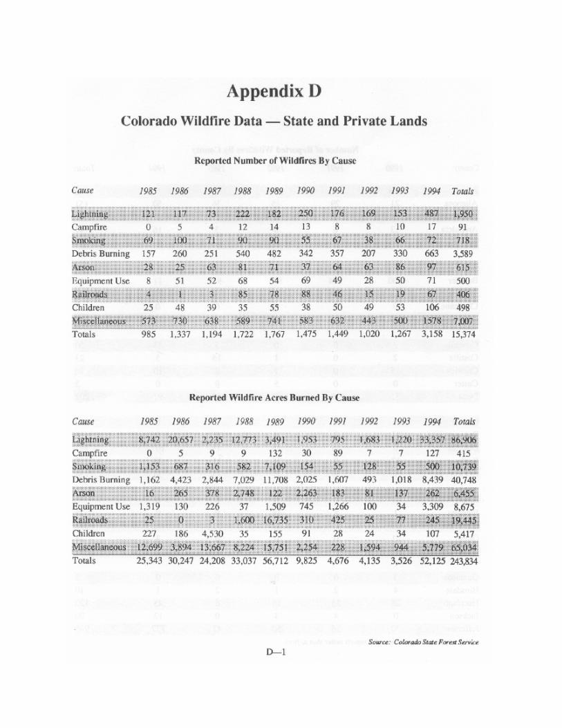
2000 Wildfire Hazard Mitigation Annex Draft 0712.rtf Page 100 of 112

2000 Wildfire Hazard Mitigation Annex Draft 0712.rtf Page 101 of 112

2000 Wildfire Hazard Mitigation Annex Draft 0712.rtf Page 102 of 112
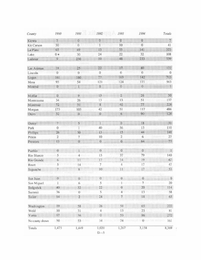
2000 Wildfire Hazard Mitigation Annex Draft 0712.rtf Page 103 of 112
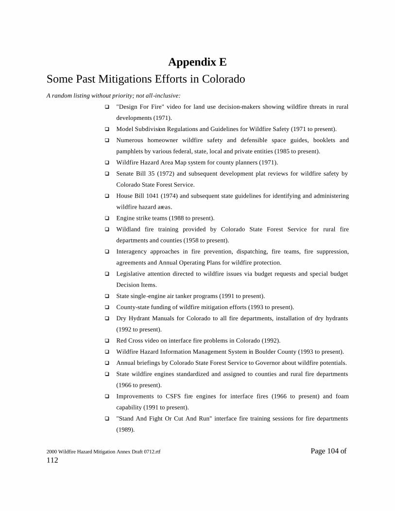
2000 Wildfire Hazard Mitigation Annex Draft 0712.rtf Page 104 of 112
Appendix E Some Past Mitigations Efforts in Colorado
A random listing without priority; not all-inclusive:
q "Design For Fire" video for land use decision-makers showing wildfire threats in rural
developments (1971).
q Model Subdivision Regulations and Guidelines for Wildfire Safety (1971 to present).
q Numerous homeowner wildfire safety and defensible space guides, booklets and
pamphlets by various federal, state, local and private entities (1985 to present).
q Wildfire Hazard Area Map system for county planners (1971).
q Senate Bill 35 (1972) and subsequent development plat reviews for wildfire safety by
Colorado State Forest Service.
q House Bill 1041 (1974) and subsequent state guidelines for identifying and administering
wildfire hazard areas.
q Engine strike teams (1988 to present).
q Wildland fire training provided by Colorado State Forest Service for rural fire
departments and counties (1958 to present).
q Interagency approaches in fire prevention, dispatching, fire teams, fire suppression,
agreements and Annual Operating Plans for wildfire protection.
q Legislative attention directed to wildfire issues via budget requests and special budget
Decision Items.
q State single-engine air tanker programs (1991 to present).
q County-state funding of wildfire mitigation efforts (1993 to present).
q Dry Hydrant Manuals for Colorado to all fire departments, installation of dry hydrants
(1992 to present).
q Red Cross video on interface fire problems in Colorado (1992).
q Wildfire Hazard Information Management System in Boulder County (1993 to present).
q Annual briefings by Colorado State Forest Service to Governor about wildfire potentials.
q State wildfire engines standardized and assigned to counties and rural fire departments
(1966 to present).
q Improvements to CSFS fire engines for interface fires (1966 to present) and foam
capability (1991 to present).
q "Stand And Fight Or Cut And Run" interface fire training sessions for fire departments
(1989).

2000 Wildfire Hazard Mitigation Annex Draft 0712.rtf Page 105 of 112
q Statewide implementation of Incident Command System by wildfire agencies (1984 to
present).
q Application of Incident Command System to all risks such as hazardous materials,
structural fire, public gatherings (varied since 1984).
q First Colorado Wildfire Hazard Mitigation Plan (1990).
q State Emergency Fire Suppression Fund contracts with 35 counties (1966 to present).
q CSU Graduate student study of homeowners' and developers' awareness of wildfire
threats on Colorado's Front Range (1969).
q CSU Graduate student analysis of wildfire risk by Colorado county (1992).
q Workshop "Protecting People and Homes From Wildfires" (1988).
q State Wildfire Mitigation Committee formed and active (1991 to present); local
mitigation groups forming (1993 to present).
q "Lets Talk Fire" materials developed and presentations to decision-makers and
homeowners (1993 to present).
q Local prohibitions of new wood roofing in wildfire prone areas (1992 to present).
q State-federal multi-partite wildfire agreement updated (1994); county level fire operating
plans updated annually and standardized (1990 to present).
q Interagency fire dispatch centers for most wildfire resource dispatching and all
reinforcement needs (1986 to present).
q Demonstration fuel hazard reductions and defensible spaces installed throughout
Colorado (1992 to present).
q Legislative attempts to authorize and fund state inmate conservation camp crews (1991
and 1992).
q Colorado Army National Guard fire-fighting helicopters with buckets (1994 to present).
2000 Wildfire Hazard Mitigation Annex Draft 0712.rtf Page 106 of 112
Appendix F Credits
This Plan is the effort of many people from diverse backgrounds throughout Colorado. All of them face the common problem of wildfires in the wildland/urban interface in some unique way. The collective knowledge, experience, and skill of all who directly contributed has produced a document that will exert a lasting influence on future safety of life and property in the state's wildland/urban interface areas. Graphics and layout Judy Serby Colorado State Forest Service
Editing Ronald J. Zeleny Fire Division Supervisor Colorado State Forest Service
The contributors are listed by the wildfire they helped review.
Wake Fire – 1994
Peter Barth Colorado State Forest Service 102 Par Place #3 Montrose CO 81401
Donna Ferganchick Delta County Commissioner 501 Palmer Delta CO 81416
Virginia Motoyama Federal Emergency Management Agency PO Box 25267 Denver CO 80225-0265
Howard Bartlett Colorado Office Of Emergency Management 15075 S Golden Rd Golden CO 80401-3979
Duane Freeman Delta County Emergency Preparedness Department PO Box 172 Delta CO 81416
Rick Oberheu US Forest Service 2250 Hwy 50 Delta CO 81416
William Blair Delta County Sheriff PO Box 172 Delta CO 81416
Susan Hausen Delta County Administrator 501 Palmer #227 Delta CO 81416
Susan Rossi Colorado Office of Emergency Management 15075 S Golden Rd Golden CO 80401-3979
Dan Carlson Federal Emergency Management Agency PO Box 25267 Denver CO 80225-0265
Ted Hayden Delta County Commissioner 501 Palmer Delta CO 81416
Helen Screen Colorado Office Of Emergency Management 15075 S Golden Rd Golden CO 80401-3979
John Denison Colorado State Forest Service 222 S 6th St #416 Grand Junction CO 81501
Don Jacks Federal Emergency Management Agency PO Box 25267 Denver CO 80225-0265
Glenn Snyder US Forest Service PO Box 25127 Lakewood CO 80225
Steve Denney Colorado Office Of Emergency Management 222 S 6th St #409 Grand Junction CO 81501
Bob Kistner Colorado Office Of Emergency Management 15075 S Golden Rd Golden CO 80401-3979
Jim Ventrello Delta County Commissioner 501 Palmer #227 Delta CO 81416
Steve Ellis Bureau of Land Management 2465 S Townsend
Fred Mckee Delta County Sheriff's Dept. PO Box 172
Ron Zeleny Colorado State Forest Service 203 Forestry Bldg.

2000 Wildfire Hazard Mitigation Annex Draft 0712.rtf Page 107 of 112
Montrose CO 81401 Delta CO 81416
Fort Collins CO 80523
II. South Canyon Fire - 1994
Howard Bartlett Colorado Office Of Emergency Management 15075 S Golden Rd Golden CO 80401-3979
Don Jacks Federal Emergency Management Agency PO Box 25267 Denver CO 80225
Winslow Robertson Bureau Of Land Management 2815 H Rd Grand Junction CO 81506
Dan Carlson Federal Emergency Management Agency PO Box 25267 Denver CO 80225
Bob Kistner Colorado Office Of Emergency Management 15075 S Golden Rd Golden CO 80401-3979
Susan Rossi Colorado Office Of Emergency Management 15075 S Golden Rd Golden CO 80401-3979
Tom Dalessandri Garfield County Sheriff Dept PO Box 249 701 Colorado Ave Glenwood Springs CO 81601
Bob Leighty US Forest Service PO Box 25127 Lakewood CO 80225
Helen Screen Colorado Office Of Emergency Management 15075 S Golden Rd Golden CO 80401-3979
John Denison Colorado State Forest Service 222 S 6th St #416 Grand Junction CO 81501
James Mason Glenwood Springs Emergency Services 806 Cooper Ave Glenwood Springs CO 81601
Glenn Snyder US Forest Service PO Box 25127 Lakewood CO 80225
Bob Elderkin Bureau Of Land Management PO Box 1009 Glenwood Springs CO 81601
Dave Michaelson Garfield County 109 8th Street Glenwood Springs CO 81601
Ron Zeleny Colorado State Forest Service 203 Forestry Bldg. Fort Collins CO 80523
Peggy Arps Emery Garfield County EMS PO Box 1604 Glenwood Springs CO 81602
Michael Morgan Rifle Fire Protection District PO Box 1133 Rifle CO 81650
Dale Hancock Garfield County Operations 109 8th Street #300 Glenwood CO 81601
Virginia Motoyama Federal Emergency Management Agency PO Box 25267 Denver CO 80225
III. Roxborough Fire Complex - 1994
Michael Bahm Colorado State Forest Service PO Box 485 Franktown CO 80116
Don Jacks Federal Emergency Management Agency PO Box 25267 Denver CO 80225-0267
Howard Bartlett Colorado Office Of Emergency Management 15075 S Golden Rd
Dan Qualman Parker Fire Protection District 10795 S Pine Drive Parker CO 80134
Fred Sibley Colorado Office of Emergency Management 15075 S Golden Rd

2000 Wildfire Hazard Mitigation Annex Draft 0712.rtf Page 108 of 112
Golden CO 80401-3979 Golden CO 80401-3979 Dan Carlson Federal Emergency Management Agency PO Box 25267 Denver CO 80225-0267
Robert Rinne Castlewood/Roxborough Rd 7900 E Berry Place Greenwood Village CO 80220
Glenn Snyder US Forest Service PO Box 25127 Lakewood CO 80225
Annette Demel Colorado Office Of Emergency Management 15075 S Golden Rd Golden CO 80401-3979
Susan Rossi Colorado Office Of Emergency Management 15075 S Golden Rd Golden CO 80401-3979
Deborah Yerousek Douglas County 101 3rd Street Castle Rock CO 80304
Ron Gosnell Colorado State Forest Service 936 Lefthand Canyon Boulder CO 80302
Gary Shaffer US Forest Service, Pike National Forest 19316 Goodard Ranch Ct Morrison CO 80465
Gary Younger Douglas County Sheriff Operations 355 S Wilcox Castle Rock CO 80104
Andy Hill Colorado Office Of Emergency Management 15075 S Golden Rd Golden CO 80401-3979
Ron Zeleny Colorado State Forest Service 203 Forestry Bldg Colorado State University Fort Collins CO 80523
IV. Olde Stage Fire - 1990
Bev Anderson Emergency Services Boulder County Sheriff Dept. PO Box 471 Boulder CO 80306
Robert Kistner Division of Disaster Emergency Services Camp George West Golden CO 80401
Dean W. Smith Colorado Division of Fire Safety 700 Kipling St Suite 3000 Denver CO 80215
Joe Ashby Division of Emergency Services Camp George West Golden CO 80401
Becky Kitchens Colorado State Forest Service 203 Forestry Building Fort Collins CO 80523
Larry Stern Emergency Services Coordinator Boulder County Sheriff Dept. PO Box 471 Boulder CO 80301
Leonard Boulas Chief Disaster Plans & Assistance Branch Division of Disaster Emergency Services Camp George West Golden CO 80401
Ernst L. Little Emergency Services Coordinator Boulder County Sheriff Dept. PO Box 471 Boulder CO 80301
Joe Turner Forest Management Contractor 615 Main Longmont CO 80501
Bob Dutton District Fire Marshall 2327 21st Street Boulder CO 80304
Marc R. Mullenix Wildland Fire Coordinator City of Boulder PO Box 471 Boulder CO 80306
Sherryl Zahn Hazard Mitigation Officer Federal Emergency Management PO Box 25267 Denver CO 80225-0267
Dave Farmer Assistant District Forester Colorado State Forest Service 936 Lefthand Canyon Drive Boulder CO 80302
David Nyquist, Chief Lefthand Fire Protection District 8384 Middle Crest Rd Boulder CO 80302
Ron Zeleny Fire Division Supervisor Colorado State Forest Service 203 Forestry Building Fort Collins CO 80523
Gary R. Goodell Boulder County Land Use Dept.
Charles C. Pringle Staff Services Captain

2000 Wildfire Hazard Mitigation Annex Draft 0712.rtf Page 109 of 112
PO Box 471 Boulder CO 80306
Boulder County Sheriff Dept. 1777 6th Street Boulder CO 80306
Rik Henrikson Emergency Services Coordinator Boulder County Sheriff Dept. PO Box 471 Boulder CO 80306
Brien Schumacher Boulder County Land Use Dept. PO Box 471 Boulder CO 80306
V. Black Tiger Fire - 1989
Bill Baden National Fire Protection Association One Batterymarch Park Quincy MA 02269-9101
Shirlee Gibson Four Mile Fire Protection District 91 Four Mile Canyon Boulder CO 80302
Ruth Ravenel Sugarloaf Fire Protection District 35308 Boulder Canyon Boulder CO 80302
David Bastos University of Colorado, Department of Sociology Box 327 Boulder CO 80309-0327
Gary Goodell Boulder County Building Department P.O. Box 471 Boulder CO 80306
Al Roberts US Forest Service, Region 2 Box 25127 Lakewood CO 80215
Donna Beaver City of Boulder P.O. Box 791 Boulder CO 80306
Ron Gosnell Colorado State Forest Service 936 Lefthand Canyon Boulder CO 80302
Dean Smith Colorado Division of Fire Safety 700 Kipling Street, Suite 3000 Denver, CO 80215
Graham Billingsly Boulder County Land Use Department P.O. Box 471 Boulder CO 80306
Steve Hart Colorado State Forest Service Box 271 Manitou Springs CO 80829
Grant Sorenson Wyoming Emergency Management Agency PO Box 1709 Cheyenne WY 82003
Lon Callen Emergency Preparedness Office Box 471 Boulder CO 80302
Greg Huele Northeast Teller County Fire Protection District P.O. Box 5587 Woodland Park CO 80866
Larry Stern Boulder County Sheriff's Office PO Box 471 Boulder CO 80306
Susan Canan Colorado Geological Survey 1313 Sherman Street Denver CO 80203
Craig Jones Colorado State Forest Service 936 Lefthand Canyon Boulder CO 80302
Jack Truby Division of Disaster Emergency Services Camp George West, EOC Golden CO 80401
Bob Davis University of Colorado Institute of Behavioral Science Campus Box 468 Boulder CO 80309
Don Lotvedt Bureau of Land management 2850 Youngfield Street Lakewood CO 80215
Chris Wilson City of Boulder 1405 South Foothills Highway Boulder CO 80303
John W. Denison Colorado State Forest Service State Services Building 222 South 6th Street, Room 416 Grand Junction CO 81501
Fred May Utah Division of Comprehensive Emergency Management 1543 Sunnyside Avenue PO Box 8136 Salt Lake City UT 84108-8136
Bob Willmot US Forest Service 240 West Prospect Fort Collins CO 80526
Chad De Vors US Forest Service
Dave Nyquist Boulder County Firefighters
Frederick H. Wingate Federal Emergency Management
2000 Wildfire Hazard Mitigation Annex Draft 0712.rtf Page 110 of 112
2995 Baseline Road Boulder CO 80309
Association 8384 Middlecrest Road Boulder CO 80301
Agency Region VIII Box 25267 Denver CO 80225-0267
Doug De Vries Boulder County Parks PO Box 471 Boulder CO 80306
Rick Perkins Larimer County PO Box 1190 Fort Collins CO 80522-1190
Sherryl Zahn Federal Emergency Management Agency Region VIII Box 25267 Denver CO 80225-0267
Ruth M. Garland Emergency Preparedness Office Box 471 Boulder CO 80302
Tony Perry Boulder Heights Fire Protection District 177 Brook Circle, JSR Boulder CO 80302
Ron Zeleny Colorado State Forest Service 203 Forestry Building Fort Collins CO 80523-5060

2000 Wildfire Hazard Mitigation Annex Draft 0712.rtf Page 111 of 112
Appendix B


2000 Wildfire Hazard Mitigation Annex Draft 0712.rtf Page 113 of 112
COLORADO STATE FOREST SERVICE James E. Hubbard, State Forester
Colorado State University Fort Collins, Colorado 80523-5060
(970) 491-6303
ALAMOSA DISTRICT Colorado State Forest Service P. O. Box 1137 401 Santa Fe Alamosa, CO 81101-1137 (719) 589-2271 BOULDER DISTRICT Colorado State Forest Service 5625 Ute Highway Longmont, CO 80503-9130 (303) 442-0428 CANON CITY DISTRICT Colorado State Forest Service 515 McDaniel Blvd., Industrial Park Canon City, CO 81212-4164 (719) 275-6865 DURANGO DISTRICT Colorado State Forest Service P. O. Box 7233 Fort Lewis College Campus Durango, CO 81301-3908 (970) 247-5250 FORT COLLINS DISTRICT Colorado State Forest Service Building #1052, Foothills Campus Colorado State University Fort Collins, CO 80523-5075 (970) 491-8660 FORT MORGAN DISTRICT Colorado State Forest Service
801 East Burlington Fort Morgan, CO 80701-3638 (970) 867-5610 FRANKTOWN DISTRICT Colorado State Forest Service 2068 North State Highway 83 P. O. Box 485 Franktown, CO 80116-0485 (303) 660-9625 GOLDEN DISTRICT Colorado State Forest Service 1504 Quaker Street Golden, CO 80401-2956 (303) 279-9757 GRANBY DISTRICT Colorado State Forest Service P. O. Box 69 201 E Jasper Granby, CO 80446-0069 (970) 887-3121 GRAND JUNCTION DISTRICT Colorado State Forest Service State Services Building 222 South 6th Street, Room 416 Grand Junction, CO 81501-2771 (970) 248-7325 GUNNISON DISTRICT Colorado State Forest Service P. O. Box 1390 Gunnison, CO 81230-1390
(970) 641-6852 LA JUNTA DISTRICT Colorado State Forest Service 208 Santa Fe Avenue, Suite 21 La Junta, CO 81050-0977 (719) 384-9087 LA VETA DISTRICT Colorado State Forest Service P. O. Box 81 Moore & Poplar Streets La Veta, CO 81055-0081 (719) 742-3588 MONTROSE DISTRICT Colorado State Forest Service 102 Par Place, Suite 3 Montrose, CO 81401-4196 (970) 249-9051 SALIDA DISTRICT Colorado State Forest Service 7980 West Highway 50 Salida, CO 81201-9571 (719) 539-2579 STEAMBOAT SPRINGS DISTRICT Colorado State Forest Service P. O. Box 773657 1475 Pine Grove Road, Suite 202A
Steamboat Springs, CO 80477-3657 (970) 879-0475 WOODLAND PARK DISTRICT Colorado State Forest Service P. O. Box 9024 113 South Boundary Woodland Park, CO 80866-9024 (719) 687-2921
8/01


2000 Wildfire Hazard Mitigation Annex Draft 0712.rtf Page 115 of 112
Appendix C
Distribution of the 2001 Annex
Hard copies: 250 Governors Office 2 FEMA 10 County Sheriffs 64 County Commissions 64 Colorado State Forest Service 40 Other State Agencies 20 Federal Agencies 20 Reserve 30 CD copies: 500 Fire Departments 400 Reserve 100 Website: www.colostate.edu/Depts/CSFS Notice of availability only. Links from: Federal Emergency Management Agency Colorado Office of Emergency Management Colorado Counties Incorporated