Embed Size (px)
Citation preview

Hampton, Virginia
C o l i s e u m c e n t r a l m a s t e r p l a n :
U r b a n d e s i g n a s s o c i a t e sN O V E M B E R 1 2 , 2 0 1 5
Adopted by cit y council on 12 November 2015

© 2
015
ur
ba
n d
esi
gn
ass
oc
iat
es
Coliseum centr al master pl an: Hampton, V irginia | November 2015 | urban design associates b
P R E PA R E D F O R
City of Hampton F U N D E D BY
City of Hampton
C O N S U LTA N T T E A M
Urban Design Associates LaQuatra Bonci Associates Hunden Strategic Partners
Coliseum Central Master Plan
C O L I S E U M C E N T R A L B U S I N E S S I M P R O V E M E N T D I S T R I C T B O A R D O F D I R E C T O R S
Raymond TrippExecutive Director
Eboni DavisDeputy Executive Director
Megan FindlayCommunications Coordinator
Randy BryantTreasurer
Debra FloresSecretary
Mark BleakleyBrad BrownReed CordishLawrence CummingMichael EdmondsRobert J. FiscellaStuart GoodmanScott HuddlestonRodney JacksonPatrick McDermottPete PetersonJohn SmithZaf TabaniTommy WatkinsBoo Williams
C I T Y C O U N C I L
George WallaceMayor
Linda CurtisVice Mayor
W.H. “Billy” Hobbs Jr.Will J. MoffettTeresa V. SchmidtChris Osby SneadDonnie R. Tuck
P L A N N I N G C O M M I S S I O N
Thomas SouthallChair
Andre McCloudVice-Chair
Mary B. Bunting Carlton M. Campbell Sr.Gaynette LaRueTeresa SchmidtGregory Williams
Acknowledgements

© 2
015
ur
ba
n d
esi
gn
ass
oc
iat
es
Coliseum centr al master pl an: Hampton, V irginia | November 2015 | urban design associates c
Table of Contents EXECUTIVE SUMMARY 1
OVERVIEW 7
The Planning Process 8
ANALYSIS 9
Market 10
Development Patterns 13
Street Network 15
Open Space & Pedestrian Connectivity 17
Transportation Analysis 18
REDEVELOPMENT POLICIES 21
FRAMEWORKS FOR GROW TH 24
Development Patterns 25
Site Improvements 26
Development Activity Since the 2004 Plan 27
Street Network 28
Infrastructure Improvements Since 2004 Plan 29
Coliseum Drive “Main Street” 30
Open Space & Pedestrian Connectivity 31
INIT IATIVE AREAS 32
Coliseum North 34
Coliseum South 4 4
Coliseum Crossroads 48
Power Plant Parkway 55
Sentara Medical Campus 58
Tide Mill Creek 60
Mercury Boulevard 64
PL AN IMPLEMENTATION 65
Priority Public Projects 66
Priority Private Projects 67

© 2
015
ur
ba
n d
esi
gn
ass
oc
iat
es
Coliseum centr al master pl an: Hampton, V irginia | November 2015 | urban design associates d
List of Amendments Adopted by City Council
May 25, 2005 Tidemill Creek InitiativeMay 25, 2005 Tidemill Creek Initiative sectionJanuary 10, 2007 Tidemill Creek InitiativeJanuary 10, 2007 Tidemill Creek Initiative sectionNovember 12, 2015 Master Plan Update

© 2
015
ur
ba
n d
esi
gn
ass
oc
iat
es
Coliseum centr al master pl an: Hampton, V irginia | November 2015 | urban design associates Executive Summary 1
Executive Summary
MAJOR ELEMENTS IN THE COLISEUM CENTRAL MASTER PL AN UPDATE
» Develop high-quality hotel rooms to support the Hampton Roads Convention Center, sports tourism, and other tourism initiatives.
» Develop restaurants in walkable districts convenient to hotels and assem-bly venues.
» Explore opportunities to expand the District’s breadth of sports tourism venues.
» Plan new street and block infrastructure that is flexible to respond to changing market conditions.
» Develop new high-quality residential development in walkable mixed-use districts.
» Encourage development patterns and form which supports Coliseum Drive as the District’s “Main Street.”
» Establish an extensive open space and pathway system throughout the Newmarket Creek and Tide Mill Creek watersheds, connecting to the proposed linear park (“Central Park”) along Newmarket Creek.
» Develop Central Park, adjacent to Newmarket Creek and focused around the Coliseum Crossroads, to include multi-use paths, promenades, access points, trail heads, canoe/kayak launches and docking areas, pro-grammable open spaces, and wildlife interpretive areas connected to both existing and new neighborhoods.
CONTEX T
The Coliseum Central area is located in the heart of Hampton, Virginia, the center of the region at the junction of I-64 and I-664. The general area surrounds two key regional transportation corridors: Interstate 64 and Mercury Boulevard. The planning area is generally bound by Billy Wood Canal and Tidemill Creek to the north; Newmarket Creek and Interstate 64 to the south; LaSalle Avenue, Newmarket Creek, and the western portions of the Riverdale neighborhood to the east; and Queen Street, the eastern portions of the Aberdeen neighborhood, and the eastern portion of the Northampton neighborhood to the west. This plan takes into consideration conditions within the “core business district,” including the boundaries of the Coliseum Central Business Improvement District (CCBID), as well as the conditions and influ-ence of surrounding neighborhoods such as Northampton, Riverdale, Tide Mill Farms, Aberdeen, Tanglewood, Windsor Terrace, Magruder Heights, Speegle Village, and Findley Square. The CCBID is a special service-taxing district authorized by state law, in which the revenues are utilized to fund a number of projects, programs, and initiatives that area designed to enhance and improve the District. Coliseum Central’s identity stems from its location at the intersec-tion of Interstate 64 and Mercury Boulevard and its major regional attractions such as Hampton Coliseum, Hampton Roads Convention Center, Power Plant of Hampton Roads, and Peninsula Town Center. While these assets are the most recognized, the district is far more diversified and complex. A full portrait of Coliseum Central includes the many neighborhoods, businesses, parks, schools, churches, hospi-tals, and parks, as well as creeks and marsh areas. Newmarket Creek and Tide Mill Creek are important watersheds that empty into the Chesapeake Bay. These tidal creeks and associated marshes penetrate the district and comprise important recreational, ecological, and envi-ronmental assets.
REGIONAL DESTINATIONS Sentara Careplex Hospital, Bass Pro Shops, and the Hampton Coliseum are examples of unique regional destinations on which the City can build.
REGIONAL LOCATOR The Coliseum Central Business Improvement District is located in the relative center of the region, at the junction of Interstates 64 and 664, within the City of Hampton.
James River
Chesapeake Bay
Hampton
I-64
Mercury Boulevard
Southwest Branch Back River
I-64
I-664
© 2
015
ur
ba
n d
esi
gn
ass
oc
iat
es
Coliseum centr al master pl an: Hampton, V irginia | November 2015 | urban design associates Executive Summary 2
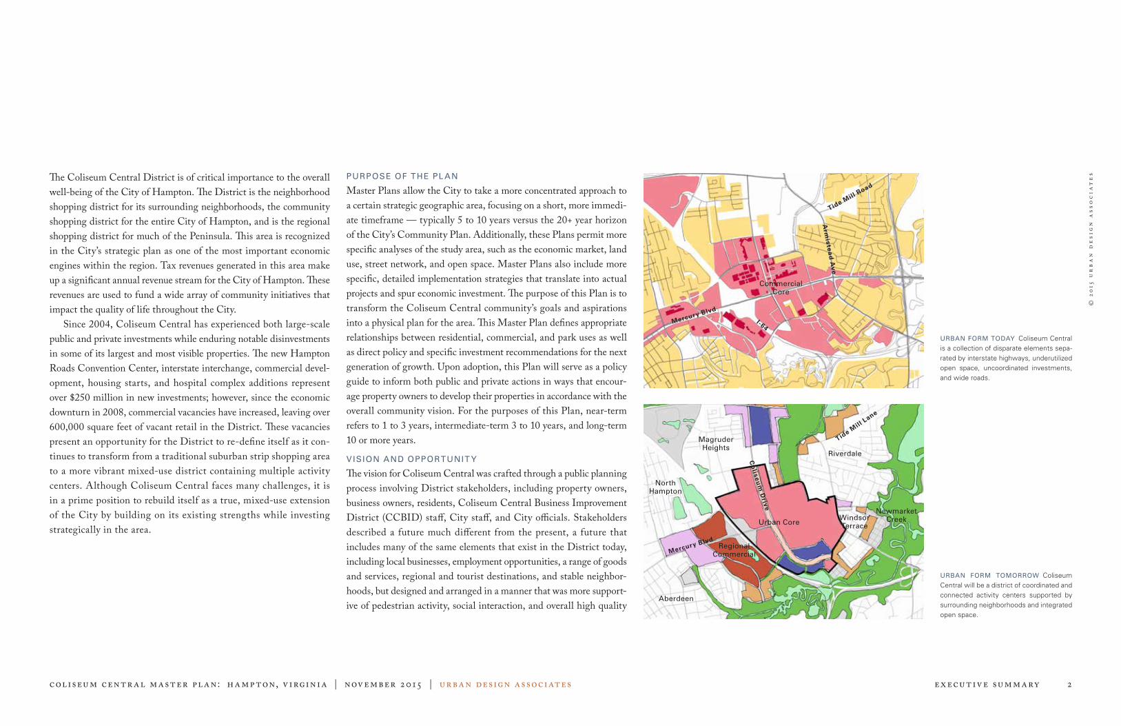
The Coliseum Central District is of critical importance to the overall well-being of the City of Hampton. The District is the neighborhood shopping district for its surrounding neighborhoods, the community shopping district for the entire City of Hampton, and is the regional shopping district for much of the Peninsula. This area is recognized in the City’s strategic plan as one of the most important economic engines within the region. Tax revenues generated in this area make up a significant annual revenue stream for the City of Hampton. These revenues are used to fund a wide array of community initiatives that impact the quality of life throughout the City. Since 2004, Coliseum Central has experienced both large-scale public and private investments while enduring notable disinvestments in some of its largest and most visible properties. The new Hampton Roads Convention Center, interstate interchange, commercial devel-opment, housing starts, and hospital complex additions represent over $250 million in new investments; however, since the economic downturn in 2008, commercial vacancies have increased, leaving over 600,000 square feet of vacant retail in the District. These vacancies present an opportunity for the District to re-define itself as it con-tinues to transform from a traditional suburban strip shopping area to a more vibrant mixed-use district containing multiple activity centers. Although Coliseum Central faces many challenges, it is in a prime position to rebuild itself as a true, mixed-use extension of the City by building on its existing strengths while investing strategically in the area.
PURPOSE OF THE PL AN
Master Plans allow the City to take a more concentrated approach to a certain strategic geographic area, focusing on a short, more immedi-ate timeframe — typically 5 to 10 years versus the 20+ year horizon of the City’s Community Plan. Additionally, these Plans permit more specific analyses of the study area, such as the economic market, land use, street network, and open space. Master Plans also include more specific, detailed implementation strategies that translate into actual projects and spur economic investment. The purpose of this Plan is to transform the Coliseum Central community’s goals and aspirations into a physical plan for the area. This Master Plan defines appropriate relationships between residential, commercial, and park uses as well as direct policy and specific investment recommendations for the next generation of growth. Upon adoption, this Plan will serve as a policy guide to inform both public and private actions in ways that encour-age property owners to develop their properties in accordance with the overall community vision. For the purposes of this Plan, near-term refers to 1 to 3 years, intermediate-term 3 to 10 years, and long-term 10 or more years.
VISION AND OPPORTUNIT Y
The vision for Coliseum Central was crafted through a public planning process involving District stakeholders, including property owners, business owners, residents, Coliseum Central Business Improvement District (CCBID) staff, City staff, and City officials. Stakeholders described a future much different from the present, a future that includes many of the same elements that exist in the District today, including local businesses, employment opportunities, a range of goods and services, regional and tourist destinations, and stable neighbor-hoods, but designed and arranged in a manner that was more support-ive of pedestrian activity, social interaction, and overall high quality
URBAN FORM TOMORROW Coliseum Central will be a district of coordinated and connected activity centers supported by surrounding neighborhoods and integrated open space.
URBAN FORM TODAY Coliseum Central is a collection of disparate elements sepa-rated by interstate highways, underutilized open space, uncoordinated investments, and wide roads.
Aberdeen
Newmarket Creek
Commercial Core
Riverdale
Magruder Heights
Regional Commercial
Urban Core
North Hampton
Arm
istea
d A
ve
Mercury Blvd
Tide Mill
Road
Co
liseu
m D
rive
Mercury Blvd
Tide Mill
Lane
Windsor Terrace
I-64

© 2
015
ur
ba
n d
esi
gn
ass
oc
iat
es
Coliseum centr al master pl an: Hampton, V irginia | November 2015 | urban design associates Executive Summary 3
FRAMEWORK OF DEVELOPMENT PATTERN The Coliseum Central District will develop with mixed-use neighborhoods, traditional Hampton residential neighborhoods, and regional attractions.
of life. For example, instead of wide roads that pedestrians cannot cross, the stakeholders described narrower streets that encourage social interaction. Instead of large parking lots separating establishments, the stakeholders described smaller, more discreet areas to park cars while walking from place to place. Instead of isolated and disconnected neighborhoods and shopping areas, stakeholders described neighbor-hoods with a mix of uses where one could live and work within easy walking distance of shopping, dining, and entertainment activities. The community’s vision puts forth a plan that commands a funda-mental change in how the District operates and defines itself, focus-ing more on city building, not simply commercial revitalization. The instrumental factors that granted Hampton a competitive position in the region 25 years ago are no longer as strong. The area can no longer thrive by defining itself as a large, auto-oriented, suburban shopping district whose character is no different from other central business districts in the region. The District’s competitive advantages today lie in its stable neighborhoods, excellent regional access, regional attrac-tions, and access to natural amenities.
The CCBID is in alignment with the community vision as they have described themselves in a state of “metamorphosis.” The CCBID is acutely aware that fundamental change is required to maintain com-petitiveness, and that the goal is not to just revitalize themselves as merely a commercial district. Rather, by building upon existing strengths, infusing the area with a sustainable mix of uses, and giving attention to connections within and outward from the area, Coliseum Central will be uniquely positioned as a destination within the region.
Incremental Action and Fundamental Change
A defining characteristic of the District is its size and range of proper-ties, large and small, with a variety of owners, interests, and capacities. By structuring this Plan with policies, frameworks, and initiatives, all levels of investments are encouraged. Upon implementation of this Plan, the District will have been transformed into a vibrant mixed-use activity center. This Plan offers a new course of action for the District, as described in its framework, and this overall strategy explains how even small investments and incremental actions, as described in the initiatives section, will produce fundamental change over time.
FRAMEWORK OF OPEN SPACE Access to open spaces and natural areas will be pro-vided through the development of sites within the Coliseum Central District and will be connected to the City’s overall green spaces.
FRAMEWORK OF STREETS New streets will reduce the scale of blocks, provide more local connections, and weave the commercial areas together with the surrounding neigh-borhoods.
ORGANIZ ATION OF THE PL AN
This Master Plan describes three levels of recommendations: policies, frameworks, and initiatives. Policies provide the general over-arch-ing direction for growth over the next decade. Frameworks specifi-cally describe, at the scale of the District, how and where this growth should occur and how it can lead to a more connected and vibrant area. Initiatives describe, in yet greater detail, how public and private invest-ments can leverage each other to implement the community vision in the form of specific design ideas and projects.
A. Policy Recommendations
Policy recommendations have been crafted to guide the redevelop-ment and growth of the Coliseum Central area. These fundamental principles are meant to guide staff and policymakers when reviewing future development proposals.
REDEVELOPMENT POLIC IES
» Create dense, connected, and pedestrian-friendly activity cen-ters in identified areas.
» Encourage residential devel-opment wherever possible, in appropriate forms that relate to neighboring land uses.
» Organize land use in terms of the scale of development rath-er than type, and cluster uses compatible in character.
» Develop and connect open space and natural areas within the District to provide ameni-ties for residents and visitors alike.
» Create new public streets with sidewalks and street trees that connect the varying land uses in the District.
» Promote development pat-terns and forms to reinforce Coliseum Drive as the District’s “Main Street.”
Mercury Blvd
Mercury Blvd
Co
liseu
m D
rive
Co
liseu
m D
rive
Mercury Blvd
Co
liseu
m D
rive

© 2
015
ur
ba
n d
esi
gn
ass
oc
iat
es
Coliseum centr al master pl an: Hampton, V irginia | November 2015 | urban design associates Executive Summary 4
B. Frameworks
Development Patterns
The District will gradually transform its underlying land use pattern from one that permits commercial development of all scales in any location to one that comprehensively organizes land uses and devel-opment patterns, according to appropriate scales, configuration, and compatibilities. This Plan recommends the consolidation of the largest commercial uses, such as retailers greater than 100,000 square feet, the regional attractions, and other auto-dominated uses to areas in proximity to the interstate. This Plan also recommends infusing the district, currently dominated by commercial and retail uses, with new areas of housing and mixed-use development.
Street Network
Introducing new public streets throughout the District will reduce the scale of larger blocks into smaller blocks that support varying scales of development. Such new streets will also better connect the District to surrounding neighborhoods and vice versa, creating an area that relies less on the major arterials for local circulation. These new streets will improve access and connectivity of the District while permit-ting Mercury Boulevard, Armistead Avenue, and other major roads to function more effectively.
Open Space and Pedestrian Connectivity
The District’s open space will be well-known and developed into a primary amenity for residents and visitors alike. Newmarket Creek, Tide Mill Creek, schools, parks, and plazas will be connected through a network of sidewalks, trails, boulevards, bike routes, and walkways. This Plan recommends multiple access points and trailheads for the proposed Newmarket Creek linear park system throughout the District, in both existing and new neighborhoods. New parks, plazas, and greens will become focal points of new mixed-use development.
C. Initiative Areas
Coliseum Drive North
Converted from an aging suburban shopping mall into a mixed-use, pedestrian-oriented regional activity center, Peninsula Town Center opened in 2010. A second phase includes plans for additional resi-dential units, new freestanding retail buildings, and a new hotel. Riverdale Plaza is intended to eventually redevelop into a more pedes-trian-friendly, mixed-use development, containing community- and neighborhood-serving retail, offices, and new housing opportunities. New streets would extend into and through the center, providing con-nections to Mercury Boulevard as well as Coliseum Drive and the Peninsula Town Center. Coliseum Crossing intends to reconfigure the southern end of the center to create frontage that faces and comple-ments the Peninsula Town Center as well as create outdoor dining and gathering areas.
Coliseum Drive South
New hotel development and reinvestment of existing hotel proper-ties to support the Convention Center and sports tourism within the City are the primary function of this area. Known as the Hotel District, hotels should primarily locate along Coliseum Drive, a walk-able street connecting the Crossroads area with the Peninsula Town Center. There are redevelopment opportunities for properties on both sides of Coliseum Drive with hotels and restaurants lining Coliseum Drive with a mix of uses behind. With the extension of Commerce Drive to Mercury Boulevard and the visibility from I-64, the addition of residential units and office space is encouraged on the west side of Coliseum Drive. On the east side of Coliseum Drive, there is the opportunity to include new residential units and additional retail to complement the existing Walmart and Goodwill retailers. A new east-west street connection would reduce block size and enhance access to retailers that sit back from Mercury Boulevard.
A SERIES OF INITIATIVE AREAS Coliseum Central is divided into multiple initiative ares. These areas were identified in the public pro-cess as priority redevelopment sites, experiencing the greatest development pressures. An initiative is a geographic area in which public and private improvements are recommended to leverage the most value out of each other.
Tide Mill Creek
Coliseum North
Coliseum South
Coliseum Crossroads
Power Plant Parkway
Sentara Medical Campus

© 2
015
ur
ba
n d
esi
gn
ass
oc
iat
es
Coliseum centr al master pl an: Hampton, V irginia | November 2015 | urban design associates Executive Summary 5
Coliseum Crossroads
With the proximity of Hampton Coliseum, Hampton Roads Convention Center, and Embassy Suites Hotel, the 2004 Plan envi-sioned attracting a mixture of specialty retail, entertainment, res-taurants, and housing in a dense setting to this very prominent area. With the recession, this type of development has not materialized. Thus a study, commissioned to determine the long-term viability of the Coliseum and Convention Center, indicated the market is strong for Hampton to expand its sport tourism offerings and reposition the Coliseum for continued success with a new offering of mixed events. This Plan reflects a new competition-level sports facility, new hotel, and grand civic park on the west side of the Coliseum, and another potential convention hotel site and additional residential units to the east of the Coliseum. Taking advantage of great interstate visibility and access, vacant land to the northeast of the Convention Center offers multiple opportunities including corporate office locations, additional residential, and/or expansion of sports tourism attractions. A linear park system runs through this area of the District along Newmarket Creek, connecting Air Power Park and the Power Plant development. New trails, parks, and promenades will transform Newmarket Creek into a regional attraction with direct access to the District’s destination retail, hotels, and civic uses as well as existing and new urban neigh-borhoods. This natural feature also offers the potential to expand the linear park beyond the District’s boundaries, connecting to additional neighborhoods and City open space systems.
Power Plant Parkway
With its proximity to the interstate, this area continues to be well suit-ed for large format retailers, supported by outparcel retail, restaurants, and hotels. These predominately auto-oriented businesses will be logi-cally organized and designed so as to not negatively impact other sur-
rounding developments. Older commercial properties along Mercury Boulevard, including Mercury Plaza and Todd Center, continue to experience either reinvestment or redevelopment of the primary center with new out-parcel tenants. Redevelopment of underperforming hotels along Mercury Boulevard into new retail would be ideal due to its great visibility and access. In general, new hotel development would be better suited for the Coliseum South and Crossroads initiative areas.
Sentara
The Sentara CarePlex Hospital, the District’s primary non-retail employer, shall continue its growth as a world-class medical campus supplemented with new medical offices and research facilities identi-fied around the hospital. These uses will support the need for addi-tional housing in this area as well as commercial uses throughout the District. The campus will be connected to the District by transit, side-walks, trails, and open space.
Tide Mill Creek
Additional court space and parking will be needed to maintain the Boo Williams Sportsplex as a strong competitor in attracting sports tourism for the City. The remainder of Armistead Pointe Park should include multi-purpose fields, playgrounds, pavilions, and walking trails to support the Sportsplex and serve as a community recreational facility. If appropriate opportunities arise, some part of the Park could be used for revenue-producing uses that would support the overall complex. The area around Tide Mill Creek will be improved to become an amenity to the adjacent neighborhoods and schools. This Plan also recommends exploring the feasibility of consolidating some portions of the school properties to create additional land for housing, to improve the edges of the schoolyards, and to provide recreational open space for the surrounding neighborhoods.
A SERIES OF INITIATIVE AREAS Coliseum Central is divided into multiple initiative ares. These areas were identified in the public pro-cess as priority redevelopment sites, experiencing the greatest development pressures. An initiative is a geographic area in which public and private improvements are recommended to leverage the most value out of each other.
Tide Mill Creek
Coliseum North
Coliseum South
Coliseum Crossroads
Power Plant Parkway
Sentara Medical Campus

© 2
015
ur
ba
n d
esi
gn
ass
oc
iat
es
Coliseum centr al master pl an: Hampton, V irginia | November 2015 | urban design associates Executive Summary 6
A SERIES OF DISTRICTS Coliseum Central will have transformed over time into a series of unique, multi-use districts stitched together by compatible developments and connected streets and open spaces.
Sentara Medical Campus
New housing adjacent to Eaton Middle School
Redeveloped Riverdale Plaza
Coliseum Crossroads HousingPeninsula Town Center
Mercury Boulevard
Co
liseu
m D
rive
Mercury
Blvd
Tide Mill
Lane
Arm
istea
d A
ve
Coliseum Crossroads
© 2
015
ur
ba
n d
esi
gn
ass
oc
iat
es
Coliseum centr al master pl an: Hampton, V irginia | November 2015 | urban design associates Overv iew 7
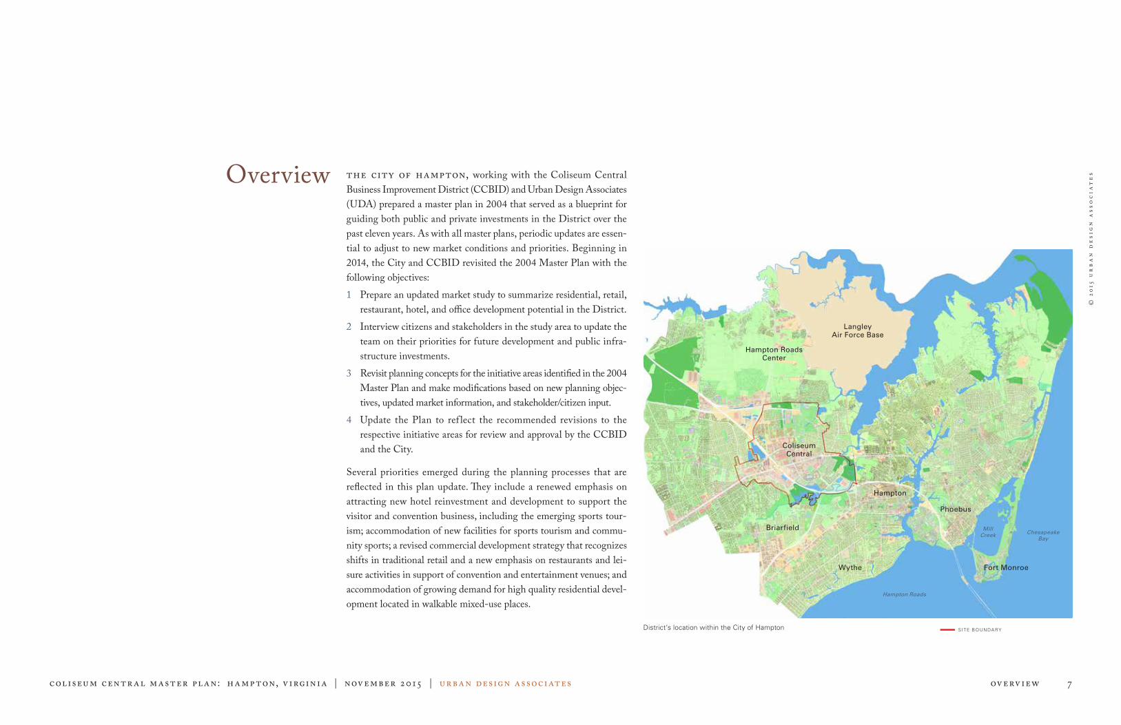
Overview The city of Hampton, working with the Coliseum Central Business Improvement District (CCBID) and Urban Design Associates (UDA) prepared a master plan in 2004 that served as a blueprint for guiding both public and private investments in the District over the past eleven years. As with all master plans, periodic updates are essen-tial to adjust to new market conditions and priorities. Beginning in 2014, the City and CCBID revisited the 2004 Master Plan with the following objectives:1 Prepare an updated market study to summarize residential, retail,
restaurant, hotel, and office development potential in the District.2 Interview citizens and stakeholders in the study area to update the
team on their priorities for future development and public infra-structure investments.
3 Revisit planning concepts for the initiative areas identified in the 2004 Master Plan and make modifications based on new planning objec-tives, updated market information, and stakeholder/citizen input.
4 Update the Plan to ref lect the recommended revisions to the respective initiative areas for review and approval by the CCBID and the City.
Several priorities emerged during the planning processes that are reflected in this plan update. They include a renewed emphasis on attracting new hotel reinvestment and development to support the visitor and convention business, including the emerging sports tour-ism; accommodation of new facilities for sports tourism and commu-nity sports; a revised commercial development strategy that recognizes shifts in traditional retail and a new emphasis on restaurants and lei-sure activities in support of convention and entertainment venues; and accommodation of growing demand for high quality residential devel-opment located in walkable mixed-use places.
District’s location within the City of Hampton SITE BOUNDA RY
Langley Air Force Base
Phoebus
Hampton
Hampton Roads Center
Briarfield
Wythe
Coliseum Central
Fort Monroe
Mill Creek
Hampton Roads
Chesapeake Bay

© 2
015
ur
ba
n d
esi
gn
ass
oc
iat
es
Coliseum centr al master pl an: Hampton, V irginia | November 2015 | urban design associates Overv iew 8
The Planning Process meeting where alternatives and ideas were presented. Following the charrette, the team conducted follow-up meetings with stakeholders to refine ideas and gather consensus on a final direction for the Plan. The final design ideas were presented at a public meeting on June 30, 2004.
PROPOSED PL AN
As with the original 2004 Plan, the basis of this Master Plan update is found in its open communication public involvement. Utilizing a three-step process: 1) analysis; 2) design alternatives; and 3) plan recommendations, the approach included engaging City staff, the CCBID, property owners, developers, other stakeholders, and interested citizens; and two public meetings. This planning process began in 2014 with an initial fact-finding trip. Urban Design Associates (UDA) and the City held meetings to review preliminary market findings for the District, results of the Coliseum Crossroads study, and meetings with the stakeholders, including the CCBID, the Hampton Roads Convention Center (HRCC), and the Coliseum. The team toured the study area and began the process by updating maps and site documentation of the District (Phase 1). UDA then prepared base materials and updated x-rays of the study area in preparation for the design workshop (Phase 2). The workshop, held in January 2015 at the HRCC, included meetings with the CCBID and stakeholders, a public open house, and a public presenta-tion of the charrette findings. After reviewing the design alternatives, City staff and UDA began to refine the design ideas and drafting the report (Phase 3). The second public input meeting was held on June 25, 2015 to receive public comment and feedback on the revised design options. This report captures those refined ideas, shaped by the stakeholders and public input, as shown in the updated initiative areas recommendations.
VISION FOR THE FUTURE
» Improved residential stock
» Increase in quality hotel rooms
» Decrease in extended stay and low quality hotel stock
» Competition-level Aquatics Facility
» Entertainment Center within the District
» Festival environment
» Recreational trails and bicycle infrastructure
HISTORY
The foundation of this Master Plan is its dedication to public process and citizen engagement. The initial planning process in 2004 included three public meetings and several focus group meetings with property owners, residents, City staff, Coliseum Central Business Improvement District (CCBID) staff, and other stakeholders. All participants were initially asked to list the strengths, weaknesses, visions, and priorities for the Coliseum Central area. The results, summarized on this page, revealed the varied interests and needs of the District. The heart of the master planning process was a design charrette held from February 16–20, 2004. At this public design workshop, the Master Plan team met with individual property owners and stakeholders to discuss plans and ideas for redevelopment. The charrette culminated in a public
STRENGTHS & WEAKNESSES: 2004
STRENGTHS WEAKNESSES
» Stable neighborhoods
» Proximity to Downtown Hampton
» An organized BID
» Recent investments in the area
» Regional identity of the Hampton Coliseum
» Proximity to Newmarket Creek
» Sentara CarePlex Hospital
» Regional transportation system
» Secondary street network
» Mercury Boulevard
» Interstate as a barrier
» Inaccessibility to natural amenities
» Narrow range of housing opportunities
» Commercial vacancies
STRENGTHS & WEAKNESSES: 2014
STRENGTHS WEAKNESSES
» Streetscape improvements
» Peninsula Town Center
» Gateway features into the District
» Linear Park along Newmarket Creek
» Boo Williams Sportsplex
» Sentara Medical Campus
» Proximity to I-64
» Lack of quality hotel rooms
» Lack of multi-family residential options
» Vacancies in retail centers
» Lack of mixed-use urban developments
» Need for more high-end dining choices
Co
liseu
m D
rive
Co
liseu
m D
rive
Mercury Blvd
Mercury Blvd

© 2
015
ur
ba
n d
esi
gn
ass
oc
iat
es
Coliseum centr al master pl an: Hampton, V irginia | November 2015 | urban design associates Analysis 9
AnalysisTHE COLISEUM CENTRAL DISTRICT is an important but com-plex area within the City of Hampton. There is a mix of commercial, institutional, and entertainment uses within the District that provide essential services to residents and visitors. Additionally, it is important to understand the surrounding uses, including well-established resi-dential neighborhoods and natural features. Extensive analysis of the Coliseum Central District was conducted for the 2004 Master Plan, much of which is still relevant, including maps and diagrams that explain the relationship of Coliseum Central and the basic surrounding uses. More specifically this analysis includes development patterns, street network and blocks, open space and pedestrian connectivity, and transportation. An updated commercial real estate market study was conducted for the District, including resi-dential market, retail and restaurant market, office market, and hotel and tourism market analysis. In addition, an individual hotel feasibil-ity study was conducted specifically to support planning related to conventions, events, and hotel development. A market and economic analysis regarding the future operation of the Hampton Coliseum was also completed. The Existing Conditions map serves as the primary base informa-tion for the exercise of testing design alternatives. The team utilized the City’s most up-to-date Geographic Information Systems (GIS) mapping information as well as on-the-ground surveying to develop an accurate map before beginning the design process.
EXISTING CONDITIONS This map illus-trates the existing conditions at the begin-ning of the 2015 Master Plan update process. All of the infrastructure and devel-opment up to that point are reflected here. The plan shows parcels, buildings, land use, streets, and open spaces.
E X IS T ING RESIDEN T IA L
E X IS T ING INS T IT U T ION A L
E X IS T ING COMMERCIA L
E X IS T ING MULT I - FA MILY RESIDEN T IA L
PA RKS A ND OPEN SPACE
E X IS T ING INDUS TRIA L
SURFACE PA RK ING
Peninsula Town Center
Sentara CarePlex Hospital
SportsplexHampton Roads Center Pkwy
Riverdale Plaza Shopping Center
Back River
Coliseum
Armistead Ave
Todd Shopping Center
Aberdeen
Northampton
Mercury Blvd
Co
liseu
m D
r

© 2
015
ur
ba
n d
esi
gn
ass
oc
iat
es
Coliseum centr al master pl an: Hampton, V irginia | November 2015 | urban design associates Analysis 10
Hotel Development
Hunden Strategic Partners (HSP), an economic and fiscal impact con-sulting firm, was tasked with conducting a hotel feasibility study to support planning related to conventions, events, and hotel development within Coliseum Central. Hunden recommends new hotel develop-ment that can enhance the market’s competitive position amongst its peer cities. The Embassy Suites and Courtyard by Marriott are quality, walkable hotels to the Hampton Roads Convention Center (HRCC) and Coliseum; however, these two hotels alone do not offer enough hotel rooms needed for large groups and events. Additionally, there are numerous underperforming hotels that offer less desirable accom-modations and amenities that negatively impact Hampton’s reputation and competitiveness to attract meetings and events. Presently, there is a lack of weekday corporate transient demand in Hampton overall and the majority of overnight stays in Hampton are likely staying in the Coliseum Central area. The Coliseum Central area has the interstate visibility, walkable restaurants, and retail options, and is in proxim-ity to the primary roomnight generators: HRCC, Coliseum, and Boo Williams Sportsplex. The best hotel investment is a newer and higher-quality product that has a recognizable brand to travelers. To improve the convention and meetings package, hotels must be in proximity to the HRCC and Coliseum to increase the quality of walkable hotel rooms currently available. Lower quality hotels would need to be either extensively renovated or acquired and razed while inducing new, qual-ity product. Based on current market conditions, creative partnerships may be necessary to implement this strategy. Although weekend stays (Friday–Saturday) are strong, corporate stays (Sunday–Thursday) remain weak; thus, the current market on its own will not support the development of higher-quality hotels. To optimize the performance of the HRCC and Coliseum, higher, convention quality hotels are needed adjacent to the facilities. In the short term, the study recommends the following options:
RECOMMENDED DEVELOPMENT IN THE DISTRICT
» Higher-quality hotels that meet the needs of the Convention Center and sports tourism venues.
» Variety of restaurants grouped together to serve patrons of the HRCC and Coliseum before and after events.
» Office buildings along major arterials that will inject more demand and daily use in the area.
» Residential development in a style similar to that found at Peninsula Town Center.
» Regional retail uses concentrated in the Coliseum North and Power Plant Parkway initiative areas.
MarketANALYSIS
Option A adds a full-service hotel of 250 rooms that would bring the number of proximate hotel rooms to 691 rooms, which would be slightly above the average number of proximate hotel rooms in the competitive set. The hotel is recommended to have its own meeting space, allowing the hotel to host its own events when the convention center is not booked. An additional quality walkable hotel to the con-vention center will make the Hampton area hospitality package more attractive to meeting planners and lead to fewer lost events. This option is an ideal recommendation since many meeting planners chose other venues because Hampton could not offer available rooms to all their attendees in one or two larger hotels. Option B would also add 250 proximate hotel rooms; however, it would allow for two select service hotels to be built in a dual-branded project. This would allow them to share back of house programming and offer two compelling brands. Function space may not need to be as high as in Option A. Option C adds 180 proximate hotel rooms in one full-service “lim-ited” hotel or select service hotel. The additional quality proximate hotel rooms will help make Hampton’s hospitality package more attractive. For the long term, Hampton needs to work toward a goal of 1,500 proximate rooms of quality, mostly branded or branded boutique hotels.

© 2
015
ur
ba
n d
esi
gn
ass
oc
iat
es
Coliseum centr al master pl an: Hampton, V irginia | November 2015 | urban design associates Analysis 11
Retail And Restaurants
Hunden Strategic Partners (HSP) conducted a commercial real estate market study for the District, focusing on the area around the Hampton Roads Convention Center (HRCC) and Coliseum. Regarding restau-rant and retail developments, HSP recommends a grouping of diverse restaurant options be integrated into any development near the HRCC and Coliseum. The market could benefit from more restaurants near the HRCC and Coliseum to create a node on Coliseum Drive and amenities for hotels. Retail demand outside of the Peninsula Town Center area is limited; and therefore, is not suggested in this area. The City should work to integrate restaurants along or near the major public event facilities to induce an entertainment atmosphere where visitors can linger longer before and after events rather than depart immediately. Restaurants that primarily act like restaurants during the day can become more nightlife destinations after 9 or 10 pm, which will enhance the vibe of Coliseum Central as a destination after 5 pm. The development of restaurant and retail is recommended to inte-grate approximately 25,000 to 45,000 square feet of tenant space. At a minimum, between four and six tenant types are suggested, although more is better, including support restaurants that each offer a unique menu and ambiance. This will attract the higher-end renters that are needed and that want to be near the dining and entertainment nodes. At least one tenant should have a higher end element and concept. Country, rock, Asian, steak, seafood, nightclub, sports and other themes/cuisines are options to be offered, as variety will help keep locals coming back and attract visitors with the multitude of options. It is important to encourage new concepts that will not replicate and directly compete with existing businesses. Ultimately, the unique con-cepts and diverse mix of options will help satisfy more visitor palates and likings. People crave variety as well as reliable options. Given the
varied palate of today’s consumer and desire for dining out, the more options, the better. This includes options for different times of day, such as coffee/breakfast and frozen yogurt/dessert. A new develop-ment node near the HRCC and Coliseum should focus on a mix of restaurants, bars, and nightlife that are targeted to all types of ages, budgets, and tastes. Restaurant developments will induce new visita-tion from leisure guests as well as recapture corporate demand that was only coming for a daytrip previously and help generate more over-night stays. It will also recapture local demand that may have been leaving Hampton for other areas to meet their food, beverage, ser-vices, or entertainment spending needs. Overall, this component will serve as the glue between all the other proposed and existing assets in Coliseum Central, providing a place for all to spend time, linger, eat, drink, and shop for daily essentials. It makes Coliseum Central the “go-to” area to choose amongst a collection of choices, not just chain restaurants, as exist in the public’s perception today. This will nurture more consistent activity in Coliseum Central and help drive invest-ments in new residential and other developments within the District.
Office
The Coliseum Central office market consists of a mix of Class A (pre-mier, newer, higher quality with above average rent rates), B (little older, good quality management and tenants with average rent rates), and C (lowest classification, typified by older buildings in less suitable locations with below average rent rates) buildings. Although Class A office space is limited, developers are starting to consider new, higher-quality developments. Tenants in the Claiborne Building in Peninsula Town Center pay a premium to be close to the retail and restaurants. With the develop-ment of residential and commercial space and the Sentara CarePlex
Hospital a mile north of West Mercury Boulevard, it is expected that there are a number of smaller healthcare and other medical related ten-ants that would pay Class A rates. Also, the area around the HRCC and Coliseum offers attractive real estate for a potential build-to-suit office building because of the great visibility and access from I-64. It is recommended that any office space south of West Mercury Boulevard along Coliseum Drive be complemented with restaurants and support service businesses. An office development would be more attractive with walkable restaurants and retail. Focusing on hotel and restaurant developments will help attract office tenants and their employees to Coliseum Central. As the market improves and guides, office development projects are recommended in various strategic loca-tions throughout the District as a more mid- to long-term strategy.

© 2
015
ur
ba
n d
esi
gn
ass
oc
iat
es
Coliseum centr al master pl an: Hampton, V irginia | November 2015 | urban design associates Analysis 12
Residential
Over the past several years, rental residential development has been and continues to be a successful real estate development type in Coliseum Central. The Chapman at Peninsula Town Center (PTC) has been a catalytic force for residential developments. The proximity to din-ing and entertainment has helped the absorption rates and properties to maintain strong occupancy rates (approximately 90 percent in the relevant developments) and rents that support viable development. For-sale development (e.g. condominiums) has been less successful since 2008, although this appears to be improving with national and other economic trends. Based on conditions at the time of development, a mix of these two types of development would be successful, so long as the proportions matched the market demand. At this point, that ratio appears to be heavily skewed toward rental units, but this may change over time. For residential development, HSP recommends the development of upscale rental properties, dominated by two-bedroom units, but with a mix of one- and three-bedroom units as well. Residential develop-ment should continue to be dense, upscale, and a mix of rental and for-sale properties although these are not necessary to succeed. Similar to PTC, the more units that can be within walkable distance to key activity nodes the better. This will help to induce other developments such as restaurants, retail, and office that serve as links between devel-opments as well as enhance Hampton’s reputation as a place to live, work, and play. The area surrounding PTC is the most attractive area for short-term residential development. Over time as commercial and/or office space develops, residential properties would help to support other real estate uses and not only in Coliseum Central. The number of Coliseum Central residential units has started to create a true urban community, so the long-term devel-opment of quality residential units in Coliseum Central is critical to attracting more residents and grow Hampton’s economic center.
Multi-family residential development should include a diverse mix of unit types. It is suggested the unit type mix include one-, two-, and three-bedroom units. Although the market has a high inventory of two-bedroom units, it is recommended that two-bedroom units continue to outweigh one- or three-bedroom units. Unit sizes should be as follows: » One bedroom — 700 to 1,000 square feet » Two bedroom — 900 to 1,300 square feet » Three bedroom — 1,200 to 1,600 square feet
The rates in the Hampton market vary, with downtown having more modest rates than the Coliseum Central area. Based on current 2014-15 rates of more luxury properties in Coliseum Central, it is expected that new luxury units can have the average rates as follows: » One bedroom — $1,100+ » Two bedroom — $1,300+ » Three bedroom — $1,700+
It is recommended to let the market decide the pricing and set quality and material standards for any residential development. At a minimum, any new development should include quality materials and amenities that are higher than existing projects.
POTENTIAL MARKET FOR NEW HOUSING UNITS
HOUSING T YPE NUMBER OF
HOUSEHOLDS
PERCENT
OF TOTAL
Multi-family, for-rent 800 34.6%
Multi-family, for-sale 280 12.1%
Single-family attached, for-sale 210 09.1%
Low-range single-family detached 510 22.1%
Mid-range single-family detached 380 16.5%
High-range single-family detached 130 05.6%
Total 2,310 100.0%
1290 units of medium to high den-sity housing: Target Market for core of Coliseum Central District
1020 units of low density housing: Target Market for edges of Coli-seum Central District
ANNUAL CAPTURE OF TARGET MARKET
HOUSING T YPE NUMBER OF
HOUSEHOLDS
% CAPTURE
OF TOTAL
NUMBER OF NEW
UNITS/YEAR
APPROXIMATE
DENSIT Y UNITS/
ACRE
REQUIRED
L AND/YEAR
Core: Multi-family, for rent, for sale, and single-family attached, for-sale
800 10% to 15% 160 14 u/ac to 40 u/ac 7.8 acres
Edges: S ing le - fami l y detached, for-sale
280 10% to 15% 127 5 u/ac to 10 u/ac 8.5 acres
Total 2,310 10% to 15% 287 16.3 acres

© 2
015
ur
ba
n d
esi
gn
ass
oc
iat
es
Coliseum centr al master pl an: Hampton, V irginia | November 2015 | urban design associates Analysis 13
Development PatternsANALYSIS
Regional Positioning
Hampton’s relative location in the region has changed significant-ly over the past 30 plus years. Prior to the interstate system, the Hampton Roads region was comprised of individual cities and towns within counties: Hampton, Newport News, Norfolk, Portsmouth, Williamsburg, and Virginia Beach. These communities were relatively self-contained and marginally connected. With the introduction of the interstate system (I-64) and tunnel crossing (connecting the Peninsula to the Southside) in the 1960s and 1970s, regional mobility increased. The interstate system, local government annexation/consolidation, and suburban growth set the tone for how the region would grow in the upcoming decades. The expanding economy in the 1970s and 1980s united the cities and towns into a single economic region. Connecting the Peninsula with the Southside, Interstate 64 was the primary regional trans-portation link to Richmond and the rest of the state. Located at the edge of the region and with excellent interstate access, Hampton was well-situated to take advantage of suburban growth. During this time, Hampton’s population increased, developed land expanded, and Coliseum Central grew up as the leading economic center for the Peninsula and the area experienced its most prosperous years. In the 1990s, the regional interstate loop (I-664) was completed, including a second alternate tunnel connection, and growth moved northward up the Peninsula and west across the James River. Hampton was no longer on the edge of a fast growth area, but rather in the center of a stable region. The competitive advantages of inexpensive land and proximity to new growth enjoyed by the area just 20 years prior had moved north and west. Today, the Coliseum Central area is located at the very center of the overall region, but still maintains excellent access, located at the crossroads of the regional interstate beltway system
THE REGION BEFORE THE INTERSTATES Hampton is one of six cities in the Hampton Roads region. The Coliseum Central area is undeveloped and on the fringe of the City (CCBID District is shown in dark green).
THE REGION IN 1980 Interstate investments overcame the waterways and began to form a single region. The Coliseum Central area is located on the edges of regional growth, benefitting from superb regional access.
THE REGION TODAY The region has evolved into two sub-regional markets. Coliseum Central is in the relative middle of the entire region, but on the edge of its respective regional sub-market.
Newport News
Hampton
Norfolk
Virginia Beach
Portsmouth
Hampton Roads, The Tidewater Region
The Peninsula
Southside
Williamsburg

© 2
015
ur
ba
n d
esi
gn
ass
oc
iat
es
Coliseum centr al master pl an: Hampton, V irginia | November 2015 | urban design associates Analysis 14
(I-64/664) and the primary interstate link (I-64) to the rest of Virginia and beyond. These changes have had a profound effect on how Coliseum Central competes for regional investments.
Patterns and Scale
At 1,900 acres, the Coliseum Central Business Improvement District (CCBID) is one of the largest economic districts in the country. By comparison, this area is over twenty times the size of Downtown Hampton. The District’s development pattern is characterized by a collection of separate, self-contained complexes, none of which is par-ticularly well-connected to the others. Mercury Plaza, Riverdale Plaza, Todds Center, Coliseum Crossing, The Power Plant of Hampton Roads, and Sentara Careplex Hospital are examples of large invest-ments that are internally cohesive yet bear little relationship to their surroundings. The commercial area; however, is surrounded by cohe-sive and stable neighborhoods, each of a walkable scale. The Peninsula Town Center, which opened in 2010, represents the preferred type of development pattern with new streets through the site that connect to existing streets on the periphery, public open spaces, pedestrian con-nectivity, and a mix of land uses within the site and buildings.
Property Inventory
While only a few undeveloped parcels exist in the Coliseum Central area, many developed parcels are either vacant, underutilized, or primed for redevelopment in the upcoming years. The City has direct control of a few properties, some of which contain public institutions or are undevelopable.
SCALE OF DEVELOPMENT Commercial development has centered on the interstate interchange and has occurred as pockets of isolated development. Neighborhoods are well-connected, with small blocks and a walkable scale.
IMPACT OF THE INTERSTATE AND MERCURY BOULEVARD Acknowledging the impact of these roads, the District can develop into smaller areas that are better connected to and supportive of their surrounding neighborhoods.
CONCLUSIONS
» Coliseum Central’s relative posi-tion in the regional market place has shifted. The District is now in the center of the region. The District must provide retailers and housing products diverse and unique to the Peninsula to compete.
» Mercury Boulevard, I-64, and Newmarket Creek separate the District into sectors.
» Most of the District is devel-oped. The next generation of growth will be characterized by redevelopment of greyfields more than the development of greenfields.
» Partnerships between the City and private property owners will be critical to direct the rede-velopment of greyfields.
VACANT AND UNDERUTILIZED PROPERTY Vacant properties (orange) are located on the periphery of the study area while underutilized properties (yellow) are located in the core.
URBAN FORM TODAY The Interstate, Mercury Boulevard, and Newmarket Creek create barriers and currently divide the study area into disconnected districts.
I-64
Mercury Boulevard
Mercury Boulevard
I-64
Mercury Boulevard
I-64
Mercury Boulevard
I-64

© 2
015
ur
ba
n d
esi
gn
ass
oc
iat
es
Coliseum centr al master pl an: Hampton, V irginia | November 2015 | urban design associates Analysis 15
Street NetworkANALYSIS
REGIONAL NETWORK Due to the City’s waterways and natural areas, Mercury Boulevard collects all north and westbound traffic from the eastern sections of Hampton.
MERCURY BOULEVARD This road, like many suburban arterials, is burdened by carrying high volumes of both regional through-traffic and local destination traffic. The result is a confusing roadway that encourages low density development and poor utilization of the land. Multiple curb cuts (represented by red dots) create access conflicts and a dangerous pedestrian environment.
Regional Traffic
Located adjacent to the region’s northern branch of the Hampton Roads Beltway (I-64/I-664), Coliseum Central sits in the middle of Hampton Roads’ regional transportation network. The District has direct and high-quality access to the interstate in all directions. The stretch of I-64 through the District is one of the highest volume road-ways of its type in the region. Mercury Boulevard is an important east/west arterial throughout Hampton and the Peninsula. It serves high volumes of through-traf-fic and connects the entire eastern half of Hampton to the interstate system and the region. Unless the Hampton Roads Center Parkway is extended further east, Mercury Boulevard will continue to be the major east/west through-route for the foreseeable future.
Local Network of Streets
Cunningham Drive/Todds Lane, Pine Chapel Road, Armistead Avenue, Aberdeen Road, and Power Plant Parkway create a macro-grid of streets that greatly facilitate the movement of both regional through-traffic and local destination-based traffic through and to the study area. This grid of streets has prevented the area from develop-ing along a single corridor, where all traffic is relegated to one street. Instead, the area has developed predominantly along two primary streets, Mercury Boulevard and Coliseum Drive, fed by the network of other arterial streets.
REGIONAL LOCATOR The District has superb regional Interstate access, as it is located at the junction of I-64 and I-664.
EXISTING CONDITIONS Mercury Boulevard at Saville Row looking west
Mercury Boulevard looking east
I-64
Mercury Blvd
Fox Hill
I-64
I-664
James River Chesapeake Bay
Cu
nn
ing
ha
m
Drive

© 2
015
ur
ba
n d
esi
gn
ass
oc
iat
es
Coliseum centr al master pl an: Hampton, V irginia | November 2015 | urban design associates Analysis 16
CONCLUSIONS
» The District is well-connected in the north/south direction but not well-connected in the east/west direction.
» Coliseum Drive has the potential to become a local street with retail uses on both sides.
» Mercury Boulevard is and will likely always be a major regional arterial with the burden of high volumes of through-traffic.
» The District’s blocks are large and not pedestrian-friendly. New pub-lic streets can reduce the scale of the blocks to create high-quality development parcels and connect the isolated pockets of semi-public pedestrian spaces.
» Coliseum Drive can become a spine for new, mixed-use development.
Blocks
The District contains a variety of block types and sizes. The older neighborhoods contain long, narrow, and organically shaped blocks of single-family housing. Assembled, these blocks tend to create a cohesive and connected neighborhood with gracious streets and front yards. The more recently built neighborhoods contain larger, more rectilinear blocks containing multi-family housing. The housing units tend to face inward, with their service and parking facing the public streets. Assembled, this block pattern creates a disconnected set of auto-dominant streets. There are two types of commercial blocks: 1) narrow and locat-ed on the main arterials, or 2) large, containing strip malls or other auto-dominant commercial uses. Few of the commercial blocks in the District contain sidewalks or any pedestrian amenity. Assembled, they create a “super grid” of streets that facilitate access and movement but do not connect surrounding neighborhoods to daily activities and services.
BLOCK SIZE COMPARISON Blocks in Downtown Hampton (above) are relatively small and interconnected while blocks in Coliseum Central (right) are large and disconnected.
EAST/WEST CONNECTIONS The District relies entirely on Mercury Boulevard for its regional east/west traffic.
NORTH/SOUTH CONNECTIONS The District is well-connected in the north/south direction. Therefore, Coliseum Drive can func-tion more like a local street.
Commercial Superblock — Greater than eight acres/block
Traditional Hampton Residential Block — Between two and four acres/block
Residential Superblock — Between four and eight acres/block
COLISEUM DRIVE As a local road, Coliseum Drive can become a spine for new development.
5 min.
5 min.
Cunningham Drive
Mercury Boulevard
Co
liseum
Drive
Marcella Road
Von Schilling Drive
Pembroke AveE
ato
n S
tree
t
Arm
istea
d A
ve
Settlers Landing Road
5 min.
5 min.
5 min.
Mercury BoulevardCunningham Drive
I-64
Co
liseu
m D
rive
Arm
istea
d A
ven
ue
La
Sa
lle A
ve
nu
e
Co
liseu
m D
rive

© 2
015
ur
ba
n d
esi
gn
ass
oc
iat
es
Coliseum centr al master pl an: Hampton, V irginia | November 2015 | urban design associates Analysis 17
Open Space &Pedestrian Connectivity
ANALYSIS
Open Space
Newmarket Creek and its tributaries surround and penetrate the District, influencing its development patterns by creating natural edges and boundaries to development. While the Creek is consid-ered by many residents to be an amenity, access to it is limited as it winds throughout the neighborhoods and through the I-64/I-664 interchange near the Coliseum. Likewise, Tide Mill Creek, connected to the Southwest Branch of the Back River, is largely inaccessible to the public as it enters the northeastern part of the District around Armistead Pointe Park and winds its way through the Tanglewood neighborhood and Cooper Elementary and Eaton Middle Schools. Currently, the area’s open space system does not play a significant role in the District or the visitor experience. It is largely a visual amenity that can only be seen when crossing it and is rarely used due to lack of convenient access. Many of the area parks are located on low-lying land that is otherwise undevelopable. The schools serve as key public open spaces and recreational amenities to the District. Armistead Pointe has been reserved in the City’s Comprehensive Plan as a site for a significant community-scale recreational and public park amenity.
Pedestrian Connectivity
Having few on-street sidewalks, most of the District’s streets have been built with little or no pedestrian accommodations. Unique to the District; however, is a pattern of relatively high-quality, semi-public pedestrian spaces. The park spaces in Peninsula Town Center, the boardwalk adjacent to Bass Pro Shops, the promenade around the Coliseum, the Boo Williams Sportsplex indoor track, and walkways in front of some of the commercial centers are all important pieces of pedestrian infrastructure. However, they are mostly isolated from each
EXISTING SIDEWALKS & PEDESTRIAN AREAS Though a number of sidewalks exist in the District, few run for a full length of street nor are connected to each other.
REGIONAL OPEN SPACE Newmarket Creek connects the interior portion of Hampton to the Back River and Chesapeake Bay, as it runs through Coliseum Central.
COLISEUM CENTRAL OPEN SPACE Newmarket Creek creates a natural boundary for the District’s neighborhoods. The low-lying lands have been developed for schools and other institutions.
CONCLUSIONS
» Newmarket Creek is adjacent to many areas of the District but is inac-cessible to residents, visitors, and employees.
» There are pockets of isolated, semi-public pedestrian spaces not con-nected to each other or to public sidewalks.
» Several of the area schools are on the edges of residential neighbor-hoods, not in the center.
SCHOOLS AND NEIGHBORHOODS Existing schools should be supported by their surrounding neighborhoods.
other, and many do not connect to sidewalks along public streets or facilities. The boardwalk adjacent to Bass Pro Shops, the promenade around the Coliseum, the Boo Williams Sportsplex indoor track, and walkways in front of some of the commercial centers are all impor-tant pieces of the pedestrian infrastructure; however, they are mostly isolated from each other and many do not connect to sidewalks along public streets or facilities.
James River
Chesapeake Bay
South
wes
t Bra
nch
of
Back R
iver
Newmarket Creek
Armistead Pointe
Tide Mill Creek
Coliseum Central
I-64
Mercury Boulevard
Co
liseu
m D
rive
I -64
Arm
istea
d A
ve
nu
e

© 2
015
ur
ba
n d
esi
gn
ass
oc
iat
es
Coliseum centr al master pl an: Hampton, V irginia | November 2015 | urban design associates Analysis 18
Transportation AnalysisANALYSIS
The redevelopment of the Coliseum Central area calls for several transportation-related interventions. However, transportation solu-tions themselves will not drive redevelopment, particularly those that singularly target traffic related concerns. More holistic and integrated strategies that balance land-use, urban design, and traffic operation issues are needed to truly catalyze redevelopment and create a more livable and sustainable District. The following transportation guide-lines capture the principle of balancing the different aspects of the Coliseum Central area and have emerged from the design workshops held with the community. These principles should guide any redevel-opment efforts.
1. Create Streets and Blocks
The Coliseum area is made up of 2,000-foot long super blocks sur-rounded by four major arterials: Mercury Boulevard, Coliseum Drive, Armistead Avenue, and Hampton Roads Center Parkway. Although offering ease of regional access, these arterials do little to facilitate the shorter and local trips that take place within the area. The sparse network of local streets offers limited connectivity and; therefore, lim-ited route choices. Though the arterials may provide superior service to vehicular travel, they make for a difficult environment for users of other modes of travel such as pedestrians, bicyclists, and transit rid-ers. The first transportation principle involves slowly modifying this existing system of streets and blocks to be more supportive of proposed land use changes through the creation of smaller blocks and a more extensive local road network. Existing driveways and parking lot drive aisles can be converted to function like streets. Enhancements may include the addition of streetscape elements such as street trees, lights, crossings, and the like along with drainage improvements.
New streets perpendicular to Mercury Boulevard and Coliseum Drive offer an opportunity to create a better-connected street network that provide alternate ways to navigate the District without overburdening the major roads. Such connecting streets have the potential to create a full intersection, a partial movement intersection, or pedestrian cross-ings. Well-connected streets also encourage safe pedestrian activity. These streets would act as pedestrian “refuge” nodes along the busy arterial and can support the development of more focused mixed-use areas or “lifestyle centers.” Streets within a lifestyle center would include appropriate streetscape elements (e.g. pedestrian-oriented fur-niture, lighting, and street trees) and on-street parking. Land uses fronting along these lifestyle center streets capture the high-visibility offered by the arterial streets without forcing the land use to front the busy arterial streets.
2. Enhance Pedestrian Network
The Coliseum Central District has an inherent market for retail and commercial services because of its significant visitor/tourist-oriented land uses (hotels, Coliseum, and Hampton Roads Convention Center HRCC). One of the keys to redeveloping the District is linking the potential retail market (south of Mercury Boulevard) to the commer-cial areas (north of Mercury Boulevard) through multiple types of networks (pedestrian, transit, and vehicular). Over the past ten years, Coliseum Drive has been transformed from a predominately auto-centered street into a more pedestrian-oriented urban street with the reduction of travel lanes and the addition of wide sidewalks, decorative crossings, street trees, pedestrian-scale lighting, street furniture, and enhanced bus stops. This streetscape treatment should be continued on the primary north-south and east-west links so they can satisfactorily accommodate pedestrian and vehicular travel. Significant north-south streets include: Aberdeen Road, Executive Drive, Saville Row, Power
GREENFIELD S TREE TS: NE W
GRE Y FIELD S TREE TS: E VOLV E FROM PA RK ING LOTS A ND DRI V ES
NE W FRON TAGE
Street Types
Mercury Boulevard
Co
liseu
m D
rive
Hampton Roads Center Parkway
Sentara Medical CarePlex
Sportsplex
Coliseum Crossing
Riverdale Plaza
Peninsula Town Center

© 2
015
ur
ba
n d
esi
gn
ass
oc
iat
es
Coliseum centr al master pl an: Hampton, V irginia | November 2015 | urban design associates Analysis 19
Plant Parkway, and finishing the work on Coliseum Drive. Significant east-west links include: Cunningham Drive, Marcella Road, Mercury Boulevard, and Pine Chapel Road. The new streetscape should include: on-street parking where feasible, safe intersection crossings, street trees, pedestrian-oriented lighting, and street furniture. Coliseum Drive provides the most continuous and extensive north-south connection within the District and should be developed as the primary pedestrian spine, serving as the District’s “main street.” North of Mercury Boulevard, redevelopment should focus on creating a con-tinuous building frontage (street wall) that frames the street. Street-oriented buildings should also be encouraged in new development and redeveloping out parcels. On-street parking is an essential element to creating successful urban streets and should be included as part of the street reconstruc-tion whenever possible and especially when critical to the success of proposed new land uses.
3. Mercury Boulevard Improvements
Mercury Boulevard has a curb-to-curb width of 160 feet between Coliseum Drive and Armistead Avenue. Within this width are eight through lanes, two continuous right-turn lanes, two to four left turn lanes, and a 45-foot-wide raised median. The arterial functions are at an acceptable level from a traffic operations perspective; however, from an urban design and land use planning perspective, the road poses a challenge for redevelopment efforts in the District. Mercury Boulevard acts as a barrier between the north and south areas of the District and achieving the dynamic visitor/commercial center envisioned, becomes challenging. With the more than 250-foot-wide distance across front-ing buildings, its lack of sidewalks, frequent curb cuts, minimal cross-ing opportunities, and absent streetscape, the road itself can be a dif-ficult environment for pedestrians. The few outparcel buildings tend to be set back from the street and do not add value to the pedestrian experience. It is important to maintain a balanced approach to changes on Mercury Boulevard as it needs to continue to perform as a critical
regional transportation corridor while supporting the more pedestrian-oriented visitor and commercial activity the redevelopment effort will bring to the District. A phased approach to improvements on Mercury Boulevard is recommended. The initial phase would focus on improv-ing pedestrian crossings at major intersections; creating new left turn bays within the existing median area that form pedestrian refuge areas while reducing the number of lanes that should be crossed in each pedestrian signal phase; incorporating crosswalks, lighting, and sig-nage to make crossings less intimidating, reducing the barrier effect of Mercury Boulevard. The second phase of improvements to Mercury Boulevard would focus on access management to the properties fronting on Mercury. The significant number of existing curb cuts creates a potentially unsafe environment of turning conflicts for vehicles as well as pedes-trians along the entire length of Mercury Boulevard throughout the District. These access points should be consolidated to allow the exist-ing continuous right turn lane to be reduced to dedicated turn lanes at specific intersections only, that would provide landscaping oppor-tunities, pedestrian protection, and eliminate some of the hazardous turning vehicle conflicts. The final phase would eliminate mid-block access points alto-gether, consolidating all access at major intersections and providing access to individual parcels from service roads running along the backs of properties fronting Mercury Boulevard. This final phase would provide an area for continuous landscaping and wide sidewalks along the edges of Mercury Boulevard, creating an attractive and inviting urban boulevard.
4. Improve Transit Service
The improvement of transit service is an essential element in Coliseum Central’s successful growth. The first step toward this end is to ensure that redevelopment efforts create a built environment supportive of the future integration of a regular transit service. Aside from ensur-ing that trip ends and origins have proper provisions for pedestrians (adequate sidewalks, streetscapes, and pedestrian amenities), improve-
MERCURY BOULEVARD (PHASE 1) Improve pedestrian enhancements with cross-walks, sidewalks, and improved median.
MERCURY BOULEVARD (PHASE 2) Improve access to properties by creating a safe deceleration and turning lane and encouraging access from a service road entered along the backs of properties.
MERCURY BOULEVARD (PHASE 3) Create an urban boulevard with continuous land-scape and minimal curb cuts.
INSIDE LEFT TURN Substantial median refuge islands are free from impact of turning radius requirements of intersecting street’s left turn
CONVENTIONAL LEFT TURN Limited median refuge islands due to turning radi-us requirements of intersecting street’s left turn

© 2
015
ur
ba
n d
esi
gn
ass
oc
iat
es
Coliseum centr al master pl an: Hampton, V irginia | November 2015 | urban design associates Analysis 20
ments should also be made to enhance existing Hampton Roads Transit (HRT) bus stops at major activity centers and along appropri-ate streets. Perhaps the most critical way to improve transit service would be through increasing the frequency of service. Second, the Coliseum Central community should consider build-ing upon the shuttle service currently serving the hotels and HRCC. The existing service is an on-demand shuttle service provided by the City to serve the hotel users. An expanded service that connects the major uses such as the Sentara CarePlex Hospital, the Peninsula Town Center (PTC), Coliseum Crossing, and the Power Plant area can be initially run and tested during event days. The frequency of the expanded trips should be closely coordinated with the other potential anchor uses depending on their needs. For instance, a lunchtime trip can be included to service the hospital and the PTC area. As redevelopment gradu-ally happens and depending on the result of the expanded service test, the feasibility and need for a regular transit service can be explored. The drawing on this page illustrates a preliminary concept of a shuttle service for the Coliseum Central area. The shuttle route and sched-ule should be closely coordinated with the HRT bus routes that run through the District. An initial estimate of four vehicles is required for regular\weekday service of 5-minute headways and six vehicles for event day service of 3-minute headways. The feasibility of a secondary route linking the Coliseum and the Power Plant should also be evaluated. As redevelopment continues and the residential and office uses within the District reach that critical density, the system could transition into a fixed-guideway system, such as bus rapid transit route (BRT). The long-term recommendation would be for this shuttle route to potentially evolve into a light rail route that connects the District to downtown as light rail service is expanded to the Lower Peninsula. An important provision for shuttle transit that could also be pro-vided in the near future is a highly visible, centrally located “multi-mode” center (for all modes of shuttle, tour bus, taxi) within the Hotel District or Crossroads area.
COLISEUM TO HOSPITAL
COLISEUM TO POWER PLANT
STOPS AND STATIONS
MAJOR ORIGINS
MAJOR DESTINATIONS
Shuttle/Transit Strategy
Mercury Boulevard
(transfer to HRT)
Co
lise
um
Dri
ve
SentaraMedicalCarePlex
Pine
Cha
pel R
oad
Marcella Road
Cunningham Drive
Power Plant
Coliseum and
Convention Center

© 2
015
ur
ba
n d
esi
gn
ass
oc
iat
es
Coliseum centr al master pl an: Hampton, V irginia | November 2015 | urban design associates Redevelopment Policies 21
Redevelopment Policies Coliseum Central is on the verge of a significant transforma-tion. Public investments in the Hampton Roads Convention Center (HRCC) and other new developments are leveraging private invest-ment throughout the District, as the regional marketplace has re-dis-covered Coliseum Central as an important location within Hampton Roads in which to do business and invest. This Master Plan recommends the next generation of growth be directed by important redevelopment policies. These policies articu-late the over-arching actions necessary to steer redevelopment in the District in accordance with the community vision.
REDEVELOPMENT POLICIES
» Create dense, connected, and pedestrian-friendly activity centers within the initiative areas.
» Encourage residential development wherever possible, in appropriate forms that relate to neighboring land uses.
» Organize land use in terms of scale of development and cluster uses compatible in character.
» Develop and connect open space and natural areas within the District to provide amenities for residents and visitors alike.
» Create new public streets with sidewalks and street trees that connect the varying land uses in the District.
» Encourage development patterns and forms which promote Coliseum Drive as the District’s “Main Street.”
Peninsula Town Center
Coliseum
Sentara
Riverdale Neighborhood
Mercu
ry Bo
ulevard
Coliseum Drive
Hampton Roads Center Parkw
ay
Armistead Avenue
Aerial photograph of Coliseum Central District, looking west.
I-64

© 2
015
ur
ba
n d
esi
gn
ass
oc
iat
es
Coliseum centr al master pl an: Hampton, V irginia | November 2015 | urban design associates Redevelopment Policies 22
Create dense, connected, and pedestrian-friendly development nodes in identified areas.
Compact nodes of development could be identified as human-scaled, pedestrian-friendly areas that provide a unique sense of place for visi-tors and residents alike. The density of investment allows for walkable places supported by a “park-once” strategy. These nodes of develop-ment should be places for more than retail transactions; they should become centers for the communities they serve. They are examples of “city building,” in that they strengthen the connectivity of the entire fabric of the city of Hampton. More dense, development nodes that are pedestrian-friendly, similar to Peninsula Town Center, are needed throughout the Coliseum Central District.
Encourage residential development wherever possible, and in appropriate forms that relate to neighboring land uses.
Though the Coliseum Central District is primarily thought of as a commercial area, many city neighborhoods lie within its boundaries or are adjacent and supportive of its commercial uses. As such, resi-dential development can build this retail market. There is significant market demand for residential development in this area of the City. Due to its proximity to larger-scale commercial, retail, and institu-tional uses, new residential development is also appropriate in denser scales than are now present. Coliseum Central provides a unique and needed opportunity to diversify the types of housing in the City of Hampton. Apartments, condominiums, lofts, and townhouses are of an appropriate scale to neighboring non-residential development. New single-family housing can also be developed directly adjacent to exist-ing neighborhoods of the same housing scale.
Organize land use in terms of the scale of development and cluster uses compatible in character.
Land uses should not be zoned into single-use, homogenous areas; but instead, character and scale of development should be coordinated to create orderly patterns and places of value for residents and visitors, as well as areas attractive to potential investors and developers. The way places are used is just as important as the uses they contain. However, some land uses appear not to be compatible with others. Typically, this can be attributed to improper scale relationships. For example, large footprint retailers should be located with other auto-dominant uses and ideally in proximity to the interstate and major arterials toward which such businesses are typically oriented. The health of develop-ment areas is largely based upon synergies between investments. Thus, coordinated, definable places within the District will strengthen both the Coliseum Central District and the City.
Pedestrian-Friendly Nodes Residential Development Coordinated Land Uses
RESIDEN T IA L NEIGHBORHOOD
URBA N CORE
MIX ED - USE
PUBLIC / INS T IT U T ION A L
NE W RESIDEN T IA L
Mercury Blvd
Mercury Blvd
Mercury Blvd
Co
lise
um
Dr.
Co
lise
um
Dr.
Co
lise
um
Dr.
AU TO - DOMIN A N T COMMERCIA L

© 2
015
ur
ba
n d
esi
gn
ass
oc
iat
es
Coliseum centr al master pl an: Hampton, V irginia | November 2015 | urban design associates Redevelopment Policies 23
Develop and connect open space and natural areas within the District to provide amenities for residents and visitors alike.
The natural position of the City of Hampton on the Virginia Peninsula gives the City, and particularly Coliseum Central, access to many unique, open space amenities. Though the Newmarket Creek watershed, is typically seen as a barrier to development, the District can redefine it as a new amenity by providing connections to uses along it. The specific sense of place that natural systems provide can establish addresses for development that are unlike those in much of the region. The connection of open space to significant civic uses and neighborhoods creates a sustainable environment due to access to quality of life amenities.
Create new public streets that connect the varying land uses in the District (retail, residential, and open space) to each other through the creation of a functioning public realm.
Currently, large arterial streets carry cars for both through-trips and local trips, within the District and its neighborhoods. The provision of a properly-scaled, local street network will clarify the types of traf-fic in the District and help establish a variety of places based upon a hierarchy of street types. Public streets should vary in width and type, and a diversity of street types will be instrumental in creating a diversity of places. Streets are an important part of the public realm. They should be thought of as places where public life is fostered, as well as to provide increased access to and connectivity between neigh-borhoods and destinations.
Open Spaces A Network of Streets Coliseum Drive as the Main Street
GREEN SPACE
PUBLIC OPEN SPACE
CI V IC BUILDINGS
E X IS T ING S TREE TS
NE W S TREE TS
Encourage development patterns and forms which promote Coliseum Drive as the District’s “Main Street.”
Coliseum Drive is the focal, north-south street, that traverses most of the initiative areas. Connecting the Sentara Medical Complex from the north to the Crossroads area in the south, Coliseum Drive has become the coveted address for retail, restaurants, hotels, etc. As such a safe pedestrian environment is critical to its success as an urban street. Such street should include generous sidewalks, street trees, safe cross-ings, and buildings located close to the sidewalk to both frame the street and provide a street edge. Encouraging activity along the street is also critical starting with a good mix of uses (e.g. retail, restaurants, hotel, residential, office, and civic) and including the addition of seat-ing areas, entry plazas, outdoor dining, etc.
Mercury Blvd
Mercury Blvd
Mercury Blvd
Co
lise
um
Dr.
Co
lise
um
Dr.
Co
lise
um
Dr.

© 2
015
ur
ba
n d
esi
gn
ass
oc
iat
es
Coliseum centr al master pl an: Hampton, V irginia | November 2015 | urban design associates Fr ameworks for Grow th 24
Frameworks for Growth To grow in a cohesive and organized manner, patterns of devel-opment, a network of streets, and a connected system of open space must be established. Discontinuity in these underlying systems results in unsustainable development. Without healthy frameworks, public and private sector investments will not be leveraged, and true meta-morphosis and evolution of a place cannot occur. These frameworks for growth address the challenges posed by a District made up of many different property owners and stakeholders with widely varying needs. By reviewing new development propos-als and redevelopment initiatives within the context of the overarch-ing frameworks of the District, one can evaluate whether invest-ments will indeed be connected to each other. As such, cohesive yet unique, meaningful places for both residents and visitors to the City of Hampton will be created because guiding principles and a holistic planning approach have guided the design process. The categories of development patterns, street network, and open space define the main systems by which connections are made between land uses. Development patterns address the ways in which land uses relate to one another in terms of character and scale, not by mere type of development. A network of streets provides both access and connectivity within the District and creates a series of develop-ment opportunities. Natural systems define a sense of place for the District and provide recreational amenities to support neighborhoods and special districts.
FRAMEWORKS FOR GROWTH The overall planning effort should be thought of in terms of its underlying systems of organization: development patterns (above), street network, open space, and pedestrian connectivity.
Framework of Streets
Framework of Open Space and Pedestrian Connectivity
Mercury Blvd
Co
liseu
m D
r.
Newmarket Creek
Mercury Blvd
Co
liseu
m D
r.
Newmarket Creek
Mercury Blvd
Co
liseu
m D
r.
Newmarket Creek

© 2
015
ur
ba
n d
esi
gn
ass
oc
iat
es
Coliseum centr al master pl an: Hampton, V irginia | November 2015 | urban design associates Fr ameworks for Grow th 25
The development patterns in Coliseum Central, currently character-ized by auto-dominant uses scattered throughout the area, will transi-tion to pedestrian-friendly, mixed-use nodes surrounded by new resi-dential neighborhoods and connected to a regional open space system. Coliseum Drive will become the District’s “Main Street” and its primary spine of development anchored in both the north and the south with major regional investments meant to infuse the District with both visitors and employees. Several nodes of mixed-use devel-opment will be located along Coliseum Drive, both north and south of Mercury Boulevard. These mixed-use nodes, as well as the areas identified on the west side of I-64, should provide community- and neighborhood-serving retail, as well as medium-density housing. Coliseum Drive should be pedestrian-oriented with a mix of uses and smaller buildings that front the street with parking behind. Regional serving land uses such as single-use office parks, large big-box retailers, and event venues are typically auto-dominated uses that should be consolidated near interstate interchanges. Such auto-dom-inant uses require significant parking areas that typically lie between the street and the building. Mixed-Use Urban Core refers to a mix of uses, either within the same site or same building set in an urban development pattern found in the center of the District. Mixed-Use Community refers to a mix of uses occurring outside of the urban core in more of a suburban development pattern. In addition to the new residential units within the mixed-use areas, new residential neighbor-hoods should fill in between commercial and existing neighborhoods.
Development PatternsFRAMEWORKS FOR GROWTH
FRAMEWORK OF DEVELOPMENT PATTERNS The District’s center will become the "Urban Core," comprised of dense mixed uses and revolving around Coliseum Drive which will transform into the pedestrian oriented "Main Street." Regional attractions should be located proximate to the interstate with auto-dominant retail concentrated on the west side of the interstate. New housing developments should be added within core and fill in the seams between the commercial areas and the existing neighborhoods.
RECOMMENDATIONS
» Establish development patterns that promote the healthy growth and integration of commercial and residential development.
» Pursue a mix of commercial development that is both regionally-unique and locally-serving.
» Concentrate retail development in the core and encourage denser devel-opment in and around identified nodes.
» Identify preferred locations for large-scale, commercial development, as well as different preferred locations for smaller-scale, neighborhood-compatible development.
» Strengthen the local retail market by aggressively developing the local housing market with both medium-density housing in the core, within walking distance of daily services, and traditional lower-density neigh-borhoods on greenfields as infill and toward the periphery of the area.
» Preserve environmentally sensitive lands whenever possible as additions to the District’s open space network.
» Reserve locations adjacent to I-64 for regional attractions and destina-tions and office that require high visibility and great access.
» Integrate the schools and local institutions into the neighborhoods by surrounding them with new housing development.
» Foster partnerships with private land owners to transition their properties from exclusively commercial to a mix of uses.
» Refocus efforts towards creating a unique identity; one that takes advantage of Hampton’s regional centrality and the District’s proximity to stable neighborhoods.
» Encourage development patterns and forms which promote Coliseum Drive as the District’s “Main Street.”
Mercury Boulevard
Sentara Medical Campus
Tide Mill Creek Neighborhood
Aberdeen
Newmarket Creek
Riverdale
Magruder Heights
Urban Core
Northampton
Mixed-Use Nodes
Newmarket Creek
Armistead Pointe
Community Park
Co
liseu
m D
rive
Windsor Terrace
AU TO - DOMIN A N T COMMERCIA L
URBA N CORE BOUNDA RY
MIX ED - USE URBA N CORE
PA RK /OPEN SPACE
PUBLIC / SEMI - PUBLIC
MIX ED - USE COMMUNIT Y
NE W RESIDEN T IA L NEIGHBORHOODS
PEDES TRIA N ORIEN TED “M A IN S TREE T”

© 2
015
ur
ba
n d
esi
gn
ass
oc
iat
es
Coliseum centr al master pl an: Hampton, V irginia | November 2015 | urban design associates Fr ameworks for Grow th 26
SITE IMPROVEMENT RECOMMENDATIONS FOR COMMERCIAL PROPERTIES
» Develop driveways as if they were streets — lined with sidewalks and street trees.
» Connect the existing pedestrian areas of the site into the District’s side-walks.
» Terminate driveways (streets) with landmark facade elements.
» Modify buildings so entrances and outdoor spaces are located adjacent to pedestrian areas.
» Buffer sidewalks from parking lots with low hedges and trees.
» Locate parallel parking in front of the stores.
» Convert large parking lots into smaller landscaped parking rooms.
» Improve access to the site by extending driveways (or streets) through the site to existing adjacent streets.
Site ImprovementsThe Coliseum Central District contains several successful traditional strip shopping centers: Coliseum Crossing, Todd Center, Coliseum Square, and Coliseum Marketplace. These centers are currently occu-pied and thriving because of their successful tenant mix and their man-agement and operations that maintain an attractive property. Whereas the largest of these properties could redevelop into smaller blocks and a mix of uses (similar to the recommendations for Riverdale Plaza); the Plan does not recommend comprehensive redevelopment of these properties as long as the current owners choose to maintain the prop-erties in excellent condition. As primarily auto-dominant retail centers, the challenge of these properties will be to maintain their competitive edge as the District around them changes into a more pedestrian-friendly environment. Improved connections to redeveloped areas and surrounding neighbor-hoods will be important as the District changes over time.
PROPOSED DRIVEWAY SECTION Primary driveways can be built similar to streets: with sidewalks, trees, and hedges screening the cars.
PROPOSED BUILDING FRONT AND SIDEWALK SECTION Parking in front of buildings and improved sidewalks will create a more desirable location for shoppers. Hedges or low walls should screen large parking lots from sidewalks.
Typical existing drive aisle in front of stores.
Proposed drive aisle in front of stores with parallel parking.
Bethesda Row, Bethesda, MD
Bethesda Row, Bethesda, MD
FRAMEWORKS FOR GROWTH
Typical existing drive aisle in front of stores.

© 2
015
ur
ba
n d
esi
gn
ass
oc
iat
es
Coliseum centr al master pl an: Hampton, V irginia | November 2015 | urban design associates Fr ameworks for Grow th 27
Development Activity Since the 2004 Plan
Several new developments have been introduced into the District over the past ten years. Some of these new developments were recommend-ed and anticipated in the Master Plan. Others were unanticipated ini-tiatives that responded to market demand. The blend of uses demon-strates the mixed-use character of the Coliseum Central District:1 Sports and Recreation: Sentara Center for Health & Fitness was
constructed as part of a medical office building across Coliseum Drive from the Sentara CarePlex Hospital; Boo Williams Sportsplex was constructed on Armistead Pointe Park, housing eight multi-use courts and an indoor track and becoming a significant tourism des-tination for competitive sports.
2 Office: New medical office buildings complement the Sentara CarePlex Hospital.
3 Residential: Several new residential apartment developments have been built including The Chapman at Peninsula Town Center, Monticello at Town Center Apartments, Marcella at Town Center, and Trail Creek. For-sale units include: Town Square and H2O, a townhouse development on Coliseum Lake. Town Park, an urban neighborhood of single-family residences on small lots in a tightly-gridded street pattern with alleys, has been built at the District’s southern gateway at Power Plant Parkway.
4 Mixed-Use Center: Peninsula Town Center is a major new lifestyle center and mixed-use focus for the District.
5 Retail: New retail has sprung up throughout the District, mostly involving the redevelopment of distressed properties. The major-ity of this redevelopment has occurred along Mercury Boulevard; Mercury Plaza has been completely razed and redeveloped with new larger format retailers with restaurant and services on outpar-
1. Boo Williams Sportsplex
5. Todd Center New Out Parcel Development
2. Sentara Health & Fitness
6. New Hotel Development
4. Peninsula Town Center3. H2O Townhouse Development
INFRASTRUCTURE IMPROVEMENTS Entry features and significant streetscape improvements have been implemented at key intersec-tions and strategic streets within the District.
FRAMEWORKS FOR GROWTH
cels; Todd Center has undergone exterior renovations and com-pletely redeveloped outparcels; Coliseum Crossing has undergone significant exterior renovations to the main center and several out-parcels; Coliseum Marketplace and The Power Plant of Hampton Roads have added new retail tenants; and three corners of the Mercury Boulevard/N. Armistead Avenue intersection have been significantly transformed.
6 Hotels: New hotels have been built near the Power Plant and the hospital and several hotels have seen considerable renovations.
1
1
2
3
3
4
5
6
Mercury Blvd
I-64
Arm
istea
d A
ve

© 2
015
ur
ba
n d
esi
gn
ass
oc
iat
es
Coliseum centr al master pl an: Hampton, V irginia | November 2015 | urban design associates Fr ameworks for Grow th 28
Unlike most suburban shopping areas, Coliseum Central is not merely a linear commercial strip. It consists of two primary streets: Coliseum Drive and Mercury Boulevard. This is a great advantage for the District because it has the makings of a potentially well-con-nected street network. A large-scale grid system is already in place with Cunningham Drive, Pine Chapel Road, Armistead Avenue, Aberdeen Road, and Power Plant Parkway. These primary streets, together with Coliseum Drive and Mercury Boulevard, provide the main structure of the District. The Plan recommends extending this grid of streets, as well as subdividing it with local streets that support new, mixed-use development. Signif icant new street connections include the extension of Coliseum Drive north to Butler Farm Road; extension of Cunningham Drive south to a new east/west street between Saville Row and Coliseum Drive; a new north/south street along Tide Mill Creek between Cunningham Drive and Armistead Avenue; a new east/west street between Coliseum Drive and the new Tide Mill Creek Road; and extending Medical Drive south from Marcella Road to Cunningham Drive. Other street extensions include the extension of Commerce Drive north through the Hotel District to Mercury Boulevard; extending Von Schilling Drive west to Coliseum Drive, linking Riverdale Plaza with the Peninsula Town Center; and extend-ing Saville Row north into Riverdale Plaza to Von Schilling Drive, strengthening the center’s connection to Mercury Boulevard. These community connections will tie the District together with surrounding neighborhoods and will extend the primary structure of the District into undeveloped areas. FRAMEWORK OF STREETS A connective street network will be established by both extensions of existing streets, as well as new rights-
of-way. Primary streets, shown in red, provide main, local connections while new local streets, shown in black, create blocks appropriately-scaled for development. Improved existing streets are indicated in green.
Street NetworkFRAMEWORKS FOR GROWTH
RECOMMENDATIONS
» Create north/south connections across Mercury Boulevard to create small, walkable development blocks.
» Extend Coliseum Drive north to provide additional north-south access to the District.
» Extend a new street along Tide Mill Creek from Cunningham Drive to Armistead Avenue to create additional development opportunities.
» Create a new north/south neighborhood street between Marcella Road and Cunningham Drive west of Eaton Middle School.
» Extend Cunningham Drive south to a new east/west street, connecting Saville Row and Coliseum Drive, to create a new commercial street and smaller development blocks.
» Redevelop Riverdale Plaza into a mixed-use node by introducing a net-work of new local streets, including the extension of Von Schilling Drive between Cunningham Drive and Coliseum Drive, and the extension of Saville Row between Mercury Boulevard and Von Schilling Drive.
» Incrementally transform Mercury Boulevard into an attractive urban bou-levard that balances the needs of both regional and local traffic.
» Continue to reinforce Coliseum Drive as a pedestrian-oriented "main street" with streetscape improvements and buildings that front the street and address the sidewalk.
» Transform Cunningham Drive (between Executive Drive and Enfield Drive) to a pedestrian-oriented street with sidewalks, landscaping, and buildings that front and address the sidewalk.
» Develop street standards that will lead to the implementation of the over-all policies of the Plan.
PRIMARY NEW CONNECTIONS
IMPROVED EXISTING STREETS
LOCAL CONNECTIONS
Mercury Boulevard
Cunningham Drive
Co
liseu
m D
rive
Arm
istea
d A
ve
nu
e
Pine C
hapel Road
Power Plant Parkway

© 2
015
ur
ba
n d
esi
gn
ass
oc
iat
es
Coliseum centr al master pl an: Hampton, V irginia | November 2015 | urban design associates Fr ameworks for Grow th 29
Infrastructure Improvements Since 2004 Plan
The 2004 Coliseum District Master Plan included recommenda-tions for street improvements, many of which have been built and have dramatically transformed the image and character of the District. Partnering with the Coliseum Central Business Improvement District, the City concentrated public improvement in three areas: Coliseum Drive; Mercury Boulevard; and several District gateways. The cumula-tive effect of these enhancements has changed public perception and improved what was once an environment entirely dominated by the needs of the automobile.
1. Entry Features
Gateways have been built at key portals into the District, introduc-ing attractive walls, iconic signage, swirling silks, landscaping, and public art in what has to date been a rather bland environment. These enhanced entryways help to define Hampton’s primary commercial core while improving the area’s appearance and enriching the District’s and the overall City’s image.
2. Coliseum Drive
Based on a recommendation from the 2004 Plan, Coliseum Drive has been transformed into a pedestrian-oriented street with wider sidewalks, paver crosswalks, enhanced landscaping, pedestrian-scale lighting, public art, and enhanced bus stops. The City’s updated zoning will guide the placement of new buildings that will front and address the sidewalk.
3. Mercury Boulevard
Perhaps the most dramatic transformation to Mercury Boulevard was the removal of the flyover ramp that was a critical component of the Peninsula Town Center project. An extensive landscaping project was completed at the Mercury/I-64 interchange. Additional streetscape and pedestrian improvements are underway along Mercury Boulevard between Aberdeen Road and N. Armistead Avenue.
INFRASTRUCTURE IMPROVEMENTS Entry features and sig-nificant streetscape improvements have been implemented at key intersections and strategic streets within the District.
Coliseum Drive Streetscape Improvements Gateway Improvements
FRAMEWORKS FOR GROWTH
MERCURY BOULE VA RD
Sidewalks/ Trees Improvements
Streetscape/ Median Improvements
New Street
COLISEUM DRI V E
G ATE WAY ELEMEN TS
1
3
2
Mercury Blvd
I-64
Arm
istea
d A
ve

© 2
015
ur
ba
n d
esi
gn
ass
oc
iat
es
Coliseum centr al master pl an: Hampton, V irginia | November 2015 | urban design associates Fr ameworks for Grow th 30
Coliseum Drive “Main Street”
» Reinforce Coliseum Drive as the “main street” through the District’s center, creating a safe and pedestrian-friendly environment.
» Focus on urban-scaled commercial development to best serve the community and visitors.
» Enhance the core of Coliseum Central to create a sense of place through physical improvement that clearly define the District and the Corridor (e.g. edge treatment, landmarks, and recognizable design elements).
» Promote economic development and assure stakeholders that future development will be appropriate for the character of Coliseum Central.
» Provide form-based guidelines for siting buildings properly with appropriate pedestrian-oriented frontage with multi-story, mixed-use buildings that activate the street.
» Establish development incentives that offer relief from the base standards in exchange for enhanced aesthetics for both site and building design elements/amenities.
The form-based guidelines are focused around three corridors:1 Coliseum Village Corridor2 Hospitality Corridor3 Crossroads Corridor
Within each corridor, there are baseline regulations with the option to induce relief from various zoning requirements in return for adhering to the adopted Design Standards for the area.
Three corridors of Coliseum Drive
Photo of Coliseum Drive at Merchant Lane within the Coliseum Village Corridor
Section of Coliseum Drive within the Hospitality Corridor
FRAMEWORKS FOR GROWTH
The City has also recognized the need to institute the intent of the Plan through regulations, including a new zoning district for the core of Coliseum Central and the Coliseum Drive corridor. These policy changes aim to accomplish the following: » Establish the image of Coliseum Central as a contemporary, vibrant,
retail/mixed-use area that is integrated into the adjacent neighbor-hoods and the water-oriented ecosystem unique to Hampton.
8'S.W. S.W.Median
12' 10'–19' 12' 12'–16' 5' 8'5' 12'–16'
R.O.W.Hotel Building FrontageOutdoor Dining/Retail
Building Frontage85'–92'
Coliseum Village Corridor
Hospitality Corridor
Crossroads Corridor

© 2
015
ur
ba
n d
esi
gn
ass
oc
iat
es
Coliseum centr al master pl an: Hampton, V irginia | November 2015 | urban design associates Fr ameworks for Grow th 31
The system of open space and pedestrian connectivity will become an important amenity for residents and visitors alike. Newmarket Creek and Tide Mill Creek are recognized by residents, yet are largely invis-ible to employees and visitors of the District. This Plan recommends development of an extensive open space system containing a range of open space types; these would include community parks in the neigh-borhoods, plazas and greens in the more urban, mixed-use areas, event spaces adjacent to the Coliseum and Convention Center, and wetlands and natural areas along Newmarket Creek and Tide Mill Creek. All these spaces should be connected together with a network of paths, trails, boulevards, promenades, esplanades, and sidewalks. A connected open space system as established in this Plan will help integrate the proposed redevelopment areas with the surround-ing neighborhoods. It will also increase the livability of the neigh-borhoods and create lasting places of value based on its inherent character and qualities. A linear park system is planned along Newmarket Creek, connect-ing Air Power Park and the Power Plant. This park will offer a range of activities that will link together natural open space areas with more designed hardscape areas and include access to freshwater and salt-water natural features. In addition to Newmarket Creek, other water bodies include Lake Hampton, Coliseum Lake, and Bass Pro Lake. Park features would include a multi-purpose path for cyclists, runners, walkers, canoe/kayak launches, docking areas, overlooks, promenades, parking, programmable open spaces, and wildlife interpretive areas. FRAMEWORK OF OPEN SPACE & PEDESTRIAN CONNECTIVITY By developing sites that provide access and take advantage of natural
systems, the Coliseum Central Business Improvement District will become better connected internally and to the City.
Open Space & Pedestrian Connectivity
FRAMEWORKS FOR GROWTH
RECOMMENDATIONS
» Develop an extensive pathway and trail system throughout the Newmarket Creek and Tide Mill Creek watersheds.
» Establish a linear park ("Central Park") along Newmarket Creek, including multi-use paths, promenades, access points, trail heads, canoe/kayak launches and docking areas, programmable open spaces,and wildlife interpretive areas connected to both existing and new neighborhoods.
» Create a central gathering space and a generous pre-function space between the Coliseum, Convention Center, and other civic uses.
» Develop promenades and an esplanade around the Coliseum Lake and Newmarket Creek.
» Establish “blue trails” in Newmarket Creek by creating launch sites for non-motorized craft.
» Establish a bike route signage system that directs residents and visitors to "Central Park" and other destinations throughout the District.
» Create plazas, greens, or squares in the middle of new, mixed-use devel-opments.
» Develop pedestrian-friendly streets throughout the District containing sidewalks and street trees.
» Implement site improvements on commercial properties that encourage pedestrian activity and social interaction.
» Establish a greenway trail connection along Hampton Roads Center Parkway connecting Armistead Pointe, Hampton Roads Center business park, and Sandy Bottom Nature Park.
Mercury Boulevard
Newmarket Creek
Newmarket Creek
Armistead Pointe Community Park
and potential school siteSentara
Medical Campus
Convention Center and Coliseum
Cooper School
Newmarket Creek
Trail connection to Sandy Bottom
Eaton School
NEIGHBORHOOD PARKS & PLAZAS
BOULEVARD & STREET IMPROVEMENTS
TRAILS & TRAIL HEADS
INSTITUTIONS, SCHOOLS, & CAMPUSES

© 2
015
ur
ba
n d
esi
gn
ass
oc
iat
es
Coliseum centr al master pl an: Hampton, V irginia | November 2015 | urban design associates Initiative Areas 32
The 2004 Coliseum Central Master Plan identified six initiative areas. These areas were identified as redevelopment sites dur-ing the public process and were determined to be facing the greatest development pressures. An initiative is a series of coordinated public and private investments designed to leverage the most value out of each other. Initiatives areas are geographically defined and typically encompass one area of the overall District. By parceling the Plan into initiative areas, all stakeholders and residents are equally considered. Each area has defined bite-sized tasks by which to implement the Master Plan. Recommendations for infrastructure and development were broken down into implementable projects for each initiative area. This Master Plan update organizes its recommendations into the same initiative areas. The design team revisited each initiative area during the planning process to understand what has been implemented to date and how current needs have changed. The recommendations in this report reflect current market conditions and show development ideas that match the market potential. The initiative areas of the Plan are Coliseum North, Coliseum South, Coliseum Crossroads, Power Plant Parkway, Sentara Medical Campus, Tide Mill Creek, and Mercury Boulevard. The initiatives in this section are described in narrative form and illustrated with plan drawings, perspectives, diagrams, and section drawings. In addition, each initiative contains a bullet list of recommendations and actions categorized under the three types of frameworks: Development Patterns, Street Network, and Open Space.
Initiative Areas
A SERIES OF INITIATIVE AREAS Coliseum Central is divided into multiple initiative ares. Identified as priority redevelopment sites in the public process, these areas are experiencing the greatest development pressures. An initiative is a geographic area in which public and private improvements are recommended to leverage the most value out of each other. (2004 Coliseum Central Master Plan)
Tide Mill Creek
Coliseum North
Coliseum South
Coliseum Crossroads
Power Plant Parkway
Sentara Medical Campus

© 2
015
ur
ba
n d
esi
gn
ass
oc
iat
es
Coliseum centr al master pl an: Hampton, V irginia | November 2015 | urban design associates Initiative Areas 33
UPDATED ILLUSTRATIVE MASTER
PLAN Focusing on the six initiative areas, this Master Plan tested the development capacity according to current market stud-ies to further improve the urban environ-ment of Coliseum Central.
PROP OSED S INGLE - FA MILY RESIDEN T IA L
E X IS T ING INS T IT U T ION A L
PROP OSED INS T IT U T ION A L
PROP OSED OFFICE
E X IS T ING COMMERCIA L
PROP OSED COMMERCIA L
PROP OSED MULT I - FA MILY RESIDEN T IA L
PA RKS A ND OPEN SPACE
PROP OSED G A R AGE
SURFACE PA RK ING
Peninsula Town Center
Sentara CarePlex Hospital
SportsplexHampton Roads Center Pkwy
Back River
Coliseum
Armistead Ave
Todd Shopping Center
Aberdeen
Northampton
Mercury Blvd
Co
liseu
m D
r

© 2
015
ur
ba
n d
esi
gn
ass
oc
iat
es
Coliseum centr al master pl an: Hampton, V irginia | November 2015 | urban design associates 34 Initiative Areas: Coliseum North
COLISEUM NORTH EXISTING CONDITIONS Coliseum Mall has been replaced by Peninsula Town Center and significant improvements have been made to Coliseum Drive. Riverdale Plaza is ready for a better future.
Coliseum NorthINITIATIVES
ILLUSTRATIVE PLAN OF COLISEUM NORTH New streets and redevelopment on the District’s largest properties will redefine the image of Coliseum Central.
Coliseum North is in the heart of the Coliseum Central District, bounded by Mercury Boulevard to the south and I-64 to the west. It includes three of the largest retail centers, and generates some of the highest commercial revenue in the City. Since 2004, the focus of this initiative area has shifted somewhat from pure commercial develop-ment to the creation of a mixed-use environment where residents can live, work, and play. Coliseum North has seen the most dramatic transformation as a result of the 2004 Plan. Coliseum Mall was redeveloped into the Peninsula Town Center (PTC), a new mixed-use lifestyle center designed with streets, urban-scale blocks, attractive public spaces, and a variety of residential and commercial uses. Since 2004, the District has also seen new residential development that takes advantage of the growing demand for urban living in Hampton. In tandem with the development of the PTC was the removal of the Mercury Boulevard flyover ramp and modifications to Coliseum Drive to transform it from an arterial to a properly designed boulevard with attractive landscaping and new pedestrian facilities including sidewalks and safe crosswalks. Coliseum North has also seen improvements to retail centers along Coliseum Drive and this Plan encourages the contin-ued commitment seen by property owners to provide attractive and responsive improvements. The properties of Coliseum North represent some of the highest potential and most underutilized properties in the District. While the PTC is incredibly successful by most standards, there are some flaws in the design and programming that can be addressed to make the space a more active, mixed-use community. Riverdale Plaza continues to be a large strip mall oriented to Mercury Boulevard that has experienced increased vacancies and declining investment, resulting in an obsolete retail center. The property is exceptionally large and the lack of through
Tide Mill Creek
Coliseum Crossroads
Power Plant
Parkway
Coliseum South
Sentara Medical Campus
Coliseum North
Co
liseu
m D
rive
Mercury Boulevard
Mercury Boulevard
Exe
cutive D
rive
Co
liseu
m D
rive

© 2
015
ur
ba
n d
esi
gn
ass
oc
iat
es
Coliseum centr al master pl an: Hampton, V irginia | November 2015 | urban design associates 35 Initiative Areas: Coliseum North
COLISEUM CROSSING SHOPPING CENTER View from Coliseum Drive
RIVERDALE PLAZA View of vacant storefronts
COLISEUM NORTH DESIGN RECOMMENDATIONS
DEVELOPMENT PAT TERNS STREET NET WORK O P E N S PA C E
» Transform aging, auto-dominant retail centers into walkable mixed-use districts, containing both residential and commercial uses.
» Redevelop underutilized properties as mixed-use, pedestrian-oriented developments with retail at the core and high-density housing along the edges adjacent to existing communities.
» Implement design strategies to transform Riverdale Plaza into a flexible street and block structure that will allow a range of uses that are responsive to the market in Riverdale Plaza.
» Implement design strategies to improve visibility and economic success of Peninsula Town Center.
» Develop medium-density urban housing to sup-port commercial uses throughout the District and transition the land use patterns from single-family residential to a residential/commercial mix.
» Develop parking structures adjacent to the core of the mixed-use nodes to support higher-densi-ty housing and commercial.
» Explore safe, pedestrian-friendly transitions from Coliseum North to other initiative areas.
» Treat the character of driveways within retail cen-ters like streets, providing appropriate landscap-ing, sidewalks, and crosswalks.
» Create pedestrian oriented streets and streetscapes that connect development nodes and neighborhoods to each other.
» Create urban plazas that connect between each of the retail center developments.
streets serves to separate it from the District; however, there is hope that the value of this property will induce redevelopment. Riverdale Plaza is an area that should transition over time. While there is oppor-tunity in the long term to incorporate residential and office uses into the retail center, this Plan update recognizes the need to continue with big box development oriented to Mercury Boulevard and the retention of existing buildings as long as they are useful in the short term. Coliseum Crossing and Coliseum Marketplace continue to be a successful traditional retail centers that feed off of and support PTC. Strong visual and pedestrian connections from Coliseum Drive and Cunningham Drive are important. Apartments, townhouses, and other urban residential buildings should continue to be developed to support both the retail and the surrounding neighborhoods. New housing should be introduced on the Riverdale Plaza site and continue to be added to Peninsula Town Center. Also, sites for office buildings with retail use on the ground floor should be considered to maximize shared parking opportunities and improve the land use mix in this initiative area. This Plan update recommends several initiatives to strengthen Peninsula Town Center as a successful commercial development and for Riverdale Plaza to experience a similar transformation. Relevant design strategies are explored in further detail for Peninsula Town Center, Riverdale Plaza, and Coliseum Crossing.
Coliseum North Strategies
» Explore safer and more comfortable pedestrian connections between the Hotel District and Peninsula Town Center.
» Orient auto-dominant uses and large retailers nearby the interstate and Mercury Boulevard.
» Link Peninsula Town Center and Riverdale Plaza by extending and improving Von Schilling Drive.
» Convert Saville Row into a new north/south street in Riverdale, extending from Mercury Boulevard to Von Schilling Drive, creat-ing smaller, urban redevelopment blocks.
» Create and connect lawns or plazas in both Peninsula Town Center and Riverdale Plaza to provide public gathering spaces and pedes-trian-oriented retail addresses.
PENINSULA TOWN CENTER View of the central green

© 2
015
ur
ba
n d
esi
gn
ass
oc
iat
es
Coliseum centr al master pl an: Hampton, V irginia | November 2015 | urban design associates 36 Initiative Areas: Coliseum North
PENINSUL A TOWN CENTER
» The Peninsula Town Center is Hampton’s most important com-mercial development project in recent decades. The residential and office uses are flourishing and Cinebistro (movie theater, bowl-ing, and lounge) as well as the perimeter restaurants are thriving. Regarding the retail, the anchor stores are doing well; however, the stores internal to the center particularly those close to the west end of the development tend to struggle. Those businesses that have vis-ibility from the interstate, Mercury Boulevard, and Coliseum Drive tend to do the best in addition to the destination retail, such as the restaurants and entertainment. Many outside patrons are either unfamiliar or unaware of the businesses along Merchant Lane and McMenamin Street, which are located at the Center’s core.
» When Peninsula Town Center was initially developed, multiple new streets were extended into the center from Mercury Boulevard, Coliseum Drive, and Cunningham Drive, creating appropriately sized urban blocks and creating a safe, walkable neighborhood; however, many of these streets terminate within the center and lack genuine focal points. In addition, the center’s gateway/entry signage and internal directional signage are inconspicuous.
» While the architecture of the overall center is attractive, cohesive, and complementary, the design in some areas is equally under-stated. The uniformity in building height contributes to the lack of focal points within the Center. In that all seven entrances in the Town Center have terminated views, no streets go through the center making it difficult to understand and see, contributing to a lack of visibility and permeability through the site. In addition, there is inadequate wayfinding signage throughout the site.
PENINSULA TOWN CENTER View of stores and restaurants along Von Schilling Drive from the Target parking lot
PENINSULA TOWN CENTER View of Merchant Lane, looking west toward Macy’s
PENINSULA TOWN CENTER EXISTING CONDITIONS With anchor stores like Target and Barnes & Noble, the Peninsula Town Center became one of the most important com-mercial development projects in recent decades
PENINSULA TOWN CENTER EXISTING PROBLEMS Stores in the outer perimeter are doing better than the ones toward the center because of the lack of visibility and perme-ability through the site. All the entrances are terminated at certain points without the ability to see or go through the site
W Mercury Blvd
Cunningham Dr
Co
liseu
m D
rMacy’s
JC Penny
Barnes & Noble
Target
Co
liseu
m D
r
W Mercury Blvd
Cunningham Dr

© 2
015
ur
ba
n d
esi
gn
ass
oc
iat
es
Coliseum centr al master pl an: Hampton, V irginia | November 2015 | urban design associates 37 Initiative Areas: Coliseum North
PENINSULA TOWN CENTER TODAY The skyline is a consistent height of two to three stories. Although the build-ings are attractive, there is nothing that indicates that this is a town center or destination point.
INCORPORATE LANDMARKS TO IMPROVE VISIBILITY Build a tower as a new landmark that is visible from far away. Build the new multi-story hotel adjacent to the other buildings to give variety to the skyline.
PENINSULA TOWN CENTER PROPOSED PLAN Adding new outparcel buildings and signage to attract people and advertise the variety of uses of the town center.
PENINSULA TOWN CENTER EXISTING CONDITIONS The town center will benefit from new commercial development along Coliseum Drive, a new hotel, and more residen-tial development. Steps should be taken to emphasize street entrances, open up vistas, and encourage visitors to enter explore the streets and squares. Street approaches to the center should cut through the parking areas with sidewalks and street trees. It is critical to make such a connection between Target and the center.
This tower element in San Marcos, Texas doubles as a sign
Precedent gateway exampleNew building heights give variety to existing buildings. Active spaces encourage visitors to hang around and enjoy the center.
Peninsula Town Center Strategies
The following steps are recommended to increase the center’s visibility and attract customers to the interior streets and shops: » Improve signage to invite people in and advertise what is there. » Build gateway elements at street entrances and a visible, architec-
tural tower feature that functions as a landmark for the center. » Increase outdoor performances and special events to attract shoppers. » Develop the outparcels along Coliseum Drive to help frame the
District’s “Main Street” and attract more visitors/shoppers. » Build upon the success of The Chapman Apartments, by adding
new housing units to support the great combination of shops and restaurants.
» Locate a new hotel onsite to draw visitors to the center to support the retail, restaurants, and entertainment. Visibility from the inter-state should be key to the hotel’s location.
E X IS T ING BUILDINGS
PROP OSED BUILDINGS
Cunningham Dr
Co
liseu
m D
r
W Mercury Blvd
Macy’s
JC Penny
Barnes & Noble
Target
CC
Ze
res
hk
Wik
ime
dia
CC
ric
kp
ilo
t_2
00
0
W Mercury Blvd
Cunningham Dr
Co
liseu
m D
rMacy’s
JC Penny
Barnes & Noble
Target

© 2
015
ur
ba
n d
esi
gn
ass
oc
iat
es
Coliseum centr al master pl an: Hampton, V irginia | November 2015 | urban design associates 38 Initiative Areas: Coliseum North
Aerial view of the new improvements to Peninsula Town Center
1 Multi-family Residential Development
2 Tower Element
3 New Hotel
4 Parking Area with Street Trees and Sidewalks
5 Outdoor Events Area
6 Reconfigured Entrance with Gateway Elements
7 Outparcels1
2
3
4
5
6
7
66
6
7

© 2
015
ur
ba
n d
esi
gn
ass
oc
iat
es
Coliseum centr al master pl an: Hampton, V irginia | November 2015 | urban design associates 39 Initiative Areas: Coliseum North
Transition From Retail To Mixed-Use
The 2004 Plan recommended the conversion of Riverdale Plaza and surrounding properties into a walkable mixed-use district. Today, the shopping center remains largely as it was over ten years ago. The front-ages along Mercury Boulevard remain some of the most valuable retail frontages in the City; however, some of the existing commercial build-ings are obsolete and some remain vacant. The buildings set further back from Mercury Boulevard are less visible and not as desirable for commercial uses. This Plan update recommends the creation of a new framework of streets and “flexible blocks” for this vast property. Without improved access, redevelopment will be more challenging and limited. Flexible blocks allow for a variety of building sizes and uses and are most adapt-able as the center pursues transitioning from a traditional strip retail
RIVERDALE PL A Z A
Existing shopping center Existing Cinema Cafe
Outparcel restaurantsPlanet FitnessRIVERDALE PLAZA SHOPPING CENTER EXISTING CONDITIONS The drawing high-lights the amount of underutilized space and how far buildings are set back from Mercury Boulevard.
configuration into a walkable mixed-use district that includes resi-dential uses, street-oriented retail, modern office space, big box retail, and attractive parks and public spaces. With a flexible block structure, parcels can be developed according to market demand and flexibility is necessary to allow the center to transition over time.
W Mercury Blvd
Cunningham Dr
Cu
nn
ing
ha
m D
r
Co
liseu
m D
r
Cinema Cafe Movie Theater
CC
NN
EC
AP
A P
ho
to L
ibra
ry

© 2
015
ur
ba
n d
esi
gn
ass
oc
iat
es
Coliseum centr al master pl an: Hampton, V irginia | November 2015 | urban design associates 40 Initiative Areas: Coliseum North
ALTERNATIVE 1 ALTERNATIVE 2 ALTERNATIVE 3
RE TA IL USE OFFICE USE RESIDEN T IA L USE
Transition From Retail To Mixed-Use
The diagrams to the right illustrate the concept of a street and block structure that can accommodate a variety of uses and development scenarios, much like a traditional city plan. The exact size of blocks and street locations can be adjusted to fit the desired uses and can evolve as the area is built out. Three concepts were prepared to illustrate how this area can develop with a broad range of building typologies. Big box retail can be constructed facing Mercury Boulevard. Tall office buildings can easily be accommodated in the block structure. A new main retail street can be integrated into the plan, and a wide variety of housing is possible. With this block structure and depending on the develop-ment’s mix of uses, many development options are possible in addi-tion to these three alternatives.
RIVERDALE PL A Z A, CONTINUED
MIXED-USE RESIDENTIAL DESIGN ALTERNATIVE Residential over retail in walkup apartments and townhouses are illustrated in this predomi-nantly residential alternative.
DESTINATION RETAIL DESIGN ALTERNATIVE Large box retail is located fronting Mercury Boulevard and is close to a main street mixed-use environment. Blocks further back are great opportunities for new residential development.
CORPORATE OFFICE DESIGN ALTERNATIVE Capitalizing on high vis-ibility from Mercury Boulevard, build to suit office buildings are integrated into the street and block structure.
PROP OSED S INGLE - FA MILY RESIDEN T IA L
E X IS T ING INS T IT U T ION A L
PROP OSED OFFICE
E X IS T ING COMMERCIA L
PROP OSED COMMERCIA L
PROP OSED MIX ED - USE
PROP OSED MULT I - FA MILY RESIDEN T IA L
PA RKS A ND OPEN SPACE
PROP OSED G A R AGE
PROP OSED SURFACE PA RK ING
W Mercury Blvd
W Mercury Blvd
W Mercury Blvd
Cunningham Dr
Cunningham Dr
Cunningham Dr
Cu
nn
ing
ha
m D
r
Cu
nn
ing
ha
m D
r
Cu
nn
ing
ha
m D
r

© 2
015
ur
ba
n d
esi
gn
ass
oc
iat
es
Coliseum centr al master pl an: Hampton, V irginia | November 2015 | urban design associates 41 Initiative Areas: Coliseum North
Riverdale Strategies
The following steps are recommended to transition the retail strip cen-ter into a more urban street and block structure with a mix of retail, residential, and office uses that are flexible with market demand: » Extend new streets through the site, strengthening connections to
Mercury Boulevard, Peninsula Town Center, and the Coliseum Crossroads area.
» Implement a network of streets and blocks that creates a flexible framework that can accommodate a mix of retail, office, and resi-dential uses.
» Front streets with multi-story buildings, with urban setbacks and front doors and windows facing the street.
» Place big box retail and its parking into the system of streets, creat-ing public access along the front of the store and protected pedes-trian access through parking fields.
» Cluster pedestrian-oriented shops and restaurants around a public gathering space or walkable street.
» Provide a mix of housing types that reflect high-quality urban pat-terns and create new options for urban living and amenities that are not currently provided in the Coliseum Central market.
» Tie the new development into the existing apartment complex to the north through the addition of a series of public greenways that align with new streets.
PREFERRED ALTERNATE PHASE 1 PREFERRED ALTERNATE PHASE 2 PREFERRED ALTERNATE FULL BUILD-OUT
PREFERRED ALTERNATIVE DIAGRAMRENDERED PERSPECTIVE SHOWING THE MIX OF USES AROUND A CENTRAL OPEN SPACE AND CONNECTED STREETS
PROP OSED S INGLE - FA MILY RESIDEN T IA L
E X IS T ING INS T IT U T ION A L
PROP OSED OFFICE
E X IS T ING COMMERCIA L
PROP OSED COMMERCIA L
PROP OSED MIX ED - USE
PROP OSED MULT I - FA MILY RESIDEN T IA L
PA RKS A ND OPEN SPACE
PROP OSED G A R AGE
PROP OSED SURFACE PA RK ING
W Mercury Blvd
W Mercury Blvd
W Mercury Blvd
Cunningham Dr
Cunningham Dr
Cunningham Dr
Cu
nn
ing
ha
m D
r
Cu
nn
ing
ha
m D
r
Cu
nn
ing
ha
m D
r
RE TA IL USE OFFICE USE RESIDEN T IA L USE

© 2
015
ur
ba
n d
esi
gn
ass
oc
iat
es
Coliseum centr al master pl an: Hampton, V irginia | November 2015 | urban design associates 42 Initiative Areas: Coliseum North
Perspective view of the redeveloped Riverdale Plaza Shopping Center

© 2
015
ur
ba
n d
esi
gn
ass
oc
iat
es
Coliseum centr al master pl an: Hampton, V irginia | November 2015 | urban design associates 43 Initiative Areas: Coliseum North
Coliseum Crossing Shopping Center is a thriving strip retail cen-ter just north of Peninsula Town Center (PTC) that provides com-munity goods and services. Taking into account that traditional soft goods retailers (e.g. clothing and accessories) are requiring less leas-able square footage than in the past, the demand for fast-casual res-taurants and other lifestyle services continues to grow. The property owners have recently acquired additional land, west of the center along Cunningham Drive. The owners have indicated a desire to redevelop the south end of the center with the newly acquired land, giving the center a greater address on Cunningham Drive, opposite of the PTC.
Coliseum Crossing Strategies
The recommendations for the Coliseum Crossing Shopping Center include the following: » Reconfigure the southern end of the center to create frontage that
faces Peninsula Town Center. » Include architectural elements that complement Peninsula Town
Center and enhance the experience of Coliseum Crossing. » Create appealing places for restaurants with outdoor seating.
Casual fast food with outdoor dining space
COLISEUM CROSSING SHOPPING CENTER EXISTING CONDITIONS The current layout is not conducive to a pedestrian-friendly environment.
COLISEUM CROSSING SHOPPING CENTER PROPOSED PLAN Creating an active frontage facing Peninsula Town Center with outdoor dining area and complementary architecture.
COLISEUM CROSSING SHOPPING CENTER
COMMERCIAL PROPERTY GUIDELINES
New sidewalks and building design that relates to surrounding street and block structures will help integrate the shopping center with its surroundings.
Extend adjacent streets into the site to cre-ate a coherent block structure.
Reinforce the block structure with a pedestrian network that connects to the adjacent properties.
Reinforce primary pedestrian corridors with building additions that engage the sidewalk.
Cunningham Dr
Marcella Rd
Co
liseu
m D
r
Ha
rtford
Rd
Cunningham Dr
Marcella Rd
Co
liseu
m D
r
Ha
rtford
Rd

© 2
015
ur
ba
n d
esi
gn
ass
oc
iat
es
Coliseum centr al master pl an: Hampton, V irginia | November 2015 | urban design associates 44 Initiative Areas: Coliseum South
Coliseum South
COLISEUM SOUTH EXISTING CONDITIONS Currently the area consists of large development blocks with few local streets connections.
INITIATIVES
ILLUSTRATIVE PLAN OF COLISEUM SOUTH Redevelop underperforming properties into new hotels and restaurants along Coliseum Drive with new residential communities behind. Transform Saville Row into a new pedestrian-oriented "retail street" that is well-connected to Riverdale. Pine Chapel Road should be utilized as a proper loading and servicing zone for the Convention Center and large box retailers. New streets will create smaller, walkable blocks that link adjacent developments.
The 2004 Plan recommended strengthening the hotel district along Coliseum Drive, improvements to Coliseum Drive, and mixed-use development. Following the recommendations of the 2004 Plan, the City has transformed Coliseum Drive from an 8-lane access road to the Coliseum into an attractive pedestrian friendly urban boulevard with decorative crosswalks and wide sidewalks, separated from the street with landscaped verge complete with street trees and pedestri-an-scale lighting. This significant infrastructure improvement has set the stage for attracting a cluster of new hotels and restaurants within comfortable walking distance of the HRCC, the Coliseum, and the Peninsula Town Center. For the purposes of this Plan, Coliseum South will be considered in two subsections: Hospitality Corridor (generally east of I-64 and both sides of Coliseum Drive); and Saville Row (generally east of Coliseum Drive and west of N. Armistead Avenue). For Coliseum South to reach its full potential as a walkable commercial and hospitality corridor, significant reinvestment, and in some cases redevelopment, of existing hotel properties will be needed. In the near term, there is an immediate need for 250 quality hotel rooms. This could be accomplished with one 250-quality-room hotel or two 125-quality-room hotels, representing different franchises, but managed by the same operator; which would allow for sharing of services. Hotel room quality refers to the room type, class, or condition (e.g. amenities/features) necessary to attract larger conventions and sports tourism events. In addition to new hotel development, the overall solution will also require significant reinvest-ment, in some cases complete redevelopment, of existing hotel proper-ties in this area. Langley Federal Credit Union property owners are moving for-ward with locating a new branch building to the corner of Mercury Boulevard and Saville Row, and plans to redevelop the aging office building, along with a vacant parcel that backs up to Pine Chapel Road.
Coliseum South is strategically located between Mercury Boulevard and the Coliseum/Convention Center area. The western end of the area is highly visible from I-64, and the eastern end enjoys easy access from multiple arterial roads. Situated between the Hampton Roads Convention Center (HRCC) and Hampton Coliseum to the south and the Peninsula Town Center to the north, this portion of Coliseum Drive continues to be the desired address for hotel and restaurants to serve visitors and guests of the City.
Tide Mill Creek
Coliseum Crossroads
Power Plant
Parkway
Coliseum North
Sentara Medical Campus
Coliseum South
Co
liseum
Dr
Saville R
ow
Con
vent
ion
Cen
ter
Blv
d
Arm
istead Ave
Pine C
hapel Rd
Mercury Blvd
Hotel District Park
Convention Center
Saville R
ow
Co
liseum
Drive
BEST Site
Pine C
hapel Road
Mercury Boulevard

© 2
015
ur
ba
n d
esi
gn
ass
oc
iat
es
Coliseum centr al master pl an: Hampton, V irginia | November 2015 | urban design associates 45 Initiative Areas: Coliseum South
In recent years, the former Target building has been repurposed and occupied by Goodwill. In addition to standard retail, this location serves as an outlet center, where donations are sent to this central clearing house and distributed to smaller locations throughout the area. Other uses in the building include a computer recycling center and skill-based training in HVAC repair and apartment maintenance, offered in partnership with Thomas Nelson Community College. Future uses include adding an employment center that will assist peo-ple with securing jobs.
Coliseum South Strategies
To promote Coliseum South into a center for hospitality and mixed-use that supports the HRCC/Coliseum and sports tourism business and its attractiveness to visitors, this Plan puts forth several strategies that are aligned with the established redevelopment policies for the District and are as follows: » Add a new convention quality hotel on the former Best Products site. » Redevelop/renovate underperforming hotels into new hotels and
restaurants along Coliseum Drive. » Add new medium density residential neighborhoods on either side
of Coliseum Drive behind the hotels and restaurants. » Extend Commerce Drive north to Mercury Boulevard. » Extend a new east/west street from Coliseum Drive to the exten-
sion of Cunningham Drive. » Extend Cunningham Drive south to a new east/west street between
Saville Row and Coliseum Drive. » Cluster support retail/restaurants at the intersection of Saville Row
and the new east/west street. » Transition Pine Chapel Road into a loading/service area for the
HRCC and larger retailers.
COLISEUM SOUTH RECOMMENDATIONS OVERVIEW
DEVELOPMENT PAT TERNS STREET NET WORK O P E N S PA C E
» Transition aging areas south of Mercury Boulevard to new mixed-use development, focusing on hotels and restaurants and supple-mented by residential and office uses.
» Promote conversion of underperforming hotels to new convention-quality hotel products that support conventions and tourism efforts.
» Explore appropriate uses to take advantage of high-visibility parcels along the interstate.
» Encourage new development and redevelop-ments to address the street frontage and facili-tate pedestrian activity.
» Locate medium-large format retail nearby similar commercial building types.
» Improve streets to provide enhanced accessibil-ity and pedestrian amenities.
» Create a local network of pedestrian friendly streets.
» Encourage pocket parks, plazas, and outdoor seating in appropriate areas along Coliseum Drive and Saville Row.
» Provide pedestrian connections between the Hospitality Corridor and Central Park.
» Create bike and pedestrian connections along the local road networks.

© 2
015
ur
ba
n d
esi
gn
ass
oc
iat
es
Coliseum centr al master pl an: Hampton, V irginia | November 2015 | urban design associates 46 Initiative Areas: Coliseum South
With the presence of the nearby Hampton Roads Convention Center (HRCC) and the rising sports tourism market in the City (due in part to the Boo Williams Sportsplex), demand for quality hotel rooms in Hampton continues to rise. The 2004 Plan identified this area of the District as the “hospitality corridor” or “hotel district.” Over the past 10 years, the former Holiday Inn site was razed with signifi-cant reinvestment in the remaining onsite hotel into the new Holiday Inn Express. Likewise, the Courtyard by Marriott has seen exten-sive remodeling. On the west side of Coliseum Drive, the properties behind the Coliseum Drive frontage are well-suited for new, urban residential neighborhoods and office as the market permits.
Hotels
Adding quality hotel rooms to the existing inventory to support the HRCC and the growing sports tourism market remains a top priority of the City. To be successful in this endeavor, other existing under-performing hotel properties within the hospitality corridor must be
OFFICE DESIGN ALTERNATIVE Office developments along I-64 RESIDENTIAL DESIGN ALTERNATIVE Multi-family developments along I-64
OFFICE
RE TA IL
HOTEL
MULT I - FA MILY RESIDEN T IA L
PA RKS A ND OPEN SPACE
SURFACE PA RK ING
HOSPITALIT Y CORRIDOR
redeveloped. Although the Holiday Inn Express and Courtyard by Marriott are examples of such reinvestment, many of the remaining hotels in this area are aging properties in great need of extensive renova-tions; and thus, unable to maintain their desired hotel franchise flags due to the condition of the property. Due to its proximity to the HRCC and the Embassy Suites hotel, this Plan continues to recognize the former Best Products site as an ideal convention quality hotel location.
Office and Residential
This Plan recommends two design ideas for this district to test different use combinations. Though the properties along I-64 have high visibility and are attractive commercial development sites, they have been difficult to access. The addition of the Commerce Drive extension will signifi-cantly improve access from Mercury Boulevard and Coliseum Drive. » Office Strategy — this proposal includes office development that
would be build-to-suit buildings for tenants interested in high vis-
EXISTING CONDITIONS Characterized by large blocks and few street connections
Co
liseum
Dr
Co
liseum
Dr
Co
liseum
Dr
Mercury Blvd
Mercury Blvd
Mercury Blvd
Pine
Cha
pel R
d
Pine
Cha
pel R
d
Pine
Cha
pel R
d
Existing Red Roof Inn
Existing Quality Inn
Limited-service hotel
CC
Na
ys
tin
ibility. This strategy would require patience and active marketing of the sites to attract companies to the Coliseum District.
» Residential Strategy — another approach proposes multi-family development in response to the desirability of the Coliseum District as a place to live. Nearby shopping, restaurants, and attractions are major draws for those seeking convenient urban life. Residential development would be integrated into the emerging walkable dis-trict. This location allows residents easy access to major arterial roads and the interstate.
In both strategies, new hotels and restaurants are shown along Coliseum Drive and Mercury Boulevard. Regardless of the future of parcels along I-64, the redevelopment of sites for the hospitality industry in a walk-able district is critical to the future of the Convention Center and the sports tourism business.
SINGLE - FA MILY RESIDEN T IA L
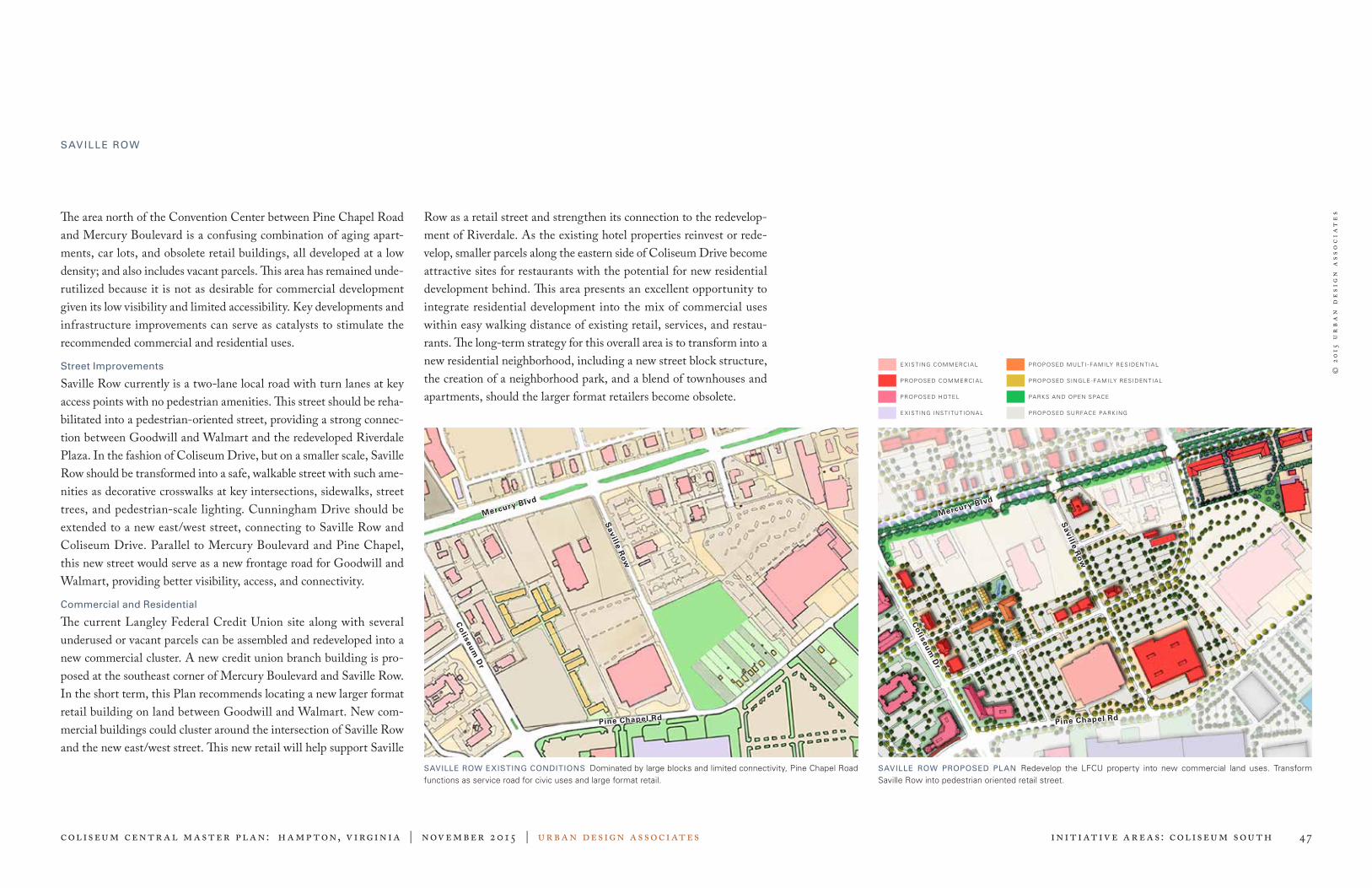
© 2
015
ur
ba
n d
esi
gn
ass
oc
iat
es
Coliseum centr al master pl an: Hampton, V irginia | November 2015 | urban design associates 47 Initiative Areas: Coliseum South
The area north of the Convention Center between Pine Chapel Road and Mercury Boulevard is a confusing combination of aging apart-ments, car lots, and obsolete retail buildings, all developed at a low density; and also includes vacant parcels. This area has remained unde-rutilized because it is not as desirable for commercial development given its low visibility and limited accessibility. Key developments and infrastructure improvements can serve as catalysts to stimulate the recommended commercial and residential uses.
Street Improvements
Saville Row currently is a two-lane local road with turn lanes at key access points with no pedestrian amenities. This street should be reha-bilitated into a pedestrian-oriented street, providing a strong connec-tion between Goodwill and Walmart and the redeveloped Riverdale Plaza. In the fashion of Coliseum Drive, but on a smaller scale, Saville Row should be transformed into a safe, walkable street with such ame-nities as decorative crosswalks at key intersections, sidewalks, street trees, and pedestrian-scale lighting. Cunningham Drive should be extended to a new east/west street, connecting to Saville Row and Coliseum Drive. Parallel to Mercury Boulevard and Pine Chapel, this new street would serve as a new frontage road for Goodwill and Walmart, providing better visibility, access, and connectivity.
Commercial and Residential
The current Langley Federal Credit Union site along with several underused or vacant parcels can be assembled and redeveloped into a new commercial cluster. A new credit union branch building is pro-posed at the southeast corner of Mercury Boulevard and Saville Row. In the short term, this Plan recommends locating a new larger format retail building on land between Goodwill and Walmart. New com-mercial buildings could cluster around the intersection of Saville Row and the new east/west street. This new retail will help support Saville
PROP OSED S INGLE - FA MILY RESIDEN T IA L
E X IS T ING INS T IT U T ION A L
E X IS T ING COMMERCIA L
PROP OSED COMMERCIA L
PROP OSED HOTEL
PROP OSED MULT I - FA MILY RESIDEN T IA L
PA RKS A ND OPEN SPACE
PROP OSED SURFACE PA RK ING
SAVILLE ROW
SAVILLE ROW EXISTING CONDITIONS Dominated by large blocks and limited connectivity, Pine Chapel Road functions as service road for civic uses and large format retail.
SAVILLE ROW PROPOSED PLAN Redevelop the LFCU property into new commercial land uses. Transform Saville Row into pedestrian oriented retail street.
Row as a retail street and strengthen its connection to the redevelop-ment of Riverdale. As the existing hotel properties reinvest or rede-velop, smaller parcels along the eastern side of Coliseum Drive become attractive sites for restaurants with the potential for new residential development behind. This area presents an excellent opportunity to integrate residential development into the mix of commercial uses within easy walking distance of existing retail, services, and restau-rants. The long-term strategy for this overall area is to transform into a new residential neighborhood, including a new street block structure, the creation of a neighborhood park, and a blend of townhouses and apartments, should the larger format retailers become obsolete.
Saville R
ow
Saville R
ow
Mercury Blvd
Mercury Blvd
Pine Chapel Rd Pine Chapel Rd
Co
liseum
Dr
Co
liseum
Dr

© 2
015
ur
ba
n d
esi
gn
ass
oc
iat
es
Coliseum centr al master pl an: Hampton, V irginia | November 2015 | urban design associates 48 Initiative Areas: Coliseum Crossroads
Coliseum Crossroads Located at the intersection of Interstates 64 and 664, the Crossroads area is the District’s front door and most visible face. Due to its great visibility from the interstate, the Hampton Coliseum itself is a land-mark and icon in the region and well complemented by the Hampton Roads Convention Center (HRCC). The City owns or controls most of the property within this area and has been actively exploring develop-ments around the Coliseum and HRCC; thus, this area is most likely to experience change in the near term. The 2004 Plan recommended redeveloping the areas surrounding the Coliseum and HRCC into a series of urban neighborhoods and mixed-use activity centers. The density of the development that includ-ed specialty retail, hotels, entertainment, and restaurants required structured parking garages and appropriate street infrastructure. Due to the changes in the market, this form of development is no longer viable, and new recommendations have been proposed. Although the Hampton Coliseum is a well-recognized and much-loved regional landmark in the area, it faces potential new competition from nearby venues on the Southside of Hampton Roads, including a proposed new arena in Virginia Beach. The live music industry has changed by consolidating into a few large entertainment groups with preferred venues, making it increasingly more difficult to sign indi-vidual entertainment acts. As a result, the use of the Coliseum pre-dominately as an entertainment venue is shifting. The HRCC is challenged to attract conventions that require large blocks of hotel rooms because convention quality hotel rooms do not exist in sufficient quantities within proximity. The Embassy Suites, Courtyard by Marriott, Holiday Inn Express, Hilton Garden Inn, and Springhill Suites offer acceptable accommodations nearby, but the remaining hotels in the immediate area are not convention quality hotels and in need of reinvestment.
COLISEUM CROSSROADS EXISTING CONDITIONS There is a large amount of publicly-owned parking areas and vacant land around the Coliseum and Convention Center that are prime for development.
Hampton Coliseum Hampton Roads Convention Center
INITIATIVES
Tide Mill Creek
Power Plant
Parkway
Coliseum North
Coliseum South
Sentara Medical Campus
Coliseum Crossroads
Coliseum Dr
Con
vent
ion
Cen
ter
Blv
d
Coliseum
Convention Center
Pine Chapel Rd

© 2
015
ur
ba
n d
esi
gn
ass
oc
iat
es
Coliseum centr al master pl an: Hampton, V irginia | November 2015 | urban design associates 49 Initiative Areas: Coliseum Crossroads
The 11-acre parcel east of the Coliseum is attractive for some form of commercial development given its high visibility from the inter-state. The 2004 Plan recommended restaurants and entertainment uses; however, the noise associated with nightlife activities would not be compatible with the H2O neighborhood, the new residential devel-opment to the southeast. As an alternative, this land should be used in a way that is compatible with H2O and the proposed sports village concept, while not competing with other City destinations. In the near term, the land between Convention Center Boulevard, Pine Chapel Road, and N. Armistead Avenue will likely develop as ancillary parking to support the Coliseum and Convention Center as the parking around these venue redevelops into the above-mentioned uses. Looking to the future, this assemblage of land could provide flex-ibility to respond to emerging market demand for a wide range of uses including office, residential, hospitality or additional public venues. The recommendations for the Crossroads focus on these two existing, regionally important civic buildings, and how new develop-ment can best complement them and their business. Thus, the City of Hampton has placed a high priority on attracting new hotel devel-opment to the District to improve the ability of the HRCC and the expanding sports tourism venues to compete for business, as well as developing a unique green space as an outdoor event "room" and com-munity parkland. The Crossroads initiative area is further divided into the Coliseum Park Sports Village and the Coliseum Central Park. While located close together, each have received significant attention with respect to design and implementation.
Coliseum North Strategies
» Develop a sports campus to include a combination of multiple sports venues, hospitality venues, and a grand civic park, proximate to the Coliseum and the HRCC.
» Establish a new mixed-use node east of the Coliseum to include a convention-quality hotel on the 11-acre site (that could be a mixed-use building incorporating either residential units or office space), service retail, and housing.
CROSSROADS RECOMMENDATIONS OVERVIEW
DEVELOPMENT PAT TERNS STREET NET WORK O P E N S PA C E / P E D E S T R I A N N E T W O R K
» Promote sports tourism as an economic driver for the City.
» Develop convention quality hotels to comple-ment existing regional, destination, and civic uses.
» Focus on quality design and architecturally sig-nificant buildings to complement existing iconic buildings.
» Transition from surface parking to structured parking as site development warrants.
» Create a network of local streets that supports mixed-use development and a walkable environ-ment.
» Develop a linear park that capitalizes on the Newmarket Creek open space system.
» Implement a parking strategy that creates an opportunity for higher density developments while maintaining convenient and accessible parking.
» Create a new major outdoor event space proximate to the Coliseum, HRCC, and new sports venues.
» Create Hampton’s Central Park and provide connections to neigh-borhoods and other green space amenities.
» Create plazas along Coliseum Lake as focal points to commercial developments both east and west of the Coliseum.

© 2
015
ur
ba
n d
esi
gn
ass
oc
iat
es
Coliseum centr al master pl an: Hampton, V irginia | November 2015 | urban design associates 50 Initiative Areas: Coliseum Crossroads
In conjunction with the Boo Williams Sportsplex, the Hampton Coliseum and Hampton Roads Convention Center (HRCC), Hampton has the potential to create a critical mass of amateur sports venues that would be unique in the region. The City is exploring the possibility of developing a competition-level aquatics facility that would be open to the public as a com-munity resource. Located west of the Hampton Coliseum adjacent to Pine Chapel Road, this facility would include an Olympic-sized indoor pool, a training pool, and an outdoor waterpark. The proposed aquatic facility would host championship events that could utilize the Coliseum space for larger event finals. Likewise, the HRCC is already used for various sporting events and tournaments and could supplement the Boo Williams Sportsplex for large events. A combination of multiple sports venues could mutu-ally support each other and increase usage as the City seeks to expand as a sports tourism destination. Such tourism could also generate addi-tional hotel revenue and more non-local spending in the community as visitors shop, eat, and play in Hampton. Therefore, this Plan also recommends a hotel sited adjacent to the proposed sports complex at the southwest corner of Coliseum Drive and Pine Chapel Road. This unique combination of sports and assembly venues could be thought of as an amateur sports village. Any future sports facility should be designed as an architecturally unique landmark similar to the Coliseum and HRCC, in keeping with a festival grounds archi-tecture that celebrates sports. The 11-acre parcel east of the Coliseum should also complement the Coliseum Park Sports Village. While previously recommended as a site for restaurant and entertainment destinations, due to changes in the market and the success of Peninsula Town Center, this Plan rec-ommends this site as another potential location for a convention qual-
QUEEN ELIZABETH OLYMPIC PARK IN LONDON Example of an iconic sports-related assembly venue
WORLDS FAIR PARK IN KNOXVILLE, TN Example of an iconic sports-related assembly venue
COLISEUM CROSSROADS — COLISEUM PARK SPORTS VILLAGE Addition of a new amateur sports venue, hotels, and civic park proximate to the Coliseum and Convention Center to create a sports village/park atmosphere.
Fli
ck
r C
C 2
01
4 E
d O
gle
Fli
ck
r C
C
Ma
rtin
Pe
ttit
t
Coliseum Dr
Pine Chapel Rd
Con
vent
ion
Cen
ter
Blv
d
Coliseum
Convention Center
ity hotel, possibly mixed with multi-family residential and/or office uses. By offering needed convention quality hotel rooms and additional housing units in a more dense, walkable environment, such uses would be in less direct competition with other retail- and restaurant-focused areas of Coliseum Central.
COLISEUM PARK SPORTS VILL AGE

© 2
015
ur
ba
n d
esi
gn
ass
oc
iat
es
Coliseum centr al master pl an: Hampton, V irginia | November 2015 | urban design associates 51 Initiative Areas: Coliseum Crossroads
COLISEUM CROSSROADS — GRAND CIVIC PARK Adding a great lawn area adjacent to the Coliseum to create this central place for outdoor performances and venues and park space.
Aerial view of proposed improvements for the Coliseum Crossroads
COLISEUM CENTRAL PARK
Newmarket Creek, a tidal water body that winds its way through the middle of Hampton and Coliseum Central, is an underutilized resource to the District and the City. Though not often thought of as an amenity, the creek, adjacent lakes (e.g. Coliseum Lake, Lake Hampton, and Bass Pro Lake), and surrounding open spaces have great potential for spurring open and green space development and becoming one of the City’s greatest community assets: Hampton’s Central Park. This Plan recommends a linear park along the Creek and through the Crossroads area that connects Air Power Park with Bass Pro Lake to include promenades, esplanades, trails, trailheads, canoe/kayak launches and docking areas, and programmable park spaces. At the heart of “Central Park” should be a new grand civic park for Hampton, providing a gathering area and appropriate setting for the Coliseum, Hampton Roads Convention Center (HRCC), and pro-posed sports facilities. Located on the west side of the Coliseum, this park should create a unique identity and setting for the civic uses and sports facilities, providing significant space for pre- and post-event gatherings, outdoor concerts, celebrations, and amusements associated with concerts and family-oriented activities. Elements of the civic park would include a large gently sloping lawn area, defined by trails and tree groupings and equipped with a performance stage; additional lawns and “outdoor rooms,” defined by landscaping that create multiple locations for passive and active outdoor use; and water features that continue the water theme at the entrances to the Coliseum and HRCC. A multi-use path would wind in and around the new facilities and function as a boardwalk out in Coliseum Lake to contribute to a larger pathway system that links to the greater Central Park along Newmarket Creek. The Crossroads plans illustrate the integration of the sports facilities and civic park together to create a continuous and unique park environment. Central Park should be a community amenity that offers better public access to the creek and lakes and be well-connected to both existing and proposed surrounding neighborhoods.
GRAND CIVIC PARK — EXAMPLE AMENITIES Waterfront Park
Interactive Digital Fountain Feature Public Art
Recreational Water Activities
Coliseum Dr
Coliseum
Convention Center
Fli
ck
r C
C A
en
ne
ke
n F
lic
kr
CC
we
bja
y

© 2
015
ur
ba
n d
esi
gn
ass
oc
iat
es
Coliseum centr al master pl an: Hampton, V irginia | November 2015 | urban design associates 52 Initiative Areas: Coliseum Crossroads
PHASED PARKING STRATEGY
Balancing the parking needs of the Coliseum and the Hampton Roads Convention Center (HRCC) will be essential to the overall redevel-opment of the area. Although an abundance of surface parking will detract from and prevent pedestrian-oriented redevelopment, struc-tured parking is expensive and should not be built until the surface parking values rise to a level that redevelopment of surface lots would help offset the cost of parking structures and they can be shared with other uses.
Early Phase
To accommodate spaces displaced by redeveloping the former Best Products site and the 19-acre site, 2100 spaces are provided in a new surface parking area northeast of the Coliseum and HRCC. This lot will be located between Convention Center Boulevard, Pine Chapel Road, and N. Armistead Avenue. A reliable shuttle service and/or transit system can be added to carry visitors to/from those farther sur-face lots to/from the Coliseum and HRCC.
Later Phase
In time, the area should transition from surface parking to structured parking. With the HRCC expansion and/or redevelopment within the eastern parking area, structured parking will become a necessity. The best strategy should be to create several multi-use (shared) parking garages centrally located between the Coliseum, HRCC, and shared uses. The primary access for one garage will be oriented to Pine Chapel Road and the primary access of the other garage will be oriented to Coliseum Drive/Convention Center Boulevard. Such orientation is critical in loading/unloading the garages during events and manag-ing the overall event traffic patterns of the Crossroads area. A third parking structure is shown adjacent to the Coliseum on the east side, elevated above an enclosed service area.
PARKING STRATEGY — CURRENT CONDITION Currently there are approximately 4,000 spaces provided for the Coliseum and the Convention Center.
PARKING STRATEGY — EARLY PHASE Approximately 1,300 spaces for the Coliseum will be displaced by the proposed sports facil-ity, hotel, and civic park. These spaces will be replaced by an increased number of spaces located in the vacant parcel northeast of the Convention Center lot.
C U R R E N T PA R K I N G
PARKING LOT C U R R E N T S PA C E S
HRCC West Lot 41 spaces
HRCC South Lot 307 spaces
HRCC East Lot 1,585 spaces
Hampton Coliseum East Lot 212 spaces
Hampton Coliseum West Lot 1,300 spaces
Overflow Parking 374 spaces
BEST Site 652 spaces
Total 4,471 spaces
P R O P O S E D E A R LY P H A S E PA R K I N G
PARKING LOT C U R R E N T S PA C E S
HRCC West Lot 41 spaces
HRCC South Lot 307 spaces
HRCC East Lot 1,585 spaces
Hampton Coliseum East Lot 212 spaces
Hampton Coliseum West Lot 500 spaces
Overflow Parking 374 spaces
Expansion Lot 2,100 spaces
Total 5,119 spaces
R E Q U I R E D PA R K I N G
PARKING LOT C U R R E N T S PA C E S
Hampton Roads Convention Center 855 spaces
Hampton Coliseum 3,267 spaces
Aquatics Facility 375 spaces
Amateur Sports Center and Hotel 274 spaces
Total 4,771 spaces
Coliseum Dr
Coliseum Dr
Pine Chapel Rd
Pine Chapel Rd
Con
vent
ion
Cen
ter
Blv
d
Con
vent
ion
Cen
ter
Blv
d
41 Spaces
41 Spaces
652 Spaces
1585 Spaces
1585 Spaces
374 Spaces
374 Spaces
307 Spaces
307 Spaces
1300 Spaces
500 Spaces
2100 Spaces
212 Spaces
212 Spaces

© 2
015
ur
ba
n d
esi
gn
ass
oc
iat
es
Coliseum centr al master pl an: Hampton, V irginia | November 2015 | urban design associates 53 Initiative Areas: Coliseum Crossroads
PARKING STRATEGY – LATER PHASE Parking for the Convention Center and Coliseum will transition to parking structures as the Convention Center expands and the northeast surface lots develop.
P R O P O S E D L AT E R P H A S E PA R K I N G
PARKING LOT C U R R E N T S PA C E S
HRCC West Lot 41 spaces
HRCC South Lot 307 spaces
HRCC East Lot 367 spaces
HRCC Parking Garage 1 1,752 spaces
HRCC Parking Garage 2 1,672 spaces
Hampton Coliseum Garage 424 spaces
Aquatics Lot 500 spaces
Office Development Lot 1100 spaces
Total 6,163 spaces
Parking for the Convention Center and the Coliseum
Balancing the parking needs of the Coliseum and HRCC will be essen-tial to the overall redevelopment of the area. Too much surface parking will detract from and prevent pedestrian-oriented redevelopment; how-ever, structured parking is expensive and should not be built unless it can be shared with other uses. In time, the area should transition from surface parking to structured parking. In general, the strategy should be to create several multi-use (shared) parking garages throughout the District as well as a viable transit system that accesses satellite parking reservoirs located elsewhere in the District.
Coliseum Dr
Pine Chapel Rd
Con
vent
ion
Cen
ter
Blv
d
41 Spaces367 Spaces
1752 Spaces
1672 Spaces
307 Spaces500 Spaces
1100 Spaces
424 Spaces

© 2
015
ur
ba
n d
esi
gn
ass
oc
iat
es
Coliseum centr al master pl an: Hampton, V irginia | November 2015 | urban design associates 54 Initiative Areas: Coliseum Crossroads
Aerial view of the proposed development for the Coliseum Crossroads

© 2
015
ur
ba
n d
esi
gn
ass
oc
iat
es
Coliseum centr al master pl an: Hampton, V irginia | November 2015 | urban design associates 55 Initiative Areas: Power Pl ant Park way
Power Plant Parkway Located on the west side of I-64, this initiative area contains opportu-nities for larger format retailers and incremental site improvements on existing commercial properties. Successful regional retail destinations in this area benefit from great highway access and visibility. Since 2004, there has been significant growth and redevelopment throughout Power Plant Parkway area. The most notable has been the redevelopment of Mercury Plaza, located south of Mercury Boulevard and west of Power Plant Parkway. The 2004 Plan recommended this site as a new mixed-use neighborhood; however, Mercury Plaza was completely razed and rebuilt with a focus on large-format retailers and new service and restaurant outparcels. Many of these “new” tenants were relocated from the former Coliseum Mall, helping to facilitate its redevelopment into the Peninsula Town Center. Other commer-cial redevelopment has occurred along Mercury Boulevard including exterior renovations and completely redeveloped outparcels at Todd Center. This area has also seen the development of two new hotels, Springhill Suites and Hilton Garden Inn, across from the Power Plant of Hampton Roads. Just outside the District, to the south along Power Plant Parkway, a significant new, urban-scale residential neighborhood was built, known as Town Park. New Coliseum Central gateway fea-tures have been added across from this neighborhood at the Parkway and Briarfield Road and at Mercury Boulevard and Aberdeen Road. While this area has experienced much retail success, there remain several areas to support additional development, including new devel-opment along Power Plant Parkway, redevelopment of aging com-mercial properties along Mercury Boulevard, infusing new residen-tial units, and connections to green and open space amenities. The Power Plant Parkway initiative area is further divided into Power Plant Parkway and Mercury West Retail.
POWER PLANT PARKWAY EXISTING CONDITIONS Aging traditional strip commercial along W. Mercury Boulevard is prime for rede-velopment to support newer, large format retail in the Power Plant of Hampton Roads.
POWER PLANT PARKWAY REDEVELOPMENT Provide additional regional destination and support retail, infused with new residential units and open space amenities.
INITIATIVES
W Mercury Blvd
W Mercury BlvdTodds Ln
Todds Ln
Power Plant Pkwy
Power Plant Pkwy
Todd Center
Power Plant
Former Mercury
Plaza Site
Coliseum Crossroads
Coliseum North
Tide Mill Creek
Coliseum South
Sentara Medical Campus
Power Plant
Parkway

© 2
015
ur
ba
n d
esi
gn
ass
oc
iat
es
Coliseum centr al master pl an: Hampton, V irginia | November 2015 | urban design associates 56 Initiative Areas: Power Pl ant Park way
POWER PL ANT PARK WAY
Property across the Parkway from Bass Pro is well suited to be rede-veloped for additional large retailers and outparcel development. The success of large retailers in the Power Plant of Hampton Roads high-lights the benefits of interstate visibility for large, regionally-unique retail destinations and these properties can benefit from their proximity. East/west connections from the Aberdeen neighborhood into the District should be enhanced as the redevelopment of these key parcels occurs. The southeast corner of Power Plant Parkway and Pine Chapel Road should also be considered for additional commercial development. In an effort to continue to add new housing units to the District, underutilized and/or vacant land on either side of the Parkway, south of the Power Plant should be considered for new urban neighborhoods of medium densities, similar to the Town Park development. This ini-tiative area also has several opportunities for outdoor community ame-nities. Bass Pro Lake is one of the trailheads of Central Park (described in detail in the Crossroads section) and there are opportunities for connections between this linear park and surrounding neighborhoods, existing (e.g. Aberdeen and Town Park) and proposed. Improvements continue at Bluebird Gap Farm with a relocated entrance that aligns with the Pine Chapel Road entrance to the Power Plant, new parking, upgraded exhibits, and pavilions. In the near term this park will continue to be a part of the District’s open space system; however, redevelopment of the site is likely in the long term as the highest and best use of this property is realized. With excellent inter-state visibility and access and its proximity to the Hampton Coliseum and Hampton Roads Convention Center, the site should be considered as another tourist destination venue or additional housing.
Power Plant Strategies
1 Pursue new residential neighborhoods along the southern end of Power Plant Parkway and W. Queen Street.
2 Enhance pedestrian connections from the Aberdeen, Town Park, and new neighborhoods to the District as the redevelopment of key parcels occurs.
3 Reserve property on Power Plant Parkway for regional destination retailers and larger format retail uses.
W Mercury Blvd
Power Plant Pkwy
4 Reinvest incrementally in Mercury Plaza and Todd Center, focus-ing on service-oriented or new retail opportunities, including space for large box retail and outparcel restaurants.
5 Explore regional recreational attractions or family-oriented tourist attractions for the future use of the Bluebird Gap Farm.
6 Improve access in retail centers by extending driveways through the site and converting driveways into internal streets, lined with street trees.
7 Consolidate multiple curb cuts into appropriate street intersections and convert large parking fields into smaller well-landscaped park-ing rooms.
8 Create a pedestrian connection from the Pine Chapel bridge over the interstate to the Power Plant; through the parking area to the boardwalk around the Bass Pro Lake; and from the Aberdeen neighborhood to the boardwalk at the Power Plant.
9 Provide pedestrian connections for new housing areas south of the Power Plant to Blue Bird Gap Farm and the Central Park path system.
10 Create open space connections to Aberdeen Elementary School from the Mercury Plaza site. POWER PLANT PARKWAY REDEVELOPMENT New larger format and destination retailers; and new residential opportunities
Pine
Cha
pel R
oad
POWER PL ANT PARKWAY RECOMMENDATIONS OVERVIEW
DEVELOPMENT PAT TERNS STREET NET WORK O P E N S PA C E / P E D E S T R I A N N E T W O R K
» Redevelop aging commercial properties along Mercury Boulevard.
» Continue reinvestment in existing retail centers.
» Promote this area as the location for destination and larger format retail uses.
» Improve streets to provide enhanced accessibil-ity and pedestrian amenities.
» Treat the character of driveways within retail cen-ters like streets, providing appropriate landscap-ing, sidewalks, and crosswalks.
» Create open space and trail connections in con-junction with Hampton’s Central Park.

© 2
015
ur
ba
n d
esi
gn
ass
oc
iat
es
Coliseum centr al master pl an: Hampton, V irginia | November 2015 | urban design associates 57 Initiative Areas: Power Pl ant Park way
MERCURY WEST RETAIL
The area on Mercury Boulevard west of the I-64 interchange represents an extensive collection of commercial properties, including the retail centers on either side of Mercury Boulevard: Todd Center; Mercury Plaza; and the Power Plant of Hampton Roads (south of Mercury). There are opportunities for several of the properties along Mercury to evolve and redevelop.
Build America Drive
This area between the interstate and Todds Lane on the north side of Mercury Boulevard currently has several underperforming hotels, a self-storage facility, and some other light industrial uses. Due to its high visibility and access, the frontage along Mercury Boulevard would be ideal for new retail. Redevelopment of the hotel properties should be a high priority project for this area.
Southeastern Corner of Mercury Boulevard and Power Plant Parkway
This triangular area, bounded by Mercury Boulevard, Power Plant Parkway, and Power Plant Way, lacks a sense of place. Retail proper-ties should be redeveloped to front Mercury Boulevard with access to parking behind the buildings off of Power Plant Way. Retail offerings could include restaurants and services to supplement the Power Plant development and the new hotels directly south.
Mercury Plaza/Todd Center
Both retail centers have recently invested in the development of new outparcels along Mercury Boulevard, bringing new tenants and higher quality frontage. These centers offer space for larger format retail with support in-line retail and restaurant and services on outparcels. As retail evolves and should the demand for traditional space decline, new opportunities will arise for the reuse of the spaces. This Plan recom-mends reinvesting incrementally in the centers to focus on service-oriented or new retail functions; more comprehensive redevelopment may become necessary as these centers evolve over time.
W Mercury Blvd
Todds Ln
Power Plant Pkwy
W Mercury Blvd
Todds Ln
Power Plant Pkwy
Todd Center
Power Plant
Mercury Plaza
MERCURY BOULEVARD EXISTING CONDITIONS Aging commercial properties in need of reinvestment/redevelopment
MERCURY BOULEVARD REDEVELOPMENT Reinvestment in existing retail centers and redevelopment of aging commercial properties Todd Center
Build America
Mercury Plaza
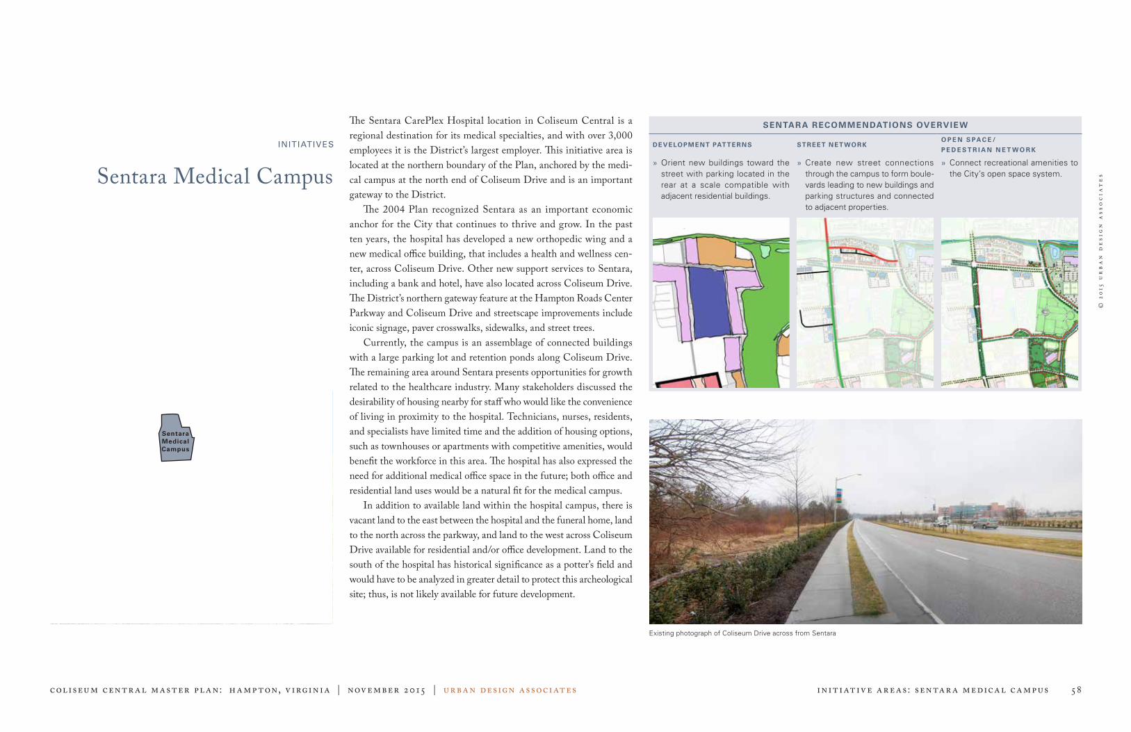
© 2
015
ur
ba
n d
esi
gn
ass
oc
iat
es
Coliseum centr al master pl an: Hampton, V irginia | November 2015 | urban design associates 58 Initiative Areas: Sentar a Medical Campus
Sentara Medical CampusINITIATIVES
The Sentara CarePlex Hospital location in Coliseum Central is a regional destination for its medical specialties, and with over 3,000 employees it is the District’s largest employer. This initiative area is located at the northern boundary of the Plan, anchored by the medi-cal campus at the north end of Coliseum Drive and is an important gateway to the District. The 2004 Plan recognized Sentara as an important economic anchor for the City that continues to thrive and grow. In the past ten years, the hospital has developed a new orthopedic wing and a new medical office building, that includes a health and wellness cen-ter, across Coliseum Drive. Other new support services to Sentara, including a bank and hotel, have also located across Coliseum Drive. The District’s northern gateway feature at the Hampton Roads Center Parkway and Coliseum Drive and streetscape improvements include iconic signage, paver crosswalks, sidewalks, and street trees. Currently, the campus is an assemblage of connected buildings with a large parking lot and retention ponds along Coliseum Drive. The remaining area around Sentara presents opportunities for growth related to the healthcare industry. Many stakeholders discussed the desirability of housing nearby for staff who would like the convenience of living in proximity to the hospital. Technicians, nurses, residents, and specialists have limited time and the addition of housing options, such as townhouses or apartments with competitive amenities, would benefit the workforce in this area. The hospital has also expressed the need for additional medical office space in the future; both office and residential land uses would be a natural fit for the medical campus. In addition to available land within the hospital campus, there is vacant land to the east between the hospital and the funeral home, land to the north across the parkway, and land to the west across Coliseum Drive available for residential and/or office development. Land to the south of the hospital has historical significance as a potter’s field and would have to be analyzed in greater detail to protect this archeological site; thus, is not likely available for future development.
SENTARA RECOMMENDATIONS OVERVIEW
DEVELOPMENT PAT TERNS STREET NET WORKO P E N S PA C E /
P E D E S T R I A N N E T W O R K
» Orient new buildings toward the street with parking located in the rear at a scale compatible with adjacent residential buildings.
» Create new street connections through the campus to form boule-vards leading to new buildings and parking structures and connected to adjacent properties.
» Connect recreational amenities to the City’s open space system.
Existing photograph of Coliseum Drive across from Sentara
Power Plant
Parkway Coliseum Crossroads
Coliseum North
Tide Mill Creek
Coliseum South
Sentara Medical Campus

© 2
015
ur
ba
n d
esi
gn
ass
oc
iat
es
Coliseum centr al master pl an: Hampton, V irginia | November 2015 | urban design associates 59 Initiative Areas: Sentar a Medical Campus
As the northern gateway to Coliseum Central, great connectivity is of high importance in this area; as such, increasing accessibility from the north to the District is vital. Coliseum Drive is planned to extend northward to Butler Farm Road, which will provide access to and development opportunities for the vacant land on the north side of the Hampton Roads Center Parkway. To create a true medical campus atmosphere, office and residential development should occur in a way that is sensitive to and includes open and green space connections. This Plan recommends continuing efforts to shape the hospital into a world-class medical campus with new buildings that frame and create open spaces, greens, quads, and courtyards connected into the City’s open space system.
Sentara Medical Campus Strategies
1 Construct a new east/west street on the southern edge of the hos-pital campus connecting Coliseum Drive to Armistead Avenue.
2 Extend Coliseum Drive from the Hampton Roads Center Parkway north to Butler Farm Road.
3 Explore new housing opportunities north of the hospital across Hampton Roads Center Parkway and west of the campus across Coliseum Drive.
4 Explore new medical-related office locations at the northeast cor-ner of Coliseum Drive and HRC Parkway; vacant land east of the hospital between Vernon Stuart Drive and the parkway; and vacant land west of the hospital across Coliseum Drive.
5 Provide a multi-purpose path connecting between Armistead Pointe Park and Sandy Bottom Nature Park along the parkway.
6 Tie the hospital campus courtyards, walking paths, and fitness course into the City’s open space system.
7 Develop a public park and landmark recognition of the Civil War Grave Site on the Sentara property.
SENTARA MEDICAL CAMPUS EXISTING CONDITIONS Vacant developable land exists all around the hospital complex
SENTARA MEDICAL CAMPUS DESIGN ALTERNATIVE
Office DevelopmentSENTARA MEDICAL CAMPUS DESIGN ALTERNATIVE
Residential Development
Precedent photos of medical and academic campusesPROPOSED VIEW OF COLISEUM DRIVE ACROSS FROM SENTARA Domestic scaled office and/or residential build-ings lining the west side of Coliseum Drive.
Hampton Roads Center Pkwy
Co
liseu
m D
r
Sentara CarePlex Hospital
Hampton Roads Center PkwyHampton Roads Center Pkwy
Co
liseu
m D
r
Co
liseu
m D
r
Sentara CarePlex Hospital
Future Road Connection
Future Road Connection
Sentara CarePlex Hospital

© 2
015
ur
ba
n d
esi
gn
ass
oc
iat
es
Coliseum centr al master pl an: Hampton, V irginia | November 2015 | urban design associates 60 Initiative Areas: Tide Mill Creek
Tide Mill CreekINITIATIVES
The Tide Mill Creek initiative area is located on the northeast border of Coliseum Central, extending south to Cunningham Drive. Tide Mill Creek is a natural waterway, leading from the Riverdale Plaza area northeastward to Armistead Pointe, emptying into the Southwest Branch of the Back River. The Creek itself is mostly a hidden natural and inaccessible asset as it winds behind neighborhoods and many vacant parcels. Largely residential in nature, this community is one of the key areas for neighborhood development and reinvestment. For Coliseum Central to be successful as a mixed-use district, resi-dential investments must be made in addition to commercial ones. Community assets, highlighted by Armistead Pointe Park are highly valuable for this area. Since the 2004 Plan, one of the most successful projects in Hampton has come to fruition: the Boo Williams Sportsplex, located within Armistead Pointe Park. By hosting large national amateur sports tournaments, the Sportsplex has not only succeeded as a sports venue, but it has also spurred growth in Coliseum Central and helped direct the City to explore other sports tourism destinations as an eco-nomic driver. Eaton Middle School and Cooper Elementary School are valuable assets to the District due to their central location to three of the north-ern initiative areas and its proximity to neighborhoods. These schools are institutions that support potential redevelopment opportunities. As Armistead Pointe Park is developed into an important community-scale recreational park, the Plan recognizes the opportunity to recon-figure some or all of the school property, as well as adjacent properties, into potential housing sites and a neighborhood park. Infusing the District with more housing at its center will support its other, vary-ing uses. Currently, the edges of the school yards are ill-defined, and the school grounds underutilized. By making better use of the school yards as neighborhood parks, including the addition of walking paths
SCHOOLS AND NEIGHBORHOODS Cooper and Eaton Schools are on the edges of the eastern neighborhoods. Residents of Magruder Heights are disconnected from the ameni-ties at the schools.
TIDEMILL CREEK EXISTING CONDITIONS Oversized blocks and underutilized land around Cooper, Eaton, and Hampton Christian schools are primed for residential development.
Riverdale Neighborhood
Magruder Heights
Neighborhood
Hampton Roads Center Parkway
Cooper School
Sentara Armistead AvenueTide M
ill Lane
Tide Mill Creek
Power Plant
Parkway Coliseum Crossroads
Coliseum North
Coliseum South
Sentara Medical Campus
Tide Mill Creek

© 2
015
ur
ba
n d
esi
gn
ass
oc
iat
es
Coliseum centr al master pl an: Hampton, V irginia | November 2015 | urban design associates 61 Initiative Areas: Tide Mill Creek
and bicycle trails throughout, the potential of Coliseum Central to support community activity and build stronger neighborhoods can be realized. Pedestrian paths and trails connect the schools together and incorporate the open space into the adjoining areas, creating a joint resource for the community. These paths will also provide access to recreation fields at Armistead Pointe Park. The recommendations for Tide Mill Creek are intended to create a center of community through new park areas, connected green spaces and residential opportunities. Recommendations regarding Marcella Road and Armistead Pointe Park are further explored.
Tide Mill Creek Strategies
1 Pursue new housing opportunities that are compatible with existing land use and residential density to fill in around Eaton, Cooper, and Hampton Christian schools, adjacent to the existing Tanglewood and Riverdale neighborhoods.
2 Create a complete community park at Armistead Pointe Park on land around the Boo Williams Sportsplex.
3 Create a new east/west connection between N. Armistead Avenue and Coliseum Drive, north of Cooper School.
4 Create a new north/south connection between Marcella Road and Cunningham Drive, along the west side of Eaton School.
5 Provide traffic calming improvements along Marcella Road.6 Create a new neighborhood park and connected walking trails at
Cooper and Eaton Schools.7 Connect Armistead Pointe Park and new neighborhood parks into
the City’s open space system.
TIDE MILL CREEK RECOMMENDATIONS OVERVIEW
DEVELOPMENT PAT TERNS STREET NET WORKO P E N S PA C E /
P E D E S T R I A N N E T W O R K
» Develop smaller more walkable blocks to enhance neighborhood connectivity.
» Provide more dense housing types and/or office uses compatible with the area west of the schools adja-cent to the commercial areas.
» Create new street connections that promote a connected, pedestrian friendly street network.
» Create new parks that support existing and new neighborhoods.
» Utilize school grounds as commu-nity and neighborhood assets.
Perspective of new housing
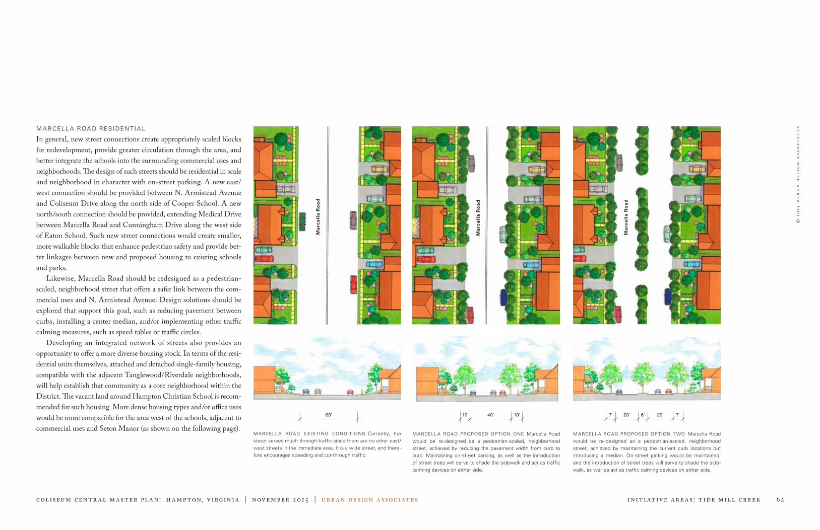
© 2
015
ur
ba
n d
esi
gn
ass
oc
iat
es
Coliseum centr al master pl an: Hampton, V irginia | November 2015 | urban design associates 62 Initiative Areas: Tide Mill Creek
MARCELLA ROAD EXISTING CONDITIONS Currently, the street serves much through-traffic since there are no other east/west streets in the immediate area. It is a wide street, and there-fore encourages speeding and cut-through traffic.
MARCELLA ROAD PROPOSED OPTION ONE Marcella Road would be re-designed as a pedestrian-scaled, neighborhood street, achieved by reducing the pavement width from curb to curb. Maintaining on-street parking, as well as the introduction of street trees will serve to shade the sidewalk and act as traffic calming devices on either side.
60' 10' 7' 7'6'10'
MARCELLA ROAD PROPOSED OPTION TWO Marcella Road would be re-designed as a pedestrian-scaled, neighborhood street, achieved by maintaining the current curb locations but introducing a median. On-street parking would be maintained, and the introduction of street trees will serve to shade the side-walk, as well as act as traffic calming devices on either side.
40' 20' 20'
MARCELL A ROAD RESIDENTIAL
In general, new street connections create appropriately scaled blocks for redevelopment, provide greater circulation through the area, and better integrate the schools into the surrounding commercial uses and neighborhoods. The design of such streets should be residential in scale and neighborhood in character with on-street parking. A new east/west connection should be provided between N. Armistead Avenue and Coliseum Drive along the north side of Cooper School. A new north/south connection should be provided, extending Medical Drive between Marcella Road and Cunningham Drive along the west side of Eaton School. Such new street connections would create smaller, more walkable blocks that enhance pedestrian safety and provide bet-ter linkages between new and proposed housing to existing schools and parks. Likewise, Marcella Road should be redesigned as a pedestrian-scaled, neighborhood street that offers a safer link between the com-mercial uses and N. Armistead Avenue. Design solutions should be explored that support this goal, such as reducing pavement between curbs, installing a center median, and/or implementing other traffic calming measures, such as speed tables or traffic circles. Developing an integrated network of streets also provides an opportunity to offer a more diverse housing stock. In terms of the resi-dential units themselves, attached and detached single-family housing, compatible with the adjacent Tanglewood/Riverdale neighborhoods, will help establish that community as a core neighborhood within the District. The vacant land around Hampton Christian School is recom-mended for such housing. More dense housing types and/or office uses would be more compatible for the area west of the schools, adjacent to commercial uses and Seton Manor (as shown on the following page).
Ma
rce
lla
Ro
ad
Ma
rce
lla
Ro
ad
Ma
rce
lla
Ro
ad

© 2
015
ur
ba
n d
esi
gn
ass
oc
iat
es
Coliseum centr al master pl an: Hampton, V irginia | November 2015 | urban design associates 63 Initiative Areas: Tide Mill Creek
ARMISTEAD POINTE PARK
The Boo Williams Sportsplex is a prosperous venue for court sports and track tournaments, attracting weekend sports tourism from around the region and the nation. It is currently operating with eight (8) courts and hosting numerous tournaments annually. Challenges to continu-ing that tourism growth in the future include: » Need for a minimum of four (4) additional courts and upgraded
track to compete with other venues and secure tournaments. » Lack of sufficient number of quality hotels within Hampton to cap-
ture visiting family night stays and associated revenue from dining and shopping. Many room nights and revenue are lost to nearby jurisdictions due to insufficient room inventory within the City.
The following options are opportunities that address efficient ways to enhance the facility and attract larger tournaments: » Continue to utilize the exhibition hall of the Hampton Roads
Convention Center for extra courts to supplement the Sportsplex. » Build a complementary facility in the Crossroads area that would
meet the needs of additional courts and modern track to attract and host larger tournaments.
» Expand the Sportsplex to the east at the Armistead Pointe Park site to include four additional courts.
The land south of the Sportsplex presents a challenge. While there is not enough developable land to accommodate outdoor field sports for tournament play, there is an opportunity to create a community-scale park with multi-purpose playing fields, playgrounds, and other passive recreational amenities (e.g. canoe/kayak launch, trails, pavilions, etc.) to augment the Sportsplex and for community use.
Hampton Roads Center Pkwy
Hampton Roads Center Pkwy
Vernon Stuart Dr
Vernon Stuart Dr
N Armistead Ave
N Armistead Ave
ARMISTEAD POINTE PARK EXISTING CONDITIONS Underutilized parkland
ARMISTEAD POINTE PARK PROPOSAL Sportsplex addition, additional parking, and community park amenities
Marcella Road
Me
dica
l Driv
e
Co
liseu
m D
rive
Co
liseu
m D
rive
Me
dica
l Driv
e
Marcella Road
Cunningham Drive
Cunningham Drive
MARCELLA ROAD EXISTING CONDITIONS Underutilized and vacant land around the schools and lack of street connectivity
MARCELLA ROAD PROPOSAL Neighborhood parks and new infill housing around the school properties that is connected to surrounding neighborhoods and the District’s overall open space system. New streets enhance circulation around the schools and neighborhood and alleviate traffic along Marcella Road
Cooper School
Eaton School
Armistead Pointe Park
Boo Williams Sportsplex
Tide
Mill
Cre
ek
Tide
Mill
Cre
ek
Tide M
ill C
reek
Tide M
ill C
reek

© 2
015
ur
ba
n d
esi
gn
ass
oc
iat
es
Coliseum centr al master pl an: Hampton, V irginia | November 2015 | urban design associates 64 Initiative Areas: Mercury Boulevard
Mercury BoulevardINITIATIVES
The Plan recommends a continued transformation of Mercury Boulevard from an unattractive regional transportation corridor to a generously landscaped urban boulevard that improves both access to local properties as well as the pass-through of regional traffic. The overall goal is to improve access to properties located on Mercury Boulevard by replacing dangerous curb cuts with appropriate street intersections and “backage” roads or cross property easements. In the process, the edge of the roadway can transition from one that is domi-nated by a continuous deceleration lane and multiple curb cuts to one that contains sidewalks and generous landscaping. Unified signage and lighting will continue to be important as busi-nesses invest incrementally in their properties. Freestanding signage should remain low to the ground, visible to both motorists and pedestri-ans. High pole signs should no longer be allowed and such existing signs eliminated. Boulevard trees should be planted every 30 feet on center on both sides of a sidewalk. Wherever possible the sidewalk should be set back from the curb, separated by a generous landscape verge.
STREETSCAPE TRANSFORMATIONS Unified signage and mature vegetation will elimi-nate the visual clutter created by competing signage.
EXISTING PHOTOGRAPH OF MERCURY BOULEVARD Good vehicular access and traf-fic management but lacks sidewalks and landscaping; signage is inconsistent.
MERCURY BOULEVARD (PHASE 1) Improve pedestrian enhancements with cross-walks, sidewalks, and improved medians.
MERCURY BOULEVARD (PHASE 2) Create safe access by eliminating continuous right turn lanes, replacing multiple curb cuts with appropriate street intersections, and encourag-ing access to properties from a service road at the backs of properties.
MERCURY BOULEVARD (PHASE 3) Create a safe urban boulevard with appropriate intersections, safe deceleration and turning lanes, minimal curb cuts, and continuous landscape.
STREETSCAPE ELEMENTS A consistent palette of paving materials, gateway elements, signage, and furnishings will help unify the District. A transformed commercial corridor
PROPOSED VIEW OF MERCURY BOULEVARD Over time, Mercury Boulevard should transition to a well landscaped urban boulevard.
Right-of-wayLandscapeEasement
Street Access
MajorSignage
Bus/TransitStation

© 2
015
ur
ba
n d
esi
gn
ass
oc
iat
es
Coliseum centr al master pl an: Hampton, V irginia | November 2015 | urban design associates Pl an Implementation 65
Plan Implementation
UPDATED MASTER SITE PLAN
The Coliseum Central Master Plan, initially adopted by City Council on September 22, 2004 with a subsequent amendments and complete update and adoption by City Council on November 12, 2015, is an official policy document for the City of Hampton. This pol-icy document replaces the prior public policies included in the Mercury Central Plan (1994) and the Coliseum Central Business Improvement District Master Plan (1997). Within the boundaries identified in this Plan, there exist numer-ous planning and public policy documents that guide public and pri-vate actions. The 2015 Coliseum Central Master Plan update may not address all aspects contained in these other policy and implementation tools. In cases where recommendations may conflict, the recommen-dation contained in the 2015 Plan shall prevail. Recommendations contained within these other policy and implementation documents, which are not specifically addressed in the 2015 Coliseum Central Master Plan and yet are consistent with the overall objectives of the 2015 Coliseum Central Master Plan, will continue to be valid guid-ance for both public and private actions. Specific implementation ini-tiatives that must follow the adoption of this Master Plan include: » Amendments to the Hampton Zoning Ordinance: Overlay District
— Coliseum Central » Amendments to the Hampton City Code: Site Plan Ordinance » Amendments to the Coliseum Central Design Guidelines » Amendments to the 2020 Parks and Recreation Master Plan » Funding through the annual Capital Improvements Plan as well as
other public and private funding sources
Existing plans or policy documents affecting areas within the boundar-ies encompassed by the 2015 Coliseum Central Master Plan update include the following: 2006 Hampton Community Plan, Hampton Roads Regional Transportation Plan, Mercury Central Plan (1994), Coliseum Central Business Improvement District Master Plan (1997), Aberdeen Neighborhood Plan, Peninsula Light Rail Study.
Peninsula Town Center
Sentara CarePlex Hospital
Sportsplex
Hampton Roads Center Pkwy
Coliseum
Armistead Ave
Todd Shopping Center
Aberdeen
Northampton
Mercury BlvdC
olise
um
Dr
Back River

© 2
015
ur
ba
n d
esi
gn
ass
oc
iat
es
Coliseum centr al master pl an: Hampton, V irginia | November 2015 | urban design associates Pl an Implementation 66
Priority Public Projects
1 Continue streetscape improvements to include sidewalks and safe crossings on prominent streets, focusing on the Coliseum Drive and Mercury Boulevard corridors, to foster a safe pedestrian envi-ronment throughout the District.
2 Create a campus of public attractions around the Hampton Roads Convention Center and Hampton Coliseum, including possible destination uses such as a signature event park, aquatics center, and entertainment venues.
3 Develop a hotel strategy to reposition underperforming hotels and the addition of at least 300 new convention quality hotel rooms proximate to the Convention Center and Coliseum to support those functions and the City’s sports tourism.
4 Develop a strategy to assist the Boo Williams Sportsplex’s efforts to expand the size of their tournaments and remain relevant nationwide for competitive sports tournaments. Such strategy might involve the use of the Convention Center to augment the Sportsplex, new court facilities within the Crossroads area, and/or expanding the Sportsplex itself.
5 Develop Armistead Pointe Park as a community park on the north side of the District to include multi-purpose athletic fields, play-ground canoe/kayak launch, pavilions, and walking trails. These park amenities will also support the Boo Williams Sportsplex and be connected to Sandy Bottom Nature Park via a multi-purpose path along Hampton Roads Center Parkway.
6 Implement the City’s premier linear “Central Park,” connecting Air Power Park to Bass Pro Lake, along Newmarket Creek to include a multi-purpose path, promenades, trail heads, pocket parks, pro-grammable open spaces, pavilions, interpretive exhibits, canoe/kayak launch and docking areas, and other accesses to Newmarket Creek, Lake Hampton, Coliseum Lake, and Bass Pro Lake.
7 Amend the Zoning Ordinance and implement design standards to assist in executing the recommendations of this Plan.
PRIORITY PUBLIC PROJECTS MAP
Peninsula Town Center
Sentara CarePlex Hospital
Sportsplex
Hampton Roads Center Pkwy
Coliseum
Armistead Ave
Aberdeen
Northampton
Mercury Blvd
Co
liseu
m D
r
Back River
Todd Shopping Center
Riverdale Plaza

© 2
015
ur
ba
n d
esi
gn
ass
oc
iat
es
Coliseum centr al master pl an: Hampton, V irginia | November 2015 | urban design associates Pl an Implementation 67
Priority Private Projects
1 Implement the second phase of Peninsula Town Center (PTC) development to include additional residential units adjacent to The Chapman; new commercial buildings on outparcels, fronting Coliseum Drive, Mercury Boulevard, and Kilgore Avenue; a new hotel; and gateways and signage enhancements to improve visibility and way-finding, especially the interior retail addresses.
2 Redevelop Riverdale Plaza, incrementally implementing new com-plete streets that create a series of flexible blocks that can accept a range of mix of uses over time; commercial uses should be focused to Mercury Boulevard with new residential and office uses inward and toward the rear of the site as the market allows.
3 Encourage the redevelopment of the Langley Federal Credit Union property, including a new credit union branch fronting Mercury Boulevard and the potential for new large format retail between Goodwill and Walmart and other support retail.
4 Continue development of the hospitality corridor with new convention quality hotels, urban-scale residential, and office space visible from I-64.
5 Continue to promote urban-scale housing projects throughout the District, focusing on Sentara, PTC, Riverdale, and the hotel dis-trict, offering choice and diversity and to support mixed-uses.
6 Focus on consolidating retail fronting along Mercury Boulevard and redeveloping underperforming hotels west of I-64.
7 Foster reinvestment in key, successful strip commercial centers: Coliseum Crossing, Coliseum Marketplace, Mercury Plaza, and Todd Center. Improvements should include: ongoing exterior aes-thetic renovations to keep centers fresh and relevant; improve access by extending streets through the site; convert driveways into inter-nal streets, lined with sidewalks and street trees; consolidate mul-tiple curb cuts into appropriate street intersections; connect existing pedestrian areas of the site to the District’s sidewalk/path system; convert large parking fields into smaller well-landscaped parking rooms; connect courtyards, promenades, plazas, and pocket parks into the District’s open space and pedestrian system; and enhance landscaping throughout the site.
PRIORITY PRIVATE PROJECTS MAP
Peninsula Town Center
Riverdale Plaza
Sentara CarePlex Hospital
Sportsplex
Hampton Roads Center Pkwy
Coliseum
Armistead Ave
Todd Shopping Center
Aberdeen
Northampton
Mercury Blvd
Co
liseu
m D
r
Back River

© 2
015
ur
ba
n d
esi
gn
ass
oc
iat
es
Coliseum centr al master pl an: Hampton, V irginia | November 2015 | urban design associates Pl an Implementation 68
AERIAL ILLUSTRATION OF COLISEUM NORTH

© 2
015
ur
ba
n d
esi
gn
ass
oc
iat
es
Coliseum centr al master pl an: Hampton, V irginia | November 2015 | urban design associates Pl an Implementation 69
AERIAL ILLUSTRATION OF COLISEUM CROSSROADS