Embed Size (px)
Citation preview

Serving the Watershed Towns of: Acworth ! Alstead ! Charlestown ! Langdon ! Lempster ! Marlow ! Unity ! Walpole
Cold River Local Advisory Committee
P.O. Box 68, S. Acworth, NH 03607
April 9, 2012
Mrs. Joyce Curll
Lake Warren Association
11 Inlet Cove Road
East Alstead, NH 03602
RE: Water Quality Review
Lake Warren Sampling Program
Dear Joyce:
The purpose of this report is to summarize the results of a comprehensive review of
historical water quality data for the Lake Warren sampling program. The review was completed
by Professional Geologist Michael Heidorn of the Cold River Local Advisory Committee
(CRLAC), at the request of and with assistance from the Lake Warren Association (LWA).
In summary, this letter includes:
! An overview of the lake’s water quality and sampling program.
! A description of the role of sub-watersheds in determining lake water quality.
! An evaluation of the trends in key water quality indicators common to both the sub-
watersheds and the lake.
! A prioritization of sub-watershed phosphorous impacts.
! Conclusions/recommendations for future actions.
The NH Department of Environmental Services (NHDES) has already provided the LWA
with annual in-lake trend analyses and recommendations for managing watershed water quality.
While there is some overlap, our goal was to supplement those efforts by evaluating long-term
trends at all locations with substantial data sets to better understand the impact of the lake’s
tributaries and other features on the lake and to prioritize areas for further investigation.
BACKGROUND
The LWA is currently developing a management plan for Lake Warren which describes
natural and cultural resources in and around the lake and provides a reasoned framework for
addressing the environmental challenges faced by the lake and its surrounding lands.

2
The CRLAC strongly supports the LWA’s management efforts and our recent
collaboration grew directly out of recommendations detailed in the Cold River Watershed
Management Plan (CRLAC, April 2009). The Lake Warren plan will ultimately complement the
Cold River plan, resulting in more comprehensive protection of local resources.
Lake Warren is included within the Cold River watershed. The lake is fed by tributaries
draining sub-watersheds in East Alstead. The lake discharges to Warren Brook, one of the major
tributaries of the river. Portions of Warren Brook were devastated by the Flood of 2005,
increasing the brook’s sensitivity to water quality and habitat fluctuations. The CRLAC seeks to
protect the brook from further degradation as one part of its work with the LWA.
As part of the current planning process, the LWA is focused on water quality issues in and
around the lake. The LWA feels, and the CRLAC concurs, that maintenance of abundant, clean
water in the lake is critical for the Town, its residents and visitors from a variety of perspectives –
including not only environmental but social, financial, recreational and historical.
WATER QUALITY IN THE LAKE
The LWA recognizes that water quality monitoring is vital to understanding lake health,
and has devoted a significant expenditure of resources toward monitoring since the 1990’s.
As a participant in the NHDES’ Volunteer Lake Assessment Program (VLAP), the LWA
collects a variety of water samples from the lake and its tributaries each summer. The NHDES
analyzes the samples in their laboratory and submits annual reports to the LWA describing the
monitoring results, with a special emphasis on trends and observations within the lake. The
NHDES also provides valuable technical advice and education to the LWA and general public.
The annual reports suggest that water quality in the lake remains generally acceptable by
comparison to other lakes in the state. However, long-term trends in key indicators show that
water quality is declining overall. For example, while in-lake mean total phosphorous (TP) levels
in the epilimnion (upper layer of the lake) are generally satisfactory, over the last two decades
those levels have increased on the order of 60%. Copies of the NHDES’ long-term in-lake trend
graphs for mean TP, chlorophyll-a and transparency are included in Attachment A.
The graphs show a combination of increasing chlorophyll-a (a measure of algal
abundance) and TP (the key nutrient in biological lake processes) and decreasing transparency.
This suggests that the lake is aging faster than would otherwise be expected.
Eutrophication is a term used to describe lake aging that is accelerated by the process of
increased nutrient input. Lakes can be classified accordingly on a scale ranging from
oligotrophic (highest lake quality; low nutrient levels and minimal algae/bacteria problems) to
eutrophic (poor lake quality; high nutrient levels and increased algae/bacteria problems). Lakes
in the middle of the continuum are termed mesotrophic.
In the last two decades, Lake Warren appears to have shifted from an oligotrophic-
mesotrophic classification to a mesotrophic-eutrophic classification as shown in Attachment A.
Extrapolation of the NHDES long-term trend lines for mean TP, chlorophyll-a and transparency

3
suggest that at the current rate of decline, the lake could reach an early eutrophic state in less than
35 years, depending on which parameter you evaluate and what level you consider eutrophic.
Eutrophic levels were examined using the following VLAP criteria:
! TP: !"20 micrograms/liter (ug/l)
! Chlorophyll-a: ! 15 milligrams/cubic meter (mg/m3)
! Transparency: # 2 meters
It is important to note the eutrophic state predictions are only approximations, subject to
the above assumptions as well as the limitations inherent in the data and the statistical analyses
performed. For example, changing the target level for mean TP to 30 ug/l results in early stage
eutrophication at 64 years. Using the trend for actual TP data versus mean TP data results in an
early stage prediction of 108 years at a target level of 30 ug/l.
Regardless of the target levels chosen for the above extrapolations, the “bottom line”
message is the same: the predictions suggest the lake could become eutrophic sometime within
this century if the current trends continue.
Eutrophic water bodies may develop into what can be called “pea-soup ponds.” This
development can result in adverse aesthetic, recreation and habitat impacts as well as significant
reductions in property values. Remediation of these conditions can be difficult and costly, easily
totaling hundreds of thousands of dollars or more.
The NHDES currently classifies the lake as “Impaired” for aquatic habitat uses based on
elevated nutrient/algae levels and acidity. Federal law requires the NHDES to determine the
pollutant sources causing impairments and to develop a pollution management, or Total
Maximum Daily Load (TMDL), plan for the lake. However, the TMDL study is considered a
low priority by the NHDES and is tentatively scheduled for initiation in 2023.
According to the NHDES (Sara Steiner, personal communication), Lake Warren will not
be removed from the Impaired waters list until water quality data suggest that the lake has
returned to an oligotrophic state. TP and chlorophyll-a levels must consistently fall below 8 ug/l
and 3.3 mg/m3, respectively. This does not appear to be a likely scenario given current trends.
The above discussion highlights the need to not only monitor the lake but to assess the
causes of water quality issues and develop an action plan for protecting water quality.
WATERSHED SAMPLING PROGRAM & DATA
The first step in developing a water quality action plan is to evaluate existing data for
trends, data gaps and areas of concern. A brief description of data availability and the current
sampling program on and around Lake Warren is provided below.
A list and basic map of all sampling stations in the target area is provided in Attachment
B. The LWA’s current sampling program includes 24 lake, tributary and outlet sites.

4
Complementing those sites are five additional NHDES culvert monitoring sites at the NW
corner of the lake and a CRLAC monitoring site co-located at the lake’s outlet (Warren Brook).
Samples have been collected at some of the above-referenced sites as far back as 1980.
Up until the 1990’s, samples were only collected by the NHDES, usually from the middle of the
lake (the “Deep Spot”). Since that time, the sampling program expanded to include the
tributary/outlet and near-shore (in-lake) sites and has largely been a volunteer effort by the LWA.
The sampling sites have been analyzed for a wide variety of parameters at varying
frequencies. Ten of the LWA sites were monitored for only a year or two and have very limited
data. The culverts also have very limited data. The remaining tributary/outlet sites are monitored
three times per year by the LWA for pH, specific conductance (SC), TP, turbidity and chloride.
The Deep Spot is typically monitored three times per year by the LWA for those
parameters plus dissolved oxygen (DO), chlorophyll-a, transparency, acid-neutralizing capacity
(ANC), phytoplankton and cyanobacteria. Many near-shore (in-lake) sites are monitored once or
twice per year by the LWA for e.Coli bacteria.
The CRLAC routinely monitors the lake outlet (site “12-WAB”) for pH, SC, temperature,
DO, turbidity and water level, and has also monitored that site on a limited basis for e.Coli
bacteria, nitrite/nitrate and TP. The data from this site may be compared directly to the data from
the LWA outlet site (“WARALSO”).
The data available from the NHDES during the preparation of this report span the time
period between 1980 and 2011. Graphical analyses of all available analytical data provided by
the NHDES for those parameters that were sampled in both the tributaries/outlet and the lake are
provided in Attachment C. This approach was selected since the common parameters facilitated
a direct comparison of most sampling stations (allowing us to focus on the relationship between
the tributaries and the lake), and the status of the lake’s water quality had already been more fully
evaluated by the NHDES in their annual reports as described above.
The parameters that are only monitored at near-shore sites or the Deep Spot have been
discussed in detail by the NHDES and were not further evaluated here.
The pH data were not included in the graphical analysis because the lake and its
tributaries are known to be slightly acidic and further evaluation of the data was not anticipated
to yield significant insights at this time. As the NHDES states in their annual VLAP reports:
“Due to the state’s abundance of granite bedrock and acid deposition received from snowmelt,
rainfall, and atmospheric particulates, there is little that can be feasibly done to effectively
increase pH.”
Attachment C includes (a) bar graph chart summaries of average and maximum TP, SC,
turbidity and chloride concentrations for all applicable sites during the 1980-2011 period and (b)
individual trend graphs of measured TP, SC and chloride concentrations for key sites during the
1980-2011 period. Key sites selected for the latter analysis were the Deep Spot, tributary and
outlet sites where a significant volume of TP and SC data has been collected.

5
Each of the trend graphs includes descriptions of applicable NHDES water quality
standards, typical NH lake water quality data and local lake/pond/stream data. Each graph with
ten or more years of data also includes a best-fit regression line to clarify increasing or decreasing
trends. While the regressions would benefit from additional data and are subject to (a) change
based on future data and (b) a large degree of data variability in some cases, they provide the
LWA with a relatively objective sense of preliminary trends.
The volume of data generated for the sampling stations, almost exclusively by LWA
volunteers, is impressive. Over 900 measurements were evaluated during this study, just for the
four parameters listed above. We estimate several thousand measurements have been completed
in total. Collectively, these measurements represent an invaluable database for examining current
water quality trends as well as monitoring future land use impacts.
IMPORTANCE OF SUB-WATERSHEDS
Water flowing into the lake is derived primarily from stream flow and groundwater
discharge. The quality of water in the lake is a direct function of the quality of water flowing into
it. While the exact percentage contributions of stream flow and groundwater discharge to Lake
Warren are not known, both items are anticipated to be important contributors to the lake’s
health. Consequently, understanding water quality in the lake’s tributaries and their associated
sub-watersheds is one important component of any lake management strategy.
Lake Warren is fed by two major tributaries, Carmen Cove (Hale) and Smith Hill Brooks,
and a number of smaller tributaries including Colburn Hill, Pickerel Cove and Dam Brooks as
well as Spruce “River” and a small stream at Scotland Yard. Each tributary is monitored by the
LWA. A preliminary review of topographic maps for the area suggests that there may be several
unnamed small tributaries that are not monitored.
Lakefront properties often drain surface runoff directly into the lake (rather than into a
stream) or indirectly via groundwater discharge. The contributions of direct runoff and
groundwater discharge to water quality in the lake, while not the focus of this evaluation, are also
important to consider in the development of a lake management strategy.
WATER QUALITY TRENDS
Trends in TP, SC, turbidity and chloride concentrations are described below for each
monitored sub-watershed, the outlet and the Deep Spot. Where appropriate, observations at near-
shore and culvert sites are also included.
Total Phosphorous:
In NH, phosphorous is the key nutrient responsible for lake eutrophication. Thus, TP
monitoring and evaluation is critical for understanding the health of Lake Warren.
Many high and low intensity land uses have the potential to increase TP levels. Possible
human sources of TP include sewage, septic system effluent, manure, fertilizer, pesticides, soil

6
erosion, air pollution, land clearing, development of impervious surfaces and certain types of
logging. Natural sources such as local soils, rocks, wetlands and precipitation are also possible.
There are no numerical surface water quality standards for TP in NH. In lieu of a
numerical standard, the NHDES offers the following guidance:
! Ideal: <10 ug/l (streams and lakes);
! Average: 11 – 25 ug/l (streams); 11 – 20 ug/l (lakes)
! More than Desirable: 26 – 49 ug/l (streams); 21 – 40 ug/l (lakes)
! Excessive: !50 ug/l (streams); >40 ug/l (lakes)
The NHDES suggests the median TP concentration in New Hampshire lakes ranges from
12 ug/l in the epilimnion (upper lake layer) to 14 ug/l in the hypolimnion (lower lake layer). In
NH lakes comparable to Lake Warren in size, depth and volume (referred to as “Similar Lakes”
on the graphs in Attachment C), the mean TP in the epilimnion is 15 ug/l.
The NHDES analyses show that mean TP concentrations are increasing in Lake Warren,
especially in the epilimnion. TP graphs provided in Attachment C for the Deep Spot show linear
regression trends consistent with that observation. TP is the limiting nutrient in the lake,
meaning that small TP increases can cause big increases in algal abundance. Those changes are
evident in the negative chlorophyll and transparency trends identified by the NHDES.
Sample data collected by the LWA suggest that sub-watershed and culvert sources are
contributing to the negative in-lake TP trend. Sub-watershed sources with worsening TP trends
(TP concentrations increasing over time) include Carmen Cove, Colburn Hill, Dam and Pickerel
Cove Brooks as well as Spruce River. Maximum TP concentrations ranging from More than
Desirable to Excessive as defined by the NHDES have been observed at each of those streams
except for Dam Brook, in most cases on more than one occasion.
Elevated TP concentrations were observed at Smith Hill Brook up until 2005. As
documented in our January 25, 2005 letter to the LWA, historical land uses in the Smith Hill
Brook sub-watershed included a large logging operation and a significant wetland alteration that
was the subject a NHDES enforcement action. Both land uses could have contributed to elevated
TP concentrations in the brook. Currently there is a decreasing TP concentration trend,
suggesting that those land uses have declined in frequency or ceased altogether.
No discernible TP trends are evident yet at Scotland Yard due to the limited data set for
that location. The average and maximum TP concentrations observed at that site are considered
More than Desirable as defined by the NHDES.
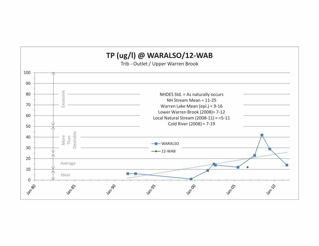
TP concentrations in the lake outlet appear to be on an increasing trend, with recent levels
in the More than Desirable range as defined by the NHDES. While this trend does not add to the
nutrient load of the lake, it is one representation of overall water quality in the lake and the
concentrations have been increasing quickly. The trend is also a concern for the CRLAC due to
the potential downstream impacts on Warren Brook and the Cold River.

7
Elevated TP levels ranging from More than Desirable to Excessive were observed in all
five of the culvert outfalls sampled in the fall of 2010. The highest TP concentrations ever
recorded in the Lake Warren sampling program, ranging from 350 to 650 ug/l, were measured at
Culverts 3, 4 and 7. With the exception of Culvert 7, the culverts collect road runoff and
discharge directly to the lake. Culvert 7 discharges to a small stream which empties into the lake.
In 2011, the NHDES issued a Letter of Deficiency (LOD) to the Town of Alstead
regarding the culvert discharges based on the turbidity/TP levels measured in the discharges and
the sediment plumes observed going into the lake. Elevated turbidities caused by sediment runoff
are often associated with elevated TP readings. The NHDES retracted the LOD after the Town
showed that the data did not prove a violation of state water quality standards had occurred.
TP levels observed in all near-shore samples fell within the Ideal to Average range as
defined by the NHDES. However, near-shore sampling data are difficult to interpret due to the
mixing of water within the lake and are not necessarily representative of on-shore sources.
Furthermore, of the five near-shore stations sampled for TP (including Curll Cove, Lawlor Shore,
Rawson Cove, Red House and Shadowlands), only one was sampled more than once. These data
limitations preclude the drawing of any conclusions regarding the near-shore sites at this time.
Comparison of the TP data from all sampling stations to the NHDES guidance levels
showed that 87% of the phosphorous concentrations over a 30-year period were in the Ideal to
Average range as defined by the NHDES. These results suggest that water quality in the
tributaries, outlet and lake is usually satisfactory and that elevated TP levels are infrequent or the
product of recent trends or localized concerns (such as the culverts).
The results also showed that 65% of the TP concentrations measured in the tributaries and
culverts exceeded the NH median epilimnetic lake TP level of 12 ug/l, and that 25% of those
concentrations were classified as More than Desirable or Excessive. These results suggest that
the tributaries and culverts are important contributing factors to the long-term increase in
phosphorous levels observed in the lake.
It is important to understand that TP levels in the lake are governed not only by the TP
concentrations of the incoming waters but also by the flow rates of those waters. In other words,
due to mass-balance considerations, relatively small increases in TP in a high flow stream can
result in relatively large contributions of TP to the lake. Likewise, relatively large TP levels in a
tiny stream can result in relatively small contributions of TP to the lake.
A qualitative survey of the lake’s tributaries was completed by the CRLAC in the summer
of 2011. Based on that survey, Carmen Cove (Hale) and Smith Hill Brooks clearly represent the
largest inflows to the lake. As noted above, an increasing TP trend was observed at Carmen
Cove (Hale) Brook. Consequently, the identification and reduction of TP sources to that brook
should be considered one important component of any lake management strategy.
Specific Conductance:
SC is a measure of the ability of water to carry an electrical current and a measure of the
free ion content in the water. Free ions are charged particles such as chlorides, nitrates, sulfates,

8
phosphates, sodium, magnesium, calcium, iron and aluminum. SC readings can help locate many
types of potential pollution sources (road salt, septic systems, fertilizers, stormwater runoff, fuels,
etc.) because polluted water usually has a higher SC than unpolluted water. SC is also related to
natural sources such as geology and groundwater quality.
There are no numerical surface water quality standards for SC in NH. In lieu of a
numerical standard, the NHDES offers the following guidance:
! Normal: 0 – 100 micromhos/centimeter (umhos/cm)
! Low Impact: 101 – 200 umhos/cm
! Moderate Impact: 201 – 500 umhos/cm
! High Impact: >501 umhos/cm
The NHDES also allows for SC measurements to be used as a surrogate to predict
compliance with numeric water quality criteria for chloride (a common component of road salt
pollution). If SC exceeds 835 umhos/cm, the chronic chloride standard of 230 mg/l is inferred to
have been exceeded based on statewide water quality studies that the NHDES has completed.
Because SC readings are impacted by naturally-occurring ions, it can be difficult to
interpret low values relative to pollution potential. However, trends can sometimes be discerned
that show changes potentially caused by pollutants. For example, one may find that a particular
sampling site exhibits elevated SC relative to similar nearby or upstream sites. Another example
is a site that demonstrates increasing SC over time.
The NHDES suggests the median and mean SC in New Hampshire lakes are 40
umhos/cm and 59 umhos/cm, respectively. The mean SC observed at the Deep Spot (epilimnion)
in Lake Warren is 59 umhos/cm, and no significantly increasing trend is evident for the Deep
Spot from the best-fit linear regression analysis in Attachment C. All SC readings for the Deep
Spot and near-shore sampling sites fall within the Normal range as defined by the NHDES.
While the in-lake SC results are encouraging with regards to our water quality
assessment, it is important to note that those results may not be particularly sensitive to small
changes in ion concentrations (especially those associated with TP) that can be very important to
the health of the lake. It is easier to use SC as a pollution screening tool for the tributaries and
culverts.
LWA sampling data show that SC readings suggestive of human impacts (>100
umhos/cm) have occurred in the culverts and Carmen Cove, Colburn Hill and Pickerel Cove
Brooks as well as Spruce River. Those tributaries were also observed to have elevated TP. The
highest SC (540 umhos/cm) ever recorded for the Lake Warren sampling program was measured
in a Spruce River sample. Maximum SC levels ranging from Moderate to High Impact as
defined by the NHDES have been recently observed on Colburn Hill Brook and Spruce River.
The possibility of a consistent correlation between SC and TP was evaluated by
comparing the graphs in Attachment C for the streams with elevated SC. Increasing SC and TP
trends were observed at both Colburn Hill and Pickerel Cove Brooks. However, similar
correlations were not observed at Carmen Cove (Hale) Brook and Spruce River. At the culverts,

9
the most elevated TP levels do appear to be broadly associated with the most elevated SC levels
but a poor best-fit correlation is evident when graphed.
The lack of a consistent correlation between TP and SC is not surprising given the many
variables influencing SC levels. A natural conclusion is that sources of elevated SC should be
evaluated on their own terms, and not assumed to necessarily represent elevated TP sources.
Nearly all SC levels in samples collected from the outlet and Smith Hill Brook during the
evaluation period were Normal as defined by the NHDES. Elevated SC levels in the Low to
Moderate Impact range were observed in four of the five culverts sampled in the fall of 2010.
Turbidity:
Turbidity is a measure of the amount of suspended material in the water. This material
typically includes clay, silt, algae and plant particles. Clean waters are generally associated with
low turbidity, but there is a high degree of natural variability involved.
Rain events can increase turbidity in surface water by flushing sediment and organic
matter into the water. Human activities such as vegetation removal and soil disruption can lead
to dramatic increases in turbidity levels. High turbidities may increase water temperature, reduce
DO concentrations and photosynthesis, and negatively affect the health of aquatic organisms
including fish. Turbidity levels also strongly influence lake transparency.
The NHDES’ water quality standard for turbidity in the Lake Warren area is “shall not
exceed naturally occurring conditions by more than 10 Nephelometric Turbidity Units (NTUs).”
Because elevated turbidities can be associated with natural events as well as human
activities and sampling error, it can be difficult to interpret the turbidity source(s). However, by
carefully collecting data during both wet- and dry-weather events, or upstream and downstream
of suspected sources, one may be able to assign changes in turbidity to natural and/or human
causes.
The NHDES suggests the median turbidity in New Hampshire lakes is 1.0 NTU. The
mean turbidity recorded for the Deep Spot in Lake Warren is 1.2 NTUs. No turbidities measured
at the Deep Spot or near-shore (in-lake) stations exceeded 3 NTUs.
Mean turbidities measured for most of the tributaries range from 0.6 to 3.9 NTUs. These
values do not exceed the applicable water quality standard. They are consistent with the range of
readings observed by the CRLAC on similar streams elsewhere in the Cold River watershed.
It is important to note that the LWA’s turbidity results for the most part reflect dry
weather sampling conditions. Wet weather sampling is necessary to adequately assess turbidity
levels and impacts. The same holds true for examining TP impacts associated with storm
erosion.
Maximum turbidities ranging from 22 to 34 NTUs were recorded for Upper Warren
Brook (the outlet), Spruce River and Smith Hill Brook. These streams were sampled by the

10
CRLAC during Tropical Storm (TS) Irene in August 2011 to better gauge the impact of wet
weather on the data set. These values may not exceed the applicable water quality standard if
they are considered naturally-occurring. Turbidity readings in the 30 NTU range were observed
at other local forested streams during that storm including Camp Brook, Dodge Brook and the
upper reach of Great Brook, suggestive of natural conditions or only minor erosion problems.
A maximum turbidity of 178 NTUs was recorded for Carmen Cove (Hale) Brook in
August 2011. This value is clearly more than 10 NTUs beyond what would be considered normal
for this stream. It is suggestive of an erosion issue that was exacerbated by TS Irene. Turbidities
exceeding 100 NTUs have only been recently observed by the CRLAC in streams with moderate
to significant erosion problems resulting primarily from the 2005 Flood, including the lower
reaches of Great, Warren and Crane Brooks as well as the Cold River below South Acworth.
Turbidity readings ranging from 88 NTUs to 785 NTUs were observed at the culverts
during wet weather sampling by the NHDES in the fall of 2010. According to the NHDES,
“turbidity plumes were evident in the lake directly in front of each culvert.” These values appear
to exceed the NHDES turbidity standard but culvert runoff is not technically considered surface
water by the NHDES.
As noted earlier in this report, in 2011 the NHDES issued an LOD to the Town of Alstead
for the culvert discharges based on the turbidity/TP levels measured in the discharges and the
sediment plumes observed in the lake. The NHDES retracted the LOD at the Town’s request
after the Town showed that the sampling data were insufficient to prove a violation of the state’s
water quality standards had occurred.
The possibility of consistent correlations between turbidity and TP/SC was evaluated
using the culvert data. The evaluation suggested that elevated turbidities above 500 NTUs could
potentially be associated with elevated TP and SC levels. However, no clear correlation was
observed using the limited data, especially at lower turbidity concentrations.
Overall, with the exception of the culverts and Carmen Cove (Hale) Brook, the turbidity
data are currently encouraging with regards to our water quality assessment of the lake.
Chloride:
Low levels of the chloride ion are found naturally in fresh waters. In NH, higher-than-
normal chloride concentrations are typically associated with road salt or septic system discharges.
Chloride ions are conservative, which means they are not degraded in the environment and tend
to remain in solution, once dissolved. According to the NHDES, research shows elevated
chloride levels can be toxic to freshwater aquatic life. Among the species tested, freshwater
aquatic plants and invertebrates tend to be the most sensitive to chloride.
In order to protect freshwater aquatic life, the NHDES has adopted acute and chronic
surface water quality standards of 860 milligrams/liter (mg/l) and 230 mg/l, respectively, for
chloride. According to the NHDES, the median chloride content in remote NH lakes is 4 mg/l.

11
The mean chloride concentration at the Deep Spot, where a handful of samples have been
collected since 1980, is approximately 8 mg/l. While the data points are limited, no clear trend
over time is evident. This suggests that chloride is not increasing due to human activities.
With the exception of the Deep Spot, chloride sampling was first initiated in 2010-11.
Only one or two rounds of chloride sampling have been completed at many of the sampled sites.
It is difficult to say anything conclusive based on the limited data, but the results are encouraging.
None of the samples contained chloride at levels exceeding the applicable standards.
It is worth noting that relatively elevated chloride levels were observed in two of the
tributaries, Spruce River and Pickerel Cove Brook. Maximum levels ranging from 29 mg/l to 41
mg/l could be suggestive of potential sewage-related pollutant impacts. Additional monitoring
would be needed to more fully assess this observation.
It is important to note that wet weather sampling during winter and spring snowmelt
periods is necessary to adequately assess potential impacts associated with road salt pollution. If
the LWA wishes to more comprehensively address this issue, wet weather sampling should be
incorporated into the monitoring program. It does not appear at this time, however, that road salt
pollution is a priority concern.
PHOSPHOROUS IMPACT PRIORITIZATION
In order to develop a better understanding of which tributaries are experiencing elevated
or increasing TP levels and prioritize their sub-watersheds according to the need for management
or remedial actions, a set of prioritization criteria were developed using the above guidelines,
graphical trends and relative stream flow contributions.
A summary table listing the sampling stations and ranking each station based on nine
prioritization criteria is provided in Attachment D. A detailed description of the table follows:
! Stream Flow: The first two prioritization criteria relate to potential TP contributions
to the lake based on flow. The tributaries have been separated into two groups. The
first group is associated with high flow sub-watersheds (Carmen Cove and Smith Hill
Brooks) and the second with low flow sites. Stations in the first group are weighted
more in the priority ranking process due to mass-balance considerations.
! Graphical Trends: The next prioritization criterion is based on the best-fit linear
regression trend demonstrated on the concentration-versus-time graph for each
sampling site. While the regressions would benefit from the collection of additional
data, the trends are one important clue as to the potential impact of the tributaries on
the lake. The trends are described in the Water Quality Trends section of this letter.
Streams with increasing TP trends are weighted more in the priority ranking process.
Please note that of the streams with increasing TP, three (Colburn Hill and Pickerel
Cove Brooks as well as the outlet) are increasing at a faster rate than the others.
! Excessive Level: The fourth prioritization criterion is a comparison of long-term
maximum concentrations to the “Excessive” NHDES classification (>50 ug/l). The

12
fifth prioritization criterion identifies which sites had more than one concentration
exceeding the Excessive level.
Sites that exhibited maximum concentrations exceeding 50 ug/l included Smith Hill,
Colburn Hill and Pickerel Cove Brooks as well as Spruce River. At Colburn Hill
Brook, maximum concentrations were Excessive on more than one occasion.
! More-than-Desirable Level: The sixth and seventh prioritization criteria include
comparisons of recent (last five years) and long-term average concentrations to the
“More than Desirable” NHDES classification (>25 ug/l).
Most stations with recent data have experienced greater-than-desirable levels in the
last five years, including a high flow site (Carmen Cove Brook) and several low flow
sites (Colburn Hill and Pickerel Cove Brooks as well as Spruce River). Recent levels
at Colburn Hill and Pickerel Cove Brooks far exceeded 25 ug/l. Greater-than-
desirable long-term average concentrations were not observed at any of the sites.
! Median NH Lake Level: The eighth prioritization criterion is a comparison of long-
term average stream concentrations to the median concentration (12 ug/l) observed in
the upper portions of New Hampshire lakes. All sites with the exception of Dam
Brook had long-term average concentrations exceeding the median lake level.
! Turbidity/SC Levels: The ninth and last prioritization criterion is based on the
maximum turbidity and SC levels documented for the streams. Sites with turbidity
exceeding 100 NTUs or SC exceeding 200 umhos/cm were weighted more in the
priority ranking process. The turbidity cutoff was selected based on experience in the
Cold River Watershed, while the SC cutoff is representative of Moderate Impact.
After assessing the nine criteria at each of the sampling stations as discussed above, a
priority ranking of High, Medium or Low was assigned to each station by comparing the assessed
values and employing weighting factors.
Increasing trends and/or elevated concentrations in the high flow sub-watersheds were
considered to be more heavily weighted. In the low flow sub-watersheds, similar weighting
criteria were used but the trends/concentrations needed to be greater in magnitude/frequency in
order to receive a rating comparable to a high flow site.
In addition, tributaries to the lake were weighted more heavily than the lake outlet since
the LWA’s primary focus is maintaining the lake. It is anticipated that prioritizing the tributaries
will ultimately result in reduced TP levels both in the lake and its outlet.
The resultant priority rankings (as shown in Attachment D) indicate that critical (Medium
to High) priority areas include the following sub-watersheds:
! High Flow: Carmen Cove (Hale) Brook
! Low Flow: Colburn Hill Brook, Pickerel Brook, Spruce River
Lower priority areas include the following sub-watersheds:

13
! High Flow: Smith Hill Brook
! Low Flow: Scotland Yard, Dam Brook, Outlet
The culverts were not included in the prioritization table due to the limited data available
for those sites and the inability to apply NHDES water quality standards directly to the sampling
results. However, the Excessive TP levels and turbidities measured at the culverts as well as the
sediment plumes observed downstream of the culverts by the NHDES suggest that the culverts
warrant a High Priority ranking in the Low Flow category.
CONCLUSIONS
Based on the above evaluation, we conclude the following:
! Water quality in the lake is generally acceptable for many parameters relative to
applicable NHDES standards and guidelines. There are still opportunities to maintain
this level of quality and reduce the adverse trends outlined below.
! NHDES TP/chlorophyll/transparency graphs suggest water quality in the lake is
declining, currently resulting in Impairments for aquatic habitat and possibly resulting
in early-stage eutrophication (premature aging) in less than 35 years.
! A detailed sampling program completed primarily by LWA volunteers in and around
the lake has contributed greatly to our understanding of the lake’s health.
! Despite the volume of data collected, existing data gaps include the need for:
o Flow data at the tributaries and outlet
o Identification of other tributaries that may require sampling
o Completion of wet weather sampling
o Targeted sampling to address the culverts and tributaries with identified water
quality concerns
! Stream flow, groundwater discharge and surface runoff are important contributors to
water quality in the lake, and water quality in the lake in turn influences Warren
Brook and the Cold River.
! TP is the key nutrient responsible for eutrophication. Increasing TP trends in the lake,
some tributaries, the culverts and the outlet are a significant water quality concern for
the LWA and all lake stakeholders.
! Flow rates in the tributaries must be considered when evaluating TP trends. Carmen
Cove (Hale) and Smith Hill Brooks represent the largest inflows to the lake. Small
increases in TP levels in those streams could have large impacts on the lake.
! SC can be a good general pollution indicator. Elevated SC levels were observed in
several of the tributaries and culverts. Increasing SC trends are occurring in Colburn
Hill and Pickerel Cove Brooks.
! Turbidities measured at the lake, tributaries, outlet and near-shore sites are generally
well below the applicable NHDES standard. However, excessive turbidities have

14
been measured during wet weather events at Carmen Cove (Hale) Brook and the
culverts. Wet weather sampling data are generally not yet available.
! No violations of the NHDES chloride standard have been observed, and road salt
pollution does not appear to be a significant water quality issue. However, the data
set is limited. Spruce River and Pickerel Cove Brook had relatively elevated chloride
levels suggestive of the potential for sewerage pollution.
! Prioritization of TP impacts associated with the tributaries/outlet using a set of nine
qualitative and numerical criteria indicated that critical priority areas for TP
management include Carmen Cove (Hale), Colburn Hill and Pickerel Brooks and
Spruce River. The culverts were also identified as a critical TP concern.
RECOMMENDATIONS
Based on the above evaluation, we recommend the following action items to manage
water quality and reduce potential pollutant loads in Lake Warren:
! In general, continue to implement the water quality protection recommendations
provided by the NHDES in their annual VLAP reports. Maintain and increase support
for the ongoing VLAP sampling program to monitor water quality trends.
! Consider developing a “VLAP Subcommittee” within the LWA as one means of
support. Also, promote the interest and retention of VLAP volunteers. One or two
long-term trainees with a willingness to learn and ability to retain the volunteer
protocols would go a long way towards a more sustainable program.
! Continue to foster strategic partnerships with local, regional and state groups that
share a common interest with the LWA, including but not limited to the CRLAC,
Alstead Conservation Commission, Monadnock Conservancy, etc.
! Incorporate the Cold River Watershed Management Plan by reference into the lake
management plan to better leverage future planning and funding opportunities.
! Initiate targeted investigations of critical priority areas for TP management using the
phased approach discussed below, and including windshield/stream surveys, site
visits, bracket sampling and/or storm sampling to identify specific pollution sources.
! Initiate targeted investigations of sub-watersheds where adverse concentrations or
trends of SC, turbidity and chloride were identified. Expand the existing sampling
program to include rain events. The easiest way to do this may be to substitute one
wet weather event for one of the routine summer tributary sampling rounds.
! Attempt to identify the source of sediment causing elevated turbidity in Carmen Cove
(Hale) Brook. A logical first step is to walk upstream during/after a rain event.
! Request that the NHDES and the Town follow up on the outstanding culvert issue and
complete a more defensible wet-weather sampling round. Assist as needed and, based
on the results, encourage the Town to remedy the situation.

15
! If not already completed, consider adding water level, temperature and DO monitoring
to the tributary sampling program. Water levels may serve as rough gauge of flow,
and could be easily incorporated by establishing reference points at each site.
! Verify drainage patterns in the vicinity of the dam and also on the upper reach of
Gilsum Mine Road. Modify tributary sampling approach if needed.
! Consider hiring a consultant to complete a nutrient loading study, including the
collection of additional stream flow data, incorporation of historical concentration
data and consideration of non-assessed sub-watersheds. A loading study identifies
nutrient sources in the lake’s watershed and estimates how much each source
contributes to the lake over time. The consultant may also be able to assist the LWA
in reviewing lake ecological processes and evaluating the likelihood of boating
impacts to water quality.
! Develop targets for in-lake TP concentration, Secchi disk transparency and
chlorophyll content based on desired lake uses, NHDES nutrient impairment criteria
and the relation among these variables for this lake. This effort may require the use of
predictive models. Model predictions of in-lake TP concentrations in response to
specific management actions. Compare predictions to measured data.
! Further examine the type of algae that are dominant in the lake and seasonal algae
changes. Discuss expected dominance of algae vs. rooted vegetation (achieving
transparent water in shallow lakes may exacerbate rooted plant problems). Continue
to monitor for the presence of the so-called toxic blue-green algae.
! Work with Alstead Planning Board and Conservation Commission to better
understand the state of the Town’s regulations with regards to the discouragement of
impervious surfaces and encouragement of on-site storm water disposal. Request to
be put on the e-mailing list for those groups to stay abreast of land use changes.
! Review chemical, storm water and wastewater management practices at sub-
watershed businesses. These practices can be a potential water quality concern.
! Continue pursuing and promoting a discounted septic pump-out program to encourage
regular pump-outs for waterfront and watershed homes. Encourage waterfront and
stream-side owners to avoid vegetated buffer removal and storm drainage to water.
! Initiate or continue discussions with large property owners in the watershed regarding
land conservation benefits/opportunities. LWA members have been instrumental in
protecting land (which also protects water quality) over the last few years.
! Develop a more specific understanding of the benefits the lake provides to non-
waterfront land owners, and use that understanding to reach out to those owners.
Their land use practices strongly influence the quality of water in the tributaries.
! Continue providing public outreach/education about lake health, land stewardship and
best management practices (BMPs) for water quality protection. Involve children and
youth groups to the extent possible, as well as recreational users and the Town. Take
advantage of the many excellent NHDES water quality and BMP fact sheets.

16
! Contact the NH Lakes Association regarding their Lake Conservation Corps program.
This program is designed to actively involve youth in hands-on shoreline and
watershed restoration projects. The Association may be able to work with the LWA,
the Town and local students to help improve the quality of Lake Warren, or at least
help the LWA to develop a comparable local program with the same objectives.
! Consider providing copies of the NHDES’ NH Homeowner’s Guide to Stormwater
Management to each lakeshore resident and key landowners on the tributaries.
We recognize that the LWA has very limited human, material and financial resources and
that implementing all of these recommendations presents a significant challenge. However, the
LWA should consider implementing urgent or relatively low-cost and less labor-intensive
recommendations as soon as possible. Less urgent, more expensive or more time-consuming
ideas can be prioritized for long-term implementation, as resources allow. Long-term priorities
will require extra LWA support and cannot reasonably be completed by one or two volunteers.
To facilitate TP management efforts, we suggest that the LWA structure or phase its
future actions in the sub-watersheds to address priority areas in the following sequence:
! Critical priority areas (High Flow)
! Critical priority areas (Low Flow, including culverts)
! Sub-watershed areas not yet assessed
! Lower priority areas (High or Low Flow)
The above suggestion is offered with at least two important caveats. The first caveat is
that prioritization is an ongoing process that will evolve as additional sampling data are collected
and evaluated. In particular, the classification of some sub-watersheds as a lower priority should
not be construed to mean that sampling should be immediately discontinued in those areas or that
the priority status of those sub-watersheds cannot change over time.
The second caveat is that while a compelling case can be made to focus management
efforts solely on critical high flow priority areas based on the concept that high flow tributaries
contribute more TP to the lake than low flow tributaries, it remains important to consider
management actions in critical low flow priority areas because:
! Localized TP impacts may be enhanced in parts of the lake near those streams.
! Impacted stream habitat may be ecologically tied to near-shore lake habitat.
! Low flow sub-watersheds tend to be relatively small and manageable, potentially with
fewer and/or more evident phosphorous sources.
! Cumulative flow from several of the smaller streams could potentially be equivalent to
the flow in one of the larger streams.
! Excessive TP concentrations and increasing TP trends have been measured at Colburn
Hill and Pickerel Brooks and Spruce River.

17
This concludes our review of water quality in and around Lake Warren as evidenced by
historical sampling data. The CRLAC would like to take this opportunity to commend the LWA
for their proactive approach to management planning and the LWA VLAP Coordinator for her
heartfelt dedication to the sampling program. These types of efforts often are largely under-
appreciated but absolutely essential to the process of democratically protecting water resources.
This report was reviewed in detail by Kate Morgan, LWA VLAP Coordinator; Phil
Sanford, LWA Weed Watch Coordinator; Lisa Murphy, LWA Management Plan Coordinator for
the Southwest Region Planning Commission (SWRPC); and Sara Steiner, VLAP Coordinator for
NHDES. The comments received from these reviewers were invaluable and much appreciated.
Thank you for allowing the CRLAC to assist you with this project. Please contact me at
603-835-2328 or [email protected] if you have any questions.
Respectfully yours,
Michael A. Heidorn
Professional Geologist
CC: Kate Morgan, LWA VLAP Coordinator
Lisa Murphy, SWRPC Senior Planner
Sara Steiner, NHDES VLAP Coordinator
Ted Walsh, NHDES Rivers Program
Attachments:
Attachment A – Lake Water Quality Trend Graphs
Attachment B – Sampling Site Index & Map
Attachment C – Graphical Summaries of TP, SC, Turbidity & Chloride Data
Attachment D – Sub-Watershed TP Impact Prioritization Summary

ATTACHMENT A
Lake Water Quality Trend Graphs

Warren Lake, Alstead
Epilimnion (Upper Water Layer)
1986 1988 1990 1992 1994 1996 1998 2000 2002 2004 2006 2008 2010
Tota
l Ph
osph
oru
sC
on
cen
trati
on
(u
g/L)
0
6
12
18
24
30
Similar Lake Median
NH Median
2010 Monthly Results
MAY JUNE JULY AUG SEPT OCT
0
6
12
18
24
30
NH Median
Hypolimnion (Lower Water Layer)
1986 1988 1990 1992 1994 1996 1998 2000 2002 2004 2006 2008 2010
Tota
l Ph
osph
oru
sC
on
cen
trati
on
(u
g/L)
0
6
12
18
24
30
Similar Lake Median
NH Median
2010 Monthly Results
MAY JUNE JULY AUG SEPT OCT
0
6
12
18
24
30
NH Median
Figure 3. Monthly and Historical Total Phosphorus Data

Warren Lake, Alstead
2010 Chlorophyll-a Results
MAY JUNE JULY AUG SEPT OCT
Ch
loro
ph
yll-a
(m
g/m
3)
0
3
6
9
12
15
Similar Lake Median
NH Median
Historical Chlorophyll-a Results
1986 1988 1990 1992 1994 1996 1998 2000 2002 2004 2006 2008 2010
Ch
loro
ph
yll-a
(m
g/m
3)
0
3
6
9
12
15
Similar Lake Median
NH Median
Figure 1. Monthly and Historical Chlorophyll-a Results

Warren Lake, Alstead
2010 Transparency Viewscope and Non-Viewscope Results
MAY JUNE JULY AUG SEPT OCT
Tra
nspare
ncy (m
ete
rs)
0
1
2
3
4
5
Similar Lake Median
NH Median
Non-Viewscope Data
Viewscope Data
Historical Transparency Non-Viewscope Results
1986 1988 1990 1992 1994 1996 1998 2000 2002 2004 2006 2008 2010
Tra
nspare
ncy (m
ete
rs)
0
1
2
3
4
5
6
Similar Lake Median
NH Median
Figure 2. Monthly and Historical Transparency Results

EUTROPHICATION ESTIMATES
Lake Warren, Alstead, NH
Mean!TP!(ug/l)!@!WARALSDLake!" Deep!Spot!(Epilimnion)
40
50
60
70
80
90
100
Eutrophic!Conditions!# 30!(approx.)(Trophic!State!Index)
Eutrophic!Conditions!# 20!(approx.)
0
10
20
30
2076±
p(NHDES!VLAP)
2038±
3
3.5
4
Mean!Secchi!Disk!Transparency!(m)!@!WARALSDLake!" Deep!Spot!(Epilimnion)
Eutrophic!Conditions!$ 2!(approx.)(NHDES VLAP)
0
0.5
1
1.5
2
2.5
Eutrophic!Conditions!$ 1.5!(approx.)(Trophic!State!Index)
2030±
(NHDES!VLAP)
2021±
0
18
20
Mean!Chlorophyll"a!(mg/m3)!@!WARALSDLake!" Deep!Spot!(Composite)
6
8
10
12
14
16
18
Eutrophic!Conditions!= 11!(approx.)(Trophic!State!Index)
2047±
Eutrophic!Conditions!=15 (approx.)
(NHDES!VLAP)2027±
0
2
4

Excerpted from: Eutrophication and Aquatic Plant Management
in Massachusetts, Final Generic Environmental Impact Report,
MA Executive Office of Environmental Affairs, 2004.

ATTACHMENT B
Sampling Site Index & Map

NHDES Station ID NHDES Station Name Location
2371-001 CULVERT 1 (Wetland Culvert #9) Culvert
2371-003 CULVERT 3 (Wetland Culvert #8) Culvert
2371-004 CULVERT 4 (Wetland Culvert #7) Culvert
2371-006 CULVERT 6 (Wetland Culvert #5) Culvert
2371-007 CULVERT 7 (24-inch Plastic Pipe) Culvert
WARALSEC01 BACTERIA SAMPLE #01 Lake
WARALSEC02 BACTERIA SAMPLE #02 Lake
WARALSBL BOAT LANDING Lake
WARALSCUCOVE CURLL COVE Lake
WARALSD DEEP SPOT Lake
WARALSEB EDITHS BEACH Lake
WARALS-GEN GENERIC Lake
WARALSLS LAWLOR SHORE Lake
WARALSRC RAWSON COVE Lake
WARALSRED RED HOUSE Lake
WARALSSL SHADOWLANDS Lake
WARALSSB SPENCER BEACH Lake
WARALSO OUTLET Outlet
12-WAB PRENTICE HILL ROAD BRIDGE Outlet
WARALSCC CARMEN COVE (Hale) BROOK Tributary
WARALSCH COLBURN HILL BROOK Tributary
WARALSDB DAM BROOK Tributary
WARALSP PICKEREL COVE BROOK Tributary
WARALSSY SCOTLAND YARD Tributary
WARALSS1 SMITH HILL BROOK Tributary
WARALSSR SPRUCE RIVER Tributary
WARALSSR1 SPRUCE RIVER 1 Tributary
WARALSSR2 SPRUCE RIVER 2 Tributary
WARALSSR3 SPRUCE RIVER 3 Tributary
WARALSSR4 SPRUCE RIVER 4 Tributary
WARALSSR5 SPRUCE RIVER 5 Tributary
SAMPLING SITE INDEX
Lake Warren, Alstead, NH

OneStop Program GIS OneStop Program GIS Map
Map Scale = 1 : 51581 (1" = 0.8 miles or 4298 feet)
The information contained in the OneStop Program GIS is the best available according to the procedures and standards of each of the contributing programs and of the GIS. The different programs are regularly maintaining the information in their databases. As a result, the GIS may not always provide access to all existing information, and it may occasionally contain unintentional inaccuracies. The Department can not be responsible for the misuse or misinterpretation of the information presented by this system.
Map prepared 5/10/2011 4:06:29 PM Developed in
cooperation with NH GRANIT
Page 1 of 1OneStop Program GIS Map
5/10/2011http://www2.des.state.nh.us/gis/onestop/printmap.asp?title=OneStop_Program_GIS_Map

ATTACHMENT C
Graphical Summaries of TP, SC, Turbidity & Chloride Data

18
16
19
19
22
11
24
19
26
37
42
63
66
81
20
45
32
11
38
24
8
9
12
7
Lake!(Generic)Lake!(Lawlor!Shore)
OutletPickerel!Cove!Bk
Lake!(Rawson!Cove)Lake!(Red!House)
Smith!Hill!BkLake!(Shadowlands)
Spruce!RiverSpruce!River!1Spruce!River!2Spruce!River!3Spruce!River!4Spruce!River!5Scotland!Yard
TP!(ug/l)!@!Lake!Warren!Sites1980!" 2011
Single!Sample
Maximum
Average!(>2!samples)
NHDES!Std. =!As!naturally!occurs
NHDES "Excessive" ! 40"50
17
19
11
14
13
31
71
45
82
10
26
28
24
12
0 10 20 30 40 50 60 70 80 90 100
Upper!Warren!BkCulvert!1Culvert!3Culvert!4Culvert!6Culvert!7
Carmen!Cove!(Hale)!BkColburn!Hill!Bk
Lake!(Curll!Cove)Lake!(Deep!Spot!" Epi.)Lake!(Deep!Spot!" Hyp.)
Dam!BrookNHDES! Excessive !! 40 50
NH!Stream!Average!=!11"25
NH!Lake!Median!=!12"14
650
600
350

40
50
60
70
80
90
100
TP!(ug/l)!@!WARALSDLake!" Deep!Spot!(Epilimnion)
NHDES!Std. =!As!naturally!occurs
NH!Lake!Median!(epi.)!=!12
NH!Similar!Lake!Mean!(epi.)!=!15
NH!Similar!Lake!Max.!(epi.)!=!121
Lake!Sunapee!Mean!(deep!spot)!=!7
Crescent!Lake!Mean!(deep!spot)!=!5"21
Newell!Pond!(epi.)!=!6"7
Excessive
0
10
20
30
40
Low!
Average
High

40
50
60
70
80
90
100
TP!(ug/l)!@!WARALSDLake!" Deep!Spot!(Hypolimnion)
NH!Lake!Median!(hypo.)!=!0.014
NH!Similar!Lake!Median!(hypo.)!=!0.022
NH!Similar!Lake!Max.!(hypo.)!=!0.217
Lake!Sunapee!Mean!(deep!spot)!=!0.007
Crescent!Lake!(hypo.)!=!0.009"0.026
Newell!Pond!(hypo.)!=!n/a
Excessive
NHDES!Std. =!As!naturally!occurs
NH!Lake!Median!(hypo.)!=!14
NH!Similar!Lake!Mean!(hypo.)!=!22
NH!Similar!Lake!Max.!(hypo.)!=!217
Lake!Sunapee!Mean!(deep!spot)!=!7
Crescent!Lake!Mean!(deep!spot)!=!6"21
Newell!Pond!(epi.)!=!6"7
Excessive
0
10
20
30
40
High
Low!
Average
High

40
50
60
70
80
90
100
TP!(ug/l)!@!WARALSCCTrib!" Carmen!Cove!(Hale)!Brook
NHDES!Std. =!As!naturally!occurs
NH!Stream!Mean!=!11"25
Warren!Lake!Mean!(epi.) =!9"16
Lower!Warren!Brook!(2008)=!7"12
Local!Natural!Stream!(2008"11)!=!<5"11
Cold!River!(2008)!=!7"19
e n ble
Excessive
0
10
20
30
40
Ideal
Average
More
Than
Desira

40
50
60
70
80
90
100
TP!(ug/l)!@!WARALSCHTrib!" Colburn!Hill!Brook
e n ble
Excessive NHDES!Std. =!As!naturally!occurs
NH!Stream!Mean!=!11"25
Warren!Lake!Mean!(epi.) =!9"16
Lower!Warren!Brook!(2008)=!7"12
Local!Natural!Stream!(2008"11)!=!<5"11
Cold!River!(2008)!=!7"19
0
10
20
30
40
Ideal
Average
More
Than
Desira

40
50
60
70
80
90
100
TP!(ug/l)!@!WARALSDBTrib!" Dam!Brook
e n ble
Excessive
NHDES!Std. =!As!naturally!occurs
NH!Stream!Mean!=!11"25
Warren!Lake!Mean!(epi.) =!9"16
Lower!Warren!Brook!(2008)=!7"12
Local!Natural!Stream!(2008"11)!=!<5"11
Cold!River!(2008)!=!7"19
0
10
20
30
40
Ideal
Average
More
Than
Desira
40
50
60
70
80
90
100
TP!(ug/l)!@!WARALSO/12"WABTrib!" Outlet!/!Upper!Warren!Brook
e n ble
Excessive
NHDES!Std. =!As!naturally!occurs
NH!Stream!Mean!=!11"25
Warren!Lake!Mean!(epi.) =!9"16
Lower!Warren!Brook!(2008)=!7"12
Local!Natural!Stream!(2008"11)!=!<5"11
Cold!River!(2008)!=!7"19
0
10
20
30
40
WARALSO
12"WAB
Ideal
Average
More
Than
Desira

40
50
60
70
80
90
100
TP!(ug/l)!@!WARALSPTrib!" Pickerel!Cove!Brook
e n ble
Excessive NHDES!Std. =!As!naturally!occurs
NH!Stream!Mean!=!11"25
Warren!Lake!Mean!(epi.) =!9"16
Lower!Warren!Brook!(2008)=!7"12
Local!Natural!Stream!(2008"11)!=!<5"11
Cold!River!(2008)!=!7"19
0
10
20
30
40
Ideal
Average
More
Than
Desira

40
50
60
70
80
90
100
TP!(ug/l)!@!WARALSS1Trib!" Smith!Hill!Brook
e n ble
Excessive NHDES!Std. =!As!naturally!occurs
NH!Stream!Mean!=!11"25
Warren!Lake!Mean!(epi.) =!9"16
Lower!Warren!Brook!(2008)=!7"12
Local!Natural!Stream!(2008"11)!=!<5"11
Cold!River!(2008)!=!7"19
0
10
20
30
40
Ideal
Average
More
Than
Desira

40
50
60
70
80
90
100
TP!(ug/l)!@!WARALSSRTrib!" Spruce!River
e n ble
Excessive NHDES!Std. =!As!naturally!occurs
NH!Stream!Mean!=!11"25
Warren!Lake!Mean!(epi.) =!9"16
Lower!Warren!Brook!(2008)=!7"12
Local!Natural!Stream!(2008"11)!=!<5"11
Cold!River!(2008)!=!7"19
0
10
20
30
40
Ideal
Average
More
Than
Desira

40
50
60
70
80
90
100
TP!(ug/l)!@!WARALSSYTrib!" Scotland!Yard
e n ble
Excessive NHDES!Std. =!As!naturally!occurs
NH!Stream!Mean!=!11"25
Warren!Lake!Mean!(epi.) =!9"16
Lower!Warren!Brook!(2008)=!7"12
Local!Natural!Stream!(2008"11)!=!<5"11
Cold!River!(2008)!=!7"19
0
10
20
30
40
Ideal
Average
More
Than
Desirab

48
66
42
23
176
129
198
340
46
82
107
149
68
265
187
251
540
141
60
53
52
63
56
148
Lake!(Generic)Lake!(Lawlor!Shore)
OutletPickerel!Cove!Bk
Lake!(Rawson!Cove)Lake!(Red!House)
Smith!Hill!BkLake!(Shadowlands)
Spruce!RiverSpruce!River!1Spruce!River!2Spruce!River!3Spruce!River!4Spruce!River!5Scotland!Yard
SC!(umhos/cm)!@!Lake!Warren!Sites1980!" 2011
Single!Sample
Maximum
Average!(>2!samples)
48
76
76
58
58
59
70
86
282
292
124
161
190
207
56
84
83
91
0 100 200 300 400 500 600
Upper!Warren!BkCulvert!1Culvert!3Culvert!4Culvert!6Culvert!7
Carmen!Cove!(Hale)!BkColburn!Hill!Bk
Lake!(Curll!Cove)Lake!(Deep!Spot!" Epi.)Lake!(Deep!Spot!" Hyp.)
Dam!BrookNHDES!Std.!=!As!naturally!occurs
NH!Human!Impact!Threshold!~!100
NH!Lake!Median!=!40

250
300
350
400
450
500
550
SC!(umhos/cm)!@!WARALSDLake!" Deep!Spot!(Epilimnion)
"Moderate!Impact"
"High!Impact"
NHDES!Std.!=!As!naturally!occurs
NH!Similar!Lake!Mean!(epi.)!=!68
NH!Lake!Median!=!40
Crescent!Lake!!Mean!(epi.)!=!34"40
Newell!Pond!(epi.)!=!19"35
0
50
100
150
200
"Normal"
"Low!Impact"

250
300
350
400
450
500
550
SC!(umhos/cm)!@!WARALSDLake!" Deep!Spot!(Hypolimnion)
"Moderate!Impact"
"High!Impact"
NHDES!Std.!=!As!naturally!occurs
NH!Similar!Lake!Mean!(hypo.)!=!75
NH!Lake!Median!=!40
Crescent!Lake!(hypo.)!~!40"43
Newell!Pond!(hypo.)!=!23"59
0
50
100
150
200
"Normal"
"Low!Impact"

250
300
350
400
450
500
550
SC!(umhos/cm)!@!WARALSCCTrib!" Carmen!Cove!(Hale)!Brook
"Moderate!Impact"
"High!Impact"
NHDES!Std.!=!As!naturally!occurs
NH!Similar!Lake!Mean!(epi.)!=!68
NH!Lake!Median!=!40
Cold!River!Tributary!(typical)!=!<!100
Camp!Brook!(2008"11)!=!32"91
0
50
100
150
200
"Normal"
"Low!Impact"

250
300
350
400
450
500
550
SC!(umhos/cm)!@!WARALSCHTrib!" Colburn!Hill!Brook
"Moderate!Impact"
"High!Impact"
NHDES!Std.!=!As!naturally!occurs
NH!Similar!Lake!Mean!(epi.)!=!68
NH!Lake!Median!=!40
Cold!River!Tributary!(typical)!=!<!100
Camp!Brook!(2008"11)!=!32"91
0
50
100
150
200
"Normal"
"Low!Impact"

250
300
350
400
450
500
550
SC!(umhos/cm)!@!WARALSDBTrib!" Dam!Brook
"Moderate!Impact"
"High!Impact"
NHDES!Std.!=!As!naturally!occurs
NH!Similar!Lake!Mean!(epi.)!=!68
NH!Lake!Median!=!40
Cold!River!Tributary!(typical)!=!<!100
Camp!Brook!(2008"11)!=!32"91
0
50
100
150
200
"Normal"
"Low!Impact"

250
300
350
400
450
500
550
SC!(umhos/cm)!@!WARALSO/12"WABTrib!" Outlet!/!Upper!Warren!Brook
WARALSO
"Moderate!Impact"
"High!Impact"
NHDES!Std.!=!As!naturally!occurs
NH!Similar!Lake!Mean!(epi.)!=!68
NH!Lake!Median!=!40
Cold!River!Tributary!(typical)!=!<!100
Camp!Brook!(2008"11)!=!32"91
0
50
100
150
200WARALSO
12"WAB
"Normal"
"Low!Impact"

250
300
350
400
450
500
550
SC!(umhos/cm)!@!WARALSPTrib!" Pickerel!Cove!Brook
"Moderate!Impact"
"High!Impact"
NHDES!Std.!=!As!naturally!occurs
NH!Similar!Lake!Mean!(epi.)!=!68
NH!Lake!Median!=!40
Cold!River!Tributary!(typical)!=!<!100
Camp!Brook!(2008"11)!=!32"91
0
50
100
150
200
"Normal"
"Low!Impact"

250
300
350
400
450
500
550
SC!(umhos/cm)!@!WARALSS1Trib!" Smith!Hill!Brook
"Moderate!Impact"
"High!Impact"
NHDES!Std.!=!As!naturally!occurs
NH!Similar!Lake!Mean!(epi.)!=!68
NH!Lake!Median!=!40
Cold!River!Tributary!(typical)!=!<!100
Camp!Brook!(2008"11)!=!32"91
0
50
100
150
200
"Normal"
"Low!Impact"

250
300
350
400
450
500
550
SC!(umhos/cm)!@!WARALSSRTrib!" Spruce!River
"Moderate!Impact"
"High!Impact"
NHDES!Std.!=!As!naturally!occurs
NH!Similar!Lake!Mean!(epi.)!=!68
NH!Lake!Median!=!40
Cold!River!Tributary!(typical)!=!<!100
Camp!Brook!(2008"11)!=!32"91
0
50
100
150
200
"Normal"
"Low!Impact"

250
300
350
400
450
500
550
SC!(umhos/cm)!@!WARALSSYTrib!" Scotland!Yard
"Moderate!Impact"
"High!Impact"
NHDES!Std.!=!As!naturally!occurs
NH!Similar!Lake!Mean!(epi.)!=!68
NH!Lake!Median!=!40
Cold!River!Tributary!(typical)!=!<!100
Camp!Brook!(2008"11)!=!32"91
0
50
100
150
200
"Normal"
"Low!Impact"

1.6
0.6
3.7
1.1
5.5
1.1
0.9
3.9
3.8
3.2
34.4
11.2
28.6
1.5
1.2
1.2
7.4
2.5
0.7
0.7
1.0
0.9
Lake!(Generic)Lake!(Lawlor!Shore)
OutletPickerel!Cove!Bk
Lake!(Rawson!Cove)Lake!(Red!House)
Smith!Hill!BkLake!(Shadowlands)
Spruce!RiverSpruce!River!1Spruce!River!2Spruce!River!3Spruce!River!4Spruce!River!5Scotland!Yard
Turbidity!(NTUs)!@!Lake!Warren!Sites1980!" 2011
Single!Sample
Maximum
Average!(>2!samples)
NHDES!Std. =!10!NTUs!above!normal
Local!Non"Storm!Stream!Average!<!10
NH!Lake!Median!=!1.0
3.2
12.3
1.6
1.3
1.3
2.6
21.6
154.0
87.5
178.1
8.4
1.2
3.2
2.3
10.3
0 100 200 300
Upper!Warren!BkCulvert!1Culvert!3Culvert!4Culvert!6Culvert!7
Carmen!Cove!(Hale)!BkColburn!Hill!Bk
Lake!(Curll!Cove)Lake!(Deep!Spot!" Epi.)Lake!(Deep!Spot!" Hyp.)
Dam!Brook Note:!!This graph!does!not!include!a
wet"weather!road!runoff!sample!collected
at!Smith!Hill!Bk!on!8/28/11!(691!NTUs).
512.0
785.0
664.0

11.5
1.5
35.3
29.0
1.5
41.0
1.5
11.0
12.0
Lake!(Generic)Lake!(Lawlor!Shore)
OutletPickerel!Cove!Bk
Lake!(Rawson!Cove)Lake!(Red!House)
Smith!Hill!BkLake!(Shadowlands)
Spruce!RiverSpruce!River!1Spruce!River!2Spruce!River!3Spruce!River!4Spruce!River!5Scotland!Yard
Cl!(mg/l)!@!Lake!Warren!Sites1980!" 2011
Single!Sample
Maximum
Average!(>2!
samples)
NHDES Ch i St d d 250
8.0
7.8
2.6
7.3
40.0
51.0
10.0
18.0
11.0
10.0
10.0
3.1
7.0
5.5
0.0 10.0 20.0 30.0 40.0 50.0
Upper!Warren!BkCulvert!1Culvert!3Culvert!4Culvert!6Culvert!7
Carmen!Cove!(Hale)!BkColburn!Hill!Bk
Lake!(Curll!Cove)Lake!(Deep!Spot!" Epi.)Lake!(Deep!Spot!" Hyp.)
Dam!Brook NHDES!Chronic!Standard!=!250
NHDES!Acute!Standard!=!860
Lower!Warren!Bk!(2008"09)!=!8"14
NH!Remote!Lake!Median!=!4
Cold!River!Basin!Streams!=!3"140

8
10
12
14
16
18
20
Cl!(mg/l)!@!WARALSDLake!" Deep!Spot!(Epilimnion)
NHDES!Chronic!Standard!=!250
NHDES!Acute!Standard!=!860
Lower!Warren!Bk!(2008"09)!=!8"14
NH!Lake!Median!=!4
Cold!River!Basin!Streams!=!3"140
0
2
4
6
8

8
10
12
14
16
18
20
Cl!(mg/l)!@!WARALSDLake!" Deep!Spot!(Hypolimnion)
NHDES!Chronic!Standard!=!250
NHDES!Acute!Standard!=!860
Lower!Warren!Bk!(2008"09)!=!8"14
NH!Lake!Median!=!4
Cold!River!Basin!Streams!=!3"140
0
2
4
6
8

ATTACHMENT D
Sub-Watershed TP Impact Prioritization

High!Flow!
Site
Low!Flow!
Site
Linear!Reg.!
Trend
Max.!Conc.!
>!Level!of!
Concern!
(0.05!mg/l)
Multiple!
Conc.!>!
Level!of!
Concern!
(0.05!mg/l)
Recent!
Conc.!>!
Desirable!
(0.025!
mg/l)
Avg.!Conc.!>!
Desirable!
(0.025!mg/l)
Avg.!Conc.!>!
Epilim.!
Median!
(0.012!mg/l)
Unusually!
High!
Turbidity!or!
SC
Current!
Priority!
Level
WARALSCC Carmen!Cove!(Hale)!Bk * " # " " * " * * H
WARALSS1 Smith!Hill!Bk * " $ * " " " * " L
WARALSCH Colburn!Hill!Bk " * ## * * * " * * M
WARALSDB Dam!Bk " * # " " " " " " L
WARALSO Outlet " * ## " " * " * " L
WARALSP Pickerel!Cove!Bk " * ## * " * " * " M
WARALSSY Scotland!Yard " * NA ! " * * * " L
WARALSSR Spruce!River " * # * " * " * * M
KEY: " Does!not!meet!prioritization!criterion % Stable!or!near"stable!trend
NA Not!available!or!applicable $ Decreasing!trend
* Meets!or!exceeds!prioritization!criterion H High!priority
# Increasing!trend M Medium!priority
## Steeply!increasing!trend L Low!priority
SUB!WATERSHED"PHOSPHOROUS"IMPACT"PRIORITIZATION"SUMMARY
Lake"Warren,"April"2012
HIGH"FLOW"SUB!WATERSHEDS
LOW"FLOW"SUB!WATERSHEDS
(Culverts!are!not!included!here!because!of!their!limited!data!set!and!the!inapplicability!of!NHDES!surface!water!quality!standards!to!road!runoff.
However,!their!very!elevated!TP/turbidity!concentrations!are!suggestive!of!High!Priority,!Low!Flow!sites.)


![General Overview of Membranes & Applications[1] Apps.pdf · General Overview of Membranes & Applications ... adsorption, stripping ... For pharmaceutical separation application e.g](https://img.dokumen.tips/doc/110x75/5b5b336f7f8b9ab8578d8d72/general-overview-of-membranes-applications1-appspdf-general-overview-of.jpg)