Embed Size (px)
Citation preview

EXECUTIVE SUMMARY
October 2021, Uruguay
NATIONAL ADAPTATION PLAN TO CLIMATE CHANGE AND VARIABILITY FOR COASTAL ZONE IN URUGUAY (COASTAL-NAP)
CoastalNAP


Authorities
President of the Republic Luis Lacalle Pou
Ministry of Environment Adrián Peña, Minister Gerardo Amarilla De Nicola, Vice Minister
National Directorate Climate Change Natalie Pareja, Director
National Directorate of Waters Viviana Pesce, Director
National Directorate of Biodiversity and Ecosystem Services Gerardo Evia Piccioli, Director
National Directorate of Environmental Quality and Evaluation Eduardo Andrés López, Director
Ministry of Housing and Land PlanningIrene Moreira, MinisterTabaré Hackenbruch, Vice Minister
National Directorate of Land PlanningNorbertino Suárez, Director
This plan has been developed within the framework of the Project “Strengthen Uruguay’s capac-ities to adapt to the effects of Climate Change in the coastal zone” between 2018 and 2021. The project was led by the National Climate Change and Variability Response System chaired by the Ministry of Environment (MA, by its acronym in Spanish), financed by the Spanish Cooperation (AECID), Climate Technology Centre & Network (CTCN), Climate Green Fund (CGF), and supported by the Uruguayan International Cooperation Agency (AUCI, by its acronym in Spanish).

5
Foreword
In Uruguay, the approach to climate issues has been characterized by a cross-cutting strategy comprising all public policies. We must also be prepared for climate change effects that are too late to avoid. From the drafting of the National Climate Change Response Plan to the approval of the National Climate Change Policy, the country has been prioritising the progress of climate action by providing for short, medium and long-term measures to guide mitigation and adaptation actions (Nationally Determined Contribution). At the same time, in order to strengthen national capacities for management and decision-making, institutional development has been carried out through the creation of the National Climate Change Response System and the National Emer-gency System.
Planned adaptation needs to be a part of a balanced and prudent response to climate change. In line with the laws and policies and under the institutional format described above, the National Coastal Ad-aptation Plan (COASTAL NAP) was drafted. It was conceived as an approach to all concerns related to climate change and variability in decision-making processes. In this sense, the process aimed to encompass all structures necessary to generate knowledge to be used for strategic planning.
COASTAL NAP has set the objective of conducting vulnerability and risk assessment studies to an-alyse the consequences and costs of not implementing adaptation measures to different climate change scenarios.
By characterizing future climate risks it is possible to identify potential adaptation deficiencies and select immediate actions to strengthen capacities and incorporate adaptation measures. Early planning can ensure a measured and cost-effective approach to managing the impacts of coastal climate change, allowing the economy and our society to adjust positively over time.
Adrián PeñaMinistry of Environment

COASTAL-NAP
5
Contents
Institutional involvement 6
Abbreviations and acronyms 9
List of figures 10
List of tables 10
1 Key messages from the COASTAL-NAP executive summary for policymakers 11
2 Key technical messages from the COASTAL-NAP executive summary 15
3 Uruguay and its coastal zone 23
3.1 Climatology
3.2 Climate change threats in the Uruguayan coastal zone
3.3 Climate change scenarios
3.4 Impact of sea level rise for Uruguay
3.5 Coastal risk map for Uruguay
4 Adaptation strategy 39
4.1 Background
4.2 Guiding principles
4.3 Main objectives
4.4 Strategies for risk assessment at national and local levels
4.5 The context of coastal adaptation in Uruguay
4.6 Adaptation capacities, gaps and needs
4.7 Adaptation lines of actions at national and sub-national levels
4.8 Adaptation measures
4.9 Long-term strategy for implementing adaptation at national level
4.10 Strategy for consultation and participation
5 Final remarks 59

6
Executive summary
7
Institutional involvement
National Climate Change and Variability Response System of Uruguay (October 2021 integration)
Ministry of Environment Natalie Pareja
Ministry of Livestock, Agriculture and Fisheries Cecilia Jones Felipe García
Ministry of Housing and Land Planning Norbertino Suárez Rossana Tierno Ana Álvarez
Planning and Budget Office Leonardo Seijo Ministry of National Defence Luis Felipe Borche Ministry of Economy and Finances Juan Martín Chaves Antonio Juambeltz Ministry of Education and Culture Alberto Majó Graciela Morelli Ministry of Industry, Energy and Mining Beatriz Olivet Laura Lacuague
Ministry of Foreign Affairs Manuel Etchevarren Matías Paolino María Noel Minarrieta Ministry of Public Health Miguel Asqueta Carmen Ciganda Gastón Casaux
Ministry of TourismIgnacio Curbelo Karina Larruina
Ministry of Transport and Public WorksNicolás Van Der Maesen
Congress of Governors Leonardo Herou National Emergency System Sergio Rico Walter Morroni Invited organisationsNational Institute of Meteorology Luis A. Loureiro Lucía Chipponelli Uruguayan International Cooperation Agency Viviana Mezzetta
The “Strengthen Uruguay’s capacities to adapt to the effects of Climate Change in the coastal zone” project started in 2018. National elections took place during the process and this caused changes in authorities and technical staff in the project’s Board and in the Technical Committee. This page mentions current authorities. Nevertheless, we thank all participants from earlier stages.

COASTAL-NAP
7
COASTAL-NAP
Technical Committee
Jorge Castro DINACCInti Carro DINACCLaura Marrero DINACCMario Jiménez DINACCPaloma Nieto DINACEA Gustavo Piñeiro DINABISE Virginia Fernández DINABISEAna Álvarez DINOTStella Zuccolini DINOTAdriana Piperno, DINAGUA Karina Larruina MINTURSebastián Solari IMFIAMónica Fossatti IMFIAMarcelo Barreiro FCIENYuri Resnichenko IDEuy
National Directorate of Waters Adriana PipernoJuan Pablo Martínez Penades Andrea Gamarra
National Directorate Climate Change Mariana KasprzykBelén ReyesJorge CastroInti CarroMario JiménezMacarena MoJuan Labat Laura MarreroCecilia PenengoLucia CuozziEmiliano SánchezVirginia Sena Carla ZilliDaniel QuiñonesPaola Visca Lorena MarquezMónica MoscatelliGabriela Pignataro
National Directorate of Environmental Quality and Evaluation Lizet de León Virginia Fernández Luis Anastasia Daniel Collazo Paloma Nieto
National Directorate of Biodiversity and Eco-system Services Martin Etcheverry Gustavo Piñeiro Diego AcevedoCarolina SeguraMariana Ríos María SzephegyiLucia Bergós Ana Laura Mello Lucia Bartesaghi Maria Nube Szephegyi Pablo Urruti
Uruguayan Institute of Meteorology Fernando ArizmendiRomina Trinchin
Ministry of Housing and Land Planning National Directorate of Land Planning Ana Álvarez Rosana TiernoCarlos Cohn Luciana Mello Virginia Pedemonte
Subnational GovernmentsColonia Luis GaratWalter De Benedetti Gonzalo SantosHéctor Anzala Gabriel González

8
Executive summary
9
San JoséAlexis BonnahonMariana DelgadoJulio TeijeiroGuillermo RoqueroSilvia LorenteAndrea FernándezRoberto VelazcoAlejandra BritosGimena CabreraCarlos RodriguezPablo García
MontevideoAndrea De NegrisCarlos MikolicGabriella Feola Alejandra BergeretJosé A.CarameloBruno D’Alessandro Marcos LisboaLourdes GadeaSoledad ManteroGerardo Poppolo Jimena Risso, Daniel Sienra
CanelonesLeonardo Herou Gerardo VanerioSumila Detomasi
Ethel BadinElizabeth AcuñaRodrigo AlonzoRosario BordahandyPaola FlorioMilka ManeiroEliana CastelliniNora Pazos Obregón
MaldonadoEduardo CarreraNatalia Di PaulaMónica FacioDiego GlejbermanFrancisco LaraBety MolinaFederico SteffeninoVirginia Villarino
RochaLeandro PiñeiroAna Laura PeryraPablo Martínez
Institutional Agreements Faculty of Sciences, University of the Republic Faculty of Engineering, University of the Re-public
The analysis and policy recommendations in this report do not necessarily reflect the opinion of its Executive Board or its Member States. The use of language that does not discriminate between men and women is one of the concerns of our team. Nevertheless, there is no consensus among linguists on how to achieve this in Span-ish. To that effect and with the intention of avoiding explicit reference to both genders, we have decided to use the generic masculine form on the understanding that all statements refer to both men and women.
COASTAL-NAP
9
Abbreviations and acronyms
AUCI Uruguayan Agency for International Cooperation
BRP Biological Reference Points
CI Congress of Mayors
DINACC Climate Change Division, MA
DINAGUA National Water Directorate, MA
DINAMA National Directorate for the Environment, MA
DINARA National Directorate of Aquatic Resources
DINOT National Directorate for Land Management, MA
EEZ Exclusive Economic Zone
ENREDD National Strategy to Reduce Emissions from Deforestation and Degradation of Native Forests
ENSO El Niño-Southern Oscillation
FCIEN Faculty of Sciences, University of the Republic
GDP Gross Domestic Product
HAB Harmful Algal Blooms
IDEuy Uruguay’s Spatial Data Infrastructure, AGESIC
INUMET Uruguayan Institute of Meteorology
IH CANTABRIA Institute of Hydraulics of the University of Cantabria, Spain
IMFIA Institute of Fluid Mechanics and Environmental Engineering, FING
INUMET Uruguayan Institute of Meteorology
IPCC Intergovernmental Panel on Climate Change
MA* Ministry of Environment
MDN Ministry of National Defence
MEC Ministry of Education and Culture
MEF Ministry of Economy and Finance
MGAP Ministry of Livestock, Agriculture and Fisheries
MIDES Ministry of Social Development
MIEM Ministry of Industry, Energy and Mining
MINTUR Ministry of Tourism
MRE Ministry of Foreign Affairs
MSL Mean Sea-Level
MSLR Mean Sea-Level Rise
MSP Ministry of Public Health
MTOP Ministry of Transport and Public Works
MTSS Ministry of Labour and Social Security
MVOT* Ministry of Housing and Spatial Planning
MVOTMA* Ministry of Housing, Spatial Planning and the Environment
NAP National Adaptation Plan. “National Adaptation Plan”
NAP AGRO National Agricultural Adaptation Plan
NAP CITIES National Adaptation Plan in Cities
NbS Nature-based solutions
COASTAL-NAP National Coastal Adaptation Plan
NCCP National Climate Change Policy
OPP Office of Planning and Budget
PLOT Local Land Management Plans
PNCC National Policy on Climate Change
PNGIR National Comprehensive Risk Management Policy
SINAE National Emergency System
SNRCC National Response System to Climate Change and Variability
UDELAR University of the Republic, Uruguay
UNFCCC United Nations Framework Convention on Climate Change
*In 2020, MVOTMA was reorganised and two new ministries were created, MVOT and MA.

10
Executive summary
11
List of figures
FIGURE TITLE CHAPTER PAGE
Fig. 1Uruguay’s coastal zone and maritime delimitation in the Rio de la Plata and the Atlantic Ocean
3 24
Fig.2 The six administrative departments along the coastal zone of Uruguay 3 25
Fig. 3Scope of action of regulations referring to coastal land area in accordance with provisions of Act No. 19,772
3 28
Fig. 4Conceptual framework for operationalizing climate change adaptation strategy in the coastal zone of Uruguay.
3 29
Fig. 5Locations where oceanographic and hydrological variables were modelled under climate change scenarios.
3 33
Fig. 6Location of impacts and assessment of vulnerability in the coastal zone of the six Uruguayan departments
3 36
Fig. 7Flow of knowledge and definitions included in the elaboration of the COASTAL-NAP
4 42
List of tables
TABLE TITLE CHAPTER PAGE
Table 1 Climate change adaptation measures in the Uruguayan coastal zone 4 49-53
Table 2Strategy on developing six pilot proposals for the implementation of adaptation measures at the local level
4 57

11
1Key messages from the COASTAL-NAP Executive Summary for Policymakers

12
Executive summary
13
1. Key messages from the COASTAL-NAP. Executive Summary
for Policymakers
Climate change will continue to impact Uruguay’s coastal resources and assets at different lev-els. In order to address current and anticipated impacts, national and subnational governments should work proactively and cooperatively by implementing adaptation strategies for resources at various levels of exposure and vulnerability. Adaptation is a process, not a single action.
A. The current state at national level
A.1 Mean annual temperature in Uruguay is 17.5 ºC, ranging from near 20 ºC in the northeast to about 16 ºC on the Atlantic coast. This average has risen about 0.8 ºC in the last 65 years.
A.2 Winter is a season under transient cyclones and anticyclones (5-7 days long). These are fre-quent and cause damages in infrastructure and property along the coastal zone.
A.3 Regarding rainfall, an increase has been observed in the order of 10-20% during spring, summer and autumn seasons (1961-2017); the most significant changes in the eastern region happened in autumn (50 mm).
A.4 Several studies have estimated the sea-level rose 11cm in Montevideo, 2-3 cm corresponding to the last three decades.
A.5 Along Río de la Plata and Atlantic Ocean coasts, flash floods are caused by a combination of meteorological and hydrological effects. Mean sea level has risen three meters above its normal level due to high tides with large atmospherically induced storm waves.
A.6 Identified technical barriers to face impacts of climate change and variability on coastal area included lack of quality data or lack of access to existing data, methodologies and tools for as-sessing climate change risks and for implementing adaptation measures or establishing metrics and procedures for evaluating adaptation processes. Other barriers included coordination be-tween national and local levels and lack of qualified human resources.
B. Possible future climate at national level
B.1 Uruguay’s climate projections for the 21st century are based on ten models to better repre-sent Uruguay’s climate. A quasi-linear rise in mean annual temperature is observed (high confi-dence).
B.2 Uruguay’s annual aggregated rainfall shows a high inter-annual variability ranging between -5 to 10 % on the short-term horizon, and between -7 and 35 % on the long-term horizon (high confidence).
B.3 Future projections show a gradual positive trend with increasing occurrence of extreme events associated with ENSO (medium confidence).
B.4 Projected mean sea level rise for the RCP8.5 scenario is 80 cm by the end of the century. (high confidence).

COASTAL-NAP
13
C. Climate information for Risk Assessment and National Adaptation
C.1 Population risk in case of coastal flood: The number of affected people increases in connec-tion with the return periods of extreme events under consideration (medium confidence). Colonia, Canelones, San José, and Montevideo are the most affected local governments from assessed cases (medium confidence).
C.2 Risk of constructed assets in case of coastal flood: Under any scenario, the greatest damage is observed on residential assets, corresponding to 50 % of damage affecting all constructed as-sets. (very high confidence). Of all assessed situations, the Maldonado stretch of coast is where the highest damage is expected (very high confidence).
C.3 Ecosystem risk in case of flood: The affected area in future scenarios will show an impact increase of 17% by 2050 and 40% under the 2100 horizon (medium confidence).
C.4 Coastal erosion hazard: Highest erosion is observed along the coast of the Rocha municipal-ity, with a current area of 700 ha (very high confidence) and expected to reach 850 ha after an increase of 21% (high confidence) by the end of the 21st century.
C.5 Risk for beach services: By the end of the 21st century, damage caused by structural coastal erosion derived from the rise of the MSL may be as significant, or even more significant, than annual coastal erosion caused by extreme events (high confidence).
D. Evidence of adaptation progress
D.1 The National Policy on Climate Change leads to principal adaptation development in Uruguay. National-level adaptation strategies are either in place in Uruguay or currently being developed.
D.2 The successful uptake of climate modelling technology has not only enabled Uruguay to develop its COASTAL-NAP, but also to enhance its capacity and secure funding for the COAST-AL-NAP implementation. Therefore, the technology uptake has directly resulted in the achieve-ment of two of the country’s key NDC targets on adaptation.
D.3 Evidence indicates that adaptation planning at national level is stimulating adaptation plan-ning at subnational level. The maturity of adaptation planning instruments varies across subna-tional governments.
D.4 Both adaptation financing and the number of adaptation projects supported by national, subnational and multilateral funds are increasing.
D.5 The COASTAL-NAP focused its strategy on the development of six pilot proposals for the im-plementation of adaptation measures at local level. Each of the sub-national governments defined the area of action considered vulnerable in the coastal risk assessment, established the working group at local level, reviewed and systematised existing information and designed the project to implement adaptation measures.
E. Challenges and lessons learned
E.1 Vulnerability and risk assessments assisted in prioritizing resources or better targeting the coastal adaptation strategy.

14
Executive summary
15
E.2 Knowledge transfer from international researchers (IH-Cantabria) to local researchers (Uni-versidad de la República) and government entities was ensured through the implementation of training strategies for technical and professional staff and decision-makers from Ministries and local governments.
E.3 Knowledge incorporation and decision-making were defined on the COASTAL-NAP strategies and actions focused on iterative mechanisms for consultation and adjustment. The National Cli-mate Change Response System guided the process.
E.4 The COASTAL-NAP is conceived as a working method that acknowledges all concerns related to variability and climate change along the decision-making processes. In this regard, this mecha-nism intends to cover all necessary structures for generating knowledge that will be applied when it comes to strategic planning.
E.5 Historical databases as well as high-resolution dynamics projections prepared by Uruguayan researchers (Universidad de la República) were necessary for local-scale impact quantification.
E.6 A gender approach allows to measure inequalities in access and control of resources as well as in decision-making participation in the coastal area.
E.7 By exchanging information and knowledge among all government levels with and between academic and civil society networks, Uruguay developed shared-ownership platforms (National Environmental Observatory; NDC Tracking System Viewer) in order to ensure long-term sustain-ability of climate modelling and vulnerability assessment technology.

COASTAL-NAP
15
2Key technical messages from the COASTAL-NAP Executive Summary
16
Executive summary
17
2. Key technical messages from the COASTAL-NAP Executive Summary
The coast will suffer many of the changes in the climate system. It is also where most Uruguayans live (70%), where most of our infrastructure is located, and where many ecosystems of national significance can be found. During the 50’s our coastline was relatively stable; this caused many construction and location decisions have been made without regard for future climate. As a result, coastal assets are vulnerable to potential climate change impacts. Current approaches to coastal management will often be inadequate for the future, and planned adaptation will be required.
Rising sea level and the potential for stronger storms pose an increasing threat to coastal cities, residential communities (72% dwellings), infrastructure, beaches, wetlands, and ecosystems. Poten-tial impacts to Uruguay extend across the entire coastal zone: ports provide gateways for goods’ transportation domestically and abroad; coastal resorts and beaches are central to Uruguayan economy (59% tourism); wetlands provide valuable ecosystem services such as water filtering and spawning grounds for commercially important fisheries. How people respond to sea-level rise and extreme events in the coastal zone will have potentially large economic and environmental costs. During the 50’s the position of our coastline was relatively stable, therefore many construction and location decisions have been made without regard for future climate. As a result, coastal assets are vulnerable to potential climate change impacts. Planned adaptation will be required as current approaches to coastal management will often be inadequate for the future. National coordination in terms of approaches for coastal adaptation will be beneficial in many areas.
Information, data, and tools needed for an informed decision making concerning climate change threats and exposure are evolving but are insufficient to assess the implications at different scales to all stakeholders. Accordingly, the COSTAL-NAP assesses the risks, impacts, vulnerability to SLR and extreme events and examines possible responses. In addition, the COASTAL-NAP briefly sum-marizes national scale implications. Finally, it outlines the steps involved in providing information at multiple scales (e.g., local, regional), guiding local governments on local adaptation and resil-iency planning.
a. The current state at national level
a.1 Uruguay is the only South American country completely within the temperate zone, present-ing characteristics of both tropical and extratropical climates. Its climate is under the strong in-fluence of the South Atlantic High, which controls winds and rainfall within the national territory.
a.2 Mean annual temperature in Uruguay is 17.5 ºC, ranging from near 20 ºC in the northeast to about 16 ºC on the Atlantic coast. This average has risen about 0.8 ºC in the last 65 years, with greater warming in the eastern region along all seasons (Barreiro et al., 2019 a y b).
a.3 Winter is a season under transient cyclones and anticyclones (5-7 days long) with warm and cold fronts moving latitudinally (Barreiro et al., 2019b). These cyclones are frequent and cause damages in infrastructure and property along the coastal zone.
a.4 Regarding rainfall, an increase has been observed in the order of 10-20% during spring, summer and autumn seasons (1961-2017) across most of the country; the biggest changes in the eastern region happened in autumn (50 mm).

COASTAL-NAP
17
a.5 Several studies (FCIEN, 2009) have estimated the sea-level rose 11 cm in Montevideo, 2-3 cm corresponding to the last three decades. This variation is even more significant in the re-maining tide stations along the Uruguayan coast (La Paloma, Punta del Este, Colonia).
a.6 Along Río de la Plata and Atlantic Ocean coasts, flash floods are caused by a combination of meteorological and hydrological effects. Mean sea level has risen three meters above its normal level due to high tides with large atmospherically induced storm waves, causing the removal of beaches and dunes, damage to coastal infrastructure and risks to navigation.
a.7 We have identified the zones most vulnerable to the impact of a general rise in mean sea-level (MSL), most of them being associated with wetlands (Santa Lucia river mouth would suffer signif-icant impact with a rise of only 20 cm and severe impact with a rise of 50 cm; Verocai, 2009); low beaches with increased coastal erosion, and saline intrusion into aquifers (Goso, 2011).
a.8 The two typical situations that cause an extreme rise in the MSL of the Río de la Plata are related to coastline cyclogenesis and the arrival of fronts from the south.
a.9 Identified technical barriers to face impacts of climate change and variability on coastal area included lack of quality data or lack of access to existing data, methodologies and tools for assessing climate change risks and for implementing adaptation measures or establishing metrics and procedures for evaluating adaptation processes. Other barriers included coordina-tion between national and local levels and lack of qualified human resources.
b. Possible future climate at global and regional level
b.1 It is unequivocal that human influence has warmed the atmosphere, ocean and land. Wide-spread and rapid changes in the atmosphere, ocean, cryosphere and biosphere have occurred (IPCC 2021).
For the South-East South America (SES) region the IPCC report;1;
b.2 Mean temperatures have very likely increased in all sub-regions and will continue to in-crease at greater rates than the global average (high confidence).
b.3 Mean precipitation is projected to change, with increases (high confidence). Increases in mean and extreme precipitation are observed since the 1960s (high confidence). This is consistent among model projections by mid- and end of the 21st century for RCP4.5 and RCP8.5 scenarios.
b.4 The intensity and frequency of extreme precipitation and pluvial floods are projected to increase (medium confidence) for 2°C of global warming level and above.
b.5 Over the last three decades, relative sea level has increased at a higher rate than global mean level in the South Atlantic.
b.6 Relative sea level rise is extremely likely to continue in the oceans around Central and South America, contributing to increased coastal flooding in low-lying areas (high confidence) and shoreline retreat along most sandy coasts (high confidence).
1 IPCC, 2021: Summary for Policymakers. In: Climate Change 2021: The Physical Science Basis. Contribution of Working Group I to the Sixth Assessment Report of the Intergovernmental Panel on Climate Change [MassonDelmotte, V., P. Zhai, A. Pirani, S.L. Con-nors, C. Péan, S. Berger, N. Caud, Y. Chen, L. Goldfarb, M.I. Gomis, M. Huang, K. Leitzell, E. Lonnoy, J.B.R. Matthews, T.K. Maycock, T. Waterfield, O. Yelekçi, R. Yu, and B. Zhou (eds.)]. Cambridge University Press. In Press.

18
Executive summary
19
b.7 Marine heatwaves are also projected to increase around the region over the 21st century (high confidence).
c. Possible future climate at national level
c.1 Uruguay’s climate projections for the 21st century are based on ten models (Barreiro et al., 2019) to better represent Uruguay’s climate. Each model was run for scenarios SSP245, SSP370 and SSP585 for two time horizons; short-term (2020-2044) and long-term (2075-2099). A qua-si-linear rise in mean annual temperature is observed (high confidence) when contrasting the evolution of mean annual temperature observed in Uruguay for the 1961-2014 period against the simulated projection for end-of-21st-century.
c.2 Uruguay’s annual aggregated rainfall shows a high inter-annual variability ranging be-tween -5 to 10 % on the short-term horizon, and between -7 and 35 % on the long-term hori-zon (high confidence).
c.3 Future projections show a gradual positive trend with increasing occurrence of extreme events (medium confidence). The inter-annual phenomenon with a higher impact on Uruguay’s rainfall is the ENSO. The CMIP5 model shows that the frequency of extreme events associated with ENSO tend to increase as global temperature rises. Additionally, extreme La-Niña-related events could become more frequent, particularly three-month drought events on a short-term horizon.
c.4 Projected mean sea level rise for the RCP8.5 scenario is 80 cm by the end of the century. (high confidence).
d. Climate information for Risk Assessment and National Adaptation
Population risk in case of coastal flood:
d.1 The number of affected people increases in connection with the return periods of extreme events under consideration (TR5 several hundred; TR500 several thousands) (medium confidence).
d.2 Colonia, Canelones, San José, and Montevideo are the most affected local governments from assessed cases (high confidence).
Risk of constructed assets in case of coastal flood:
d.3 Current damages increase in the return period of extreme events under consideration (TR5 USD 26 million; TR500 USD 65 million) (medium confidence).
d.4 Under any scenario, the greatest damage is observed on residential assets, corresponding to 50 % of damage affecting all constructed assets. The next most affected category is services (very high confidence).
d.5 Under horizon 2100, damage will increase 49% (RCP45) and 185% (RCP85) in relation to the current status (high confidence).
d.6 Of all assessed situations, the Maldonado stretch of coast is where the highest damage is expected (very high confidence).

COASTAL-NAP
19
d.7 In the Montevideo coastal zone, risk will increase 600% for the 2100 horizon under scenario RCP85 (very high confidence).
Ecosystem risk in case of flood:
d.8 The area currently affected is about 500 ha of ecosystems regarded as vulnerable (medium confidence).
d.9 Future scenarios will show an impact increase of 17% by 2050 and 40% under the 2100 horizon (medium confidence).
Coastal erosion hazard:
d.10 Current loss per extreme event ranges between 1,463 and 2,175 ha (very high confidence).
d.11 Highest erosion is observed along the coast of the Rocha municipality, with a current area of 700 ha (very high confidence) and expected to reach 850 ha after an increase of 21% (high confidence) by the end of the century.
Risk for beach services:
d.12 Currently expected annual damage derived from erosion is approximately USD 45.5 mil-lion; a value that will increase in about 25% (medium confidence) by the end of the 21st centu-ry. Montevideo (USD 18 millions) and Maldonado (USD 14 millions) are the local governments with the highest annual damage (medium confidence).
d.13 By the end of the 21st century, damage caused by structural coastal erosion derived from the rise of MSL may be as significant, or even more significant, than annual coastal erosion caused by extreme events (high confidence).
e. Evidence of adaptation progress
e.1 The National Policy on Climate Change leads to principal adaptation development in Uruguay.National-level adaptation strategies are either in place in Uruguay or currently being developed.
e.2 Knowledge transfer from international researchers (IH-Cantabria) to local researchers (Uni-versidad de la República) and government entities was ensured through the implementation of training strategies for technical and professional staff and decision-makers from Ministries and local governments. Training was organized in eight modules throughout seven months, following technical specifications from academic institutions and managing specifications from the inter-institutional working group in charge of drafting the COASTAL-NAP.
e.3 Uruguay has made its Nationally Determined Contribution a priority to develop and implement a national adaptation plan for coastal areas (COASTAL-NAP) based on detailed information on hazards, exposure, sensitivities, and adaptive capacities of human-natural systems.

20
Executive summary
21
e.4 Uruguay is built on and learned from existing global and regional systems to increase the level of detail of its national information system to feed directly into decision-making processes in terms of prioritization and adaptation strategies.
e.5 The successful uptake of climate modelling technology has not only enabled Uruguay to develop its COASTAL-NAP, but also to enhance its capacity and secure funding for the COAST-AL-NAP implementation. Therefore, the technology uptake has directly resulted in the achieve-ment of two of the country’s key NDC targets on adaptation.
e.6 Evidence indicates that adaptation planning at national level is stimulating adaptation planning at subnational level. The maturity of adaptation planning instruments varies across subnational governments.
e.7 Both adaptation financing and the number of adaptation projects supported by national, subnational and multilateral funds are increasing.
f. Challenges and lessons learned
f.1 Knowledge incorporation and decision-making were defined on the COASTAL-NAP strate-gies and actions focused on iterative mechanisms for consultation and adjustment. The Nation-al Climate Change Response System (NCCRS) guided the process.
f.2 Main COASTAL-NAP progress can be identified in some approaches, i.e.: (i) coordination among administrations and integration of competences beyond sector fragmentation, (ii) cross-border cooperation on common transboundary issues, (iv) long-term view and adaptive management approach, (v) provision of a general framework that can be targeted to local spe-cificities and different scales (from national to local).
f.3 For a period of five years (2015 – 2020), the COASTAL-NAP has maintained various con-sultation and training strategies for local governments along the Río de la Plata and Atlantic Ocean coastal area.
f.4 The COASTAL-NAP is conceived as a working method that acknowledges all concerns relat-ed to variability and climate change along the decision-making processes. In this regard, this mechanism intends to cover all necessary structures for generating knowledge that will be applied when it comes to strategic planning.
f.5 Historical databases as well as high-resolution dynamics projections prepared by Uruguay-an researchers were necessary for local-scale impact quantification. The improved national database and information systems on variables associated with marine dynamics, now also serves as reference for integrated coastal zone management, operational oceanography, in-frastructure construction, coastal zone risk management, ecosystem resilience and tourism management.
f.6 A gender approach allows to measure inequalities in access and control of resources as well as in decision-making participation in the coastal area. Technology enabled the assess-ment of physical vulnerability from which the potentially affected social composition could be determined. In addition to the general impact on housing, the alteration of coastal space also becomes relevant because it serves recreational purposes and as a transit area to essential

COASTAL-NAP
21
services, including health, education and access to employment areas. A gender-sensitive ap-proach was crucial to analyze differential uses and precisely determine who will be affected so as to define social vulnerability based on a process that integrates population’s needs accord-ing to their specific reality.
f.7 By exchanging information and knowledge among all government levels with and between academic and civil society networks, Uruguay developed shared-ownership platforms (National Environmental Observatory; NDC Tracking System Viewer) in order to ensure long-term sus-tainability of climate modelling and vulnerability assessment technology.

22
Executive summary
23

COASTAL-NAP
23
3Uruguay and its coastal zone

24
Executive summary
25
3. Uruguay and its coastal zone
The Uruguayan coastal zone is a defined area of the national territory with specific natural, demo-graphic, social and economic and cultural characteristics. (Figure 1). It consists of a strip of land and maritime space of variable width where sea-land interactions take place. It contains very rich, diverse and productive ecosystems, that supply goods and services and sustain activities such as fishing, tourism, navigation, port development projects, oil production, and where urban and industrial settlements are found. The Uruguayan coastline on the Rio de la Plata and the Atlantic Ocean is approximately 714 km long (478 km correspond to the Río de la Plata and 236 km to the Atlantic Ocean). The prevailing coastal formations are arc-shaped sandy beaches bounded by rocky headlands, and a ridge of dunes -- coastal lagoons and wetlands stand out along the oce-anic coastline. Three macro-basins can be identified: De la Plata Basin (12,400 km2), Santa Lucía Basin (13,250 km2) and the Atlantic Ocean Basin (8,600 km2). Their main uses are irrigation, public water supply (Santa Lucía River) and industrial use (Río de la Plata). In terms of water resources exploitation, the most controversial areas are found on the coastal zones of San José, Canelones, Maldonado and Rocha administrative departments, where intensive uncontrolled exploitation has caused saline intrusion events, and poor waste-water disposal has created bacterial contamina-tion issues in coastal waters.
FIGURE 1. Coastal zone of Uruguay and its maritime delimita-tion in the Rio de la Plata and the Atlantic Ocean.

COASTAL-NAP
25
The territory of the Oriental Republic of Uruguay is divided into nineteen administrative de-partments, six of which lie along the coastal zone (Colonia, San José, Montevideo, Can-elones, Maldonado, Rocha; Fig. 2). With a total area of 176,215 km², Uruguay is the second smallest country in South America. After having made a strong progress during the past years, Montevideo gets the best position - followed by Rocha - when applying the Human Development Index to coastal departments. At the other end of the scale is San José, rank-ing 15 at national level. At the same time, an analysis on the Gross Domestic Product shows how relevant coastal departments are, accounting for 75% of the country’s added value (tak-ing 2018 as reference). One of the most impressive facts is the population growth that Mal-donado and Canelones have experienced during the last fifteen years, which confronts them with the need for new investments and realignment of existing services and infrastructures.2
2 It must be noted that this planning corresponds to a “modified” HDI, which is not taken into account for the departmental GDP but is rather calculated on the average income of households in each region. The intention is to more accurately reflect the resources that reach households in each department, as they seldom coincide with the GDP in a scenario of high spatial mobility as, for instance, the Montevideo metropolitan area.
FIGURE 2. The six administrative departments along the Coastal zone in Uruguay.

26
Executive summary
27
An important aspect of population growth in some departments - Montevideo and, to a lesser extent, Maldonado - is the occurrence of shanty towns. They tend to settle in the outskirts of cities, rural areas or near water courses, where services coverage is seldom available. Additionally, studies on the subject emphasize the risks implied in terms of residential segmentation process-es, resulting from a context of growing social fragmentation and disintegration. An element that should be taken into account when analysing the environmental impact and its relation with pop-ulation growth is the seasonal nature of the amount of people in the area. Tourism is the most rel-evant activity in all six departments addressed, where population cyclically increases in summer.
As a result of these population processes, a series of changes could be identified in terms of status and behaviour of the coastal system, even with a possible negative impact on goods and services provided by the system. The most important evidence collected is associated with degradation and loss of dune fields, shrinking of beach areas, groundwater surfacing, increased pollution (physical, chemical and biological) and presence of alien or invasive vegetation (Panario and Gutiérrez, 2006; GEO, 2008; Defeo et al., 2009; Rodríguez-Gallego, 2010; Gutiérrez et al., 2015, 2016).
Surveyed information reveals, Uruguayan public opinion - as much as 90% of the population, according to periodic surveys (GEO, 2008) - regards the coastal zone as highly important. Re-cently, the social perception of the impacts and responses to climate change was evaluated, with 43% of the population considering it a very important problem and 6 out of 10 Uruguay-ans visualizing citizens and government as the main responsible actors (PNUD Uruguay, 2021). Among the most mentioned negative effects are coastal erosion and loss of beaches (PNUD Uruguay, 2021). The analysis of the results place environmental problems as the most frequent-ly mentioned coastal issues, particularly by those who live in the area. The following concern is pollution in general.
Social involvement with environmental policies in Uruguay shows significant progress during the last decade (Iglesias, 2014); coastal and marine management achieved some highly positive tools, learning processes and pooling of public engagement experiences. Nevertheless, to consolidate such processes, real participation is required for the existing advisory and informative approach to evolve into binding and co-constructive public coastal policies. At a local level, coastal local gov-ernments have open-hall town meetings and participatory budgets as their main tools. Regarding land planning (at local, sub-national and national levels) and environmental impact evaluations, public audiences are clearly the main instrument of public participation.
The characteristics of the Uruguayan coast, with very old geological formations and crystalline outcrops near the shoreline, have served as a refuge for flora and fauna in direct relation with the diversity of environments and substrates. A third of the Uruguayan flora, a rich fauna of am-phibians and reptiles, and 46% of the country’s birdlife can be currently found within a coastal strip of 10 km. The main threats to coastal-terrestrial biodiversity are associated with habitat loss and disturbance.
The Uruguayan coastline of the Rio de la Plata and Atlantic Ocean is characterized by a wide variety of environments such as beaches and dunes, sedimentary ravines, and coastal lagoons. This coastline results from a series of factors: Río de la Plata hydrodynamics, wind dynamics and geological material nature. Several problems with landscape can be observed; these include erosion phenomena (receding ravines, disrupting the ridge of dunes, damaging infrastructure) of

COASTAL-NAP
27
complex origin, that may be grouped into two categories: natural erosion - associated to extreme events (storms) - and anthropogenic activities associated to morphological evolution and sedi-ment transport (sand mining, infrastructure works allied with sediments balance, modification of water table levels or afforestation).
Uruguay is fully aware of the impact of climate change, mainly in technical circles where coast-al management is dealt with at national and sub-national levels. The Uruguayan coastal zone will most probably be affected by the impacts of climate change. Management and research programmes related to coastal issues have therefore provided baseline diagnosis in several disci-plines in the areas of natural and social sciences. The level of vulnerability of coastal resources is high, considering changes in rainfall, discharges from Río de la Plata tributaries, modification of wind patterns and the rise of global mean sea-level. The different regions of this complex marine and coastal system will reflect these changes in diverse ways and with different intensity. The first study to assess the economic impact of climate change in Uruguay on various time frames (2030, 2050, 2070 and 2100; ECLAC 2010) shows that the total impact (accumulated to year 2100) of rise in sea-level shall be 12% of the GDP (reference year: 2008). The cost of floods is significant, with urban infrastructure being the hardest hit.
Analysis of inquiries to coastal zone municipalities (3rd level of government) show that the top three issues in the agenda of the subnational government are: response to formal and informal settlements on flood areas, development of beach-profile management (coastal erosion, resto-ration of dunes), and recovery of public coastal space from private occupation. Meanwhile, de-partments with a high level of coastal occupation present a broader beach-profile management, greater development of institutional areas dedicated to coastal zones, and a need to respond to demands. Such response is mainly focused on strengthening work teams and consolidating budget sources for the implementation of corrective and remedial actions on coastal areas. In these departments discussions about institutional capacities give priority to redesigning the dis-tribution of resources and competencies between national and sub-national levels.
Sub-national government strategies covered by specific regulations are recent. Act No.19772 enacted in 2019 regulates the Territorial Planning and Sustainable Development of the Coastal Area of the Atlantic Ocean and the Río de la Plata and constitutes a general public policy tool in this issue. It limits the geographical scope for the first time in this country (Fig. 3) and places emphasis on inter-institutional coordination in order to better apply custody strategies on coast-al assets. However, the definition of spaces currently considered in need of special protection as well as the use and management of natural resources is still pending. All this is subject to its prior regulation.

28
Executive summary
29
A conceptual framework (Figure 4) was applied to information coming from different sources regarding current risks and vulnerabilities in the Uruguayan coastal area. Documentation was gathered focusing on policies and national and sub-national land planning reference plans and academic studies and reports supporting coastal area management. Issues identified as priorities by people living in the coastal area were also assessed on different occasions.
FIGURE 3. Scope of action of regulations referring to coastal land area in accordance with provisions of Act No. 19,772 (National Guidelines for Coastal Space and Sustainable Development).

COASTAL-NAP
29
Thus, this analysis was evaluated taking as a reference the impacts caused by climate change in the coastal zone. The information above was organized into three groups: vulnerability of coastal area communities, risks in coastal areas and adaptation measures proposed for the country’s coastal area; they are currently being evaluated and implemented in test sites in compliance with the United Nations Convention on Climate Change (Undetermined Contributions by 2025).
FIGURE 4. Conceptual framework for operationalizing climate change adaptation strategy in the coastal zone of Uruguay. Light pink boxes represent implemented stages and light blue boxes represent stages to be assessed and executed at 2022 -2024 period.
COASTAL RISK ANALYSIS
Description of problems(Exposure, vulnerabilities, hazards, impacts)
Description of existing
Vulnerability & Risk assessment
COASTAL RISK MANAGEMENT
Identification of stakeholders
Identification of ecological situation
Identification of human situation
GOVERNANCE STRUCTURES
Capacity building
ADAPTATION MEASURES
Develop Operational Adaptation Strategies
Draw up a checklist of measures
Socialize potential adaptation measures
CHOOSE STRATEGIESIMPLEMENTATION
MONITORING&
EVALUATION
Specify climate scenarios
Climate variability

30
Executive summary
31
3.1 Climatology
Uruguay is the only South American country located within the temperate zone, presenting char-acteristics of both tropical and extratropical climates. Its climate is under the strong influence of the South Atlantic High-pressure System, which controls winds and rainfall within the national territory. During winter (July - September), only Uruguay, southern Brazil and southern Chile get gentle northerly winds with rains. In summer (December – February), on the other hand, the semi-permanent anticyclone retreats towards the ocean, thus defining a low-pressure system which allows humidity and heavy rainfall to reach our country (Barreiro et al., 2019b). In turn, winter is a season under transient cyclones and anticyclones (5-7 days long) with warm and cold fronts moving latitudinally (Barreiro et al., 2019b). These cyclones are frequent in Uruguay, and associated strong winds damage infrastructure and property along the coastal strip.
Mean annual temperature in Uruguay is 17.5ºC, ranging from near 20ºC in the northeast to around 16ºC on the Atlantic coast. This average has risen about 0.8ºC in the last 65 years, warm up being greater in the eastern region along all seasons (Barreiro et al., 2019b).
During the last decade, significant changes have occurred in sea surface temperature (Río de la Plata and Exclusive Economic Zone, Atlantic Ocean platform). Based on the linear model (NOAA OI. v2, Barreiro et al., 2019b), from 1982 to 2018, the sea surface temperature has risen 0.46ºC each decade (Ortega 2019, pers. comm.). The confluence of Brazil and Malvinas currents (37-38 S) controls this ocean region’s average conditions and variability, while there is a south-north gradient in the sea surface temperature with cold waters off Buenos Aires and warm off southern Brazil.
Regarding rainfall, an increase has been observed in the order of 10-20% during spring, summer and autumn seasons (1961-2017) across most of the country; biggest changes in the eastern region concentrating in autumn (50 mm). The quarterly wind climatology in Uruguay is deter-mined by the position of the semi-permanent South Atlantic anticyclone. The trend of the surface winds in the Atlantic Ocean Basin has shown a southward shift of easterlies and westerlies which is attributed mainly to the depletion of the ozone layer (Barreiro et al., 2020). In Uruguay, these changes have modified the wind seasonal pattern in coastal areas - easterly winds prevail in sum-mer, while southerly winds prevail in winter (Barreiro et al., 2019b, 2020).
3.2 Climate Change Threats in the Uruguayan Coastal Zone
It has been predicted that variability and climate change will exacerbate the impact of current threats on coastal zones, either by magnifying current stress sources or by directly destroy-ing habitats and causing loss of species (Gómez-Erache, 2013). Uruguayan coastal resources are highly vulnerable, considering changes in rainfall, discharges from Río de la Plata tributar-ies, modification of wind patterns and location of the southwest Atlantic subtropical anticyclone (Nagy et al., 2006; Verocai et al., 2015). As a result, adaptability to change in ecosystems and populations at risk will be overrun and significant loss is to be expected. At a national scale, sever-al studies (FCIEN, 2009) have estimated sea-level rise in Montevideo in 11 cm, of which 2-3 cm cor-respond to the last three decades. Variation is even greater in the remaining tide stations along

COASTAL-NAP
31
the Uruguayan coast (La Paloma, Punta del Este, Colonia). The most vulnerable zones affected by a general rise in the mean sea-level have been identified, most of them being associated with wetlands (Santa Lucia river mouth would suffer significant impact with a rise of only 20 cm and severe impact with a rise of 50 cm; Verocai 2009, Verocai et al 2015); low beaches with increased coastal erosion, and saline intrusion into aquifers. The two standard situations that cause extreme increase in the MSL of the Río de la Plata are related to littoral cyclogenesis and the arrival of fronts from the south.
The different regions of this complex estuarine-oceanic system will reflect these changes in dif-ferent ways and further erosion will affect Uruguay’s east coast. Estimation shows that 191 km of the Río de la Plata coast (Nueva Palmira to Punta del Este) present some kind of coastal erosion processin active cliffs, gullies, headlands and platforms; all these landforms accounting for 42 % of the Uruguayan coast (Goso 2006, 2011). Additionally, 32 % of the Atlantic coast (Punta del Este - Barra del Chuy, 74 km) is subject to erosion, particularly during extreme events like storms caused by wind action and waves (Goso et al., 2011).
Beaches are affected by the El Niño-Southern Oscillation (ENSO) inter-annual climate variation, namely through accretion cycles (increase in sand volume) during El Niño events and erosion cy-cles during strong La Niña events (Gutiérrez et al., 2016). Within La Niña years there is a stronger incidence of strong southern winds, particularly from the SW, while E-ESE winds increase during El Niño years (Gutiérrez et al., 2016). Three storm events coincided with elevations of 2.11 m (1921 - 2008) above MSL. In Montevideo, a shoreline retreat of 1.7 m is expected for every centi-metre of sea-level rise (Gutiérrez et al., 2016).
Sea-level rise (1.1 mm year-1; Nagy et al., 2007), a deficit in sediment balance, and the conse-quences of some coastal engineering works during the 1970s and 1980s, would be the main causes of coastal erosion processes in Uruguay. In relation to coastal cliffs, the shoreline retreat ranges between 0.5 and 1.1 m year-1. In some cases, the effects of storms and the increment in rainfall are combined, resulting in events with a high energy concentration of waves and river run-off that end up eroding non-consolidated materials. Regarding seasonality, out of 164 extreme events observed on the Uruguayan coast (Verocai et al., 2015), 32.7% occurred in summer, 27% in autumn, 24% in spring and 15% in winter. When cyclones develop on the Argentina-Uruguay littoral zone, strong southeast winds (35-50 km h-1) are frequent on the Río de la Plata area and on the oceanic coast as a result of the combination of cyclonic winds.
Along Río de la Plata and Atlantic Ocean coasts, flash floods are caused by a combination of meteorological and hydrological effects. The occurrence of high tides with large atmospherically induced storm waves has raised the mean sea level to three meters above its normal level, causing the removal of beaches and dunes, damage to coastal infrastructure and risks to navigation.
3.3 Climate change scenarios
Climate change projections consider scenarios describing future societies without new climate change policies other than current ones. Scenarios developed for the sixth IPCC Assessment Re-port are called Shared Socio-economic Pathways (SSP) and they use last-generation climate mod-el outputs (CMIP6), unlike those used for the fifth previous IPCC Assessment Report. Uruguay’s

32
Executive summary
33
climate projections for the 21st century are based on models which shall be published in the sixth IPCC Assessment Report (Barreiro et al., 2019). The models have been gaining complexity and spatial resolution by increasing the number of experiments. Barreiro et al. (2019) considered ten models for best representing Uruguay’s climate; each of them was run for scenarios SSP245, SSP370 and SSP585 for two time horizons: short-term (2020-2044) and long-term (2075-2099). When contrasting the observed and simulated evolution of mean annual temperature in Uruguay for the 1961-2014 period against the end-of-21st century projections, a quasi-linear rise in mean annual temperature is observed.
The annual aggregated rainfall of Uruguay shows a high inter-annual variability ranging between -5 and 10 % in short-term horizon, and between -7 and 35 % in long-term horizon. Future projec-tions show a gradual positive trend with increasing occurrence of extreme events. The inter-an-nual phenomenon with higher impact on Uruguay’s rainfall is the ENSO. The CMIP5 model shows that extreme events associated with ENSO tend to increase in frequency as global temperature rises. Additionally, extreme La-Niña-related events could become more frequent, particularly three-month drought events in a short-term horizon.
3.4 Impact of SLR on human occupation
The quantification of local-scale impact of SLR projections in Uruguay was performed by IH-CAN-TABRIA using historical sea-level databases (IMFIA 2018) as well as projections of high-resolu-tion risk dynamics (IH-CANTABRIA, 2019 b). Simulated data on winds and atmospheric pressure served to create a regional atmospheric model. Numerical models for wave propagation and currents were created using data on topography (IDEuy, 2018), bathymetry and wind (Figure 5). The results were validated with instrumental observations, making it possible to infer chang-es in sea-level dynamics under different climate change scenarios (IH-CANTABRIA, 2019 a). The elements considered for risk assessment were population exposure, constructed assets, critical infrastructures and ecosystems below +10 m altitude for the different scenarios and studied re-turn periods (5, 10, 25, 50, 100 and 500 years).

COASTAL-NAP
33
Preliminary results indicate that currently flooded coastal area ranges from 7,000 to 12,000 ha, for the 5-year return period. This area increases as time horizon expands, becoming critical for the RCP8.5 scenario. The increase expected by the end of the 21st century corresponds to an average of 43%, flood values ranging between 10,500 and 12,000 ha for a 500-year return period. In any of the studied scenarios, the greatest damage is observed on residential assets, corresponding to 50% of the damage on all constructed assets. Coastal erosion caused by extreme events is currently responsible for the loss of 15,000 to 22,000 km2, and the area will increase between 2% and 3% by the end of the 21st century under the RCP8.5 scenario, over the whole coastal zone.
Identifying and defining the limits of coastal areas with the highest vulnerability or critically en-dangered to SLR will depend not only on how they are impacted, but also on their usage(rural use, buildings, brownfield sites, beaches). A study calculated the human occupation for the differ-ent land-uses in the area under the Law of the Atlantic Ocean and Río de la Plata Coastal Areas (“Ley del Espacio Costero del Océano Atlántico y del Río de la Plata”, Act No. 19772). According to that study (Albín, 2019), Rocha is the department with the highest percentage of rural areas and beach systems, which makes it a special natural area. The study is still unfinished; analysis of the urban areas in Montevideo is still pending. Buildings is the predominant use in Canelones and
FIGURE 5. Locations where oceanographic and hydrological variables were modelled under climate change scenarios. For each location there are climate sheets useful for characterizing vulnerabilities and implementing adaptation measures. Source: Modified from IH-Cantabria 2019.

34
Executive summary
35
Maldonado, the latter also showing a high percentage of brownfield, compared to the remaining departments. Based on this profile, a process of identification and estimation of the economic value of available assets on the Uruguayan coastal strip is carried out for the first time in the country. The creation of a methodological basis for an efficient estimation of such assessment is in its final phase. It will employ the information publicly available in the country.
A different study focused on the potential impact of three very heterogeneous erosive processes (Piaggio, 2015a) and their impact on different coastal locations (Neptunia, Canelones; La Floresta, Canelones; Ciudad del Plata, San José) in terms of the property value. The coastal erosion process in Neptunia is gradual. Although it is seen as a problem in the area because it affects real-estate trans-actions, it does not prevent them. The estimate price of a piece of land threatened by coastal erosion may be affected as much as in 58%. The case in La Floresta is different, though: coastal erosion affects the area so deeply that real-estate transactions have stopped completely. Lastly, the exact opposite happens in Ciudad de Plata, where house prices have not decreased due to its boom as com-muter town and the fact that no private sites have been affected yet by the coastal erosion process.
3.5 Coastal risk map for Uruguay
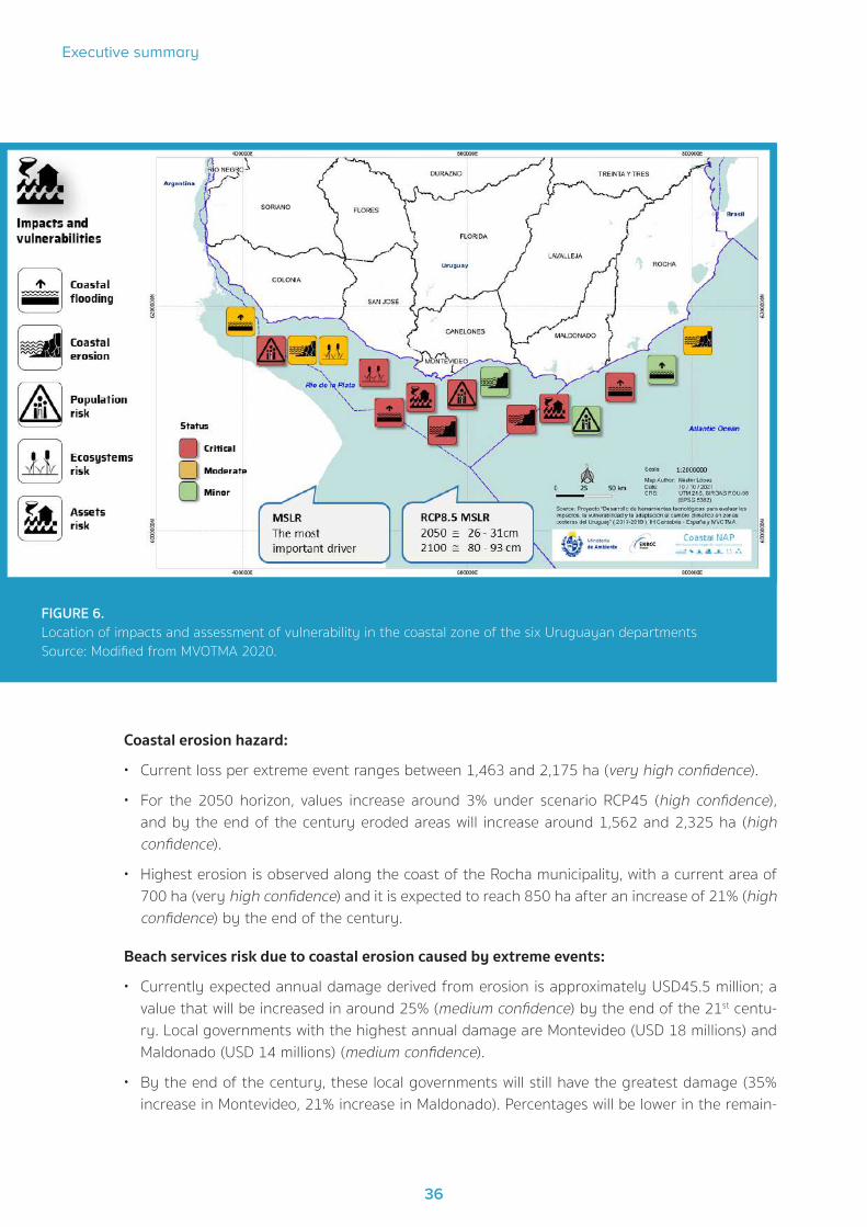
Risk in coastal ecosystems results from combining impact, exposure, and vulnerability in asso-ciation with forcing factors, which are affected by climate change and variability. The elements considered for coastal flood risk assessment in the Uruguayan coast were population exposure, constructed assets (homes, industries, services), critical infrastructures (airports, schools, ports, health centres) and ecosystems (threatened and critically endangered) (IH-CANTABRIA, 2018). The assessment of vulnerability and coastal risk levels are shown in Figure 6 illustrating the cur-rent coastal situation by administrative department.
Given that planning and implementation of adaptation measures have long-term time-scales and predictions have been made based on the analysis of possible scenarios of hypothetical social and economic growth (IPCC, 2014) - each with its specific uncertainties - the challenge is to reduce time-scales and properly convey information to decision-makers. For that purpose, consistency is essential. Even though the information generated has been scientifically accurate, we must bear in mind that adaptation policies and strategies must be based on data and models fit for each activity, providing an honest perspective of the uncertainties inherent to predictions made. Thus, following the IPCC approach, every mentioned risk had an additional concept assessment to express the level of confidence in the assertions (very low, low, medium and high confidence)3. Below are the main risks observed for the priority issues in the Uruguayan coast (IH-CANTABRIA, 2019 a,b,c):
Coastal flood hazard:
The currently flooded coastal area ranges between 7,000 and 12,000 ha, depending on the return period of the event under consideration. The flooded area increases as scenarios considered turn
3 Mastrandrea, M.D., C.B. Field, T.F. Stocker, O. Edenhofer, K.L. Ebi, D.J. Frame, H. Held, E. Kriegler, K.J. Mach, P.R. Matschoss, G.-K. Plattner, G.W. Yohe, and F.W. Zwiers, 2010: Guidance Note for Lead Authors of the IPCC Fifth Assessment Report on Consistent Treatment of Uncertainties. Intergovernmental Panel on Climate Change (IPCC).

COASTAL-NAP
35
pessimistic (RCP85) and time horizon grows (high confidence). An increase of 43% is expected by the end of the century - from 7,000 to 10,000 ha for a 5-year return period, and from 12,000 to 16,369 ha for a 500-year period. (medium confidence)
Population risk in case of coastal flood:
• Currently the number of affected people increases in connection with return periods of the extreme events under consideration (TR5 several hundred; TR500 several thousands) (medium confidence). Future projections for 2100 show that the number of people to be potentially af-fected is higher under scenario RCP85, increasing by 300% (medium confidence).
• The most affected local governments in the studied cases are Colonia, Canelones, San José, and Montevideo (high confidence).
Risk of constructed assets in case of coastal flood:
• Current damages increase in the return period of extreme events under consideration (TR5 USD 26 million; TR500 USD 65 millions) (medium confidence).
• Future damage projections increase in connection with time horizon, while for a single horizon (2100) the expected damage is higher under scenario RCP85 (very high confidence).
• Under any scenario, the greatest damage is observed on residential assets, corresponding to 50% of damage affecting all constructed assets. The second most affected category is services (very high confidence).
• Under horizon 2100, the damage will be increased in 49% (RCP45) and 185% (RCP85) in rela-tion to current status (high confidence).
• Of all assessed situations, the highest damage is expected in the Maldonado stretch of coast (very high confidence).
• In Montevideo’s coastal zone, risk is increased in 600% for the 2100 horizon under scenario RCP85 (very high confidence).
Ecosystem risk in case of flood:
• The currently affected area is about 500 ha of ecosystems regarded as vulnerable (medium confidence).
• Future scenarios will show an impact increase of 17% by 2050 and 40% under the 2100 hori-zon (medium confidence).
• Impact will be more intense in the municipality of Colonia (127%), followed by San José and Maldonado (75%) (medium confidence).
Risk assessment associated with coastal erosion included beaches as an element of exposure. Beaches were physically characterized according to their area, and economically characterized according to the protective and recreational services they offer. Beaches’ vulnerability was estab-lished as a relationship between eroded surface and percent of damage caused on each location.
36
Executive summary
37
Coastal erosion hazard:
• Current loss per extreme event ranges between 1,463 and 2,175 ha (very high confidence).
• For the 2050 horizon, values increase around 3% under scenario RCP45 (high confidence), and by the end of the century eroded areas will increase around 1,562 and 2,325 ha (high confidence).
• Highest erosion is observed along the coast of the Rocha municipality, with a current area of 700 ha (very high confidence) and it is expected to reach 850 ha after an increase of 21% (high confidence) by the end of the century.
Beach services risk due to coastal erosion caused by extreme events:
• Currently expected annual damage derived from erosion is approximately USD45.5 million; a value that will be increased in around 25% (medium confidence) by the end of the 21st centu-ry. Local governments with the highest annual damage are Montevideo (USD 18 millions) and Maldonado (USD 14 millions) (medium confidence).
• By the end of the century, these local governments will still have the greatest damage (35% increase in Montevideo, 21% increase in Maldonado). Percentages will be lower in the remain-
FIGURE 6. Location of impacts and assessment of vulnerability in the coastal zone of the six Uruguayan departments Source: Modified from MVOTMA 2020.

COASTAL-NAP
37
ing local governments (14% increase in Rocha, 10% in Canelones and Colonia, and 6% in San José) (medium confidence).
• From the perspective of recreational services provided by beaches, local governments of Mal-donado and Colonia currently show the highest damages (USD40,000 per year) (medium con-fidence). By the end of the 21st century the situation will be different, and the beaches along Rocha and Montevideo will show the highest increases (25 %) (medium confidence).
Beach services at risk due to structural erosion:
• By the year 2050, the beaches on the Uruguayan coast are expected to suffer damages amounting to USD6.59 million (medium confidence). According to the different scenarios, this will represent 0.6 % to 1.1 % of the total beach value (RCP45), and 5.7% to 11.2 % (RCP85) (medium confidence). All this damage will be mainly caused by reduction of protection services that sand dynamics provides to arc-shaped beaches (very high confidence).
• The greatest damage will occur on the Montevideo coastal area, potentially reaching between USD 11.4 million (RCP45) and USD 28 million (RCP85) by the end of the century (medium confidence). Under all scenarios, values for the Maldonado and Colonia coasts may vary from USD 24.4 to 13.5 million respectively by the end of the 21st century (medium confidence). By 2100, the coasts of Rocha and Canelones will suffer damage between USD 2.0 million and USD 5.7 million, while in San José damage is expected to be practically insignificant (medium confidence).
• By the end of the 21st century, damage caused by structural coastal erosion derived from the rise of the MSL may be as significant, or even more, than annual coastal erosion caused by extreme events (high confidence).
It is worth stressing that the most important effects that climate change and its variability may cause in beaches are the modification of flood levels and the retreat/advance of the shoreline. For a 2050 time horizon and under a pessimistic scenario (RCP85) the shoreline of all Uruguayan beaches will retreat ≤ 5 m; while by the end of the 21st century and for a medium increase of MSL, a great differentiation is observed in each stretch of the coast, with shoreline retreat ranging from 5 m to 20 m, particularly in fine-sand beaches and those with deep sea near the shore.

38
Executive summary
39

COASTAL-NAP
39
4Adaptation strategy

40
Executive summary
41
4. Adaptation strategy
4.1 Background
The National Policy on Climate Change (PNCC) was created in 2016 under this inter-institutional framework. This strategic document includes measures up to the 2050 horizon and the country’s short-, medium- and long-term action guidelines for adaptation and mitigation of challenges posed by climate change. The PNCC strategies and action lines, the National Policy on Integral Risk Management (PNGIR), the preparation of the National Adaptation Plan for the Agricultural Sector (NAP AGRO), the National Adaptation Plan for Coastal Areas (COASTAL-NAP), the National Adaptation Plan for Cities and Infrastructure (NAP CITIES), and the National Strategy for Reduc-tion of Emissions from Deforestation and Native Forest Degradation (ENREDD) are all examples of the political and inter-institutional priority given to climate actions and the United Nations Sustainable Development Goal 13 implementation in Uruguay.
The PNCC was the framework for the preparation of the First Nationally Determined Contribution (NDC) under the Paris Agreement, presented before the Conference of the Parties at the UNFCCC. This helped strengthen the national agenda by defining adaptation and mitigation measures, as well asstrengthen capacities and create knowledge about climate change. Policy monitoring and evaluation are currently a priority in Uruguay, as well as implementation of measures according to NDC and progress follow-up towards its goals. The country is strongly committed to achieving this implementation and the transparency of the process. Such objectives shall be achieved with national resources, while others may be achieved with additional specific means for their imple-mentation, as approved by Decree No. 310/017, on November 3, 2017.
4.2 Guiding principles
The coastal zone, where many Uruguayans live, will experience a full range of impacts from cli-mate change, In this context, an emerging challenge is to design initiatives that explicitly address climate change-driven problems. The National Climate Change Policy established the guiding principles to reduce vulnerability to impacts of climate change and variability in the coastal zone of Uruguay through ecosystem-based adaptation actions that minimize losses and damage to infrastructures and these natural ecosystems.
4.3 Main objectives
With the emerging necessity to adapt to climate change, Uruguay set the following objectives:
• Incorporate an adaptation perspective in the development and implementation of the coastal zone policy framework.
• Strengthen capacities at national, sub-national and municipal levels related to climate risk man-agement and adaptation in coastal ecosystems through of human resources training and spe-cific actions financing, as appropriate in terms of budgetary competencies at the respective government levels.

COASTAL-NAP
41
• Promote preservation of coastal natural spaces and processes threatened by climate change and variability.
4.4 Strategies for Risk Assessment at National and Local Levels
A national system (“Sistema Nacional de Respuesta al Cambio Climático y Variabilidad”, SNRCC) was created in 2009 to coordinate national policies, plans and actions related to climate change and its variability. The Ministry of Environment (MA) is in charge of this national system and is also the Chair to its coordination board, composed of other seven ministries - Ministry of Industry, Energy and Mining (MIEM); Ministry of Livestock, Agriculture and Fisheries (MGAP); Ministry of Economy and Finances (MEF); Ministry of Foreign Affairs (MRE); Ministry of Public Health (MSP); Ministry of Tourism (MINTUR); and Ministry of National Defence (MDN) - the Planning and Budget Office (OPP), the Congress of Governors (CI) and the National Emergency System (SINAE). Oc-casionally some other public bodies have been invited to participate: Ministry of Education and Culture (MEC), Ministry of Transport and Public Works (MTOP), Ministry of Social Development (MIDES), Ministry of Labour and Social Security (MTSS), the Uruguayan International Cooperation Agency (AUCI), and the National Institute of Meteorology (INUMET).
Both definitions on components and contents of COASTAL-NAP (Gómez-Erache, 2019) and crea-tion of knowledge have been developed through the above-mentioned inter-institutional coordi-nation at the SNRCC. General guidelines for knowledge incorporation and decision-making were defined on the COASTAL-NAP strategies, and actions (Figure 7) were focused on iterative mecha-nisms for consultation and adjustment, involving four levels of institutional participation. SNRCC guided the process and created a work group called “Adaptation in the Coastal Area”, composed of national institutions (DCC, DINAMA, DINOT, DINAGUA, MINTUR, UDELAR, IDEuy). Its goal was to integrate emerging national, local, and sectoral priorities and to prepare and/or validate technical drafts for the different components during the creation of COASTAL-NAP. Sub-national govern-ments were also consulted and participated in different ways, including training workshops aim-ing at improving understanding of vulnerabilities in the Uruguayan coastal zone.

42
Executive summary
43
As stated in the initial phase of the COASTAL-NAP elaboration process, SNRCC aimed at identi-fying impacts and assessing risks and vulnerabilities in the Uruguayan coastal zone in collabora-tion with the Hydraulics Institute of the University of Cantabria and the Faculties of Science and Engineering of the University of the Republic. The information generated established a baseline for coastal vulnerability for the first time in the country and was used to build future projections based on climate change scenarios.
In line with laws and policies and within the institutional framework described above, the prepara-tion of the COASTAL-NAP seeks to strengthen capacities and incorporate measures of adaptation to variability and climate change to the planning and management processes of national and sub-national government systems. For a five-year period (2015-2020), the COASTAL-NAP has maintained various consultation and training strategies for local governments along the Río de la Plata and Atlantic Ocean coastal area.
FIGURE 7. Flow of knowledge and definitions included in the elaboration of the Coastal National Adaptation Plan.(Acro-nym in Spanish; SNRCC: National Climate Change Response System; MA: Environment Ministry; DCC: Climate Change Direction; PNCC: National Policy of Climate Change; NDC: Nationally Determined Contributions; MRV: Monitoring, Report and Verification; MVOT: Ministry of Housing and Planning; MINTUR: Ministry of Tourism; MTOP: Ministry of Transport and Public Works; AGESIC: Agency for Electronic Government and the Informa-tion and Knowledge Society; SINAE: National Emergency System)
SNRCCCoordination Group
SNRCCCoastal ZoneAdaptationWorking Group
MA-DCCNational Focal Point to the UNFCCC
National/LocalGovernment
Academia, Private and Civil Society
Strategic guidelines documents PNCC, NDC, MRV
Proposed strategies for the implementation of the COASTAL NAP within national and
local policies and plans
Draft technical documents for the components of the COASTAL NAP process
MVOT, MA, MINTUR, MTOP, AGESIC, SINAE
Public ConsultationPNCC, NDC, MRV, Workshops / Interviews
COASTAL NAP, Workshops / Interviews
Consultation / Advice on the elaboration of
the COASTAL NAP
Approval of the COASTAL NAP
Recommendations regarding the technical and political contents
of the COASTAL NAP
Integrating national, local and sectoral priorities into the
COASTAL NAP
Townships and Municipalities Colonia, San José, Montevideo,
Canelones, Maldonado, Rocha
Incorporate inputs from all actors into the COASTAL NAP

COASTAL-NAP
43
COASTAL-NAP is a working method that acknowledges all concerns related to variability and climate change along decision-making processes. In this regard, this mechanism intends to cover all neces-sary structures required to generate knowledge to be applied when it comes to strategic planning.
Within the COASTAL-NAP framework, SNRCC is committed to enhance technical and institutional capacities at different levels, focusing on medium- and long-term planning, and implementation of adaptation measures on the coastal zone in the departments of Colonia, San José, Montevideo, Canelones, Maldonado and Rocha. COASTAL-NAP is a working method that acknowledges all con-cerns related to climate change and its variability during the decision-making processes (Figure 7). The methodology applied was underpinned by the IPCC (2014) general framework, evaluating risks on socio-economic and natural coastal systems, and integrating hazard, exposure, and vulnerability factors to current situation and to future horizons under different climate change scenarios.4
In order to implement their main objectives, national and local institutions must receive perma-nent strengthening of their capacities. Within this context, it is imperative for national govern-ment to consolidate platforms for knowledge and information sharing related to adaptation at all governance levels, as well as to secure academic and civil society networks. Consequently, Uru-guay started a consultation process to prepare COASTAL-NAP to consider the above-mentioned measures covering all necessary structures required to generate knowledge to be applied, when time comes, to strategic planning, including local, sub-national and national plans.
At local level, a cross-cutting look on these subjects may show how common priorities tend to group themselves into three wide policy-development processes: management of beach profile and dune ridges, recovery of public coastal space, and freeing-up or adaptation of spaces exposed to coastal flood events (Gómez-Erache, 2019). With an approach focused on factors such as urban network or growing tourism, municipal governments pay great attention to combating coastal erosion through civil engineering works or nature-based solutions. Where major engineering works are necessary, costs are a limitation for sub-national governments. Yet, action is required, and technical assistance is sought in studies that combine problem understanding with executive projects in order to imple-ment solutions. Additionally, between 2015 and 2020, alternative ecosystem-based solutions have been significantly developed, thus spreading these policies throughout the territory.
Adaptation processes in urbanized coastal floodplains show partial progress and strong tensions in management. Although the formal network no longer spreads over flood-prone areas, it is current-ly difficult to reverse or mitigate problems in risk areas where it did consolidate since the 1990s.
Each municipality has its own particular situation regarding current institutional development of coastal working teams, leading to different degrees in their requirements. Local governments in earlier stages of such development did not create any specific unit to address coastal issues (Colonia, San José), while technicians involved in its management request its creation and specific funding in the municipal budget to ensure the continuity of the appointed staff (beach team leaders in San José; experts in hydraulic engineering in Colonia). Besides suitable staff for manag-
4 Financial support for the preparation of the National Adaptation Plan for coastal areas climate change was granted by the Spanish Agency for International Cooperation - AECID, (Spanish acronym) under project ““Strengthen Uru-guay’s capacities to adapt to the effects of Climate Change in the coastal zone” , the Climate Technology Centre and Network (CTCN) under project “Development of technology tools for the assessment of impacts, vulnerability and adaptation to climate change in the coastal zones of Uruguay”, Green Climate Fund (GCF) under projects “Inte-grating adaptation into cities, infrastructure and local planning in Uruguay Project” and “Institutional and technical capacity building to increase transparency under the Paris Agreement”. Additional support was provided in the form of a digital terrain model used for the coastal area vulnerability study by the E-Government and Information and Knowledge Society Agency - AGESIC(Spanish acronym) through the decentralized agency of the Presidency of the Republic “Spatial Data Infrastructure” (SDI).

44
Executive summary
45
ing and impact evaluation tasks on the coastal zone, there are basic needs that must be covered in equipment availability for urban works (Gómez-Erache, 2019). The municipality of Rocha is a good example of effective implementation at this basic level, with a coastal administrative unit run by individuals responsible for coordinating management and coastline intervention actions, among the heads of the corresponding departments at each municipality.
Canelones and Maldonado are an example of a second-level development stage, where units integrate staff qualified in coastal issues, include climate change adaptation measures in routine activities, have a greater budget and explicitly mention the need for more personnel. Closely as-sociated to this situation, they also set forth the need to create a national policy to ensure coastal actions (Gómez-Erache, 2019).
Montevideo has a better internal organization, and the developed structure is better adjusted to the tasks challenges. Lack of personnel is not mentioned as a problem, and strategies for tpreser-vation of beach profiles and ridge of dunes are well consolidated (Gómez-Erache, 2019). Accord-ing to the technical staff assigned to coastal management in the different local governments, the basic problem is the gradual shift in the institutional agenda towards new coastal concerns, such as impact of climate change and variability. Under these circumstances, no specific assignments can be identified in each coordination unit for addressing such issues and, therefore, neither is specific budget allocated. In this context, actions are underpinned by political will rather than by consolidated regulations, institutional structure and budgets which may transcend different administrations and be a constitutive part of sub-national governments.
4.5 The Context of coastal adaptation in Uruguay
Well-designed adaptation strategies require that options under consideration be technically and economically feasible, as well as socially and politically acceptable. Nevertheless, there are many limitations that usually make it very difficult to apply planning and implementation measures on adaptation to climate change in Uruguay (Gómez-Erache, 2019). The characterization of future climate risks enables the identification of possible adaptation deficiencies and immediate actions:
• Reduction of environmental vulnerability derived from rising of sea-level
• Monitoring and maintenance of functioning and health of coastal ecosystems
• Decrease of costs associated with disaster response and restoration operations
• Protection of critical infrastructure from variability and climate change impact
• Minimization of economic loss derived from variability and climate change impact
• Lowering of damage to natural environment and loss of public access through adaptation to variability and climate change
• Scaling-up of public awareness of variability and climate change impact on coastal areas
• Improvement of technical capacity for projecting variability and climate change impact
• Granting sub-national government and municipality leadership in climate change adaptation processes
• Enhancement of intra- and inter-institutional collaboration and coordination

COASTAL-NAP
45
Its territorial scale and the fact that Uruguay has a unitary government system enable a closer approach to sub-national governments for building coastal adaptation strategies on balanced perspectives. It also allows for mutual feedback between national government priorities for coast-al project management and priorities determined by sub-national and coastal zone communities.
4.6 Adaptation capacities, gaps and needs
The origin of main barriers for implementation of future climate adaptation processes in Latin American countries has been identified to be weakness in many areas such as attitude, social behaviour, knowledge, education and human capital, financing, governance, institutions and pol-icies, together with low capacity for adaptation and development (Rosas et al., 2018). Some of the technical limitations identified are; lack of quality data or lack of access to existing data, lack of standardized criteria, methodologies and tools for assessing climate change risks and imple-menting adaptation measures or establishing metrics and procedures for evaluating adaptation processes. Among institutional and social barriers, it is worth mentioning the issues with relevant national and local competences in the coast, the lack of sufficient knowledge and capacities to address the problem derived from the lack of qualified human resources for climatological and hydrological modelling. A particular case is the poor quality of climate observations and the lack of robust continuous monitoring systems on the coastal zone.
Furthermore, in Uruguay, identified technical barriers to face impacts of climate variability and climate change on coastal area included lack of quality data or lack of access to existing data, methodologies and tools for assessing climate change risks and implementing adaptation meas-ures or establishing metrics and procedures for evaluating adaptation processes. Other barriers included coordination between national and local levels and lack of qualified human resources.
According to Uruguayan Act No. 9515/1935, the mission of sub-national governments includes ensuring conservation of maritime and river beaches. The first assessment of municipal govern-ment budget allocation to coastal management was carried out in Maldonado (Piaggio, 2015 a y b), specifically in Punta del Este, resulting in USD328,066 invested in 2014. Additionally, for 2010 and 2014 the investment increased by 8% (annual average of 1.7%) in items such as “beach cleaning” and “beach accessibility”, accounting, respectively, for 45% and 34.6% of the annual total. Items associated with implementation of climate change adaptation measures (sand dune fixation) ranged between 15% and 21% of the annual total expenditure throughout a five-year term. It could also be observed that licensed services related to coastal activities (collapsible paradors, water sports, etc) correspond to 84% to 93% of coastal restoration total (2010-2014), showing a high reinvestment rate by Maldonado’s municipal government.
An economic impact assessment could be carried out for the Uruguayan coast from a recent risk and vulnerability analysis (IH-CANTABRIA, 2019 d). Integration of different return periods applied resulted in an expected annual damage risk indicator for each scenario (RCP4.5, RCP8.5). So far, a total of USD9 million was the resulting value of climate impact on the coastal zone. This cost will increase to USD11 million for the 2050 horizon, amounting to USD15 million by the end of the 21st century under RCP4.5 and over USD20 million under RCP8.5. Disaggregation of this result according to types of assets shows that the greatest damage (50%) will be on residences, as they are on the coastal frontline.

46
Executive summary
47
4.7 Adaptation lines of action at national and sub-national levels
Climate change and its variability have an adverse impact on the coast and its infrastructure. Managers and residents, as well as their means of livelihood, ecosystems, and services, are ex-posed to extreme events and to a rising sea-level. Through the MA’s National Division of Climate Change (DCC), the Uruguayan Government has seen the need to evaluate risk assessment and prioritize adaptation measures including them in the institutions’ own coastal zone management systems, both at national and at local levels.
Understanding local climate change impacts is an inherently dynamic process, and permanent evaluation and adjustment are necessary to propose effective adaptation measures. During seven years (2012-2019), DCC has focused on promoting reduction of existent gaps in knowledge and diagnosis of coastal vulnerability by means of public consultation activities in need of adaptation measures. This was co-coordinated with several municipal governments and led to 33 workshops to assess the perception of local stakeholders, the messages from the scientific community, and to design the climate change adaptation response. A total of 210 actions were identified, of which 33% referred to strengthening capacities at sub-national governments, 26% focused on coastal spatial planning, and 25% proposed the creation of knowledge and the search for technological solutions. Five strategic lines of action have been agreed so far within the framework of COAST-AL-NAP, and progress has been achieved in the design and implementation of specific actions:
1. Deeper knowledge and search for technological solutions. Action has been taken to ob-tain better knowledge about coastal processes and their relation with variability and climate change, both in general (e. g., studies focused on coastal zone vulnerability caused by the combination of sea-level rise and climate extremes) and with a sectoral perspective (e. g., eco-nomic assessment of coastal assets).
2. Stronger capacities to reduce vulnerability. The SNRCC work group for coastal issues has promoted inter-institutional coordination to solve technical challenges (shoreline definition, adjusted digital terrain model, gathering of historical data on coastal dynamics), establish methodologies for impact selection (set of combined methods for qualitative, statistical and spatial analysis, identification and selection of a defined amount of priority impact chains to set limits and focus on), transfer knowledge and raise awareness on climate change (training aimed at different communities involved in the implementation of adaptation measures, high-rank professional and technical local decision-makers).
3. Coastal spatial planning. Goals for 2030 have gradually incorporated adaptation through elaboration of national plans (National Environmental Plan for Sustainable Development, Na-tional Strategy for Sustainable Cities). Municipal Governments have worked under an interdis-ciplinary perspective in including coastal adaptation to these territorial planning instruments (local plans, PLOT), urban planning (Montevideo Resiliente), management plans for protected areas (protocol for the opening of the Laguna de Rocha bar), and in updating coastal infra-structure design standards (criteria for classification of housing construction projects along the coastal defence strip, MVOT).
4. Tourism management. Development strategies have been prepared for a sustainable tourism industry that will prove resilient to climate change (“Sello Verde Turístico”, MINTUR). These

COASTAL-NAP
47
strategies entail the incorporation of the sector to workshops on assessing perception of vulnerability in the coastal zone derived from variability and climate change and supporting the development of tourism in coastal areas of interest in terms of conservation of beach ecosystems.
5. Restoration and recovery. They involves the implementation of specific measures for re-covering dune systems (Kiyú), management of rain drainage (Punta del Diablo, Kiyú, Juan Lacaze, Ordeig), beach accessibility (beaches in Canelones and Maldonado), and recovering eroded areas (beaches and ravines in Colonia, San José, Montevideo, Canelones, Maldonado and Rocha).
The execution of an agenda of short-, medium- and long-term actions will prove, for the first time in the country, that the construction of a participative and inter-institutional model is capable of increasing the resilience of communities and coastal ecosystems subject to vulnerability and climate change. Through participatory processes of co-management of information and knowl-edge generation through cooperation between international and national researchers, technical and professional staff from the Ministry of Environment, the Ministry of Tourism, the Ministry of Transport and Public Works, local governments, environmental NGOs, students and citizens, the country managed to develop information and capacities to meet the needs for analyzing climate information and selecting and implementing adaptation measures in coastal areas.
The improved national database and information systems on variables associated with marine dy-namics (wind, pressure, waves, meteorological tide, and sea-level), including high temporal reso-lution information, also serves as reference for integrated coastal zone management, operational oceanography, infrastructure construction, coastal zone risk management, ecosystem resilience and tourism management.
4.8 Adaptation measures
The coastal risk assessment described above under an innovative methodology in Uruguay (IH-CANTABRIA, 2019c) leaves the country in the best possible conditions for implementing short-, medium- and long-term adaptation measures. Variability and climate change have prov-en to impact locations differently. Likewise, local needs will be different when addressing these issues. Consequently, there is a wide range of options for adaptation measures, many of which are not comparable in terms of intended effect nor in their time or spatial scales. The methodol-ogy applied to identify and implement adaptation measures shall be a tool to improve and select measures more effectively, and needs to be supported by a technical framework that takes social, political and economic criteria into consideration.
Best practices are to be potentially effective, fair, and legitimate. Adaptation to climate change means strengthening processes that permanently create capacities in all stakeholders. Such ca-pacities must be related with local knowledge of the different actors and sectors to directly affect decision-making processes, which must be transparent and based on reliable and quality data.
Within this context, identifying measures that comply with adaptation planning objectives include considering options that would meet existing policies and/or plans, while also contemplating al-ternatives that may require an innovative approach. Sometimes, plans may easily fit or overlap

48
Executive summary
49
with existing planning measures. In other cases, however, there may be a need to review existing actions, making climate change the new context for decision-making, or new actions and man-agement objectives may prove necessary. In any case, identifying specific actions helps under-stand the needs of stakeholders and may encourage political, public, and financial support.
In Uruguay, a set of realistic measures to address risks assessed was selected, and needs were identified in relation to implementation of such measures (including public support for measures and necessary institutional changes, or national and sub-national financial and planning man-agement). To date, there is a consensual set of adaptation measures which may be applied along the coastal zone in general, while still in line with the results of vulnerability and isk assessments described above. These measures have been sorted depending on whether they are meant for intervention on coastal territory or for general implementation processes. Depending on their structural typology, they are grouped as physical, social, or institutional. COASTAL-NAP focused on a limited set of essential measures (Table 1). There are proactive measures which intend to preserve and protect resources anticipating climate change impact (anticipatory measures), and reactive measures, which are applied as a result of the observation of climate change effects (es-tablishing surveillance methods to identify changes), as part of reconstruction after natural dis-asters, of local communities joining action, or at the availability of extra or emergency resources.
Permanent strengthening of local and national institutional capacities is required to implement such adaptation actions. Within this context, the Uruguayan Government finds it imperative to consolidate platforms that enable knowledge and information sharing related to adaptation at all governance levels, as well as to build up networks with academy and social organisations. The methodology applied during the creation of COASTAL-NAP helped implement an iterative knowl-edge update on coastal vulnerability mainly focused on strengthening institutional frameworks to address long-term adaptation.
The NAP Costas is integrated into the Strategy and Action Plan on Gender and Climate Change, which implies that adaptation measures have been categorized according to their potential im-pact to reduce gender and generation gaps, and recommendations are made to reverse these inequalities.5
5 https://www.gub.uy/ministerio-ambiente/politicas-y-gestion/estrategia-genero-cambio-climatico

COASTAL-NAP
49
Table 1. Climate change adaptation measures in the Uruguayan coastal zone. The sixty
measures were classified into those directly implemented in the territory and those that en-
able adaptation processes. Three categories are recognized: physical structural, social and
institutional. Source: MVOTMA (2019).
Categories Subcategories INTERVENTION MEASURES IN THE TERRITORY
Physical structures
Engineering
Assessment of infrastructure in highly vulnerable areas, identifying those that are obsolete or that may cause coastal erosion processes.
Elimination of hard and/or soft coastal structures to recover the system and move towards natural functioning.
Establish a procedure for revision and maintenance of coastal infra-structures exposed to the SLR, at national level.
Introduce the effect of climate change in the design of new coastal infrastructure during the lifespan of the works.
Develop recommendations for highly vulnerable areas to avoid fu-ture hard infrastructure interventions without prior studies incor-porating climate change scenarios.
In the implementation of adaptation measures for beaches and es-tuaries consider:
• Incorporating nature-based solutions
• Developing design and construction protocols adapted to nation-al reality when applying traditional measures (soft, hard, hybrid)
In the implementation of adaptation measures for harbours:
• Operational and structural risk analysis and assessment of har-bours incorporating CC scenarios.
• Study on the reconditioning or adaptation of critical infrastruc-tures that have been compromised.
In the implementation of adaptation measures for other structures (e.g., esplanades):
• Analysis and evaluation of operational and structural risk of es-planades incorporating CC scenarios.
• Generation of a protocol for the design and execution of new in-frastructures, alternative to rigid works and resilient approaches.
Sustainable Urban Drainage Systems (SuDS)
Protect and adapt drainage systems (rainwater, sewerage net-works) to the possibility of flooding, especially in areas of gullies and river and stream mouths.
Design and installation of sustainable drainage devices (filled ba-sins, drains, flow dampers, roads) at coastal basins level and on sections of coast with high slopes (3-5% in the last 500 m).

50
Executive summary
51
Physical structures
Technology
Identifying, evaluating and monitoring impacts caused by extreme hydro-climatic events.
Early warning and response systems for extreme weather events, windstorms, and heavy rainfall.
Adaptive management of bar opening at the mouths of rivers, streams and lagoons in the coastal zone.
Artificial sand recharge by refilling coastal banks on highly vulner-able sections.
Implementation of drainage devices including filled ditches, rolling wetlands, infiltration plots, incorporating coastal aquatic vegetation.
Nature-based solutions (NbS)
Renaturation of ravines and coastal wetlands as part of the design of sustainable urban drainage systems.
Floodplain restoration and reconnection.
Restoration and conservation of coastal psammophilous forest as-sociated with dune and wetland systems in the coastal zone.
Protection and restoration of coastal wetlands
Management of exotic species (acacia, eucalyptus, pines) to reduce risk of falls and fires and facilitate dune regeneration.
Reduced risk of damages and economic loss
In partially affected areas introduce the necessary spatial plan-ning by introducing studies of vulnerability to the effect of climate change and apply adaptation measures to the infrastructure asso-ciated with the area.
Categories Subcategories ENABLING MEASURES
Social Capacity-building
Basic specialised training in risk management and early warning systems.
Participatory development, validation, and implementation of warn-ing systems for extreme events (winds and rainfall).
Training of OCS, nurseries, landscapers in NbS, restoration and con-servation of coastal ecosystems.
Training of technical teams from sub-national governments for the design, implementation and maintenance of sustainable road and drainage infrastructure.
Continuous training programme on:
• Dynamics of beaches and river mouths
• Calculation and assessment of natural risks

COASTAL-NAP
51
Social
Capacity-building
Generation of an information system for the calculation of risks that includes:
• Comprehensive system for monitoring beaches (coastline, pro-files, granulometry) at high frequency and in the long term
• Integral monitoring system of the evolution of river mouths (riv-ers, streams, and coastal lagoons)
• Integrated system for monitoring flows in coastal lagoons.
• Wave and wind measurement system, particularly in areas with non-existent information
• Operational system for level and wave prediction. Systematic up-date of database
Information
Generation of high-resolution database for the formulation of indi-cators to monitor impacts, vulnerability, and adaptation.
Generation of georeferenced population data and indicators of social vulnerability (single-parent households headed by women, housing deficit, public childcare services).
Preparation of hazard, vulnerability and risk maps for sectors iden-tified as vulnerable.
Preparation of coastal flood maps in urban centres along the coast-al zone.
Development of new high-resolution projections focusing on up-dated climate scenarios for the Uruguayan coast.
Coordination of research agendas together with national and local government managers as well as with institutions and non-gov-ernmental organizations to define the areas of knowledge to be strengthened and to generate research products that facilitate de-cision-making.
Protocols for evacuation and/or relocation of populations affected by flooding in the coastal area.
Public awareness and technical assistance
Diversification of activities in coastal areas to mitigate the impact on sun and beach tourism, addressing differential needs based on gender and generations.
Incorporation of good practices associated with climate change ad-aptation into tourism management in the coastal area in coordina-tion with the private sector.
Keep media, academia and general public informed about climate change, technological tools, measures and instruments for adapta-tion, as well as successful stories and lessons learned.
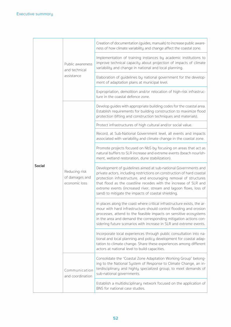
52
Executive summary
53
Social
Public awareness and technical assistance
Creation of documentation (guides, manuals) to increase public aware-ness of how climate variability and change affect the coastal zone.
Implementation of training instances by academic institutions to improve technical capacity about projection of impacts of climate variability and change in national and local planning.
Elaboration of guidelines by national government for the develop-ment of adaptation plans at municipal level.
Expropriation, demolition and/or relocation of high-risk infrastruc-ture in the coastal defence zone.
Reducing risk of damages and economic loss
Develop guides with appropriate building codes for the coastal area. Establish requirements for building construction to maximize flood protection (lifting and construction techniques and materials).
Protect infrastructures of high cultural and/or social value.
Record, at Sub-National Government level, all events and impacts associated with variability and climate change in the coastal zone.
Promote projects focused on NbS by focusing on areas that act as natural buffers to SLR increase and extreme events (beach nourish-ment, wetland restoration, dune stabilization).
Development of guidelines aimed at sub-national Governments and private actors, including restrictions on construction of hard coastal protection infrastructure, and encouraging removal of structures that flood as the coastline recedes with the increase of SLR and extreme events (increased river, stream and lagoon flows, loss of sand) to mitigate the impacts of coastal shielding.
In places along the coast where critical infrastructure exists, the ar-mour with hard infrastructure should control flooding and erosion processes, attend to the feasible impacts on sensitive ecosystems in the area and demand the corresponding mitigation actions con-sidering future scenarios with increase in SLR and extreme events.
Incorporate local experiences through public consultation into na-tional and local planning and policy development for coastal adap-tation to climate change. Share these experiences among different actors at national level to build capacities.
Communication and coordination
Consolidate the “Coastal Zone Adaptation Working Group” belong-ing to the National System of Response to Climate Change, an in-terdisciplinary and highly specialized group, to meet demands of sub-national governments.
Establish a multidisciplinary network focused on the application of BNS for national case studies.

COASTAL-NAP
53
SocialCommunication and coordination
Identify and promote spaces for public participation and consulta-tion with a gender and generational perspective.
Develop strategies to raise awareness of managers and technicians in different areas of public administration (Ministries of National Defence, Transport and Public Works, Energy).
In coordination with secondary education authorities, develop mate-rials including potential effects of climate change on the coastal area.
Economic evaluation of built coastal assets.
Institutional
Incentive structure
Allocate funds for coastal restoration, conservation, and monitoring with the participation of the third government level, private sector and Civil Society Organizations.
Collect physical and socio-economic data focused on a better com-prehensive understanding of social, housing, infrastructure, and loss and damage vulnerabilities.
Review regulations of Spatial Planning Instruments about land oc-cupation and other urban planning parameters, with an impact on rainwater drainage and erosion (catchment structures and control of property flow, water rights).
Regional and local plans and regulatory instruments
Establish, in the Management Plans of Coastal-Marine Protected Areas, that criteria for technical evaluation of actions in risk zones are incorporated considering climate change effects.
Review of Spatial Planning Instruments’ regulations referring to ba-sins transfer in order to improve conduction towards points of less vulnerability to erosive processes.
Combine different land use regulations (National Coastal Space Guidelines, Land Use Planning Instruments, Strategic Environmen-tal Assessment, Environmental Impact Assessment) and develop guidance to ensure that coastal development does not inhibit natu-ral inland migration of coastal resources. Request feasibility studies on the use of soft-shell techniques (BNS) to reduce environmental impacts to urban development initiatives.
Assessment of coastal ecosystem services and their incorporation into land-use planning instruments
Government Policies and Programmes
Encourage implementation of integrated coastal zone management including potential effects of climate change as another element to be considered.
Encourage introduction of climate change effects in Maritime Works Recommendations and other standards applicable to infra-structure in highly vulnerable areas.

54
Executive summary
55
4.9 Long-term strategy for implementing adaptation at national level
COASTAL-NAP established a national-level monitoring and evaluation process to assess whether strategy instruments and measures lead the country towards achieving its goal of reducing vul-nerability and maintaining and improving adaptability of natural, societal and economic systems to the unavoidable impacts of global climate change.
To ensure long-term sustainability of the uptake of climate modelling and vulnerability assess-ment technology, Uruguay has developed shared-ownership platforms: National Environmen-tal Observatory; NDC Tracking System Viewer) for the exchange of information and knowledge among all government levels with and between academic and civil society networks. These plat-forms ensure continuous engagement of the different stakeholder groups in the use and further development of technology.
A monitoring system comprising 40 indicators organized across sixty measures was classified into those directly implemented in the territory and those enabling adaptation processes. Three categories are recognized: physical structures, social and institutional. Notably, the system makes provisions for cases where there is unavailable data or insufficient quality, allowing case studies or proxy indicators to be used until the required data becomes available.
In line with an adaptive management policy, COASTAL-NAP had to proceed despite information being incomplete and keep reviewing and updating the plan as information and experience in adaptation were obtained. All along the process, national and sub-national governments may choose to identify easy implementation fit for short-term action adaptation measures or identify a set of more substantial long-term measures that include options with lower regret levels. To date, Uruguay has a portfolio of adaptation measures ready to be executed in the short- and long-term. The monitoring and evaluation system consists of four components:
1. Elaboration of Municipal Agendas for Climate Change Coastal Adaptation , implementing actions that acknowledge climate change in spatial planning instruments and incorporate var-iability and climate change dimensions to local spatial planning and management of coastal marine protected areas.
2. A national vulnerability assessment conducted every three years to monitor changes in vulnerability over time. It has been developed in close cooperation with stakeholders and ac-ademia. This action will specifically concentrate on studies on the combined effect of coastal vulnerability and rising sea level, increasing intensity and frequency of climate extremes. It will also determine physical, environmental, economic, and human impact thresholds and develop technological solutions to effectively protect coastal morphology.
3. An evaluation report, published every five years, to inform the process of updating COS-TAL-NAP. This evaluation is based on additional information about experiences and progress made, considering qualitative information and stakeholders feedback beyond indicators.
4. Strengthening capacities for climate change risk reduction by coordinating national, and local policies, and training local managers, specifically establishing systems for monitoring and disseminating information in the coastal zone.

COASTAL-NAP
55
These four components together provide for a well-informed review of the Adaptation Action Plan every five years. Nevertheless, permanent strengthening of local and national institutional capac-ities is required to implement such adaptation actions.
Within this context, the Uruguayan Government finds it imperative to consolidate platforms to share knowledge and information regarding adaptation at all governance levels, as well as to se-cure academic and civil society networks. Consequently, Uruguay started a consultative process to prepare COASTAL-NAP together with all above-mentioned measures and covering all necessary structures for generating knowledge that will be applied when it comes to strategic planning, including local and sub-national plans.
The financing strategy for the development of COASTAL-NAP was centered on donor funds from international cooperation. As a result, AECID, through its EUROCLIMA+ programme, CTCN with IH-Cantabria as implementing partner, and GCF NAP-CITIES project supported it. The successful uptake of climate modelling technology has not only enabled Uruguay to develop its COAST-AL-NAP, but also to enhance its capacity and secure funding for COASTAL-NAP implementation. Therefore, the technology uptake has directly resulted in the achievement of two of the country’s key NDC targets on adaptation. Therefore, funding sustainability for implementing adaptation measures will require combining national government’s commitment (MA, MTOP, and OPP) and sub-national governments (Colonia, San José, Montevideo, Canelones, Maldonado, Rocha) by al-locating sustainable funds.
4.10 Strategy for consultation and participation
The efforts to incorporate and apply climate change adaptation measures are often resisted. Such incorporation calls for agreements with a wide range of organizations and groups, each with its own policies and interests. Thus, it may take a long time and pose a real challenge. A certain amount of resistance is simply inherent to any new management proposal. In the case of climate change adaptation, it is exacerbated as a result of its cumulative nature and long-term time frame to see its effects. The fact that people and organizations have different interpretations of the uncertainties about climate change and its impact results in dissimilarities in risk-tolerance levels and makes it a little more complicated. Consequently, understanding local impacts of climate change is an inherently dynamic process, and permanent evaluation and adjustment are neces-sary to propose adaptation measures.
Managers have substantial flexibility and discretion when selecting coastal adaptation strategies. Yet, this flexibility and discretion are not unconstrained; various policy and guidance documents (ECOPLATA 2000; FREPLATA 2004, 2005 a y b; Nagy et al 2006 y 2007; GEO URUGUAY 2008; Gómez-Erache 2019; Zentella 2015; MVOTMA 2019; MVOTMA-UDELAR 2019) contain additional considerations that should be incorporated into coastal managers’ decisions about adaptation alternatives. With the emerging necessity to adapt to climate change, Uruguay has started de-signing and implementing adaptation initiatives of different types, scales, and coverage. These initiatives manage anticipated climate change risks at national, sub-national, and local/commu-nity levels. Some focus on developing system-wide local capacities aimed at analyzing, planning, and implementing a range of priority actions that strengthen resilience of key stakeholders and institutions against anticipated climate change risks.
56
Executive summary
57
COASTAL-NAP has focused its strategy on developing six pilot proposals for the implementation of adaptation measures at local level (Table 2). Each sub-national government defined the area of action considered vulnerable in the coastal risk assessment, established a working group at local level, reviewed and systematized existing information, and designed the project to implement adaptation measures. Adaptation includes a range of potential responses, including resisting change, accommodating change, and directing change towards a specific desired new future.
The implementation of the six pilot projects allowed to:
1. Test how a set of policy measures may contribute to social benefit. Disclosure of results to publicly inform what is crucial in a success application of climate change adaptation measures on a broader scale.
2. Build trust by addressing simple issues first; this allows more controversial or unclear issues to be addressed later.
3. Perform further research on coastal vulnerability assessment and reveal its results to raise awareness on existing risks, their causes and solutions.
4. Encourage addressing common interests and threats collectively rather than taking specif-ic measures that favour radical positions.
5. Involve a broad range of stakeholders when assessing coastal vulnerabilities in all the pro-cess stages. All leading institutions and significant stakeholders must participate or be in-formed of any progress so that they feel identified with it and become active associates in the application stage.
In Uruguay, there is a high degree of involvement of decision-makers and technicians from var-ious ministries involved in the coastal zone management. The same is true for managers and technicians from sub-national governments. Assessments of coastal evaluation in pilot locations from the six coastal local governments are available and efforts have been made on adaptation measures, both cross-cutting and site-specific, and on creating monitoring indicators for vulnera-bility and effectiveness of adaptation measures.

COASTAL-NAP
57
Table 2. Strategy on developing six pilot proposals for the implementation of adaptation
measures at local level.
TASKS ACTIVITIES
Define project scope
Define stakeholder context (who needs to be involved for what purposes given the objective of designing an adaptation initiative)
Review the effectiveness, opportunities and gaps for key governance and institutional systems to facilitate adaptation
Review the existing enabling environment and policy formulation and implementation process for entry points in order to promote adaptation
Define the NAP objectives and expected outcomes
Develop a communication plan.
Establish project team Select an inter-disciplinary team to design the project
Review and synthesize existing information on vulnerability and adaptation
Review and synthesize existing information on vulnerability and climate change risk, including gender and generation analysis, based on previ-ous studies, expert opinion, and policy context
Describe policies and measures in place that influence the ability to successfully cope with climate variability as well as manage long-term climate change likely implications
Identify indicators of vulnerability and adaptive capacity
Design project for adaptation
Select approach and method for formulating an adaptation initiative that is operational and financially viable
Describe process to integrate future vulnerability and adaptation as-sessments findings, and to implement options and recommendations into the design of local adaptation initiatives, including gender and gen-eration analysis.
Develop monitoring and evaluation plan for the project
Develop terms of references for local adaptation projects implementation
Climate change adaptation is not a stand-alone plan, but should be addressed on ongoing, rou-tine planning processes such as foundation documents, general management plans, resource stewardship strategies, and preparedness planning. Adaptation is most effective when it is inten-tionally and deliberately designed as a response to anticipated effects associated with climate change and selected strategies may require a series of decisions and actions that will change over time.
It is worth mentioning that a gender perspective factor was added to the consultation process in order to ensure a balanced participation of both men and women, while the youth’s perception was also considered. This is a result of making sure that the calls to participate in local consulta-tion workshops explicitly posed the need of having both genders equally represented. Facilities ensured enough space and accessibility to all, and the incorporation of schools ensured the par-
58
Executive summary
59
ticipation of young people. Specific activities were carried out to raise awareness of women who are the head of single-parent households to demonstrate why it is more challenging to involve them in climate change adaptation processes.
Moreover, technology enabled the assessment of physical vulnerability from which the potentially affected social composition could be determined. In addition to the general impact on housing, the alteration of coastal space also becomes relevant because it serves recreational purposes and as a transit area to essential services, including health, education and access to employment areas.
A gender-sensitive analysis was crucial to analyse differential uses and precisely determine who will be affected so as to define social vulnerability based on a process that integrates popula-tion’s needs according to their specific reality. For the gender analysis, a methodology for the collection of statistical data disaggregated by sex has been applied together with secondary documentation, as well as techniques of focus groups and interviews with key actors. In addition, a gender approach allows to measure inequalities in access and control of resources as well as in decision-making in decision-making participation in the coastal area. Lastly, a proposal for risk mapping promoted gender and generational awareness, and different tools enabled a bias anal-ysis on the exposure to extreme events

COASTAL-NAP
59
5Final Remarks

60
Executive summary
61
5. Final Remarks
Addressing climate issues in Uruguay has been characterised by the implementation of a cross-cut-ting public policies approach. Since the approval of the National Policy on Climate Change ap-proved in 2016, the country has been giving priority to climate action, anticipating measures for the short-, medium- and long-term, with the purpose of guiding mitigation and adaptation actions (Nationally Determined Contribution, 2017).
The Paris Agreement highlights the importance of technology for implementing mitigation and adaptation actions. Since 2018, the Uruguayan authorities with the involvement of the cooper-ating agencies of AECID, CTCN Advisory Board and GCF6 have identified areas for collaboration and activities to ensure technological transference. To date, identified technical barriers to face climate change impacts on the coastal zone include lack of quality data or lack of access to exist-ing data and lack of standardised criteria, methodologies and tools for assessing climate change risk and implementing and evaluating adaptation measures.
Among the institutional and social barriers, it is worth mentioning the issues with relevant national and local competences in the coast and the lack of sufficient knowledge, capacities, and qualified human resources to address the problem. A particular case is the poor quality of climate obser-vations due to the lack of a long-term robust continuous monitoring system on the coastal zone.
Generated knowledge is mostly oriented towards interpreting the observed climate variability, developing climate change scenarios, and modelling coastal flood and erosion processes derived from the rise of sea level and extreme events at national and departmental levels. Those studies assessed climate variability and climate change within the national territory, and added research on how observed and projected changes increase vulnerability and risk on the coastal zone. At the same time, they enabled us to substantiate assessments on consequences and costs implied from inaction when implementing adaptation measures for different climate change scenarios.
Historical databases as well as high-resolution risk dynamics projections prepared by IMFIA re-searchers were necessary for local-scale impact quantification (IMFIA, 2018). A new analysis was hence designed using simulated data on winds and atmospheric pressure, creating a regional atmospheric model. At the same time, a wave propagation model and another one for currents generation were created using topographic data (Digital Terrain Model, IDEuy) and coastal bathy-metric and wind data. Simulations on these models generate databases that are then validated with instrumental observations in the country, making it possible to infer changes in dynamics under climate change scenarios (IH-CANTABRIA, 2019 a). Variability observed in Uruguay’s cli-mate was also analysed, temperature and rainfall climate trends were identified based on the projection of climate models for potential changes during the 21st century (Barreiro et al., 2019).
Due to the analysis’ high resolution (4-metre spatial resolution for flood cases, beach-level for erosion analysis), proposed maps have been generated at different scales without losing infor-mation or analytical capacity. Proposed scaling levels are: national (the entire Uruguayan coast),
6 The National Adaptation Plan for coastal areas climate change was financed by the Spanish Agency for International Cooperation (AECID, acronym in Spanish) under project “Strengthen Uruguay’s capacities to adapt to the effects of Climate Change in the coast-al zone” , the Climate Technology Centre and Network (CTCN) under project “Development of technology tools for the assessment of impacts, vulnerability and adaptation to climate change in the coastal zones of Uruguay”, Green Climate Fund (GCF) under projects “Integrating adaptation into cities, infrastructure and local planning in Uruguay Project” and “Institutional and technical capacity building to increase transparency under the Paris Agreement”.

COASTAL-NAP
61
by municipality and by census district, although a detailed customised map can be generated for any zone. The combination of high-resolution basic information with impact processes models and a probabilistic approach contributed to significantly reducing uncertainties, when compared to other national-scale studies which are usually applied to indicators for characterising impact and other risk components. The applied methodology enabled us to identify zones with the po-tentially highest coastal flood and erosion risks, the most vulnerable natural and socio-economic sub-systems, and the areas with the highest need for adaptation action.
The National Environmental Observatory (OAN, acronym in Spanish) (https://www.dinama.gub.uy/oan/) and the Territorial Information System (SIT, acronym in Spanish) (https://sit.mvotma.gub.uy/js/sit/) will be able to generate a high number of potential maps (over 500 different out-puts depending on the scale) due to the possibility to generate graphic outputs, together with the high resolution of impact, exposure and risk analysis. The characterization of future climate risks enables the identification of possible adaptation deficits and the selection of immediate actions.
In order to strengthen Uruguay’s capacities for climate change adaptation, the country inno-vated in the creation of information by means of the joint collaboration of national researchers (Faculty of Engineering and Faculty of Science from the University of the Republic), international researchers (University of Cantabria Hydraulics Institute) and technical and professional staff from the Ministry of Housing and Land Planning, the Ministry of Environment (DINAMA, DINOT, DINAGUA, DCC), the Ministry of Tourism, the Ministry of Transport and Public Works (DNH) and local governments. Know-how transfer from the COASTAL-NAP between scholars from UDELAR and IH-CANTABRIA was ensured through the implementation of training strategies for technical and professional staff as well as for decision-makers at the ministries and the aforementioned local governments. Training was organised following technical specifications from academic in-stitutions and managing specifications from the inter-institutional working group in charge of drafting the COASTAL-NAP (DINAMA, DINOT, DINAGUA and DCC) (MVOTMA, 2019).
The National Policy on Climate Change leads to principal adaptation development in Uruguay. National-level adaptation strategies are either in place in Uruguay or currently being developed and evidence indicates that adaptation planning at national level is stimulating adaptation plan-ning at subnational level.
Faced with this challenge, Uruguay has made it a priority in its NDC to develop and implement a national adaptation plan for coastal areas based on detailed information on hazards, exposure, sen-sitivities, and adaptive capacities of human-natural systems. Coastal areas are listed in Uruguay’s NDC as one of the main priorities for implementation and support needs on adaptation measures. Specifically, the NDC includes two targets to have “formulated, adopted and started the implemen-tation of a National Adaptation Plan for Coastal Areas by 2020” and “mapped the coastal vulnerabil-ity of the Río de la Plata and the Atlantic Ocean to climate change and variability by 2020”.
The National Climate Change Response System (NCCRS) guided the process and created a work-ing group called «Adaptation in the Coastal Area» which was composed of national institutions. Its goal was to integrate emerging national, local, and sectoral priorities and to prepare and validate technical drafts for the different components during the creation of the COASTAL-NAP. Sub-na-tional governments were also consulted through different means of participation and training workshops aimed at improving understanding of the vulnerability of the Uruguayan coastal zone. For a period of five years (2015 – 2020), the COASTAL-NAP has maintained several consultation

62
Executive summary
63
and training strategies for local governments along the Río de la Plata and the Atlantic Ocean coastal area. The COASTAL-NAP is conceived as a working method that acknowledges all concerns related to variability and climate change along the decision-making processes. In this regard, this mechanism intends to cover all necessary structures for generating knowledge that will be applied when it comes to strategic planning.
Coastal adaptation is complex. Responses to climate change in the coastal zone will need to be cross-cutting, socially complex, long-term and flexible to change. Without effective adaptation to coastal climate change impacts, there will be large implications for Uruguayan society and long-term sustainability of the coastal zone. Governments, businesses, communities and individuals all have a role in responding to climate change. However, the role of governments will be particularly important as effective adaptation actions will largely be underpinned by planning reform and up-dated building and construction codes and practices led by the National Climate Change Policy.

COASTAL-NAP
63
References
Albín, S. (2019), Valoración económica de activos en la faja costera uruguaya. Informe final. Documento de Proyecto: “Desarrollo de herramientas tecnológicas para la evaluación de los impactos, la vulnerabilidad y la adaptación al cambio climático en la zona costera de Uruguay”. MVOTMA – ARAUCLIMA. 38 pp
Barreiro, M., F. Arizmendi and R. Trinchín R (2019a), Proyecciones del clima sobre Uruguay. Producto real-izado en el marco del Plan Nacional de Adaptación Costera y el Plan Nacional de Adaptación en Ciudades, Convenio MVOTMA – Facultad de Ciencias, 31 pp. Financiado por los proyectos PNUD-URU/16/G 34 y AECID-ARAUCLIMA 2016.
Barreiro, M., F. Arizmendi and R. Trinchín (2019b), Variabilidad observada del clima en Uruguay. Producto realizado en el marco del Plan Nacional de Adaptación Costera y el Plan Nacional de Adaptación en Ciu-dades, Convenio MVOTMA – Facultad de Ciencias, 52 pp. Financiado por los proyectos PNUD URU/18/002 y AECID-ARAUCLIMA 2016.
Barreiro, M, F. Arizmendi, R. Trichín, Y. Montesino Y and R. Santana (2020), Variabilidad de vientos region-ales y relación con lluvias en Montevideo y nivel del mar en la costa. Convenio MVOTMA – Facultad de Ciencias, 30 pp. Financiado por los proyectos PNUD-URU/16/G 34 y AECID-ARAUCLIMA 2016.
Defeo, O., S. Horta, A. Carranza, D. Lercari, A.de Álava, J. Gómez, G. Martínez, J.P. Lozoya, E. Clentano (2009), Hacia un Manejo ecosistémico de pesquerías. Áreas Marinas Protegidas en Uruguay. Informe del Proyecto ”Hacia una implementración de áreas marinas protegidas como herramientas para el manejo y conservación de la fauna marina costera en Uruguay” PDT – S/C/OP/07/49, 122 pp.
ECLAC (2010), Economics of Climate Change in Latin America and the Caribean. United Nations Publication, LC/G2474, 108 pp.
EcoPlata (2000). Diagnóstico Ambiental y Socio-Demográfico de la Zona Costera Uruguaya del Río de la Plata. López Laborde J, Perdomo A, Gómez-Erache M (Eds). CIID-PNUD-MVOTMA-UNESCO-EcoPlata.
FCIEN (2009), Escenarios climáticos futuros y del nivel del mar, basado en los modelos climáticos globales y efecto de los vientos y caudal sobre las fluctuaciones del nivel del mar. Informe Nº II: Información sobre los resultados de los productos 3, 6 y 8 del Convenio FCien – Proyecto URU/07/G32, Montevideo Junio 2009.
FREPLATA (2004), Análisis Diagnóstico Transfronterizo del Río de la Plata y su Frente Marítimo. Brazeiro A, Carsen A, Gómez M, Himschoot P, Lasta C, Oribe Stemmer J, Perdomo A y Roche H (Eds). Documento Técnico. Proyecto Protección Ambiental del Río de la Plata y su Frente Marítimo. Proyecto PNUD/GEf/ RLA/ 99/G31.
64
Executive summary
65
FREPLATA (2005a), Análisis Diagnóstico Transfronterizo del Río de la Plata y su Frente Marítimo. Capítulo VI Análisis de causa-efecto, futuros escenarios y recomendaciones para la etapa del Programa de Acción Estratégica. Proyecto PNUD/GEF/ RLA/99/G 31. (www.freplata.rog/documentos).
FREPLATA, (2005b), Análisis Diagnóstico Transfronterizo del Río de la Plata y su Frente Marítimo. Capítulo II Litoral costero sobre el Río de la Plata y el Océano Atlántico: Caracterización y Diagnóstico. Proyecto PNUD/GEF/ RLA/99/G 31. (www.freplata.rog/documentos).
GEO (2008), URUGUAY. Zona Costera. Cap 3: 118-176. Gómez Mónica & Martino Diego (Eds).
Gómez-Erache, M. (2013), Condiciones de referencia para la implementación del monitoreo nacional del Río de la Plata y su Frente Marítimo. PNUD-GEF RLA/99/G31. 65 pp.
Gómez-Erache, M. (2019), La vulnerabilidad de la zona costera uruguaya ante la variabilidad y el cambio climático. El desafío de la planificación. Documento de trabajo del Proyecto “Fortalecer las capacidades de Uruguay para la adaptación al cambio climático en la zona costera”, ARAUCLIMA 2016. http://mvotma.gub.uy/política-planes-y-proyectos.
Goso Aguilar, C., V.Mesa and M. C. Alvez (2011), Sinopsis geológico-ambiental de la costa platense y atlán-tica de Uruguay. En: Problemática costera en Provincia de Buenos Aires, Uruguay y Río Grande del Sur. p.: 59 – 76. Eds: Marcomini S y López R. Editorial: Croquis , Buenos Aires.
Goso Aguilar, C.A. and R. Muzio (2006), Geología de la costa uruguaya y sus recursos minerales asociados. En: Menafra R, Rodríguez-Gallego L, Scarabino F & Conde D (eds). Bases para la conservación y el manejo de la costa uruguaya. VIDA SILVESTRE URUGUAY, Montevideo. Pp: 9-19.
Gutiérrez, O., D. Panario., G.J Nagy, G. Pineiro and C. Montes (2015), Long-term morphological evolution of urban pocket beaches in Montevideo (Uruguay): impacts of coastal interventions and links to climate forc-ing. J. Integr. Coast. Zone Manag. Rev. Gest. Costeira Integr. 15 (4), 467e484. http://dx.doi.org/ 10.5894/rgci553
Gutiérrez, O., D. Panario D, G.J. Nagy, M. Bidegain, C. Montes (2016), Climate teleconnections and indicators of coastal systems response. Ocean & Coastal Management, Volume 122: 64-76
IDEuy (2018), Modelo digital de terreno (MDT), cobertura nacional G26A2_Remesa_01. https://visualizador.ide.uy/geonetwork/srv/api/records/5a232406-7c67-f54b-b728-5d3ffecf63c6
Iglesias Rossini, G.F. (2014), Participación ciudadana, acceso a la información y educación ambiental en el derecho ambiental uruguayo. Revista de la Facultad de Derecho, 36: 127-152. ISSN 0797-8316
IH-CANTABRIA (2018), Listado de las bases de datos nacionales. Desarrollo de herramientas tecnológicas para evaluar los impactos, vulnerabilidad y adaptación al cambio climático en la zona costera de Uruguay. Producto realizado en el marco del Plan Nacional de Adaptación Costera, MVOTMA - CTCN - AECID, 11 pp.
IH-CANTABRIA (2019a), Proyecciones de cambio climático del oleaje y residuo del nivel del mar en Uruguay. Proyecciones regionales del nivel medio del mar en Uruguay. Desarrollo de herramientas tecnológicas para evaluar los impactos, vulnerabilidad y adaptación al cambio climático en la zona costera de Uruguay. Producto realizado en el marco del Plan Nacional de Adaptación Costera, MVOTMA - CTCN - AECID, 36 pp.
IH-CANTABRIA (2019b), Informe técnico sobre la metodología en el proyecto. Escala nacional. Desarrollo

COASTAL-NAP
65
de herramientas tecnológicas para evaluar los impactos, vulnerabilidad y adaptación al cambio climático en la zona costera de Uruguay. Producto realizado en el marco del Plan Nacional de Adaptación Costera, MVOTMA - CTCN - AECID, 149 pp.
IH-CANTABRIA (2019c), Atlas de riesgos e impactos en la costa. Desarrollo de herramientas tecnológicas para evaluar los impactos, vulnerabilidad y adaptación al cambio climático en la zona costera de Uruguay. Producto realizado en el marco del Plan Nacional de Adaptación Costera, MVOTMA - CTCN - AECID, 12 pp.
IH-CANTABRIA (2019d), Atlas de riesgos e impactos en la costa. Manual de usuario. Desarrollo de herra-mientas tecnológicas para evaluar los impactos, vulnerabilidad y adaptación al cambio climático en la zona costera de Uruguay. Producto realizado en el marco del Plan Nacional de Adaptación Costera, MVOTMA - CTCN - AECID, 92 pp.
IMFIA (2018), Entregables E1.1, E.1.2, E.2.1. Informe de actividades en el marco del proyecto: URU/18/002. Integración del enfoque de adaptación en ciudades, infraestructura y ordenamiento territorial en Uruguay. https://www.gub.uy/ministerio-ambiente/politicas-y-gestion/nap-costas-publicaciones-dinamica-del-rio-pla-ta-costa-oceanica
IPCC (2014), Cambio climático 2014: Informe de síntesis. Contribución de los Grupos de trabajo I, II y III al Quinto Informe de Evaluación del Grupo Intergubernamental de Expertos sobre el Cambio Climático [Equipo principal de redacción, R.K. Pachauri y L.A. Meyer (eds.)]. IPCC, Ginebra, Suiza, 157 págs.
IPCC (2021), Summary for Policymakers. In: Climate Change 2021: The Physical Science Basis. Contribution of Working Group I to the Sixth Assessment Report of the Intergovernmental Panel on Climate Change [MassonDelmotte, V., P. Zhai, A. Pirani, S.L. Connors, C. Péan, S. Berger, N. Caud, Y. Chen, L. Goldfarb, M.I. Gomis, M. Huang, K. Leitzell, E. Lonnoy, J.B.R. Matthews, T.K. Maycock, T. Waterfield, O. Yelekçi, R. Yu, and B. Zhou (eds.)]. Cambridge University Press. In Press.
INE (2011), Resultados del Censo de Población 2011: población, crecimiento y estructura por sexo y edad. Instituto Nacional de Estadísticas y Censos del Uruguay, 22pp. http://www.ine.gub.uy/docu-ments/10181/35289/analisispais.pdf
MVOTMA (2019), Plan Nacional de Adaptación de la Zona Costera de Uruguay. Documento de propues-ta para la consulta pública. MVOTMA, Montevideo. https://www.gub.uy/ministerio-ambiente/plan-nacion-al-adaptaci%C3%B3n-zona-costera.
MVOTMA-UDELAR (2019), Geomorfología, vulnerabilidad y respuestas a la erosión costera y sedimentación dunar en la costa platense y atlántica. Informe del Proyecto PNUD URU/11/G31, a División de Cambio Climático, MVOTMA.
Nagy, G., M. Gómez-Erache and V. Fernández (2007), El aumento del nivel del mar en la costa uruguaya del Río de la Plata: Tendencias, vulnerabilidades y medidas de adaptación. Medio Ambiente y Urbanización. Cambio Climático Vulnerabilidad y Adaptación en Ciudades de América Latina, IIED- AL 67: 77-93
Nagy, G.J., M. Bidegain and R. M. Caffera (2006), Adaptive Capacity for Responding to CLimate Variability and Change in Estuarine Fisheries of the Rio de la Plata. AIACC Working Paper Nº 36, www.aiaccproject.org.
Panario, D.and O. Gutiérrez (2006), Dinámica y fuentes de sedimentos de las playas uruguayas. In: Bases para la conservación y el manejo de la costa uruguaya. Editores R. Menafra, L. Rodríguez, F. Scarabino & D. Conde. Vida Silvestre Uruguay. Montevideo, 21-34 pp.

66
Executive summary
67
Piaggio, M. (2015a), Evaluación económica de las medidas piloto de adaptación al cambio climático en áreas costeras de Uruguay. Producto 2. Documento de Proyecto URU/07/G37 “Implementación de medidas piloto de adaptación al cambio climático en áreas costeras de Uruguay”. 121 pp.
Piaggio, M. (2015b), Evaluación económica de las medidas piloto de adaptación al cambio climático en áreas costeras de Uruguay. Producto 3. Documento de Proyecto URU/07/G37 “Implementación de medidas piloto de adaptación al cambio climático en áreas costeras de Uruguay”. 121 pp.
PNUD Uuruguay (2021), Percepción Social del Cambio Climático en Uruguay. Informe desarrollado en el marco de la iniciativa Promesa Climática (Cimate Promise) del Programa de las Naciones Unidas para el Desarrollo (PNUD), junto con la Dirección Nacional de Cambio Climático del Ministerio de Ambiente de Uruguay, en colaboración con el Sistema Nacional de Respuesta al Cambio Climático. 36 pp.
Rodríguez-Gallego, L., F. Scarabino F and D. Conde (eds) (2010). Bases para la conservación y el manejo de la costa uruguaya. VIDA SILVESTRE URUGUAY, Montevideo. Pp: 105-111.
Rosas, F., M. Trimble, N. Mazzeo, A. L. Ciganda, C. Zurbriggen and P. Santos (2018), Brechas de conocimien-to en adaptación al cambio climático. Informe de Diagnóstico Uruguay. Red Regional de Cambio Climático y Toma de Decisiones. Programa UNITWIN de UNESCO, Proyecto LatinoAdapta, 63 pp.
Verocai, J. (2009), Base de datos de las series de niveles del mar en la costa uruguaya, actualizadas con cuantificación de tendencias y tasas de aumento. En: Escenarios climáticos futuros y del nivel del mar, basa-do en los modelos climáticos globales y efecto de los vientos y caudal sobre las fluctuaciones del nivel del mar. Informe Nº II: Información sobre los resultados de los productos 3, 6 y 8 del Convenio FCien – Proyecto URU/07/G32, Montevideo Junio 2009.
Verocai, J.E., M. Gomez-Erache, G.J. Nagy and M. Bidegain, M. (2015), Addressing climate extremes in coastal management: the case of the Uruguayan coast of the Rio de la Plata System. J. Integr. Coast. Zone Manag. Rev. Gest. Costeira Integr. 15,91e107. http://dx.doi.org/10.5894/rgci555.
Zentella, J. C. (2015), Implementación de medidas ploto de adaptación en áreas costeras de Uruguay. In-forme de consultoria, 63 pp. Proyecto URU/07/G32. PNUD-MVOTMA, División de Cambio Climático.

COASTAL-NAP
67