Embed Size (px)
Citation preview

Northwest Atlantic Marine Ecoregional Assessment • Phase 1 Report 2-1
Introduction: Coastal Communities at the Land-Sea InterfaceThe fringing ribbons of habitats that make up the land-sea interface maintain marine diversity and play critical roles for both nearshore and offshore plants and animals. The Northwest Atlantic coastline is particularly well known for its hun-dreds of productive estuaries that provide juvenile nursery and spawning grounds for fish, mollusks, seabirds, and crabs. This report focuses specifically on the contributions that coastal ecosystems make to marine diversity.
The edge of earth that meets the sea – what we call coast-line – is the ultimate ecotone, a critical ecological transition, as dramatic and obvious a natural boundary as one can find on Earth. While well defined, coastlines are very dynamic over geologic time. Over millennia, estuarine and ocean shorelines have advanced and retreated thousands of kilome-ters inland and seaward, and back again in cycles. The zone where ocean meets earth includes diverse landforms that are cut and shaped by waves and tides and by the continu-ous flow of new sediments carried by freshwater in coastal watersheds. The adjacent shallow, well-lit, and productive coastal waters give rise to habitats like the salt marshes, oyster reefs, and seagrass meadows discussed in this chapter, crit-ical habitats that directly and indirectly support many of the species mentioned throughout this report.
The coasts and estuaries in this region are also of great importance to humans. Tremendous material, aesthetic, and spiritual resources associated with shorelines have attracted and sustained humans for thousands of years. Our coasts and estuaries are where we live, recreate, work, and gather. They help support the economy and sustain us in many ways, including providing places to live, opportunities for tourism, shipping and transportation routes, commercial fishing, and seafood processing. Conversely, the malfunctioning of these systems in the form of pollution, habitat destruction, hypox-ia, harmful algal blooms, fishery collapses, and increased coastal erosion can have devastating social and financial impacts for coastal communities.
Coasts and estuaries and their component organisms and habitats provide ecosystem services at multiple scales. For ex-ample, at the scale of meters, estuarine bivalves such as the Eastern oyster convert pelagic primary production into food and habitat for benthic organisms and clear water for submerged vascular plants. At the kilometer scale, tidal wetland vegetation cycles nutrients, sequesters carbon, and serves as a marine nursery. At the coast-wide scale, each estuary sup-ports a wide array of coastal migratory fishes, and at the global scale the network of estuaries in this region produces the food that fuels shorebirds flying to Alaska and tuna swimming to the Mediterranean Sea.
Recognizing the heterogeneity and ever-changing nature of the coastline, this section of the assessment reviews the his-tory of coastal systems in the region, provides an overview of coastal habitats such as salt marshes, seagrass beds, and oys-ter reefs, examines some of the threats and human interactions with these systems, provides an in-depth look at sea level rise and reviews potential strategies for enhancing resilience of coastal systems.
Coastal EcosystemsBarbaraVickery,MarciBortman,CarlLobue,RayKonisky,JayOdell,andArleneOlivero
CHAPTER
2
© M
ark
God
frey
, TN
C

Northwest Atlantic Marine Ecoregional Assessment • Phase 1 Report
Chapter 2 - Coastal Ecosystems
Technical Teams MembersHistoricalcontextsub-teamJay Odell, The Nature Conservancy, Virginia
Coastalsystemssub-teamMark Anderson, Ph.D., The Nature Conservancy, Eastern DivisionMarci Bortman, Ph.D., The Nature Conservancy, Long IslandMark Bryer, The Nature Conservancy, MarylandChris Clapp, The Nature Conservancy, Long IslandJennifer Greene, The Nature Conservancy, Eastern DivisionAlexandra Jospe, The Nature Conservancy, Eastern DivisionHeather Leslie, Ph.D., Brown UniversityKathleen Leyden, Maine Coastal ProgramCarl Lobue, The Nature Conservancy, Long Island Nicole Maher, Ph.D., The Nature Conservancy, Long IslandDan Morse, The Nature Conservancy, Eastern DivisionJay Odell, The Nature Conservancy, VirginiaArlene Olivero, The Nature Conservancy, Eastern DivisionCaroly Shumway, Ph.D., Visiting Researcher, Boston UniversityPeter Slovinsky, Maine Geological SurveyBarbara Vickery, The Nature Conservancy, Maine
Shellfish sub-teamRobert Brumbaugh, Ph.D., The Nature Conservancy, Global Marine Initiative Mark Bryer, The Nature Conservancy, MarylandLoren Coen, Ph.D., Sanibel Captiva Conservation FoundationJonathan Grabowski, Ph.D., Gulf of Maine Research InstituteRay Grizzle, Ph.D., University of New HampshireBoze Hancock, Ph.D., The Nature Conservancy, Global Marine InitiativeSally Harold, The Nature Conservancy, ConnecticutRay Konisky, Ph.D., The Nature Conservancy, New HampshireJay Leverone, Ph.D., Sarasota Bay Estuary ProgramCarl Lobue, The Nature Conservancy, Long IslandJay Odell, The Nature Conservancy, VirginiaMarc Ouellette, Division of Fisheries and Oceans CanadaStephen Tettlebach, Ph.D., Long Island UniversityBarry Truitt, The Nature Conservancy, Virginia
Sea level rise sub-teamDan Coker The Nature Conservancy, MaineZach Ferdana, The Nature Conservancy, Global Marine Initiative Sarah Newkirk, The Nature Conservancy, Long IslandJay Odell, The Nature Conservancy, VirginiaBarbara Vickery, The Nature Conservancy, Maine
2-2

Northwest Atlantic Marine Ecoregional Assessment • Phase 1 Report 2-�
Chapter 2 - Coastal Ecosystems
Selection of Target Coastal HabitatsFor coastal habitats, the team chose to focus on a limited number of targets. These are most simply summarized in three categories; the various types of habitats that make up the land-sea interface (e.g., salt marsh, beach), seagrass meadows (beds of submerged marine rooted vascular plants), and nearshore shellfish assemblages.
The land-sea targets discussed in this section are consis-tent with the initial charge to the group, which was to re-examine conservation targets already identified in TNC’s adjacent terrestrial North Atlantic Coast (NAC) and Northern Appalachian (NAP) ecoregional plans from a marine perspective. Within the nearshore shellfish as-semblage category, specific targets were selected based on general criteria of 1) need for specific conservation action, 2) wide historical distribution and significant abundance within the region, 3) relative importance of ecosystem ser-vices provided, and 4) cultural and economic value. The resulting list focuses on species located in closer proximity to human settlements, those for which there are economic markets, and bounded estuarine embayments that en-hance ecological services. Other economically important shellfish species that occur in some nearshore areas but are more typically offshore were excluded as not currently overfished and likely having less coastal habitat value (ASMFC 2007).
The following targets were selected for this assessment:• Land-sea interface• Vegetated tidal wetlands (salt and brackish emergent marshes)• Sandy beaches • Cobble shores• Non-vegetated sheltered coasts, including sand and mud flats• Rocky headlands• Coastal salt ponds • Seagrass beds• Nearshore shellfish assemblages• Eastern oyster• Hard clam
• Softshell clam• Bay scallop• Blue mussel• Ribbed mussel
Population Status and the Importance of the Northwest Atlantic Region: A Historical Review of Key Coastal Habitats and SpeciesThe purpose of this section is to help provide a histori-cal context for conservation and restoration and a call to action for setting thoughtful and ambitious goals going forward. Restoration and conservation goals need to con-sider quantitative knowledge about the past and the en-vironmental constraints of the present. They also need to be ambitious enough to make a difference – to affect the trajectory of ecosystem state conditions in ways that ben-efit nature and people. This section is not intended to be a comprehensive inventory of loss and damage to Northwest Atlantic coastal ecosystems. It is rather a sampling of available datasets that collectively can provide context for the assessment of current condition provided in the rest of this chapter.
Although quantitative data on historical conditions are relatively scarce, in recent years a large amount of qualita-tive and anecdotal historical data has become more readily available through internet sources. Some of the old stories ring true, and some may contain exaggeration or outright fiction. However, in total, these stories, frequently verified through comparisons with empirical data, strongly evoke the shifting baselines phenomenon (Pauly 1995). The con-dition of present day coastal ecosystems may be correctly perceived as being somewhat degraded in comparison to conditions a few generations ago, without full apprecia-tion of the magnitude of damage and loss in comparison to conditions a few hundred years ago. Perhaps an inkling of baseline conditions from around the time of European settlement is revealed in this report from 1629, tran-scribed from Massachusetts Bay Colony reports in 1846. Theabundanceofsea-fisharealmostbeyondbelieving;and sureIshouldscarcehavebelieveditexceptIhadseenitwith mineowneyes.Isawgreatstoreofwhales,andgrampuses, andsuchabundanceofmackerelsthatitwouldastonishoneto

Northwest Atlantic Marine Ecoregional Assessment • Phase 1 Report
Chapter 2 - Coastal Ecosystems
behold;likewisecodfish,abundanceonthecoast,andintheir seasonareplentifullytaken.Thereisafishcalledabass,amost sweetandwholesomefishaseverIdideat;itisaltogetherasgood asourfreshsalmon;andtheseasonoftheircomingwasbegun whenwecamefirsttoNew-EnglandinJune,andsocontinued aboutthreemonths’space.Ofthisfishourfisherstakemany hundredstogether,whichIhaveseenlyingontheshore,tomy admiration.Yea,theirnetsordinarilytakemorethanthey areabletohaultoland,andforwantofboatsandmenthey areconstrainedtoletamanygoaftertheyhavetakenthem; andyetsometimestheyfilltwoboatsatatimewiththem.And besidesbass,wetakeplentyofscateandthornback,andabun danceof lobsters,andtheleastboyinthePlantationmayboth catchandeatwhathewillofthem.Formyownpart,Iwas sooncloyedwiththem,theyweresogreat,andfat,andluscious. Ihaveseensomemyselfthathaveweighedsixteenpound;but othershavehaddiverstimessogreatlobstersashaveweighed twenty-fivepound,astheyassuredme.(Young 1846). Even a cursory review of the historical and current condi-tions of Northwest Atlantic coastal ecosystems reveals that tremendous changes, including significant resource depletion, have taken place since European settlement. At least four marine species in the Northwest Atlantic be-came extinct in historic times – Atlantic gray whale (early 1700s), sea mink (1880), great auk (1884), and in 1929 the eelgrass limpet was lost during the eelgrass wasting disease pandemic (Geerat 1993; Carlton et al. 1999). While total range-wide extinctions in marine ecosystems appear to be relatively uncommon or go unnoticed, local extirpations and sharp population reductions with associated loss of ecosystem services are quite evident.
Prior to 1900, thousands of rivers and streams were dammed, and as a result, many thousands of kilometers of spawning habitat for diadromous fish were lost. Intensive logging cleared entire watersheds, leading to erosion and delivery of excessive sediment to estuaries, dramatically changing bathymetry and impacting a variety of habi-tats and species. Silt and enormous quantities of sawdust and wood debris from mills were dumped in estuaries, smothering shellfish, eelgrass, and benthic communities. Meanwhile, urban centers like Boston and New York grew rapidly into their adjacent estuaries, filling coastal
wetlands and hardening natural shorelines. Unregulated effluents from textile mills, tanneries, and other industries combined with untreated sewage to poison and degrade benthic and pelagic habitats (Jackson 1944; Buschbaum et al. 2005). Against this backdrop of estuarine habitat destruction, largely unregulated harvesting of marine re-sources proceeded with the illusory idea that the ocean’s bounty was limitless (Huxley 1884). However, by the mid to late 1800s many authors began to describe the damage that had begun to accrue and some of their observations are excerpted below. Modern scientists are revisiting the same questions, equipped with better scientific under-standing while also at a great disadvantage due to the long passage of time. To provide an historical context forseveral of the conservation targets, the following sections highlight changes in salt marshes, eelgrass, and oysters.
Salt MarshesSalt marshes are intertidal wetlands typically located in low energy environments such as estuaries. They exist both as expansive meadow marshes and as narrow fring-ing marshes along shorelines. Considered one of the most productive ecosystems in the world, salt marshes provide numerous ecological functions, including shoreline sta-bilization, wildlife habitat, and nutrient cycling. Their critical role in providing breeding, refuge, nursery, and forage habitats for diverse marine fauna is well known. Salt marsh dependent species facilitate the export of nutri-ents and carbon from coastal to offshore food webs. The emerging field of valuing nature (calculating ecosystem services in economic terms) is sometimes controversial, but by any measure salt marsh is one of the most valuable habitat types on Earth. Bromberg Gedan et al. (2009) cautiously estimate that the ecosystem services of one hectare of salt marsh exceed a value of $14,000 per year (Table 2-1).
In the past few centuries, a large portion of the Northwest Atlantic’s salt marsh habitat has been altered or de-stroyed. Soon after European settlement, salt marshes were ditched and drained to facilitate hay production, and subsequently to control mosquitoes. Over decades, various forms of coastal development (urban expansion, roadways,
2-4

Northwest Atlantic Marine Ecoregional Assessment • Phase 1 Report 2-�
Chapter 2 - Coastal Ecosystems
residential development, and industry) have altered and reduced the extent of marshes through diking, dredging, filling, and armoring.
A comprehensive estimate of salt marsh loss along the eastern seaboard has not yet been produced and is be-yond the scope of this project. However, GIS methods are increasingly being used to examine historical maps to produce local and regional spatially explicit estimates. It has been estimated that Rhode Island salt marsh area has been reduced by 53% since 1832 and that, since 1777, 40% of Massachusetts salt marsh has been lost, with over 80% lost in the heavily filled Boston area estuary (Bromberg Gedan and Bertness 2005). At Great Bay, New Hampshire a comprehensive review of historical data identified likely locations of salt marsh loss (Figure 2-1). Results indicate that the current extent of salt marsh in the Great Bay estuary is about 400 hectares and the iden-tified restoration opportunities total about 200 hectares (GBERC 2006).
Eelgrass Eelgrass (Zosteramarina) is the major seagrass in the west-ern North Atlantic, a marine flowering plant that grows in subtidal and intertidal regions of coastal waters in both protected and exposed systems. In addition to providing food and critical spawning and refuge habitat for fish and invertebrates (Wyda et al. 2002; Heck et al. 2003), the complex networks of leaves, roots, and rhizomes serve to trap nutrients and sediments, protect shorelines from ero-sion, and filter pollution. In northern latitudes eelgrass typically exhibits a seasonal change in abundance, with low biomass in winter months followed by rapid increases in the spring and early summer (Short et al. 2007).
Oysters and other shellfish benefit from associations with eelgrass in several ways. Eelgrass meadows trap and se-quester suspended sediments that might otherwise smoth-er juvenile shellfish and reduce habitat quality for adults. The beds also create eddies in currents that can affect larval retention and settlement, and the plants provide potential attachment sites for planktonic stages of some shellfish, notably bay scallops (Argopectenirradians)(Newell and Koch 2004).
Table 12-1 Valuation of salt marsh ecosystem services. Reprinted with permission from Bromberg Gedan et al. (2009).
Ecosystem Service Examples of Human Benefits Average Value (Adj. 2007 $a ha–1 year–1)
Disturbance regulation Storm protectio and shoreline protection $2824
Waste Treatment Nutrient removal and transformation $9�6�
Habitat/refugia Fish and shrimp nurseries $280
Food Production Fishing, hunting, gathering, aquaculture $421
Raw materials Fur trapping $1�6
Recreation Hunting, fishing, birdwatching $1171
TOTAL $14,397

Northwest Atlantic Marine Ecoregional Assessment • Phase 1 Report 2-6
Chapter 2 - Coastal Ecosystems
Figure 2-1. Estimated salt marsh loss at Great Bay, New Hampshire. This image shows the detail of a map from the Great Bay Estuarine Restoration Compendium (2006). Dark orange indicates areas of probable loss identified using comparison of maps from 1918 with modern survey data showing current salt marsh distribution (beige areas).
In the North Atlantic, a wasting disease first noted in the 1930s caused a rapid coastwide decline in the extent of eelgrass. The link between the disease and the marine slime mold Labrynthulazosteraeis now well established (Den Hartog 1989; Muehlstein et al. 1991). It is thought that higher than average salinity and human impacts on seagrass systems facilitated the disease.
Despite the widespread loss of the great majority of the eelgrass along the Northwest Atlantic coast, many eelgrass beds recovered over the subsequent few decades. However, this recovery coincided with rapidly increasing nutrient and sediment loads to coastal ecosystems, minimizing recovery in some areas and leading to the eventual loss of thousands of hectares of eelgrass beds that had briefly re-turned following the disease outbreak (Orth et al. 2006; Wazniak et al. 2007). Because of its functional role

Northwest Atlantic Marine Ecoregional Assessment • Phase 1 Report 2-7
Chapter 2 - Coastal Ecosystems
Figure 2-2. Eelgrass (Zostera marina) loss at Waquoit Bay, Massachusetts. This image shows post-disease re-growth followed by loss due to eutrophication (Costa et al. 1992). Nitrogen oncentrations in this embayment doubled between 1938 and 1990 (Bowen and Valiela 2001).
within coastal ecosystems, the loss of eelgrass has second-ary impact on dependant fauna, from waterfowl such as brant (Brantabernicla) to bay scallops, and myriad other fish and invertebrate species (Bowen and Valiela 2001; Deegan et al. 2002; Kennish et al. 2007).
A comprehensive estimate of eelgrass loss and restora-tion opportunities for the project area has not yet been completed. However, estimates for some locations (Figure 2-2 and 2-3), have been produced through comparison of aerial photography with old maps and the use of habitat models (Orth and Moore 1983; Orth and Moore 1984; GBERC 2006). The greatest amount of eelgrass loss in the Northwest Atlantic has occurred within Chesapeake Bay, where more than half the area historically covered by eelgrass was lost by the 1970s (Robert Orth, personal communication).
Eelgrass restoration efforts are picking up steam through-out the region, including at locations in Great Bay, New Hampshire, in Long Island Sound, and the seaside
lagoons of the eastern shore of Virginia. As an example, the Conservancy is working with the Virginia Institute of Marine Science, Virginia’s Coastal Zone Management Program, and NOAA to expand the world’s largest suc-cessful seagrass restoration project. This landscape scale restoration project is being monitored to evaluate benefits for diverse eelgrass community fauna and includes re-in-troduction of eelgrass dependant bay-scallops and oyster settlement substrate.
OystersEastern oysters (Crassostreavirginica) are found in shallow subtidal and intertidal areas throughout the Northwest Atlantic, providing substantial ecosystem services includ-ing water filtration, provision of fish habitat, and erosion control (Coen et al. 2007).
Much attention and resources have been brought to bear on protecting and conserving coral reef systems around the world. In temperate waters, reefs formed by oysters and other shellfish provide similar critical habitat and

Northwest Atlantic Marine Ecoregional Assessment • Phase 1 Report 2-8
Chapter 2 - Coastal Ecosystems
Figure 2-3. Long Island Sound Eelgrass Distribution. Comparison of historic and 2003 eelgrass (Zostera marina) bed locations (from LISHRI 2003).
ecosystem benefits as their tropical reef brethren. Globally, native shellfish are not just highly threatened, they are functionallyextinct in most bays (Beck et al. in re-view). It is difficult to identify intact oyster reefs or shell-fish beds anywhere in the northern hemisphere, including the major estuaries, tidal rivers, coastal bays, and lagoons of the Northwest Atlantic.
Many oyster shell middens along the Atlantic coast’s estu-aries and tidal rivers have been located and studied. These data-rich shell piles are monuments to the persistence of both abundant shellfish resources and human harvesters for thousands of years before European settlers stepped ashore.
Drake (1875) made many observations regarding the con-dition of oysters and other natural resources along the New England coast in the late 1800s. In reference to the famous thirty foot high oyster shell middens along the shores of the Damariscotta River in southern Maine and the abundance and large size of oysters in Massachusetts, he wrote:
Theshellheapsareofcommonoccurrenceallalongthecoast. Thereaderknowsthemforthefeeding-placesofthehordes precedingEuropeancivilization.Heretheyregaledthemselves onadelicacythatdisappearedwhentheyvanishedfromthe land.TheIndiansnotonlysatisfiedpresenthunger,butdried theoysterforwinterconsumption…Josselynmentionsthelong- shelledoysterspeculiartothesedeposits.Henotesthemofnine inchesinlengthfromthejointtothetoe,thatweretobecutin threepiecesbeforetheycouldbeeaten.…Theproblemofthe oyster’sdisappearanceisyettobesolved.
Ingersoll (1881) published a comprehensive review of oys-ter distribution and associated industry for the United States Bureau of Fisheries. Substantial oyster reefs, con-sisting of much larger oysters than are typically found today, were noted in nearly every estuary and tidal river in the region. His 1881 review stated:
In1634WilliamWood,inhisNewEngland’sProspect, speaksof“agreatoysterbank”inCharlesriver,andanother inthe“Misticke”,eachofwhichobstructedthenavigationof itsriver.Shipsofsmallburden,hesays,wereabletogoupasfar asWatertownandNewton,“buttheOyster-bankesdobarre outthebiggerShips.”…“ShipswithouteitherBallastorloading, mayfloatedownethisRiver;otherwisetheOyster-bankewould hinderthemwhichcrosseththeChannell.”
“TheOysters,”addsWood,“begreatonesinformofa Shoehorne;somebeafootlong;thesebreedoncertainbanks thatarebareeveryspringtide.Thisfishwithoutshellissobig, thatitmustadmitofadivisionbeforeyoucanwellgetitinto yourmouth.”

Northwest Atlantic Marine Ecoregional Assessment • Phase 1 Report 2-9
Chapter 2 - Coastal Ecosystems
Figure 2-4. East Coast oyster landings and prices (inflation-corrected) of oysters, 1880 to 1990. Reprinted with permission from Mackenzie (2007).
Thisbankappearstohavebeenavery well-knownandprominentfeaturein thosedays,thoughnopopular traditionofitremains.Forexample, Winthrop’sHistoryofNewEngland, editedbytheRev.JohnSavage,p.106, containsunderdateofAugust6,1633, thefollowingstatement:“Twomen servantstooneMoodye,ofRoxbury, returninginaboatfromthewindmill, struckupontheoyster-bank.They wentouttogather‘oysters,and,not makingfasttheirboat,whentheflood came,itfloatedaway,andtheywere bothdrowned,althoughtheymight havewadedoutoneitherside;but itwasanevidentjudgmentofGod uponthem,fortheywerewicked persons.
The loss of oyster populations throughout the Northwest Atlantic is chronicled in many of the annual reports of the United States Bureau of Fisheries (USCF 1916). There is a wealth of credible historic information and maps indicating that oysters were formerly much more abundant than in modern times. East coast annual oyster harvests peaked at nearly 27 million bushels during the 1890s, declined to about 12 million bushels by 1940, and have been well below 0.5 million bushels in recent years (Figure 2- 4). Intense market demand and increasingly effective fishing methods fueled oyster fishery growth during the 1800s even though oyster populations had already been sharply reduced during the 17th and 18th centuries due to pollution and sedimentation from mills and logging.
Chesapeake Bay, the nation’s largest estuary, has historically produced the highest oyster landings in the Northwest Atlantic. Ingersoll (1881) reports that in 1880 total Chesapeake Bay oyster production exceeded 17 million bushels. In Maryland and Virginia, the oyster industry employed at least 32,000 people in harvest-
ing, processing, and marketing operations. Additional Chesapeake Bay production included millions of seed oysters sold and transported to help augment diminished oyster resources at many locations from Delaware to Maine. However, even during these times of extraordinary abundance, there were warning signs that these harvest levels were unsustainable (Ingersoll 1881; USBCF 1893).
Comprehensive and detailed estimates of oyster loss and current restoration opportunities for the project area have not been produced. However, loss and restoration potential have been estimated for some locations using both historic maps and habitat models. At Great Bay, New Hampshire the extent of oysters before significant losses occurred between the 1700s and about 1970 remains unknown. However, GIS analysis of available map data (Figure 2-5) indicates that oysters covered at least 365 hectares, and perhaps as much as 525 hectares, compared to the current extent of live oyster bottom of 20 to 40 hectares. It should be noted that although disease has taken a heavy toll on oysters within the Great Bay

Northwest Atlantic Marine Ecoregional Assessment • Phase 1 Report 2-10
Chapter 2 - Coastal Ecosystems
Figure 2-5. Overlay of seven oyster distribution maps from Great Bay, New Hampshire. Colors indicate number of coincident survey footprints (gray = 1, yellow = 2, green = 3, blue = 4, and red = 5). This analysis was used in preparation of the Great Bay Estuarine Restoration Compendium to inform confidence levels regarding the validity of historic maps.

Northwest Atlantic Marine Ecoregional Assessment • Phase 1 Report 2-11
Chapter 2 - Coastal Ecosystems
estuary, oysters in an area closed to harvest due to pollution concerns are thriving and forming a three-dimensional reef structure.
Since 2005, the Delaware Bay Oyster Restoration Task Force has strategically planted millions of bushels of shell material onto historic reef sites in Delaware Bay (Figure 2-6), attaining initial goals of equilibrium condi-tions for settlement habitat. Recent obser-vations suggest that restoration efforts are leading to a substantial increase in juvenile oyster survival (DBOP 2009).
These are only two examples; additional oyster restoration projects are proceeding or being initiated in many states of the Northwest Atlantic region (MDNR 2009; NJB 2009; VIMS 2009).
Throughout the Northwest Atlantic, a combination of factors continues to limit prospects for effective oyster res-toration. These factors include continued recreational and commercial oyster harvest pressure, two oyster diseases (MSX and Dermo), excess sediments, reduced freshwater flows, and dredging for navigation. The relative impor-tance and nature of these stresses varies substantially geographically. However, the long-held notion that oyster diseases present an insurmountable barrier to effective restoration is yielding to increasing evidence that, with ap-propriate investment and protection of sufficient numbers of oysters within sanctuaries, native oyster restoration can be very successful (Powers et al. in press).
Lessons LearnedThe historical anecdotes and data summarized above pro-vide evidence that the condition and geographic extent of coastal habitats and populations of key species are greatly diminished compared to past times. At the same time, the outdated notion that undisturbed nature represents an ideal state has given way to a more realistic view - that ecosystems are dynamic, with multiple potential stable states and ever-changing mosaics of diverse habitats. It is not realistic to set restoration goals that attempt to recre-ate the exact conditions of the past.
With that caveat in mind, we also recognize that human activities have unintentionally altered many ecological processes necessary for the long term persistence of estua-rine habitats and the species that depend on them (Lotze et al. 2006; UNEP 2006). Left unchecked, these altera-tions can drive ecosystems into alternate and relatively stable states that are clearly undesirable, possibly including hypoxic or anoxic “dead zones,” food webs simplified by the loss of formerly dominant species, and a loss of natural
Figure 2-6. Delaware Bay’s historic oyster reefs and restoration sites. This map image is reprinted courtesy of the Delaware Bay Oyster Restoration Task Force.

Northwest Atlantic Marine Ecoregional Assessment • Phase 1 Report 2-12
Chapter 2 - Coastal Ecosystems
resources and ecological services desired and required by human communities (Leslie and Kinzig 2009). These undesirable states are now being observed in coastal eco-systems around the world.
Our challenge is to set ambitious and achievable conserva-tion and restoration goals, in clear recognition of all the threats that degrade coastal ecosystems. At many loca-tions, habitat and species-focused restoration will not be successful without prior substantial and successful work to conserve land within coastal watersheds and to abate point and non-point pollution impacts. Policy-focused strate-gies to reduce water pollution, habitat loss and harvest of threatened species, as well as place-based projects to plant eelgrass and oysters, to restore salt marshes, and to improve fish passage are urgently needed. An invigorated whole-ecosystem approach offers much promise for in-creasing ecological resilience - the ability of an ecosystem to rebound from disturbances (Leslie and Kinzig 2009). We have an opportunity now to learn from history and move forward with coordinated science and policy to avoid and reverse undesirable ecosystem state conditions so that our coastal habitats continue to support life and produce the material and aesthetic goods and services that people want and need.
Humanimpactshavepushedestuarineandcoastalecosystems farfromtheirhistoricalbaselineofrich,diverse,and productiveecosystems.Theseverityandsynchronyof degradationtrendsandthecommonalityofcausesand consequencesofchangeprovidereferencepointsand quantitativetargetsforecosystembasedmanagementand restoration.Overexploitationandhabitatdestructionhave beenresponsibleforthelargemajorityofhistoricalchanges, andtheirreductionshouldbeamajormanagementpriority. Eutrophication,althoughsevereinthelastphaseofestuarine history,largelyfollowedratherthandroveobserveddeclines indiversity,structure,andfunctioning.Despitesome extinctions,mostspeciesandfunctionalgroupspersist,albeitin greatlyreducednumbers.Thus,thepotentialforrecovery remains,andwherehumaneffortshavefocusedonprotection andrestoration,recoveryhasoccurred,althoughoftenwith significantlagtimes.(Lotze et al. 2006)
Ecosystem Interactions and Ecological Dependencies
NaturalShorelines
Vegetated Tidal Wetlands – Salt, Brackish, and Freshwater Emergent Marshes Among the most biologically productive ecosystems on earth (Teal 1962; Odum 1970; Valiela et al. 1976; Nixon 1980), salt marshes perform many ecosystem services that are highly valued by society. Salt marshes protect estuarine water quality by acting as a sink for land-derived nutri-ents and contaminants (Valiela et al. 2004; O’Connor and Terry 1972; Teal and Howes 2000). They are also an important component of the estuarine food web: there is a strong positive relationship between the productivity of salt marshes and the productivity of coastal fisheries (Peterson et al. 2000). During high tide, salt marshes and the network of tidal creeks and pools within them provide food and important nursery grounds for shellfish and fin-fish, including many commercially harvested species (Teal 1962; Weisburg and Lotrich 1982; Dionne et al. 1999; Able et al. 2000; Cicchetti and Diaz 2000). Juvenile menhaden, for example, derive much of their energy from marsh plant detritus rather than from a phytoplank-ton–based food web (Pernell and Peters 1984). Able et al. (2000) found that the guts of striped bass (Moronesaxati-lis) caught in marsh creeks were full of killifish (Fundulusheteroclitus), a common marsh resident. During low tide, salt marshes provide foraging opportunities for terrestrial species, including songbirds and shorebirds. Salt marshes also provide valuable wildlife habitat and nesting areas for osprey, the sharp-tailed sparrow and the clapper rail.
Typical northeastern salt marshes are described by Niering and Warren (1980), Edinger et al. (2002), Bertness (2006), and others. The low marsh zone, which is flooded on a daily basis by the tides, is dominated by the cordgrass, Spartinaalterniflora. Low marsh grades into high salt marsh habitat. At slightly higher elevations, these are flooded periodically by spring and flood tides (Edinger et al. 2002). High salt marsh habitat occurs in a band from the mean high tide level to the landward limit of the

Northwest Atlantic Marine Ecoregional Assessment • Phase 1 Report 2-1�
Chapter 2 - Coastal Ecosystems
highest spring tides. The dominant plant species in the high salt marsh community is the salt-meadow grass or marsh hay (Spartinapatens). Spikegrass (Distichlisspicata),black-grass(Juncusgerardii), and glassworts(Salicorniaspp.) are also common in the high marsh. Characteristic invertebrates of the salt marsh include ribbed mussels (Geukensiademissa) and fiddler crabs (Uca spp.), both of which boost productivity of marsh plants.
As sea level has very gradually risen since the last glacia-tions period, salt marshes have grown both horizontally and vertically (Redfield 1965 and 1972). Horizontal growth occurs via migration into adjacent upland areas and vertical growth occurs through the accumulation of
mineral and biologic sedimentary materials that form the peat substrate (Bertness 2006). Each year’s new growth builds on these two types of sediments that form the marsh peat. Historically, this type of accretion has more or less kept pace with changing relative sea level in most parts of our region. However, human alterations such as shore-line hardening and development can impede this growth.
In regions where rivers bring large quantities of fresh-water, salt water tidal marshes may grade to brackish and even completely fresh. Long bands of freshwater tidal marsh occur along the shores of the Hudson, Connecticut, and Kennebec River estuaries, for instance. Here, the graminoid (grass and grass-like) species shift from cord-
grass to cattails, rushes, wild rice, and numerous forbs, many of which are restricted to this habitat and thus rare in the region. Brackish and freshwater tidal marshes are important for migrating waterfowl and anadromous fishes and, like salt marshes, contribute considerable carbon to the estuaries of which they are part. In some parts of the region, these wetlands have been heavily impacted by industrial development of major ports or by dams which have shifted the tidal flooding and salinity regimes. Rising sea level will be a particularly important factor in determining future trends in tidal marsh health and distribution.
A very small percentage of the overall shoreline in this region is classified by National Oceanic and Atmospheric Administration (NOAA) Environmental Sensitivity Index (ESI) as “swamp,” mostly in the Southern New England and Mid-Atlantic subregions. According to ESI, freshwater tidal swamps are forested or shrub-dominated tidal wetlands, a classification used in the United States Fish and Wildlife Service (USFWS) National Wetlands Inventory (NWI), that occur along freshwater tidal por-tions of large river systems characterized by gentle slope gradients coupled with tidal influence over consider-able distances. The swamp substrate is always wet and is subject to semidiurnal flooding by fresh tidal water (salinity less than 0.5 ppt). The characteristic trees are ash (Fraxinus) and tupelo (Nyssa and Taxodiumspecies) (Reschke 1990).
Sandy Beach and Dune systemsThere are three primary types of sandy beach systems found within the region: barrier island and barrier beach-es, primarily found in the south, and pocket beaches, gen-erally found in the north at the head of small bays.
Sandy ocean beaches especially in the southern half of the region are often associated with barrier island systems. In their natural state, sand-derived barrier islands and bar-rier beaches attached to the mainland are highly dynamic systems, constantly shaped and reshaped by winds, storms and ocean currents. Generally speaking, prevailing winds and nearshore currents cause North Atlantic barrier is-
© R
ober
t H. P
os/U
SFW
S

Northwest Atlantic Marine Ecoregional Assessment • Phase 1 Report 2-14
Chapter 2 - Coastal Ecosystems
lands to migrate slowly southward (westward on Long Island), with sand lost from the north (east) end often transported to build new beaches and dunes at the south (west) end. Hurricanes and nor’easters episodically move tremendous quantities of sand, both onshore and off-shore, as well as along the main axis of the islands. Barrier beaches typically protect tidal lagoons, coastal salt ponds, or salt marshes behind them. Breaches or blowouts of the beach/dune systems can occur during major storms, cre-ating new channels for flow between the ocean and back bays, and flood plain deltas which eventually submerge to create sand flats, or become vegetated to create wetlands.
In the more northern part of the region sandy beaches tend to be pocket beaches at the head of small bays or fringing beaches at the base of bluffs. These are much smaller than barrier beaches but cumulatively still figure in the overall sediment budget and habitat dynamics of estuaries.
All types of sandy beaches in this region are breeding grounds for endangered and threatened species such as the piping plover, least terns, Arctic terns, roseate terns as well as several species of sea turtles (see Chapter 11 and 12 for more information). They also provide critical roost sites for migrant shorebirds. The sand of an open beach may appear relatively devoid of marine life, but a variety of spe-cies live in the sand as infauna, often serving as important food sources (Bertness 2006). The value of sandy beaches to marine species is enhanced by their functional relation-ship to the habitats behind them (e.g. dune systems) and to the productive sand and mud flats (see below) often as-sociated with them.
Sandy ocean beaches have been long been valued for their recreation and tourism value and billions of dollars are spent to maintain these resources. This maintenance can include artificial stabilization to minimize erosion. However, in some cases the very techniques designed to secure the beach for human uses, such as groins, beach walls, and beach fill, actually interfere with the dynam-ics necessary for sandy shorelines and barrier islands to persist. This is particularly relevant in the face of rising
sea level and storm surges. Thus, these shoreline armoring measures are actually detrimental to the ecological communities that rely on the beaches and adjacent habitats (Pilkey and Dixon 1996).
Cobble ShoresCobble shores range from the mid to high energy cobble-filled nooks among the rocky headlands to stretches of cobble-lined shoreline adjacent to sandy beaches. More common in the northern half of the region, they support a different suite of species than the rocky headlands, as the cobble provides a less stable substrate for attachment. Cobble stones roll about in the surf, and are shoved into piles during one storm event and spread out again in an-other. Species associated with the cobble shore tend to be small, mobile, and short-lived (Tyrrell 2005), commonly including Irish moss, barnacles, periwinkles, and other invertebrates and the shorebird species that feed on them. The large algae species of the rocky headlands are mostly absent here but may be present on larger boulders.
Sand and Mud FlatsNon-vegetated sheltered coasts, usually sand and mud flats, have received less attention by resource managers than sandy ocean beaches or vegetated tidal wetlands, and therefore their importance to wildlife and humans has often been overlooked. Recently, however, the focus on the relationship between endangered shorebirds and shel-tered beach-nesting horseshoe crabs has brought to light the ecological importance of these often under-protected coastlines. Intertidal sand and mud flats of the sheltered coasts can be fringing or expansive, depending on bathym-etry and tidal amplitude.
Sediment size, sediment chemistry, inundation cycle, salinity, frequency of disturbance, and latitude are all determinants of the biotic community within flats. These flats are habitat for shellfish such as blue mussel (Mytilusedulis), Eastern oyster (Crassostreavirginica),hard clam (Mercenariamercenaria) and soft shell clam (Myaarenaria). In addition to the typical resident invertebrate communi-ties of annelids, crustaceans, and bivalves, tidal flats are foraging grounds for marine organisms such as eels, crabs,

Northwest Atlantic Marine Ecoregional Assessment • Phase 1 Report 2-1�
Chapter 2 - Coastal Ecosystems
fish, snails, and shrimp at high tide and terrestrial organisms, particularly shorebirds, at low tide.
A variety of algal species often grow or float among the shells, rocks, and other structures present in the intertidal areas. The algae and bacteria that grow here provide addi-tional food for fish, shellfish, and other animals using this habitat. However, in some areas of anthropogenic eutro-phication excessive growth of certain green algae species can actually suffocate the infauna of the mudflats below.
Rocky HeadlandsThe organisms of the stable bedrock and boulder seacoast include those capable of attaching to rock and with-standing intense wave impact and periodic desiccation. These include attached macroalgae such as rockweeds (Ascophyllumnodosum,Fucusspp.), kelp (Laminariaspp.), Enteromorpha spp., and Rhizoclonium spp., and invertebrates such as blue mussel (Mytilusedulis), rock barnacle (Balanusbalanoides), sea star (Asteriasspp.), and sea urchin (Arbaciapunctulata). As the environment is high energy, rocky shore communities may be less vulnerable to human caused deg-radation, although eutrophication, sedimentation, overex-ploitation, and trampling can still pose problems (Menge and Branch 2001). Like large intertidal cobble and boul-ders, rocky headlands also provide habitat for juvenile lobsters (Cowan 1999) and fishes. Island occurrences of rocky headlands provide haul out areas for seals and nest-ing areas for seabirds.
Coastal Salt PondsCoastal salt ponds, found mostly in southern New England (according to the NWI), are marine shoreline lakes or ponds formed when sandspits or barrier beaches close off a lagoon or bay from the surrounding estuarine or oceanic waters. These ponds can be permanent, tran-sient, or periodic. The salt pond water is often less saline that the surrounding embayment and its volume is depen-dent upon the rates of freshwater input, evaporation, and the frequency of breaching or flooding. Some ponds have been modified to have permanent inlets, and some are managed by opening and closing inlets. Salt pond species are usually the same as those found in adjacent sheltered
brackish embayments; however, unique community assem-blages can arise within ponds that are only periodically breached. Species which can tolerate salinity and tem-perature changes such as the killifish (Fundulusheteroclitus), Eastern oyster (Crassostreavirginica), and American eel (Anguillarostrata) can thrive in salt ponds. Isolation within a salt pond can protect species, at least temporarily, from migratory marine predators. In winter, coastal salt ponds provide migratory refuge for a broad variety of waterfowl including canvasback duck (Aythyavalisneria), pintail (Anasacuta), scaup (Aythyaaffinis), and common loon (Gaviaimmer).
SeagrassBedsSeagrasses are marine, subtidal, rooted vascular plants found in shallow coastal waters in various types of sedi-ment substrate from sand to mud. Eelgrass (Zosterama-rina), the major seagrass species in the region, grows in perennial beds that form highly diverse and productive
ecosystems providing a wide range of services. Widgeon grass (Ruppiamaritima) is an annual seagrass species that also grows in the region but tends not to form extensive bed structures. Eelgrass beds serve as shelter and nursery grounds for hundreds of species from all phyla, including juvenile and adult fishes, shellfish, and invertebrates.
The plants can contribute significantly to the overall pri-mary productivity of an estuary; energy present in seagrass enters the estuarine food web as detritus. In addition,
© J
erry
Mon
kman

Northwest Atlantic Marine Ecoregional Assessment • Phase 1 Report 2-16
Chapter 2 - Coastal Ecosystems
numerous animals feed directly on seagrasses, including fishes, geese, swans, sea turtles, and crabs. Seagrass pro-vides structure for benthic (seabed) communities and can slow down currents, thereby increasing sediment trapping. The seabed is stabilized by seagrass roots and rhizomes. Seagrass provides oxygen to the water column and shallow benthos, and takes up nutrients (e.g. nitrogen and phosphorus) during its growing season (spring to fall), re-releasing the nutrients through organic decay.
Seagrasses support a diverse epiphyte (plants that grow on the surface of another plant) community, including benthic diatoms and other algae, and free-floating macro and microalgae. Other organisms living on blades of eel-grass include protozoans (ciliates, flagellates, and fora-minifera), nematodes, and copepods (Perry 1985). Sessile (attached) animals living on the blades and at the base of eelgrass shoots include bay scallops, crustaceans, sponges, anemones, bryozoans, tube worms, polychaetes, barnacles, and other arthropods and tunicates (Perry 1985).
Seagrass beds can occur in association with a variety of natural shoreline types. Ecological factors contributing to the distribution and continued health of seagrasses include water quality, depth, substrate type, light and nutrient regime, existing meadow size, germination and growth, water temperature, pore water chemistry, salin-ity, sediment dynamics, and wave energy. Many of these attributes are site specific. Although in many parts of the region seagrass beds have significantly declined, computer models (Short and Burdick 2005) have recently become available to help determine the most suitable places for eelgrass within some estuaries.
Nearshore Shellfish AssemblagesDense beds of oysters, clams, scallops, and mussels once populated the bays and estuaries of the Atlantic coast, providing a wide array of ecological services. For instance, oysters develop vertical reef structures that provide fish habitat, filter the water and modify patterns of estuarine circulation, sediment transport, and wave energy. The viability of nearshore shellfish populations is highly de-
pendent on sustainable harvest levels and presence of high quality settlement substrate, as well as estuarine water quality and salinity regimes. Although many shellfish species are found in abundance in the region, populations of some formerly dominant bivalve species are dwindling.
Prominence as a food source often overshadows the critical roles that shellfish assemblages play in ecosystem function (Grabowski and Peterson 2007). Bivalves are suspension feeders that, in abundant colonies, have the capacity to filter volumes of water equivalent to entire bays in a matter of days (Newell 2004). Filter feeders exert controls on harmful algal blooms and may facilitate eel-grass productivity (Peterson and Heck 1999; Wall et al. 2008). Reefs formed by oysters and blue mussels provide refuge and structure for many marine plants, animals, and invertebrates (ASMFC 2007), including economically valuable fish (Peterson et al. 2003). Once established, shellfish form dense colonies that provide many services, especially water filtration that directly benefits other spe-cies and habitats like eelgrass. In intertidal areas, shellfish beds trap sediments and stabilize shorelines against wave and storm erosion (Piazza et al. 2005; Meyer et al. 1997). The loss of shellfish habitat therefore has wide-ranging and serious implications for human and marine communi-ties alike.
Larval forms of bivalves are preyed upon by many fish and marine invertebrates. As juveniles and adults, bivalves are major forage for all forms of fish, invertebrates (especially crabs, whelks, and starfish), shorebirds, seabirds, and even mammals.
Eastern Oyster (Crassostrea virginica)Also known as the American oyster, this species is argu-ably the most historically dominant and commercially valuable shellfish species found throughout the region. Reefs occur in both subtidal and intertidal locations, with commercial activities focused on subtidal beds. Oysters are widely recognized as “ecosystem engineers” that create essential fish habitat, augment water quality, and provide services fundamental to the ecological health of estuaries and nearshore areas. The Eastern oyster occurs naturally

Northwest Atlantic Marine Ecoregional Assessment • Phase 1 Report 2-17
Chapter 2 - Coastal Ecosystems
from the Gulf of St. Lawrence (Canada) to the Gulf of Mexico. In the region, most remaining oysters are located from Delaware Bay south. Oysters form reefs in subtidal areas to depths of 10 m and intertidal areas (primarily south of Long Island), tolerating a wide range of tem-peratures and salinity levels. Spawning is temperature dependent, and larvae are planktonic. Larvae require hard substrate and prefer biogenic surfaces (e.g. shell bottom) for successful recruitment.
Hard Clam (Mercenaria mercenaria)Hard clams, also known as quahogs or littlenecks, are widely-distributed in subtidal areas of the Northwest Atlantic. A commercially valued species, dense beds of hard clams create benthic habitat and contribute to im-proved water quality. The hard clam is found from the Gulf of St. Lawrence (Canada) to Texas, although they are most abundant from Massachusetts to Virginia. Hard clams aggregate in intertidal and subtidal areas to depths of 15 m, and typically occur in locations with salinity levels >19 ppt. Spawning is temperature dependent. Larvae are planktonic and settle in a variety of substrate types, in-cluding sand, sandy mud, and gravel.
Softshell Clam (Mya arenaria)Softshell clams, also known as steamers, are a dominant filter-feeder in intertidal areas and mudflats of coastal embayments, from the Bay of Fundy to the mid-Atlantic coast, but are most abundant from New England to the Chesapeake Bay. An important commercial species, es-pecially in New England, this species also stabilizes soft sediments and is capable of considerable water filtration. Softshell clams populate intertidal and subtidal areas to depths of 200 m, with preferred salinity levels > 20 ppt in northern areas and 4-15 ppt in southern areas. Spawning is temperature dependent. Larvae are planktonic and settle in a range of substrate types, including sand, sandy mud, mud, clay, and gravel, but not in cobble or rocky ledges.
Bay Scallops (Argopecten irradians)Bay scallops, unlike deeper-water sea scallops, are primarily estuarine bivalves that congregate in subtidal low energy areas such as seagrass meadows. Bay scallops
are historically an important commercial species, and existing populations help maintain water quality by filtering algae and phytoplankton. Distributed from New England to Texas, they are most abundant from Cape Cod (Massachusetts) to Virginia. The species occurs in low-energy, shallow subtidal areas to depths of 18 m. Bay scallops do not tolerate low annual salinity levels (< 10 ppt). Spawning is temperature dependent, and the planktonic larvae may attach to eelgrass shoots before settling to the bottom.
Blue Mussel (Mytilus edulis)Blue mussels are found extensively in subtidal and inter-tidal areas throughout the Northwest Atlantic region, Europe, and other temperate waters. Beds are common from Labrador (Canada) to South Carolina, and typically found in littoral zones to depths of 100 m (maximum depth 500 m). Considered of lesser commercial value than other shellfish, mussels have become dominant shellfish species in northern regions, forming large reefs and filter-ing extensive reaches of coastal water bodies. Blue mus-sels are preyed upon by many aquatic species, especially waterfowl and macro-invertebrates. This species tolerates a wide range of salinity levels and temperatures. Spawning is temperature and food-dependent and may occur more than once a year. The planktonic larvae settle first on algae and seaweed before attaching to hard shell or rock substrates.
Ribbed Mussel (Geukensia demissa)Ribbed mussels inhabit salt marshes throughout the region and oyster reefs in southern parts of the region. Where present, these mussels can form colonies as dense as 100 m-2 that provide sediment stabilization, water qual-ity controls, and food sources for many crustacean and avian species. Ribbed mussels occur from the Gulf of St. Lawrence (Canada) to Texas. The species prefers intertid-al areas of salt marsh and oyster reef habitat, and tolerates a wide range of salinity levels and temperatures. Spawning is temperature and food dependent. Larvae are planktonic and must attach to filamentous or reef-type structures.

Northwest Atlantic Marine Ecoregional Assessment • Phase 1 Report 2-18
Chapter 2 - Coastal Ecosystems
Northwest Atlantic Distribution and Characterization
MethodsOverviewPrevious terrestrially-focused ecoregional assessments by TNC delineated specific beach and dune systems and tidal wetlands of regional importance based on their size, natural condition, and presence of rare nesting birds, plants or exemplary terrestrial natural communities. Unlike these earlier efforts, this assessment is the first to focus on the coast from a marine perspective. To facili-tate characterization of the entire coastline and potential values of various subsets of the coast for marine processes, the coast was divided into 62 discrete stretches of shore-line and nearshore habitat (Coastal Shoreline Units, here-after CSUs). These were stratified by subregions (Gulf of Maine, Southern New England, and the Mid-Atlantic Bight), and by estuary type. Each unit in the United States portion fits into one of four Coastal Marine Ecological Classification Standard (CMECS) types (Madden et al. 2005) assigned by the Environmental Protection Agency (EPA) (Figure 2-7). The CMECS types of coastal areas are 1) river dominated, 2) lagoon, 3) coastal embayment, and 4) fjord. In addition, the relatively uniform Canadian coastline within this region was characterized as the Bay of Fundy type. The CSUs of the region sorted into the following categories: • Lagoons (7 examples)• Embayments (10 examples)• River-dominated (20 examples)• Fjords (18 examples)• Bay of Fundy (7 examples)
Each discrete CSU delineates a segment of coast line typically encompassing a large estuary or a set of small interconnected estuaries or a barrier beach and lagoon sys-tem. Each was characterized by summarizing a variety of natural features that have presumed relevance to how the coastline contributes to marine productivity and biodiver-sity. These included:
• Amount of tidal marshes (both salt and brackish emergent marsh)• Amount of eelgrass beds• Types of shellfish beds• Amount of beaches and dunes• Amount of rocky shores and cliffs• Number of salt ponds• Diversity of natural shoreline habitats• Importance to estuarine-dependent fish species• Importance to diadromous fish species• Importance to coastal breeding or wintering birds
In addition, the condition of each CSU was summarized with respect to the amount of development, man-made shoreline, and land use. It should be noted that the under-lying data and methods for these characterizations could be applied to any geography, estuarine site classification, or state for purposes of comparison.
CMECS ClassificationThe CMECS classification focuses on the importance of estuary size, shape, and flushing in dictating processes within an estuary and the adjacent coastal area. The clas-sification variables are considered to be “natural” char-acteristics of the estuary, in both material and energetic terms, meaning those which influence estuarine process-ing to varying degrees and are not generally controllable or influenced by either stressor or response variables. The types recognized in the CMECS classification are so distinct in geomorphology and hydrology that they not only look very different from each other, but also process nutrients in very different ways based on their exchange with the ocean, fresh water inflow, and residence time. Although other coastal and estuarine classifications exist in the region (Engle et al. 2007; Bricker et al. 2007), the CMECS classification brings together many local clas-sifications via a standard format. The resultant classes provide useful descriptors for biological and response characteristics of the environment and are being used in the forthcoming EPA e-Estuary project which will provide a database and tools to support environmental decision-making for estuaries (Detenbeck 2008, personal commu-nication).

Northwest Atlantic Marine Ecoregional Assessment • Phase 1 Report 2-19
Chapter 2 - Coastal Ecosystems
Figure 2-7. Coastal Marine Ecological Classification Standard (CMECS) types (Madden et al. 2005) as assigned by the EPA.

Northwest Atlantic Marine Ecoregional Assessment • Phase 1 Report 2-20
Chapter 2 - Coastal Ecosystems
RiverDominated areas include river channels, drowned river valleys, deltaic estuaries, salt wedge estuaries, and tidal fresh marshes. This class of estuary tends to be lin-ear and seasonally turbid, especially in upper reaches, and can be subjected to high current speeds. These estuaries are sedimentary and depositional, and can be associated with a delta, bar, or barrier island and other depositional features. These estuaries also tend to be highly flushed, with a wide and variable salinity range, and seasonally stratified. They have moderate surface to volume ratios, high watershed to water area ratios, and can have very high wetland to water area ratios as well. These estuaries are often characterized by a V-shaped channel configuration and a salt wedge.
Coastallagoon areas include lagoons, sloughs, barrier island estuaries, bar-built estuaries, and tidal inlets. This class of estuary tends to be shallow and highly enclosed, with reduced exchange with the ocean. They often ex-perience high evaporation, and are quiescent in terms of wind, current, and wave energy. They tend to have a very high surface to volume ratio, low to moderate watershed to water area ratios, and can have a high wetland to water ra-tio. Note that the length of the outer barrier beaches that form the lagoons was included in the CSU characteriza-tions below.
Coastalembayments include bays, sounds, and coastal bights. This class of estuary is loosely bounded by land-forms, open to marine exchange, and has moderate to high salinities. They are well-flushed, often deep, and subject to potentially high energy input from tides, winds, waves and currents. These estuaries can range from very low to very high in terms of surface area to volume, watershed to water area, and wetland to water ratio.
Fjords, glacially carved embayments that are drowned by the sea, are deep, seasonally cold-water estuaries with low to moderate riverine inputs found at mid to high latitudes. This class of estuary has relatively complex, usually rocky shorelines and bottoms and is partially enclosed, some-times by mountainous landforms. The waters of fjords are typically stratified, often due to a geologic sill formation
at the seaward end formed by glacial action. However, the fjords of the Gulf of Maine (sometimes referred to as “fjards” – see Pettigrew et al. 1997) lack the topographic and benthic constrictions of true fjords and are generally well mixed.
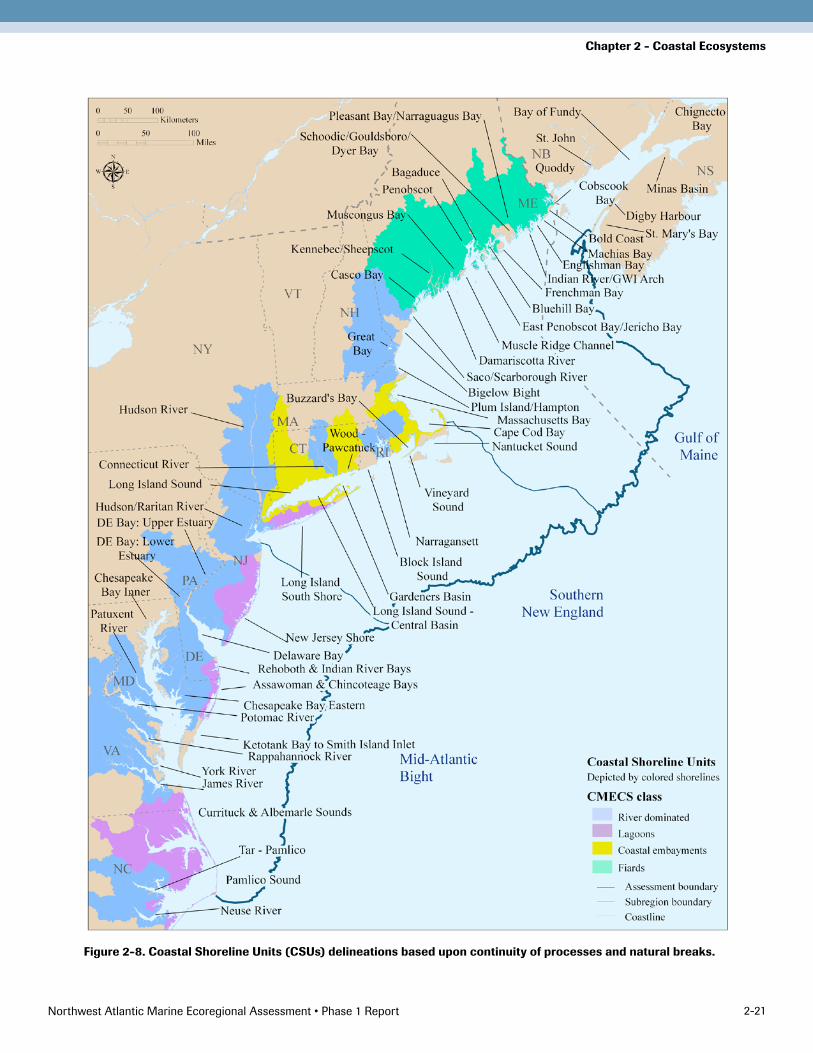
Delineating CSU BoundariesFour project sub-teams made CSU delineations based upon continuity of processes and natural breaks. The team collectively reviewed and approved a final set of 62 delin-eations, shown in Figure 2-8.
To the extent possible, areas were delineated at oceano-graphic discontinuities such as large-scale oceanic cur-rents. Estuarine circulation models and tidal maps of discontinuities (i.e. where currents move in opposite directions) were consulted. These delineations were then compared with information on the biogeography of ma-rine invertebrates (Wigley and Theroux 1981). The sub-teams attempted to avoid crossing over watersheds and consolidating areas with very different freshwater inputs. In Maine, focus area boundaries already delineated by Maine’s Beginning with Habitat program were consid-ered (BwH 2009). Generally, islands along the Maine coast were included in their most immediate nearby CSU. Riverine CSUs were separated for midsize to large tribu-taries by intuitive natural features. In general, strings of barrier island lagoons are presented as single CSUs. Unit boundaries were sometimes extended beyond a particular feature or estuarine unit so that the coast would be di-vided into a contiguous string of CSUs. (For some parts of the region where this delineation resulted in relatively large units, subunits were also delineated based on coastal ecology and locally accepted delineations for planning and management purposes.)
Northwest Atlantic Marine Ecoregional Assessment • Phase 1 Report 2-21
Chapter 2 - Coastal Ecosystems
Figure 2-8. Coastal Shoreline Units (CSUs) delineations based upon continuity of processes and natural breaks.

Northwest Atlantic Marine Ecoregional Assessment • Phase 1 Report 2-22
Chapter 2 - Coastal Ecosystems
Characterizing Coastal Shoreline UnitsEach CSU was characterized with respect to size, habitat diversity, and condition in order to identify patterns by subregion and by CMECS type.
SizeSize is an important CSU parameter because many other variables are likely to correlate with it. Size of each CSU was characterized by shoreline length and hectares of intertidal habitat. In general, the lagoon and river types are much larger than the embayment or fjord CSU types, with an average shoreline length of 2,791 and 1,798 km respectively versus 690 and 483. Similarly, the average intertidal habitat area of lagoons is 10 times that of em-bayments. This is why subdivisions of many lagoons and rivers into tier 2 subunits were deemed helpful. However, there is a large range in size within all four classes. In par-ticular, riverine CSUs range from 7,163 km for the eastern Chesapeake Bay CSU to only 237 km for the Saco River/Scarborough CSU in Maine. There is corresponding re-gional variation in size of CSUs. In general, the highly in-dented Gulf of Maine coast is characterized by fjords, on average the smallest of the four types, so the CSUs of the Gulf of Maine are on average one fifth the size of those of the Mid-Atlantic.
HabitatDiversityHabitat diversity of CSUs was characterized in several ways. First, the length of each CSU shoreline was calculat-ed by major habitat type, as per the ESI. The ESI classifies the coastline into 22 categories, which was consolidated into the following eight categories for simplification of in-terpretation: 1) beach, 2) flat, 3) marsh, 4) swamp, 5) rocky shore/cliff/platform, 6) non-rocky bluff/steep/platform, 7) manmade, and 8) undefined.
Second, the amount of six intertidal habitat classes was calculated (in hectares) for each CSU. Intertidal habitat types were mapped by extracting intertidal coded poly-gons from the NWI (US DOI FWS 2008) in the United States and by extracting coastal ecosystem polygons from the Northern Appalachian Ecoregional Planning coastal target polygon dataset (Anderson et al. 2006a) in
Canada. The polygons were placed into the following six intertidal habitat categories 1) unconsolidated shore (sand, gravel, cobble), 2) unconsolidated shore (mud, organic, flat), 3) emergent marsh, 4) forested wetland, 5) rocky shore, and 6) scrub-shrub wetland.
The quantification of emergent marsh or vegetated tidal wetlands in the analyses presented here is different than the quantification of “tidal wetlands” in the North Atlantic Coast Ecoregional Assessment (Anderson et al. 2006b). Unlike the 2006 coastal assessment, which lumped unvegetated tidal wetlands and some submerged lands into tidal wetland complexes, this assessment sepa-rated out vegetated tidal wetlands (e.g., salt marsh, tidal marsh or emergent marsh) from unvegetated wetlands. The rationale for this difference in approach is the desire to distinguish “wetland loss” and “wetland conversion” as threats to these estuarine systems. With the exception of vegetated tidal wetlands that get filled and or armored, “wetland loss” attributable to other causes is often first evidenced by the loss of emergent vegetation and then submergence of land.
Third, the amount of seagrass was calculated and the number of coastal salt ponds was counted within each CSU. Unlike the NWI and ESI datasets, seagrass cover-age was determined by combining many different datasets from federal, state and local data sources. These sources include Maine Department of Marine Resources, New Hampshire Department of Environmental Services, Massachusetts Department of Environmental Protection, Rhode Island Narragansett Bay Estuary Program, USFWS (for Connecticut), New York Sea Grant (for the Hudson River), Peconic Estuary Program, (for Peconic Bays, New York), NOAA Coastal Services (for Long Island’s south shore estuaries), Rutgers Center for Remote Sensing and Spatial Analysis (for New Jersey), ESI (for Delaware), Virginia Institute of Marine Science (for Chesapeake Bay and the Eastern Shore of Virginia), and TNC’s Carolinian Ecoregional Plan (for North Carolina). Data collection methods for seagrass coverage tend to vary by locality, as did year of data collection (1968 – 2008). For consistency at the regional scale, seagrass meadows
Northwest Atlantic Marine Ecoregional Assessment • Phase 1 Report 2-2�
Chapter 2 - Coastal Ecosystems
are shown as presence or absence only, although in some geographies more fine scale delineations (such as con-tinuous/discontinuous; thick, medium, or thin; or root or above ground biomass/unit area) are available and these attributes are preserved in the dataset. Some states have only one year of data, while others have several, collected in subsequent or consecutive years. Consequently, two dif-ferent seagrass datasets were compiled: total historical sea-grass coverage and the most recent available year of data. For this report, seagrass presence in the most recent year of data is presented, outlined by a 2-point line for graphi-cal display. Coastal salt pond data was summarized from 2008 Natural Heritage Program Element Occurrences.
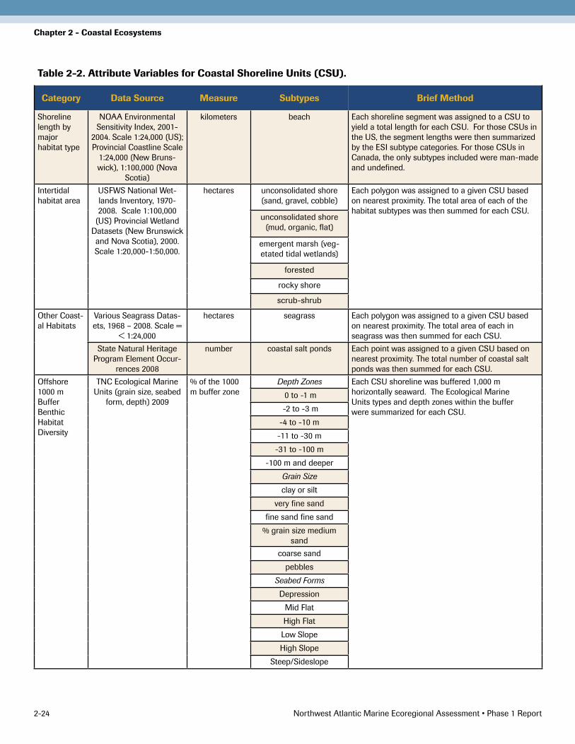
Finally, the diversity of benthic habitats was characterized, by depth, grain size, and seabed form, offshore to 1,000 m (see Chapter 3 for further information). Unfortunately, data were lacking for several of these parameters for the Canadian portion of the region, so the Fundy CSUs were not characterized for these attributes. The variables and the attribution method are briefly presented in a summary table (Table 2-2).
AssessmentofCSUConditionIndicators of both shoreline condition and water quality were examined within the estuaries for which there were consistent coast-wide data. For shoreline condition, the proportion of man-made vs. natural shoreline within each CSU was calculated, derived from the ESI. The number of man-made structures per unit of shoreline was deter-mined to be another appropriate indicator, but found that the relevant NOAA dataset was inconsistent with respect to date and sometimes incomplete.
Nearshore land use is a relevant potential indicator of both shoreline condition and water quality. The amount of developed land in the nearshore zone was calculated for two areas: the area adjacent to the shoreline that was lower than 2 m elevation and for the area within 300 m hori-zontal distance of the shoreline. These two measures gen-erally track each other but the former can be particularly helpful when considering potential impacts of sea level rise. Finally, the amount of developed and
agricultural land and impervious surface was calculated within each CSU watershed. These watersheds do not exactly coincide with those used by NOAA in their Estuarine Eutrophication Assessments. Maps for the latter are provided for comparison and in many cases corroboration. The condition variables are briefly pre-sented in Table 2-3.
Characterizing Nearshore Shellfish AssemblagesDespite the commercial importance of these target species (except ribbed mussel), reports of population distribution, abundance, and health status are not available consis-tently region-wide. To address questions of distribution and abundance, two metrics were examined for nearshore shellfish assemblages. Presence/absence of each species (where data were available) was documented for each bay to examine distribution. As a proxy for population status, NOAA’s National Marine Fisheries monthly commercial landings statistics was analyzed.
DistributionThe primary source for distribution data was the 1995 National Shellfish Register of Classified Shellfish Growing Waters (NOAA 1997). The 1995 Register is the most recent, and only regional, dataset for shellfish distri-bution and abundance in the Northwest Atlantic. Other state and local shellfish datasets were identified, but a lack of consistent standards, spatial coverage, and availability rendered these sources unusable for this assessment. In developing the 1995 Register, NOAA worked with state shellfish resource managers to identify nearshore shell-fish waterbody areas, resulting in a catalogue of about 2,900 discrete areas from Maine to North Carolina. State managers were asked to rank each waterbody, known as Classified Shellfish Areas (CSA), for the relative abun-dance of each shellfish species compared with all other state waterbodies.
The CSA database was found to contain many entries coded as “Not Reported,” for non-managed shellfish spe-cies like blue mussel and ribbed mussel. Mussel abundance was reported for less than 1% of areas across the region.
Northwest Atlantic Marine Ecoregional Assessment • Phase 1 Report 2-24
Chapter 2 - Coastal Ecosystems
Table 2-2. Attribute Variables for Coastal Shoreline Units (CSU).
Category Data Source Measure Subtypes Brief Method
Shoreline length by major habitat type
NOAA Environmental Sensitivity Index, 2001-
2004. Scale 1:24,000 (US); Provincial Coastline Scale
1:24,000 (New Bruns-wick), 1:100,000 (Nova
Scotia)
kilometers beach Each shoreline segment was assigned to a CSU to yield a total length for each CSU. For those CSUs in the US, the segment lengths were then summarized by the ESI subtype categories. For those CSUs in Canada, the only subtypes included were man-made and undefined.
Intertidal habitat area
USFWS National Wet-lands Inventory, 1970-2008. Scale 1:100,000
(US) Provincial Wetland Datasets (New Brunswick and Nova Scotia), 2000. Scale 1:20,000-1:�0,000.
hectares unconsolidated shore (sand, gravel, cobble)
Each polygon was assigned to a given CSU based on nearest proximity. The total area of each of the habitat subtypes was then summed for each CSU.
unconsolidated shore (mud, organic, flat)
emergent marsh (veg-etated tidal wetlands)
forested
rocky shore
scrub-shrub
Other Coast-al Habitats
Various Seagrass Datas-ets, 1968 – 2008. Scale =
< 1:24,000
hectares seagrass Each polygon was assigned to a given CSU based on nearest proximity. The total area of each in seagrass was then summed for each CSU.
State Natural Heritage Program Element Occur-
rences 2008
number coastal salt ponds Each point was assigned to a given CSU based on nearest proximity. The total number of coastal salt ponds was then summed for each CSU.
Offshore 1000 m Buffer Benthic Habitat Diversity
TNC Ecological Marine Units (grain size, seabed
form, depth) 2009
% of the 1000 m buffer zone
Depth Zones Each CSU shoreline was buffered 1,000 m horizontally seaward. The Ecological Marine Units types and depth zones within the buffer were summarized for each CSU.
0 to -1 m
-2 to -� m
-4 to -10 m
-11 to -�0 m
-�1 to -100 m
-100 m and deeper
Grain Size
clay or silt
very fine sand
fine sand fine sand
% grain size medium sand
coarse sand
pebbles
Seabed Forms
Depression
Mid Flat
High Flat
Low Slope
High Slope
Steep/Sideslope

Northwest Atlantic Marine Ecoregional Assessment • Phase 1 Report 2-2�
Chapter 2 - Coastal Ecosystems
Table 2-3. Condition variables for Coastal Shoreline Units (CSU).
Category Data Source Measure Subtypes Brief Method
Man-made shoreline
NNOAA Environmental Sensitivity Index, 2001-2004.
Scale 1:24,000 (for US); Provincial Coastline Scale 1:24,000 (for New Bruns-wick), 1:100,000 (for Nova
Scotia); US land cover: EPA National Land Cover Data-set, 2001; New Brunswick and Nova Scotia: DNRE.
Generalized 1:10,000 forest stand data c. 1990s
% of total CSU length
beach For the non-Maine part of the US coast, the length of “man-made” was summarized for each CSU based on source NOAA ESI line type coding. Special processing was done to assign a “man-made” class in Maine and Canada, where no man-made shoreline types had been assigned by NOAA or other sources. The processing method included overlapping the developed land cover cells with the shorelines to identify sections of the shoreline that were adjacent to developed lands, and thus likely “man-made” shorelines.
United States land cover: EPA National Land Cover
Dataset, 2001; EPA Impervious Surface
Dataset, 2001
% of total land area in whole
upstream watershed
% developed (residential, commercial, transporta-
tion, and quarries)
The full upstream watershed for each CSU was delineated using Basin Delineator Tool distributed with the USGS National Hydrography Plus dataset. Inputs to the tool for each CSU included all reaches with their outflow within 100 m of the CSU shoreline. The land cover types within the delineated full watershed were then summarized for each CSU.
% agriculture (row crops and pasture)
% natural (including barren)
% impervious surface
Eutro-phication (for US only)
NOAA National Estuarine Eutrophication Assessment,
1999, 2004 update
Reporting of NOAA metrics in the primary and second-ary Ecological Drainage Unit
associated with each CSU
NOAA NEEA 1999 overall eutrophication
The NOAA NEEA dataset was provided at the Estuarine Drainage Area (EDA) watershed unit scale. These EDA units did not overlap one to one with our CSUs. To summarize the NEEA data by CSU, we joined each CSU component arc to the nearest EDA. The percent of the total CSU shoreline length occurring in each EDA was then calculated. The four eutrophication subtype metrics of interest were reported for the primary EDA with which each CSU was associated. For CSUs crossing more than one EDU, the four eutrophication subtype metrics of interest were also reported for the secondary EDA with which each CSU was associated.
NOAA NEEA 1999 influencing factor on
eutrophication (human influence)
NOAA NEEA 1999 projected changes in eutrophic conditions
through 2020 based on projected population
growth and susceptibility
NOAA NEEA 2004 update to overall eutrophication
Northwest Atlantic Marine Ecoregional Assessment • Phase 1 Report 2-26
Chapter 2 - Coastal Ecosystems
Lacking other spatial data sources for these species, mus-sels could therefore not be included in ecoregional abun-dance mapping.
For managed species, more than 50% of areas in the region included data for populations of Eastern oyster, hard clam, softshell clam, and bay scallop. For these species, most of the “Not Reported” areas appeared to be in states without substantial natural populations remaining. For example, oysters were under-reported in most of Maine and New Jersey; hard clams were under-reported in Maine and south of Virginia; and softshell clams and bay scallops were not reported south of New Jersey. In addition to species absence, some under-reporting was likely due to inconsistencies among states. NOAA noted that “data quality was directly related to the resources available to conduct shellfish management responsibilities.” However, state managers did provide “final verification of the data content” (NOAA 1997). With a greater than 50% over-all reporting rate, very good coverage of state-managed shellfish beds, and few other reporting options, the CSA database was determined to be a reasonable and adequate source for regional shellfish reporting.
In developing a map of target shellfish distribution and abundance, CSA entries with ranked abundances for the four target species under state management (oyster, hard clam, softshell clam, and bay scallop) were used. Abundance ranks could not be compared across states and further do not provide any historical context for shellfish distribution and abundance. Therefore, ranks of “High,” “Medium,” and “Low Abundance” for each shellfish spe-cies were converted to present and ranks of “None” or “Not Reported” to absent. In addition, each area was as-signed a number from 0 to 4 depending on the number of reported target species present there in order to identify those areas of particular importance for protection of shellfish assemblages.
PopulationStatusAs a proxy for population status, National Marine Fisheries Service (NMFS) monthly commercial landings data were analyzed for mollusk species (NOAA 2008).
Eastern oyster, hard clam, softshell clam, and bay scallop landings data were queried for each state for the entire reporting period of the database (1950 to 2007). Data are from continuous records collected by joint state and fed-eral agencies, and reported as metric tons (wet weight).
To understand the changes in historical landings for each state and species, time series of annual landings were ana-lyzed for 1) maximum annual harvest in the series, 2) year of the maximum harvest, 3) total number of years report-ed (out of 58 possible reporting years from 1950 to 2007), 4) mean value for the last three years reported in the time series, and 5) last three-year average as a percentage of the maximum annual harvest. New Hampshire, as the only assessment state without commercial shellfish land-ings, was not included in the NMFS database. For New Hampshire, a time series of annual estimates of standing stock was analyzed for Eastern oyster and softshell clam, as surveyed by the New Hampshire Department of Fish and Game (NHEP 2006). Results are presented in Table 2-4.
Several important caveats apply to this use of commercial landings data as a proxy for abundance. First, data are not normalized for fishing effort. Peak harvest benchmarks may reflect levels of unsustainable pressure. Further, it is possible to have a sustainable fishery even if current har-vest levels are very low compared to historic benchmarks. Natural variability in year-to-year recruitment can also produce wide swings in standing stock and harvest oppor-tunity. Finally, NMFS mollusk datasets include aquacul-ture landings (totals not available separately) that contrib-ute to recent landings totals and may mean that the results presented here overestimate natural bed conditions. For the four target species, maps were developed to show the last 3-yr average landings as a percent of maximum harvest by 0 - 10%, 11 - 50%, and 51 - 100% levels for each state (Figure 2-9, 2-10, 2-11, and 2-12).

Northwest Atlantic Marine Ecoregional Assessment • Phase 1 Report 2-27
Chapter 2 - Coastal EcosystemsTa
ble
2-4
. Mon
thly
Com
mer
cial
Lan
ding
s S
umm
ary
as r
epor
ted
by N
OA
A N
atio
nal M
arin
e Fi
sher
ies
Ser
vice
(19
50-2
007
).
http
://w
ww
.st.
nmfs
.noa
a.go
v/st
1/co
mm
erci
al/l
andi
ngs/
mon
thly
_lan
ding
s.ht
ml N
ote:
New
Ham
pshi
re v
alue
s ar
e es
tim
ated
st
andi
ng s
tock
from
fiel
d su
rvey
s (N
HEP
200
6) c
onve
rted
from
bus
hels
to
met
ric
tons
(w
et w
eigh
t ).
ME
NH
MA
RI
CT
NY
NJ
DE
MD
VA
NC
East
ern
Oys
ter
Max
imum
har
vest
(met
ric to
ns)
1�8.
720
�7.4
*1�
4.1
418.
��7
40.8
�98�
.7�2
84.9
1968
.692
6�.4
11�6
8.4
7��.
2
Year
of m
axim
um19
9019
9�19
8019
�019
9�19
�019
�019
�419
7�19
�819
�2
Num
ber
year
s re
port
ed��
1249
46�7
�8��
48�8
�7�8
Last
� y
r re
port
ed m
ean
(met
ric to
ns)
19.8
99.9
*67
.��4
.787
92.�
144.
6��
.619
2.2
4119
1.6
Last
� y
r m
ean
(as
% o
f max
imum
)12
%�%
�0%
8%2%
2%4%
2%2%
0%26
%
Har
d C
lam
Max
imum
har
vest
(met
ric to
ns)
2�8.
198
�.7
2277
2��0
.��8
77.8
2�06
.4�6
6.6
�60.
411
28.2
699.
�
Year
of m
axim
um19
�119
�119
��20
0419
7119
�019
�019
6919
6�19
80
Num
ber
year
s re
port
ed�1
49�7
�6�7
46�6
�947
�8
Last
� y
r re
port
ed m
ean
(met
ric to
ns)
1.8
197.1
�61.
�16
9969
7.2
8�0.
�27
.68.
810
7.7
190.
6
Last
� y
r m
ean
(as
% o
f max
imum
)1%
20%
16%
7�%
18%
�6%
8%2%
10%
27%
Sof
tshe
ll C
lam
Max
imum
har
vest
(met
ric to
ns)
����
.94�
7.4*
9�2.
�22
7.11.
717
8.�
204.
1�7
0�.�
180.
6
Year
of m
axim
um19
7719
9719
8219
�019
�020
0619
�019
6419
66
Num
ber
year
s re
port
ed46
�848
�818
�740
��12
Last
� y
r re
port
ed m
ean
(m
etric
tons
)84
0.�
�7.4
*4�
4.4
89.1
0.1
1�0.
212
.��4
.46�
.�
Last
� y
r m
ean
(as
% o
f max
imum
)24
%1�
%47
%�9
%6%
7�%
6%1%
�6%
Bay
Sca
llop
Max
imum
har
vest
(met
ric to
ns)
929.
920
�.�
190.
644
8.1
170.
728
9.7
Year
of m
axim
um19
7119
7819
��19
6219
6419
68
Num
ber
year
s re
port
ed41
2917
�81�
�4
Last
� y
r re
port
ed m
ean
(m
etric
tons
)��
.�1.
��.
��.
�11
.7�.
4
Last
� y
r m
ean
(as
% o
f max
imum
)6%
1%�%
1%7%
2%

Northwest Atlantic Marine Ecoregional Assessment • Phase 1 Report 2-28
Chapter 2 - Coastal Ecosystems
Figure 2-9. Most recent 3-yr average of Eastern oyster landings, represented as a percent of maximum harvest by 0-10%, 11-50%, and 51-100% levels for each state.

Northwest Atlantic Marine Ecoregional Assessment • Phase 1 Report 2-29
Chapter 2 - Coastal Ecosystems
Figure 2-10. Most recent 3-yr average of hard clam landings, represented as a percent of maximum harvest by 0-10%, 11-50%, and 51-100% levels for each state.

Northwest Atlantic Marine Ecoregional Assessment • Phase 1 Report 2-�0
Chapter 2 - Coastal Ecosystems
Figure 2-11. Most recent 3-yr average of soft shell clam landings, represented as a percent of maximum harvest by 0-10%, 11-50%, and 51-100% levels for each state.

Northwest Atlantic Marine Ecoregional Assessment • Phase 1 Report 2-�1
Chapter 2 - Coastal Ecosystems
Figure 2-12. Most recent 3-yr average of bay scallop landings, represented as a percent of maximum harvest by 0-10%, 11-50%, and 51-100% levels for each state.

Northwest Atlantic Marine Ecoregional Assessment • Phase 1 Report 2-�2
Chapter 2 - Coastal Ecosystems
Data, Analysis, and Areas of ImportanceShoreline Habitat DiversityThe shoreline habitats and intertidal NWI type charac-terization corroborated stratification by CMECS class. For example, rocky shorelines are essentially non-existent in the lagoon and riverine types, but prominent in fjord types. Swamp shorelines are only a small percentage of any CSU shoreline, but do not occur at all in fjord or Fundy CSUs. Marshes make up the highest percentage of shore-line habitats in lagoons and riverine CSUs. Beach and flat shorelines are found in the highest percentages in embay-ments and fjord CSUs. However unconsolidated inter-tidal habitats of mud make up more than 50% of intertidal habitats in most fjords while unconsolidated shores of sand, gravel, and cobble make up over 50% of intertidal habitats in most embayments. Although these differences between CMECS classes were evident, significant differ-ences among CSUs of the same CMECS class were also observed. For example, some embayment CSUs have > 50% beach shorelines, while others have only 10% - 15% beach shorelines. Differences were also observed among subregions (Gulf of Maine, Southern New England, and Mid-Atlantic Bight). Although the 8,000 km of beach shoreline in the region were surprisingly evenly distribut-ed across the three subregions, beaches of fjords are most often small pocket or cove beaches whereas those of the lagoon and embayment areas are often very long, nearly continuous barrier beaches. Salt marshes are also found to occur in all subregions and CMECS estuarine types. As a percent of shoreline length, there are not such marked dif-ferences within CMECS types or subregions. However, in areal extent they make up over 70% of intertidal habitat in most lagoons and riverine types and < 35% in other groups. The total area of salt marshes in lagoon types of the Mid-Atlantic Bight is orders of magnitude greater than in the rest of the region, especially Gulf of Maine fjords (Figure 2-13, 2-14, and 2-15).
Seagrass beds occur along the entire Atlantic coast (Figure 2-16). Based on the most recent data available from each state, the largest seagrass bed coverage occurs in the Pamlico Sound CSU (36,429 hectares), although other
CSUs have significant amounts of seagrass habitat (e.g., Casco Bay, 3,331 hectares; Nantucket Sound, 6,462 hect-ares; Long Island South Shore, 9,861 hectares; Chesapeake Bay Eastern, 24,838 hectares). By CMECS type, the vast majority of seagrass in the region occurs within CSUs of the lagoon (63,459 hectares) and riverine types (44,087 hectares). However, there is substantial variation within each CMECS class. For example, Chesapeake Bay Inner has 9,710 hectares of seagrass, whereas several other CSUs of the riverine type have only several hundred hectares. The regional seagrass dataset includes histori-cal time series snapshots of eelgrass coverage and presents a new opportunity to evaluate loss and identify spatially explicit restoration priorities. Areas mapped as coastal salt ponds only occur in the embayment type. Among the 10 CSUs of this type, five had no coastal salt ponds and others had as many as six or eight.
Not surprisingly, these differences in characteristic habitat extend to the immediate offshore zone. At the scale of in-dividual CSUs, calculating the percent of various benthic classes within the 1,000 m zone would not be accurate enough to fairly compare one CSU to another. However, when combined into CMECS classes, the average percent-ages do seem meaningful. The benthic zone just offshore from fjords includes significant areas deeper than 31 m and is characterized by steep canyon seabed forms, largely absent from the offshore zones of other CSUs. In contrast, benthic zones immediately offshore of lagoons and river-ine CSUs have extensive areas within the seagrass grow-ing depth zone of 1 to 3 m. The benthic zones offshore of lagoons are characterized by clays, silt, and fine sands and have zero mapped areas of pebble or cobble, which are abundant in the nearshore of the Gulf of Maine.
Abundance and variety of stream habitats feeding the CSUs, particularly relevant for diadromous fish, were not included because of the challenges of identifying compa-rable metrics across the region. Diadromous fish habitat use and distribution is addressed in a separate chapter.
Note: Further characterizations of spatial complexity, sin-uosity, and functional connectivity among habitats could

Northwest Atlantic Marine Ecoregional Assessment • Phase 1 Report 2-��
Chapter 2 - Coastal Ecosystems
Figure 2-13. A fjord example of shoreline habitat diversity.

Northwest Atlantic Marine Ecoregional Assessment • Phase 1 Report 2-�4
Chapter 2 - Coastal Ecosystems
Figure 2-14. A riverine example of shoreline habitat diversity.

Northwest Atlantic Marine Ecoregional Assessment • Phase 1 Report 2-��
Chapter 2 - Coastal Ecosystems
Figure 2-15. A lagoon example of shoreline habitat diversity.

Northwest Atlantic Marine Ecoregional Assessment • Phase 1 Report 2-�6
Chapter 2 - Coastal Ecosystems
Figure 2-16. Seagrass presence (most recent year of data) in the Northwest Atlantic region.

Northwest Atlantic Marine Ecoregional Assessment • Phase 1 Report 2-�7
Chapter 2 - Coastal Ecosystems
Figure 2-17. An example from Southern New England of the extent of man-made shoreline.

Northwest Atlantic Marine Ecoregional Assessment • Phase 1 Report 2-�8
Chapter 2 - Coastal Ecosystems
be very informative in assessing relative value of CSUs for coastal marine species. Sinuosity, basically the ratio of edge to area, reflects the amount of marsh/tidal creek edge per unit area. There is evidence from estuarine systems around the world that the value of estuarine habitats for marine species increases as spatial complexity (patch den-sity), sinuosity, and functional connectivity among habi-tats increase. These are attributes one could theoretically calculate using GIS models. However, because of the need to further define indicators for these attributes that would be most relevant ecologically, as well as time constraints, and limitations of the relevant spatial data available re-gion-wide, these analyses have not yet been attempted.
CSU ConditionA significant proportion of the shoreline of the Northwest Atlantic region is now man-made or heavily altered by hu-man structures of various kinds. The average proportion of man-made shoreline per CSU across the region is 11%. Not surprisingly, in the more industrialized and popu-lated coast of Southern New England, the average is 15%. However, there are marked differences in the proportion of man-made shoreline in different CSUs, ranging from over 30% to near zero (Figure 2-17).
To examine the condition of nearshore land, both the natural land within 2 m elevation and the natural land within a 300 m horizontal buffer were calculated. In the Gulf of Maine where the topography tends to be steeper, the area within 2 m elevation of the shore is only 15% of the area within the 300 m horizontal buffer. In Southern New England the area within 2 m elevation of shore is 25% of the area covered by the 300 m buffer, whereas in the flatter Mid-Atlantic Bight, the area covered by the 2 m elevation rise is 12% largerthan the area within the 300 m horizontal buffer (Figure 2-18).
In the Gulf of Maine, there are fewer than 2,428 hect-ares within 2 m vertical elevation of the ocean shore in most CSUs. In contrast, in the Mid-Atlantic there are usually over 53,014 hectares per CSU within the same area. As such, across the entire region, a 2 m rise in sea level might inundate or significantly increase the tidal
influence on almost 1 million hectares, (with a dispro-portionate effect to the south), of which 41%, or almost 415,000 hectares, is wetlands. The Mid-Atlantic Bight contributes over 800,000 hectares to the total projected inundated hectares and over 385,000 hectares of wetlands below 2 m elevation.
Within the 2 m vertical elevation zone, the proportion of that land with natural cover varies by subregion. The Gulf of Maine has the highest proportion of natural cover (average of 78% per CSU) followed by the Mid-Atlantic (69% natural cover) and Southern New England (56% natural cover). Yet within each subregion there are some CSUs with a very high proportion of natural cover within the 2 m elevation zone (the maximums for Gulf of Maine, Southern New England and the Mid-Atlantic are 96%, 95%, and 92%, respectively) and some with very little (the minimums for Gulf of Maine, Southern New England and the Mid-Atlantic Bight are 20%, 7%, and 47%, respec-tively). The horizontal buffer tells the same story: The average proportion of natural cover in this buffer per CSU in the Gulf of Maine, Southern New England, and the Mid-Atlantic Bight is 78%, 57%, and 70%, respectively.
The land cover/land use of the watershed, as with the proportion of man-made shoreline, shows marked dif-ferences geographically and among CSUs of the same estuarine type. Previous research suggests that watersheds with higher percentages of urban and agricultural land are associated with lower estuarine benthic indicators of condition and biodiversity (Hale et al. 2004) and reduced submerged aquatic vegetation (Li et al. 2007). Freshwater aquatic systems also become seriously impacted when impervious cover exceeds 10% (CWP 2003), and reduc-tions in certain taxa sensitive to urban contaminants and habitat disturbance have been found where as little as 3% of the land cover of the watershed is urban (Coles et al. 2004). The average proportion of developed land within the watersheds of CSUs in Southern New England is 29%, and average impervious surface is 9%. A recent study by the Connecticut Department of Environmental Protection (CTDEP) using satellite-based land cover data combined with chemical and biological data from

Northwest Atlantic Marine Ecoregional Assessment • Phase 1 Report 2-�9
Chapter 2 - Coastal Ecosystems
Figure 2-18. Condition of nearshore land within a 300 m buffer.

Northwest Atlantic Marine Ecoregional Assessment • Phase 1 Report 2-40
Chapter 2 - Coastal Ecosystems
streams across the state found that “no segment of stream in Connecticut with > 12% Impervious Cover upstream of the sampling location was able to meet Connecticut Water Quality Standard for aquatic life” (CTDEP 2009). In contrast, the averages of proportion of developed land in Mid-Atlantic and Gulf of Maine watersheds are both 9% and their average impervious surface only 2 and 3% respectively. The Mid-Atlantic, however, has much more agriculture in most of its coastal watersheds. However, within each CMECS class and subregion there are some CSUs in very natural condition and others that are much more developed.
A comparison with the NOAA National Estuarine Eutrophication Assessment in some cases corroborates and parallels the watershed land cover characterization, but not in all cases. For example, Massachusetts Bay, clas-sified by NOAA as moderate to high overall eutrophica-tion, has one of the highest percentages of impervious sur-face, 23.7%. In contrast, the Neuse Riverine CSU in the Mid-Atlantic is classified as having high overall eutrophi-cation although it is not among the highest in developed/agricultural land or impervious surface (Figure 2-19).
Nearshore Shellfish DistributionFigure 2-9, 2-10, 2-11, and 2-12 show the reported 1995 regional distribution of oysters, hard clams, softshell clams, and bay scallops, respectively. Recent landings versus historic maxima are shown as shaded areas. Blue mussels and ribbed mussels are distributed throughout the region, but spatial data are not available.
With respect to shellfish species viability, we cautiously as-sert that regional patterns of weak recent harvests relative to benchmarks indicate low-density populations at risk of spawning failure in some areas. In particular, Eastern oyster landings are < 10% of historic highs in eight of 11 reporting states, and bay scallop landings are < 10% in all six reporting states. Hard clam landings are < 10% in four states and < 25% in three other states, also suggesting spawning limitations. Softshell clam populations may be in slightly better condition, with only five of 10 states re-porting recent landings < 25% of maxima.
Human Interactions Natural Shoreline CommunitiesMost of the coastal areas in the northern half of the region were covered with ice less than 20,000 years ago. This reality speaks to the adaptability and resilience of many of the plants and animals now using these habitats. Today, however, a variety of pressures, including oil spills, climate change, invasive species introductions, eutrophication, and the impending squeeze between the rising sea and human development are rapidly threatening the biological and human communities which rely upon our coasts and estuaries.
CoastalDevelopmentThe squeeze of coastal habitats between human coastal development and sea level rise is and will continue to be a major threat, as long as there is a societal desire to engineer less stable shoreline types in an effort to pro-tect vulnerable real estate from inundation and erosion. Coastal development also brings with it increased inputs of nutrients and toxins, alterations of tidal flow, and over-land freshwater input, all of which can impact shoreline systems.
ShorelineStabilization,AlteredSedimentRegimesBarrier islands and riverine deltas are the habitat types probably threatened most by storms and erosion, as they are the most geologically unstable and therefore likely to be impacted directly and indirectly by engineering that alters natural sediment supplies. Alteration of sediment dynamics by creation and maintenance of inlets to embay-ments, coastal salt ponds, and lagoons also impacts tidal amplitudes, residence times, temperature, and salinity, as well as the export and import of dissolved and particulate nutrients for entire systems. At a smaller scale, channel dredging can impact adjacent shores as sediments accu-mulate in the deeper channels rather than near the adja-cent shores. Similarly, nearshore sand mining can starve some beaches of their natural sand supply in an attempt to nourish other beaches.

Northwest Atlantic Marine Ecoregional Assessment • Phase 1 Report 2-41
Chapter 2 - Coastal Ecosystems
Figure 2-19. Eutrophic conditions in 1999 and 2004, human influence, and projected changes in eutrophication through 2020.
A B
C D

Northwest Atlantic Marine Ecoregional Assessment • Phase 1 Report 2-42
Chapter 2 - Coastal Ecosystems
Shoreline armoring of all types (groins, bulkheading, rip rap, gambion, etc.) often causes direct loss of habitat, most often impacting adjacent properties (Nordstrom et al. 2003). There are legislative protections against dredg-ing, filling, and bulkheading vegetated wetlands and/or sandy ocean beaches in some states. However, there is less protective legislation preventing the future armoring of shorelines in the sheltered coast. By their very nature, rocky shorelines are already hardened and more stable. With few exceptions, rocky coasts have been less subjected to anthropogenic shoreline armoring, and when present these structures have less of an ecological impact than they do when they are constructed on more geologically dynamic shoreline types.
OilSpillsOil spills are a significant threat to both marine and ter-restrial wildlife along the shore. The potential threat of large-scale oil spills is related to the proximity of large shipping, storage, and/or oil and gas exploration opera-tions. Appropriate regulations and precautions can be used to mitigate the potential for harmful spills in areas where the drilling and transport of oil occurs. ESI maps features sensitive to oil spills to facilitate rapid response.
InvasiveSpeciesNew exotic marine species can have major impacts on ma-rine and coastal systems through competition with native species, predation (e.g. green crabs on clams), or actual habitat impacts. By the time they are detected, marine invasive species are virtually impossible to eradicate. The ecological consequences of recent marine invasions in this region are uncertain. Global shipping and aquaculture are the main vectors for introduction of exotic marine species and marine disease invasions. In salt marshes, the European genotype of common reed (Phragmitesaustralis) is an aggressive competitor capable of forming dense monocultures that crowd out native salt-tolerant plant communities.
SeaLevelRiseAccelerated sea level rise due to global warming is a threat to all coastal targets. An in-depth look at this topic is ad-dressed in the following section.
Seagrass MeadowsThe mechanisms of seagrass loss can be characterized as direct or indirect. Examples of direct mechanisms in-clude the uprooting of plants while harvesting shellfish, destruction of plants when motorized boats run aground, and a species-specific “wasting disease” which decimated many eelgrass beds in the last century. There is more un-certainty in the assessment of indirect threats to seagrass, some of which are correlated with each other and are likely to have cumulative and synergistic impacts, such as the direct physiological impacts of increased nutrient loading and the consequences of shading by chronic algal blooms and excessive siltation. Threats which characteristically impact the grasses’ key ecological attributes include eutro-phication, algal blooms, alterations to water temperature regime, benthic organism harvest methods, boating ac-tivities, shoreline armoring and impediments to natural sediment movements, barrier island and inlet stabilization approaches, invasive species (especially green crabs), tox-ins, excessive macroalgae, altered seed predation regime, dredging, decreased abundance of native shellfish, disease, and herbivory.
Nearshore ShellfishFive critical threats to nearshore shellfish assemblages in the Northwest Atlantic region were identified:
OverharvestEvidence of harvest of oysters, bay scallops, hard clams, and softshell clams, all valuable commercial species today, precedes written history. Despite management by state agencies, many historic populations have been exploited to levels too low for successful regeneration. For oysters, long-term harvest reports show that landings may have peaked for some regions as early as the 1880s (Stanley and Sellers 1986; Kirby 2004). Recent data show oyster landings on the United States East Coast at a mere 2% of historic highs (Eastern Oyster Biological Review Team

Northwest Atlantic Marine Ecoregional Assessment • Phase 1 Report 2-4�
Chapter 2 - Coastal Ecosystems
2007). A similar, albeit less drastic, pattern of regional resource exploitation is evident for hard clams (Stanley and DeWitt 1983), softshell clams (Abraham and Dillon 1986), and bay scallops (Fay et al. 1983). Overharvest is typically of most concern for repeat spawners like oysters and clams; scallops die after they spawn and therefore may be less susceptible to damaging impacts from late-season harvest.
Direct removal of shellfish brood stock has most certainly diminished populations, but indirect impacts from fish-ing activities, including dragging, dredging, and boat wakes, also threaten shellfish beds by damaging habitat. Fishing activities can scour benthic habitats, destroy hard substrates and seagrass beds critical for spawning, and suspend sediments that deposit silt on intertidal beds and cloud seagrasses. Destruction and removal of shell sub-strate during oyster harvesting eliminates the foundation on which future generations of oysters will settle.
PollutionPollution inputs from nutrient and sediment sources are a long-standing and accelerating problem for estuarine and coastal waters along the entire Atlantic coast. The most recent EPA National Coastal Condition report (2004) ranked the Maine-to-Virginia section of coast with its lowest national ratings for sediment quality and benthic indices, and its second-to-worst rating for water quality. In particular, nutrient pollution is extensive in the heavily populated region. High or moderate eutrophic conditions (i.e. elevated chlorophyll, low dissolved oxygen, extensive macroalgae, and diminished seagrasses) were detected in two thirds of the region’s estuaries, with conditions in most expected to worsen by 2020 (Bricker et al. 1999).
Shellfish suffer from pollution from a number of sources, but direct and indirect effects of algae blooms are among the worst, as nutrient-mediated phytoplankton blooms (i.e., green, brown, and red tides) inhibit growth and cause recruitment failures (Summerson and Peterson 1990; Kraeuter and Castagna 2001). Dense beds of macroalgae, such as Ulva, disrupt filter feeding and eliminate suitable settling areas (Galtsoff 1964).
Sediment pollution is also major threat, as resuspended sediments and siltation events harm shellfish gills, inter-rupt feeding, and lower recruitment success (Kennedy et al. 1996). Marine shellfish ingest, retain, and bio-accu-mulate toxic metals and organic compounds from filtered seawater. Elevated levels of organic contaminants and metals found in shellfish tissue have been shown to inhibit growth and disrupt reproductive functions (Kennedy et al. 1996; Kraeuter and Castagna 2001).
Parasites,Diseases,andInvasiveSpeciesHarmful parasites are prevalent in filter-feeding bivalves, especially oysters and hard clams. In particular, oyster populations in the region suffer from high infection rates by the protozoans Dermo (Perkinsusmarinus) and MSX (Haplosporidiumnelsoni) (Kennedy et al. 1996). These dis-eases may be limiting factors in the re-establishment of healthy oyster populations in many parts of the region, from Chesapeake Bay to New Hampshire. Likewise, hard clams suffer from a parasite known as Quahog Parasite Unknown (X) or QPX that causes wide-spread but less catastrophic mortality in beds from Canada to Virginia (Lyons et al. 2007).
The invasive European green crab (Carcinusmaenas) is considered omnivorous and known to be an important predator of many shellfish species. In current areas of abundance from Gulf of Maine to Delaware Bay, this spe-cies can cause significant losses of shellfish populations, especially for clams and mussels (Kraeuter and Castagna 2001).
AlteredFreshwaterRegimeHuman activities that result in freshwater diversions (e.g., dams, impoundments, freshwater withdrawals) can produce stressful conditions and higher mortality in es-tuarine shellfish populations. Lethal disease outbreaks in oysters are linked to higher salinity conditions (Kennedy et al. 1996), and several common shellfish predators such as the oyster drill (Thaishaemastoma), starfish (Asteriasfor-besi), and whelk (Fasciolariahunteria) are limited in distribu-tion to higher salinity areas (Kennedy et al. 1996).

Northwest Atlantic Marine Ecoregional Assessment • Phase 1 Report 2-44
Chapter 2 - Coastal Ecosystems
ClimateChangeExtreme precipitation events and warming sea surface temperatures due to global climate change are likely to disrupt shellfish recruitment strategies that rely on strong seasonal patterns of temperature, salinity, and circulation. As nearshore waters warm with climate change, range expansion of shellfish predators enhances the likelihood of locally heavy predation losses for shellfish beds in northern areas of the region. Warmer water is likely a factor in the spread of Dermo (Kennedy et al. 1996). In addition, lower ocean pH due to elevated global CO2 concentrations (ocean acidification) may inhibit bio-chemical processes that bivalves rely on for shell development (Beesley et al. 2008). Below is an in-depth look at sea level rise, which discusses relative vulnerability, ecological resilience, and potential strategies for enhanc-ing resilience of coastal systems.
Management and ConservationRegulatory AuthoritiesManagement of the coastal zone involves a myriad of state and federal agencies whose jurisdictions and authorities overlap in complex ways. Most states have further delegat-ed authority for certain management activities to individ-ual coastal towns, whether for zoning and permitting of development or shellfish management. One unifying fed-eral program is the Coastal Zone Management Act which provides federal funding to each state to carry out research and outreach that may facilitate or enhance regulation but is not directly regulatory itself. Regulatory authority for specific activities within the coastal zone is still most often administered separately by different municipal, state, and federal agencies.
Given the wide variety of uses and activities in the coastal zone, it is not surprising that there is a complex mosaic of management authorities. Municipal, state, and federal authorities often overlap in the same geographic coastal areas and regulation of certain activities may require the involvement of multiple agencies at multiple levels of government. Current efforts being undertaken by the Obama Administration, such as the emerging National Ocean Policy and the framework for coastal and marine
spatial planning, hold promise for additional coordination and improvement in coastal resource regulation and man-agement.
All of the states in this region participate in the voluntary Coastal Zone Management Program, under the Coastal Zone Management Act of 1972, and have federally-ap-proved management plans including regulatory authorities to protect and conserve coastal resources. Depending on the individual state, regulatory controls are exercised by a single state coastal agency or by a network of environ-mental, wildlife, and conservation agencies. The overall program objectives of the CZMA are to “preserve, pro-tect, develop, and where possible, to restore or enhance the resources of the nation’s coastal zone.” The CZMA includes two national programs, the National Coastal Zone Management Program and the National Estuarine Research Reserve System. The state coastal programs aim to balance competing land and water issues in the coastal zone, while estuarine reserves serve as field laboratories to provide a greater understanding of estuaries and how hu-mans impact them. In addition to regulatory approaches, most coastal programs have a local grants component and outreach and education programs and include emphases on such topics as nonpoint source pollution, habitat resto-ration and land conservation.
The extent and type of home rule authority granted to local governments varies considerably from state to state; in most states land use controls including zoning and land development permitting are exercised by local and/or county governments. Some states have delegated addition-al authorities to municipalities and other units of govern-ment for other management activities that concern coastal resources, such as, for example shellfish management, harbor management and wetland management.
The United States Exclusive Economic Zone (EEZ) extends from the outer boundary of state waters (3 miles) out to 200 miles from shore. However, the federal government’s legal authority in navigation, commerce and security extends shoreward into state waters. The federal agencies that have a role in regulation or review of

Northwest Atlantic Marine Ecoregional Assessment • Phase 1 Report 2-4�
Chapter 2 - Coastal Ecosystems
activities in state waters include NMFS, USFWS, EPA, United States Army Corps of Engineers (USACE), United States Coast Guard (USCG), and the Federal Energy Regulatory Commission (FERC).
Unlike groundfishing and mid-water trawling for forage fish or shrimp, nearshore shellfish harvest and aquaculture are regulated at the state level, with no overarching federal or regional management authorities, other than the Food and Drug Administration’s oversight responsibilities for ensuring public health in relation to commercially har-vested shellfish. Within Food and Drug Administration constraints, state, or in some areas, town shellfish manag-ers set harvest limits and regulations, and shellfish sanita-tion commissions control the opening or closing of areas to harvest and consumption. Harvest of mussels is often unregulated.
Current Conservation EffortsConservation efforts on behalf of the many features and values of the coastal zone are as many and varied as the regulatory jurisdictions, with the addition of activities by a host of private organizations from global, such as TNC, to bay-specific. These are too numerous and varied to sum-marize here. Most have a specific geographic focus, and aim to link land-based activities with the health of the estuary and in turn the health of the estuary to the values to the human communities that border them. A notable feature of coastal zone conservation is the numerous ex-amples of public-private partnerships and programs such as the National Estuary Program (EPA), the National Estuarine Research Reserve Program (NOAA), and the Chesapeake Bay Program, which are designed to engage stakeholders and foster broad partnerships and are often paralleled by complementary private organizations such as the Chesapeake Bay Foundation and Friends of Casco Bay.
Shellfish restoration activities provide one example of the varied players in these coastal estuarine programs. The NOAA Restoration Center is a primary provider of funding for shellfish restoration projects and activities, especially for oysters and hard clams. These programs are
augmented by state-level programs for certain conserva-tion activities, such as shell management for restoration in the Carolinas and private non-profit efforts such as those of TNC in Great South Bay, Long Island, New York. Restoration funding for shellfish often requires protection from harvesting, which is most often accomplished by sit-ing projects in areas closed due to poor water quality. A combined focus on restoration and conservation has led to the concept of protected spawner sanctuaries in some ar-eas. Oyster restoration projects in the Chesapeake Bay and Delaware Bay are particularly prominent in this region, although these large-scale projects also include harvest provisions.
The United States Department of Agriculture Natural Resources Conservation Service is another provider of funding for oyster restoration, especially in the context of expanded aquaculture operations that provide restoration benefits. This funding model has been successfully devel-oped in Rhode Island, Virginia, and other Atlantic states.
In-depth Look: Sea Level RiseAssessing Relative Vulnerability and Ecological Resilience to Sea Level RiseSea level rise is already impacting coastal communities and natural habitats along the East Coast of the United States. In the coming century, potentially accelerated rates of sea level rise could significantly impact coastal ecosystems and human communities. The assessment team recognized the challenge of including long term threats, such as climate change and sea level rise, in conservation planning ef-forts. For this reason, a subteam was established to review the state of the science and management of sea level rise within coastal systems. This is a departure from earlier terrestrial ecoregional assessments along the eastern sea-board completed by TNC in recent years. These included analyses of the status of coastal species and ecosystems, but climate change impacts were not considered, particu-larly the consequences of predicted sea level rise. The best available science indicates coastal species and ecosystems throughout the region are at risk of alteration and loss due to sea level rise (Titus 1990; Markham 1996; Feagin et al. 2005; Nicholls et al. 2007).

Northwest Atlantic Marine Ecoregional Assessment • Phase 1 Report 2-46
Chapter 2 - Coastal Ecosystems
Of course, sea level rise and increasingly frequent intense storms will not be the only climatic impacts to Northwest Atlantic marine ecosystems. Other potential impacts such as increased water and air temperature and ocean acidifi-cation are addressed elsewhere in this report.
In order to inform prioritization of conservation locations and strategies in the face of climate change impacts to coastal ecosystems, the sea level rise team sought to:
1. Apply principles of vulnerability and resilience to sea level rise and storm impacts to the region’s coastal ecosystems; 2. Compile existing information on sea level rise impact studies and on-going adaptation strategies for the Northwest Atlantic coast; 3. Assess additional information or analysis needs and appropriate data availability; 4. Determine potential next steps to further inform conservation action in the coastal zone.
How High and How Fast?Twentieth century global sea level has been steadily ris-ing at a rate of ~1.7 to 1.8 mm yr-1, increasing to over 3 mm yr-1 within the last decade (IPCC 2007). Most of this in-crease comes from warming of the world’s oceans (nearly 60%) and melting of mountain glaciers (~30%), which have receded dramatically in many places especially within the last few decades (IPCC 2007). However, the IPCC pro-jections of an 18 to 59 cm sea level rise by 2100 may un-derestimate potential polar ice sheet contributions. Recent trends from Greenland and the West Antarctic ice sheet raise concern (Shepherd and Wingham 2007; Velicogna and Wahr 2006a; Thomas et al. 2006). Satellites detect a thinning of parts of the Greenland Ice Sheet at lower elevations, and glaciers are disgorging ice into the ocean more rapidly, adding 0.23 to 0.57 mm yr-1 to the sea within the last decade (Rignot and Kanagaratnam 2006). The West Antarctic Ice Sheet may also be thinning (~0.4 mm yr-1 from 2002- 2005). The combined ice sheet melting of Greenland and Antarctica from the 1990s to the present is adding some 0.35 mm yr-1 to sea level rise (Shepherd and Wingham 2007).
Global warming could cause further thinning of these ice sheets. Either ice sheet, if melted completely, contains enough ice to raise sea level by around 7 m. By contrast, mountain glaciers hold the equivalent of only ~0.5 m of potential sea level rise. A regional temperature rise of only 3°C (Gregory et al., 2004) or 3.2E- 6.2EC (IPCC 2007) may be enough to destabilize Greenland irrevers-ibly. While such temperature increases fall within the range of several future climate projections by 2100, major breakdown of the ice sheet would probably lag warming by several centuries. If basal melting rates for buttress-ing Antarctic ice shelves exceed 5-10 m yr-1, the West Antarctic Ice Sheet could break up within several centuries (Alley et al. 2005).
A recent study modeling ocean currents in response to sea level predicts that the Northwest Atlantic will experience even higher sea levels than the global average because of anticipated slowdowns of ocean currents in response to global warming (Yin et al. 2009). It is also important to point out that even with stabilization of global tempera-tures sea level is expected to continue to rise for centuries (Wigley 2005).
Several factors that contribute to relative sea level change vary geospatially. Locally-specific parameters include water surface elevation and land movement attributable to isostatic adjustment of the Earth’s crust after the most recent ice age. The Columbia Center for Climate Systems Research and the Goddard Institute for Space Studies (CCCSR/GISS) recently produced projections of sea level rise for Long Island and Long Island Sound for TNC’s Long Island coastal resilience project (http://coastalresilience.org) using seven of the IPCC Global Climate Models (GCMs) that are capable of producing projections for sea level rise, three emissions scenarios, and a parameter representing rapid ice sheet melting. These projections clustered around 1 m of rise by the end of the century in the absence of rapid ice sheet melting, and around 2 m by the end of the century with a rapid ice melt parameter included (GISS/CCCSR 2008). It should be noted that the local parameters in these pro-jections are specific to the Long Island study area, and it is

Northwest Atlantic Marine Ecoregional Assessment • Phase 1 Report 2-47
Chapter 2 - Coastal Ecosystems
not clear how much of the assessment study area would be covered by the local adjustments made. Many stakehold-ers and scientists and planners associated with the project agree that these 1 and 2 m projections within this century are conservative.
While the Long Island project is a good example of downscaling climate data to generate locally relevant ap-plications from GCMs, it is not possible to select the “true” model, as by their nature projections of SLR are uncertain. However, given the risks and potential costs of inaction and under-prediction, it is essential to imagine potential impacts and develop plans and strategies that address these potential outcomes. Several state govern-ments and other entities have confronted this uncertainty by selecting a value (in an informed, but necessarily ar-bitrary way) and requiring agencies to make plans that account for that amount of sea level change. For example, the State of Maine’s Coastal Sand Dune Rules plans for two ft of sea level rise in 100 years; the state of Maryland’s Department of Natural Resources uses a policy guid-ance document that plans for 2-3 ft of sea level rise in 100 years; and Rhode Island’s Coastal Resources Management Council plans around an expected 3-5 ft of sea level rise in 100 years. Rhode Island’s projection is consistent with TNC’s recommendation of 1 and 2 m in 100 years as conservative projections for this region for the purposes of this review and proposed future analyses. However, it should be noted that the pace of sea level rise is as critical as the endpoint. If that change were to occur in 20 years rather than steadily over a century, it is much less likely that any natural systems would be able to adjust to keep up (Bricker-Urso 1989).
Multiple Climate Change Effects on Coastal SystemsIn evaluating climate change’s impact, one must con-sider the synergistic interactions of its effects. Combined impacts from sea level rise, increased precipitation, and intensity and frequency of storms and storm surges will include: • both permanent inundation and increased flooding associated with episodic events
• increased salinities in tidal wetlands • increased saline intrusion into coastal groundwater • increased tidal velocities, and • increased freshwater discharges and altered hydrology of tidal rivers
All of these impacts are likely, in turn, to cause increased erosion and wash-overs (French 2008), and 1) shrinking or disappearance of some islands, 2) landward migra-tion of beaches and coastal wetlands where possible, 3) increased storm water run-off carrying pollutants, 4) increased eutrophication and contamination due to syner-gistic effects of impacts above in combination with rising water temperatures (EPA 2008), 5) alteration and conver-sion of high marsh to low marsh, and conversion of low marsh to unvegetated wetlands, and 6) loss of some wet-lands, with associated loss of flood control, buffering, and nursery, foraging, and spawning areas for diverse marine fauna (http://www.fws.gov/chesapeakebay/slamm) and (http://www.slammview.org).
All of these first and second order impacts have significant implications for coastal habitat conservation and many are likely to lead to intense conflicts between flood defense and habitat restoration and protection objectives (French 2008). There are also likely to be significant implications for species whose populations are small or declining, especially species dependent on lower tidal elevation marsh habitats such as salt marsh sparrows, and beach-dependent species, such as piping plovers, horseshoe crabs and migratory shorebirds (Nicholls et al. 2007). There will also be significant costs for coastal communities beyond the most obvious impacts of flooded public and private infrastructure, including salt water intrusion into drinking water, overwhelmed storm water discharge systems, and the presence of hazardous waste at sites below projected flood levels (Cooper et al. 2008). Some human responses to protect life and property from sea level rise impacts will exacerbate negative impacts to natural systems (e.g., shoreline hardening) while others may facilitate ecosystem resilience and the persistence of critical habitats (e.g., living shorelines, coastal retreat).

Northwest Atlantic Marine Ecoregional Assessment • Phase 1 Report 2-48
Chapter 2 - Coastal Ecosystems
Vulnerability and ResilienceFor the purposes of this assessment, it is imperative to assess coastal system types in the context of both likely vulnerability and potential resilience to impacts from ris-ing sea levels, storm surges, and flooding from increasingly frequent and intensified storms. Vulnerability is defined here as the relative impact sea level rise will have on a given system, and resilience as the ability of the system to adapt and persist in the face of these predicted effects. In particular, this assessment focused on 1) coastal beach and dune complexes and 2) salt marshes and other tidal wet-lands, along with the species that depend on them, as the most vulnerable to sea level rise and associated impacts.
Coastal marshes and beaches of the Northwest Atlantic are naturally dynamic systems which characteristically vary both spatially and temporally. Specifically, they have been adapting to changes in relative sea level during all of the Holocene. However, it is the rate of change associated with contemporary sea level rise that is predicted to be a significant stressor. While all coastal systems are vulner-able to impacts from sea level rise to an extent, some are more vulnerable than others. Projecting vulnerability to sea level rise is, first and foremost, a matter of predicting extents and depths of storm surge and inundation and, in the case of tidal rivers, the distance of upstream salt wedge migration. These are driven by regional differences in geomorphology, coastal slope, relative sea-level change, shoreline erosion/accretion, mean tide range, and mean wave height (Coastal Vulnerability Index (CVI); Thieler and Hammer-Klose 1999). For instance, the CVI analysis by the United State Geological Service predicts that the rocky coast of the Gulf of Maine is much less vulnerable to sea level rise and erosion associated with storm surges than the relatively low-lying wetlands along Chesapeake Bay (Figure 2-20). However, the CVI is a relatively coarse scale analysis. Conservation investments, whether in land preservation or restoration activities, will be most effective when informed by finer scale spatial data regarding local variation in both vulnerability and resilience to sea level rise impacts. Local scale characterizations of predicted vulnerability and resilience require finer-scale datasets than are currently unavailable for most of the Northwest Atlantic coast.
Predicting relative resilience is in large part a matter of estimating the potential for natural systems to “migrate” (i.e. to move upslope and away from the sea) and adapt in the face of that inundation. However, the other exist-ing stresses faced by a given site or ecosystem is essential information. Multiple additional stressors are likely to further reduce a site or ecosystem’s resilience. It should be emphasized that human activity on the coast can poten-tially increasethe vulnerability of an ecosystem and sub-sequently decrease its resilience (Leslie and Kinzig 2009). For example, permitting nearshore development adjacent to at-risk habitats inhibits their ability to migrate, and consequently increases their vulnerability and reduces their resilience. Similarly, shoreline armoring inhibits cross- and long-shore sediment movement and thereby increases the vulnerability of nearshore beaches and wet-lands that rely on natural transport processes to maintain elevation. Accordingly, the human response to coastal risk is likely to be a major driver of both vulnerability and re-silience to sea level rise and accompanying hazards.
A number of studies of the potential impacts of pro-jected sea level rise have been conducted in and near the Northwest Atlantic region, including in Assateague Island National Seashore and the Virginia Coast Reserve (Pendleton et al. 2004), Chesapeake Bay, the New Jersey coast (Zhang et al. 2004), Long Island (New York) (Goddard Institute 2008), the Mid-Atlantic coast from New York to North Carolina (Titus and Wang 2008; Titus and Strange 2008; Titus et al. 2008; Reed et al. 2008; CCSP 2009), Quonochontaug Pond, Rhode Island (Vinhateiro 2008), Scarborough Marsh, Maine (Slovinsky and Dixon 2008), and Albermarle Sound, North Carolina (http://www.nature.org/initiatives/cli-matechange/work/art26197.html). See individual refer-ences for more information about each of these programs. Also, see TNC’s coastal resilience project where notable subregional and site-specific examples of sea level rise impacts within the Northwest Atlantic region are being compiled (http://coastalresilience.org).

Northwest Atlantic Marine Ecoregional Assessment • Phase 1 Report 2-49
Chapter 2 - Coastal Ecosystems
Predicting Ecological ResilienceWhile these studies offer information on the likely vul-nerability of specific coastal areas and some provide pre-dictions of potential beach and marsh migration, most do not provide comparative predictions of resilience for multiple sites. Are there attributes of particular coastal systems or classes of systems that would make them more or less ecologically resilient? Here the concept of ecologicalresilience is used as a predictor of persistence of the eco-system type over time, with recognition that it may not persist in the same location with all of the same species. For instance, a fringing beach backed by a bedrock head-land will likely disappear as sea levels rise; such a beach is not resilient to sea level rise once a certain threshold is reached. In contrast, a large and unconstrained barrier beach and dune system with a salt marsh behind it may be able to migrate and persist over time, as such beaches have done historically. Note that this use of resilience is distinct from the concept of coastalhazardsresilience used by NOAA and others, which focuses primarily on attributes of hu-man communities rather than natural systems. We believe assessing coastal systems’ ecological resilience may be a useful additional method for prioritizing conservation investments and in choosing restoration and adaptation approaches.
Key attributes to consider in evaluating rela-tive ecological resilience of coastal systems
SizeIn general, there is a large body of conservation biol-ogy literature speaking to the greater resilience of larger systems versus smaller, e.g. the minimum dynamic area and minimum dynamic reserve concepts (Pickett and Thompson 1978; Leroux et al. 2007). Larger marshes are likely to have more microhabitats and more room to ad-just. Larger beach and dune systems typically have more available sand and thus may be able to adjust up and away from the rising sea better than low narrow beaches.
LandwardTopographyandBarrierstomarshmovementupslopeIn order to keep pace with sea level rise, salt marshes must grow in two directions: horizontally and vertically. Horizontal growth occurs via migration into adjacent upland areas where the marshes are unimpeded by steep natural slopes or shoreline hardening and development; vertical growth occurs through the accumulation of min-eral and biologic sedimentary materials that form the peat substrate. Likewise, tidal marshes with adjacent low-ly-ing land normally can migrate into these lands unless the slopes are too steep or there are man-made or natural physical barriers (Titus et al. 1991). Along the Maine coast, there are a number of salt marshes with old tree stumps protruding or buried in the marsh peat attesting to such landward migration over the last several thousand years (Dickson, personal communication). However, in many places roads, railroads and buildings now crowd the marsh edge and various kinds of structures are in place to protect that infrastructure from infringing high water. Furthermore, there are many areas where additional bar-riers may likely to be constructed to protect current or planned human infrastructure. The presence of existing or potentially planned human infrastructure is an ad-ditional potential factor influencing the landward and upslope movement of both marshes and beaches.
Barriers to beach movement long-shore and landwardWhen subjected to rising sea levels, beaches may translate upward and landward. This concept applies when there is physical space in which to migrate horizontally unim-peded by obstructions and simultaneous sand accretion to build the beach vertically at a pace to keep up with sea level rise (Pilkey and Dixon 1996). Where there are sub-tidal supplies of sand, coastal storms can help replenish sediment by moving sand up the beach profile from off-shore deposits (Cooper et al. 2008). However, if either of these conditions is absent, or if the pace of sea level rise is too rapid, a beach will subsequently erode and eventually become submerged.

Northwest Atlantic Marine Ecoregional Assessment • Phase 1 Report 2-�0
Chapter 2 - Coastal Ecosystems
In recognition of the importance of barrier beaches to the tidal wetlands and lagoons behind them, many states have taken action to protect their barrier beaches by prevent-ing additional structures that might impede their natural accretion or migration (e.g. Massachusetts Barrier Beach Inventory and Executive Order restricting further build-ing on barrier beaches).
LongitudinalupstreamconnectivityAs sea level rises the salt wedge will intrude farther up-stream in coastal rivers (Najjar et al. 2000). Thus, where now there may be fringing salt marshes at the seaward end of estuaries and brackish and then freshwater tidal wetlands fringing farther upstream, in the future all these may become salt (if they remain elevated enough to be vegetated at all.) However, in some larger coastal rivers there is plenty of longitudinal space for these fringing tidal marshes to migrate upstream as the sea level rises and tidal influence and salt intrude farther. On the other hand, where coastal river continuity is truncated by natu-ral falls, dams, or restricting culverts that would prevent a tidal wetland from moving upstream, it is likely that the freshwater and brackish tidal wetlands will disappear and/or become entirely saline. Note however, that model-ing such changes specifically is complicated by the need to take into account changes in the river’s hydrology due to potential changes in the rates and volumes of freshwater flow.
Rateofaccretion/erosionTidal wetlands and other shorefront habitats can persist in the face of moderate rates of sea level rise through accre-tion, supported by sedimentation and organic matter ac-cumulation (Chmura et al. 2003). However, if relative sea level change exceeds net elevation change (the net effect of accretion and compaction), wetlands and beaches will be inundated and ultimately lost (Peterson et al. 2008). In general, over the last century, salt marshes have accreted sediment at a rate to keep up with rising seas (Hartig et al. 2002; Najjar et al. 2000; Roman et al. 1997). Recently, however, several authors have predicted that salt marshes will not be able to accrete fast enough to keep up with predicted sea level rise and the result will be outright
inundation in some cases or at the least major losses of Spartinapatens dominated marsh and expansion of Spartinaalterniflora dominated marsh (Gornitz et al. 2004; Morris et al. 2005).
Not all tidal wetlands accrete at the same rates. Some, such as freshwater tidal wetlands that may have sparse plant cover but harbor many rare plant species, are more dependent for accretion on sediment input from rivers than salt marshes (Neubauer 2008). Salt marshes are more dependent on vegetative accretion than sediment inputs and the vegetative production may be dependent on the stimulus of flooding (Nyman et al. 2006). In some areas warmer temperatures associated with climate change may increase marsh productivity and subsequently increase organic sediment accretion rates (Langley et al. 2009). However, this effect may be more pronounced in freshwater than saltwater systems and background accre-tion and erosion rates are a fairly site-specific phenom-enon, depending on a variety of local factors not easily predicted without detailed studies. Titus (2008) has com-piled maps that depict site-specific scenarios for wetland accretion along the Mid-Atlantic coast from New York to Virginia. Other authors have determined accretion rates in other states (e.g., CT: Orson et al. 1998; Warren and Niering 1993; RI: Bricker-Urso et al. 1989).
Potential Resilience Attributes to be Assessed at Regional Scales Given data gaps and data resolution, comparative resil-ience is probably best addressed at an estuary or CSU level, rather than at a beach by beach or marsh by marsh level (EPA 2008). A logical start would be to build from some of the following system-specific attributes.
BeachesSizeThe area of all beach and dune systems in the Northwest Atlantic has been calculated using GIS data from TNC’s Northern Appalachian and North Atlantic Coast ecoregional plans and generated for Chesapeake Bay based on the NWI, ESI, and National Land Cover Dataset (NLCD). It would be advisable to update these

Northwest Atlantic Marine Ecoregional Assessment • Phase 1 Report 2-�1
Chapter 2 - Coastal Ecosystems
measurements using LiDAR data when available. Length can be reasonably measured from existing data sources. However, the width and height of beach/dune systems are key aspects of beach size related to resilience that are much more difficult to measure without extensive map-ping efforts derived from orthophotography or localized geologic studies.
AppropriateadjacenthabitatBeaches could be assessed using shoreline (e.g. ESI), es-tuarine (e.g. NWI), and land cover classifications in addi-tion to elevation to indicate whether they are backed by a headland, dunes, coastal wetlands, or forest types. Those backed by headland could be further characterized using geological data sources as to whether the headland is of unconsolidated material (sand, mud, gravel, which pre-sumably could contribute to accretion of beach material) or bedrock.
Presence/Absence of artificial barriers to natural beach movementBarriers could be assessed using NOAA structures data for piers, groins, and jetties, and NLCD or NOAA Coastal Change Analysis Program (CCAP) Land Use Land Cover data for roads and houses on the beach-dune. However, these are generally out of date and incomplete. Some states in the region have recently completed or are in the process of completing coast-wide coastal structures inventories. These datasets are likely to be the best ap-proach to assessing this attribute on a regional basis. For the CSU analysis, the percent of total CSU length that was “man-made” was measured using ESI line type cod-ing and, where this did not exist in Maine and Canada, by overlapping EPA and Canadian Department of Natural Resources and Energy data.
ShorelineChangeRates may be one of the most impor-tant factors in predicting beach resilience to sea level rise. Where local studies have been done or are underway these should be factored in.
TidalWetlandsSizeFor the CSU characterization described above, the area of all tidal wetlands was calculated using GIS. Patches were grouped according to an algorithm based on adjacency and hydrological connections (e.g. marsh patches on either side of a tidal inlet or river) as above.
LandwardtopographyThis parameter refers to the amount of adjacent land at less than 1 and 2 m elevation. For accuracy this would need to be calculated using LiDAR when avail-able. Analysis of landward topography, that is, slope and amount of adjacent land under a particular elevation, is the primary approach of most of the studies of sea level rise impacts to coastal habitats cited above.
Presence/absence of artificial barriers to upslope movementThis parameter could be assessed using the NLCD or CCAP land cover data on natural versus developed cover types plus a transportation layer. On a site-specific scale these barriers can also be assessed in some areas by com-piled maps of hardened shorelines or by analysis of digital orthophotos. These constraints to upslope migration are built into some, but not all, of the site-specific models of inundation (See U Arizona web-based model in addition to the SLAMM references).
LongitudinalConnectednessUpstreamThere is no region-wide GIS dataset that would allow determination of natural or anthropogenic barriers to up-stream migration of fringing tidal wetlands or salt wedges. However, this parameter could be determined on a site-specific basis by consulting local datasets and examination of aerial photos and contour and bathymetry maps.
Putting It All TogetherAnalyzing key ecological attributes from beach and tidal wetland ecosystems can support the growing understand-ing of resilience. Weighting, combining, and ranking these attributes to produce relative scales of resilience can fur-ther our ability to assess ecosystem structure and function

Northwest Atlantic Marine Ecoregional Assessment • Phase 1 Report 2-�2
Chapter 2 - Coastal Ecosystems
in the face of climate change. Research and design of such methods are an important next steps in the Northwest Atlantic coastal system as we identify conservation priorities and strategies for taking action to protect specific places. For example, a relative scale of tidal salt marsh resilience could be evaluated in the context of current land use and conservation protection. This analysis may identify the protection of individual, relative-ly more resilient sites while also determining the need to secure or maintain protection of adjacent freshwater wet-lands and uplands within 2 m of high water to give them space to migrate and persist in the future.
Much more research and modeling are needed regarding how coastal systems will react and adapt to sea level rise and what factors impede or facilitate resilience. Detailed scientific studies will necessarily focus on a relatively small scale, rather than the entire region, and should take place over multiple years (for instance, National Science Foundation funded research underway at TNC’s Virginia Coast Reserve). For purposes of this assessment, the ulti-mate goal is to use site-specific assessments of sea level rise vulnerability and resilience in the prioritization of strate-gies and places for conservation and restoration. We hope that as federal and state coastal inundation analyses pro-ceed they factor in some attributes relevant to resilience to add to collective knowledge.
We wish to reiterate that the vulnerability of human infrastructure and likely societal responses to protect infrastructure pose significant threats to the resilience of coastal systems which may compound and exacerbate natural impacts. It would be appropriate to take these into account in comparing vulnerability and resilience of vari-ous parts of the coast or one bay versus another (Titus and Wang 2008; Titus et al. 2009).
NOAA’s Digital Coast PartnershipNOAA Coastal Services Center leads the Digital Coast effort, envisioned as an information delivery system that efficiently provides not only data, but also the training, tools, and examples needed to turn data into useful information for the management of coastal resources
(http://csc.noaa.gov/digitalcoast/index.html). An impor-tant part of the Digital Coast is the partnership network, the guiding team that represents user groups and content providers. As a member of the partner network, TNC has been contributing to Digital Coast specifically by provid-ing case studies. One study done in conjunction with this assessment was the development of a regional framework for assessing coastal vulnerability to sea level rise in south-ern New England (Cape Cod, Massachusetts to Long Island, New York).
The Southern New England Coastal Vulnerability study imposes an assessment of future coastal development and ecological resources on a regional framework based on coastal topography. This framework will help illustrate the current limitations of, and opportunities for, mapping SLR at regional scales, considering the relative vulner-ability of human communities and deciphering whether the presence and contribution of coastal ecosystems pres-ents a viable opportunity for adaptation solutions. With this study, TNC and its partners hope to add value to the growing field of coastal resilience and adaptation planning through the development of this initial regional frame-work (see http://webqa.csc.noaa.gov/digitalcoast/action/hazards/slr-newengland.html). In addition, the complete case study will be included in the Coastal Inundation Toolkit (http://csc.noaa.gov/digitalcoast/inundation/dis-cover.html) by spring 2010.
TNC is working nationally with NOAA’s Digital Coast program as well as in different geographies across the United States on issues of vulnerability and resilience as they pertain to sea level rise and coastal inundation. Please refer to TNC’s climate change initiative (http://www.nature.org/initiatives/climatechange/work) for additional information.
Potential Strategies for Enhancing Resilience of Coastal SystemsThe vulnerability of human infrastructure and likely societal responses to threats to that infrastructure will impact the resilience of coastal systems. While it will be important to maintain certain aspects of the built

Northwest Atlantic Marine Ecoregional Assessment • Phase 1 Report 2-��
Chapter 2 - Coastal Ecosystems
environment that protect and provide important services to human communities, this must be balanced with at-tempts to maintain natural diversity and natural infra-structure of coastal habitats, many of which provide vital services to those same communities.
It is imperative that government agencies and the public begin constructive discussions about appropriate respons-es to the new stresses climate change will place on already stressed coastal environments. Fortunately, many states are already engaged in such discussions and planning. A variety of strategies for increasing the long term resilience of coastal ecosystems should be considered, along with the appropriate means of mitigating the short term collateral impacts of such strategies on coastal landowners and mu-nicipalities:
• Acquiring low-lying natural land adjacent to beaches and marshes for conservation• Inclusion of future habitats in land use planning• Removing barriers to upstream connectivity, e.g., dams, roads, or dikes across marshes with narrow culverts• Preventing armoring of beaches and building on dune systems• Removing or preventing man-made barriers to upslope connectivity such as development adjacent to marshes• Not rebuilding or removing armoring and seawalls; realigning and redesigning built “defenses” necessary to protect infrastructure to have less impact on natural systems• Where stabilization is absolutely essential, supporting development of “soft solutions” and/or Living Shorelines instead of hardened shorelines for areas where complete retreat is not an option• Reducing and mitigating impacts of other stresses, such as excessive nutrients (inadequate wastewater treatment, combined sewer overflows, etc.), incompatible development, and invasive species
• Avoiding beach replenishments which are often extremely expensive, temporary in impacts, and counter-productive, with impacts to beach fauna and subtidal shoal habitats; however in some cases beach nourishment can be beneficial by simulating a natural bypassing of sediment that would occur in the absence of an armoring structure.
In 2009, on Earth Day, the Heinz Center and Ceres re-leased a “Resilience Coasts Blueprint” outlining proposed policy changes and local actions that could significantly reduce future United States coastal losses due to sea level rise and storm impacts. This report was endorsed by a di-verse group including NOAA, representatives of major in-surers, and The Nature Conservancy. In January of 2009, the EPA released an in depth document on coastal sen-sitivity to sea level rise with a focus on the Mid-Atlantic region which includes comprehensive overview of various response options and the federal and state policy implica-tions for adaptation (CCSP 2009). These and other strat-egies should be assessed more completely in the future, and methods for prioritizing locations for deployment of site-specific strategies should be developed.

Northwest Atlantic Marine Ecoregional Assessment • Phase 1 Report 2-�4
Chapter 2 - Coastal Ecosystems
Literature Cited
Able, K.W. and S.M. Hagan. 2000. Effects of Common Reed (Phragmitesaustralis) invasion on marsh surface macrofauna: Response of fishes and decapod crustaceans. Estuaries. 23(5): 633-646.
Able, K.W., D. M. Nemerson, P.R. Light, and R.O. Bush. 2000. Initial Responses of Fishes to Marsh Restoration at a former salt hay farm bordering Delaware Bay. In M. P. Weinstein and D. A. Kreeger (eds.), Concepts and Controversies in Tidal Marsh Ecology. Kluwer Academic Publishing, The Netherlands. 749-773
Abraham, B-J. and P.L. Dillon. 1986. Species profiles: life histories and environmental requirements of coastal fishes and invertebrates (Mid-Atlantic)--Softshell Clam. U.S. Fish Wildlife Service Biological Report. 82(11.68). U.S. Army Corps of Engineers, TR EL-82-4. 1B PP
Alley, R.B., P. U. Clark, P. Huybrechts, and I. Joughin. 2005. Ice-sheet and sea-level changes. Science. 310: 456-460.
Anderson, M.G., Vickery, B., Gorman, M., Gratton, L., Morrison, M., Mailet, J., Olivero, A., Ferree, C., Morse, D., Kehm, G., Rosalska, K., Khanna, S., and S. Bernstein. 2006a. The Northern Appalachian / Acadian Ecoregion: Ecoregional Assessment, Conservation Status and Resource CD. The Nature Conservancy. Boston, MA.
Anderson, M. G., K. Lombard, J. Lundgren, B. Allen, S. Antenen, D. Bechtel, A. Bowden, M. Carabetta, C. Ferree, M. Jordan, S. Khanna, D. Morse, A. Olivero, N. Sferra, and A. Upmeyer. 2006b. The North Atlantic Coast: Ecoregional Assessment, Conservation Status Report and Resource CD. The Nature Conservancy. Boston, MA.
ASMFC. 2007. Public information document for Amendment 2 to the interstate fisheries management plan for shad and river herring. Atlantic States Marine Fisheries Commission. 21 pp.
Beck, M., R. Brumbaugh, L. Airoldi, A. Carranza, L. Coen, C. Crawford, O. Defeo, G. Edgar, B. Hancock., M. Kay, H. Lenihan, M. Luckenbach, C. Toropova , and G. Zhang, in review. Shellfish reefs at risk globally and recommendations for ecosystem revitalization. Submitted to Proceedings of the National Academy of Science.
Beesley, A., D.M. Lowe, C.K Pascoe, and S. Widdicombe. 2008. Effects of CO2-induced seawater acidification on health of Mytilusedulis. Climate Research. 37:215-225.
BwH (Beginning with Habitat). 2009. Maine Department of Inland Fisheries & Wildlife. http://www.beginningwith-habitat.org/index.html.
Bertness, M. D. 2006. Atlantic Shorelines: Natural History and Ecology. Princeton University Press, Princeton, NJ.
Bowen, J. L. and I. Valiela. 2001. The ecological effects of urbanization of coastal watersheds: historical increases in ni-trogen loads and eutrophication of Waquoit Bay estuaries. Canadian Journal of Fisheries and Aquatic Sciences. 58: 1489-1500.

Northwest Atlantic Marine Ecoregional Assessment • Phase 1 Report 2-��
Chapter 2 - Coastal Ecosystems
Bricker, S., B. Longstaff, W. Dennison, A. Jones, K. Biocourt, C. Wicks, and J. Woerner. 2007. Effects of Nutrient Enrichment In the Nation’s Estuaries: A Decade of Change. NOAA Coastal Ocean Program Decision Analysis Series No. 226. National Centers for Coastal Ocean Science, Silver Spring, MD. 328 pp.
Bricker, S.B., C.G. Clement, D.E. Pirhalla, S.P. Orlando, and D.G.G. Farrow. 1999. National Estuarine Eutrophication Assessment: Effects of nutrient enrichment in the Nation’s estuaries. Silver Spring, MD: Special Projects Office and the National Centers for Coastal Ocean Science, National Ocean Service, National Oceanic and Atmospheric Administration.
Bricker-Urso, S., S. W. Nixon, J. K. Cochran, D. J. Hirschberg, and C. Hunt. 1989. Accretion rates and sediment accu-mulation in Rhode Island salt marshes. Estuaries. 12:300-317.
Bromberg Gedan, K. D. and M. D. Bertness. 2005. Reconstructing New England salt marsh losses using historical maps. Estuaries. 28(6): 823-832.
Bromberg Gedan, K. D., B. R. Silliman, and M. D. Bertness. 2009. Centuries of human-driven change in salt marsh ecosystems. Annual Review of Marine Science. 1:117-141.
Buchsbaum, R. J., J. Pederson, W. Robinson. 2005. The Decline of Fisheries Resources in New England: Evaluating the Impact of Overfishing, Contamination and Habitat Degradation. MIT Sea Grant Press. 167 pp. http://massbay.mit.edu/publications/NEFishResources/index.html
Carlton, J. T., J. B. Geller, M. L. Reaka-Kudla, and E. A. Norse. 1999. Historical extinctions in the sea. Annual Review of Ecology and Systematics. 30:525-538.
CCSP (Climate Change Science Program). 2009. Coastal Sensitivity to Sea-Level Rise: a Focus on the Mid-Atlantic Region. A report by the U.S. Climate Change Science Program and the Subcommittee on Global Change Research [James G. Titus (Coordinating Lead Author), J. K. Eric Anderson, Donald R. Cahoon, Dean B. Gesch, Stephen K. Gill, Benjamin T. Gutierrez, E. Robert Thieler, and S. Jeffress Williams (Lead Authors)], U.S. Environmental Protection Agency, Washington, D.C. USA. http://www.epa.gov/climatechange/effects/coastal/SAP%204.1%20Final%20Report%2001.15.09.pdf
Center for Watershed Protection. 2003. Watershed Protection Research Monograph No. 1: Impacts of Impervious Cover on Aquatic Systems.
Chmura, G. L., S. C. Anisfeld, D. R. Cahoon, and J. C. Lynch. 2003. Global carbon sequestration in tidal, saline wetland soils. Global Biogeochemical Cycles. 17(4): 1111.
Cicchetti, G. and R. J. Diaz. 2000. Types of salt marsh edge and export of trophic energy from marshes to deeper habitats. In M. P. Weinstein and D. A. Kreeger (eds.), Concepts and Controversies in Tidal Marsh Ecology. Kluwer Academic Publishing, The Netherlands.

Northwest Atlantic Marine Ecoregional Assessment • Phase 1 Report 2-�6
Chapter 2 - Coastal Ecosystems
Coen, L.D., R.D. Brumbaugh, D. Bushek, R. Grizzle, M.W. Luckenbach, M.H. Posey, S.P. Powers, and S.G. Tolley. 2007. Ecosystem services related to oyster restoration. Marine Ecology Progress Series. 341: 303-307.
Coles, J. F., R. F. Cuffney, G. McMahon, and K. M. Beaulieu. 2004. The effect of urbanization on the biological, physical, and chemical characteristics of coastal New England streams. U.S. Geological Survey Professional Paper 1695.
CTDEP (Connecticut Department of Environmental Protection). 2009. Impervious Land Cover and Water Quality. Web. Accessed November, 2009. http://www.ct.gov/dep/cwp/view.asp?a=2719&q=433012&depNav_GID=1654
Cooper, M. J. P., M. D. Beevers, and M. Oppenheimer. 2008. The potential impacts of sea level rise on the coastal region of New Jersey, USA. Climate Change. 90: 475-492.
Costa, J.E., B.L. Howes, I. Valiela and A.E. Giblin. 1992. Monitoring nitrogen and indicators of nitrogen loading to support management action in Buzzards Bay. In: McKenzie et al. (eds.) Ecological Indicators, Chapter 6, pp. 497-529.Cowan D. F. 1999. Methods for assessing relative abundance, size distribution, and growth of recently settled and early juvenile lobsters (Homarusamericanus) in the lower intertidal zone. Journal of Crustacean Biology. 19(4):738-751.
Delaware Bay Oyster Restoration Partnership. 2009. Delaware Bay Oyster Restoration Partnership website. http://www.delawareestuary.org/onthegroundactivities/oysterrevitalization.asp. Accessed February 8, 2009.
Deegan, L. A., A. Wright, S. G. Ayvazian, J. T. Finn, H. Golden, R. R. Merson, and J. Harrison. 2002. Nitrogen loading alters seagrass ecosystem structure and support of higher trophic levels. Aquatic Conservation - Marine and Freshwater Ecosystems. 12: 193-212.
Den Hartog, C. 1989. Early records of wasting-disease-like damage patterns in eelgrass Zosteramarina. Diseases of Aquatic Organisms. 7: 223.
Dionne, M., F. T. Short, and D. M. Burdick. 1999. Fish utilization of restored, created, and reference salt marsh habitat in the Gulf of Maine. American Fisheries Society Symposium 22:384-404.
Drake, S.A. 1875. Nooks and Corners of the New England Coast. Harper and Brothers, New York, NY. 459pp.
Eastern Oyster Biological Review Team. 2007. Status review of the Eastern Oyster (Crassostreavirginica). Report to the National Marine Fisheries Service, Northeast Regional Office. February 16, 2007. 105 pp. Edinger, G.J., D.J. Evans, S. Gebauer, T.G. Howard, D.M. Hunt, and A.M. Olivero (editors). 2002. Ecological Communities of New York State. Second Edition. A revised and expanded edition of Carol Reschke’s Ecological Communities of New York State. (Draft for review). New York Natural Heritage Program, New York State Department of Environmental Conservation, Albany, NY. Engle, V. D., J. C. Kurtz, L. M. Smith, C. Chancy, and P. Bourgeois. 2007. A Classification of U.S. Estuaries Based on Physical and Hydrologic Attributes. Environmental Monitoring and Assessment. 129:397-412.

Northwest Atlantic Marine Ecoregional Assessment • Phase 1 Report 2-�7
Chapter 2 - Coastal Ecosystems
EPA (Environmental Protection Agency). 2004. National Coastal Condition Report II EPA-620/R-03/002
EPA (Environmental Protection Agency). 2008. Adaptation options for climate-sensitive ecosystems and resources. Federal Register: January 7, 2008. Volume 73, Number 4.
Epifanio, C.E. and R.W. Garvine. 2001. Larval Transport on the Atlantic Continental Shelf of North America: a Review. Estuarine, Coastal and Shelf Science 52: 51-77.
Fay, C.W., R.J. Neves, and G.B. Pardue. 1983. Species profiles : life histories and environmental requirements of coastal fishes and invertebrates (North Atlantic) Bay Scallop. Fish & Wildlife Service Biological Report FWS/OBS-82/11.12. U.S. Army Corps of Engineers, TR EL-82-4. 17 pp.
Feagin, R. A., D. J. Sherman, and W. E. Grant. 2005. Coastal erosion, global sea-level rise, and the loss of sand dune plant habitats. Frontiers in Ecology and the Environment. 3:359-364.
French, J. R. 2008. Hydrodynamic modeling of estuarine flood defense realignment as an adaptive management response to sea-level rise. Journal of Coastal Research. 24(2B): 1-12.
Galtsoff, P.S. 1964. The American oyster CrassostreavirginicaGmelin. Fish. Bull. 64: 1-480.Great Bay Estuarine Restoration Compendium. 2006. The Nature Conservancy, University of New Hampshire, New Hampshire Estuary Project, New Hampshire Coastal Program. http://conserveonline.org/library/GBERC%20report.pdf/view.html. 93 pp.
Geerat, J. V. 1993. Biogeography of recently extinct marine species: Implications for conservation. Conservation Biology 7(2): 391-397.
Goddard Institute for Space Studies and Columbia Center for Climate Systems Research. 2008. Draft projections developed for The Nature Conservancy on Long Island’s Coastal Resilience Project (coastalresilience.org).
Gornitz, V., S. Hale, K. Larsen, N. Levine, C. Rosenzweig, and L. Sacks. 2004. Bracing for Climate Change in the Constitution State: What Connecticut Could Face. Environmental Defense. New York, NY.
Grabowski, J. H., and C. H. Peterson, editors. 2007. Restoring oyster reefs to recover ecosystem services. Ch. 15, pp. 281-298, in Ecosystem Engineers: Concepts, Theory and Applications, Eds., K. Cuddington, J.E. Byers, W.G. Wilson, and A. Hastings, Elsevier/Academic Press, Netherlands.
Gregory , J.M., P. Huybrechts, and S.C.B. Raper, 2004. Threatened loss of the Greenland ice-sheet. Nature. 428, 616.
Hale, S. S., J. F. Paul, and J. F. Heltshe. 2004. Watershed landscape indicators of estuarine benthic condition. Estuaries. 27(2): 283-295.

Northwest Atlantic Marine Ecoregional Assessment • Phase 1 Report 2-�8
Chapter 2 - Coastal Ecosystems
Hartig, E. K., V. Gornitz, A. Kolker, F. Mushacke, and D. Fallon. 2002. Anthropogenic and climate-change impacts on salt marshes of Jamaica Bay, New York City. Wetlands. 22(1): 71-89.
Heck, K. L., G. Hays, and R. J. Orth. 2003. Critical evaluation of the nursery role hypothesis for seagrass meadows. Marine Ecology Progress Series. 253: 123-136.
Huxley, T. 1884. Inaugural address. Fisheries Exhibition Literature. 4: 1-22.
Ingersoll, E. 1881. The history and present condition of the fishery industries. The oyster industry. Department of the Interior. Tenth Census of the United States. Government Printing Office. Washington. 252 pp.
IPCC (Intergovernmental Panel on Climate Change). 2007. Climate change 2007: The physical science basis. Contribution of Working group I to the fourth assessment report of the Intergovernmental Panel on Climate Change [Solomon, S., D. Qin, M. Manning, Z. Chen, M. Marquis, K.B. Averyt, M. Tignor and H.L. Miller (eds.)] Cambridge University Press, Cambridge, United Kingdom and New York, NY.
Jackson, C. F. 1944. A Biological Survey of Great Bay, New Hampshire. No. 1. Physical and Biological Features of Great Bay and the Present Status of its Marine Resources. New Hampshire Marine Fisheries Commission. Durham, NH.
Kennedy, V.S., R.I.E. Newell, and A.F. Able, editors. 1996. The Eastern Oyster Crassostreavirginica. Maryland Sea Grant College, College Park, MD, USA.
Kennish, M. J., S.B. Bricker, W.C. Dennison, P.M. Gilbert, R.J. Livingston, K.A. Moore, R.T. Noble, H.W. Paerl, J.M. Ramstack, S. Seitzinger, D.A. Tomasko, and I. Valiela. 2007. Barnegat Bay-Little Egg Harbor Estuary: Case study of a highly eutrophic coastal bay system. Ecological Applications. 17: S3-S16.
Kirby, M.X. 2004. Fishing down the coast: Historical expansion and collapse of oyster fisheries along continental margins. Proceedings of the National Academy of Sciences. 101(35): 13096-13099.
Kraeuter, J.N. and M. Castagna, editors. Biology of the Hard Clam. 2001. Elsevier Science, Amsterdam, Netherlands.
Langley, J. A., K. L. McKee, D. R. Cahoon, J. A. Cherry, and J. P. Megonigal. 2009. Elevated CO2 stimulates marsh elevation gain, counterbalancing sea-level rise. Proceedings of the National Academy of Sciences. 106(15): 6182-6186.
Leroux, S. J., F. Schmiegelow, R. B. Lessard, and S. G. Cumming. 2007. Minimum Dynamic Reserves: A framework for determining reserve size in ecosystems structured by large disturbances. Biological Conservation. 138: 464-473.
Leslie, H. M. and A. P. Kinzig. 2009. Resilience Science. Pages 55-73 in K. L. McLeod and H. M. Leslie, editors. Ecosystem-Based Management for the Oceans. Island Press, Washington, DC.

Northwest Atlantic Marine Ecoregional Assessment • Phase 1 Report 2-�9
Chapter 2 - Coastal Ecosystems
Li, X., D. E. Weller, C. L. Gallegos, T. E. Jordan, and H. Kim. 2007. Effects of watershed and estuarine characteristics on the abundance of submerged aquatic vegetation in Chesapeake Bay subestuaries. Estuaries and Coasts. 30(5): 840-854.
LISHRI (Long Island Sound Habitat Restoration Initiative ). 2003. Habitat Restoration Technical Manual, Section 3 Submerged Aquatic Vegetation.
Lotze, H. K., H.S. Lenihan, B.J. Bourque, R.H. Bradbury, R.G. Cooke, M.C. Kay, S.M. Kidwell, M.X. Kirby, C.H. Peterson, and J. B. C. Jackson. 2006. Depletion, degradation, and recovery potential of estuaries and coastal seas. Science. 312:1806-1809.
Lyons, M., R. Smolowitz, M. Gomez-Chiarri, and J.E. Ward. 2007. Epizootiology of Quahog Parasite Unknown disease in northern quahogs Mercenariamercenaria.Journal of Shellfish Research. 11:130-148.
Mackenzie, C. L. 2007. Causes underlying the historical decline in eastern oyster Crassostreavirginica (Gmelin, 1791) landings. Journal of Shellfish Research. 26: 927-938.
Madden, C. J., D. H. Grossman, and K. L. Goodin. 2005. Coastal and Marine Systems of North America: Framework for an Ecological Classification Standard: Version II. NatureServe, Arlington, Virginia. 48pp.
Markham, A. 1996. Potential impacts of climate change on ecosystems: a review of implications for policymakers and conservation biologists. Climate Research. 6:179-191.
Maryland Department of Natural Resources. 2009. Oyster restoration program website. http://www.dnr.state.md.us/fisheries/recreational/articles/oysterrestoration.html Accessed February 8, 2009.
Menge, B. A. and G. M. Branch. 2001. Rocky Intertidal Communities. Pages 221-252 in M. D. Bertness, S. D. Gaines, and M. E. Hay, editors. Marine Community Ecology. Sinauer Associates, Inc., Sunderland, MA.
Meyer, D.L., E.C. Townsend, and G.W. Thayer. 1997. Stabilization and erosion control value of oyster cultch for intertidal marsh. Restoration Ecology 5:93-99. Morris, J. T., D. Porter, M. Neet, P. A. Noble, L. Schmidt, L. A. Lapine, and J. Jensen. 2005. Integrating LIDAR elevation data, multispectral imagery and neural network modeling for marsh classification. International Journal of Remote Sensing. 26:5221-5234.
Morris, J. T., D. Porter, M. Neet, P. A. Noble, L. Schmidt, L. A. Lapine, and J. Jensen. 2005. Integrating LIDAR elevation data, multispectral imagery and neural network modeling for marsh classification. International Journal of Remote Sensing. 26:5221-5234.
Muehlstein, L. K., D. Porter, and F. T. Short. 1991. Labyrinthulazosterae sp. nov., the causative agent of wasting disease of eelgrass, Zosteramarina. Mycologia. 83:180.

Northwest Atlantic Marine Ecoregional Assessment • Phase 1 Report 2-60
Chapter 2 - Coastal Ecosystems
Najjar, R. G., H.A. Walker, P.J. Anderson, E.J. Barron, R.J. Bord, J.R. Gibson, V.S. Kennedy, C.G. Knight, J.P. Megonigal, R.E. O’Connor, C.D. Polsky, N.P. Psuty, B.A. Richards, L.G. Sorenson, E.M. Steele, and R.S. Swanson. 2000. The potential impacts of climate change on the Mid-Atlantic coastal region. Climate Research. 14:219-233.
NOAA (National Oceanic and Atmospheric Administration). 1997. The 1995 National Shellfish Register of Classified Growing Waters. Silver Spring, MD: Office of Ocean Resources Conservation and Assessment, Strategic Environmental Assessments Division. 398 pp.
NOAA (National Oceanic and Atmospheric Administration). 2002. NOS OR&R 11 Environmental Sensitivity Index Guidelines. Version 3.0. Hazardous Materials Response Division. Office of Response and Restoration. NOAA Ocean Service. National Oceanic and Atmospheric Administration. Seattle, Washington.
NOAA (National Oceanic and Atmospheric Administration). 2003. Center for Sponsored Coastal Research. Ecological Effects of Sea Level Rise: A new research program sponsored by the NOAA’s Center for Sponsored Coastal Ocean Research. http://www.cop.noaa.gov/stressors/climatechange/current/sea_level_rise.html
NMFS (National Marine Fisheries Service) 2008. Monthly Commercial Landing Statistics. Web.http://www.st.nmfs.noaa.gov/st1/commercial/landings/monthly_landings.html
Neubauer, S. C. 2008. Contributions of mineral and organic components to tidal freshwater marsh accretion. Estuarine Coastal and Shelf Science. 78(1): 78-88.
Newell, R.I.E. 2004. Ecosystem influences of natural and cultivated populations of suspension-feeding bivalve mollusks: A review. Journal of Shellfish Research. 23: 51-61.
Newell, R. E. and E. W. Koch. 2004. Modeling seagrass density and distribution in response to changes in turbidity stemming from bivalve filtration and seagrass sediment stabilization. Estuaries. 27(5): 793-806.
Nicholls, R. J., P. P. Wong, V. R. Burkett, J. O. Codignotto, J. E. Hay, R. F. McLean, S. Ragoonaden, and C. D. Woodroffe. 2007. Coastal systems and low-lying areas. Cambridge University Press, Cambridge, UK.
Niering, W. A and R. S. Warren. 1980. Vegetation patterns and processes in New England salt marshes. Bioscience. 30:301-307.
Nixon, S. W. 1980. Between coastal marshes and coastal waters: a review of twenty years of speculation and research on the role of salt marshes in estuarine productivity and water chemistry in Hamilton, P. and K.B. MacDonald (eds.) Estuarine and Wetland Processes. NY: Plenum Press. p. 437-525.
New Jersey Baykeeper. 2009. Oyster restoration program website. http://www.nynjbaykeeper.org/programs/42 Accessed February 8, 2009.
New Hampshire Estuaries Project. 2006. State of the Estuaries. University of New Hampshire, Durham, NH.

Northwest Atlantic Marine Ecoregional Assessment • Phase 1 Report 2-61
Chapter 2 - Coastal Ecosystems
Nordstrom, K. F., N. L. Jackson, J. R. Allen, and D.J . Sherman. 2003. Longshore sediment transport rates on a microtidal estuarine beach. Journal of Waterway, Port, Coastal, and Ocean Engineering. 129: 1-4.
Nyman, J. A., R. J. Walters, R.D. Delaune, and W.H. Patrick, Jr. 2006. Marsh vertical accretion via vegetative growth. Estuarine Coastal and Shelf Science. 69(3-4): 370-380.
O’Connor, J. S. and O. W. Terry. 1972. The Marine Wetlands of Nassau and Suffolk Counties, New York. Marine Sciences Research Center. State University of New York at Stony Brook. Stony Brook, NY. 99pp.
Odum, E. P. 1970. Fundamentals of Ecology. Saunders, Philadelphia, PA. 546.
Orson, R. A., R. S. Warren, and W. A. Niering. 1998. Interpreting sea-level rise and rates of vertical marsh accretion in a southern New England tidal salt marsh. Estuarine and Coastal Shelf Science. 47:419-429.
Orth, R. J. and K. A. Moore. 1984. Distribution and abundance of submerged aquatic vegetation in Chesapeake Bay: An historical perspective. Estuaries. 7:531-540.
Orth, R. J., M. L. Luckenbach, S. R. Marion, K. A. Moore, and D. J. Wilcox. 2006. Seagrass recovery in the Delmarva Coastal Bays, USA. Aquatic Botany. 84: 26-36.
Orth, R. J. and K. A. Moore. 1983. Chesapeake Bay: An unprecedented decline in submerged aquatic vegetation. Science. 222: 51-53.
Pauly, D. 1995. Anecdotes and the shifting baseline syndrome of fisheries. Trends in Ecology and Evolution. 10(10): 430.
Pendleton, E. A., S. J. Williams, and E. R. Thieler. 2004. Coastal Vulnerability Assessment of Assateague Island National Seashore (ASIS) to Sea-Level Rise. U.S. Geological Survey Open-File Report 2004-1030.
Pernell, L. V. and D. S. Peters. 1984. Menhaden, a single step from vascular plant to fishery harvest. Journal of Experimental Marine Biology and Ecology. 84 (1): 95-100.
Perry, B. 1985. A Sierra Club Naturalist’s Guide to the Middle Atlantic Coast - Cape Hatteras to Cape May. San Francisco, CA: Sierra Club Books. 470pp.
Peterson, B.J., K.L. Heck, 1999. The potential for suspension feeding bivalves to increase seagrass productivity. Journal of Experimental Marine Biology and Ecology. 240:37-52.
Peterson, C. H., J. H. Grabowski, and S. P. Powers. 2003. Estimated enhancement of fish production resulting from restoring oyster reef habitat: Quantitative valuation. Marine Ecology Progress Series. 264:249-264.

Northwest Atlantic Marine Ecoregional Assessment • Phase 1 Report 2-62
Chapter 2 - Coastal Ecosystems
Peterson, C. H., R. T. Barber, K. L. Cottingham, H. K Lotze, C. A. Simenstad, R. R. Christian, M. F. Piehler, and J. Wilson. 2008. National Estuaries. In: Preliminary review of adaptation options for climate-sensitive ecosystems and resources. A Report by the U.S. Climate Change Science Program and the Subcommittee on Global Change Research [Julius, S.H., J.M. West (eds.), J.S. Baron, B. Griffith, L.A. Joyce, P. Kareiva, B.D. Keller, M.A. Palmer, C.H. Peterson, and J.M. Scott (Authors)]. U.S. Environmental Protection Agency, Washington D.C.
Peterson, M. S., B. H. Comyns, J. R. Hendon, P. J. Bond, and G. A. Duff. 2000. Habitat use by early life-history stages of fishes and crustaceans along a changing estuarine landscape: Differences between natural and altered shoreline sites. Wetlands Ecology and Management. 8(2-3): 209-219.
Pettigrew, N. R., D. A. Kistner, G. P. Barbin, A. K. Laursen, D. W. Townsend, and J. Christensen. 1997. Somes Sound: Fjord or well-mixed estuary? Northeastern Naturalist. 4(1): 35-44.
Piazza, B.P., P.D. Banks, and M.K. La Peyre. 2005. The potential for created oyster shell reefs as a sustainable shoreline protection strategy in Louisiana. Restoration Ecology. 13:499–506.
Pickett, S. T. A. and J. N. Thompson. 1978. Patch dynamics and the design of nature reserves. Biological Conservation. 13: 27-37.
Pilkey, O. H. and K. Dixon. 1996. The Corps and the Shore. Island Press. Washington, D.C. 286.
Powers, S. P., C. H. Peterson, J. H. Grabowski and H. S. Lenihan. In press. Evaluating the success of oyster reef restoration in the presence of multiple environmental stressors. Manuscript accepted for publication in Marine Ecology Progress Series. Published online: 15 March 2009 | DOI:10.1038/ngeo462.
Redfield, A. C. 1965. Ontogeny of a salt marsh estuary. Science. 147: 50-55.
Redfield, A. C. 1972. Development of a New England salt marsh. Ecological Monographs. 42: 201-237.
Reed, D. J., D. A. Bishara, D. R.Cahoon, J. Donnelly, M. Kearney, A. S. Kolker, L. L. Leonard, R. A.Orson, and J. C. Stevenson. 2008. Site-Specific Scenarios for Wetlands Accretion as Sea Level Rises in the Mid-Atlantic Region. Section 2.1 in Background Documents Supporting Climate Change Science Program Synthesis and Assessment Product 4.1. J.G. Titus and E.M. Strange (eds.) EPA 430R07004.U.S. EPA, Washington, DC.
Reschke, C. 1990. Ecological Communities of New York State. New York Natural Heritage Program N.Y.S. Department of Environmental Conservation. Latham, NY.
Rignot, E. and Kanagaratnam, P., 2006. Changes in the velocity structure of the Greenland ice sheet. Science. 311, 986-990.
Roman, C. T., J. A. Peck, J. R. Allen, J. W. King, and P. G. Appleby. 1997. Accretion of a New England (U.S.A) salt marsh in response to inlet migration, storms, and sea level rise. Estuarine, Coastal and Shelf Science. 45(6):717-727.

Northwest Atlantic Marine Ecoregional Assessment • Phase 1 Report 2-6�
Chapter 2 - Coastal Ecosystems
Shepherd, A. and D. Wingham. 2007. Recent sea-level contributions of the Antarctic and Greenland ice sheets. Science. 315: 1529-1532.
Short, F., T. Carruthers, W. Dennison and M. Waycott. 2007. Global seagrass distribution and diversity: A bioregional model. Journal of Experimental Marine Biology and Ecology. 350 (1-2): 3-20.
Short, F. T., and D. M. Burdick. 2005. Interactive GIS-based, Site Selection Model for Eelgrass Restoration on CD-ROM. A Final Report Submitted to The NOAA/UNH Cooperative Institute for Coastal and Estuarine Environmental Technology (CICEET).
Slovinsky, P. A. and S. M. Dickson. 2006. Impacts of Future Sea Level Rise on the Coastal Floodplain. MGS Open-file 06-14. A report prepared by the Maine Geological Survey for the Maine Coastal Program/Maine State Planning Office pursuant to NOAA Award No. NA05NOS4191071.
Stanley, J. G., and R. DeWitt. 1983. Species profiles: life histories and environmental requirements of coastal fishes and invertebrates (North Atlantic) Hard Clam. U.S. Fish Wildl. Serv. FWS/OBS-82/11.18. U.S. Army Corps of Engineers, TR EL-82-4. 19 pp.
Stanley, J.G. and M.A. Sellers. 1986. Species profiles: life histories and environmental requirements of coastal fishes and invertebrates (Mid-Atlantic) American oyster. U.S. Fish & Wildlife Service Biological Report 82(11.65). U.S. Army Corps of Engineers. TR EL-82-4. 25 pp.
Summerson, H.C. and C.H. Peterson. 1990. Recruitment failure of the Bay Scallop, Argopectenirradiansconcentricus, during the first red tide, Ptychodiscusbrevis, outbreak recorded in North Carolina. Estuaries. 13: 322-331.
Teal, J. M. 1962. Energy flow in the salt marsh ecosystem of Georgia. Ecology. 43:614-624.
Teal, J. M. and B. L. Howes. 2000. Salt Marsh Values: Retrospection from the end of the century. in Concepts and Controversies in Tidal Marsh Ecology (eds) M.P. Weinstein and D.A. Kreeger. Kluwer Academic Publishers. Dordrecht, The Netherlands. 9-19.
Thieler, E. R. and E. S. Hammer-Klose. 1999. Vulnerability to sea-level rise: preliminary results for the US Atlantic Coast. United States Geological Survey. Woods Hole, MA.
Thomas, R., E. Frederick, W. Krabill, S. Manizade, and C. Martin. 2006. Progressive increase in ice loss from Greenland. Geophysical Research Letters. 33, L10503, 4p.
Titus, J. G. and J. Wang. 2008. Maps of Lands close to Sea level along the Middle Atlantic Coast of the United States: an Elevation Data Set to use while waiting for LIDAR. Section1.1 in Background documents Supporting climate change Science Program Synthesis and Assessment product 4.1. J.G. Titus and E. M. Strange (eds.). EPA 430R07004.U.S. EPA, Washington, DC.

Northwest Atlantic Marine Ecoregional Assessment • Phase 1 Report 2-64
Chapter 2 - Coastal Ecosystems
Titus, J.G., D.E. Hudgens, D.L. Trescott, M. Craghan, W.H. Nuckols, C. H. Herschner, J.M. Kassakian, C. J. Linn, P.G. Merritt, T.M. McCue, J.F. O’Connell, J. Tanski, and J. Wang. 2009. State and local governments plan for development of most land vulnerable to rising sea level along the US Atlantic coast. Environmental Research Letters. 4:1-7.
Titus, J. 1990. Greenhouse effect, sea level rise, and barrier islands: Case study of Long Beach Island, New Jersey. Coastal Management. 18:65-90.
Titus, J. G. and E. M. Strange, eds. 2008. Background Documents Supporting Climate Change Science Program Synthesis and Assessment Product 4.1:Coastal Elevations and Sensitivity to Sea Level Rise. EPA 430R07004. U.S. EPA, Washington, DC.
Titus, J. G., R. Jones, and R. Streeter. 2008. Maps that depict site-specific scenarios for wetland accretion as sea level rises along the Mid-Atlantic coast. Section 2.2 in: Background documents supporting climate change science program synthesis and Assessment product 4.1, J.G. Titus and E.M. Strange (eds.). EPA 430R07004. USEPA, Washington, D.C.
Titus, J. G. R., A. Park, S. P. Leatherman, J. R. Weggel, M. S. Greene, P. W. Mausel, M. S. Trehan, S. Brown, C. Grant, and G. W. Yohe. 1991. Greenhouse effect and sea level rise: Loss of land and the cost of holding back the sea. Coastal Management. 19(2):171-204.
Tyrrell, M.C. 2005. Gulf of Maine Marine Habitat Primer. Gulf of. Maine Council on the Marine Environment, www.gulfofmaine.org.
UNEP. 2006. Marine and coastal ecosystems and human wellbeing: A synthesis report based on the findings of the Millennium Ecosystem Assessment. UNEP.
USFWS (United States Fish and Wildlife Service). 1977-2008. National Wetlands Inventory. Classification of Wetlands and Deepwater Habitats of the Coterminous United States. Washington, D.C. FWS/OBS-79/31 1:24,000. Vector digital data.
USCF (United States Commissioner of Fisheries). 1916. Annual report of the Commissioner of Fisheries to the Secretary of Commerce for the fiscal year ended June 30, 1916. Department of Commerce. Government Printing Office. Washington. 123 pp.
Valiela, I., J.M. Teal, and N.Y. Persson. 1976. Production and dynamics of experimentally enriched salt marsh vegetation: belowground biomass. Limnology and Oceanography. 21(2): 245-252.
Valiela, I., D. Rutecki, and S. Fox. 2004. Salt marshes: biological controls of food webs in a diminishing environment. Journal of Experimental Marine Biology and Ecology. 300(1-2): 131-159.
Velicogna, I. and J. Wahr. 2006a. Acceleration of Greenland ice mass loss in spring 2004. Nature. 443: 329-331.

Northwest Atlantic Marine Ecoregional Assessment • Phase 1 Report 2-6�
Chapter 2 - Coastal Ecosystems
Virginia Institute of Marine Science. 2009. Virginia oyster restoration atlas. http://web.vims.edu/mollusc/oyrestatlas/oraintro.htm. Accessed February 8, 2009.
Vinhateiro. 2008. Sea level Rise and Current Status of digital Terrain Data for the South Shore of Rhode Islands. A White Paper in Integrated Coastal Science prepared for the Coastal Resources Management Council. http://www.ci.uri.edu/ciip/WhitePaper/2008/Vinhateiro.pdf.
Wall, C. C., B. J. Peterson, and C. J. Gobler. 2008. The facilitation of seagrass Zosteramarina productivity by suspension feeding bivalves. Marine Ecology Progress Series. 357:165-174.
Warren, R. S. and W. A. Niering. 1993. Vegetation change on a northeast tidal marsh: interaction of sea-level rise and marsh accretion. Ecology. 74 (1): 96-103.
Wazniak, C. E., M. R. Hall, T. J. B. Carruthers, B. Sturgis, W. C. Dennison, and R. J. Orth. 2007. Linking water quality to living resources in a Mid-Atlantic lagoon system, USA. Ecological Applications. 17: S64-S78.
Weisburg, S. B. and V. A. Lotrich. 1982. The importance of an infrequently flooded intertidal marsh surface as an energy source for the mummichog Fundulusheteroclitus: An experimental approach. Marine Biology. 66:307-310.
Wigley, T. M. L. 2005. The Climate Change Commitment. Science. 307: 1766-1769.
Wigley, R.L., and R.B. Theroux. 1981. Atlantic Continental Shelf and Slope of the United States- macrobenthic invertebrate fauna of the Middle Atlantic bight region- faunal composition and quantitative distribution. Department of the Interior. Geological Survey Professional Paper 529-N. United States Government Printing Office, Washington. 8
Wyda, J. C., L. A. Deegan, J. E. Hughes, and M. J. Weaver. 2002. The response of fishes to submerged aquatic vegetation complexity in two ecoregions of the mid-Atlantic bight: Buzzards Bay and Chesapeake Bay. Estuaries. 25: 86-100.
Yin, J., M. E. Schlesinger, and R. J. Stouffer. 2009. Model projections of rapid sea-level rise on the northeast coast of the United States. Nature Geoscience. 2: 262 – 266.
Young, A. 1846. Chronicles of the First Planters of the Colony of Massachusetts Bay, 1623-1636. C. C. Little and J. Brown (Original from Harvard University). 571 pp.
Zhang, K., B. C. Douglas, and S. P. Leatherman. 2004. Global Warming and Coastal Erosion. Climate Change. 64: 41-58.