Embed Size (px)
Citation preview

Quaternary International 72 (2000) 73}85
Climatic events during the Late Pleistocene and Holocenein the Upper Parana River: Correlation with NE Argentina
and South-Central Brazil
JoseH C. Stevaux*Universidade Federal do Rio Grande do Sul - Instituto de GeocieL ncias - CECO, Universidade Estadual de Maringa& - Geography Department,
87020-900 Maringa& , PR } Brazil
Abstract
Most Quaternary studies in Brazil are restricted to the Atlantic Coast and are mainly based on coastal morphology and sea levelchanges, whereas research on inland areas is largely unexplored. The study area lies along the ParanaH River, state of ParanaH , Brazil, at223 43@S latitude and 533 10@W longitude, where the river is as yet undammed. Paleoclimatological data were obtained from 10 vibrocores and 15 motor auger holes. Sedimentological and pollen analyses plus TL and 14C dating were used to establish the followingevolutionary history of Late Pleistocene and Holocene climates:
First drier episode ?40,000}8000BPFirst wetter episode 8000}3500BPSecond drier episode 3500}1500BPSecond (present) wet episode 1500BP}Present
Climatic intervals are in agreement with prior studies made in southern Brazil and in northeastern Argentina. ( 2000 ElsevierScience Ltd and INQUA. All rights reserved.
1. Introduction
Geomorphological and paleoclimatological studies ofthe Upper ParanaH River Basin are scarce and regional innature. King (1956, pp. 157}159) de"ned "ve geomor-phological cycles in the Brazilian landscape (Gondwana,Post-Gondwana, Sul-Americano, Velhas and Paraguac7 ucycles) and correlated them within southern Africa.Later, Braun (1971), using aerial photography and radarimages, updated King's work and provided more details(Table 1).
King's (1956) last two cycles have been correlated withsome morphological features recognized in the UpperParanaH River area by other authors. Maack (1968, p. 254)compared the beginning of the Velhas Cycle (end ofPliocene) with the di!erentiation of the ParanaH andUruguay River basins (Stevaux, 1994b, for a resume) and
*Corresponding author. Tel.: #55-44-263-2285; fax: #55-44-263-5116.
E-mail address: [email protected] (J.C. Stevaux).
the excavation of Sete Quedas Falls on the ParanaH River(today the site of the Itaipu dam). Barthelness (1960,1961) de"ned a regional surface in the Guaira area de-veloped at the end of the Pleistocene (Guaira Surface)and correlated it with the Velhas Cycle. In an overview ofCentral Brazil geomorphology and paleoclimatology,Bigarella and Ab'Saber (1964) de"ned some importantpediments, pediplanes and terraces. These were linked tothe Velhas and Paraguac7 u cycles.
Pioneer work in the Quaternary paleoclimatology inCentral Brazil was undertaken by Cailleux and Tricart(1957). Bigarella and Ab'Saber (1964) proposed the "rsttentative correlation of glacial events and semi-arid con-ditions in Brazil. Basing their studies on arkosic sands inthe Brazilian Continental Shelf, Damuth and Fairbridge(1970) outlined the climatic mechanisms and climaticconditions in South America during the last glacial event.However, Milliman et al. (1975) and Irion (1984) are ofthe opinion that the feldspar of this sand comes fromthe Andes or has originated from deep erosion of theAmazon River during periods of lower sea level. Colin-vaux (1996) pointed out that in this case, the deposits of
1040-6182/00/$20.00 ( 2000 Elsevier Science Ltd and INQUA. All rights reserved.PII: S 1 0 4 0 - 6 1 8 2 ( 0 0 ) 0 0 0 2 3 - 9

Table 1Brazilian geomorphological cycles (after King, 1956; Braun, 1971)
Epoch Geomorphological cycle Main events
Holocene Paraguac7 u Terrace processes, mainly #uvial systemsPleistocenePlio-Pleistocene Velhas Coastal and #uvial plains construction, shelf sedimentationPliocene to Eocene Sul-Americano Pediplanization phase (aggradation), laterization, karstic drainagePaleocene to Cenomanian Denudation phase, tectonic activity (graben and horst)Turonian to Aptian Post-Gondwana Pediplanization phase (aggradation), end of basaltic volcanismBarremian to Berriasian Denudation phaseUpper Jurassic to Paleozoic Gondwana Basaltic volcanism, desert formation
Great sedimentary basins
arkosic sand does not require an arid climate in theAmazon Basin. Bigarella and Backer (1975) made a syn-thesis of paleoclimatical changes in Southern Brazil dur-ing the Quaternary. Ab'Saber (1977, 1982) published anintegration of the knowledge on Central Brazilianpaleoclimatology available at the end of the 1970s.Paleoclimatological studies in the last two decades con-cerning the Brazilian continental Quaternary involvedmainly local approaches (Ledru, 1993; van der Hammer,1991; Servant et al., 1989; Sifeddine et al., 1994).Markgraf (1989) made an extensive climatic review ofCentral and South America since 18,000BP, based onpollen data. Clapperton (1993, pp. 202}205) gave ageneral review of the environmental changes in SouthAmerica during the Last Glacial Maximum based ongeomorphological evidence. Thomas and Thorp (1995,1996) compared the humid and sub-humid tropics inSouth America and Africa during the Late Pleistoceneand Early Holocene.
An important contribution for the understanding ofthe ParanaH River Valley evolution has been made byRuiz (1963) and Fulfaro and Suguio (1974), who studiedthe occurrence of gravel deposits within the eastern partof the basin. Basically, they found two generations ofgravels with di!erent compositions at di!erent altitudes,and related them to the uplift of the Serra de Maracaju,the headwaters of the ParanaH and Paraguay rivers.
2. Study area of the upper ParanaH River Basin
The ParanaH River Basin is divided into four majorparts (Fig. 1): upper course: from its source at the con#u-ence of the ParanamHba and Grande rivers (lat. 203S, long.513W) to the Itaipu Dam (site of the Sete Quedas Falls);middle course: along the Argentine and Paraguayan bor-ders to the con#uence of the Paraguay River near Cor-rientes (Argentina); lower course: corresponding to a vastalluvial plain as far south as Rosario; and delta course:from the con#uence of Carcarana River to the La PlataEstuary (lat. 343S, long. 583W). This division is slightly
di!erent from that proposed by Bonetto et al. (1986,1990) which excludes the Brazilian reach of the river. Outof the 909km constituing the Upper ParanaH River (fed bya basin area of 820,000 km2), only a stretch of 250 km isundammed.
The object of this study lies near the village of PortoRico (Fig. 2), state of ParanaH (223 43@S and 533 10@W),Brazil. The annual range of temperature of the area is10.3 to 33.63C, with a mean of 22.43C, and an annualrainfall of 1200mm. Thus, the region has a tropi-cal}subtropical climate (Cwa in KoK ppen's classi"cation).The ParanaH River, a wide (3.4}4.0 km in width) anas-tomosing-braided system (Stevaux and Santos, 1998), hasan extensive alluvial plain developed only along its right(northwestern) margin.
The area comprises the geomorphological regiontermed the Alto ParanaH highland by Justus (1985), char-acterized by smooth hills with altitudes ranging from 250to 320m. Stevaux (1994a) outlined four main geomor-phological subdivisions that can be recognized along thealluvial valley: Porto Rico, Taquaruc7 u, Fazenda BoaVista, and Rio Parana Geomorphological Subdivisions(Fig. 2 and Table 2).
Structurally, the study area is situated between the Sa8 oJeronimo-Curiuva and Rio Alonso lineaments (Ferreira,1982; Fulfaro et al., 1982). These features correspond todiabase dikes, fractures and faults oriented in NW}SEdirection and delimit a series of tectonic blocks in thenortheastern portion of the ParanaH Sedimentary Basin.Jabur (1992) identi"ed an alternation of high and lowblocks along the longitudinal pro"le of the ParanaH Riverthat are correlated with the former lineaments. Using thelongitudinal pro"le of Jabur (1992) plus geotechnical welldata from the Primavera Dam and Doutor Camargobridge over the ParanaH , Stevaux (1994a) concluded thatthe tectonic lineaments and blocks control the river pat-tern, particularly the occurrence of node points andbraided reaches.
Maack (1968, p. 252.) thought that the ParanaH Riverchannel followed a vertical fault (probably Late Me-sozoic) in the area of `ParanaH Canyona. Iriondo and
74 J.C. Stevaux / Quaternary International 72 (2000) 73}85
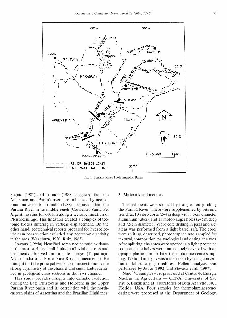
Fig. 1. ParanaH River Hydrographic Basin.
Suguio (1981) and Iriondo (1988) suggested that theAmazonas and ParanaH rivers are in#uenced by neotec-tonic movements. Iriondo (1988) proposed that theParanaH River in its middle reach (Corrientes-Santa Fe,Argentina) runs for 600km along a tectonic lineation ofPleistocene age. This lineation created a complex of tec-tonic blocks di!ering in vertical displacement. On theother hand, geotechnical reports prepared for hydroelec-tric dam construction excluded any neotectonic activityin the area (Washburn, 1930; Ruiz, 1963).
Stevaux (1994a) identi"ed some neotectonic evidencein the area, such as small faults in alluvial deposits andlineaments observed on satellite images (Taquaruc7 u-Anaurila( ndia and Porto Rico-Rosana lineaments). Hethought that the principal evidence of neotectonics is thestrong asymmetry of the channel and small faults identi-"ed in geological cross sections in the river channel.
This study provides insights into climatic evolutionduring the Late Pleistocene and Holocene in the UpperParanaH River basin and its correlation with the north-eastern plains of Argentina and the Brazilian Highlands.
3. Materials and methods
The sediments were studied by using outcrops alongthe ParanaH River. These were supplemented by pits andtrenches, 10 vibro cores (2}4m deep with 7.5 cm diameteraluminium tubes), and 15 motor-auger holes (2}5m deepand 7.5 cm diameter). Vibro core drilling in pans and wetareas was performed from a light barrel raft. The coreswere split up, described, photographed and sampled fortextural, composition, palynological and dating analyses.After splitting, the cores were opened in a light-protectedroom and the halves were immediately covered with anopaque plastic "lm for later thermoluminescence samp-ling. Textural analysis was undertaken by using conven-tional laboratory procedures. Pollen analysis wasperformed by Jabur (1992) and Stevaux et al. (1997).
Nine 14C samples were processed at Centro de EnergiaNuclear na Agricultura * CENA, University of Sa8 oPaulo, Brazil; and at laboratories of Beta Analytic INC.,Florida, USA. Four samples for thermoluminescencedating were processed at the Department of Geology,
J.C. Stevaux / Quaternary International 72 (2000) 73}85 75

Fig. 2. Hydrology and geomorphology of the studied area (afterStevaux, 1994a).
Table 2Geomorphological subdivisions in the Porto Rico area (modi"ed from Stevaux, 1994a, b)
Geomorphological Subdivision Sedimentary composition Description
Porto Rico Sandstone, sandy soil and colluvium Smooth hillsTaquaruc7 u Sandy colluvium Hundreds of pansFazenda Boa Vista Sand and gravelly sand Alluvial terrace and fanParanaH River Sand, mud Present alluvial plain
Table 314Carbon and thermoluminescence data
Lab. code! Material Localization and depth Method Age
Nogueira Jr. (1988) Woods Channel, ca. 10m Standard-14C '40,000CENAd110 Woods Channel, 11.0m Standard-14C '40,000CENAd112 Organic clay Flood plain, 4.5m Standard-14C 4870$100BETAd92912 Leaves Terrace, 11.0m Standard-14C 31,140$1760BETAd92911 Woods Terrace, 10.0m AMS-14C 42,520$1700BETAd92010 Woods Flood plain, 1.6m Standard-14C 3160$80BETAd92909 Leaves Flood plain, 1.5m Standard-14C 3150$90BETAd92908 Leaves Island, 2.0 m Standard-14C 270$60BETAd92907 Woods Flood plain, 3.5m AMS-14C 1990$80UPd0107 Fine sand Pan, 0.7 m Additive dose-TL 1540$730UPd0104 Fine sand Pan, 1.8 m Additive dose-TL 23,540$2240UPd0105 Fine sand Pan, 0.6 m Additive dose-TL 3230$750UPd0108 Fine sand Pan, 1.7 m Additive dose-TL 5290$450
!CENA: Centro de Energia Nuclear na Agricultura, Brazil; BETA: BETA Analytic, USA; UP: University of Peking, People's Republic of China.
University of Peking, China, and at the Institute ofPhysics, University of Sa8 o Paulo, Brazil. SEM photo-graphs were made in IBLC * UNESP, Ribeira8 o Preto,
Brazil, and X-ray di!ractometry of clay was made byPETROBRAS, Rio de Janeiro, Brazil (Table 3).
4. Pans of the Taquaruc7 u Geomorphological Subdivision
The unit has hundreds of small pans with diametersvarying from 300 to 6000m (Fig. 3) very similar to thosedescribed by Goudie (1991) in South Africa and Austra-lia, and by Klammer (1982) in South America. The originof these pans is controversial. Popolizio (1975, 1992)suggested that similar water bodies in the Middle ParanaHRiver plain, near Corrientes, Argentina, were formed bypseudokarst processes during dry periods. Justus (1985)and Pires Neto et al. (1994) thought that the small pans(`lagoasa) were formed by colluviation in"lling of anancient drainage pattern. Iriondo (1997) suggested thatwind de#ation processes formed the pans.
Based on core descriptions, four facies associationswere recognized in the pan deposits: massive sandy mud,pollen-rich mud, massive sand and organic deposits(Table 4 and Fig. 4).
Massive sandy mud: The deepest sediments cored(1.5}2.0m depth) consist mostly of light grey (5Y5/2)to olive grey (5Y6/2) patchy mud, with 20% consistingof matrix-supported grains of "ne to very "ne,well-sorted sand. The largely massive nature of the mudisthe result of burrowing organisms, as indicated by
76 J.C. Stevaux / Quaternary International 72 (2000) 73}85

Fig. 3. Aerial photograph of pans of the Taquaruc7 u GeomorphologicalSubdivision (Black bar is 1.0 km).
Table 4Facies associations and sedimentary processes of pan deposits of Taquaruc7 u Geomorphological Subdivision
Facies association Facies description Processes TL age Pollen zone!
Organic deposit Black organic mud Suspention Present IVMassive sand Light grey "ne to very "ne sand Wind-blown ca. 3000 to 1540$100BP IIIPollen-rich mud Black to very dark grey
organic mudSuspension 5290$450 to 3230$250BP II
Massive sandy mud Burrowed, light grey to olive mud,"ne to very "ne sand
Suspension andwind-blown
23,540$2240BP I
!Stevaux et al. (1997).
tubes of 0.5}2.0mm diameter with olive grey clay coat-ings. Smectite and detrital kaolinite form the predomi-nant clay minerals. Sand percentages decrease upward,whereas organic, pollen and sponge content, increasetoward the top. The upper part of this unit consists ofmedium to dark grey (5Y5/1}4/1) massive sandy mud,with high contents of vegetal remains and abundant rootbioturbation. This unit is interpreted as lacustrine sus-pension deposits with wind-blown sand forming a mud-supported sand grain fabric.
Pollen-rich mud: This unit is mostly composed of blackto very dark grey (5Y2.5/1}5Y6/1) organic mud, massive,mottled by bioturbation, with a high percentage ofvegetal remains and high pollen and sponge content.Sand grains are mostly absent in the pollen-rich mud.
Massive sand: This unit consists of white to light grey(5Y7/1}7/2) "ne to very "ne quartzose, well-sorted sand.It consists of a single bed 0.3m thick with an abrupt andirregular basal contact.
Organic deposit: This unit is mainly composed ofvegetal remains (leaves and logs) and peat, with few blackorganic mud layers rich in pollen and sponges. Thinlayers of spongolith (5 cm) can also be found.
Jabur (1992) and Stevaux et al. (1997) presented a pol-len diagram from the cores of Taquaruc7 u Geomor-phological Unit with four pollen zones.
Zone I: The TL date at the base of this interval is23,540$2240BP (Stevaux, 1994a). The low concentra-tion of pollen with the predominance of Gramineae,Umbelliferae and Palmae suggests savanna vegetation.The presence of mud-supported grains of sand associatedwith a low content of organic carbon also supports theassumption of semi-arid climate with high wind activityin the area.
Zone II: Two TL ages of 5290$450 and 3230$250BPwere obtained at the base and top of this zone. Pollendiagrams show forest elements including Myrtaceae,Moraceae, Araceae and Rapanea with a low concentra-tion of savanna elements such as Gramineae, Compositae,Umbeliferae, Polygonaceae, Acanthaceae and Mal-vaceae. The increase in pollen abundance associated withlow percentage of sand grains is best interpreted as a hu-mid climate with more vegetation and less eolian activity.
Zone III: In spite of the absence of dating within thisinterval, the time range of the zone can be estimatedusing the age of underlying and overlying units as aboutca. 3000 to 1540 yrBP. Sandy facies, decreasing in pollenabundance, and the predominance of savanna elementsassociated with low percentage of organic content sug-gest a short period of semi-aridity.
Zone IV: This zone corresponds to the present depo-sitional pan processes. The pollen diagram containsforest elements (Myrtaceae, Rubiaceae, Moraceae,Bignoniaceae, Leguminosae) and less-abundant savannaelements. Pollen and facies suggest a climatic changetowards a more humid condition (present-day climate)since 1540$100BP, as dated at the base of the zone.
5. Terraces of the Fazenda Boa Vista GeomorphologicalSubdivision
The unit was "rst described by Suguio et al. (1984) andNogueira Jr. (1988). It is about 10m thick and consists ofgravelly sand and gravel (Gm, Gt, Sm and Sp facies) witha predominance of muddy sand and sandy mud (Sr and
J.C. Stevaux / Quaternary International 72 (2000) 73}85 77
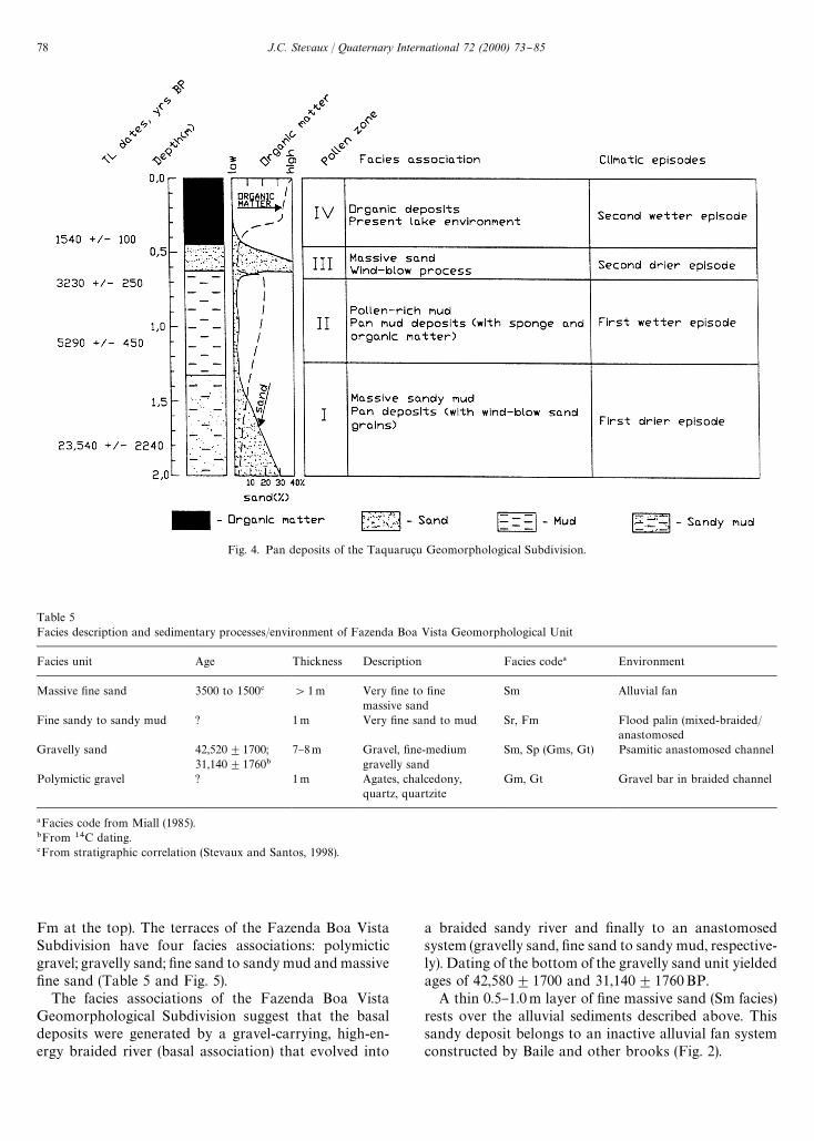
Fig. 4. Pan deposits of the Taquaruc7 u Geomorphological Subdivision.
Table 5Facies description and sedimentary processes/environment of Fazenda Boa Vista Geomorphological Unit
Facies unit Age Thickness Description Facies code! Environment
Massive "ne sand 3500 to 1500# '1m Very "ne to "nemassive sand
Sm Alluvial fan
Fine sandy to sandy mud ? 1m Very "ne sand to mud Sr, Fm Flood palin (mixed-braided/anastomosed
Gravelly sand 42,520$1700;31,140$1760"
7}8m Gravel, "ne-mediumgravelly sand
Sm, Sp (Gms, Gt) Psamitic anastomosed channel
Polymictic gravel ? 1m Agates, chalcedony,quartz, quartzite
Gm, Gt Gravel bar in braided channel
!Facies code from Miall (1985)."From 14C dating.#From stratigraphic correlation (Stevaux and Santos, 1998).
Fm at the top). The terraces of the Fazenda Boa VistaSubdivision have four facies associations: polymicticgravel; gravelly sand; "ne sand to sandy mud and massive"ne sand (Table 5 and Fig. 5).
The facies associations of the Fazenda Boa VistaGeomorphological Subdivision suggest that the basaldeposits were generated by a gravel-carrying, high-en-ergy braided river (basal association) that evolved into
a braided sandy river and "nally to an anastomosedsystem (gravelly sand, "ne sand to sandy mud, respective-ly). Dating of the bottom of the gravelly sand unit yieldedages of 42,580$1700 and 31,140$1760BP.
A thin 0.5}1.0m layer of "ne massive sand (Sm facies)rests over the alluvial sediments described above. Thissandy deposit belongs to an inactive alluvial fan systemconstructed by Baile and other brooks (Fig. 2).
78 J.C. Stevaux / Quaternary International 72 (2000) 73}85

Fig. 5. Pro"le of deposits in the Fazenda Boa Vista Geomorphological Subdivision.
6. Alluvial plain of the ParanaH River GeomorphologicalUnit
In general, the alluvial deposits of the ParanaH Riverform a wedge whose thickness varies from 6 to 10m inthe #ood plain, and up to 10}15m in the channel (Fig. 6).Three main sedimentary units are identi"ed within thealluvial deposits of the ParanaH River: sandy gravel; strat-i"ed and gravelly sand; and sandy mud. The "rst andsecond units are found in the channel and in the #oodplain; the third one occurs only on the #ood plain(Table 6).
The transverse section of alluvial deposits of theParanaH River (Fig. 6) has two intervals with di!erentfacies corresponding to changes in hydrologic regimeduring the Late Quaternary. The lower interval formedby the sandy gravel facies association (Gm, Gt and Spfacies) suggests deposition in a braided river environ-ment. Two 14C dates in the sandy facies (Sp) of thisdeposit indicate ages higher than the method's resolu-tion. No organic material was found in sediments of theupper limit of this interval. However, through strati-graphic correlation it is possible to assume an age of ca.8000BP (Stevaux, 1994a; Stevaux and Santos, 1998).
The upper interval consists of a strati"ed sand andgravelly sand unit (channel facies Sp, St and Sr facies)overlying a sandy mud unit (#ood plain facies Fm).This facies association is believed to have been depos-ited in an anastomosing river environment. Three14C and two thermoluminescence determinationsgave the following ages: 4870$100, 3150$90 and2050$80 BP for the basal portion of the #ood plaindeposits.
In spite of the islands' occcurrence in the channel,the sedimentary processes are closely related to the over-bank environment. These forms originated from channelbars followed by aggradation produced by #ood pro-cesses (Stevaux, 1994a). There are two main groupsof islands: depositional and erosional islands. Thelatter form the main group and are probably relatedto a vertical channel incision at the beginning of theSecond (Present) Wet Episode (see below). Island de-posits are of di!erent ages according to their positionrelated to the water level of the river: 2450$350and 870$30BP, respectively, at 4.50 and 1.25 mdepth (below the river medium water level), and 270$60and 60BP for minor abandoned channels on the #oodplain.
J.C. Stevaux / Quaternary International 72 (2000) 73}85 79

Fig. 6. Alluvial plain deposits (channel and #ood plain) of the Upper ParanaH River at the section of Porto Sa8 o JoseH . Note the strong channelasymmetry.
Table 6Facies description, sedimentary processes and environment of the Rio ParanaH Geomorphological Subdivision sediments
Facies association YearsBP Thickness Structure Facies! Environment
Sandy mud 4780$100"; 1}4m Massive and laminated Fm, Sr Flood plain, crevasse,3160$80"; natural levee (islands)3150$90";2450$350$
2050$80"
870$30$
270$602"
PresentStrati"ed sand and
gravelly sand8000}present# 10}12m Lenses and blankets of sand Sp, St, Ss (Sr) Mega ripple and dune in
anastomosed sandy channelSandy gravel '40,000" 0.5}1m Crudely strati"ed imbricated to
massive gravelGm, Gms, Gt Flash #ood, grain #ow in
braided river
!Facies code from Miall (1985)."From 14C dating.#From stratigraphic correlation (Stevaux and Santos, 1998).$From TL dating.
7. Paleoclimatological interpretation
The following paleoclimatological interpretations arein accordance with the climatic episodes described byStevaux (1994a) for the Late Pleistocene and Holocene of
the Upper Parana River Basin. Using the present climateas a reference base, the following four paleoclimate peri-ods are inferred:
First drier episode: End of Pleistocene to Early Holo-cene ('40,000-ca. 8000BP). The lack of absolute dates
80 J.C. Stevaux / Quaternary International 72 (2000) 73}85
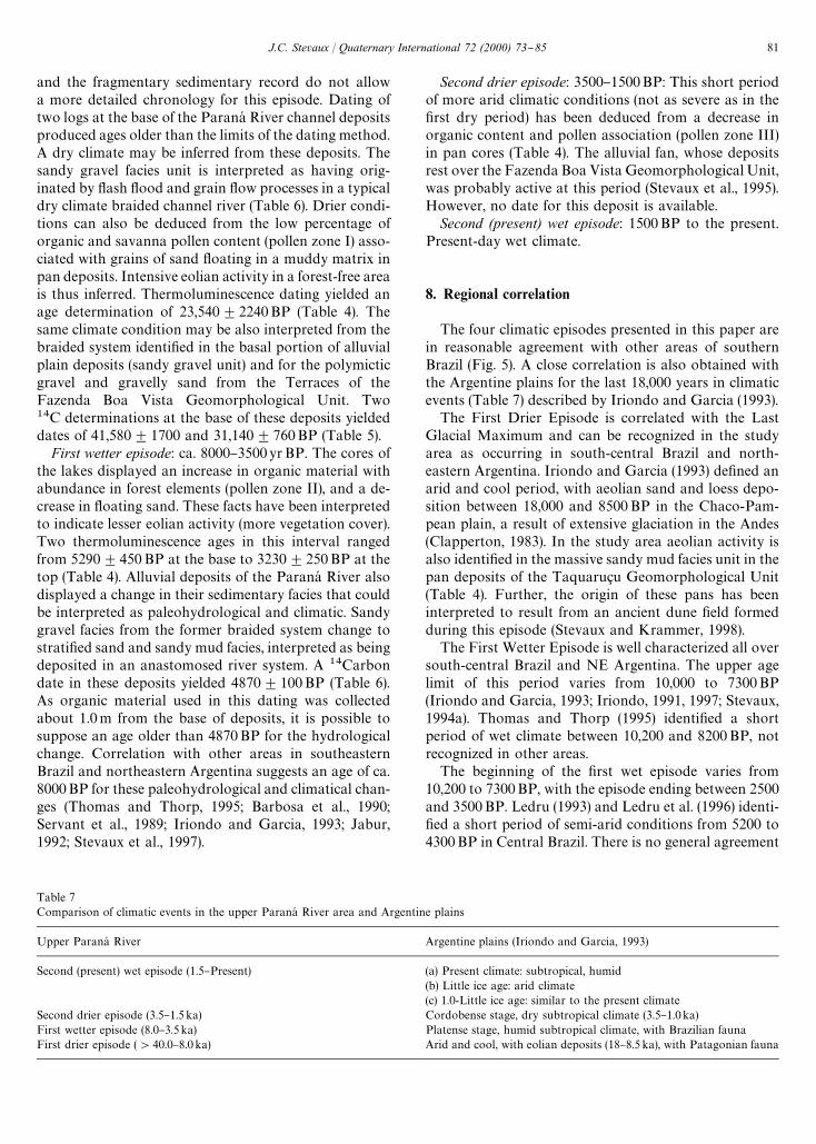
Table 7Comparison of climatic events in the upper ParanaH River area and Argentine plains
Upper ParanaH River Argentine plains (Iriondo and Garcia, 1993)
Second (present) wet episode (1.5}Present) (a) Present climate: subtropical, humid(b) Little ice age: arid climate(c) 1.0-Little ice age: similar to the present climate
Second drier episode (3.5}1.5 ka) Cordobense stage, dry subtropical climate (3.5}1.0 ka)First wetter episode (8.0}3.5 ka) Platense stage, humid subtropical climate, with Brazilian faunaFirst drier episode ('40.0}8.0 ka) Arid and cool, with eolian deposits (18}8.5 ka), with Patagonian fauna
and the fragmentary sedimentary record do not allowa more detailed chronology for this episode. Dating oftwo logs at the base of the ParanaH River channel depositsproduced ages older than the limits of the dating method.A dry climate may be inferred from these deposits. Thesandy gravel facies unit is interpreted as having orig-inated by #ash #ood and grain #ow processes in a typicaldry climate braided channel river (Table 6). Drier condi-tions can also be deduced from the low percentage oforganic and savanna pollen content (pollen zone I) asso-ciated with grains of sand #oating in a muddy matrix inpan deposits. Intensive eolian activity in a forest-free areais thus inferred. Thermoluminescence dating yielded anage determination of 23,540$2240BP (Table 4). Thesame climate condition may be also interpreted from thebraided system identi"ed in the basal portion of alluvialplain deposits (sandy gravel unit) and for the polymicticgravel and gravelly sand from the Terraces of theFazenda Boa Vista Geomorphological Unit. Two14C determinations at the base of these deposits yieldeddates of 41,580$1700 and 31,140$760BP (Table 5).
First wetter episode: ca. 8000}3500yrBP. The cores ofthe lakes displayed an increase in organic material withabundance in forest elements (pollen zone II), and a de-crease in #oating sand. These facts have been interpretedto indicate lesser eolian activity (more vegetation cover).Two thermoluminescence ages in this interval rangedfrom 5290$450 BP at the base to 3230$250BP at thetop (Table 4). Alluvial deposits of the ParanaH River alsodisplayed a change in their sedimentary facies that couldbe interpreted as paleohydrological and climatic. Sandygravel facies from the former braided system change tostrati"ed sand and sandy mud facies, interpreted as beingdeposited in an anastomosed river system. A 14Carbondate in these deposits yielded 4870$100BP (Table 6).As organic material used in this dating was collectedabout 1.0m from the base of deposits, it is possible tosuppose an age older than 4870BP for the hydrologicalchange. Correlation with other areas in southeasternBrazil and northeastern Argentina suggests an age of ca.8000BP for these paleohydrological and climatical chan-ges (Thomas and Thorp, 1995; Barbosa et al., 1990;Servant et al., 1989; Iriondo and Garcia, 1993; Jabur,1992; Stevaux et al., 1997).
Second drier episode: 3500}1500BP: This short periodof more arid climatic conditions (not as severe as in the"rst dry period) has been deduced from a decrease inorganic content and pollen association (pollen zone III)in pan cores (Table 4). The alluvial fan, whose depositsrest over the Fazenda Boa Vista Geomorphological Unit,was probably active at this period (Stevaux et al., 1995).However, no date for this deposit is available.
Second (present) wet episode: 1500BP to the present.Present-day wet climate.
8. Regional correlation
The four climatic episodes presented in this paper arein reasonable agreement with other areas of southernBrazil (Fig. 5). A close correlation is also obtained withthe Argentine plains for the last 18,000 years in climaticevents (Table 7) described by Iriondo and Garcia (1993).
The First Drier Episode is correlated with the LastGlacial Maximum and can be recognized in the studyarea as occurring in south-central Brazil and north-eastern Argentina. Iriondo and Garcia (1993) de"ned anarid and cool period, with aeolian sand and loess depo-sition between 18,000 and 8500 BP in the Chaco-Pam-pean plain, a result of extensive glaciation in the Andes(Clapperton, 1983). In the study area aeolian activity isalso identi"ed in the massive sandy mud facies unit in thepan deposits of the Taquaruc7 u Geomorphological Unit(Table 4). Further, the origin of these pans has beeninterpreted to result from an ancient dune "eld formedduring this episode (Stevaux and Krammer, 1998).
The First Wetter Episode is well characterized all oversouth-central Brazil and NE Argentina. The upper agelimit of this period varies from 10,000 to 7300BP(Iriondo and Garcia, 1993; Iriondo, 1991, 1997; Stevaux,1994a). Thomas and Thorp (1995) identi"ed a shortperiod of wet climate between 10,200 and 8200BP, notrecognized in other areas.
The beginning of the "rst wet episode varies from10,200 to 7300BP, with the episode ending between 2500and 3500BP. Ledru (1993) and Ledru et al. (1996) identi-"ed a short period of semi-arid conditions from 5200 to4300BP in Central Brazil. There is no general agreement
J.C. Stevaux / Quaternary International 72 (2000) 73}85 81
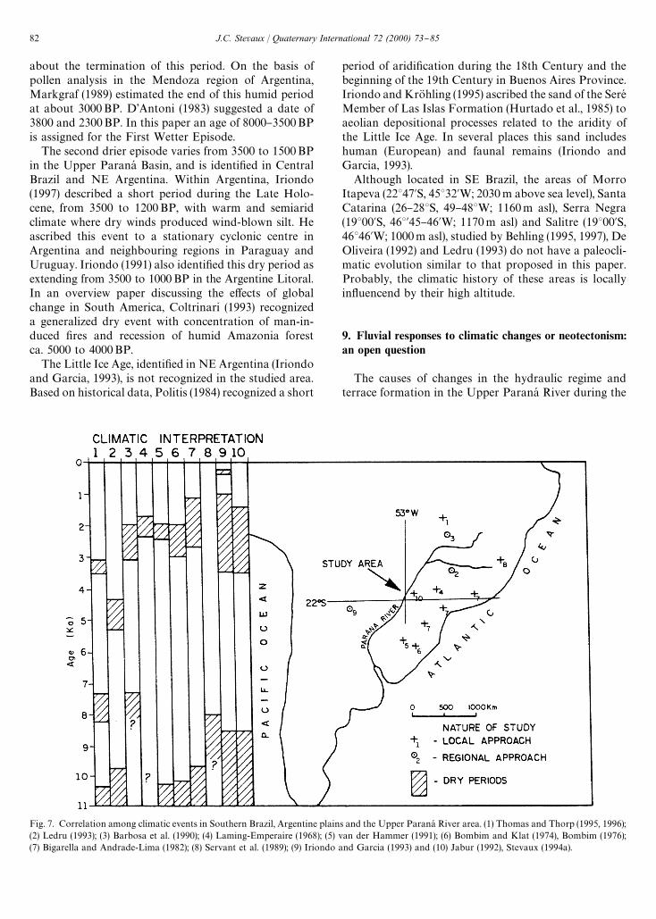
Fig. 7. Correlation among climatic events in Southern Brazil, Argentine plains and the Upper ParanaH River area. (1) Thomas and Thorp (1995, 1996);(2) Ledru (1993); (3) Barbosa et al. (1990); (4) Laming-Emperaire (1968); (5) van der Hammer (1991); (6) Bombim and Klat (1974), Bombim (1976);(7) Bigarella and Andrade-Lima (1982); (8) Servant et al. (1989); (9) Iriondo and Garcia (1993) and (10) Jabur (1992), Stevaux (1994a).
about the termination of this period. On the basis ofpollen analysis in the Mendoza region of Argentina,Markgraf (1989) estimated the end of this humid periodat about 3000BP. D'Antoni (1983) suggested a date of3800 and 2300BP. In this paper an age of 8000}3500BPis assigned for the First Wetter Episode.
The second drier episode varies from 3500 to 1500BPin the Upper ParanaH Basin, and is identi"ed in CentralBrazil and NE Argentina. Within Argentina, Iriondo(1997) described a short period during the Late Holo-cene, from 3500 to 1200BP, with warm and semiaridclimate where dry winds produced wind-blown silt. Heascribed this event to a stationary cyclonic centre inArgentina and neighbouring regions in Paraguay andUruguay. Iriondo (1991) also identi"ed this dry period asextending from 3500 to 1000BP in the Argentine Litoral.In an overview paper discussing the e!ects of globalchange in South America, Coltrinari (1993) recognizeda generalized dry event with concentration of man-in-duced "res and recession of humid Amazonia forestca. 5000 to 4000BP.
The Little Ice Age, identi"ed in NE Argentina (Iriondoand Garcia, 1993), is not recognized in the studied area.Based on historical data, Politis (1984) recognized a short
period of aridi"cation during the 18th Century and thebeginning of the 19th Century in Buenos Aires Province.Iriondo and KroK hling (1995) ascribed the sand of the SereHMember of Las Islas Formation (Hurtado et al., 1985) toaeolian depositional processes related to the aridity ofthe Little Ice Age. In several places this sand includeshuman (European) and faunal remains (Iriondo andGarcia, 1993).
Although located in SE Brazil, the areas of MorroItapeva (22347@S, 45332@W; 2030 m above sea level), SantaCatarina (26}283S, 49}483W; 1160m asl), Serra Negra(19300@S, 463@45}46@W; 1170m asl) and Salitre (19300@S,46346@W; 1000m asl), studied by Behling (1995, 1997), DeOliveira (1992) and Ledru (1993) do not have a paleocli-matic evolution similar to that proposed in this paper.Probably, the climatic history of these areas is locallyin#uencend by their high altitude.
9. Fluvial responses to climatic changes or neotectonism:an open question
The causes of changes in the hydraulic regime andterrace formation in the Upper ParanaH River during the
82 J.C. Stevaux / Quaternary International 72 (2000) 73}85

Holocene are not well understood. Were they caused byclimatic or tectonic in#uences? In spite of the lack ofstructural studies in the area, Iriondo (1988), Souza-Filho(1993), and Stevaux (1994a) discussed some evidence oftectonic activity occurring during the climatic changes inthe Late Quaternary. Small faults in ancient alluvialgravel deposits, the vertical incision of Fazenda BoaVista Geomorphological Subdivision, and the strongasymmetry of the alluvial sediment wedge (Fig. 7) are themain evidence for Quaternary tectonism. On the otherhand, the climatic episodes described above were strongenough to have caused di!erent paleohydrological re-gimes (braided to anastomosed pattern, Stevaux et al.,1995, 1997) and to have generated terraces identi"ed inthe Upper ParanaH River.
The paleoclimate studied in this work presentedonly qualitative aspects of the paleoenvironmentalvariables. However, the elaboration of deterministicmodels for paleoclimatic changes needs a quantitativeapproach for these variables. Analysis of water and airtemperature, rainfall, pH, salinity, sediment load and#ow velocity are indispensable for this purpose. Quanti-tative analyses of variables will be possible accordingto the progress of studies on sponge, algae, benthic or-ganisms, and phytoliths, together with more accuratesurveys on sedimentology and stratigraphy. Moreover,the research area requires a progressive extension notonly to the tributary valleys, but over the entire drainagebasin.
Acknowledgements
This research is part of the project titled `UpperTertiary and Quaternary Paleoclimates in the UpperParanaH River Basina supported by the ConselhoNacionalde Desenvolvimento CientmH "co e TecnoloH gico,Brazil (CNPq 522456/94 and 520099/96-6). The NuH cleode Pesquisas em Limnologia, Ictiologia e Aquicultura* NUPELIA, University of MaringaH provided accom-modations and equipment for "eld work. The authorwould like to thank Vera Markgraf, MartmHn Iriondo andPaul Potter for their helpful suggestions in reviewing themanuscript and is grateful to Thomas Bonnici for thetranslation.
References
Ab'Saber, A.N., 1977. Espac7 os ocupados pela expansa8 o dos climassecos na AmeH rica do Sul, por ocasia8 o dos permHodos glaciais doQuaternaH rio. Paleoclimas, Vol. 3, Instituto de Geogra"a, Univer-sidades de Sa8 o Paulo, Sa8 o Paulo, Brasil, pp. 1}19.
Ab'Saber, A.N., 1982. The paleoclimate and paleoecology of BrazilianAmazonia. In: Prance, G.T. (Ed.), Biological Diversi"cation in theTropics, Columbia, New York, pp. 1}59.
Barbosa, A.S., Ribeiro, Schimitz, P.I., 1990. Cultura e ambiente emaH reas de cerrado do Sudoeste de GoiaH s. In: Pinto, M.N. (Ed.),Cerrado* Caracterizac7 a8 o, ocupac7 a8 o e perspectivas. Universidadede BrasmH lia, pp. 67}100.
Barthelness, H., 1960. ComentaH rio geomorfoloH gico sobre o valedo rio IvamH . Boletim Paranaense de Geogra"a, Curitiba, PR 1 (1),8}17.
Barthelness, H., 1961. Infere( ncias de comportamento de umadrenagem. Boletim Paranaense de Geogra"a, Curitiba, PR 1 (2}3),6}13.
Behling, H., 1995. Investigation into the Late Pleistocene and Holocenehistory of vegetation and climate in Santa Catarina (S. Brazil).Veget. Hist. Archaeobot. 4 (3), 127}152.
Behling, H., 1997. Late Quaternary, climate and history from thetropical mountain region of Morro de Itapeva, SE Brazil.Paleogeography, Paleoclimatology, Paleoecology 129, 407}422.
Bigarella, J.J., Ab'Saber, A.N., 1964. PaleK ogeographische und paleK o-klimatische Aspekte der KaK enoziokums in SuK dbrasilien. ZeitschriftfuK r Geomorphologie 8 (3), 286}312.
Bigarella, J.J., Backer, R.D., 1975. International Symposium on theQuaternary. Curitiba, PR. Boletim Paranaense de Geocie( ncias, pp.33}77.
Bigarella, J.J., Andrade-Lima, D., 1982. Paleoenvironmental changes inBrazil. In: Prance, G.T. (Ed.), Biological Diversi"cation in theTropics. Columbia, New York, pp. 27}39.
Bombim, M., 1976. Modelo paleopedoloH gico evolutivo parao NeoqaternaH rio da regia8 o da Campanha Oeste do Rio Grande doSul. A Formac7 a8 o Touro Passo, seu conteuH do fossilmH fero e ped-oge( nese poH s-deposicional. Vol. 15, Comunicac7 a8 o do Museu deCie( ncias da PontifmHcia Universidade CatoH lica do Rio Grande do Sul,Porto Alegre, pp. 1}90.
Bombim, M., Kant, E., 1974. Evide( ncia paleoclimaH tica em solos do RioGrande do Sul. Anais XXVIII Congresso Brasileiro de Geologia.Porto Alegres 3, 183}194.
Bonetto, A.A., Castello, H.P., Wais, I.R., 1986. Comparison between thedi!erential impacts of dams on two large river basins in Argentina.Proceedings, International Symposium on the Impact of LargeWater Projects on the Environment, Paris, France, October 27}31,UNESCO Headquarters, 14 pp.
Bonetto, A.A., Wais, I.R., Castello, H.P., 1990. The increasing dammingof the ParanaH Basin and its e!ects on the lower reaches. RegulatedRivers: Research and Management 4, 333}346.
Braun, O.P.G., 1971. Contribuic7 a8 o a geomorfologia do Brasil central.Revista de Geocie( ncias XXXIII (32), 1}16.
Cailleux, A., Tricart, J., 1957. Zones phytogeographiques et morpho-cliamtiques du Quaternaire du BreH sil. Vol. 293, Comptes Rendues.de la Societe de Biogeographie, Paris, pp. 7}13.
Clapperton, C.M., 1983. The glaciation of the Andes. QuaternaryScience Reviews 2, 83}155.
Clapperton, C.M., 1993. Nature of environmental changes in SouthAmerica at the Last Glacial Maximum. Paleogeography, Paleo-climatology, Paleoecology 101, 189}208.
Colinvaux, P.A., 1996. Quaternary environmental history and forestdiversity in the Neotropics. In: Jackson, J.B.C., Budd, A.F., Coates,A.G. (Eds.), Evolution and environment in Tropical America. TheUniversity of Chicago Press, Chicago, pp. 359}405.
Coltrinari, L., 1993. Global Quaternary changes in South America.Global and Planetary Change 7, 11}23.
Damuth, J.E., Fairbridge, R.W., 1970. Equatorial deep-sea arkosicsands and Ice-Age aridity in tropical South America. GeologicalSociety of America Bulletin 81, 189}206.
D'Antoni, H., 1983. Pollen analysis of Gruta del Indio. Quaternary inSouth America and Antarctica Peninsula 1, 83}104.
De Oliveira, P.E., 1992. A palynological record of the Quaternaryvegetational and climatic change in southeastern Brazil. Thesis.Ohio State University, Columbus, 238 pp.
J.C. Stevaux / Quaternary International 72 (2000) 73}85 83
Ferreira, F.S.F., 1982. Alinhamentos estruturais-magneH tico da regia8 ocentro-oriental da Bacia do ParanaH e seu signi"cado tecto( nico.PAULIPETRO, Geologia da Bacia do ParanaH , Sa8 o Paulo, pp.143}166.
Fulfaro, V.J., Suguio, K., 1974. O CenozoH ico paulista: ge( nese e idade.Anais XVII Congresso Brasileiro de Geologia. Porto Alegre 3,91}101.
Fulfaro, V.J., Saad, A.R., Santos, M.V., Vianna, R.B., 1982. Compar-timentac7 a8 o e evoluc7 a8 o tecto( nica da Bacia do ParanaH . RevistaBrasileira de Geocie( ncias 12 (4), 590}610.
Goudie, A.S., 1991. Pans. Progress in Physical Geography 15 (3),221}237.
Hurtado, M., Dilon, A., Castilho, R., 1985. Incidencia de fatorespedogeneticos en suelos des partido de Carlos Tejedor. 1! JornadaGeologica de la Provincia de Buenos Aires, Actas, pp. 23}25.
Irion, G., 1984. Mineralogical and geochemical contribution to climatichistory in central Amazonia during Quaternary time. TropicalEcology 23, 76}85.
Iriondo, M.H., 1988. A comparison between the Amazon and ParanaRivers system. Vol. 66, Mitteilung der Geologisch-PlalaK on-tologisches Instituts, UniversitaK t Hamburg (Scope/UNEP Scnder-band), pp. 77}92.
Iriondo, M.H., 1991. El Holoceno en el Litoral. Com. Mus. Prov.Cie( ncias Naturales `Florentino Ameghinoa, Santa FeH , Argentina4 (2), 3}46.
Iriondo, M.H., 1997. Models of deposition of loess and loessoids in theUpper Quaternary of South America. Journal of South AmericanEarth Sciences 10 (1), 71}79.
Iriondo, M.H., Suguio, K., 1981. Neotectonics of the Amazon #oodplain. Vol. 4, Bulletin of the INQUA, Tectonic Commission, Stock-holm, pp. 72}78.
Iriondo, M.H., Garcia, N., 1993. Climatic variations in the Argentineplains during the last 18,000 years. Paleogeography, Paleoclimatol-ogy, Paleoecology 101, 209}220.
Iriondo, M.H., KroK hling, D.M., 1995. El Systema Eolico Pampeano.Com. Mus. Cie( ncias Naturales `Florentino Ameghinoa. Santa FeH ,Argentina 5 (1), 1}68.
Jabur, I.C., 1992. AnaH lise Paleoambiental do QuaternaH rio Superior naBacia do Alto ParanaH . Doctoral thesis, Instituto de Geocie( nciase Cie( ncias Exatas, UNESP, Rio Claro, 184 pp.
Justus, J., 1985. SubsmHdios para interpretac7 a8 o morfogeneH tica atraveH s dautilizac7 a8 o de imagens de radar. Masters Dissertation, UniversidadeFederal da Bahia, BA, Brazil, 204 pp.
Klammer, G., 1982. Die PalaK owuK ste des Pantanal von Mato Grossound die pleistozaK ne Klimageschite der brasilianischen Randtropen.Zeitschrift fuK r Geomorphologie 26 (4), 393}416.
King, L.C., 1956. A geomorfologia do Brasil central. Revista Brasileirade Geogra"a XVII (2), 147}263.
Laming-Emperaire, A., 1968. Missions archeologiques franc7 aise auChilil Austral et au BreH sil Meridional. Journal of Social American-istes 57, 77}99.
Ledru, M.P., 1993. Late Quaternary environmental and climaticchanges in Central Brazil. Quaternary Research 39, 90}98.
Ledru, M.P., Braga, P.I.S., Soubies, F., Fournier, M., Martin, L.,Suguio, K., Turcq, B., 1996. The last 50,000 years in Neo-tropics (Southern Brazil): evolution of vegetation and cli-mate. Paleogeography, Paleoclimatology, Paleoecology 123,239}257.
Maack, R., 1968. Geogra"a FmH sica do ParanaH . Secretaria daCultura e do Esporte do Governo do ParanaH . JoseH Olimpo S.A.,450 pp.
Markgraf, V., 1989. Paleoclimates in Central and South America since18,000 BP based on pollen and lake-level records. QuaternaryScience Reviews 8, 1}24.
Miall, A.D., 1985. Architectural element analysis applied to #uvialdeposits. Earth Science Reviews 22, 261}308.
Milliman, J.D., Summerhayes, C.P., Barreto, H.T., 1975. Quaternarysedimentation on the Amazon continental margin: a model. Geo-logical Society of America Bulletin 86, 610}614.
Nogueira Jr., J., 1988. Possibilidades de colmetac7 a8 o qumHmica dos "ltrose drenos de barragem de Porto Primavera (SP) por compostos deferro. Master's Dissertation, Vols. I and II, Instituto de Geocie( ncias,Universidade de Sa8 o Paulo, Sa8 o Paulo, 239 pp.
Pires Neto, A.G., Bartorelli, A., Vargas, M.S., 1994. A planmH cie do rioParanaH . Boletim Paranaense de Geocie( ncias 42, 217}229.
Politis, G., 1984. Climatic variation during historical times in EasternBuenos Aires, Argentina. Quaternary of South America and Antarc-tic Peninlsula 2, 133}162.
Popolizio, E., 1975. El seudokarst y su importancia en losestudios hidrologicos del Nordeste Argentino, No. 1. Centrode Geociencias Aplicadas. Universidad Nacional do NoroesteArgentino. Resistencia, Chaco, Argentina, Serie C. Investigacion,14 pp.
Popolizio, E., 1992. Geomorphology of the Argentina Northeast. WaterInternational 7, 162}177.
Ruiz, M.D., 1963. Geologia aplicada a barragem de JupiaH (SistemaUrubupungaH ). Instituto de Pesquisas TecnoloH gicas (IPT), CentraisEleH tricas de UrubupungaH S.A., Sa8 o Paulo, Technical Report,34 pp.
Sifeddine, A., Bertrand, P., Fournier, M., Martin, L., Servant, M.,Souibies, F., Suguio, K., Turcq, B., 1994. La sedimentationoreganique en milieu tropical humide (CarajaH s, Amazonic orientale,BreH sil): relation avec les changements climatiques au cours des60,000 dernieres aneeH s. Bulletin de la Societe GeH ologique de France165 (5), 613}621.
Servant, M., Soubies, F., Suguio, K., Turcq, B., Founier, M., 1989.Alluvial fans in Southern Brazil as evidence for Early Holocenedry climate periods, Vol. 1. International Symposium on GlobalChanges in South America During the Quaternary, Sa8 o Paulo,1989, Special Publication, pp. 75}77.
Souza-Filho, E.E., 1993. Aspectos da geologia e estratigra"a dos de-poH sitos sedimentares do rio ParanaH entre Porto Primavera (MS)e GuamH ra (PR), Instituto de Geocie( ncias, Universidade de SaoPaulo, Doctoral Thesis, Sa8 o Paulo, Brazil, 240 pp.
Stevaux, J.C., 1994a. The Upper ParanaH River (Brazil); geomorphology,sedimentology and paleoclimatology. Quaternary International 21,143}161.
Stevaux, J.C., 1994b. Paleoclima, tectonismo and paleohidrologia doalto curso do rio ParanaH durante o QuaternaH rio. Boletim de Re-sumos Expandidos, 383. Congresso Brasileiro de Geolgoia* SBG,CamboriuH , SC, pp. 214}216.
Stevaux, J.C., Krammer, W.M., 1998. Genesis and Quaternaryevolution of pans in the Taquaruc7 u GeomorphjologicalUnit: a theme for discussion. Abstract, International Joint Field* Loess in Argentina: Temperate and Tropical. ParanaH , Argentina,p. 8.
Stevaux, J.C., Santos, M.L., 1998. Paleohydrological changes in theUpper ParanaH River during the Late Quaternary. In: Benito, G.,Baker, V.R., Gregory, K.J. (Eds.), Paleohydrology and HydrologicalSciences. Wiley, London.
Stevaux, J.C., Souza-Filho, E.E., Jabur, I.C., 1997. A histoH ria quater-naH ria do rio ParanaH em seu alto curso. In: Vazzoler, A.E.A.M.,Agostinho, A.A., Hahn, N.S. (Eds.), A planmHcie de inundac7 a8 o do altorio ParanaH . Editora UEM, MaringaH , PR, pp. 47}72.
Stevaux, J.C., Takeda, A.M., Moraes, M., 1995. Paleoclima, tectonismoe paleohidrologia do alto curso do rio ParanaH durante o Quater-naH rio, Vol. 1. Boletim de Resumos Expandidos, 63. SimpoH sio Sul-Brasileiro de Geologia, Porto Alegre, RS, pp. 414}425.
Suguio, K. Nogueira Jr., Taniguchi, H., Vasconcellos, M.L., 1984.QuaternaH rio do rio ParanaH em Pontal do Paranapanema:proposta de um modelo de sedimentac7 a8 o, Vol. 1. Anais XXXVIIICongresso Brasileiro de Geologia, Rio de Janeiro, pp. 10}18.
84 J.C. Stevaux / Quaternary International 72 (2000) 73}85

Thomas, M.F., Thorp, M.B., 1995. Geomorphic response to rapidclimatic and hydrologic change during the Late Pleistocene andEarly Holocene in the humid and sub-humid tropics. QuaternaryScience Reviews 14 (2), 193}207.
Thomas, M.F., Thorp, M.B., 1996. The response of geomorphic systems toclimatic and hydrological change during the Late Glacial and earlyHolocene in the humid and sub-humid tropics. In: Branson, J., Greg-ory, K.J. (Eds.), Global Continental Changes: the Context of Paleohyd-rology, Vol. 115. Geological Society Special Publication, pp. 139}153.
Van der Hammer, 1991. Paleoecology of the neotropics: an overviewof the state of a!airs. In: Suguio, K., Tessler, M. (Eds.), Proceed-ings of the Global Changes in South America during theQuaternary, Vol. 8, May 8}12, 1989. Bol. Instituto de Geocie( n-cias da Universidade de Sa8 o Paulo, Special Publication,pp. 35}55.
Washburn, C.W., 1930. Petroleum geology of the State of Sa8 o Paulo,Brazil. Boletim da Comissa8 o GeograH "ca e geoloH gica do Estado deSa8 o Paulo 2, 159}222.
J.C. Stevaux / Quaternary International 72 (2000) 73}85 85