Embed Size (px)
Citation preview

CLASS Conference 2014, Bled, September 25-26 2014
Cloud computing for Earth observation
Krištof Oštir, Tomaž Rodič and Grega Milčinski
Slovenian Centre of Excellence for Space Sciences and Technologies, Research Centre of the Slovenian Academy of Sciences and Arts and
Sinergise

SPACE-SI

R&D activities

Microsatellite under development 70 kg satellite for earth monitoring and observation
2.8 m gsd from a reference altitude of 600 km
four spectral channels
(450-520 nm, 520-600 nm, 630-690 nm, and 760-900 nm).
high-definition video at 1920 by 1080 pixels.
real-time imaging and video streaming over Slovenia
three-axis stabilized bus
50 mbps x-band downlink
128 gb of on-board storage,
power system generating nearly 90 w
100 w-h li-ion battery.
Ground control infrastructure

Number of active satellites

Satellites by country

Spatial resolution of images

Data volume
TB per year per 100 km2

WorldView-3 level of detail

WorldView-3

WorldView-3

WorldView-3

WorldView-3

Detection of Japanese knotweed


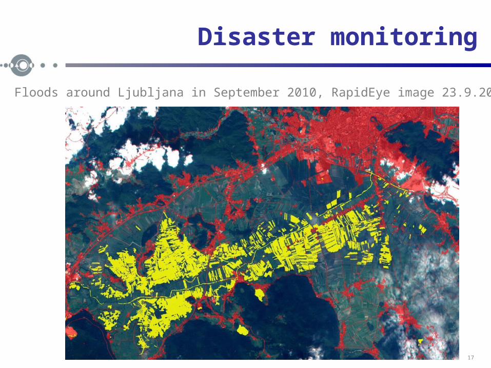
Disaster monitoring
17
Floods around Ljubljana in September 2010, RapidEye image 23.9.2010

Radarsat-2 RapidEye

Floods around Ljubljanain September 2010rapid mapping product

Interactive graphs:
Drought monitoring:
Multitemporal land cover classification:
Drought mapping

Space-SI Processing chain is cloud ready
Geometriccorrections
Radiometriccorrections
Generation ofResults
End userServices
Data preparation
GCP extraction
Orthorectification
Topographic correction
NDVI generation
Web mapping of products
Remote sensing data
Test data: RapidEye
Change detection
NDVI changes
Atmospheric correction
Various full-frame and pushbroom sensors
Data catalog
End user triggered re-processing
RapidEye
WorldView-2
THEOS
Pleiades

Establishment of a the Sentinel processing and archiving cloud

Mobile app Web GIS
Web services
Crowdsourcing
Close the loop between satellite developers, operators, expert users and genereal public

Mobile app
• Storms, hail• Water levels• Water pollution

Conclusions
• Satellites are generating huge amount of data• Only information – report, yes/no, alert - is relevant to the
end user• Automatic processing is necessary• Steps are defined and tested – ready to be implemented in
the cloud

Conclusions
• ICT technologies• Space and ground infrastructure• Smart cities and communities
• Spatial data • Planning• Crowdsourcing
• Smart use of resources• Health


![MODUL: DESCRIPTION OF PRACTICAL - OktawaveSTEM4Youth]ChemistryAndSport_EN.… · Programme prepared by Department of Physical and Organic Chemistry (K3), Dr. Peter Rodič MODUL: Chemistry](https://img.dokumen.tips/doc/110x75/5b6dbbfc7f8b9aa5478d2c56/modul-description-of-practical-oktawave-stem4youthchemistryandsporten.jpg)


![Fran Milčinski U BTAI CL - domžalec.si · 2019. 1. 10. · 821.163.6-93-32(0.034.2) MILČINSKI, Fran, 1867-1932 Butalci [Elektronski vir] / Fran Milčinski. ... Leta 1890 je postal](https://img.dokumen.tips/doc/110x75/60f97bfd4c669727cc3b5b70/fran-milinski-u-btai-cl-domalecsi-2019-1-10-8211636-93-3200342.jpg)