1
E a s t M o u nt ain R d N F i s hk i l l ¯ Z 9 I n d i a n B r o ok O l d A l ba n y P o s t Can o p u s H ill B ell H o l low Hudson Highlands State Park T S P R ic h ar d sv i l l e P u d di n g T S P T S P E a s t M o untai n R d S ou t h P e e ks k il l H o llo w Osc a w a n a H e i g hts S ou t h H i g h l an d De n n y t o w n C l e a r L a k e G l y n w o o d S u n k e n M ine C a n op u s L ak e O sc a w a n a L a k e R o a r i n g B r o o k L a ke W i c c o p e e Re s e r v o i r Wa y w a n d a L a k e S t i l l w a t e r P o n d Cl o v e C r ee k S a g a mo r eLa ke H u d s o n R iv e r DUTCHESS COUNTY PUTNAM COUNTY I A I A PL SL T r o u t B r o ok W i c cop e e C r e e k C l o v e C r e e k C a n o p u s C r e ek W i c c o p ee B r o o k Pe e k s k i l l H o l l o w C re e k P ee k ski l l Hol l o w C r e e k F o u n dr y B r o ok C l o v e Cr e e k CLC CF HL ) ¥ ) ¥ ) ¥ [ Ï [ Ï [ Ï TB I A TL CL TL PP RB SM CF RB CM MM CL CL PA PT CC MMA EM CL CH RH WI FS CA FS CB OM FS CB PT MM 2 9 3 0 1 2 MILES STATE YORK NEW Preservation and Historic Parks, Recreation Clarence Fahnestock Memorial State Park 1498 Route 301, Carmel, NY 10512 Legend Campground Comfort Station Concession Stand Drinking Fountain Parking Area Park Office Scenic View Taconic Outdoor Education Center Lodge Beach Trail Color Varies Multi-Use Trail Color Varies Umarked Trail Road Taconic State Parkway Counties Line 50' Contour Streams Wetland Water State Park Conservation Easement Other Park Lands C a n o p u s L a k e T S P ATC ATC SB I A RI RI Map produced by NYSOPRHP GIS Bureau, January 16, 2019. Park Office: (845) 225-7207 Taconic Outdoor Education Center: (845) 265-3773 Taconic Regional Office: (845) 889-4100 State Park Police: (845) 889-4100 x310 In Case of Emergency: 1(877) 851-6086 μ Please be considerate of other park users. Please report any accident or incident immediately to park police. All boundaries and trails are shown as approximate. Be aware of changing trail conditions. Hiking Trails Trail Name Appalachian Trail Appalachian Trail Connector Cabot Trail Charcoal Burners Trail Clove Creek Trail Catfish Loop Candlewood Hill Trail Clear Lake Scout Reservation Trail Clear Lake Connector Trail Chimney Top Trail East Mountain Loop Fahnestock Trail Hubbard Loop Moneyhole Mountain Trail Moneyhole Mountain Access Trail Old Mine Railroad Perkins Access Trail Pasture Loop Perkins Trail Pelton Pond Nature Trail Roaring Brook Trail Round Hill Bypass Trail Ridge Line Trail Snow Bunting Stillwater Loop School Mountain Road Trout Brook Three Lakes Trail Wiccopee Trail Mileage 10.24 3.13 1.02 3.33 1.43 4.31 2.48 4.36 0.21 0.53 1.50 6.09 0.55 4.07 0.42 1.65 1.18 0.52 4.16 0.87 7.51 0.27 0.69 0.15 1.54 4.06 0.40 4.39 1.82 I A ID ATC CA CB CC CF CH CL CLC CM EM FS HL MM MMA OM PA PL PT PP RB RH RI SB SL SM TB TL WI

Clarence Fahnestock State Park Trail Map · Parks, Recreation Clarence Fahnestock Memorial State Park 1498 Route 301, Carmel, NY 10512 Legend Campground Comfort Station Concession

  • Upload
    others

  • View
    10

  • Download
    0

Embed Size (px)

Citation preview

E ast Mou ntain

Rd N

Fishki

ll

Z̄9

Ind

ian Brook

Old Albany Post

Canopus H illBe

ll Hollo

w

Hudson HighlandsState Park

TS P

Ric

hardsville

Pudding

TS P

TS P

East Mountain Rd South

Peeks

killHo

llow

Osca wana

Heights

Sou th Highlan d

Denn

ytown

Clear

Lake

Glynwood

S unken Mine

Can op

usLa

ke

Oscaw

ana L

ake

RoaringBr o ok Lake

Wi cco p ee Reser voi r

Waywanda L ake

St il lwat erPond

Clov e

C reek

Sagamore

Lake

Hudso nRiver

DUTCHESS COUNTY

PUTNAM COUNTY

IA

IA

PL

SL

Tro u tBro

ok

WiccopeeCr e ek

Clov e

Cr eek

Ca no pu

s Cr ee

k

Wi c copee B r ook

Pe ek skil l

Holl o

w Cree

k

Peekskill Hollow Cr eek

F oun dr y B r ook

Clove

Cr eek

CLC

CF

HL

)¥[Ï

TBIA

TL

CLTL

PP

RB

SM

CFRB

CM

MM

CL

CLPA

PT

CC

MMA

EM

CL

CH

RH

WI

FS

CA

FS

CB

OM

FS

CBPT

MM

293

0 1 2

MILES

TM

STATEYORKNEW

Preservationand HistoricParks, Recreation
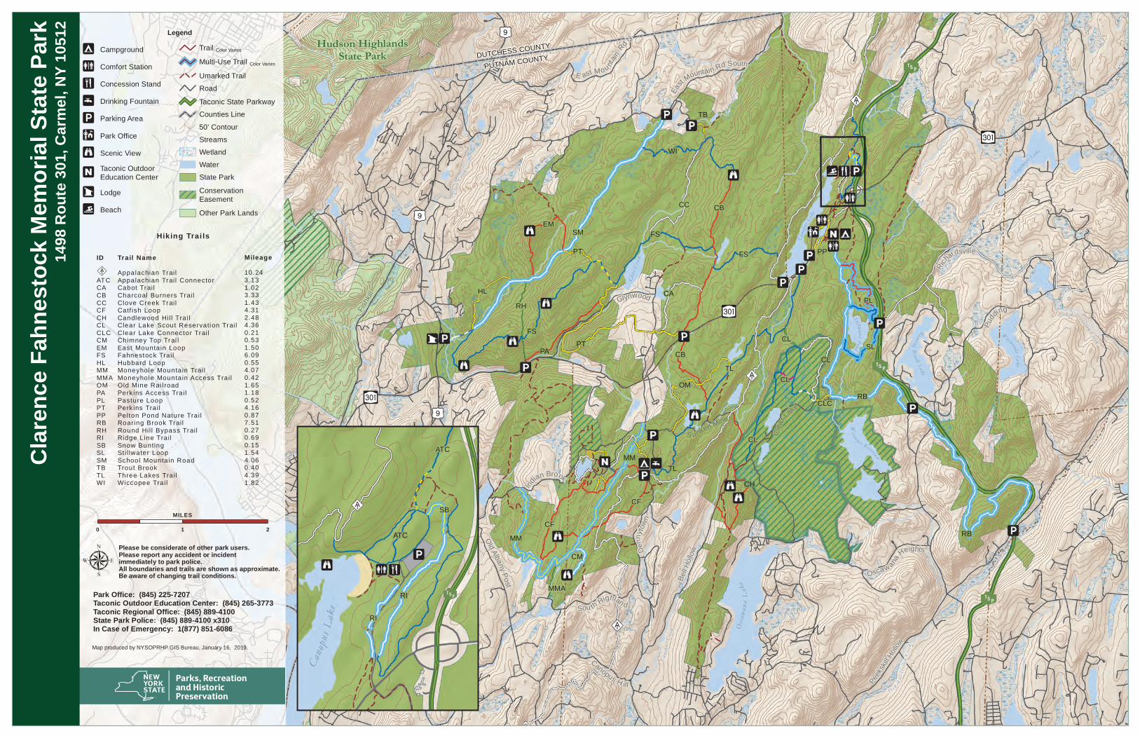
Clare

nce F

ahne

stock

Mem

orial

State

Park

1498

Rou

te 30

1, Ca

rmel,

NY 1

0512 Legend

CampgroundComfort StationConcession StandDrinking FountainParking AreaPark OfficeScenic ViewTaconic OutdoorEducation CenterLodgeBeach

Trail Color Varies

Multi-Use Trail Color Varies

Umarked TrailRoadTaconic State ParkwayCounties Line50' ContourStreamsWetlandWaterState ParkConservationEasementOther Park Lands

Canop

usLa

ke

T S P

ATC

ATC

SBIA

RI

RI

Map produced by NYSOPRHP GIS Bureau, January 16, 2019.

Park Office: (845) 225-7207Taconic Outdoor Education Center: (845) 265-3773Taconic Regional Office: (845) 889-4100State Park Police: (845) 889-4100 x310In Case of Emergency: 1(877) 851-6086

µPlease be considerate of other park users.Please report any accident or incidentimmediately to park police. All boundaries and trails are shown as approximate.Be aware of changing trail conditions.

Hiking Trai ls

Trail NameAppalachian Trai lAppalachian Trai l ConnectorCabot Trai lCharcoal Burners Trai lClove Creek Trai lCatf ish LoopCandlewood Hil l Trai lClear Lake Scout Reservation Trai lClear Lake Connector Trai lChimney Top Trai lEast Mountain LoopFahnestock Trai lHubbard LoopMoneyhole Mountain Trai lMoneyhole Mountain Access Trai lOld Mine Rai lroadPerk ins Access Trai lPasture LoopPerk ins Trai lPelton Pond Nature Trai lRoaring Brook Trai lRound Hil l Bypass Trai lRidge Line Trai lSnow BuntingSt i l lwater LoopSchool Mountain RoadTrout BrookThree Lakes Trai lWiccopee Trai l

Mileage10.243.131.023.331.434.312.484.360.210.531.506.090.554.070.421.651.180.524.160.877.510.270.690.151.544.060.404.391.82

IAID

ATCCACBCCCFCHCLCLCCMEMFSHLMMMMAOMPAPLPTPPRBRHRISBSLSMTBTLWI