Embed Size (px)
Citation preview

Authority: Planning and Growth Management Committee Item 2.5,
adopted as amended, by City of Toronto Council on April 12 and 13, 2011
Enacted by Council: April 13, 2011
CITY OF TORONTO
BY-LAW No. 539-2011
To amend City of Toronto Zoning By-law No. 1156-2010, as amended, to standardize
boundary line locations on the Zoning By-law Map and Overlay Maps.
WHEREAS authority is given to Council by Section 34 of the Planning Act, R.S.O. 1990,
c.P. 13, as amended, to pass this By-law; and
WHEREAS the Council of the City of Toronto conducted a public meeting under Section 34 of
the Planning Act regarding the proposed zoning by-law amendment;
The Council of the City of Toronto HEREBY ENACTS as follows:
1. By-law No. 1156-2010, as amended, is amended as follows:
(A) change the height value to "HT 11.0 ST 3" on the Height Overlay Map for the
lands generally on the east side of Humber Trail, between Humberview Road to
the north and Folkes Street to the south, as shown on Diagram 1.
(B) change the height value to "HT 10.0 ST 2" and delete from the Height Overlay
Map for the lands generally to the north of Briar Hill Avenue, from just west of
Bathurst Street to Caldow Road to the east, as shown on Diagrams 2a, 2b, 2c, 2d,
2e and 2f.
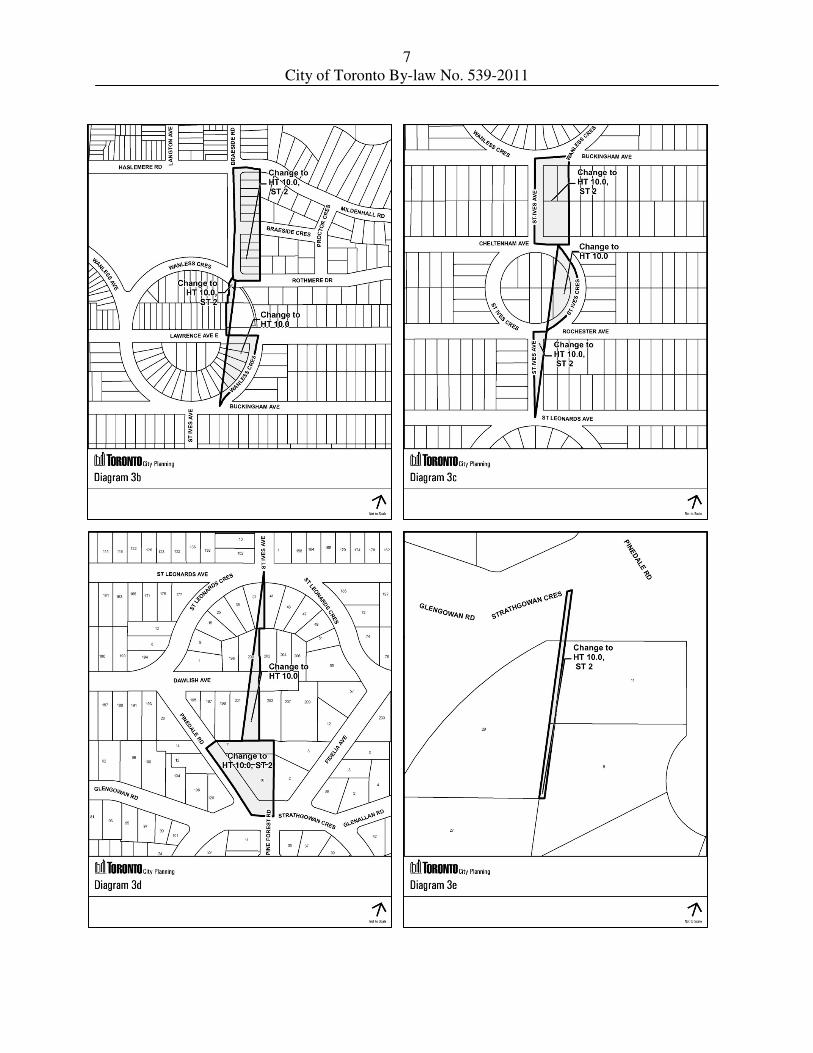
(C) change the height values to "HT 10.0", and "HT10.0 ST 2" on the Height Overlay
Map for the lands generally near Pine Forest Road to the south and commencing
north generally to Rochester Avenue and St Ives Avenue; to Lawrence Avenue
West and Wanless Crescent; to Braeside Road and Haslermere Road; and further
north to Riverview Drive as shown on Diagrams 3a, 3b, 3c, 3d, 3e and 3f.
(D) change the height value to "HT 10.0" on the Height Overlay Map for the lands
generally just north of Morrison Avenue, commencing at Harvie Avenue to the
west to Dufferin Street to the east, as shown on Diagrams 4a, 4b, 4c, 4d, 4e and
4f.
(E) amend the Zoning By-law Map to adjust the boundaries of the "CR" and "CRE"
zones to the centerline of the public lanes known as Lot Street Lane and
Jack Cooper Lane in the area generally south of Queen Street West between
Spadina Avenue and Peter Street.
(F) adjust the boundaries of the "HT 30.0", "HT 39.0" and "HT 16.0" height areas on
the Height Overlay Map to the centerline of the public lanes known as Lot Street
Lane and Jack Cooper Lane in the area generally south of Queen Street West
between Spadina Avenue and Peter Street.

2
City of Toronto By-law No. 539-2011
(G) delete the height value "HT 10.0" on the Height Overlay Map for the lands
generally on the west side of Westmount Avenue, just north of
Rosecliffe Avenue, as shown on Diagram 5.
(H) change the height value to "HT 10.0" on the Height Overlay Map for the lands on
the south side of Barrie Avenue, west of Atlas Avenue, as shown on Diagram 6.
(I) change the height values to "HT 10.0", and "HT10.0 ST 2" and delete from the
Height Overlay Map for the lands generally just north of the intersection of
Lawrence Avenue West and Rosewell Avenue, west of Elm Road and
commencing north generally to Douglas Avenue near Sylvan Valley Way; and
commencing generally further north to Cranbrooke Avenue; Brookdale Avenue;
Fairlawn Avenue; St Germain Avenue; Melrose Avenue; Deloraine Avenue; Old
Orchard Grove; and to Roe Avenue as shown on Diagrams 7a, 7b, 7c, 7d, 7e, 7f,
7g, 7h and 7i.
(J) change the height values to "HT 12" and "HT 24.0 ST 8" on the Height Overlay
Map so that the height value for 9 Raglan Avenue is "HT 24.0 ST 8" and for
12 Raglan Avenue is "HT 12" as shown on Diagram 8.
(K) change the height value to "HT 10.0" on the Height Overlay Map for the lands on
the west side of Jane Street, just north and south of Raymond Avenue as shown
on Diagram 9.
(L) delete the height values on the Height Overlay Map for the area shown on
Diagram 10a and add the height value "HT 9.5" on the Height Overlay Map for
the area shown on Diagram 10b for the lands generally on west side of
Long Branch Avenue, between Park Boulevard to the north and Lake Promenade
East to the south.
(M) change the height value to "HT 10.0 ST 2" on the Height Overlay Map for
6186 Kingston Road, as shown on Diagram 11.
(N) change the height value to "HT 10.0" on the Height Overlay Map for
279 Cortleigh Boulevard and 168 and 169 Hillhurst Boulevard, as shown on
Diagram 12.
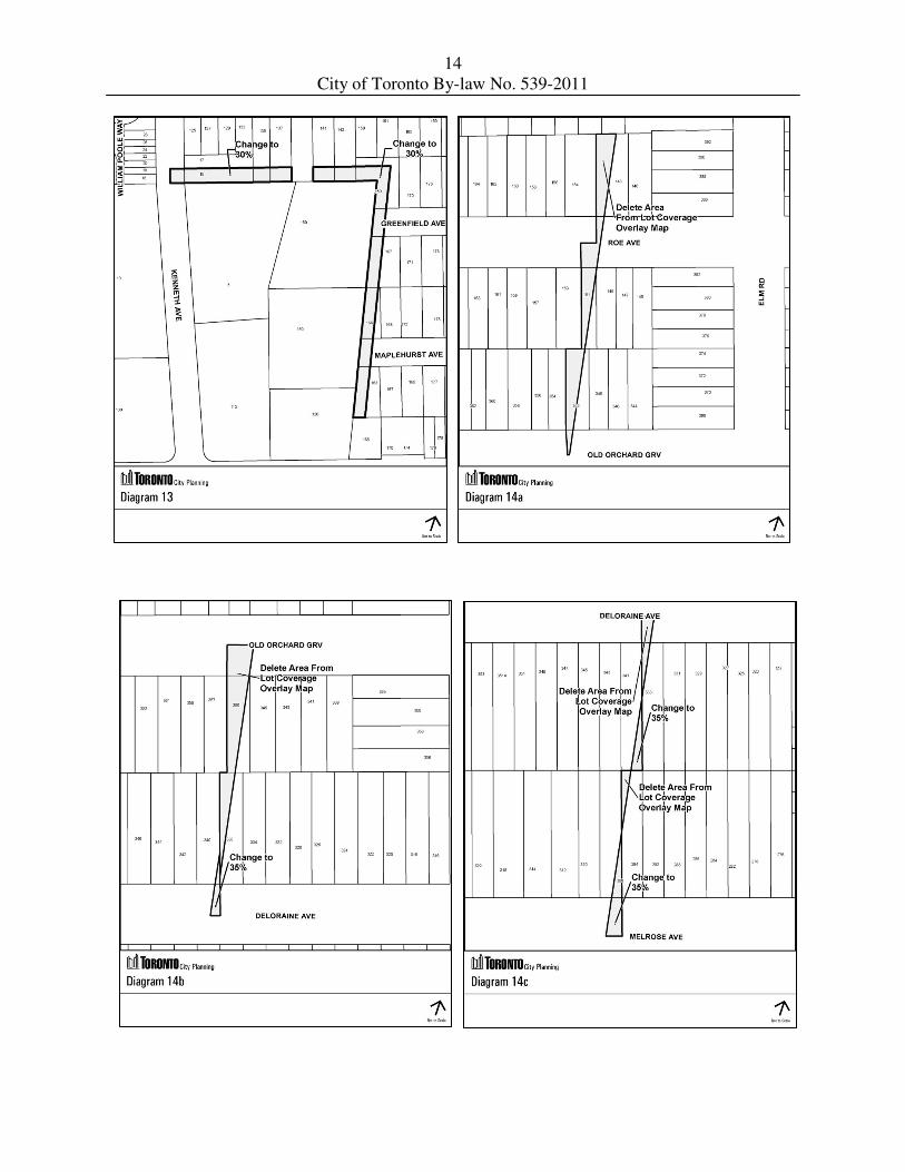
(O) change the lot coverage value to "30" on the Lot Coverage Overlay Map for the
lands generally south of Spring Garden Avenue and west of Dudley Avenue,
as shown on Diagram 13.
(P) change the lot coverage value to "35" and delete from the Lot Coverage Overlay
Map for the lands north of Brookdale Avenue, east of Avenue Road and west of
Elm Road and commencing generally further north to Fairlawn Avenue;
St. Germain Avenue; Melrose Avenue; Deloraine Avenue; Old Orchard Grove;
and to Roe Avenue as shown on Diagrams 14a, 14b, 14c, 14d, 14e and 14f.

3
City of Toronto By-law No. 539-2011
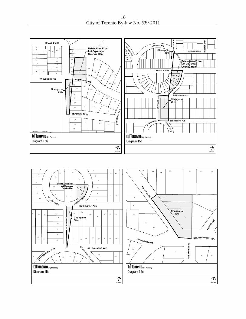
(Q) change the lot coverage value to "35" and delete from the Lot Coverage Overlay
Map for the lands generally near Pine Forest Road to the south and commencing
north generally to Rochester Avenue and St Ives Avenue; to Lawrence Avenue
West and Wanless Crescent; to Braeside Road and Haslermere Road; and further
north to Riverview Drive as shown on Diagrams 15a, 15b, 15c, 15d, 15e and 15f.
(R) change the lot coverage value to "30" on the Lot Coverage Overlay Map for the
lands generally commencing at Franklin Avenue, just east of Linelle Street and
commencing north to Cameron Avenue, Florence Avenue, Johnston Avenue, and
to Poyntz Avenue as shown on Diagrams 16a and 16b.
(S) change the lot coverage value to "30" on the Lot Coverage Overlay Map for the
lands generally at Park Home Avenue and Beecroft Road and commencing north
to Betty Ann Drive, as shown on Diagram 17.
(T) change the lot coverage value to "30" on the Lot Coverage Overlay Map for the
lands generally at the southeast corner of the Queenslea Avenue and
Grattan Street intersection commencing east to Walwyn Avenue and commencing
further east along the south side of Lamont Avenue to Cypress Street, as shown
on Diagrams 18a, 18b and 18c.
(U) adjust the boundary of the height value "HT 10, ST 2" to include all of
433 Woburn Avenue, as shown on Diagram 33.
(V) adjust the boundary of the zoning lines and assign the zone labels on the
Zoning By-law Map, to match the property boundaries for the lands as shown on
Diagram 34.
(W) adjust the boundary of all zoning lines located within the right-of-way of a street
so that the zoning boundary is located along the centre line of the street.

4
City of Toronto By-law No. 539-2011
(X) amend the legend at the bottom of the Zoning By-law Map so that the phrase
'Zone Categories' is replaced by the word 'Legend' and relocate the phrase
"Not Part of This By-law' under the phrase 'Hydro Line', so that the amended
legend area appears as follows:
ENACTED AND PASSED this 13th day of April, A.D. 2011.
FRANCES NUNZIATA, ULLI S. WATKISS,
Speaker City Clerk
(Corporate Seal)

5
City of Toronto By-law No. 539-2011

6
City of Toronto By-law No. 539-2011
7
City of Toronto By-law No. 539-2011

8
City of Toronto By-law No. 539-2011

9
City of Toronto By-law No. 539-2011

10
City of Toronto By-law No. 539-2011

11
City of Toronto By-law No. 539-2011

12
City of Toronto By-law No. 539-2011

13
City of Toronto By-law No. 539-2011
14
City of Toronto By-law No. 539-2011

15
City of Toronto By-law No. 539-2011
16
City of Toronto By-law No. 539-2011

17
City of Toronto By-law No. 539-2011

18
City of Toronto By-law No. 539-2011

19
City of Toronto By-law No. 539-2011


![Untitled-2 [] Avenue Brochure individual...Ashok Nagar Prithviraj Rd. Upasana 5th Avenue Statue Circle SMS WPASANA Avenue Smarter Way to live Premium Apartments UPA.SANX Avenue Smarter](https://img.dokumen.tips/doc/110x75/5aeec9827f8b9ac2468bd3ad/untitled-2-avenue-brochure-individualashok-nagar-prithviraj-rd-upasana-5th.jpg)