Embed Size (px)
Citation preview

City of Petaluma:General Plan 2025
MAY 2008
Revision Date: May 12, 2021


City of Petaluma:General Plan 2025
MAY 2008
City Council:Pamela Torliatt, Mayor
David Rabbitt, Vice Mayor
Teresa Barrett
Samantha Freitas
Mike Harris
Karen Nau
Mike O’Brien
Planning Commission:John Mills, Chair
Kathy Miller, Vice Chair
Christopher Arras
Spence Burton
Will Dargie
David Rabbitt, City Council Representative
Tanya Sullivan
Staff Contribution:Project Management: Dept. of General Plan Administration
Pamela Tuft, AICP, Director
Scott Duiven, Senior Planner
Karen Thoreson, Secretary
General Plan Executive Team (City Manager, Community Development, Fire, Parks & Recreation, Police, Public Works, and Water Resources and Conservation)
Prepared By:
CITY OF PETALUMA STAFF
and
Dodson Psomas - Water Supply, Recycled Water and Conservation
Dyett and Bhatia - Land Use Planners
EIP Associates - Environmental Consultants
Fehr & Peers Associates - Transportation Planners
Mundie & Associates - Economic/ Fiscal Consultants
West Consultants - Surface Water
West Yost Associates - Groundwater
Winzler & Kelly - Green House Gas Emissions and Recycled Water

General Plan AmendmentsThe following amendments have been incorporated into the General Plan text and land use map.
Resolution # Date Adopted Notes
2010-213 N.C.S. 12/06/2010 Extending expiration of Urban Growth Boundary (UGB) from December 31, 2018 to December 31, 2025.
2009-094 N.C.S. 06/15/2009 Adoption of the 2009-2014 Housing Element Update.
2009-206 N.C.S. 12/21/2009 450 Jefferson Street - High Density Residential to Mixed Use (Silk Mill).

�
Table of Contents
Table of Contents
Introduction and Overview
i.1 Petaluma Growth and Evolution ....................................................................................................i-1
i.2 Scope and Purpose of the General Plan .........................................................................................i-5
i.3 Guiding Principles ............................................................................................................................i-7
i.4 Planning Area ................................................................................................................................i-10
i.5 The Planning Process .....................................................................................................................i-10
i.6 Related Documents .......................................................................................................................i-14
i.7 Plan Organization ........................................................................................................................i-18
Land Use, Growth Management, and the Built Environment
1.1 Background and Context ...............................................................................................................1-2
1.2 Land Use Framework ......................................................................................................................1-3
1.3 General Plan Buildout ....................................................................................................................1-9
1.4 Growth Management ..................................................................................................................1-12
Community Design, Character, and Green Building
2.1 City Form and Identity ...................................................................................................................2-2
2.2 Planning Subareas ..........................................................................................................................2-5
2.3 Green Building ..............................................................................................................................2-24
Historic Preservation
3.1 Benefits of Historic Preservation ...................................................................................................3-2
The Natural Environment
4.1 Biology and Natural Resources ......................................................................................................4-2
4.2 Air Quality .......................................................................................................................................4-5
4.3 Energy .............................................................................................................................................4-8
4.4 Solid Waste ...................................................................................................................................4-10
4.5 Greenhouse Gas Emissions ...........................................................................................................4-11

��
Petaluma General Plan 2025
Mobility
5.1 Background and Context ...............................................................................................................5-1
5.2 Mobility Framework .......................................................................................................................5-3
5.3 Motor Vehicle Circulation ...........................................................................................................5-10
5.4 Transportation Demand Management and Parking ..................................................................5-12
5.5 Bicycle and Pedestrian Circulation ..............................................................................................5-14
5.6 Public Transit .................................................................................................................................5-22
5.7 Traffic Calming / Neighborhood Traffic Management ...............................................................5-23
5.8 Water, Air and Rail Transport ......................................................................................................5-24
Recreation, Music, Parks, & the Arts
6.1 Parks and Recreation ......................................................................................................................6-2
6.2 The Arts ........................................................................................................................................6-19
Community Facilities, Services and Education
7.1 Public Facilities and Services ..........................................................................................................7-2
7.2 Schools, Education, and Childcare .................................................................................................7-8
7.3 Emergency Management (Police, Fire, Hospitals) ......................................................................7-14
Water Resources
8.1 Water Supply and Demand ............................................................................................................8-2
8.2 Water Distribution System ...........................................................................................................8-12
8.3 Surface Water Management........................................................................................................8-13
Economic Health & Sustainability
9.1 Economic Vitality And Opportunity ..............................................................................................9-2
9.2 Economic Sustainability .................................................................................................................9-4
9.3 Strengthened Retail Sector ............................................................................................................9-5
9.4 Vibrancy And Attractiveness Of Downtown Petaluma ................................................................9-7
9.5 Fiscal Health ....................................................................................................................................9-8

���
Table of Contents
Health & Safety
10.1 Geologic and Seismic Hazards ...................................................................................................10-2
10.2 Noise ..........................................................................................................................................10-4
10.3 Hazardous Materials ................................................................................................................10-10
HOUSING NOTE: The Housing Element is unique in that it is the only element of the General Plan that requires outside review and certification by the California State Department of Housing and Community Development (HCD) and is on a State mandated time frame. Petaluma’s current Housing Element is valid from 2009-2014 and is available as a separate document. The current Housing Element was adopted in June 2009.
Charts
Chart 1-1: Existing Land Use Acreage (2005) ..........................................................................................1-2
Chart 1-2: Land Use Acreage at Plan Buildout (2025) ............................................................................1-9
Chart 1-3: Population and Employment, 2005 and Buildout ..............................................................1-10
Chart 1-4: Jobs/Employed Residents Balance, 2005 and Buildout .......................................................1-10
Chart 9-1: Percent Change in Employment, 1990-2005 .........................................................................9-2
Figures
Figure i-1: Evolution of Urban Form .......................................................................................................i-3
Figure i-2: Regional Location ....................................................................................................................i-9
Figure i-3: Planning Boundaries .............................................................................................................i-11
Figure i-4: Specific and Area Plans and Redevelopment Area .............................................................i-15
Figure 1-1: Land Use Map ........................................................................................................................1-5
Figure 2-1: Planning Subareas .................................................................................................................2-7
Figure 3-1: Historic Districts .....................................................................................................................3-6
Figure 5-1: Street Classifications ..............................................................................................................5-7
Figure 5-2: Proposed and Existing Bicycle Facilities .............................................................................5-15
Figure 6-1: Parks and Open Space ...........................................................................................................6-3
Figure 7-1: Public Facilities .......................................................................................................................7-3
Figure 7-2: Public School District Boundaries, School Sites and Santa Rosa Junior College ................7-9
�v
Petaluma General Plan 2025
Figure 8-1: 100-year Flood Boundary General Plan 2025 Buildout .....................................................8-23
Figure 8-2: 100-year Flood Boundary General Plan 2025 Buildout Areas of Water Depths Exceeding
One Foot .......................................................................................................................................8-25
Figure 10-1: Petaluma Noise Contours ..................................................................................................10-7
Figure 10-2: Land Use Compatibility Standards ...................................................................................10-9
Tables
Table i.1-1: Population Trends, 1985-2005 ...............................................................................................i-5
Table 1.3-1: Land Use Acreages at Plan Buildout ...................................................................................1-9
Table 1.3-2: Estimated Housing Units at Plan Buildout..........................................................................1-9
Table 1.3-3: Non-Residential Development at Plan Buildout (sq. ft.)..................................................1-11
Table 1.3-4: Buildout Population and Employment .............................................................................1-11
Table 4.5-1: Petaluma Community-wide 1990 and 2005 Greenhouse Gas Emissions and Projected
Emissions for 2025 .........................................................................................................................4-13
Table 5.1-1: Journey to Work by Mode of Travel, Petaluma Residents .................................................5-2
Table 5.2-1: Typical Attributes of Different Street Types .......................................................................5-6
Table 6.1-1: Park and Open Space Acreage in Petaluma (Existing and Proposed) ...............................6-5
Table 6.1-2: Community Parks (Existing and Proposed) .........................................................................6-5
Table 6.1-3: Neighborhood Parks (Existing and Proposed) ...................................................................6-7
Table 6.1-4: Other City-Owned Parks (Pocket)........................................................................................6-9
Table 6.1-5: Regional Parks (Existing and Proposed)..............................................................................6-9
Table 6.1-6: Urban Separators (Existing and Approved) ......................................................................6-10
Table 6.1-7: Summary of Park Standards and Park Needs ...................................................................6-14
Table 6.1-8: New Neighborhood and Community Parks (Under the Land Use Plan) .........................6-14
Table 6.1-9: Summary of Recreational Assets at Buildout (Within UGB) ...........................................6-15
Table 7.1-1: City-Owned Public Facilities in Petaluma............................................................................7-2
Table 7.2-1: Estimated Public School Enrollment (2005 and 2025)......................................................7-11
Table 8.1-1: Existing and Projected Water Demands .............................................................................8-3
Table 8.1-2: Projected Total Water Use ...................................................................................................8-3
Table 8.1-3: Current and Projected Annual Water Supply .....................................................................8-4
Table 8.1-4: Current and Projected Maximum Month Water Supply ....................................................8-4
Table 8.1-5: Summary Tertiary Recycled Water Customers ....................................................................8-5
Table 8.1-6: City Water Conservation Best Management Practices .......................................................8-7
Table 8.1-7: Additional City Water Conservation Best Management Practices ....................................8-7

v
Table of Contents
Table 11.2-1: Construction and Program Implementation, 1991-1998 ...............................................11-6
Table 11.3-1: Jobs/Housing Balance ....................................................................................................11-11
Table 11.3-2: Occupations of Residents (2000) ...................................................................................11-12
Table 11.3-3: Comparison of 1999 Household Income .......................................................................11-12
Table 11.3-4: Distribution of Housing Types (2000) ............................................................................11-13
Table 11.3-5: Comparison of Petaluma Housing Costs and Income Increases ..................................11-15
Table 11.3-6: Sonoma County Income Limits (2002) and Maximum Housing Costs .........................11-17
Table 11.3-7: Comparison of Monthly Income and Housing Affordability (2001) ...........................11-17
Table 11.4-1: Petaluma Share of Regional Housing Need, 1999-2006 ..............................................11-25
Table 11.5-1: Residential Land Use Designations ...............................................................................11-27
Table 11.5-2: Land Use Re-Designations Since 1988 ...........................................................................11-27
Table 11.5-3: Selected Development Standards for Residential Zones .............................................11-29
Table 11.5-4: Challenge in New SFD Characteristics Nationwide ......................................................11-39
Table 11.5-5: Change in New MFD Characteristics Nationwide.........................................................11-39
Table 11.6-1: Residential Units Completed Since 1999 by Income Category ....................................11-43
Table 11.6-2: Units Under Construction by Income Category ............................................................11-43
Table 11.6-3: Approved Units ..............................................................................................................11-43
Table 11.6-4: Residential Projects Submitted to City ..........................................................................11-44
Table 11.6-5: Vacant Residential Acreage ...........................................................................................11-45
Table 11.6-6: Remaining Regional Housing Need (August 2002) ......................................................11-46
Table 11.7-1: Quantified Objectives for Housing; January 1, 1999-July1, 2006 ................................11-60
Glossary of Terms
v�
Petaluma General Plan 2025
TECHNICAL APPENDICES LIST
Volume 1:
APPENDIX A
Survey of Residents (August 2002) ......................................................................................................... A-1
Notice of Preparation and Written Responses (August 2004) .............................................................. A-2
APPENDIX B
Mobility
Draft Bicycle & Pedestrian Plan (June 2006) ....................................................................................... B-1
Traffic Model Development Report (September 2003) ...................................................................... B-2
Volume 2:
APPENDIX C
Water Supply and Demand Analysis Report (June 2006)...................................................................... C-1
Volume 3:
APPENDIX D
Water Distribution System Master Plan (July 2006) .............................................................................. D-1
APPENDIX E
Surface Water
Facilities Review (Technical Memo 1, May 2003) .................................................................................E-1
Operations & Maintenance Plan (Technical Memo 2, April 2003)......................................................E-2
Volume 4:
APPENDIX F
Fiscal Impacts of the Preferred Plan (March 2006) .................................................................................F-1
APPENDIX G
Environmental Impact Report ............................................................................................................... G-1
Biological Resources Review (Technical Memo 3, December 2003) ..................................................... G-2
XP-SWMM - Surface Water Management Model Report ..................................................................... G-3

i.1 PETALUMAGROWTHANDEVOLUTION
Evolution of thE City
Petaluma’s historical evolution is closely tied to development along the Petaluma River. In 1850, a group of hunters established a primitive camp on the west bank of the river, and as the burgeoning city of San Francisco increased its demands on the surrounding region for food and supplies, a trading post was built in Petaluma. More permanent settlement soon followed, and in 1858, Petaluma incorporated with approximately 1,340 residents.
The city’s downtown grew on the southwest bank of the Petaluma River along what is now Petaluma Boulevard North, south of Washington Street. Later, commercial and industrial uses grew on the northeast riverbank. The river, coupled with the arrival of the railroad in the 1870s, transformed the city into a thriving center of agricultural commerce for the region.
introduction and overview

i-�
Petaluma General Plan �0�5
In Petaluma’s early days, the riverbanks were crowded with piers, boat landings, and local manufacturing businesses such as tanneries, flour mills, carpentry shops, and wagon-making shops. With the growth of the dairy and poultry industries, the riverfront evolved into a thriving center of agricultural commerce. By 1917, the river channel was widened and deepened for steamship services to San Francisco.
Petaluma began to transform into a bedroom community after the Golden Gate Bridge was built in 1937 and post-World War II suburbanization swept the nation. The construction of US Highway 101 in the late 1950s provided improved automobile access to San Francisco, and diminished the importance of rail and river transportation. Residential neighborhoods and business parks expanded east of the new highway, where access was improved and land was flat and readily available. Commercial buildings and business parks were developed around thoroughfares close to highway interchanges in addition to those near the river and railroad corridors.
Petaluma has grown steadily since its incorporation in 1858, with a notable spurt following suburbanization from the 1950s to 1970s. Following the adoption of Residential Growth Management legislation, in the early 1970s, the city slowed its residential growth rate to not exceed 500 units per year through the turn of the century.
The General Plan 2025 will guide development in Petaluma over the next 20 years.
Petaluma, however, experienced growth spurts in the early 1980s and again in the early 1990s. As easily developed land inventory diminished, infill projects reflected a slowed growth rate during the first five years of the new century—to an annual average rate of just 0.8 percent, or an increase of 2,100 people. Between 1985 and 2005 Petaluma’s population has grown at an average annual rate of 1.8 percent.
Figure i-1 illustrates the evolution of urban land development in Petaluma from 1865-2005, while Table i.1-1 shows population growth trends in Petaluma from 1985 to 2005.
In Petaluma’s early days, the banks of the turning basin were crowded with piers, boatlandings, and local businesses; remnants of which still exist today.

i-�
iintroduction and overview
figure i-1

i-�
Petaluma General Plan �0�5

i-5
iintroduction and overview
table i.1-1: Population trends, 1985-�005
1985 1990 1995 2000 2005Average Annual Growth
1985-2005
Population 39,900 43,200 49,400 54,500 56,632 1.8%
Average Annual Growth (preceding five years) 2.5 % 1.6 % 2.7 % 2.0 % 0.8%
Source: ABAG Projections 1990, U.S. Census 1990, U.S. Census 2000, DOF Table E-5 2005
i.2 SCOPEANDPURPOSEOFTHEGENERALPLAN
SCoPE and PurPoSE
The Petaluma General Plan serves the following purposes:
Its adoption, by the City Council, reflects a commitment on the part of the City Council and their appointed representatives and staff to carry out the Plan;
Outlines a vision for Petaluma’s long-range physical and economic development and resource conservation; enhances the true quality of life for all citizens; recognizes that all human activity takes place within the limits of the natural environment; and reflects the aspirations of the community;
Provides strategies and specific implementing policies and programs that will allow this vision to be accomplished;
Establishes a basis for judging whether specific development proposals and public projects are in harmony with Plan policies and standards;
Allows City departments, other public agencies, and private developers to design projects that will enhance the character of the community, preserve and enhance critical environmental resources, and minimize impacts and hazards; and
Provides the basis for establishing and setting priorities for detailed plans and implementing programs, such as the Development Codes, the Capital Improvement Program (CIP), facilities and master plans, and redevelopment projects.
•
•
•
•
•
•
PubliC PartiCiPation
A critical component of the General Plan 2025 preparation process was soliciting and synthesizing input on community concerns and possibilities. During each phase of the process, community members were asked for ideas and input through public workshops, neighborhood meetings, newsletters and mailings, the City’s website, and telephone surveys.
Through these forums, residents and other stakeholders identified issues, opportunities, and challenges relevant to the General Plan. The 2001 Evaluation Workbook of the 1987-2005 General Plan, the results of Fall/Winter 2001/02 community meetings and workshops, a July 2002 telephone survey of residents, and input on the Existing Conditions, Opportunities and Challenges Report (October 2002) as well as the Land Use and Mobility Alternatives Report (February 2004), have been collected to insure the issues most important to the Petaluma community are included.
Input from the community members and stakeholders was pivotal in formulation of the Plan’s vision.

i-�
Petaluma General Plan �0�5
KEy iSSuES
Through discussions with the various elected and appointed City officials and numerous interested residents, five key issue areas emerged as the plan took shape; General Plan policies have been developed to respond to these topics in an integrated manner:
Economic Health. Ensuring diversity and balance of economic activities is essential to the economic health and fiscal sustainability of Petaluma. Of particular concern is the need to provide opportunities for new retail businesses not presently available within the city. The Leakage and Sustainable Retail Strategy Study (June 2004), identifies specific occupancy types as the “missing pieces” in Petaluma’s retail mix, such as electronics, furniture, appliance and upper-end apparel, mixed-use centers and walking access to neighborhood retail. The policies and programs in the Economic Health and Sustainability Element (Chapter 9) of the General Plan provide specific direction for ensuring that retail diversity and intensification, as well as continued development of a diverse employment base is achieved.
Infill/Residential Growth Projection. Petaluma has been a pioneer in managed growth. This plan continues this practice by identifying land use designations and policies to provide an acceptable level of residential growth to complement the desired expansion of employment and retail opportunities. Providing for a balance of housing opportunities over the next 20+ years is a critical component of the new General Plan. Given the limited availability of land within the city’s Urban Growth Boundary (UGB), an increase in residential densities in select areas of the remaining supply of vacant and under utilized lands and redefining existing uses are central aspects of this Plan. In addition, the General Plan, in conjunction with the Central Petaluma Specific Plan (June 2003), increases the amount of higher density mixed use projects, providing a significant amount of housing in the central area of the community with less consumption of land.
Water Resources. Public workshops on water resources identified common themes regarding management of surface water systems (i.e., creeks and rivers), including restoring wildlife habitat, keeping rivers and channels clean and free flowing, providing bicycle and walking paths along creeks
•
•
•
and rivers, and minimizing flooding potential by providing greater capacity within and adjacent to the river channel. The City has and continues to put forth significant efforts, including the adoption and implementation of the Petaluma River Access and Enhancement Plan (May 1996). The limited supply of water and the maintenance of an aging water distribution system were analyzed to insure the ability to meet the future demands of the community. In 2001, the City Council directed the preparation of Water Resource Master Plans in conjunction with the new General Plan. Those work efforts have framed the preparation of the Water Resources Element (Chapter 8) of the General Plan. The Element provides the general objectives to insure all city water systems meet the present and future needs of the community, in an environmentally sensitive manner.
Mobility. The Petaluma River, Northwest Pacific Railroad, and Highway 101 traverse the city in close proximity to one another dividing the city into eastern and western segments. Cross-town connections between these two segments are extremely limited, and the connecting roadways are major points of congestion. The Plan focuses on new linkages, as well as on reducing automobile dependence by supporting alternative modes of transportation, such as walking, bicycling, and transit, while promoting utilization of infill sites for diversified neighborhood-serving land uses.
Public Facilities and Parks. The Plan addresses the capability of existing city infrastructure (parks, community centers, cultural resources and amenities) to serve the 2025 community by weighing it against the physical and fiscal reality of providing expanded facilities, both passive and active.
Sustainability. In recent years, we have confronted a range of challenges: worsening traffic, frequent flooding, limited supplies of fresh water, lack of landfill space, unstable energy prices, global climate change, and others. We acknowledge that we bear a responsibility to craft our policies for the next twenty years and beyond with consideration for the world that we will be leaving to future generations.
•
•
•
i-�
iintroduction and overview
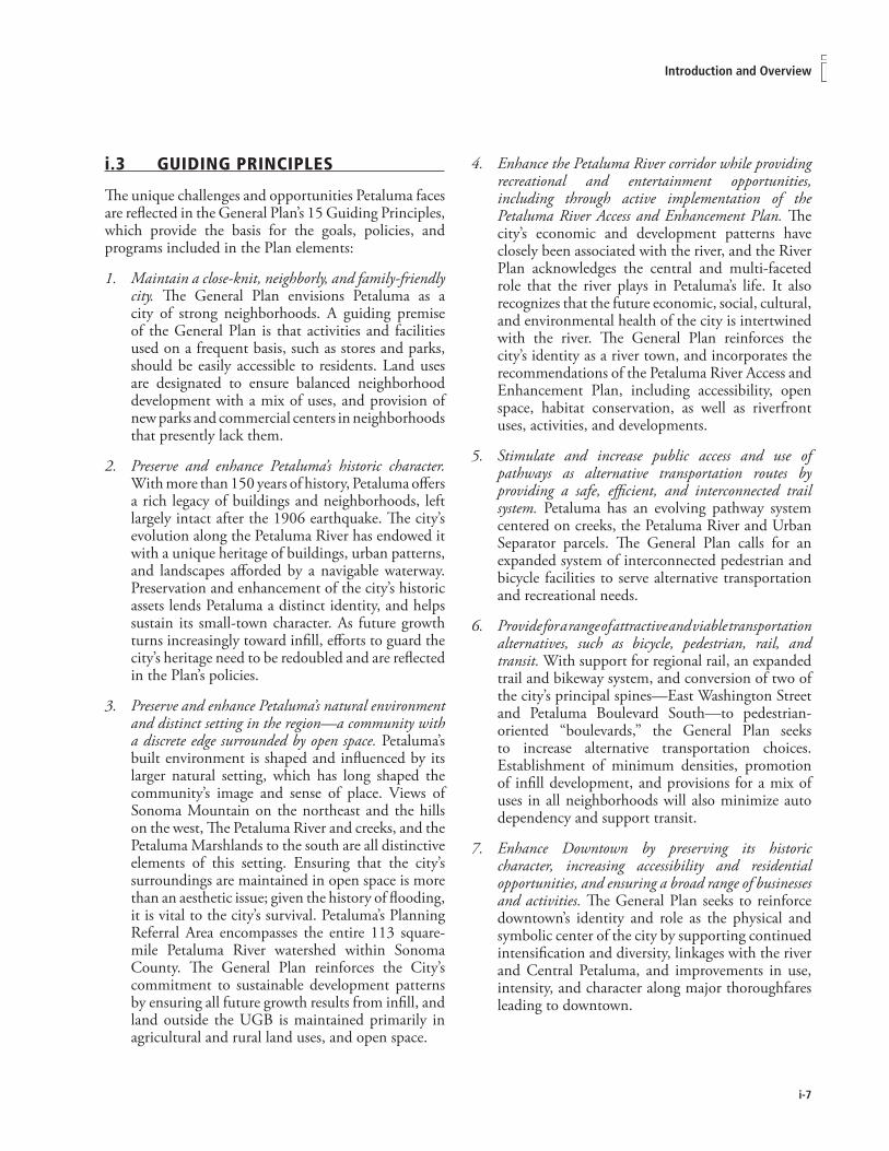
i.3 GUIDINGPRINCIPLES
The unique challenges and opportunities Petaluma faces are reflected in the General Plan’s 15 Guiding Principles, which provide the basis for the goals, policies, and programs included in the Plan elements:
Maintain a close-knit, neighborly, and family-friendly city. The General Plan envisions Petaluma as a city of strong neighborhoods. A guiding premise of the General Plan is that activities and facilities used on a frequent basis, such as stores and parks, should be easily accessible to residents. Land uses are designated to ensure balanced neighborhood development with a mix of uses, and provision of new parks and commercial centers in neighborhoods that presently lack them.
Preserve and enhance Petaluma’s historic character. With more than 150 years of history, Petaluma offers a rich legacy of buildings and neighborhoods, left largely intact after the 1906 earthquake. The city’s evolution along the Petaluma River has endowed it with a unique heritage of buildings, urban patterns, and landscapes afforded by a navigable waterway. Preservation and enhancement of the city’s historic assets lends Petaluma a distinct identity, and helps sustain its small-town character. As future growth turns increasingly toward infill, efforts to guard the city’s heritage need to be redoubled and are reflected in the Plan’s policies.
Preserve and enhance Petaluma’s natural environment and distinct setting in the region—a community with a discrete edge surrounded by open space. Petaluma’s built environment is shaped and influenced by its larger natural setting, which has long shaped the community’s image and sense of place. Views of Sonoma Mountain on the northeast and the hills on the west, The Petaluma River and creeks, and the Petaluma Marshlands to the south are all distinctive elements of this setting. Ensuring that the city’s surroundings are maintained in open space is more than an aesthetic issue; given the history of flooding, it is vital to the city’s survival. Petaluma’s Planning Referral Area encompasses the entire 113 square-mile Petaluma River watershed within Sonoma County. The General Plan reinforces the City’s commitment to sustainable development patterns by ensuring all future growth results from infill, and land outside the UGB is maintained primarily in agricultural and rural land uses, and open space.
1.
2.
3.
Enhance the Petaluma River corridor while providing recreational and entertainment opportunities, including through active implementation of the Petaluma River Access and Enhancement Plan. The city’s economic and development patterns have closely been associated with the river, and the River Plan acknowledges the central and multi-faceted role that the river plays in Petaluma’s life. It also recognizes that the future economic, social, cultural, and environmental health of the city is intertwined with the river. The General Plan reinforces the city’s identity as a river town, and incorporates the recommendations of the Petaluma River Access and Enhancement Plan, including accessibility, open space, habitat conservation, as well as riverfront uses, activities, and developments.
Stimulate and increase public access and use of pathways as alternative transportation routes by providing a safe, efficient, and interconnected trail system. Petaluma has an evolving pathway system centered on creeks, the Petaluma River and Urban Separator parcels. The General Plan calls for an expanded system of interconnected pedestrian and bicycle facilities to serve alternative transportation and recreational needs.
Provide for a range of attractive and viable transportation alternatives, such as bicycle, pedestrian, rail, and transit. With support for regional rail, an expanded trail and bikeway system, and conversion of two of the city’s principal spines—East Washington Street and Petaluma Boulevard South—to pedestrian-oriented “boulevards,” the General Plan seeks to increase alternative transportation choices. Establishment of minimum densities, promotion of infill development, and provisions for a mix of uses in all neighborhoods will also minimize auto dependency and support transit.
Enhance Downtown by preserving its historic character, increasing accessibility and residential opportunities, and ensuring a broad range of businesses and activities. The General Plan seeks to reinforce downtown’s identity and role as the physical and symbolic center of the city by supporting continued intensification and diversity, linkages with the river and Central Petaluma, and improvements in use, intensity, and character along major thoroughfares leading to downtown.
4.
5.
6.
7.
i-8
Petaluma General Plan �0�5
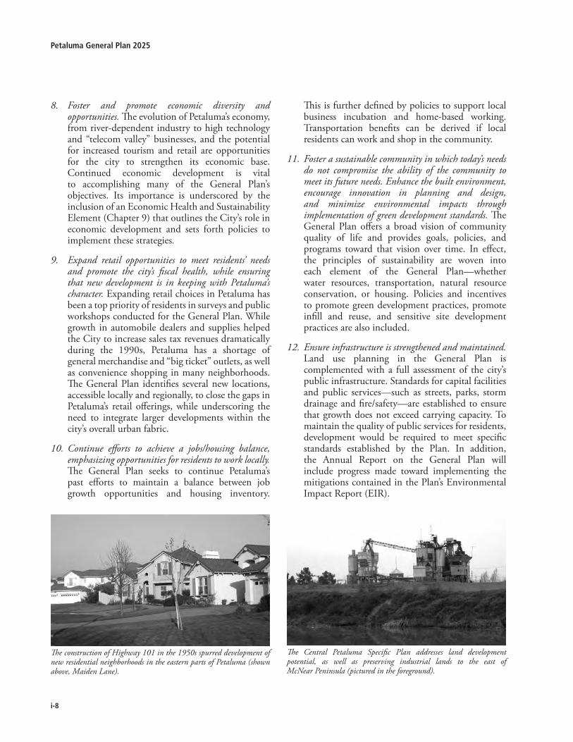
The construction of Highway 101 in the 1950s spurred development of new residential neighborhoods in the eastern parts of Petaluma (shown above, Maiden Lane).
The Central Petaluma Specific Plan addresses land development potential, as well as preserving industrial lands to the east of McNear Peninsula (pictured in the foreground).
Foster and promote economic diversity and opportunities. The evolution of Petaluma’s economy, from river-dependent industry to high technology and “telecom valley” businesses, and the potential for increased tourism and retail are opportunities for the city to strengthen its economic base. Continued economic development is vital to accomplishing many of the General Plan’s objectives. Its importance is underscored by the inclusion of an Economic Health and Sustainability Element (Chapter 9) that outlines the City’s role in economic development and sets forth policies to implement these strategies.
Expand retail opportunities to meet residents’ needs and promote the city’s fiscal health, while ensuring that new development is in keeping with Petaluma’s character. Expanding retail choices in Petaluma has been a top priority of residents in surveys and public workshops conducted for the General Plan. While growth in automobile dealers and supplies helped the City to increase sales tax revenues dramatically during the 1990s, Petaluma has a shortage of general merchandise and “big ticket” outlets, as well as convenience shopping in many neighborhoods. The General Plan identifies several new locations, accessible locally and regionally, to close the gaps in Petaluma’s retail offerings, while underscoring the need to integrate larger developments within the city’s overall urban fabric.
Continue efforts to achieve a jobs/housing balance, emphasizing opportunities for residents to work locally. The General Plan seeks to continue Petaluma’s past efforts to maintain a balance between job growth opportunities and housing inventory.
8.
9.
10.
This is further defined by policies to support local business incubation and home-based working. Transportation benefits can be derived if local residents can work and shop in the community.
Foster a sustainable community in which today’s needs do not compromise the ability of the community to meet its future needs. Enhance the built environment, encourage innovation in planning and design, and minimize environmental impacts through implementation of green development standards. The General Plan offers a broad vision of community quality of life and provides goals, policies, and programs toward that vision over time. In effect, the principles of sustainability are woven into each element of the General Plan—whether water resources, transportation, natural resource conservation, or housing. Policies and incentives to promote green development practices, promote infill and reuse, and sensitive site development practices are also included.
Ensure infrastructure is strengthened and maintained. Land use planning in the General Plan is complemented with a full assessment of the city’s public infrastructure. Standards for capital facilities and public services—such as streets, parks, storm drainage and fire/safety—are established to ensure that growth does not exceed carrying capacity. To maintain the quality of public services for residents, development would be required to meet specific standards established by the Plan. In addition, the Annual Report on the General Plan will include progress made toward implementing the mitigations contained in the Plan’s Environmental Impact Report (EIR).
11.
12.
i-9
iintroduction and overview
580
101
116
101
12
12
121
121
37
29
128
128
1
116
116
1
1
12
29
121
4
80
80
680
780
680
24
13
580
880
980
80
280
Healdsburg
Windsor
Santa Rosa
Rohnert Park
Cotati
Sebastopol
Petaluma
Sonoma
Novato
San Rafael
SanAnselmoFairfax
Ross
Larkspur
Corte Madera
MillValley
Sausalito
Tiburon
Belvedere
Napa
Yountville
St Helena
Calistoga
AmericanCanyon
Vallejo
Benicia
Moraga
Cast
Pleasant Hill
Martinez
LafayetteOrinda
Piedmont
BerkeleyAlbany
El Cerrito
Richmond
Emeryville
AlamedaSan Francisco
San Leandro
Oakland
SanPablo
Pinole
Hercules
RodeoCrockett
S O N O M A N A P A
M A R I N
Guerneville
Monte RioJenner
Graton
Cazadero
Forestville
Kenwood
GlenEllen
El Verano
Cordelia
El Sobrante
Bodega Bay
Dillon Beach
Tomales
Pt ReyesStation
Inverness
Woodacre
ForestKnollsLagunitas
Ignacio
LagoonValley
BoyesHot Springs
PopeValley
Angwin
Planning Referral Area
Urban Growth Boundary
Urban Areas
MILES0 5 2010
Source: Dyett & Bhatia, 2002
City of Petaluma11 English Street
Petaluma, CA [email protected]
Figure i-2
REGIONAL LOCATIONPetaluma General Plan 2025

i-10
Petaluma General Plan �0�5
Integrate and connect the east and west sides of town. The Petaluma River, the railroad tracks, and Highway 101 present barriers between the eastern and western portions of the city. Integration of different parts of the city is a theme that is reflected in several Plan policies. Roadway improvements and new streets are also proposed to link different neighborhoods, including two major east-west connections—the Rainier underpass/interchange and the Caulfield Lane “southern crossing”—to better integrate the east and west sides of town.
Encourage cultural, ethnic, and social diversity. The General Plan reinforces the city’s diversity by providing a range of housing choices—from large-lot hillside homes to urban units adjacent to downtown or the Petaluma River—and opportunities for a variety of large and small-scaled business establishments.
Recognize the role Petaluma holds within the region and beyond. This General Plan identifies the City’s willingness and dedication to participate in the collective solutions to adverse changes in the global climate. Policies and programs are identified to protect the community and reduce the community’s impacts to regional and global resources.
13.
14.
15.
i.4 PLANNINGAREA
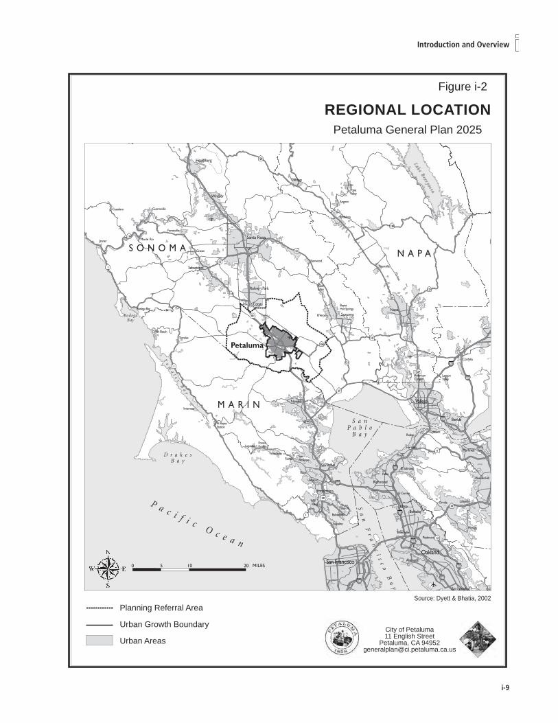
Petaluma is located in southwestern Sonoma County; Figure i-2 illustrates the city’s regional location. Petaluma’s boundaries are defined by the surrounding landscape—the city originated along the banks of the Petaluma River, then spread outward over the floor of the Petaluma River Valley. The Valley itself is defined by Sonoma Mountain on the northeast and by the hills extending northward from Burdell Mountain on the west. To the south are the Petaluma Marshlands and beyond, the San Francisco Bay.
The planning boundaries for the General Plan 2025 are illustrated in Figure i-3. The Planning Referral Area—unchanged from the 1987 General Plan—covers the 113 square-mile Petaluma River watershed within Sonoma County. The 20-year Urban Growth Boundary (UGB), the Sphere of Influence, and the city’s municipal boundary are all contained within the Planning Referral Area.
urban Growth boundary (uGb)
The UGB was established by voter approval as part of Measure I in November 1998 and extended by Measure T in November 2010. The measure ensures that urban development and provision of city water and sewer services are contained within the UGB through December 31, 2025. Although four possible expansion areas were identified as locations where development could occur before the UGB expires in 2025, the General Plan assumes that all growth through 2015 will occur within the current UGB, reflecting community sentiment. Further information on the UGB and detailed policies related to growth management are included in Chapter 1: Land Use, Growth Management, and the Built Environment.
i.5 THEPLANNINGPROCESS
The City’s planning process includes monitoring and updating the General Plan, the preparation of specific and area plans, and implementing resource management plans, neighborhood and special plans. Master Plans may also be prepared to address specific multi-parcel needs. Appendix documents go into far greater detail on topics such as the Petaluma River Access and Enhancement Plan, the Bike Plan, and utility Master Plans. Adopted Specific Plans further define the City’s vision for defined areas, those include the Corona-Ely and Central Petaluma Specific Plans.

i-11
iintroduction and overview
figure i-�

i-1�
Petaluma General Plan �0�5
i-1�
iintroduction and overview
amEndmEntS to thE GEnEral Plan
As the City’s constitution for development, the General Plan is the heart of the planning process. It is intended to be a living document, and as such, will be subject to more site-specific and comprehensive amendments. Amendments may also be needed from time to time to conform to State or federal law passed since adoption, as well as to eliminate or modify policies that may become obsolete or unrealistic due to changed conditions (such as completion of a task or project, development on a site, or adoption of an ordinance or plan).
State law limits the number of times a city can amend its general plan. Generally, no jurisdiction can amend any mandatory element of its General Plan more than four times in one year, although each amendment may include more than one change to the General Plan. This restriction, however, does not apply to amendments that:
Relate to optional elements (such as Community Design, Economic Health, and Water Resources);
Allow development of affordable housing;
Comply with a court decision; or
Comply with the City’s Airport Land Use Plan.
SPECifiC PlanS
The General Plan includes policies for each of the planning subareas in Chapter 2: Community Design, Character, and Sustainable Building. The 2025 General Plan does not anticipate any new Specific Plans within the 2025 UGB. Expansion of the UGB could incorporate the use of a Specific Plan. Requirements for specific plans are spelled out in the State Government Code.
nEiGhborhood and SPECial arEa PlanS
The City may consider establishing neighborhood and special area plans for areas with unique planning needs. Adopted in 1996, the Petaluma River Access and Enhancement Plan is an example of such a plan. Although they must be consistent with the General Plan, neighborhood and special area plans need not necessarily address all the topics required by State law for specific plans. For several decades the City has used the Planned Unit District (PUD) method to define neighborhood specific development standards. Combining a PUD with an Assessment District, such as with the Sunnyslope
•
•
•
•
area, has allowed public improvements and a systematic development pattern. The General Plan 2025 does not anticipate new neighborhood or special area plans but does not preclude their use, particularly for funding local serving amenities.
rEdEvEloPmEnt Plan
In 2006, the City merged its two redevelopment project areas—the Central Business District Project Area (CBD) and the Petaluma Community Development Area (PCD). As shown in Figure i-4, the PCD Project Area encompasses a total of 2,965 acres and generally lies along US Highway 101, and includes the majority of the Central Petaluma Specific Plan Area. In redevelopment areas, the property tax increment from new development—whether through public improvements, economic development strategies, or other measures—is reinvested into the redevelopment area. The law requires that a city or county have an adequate general plan before it adopts a redevelopment plan, and any redevelopment plan must conform to the adopted general plan (California Health and Safety Code §33302 and §33331).
imPlEmEntation
In order to ensure that General Plan policies are incorporated in everyday City activities, the City will prepare an Implementation Plan. The Implementation Plan contains language that allows for technical changes to be made in the General Plan as well as methods to integrate the implementation of the Plan with annual budgeting and departmental planning efforts. Furthermore, implementing ordinances and standards required by the policies of this General Plan shall be adopted as soon as appropriate.
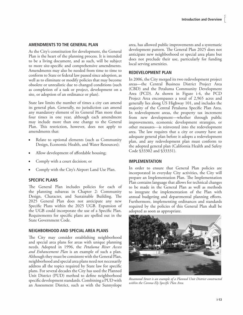
Rosamond Street is an example of a Planned Unit District constructed within the Corona-Ely Specific Plan Area.

i-1�
Petaluma General Plan �0�5
annual rEPort
California Government Code §65400(b) requires that an annual report be submitted to the City Council on the status of the General Plan and its implementation. This report must detail progress made in meeting the city’s share of regional housing needs as well as a summary of all General Plan amendments adopted during the preceding year, and an action list for the forthcoming year. The report will provide an overview of the status of the General Plan and its implementation program. In addition, mitigation monitoring and reporting requirements prescribed by the California Environmental Quality Act (CEQA) should be addressed in the annual report as they are closely tied to Plan implementation.
The Petaluma General Plan annual report will be prepared by City staff during the early stages of the budget process and submitted for review to the Planning Commission and City Council. Public comments on the annual report may be submitted in writing to the Community Development Department. The Planning Commission and the City Council will also hear public comments on the annual report at duly noticed public meetings.
i.6 RELATEDDOCUMENTS
GEnEral Plan doCumEntS
As part of the General Plan preparation, several technical studies were conducted to document environmental conditions, analyze prospects for economic development, community character and growth, and evaluate alternatives. Studies prepared include:
Survey of Residents
Existing Conditions, Opportunities and Challenges Report
Surface Water Operations and Maintenance Plan (Technical Memo 2)
Surface Water Facilities Review (Tech. Memo 1)
Traffic Model Development Report
Biological Resources Review (Technical Memo 3)
Land Use & Mobility Alternatives Report
Groundwater Feasibility Study (Tech. Memo 4)
Leakage and Sustainable Retail Strategy Study
Water Supply and Demand Analysis
Water Distribution System Master Plan
XP-SWMM Surface Water Model Calibration and Analysis Report
Fiscal Impacts of the Draft General Plan
Environmental Impact Report
Implementation Plan and Mitigation Monitoring Program
City PlanS and ProGramS
The City has adopted other planning documents to guide growth and development, which shall be consulted together with the General Plan (specific plan boundaries are shown in Figure i-4) in the review of any public or private project:
The Central Petaluma Specific Plan (CPSP) addresses land use, density and intensity, transportation, and community character in the Central Petaluma area. The Central Petaluma area contains extensive vacant and under utilized parcels surrounding the Petaluma River
•
•
•
•
•
•
•
•
•
•
•
•
•
•
•

i-15
iintroduction and overview
figure i-�

i-1�
Petaluma General Plan �0�5

i-1�
iintroduction and overview
and Turning Basin, a rail corridor with transit potential, and adjacent commercial and industrial uses. Adopted in June 2003, the Central Petaluma Specific Plan calls for a mix of housing and activities within a walkable core area, a variety of transportation alternatives, and a working industrial waterfront along the river. With a few amendments (see Section 2.2 Planning Subareas: 1. CPSP) the General Plan incorporates the land uses and planning concepts from the Central Petaluma Specific Plan. The CPSP EIR recognizes the impacts to traffic from the intensification of the expected infill development. Acceptance of these impacts is acknowledged through the adoption of statements of overriding consideration with regard to impacts to the Level of Service (LOS) of particular intersections and street segments.
The Corona-Ely Specific Plan, adopted in 1989, provides land uses and densities, transportation, neighborhood design and public amenities for the 675-acre area located at the City’s northeast quadrant (Sonoma Mountain Parkway from E. Washington north to Corona Road). Key land uses in the area include the new Santa Rosa Junior College campus, a neighborhood serving shopping center, three elementary schools, a new junior high school, parks, and creekside open space and trails. By 2005, the Specific Plan area was nearly developed.
The Petaluma River Access and Enhancement Plan provides a framework for preservation and restoration of the Petaluma River corridor. Adopted in May 1996, the Access and Enhancement Plan addresses corridor improvements, land uses, and accessibility along the 6.5-mile section of the Petaluma River within the city limits. Its four major components include restoration of the river’s natural resources, construction of a multi-use trail, a vibrant waterfront district adjacent to Downtown, and mixed uses along the river corridor. The Plan also introduced the concept of constructing flood terraces along the River to increase its carrying capacity and reduce localized flood levels. The General Plan assumes sensitive development patterns along the river corridor that allow integration of land uses, recreation, and preservation/restoration goals.
The City of Petaluma Bicycle and Pedestrian Plan (Bicycle Plan), developed by the Petaluma Pedestrian and Bicycle Advisory Committee, identifies and prioritizes bicycle and pedestrian improvement projects. Adopted in 2000 and updated for inclusion as part of this General Plan, the Bicycle Plan includes specific policies and programs for enhanced bicycle/pedestrian circulation, increased connectivity throughout the city, and improved safety.
PlanS and ProGramS of SurroundinG JuriSdiCtionS
The Sonoma County General Plan 2020 is a revision of the previous General Plan which was adopted in 1989. The County Plan establishes a framework for protecting open space and agricultural uses, and limiting new development. The County Plan is generally compatible with the plans of its nine cities, and with plans or policies established by other governmental agencies. Although the County’s plan does not regulate development within Petaluma, it is applicable to lands within the unincorporated portions of the Planning Referral Area. Consultation with Petaluma, however, is required for lands within its Sphere of Influence. In some instances, the policies of the County Plan establish larger “areas of interest” for cities in order to provide for their review and comment on proposed county actions. Sonoma County Area Plans, such as the West Petaluma Dairy Belt Area Plan, should be consulted for areas within Petaluma’s Urban Growth Boundary, beyond the existing City Limits.
The Penngrove Specific Plan, originally adopted by the Sonoma County Board of Supervisors in 1984, identifies land use and open space goals for the long-term development pattern of this unincorporated community located adjacent to the northeast corner of Petaluma. Through agreements, the wastewater from a defined area within Penngrove flows into and is served by the City of Petaluma Wastewater Treatment Plant.
The Petaluma River Access and Enhancement Plan includes pedestrian trails and recreational access to the Petaluma River, as shown at Foundry Wharf (Petaluma Rowing Club).

i-18
Petaluma General Plan �0�5
i.7 PLANORGANIZATION
GEnEral Plan StruCturE
The Petaluma General Plan is organized into 11 chapters:
i. Introduction and Overview. This includes General Plan Guiding Principles and, requirements for Plan monitoring, review, and amendments.
Land Use, Growth Management, and the Built Environment. This element provides the physical framework for development in the city. It establishes policies related to the location and intensity of new development, and citywide land use policies.
Community Design, Character, and Green Building. This chapter outlines policies to ensure that new development protects and enhances the community character. Urban form, edges, and views, and neighborhoods, streets, historic preservation and green building are all addressed. This chapter also includes detailed policies for each one of the 14 sub-areas that comprise the Planning Area.
Historic Preservation. This chapter outlines policies and programs to ensure the preservation, protection, and restoration of historical and cultural resources.
The Natural Environment. This chapter outlines policies relating to the Petaluma River, habitat and biological resources, air quality, energy resources, and solid waste.
Mobility. This element includes policies and programs to enhance opportunities, capacity, and circulation. It identifies future improvements and addresses alternative transportation systems and parking.
Recreation, Music, Parks, and the Arts. This chapter outlines the policies and standards relating to parks and recreation, including recreation and cultural programs and events.
Community Facilities, Services, and Education. This chapter outlines the policies and standards relating to public facilities and services, including public schools.
Water Resources. Establishes policies regarding water supply, wastewater and the use of recycled water, conservation, and surface water management.
1.
2.
3.
4.
5.
6.
7.
8.
Economic Health and Sustainability. This element establishes policies to promote economic expansion and job growth in the city, balanced to provide fiscal sustainability while maintaining the city’s character.
Health and Safety. The chapter addresses the risks posed by seismic and geologic hazards, as well as other topics, including solid waste management and recycling, hazardous materials, and emergency management (Police and Fire).
Housing. To meet the delivery deadlines of California’s Department of Housing and Community Development (HCD), the Housing Element update was adopted in December 2002, ahead of the remainder of the General Plan. The Housing Element has been reviewed for internal consistency, and is incorporated into the General Plan. The Element will be updated in 2009, then reviewed with the whole General Plan mid-term in 2015.
orGanization of thE ElEmEntS; PoliCy StruCturE
Each chapter or element of the General Plan includes brief background information to establish the context for goals, policies, and programs in the Element. This background material is neither a comprehensive statement of existing conditions nor does it contain any adopted information. Readers interested in a comprehensive understanding of existing conditions or issues related to a particular topic should refer to Petaluma General Plan 2025: Existing Conditions, Opportunities, and Challenges Report (October 2002). This background information is followed by:
Goals: Statements of vision and philosophy toward which the City will direct its efforts and resources. Denoted by the element number, followed by a ‘G’, then in numerical order within that element (e.g.: 2-G-1 would be the first goal of the Community Design Element).
Policies are a specific statement of principle to guide City actions. The term “shall” reflects mandatory policies, while “strive,” “may,” and “should” refer to intent but is not always mandatory. Denoted by the element number, followed by a ‘P’, then in numerical order within that element (e.g.: 2-P-2 would be the second policy within the Community Design Element).
9.
10.
11.
•
•

i-19
iintroduction and overview
Goals and policies in many instances are supplemented by:
Programs. These represent implementation commitments to specific goals and policies. Language may refer to existing programs or call for establishment of new ones. Programs are denoted by letters under associated policies.
Together, the Elements articulate a vision for Petaluma that the General Plan seeks to achieve. They also provide protection for the city’s resources by establishing requirements, thresholds, procedures, and criteria for project review.
Explanatory material accompanies some Goals, Policies and Programs (often in the form of bulleted lists). This explanatory material provides background information or is intended to guide Plan implementation. Where the same topic is addressed in more than one chapter, sections and policies are cross-referred, typically in italics for easy reference.
The Guiding Principles, Goals, Policies and Programs are ‘adopted’ while the supporting text is explanatory and shall not be considered adopted mandates.
The provisions of this General Plan shall not apply to the extent that they would violate the constitution or laws of the United States or the State of California. The purpose of this provision is to ensure that this General Plan does not violate any person’s constitutional or legal rights.
Policy numbering System
Policies in the General Plan are organized using a two-part numbering system that is intended to give each goal and policy a discrete, easily referenced number. The first part refers to the chapter/element (and the subsection within the chapter), followed by a letter identifying the Goal (G) or Policy (P), and finally by a second number referring to the specific policy. Thus, the first goal in Chapter 3 would be 3-G-1, and subsequent implementing policies would be 3-P-1, 3-P-2, etc.
Programs are listed under each relevant goal and/or policy. For example, Policy 3-P-1 may have Program A, B, C, etc. Bullets within Programs offer additional direction regarding implementation.
•

i-�0
Petaluma General Plan �0�5
Aerial view of Petaluma looking southwest toward San Francisco.

The text and policies of the Land Use, Growth Management, and the Built Environment Element along with the General Plan Land Use Map constitute the physical framework that guides land use decision-making. The Element provides the General Plan land use classification system, information on population and projected buildout, and outlines citywide land use policies. It also includes policies on pacing growth and possible Urban Growth Boundary (UGB) expansion. Detailed policies for each of the 14 individual sub-areas that comprise the General Plan Planning Area are in Chapter 2: Community Design, Character, and Green Building.
Land Use, Growth Management, and the Built Environment

1-�
Petaluma General Plan 2025
1.1 Backgroundandcontext
Petaluma’s current land use pattern is defined by its historical growth and regulations. Distinct residential neighborhoods illustrate architectural and site design trends of different decades, encompassing more than 150 years of evolution. Downtown and surrounding older neighborhoods, with smaller residential lots and alleys between some blocks, provide a walkable urban core. Heavy commercial, industrial, and warehouse facilities are clustered along the Petaluma River corridor, where access to shipping facilities was important through the mid-1900s. At the same time, major portions of U.S. Highway 101 were completed, encouraging large commercial shopping areas and business/industrial parks to locate along this corridor. East of the highway, where flat, developable land became readily available starting in the 1950s, residential neighborhoods designed around schools, parks, and creek trails were later established.
Land Use Distribution
Today, Petaluma’s UGB encompasses approximately 9,911 acres, inclusive of all streets, the Petaluma River, and other rights-of-way. As seen in Chart 1-1, Petaluma’s existing land use distribution is dominated by residential land uses. Commercial uses developed historically along Petaluma Boulevard and Lakeville Highway, but in recent decades, businesses have located along East Washington Street and McDowell Boulevard. These four corridors, along with Downtown, constitute the city’s major commercial areas. Industrial uses were historically concentrated east of Downtown, on sites along the Petaluma River with shipping and rail access. Light industrial activities are also clustered in business parks at the northern and southern edges of Petaluma, adjacent to Highway 101. Open space, such as Shollenberger/Alman and Helen Putnam (a County park), constitute a significant portion of the city’s acreage. Thirty percent of this open space, however, is comprised of privately-held and/or operated recreation facilities (i.e., golf courses).
Vacant land and reuse opportunities
New development under the General Plan seeks to infill existing vacant and under utilized sites within the UGB that are not environmentally constrained. The western and southern foothills encompass most of the vacant land, with about 350 acres. Due to land constraints posed by topography and public input on defining the community’s long-term vision, however, most new development in these areas will remain rural in nature.
Vacant land and development/redevelopment potential also exists along the Petaluma River corridor. Much of the land area north of Payran Street between Petaluma Boulevard and Highway 101 has not yet developed. Should floodplain improvements permanently reduce development constraints, these parcels could provide significant infill and public amenity opportunities within the General Plan timeframe.
Vacant and under utilized lands also occur along the arterial corridors leading to Downtown and Central Petaluma, such as Petaluma Boulevard and Washington Street. Most of these sites will also be redeveloped or reused for mixed uses. The Central Petaluma area, for which a Specific Plan was adopted in June 2003, contains extensive vacant and under utilized parcels, particularly along the Petaluma River and Turning Basin, an active rail corridor with transit potential, and adjacent commercial and industrial uses. Vacant lands located in existing industrial and business park areas exist at the northern and southern ends of the city.
Recognizing the limited availability of land within the UGB, the General Plan allows for an increase in residential densities on portions of the remaining supply of vacant and under utilized lands, as well as redefinition of some lands previously designated for commercial and/or industrial uses to residential or mixed use. New development will complement existing patterns, and reinforce connections between neighborhoods and activity centers.
Residential43%
Public and Educational
16%
Parks and Open Space18%
Mixed Use<1%
Vacant10% Industrial
5%Commercial
8%
Chart 1-1: Land Use Acreage (2005)

1-�
1Land Use, Growth Management, & the Built Environment
to back-of-curb), and for non-residential and mixed uses a maximum permitted ratio of floor area to net site area (FAR) is specified. FAR is a broad measure of building bulk that controls both visual prominence and traffic generation. The provision of both minimum and maximum densities will ensure a broad range of housing types is developed and ensure efficient use of the remaining land available for infill development. The FAR standards can be clearly translated to a limit on building bulk in the Development Code (the City’s zoning regulations) and is independent of the type of use occupying the building. The Development Code could provide specific exceptions to the FAR limitations for uses with low employee densities, such as research facilities, or low peak-hour traffic generation, such as a hospital. In addition to density/intensity standards, some land use classifications stipulate allowable building types as well (such as single- or multifamily residential) to respect community design considerations.
The density/intensity standards do not imply that development projects will be approved at the maximum density or intensity specified for each use. Development regulations consistent with General Plan policies and/or site conditions may reduce development potential within the stated ranges—for example steep slopes, floodplains, designated setbacks and other standards designed to ensure compatibility with the surroundings and address physical site constraints may limit maximum attainable densities.
CLAssifiCAtion systEM
The classifications in this section represent adopted City policy. They are meant to be broad enough to give the City flexibility in implementation, but clear enough to provide sufficient direction to carry out the General Plan. The City’s Development Code contains more detailed provisions and standards. More than one zoning district may be consistent with a General Plan land use classification. Any change(s) to the land use designation(s) set forth on the land use map require a General Plan Amendment.
Residential
Seven residential land use classifications are established to provide for development of a full range of housing types (mixed-use classifications that permit residential uses are included later in this section). Densities are stated as a number of housing units per net acre of developable land (except within the CPSP which is per gross acre of land), provided that at least one dwelling unit may be built on
1.2 LanduseFramework
CURREnt AnD fUtURE DEVELoPMEnt
The General Plan is based on the premise that growth during the period of 2005-2018 should occur within the present UGB, with possible limited expansion of the UGB between 2018 and 2025. Development in the western half of the city is limited by hillsides and the UGB; while expansion to the east is constrained by the UGB until 2025, a dedicated Urban Separator, as well as the presence of the Airport and its flight pattern. Consequently, development is targeted in centers and corridors to fulfill the city’s twin objective of enhancing quality of life and economic vitality while ensuring that established areas are not unduly impacted. Neighborhood issues such as scale and character of new development and better linkages between and within neighborhoods are also explored in this and other plan elements.
GEnERAL PLAn LAnD UsE MAP
The land use framework of the General Plan is illustrated on the Land Use Map (Figure 1-1). The Land Use Map designates the proposed general location, distribution, and extent of land uses through buildout, which is expected by about 2025. As required by case law, land use classifications, shown as color/graphic patterns, letter designations, or labels on the Map, specify a range for housing density and building intensity for each type of designated land use. These density/intensity standards allow circulation and public facility needs to be determined by giving an estimate of plan buildout.
The Land Use Map is a graphic representation of policies contained in the General Plan; it is to be used and interpreted only in conjunction with the text and other figures contained in the General Plan. Designation of a site for a certain use does not necessarily mean that the site will be built/redeveloped with the designated use over the next 20 years, the horizon of this Plan.
DEnsity/intEnsity stAnDARDs
As mentioned, the General Plan establishes density/intensity standards for each land use classification.1 Residential density is expressed as a minimum and maximum number of housing units per net acre (that is, exclusive of existing and proposed public streets and other vehicular rights-of-way from back-of-curb
1. Densities and FARs within the boundary of the Central Petaluma Specific Plan (CPSP) shall be undertaken in accordance with the CPSP.

1-�
Petaluma General Plan 2025
Low Density Residential (2.6 to 8.0 units per acre). Single-family residential development. This classification represents the majority of the existing stock of detached single-family dwellings.
Diverse Low Density Residential (6.1- to 12.0 units per acre). This classification encompasses the diversity of housing types and densities in the older neighborhoods surrounding downtown Petaluma. The density range represents an overlap between the Low and Medium densities, reflecting existing prevailing densities and structure massing.
Medium Density Residential (8.1 to 18.0 units per acre). This classification provides for a variety of dwelling types, including single-family and multi-family housing. Under a discretionary review process opportunities to blend live-work or limited commercial/office uses within a residential development may be permitted when abutting an arterial roadway.
High Density Residential (18.1 to 30.0 units per acre). This designation would permit the full range of housing types, but is intended for multi-family housing in specific areas where higher density is considered appropriate. Under a discretionary review process opportunities to blend live-work or limited commercial/office uses within a residential development may be permitted when abutting an arterial roadway.
Mobile/Manufactured Homes (8.0 to 18.0 units per acre) Residential home developments of eight or more units. Mobile or manufactured homes are the only allowed housing type.
Existing residential projects with low (left, homes at Hilligoss Court and Bantam Way) and medium (right, multi-family housing, Corona Ranch at Ely Road) densities.
each existing legal parcel designated for residential use.
The State’s density bonus requirements (Government Code Section 65915) specifies that applicants are entitled to a density bonus of up to 35 percent of the maximum allowable residential density provided certain amounts of affordable housing is included. The General Plan residential densities were established considering the possible increase in density as a result of this law. Development is required within the density range (both maximum and minimum) stipulated in the classification. Plan policies provide for exceptions in certain situations, such as where preservation of existing structures affects ability to meet minimum densities.
Secondary units (also known as accessory units or in-law apartments) permitted by local regulation and state-mandated density bonuses for provision of affordable housing are in addition to densities otherwise permitted.
Rural Residential (0.1 to 0.6 units per acre). Single-family residential development located primarily at the western perimeter of the city, along the Urban Growth Boundary. This designation maintains a rural character and provides a transition to unincorporated rural and agricultural lands. This density range reflects prevailing lot sizes and development patterns.
Very Low Density Residential (0.6 to 2.5 units per acre). Single-family residential development applied primarily to the southern hillsides, with a minimum lot size of half an acre, and larger lots required for sloped sites.

1-�
1Land Use, Growth Management, & the Built Environment
fiGURE 1-1

1-�
Petaluma General Plan 2025

1-�
1Land Use, Growth Management, & the Built Environment
Commercial
Neighborhood Commercial (0.8 maximum FAR). Neighborhood Commercial provides for shopping centers, typically 10 acres or less in size, with off-street parking, or clusters of street-front stores that serve the surrounding neighborhood.
Community Commercial (1.2 maximum FAR). This category includes shopping centers and commercial districts, including regionally-oriented centers.
Mixed Use (outside of the CPsP)
Mixed Use (2.5 maximum FAR). This classification requires a robust combination of uses, including retail, residential, service commercial, and/or offices. Development is oriented toward the pedestrian, with parking provided, to the extent possible, in larger common areas or garages. Maximum FAR including both residential and non-residential uses2 is 2.5, and maximum residential density is 30 d.u./acre.
The Community Design, Character, and Sustainable Building Element provides direction as to the intent of the Mixed Use classification in certain areas of the city. For example, along corridors such as Washington Street and Petaluma Boulevard the intent of mixed use is to recognize a broad range of uses along those corridors including both commercial and residential uses; a mixture of uses on these smaller individual parcels is encouraged but not required.
Densities and FARs within the boundary of the Central Petaluma Specific Plan (CPSP) shall be undertaken in accordance with the CPSP.
Business Park
Business Park (1.5 to 3.0 variable maximum FAR). This classification is intended for business and professional offices, technology park clusters, research and development, light industrial operations, and visitor service establishments, with retail only as a secondary use. The maximum FAR is 1.5, although an FAR of 3.0 is attainable if all required parking is structured. Refer to the Development Code for more details.
2. This FAR is simply calculated by dividing total floor area of all uses—residential and non-residential, but excluding parking—by the site net area.
industrial
Industrial (0.6 maximum FAR). This designation is intended to provide and protect industrial lands for the full range of manufacturing, industrial and/or food processing/preparation, general service (e.g. may include but not be limited to businesses that provide service in conjunction with retail components such as major vehicle motor and body repair, tire servicing and sales, etc.), warehousing, storage and distribution operations. Small restaurants and service commercial may be allowed as ancillary uses, subject to appropriate standards.
Agriculture. Lands that are actively and primarily used for grazing, or the production or sale of food and fiber. Parcels subject to seasonal or historic inundation and identified by FEMA as areas warranting special consideration are included.
Agricultural Support Industry (maximum FAR as per the CPSP). This designation allows for food processing, feed mills and related industrial uses which provide direct support to agricultural uses located in the Petaluma area. Agricultural uses include traditional dairy and poultry operations, but may also include organic farming and food processing and any other related uses that are consistent with supporting local agricultural production. All sites of this designation are within the boundaries of the Central Petaluma Specific Plan.
River-Dependent Industrial (maximum FAR as per the CPSP). Heavy industrial manufacturing, raw material processing and related uses that require river access as an integral part of daily operations for the purpose of regularly shipping or receiving raw materials and fin-ished products by water transport (commercial tonnage). Businesses that locate on properties with this designation shall be dependent on the Petaluma River for transport-ing a significant portion of its goods and materials.
Public and Educational
Public/Semi-Public. Public/Semi-Public includes pro-posed gateways, public utility facilities, government of-fices, and community service uses (e.g. churches) and lands.
Education. Education contains lands owned and operated by the elementary, secondary, or community college districts, as well as private and/or parochial schools. The Education classification does not include preschool facilities, nor does it preclude future regulations from allowing public or private schools in any other designated areas.

1-�
Petaluma General Plan 2025
Park and open space
City Parks. City Parks are City-owned lands whose primary purpose is recreation. Neighborhood parks are intended to typically serve the daily recreational needs of people living or working within a half-mile radius, while community parks are intended to serve the entire city. Proposed park facilities are identified with a special symbol; acreage of proposed parks is site specific and addressed within the Recreation, Music, Parks, and the Arts Element.
Open Space. This designation includes unimproved sites devoted to the preservation of natural and cultural resources, outdoor recreation, or public health and safety.
Urban Separator. The Urban Separator includes open space lands within and/or directly adjacent to the Urban Growth Boundary that are intended to serve as the outer boundary of urban development, as designated by the City of Petaluma. They provide an edge that buffers agricultural fields from urban land, may serve as a recreational area, and act as a key component of the city’s open space system. On lands with development potential, the Urban Separator allows transferability of development potential to the remaining portion of the same property.
Floodway. Floodway delineates the channel of the Petaluma River or other watercourse and the adjacent land areas that must be reserved in order to discharge the “base flood” without cumulatively increasing the water surface elevation more than one foot. No new development is allowed.
The boundary of the Floodway is determined by the Federal Emergency Management Agency’s (FEMA) Flood Insurance Rate Maps (FIRM); amendments to the FIRMs will be subsequently reflected on the City’s General Plan Land Use Map. The Petaluma River Access and Enhancement Plan (adopted 1996) and the future Surface Water Master Plan address the Floodway and Floodplain areas in greater detail than the General Plan.
overlays
Floodplain. The Floodplain represents lands subject to periodic inundation in a 100-year storm event, as defined by the FEMA Flood Insurance Rate Maps. The Floodplain delineation is intended as an overlay for informational purposes and to distinguish properties subject to regulations outlined in the Development Code.
Petaluma River Corridor. Areas determined to be needed for the implementation of the adopted Petaluma River Access and Enhancement Plan (1996) and to provide for future floodplain management projects. Development potential may be transferable, subject to other applicable policies and regulations.
Urban Separator Path. Identifies locations where the fee title dedication of an Urban Separator may not be feasible but provision of an improved pathway for connectivity is desired and/or appropriate.
symbols
Transit. A transit station site for the regional transportation system (rail, light rail, trolley, and/or bus) existing or proposed along the highway or existing railroad right-of-way, or an existing or proposed vehicular and bicycle park-and-ride facility.
Gateway. A Gateway indicates public and private property that serves as an important entrance to the city. It is intended that treatment of these gateways, through signs, landscaping, and/or public amenities will provide a sense of introduction and entry into Petaluma.
County Designations
County Park. The County Park classification delineates Sonoma County’s Helen Putnam Regional Park, located along the southwestern edge of Petaluma’s Urban Growth Boundary.
Community Separator. The Community Separator includes lands located outside of the Urban Growth Boundary that are intended to serve as a buffer between adjacent cities, as designated by Sonoma County and the City of Petaluma. Land uses are permitted on these lands under the Sonoma County General Plan. Cooperation between the City and County could lead to development of public amenities such as surface water detention basins and/or low intensity open space uses.

1-�
1Land Use, Growth Management, & the Built Environment
1.3 generaLPLanBuiLdout
This section describes the implications of General Plan buildout in terms of future new population, housing units, and jobs. Adequate land is provided by this General Plan to accommodate anticipated housing and job needs in Petaluma through 2025. Table 1.3-1 and Chart 1-2 show the buildout acreage and distribution of the General Plan Land Use Map. As compared to the existing land use distribution shown in Chart 1-1, the key land use changes are the increase in residential and mixed use land areas. Additional mixed use land will allow for a greater flexibility in Downtown, Central Petaluma, and along major arterial corridors.
Tables 1.3-2 and 1.3-3 compare the additional housing units and non-residential building area expected under the General Plan buildout. As shown, the General Plan will result in approximately 6,000 additional housing units for a buildout total of approximately 27,950 units. The Plan is also intended to accommodate an additional 6.1 million square feet of non-residential space, resulting in approximately 23 million square feet of non-residential floor area in Petaluma. Development under the Plan (including the CPSP and approved projects) represents a 27 percent increase in housing units and about a 36 percent increase in non-residential building area over the combined total for existing, approved development, and planned CPSP construction.
table 1.3-1: Land Use Acreages at Plan BuildoutLand Use Land Area (acres)
Residential Land 4,348
Rural ���
Very Low Density �0�
Low Density �,��0
Diverse Low ���
Medium Density ���
High Density ��
Mobile Homes 11�
Commercial Land 290
Neighborhood Commercial ��
Community Commercial �0�
Mixed Use 542
Business Park 512
Industrial Land 188
Industrial 1�0
Agriculture Support Industrial (CPSP)
�
Public and Educational 1,447
Public/Semi-Public 1,1��
Education ���
Parks and Open Space 1,594
City Parks �0�
County Parks ���
Agriculture ��
Open Space ���
Total Uses 8,921Note: Land use acreage does not include streets, river, or areas outside of the UGB.
Chart 1-2: Land Use Acreages at Plan Buildout (2025)
Residential51%
Commercial3%
Business Park6%
Mixed Use6%
Public and Educational
17%
Parks and Open Space15%
Industrial2%
table 1.3-2: Estimated Housing Units at Plan BuildoutExisting Units (�00�) �1,���
Increase to Buildout1 �,00�
Total Housing Units 27,9491. Includes those sites where projects are currently under construction, approved, or in formal review.

1-10
Petaluma General Plan 2025
BUiLDoUt PoPULAtion AnD EMPLoyMEnt
Table 1.3-4 summarizes the buildout population and employment under the General Plan. These projections are based entirely on estimates of housing units and non-residential building floor area, which are derived from the acreage estimates in Table 1.3-1.
At buildout, Petaluma will have added approximately 15,500 residents to the city, reaching a total buildout population of 72,707. This represents an overall annual growth rate of about 1.2 percent over the next 20 years, a slightly slower rate than that experienced by the city over the last 20 years (1.8%). Petaluma’s population grew by 41 percent between 1985 and 2005; this General Plan represents a 27 percent increase over the next 20 years.
Non-residential building space in Petaluma could increase from an estimated 16.8 million square feet (in 2005) to 23.0 million square feet at buildout (an increase of 36 percent), accommodating a comparable increase in employment—from 33,160 currently to 46,540 at buildout (an increase of 40 percent).
A city’s job/housing ratio (jobs to employed residents) would be 1:1 if the number of jobs in the city equaled the number of employed residents. In theory, such a balance would eliminate the need for commuting. As shown in Table 1.3-4, the current jobs/housing ratio in Petaluma is 1.12, meaning that the number of jobs in the city exceeds the number of employed residents by about 12 percent. Despite this, the 2000 Census shows that the majority (over 60 percent) of employed residents continue to commute to work outside the city. While the jobs/housing ratio expected at Plan buildout will decrease to 1.05. The General Plan seeks to maintain this balance by providing a diversity of employment opportunities within the city as well as by providing for alternative modes of travel.
Chart 1-4: Jobs/Employed Residents Balance, 2005 and Buildout
Chart 1-3: Population and Employment, 2005 and Buildout
33,16029,700
44,45046,540
-
10,000
20,000
30,000
40,000
50,000
Jobs Employed Residents
2005 Buildout
57,085
33,160
72,707
46,540
-
10,000
20,000
30,000
40,000
50,000
60,000
70,000
80,000
Population Employment
2005 Buildout

1-11
1Land Use, Growth Management, & the Built Environment
table 1.3-3: non-Residential Development at Plan Buildout (sq. ft.)2005 Increase to Buildout1 Total at Buildout
Commercial/Retail �,1��,000 �,��1,000 �,0��,000
Office �,���,000 �,��1,000 �,���,000
Industrial �,��1,000 ���,000 �,���,000
Institutional 1,�0�,000 - 1,�0�,000
Total 1�,���,000 �,1��,000 22,983,0001. Includes pipeline projects as well as development proposed under the Plan.
table 1.3-4: Buildout Population and Employment2005 Increase to Buildout Buildout 2025
Population
Total ��,0��¹ 1�,��� ��,�0�
Household Population ��,��� 1�,�0� �1,���
Total Jobs ��,1�0 1�,��0 ��,��0
Jobs/Housing Balance
Employed Residents ��,�00 1�,��0 ��,��0
Jobs/Employed Residents 1.1� 1.0�
Assumptions: �% housing vacancy rate; �.� persons per household; household population as ��.�% of total population.
1. Population estimate includes all areas within the UGB.
Source: DOF, ABAG Projections 2005, City of Petaluma
Petaluma’s two major business parks located at the north and south ends of McDowell Boulevard are important employment centers and home to many office, research and development, and light industrial based businesses.

1-1�
Petaluma General Plan 2025
1.4 growthmanagement
HistoRy of GRowtH MAnAGEMEnt
Petaluma was an early leader in public management of population growth. Infrastructure shortages and sprawling subdivisions that were seen to overtax the environmental and aesthetic quality of the community in the 1960s alerted the City to the problems of rapid growth. Further frustrations were felt as the city became divided between the older West Side and the new commuter-oriented East Side. Growth began endangering the local economy by impinging on agricultural and dairy lands, and by drawing retail business away from Downtown to East Side shopping centers. Most importantly, neither the sewer system nor the public school facilities could keep up with the rapid growth. As a result, the City instituted a system of controls to set the pace for new residential construction.
Milestones in the City’s growth management history include:
1961 General Plan. The 1961 General Plan recognized the importance of compact development patterns and cost-effective provision of public services and infrastructure. It provided a framework for development within Downtown, expansion of industrial areas, new parks, residential neighborhoods, commercial areas, schools, and the roadway network.
Environmental Design Plan of 1972. This served as a short-range strategic plan, limiting housing construction to a not-to-exceed rate of 500 dwelling units per year for the five-year period 1972–1977. It also established an urban separator (then called greenbelt).
Residential Growth Management System (RGMS). As part of the 1972 Plan (see above), the RGMS established the criteria to distribute 500 annual housing unit permits. The review process included a Council appointed citizen committee to review all residential development proposals prior to the Council granting of allocations. Although the allocation process is no longer utilized, the cap of 500 housing units is still monitored.
Environmental Design Plan of 1978. This reiterated the city’s Urban Growth Boundary (then called Environmental Design Plan boundary), and
•
•
•
•
extended its effective date through 1985. It identified an optimum population of approximately 70,000–90,000 residents.
Urban Limit Line (ULL). The 1987 General Plan designated a ULL for the period 1987–2005 that identified the outer edge of allowable urban development, encompassing 10,300 gross acres. General Plan population projections for buildout were “between 60,000 and 67,000 persons.” Buildout was, at the time, expected to be reached by 2008.
Urban Growth Boundary (UGB). Placed on the ballot by the City Council in 1998, city voters overwhelmingly adopted a fixed urban edge, which for the most part was coterminous with the 1987 ULL. Although the UGB did not affect the growth management numbers, it confined the growth and physical development of the city until 2018. In 2010, the City Council placed a ballot measure before the voters extending the UGB to 2025.
CURREnt GRowtH MAnAGEMEnt PRoGRAMs AnD PoLiCiEs
Residential Growth Management system (RGMs)
RGMS is designed solely to regulate the number of residential allotments granted according to Petaluma Municipal Code regulations and General Plan policy, with location and density determined by the General Plan. The system allows the City to grant a maximum average of 500 allotments per calendar year; however, some level of flexibility is allowed for years of higher or lower demand. The RGMS also exempts multi-family housing for the elderly, low-income, and very low-income households; as well as projects on sites less than five acres and with fewer than 30 units.
Other than during the first few years, the RGMS has not been controlling; typically, the maximum allowable number of permits has not been reached. With a projected increase of approximately 6,000 housing units over the next 20 years (to year 2025), however, approving growth at 500 units per year could exhaust the development potential around the twelfth year. Looking at the availability of land in an attempt to ensure some annual growth at least until 2025, consideration could be given annually to lowering the maximum number of that year’s residential units allocated while still keeping pace with the growth patterns of the last twenty years.
•
•
1-1�
1Land Use, Growth Management, & the Built Environment
Urban Growth Boundary
The UGB is nearly identical to the 1987 General Plan Urban Limit Line (see descriptions above), although four possible expansion areas were included in the ballot measure. Voter approval is required to amend the UGB (with minor exceptions) so that rural lands are not prematurely or unnecessarily converted to urban uses. Adoption of the UGB was intended to fulfill the following objectives:1
Encourage efficient growth patterns and protect the quality of life by concentrating future development largely within existing developed areas;
Promote uses that foster public health and safety and productive investment for farming enterprises on lands outside Petaluma’s UGB;
Foster and protect Petaluma’s natural setting while encouraging appropriate economic development in accordance with the city’s unique local conditions;
Concentrate growth within a well-defined UGB in order to limit the extent of required City services and restrain increases in their costs;
Allow the City to continue to meet the housing needs for all economic segments of the population, especially lower and moderate income households, by directing the development of housing into areas where services and infrastructure can be provided more cost effectively; and
Promote stability in long-term planning for the city by establishing a cornerstone policy within the General Plan designating the geographic limits of long-term urban development and allowing sufficient flexibility within those limits to respond to the city’s changing needs over time.
The 1998 Urban Growth Boundary contains a total of 9,900 gross acres (including streets, the Petaluma River, and other rights-of-way). The four possible UGB expansion areas adopted as part of the UGB Measure include approximately 330 acres, which would be available for annexation given findings that infill acreage is limited and infrastructure capacity is sufficient to serve these outlying areas. Figure i-3 illustrates the city’s UGB and possible expansion areas.
1. Measure I: City of Petaluma Urban Growth Boundary, November 1998 ballot.
•
•
•
•
•
•
The voter-approved UGB will expire in 2025. The General Plan provides direction to evaluate growth boundary expansion issues at the time of mid-term review in 2015.
CoUnty AnD REGion: City-CEntERED GRowtH PHiLosoPHy
Sonoma County maintains a city-centered development goal in its General Plan in order to preserve open space areas, define and separate urbanized communities, and prevent rural residential construction from intruding into surrounding agricultural lands. Urban-scale development is focused within the Urban Growth Boundaries of incorporated cities. Community separators are identified between incorporated cities to ensure that urban areas do not blend together. Chapter 6: Recreation, Music, Parks, and the Arts contains a detailed description of these community separators.
The Urban Growth Boundary (UGB) on the northeast side of town is clearly defined by the edge of urban development to the left, a 300-foot Urban Separator, and agricultural uses beyond the UGB to the right.

1-1�
Petaluma General Plan 2025
• Division of existing residences, being preserved, where minimum lot area is met.
• In the case where either minimum or maximum development yield is constrained by a pre-existing PUD or PCD the entitlement process shall include an a amendment to the applicable PUD or PCD.
1-P-5 The unit yield calculation historically used in the Sunnyslope Assessment District, per the 1985 annexation, is superseded by the applicable density ranges in the General Plan. Any parcels and/or units that are created in the future that were not contemplated by the original assessment and unit yield calculation will be required to pay the full cost of any additional infrastructure (sewer, water etc.) needed to support those new parcels/units.
1-P-6 Encourage mixed-use development, which include opportunities for increased transit access.
1-P-7 Encourage flexibility in building form and in the nature of activities to allow for innovation and the ability to change over time.
1-P-8 Maintain Business Park uses by monitoring availability of industrial land area for possible expansion of high employment businesses.
A. Provide a review process to consider allowing retail components in conjunction with uses in the industrial/business park areas.
1-P-9 Support continued development and intensification of employment centers.
1-P-10 Develop and maintain the following areas as neighborhood centers. These centers will serve to focus commercial activity close to residential uses, providing convenient retail and services for all Petaluma residents:
• Lakeville Highway at Casa Grande Road
• Caulfield Lane at Lakeville Street
• Along Petaluma Boulevard, near McNear Avenue, at Shasta Avenue/Sycamore Lane, and at Corona Road
• Sonoma Mountain Parkway, at Riesling Road
• McDowell Boulevard South at Casa Grande Road
• McDowell Boulevard North at Old Redwood Highway
goaL1-g-1:LanduseMaintain a balanced land use program that meets the long-term residential, employment, retail, institutional, education, recreation, and open space needs of the community.
Policies and Programs:
Goals and policies listed here focus on citywide issues and those of a programmatic nature; land use policies for each of the planning sub-areas are spelled out in Chapter 2: Community Design.
1-P-1 Promote a range of land uses at densities and intensities to serve the community needs within the Urban Growth Boundary (UGB).
A. Update the city’s Development Code for consistency with the General Plan, including:
• Establishment of new base districts, consistent with the land use classifications in the General Plan.
• Identification of overlay districts, such as the Floodplain, Historic Districts, Petaluma River Corridor, and groundwater recharge/surface water retention areas.
• Maintain both minimum and maximum development intensities as stipulated in the General Plan Land Use Classifications.
• Opportunities for infill without land division.
• Design Guidelines, where applicable.
1-P-2 Use land efficiently by promoting infill development, at equal or higher density and intensity than surrounding uses.
1-P-3 Preserve the overall scale and character of established residential neighborhoods.
A. In addition to density standards, establish building intensity (floor area ratio) standards for residential development in the Diverse Low and Medium Density Residential districts, to prevent development out of scale with existing neighborhood context.
Actual standards are to be developed and main-tained in the City’s Development Code.
1-P-4 Exception to minimum density may be considered to address the following:
• Where an existing residence is retained.

1-1�
1Land Use, Growth Management, & the Built Environment
1-P-11 Allow land use intensification at strategic locations along the arterial corridors leading to Downtown and Central Petaluma, including aging commercial and industrial sites.
1-P-12 Encourage reuse of under-utilized sites along East Washington Street and Petaluma Boulevard as multi-use residential/commercial corridors, allowing ground-floor retail and residential and/or commercial/office uses on upper floors.
A. Develop incentives in the Development Code to encourage lot consolidation to enable efficient multi-story buildings, and relocation of driveways to side streets.
1-P-13 Maintain Downtown as the City’s geographic and symbolic center and a focus of commercial and cultural activities.
1-P-14 Require provision of street trees, landscaping, parking and access features to help integrate land uses and achieve an effective transition between uses of disparate intensities.
1-P-15 Under a discretionary review process, consider allowing live-work or limited commercial uses within medium and high-density residential development when abutting an arterial roadway.
goal1-g-2:hillsides/ridgelinesPreserve the essential scenic and natural resources of the open ridgelines and hillsides that help define the unique character of Petaluma.
Policies and Programs:
1-P-16 Allow development in hillside areas that preserve ridgelines and are site sensitive.
A. Establish development and design standards related to residential development in hillside areas that address:
• Location of hillside residential units, including preserving ridgelines.
• Specific provisions to preserve open space, natural assets (woodlands, creeks, etc.).
• Standards for building height and massing.
• Appropriate forms of clustered development, including amount of bonus, alternate development forms, common recreational facilities, phasing, etc.
B. Enhance the hillside development regulations in the Development Code to include:
• Regulating development density by degree of hillside slope.
• Protecting unique natural features, including landforms, mature trees and their surrounding habitat, and ridge lines, by requiring location of structures away from these assets.
• Requiring architectural design that reflects the natural form of the hillside setting, in order to minimize visual and environmental impacts.
Preventing the significant alteration of hillside topography through grading and paving.
• Use of visually unobtrusive building materials.
1-P-17 Retain ridgelines and prominent hillsides as open space through appropriate clustering and/or transfer of density to other parts of a development site (applies to Rural and Very Low Residential areas within the West Hills, South Hills and Petaluma Boulevard North subareas only).
goaL1-g-3:LanduseMaintain a well-defined boundary at the edge of urban development.
Policies and Programs:
1-P-18 Maintain a permanent open space around the city by the continuation of the Urban Separator and the use of an Urban Separator Pathway, as designated.
1-P-19 Ensure that the Urban Separator and Urban Separator Pathway function as an overlay, the intent of which is to provide property owners with the opportunity to request transfer of the development potential of land designated as urban separator to another portion of the same site.
1-P-20 Maintain a standard width for the urban separator at a minimum of 300 feet except in those areas where it may be variable due to topography, physical or ownership constraints, or is already established at more or less than 300 feet.
•

1-1�
Petaluma General Plan 2025
1-P-21 As development or annexation occurs, the Urban Separator and/or Urban Separator Pathway shall be dedicated to the City, at no cost for the City for the land or required interface improvements.
A. Public access pathways and appropriate landscaping, scenic or overlook areas where appropriate, and fencing along the entire length of the urban separator shall be provided by the developer through the development review process, in concert with project design.
B. Maintenance, in perpetuity, shall be the responsibility of the development through a guaranteed funding source, such as a Landscape Assessment District and/or a funded trust.
1-P-22 Should expansion of the 1998 Urban Growth Boundary occur, dedication and improvement of additional Urban Separator to include the expanded area shall be required.
1-P-23 Establish public scenic or overlook areas in appropriate locations within the Urban Separator concurrently with project design.
1-P-24 Support designation of land uses in the unincorporated area beyond the Urban Growth Boundary as rural, agricultural and/or open space.
A. Work with local, state and federal funding sources to acquire open space outside of the Urban Separator and/or beyond the Urban Growth Boundary where community-wide benefit is achieved.
1-P-25 Support regulatory measures and work with other jurisdictions and agencies to maintain and expand the existing Community Separators in agreement with Sonoma and Marin Counties.
1-P-26 Work with public agencies and utilities to facilitate joint-use where feasible.
A. Work with utility companies to use and enhance utility corridors to link open space lands with activity centers.
B. Work with regulatory and transportation agencies to utilize unused railroad rights-of-way to link open space lands and activity centers.
1-P-27 Encourage innovative site and building design to address parking solutions such as shared, structured, and/or underground facilities.
New development will include neighborhood commercial uses similar to existing ground-level retail Downtown (top) and regional commercial uses like those at the Petaluma Factory outlets (middle). New parks serving residential development will also be needed (Meadow Park off Yarberry Drive, bottom).
1-1�
1Land Use, Growth Management, & the Built Environment
1-P-28 The City does not guarantee that any individual project will be permitted to achieve the maximum densities shown on the Land Use Map.
goaL1-g-4:urbangrowthBoundaryMaintain a parcel-specific Urban Growth Boundary.
Policies and Programs:
Policies 1-P-29 through 1-P-36 reflect the 1998 UGB ballot measure.
1-P-29 It is the policy of the City to build within the agreed upon Urban Growth Boundary. No urban development shall be permitted beyond the Urban Growth Boundary. “Urban development” shall mean development requiring one or more basic municipal services including, but not limited to, water service, sewer, improved storm drainage facilities, fire hydrants and other physical public facilities and services; but shall not mean providing municipal or public services to open space uses, public or quasi-public uses such as schools or public safety facilities. Said municipal or public services or facilities can be developed beyond the UGB to provide services within the UGB.
A. Maintain a time certain and parcel-specific Urban Growth Boundary around the city, beyond which urban development will not take place.
B. Use the growth management system, design review, or other project review methods to assure that the density of new residential development is greatest within and adjoining existing urbanized areas and gradually and logically lessens as it approaches the urban edge.
C. Encourage the County to continue to promote agricultural land use and to strictly limit further residential infilling on lands beyond the Urban Growth Boundary within the Petaluma Planning Referral Area.
1-P-30 No urban development beyond the Urban Growth Boundary shall be served by City services except for (1) extensions to residential dwellings in existence or approved for construction on parcels created on or before December 5, 1983; (2) extensions required pursuant to the terms of a service contract in effect as of July 20, 1998; (3) extensions to remedy a clear health
hazard to residential dwellings in existence or approved for construction on parcels created on or before July 20, 1998 where there is no reasonable alternative means to remedy that health hazard; (4) extensions to open space and park uses; (5) expansion of service to public and quasi-public uses existing as of July 20, 1998; and (6) extraordinary circumstances pursuant to applicable General Plan policies. Extraordinary circumstances justifying extension of City services outside of the UGB shall be deemed to exist only if the City Council makes each of the following findings based on substantial evidence in the record:
• That the land use to which the City service would be extended is consistent with all applicable policies of the City’s General Plan; and
• That the land use to which the City service would be extended is compatible with open space uses as defined in Government Code section ����0 as of July 1, 1���, does not interfere with accepted agricultural practices, and does not adversely affect the stability of land use patterns in the area; and
• That the property to which the City service would be extended is immediately adjacent to land already served by the service(s) to be extended; and
• That specific circumstances, unique to the property to which the City service would be extended, would otherwise deprive the property of privileges enjoyed by other comparable property outside the UGB and in the vicinity of the property to be served; and
• That substantial evidence demonstrates that the proposed City service extension will not cause the Levels of Service specified in adopted City policies to be exceeded with respect to water, wastewater, parks, fire services, police services, storm drainage, schools, traffic and other public facilities and services.
1-P-31 Except as set forth in Policy 1-P-32, the Urban Growth Boundary Policies 1-P-29, 1-P-30, 1-P-31, and 1-P-32 shall be in effect until December 31, 2025.
1-P-32 The Urban Growth Boundary designated on the Petaluma General Plan Land Use Map may be amended only by a vote of the people or pursuant to the procedures set forth below:

1-1�
Petaluma General Plan 2025
Exception I - Affordable Housing: To comply with state law regarding the provision of housing for all economic segments of the community, the City Council may amend the Urban Growth Boundary in order to include within the Urban Growth Boundary lands to be designated for residential uses, provided that no more than � acres of land may be brought within the Urban Growth Boundary for this purpose in any calendar year. If in any year, fewer than five acres are brought within the UGB pursuant to this policy, then the unused increment may be brought within the UGB in subsequent years, provided that, no more than �0 acres may be brought within the UGB before December �1, �0��. (Thus, for example in �00� the City Council could, upon making the findings below, bring up to �0 acres within the UGB under this exception, provided none had previously been brought within the UGB under this exception.) Such amendment may be adopted only if the City Council makes each of the following findings based on substantial evidence in the record:
• The land is immediately adjacent to existing comparably developed areas and the applicant for the redesignation has provided sufficient evidence that the Fire Department, Police Department, Department of Public Works, the Community Development Department, Parks and Recreation Department, the School District(s) and other relevant City departments and public agencies have adequate capacity to accommodate the proposed development and provide it with adequate public services; and
• The proposed development will consist of at least �� percent moderate income housing and at least �� percent low and very low income housing; and
• That there is no existing residentially designated land available within the Urban Growth Boundary to accommodate the proposed development; and
• That it is not reasonably feasible to accommodate the proposed development by redesignating lands within the Urban Growth Boundary for low and very low income housing; and
• The proposed development is necessary to comply with state law requirements for provision of low and very low income housing; and
• The proposed development meets the intent of General Plan policies relative to density feathering.
Exception II - Takings: The City Council may amend the Urban Growth Boundary if it finds, by at least a six-sevenths vote and based on substantial evidence in the record, that:
• The application of the Urban Growth Boundary policies would constitute an unconstitutional taking of a landowner’s property; and
• The amendment and associated land use designation will allow additional land uses only to the minimum extent necessary to avoid said unconstitutional taking of the landowner’s property.
Exception III - Transit-Oriented or Industrial Development: The City Council may amend the Urban Growth Boundary if it finds, by at least a six-sevenths vote and based on substantial evidence in the record, that:
• The lands to be included within the UGB will be used for transit oriented residential and local-serving commercial development within 1�00 feet of a rail transit station; and the Fire Department, Police Department, Department of Public Works, the Community Development Department, Parks and Recreation Department, the School District(s), and other relevant City departments and public agencies have adequate capacity to accommodate the proposed development and provide it with adequate public services. No more than 100 acres of land may be brought within the UGB for this purpose before December �1, �0��; or
• The lands to be included within the UGB will be used for office or light industrial uses to improve local employment. No land may be brought within the UGB for this purpose before January 1, �00�. No more than 100 acres of land may be brought within the UGB for this purpose before December �1, �0��. Such amendments may be adopted only if the City Council makes all of the following findings:
– That there is no existing office or light industrial designated land available within the UGB that could accommodate the proposed development and it is not reasonably feasible to accommodate the proposed development by redesignating lands within the UGB for office and light

1-1�
1Land Use, Growth Management, & the Built Environment
industrial uses; and
– That the Fire Department, Police Department, Department of Public Works, the Planning Department, Parks and Recreation Department, the School District(s), and other relevant City departments and public agencies have adequate capacity to accommodate the proposed development and provide it with adequate public services; and
– That the land to be included (1) is immediately adjacent to the existing UGB, and (�) serviceable water and sewer connections can be provided; and
– That the land to be included meets the intent of the General Plan pertaining to the preservation of open space or urban separator areas at the edge of the proposed UGB expansion area.
• The following areas have been preliminarily identified as appropriate for potential future expansion of the UGB, subject to the Council making the findings set forth in the first two sections of Exception III above. The list is not intended to be exclusive.
– East of Lakeville Highway in the vicinity South of Frates Road; or
– West of Old Redwood Highway near Denman Road/Orchard Lane; or
– The Haystack Landing area along Petaluma Boulevard South; or
– Northeast corner of Corona Road and railroad tracks, north of Sonoma Mountain Parkway intersection.
The specific boundaries of any amendment to the UGB will be determined at the time that the amendment is adopted.
Exception IV - Agriculture, Agriculture Support or Related Development: The City Council may amend the Urban Growth Boundary if it finds, by at least a six-sevenths vote and based on substantial evidence in the record, that the lands to be included within the UGB will be used for an agricultural or agricultural support use. Agricultural Support Use shall mean an industrial, manufacturing or mixed use project which is determined by the City to support the regional agricultural community and economy and is dependent on municipal services to exist. Such agricultural or agricultural support use amendments may be adopted only if the City Council makes all of the following findings:
• That there is no existing agricultural or compatible light industrial designated land available within the UGB to accommodate the proposed development and it is not reasonably feasible to accommodate the proposed development by designating lands within the UGB for agricultural or agricultural support uses; and
• That the Fire Department, Police Department, Department of Public Works, the Planning Department, Parks and Recreation Department, the School District(s), and other relevant City departments and public agencies have adequate capacity to accommodate the proposed development and provide it with adequate public services; and
• That the land to be included (a) is immediately adjacent to the existing UGB, and (b) (serviceable water and sewer connections can be provided; and
• That the land to be included meets the intent of the General Plan pertaining to the preservation of open space or urban separator areas at the edge of the proposed UGB expansion area.
Prior to adopting any General Plan amendment pursuant to Exceptions I, II, III, or IV of this Policy 1-P-��, the City Council shall hold at least one noticed public hearing for the purpose of receiving testimony and sufficient evidence from the applicant and the public on the proposed amendment and any findings proposed in connection with such amendment. This hearing shall be in addition to any other public hearings regularly required for a General Plan amendment.
1-P-33 Every effort shall be made to keep the visual separation that now exists between communities, outside the Urban Growth Boundary. All references to the Urban Limit Line in this General Plan and other City policies, ordinances, and regulations shall be considered references to the Urban Growth Boundary.
1-P-34 The Urban Growth Boundary shall coincide with the line shown on the official General Plan Land Use Map until December 31, 2025.
1-P-35 Growth shall be contained within the boundaries of the Urban Growth Boundary. The necessary infrastructure for growth will be provided within the Urban Growth Boundary.

1-�0
Petaluma General Plan 2025
1-P-36 For properties adjoining the Urban Growth Boundary, it is the intent of the City that projects developed in the City or requesting City services shall be of limited density (as shown on the General Plan Land Use Map), unless greater density is required to satisfy the requirements of state housing laws, and shall be designed to preserve the visual and physical openness and preserve the aesthetic and natural features of that portion of the property proximate to the rural areas outside of the designated Urban Growth Boundary.
End of UGB Ballot Measure.
1-P-37 Ensure that the UGB continues to serve the community while allowing for consideration of development to meet the goals of this document.
A. Present a ballot measure to the community to extend the life of the existing UGB ballot measure to �0��, consistent with the General Plan �0��.
B. By, or during, year �01�, independently or as part of comprehensive General Plan review, analyze the Urban Growth Boundary that includes assessment of a comprehensive range of factors, including:
• Availability of vacant land
• Growth trends and projections
• City’s economic development and affordable housing needs, and
• Infrastructure capacity
1-P-38 Require all development outside of city limits and within the UGB to annex to the city as a condition of extension of City services. Annexation requires the extension of both potable water and sewer services in compliance with adopted Master Plans, in conjunction with other public improvements as deemed appropriate by the City.
1-P-39 Consider the use of Specific or Master Plans for major annexations beyond the 1998 UGB to ensure orderly development as well as financing for necessary infrastructure and services.
The Urban Growth Boundary seeks to ensure that new development does not extend into surrounding rural agricultural lands, and limits housing construction to areas where infrastructure and services are accessible (Grevillia Drive in the West Hills area, a western edge tree farm, and a vineyard at the eastern edge of town are shown).

1-�1
1Land Use, Growth Management, & the Built Environment
goal1-g-5:PetalumariverDevelop land uses in proximity to the Petaluma River that insure the restoration of the natural River corridor, provide for adequate storm flow capacities, and enable public access and stewardship.
Policies and Programs:
See also Chapter 4: Natural Environment, and Chapter 8: Water Resources – Surface Water goals and policies.
1-P-40 An area shown as the Petaluma River Corridor (PRC), along the Petaluma River, shall be set aside for the creation of flood terraces where appropriate; preservation, expansion, and maintenance of flood storage capacity of the floodplain; habitat conservation; and public access.
1-P-41 The Petaluma River Corridor (PRC) shall be irrevocably offered for dedication to the City, improved and maintained in perpetuity by the development as adjacent development occurs.
A. Design Standards shall be developed for the Petaluma River Corridor.
B. Maintenance of the PRC, not covered by maintenance in perpetuity by adjacent development, shall be assured through the creation of a funding mechanism such as citywide surface water utility fee or Landscape Assessment District.
1-P-42 Development on lands affected by the PRC designation shall be subject to a discretionary review process beyond that required by CEQA.
1-P-43 Development shall incorporate the River as a major design focal point, orienting buildings and activities toward the River and providing water access, to the extent deemed feasible.
1-P-44 Develop the Petaluma River as a publicly-accessible green ribbon, fronted by streets, paths, access points, and open spaces, by implementing the Petaluma River Access and Enhancement Plan within the context of the PRC Design Standards.
1-P-45 Development along the River shall include the creation and maintenance, in perpetuity, of public access sites. Amenities provided may include ramps, steps, docks or other means of access to the water.
1-P-46 New development shall acknowledge, preserve, protect, and enhance the ecological and biological health and diversity of the Petaluma River.
Example of improvements within the Petaluma River Corridor, including a flood terrace, overlook with benches and kiosks, and public trails.
The Petailuma River within the Denman Reach along Industrial Avenue.

1-��
Petaluma General Plan 2025
goaL1-g-6:growthmanagementMaintain a residential growth management system to ensure public infrastructure keeps pace with growth.
Policies and Programs:
1-P-47 Ensure that the pace of growth does not create spikes that unduly strain City services.
A. Monitor the availability of resources necessary to serve new development, prior to granting entitlements.
B. Upon adoption of the General Plan, immediately reevaluate the Residential Growth Management System, with the possibility of reducing the annual allocation numbers and/or eliminating or reducing exemptions, to keep pace with infrastructure capacities and to allow a reasonable annual growth rate through �0��.
C. Evaluate the need for a nonresidential growth management program.
1-P-48 Ensure all new development provides necessary public facilities to support the development.
A. Collect proportionate fair share of long-term infrastructure improvement costs as entitlements are granted.
B. Initiate design of long-term infrastructure improvements in a timely manner to insure their completeness to coincide with demand.
goaL1-g-7:treesandtheBuiltenvironmentRecognize that trees are a community asset, an essential element in the interface between the natural and built environment, and part of the urban infrastructure.
Policies and Programs:
1-P-49 Preserve existing tree resources and add to the inventory and diversity of native/indigenous species.
A. Review and update existing tree regulations and development procedures relating to trees, including:
• Standardize submittal requirements and design review procedures for development and redevelopment projects.
• Create a manual or reference guide outlining all tree-related guidelines, standards, and specifications; including, but not limited to: Requirements for design review and construction permit submittals; protection measures for trees in or near construction areas; monitoring requirements for trees during construction; guidelines for injury mitigation and replacement values; and guidelines for planting and maintenance.
B. Develop and adopt an Ordinance for Tree Preservation and Management Regulations.
C. Designate an official City Arborist(s). Role to include, but not be limited to: Review of all development and redevelopment project applications with regard to trees and subsequent project monitoring; Educate citywide staff on tree issues relating to each development; Provide a central authority for the coordination, review, and development of tree related policies and program; Promote a healthy urban forest and encourage supporting practices.
1-P-50 Preserve and expand the inventory of trees on public property, by undertaking the following:
A. Develop a program, and associated costs, to monitor and maintain all trees on public property.
B. Develop Street Tree Master Plan(s) for neighborhoods and downtown districts.
C. Assist and encourage private property owners to plant street trees (e.g.: no fee permits for concrete removal, neighborhood tree planting programs).
D. Allocate funding for the planting and long-term care of trees.
A mature canopy of trees lends both shade and character to this residential street.

Petaluma has a unique identity valued by residents and visitors alike. This element includes policies aimed at protecting and enhancing the physical elements (both natural and created) that have helped shape this identity. Included among these are the city’s setting, general distribution of neighborhoods and land uses, landmarks, special neighborhoods, open space amenities, and historical and archeological resources. On a more detailed level, the discussion outlines policies for each of Petaluma’s 14 planning subareas, as well as green building policies. Policies focus attention on the city’s neighborhoods, on the creation of pedestrian-oriented activity centers, and linkages.
In addition to the information provided in this element, the Central Petaluma Specific Plan provides a detailed vision for the design and character of the city’s center, while the Natural Environment Element and the Petaluma River Access and Enhancement Plan more specifically describe the areas along the riverfront.
Community Design, Character, and Green Building

2-2
Petaluma General Plan 2025
axis formed by the Petaluma River, the railroad tracks, and Highway 101. Commercial and industrial uses are gathered along these transportation corridors, with heavy industry (both river dependent and agricultural support) clustering around the river; business parks and light industry close to highways on the northwest and southeast ends of town; and commercial uses on city arterials. The older residential neighborhoods southwest of the river, the small housing lots between the river and Highway 101, and newer suburban subdivisions to the east and northeast occupy the bulk of the land on either side of the city’s main transportation routes. The General Plan enhances the existing city structure with the intensification of commercial centers as well as the addition of mixed-use development along the major transportation corridors. Strong entries are another important element of community design, as their character creates the image Petaluma presents upon arrival. Significant gateways or points of entry to the city occur along Highway 101 and most of the arterials.
LanDmarks
A variety of natural and artificial or cultural features lend Petaluma a character distinct from other cities in Sonoma County or elsewhere in the San Francisco Bay Area. These visual landmarks provide identity and special places to visit; enable people to navigate through their physical environment; establish edges and boundaries, as well as connections between places; and display the city’s architectural heritage. Structures such as the industrial “working grain elevators” rising above local development, the Great Petaluma Mill, and the old railroad depot are markers in the urban landscape reminding residents of Petaluma’s rich agricultural and industrial history. The river itself is one of the most important features in Petaluma, providing a sense of direction and history, as well as a natural resource to the city. Other landmarks identified by residents include the St. Vincent de Paul Parish church, the Petaluma Historical Library and Museum, and the Petaluma and Santa Rosa Railroad Trestle in the downtown area, the Petaluma Municipal Airport, and the Fairgrounds.
special neighborhoods
Downtown, the riverfront warehouse district, B and D Streets, and the “A” Street and Oakhill-Brewster neighborhoods are historical areas in Petaluma that residents identify as unique and valuable. Still a destination in the city and a hub of commercial and retail activity, Downtown is the special place most frequently
2.1 Cityformandidentity
Petaluma has a picturesque setting along the Petaluma River, with a backdrop of hills to the west and south, and vistas of Sonoma Mountain to the east. Complementing the natural setting is the city’s legacy of Victorian-era residential and commercial buildings, left largely unscathed by the 1906 earthquake, as well as the city’s history as a farming town and place of commerce.
Historically, radial streets—such as Western Avenue, D Street, and Washington Street—provide access to the river from other parts of the city and the surrounding countryside. Commercial uses focused on and around the river, while residences were built farther to the west on higher ground, out of potential flood areas. In addition to replacing Petaluma Boulevard and the river as the main north-south thoroughfares in the 1950s, Highway 101 spurred development to the east. These residential subdivisions, shopping centers, and, more recently, business parks, dominate the urban landscape east of Highway 101.
settinG
The rural residential, agricultural and open space greenbelt that surrounds Petaluma is a distinctive aspect of the city’s identity. The city lies in the Petaluma River Valley, which extends northwest-southeast between Sonoma Mountain and Mount Burdell. Foothills rising to these peaks flank the city, providing views of rolling, oak-dotted landscape and small-scale agricultural uses. The Petaluma River—whose headwaters are several miles to the north of Petaluma—flows through gently sloping farmland, then through the center of Petaluma, and finally through rich marshlands as it makes its way to San Pablo Bay.
The city’s Urban Growth Boundary (UGB), enacted by voters in 1998, and extended in 2010, limits future development to areas immediately adjacent to, or within, the city’s current boundaries until 2025 (for more discussion of the UGB, see Chapter 1: Land Use and Growth Management). Sonoma County’s Community Separators provide open space buffers between urbanized areas within the County as well. Thus, fields and farmland will continue to exist just outside the city limits, and undeveloped hillsides will remain visible from many points in town.
City struCture
Petaluma is oriented along the northwest-southeast

2-�
Community Design, Character, and Green Building 2
identified by residents in planning workshops. The area is marked by its historic structures and a walkable street scale, making it an important district in Petaluma. B and D Streets are tree-lined residential roads that traverse Downtown and the warehouse district on the southwest bank of the river. They contain historic houses and boast a somewhat lush ambience due to the presence of mature trees. The warehouses along the river offer a blend of historical and functional industrial activity and small-scale manufacturing alongside both low and high density residential uses. This is considered by many to be unique in Petaluma and a special area of the city.
OPen sPaCe
In addition to landmarks and unique districts, community workshop participants named many of the city’s open space resources as special places. Among the most frequently mentioned include urban separator areas, Luchessi, Prince and McNear parks, the Petaluma River and floodplain, and Shollenberger Park. Open space areas within and around the city contain natural vegetation and habitat lending to the area’s ecological diversity (marshlands, river and creek corridors, floodplains, grasslands, and oak woodlands) and contribute to its identity as a close-knit town surrounded by countryside. Open space is addressed in greater detail in Chapter 6: Recreation, Music, Parks, and the Arts and Chapter 4: The Natural Environment.
GoaL2-G-1:CityformandidentityPreserve Petaluma’s setting as an urban place surrounded largely by rural land uses and densities, agriculture and open space.
Policies and Programs:
2-P-1 AsdepictedontheLandUseMapallowforurbandevelopmentatdefineddensitiesandintensitiestopreventtheneedtoextendoutwardbeyondtheUrbanGrowthBoundary.
2-P-2 FordevelopmentadjacenttotheUrbanGrowthBoundary, the intent of the designated landusesistofeatherorreducedensitiestoprovideatransitionfromurbantorural.
GoaL2-G-2:Cityformandidentitymaintain and enhance Petaluma’s unique identity and sense of community, history and place.
Policies and Programs:
2-P-3 Maintain landmarks and aspects of Petaluma’sheritagethatfosteritsuniqueidentity.
A. Reinforce the industrial character of the city by:
• Adaptively reutilizing, reusing and preserving industrial landmarks such as the Train Depot, the Sunset Line & Twine building, Petaluma & Santa Rosa Railroad trestle, the livery stable at Steamer Landing Park, and existing granaries.
2-P-4 Support the continuation of active industry,includingriver-dependentlanduses,withinthecommunity to provide a balance of land usesandthemaintenanceoftheriverasaworkingriver.
A. Evaluate the feasibility, and initiate formation, of an assessment district to ensure routine dredging of the Petaluma River.
B. Review all development proposals along the navigable portion of the river to determine that they are designed to encourage long-term retention of river-dependent uses to the extent feasible.
2-P-5 Strengthenthevisualandaestheticcharacterofmajorarterialcorridors.
A. Improve key arterial corridors through:A view of Petaluma from the hills on the west to the hills of Sonoma Mountain to the east. Petaluma largely occupies the flat valley floor.

2-�
Petaluma General Plan 2025
• Intensification via infilling, orientation of facades toward the street, appropriate building height, and interior parking lot configuration on the parcel;
• Prohibiting the use of soundwalls facing the roadway;
• Sidewalk improvements including trees, lighting fixtures, planters, curbs, shading devices, public and commercial-related seating, and paving materials;
• Streetscape improvements including use of planted medians, parking configuration, signage, and paving materials;
• Transition into neighborhoods bordering corridors such as Payran McKinley residences abutting East Washington Street utilizing improvements such as street neck-downs, canopy trees, transitional building setbacks and heights for the corner commercial, etc.; and
• Creating strong streetscape elements where deemed appropriate (for example, intensely planted tree corridors could draw attention to the street itself as a green passage).
2-P-6 Createa strong senseofentry into the cityatkey locations, identified as Gateways. Eachgatewayshouldbeconsideredindividuallywithsome requiring architectural and/or landscapetreatmentsandothersmoresimplyprotecting/enhancing what already exists (e.g. culturallandscapesandecologicaldiversity) toprovideasenseoftransitionorentrytoPetaluma.
A. Designate the following areas, located along the UGB, as entry gateways into Petaluma, and create distinctive features at these points:
• Highway 101, at the northern entrance into the city;
• Highway 101/Petaluma Boulevard South;
• I Street, at southwestern entrance;
• D Street, at southwestern entrance;
• Bodega Avenue, at western entrance;
• Stony Point Road, at northern entrance;
• Old Redwood Highway, at northern entrance;
• Corona Road, at eastern entrance;
• East Washington Street, at eastern entrance;
• Frates Road at eastern entrance; and
• Lakeville Highway at southeastern entrance.
2-P-7 Encourage creation of a street tree plantingprogram in existing residential areas andindustrialareasundergoingrevitalization.Suchaprogrammayinclude:
• Examples of appropriate tree species to reflect local growing conditions.
• Standards for the placement of trees to ensure successful growth and limit impacts to infrastructure from roots.
• A privately funded mechanism for replacing, maintaining, and expanding the inventory of street trees.
Petaluma contains a sizable amount of residential stock dating from after the 1950s. Streetscape improvements will enliven the character of such areas as South East, Payran-McKinley, and Washington Core, which currently have relatively barren streetscapes with few trees and dominant driveway frontages. See also Element 1, Goal 1-G-7 Trees and the Built Environment.
2-P-8 Require single-loaded streets along the UrbanSeparator and riparian corridors to ensure thecreation of linear open space corridors withmaximum public accessibility, visibility, andopportunitiesforstewardship.
Linear open space corridors such as along Lynch Creek provide habitat protection, recreational opportunities, and connectivity between neighborhoods.

2-�
Community Design, Character, and Green Building 2
2.2 PLanninGsubareas
This section establishes policies specific to fourteen planning subareas in the city, as shown in Figure 2-1. Policies in this element complement citywide policies included in the Land Use and other elements. Land use information has been collectively derived from analysis of land use and urban design patterns and the need for focused planning efforts and activities. Descriptions of these areas and detailed policies for each subarea are included. Note that some overlay occurs between the subareas affected by the Central Petaluma Specific Plan.
1.CPSP
The Central Petaluma Specific Plan (CPSP) subarea encompasses nearly 400 acres within the heart of the city and is characterized by the Petaluma River, the Turning Basin, and an active rail corridor. Warehouses and light industrial uses, mixed with new office and residential development, lie in the blocks west of the river in an area historically referred to as the “warehouse district.” Commercial uses lie primarily near the Basin, and along Petaluma Boulevard South. This subarea also contains a portion of the city’s Downtown fronting the river.
The CPSP aims to bring together the eastern and western portions of the city while focusing on the river as an amenity and linkage within the city. While the Plan is also aimed at supporting existing viable industrial uses, it advocates for greater densities and mixed use opportunities, including ground floor retail. The Central Petaluma Specific Plan envisions the following major objectives:
City-centered Growth. Projected new employment, housing, shopping, and entertainment activities will be directed into the Central Petaluma area, adjacent to Downtown and future transit facilities.
Connections to the River. Public access along the Petaluma River will be provided, while maintaining traditional industrial and warehouse waterfront activities while enhancing the ecological setting.
Alternative Transportation. A variety of viable transportation alternatives will be developed, including water taxi service, passenger rail and station areas, multiuse river trail, and on-street bikeways.
Industrial Riverfront. Industrial and business service uses along the riverfront will be retained and
•
•
•
•
expanded. Compatibility between established heavy industry and new development is a priority for the Plan.
City Identity. Central Petaluma’s physical features—including the Petaluma River and estuary, McNear Peninsula, Petaluma Depot, and architecturally significant buildings—will serve as focuses and amenities for new development.
Except for designated agricultural support and river dependent industrial areas, the Central Petaluma Specific Plan calls for a single mixed-use designation throughout the subarea, along with creation of four new zoning districts to reflect the area’s diverse character and future potential. The CPSP uses a “smart code” to address development standards for future development consistent with the policies of the Specific Plan.
Policies and Programs:
Land use development in the CPSP subarea shall be undertaken according to the Central Petaluma Specific Plan, unless amended herein or on the Land Use Map. Densities and FARs within the boundary of the CPSP shall be undertaken in accordance with the CPSP.
2-P-9 ProvidefortheextensionofCopelandStreettoPetalumaBoulevardNorthinthevicinityofOakStreet.
A. Establish a plan line for the extension of Copeland Street to Petaluma Boulevard North.
2-P-10 ProvidefortheextensionofCaulfieldLanefromLakeville Street to Petaluma Boulevard South(SouthernCrossing).
A. Establish a plan line for the extension of Caulfield Lane to Petaluma Boulevard South.
2-P-11 Encourage and support the rehabilitationand development of buildings and structuresreflective of the history of Petaluma’s richagricultural and river-oriented industrial pastandpresent,suchas:
The Livery Stable (Steamer Landing Park) as an educational and/or cultural center.
The Petaluma and Santa Rosa Railroad Trestle as a boardwalk and/or trolley line.
2-P-12 Support the establishment of pedestrianaccesstotheRiver,includingtheprovisionofafacilitytoallowlaunchingofsmall,lightweightwaterbornecraft.
•
•
•

2-�
Petaluma General Plan 2025
2-P-13 Meet the recreational needs of the increasingresidentialpopulationthroughthedevelopmentofacommunityparkintheLowerReachoftheCPSParea.
2.DOwNtOwN
The heart of Petaluma is its Downtown, which includes an historic commercial district on the National Register of Historic Places. Established in the mid-1800s, Downtown Petaluma was developed with a grid of regular streets and small blocks. Today, its historic structures, iron front facades, walkable street scale, and a number of entertainment businesses and restaurants continue to make it an important district in the city.
The original Downtown extended along Main Street (now Petaluma Boulevard) to Washington Street. Its boundaries now stretch among three subareas—CPSP, West, and East Washington Corridor. The Downtown Commercial District was created to ensure that architectural heritage is preserved within the city’s original commercial core. This area, encompassing approximately 31 acres, is generally bounded by Prospect Street to the north, D Street to the south, the Petaluma River to the east, and Kentucky and Fourth Streets to the west. In 1995, most of the city’s Downtown was placed on the National Register of Historic Places and established as a National Register District. In 1999, Design Guidelines for the District were adopted. Any work within the District is subject to the Secretary of the Interior’s Standards for Rehabilitation.
Downtown’s unique characteristics—historic buildings, the river, and pedestrian scale—make it a destination point with visitors and residents alike. This General Plan envisions preserving and enhancing these features in order to create a vibrant mixed-use center, with specialty retail, restaurants, public uses, professional offices and limited opportunities for residential uses.
GoaL2-G-3:downtownadvance Downtown Petaluma as a focus of civic and cultural activity in the community, retain a strong pedestrian orientation and scale, preserve and enhance buildings of historic and architectural importance.
Policies and Programs
See Section 9.4 in the Economic Health & Sustainability Element for policies regarding Downtown’s economic
vitality.
2-P-14 PromotethedevelopmentandintensificationoftheDowntowncommercialcoreasbothavisitordestinationandaneighborhoodretailcenter.
2-P-15 Maintainadowntownpresenceforgovernmentandothercivicfunctions.
2-P-16 EnhancelinkagesbetweenDowntownandtheriver,and increasestreet connectivitywith thesurroundingneighborhoods.
2-P-17 Pursue the development and promotion ofculturalactivitiesandfacilities,suchasmuseums,meeting halls, community theatres, public artgalleries and shows, and outdoor gatheringplaceswithintheDowntownarea.
2-P-18 Develop Downtown uses and activities thatrelatetothecity’shistory:
Continue the preservation, rehabilitation, and reuse of historically significant structures within the Downtown, as directed by the Petaluma Historic Commercial District Design Guidelines.
Build upon the public signage program to incorporate historical information.
Develop a program for reflecting Downtown’s agricultural past in the built space or through activities. Examples include retail outlets specializing in North Bay-produced foodstuffs and other regional products, and events focused on the continuing vitality of regional agriculture (wine events, cheese tasting, produce and/or product award programs, etc.).
2-P-19 Maintain the grid street pattern withinDowntown,andimproveconnectionsbetweenDowntownandsurroundingareas.
2-P-20 Allow a greater diversity and intensity ofactivitieswhilestronglysupportingcontinuationof traditional river-dependent, agriculturalsupportandotherindustries.
2-P-21 MaintainacohesivestreettreeprogramintegraltoredevelopmentandnewdevelopmentwithintheDowntownarea.
•
•
•

2-�
Community Design, Character, and Green Building 2
Figure 2-1

2-�
Petaluma General Plan 2025

2-�
Community Design, Character, and Green Building 2
3.wASHINGtONCORRIDOR
The East Washington/Washington Street corridor serves as the principal east/west connector and one of the primary gateways into the community connecting the rural landscape with Petaluma’s urban center. The City’s 1987 General Plan noted: “Washington Street itself is broad, treeless, unrelieved asphalt and concrete with a number of confusing driveways and signs.” Little has changed in this corridor.
While the Central Petaluma Specific Plan addresses a short section of this corridor, the remainder represents a significant opportunity to address community character and connectivity, particularly between Downtown and the East Washington/McDowell intersection. Each end of the Washington Street subarea consists primarily of residential areas; the central portion is predominantly low-intensity mostly single-story automobile-dependent commercial uses such as retail, small offices, gas stations, and fast-food restaurants. The street is heavily trafficked, with multiple driveway cuts and few amenities for pedestrians and cyclists. The street serves as a bus corridor and a regional through route to the coast.
The 2025 General Plan conceptualizes Washington Street as a mixed use arterial that accommodates cars, but is designed for pedestrian comfort and walking, with a mix of high intensity land uses, and streetscape improvements to present a strong and memorable gateway. Existing residential structures of potential local significance, such as, but not limited to, 421 and 423 East Washington, known as the Soberanes homes, and 415 East Washington, are important reflections of their past when this corridor represented the eastern edge of the community. Further examples
of the historic nature of this corridor include 1197 East Washington, known as the Martin House, which is listed on the National Register of Historic Places. Retaining these structures, in their current locations, preserves the historical context in which they were established.
New development in this corridor will result from reuse and redevelopment of low-intensity uses in the central portion of the corridor that extends from Lakeville Street to Highway 101. East of Highway 101, aside from potential reuse of older shopping centers (addressed in the Washington Core section), residential uses along the corridor will remain, although streetscape improvements will reinforce the desired boulevard character of this corridor.
GoaL2-G-4:WashingtonCorridorencourage the evolution of land uses to create a corridor of mixed-use development.
Policies and Programs
2-P-22 Encouragedevelopmentwithactivegroundleveluses, plazas and open spaces, while allowingresidentialandcommercialusesatupperfloors.
2-P-23 Facilitate development patterns that providean urban edge along East washington Street,providing visual continuity and cohesiveness,andincreasedsafety.
A. Undertake streetscape improvements to slow traffic speeds, widen sidewalks and promote a pedestrian orientation. Add trees that maximize shade and sense of enclosure. Select street trees appropriate to the scale and character of the
Streetscape improvements, such as trees and the reduction of curb cuts, will allow for a more pedestrian-friendly environment along East Washington Street.

2-10
Petaluma General Plan 2025
area. Include street tree planting for lateral streets accessing the corridor.
B. Maintain design and development standards in the Development Code that incorporate:
• Require building location and height to present a storefront along the corridor.
• Design standards to promote a pedestrian orientation.
• “Build-to” lines to ensure an expanded sidewalk or outdoor seating, while maintaining a cohesive corridor.
• Parking lots at the rear of buildings, accessible from side streets where feasible.
• Provide for a transition between the more traffic-oriented East Washington Street corridor and the residential areas immediately adjacent to the corridor.
C. As development/redevelopment occurs require the reduction or elimination of curb-cuts along East Washington Street; and encourage potential consolidation of lots to maximize access from side streets.
D. Ensure that development at the old Kenilworth Jr. High school site and any future redevelopment of the Fairgrounds property maintains a public, pedestrian, and active face along East Washington Street, and provides civic and ceremonial spaces with links to the Library and other uses.
E. Explore the feasibility of establishing a parking district or other methods of consolidated parking for the corridor, including joint use possibilities with the Fairgrounds or other uses in the area.
F. Using the Mobility Element as a guide, develop a cohesive streetscape plan for the corridor west of Highway 101 that incorporates widened sidewalks, street trees, reduced traffic lanes or elimination of center turn lane (or addition of a landscaped median between left turn lanes if lane is maintained), and reduction or elimination of mid-block driveways.
2-P-24 EnhancepedestriancrossingsinthewashingtonStreet section to improve safety andneighborhoodconnectivity.
2-P-25 Improvebicyclecirculationthroughthecorridorby adding bicycle lanes on or parallel to Eastwashington Street (i.e., East D Street and/orMadisonStreet.
4.LAKEVILLEHIGHwAY
The Lakeville Highway subarea is bounded by Lakeville Highway, the Petaluma River and estuary, Frates Road, Petaluma’s Urban Growth Boundary (UGB), and Highway 101. The subarea’s main thoroughfare, Lakeville Highway, is a gateway to Petaluma both from its Highway 101 interchange, its approach from the county areas on the southeast edge of town, and from communities to the east and south via Highways 116 and 37.
A large portion of the subarea consists of marshlands, public trails, and open space along the river, and business and light industrial parks at the southern terminus of McDowell Boulevard South. The new Ellis Creek Water Recycling Facility, located on the former Mascorini Ranch, includes the old farm house, trails, and open space. Unincorporated rural lands lie east of Lakeville Highway, which effectively frame the southeast corner of the City. This subarea also contains the Petaluma Marina and the city’s largest hotel.
The Lakeville area contains a residential neighborhood, which enjoys proximity to Shollenberger Park, a large dredge disposal site and wetlands area with trails. With more residential development anticipated in this area, creating a cohesive neighborhood and close access to stores and services, as well as connections to the residential areas north of Lakeville Highway, is appropriate. Additionally, infill and redevelopment opportunities to increase employment densities remain in the Lakeville and Oakmead Northbay Business Parks.
GoaL2-G-5:LakevilleHighwayenhance the connectivity across and between all land uses along the Lakeville Highway to minimize the barrier it creates by presence, design and vehicular speed.
Policies and Programs:
2-P-26 Foster development of a cohesive high-density residential neighborhood adjacent toShollenberger Park, with a new “main street”style neighborhood center at or along CasaGrandeRoad.
Require new development adjacent to the street to include neighborhood-oriented commercial uses facing the street at the ground level, while allowing other uses at the upper level;
•
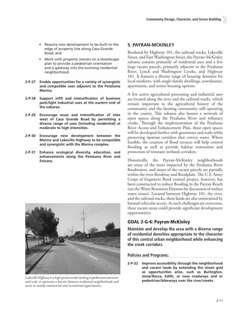
2-11
Community Design, Character, and Green Building 2
Require new development to be built to the edge of property line along Casa Grande Road; and
Work with property owners on a streetscape plan to provide a pedestrian orientation and a gateway into the evolving residential neighborhood.
2-P-27 Enableopportunitiesforavarietyofsynergisticand compatibleusesadjacent to thePetalumaMarina.
2-P-28 Support infill and intensification of businesspark/lightindustrialusesattheeasternendofthesubarea.
2-P-29 Encourage reuse and intensification of siteswest of Casa Grande Road by permitting adiverse rangeofuses (including residential) atmoderatetohighintensities.
2-P-30 Encourage new development between theMarinaandLakevilleHighwaytobecompatibleandsynergisticwiththeMarinacomplex.
2-P-31 Enhance ecological diversity, education, andenhancements along the Petaluma River andEstuary.
•
•
5.PAYRAN-MCKINLEY
Bordered by Highway 101, the railroad tracks, Lakeville Street, and East Washington Street, the Payran-McKinley subarea consists primarily of residential uses and a few large vacant parcels, primarily adjacent to the Petaluma River, Lynch and Washington Creeks, and Highway 101. It features a diverse range of housing densities for local residents, with single-family dwellings, townhomes, apartments, and senior housing options.
A few active agricultural processing and industrial uses are located along the river and the railroad tracks, which remain important to the agricultural history of the community and the farming community still operating in the county. This subarea also houses a network of open spaces along the Petaluma River and tributary creeks. Through the implementation of the Petaluma River Access and Enhancement Plan, these open spaces will be developed further with greenways and trails while preserving riparian corridors that convey water. Where feasible, the creation of flood terraces will help control flooding as well as provide habitat restoration and protection of remnant wetland corridors.
Historically, the Payran-McKinley neighborhoods are some of the most impacted by the Petaluma River floodwaters, and many of the vacant parcels are partially within the river floodway and floodplain. The U.S. Army Corps of Engineers flood control project, however, has been constructed to reduce flooding in the Payran Reach (see the Water Resources Element for discussion of surface water issues). Located between Highway 101, the river, and the railroad tracks, these lands are also constrained by limited vehicular access. As such challenges are overcome, these vacant areas could provide significant development opportunities.
GoaL2-G-6:Payran-mcKinleymaintain and develop the area with a diverse range of residential densities appropriate to the character of this central urban neighborhood while enhancing the creek corridors.
Policies and Programs:
2-P-32 Improveaccessibilitythroughtheneighborhoodand vacant lands by extending the street gridas opportunities arise, such as Burlington,Jesse/Rocca, Edith, or new roadways and orpedestrian/bikewaysovertheriver/creeks.
Lakeville Highway is a high speed corridor lacking in pedestrian amenities and scale; it represents a barrier between residential neighborhoods and access to nearby commercial and recreational opportunties.

2-12
Petaluma General Plan 2025
2-P-33 Develop the Petaluma River as a publicly-accessible green ribbon, fronted by streets,paths, and open spaces by implementing thePetalumaRiverAccessandEnhancementPlan.
2-P-34 Fosterconnectionstotheriverfromsurroundingareasandensurethatnewdevelopmentadjacenttotheriverisorientedtowardit.
2-P-35 through site planning techniques, protectresidentialunits fromvisualandnoise impactsfromHighway101.
2-P-36 Ensure that intensificationofEastwashingtonStreetdoesnotunduly impact residentialusesbyrequiringnewdevelopmentinthecorridortoprovideanadequatetransition.
2-P-37 Use the Natural Environment Element, waterResources Element and the Petaluma RiverAccessandEnhancementPlanastoolsto:
Implement the Petaluma River greenway by maintaining setbacks.
Creating flood terraces where appropriate.
Preserving flood storage capacity of the floodplain.
Protecting and enhancing habitat conservation areas.
Protecting and enhancing oak and riparian habitat and other open spaces along the river.
2-P-38 Promote greater accessibility to the PetalumaRiverandvacantlandsthroughroadextensions,bikeways,andtrails,including:
Extending Burlington Drive northward across Lynch Creek, and consider other options to extend streets through to new developments.
Requiring new development to be oriented to the river, and providing continuous public access to the riverfront.
2-P-39 Explorethefeasibilityofusingfloodplainareasforpublicspacesandrecreationaluses,suchasontheJohnsonProperty(seeRecreation,Music,Parks,andtheArtsElement).
2-P-40 Develop two new Parks—a community parknortheastofPetalumaRiver/LynchCreekandaneighborhoodparkalong the rivernearCedarGrovePark.
•
•
•
•
•
•
•
PetaLuma BOuLeVarD
Petaluma Boulevard North and South serve as gateways from Highway 101 toward Downtown. The arterial roadway also serves as the main north/south corridor for the western half of the community, and provides access to cross-town roadways such as Corona Road, Payran, East Washington, Lakeville and “D” Streets. Both entrances pass through unincorporated areas of Petaluma with rural or commercial/industrial land uses, open roadside drainage swales and vacant or under-utilized parcels. The northern gateway offers a mature tree-lined stretch of road, which when driven appears to be heading away from, rather than toward, an urbanized area. The southern gateway serves as access to heavy industrial and river-dependent uses, some of which were displaced from locations more central to the community. Petaluma Boulevard also encompasses portions of the Petaluma River as it flows through and away from the city.
Petaluma Boulevard North and South subareas are different in their character, as discussed below.
6.PEtALUMABOULEVARDSOUtH
Petaluma Boulevard South is the southern gateway to the city as it is approached from Highway 101 while passing through Petaluma’s rich estuary. This thoroughfare presents a working industrial face to the northeast, grassy fields dotted with oaks to the southeast, and distant vistas across the Petaluma River and the southeast quadrant of the community to the Sonoma Hills. Very low building intensities on industrial sites accommodate storage and working yards. Single family residences are located on the west side of Petaluma Boulevard South with significant additional development potential. Existence of street frontage improvements, or lack thereof, clearly indicates those areas within the city from those still in the unincorporated area of the County. Petaluma Boulevard South is comprised of two distinct areas:
East of Highway 101. Located within the Urban Growth Boundary, but currently beyond city limits, this area will remain industrial in character and offers opportunities to preserve views to the Petaluma River and beyond. While river-dependent uses will be preserved and intensified, streetscape improvements to this portion of the Boulevard will slow traffic while strengthening this gateway.
Highway 101 to D Street (includes areas across from the Central Petaluma Specific Plan). As one
•
•

2-1�
Community Design, Character, and Green Building 2
approaches downtown Petaluma, this portion of Petaluma Boulevard South becomes more urban in character. Between Highway 101 and McNear Avenue significant changes will occur during the early life of this General Plan. New residential neighborhoods and the eventual extension of Caulfield Lane, as the Southern Crossing, to connect to Petaluma Boulevard South will provide east/west linkages for the whole community. As development results in changes to the character of the roadway itself (i.e.: better definition of lanes, provision of street lights, curbs and sidewalks, addition of trees, etc.) the sense of arrival to a community will move southward. Existing vehicle speeds on the Boulevard need to be addressed to insure the new neighborhoods are not subjected to conditions not conducive to pedestrian and bicycle safety. The use of roundabouts can improve the sense of entry.
North of McNear Avenue the eastern side of the Boulevard is envisioned having an intense urban form as established in the CPSP. The western side of the Boulevard, on the other hand, will act as a transition from the high-intensity development of the CPSP to the small scale neighborhoods to the west, enabling preservation of historic buildings, and views of hills while acknowledging diversity of the built and natural landscape. This portion of the Boulevard will have a similar mixture of uses as the CPSP, but at a lower intensity.
GoaL2-G-7:PetalumaboulevardsouthCreate a strong sense of entry into the community and provide a transition from the highway to the Central Petaluma specific Plan area.
Policies and Programs:
2-P-41 Provide gateway improvements both east andwestoftheHighway101overcrossing.
A. East of Highway 101, undertake a streetscape improvement program that recognizes existing trees, incorporates new trees and vegetation, while reinforcing a visual and physical connection to the Petaluma River and estuary.
B. Preserve and expand river-dependent industrial uses, while improving appearance from Petaluma Boulevard South with landscaping.
C. Develop the terminus of the Caulfield Lane “southern crossing” with Petaluma Boulevard
•
South as a gateway, with methods—such as a roundabout, tree-lined median, reduced lane widths, or other traffic calming/design treatments—to slow traffic and define an entrance into the community and new neighborhoods.
D. With or without the southern crossing develop traffic calming measures to address traffic speeds.
2-P-42 Provide vistas eastward to the Petaluma RiverandacrosstowardSonomaMountain.
2-P-43 Provide additional pedestrian/bicycle access toandalongtheriverfronttoconnecttoexistingandfuturetrailstowardDowntown.
2-P-44 InthestretchbetweenMountainViewAvenueandDStreet,maintainamixofusessimilartothoseatCPSP,butatalowerheightandintensity(toaddressviews,shading,senseofscale,etc.),while preserving historic structures along thecorridor.
2-P-45 Allow intensification of the bowling alleysite to an appropriately-scaled NeighborhoodCommercialcenter,extendingalongthesouthernsideofPetalumaBoulevard toMountainViewAvenue.
2-P-46 ExplorethefeasibilityofextendingIStreetandMountain View Avenue to the Petaluma RiverandapedestrianconnectionbetweenPetalumaBoulevard and the river as redevelopmentopportunitiesarise.

2-1�
Petaluma General Plan 2025
7.PEtALUMABOULEVARDNORtH
Highway 101, the western edge of the Urban Growth Boundary (UGB), Washington Street, and the railroad tracks define the Petaluma Boulevard North subarea. Commercial and industrial uses on the eastern side of Petaluma Boulevard North, and rural residential developments on the western side, characterize this subarea. Some of the dominant retail centers in Petaluma—the Auto Mall and the Factory Outlet Village—are located between Petaluma Boulevard and Highway 101. Some of the largest tracts of vacant land within the UGB are located within or adjacent to the Petaluma River floodplain.
In addition to the main through road, Petaluma Boulevard North, this subarea is served by Corona Road and Industrial Avenue within the city and rural roads such as Gossage Avenue, and Skillman Lane in the unincorporated County area. A principal defining feature of the area, although currently not consistently visible from public streets, is the Petaluma River.
Petaluma Boulevard North is comprised of three distinct areas:
Petaluma Boulevard North–North of Cinnabar Avenue. This western portion of Petaluma Boulevard North serves as a gateway connecting Highway 101 to Downtown. The General Plan seeks to reinforce the rural character of the boulevard. This section of the boulevard, along with the twin bridges, is characterized by a median, many portions of which boast full-grown sycamore trees and has been identified as a community asset to be preserved and expanded upon. This subarea contains small, narrow parcels sandwiched between the roadway and the river and, across the Boulevard, parcels of varying size and topography. A small underdeveloped commercial node exists at Corona Road.
Petaluma Boulevard North–South of Cinnabar Avenue. The median along Petaluma Boulevard North terminates at Cinnabar Road, and gradually acquires a more urban character. South of Payran Street many older and smaller buildings are built to the street. The General Plan provides for intensification along the corridor, with intensities increasing approaching Downtown, and reinforcement and intensification of the neighborhood commercial cluster at Payran Street.
•
•
Petaluma River Corridor. The General Plan envisions this stretch of the river as a green ribbon connecting neighborhoods, with full public access and recreational spaces along the river. Unconstrained sites will be developed with moderate to high-intensity uses, designed with sustainable practices and providing accessibility and connections to the river. Creation of flood terraces to retain and, where possible, increase the storm water carrying capacity of the river and reduce the extent of localized flooding are expected to be developed within this Reach while enhancing ecological diversity of the riparian corridor.
GoaL2-G-8:northofCinnabaravenuemaintain the rural character of the entry roadway with large median trees and significant building setbacks along Petaluma Boulevard north.
Policies and Programs:
2-P-47 Reinforce Petaluma Boulevard North as agatewayintothecity.MaintaintheareanorthofCinnabarAvenuealongthewesternedgeofPetalumaBoulevardinaruralcharacter(exceptfor a minor neighborhood commercial nodeat Corona Road), with trees, vegetation, andbuildingsetbacksreinforcingthehistoricaldesignofthecorridorasalandscapedboulevard.
A. Monitor and replace, if required due to age or disease, the existing Sycamore trees located within the median in order to preserve the character which these trees lend to this gateway. Replace with 2�” box or larger.
B. Enhance ecological diversity by planting native oaks, buckeyes and other appropriate native species to enhance gateway.
2-P-48 Maintaintheruralcharactertothewestofthiscorridorbylimitingdensity:
• to primarily Rural Residential uses west andnorthofGossageAvenue.
• A combination of Rural and Low DensityResidentialusessouthofGossageAvenue.
• Limiting the mixed use of the KOA site toallow continuation and possible expansion ofthevarietyofuseson the site (i.e. recreation/camping, support commercial, RV storage,outdoorrecreationalactivities,seasonalevents,etc.)
•

2-1�
Community Design, Character, and Green Building 2
2-P-49 Encourage development of small scaleNeighborhoodCommercialusesattheCorona/Skillman/PetalumaBoulevardNorthcorners.
2-P-50 Ensure that all development along PetalumaBoulevard North, north of Cinnabar Road,provides significant building setbacks, withvegetationandtreestomaintainarichecologicaldiversity and landscaped character along thestreet.
2-P-51 Develop a neighborhood park at Jessie Lane/PetalumaBoulevardNorth.
2-P-52 Prohibit the use of sound/noise-attenuationwallsalongPetalumaBoulevardNorth.
GoaL2-G-9:southofCinnabaravenueCreate a transition from the northern rural gateway to Downtown.
Policies and Programs:
2-P-53 Permitamixofuses,withfairlyhighintensitiesto create the ambiance of a bustling urbancorridor.
2-P-54 Reinforce existing Neighborhood Commercialuses at west Payran Street; encourageintensification and expansion of the existingcenter to provide a wider range of productsto meet the needs of the surroundingneighborhoods.
2-P-55 Encourage development of the area south ofPayranStreetasanurbancorridor,withamixof uses comparable to those of the CentralPetaluma Specific Plan, increasing in intensityapproachingDowntown.
2-P-56 Preserveandenhancetheoakwoodlandsettingand integrate development to protect andenhancetheseresources.
GoaL2-G-10:Petalumariverincorporate the river as a focal point for development along the Boulevard.
Policies and Programs:
2-P-57 Fosterconnectionstotheriverfromsurroundingareasandensurethatnewdevelopmentadjacenttotheriverisorientedtowardit.
2-P-58 UsethePetalumaRiverAccessandEnhancementPlan as the tool to implement the PetalumaRiverCorridorbymaintainingsetbacks;creatingnatural flood terraces where appropriate; andenhancingfloodplainandhabitatconservationareas and other open spaces along the riverutilizinganecologically-baseddesignapproach.
2-P-59 Promote greater accessibility and views toPetaluma River through road extensions,bikeways,andtrails,including:
Requiring new development to be oriented to the river, and provide continuous public access parallel to the riverfront.
Extending Industrial Avenue south of Corona Road.
Requiring a new pedestrian/bicycle connection to the river east of Jessie Lane and intersecting with Petaluma Boulevard North.
Requiring a new street connection to the river at, or near, the intersection of Gossage Avenue.
Requiring paths from the area of Jessie Lane southwest toward Magnolia Avenue to link with existing neighborhoods.
Enhancing the ecological diversity of the riparian corridor.
Requiring development to enhance the natural ecology along the river.
•
•
•
•
•
•
•
The Petaluma River is the central spine that weaves together the city’s neighborhoods with publicly accessible open space as new development occurs.

2-1�
Petaluma General Plan 2025
tHe HiLLs
Located along the edges of the city’s Urban Growth Boundary, the western and southern foothills are rural in character. Rather than introduce urban densities into these subareas, the General Plan retains the existing rural large-lot pattern. Focusing development on the Petaluma River and along key corridors (i.e. Washington Street and Petaluma Boulevard) allows parcels in the western and southern hills to be reserved for primarily Rural and Very Low Density residential uses, as well as City Parks, Open Space, an extended Urban Separator, and trails.
8.wEStHILLS
West Hills is primarily defined by Petaluma’s Urban Growth Boundary (UGB) to the west and south. Although this area contains more vacant land than any other subarea, much of it is constrained by steep slopes. West Hills’ rural quality is emphasized by these tracts of open land, as well as older, narrow roads, wildlife corridors, grasslands naturally dotted with mature oak woodlands, remnant hedge/wind rows, agricultural plantings (e.g. walnut trees), and a wide range of home styles and sizes. About one and a half acres of commercial and office uses lie near the intersection of Bodega Avenue and Paula Lane; this mixed-use area will continue to provide convenience retail for surrounding urban and rural residents.
With its grassy slopes, large oaks, natural streams and low housing density, West Hills serves as a transition area from Petaluma’s urban densities to the rural residential uses, agricultural activities, and grazing land beyond the UGB.
GoaL2-G-11:WestHillsreinforce the existing rural character and densities of the hillside neighborhoods.
Policies and Programs:
2-P-60 ProvideatransitionfromtheurbandensitiesofDowntown to the rolling hills and agriculturallandsbeyondtheUGB.
2-P-61 Protect existing agricultural uses, wildlife,historic and cultural resources, and naturalvegetation.
2-P-62 Preserve the rural aspect of the area bymaintainingtheexistingdensity(Rural,VeryLowandLowResidential)andlandusepatterns.
A decrease in density through minimum lot sizes within the Development Code can achieve the desired transition.
2-P-63 Allow for clustering of residential units in thehills,permittingsmallerlotsizeswhereclusteringandcommonspaceismaintainedandproposeddevelopmentcorrespondstostipulateddensityranges.
Also see Hillside/Ridgelines policies in Chapter 1.
2-P-64 Reinforce the existing Neighborhood CenterusesatBodegaAvenue/PaulaLanebypermittinglimitedmixedusedevelopmentatthisnode.
2-P-65 RequirededicationoftheUrbanSeparatorand/orUrbanSeparatorPathwayalongthewesternandsouthernboundariesoftheUGB.
2-P-66 DevelopgatewaysatCityentrancesonBodegaAvenue, western Avenue and “D” Street thatrecognize the transition from a rural to urbanareabyenhancingexistingnaturaltourbantreepatterns.
2-P-67 Create an open space network throughresidential areas by requiring integration ofopen space with public trails when propertiesaredeveloped.
The rural character of the West Hills subarea allow for a transition between agricultural uses (left) and the city core. The General Plan calls for the preservation of steep topography, mature oak trees, and ridgelines in the West Hills (right) and South Hills subareas.

2-1�
Community Design, Character, and Green Building 2
2-P-68 PreservetheuniquenessofthepropertyattheintersectionofDStreetandwindsorDrive(ScottRanch) through incorporationof the followingcriteriainthefuturedevelopmentprocess:
Respect the gateway value with a minimum 100’-setback from D Street with no sound walls.
Maintain a minimum of a 100’-setback along Kelly Creek and its tributaries.
Preserve the red barns in place, designate them historic and encourage the incorporation of a nature study area.
Preserve and maintain habitat areas and trees.
Avoid slide areas and minimize grading.
Provide a minimum �00’-wide Urban Separator.
Provide a minimum of a �-acre park site.
Include the provision of trailhead facilities with restrooms and parking with a connection to Helen Putnam Regional Park.
Respect City hillside regulations.
9.SOUtHHILLS
South Hills is a small subarea defined by Petaluma’s Urban Growth Boundary (UGB) and I Street. The majority of this subarea remains unincorporated although many of the existing homes presently receive City utility services. Like the West Hills, this subarea is characterized by its topography of steep to rolling hills dotted with mature oak woodlands accommodating large rural residential lots (five acres or larger) arranged on narrow local roads (i.e. Purrington Road and the southern section of Mountain View Avenue). Open space in the form of the privately-owned Petaluma Golf and Country Club comprises a large portion of the land in this subarea, with scattered vacant residential parcels accounting for the remaining acreage. ‘I’ Street Extension provides a minor gateway from outlying agricultural lands.
The General Plan envisions little change to this neighborhood, preserving its existing hillside residential character, while allowing low density infill development on vacant and under utilized sites between existing neighborhoods and Purrington Road. The remaining lands could slowly develop, as utility extensions occur, to allow Very Low Density residential uses (up to two dwelling units/acre).
•
•
•
•
•
•
•
•
•
GoaL2-G-12:southHillsreinforce the existing natural character of the hillside neighborhoods, preserving topography and ridgelines.
Policies and Programs:
2-P-69 LimitresidentialdensitiestoVeryLowandLowDensityResidential.
2-P-70 Extend the Urban Separator and/or UrbanSeparatorPathway.
To the extent feasible, provide an area up to �00-feet in width along the eastern boundary of the South Hills subarea by requiring dedication of land as Urban Separator, while allowing density transfers from the Urban Separator and Urban Separator Pathway to the developable portion of individual sites.
2-P-71 Develop a strong gateway at I Street withlandscapetreatmentandviewsofthePetalumaValley.MaintaintheruralcharacterandinterfaceoftheadjacentoutlyingareasoftheUGBwhendesigninggatewayimprovements.
2-P-72 PreservetheexistingpublicviewshedsfeaturingthePetalumacommunity.
2-P-73 Minimize grading, to all extent possible,steppingdevelopmentintoandwiththenaturaltopography.
2-P-74 PreservetreesandenhancethenaturalwoodlandecologyoftheSouthHillssubarea.
Also see Hillside/Ridgelines policies in Chapter 1.
•
The South Hills subarea is lightly populated with rural single family homes tucked into hillside properties that provide beautiful views of Petaluma.

2-1�
Petaluma General Plan 2025
10.wASHINGtONCORE
The Washington Core subarea is composed of a diverse mix of land uses. Two shopping centers, providing both neighborhood and regional retail uses for city residents, occupy opposing corners of the East Washington Street and McDowell Boulevard intersection.
The Sonoma-Marin Fairgrounds occupy the largest single parcel—about 64 acres in size. A diverse array of special events are held at the Fairgrounds throughout the year, including the annual Sonoma-Marin Fair in late June. The lease of the Fairgrounds site (owned by the City) will expire in 2023, at the far end of the General Plan time frame. The long-term value of having a Fairgrounds site in Petaluma has been supported by the community, although the Fairgrounds could be considered for relocation to a site with greater flexibility or redevelop the existing site to meet the economic and use needs of the Fair District. In case of future reuse and relocation of the Fairgrounds, extension of the street grid into new development will help connect Petaluma’s central/core neighborhoods. The old Kenilworth Junior High School site, located adjacent to Highway 101, is slated for reuse as a shopping center with a combination of large stores and smaller shops, and townhomes. Orienting the redevelopment of this block toward existing arterial streets and established, older neighborhoods will insure compatibility of design and intensity.
A grid of bungalows originally housing riverfront workers lies behind the East Washington Street and Lakeville Street corridors, southwest of Payran Street. Property-owners have rehabilitated lots and expanded houses to allow two and three units on some parcels. Houses are located near the street and feature small porches or stoops. However, some buildings within this subarea, particularly along Lakeville, fail to define the street, often face away from the road, and are out of scale for the pedestrian.
Continued renovation and preservation of the housing stock within this area, as well as an emphasis on creating a more urban form, will retain the uniqueness of this neighborhood within easy walking distance of Downtown and local services.
Washington Core has great access and visibility from Highway 101. The planned Caulfield Lane extension (southern crossing) will provide increased accessibility to the area from the southern areas of the city as well.
GoaL2-G-13:WashingtonCorestrengthen the connection between Downtown and the Washington Core sub-area.
Policies and Programs:
2-P-75 Allow development and redevelopment tointensify the land uses while preserving thequality and character of the Old East D Streetneighborhood.
2-P-76 Develop the area with a diverse range ofcommercial and residential uses with intensityand character appropriate to a central urbanneighborhood.
2-P-77 CapitalizeonopportunitiestoprovideRegionalandCommunityCommercialfacilitiesattheoldKenilworth school site, while integrating newdevelopmentwiththeintendedscaleandnewcharacterforEastwashingtonStreet.
2-P-78 Foster intensification and redevelopment ofexisting Neighborhood Commercial centers intheMcDowellBoulevardcorridor.
2-P-79 Extendtraditionalstreetgridsasopportunitiesarise.
2-P-80 EncourageintensificationofthePetalumaPlazaand Plaza North sites with a diverse range ofCommunity Commercial uses. Ensure that newdevelopment:
Presents an urban face along McDowell Boulevard, with parking tucked behind buildings.
Incorporates bike access from Lynch Creek.
2-P-81 Permitarangeoflargeandsmall-sizedretailandofficeaswellasresidentialusesontheformerKenilworthSchoolsite,whileensuringthatthedevelopment:
Presents an urban/pedestrian face on Washington Street, with parking tucked behind buildings.
Incorporates a plaza or other civic open space.
Provides adequate open space to meet the needs of residents.
2-P-82 work with the Sonoma-Marin Fair to exploremoreoptimaluseorrelocationoftheFair’ssite.
A. Optimal use could include redesign and
•
•
•
•
•

2-1�
Community Design, Character, and Green Building 2
intensification of the existing acreage; reduction and intensification of the existing site; or master planning of the Fairground and adjacent property(ies) to create an improved layout of the fairground; improve compatibility with existing neighborhoods, and enhance adjacent development potential.
B. If the Fairground is relocated, permit a diverse range of residential and commercial uses appropriate in intensity and character to compliment the residential neighborhood to the southwest, and new commercial uses toward Highway 101. Require provision of park and open space and extension of the existing street grid.
2-P-83 work with the Sonoma-Marin Fair to exploreopportunitiestoachieveajoint-useagreementand/or year-around use of open space/greenfieldareasof thefairgroundsforpublicaccessand/or recreational activities including groupsports.
2-P-84 Considertheneedforatransitionzonebetweenthe more traffic-oriented East washingtonStreet and McDowell Boulevard and the morepedestrian lateral neighborhood streets andshoppingcenters.
Protect existing trees and develop a street tree program that maximizes shade and improves the pedestrian scale.
2-P-85 Preserve existing and plant additional treesin the washington Creek area between NorthMcDowell Boulevard and Sonoma MountainParkway.
2-P-86 Provide enhanced facilities to encourageimprovedpedestrianandbicyclemobilityalongEastwashingtonStreetandEastDStreet,suchas:
Enhancing the existing pedestrian overcrossing of Highway 101.
Improving and expanding connections to the Lynch Creek trail system.
Improve pedestrian and bicycle facilities on the East Washington Street overpass.
•
•
•
•
11. NORtHMCDOwELLBOULEVARD
The North McDowell subarea lies between Highway 101, the Plaza and Plaza North Shopping centers, North McDowell Boulevard, the railroad tracks, and Petaluma’s Urban Growth Boundary at the northeast corner of the community. It provides two gateways into Petaluma—through Old Redwood Highway and Highway 101. Along with Sonoma Mountain Parkway/Ely Boulevard South, McDowell Boulevard itself is a primary north-south connector for the eastern portion of Petaluma. In general, heavy traffic volumes, large parcels, lack of continuous sidewalks, and introversion of its developments make most of North McDowell more amenable to the car than to the walker or cyclist.
Commercial and industrial uses dominate the North McDowell Boulevard subarea. Highway-oriented commercial uses—such as hotels, restaurants, retail stores and auto service stations—are located adjacent to the Highway 101/Old Redwood Highway interchange. Business park complexes, featuring office and light industrial uses, are clustered along Old Redwood Highway and McDowell Boulevard. The North McDowell Boulevard subarea also contains a significant portion of the city’s senior housing. South of Corona Road, four mobile homes parks and one apartment complex are located along North McDowell Boulevard, providing affordable living for Petaluma’s seniors and families.
Approximately 15 percent of the North McDowell Boulevard subarea is vacant (77 acres), most of it adjacent to the proposed new Rainier Avenue interchange/underpass. Vacant and under utilized lots provide opportunities for expansion of commercial, office, and light industrial uses along North McDowell Boulevard. Mixed Use designations offer an opportunity to intensify existing uses and provide more diversity and employment intensity along this arterial roadway.
GoaL2-G-14:northmcdowellboulevardrecognize the complex demands upon the Boulevard and enhance the function and aesthetic value it could provide to the community.
Policies and Programs:
2-P-87 whereapplicable,providea transition in scalealongNorthMcDowellBoulevardbetweentheindustrialusesonthewestsideoftheboulevardand the residential developments to the east,

2-20
Petaluma General Plan 2025
whileallowingnewdevelopmentatintensitiesreflectiveofenhancedconnectionsprovidedbythenewcross-townconnectorandinterchangeatRainierAvenue.
2-P-88 Provide enhanced pedestrian and bicyclenetwork connections between the industrial,commercialandresidentialclusters.
2-P-89 Allowforarangeofuses,includingcommercial,officeandresidential,inthemixed-useareaonthe southwest corner of North McDowell andRainierAvenue.
2-P-90 workwithregionalandotheragenciestocreatea new light rail transit station near CoronaRoad with high-intensity, transit-orienteddevelopment.
2-P-91 Promotewalkabilitybyclusteringbusinessparksand increasing pedestrian linkages betweenoffice structures and nearby commercial andrestaurantuses.
A. Develop a program for modifying existing lawn areas fronting industrial development to provide sidewalks.
2-P-92 Promote greater accessibility to the PetalumaRiver and neighboring areas, while enhancingthe ecology and providing native plantingthrough road extensions, bikeways, and trails,including:
Extending Lynch Creek Way northwest through new developments, connecting with the Rainier Avenue extension.
Extending Rainier Avenue westward to Petaluma Boulevard North, creating a new interchange with Highway 101.
2-P-93 work with Caltrans and other agencies toestablish a park-and-ride lot close to the newinterchange.Includeparkingspaceswithelectricvehicle recharging facilities, secure bicycleparking, and reserved spaces for ride-sharingvehicles.
2-P-94 Encourage the development of landscapestandardsthatreduceexistinglawnsandrequiretreeplanting.
•
•
12. NORtHEASt
Bounded by East Washington Street, North McDowell Boulevard, Corona Road, and Petaluma’s Urban Growth Boundary (UGB), the North East subarea consists of established suburban residential neighborhoods with low building densities and heights. Significant public uses include the Community Center, Lucchesi, Prince, and Leghorns Parks, numerous smaller neighborhood parks, Boys and Girls Club, Santa Rosa Junior College Campus, a public golf course, and numerous schools and churches. Neighborhood commercial is limited to a small shopping center on Sonoma Mountain Parkway. Arterials and principal connector roads are Sonoma Mountain Parkway, North McDowell Boulevard, East Washington Street, Maria Drive, and Rainier Avenue. East Washington Street and Corona Road serve as gateways to Petaluma at the eastern city limit.
This area follows the “neighborhood unit” concept to some degree, with commercial uses located at intersections of arterial streets, schools at the center of neighborhoods, and dwellings mixed throughout. North East contains more parks than any other subarea, as well as access to the public Rooster Run Golf Club and the Urban Separator running nearly continuously along its northeast boundary. Walking and bicycle trails that provide linkages between neighborhoods, open spaces, and other local destinations include those along Lynch, Capri, and Corona creeks. Opportunities exist to further link the network of walking paths, creeks, and open spaces in this subarea.
The character of this subarea is largely established, and given limited infill opportunities on vacant or under utilized land, it is unlikely that it will change substantially over the next 20 years. The Hansen House property, at 718 North McDowell, represents one of these infill opportunities. This structure represents a small remnant of the historic agricultural use of this area and should be preserved and incorporated into proposed development of the site. Transportation modes could change should development of a light rail system be completed with a rail stop at Corona Road.
GoaL2-G-15:northeastmaintain the rich mix of residential densities, commercial opportunities, educational facilities, and natural and public amenities.
Policies and Programs:

2-21
Community Design, Character, and Green Building 2
2-P-95 Preserve,improveandincreasetheinventoryofandaccesstoexistingopenspaceresourcesandschools.
2-P-96 DevelopHighandMediumDensityResidentialneartheproposedrailtransitstationonCoronaRoad.
2-P-97 the parcel at the corner of Sonoma MountainParkway and Corona Road with a splitdesignationofMediumDensityandHighDensityResidentialshallreflecttheintentofprovidinga mixture of unit types both consistent withthesurroundingneighborhoodsandthedesirefor high density housing in proximity to theproposedrailstation.Distributionofamixtureof medium and high density unit types acrossthepropertymaybepermitted.
2-P-98 Continue the Urban Separator and path alongthenortheasternboundaryofSantaRosaJuniorCollegetoprovidethecontinuouslinkbetweenneighborhoods.
2-P-99 Improve older streetscapes with added streettrees,landscapingandpedestrianamenities.
2-P-100 DevelopagatewayatEastwashingtonStreet/UGBwithlandscapetreatment.
Maintain the rural character and enhance the natural ecology of those gateways adjacent to the UGB when designing street tree plans and landscape improvements.
2-P-101East of Maria Drive, narrow East washingtonStreet from four lanes to two lanes (that is,one lane in either direction), with increasedlandscaping to screen sound walls, and withexpandedsidewalksandbikeways.
2-P-102 Encourage neighborhood adoption andparticipation in the restoration of naturalhabitats(e.g.creeksandurbanseparator).
Preserve the natural habitat and trees along creek corridors.
2-P-103 work with neighborhoods to undertakeenhancement projects within the UrbanSeparator (e.g. oak woodland, communitygardens,andadditionalrecreationalamenities).
2-P-104 Keep Corona Road as a rural two-lane road(east of Sonoma Mountain Parkway) with animprovedcross-sectiontofacilitatesaferbicycleand pedestrian use utilizing innovative designstandardsthatincreaseconnectivityandsafetywhilemaintainingtheruralcontext.
•
•
The north east quadrant of Petaluma provides a wide variety of land uses including community parks, shopping centers, diverse housing types, and the recently expanded Petaluma Campus of Santa Rosa Junior College.

2-22
Petaluma General Plan 2025
likely will not change substantially over the next 20 years except by virtue of streetscape improvements and limited infill development. Unlike the North East subarea, this area does not have the same acreage and proximity of parks, which are primarily located along the Urban Separator and on school properties. Redevelopment of existing under utilized commercial areas on Casa Grande Road and South McDowell could allow more neighborhood serving uses.
GoaL2-G-16:southeastencourage the enhancement of older neighborhoods through development of improved streetscapes, trail connections, and introduction of new neighborhood compatible uses.
Policies and Programs:
2-P-105 Preserve the existing blend of residential,educational, public/semi-public (e.g. churches,schools)usesoftheneighborhoods.
2-P-106 PreserveandimproveopenspaceresourcesbyenhancingcreekecologyalongEastwashingtonandAdobecreeks.
2-P-107 Encourage thedevelopment/redevelopmentofsmallneighborhoodservingcommercial.
2-P-108 Encourageintensification/redevelopmentoftheexistingNeighborhoodCommercialusesatCasaGrandeRoad/McDowellBoulevardSouth.
2-P-109 EmphasizeLakevilleHighway,FratesRoadandCasaGrandeRoadasgatewaystothecitythroughlandscapeandsidewalkimprovements.
Maintain the rural character and enhance the rural to urban transitions from the adjacent outlying areas of the UGB when designing street tree plans and landscape improvements.
2-P-110 ImprovepedestrianandbicycleamenitiesalongFratesRoad/CaderLaneasaccesstoindustrial/employmentareasandShollenbergerPark.
2-P-111 Extend bicycle paths along Adobe Creek, andprovidenewpathsalongmajorlocalconnectorsandcityarterials.
2-P-112 Encourageneighborhoodbeautificationprojectsemphasizing street tree programs and trafficcalming(e.g.medians,roundabouts,roaddiets,streettrees,etc.).
•
13. SOUtHEASt
The South East subarea is defined by East Washington Street, Highway 101, Lakeville Highway, Frates Road, and Petaluma’s Urban Growth Boundary (UGB). Lakeville Highway, Frates Road and East Washington Street all act as city gateways to Petaluma from the countryside and neighboring communities to the south and east.
The South East subarea, similar in scale and character to the North East, consists primarily of single-family residences. Shopping centers at McDowell Boulevard’s intersections with East Washington Street and Casa Grande Road service residential needs. The subarea has three elementary schools and one high school.
The Petaluma Municipal Airport, which lies near the eastern edge of the UGB, contributes to the large amount of public land in this subarea. Open spaces include the golf course located on Frates Road, small neighborhood parks, and the Urban Separator between the Airport and nearby residential neighborhoods. Open space corridors, with minimal trail and landscaping improvements also line most of the length of two creeks (East Washington and Adobe Creeks) in the subarea. Enhancing the ecological diversity of the creeks and providing improved public access and connectivity along these natural corridors would benefit the surrounding neighborhoods.
Relatively little vacant land is available in this subarea, and intensification opportunities are minimal as well. The largest vacant parcel east of the Rooster Run Golf Course, at the city’s edge, is currently slated for recreation uses. Like neighboring North East, the character of South East is largely defined by existing developments and most
Single-family housing in the South East subarea, such as the Adobe Creek subdivision, provides housing for larger Petaluma families.

2-2�
Community Design, Character, and Green Building 2
14. wESt
West—the largest and oldest subarea—includes all of Downtown west of Petaluma Boulevard, commercial uses, residential neighborhoods, schools, parks, churches and other religious facilities and open space. It is home to several historic areas, including the Petaluma Historic Commercial District, Oakhill-Brewster Historic District, “A” Street Historic District, as well as numerous neighborhoods of the quality to justify historic designation. Commercial and office uses within Downtown are housed in historic structures constructed at a pedestrian scale. Additional commercial development along the Petaluma Boulevard corridor provides neighborhood shopping, service commercial, and minor hotel uses. Other important public uses include Petaluma Junior High and High Schools, three elementary schools, City Hall, and the School Administration Center.
The West subarea provides a significant amount (105 acres) of the city’s vacant land acreage, although much of it is located in areas constrained by topography. Because neighborhoods in this subarea are the longest established in Petaluma, infill development needs to carefully consider issues of scale and character.
GoaL2-G-17:WestPreserve the density, scale, architectural quality and character of existing neighborhoods while allowing intensification of Downtown’s unique mix of uses.
Policies and Programs
2-P-113 StrengthenpedestrianconnectionstoDowntownand the Central Petaluma Specific Plan (CPSP)subarea through streetscape improvementsalong the washington Street/Bodega Avenuecorridor.
2-P-114 MaintaindesignanddevelopmentstandardsintheDevelopmentCodereflectiveoftraditionaldevelopmentpatterns:
Allow for smaller lots and setbacks.
Include design and structure massing controls to prevent large homes on small lots.
2-P-115 Allow lot consolidation in residential areasonlywhenfindingthatthiswillnotnegativelyimpacttheexistingneighborhoodcharacter.
•
•
2-P-116 Streettreesshallbepreservedandtheirnumbersincreased as development/redevelopment/remodelingoccurs.
2-P-117 Establishment of additional Historic Districts,expansion of existing Historic Districts, and/orcreationof,NeighborhoodPreservationDistrictsby neighborhood, shall be required, initiated,encouragedand/orsupportedbytheCity.
Adjacent to Downtown, the West subarea includes well-preserved historic districts with many early-1900s homes.

2-2�
Petaluma General Plan 2025
2.3 GreenbuiLdinG
A variety of policies dispersed in this General Plan—such as land use policies that foster infill development and efficient use of land, and transportation policies that encourage walking, bicycling and transit—directly or indirectly promote sustainable development patterns. This section identifies policies to promote sustainable and environmentally appropriate site planning practices as well as “green buildings.”
Green Building is the weaving together of many disparate energy-efficient, resource-efficient, and people-friendly practices in the design and construction of our buildings and the physical layout of our communities. The maintenance and rehabilitation of existing structures is inherently greener than their demolition and replacement with new construction. As it is currently used, the term “green building” is roughly synonymous with the terms “sustainable building” and “high-performance building.” Green building encompasses the environmental, economic, and social impacts of buildings, including energy efficiency, water conservation, indoor environmental quality, use of recycled and renewable materials, construction waste reduction, and site planning. Historic Preservation is an intrinsically green building practice.
Sustainable site planning practices—such as those that decrease runoff or decrease need for water for irrigation—are especially critical in Petaluma because of the city’s location in a floodplain, the presence of sensitive biological habitats along the Petaluma River, and the constraint of a limited water supply (see Chapter 8: Water Resources “Sustainable Site Planning”).
Green building programs, such as the LEED (Leadership in Energy and Environmental Design) system developed by the U.S. Green Building Council, have developed in response to a growing movement by local governments and other community interests to address environmental and economic sustainability through an integrated design approach.
In 2006, the City of Petaluma adopted a voluntary green building program – “Petaluma Build it Green.” Petaluma Build it Green is a voluntary, points-based program designed to stimulate and support green building in Petaluma. Based on the nonprofit organization Build it Green, the program offers suggestions for conserving natural resources, using water and energy wisely, improving indoor air quality and planning for livable and vibrant communities. The purpose of a citywide policy on green building is to demonstrate the City’s commitment to environmental, economic, and social stewardship, and to
contribute to the City’s goals of protecting, conserving, and enhancing the region’s environmental resources.
GoaL2-G-18:GreenbuildingProvide leadership and guidance to ensure the application of sustainable site planning and green building practices.
Policies and Programs:
2-P-118 AspartoftheDevelopmentCodeandStandardsUpdates,incorporatesustainablesiteplanning,development, and maintenance standards andprocedures, reflectingconditions inthevarietyof Petaluma settings (such as hillsides andfloodplains).
A. Prepare, periodically update, and implement green building guidelines and/or standards, appropriate to the Petaluma context, to ensure high level of energy efficiency and reduction of life-cycle environmental impacts associated with construction and operations of buildings.
B. Prepare and adopt green street standards, and incorporate these practices in design of city streets.
C. Prepare a salvage ordinance that requires an inventory of usable materials prior to demolition.
2-P-119 Incorporate green building principles andpracticesintotheplanning,design,construction,management, renovation, operations, anddemolitionofallfacilitiesthatareconstructed,owned,managedorfinancedbytheCity.
2-P-120 Encourage Sonoma county to use the sameGreen Building Standards when constructingnewfacilitiesthatservePetaluma,thatPetalumarequiresforconstructionofcity-ownedorcity-sponsoredfacilitiesaftersuchtimeasPetalumahasadoptedstandards.
2-P-121 Evaluate the success of the voluntary greenprogram and develop and implement amandatory program for new residential,commercial and municipal development andremodels.
2-P-122 Require development projects to prepare aConstruction Phase Recycling Plan that wouldaddressthereuseandrecyclingofmajorwastematerials (soil, vegetation, concrete, lumber,metal scraps, cardboard packaging, etc.)generated by any demolition activities andconstructionoftheproject.

The Petaluma River Valley has been the location of human settlement for hundreds of years. The California Historical Resources Information System records 14 Native American and 19 historic era cultural resource sites within Petaluma’s UGB. In addition, Petaluma has two City-designated local Historic Districts and one Nationally Registered Commercial District as well as over 300 properties that have been surveyed for potential historical significance1 (see Figure 3-1). Additionally, the Petaluma Vallejo Adobe, located just east of the city’s UGB, is a State Historic Park and National Landmark. Examples of individual properties listed as National Register Buildings include, but are not limited to: the Sweed House, United States Post Office (4th and D Streets), the Opera House, the former Carnegie Library (now the Petaluma Historical Library and Museum), and the Old Silk Mill.1 California Historical Resources Information System, Northwest Information Center: Sonoma State University,
December 17, 2001.
Historic Preservation

3-�
Petaluma General Plan 2025
revitalization; create highly skilled jobs and retain a strong concentration of local businesses; increase opportunities for heritage tourism; and maintain a diversified housing stock.
Social benefits – including those which encourage community pride and mutual concern for the local historic residential and nonresidential building stock.
Planning benefits – those which result from having a concerted and well-defined planning approach for the protection of historic buildings.
Environmental Benefits – historic preservation through the rehabilitation and reuse of existing buildings is an intrinsically “green” building practice as opposed to demolition.
GOAL 3-G-1: Historic PreservationIdentify, recognize and protect Petaluma’s unique and irreplaceable cultural heritage through the implementation of policies and programs that maintain the character and identity of the community, enhance the quality of the built environment, encourage awareness and appreciation for its history and culture, and contribute to its economic vitality. Ensure that future plans, ordinances, and City programs are complimentary to the historic preservation goals and policies contained within this plan.
Policies and Programs:
3-P-1 Protect historic and archaeological resourcesfor the aesthetic, cultural, educational,environmental, economic, and scientificcontribution they make to maintaining andenhancing Petaluma’s character, identity andqualityoflife.
A. Maintain the historic-era integrity of the Petaluma Historic Commercial District, which is listed on the National Register of Historic Places, by adhering to the city’s Historic Commercial District Design Guidelines.
B. Maintain the historic-era integrity within the Oak Hill-Brewster and “A” Street Historic districts as adopted local historic districts.
C. Develop floor area ratio and other design standards that relate overall building size and bulk to site area for Downtown, the Oak
•
•
•
Much or the Petaluma Historic Commercial District is listed on the National Register of Historic Places, and includes 96 contributing buildings on 23 acres of land2. The City has also identified The Oakhill-Brewster and “A” Street areas as locally designated architectural preservation districts, and has developed Preservation Guidelines and Standards for the three areas. The Oakhill-Brewster Historic District encompasses one of the earliest residential neighborhoods in Petaluma, northwest of Downtown, representing styles from the 1850s through the 1980s in a nearly continuous fabric of architecture. The “A” Street Historic District is an area of about six city blocks just at the southwest edge of Downtown. The District contains residences, offices, churches, and apartments, nearly all built before 1925. The Central Petaluma Specific Plan (2004) contains goals, objectives and policies and programs specific to that area of the community (see Figure 2-1 for CPSP boundary).
Also of historical value is the Petaluma Adobe State Historic Park, a National Historic Landmark, located at the intersection of Adobe Road and Casa Grande Road, east of the city limits. This 41-acre park features the main residence of the Rancho Petaluma – the fertile 66,000-acre ranch owned by General Mariano Guadalupe Vallejo in the mid 1800s. Today, the main house contains authentic furniture and interpretive displays representing aspects of life on Vallejo’s ranch.
3.1 BENEFITS OF HISTORIC PRESERVATION
The overall goal of this section is to ensure the preservation, protection, rehabilitation and restoration of historical and cultural resources by recognizing their inherent value in linking our present form to our community’s roots and evolution. Historical resources may include objects, buildings, structures, districts, trees and landscapes which invoke Petaluma’s past. The preservation of historic resources defines and fosters Petaluma’s unique identity, increases property values, creates neighborhood stability, promotes tourism, and spurs economic development. The California State Office of Historic Preservation outlines the following benefits of Historic Preservation:
Cultural benefits – those which make a community culturally richer for having the tangible presence of past eras and historic styles.
Economic benefits – such as those which increase property values and tax revenues when historic buildings are protected and made the focal point of
2 California Office of Historic Preservation, Directory of Properties in the Historic Property Data File for Sonoma
County, November 2, 2001.
•
•

3-3
Historic Preservation 3
Hill-Brewster, and “A” Street Historic District neighborhoods.
D. Conduct a comprehensive, city-wide survey of historic and cultural resources for the purpose of creating an historic resource inventory.
• Include updated surveys of existing Historic Districts as well as their adjacent areas.
• Identify individual resources for designation as local, state or nationally designated landmarks.
• The historic resource inventory shall be updated on a regular basis, per national standards. Inventories should be phased by prioritizing critical areas including areas targeted for development through the Central Petaluma Specific Plan and this General Plan.
E. Develop historic preservation guidelines or standards for protecting resources that are not currently designated through initiating, requiring and/or encouraging designation of additional historic districts, expanding the boundaries of existing districts and identifying and designating local landmarks.
F. Pursue Certified Local Government (CLG) status through the California State Office of Historic Preservation.
G. Create a central repository for historic surveys, reports, guidelines, ordinances etc. that is easily accessible to the public, while protecting confidentiality regarding archeological sites and Traditional Cultural Places.
H. The loss of designated and eligible historic
resources shall be minimized through strict enforcement of City policies requiring proposed demolition to be reviewed by the Historic and Cultural Preservation Committee. All means shall be used to encourage preservation of eligible historic resources (Resolution �005-198 N.C.S. as thereafter amended).
• Reconsider defining structures/resources 45 years or older as the standard for review to be consistent with the State of California, CEQA, and the National Register criteria.
I. Prepare a salvage ordinance that requires an inventory of usable materials, in cases where demolition is the only alternative, prior to demolition of historic structures.
J. Ensure the protection of known and unrecorded archaeological resources in the city by requiring a records review for any development proposed in areas that are considered archeologically sensitive for Native American and/or historic remains.
K. In accordance with CEQA and the State Public Resources Code, require the preparation of a resource mitigation plan and monitoring program by a qualified archaeologist in the event that archaeological remains are discovered.
L. Ensure that city staff responsible for planning decisions affecting historic resources are well-versed in historic preservation theory and practice; consider the creation of an historic preservation planner position on staff.
Petaluma’s Historic Commercial District is part of the National Register of Historic Places.
Residences in the Oakhill-Brewster Historic District help define the character of the street and neighborhood.

3-4
Petaluma General Plan 2025
3-P-2 Provide incentives for encouraging thepreservation and revitalization of historic andculturalresources.
A. Continue and expand the Storefront Improvement Loan Program.
B. Consider a reduced fee for projects that involve the preservation of historic resources.
C. Encourage and enforce the use of the State Historical Building Code.
D. Encourage owners of historic resources to take advantage of the Rehabilitation Tax Credit; investigate the costs/benefits of applying limited use of the Mills Act within the City.
E. Take advantage of the benefits of the Certified Local Government program such as grant funding available through the California Office of Historic Preservation.
F. Work with local nonprofits, preservation groups, and the private sector to establish funding partnerships to raise local funds for preservation projects.
3-P-3 As a policy, the City of Petaluma does notsupportdemolitionbyneglect.
A. Prepare an ordinance that implements fines and penalties for property owners who willfully allow for the destruction of historic resources through a lack of adequate maintenance.
3-P-4 Foster appreciation for Petaluma’s culturalheritage and encourage greater publicparticipation in education regarding thepreservationofresources.
A. Create a program and standards for the installation of signs, kiosks, plaques, and/or interpretive art commemorating past events/sites of historical or cultural interest.
B. Independently, or in concert with community group(s), annually recognize individuals, groups, or businesses that have made a significant contribution to the preservation, protection or restoration of historical or cultural resources.
C. Work with local groups and organizations to provide tours, educational opportunities and other public information programs geared toward increased knowledge and understanding of Petaluma’s historic and cultural resources.
D. Provide opportunities for ongoing education on historic and cultural preservation for City staff and elected/appointed officials.
3-P-5 The protection of historic resources shall be akey consideration and an equal component inthedevelopmentreviewprocess.
A. Develop procedures to ensure that historic resource reports and similar background materials be submitted to Historic SPARC during preliminary review of projects involving historic or cultural resources in order to resolve potential conflicts between preservation and proposed development early in the planning process.
B. Ensure that future plans, ordinances, and City programs are complimentary to the historic preservation goals and policies contained within this plan.
Historic buildings, such as the Train Depot (left) and the Old Silk Mill (right) offer opportunities for preservation and adaptive reuse.

3-5
Historic Preservation 3
C. Develop standards for historical review.
3-P-6 Ensurethatnewdevelopmentadjacenttoeligiblehistoricandculturalresourcesiscompatiblewiththecharacterofthoseresources.
3-P-7 Recognize landscape features, including treesin both their urban and natural environmentas part of Petaluma’s identity and part of thecharacterdefiningfeaturesoftheCity’shistoricdistricts.
A. Develop a program for monitoring and maintaining historic and/or contextually significant trees as defined in tree ordinance (as part of new Development Code).
B. Conduct and periodically update a survey of existing significant trees.
C. Make information available to residents and businesses related to the protection, maintenance, and proper care of significant trees and other historically significant landscape features.
D. Allocate funds for the maintenance, monitoring, and planting of street trees in designated historic districts, as appropriate to the historic character of these districts.
3-P-8 Recognize the value of, and protect theoperation of, active river-dependant andagricultural-supportuseslocatedwithintheCityofPetaluma.
A heritage home on Sixth Street, part of the A Street Historic District.
The Saint Vincent de Paul Parish Church and Dairymen’s Feed and Supply Cooperative’s grain elevators are prominent landmarks among Petaluma’s skyline.

3-�
Petaluma General Plan 2025
BST
6TH ST
WEST ST
WESTERN AVE
CST
4TH ST
EDITH STKEOKU
KST
MAGNOLIA AVE
WE
BS
TER
ST
KELLER
ST
HOWARDST
LIBERTY
ST
FAIRST
ENGLISH
ST
OAK ST
BAKERST
KENT ST
UPHAMST
NAST
KENTU
CKY
ST
WALN
UT
ST
PROSPECTST
GALLAND ST
CHERRY ST
BASSETT ST
LAU
REL
ST
A
ST
EST
COPELAND ST
STANLE
YST
DOUGLA
SST
POU
LTRY
ST
POST ST
PAR
KAV
E
BER W AY
WELLER ST
RO
CC
AD
R
BROADWAY
PLEASANT ST
SONOMA AVE
EL LIS CT
RIO VISTA WAY
BAYLISST
HILL
DR
CADER CT
SAN CARLOS DR
WA
LLA
CE
CT
SHELDONST
AVE
WOODWORTH WAY
GR
EYST
PARKSIDE
TER
CED
ARG
RO
VEPK
Y
MA
D
MARTHA ST
GAI
LIN
D
MYR TLE CT
DEERFIELD LN
ZAYDA LN
CLARKST
ELINOR CT
NATALIE CIR
7TH ST
KENTUCKY
ST
EST
FAIRST
MADIS
ONST
PETALU
MA
BLVD
Oakhill-Brewster
A Street
Downtown
µ 0 500250 Ft
DISCLAIMERThese maps or plans were compiled and or digitized via electronic meansutilizing many source documents. It is intended to be representative ofcertain physical, legal and geometric features within the City of Petaluma, CAand its environs. The existence or location of facilities must be field verified andthis document does not imply or guarantee neither adequate capacity nor theavailability of service. The City of Petaluma assumes no responsibility regardingthe accuracy of the information presented herein for legal documentation,representations of actual construction or for any other purpose for which thismap was not intended.
Revision Date: May 19, 2008
Figure 3-1
Petaluma General Plan 2025
HISTORIC DISTRICTS
City of Petaluma11 English Street
Petaluma, CA [email protected]

Petaluma is a city defined by the natural environment. The aquatic and riparian resources along the Petaluma River; the rich, ecologically diverse plant and wildlife communities; the area’s precious water and air resources; and productive open space resources—contribute greatly to the city’s quality of life. Protection, restoration, and enhancement of the natural environment are intrinsic components of fostering sustainability.
This element outlines policies related to the river, biological resources, air quality, energy, and solid waste. Detailed background information about the natural environment in Petaluma is provided in the Biological Resources Review (Appendix F-3, Volume 4 of Technical Appendices).
The Natural Environment
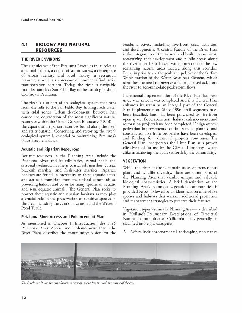
4-�
Petaluma General Plan 2025
4.1 Biologyandnaturalresources
ThE RivER ENviRoNs
The significance of the Petaluma River lies in its roles as a natural habitat, a carrier of storm waters, a centerpiece of urban identity and local history, a recreation resource, as well as a water-borne commercial/industrial transportation corridor. Today, the river is navigable from its mouth at San Pablo Bay to the Turning Basin in downtown Petaluma.
The river is also part of an ecological system that runs from the hills to the San Pablo Bay, linking fresh water with tidal zones. Urban development, however, has caused the degradation of the most significant natural resources within the Urban Growth Boundary (UGB)—the aquatic and riparian resources found along the river and its tributaries. Conserving and restoring the river’s ecological system is essential to maintaining Petaluma’s place-based character.
Aquatic and Riparian Resources
Aquatic resources in the Planning Area include the Petaluma River and its tributaries, vernal pools and seasonal wetlands, northern coastal salt marshes, coastal brackish marshes, and freshwater marshes. Riparian habitats are found in proximity to these aquatic areas, and act as a transition from the upland communities, providing habitat and cover for many species of aquatic and semi-aquatic animals. The General Plan seeks to protect these aquatic and riparian habitats as they play a crucial role in the preservation of sensitive species in the area, including the Chinook salmon and the Western Pond Turtle.
Petaluma River Access and Enhancement Plan
As mentioned in Chapter 1: Introduction, the 1996 Petaluma River Access and Enhancement Plan (the River Plan) describes the community’s vision for the
Petaluma River, including riverfront uses, activities, and developments. A central feature of the River Plan is the integration of the natural and built environment, recognizing that development and public access along the river must be balanced with protection of the few remaining natural areas located along this corridor. Equal in priority are the goals and policies of the Surface Water portion of the Water Resources Element, which identifies the need to preserve an adequate setback from the river to accommodate peak storm flows.
Incremental implementation of the River Plan has been underway since it was completed and this General Plan enhances its status as an integral part of the General Plan implementation. Since 1996, trail segments have been installed, land has been purchased as riverfront open space, flood reduction, habitat enhancement, and restoration projects have been completed. Design of new pedestrian improvements continues to be planned and constructed, riverfront properties have been developed, and funding for additional projects continues. The General Plan incorporates the River Plan as a proven effective tool for use by the City and property owners alike in achieving the goals set forth by the community.
vEGETATioN
While the river environs contain areas of tremendous plant and wildlife diversity, there are other parts of the Planning Area that exhibit unique and valuable biological characteristics. A brief description of the Planning Area’s common vegetation communities is provided below, followed by an identification of sensitive species and habitats that warrant additional protection and management strategies to preserve their features.
Vegetation types within the Planning Area—as described in Holland’s Preliminary Descriptions of Terrestrial Natural Communities of California—may generally be classified into eight categories:
Urban. Includes ornamental landscaping, non-native 1.
The Petaluma River, the city’s largest waterway, meanders through the center of the city.
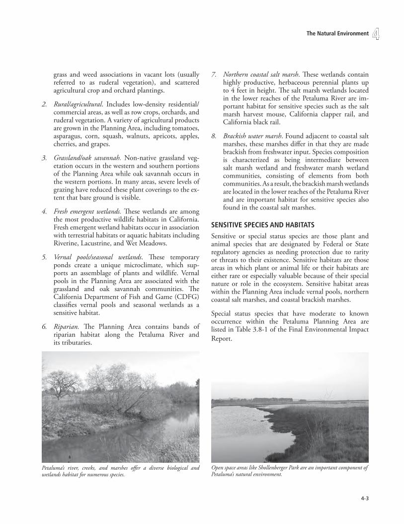
4-�
4The Natural Environment
grass and weed associations in vacant lots (usually referred to as ruderal vegetation), and scattered agricultural crop and orchard plantings.
Rural/agricultural. Includes low-density residential/commercial areas, as well as row crops, orchards, and ruderal vegetation. A variety of agricultural products are grown in the Planning Area, including tomatoes, asparagus, corn, squash, walnuts, apricots, apples, cherries, and grapes.
Grassland/oak savannah. Non-native grassland veg-etation occurs in the western and southern portions of the Planning Area while oak savannah occurs in the western portions. In many areas, severe levels of grazing have reduced these plant coverings to the ex-tent that bare ground is visible.
Fresh emergent wetlands. These wetlands are among the most productive wildlife habitats in California. Fresh emergent wetland habitats occur in association with terrestrial habitats or aquatic habitats including Riverine, Lacustrine, and Wet Meadows.
Vernal pools/seasonal wetlands. These temporary ponds create a unique microclimate, which sup-ports an assemblage of plants and wildlife. Vernal pools in the Planning Area are associated with the grassland and oak savannah communities. The California Department of Fish and Game (CDFG) classifies vernal pools and seasonal wetlands as a sensitive habitat.
Riparian. The Planning Area contains bands of riparian habitat along the Petaluma River and its tributaries.
2.
3.
4.
5.
6.
Petaluma’s river, creeks, and marshes offer a diverse biological and wetlands habitat for numerous species.
Open space areas like Shollenberger Park are an important component of Petaluma’s natural environment.
Northern coastal salt marsh. These wetlands contain highly productive, herbaceous perennial plants up to 4 feet in height. The salt marsh wetlands located in the lower reaches of the Petaluma River are im-portant habitat for sensitive species such as the salt marsh harvest mouse, California clapper rail, and California black rail.
Brackish water marsh. Found adjacent to coastal salt marshes, these marshes differ in that they are made brackish from freshwater input. Species composition is characterized as being intermediate between salt marsh wetland and freshwater marsh wetland communities, consisting of elements from both communities. As a result, the brackish marsh wetlands are located in the lower reaches of the Petaluma River and are important habitat for sensitive species also found in the coastal salt marshes.
sENsiTivE sPEciEs ANd hAbiTATs
Sensitive or special status species are those plant and animal species that are designated by Federal or State regulatory agencies as needing protection due to rarity or threats to their existence. Sensitive habitats are those areas in which plant or animal life or their habitats are either rare or especially valuable because of their special nature or role in the ecosystem. Sensitive habitat areas within the Planning Area include vernal pools, northern coastal salt marshes, and coastal brackish marshes.
Special status species that have moderate to known occurrence within the Petaluma Planning Area are listed in Table 3.8-1 of the Final Environmental Impact Report.
7.
8.

4-4
Petaluma General Plan 2025
Policies and Programs:
4-P-1 Protect and enhance the Petaluma Riverand its tributaries through a comprehensiveriver management strategy of the followingprograms:
A. Fully adopt and incorporate the Goals, Objectives, Policies and Programs of the Petaluma River Access and Enhancement Plan as an integral part of the General Plan �0�5. Implement the Petaluma River Access and Enhancement Plan including expanded improvements identified through project specific environmental assessment.
B. Institute and maintain public access to and along the entire length (on one or both sides), of the river while ensuring that natural resources and river dependent industry are protected.
C. Require design review to address the relationship and stewardship of that project to the river or creek for any development on sites with frontage along the river and creeks.
D. Create setbacks for all tributaries to the Petaluma River extending a minimum of 50 feet outward from the top of each bank, with extended buffers where significant habitat areas, vernal pools, or wetlands exist. Development shall not occur within this setback, except as part of greenway enhancement (for example, trails and bikeways). Where there is degradation within the zone, restoration of the natural creek channels and riparian vegetation is mandatory at time of adjacent development.
E. Facilitate compliance with Phase II standards of the National Pollutant Discharge Elimination System (NPDES) to improve the water quality and aesthetics of the river and creeks.
F. Work with the State Lands Commission, State Department of Fish and Game, the Sonoma County Water Agency, and other jurisdictional agencies on preservation/enhancement of the Petaluma River as a component of reviewing major development along the River.
G. Expand the planting and retention of trees along the upper banks of the river and creeks to reduce ambient water temperature and shade out invasive, non-native species.
H. Revise the Development Code to include:
• Standards for the four management zones that run the entire length of the river: 1) Restoration Zone, �) Buffer Zone, �) Preservation Zone, and 4) River Oriented Development Zone. These standards shall be based on the River Plan’s text and sections A-A through O-O as augmented by the cross-section needs identified through the XP-SWMM analyses;
• Design review requirements as articulated in the River Plan for any development on sites with frontage along the river or within �00 ft. of the river;
• The use of transfer of development rights (TDR) from portions adjacent to the river to elsewhere on the parcel by allowing property owners an increase in residential densities or in allowable Floor-to-Area-Ratio (FAR) and/or smaller/clustered lots to compensate for the loss of development opportunity on land within the Restoration, Buffer, or Preservation zones of the River Plan. The overall development potential on a site shall be consistent with the General Plan. TDRs shall not be applied to lands within the Floodway as there is no development potential within the Floodway.
I. Develop a consistent design for site furniture, a wayfinding system, and educational signage in the PRC and along the creeks and tributaries leading to it to heighten the recognition and value of the river and its ecosystem.
J. Utilize the Parks and Recreation, Water Resources & Conservation, Public Works departments, property owners (e.g. Landscape Assessment Districts) and/or other appropriate public agencies (e.g. Sonoma County Water Agency) to manage the long term operations, maintenance responsibilities, and stormwater capacity associated with the river and tributary greenways.
K. Prohibit placement of impervious surfaces in the Floodway (i.e. Parking lots, roadways, etc.) with the exception of pathways and emergency access improvements.
L. Continue to implement, where appropriate, flood terrace improvements to reduce localized flooding in concert with habitat enhancement projects.
M. Cooperate with State and Federal agencies to address and/or eradicate issues and environmental problems associated with
goal4-g-1:Biology&naturalresourcesProtect and enhance biological and natural resources within the UGb.

4-5
4The Natural Environment
possible infestation of the midden crab into the Petaluma River and adjacent tributaries.
4-P-2 Conserve wildlife ecosystems and sensitivehabitatareasinthefollowingorderofprotectionpreference:1)avoidance,2)on-sitemitigation,and3)off-sitemitigation.
A. Utilize Technical Memorandum �: Biological Resources Review as a baseline document, expanding to address project specific impacts.
4-P-3 Protect special status species and supportinghabitats within Petaluma, including speciesthatareStateorFederal listedasendangered,threatened,orrare.
A. As part of the development review process, site-specific biological resource assessments may be required to consider the impacts on riparian and aquatic resources and the habitats they provide for invertebrates, fish, amphibians, reptiles, birds, mammals, and plants. If development is located outside these ecologically sensitive regions, no site-specific assessment of biological resources may be necessary. Appropriate mitigation measures to reduce impacts to sensitive habitats and special status species shall be imposed on a project-by-project basis according to Petaluma’s environmental review process.
B. Permit mitigation banking as a conditional use in all land use designations along the Petaluma River and its tributaries.
goal4-g-2:Biology&naturalresourcesPromote resource protection within the Petaluma Watershed to conserve grassland habitats, oak woodlands, and other natural resources that are found in areas between the UGb and the Planning Area boundary.
Policies and Programs:
See also Chapter 8: Water Resources.
4-P-4 Continuetosupportrurallandusedesignationsand Agricultural Best Management PracticeswithintheSonomaCountyGeneralPlan.
A. Coordinate with Sonoma County’s Agricultural Preservation and Open Space District, Permit and Resource Management Department, and Water Agency to protect riparian corridors and
critical biological habitats as well as to reduce cumulative impacts on sensitive watershed areas outside of the city limits.
B. Work with County, State and federal agencies to ensure that development within the Planning Referral Area does not substantially affect State or federally listed rare, endangered, or threatened species or their habitats. Require assessments of biological resources prior to approval of any development in or within �00 feet of ecologically sensitive areas.
4-P-5 SupportwetlandmitigationandoakwoodlandsrestorationintheunincorporatedareasoutsidetheUGB.
4.2 airquality
In addition to being a regional issue of significance, air quality is vital to the overall health of the environment and the attractiveness of any locality. The Petaluma Valley enjoys generally good air quality largely due to its link with the Petaluma Gap (the region from the Estero Lowlands to the San Pablo Bay) and its low population density.
Mobile sources, including trains, boats, planes, and on- and off-road vehicles, present the greatest threat to air quality in Petaluma, as well as the region. Highway 101 and its interchanges are the most significant cause of elevated ozone levels in the area. Wood burning and other outdoor burning during late fall and winter is another source of air pollutants (primarily particulates and carbon monoxide). However, the prevailing wind assists in providing Petaluma with good air quality as there are no significant pollution sources upwind of Petaluma, and pollutant loads tend to be carried to the southeast away from the most developed areas.1 While air pollution potential is low, Petaluma’s role in the cumulative regional air quality must be addressed.
sAN FRANcisco bAy AREA AiR bAsiN
The City of Petaluma is located within the nine-county San Francisco Bay Area Air Basin. The air quality within the Bay Area Air Basin is influenced by a wide range of emissions sources—such as dense population centers, heavy vehicular traffic, and industry.
Under the Federal Clean Air Act, the U.S. Environmental 1. City of Petaluma, Department of Community Development, River
Oaks/Petaluma Outlet Village Master Plan Draft Environmental Impact Report, March 1990.

4-�
Petaluma General Plan 2025
Protection Agency (EPA) can classify an air basin or a portion thereof, as either in “attainment” or “non-at-tainment.” This classification is based on whether or not the basin meets national ambient air quality standards. Likewise, a basin is classified under the California Clean Air Act with respect to the achievement of State ambi-ent air quality standards. The Bay Area is considered in “attainment” for all of the national standards. It is con-sidered in “non attainment” for State standards for ozone and suspended particulate matter (PM-10 and PM 2.5, but is “unclassifiable” with regard to visibility-reducing particles2).
cRiTERiA AiR PollUTANTs
Federal, State, and local laws and regulations are the basis for controlling air pollution. The federal Clean Air Act requires the EPA to identify National Ambient Air Quality Standards. The EPA has established national standards for six criteria air pollutants, including ozone (O3), carbon monoxide (CO), nitrogen dioxide (NO2), sulfur dioxide (SO2), suspended particulate matter, and lead (Pb). In addition, the California Clean Air Act sets State standards for ambient air quality that are more stringent than the corresponding national standards. This legislation also sets standards for sulfates, hydrogen sulfide, and vinyl chloride, pollutants for which no national standards have been set.
At the regional and local levels, the Bay Area Air Quality Management District (BAAQMD) is primarily responsible for planning, implementing, and enforcing the federal and State ambient standards in the Bay Area. The BAAQMD operates a nearby air quality monitoring station in Downtown Santa Rosa at 5th Street, approximately 15 miles north of Petaluma. According to station measurements, no violations of federal or state standards for carbon monoxide occurred from 1996-2004 in the area, and ozone levels exceeded the State standard only twice. Occasional violations of particulate matter standards are a result of combustion, construction, grading, demolition, agricultural activities, and motor vehicles; however, the number of days when violations occurred is significantly lower than in previous years, especially the 1980s.
Toxic AiR coNTAmiNANTs
Unlike criteria air pollutants, ambient air quality standards have not been established for toxic air contaminants (TACs). These pollutants are typically carcinogens,
2. http://www.arb.ca.gov/desig/adm/adm.htm
mutagens, or reproductive toxins. Regulation of toxic air contaminants is achieved through federal and State controls on individual sources.3
The preferred technique for reducing toxic air emissions is source reduction, and as part of a local control strategy in the Bay Area, all applications for new stationary sources are reviewed to ensure compliance with required emission controls and limits. BAAQMD maintains an inventory of stationary sources of toxic air contaminants that emit TACs above certain threshold quantities in the Bay Area. There are currently 11 such sources listed within Petaluma, six of which are dry cleaners.
Hazardous Air Pollutants (HAPs) are emitted by any source that burns fuel (other than hydrogen). There are a wide variety of Federal and State controls on TACs and HAPs that apply to mobile and stationary sources.
sensitive Receptors
The BAAQMD defines sensitive receptors as “facilities or land uses that include members of the population that are particularly sensitive to the effects of air pollutants, such as children, the elderly and people with illnesses. Examples include schools, hospitals and residential areas.”4 Heightened sensitivity may be caused by health problems, proximity to the emissions source, and duration of exposure to air pollutants. Sensitive receptors in Petaluma include approximately 20 elementary schools, two junior high schools, seven high schools, one hospital and several convalescent homes. Any residence can also be considered a sensitive receptor.
Recognizing those sensitive members of the community are also likely to be at parks and in or around any residential area, all residential structures could also be deemed sensitive.
3. Federal environmental laws refer to “hazardous air pollutants” and California environmental laws refer to “toxic air contaminants.”
4. Bay Area Air Quality Management District, Bay Area ’97 Clean Air Plan and Triennial Assessment, December 17, 1997.

4-�
4The Natural Environment
goal4-g-3:airqualityimprove air quality and meet all Federal and state ambient air quality standards and goals by reducing the generation of air pollutants from stationary and mobile sources.
Policies and Programs:
4-P-6 Improve air quality through required plantingof trees along streets and within park andurbanseparators,andretainingtreeandplantresourcesalongtheriverandcreekcorridors.
A. Require planting of trees for every significanttree removed at a project site. Replacementplanting may occur on the project site oron a publicly owned area, with long-termmaintenance assured.
• Encourage the use of trees which providebiogenic benefits to air quality and aresuitable to the local environment.
• Establish ratio and size of replacement treesas part of the development code update.
4-P-7 Reducemotorvehiclerelatedairpollution.
A. Enforce land use and transportation strategiesdescribed in Chapter 1: Land Use and Chapter5: Mobility that promote use of alternatives tothe automobile for transportation, includingwalking, bicycling, bus transit, and carpooling.
Motor vehicles, regulations of whose emissionsby local agencies is preempted by State law,are the major source of criteria air pollutantsin the Bay Area Air Basin, accounting forthe vast majority of carbon monoxide andparticulate matter and over a quarter of thereactive oxygen gas and nitrogen dioxide in theregion. Increased use of transit and carpooling,coupled with land use and circulation patternsthat promote walking and bicycling, can leadto a decrease in daily trips, less emissions, andimproved air quality.
4-P-8 Support, where feasible, the development ofalternativefuelstations.
4-P-9 Requireapercentageofparkingspacesinlargeparking lots or garages to provide electricalvehiclechargingfacilities.
Prohibit new fossil fuel gas stations andtransition existing stations to serve ZeroEmission Vehicles
4-P-10
4-P-11 Promoteride-sharingandcar-sharingprograms.
4-P-12 Prohibit new drive-thru food and servicefacilities with the exception of vehicle servingbusinesses, suchascarwashandoil/lube,andlimitexpansionofthedrive-thrucomponentsofexistingfacilitieswhichincreaseidlingvehicles.
• Discretionary approvals for such facilitiesshall include provisions which decreaseor eliminate idling vehicles, to the extentfeasible and practical.
4-P-13 Require development of traffic roundabouts,where feasible, as an alternative to a trafficsignal,toreduceidlingvehicles.
4-P-14 DevelopandintegrateIntelligentTransportationTechnologies, as applicable, into Petaluma’stransportationsystem.
4-P-15 Improveairqualitybyreducingemissionsfromstationary point sources of air pollution (e.g.equipmentatcommercialandindustrialfacilities)andstationaryareasources(e.g.wood-burningfireplaces&gaspoweredlawnmowers)whichcumulativelyemitlargequantitiesofemissions.
A. Continue to work with the Bay Area Air QualityManagement District to achieve emissionsreductions for non attainment pollutants;including carbon monoxide, ozone, and PM-10, by implementation of air pollution controlmeasures as required by State and federal
Highway 101 and its interchanges are the most significant causes of elevated ozone levels in the area.
.

4-�
Petaluma General Plan 2025
statutes.
The BAAQMD’s CEQA Guidelines should be used as the foundation for the City’s review of air quality impacts under CEQA.
B. Continue to use Petaluma’s development reviewprocess and the California EnvironmentalQuality Act (CEQA) regulations to evaluate andmitigate the local and cumulative effects ofnew development on air quality.
C. Continue to require development projectsto abide by the standard construction dustabatement measures included in BAAQMD’sCEQA Guidelines.
These measures would reduce exhaust andparticulate emissions from construction andgrading activities.
D. Reduce emissions from residential andcommercial uses by requiring the following:
• Use of high efficiency heating and otherappliances, such as cooking equipment,refrigerators, and furnaces, and lowNOx water heaters in new and existingresidential units;
• Compliance with or exceed requirementsof CCR Title �4 for new residential andcommercial buildings;
• Incorporation of passive solar buildingdesign and landscaping conducive to passivesolar energy use for both residential andcommercial uses, i.e., building orientationin a south to southeast direction, encourageplanting of deciduous trees on west sidesof structures, landscaping with droughtresistant species, and use of groundcoversrather than pavement to reduce heatreflection;
• Encourage the use of battery-powered,electric, or other similar equipment thatdoes not impact local air quality for non-residential maintenance activities;
• Provide natural gas hookups to fireplaces orrequire residential use of EPA-certified woodstoves, pellet stoves, or fireplace inserts.
Current building code standards generallyban the installation of open-hearth, wood-burning fireplaces and wood stoves in newconstruction. It does, however, allow forthe use of low-polluting wood stoves andinserts in fireplaces approved by the federalEnvironmental Protection Agency, as well asfireplaces fueled by natural gas.
4-P-16 To reduce combustion emissions duringconstruction and demolition phases, the con-tractor of future individual projects shallencouragetheinclusioninconstructioncontractsof the following requirements or measuresshowntobeequallyeffective:
• Maintain construction equipment enginesin good condition and in proper tuneper manufacturer’s specification for theduration of construction;
• Minimize idling time of construction-related equipment, including heavy-dutyequipment, motor vehicles, and portableequipment;
• Use alternative fuel construction equipment(i.e., compressed natural gas, liquidpetroleum gas, and unleaded gasoline);
• Use add-on control devices such as dieseloxidation catalysts or particulate filters;
• Use diesel equipment that meets the ARB’s�000 or newer certification standard for off-road heavy-duty diesel engines;
• Phase construction of the project;
• Limit the hours of operation of heavy dutyequipment.
4-P-17 To avoid potential health effects and citizencomplaints that may be caused by sources ofodors, dust from agricultural uses, or toxic aircontaminants the following measures may beconsidered:
• Locate new stationary sources of airpollutants, such as industrial facilities, atsufficient distances away from residentialareas and facilities that serve sensitivereceptors to avoid significant impacts causedby odors, dust, and toxic air contaminants.
• Include buffer zones within new residentialand sensitive receptor site plans to separatethose uses from potential sources of odors,dust from agricultural uses, and stationarysources of toxic air contaminants.
4.3 energy
Like almost every community in California, Petaluma uses electricity, natural gas, and petroleum-based fuels as its primary sources of energy. In California, approximately 54 percent of the State’s entire energy supply is made up of petroleum-based fuels. Natural gas makes up 33 percent of the energy supply, and 13 percent comes from electricity. Petroleum-based fuels, or transportation fuels,

4-�
4The Natural Environment
• Schedule energy efficiency “tune-ups” ofexisting buildings and facilities.
• Institute a lights-out-at-night policy in allpublic buildings where feasible.
• Continue to retrofit older lighting fixturesin City facilities until all buildings have beenupgraded.
• Where new traffic signals or crosswalksignals are installed, or existing signals areupgraded, continue to use LED bulbs orother equivalent efficient technology thatmay develop.
• Evaluate the possibility of decreasing theaverage daily time streets lights are on.
• Periodically evaluate the efficiency ofpotable and sewer pumping facilities andidentify measures to improve pumpingefficiency.
• Encourage the County of Sonoma toupgrade existing, inefficient facilities whichserve Petaluma (e.g. potable water pumpingfacilities).
B. Identify energy conservation measuresappropriate for retrofitting existing structures.Work with local energy utility to encourageincentive program for retrofitting. Considerthe use of alternative transportation fuelsamong City-owned vehicles and the PetalumaTransit system to reduce dependence onpetroleum-based fuels and improve local airquality. Continue to replace traditional fuelvehicles in the City’s fleet with alternative fuelvehicles and/or zero/low emission vehicles, asappropriate. When selecting alternative fuelvehicles consider the “full cycle” of emissionsfor the different fuel types.
In 2002, the City of Petaluma adopted a CleanCity Fleets resolution. The Clean Fleets Program,sponsored by the American Lung Association,directs local government staff to purchase thecleanest vehicle available for municipal fleets.
C. Investigate and implement alternative sourcesof renewable power to supply City facilities,such as solar water heating at the PetalumaSwim Center, cogeneration at the Ellis CreekWater Recycling Facility, and solar photovoltaicson City-owned buildings.
4-P-19 Encourageuseanddevelopmentof renewableornontraditionalsourcesofenergy.
A. Participate in state and local efforts to developappropriate policies and review proceduresfor the institution of renewable energy
and natural gas are considered primary sources because they are readily available.
Reduced energy use in housing, commercial structures, public facilities, and transportation helps maintain local economic vitality and reduces the need for new infrastructure to deliver energy to the city. The energy shortages faced by the State and the threatened rolling blackouts in the summer of 2001 as well as the high gasoline prices in summer 2005, underscore the importance of conserving energy resources. Better use of materials, insulation, and increased harnessing of solar incidence in building design reduces demand on natural gas and heating products. Transportation measures that facilitate pedestrian use and bicycling reduce dependence on petroleum. Together, these steps will lead to a more reliable, sustainable, economic energy future.
goal4-g-4:energyReduce reliance on non-renewable energy sources in existing and new development.
Policies and Programs:
Energy policies supporting alternative and efficient transportation systems, reduction of energy consumption in buildings by means of appropriate design and orientation are identified in Section 3.3: Sustainable Building and Chapter 5: Mobility. Residential energy efficiency is addressed in Chapter 11: Housing Element.
4-P-18 Develop and adopt local energy standardsthat would result in less energy consumptionthan standards set by the California EnergyCommission’s(CEC)Title24orupdatesthereto.
The State of California addresses energy conservation through Title 24 “Energy Efficiency Standards for Residential and Nonresidential Buildings.” Whereas Title 24 applies to new buildings, much of the City west of Highway 101 was developed prior to 1953 and there is a tremendous opportunity to encourage greater energy efficiency in Petaluma’s older structures. Energy-efficient air conditioners, high-efficiency lighting and glass, automatic controls for lighting, photocell dimming, higher insulation levels, and reflective rooftops are examples of standards that could reduce energy consumption in new and existing buildings.
A. Identify and implement energy conservationmeasures that are appropriate for publicbuildings and facilities, such as:

4-10
Petaluma General Plan 2025
sources such as solar, wind, geothermal, and hydroelectric power.
One such effort began in August 2005, when the City adopted a resolution requiring developers of residential projects of 5 or more units to wire all units for future photo voltaic arrays.
In addition, the State’s Emerging Renewables Buydown Program provides rebates to consumers who install qualifying energy systems, such as photo voltaic, wind turbines, and fuel cells. As of July 2005, nearly 80 participants from within Petaluma have been involved with the program through the use of solar energy systems.
B. Implement green building code to allow use ofalternative building materials and methods.
C. Work with the Petaluma Area Chamber ofCommerce and PG&E in encouraging localbusinesses to undertake energy audits andimplement energy reduction improvements.
D. Consider the feasibility of requiring apercentage of new development to meet50% of their energy needs from fossil fuelalternatives (e.g. solar panels, etc.).
4-P-20 Continue to participate in undergrounding ofpublicutilitylines;wheneverappropriate,requireconversionofoverheadlinestoundergroundinconjunctionwithpublicandprivateprojects.
4.4 solidwaste
Solid waste transfer and disposal facilities are owned and operated by the Sonoma County Department of Transportation and Public Works, which also helps maintain the Countywide Integrated Waste Management Plan (CoIWMP) jointly with the Sonoma County Waste Management Agency (SCWMA).
At this time, the County owns and operates one landfill and owns and contracts the operation of five transfer stations that provide service to its residents. The Central Landfill, located within the Central Disposal Site, and the Sonoma Transfer station service Petaluma. In 2001, the Central Landfill was expanded to provide sufficient capacity for solid waste disposal through 2015. There is, however, the possibility of expanding the facility and postponing its closure further into the future. An analysis done by Sonoma County recommends siting a new landfill in the County once the Central Landfill
has reached capacity. In 2001, Petaluma disposed approximately 56,000 tons of solid waste at this site, representing about 11 percent of the total waste disposed at the Central Landfill.
As of January 2006, the private hauler Green Waste Recovery is responsible for the city’s solid waste pickup and disposal. Under various options for waste disposal, Petaluma’s waste could go to landfills in Novato, Hollister, Suisun City, or Dixon.
REcycliNG
The Integrated Waste Management Act requires local governments to prepare and implement plans to achieve 50 percent waste reduction in 2000. Sonoma County and individual city recycling and composting programs resulted in a 40 percent diversion rate for the County as a whole in 2000. The 50 percent diversion goal has been extended for the County and a 70 percent goal for 2015 has already been approved by the SCWMA. The County’s Source Reduction and Recycling Element (SRRE) documents how source reduction, recycling, composting, and public education will contribute to the diversion of solid wastes from landfills.
Petaluma has two drop-off/buyback centers, two 20/20 buyback centers, single-family residential curbside recycling, as well as commercial recycling. The curbside recycling program, operated under Green Waste, provides a single-stream bin system. In addition, yard waste collection services are provided on a weekly basis.
The South Petaluma Recycling Center, located on Petaluma Boulevard South, offers free drop-off service for most recyclables.

4-11
4The Natural Environment
Petaluma contributed 8,681 tons of recyclable waste (13 percent of the County’s 64,596 tons) and 18,846 tons of composting waste (16 percent of the county’s 115,000 tons) in 2000. The city’s percentage of participation in County recycling slightly outweighed its proportion of population, at 12 percent of the County’s total.
goal4-g-5:solidwastemeet Petaluma’s solid waste disposal needs while maximizing opportunities for waste reduction, reuse, and recycling, in compliance with the california integrated Waste management Act of 1989.
Policies and Programs:
See also Section 10.3: Hazardous Waste Management for policies relating to Hazardous Waste storage and disposal.
4-P-21 Reduce solid waste and increase reduction,reuseand/or recycling, in compliancewith theCountywide Integrated Waste ManagementPlan(CoIWMP).
A. Work with Sonoma County to identifyenvironmental and economical means to meetthe need for solid waste disposal.
B. Require new or remodeled residential and allnon-residential development to incorporatesufficient, attractive, and convenient interiorand exterior storage areas for recyclables andgreen waste.
C. Continue to encourage waste reductionand recycling at home and in businessesthrough public education programs, such asinformational handouts, on recycling, yardwaste, wood waste, and hazardous wastecollection.
D. Develop a residential and commercial foodwaste composting program.
E. Purchase goods containing recycled materialsfor City use.
F. Continue to cooperate, require, and/or supportthe operation of resource recovery facilitiesby the City waste hauler and the disposal siteoperators.
G. Investigate and replace bottled water in Cityoffices with alternate source of drinking water.
H. Ensure that all public facilities have adequateand accessible depositories for recyclables.
4-P-22 Require future waste contract negotiations toincludethefollowing:
A. Disposal of City waste products at a site withthe least potential for environmental impacts.
B. Discussion on resource recovery services forPetaluma waste.
C. The identification of recycling and waste streamdiversion goals.
D. Hazardous waste collection.
4.5greenhousegasemissions
Petaluma seeks to evaluate and lessen the impact of greenhouse gas emissions by reducing emissions, conserving resources and implementing the goals, policies and programs outlined in the General Plan 2025.
GlobAl
Climate change is a shift in the average weather patterns observed on earth, which can be measured by such variables as temperature, wind patterns, storms and precipitation. The temperature on earth is regulated by what is commonly known as the “greenhouse effect.” Naturally occurring greenhouse gases in the atmosphere, including carbon dioxide, methane, nitrous oxides, and water vapor, absorb heat from the earth’s surface and radiate it back to the surface.
Human activities result in emissions of four principal greenhouse gases: carbon dioxide, methane, nitrous oxide, and halocarbons (fluorine, chlorine and bromine). Of all human activities, the burning of fossil fuels is the largest contributor in overall greenhouse gas emissions, releasing carbon dioxide gas into the atmosphere.5
The resulting increases in greenhouse gas emissions from human activities are leading to higher concentrations and a change in composition of the atmosphere. For instance, the concentration of CO2 in the atmosphere has risen about 30 percent since the late 1800s (National Assessment Synthesis Team [NAST], 2001).6 Many sources and models indicate that temperatures on earth are currently warming and will continue to warm at unprecedented levels. The global mean surface temperature has increased
5 Intergovernmental Panel on Climate Change, Fourth Assessment Report (IPCC 4th), 2007, Working Group
(WG) I, Frequently Asked Question 2.1, How do Human Activities Contribute to Climate Change and How Do
They Compare with Natural Influences?
6 Climate Action Team, 2006, Climate Action Team Report to Governor Schwarzenegger and the Legislature,
March.

4-1�
Petaluma General Plan 2025
by 1.1˚ F since the 19th century (IPCC Synthesis report, 2001), and the 10 warmest years of the last century all occurred within the last 15 years.6
The many effects of Greenhouse Gas Emissions are still being researched and are not fully known, but are expected to include increased temperatures which would: reduce snowpack, a primary source of drinking water; exacerbate air quality problems and adversely impact human health by increasing heat stress and related deaths; increase the incidence of infectious disease, asthma and respiratory health problems; cause sea levels to rise, threatening urban and natural coastlands; increase pests and pathogens; and cause variations in crop quality and yields.
This section of the General Plan is focused on the reduction of greenhouse gas emissions. To the extent that Petaluma is affected by global warming, for example rises in sea level, the issues are addressed in the Water Resources Element.
sTATE oF cAliFoRNiA
In California, the majority of human activity greenhouse gas emissions can be broken down into four sectors: transportation, industrial, electrical power, and agriculture/forestry. The largest source is from the transportation sector.6
In 2005, Governor Schwarzenegger issued Executive Order S-02-05, calling for statewide reductions to 2000 levels by 2010, 1990 levels by 2020 and to 80 percent below 1990 levels by 2050. The Executive Order also called for the creation of a state “Climate Action Team”, which would report to the Governor every two years on both progress toward meeting the targets and effects of Greenhouse Gas Emissions on the state.
In the Fall of 2006, the Governor signed Assembly Bill 32 (AB32), the “Global Warming Solutions Act of 2006,” committing the State of California to reducing greenhouse gas emissions to 1990 levels by 2020. The statute requires the California Air Resources Board (CARB) to track emissions through mandatory reporting, determine what 1990 emissions were, set annual emissions limits that will result in meeting the target, and identify a list of discrete early actions that directly address greenhouse gas emissions, are regulatory, and can be enforced by January 1, 2010.
ciTy oF PETAlUmA
Municipal Greenhouse Gas Emissions
On August 5th, 2002, the City Council adopted Resolution 2002-117 committing to participate in the Cities for Climate Protection. By doing so the City committed to:
Taking a leadership role in promoting public awareness about the causes and impacts of Greenhouse Gas Emissions.
Undertaking the Cities for Climate Protection program’s five milestones to reduce greenhouse gas and air pollution emissions throughout the community by:
1. Conducting a greenhouse gas emissions inventory and forecast to determine the source and quantity of GHG emissions.
2. Establishing a greenhouse gas emissions reduction target.
3. Developing an action plan with both existing and future actions to meet the greenhouse gas reduction target.
4. Implementing the action plan.
5. Monitoring to review progress.
In 2005 the City completed steps 1 and 2. On July 18, 2005 the City passed Resolution 2005-118, “Resolution to Establish GHG Emission Reduction Target(s) for the City of Petaluma”. Resolution 2005-118 established greenhouse gas emissions reduction targets of 25% below 1990 levels by 2015 for community emissions and 20% below 2000 levels by 2010 for municipal operations. The City’s reduction targets are more stringent than those passed by the State. The City is currently working on Step 3, development of the action plan for municipal emissions.
Also, the City signed the U.S. Mayors Climate Protection Agreement calling for participating cities to meet or surpass the Kyoto Protocol targets, and the resolutions above do surpass the Kyoto targets.
Since 2005 the City has implemented, or is in the process of implementing, many programs to reach the municipal operations goal. These include: a major lighting retrofit at City Hall, the Police Department and the Lucchesi Community Center; replacement of four traditional fuel fleet vehicles with one zero emission electric vehicle and three hybrid vehicles; retrofit of nine “off-road” vehicles (dump trucks, vacuum trucks, etc) to
•
•

4-1�
4The Natural Environment
comply with the California Air Resources Board lower vehicle emission regulations7; replacement of 99 percent of the incandescent traffic lights with LED lights; and replacement of three of nine 1989 diesel buses with four, 2007 Gillig models, which are equipped with clean burning diesel engines that meet the 2010 CARB regulations. As standard procedure, the Public Works Maintenance & Operations staff replaces older lighting fixtures with energy efficient units, as the original fixtures burn out.
The Green Team, a Council sanctioned group composed of City staff members and interested citizens, was formed to analyze City procedures and processes to identify areas of improvement, educate staff and the community, and sponsor the Going Green Expo.
The City is currently preparing a Climate Action Plan (CAP) for its municipal activities per Resolution 2002-117. The purpose of the municipal CAP is to identify and prioritize programs, projects, and procedural policies that will help the City achieve the municipal greenhouse gas emission goals of Resolution 2005-118.7 California Environmental Protection Agency, Air Resources Board, November 1998, EV II
–AmendmentstoCalifornia’sLow-emissionVehicleRegulations.
Table4.5-1:PetalumaCommunity-wide1990and2005GreenhouseGasEmissionsandProjectedEmissionsfor2025
1990 2005 2025
Electricity (kWh)
Natural Gas (Therms)
CO2e Emissions Percent of
TotalElectricity
(kWh)Natural Gas
(Therms)
CO2e Emissions Percent of
TotalElectricity
(kWh)Natural Gas
(Therms)
CO2e Emissions Percent of
Total(tons) (tons) (tons)Buildings 335,233,026 9,083,718 172,200 40% 455,792,623 12,245,736 237,400 39% 554,183,117 15,572,117 292,800 40%
Municipal Services -
6,184,009 209 2,100 0% 6,786,555 209 2,400 0% 10,146,879 6,000 3,600 1%Water & Sewer
Population
Waste Generated
(tons) Population
Waste Generated
(tons) Population
Waste Generated
(tons)
Solid Waste 43,200 49,567 22,500 5% 57,085 29,144 12,500 2% 72,707 37,178 15,900 2%
Vehicle Miles
Traveled
Vehicle Miles
Traveled
Vehicle Miles
TraveledTranspor- tation 305,992,640 238,100 55% 544,710,305 358,100 59% 662,392,145 409,200 57%
TOTAL 434,900 100% 610,400 100% 721,600 100%Percent Increase
2.7% increase per year from 1990 to 2005
0.9% increase per year from 2005 to 2025
Notes: Columns may not add due to rounding.
Community Greenhouse Gas Emissions
As stated above, Resolution 2005-118 established greenhouse gas emissions reduction targets of 25% below 1990 levels by 2015 for community emissions. The primary sources of community greenhouse gas emissions in Petaluma are identified in Table 4.1-1 on the following page. In summary, residential and commercial buildings are responsible for about 40 percent; transportation is responsible for about 55 to 59 percent; and municipal services and solid waste management account for about 2 to 5 percent of emissions.
Emissions have grown from about 434,900 tons in 1990 at about 10.1 tons per person to 610,400 tons in 2005 at about 10.7 tons per person. Without benefit of the policies in the General Plan, emissions in 2025 are estimated to be 721,600 tons at about 9.9 tons per person. Although emissions would continue to increase, the rate of increase is expected to slow in the future based on implementation of the General Plan policies and State measures.
Throughout this General Plan, many far-reaching goals and policies are identified to promote the vision

4-14
Petaluma General Plan 2025
for Petaluma’s long-range physical and economic development and resource conservation. These policies, in such key areas as land use, conservation, systems efficiency, safety, mobility and housing, serve a dual purpose to implement the City’s long-range goals and also require that growth occurs in ways that reduce the City’s contribution of greenhouse gas emissions, see the following chapters:
1. Land Use, Growth Management and the Built Environment
2. Community Design, Character, and Green Building
5. Mobility
6. Recreation, Music, Parks, & the Arts
7. Community Facilities, Services, and Education
8. Water Resources
9. Economic Health and Fiscal Sustainability.
goal4-g-6:greenhousegasemissionsReduce the contribution to greenhouse gases from existing sources and minimize the contribution of greenhouse gases from new construction and sources.
Policies and Programs:
4-P-23 Fundand/ordesignateaGreenProgramManagerto oversee implementation of all GreenhouseGasEmissionspoliciesandprogramsidentifiedintheGreenhouseGasEmissionssectionaswellastheCity’sClimateActionPlan.Thepoliciesandprogramswillneedtobereviewedandupdatedperiodically as new information, regulatorystandards, and technologies develop. A reportshallbeprovidedtotheCityCouncilbiannually,reportingon the statusof theCity’sefforts toreducegreenhousegases,andrecommendationsforanychangesthataredeemednecessary.
4-P-24 ComplywithAB32anditsgoverningregulationsto the full extent of the City’s jurisdictionalauthority.
4-P-25 To the full extent of the City’s jurisdictionalauthority, implement any additional adoptedStatelegislativeorregulatorystandards,policiesandpracticesdesignedtoreducegreenhousegasemissions,asthosemeasuresaredeveloped.
4-P-26 Implement all measures identified in themunicipal Climate Action Plan to meet themunicipal target set in Resolution 2005-118(20%below2000levelsby2010).
4-P-27 The City shall prepare a Community ClimateActionPlantoidentifyandprioritizeprograms,projects, andproceduralpolicies thatwillhelpthe City achieve the community greenhousegasemissiongoalsofResolution2005-118(25%below1990levelsby2015).
4-P-28 Prepare a feasibility report for the City ofPetaluma forming a Community ChoiceAggregation(throughAB117,permitsanycityor county to aggregate the electric loads ofresidents, businesses and municipal facilitiesto facilitate thepurchaseandsaleofelectricalenergy)asawayofsupplyingrenewableenergytothecommunity.
4-P-29 TrainappropriateCitystaffonnewtechnologyand look for opportunities to improve energyefficiencyinpublicfacilities.
4-P-30 Continue to monitor new technology andinnovative sustainable design practices forapplicability to insure future developmentminimizes or eliminates the use of fossil fuelandGHG-emittingenergyconsumption.
4-P-31 Provide information and tips on reducinggreenhousegasemissionstothecommunity.
A. Advertise “Green Tip” in the local newspaper.
B. Work with utilities to offer Green Tips with the utility bills.
C. Continue sponsoring Petaluma’s green programs, including, but not limited to, the Going Green Expo.
D. Create a program of on-going community education.
E. Support the efforts of the Sonoma Green Business Program.
4-P-32 Develop and implement a municipalEnvironmentally Preferable PurchasingProgram.
4-P-33 Investigate the feasibilityofdevelopingaCitysponsoredprogramtosubsidizeorassisthome-owners in purchasing solar water heatingor passive solar systems, or other forms ofrenewable energy, through low-interest loansorpropertytaxassessments.

The Mobility Element identifies long-range transportation needs for moving people and goods in and around Petaluma. It is comprehensive and far-reaching, addressing bicycle, motor vehicle and pedestrian travel as well as public transit, rail, air, and water travel. A range of public safety, environmental, and social equity issues associated with transportation are addressed through the policies and programs identified in this section.
Mobility

5-�
Petaluma General Plan �0�5
Travel CharaCTerisTiCs
Based on the 2000 Census, the majority of Petaluma’s employed residents commute to work outside of the City and travel by single-occupancy private automobile. Thirty-eight (38) percent of Petaluma’s working residents are employed in Petaluma, 18 percent are employed elsewhere in Sonoma County, and 43 percent work outside of Sonoma County. This represents little change from the 1990 Census, despite a growing employment base within the City. Recent trends suggest that greater amounts of traffic are heading north of Petaluma as Santa Rosa becomes an employment center.
As shown by Table 5.1-1, just over 72 percent of Petaluma’s residents drove alone to work in 2000, a slight decrease since 1990. Fourteen (14) percent of residents carpooled to work and five percent used transit
Table 5.1-1: Journey to Work by Mode of Travel, Petaluma residentsMode 2000 Census 1990 Census
Drive alone 72.1 % 74.1 %
Carpool 13.8 % 15.3 %
Transit 5.0 % 4.2 %
Walk 2.6 % 2.6 %
Worked at home 4.7 % 2.2 %
Bicycle 0.9 % 1.1 %
Motorcycle 0.2 % 0.3 %
Other 0.7 % 0.3 %
Source: U.S. Census
Petaluma’s early transportation network relied on the Petaluma River for mobility.
5.1 Backgroundandcontext
Mobility has always been an important issue in Petaluma. The early transportation network was characterized by its reliance on the Petaluma River and the old Northwestern Pacific Railroad line. Petaluma’s early industries and residences were located along both sides of the river. The area west of the Petaluma River was laid out along radial streets that led to Downtown, with connecting streets parallel to Petaluma Boulevard and the river. Tree-lined streets and pleasant pedestrian conditions characterize much of this section of Petaluma. East of the Petaluma River, the central downtown area is a primarily commercial and industrial area traversed by the railroad tracks and the location of the historic Petaluma Depot.
The arrival of the automobile age allowed for decentralization of land uses across a broader area. Highway 101 was originally built to bypass Petaluma and effectively replaced Petaluma Boulevard as the City’s main thoroughfare. Much of the area east of the highway developed following its completion in the 1950s, with a development pattern characterized by wider streets and an emphasis on automobile travel. Four widely separated freeway interchanges established the “nodes” for roadside commercial development, particularly at the intersection of McDowell Boulevard and East Washington Street. East Washington Street, because of its role as a through route to downtown and West Sonoma County, became a “commercial strip” with heavy traffic. In addition, higher-speed arterial roadways were built parallel to the freeway to serve new development and funnel traffic to Highway 101.
Land use and transportation patterns evolved to emphasize automobile travel at the expense of other modes.

5-�
5Mobility
(up from 4.2 percent in 1990). The percent of people employed at home more than doubled between 1990 and 2000, to 4.7 percent, while 2.6 percent walked to work and 0.9 percent bicycled to work. From 2000 to 2006, increasing gas prices have likely led to a decrease in the percentage of residents driving alone to work.
relaTed PlanninG efforTs
Central Petaluma specific Plan
Adopted in 2003, the Central Petaluma Specific Plan directs growth into the City’s historic core. A key element of the Plan provides that locating new growth in the geographic heart of the City (adjacent to downtown and a rail corridor with future transit potential and served by the City’s key cross-town connectors) to allow future development to occur with reduced reliance on motor vehicles and an increased emphasis on pedestrian, bicycle and transit circulation.
sMarT Corridor
In 2003, the Sonoma Marin Area Rail Transportation (SMART) District was established to oversee the development and implementation of passenger rail service on the Northwestern Pacific Railroad corridor. The new rail district holds in public ownership over 70 miles of railroad right-of-way (ROW) estimated to be worth over a billion dollars. The SMART District is charged with planning, engineering, evaluating and implementing passenger train service and corridor maintenance from Cloverdale to a Ferry Terminal that connects to San Francisco. SMART would potentially include two stations in Petaluma, at the historic Petaluma Depot and at Corona Road.
Widening of highway 101
Continued growth and congestion on the Highway 101 corridor has led to plans to expand the highway from four to six lanes with the addition of high occupancy vehicle (HOV) lanes, although this project is not fully funded as of 2005. Future increases in traffic volumes on the freeway may also generate increased traffic on Petaluma’s arterial streets that provide access to and from the freeway or, as is the case with Petaluma Boulevard, McDowell Boulevard, Stony Point, and Old Redwood Highway, serve as an alternate parallel route.
5.2 moBilityframework
For many years, the response to increasing motor vehicle congestion in many cities was to add capacity to the street and roadway system. Such improvements initially increased mobility and spurred economic growth but also encouraged a decentralized pattern of land use in which travel by private automobile is almost essential. Today, we are faced with rapidly increasing levels of congestion and the need to effectively plan for future transportation needs. Tomorrow’s transportation system must emphasize alternate means of travel to reduce the burden of traffic congestion. This plan articulates the steps by which Petaluma’s transportation system will provide not just auto mobility, but mobility for all.
MobiliTy PrioriTies
The primary mobility priorities contained in the General Plan are to:
• Improve Petaluma’s transportation system to increase mobility for all modes of travel, especially for automobiles, pedestrians, bicycles, buses, and freight and/or passenger rail transit;
• Provide cross-town mobility enhancements for Petaluma residents that make crossings of Highway 101, the Northwest Pacific Railroad Tracks and the Petaluma River easier and more convenient;
• Create a pedestrian environment that is safe, attractive, encourages walking, and is accessible to all;
• Implement a bicycle network free of gaps that permits easy bicycle travel to all schools and major City destinations;
• Support efforts to provide regional commuter rail service to neighboring cities in Sonoma and Marin Counties; and
• Improve the existing bus transit system so that it is convenient and provides more frequent, regular service along major City corridors. Better coordinate the local transit system schedule and service with Sonoma County Transit, Golden Gate Transit, local paratransit services, and school schedules.
Priorities are articulated through the “Goals” and “Policies” listed in this section.
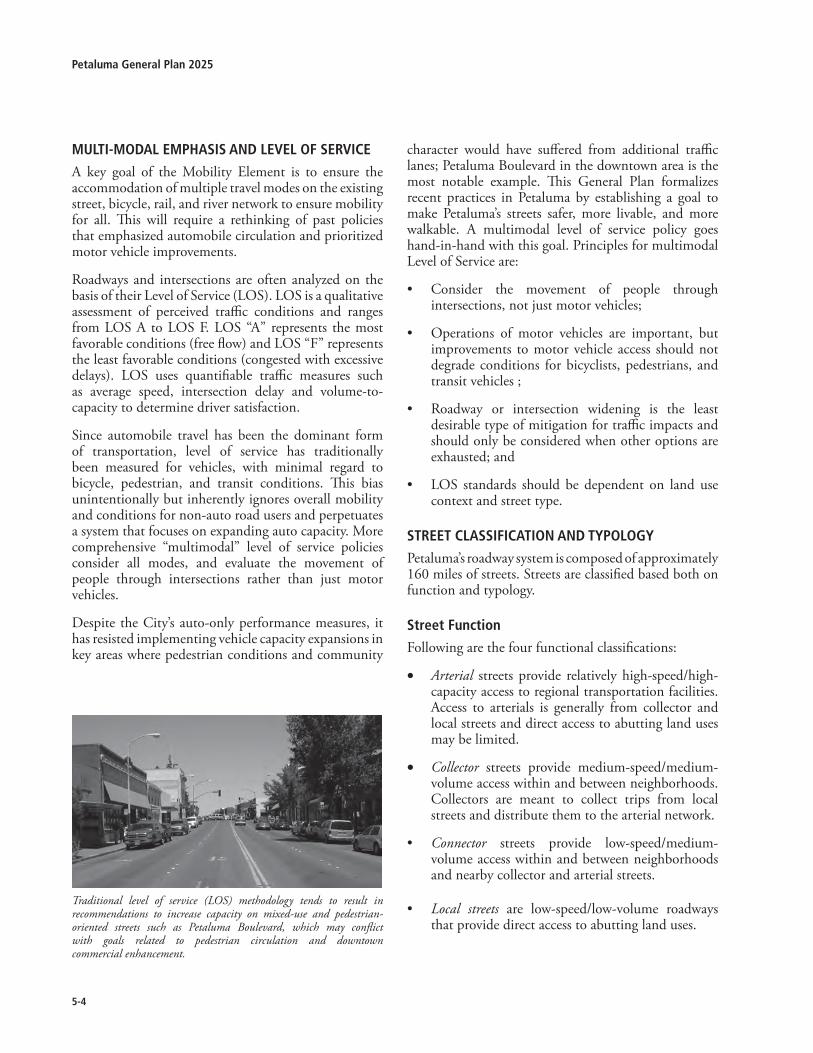
5-�
Petaluma General Plan �0�5
character would have suffered from additional traffic lanes; Petaluma Boulevard in the downtown area is the most notable example. This General Plan formalizes recent practices in Petaluma by establishing a goal to make Petaluma’s streets safer, more livable, and more walkable. A multimodal level of service policy goes hand-in-hand with this goal. Principles for multimodal Level of Service are:
• Consider the movement of people through intersections, not just motor vehicles;
• Operations of motor vehicles are important, but improvements to motor vehicle access should not degrade conditions for bicyclists, pedestrians, and transit vehicles ;
• Roadway or intersection widening is the least desirable type of mitigation for traffic impacts and should only be considered when other options are exhausted; and
• LOS standards should be dependent on land use context and street type.
sTreeT ClassifiCaTion and TyPoloGy
Petaluma’s roadway system is composed of approximately 160 miles of streets. Streets are classified based both on function and typology.
street function
Following are the four functional classifications:
• Arterial streets provide relatively high-speed/high-capacity access to regional transportation facilities. Access to arterials is generally from collector and local streets and direct access to abutting land uses may be limited.
• Collector streets provide medium-speed/medium-volume access within and between neighborhoods. Collectors are meant to collect trips from local streets and distribute them to the arterial network.
• Connector streets provide low-speed/medium-volume access within and between neighborhoods and nearby collector and arterial streets.
• Local streets are low-speed/low-volume roadways that provide direct access to abutting land uses.
Traditional level of service (LOS) methodology tends to result in recommendations to increase capacity on mixed-use and pedestrian-oriented streets such as Petaluma Boulevard, which may conflict with goals related to pedestrian circulation and downtown commercial enhancement.
MulTi-Modal eMPhasis and level of serviCe
A key goal of the Mobility Element is to ensure the accommodation of multiple travel modes on the existing street, bicycle, rail, and river network to ensure mobility for all. This will require a rethinking of past policies that emphasized automobile circulation and prioritized motor vehicle improvements.
Roadways and intersections are often analyzed on the basis of their Level of Service (LOS). LOS is a qualitative assessment of perceived traffic conditions and ranges from LOS A to LOS F. LOS “A” represents the most favorable conditions (free flow) and LOS “F” represents the least favorable conditions (congested with excessive delays). LOS uses quantifiable traffic measures such as average speed, intersection delay and volume-to-capacity to determine driver satisfaction.
Since automobile travel has been the dominant form of transportation, level of service has traditionally been measured for vehicles, with minimal regard to bicycle, pedestrian, and transit conditions. This bias unintentionally but inherently ignores overall mobility and conditions for non-auto road users and perpetuates a system that focuses on expanding auto capacity. More comprehensive “multimodal” level of service policies consider all modes, and evaluate the movement of people through intersections rather than just motor vehicles.
Despite the City’s auto-only performance measures, it has resisted implementing vehicle capacity expansions in key areas where pedestrian conditions and community
5-5
5Mobility
This traditional approach to classifying streets, known as “functional street classification,” establishes one set of standards for the design and operation of roadways within an entire jurisdiction, failing to distinguish between the varying access needs found within a typical city. For instance, Central Petaluma has a much greater reliance on pedestrian mobility and on-street parking than an industrial or strip commercial district, which typically relies on automobile mobility and off-street parking.
street Typology
The transportation objectives of this General Plan additionally include a street classification system based on street “typologies.” Street typologies are an expansion of functional classifications that consider street context and alternate travel modes. This definition ensures that street standards are not uniformly applied but consider a street’s relation to surrounding land uses, appropriate travel speeds, and need to accommodate multiple travel modes.
Most street types can be found in more than one functional class, and vice versa. Street design must consider the characteristics of both street function and street type when enhancements are made to the multi-modal street system. For example, a street that has an arterial function and a residential type will have different characteristics and design features than a residential street with a collector or local access function. Residential arterial streets serve longer distance trips than residential collector or local streets. As such, maintaining the through capacity should be a higher priority on a residential arterial than on a residential collector or local street. Similarly, a mixed-use collector street and an industrial collector street have different characteristics. A mixed-use collector emphasizes accommodating several transportation modes while an industrial collector emphasizes accommodating heavy trucks and automobiles.
Residential Streets: Residential Streets serve two major purposes. As arterials, Residential Streets balance multi-modal mobility with land access. As collector or local streets, Residential Streets are designed to emphasize walking, bicycling, and land access over mobility. In both cases, Residential Streets tend to be more pedestrian-oriented than Commercial Streets.
•
Main Streets: Main Streets serve retail and mixed land uses including downtown areas and neighborhood centers. Unlike Commercial Streets, Main Streets are designed to promote walking, bicycling, and transit with attractive streetscape and pedestrian-oriented design elements. Generally, Main Street activities are concentrated along a two- to eight-block area, but may extend further depending on the type of adjacent land uses and the area served. Narrower street widths (34’ to 36’) are intended to reduce travel speeds on main street segments. An arterial main street segment (such as Petaluma Boulevard) will likely include travel lanes and turn pockets.
Mixed-Use Streets: Mixed-Use Streets are located in high intensity mixed-use commercial, retail, and residential areas with substantial pedestrian activity. Alternative modes of travel are emphasized on Mixed-Use Streets with increased use of pedestrian, bicycle and transit design elements. Mixed-Use Streets typically consist of two to four travel lanes with a center-turn lane provided in some cases.
Commercial Streets: The most prevalent Commercial Streets are the strip commercial arterials. Strip commercial arterials typically serve commercial areas containing numerous small retail strip centers with buildings set back behind fronting parking lots. Because of this, strip commercial arterials have numerous intersections and driveways to access adjacent businesses. Historically, this type of street is often highly auto-oriented and tends to discourage walking and bicycling. Mid-block crosswalks are rare, and on-street parking is infrequent because of ample off-street parking lots serving adjacent businesses.
Industrial Streets: Industrial Streets are designed to accommodate significant volumes of large vehicles such as trucks, trailers, and other delivery vehicles. Because these areas have a relatively low-intensity, bicycle and pedestrian travel is more infrequent than in other types of neighborhoods, but still should be accommodated. In some cases, the sidewalk and landscape width will vary where meandering sidewalks are provided.
• Boulevards: Boulevards are arterials that serve a gateway or civic purpose and should be considered for special treatments that may include expansive landscaped medians and wide sidewalks. Traffic flow
•
•
•
•

5-�
Petaluma General Plan �0�5
Table 5.�-1: Typical attributes of different street Types
Functional Class Street Type
Bicycle Facilities*
Transit Facilities
Sidewalk Width
Planter Strip
Desired Speed
Traffic Calming
On-Street
Parking
Preferred Lane
Width
# of Travel Lanes
Arterial Residential Yes Accom 5’-10’ Yes <35 Some*** Possibly 10’-11’ 4
Main Street Yes Priority 12’-13’** No** <25 Some*** Yes 10’ 2-4
Mixed Use Yes Priority 5’-10’ Yes <35 No Yes 10’ - 11’ 2-4
Commercial Yes Priority 5’-10’ Yes 30-35 No No 10’ - 11’ 4
Boulevard Yes Priority 5’-10’ Optional 30-35 No Yes 10’ - 11’ 4
Collector Residential Yes Accom 5’-10’ Yes <35 Yes Possibly 10’ – 11’ 2
Main Street Yes Accom 12’-13’** No** <25 Possibly Yes 10’ 2
Mixed Use Yes Accom 5’-10’ Yes <30 Possibly Yes 10’ - 11’ 2
Industrial Yes Infreq 5’-6’ Yes <30 No Possibly 12’ 2
Boulevard Yes Accom 5’-10’ Optional 30-35 No Yes 10’ – 11’ 2
Connector Residential Yes Infreq 5’-8’ Yes <25 Possibly Yes 10’ 2
Main Street Yes Infreq 5’-8’ No** <25 Possibly Yes 10’ 2
Mixed Use Yes Infreq 5’-8’ Yes <25 Possibly Yes 10’ 2
Local - Possibly Infreq 5’-6’ Yes <25 Yes Yes 10’ 2
Notes: * Type of bicycle facility will vary based on site context, e.g. use of Class I, Class II, or Class III bikeways.** Main Street sidewalk width of 12’ to 13’ includes 4’ tree planters placed intermittently.*** Traffic calming measures on arterial streets may be limited to pedestrian enhancements, such as bulb-outs, and beautification measures, such as landscaped medians.
Transit Facilities: “Priority” = Regular bus service with short headways between buses and amenities at bus stops “Accommodate” = Regular bus service with longer headways and limited amenities at bus stops“Infrequent” = Demand responsive service, such as paratransit, on a limited basis
should be maintained and transit access prioritized. An optional design element could include medians that separate travel lanes from parking access lanes, to reduce delays caused by on-street parking and provide an additional buffer for adjacent land uses. Examples of streets in the Bay Area with boulevard treatments include Shattuck Avenue in Berkeley and Octavia Boulevard in San Francisco. Such a treatment could be considered for segments of Petaluma Boulevard North.
• Private Streets: Private streets provide a solution to unique situations where public streets standards require excessive grading or to meet site-specific issues. Private streets shall retain public access easements and shall not prohibit access by way of gates or barriers.
Typical attributes of Petaluma streets are shown in Table 5.2-1.

5-�
5Mobility
(fig 5-1 street Classifications)

5-�
Petaluma General Plan �0�5

5-�
5Mobility
goal5-g-1:mobilityframeworkTo improve Petaluma’s mobility system to increase efficiency for all modes of travel.
Policies and Programs:
5-P-1 Developaninterconnectedmobilitysystemthatallows travel on multiple routes by multiplemodes.
Develop a network that categorizes streets according to function and type, considering the surrounding land use context.
Develop a network for off-street paths and routes according to function and type, considering the intensity of use and purpose.
Review and update the City’s Street Design Standards to be consistent with street function and typology.
Explore the redesign of existing streets to potentially reduce the width and/or number of travel lanes, improve the multimodal function of intersections and street segments, and introduce amenities such as wider sidewalks, special paving treatments, bus priority treatments, landscaped medians, and street trees within parking lanes.
Evaluate the feasibility of road diets on streets with projected excess capacity at buildout (see Section 5.3).
A.
B.
C.
D.
E.
5-P-2 Ensure the identified mobility system isprovided in a timely manner to meet theneedsofthecommunitybyupdatingtheCity’stransportation impact fee program to insurethat necessary citywide improvements arefunded.
Transportation impact fees will be determined based on each project’s fair share of the aggregate costs of roadway improvements identified within the Mobility Element and EIR.
The fee program is intended to ensure that new developments pay its proportionate share of traffic infrastructure improvements to mitigate direct traffic impacts from new development.
Some portion(s) of the identified mobility system improvements will be constructed as part of project related frontage improvements.
Allocation of mitigation funds shall be designated to the capital improvement project for which it was exacted.
Transportation impact fees will be routinely updated to reflect project timing and costs.
5-P-3 Ensure public improvements are constructedandmaintainedinamannerthatiseconomicallyfeasible to the budgetary constraints of theCity.
Establish priorities for transportation improvements and prepare an action program to implement identified street improvements.
Investigate innovative means to fund the design, construction and maintenance of both neighborhood and community-wide mobility infrastructure.
5-P-4 New development and/or major expansionor changeofusemay require constructionofoff-site mobility improvements to completeappropriatelinksinthenetworknecessaryforconnecting the proposed development withexistingneighborhoodsandlanduses.
5-P-5 Considerimpactsonoverallmobilityandtravelby multiple travel modes when evaluatingtransportationimpacts.
5-P-6 Ensure new streets are connected into theexisting street system and encourage a grid-basednetworkofstreets.
5-P-7 Whereaesthetic,safety,andemergencyaccesscan be addressed, allow narrower streets in
A.
B.
C.
D.
E.
A.
B.
Unfinished street cross-sections, such as this segment of Shasta Avenue shown above, create opportunities to implement new street types at such time as these streets are fully improved with curb, gutter, landscape strips and sidewalks.

5-10
Petaluma General Plan �0�5
residentialdevelopmenttocreateapedestrianscaledstreetenvironment.
5-P-8 The priority of mobility is the movement ofpeople within the community including thepreservationofqualityoflifeandcommunitycharacter.
Develop formal transportation impact analysis guidelines that consider multi-modal impacts of new developments.
Develop and adopt multi-modal level of service (LOS) standards that examine all modes and vary the standards by facility type to imply a preference to selected modes based upon the context (including street type and location).
LOS analysis data shall utilize the peak hour (60 minutes) rather than the peak period (15 minutes) for determining intersection LOS.
5.3 motorVehiclecirculation
In the last 20 years, Petaluma’s population has increased by nearly 50 percent. A general trend nationwide has been that increases in trips and trip length proceed at a higher rate than growth in population. This is due in part to changing lifestyles (the prevalence of two-income families and a greater percentage of non-work trips on a day-to-day basis) and increased reliance on the private automobile. Petaluma’s roadways currently experience congestion during peak travel periods. Even with substantial increases in alternative mode shares in the years ahead, automobile travel in Petaluma will remain the form of transportation used for most trips.
Planned iMProveMenTs
Several new roadways and “cross-town connectors” are incorporated in the General Plan to help reduce traffic congestion at freeway interchanges and crossings of the Petaluma River. Roadway improvements include:
Washington Street Interchange Improvements. The Washington Street Interchange has long been one of the city’s most congested areas. Improvements are planned to upgrade and realign existing freeway ramps and provide an additional ramp to Northbound Highway 101.
Rainier Avenue Extension and Interchange. Rainier Avenue will be extended to connect with a new freeway interchange on Highway 101 between
A.
B.
C.
•
•
Washington Street and Corona Road and provide another cross-town travel route and access to Highway 101.
Petaluma Boulevard North Grid. A grid of streets will be developed near Petaluma Boulevard North adjacent to the Rainier Avenue extension and a planned southward extension of Industrial Avenue.
Caulfield Lane Extension. A “Southern Crossing” of the Petaluma River is incorporated to reduce traffic congestion along the D Street and Washington Street corridors. A connecting grid of streets will be developed near Caulfield Lane between the River and Lakeville Street.
Old Redwood Highway Interchange Widening. The Old Redwood Highway interchange between Petaluma Boulevard North and North McDowell Boulevard would widen Old Redwood Highway to four lanes with bicycle lanes.
Copeland Street Extension. Copeland Street would be extended across the Petaluma River to connect with Petaluma Boulevard North in the vicinity of Oak Street. A minor grid street system between the Boulevard, Lakeville, E. Washington and the River would also improve localized traffic movements.
Caulfield Lane/Payran Street Intersection Improvements. Install a westbound right-turn lane on Caulfield Lane.
Petaluma Boulevard/Magnolia Avenue–Payran Street Intersection. Add right-turn lanes on Petaluma Boulevard in both the northbound and southbound directions. In order to reduce impacts on pedestrians resulting from increased crossing distances, install a median refuge (at least five feet wide) for pedestrians crossing Petaluma Boulevard.
reConfiGurinG exisTinG roadWays
While some of Petaluma’s streets will substantially benefit from roadway improvements and increased capacity, many streets have excess capacity and can benefit from road “diets” or treatments to reduce speeds and make streets more livable. A “road diet” is typically the conversion of a four-lane undivided road into three lanes (one in each direction with a center turn lane) to become leaner, safer, and more efficient. A road diet can also modify driving behavior by reducing lane width, providing bulb-outs, medians and/or surface material
•
•
•
•
•
•

5-11
5Mobility
changes which in turn reduce traffic speeds. At the same time these modifications also allow the provision of enhanced and safer facilities for pedestrians, bicyclists and transit users. Generally, streets carrying less than 15,000 vehicles per day need two lanes (one in each direction). In some cases streets with as much as 20,000 vehicles per day function well with only two lanes (one in each direction) if a median or center turn lane is provided. Several Petaluma streets with four lanes (two in each direction) are expected to continue to have excess capacity in the future. Road diets may also be applicable where policy-makers determine that there are social, aesthetic, multi-modal and/or safety benefits. Examples of streets with road diet potential include, but are not limited to the following:
Casa Grande Road Ely Boulevard Caulfield LaneMcDowell BoulevardBaywood DrivePetaluma Boulevard (North and South)
TraffiC safeTy
As traffic volumes have increased in Petaluma, so have traffic safety concerns. Traffic safety can be improved by parallel strategies known as the “Three E’s”: engineering, education, and enforcement. Engineering strategies typically consist of physical measures constructed to lower speeds, improve safety, or otherwise reduce the impacts of automobiles. Education strategies include information-sharing, awareness raising, and targeting drivers, pedestrians, and cyclists about the safest, best ways to share the road. Enforcement strategies include targeted speed enforcement and other violations such as failing to yield to pedestrians and running stop signs.
Collision data for the City of Petaluma was evaluated over a five-year period from 1996 to 2000. A total of 4,150 collisions were reported for the period, an average of 830 per year. According to the data provided, 37 percent of the collisions occurred at intersections. The collisions analysis included findings that 71 percent of motor vehicle collisions were with other motor vehicles; five percent of collisions involved a motor vehicle colliding with a cyclist; and three percent of collisions involved a motor vehicle colliding with a pedestrian. The most common types of collisions were rear-end collisions (30 percent), broadsides (27 percent) and sideswipes (19 percent). A majority of collisions, 82
•
•
•
•
•
•
percent, involved a vehicle code violation. Motorists traveling at unsafe speeds, the single largest violation category, caused 22 percent of all collisions. There were 12 fatal collisions during the five-year study period.
Petaluma should continue to take steps to improve traffic safety for all modes of travel. Strategies recommended in this plan include the development of an annual traffic safety review and coordinated efforts by City staff and the Police Department to improve safety on Petaluma’s streets.
TruCk Travel
Trucks and other heavy vehicles frequently travel through Petaluma. The City should continue the use of designated official truck routes through town to ensure truck traffic minimizes its encroachment on residential neighborhoods and avoids mixed use and central main streets where possible. This is especially important to balance goals related to enhancing the continued operation of agricultural businesses near Petaluma and the need for agricultural trucks to travel from the west county area into the city.
goal5-g-2:motorVehiclecirculationPromote the safe movement of people and goods through Petaluma’s streets.
Policies and Programs:
5-P-9 Ensuresafetyimprovementsareundertakeninresponsetothechangingtravelenvironment.
Establish a program to annually collect and evaluate traffic collision data at the top collision locations for automobiles, bicycles, and pedestrians in Petaluma, and design countermeasures where needed.
Explore the development of a citywide Intelligent Transportation Systems (ITS) plan to maximize the efficiency of the transportation system through advanced technologies, such as adaptive signal controls, real-time transit information, and real-time parking availability.
Designate official truck routes to ensure truck traffic minimizes its impact on residential neighborhoods and avoids mixed use and main streets, where possible, and enforce truck parking restrictions.
5-P-10 Maintainanintersectionlevelofservice(LOS)standard for motor vehicle circulation that
A.
B.
C.

5-1�
Petaluma General Plan �0�5
ensures efficient traffic flow and supportsmulti-modal mobility goals. LOS should bemaintained at Level D or better for motorvehiclesdue to traffic fromanydevelopmentproject.
A lower Level of Service may be deemed acceptable, by the City, in instances where the City finds that potential vehicular traffic mitigations (such as adding additional lanes or modifying signal timing) would conflict with the Guiding Principles of the General Plan, particularly with regard to:
• Guiding Principle #2. Preserve and enhance Petaluma’s historic character.
• Guiding Principle #6. Provide a range of attractive and viable transportation alternatives, such as bicycle, pedestrian, rail and transit.
• Guiding Principle #7. Enhance Downtown by preserving its historic character, increasing accessibility, and ensuring a broad range of business and activities and increasing residential activities.
The above does not relieve any need to miti-gate development related impacts, which may include multi-modal improvements to reduce identified impacts.
5-P-11 Require proposed development to assist, inaddition to seeking other funding sources, inthefundingandconstructionofthefollowingimprovements:
• Washington Street/Highway 101 interchange improvements
• Rainier Avenue extension and interchange
• Caulfield Lane extension to Petaluma Boulevard South (southern crossing)
• Old Redwood Highway interchange widening
• Copeland Street extension to Petaluma Boulevard North
• Caulfield Lane/Payran Street Intersection Improvements
• Petaluma Boulevard North/Magnolia Avenue/West Payran Street Intersection.
goal5-g-3:motorVehiclecirculationrecognize Petaluma’s role in the regional mobility system.
A.
Policies and Programs:
5-P-12 Cooperate with local jurisdictions, County,StateandFederalagenciestowardidentifyingand implementing regional improvements tothenetwork.
Work with CalTrans and the Sonoma County Transportation Authority (SCTA) to achieve timely implementation of programmed freeway and interchange improvements.
Designate SCTA as the agency with the overall responsibility for regional circulation and transit coordination between the City and County.
Work with the County and SCTA to develop regional/subregional fees and/or allocate a fair share contribution to accommodate transportation demand created by new development.
5.4 transportationdemandmanagementandparking
TransPorTaTion deMand ManaGeMenT
The intent of Transportation Demand Management (TDM) programs is to reduce the amount of peak-period motor vehicle traffic on city roadways and highways as well as parking. TDM strategies encourage the use of modes other than single-occupant vehicles for travel. The City’s focus is on providing adequate and well connected roadways and transit systems to reduce peak traffic volumes. The possible benefits of a TDM program must be balanced against possible equity owners and tenants. A TDM program could include incentives to reduce Petaluma’s dependence on the automobile.
The establishment of a TDM program or ordinance could help reduce peak period traffic within Petaluma. Funding for a citywide TDM program could be provided through annual assessments on new development. Implementation of TDM strategies can have a substantial impact in reducing automobile traffic. Potential TDM strategies include:
1. Transit subsidies/reimbursement (“commuter check” or “EcoPass”) to residents and employees;
2. Car-Share programs and neighborhood electric vehicle programs, to reduce the need to have a car or second car;
A.
B.
C.

5-1�
5Mobility
3. Citywide TDM Coordinator could manage and promote TDM programs and oversee monitoring to determine program effectiveness, or a separate Transportation Management Association (TMA) could be established to oversee TDM programs and monitoring;
4. Integrated bicycle parking and support facilities, primarily to reduce trips within the City of Petaluma;
5. Modified parking codes to reduce the supply of parking in order to discourage driving and take advantage of shared-parking opportunities generated by mixed use development;
6. Guaranteed ride home program for employees in the event of an emergency;
7. Incentives, such as a “parking cashout” program in which employees receive cash in lieu of receiving free parking, to encourage carpool and vanpool use (this incentive may be provided in cases where no paid parking facilities exist, as a means of reducing the indirect subsidy that exists where employers provide free parking to employees);
8. Marketing and information programs to encourage alternative transportation modes; and
9. Strategies to make the cost of residential and commercial parking visible to households and commercial tenants, such as separating the cost of parking in lease agreements with tenants (e.g., implementing paid parking facilities in cases where parking is currently free but the actual cost of providing and maintaining parking facilities is hidden in monthly rents and/or the cost of goods).
MoTor vehiCle ParkinG
Parking policies have the potential to impact the mode choices of residents, employees and retail customers. The City’s development review process implements parking requirements that are intended to ensure that adequate numbers of parking spaces are provided for most land uses. However, in some cases, it may be desirable to investigate strategies that would allow for a reduction in the amount of parking provided, such as through shared parking for uses that have different peaking patterns for parking usage.
Central Petaluma experiences high parking demand
on weekdays during business hours and on weekends. Recent parking studies have been performed for Central Petaluma and have recommended increased parking enforcement and strategies to discourage employees from occupying public, short-term parking spaces in the core area. The provision of dedicated long-term employee parking in the Keller Street Garage was also recommended. A second parking garage is located at 1st and C Streets. More detailed recommendations pertaining to parking needs and potential garage locations are provided in the Central Petaluma Specific Plan.
goal5-g-4:transportationdemandmanagementandparkinguse transportation demand management (TdM) tools on a citywide basis to encourage and create incentives for the use of alternate travel modes.
Policies and Programs:
5-P-13 Encourageexistingmajoremployerstodevelopand implement Transportation DemandManagementprogramstoreducepeakperiodtripgeneration.
Study the feasibility of a citywide TDM program that could be funded by annual fees or assessments on new development.
If developed, assign a proportion of TDM fees to Petaluma Transit for expansion of service and future fare reductions or fare elimination.
Assign trip reduction credits and reduced transportation impact fees for demonstrated commitment to TDM strategies.
Reduce parking requirements for mixed-use developments and for developments providing shared parking or a TDM program.
Consider establishing a TDM program for City of Petaluma employees.
Continue to collaborate with Santa Rosa Junior College to minimize the impact of future enrollment growth on local traffic and parking demand, such as though TDM measures, limitations on parking near the College, and on-campus parking management.
Encourage provision of preferential parking in selected areas for designated carpools, motorcycles, bikes and alternative fuel vehicles.
A.
B.
C.
D.
E.
F.
G.

5-1�
Petaluma General Plan �0�5
Class III bicycle routes. Class III bikeways are designated by signs only. Cyclists share the travel lane with motor vehicle traffic on these routes. Some Class III routes have a wide outer curb lane while others carry low volumes of motor vehicle traffic, making a separate bicycle lane or wide curb lane unnecessary and often connect discontinuous segments of a Class I or Class II bikeway;
Recreational Trail. Recreational Trails are off street bicycle and pedestrian facilities which due to locational constraints such as topography or limited right of way a Class I bikeway is not feasible or desired.
Bicycle Boulevards. Bicycle Boulevards are essentially modified Class III routes in which a street, usually determined to be key to bicycle through-traffic, has been given precedence over cars by means of barriers, traffic calming, stop signs aimed at car travel and other measures. Although there are no bicycle boulevards currently planned in Petaluma, this treatment option could be considered for future implementation if desired on a specific street or corridor.
biCyCle ParkinG and suPPorT faCiliTies
Every bicycle trip has two components: the route selected by the bicyclist and the “end-of-trip” facilities at the destinations. Support facilities are facilities that cyclists use when they reach their destinations. They can include short and long-term bicycle parking, showers, lockers, good lighting, and even public phones. The lack of secure bicycle parking, showers, and locker facilities can be one of the largest deterrents to cycling for many riders.
Types of bicycle Parking and support facilities
There are different types of support facilities just as there are different levels of bikeway facilities. Support facilities fall into one of three main categories:
• Short-term Bicycle Parking: Bicycle racks are low-cost devices that provide a location to secure a bicycle. Ideally, bicyclists can lock both their bicycle frame and wheels. The bicycle rack should be in a highly visible location secured to the ground, preferably within 50 feet of a main entrance to a building or facility. Short-term bicycle parking is commonly used for short trips, when cyclists are planning to leave their bicycles for a few hours.
•
•
•
5-P-14 Totheextentdeemedfeasibleandappropriateby the City, maximize shared parkingopportunities and support the constructionof additional structured parking in CentralPetaluma.
5.5 Bicycleandpedestriancirculation
The size, topography, and climate of Petaluma make it an ideal city for bicycling. Bicycles are a convenient means of transportation for short trips within cities, especially those less than three miles in length. According to the U.S. Department of Transportation, one-quarter of all trips in this country are under one mile; about 40 percent of all trips are two miles or shorter. According to the 2000 Census, less than one percent of Petaluma residents commute to work by bicycle. The bikeway network has not been developed as a viable commute alternative in Petaluma. Bicycle lanes and support facilities, such as bicycle parking, are lacking in most areas.
Given that 38 percent of Petaluma’s working population is employed in Petaluma, construction of a comprehensive citywide bikeway network and support facilities, such as bicycle parking at employment locations and other destinations, could greatly increase the mode share of bicycling. Reducing local vehicle trips into Downtown and Central Petaluma by shifting those trips to bicycling or walking would help alleviate circulation and parking concerns. Development of a bicycle and pedestrian path along the NWP railroad tracks is also an opportunity to provide alternative cross-town linkages.
bikeWay ClassifiCaTions
The City’s bikeway classifications are listed below:
Class I bicycle paths. Class I bikeways are completely separated from motor vehicle traffic, as in the case of an off-street path along a river or railroad corridor and may be shared with pedestrians. A sidewalk bicycle path would not be considered a Class I facility unless properly designed and separated from the roadway by an appropriate buffer;
Class II bicycle lanes. Class II bikeways are located on streets and allow bicyclists to utilize a separate lane of travel, usually 5 feet wide, separated from motor vehicle traffic by a 6-inch white stripe, and include bike lane stencils and signs;
•
•

5-15
5Mobility
(fig 5-� bicycle facilities)

5-1�
Petaluma General Plan �0�5

5-1�
5Mobility
• Long-term Bicycle Parking: Bicycle Lockers are covered storage units that can be locked individually, providing secure parking for one bicycle. Bicycle cages are secure areas with limited-access doors. Occasionally, they are attended. Each of these means is designed to provide bicyclists with a high level of security so that they feel comfortable leaving their bicycles for long periods of time. They are appropriate for employees of large buildings and at transit stations.
• Shower and Locker Facilities: Lockers provide a secure place for bicyclists to store their helmets or other riding gear. Showers are important for bicycle commuters with a rigorous commute and/or formal office attire.
• Bicycle Stations: Bicycle Stations provide all-day, attended bicycle parking. Three recent bicycle station projects include one in Long Beach, the Palo Alto CalTrain station, and the Downtown Berkeley BART station. Bicycle stations can provide bicycle tune-ups, repairs, and rentals in order to sustain their operation. They are intended to serve locations with larger numbers of bicycle commuters needing long-term bicycle parking and are an excellent means of facilitating the intermodal connections between bicycles and transit.
biCyCle safeTy
Bicycle injury rates in Petaluma are currently somewhat higher than the statewide average but are comparable to other Bay Area cities with similar populations. From 1998-2003, there was an annual average of 29 injury collisions reported involving bicyclists. From 1996-2000, nearly 60 percent of the 193 total bicycle collisions occurred on arterial streets, with the majority of those occurring on Washington Street, Petaluma Boulevard, McDowell Boulevard and Lakeville Highway).
PedesTrian CirCulaTion
See also Chapter 2: Community Design, for policies related to pedestrian connectivity and priority areas, and Chapter 6: Recreation, Music, Parks, and the Arts for policies on recreational trails and parks.
Everyone becomes a pedestrian at some point in his or her journey, and the walking environment is one of the most basic public spaces where people interact in the urban landscape. Walking should be a fundamental component of land use planning, design standards and
design guidelines.
The City’s pedestrian network consists of sidewalks, trails, street crossings, and in some locations pedestrians share the street with motor vehicles and bicyclists. Petaluma has many areas that seem especially conducive to walking for recreation and transportation, particularly within the Downtown area, along the Petaluma River and its tributary creeks, within its neighborhoods and along the urban separator at the City’s eastern edge. The City has in the past established policies to encourage improvement of the pedestrian network in those areas, though pedestrian connections between Downtown, the River, and adjacent neighborhoods are not well-developed in many cases. Favorite walking areas identified by workshop participants include Downtown Petaluma, city parks and the riverfront.
Central Petaluma and the West Side are fairly well served by an extensive sidewalk network and pleasant walking conditions. Pedestrian connectivity along creeks and at the city’s eastern edge was created through development review processes beginning in the mid-1980s but many opportunities to improve access remain.
PedesTrian iMProveMenT PrioriTies
Barriers to pedestrian movement limit the viability of walking as a form of transportation in some parts of the city. Specific pedestrian issues raised during the “pedestrian hot spot” discussion undertaken as part of the new General Plan preparation include the lack of pedestrian crossings at intersections, the lack of
Many bicycle collisions result from riding the wrong way on a street.

5-1�
Petaluma General Plan �0�5
sidewalks along Petaluma Boulevard North, difficult crossings on Washington Street and speeding cars on Windsor Drive. While public input was received during the General Plan update process and several streets or districts (Washington Street, Petaluma Boulevard, Ely Road, Caulfield Lane, Casa Grande Road, Lakeville highway, Highway 101 interchanges and cross-town connectors and Central Petaluma) have been identified to receive special attention, care should be given citywide to reducing or eliminating pedestrian barriers:
In addition, physical improvements, such as the roundabouts along Windsor Drive, have been installed to reduce vehicle speed.
This plan seeks to promote walking and bicycling within Petaluma by improving facility conditions, increasing safety, and creating a land use context supportive of alternative travel. The goals and policies described below articulate these needs.
The goal, policies, and programs related to bicycles and pedestrians are the same as those contained in the updated Bicycle and Pedestrian Plan which is adopted as an appendix to the General Plan.
goal5-g-5:BicycleandpedestrianimprovementsCreate and maintain a safe, comprehensive, and integrated bicycle and pedestrian system throughout Petaluma that encourages bicycling and walking and is accessible to all.
Policies and Programs:
The goal, polices, and programs related to bicycles and pedestrians are the same as those contained in the updated Bicycle and Pedestrian Plan which will be adopted as an appendix to the General Plan.
Bicycleimprovements5-P-15 Implementthebikewaysystemasoutlinedin
the Bicycle and Pedestrian Plan, and expandandimprovethebikewaysystemwherevertheopportunityarises.
Fund and implement the Bicycle Plan and complete gaps in the bikeway network through new development, redevelopment and the Capital Improvements Program.
Develop and update guidelines and standards for the design of bicycle facilities.
A.
B.
Design and maintain bikeways at or above local, state, and federal standards in order to maximize safety for bicyclists (e.g. width).
Develop and implement a uniform bicycle signage program to enhance safety and ease of travel for all who use the city transportation network.
Identify loop detectors along bikeways with stencils where (a) the outline of the loop is not identifiable on the surface of the roadway, or (b) where it is unclear which of the identifiable loops will activate the signal.
Preserve the Highway 101 pedestrian/bicycle over-crossing south of East Washington Street interchange.
Continue to outfit local transit busses with bike racks; and encourage regional transit providers to provide bike racks as well.
5-P-16 IfClassIIbikelanesarenotpossibleonstreetsdesignated as such on the Bicycle FacilitiesMap, those streets shall become enhancedClassIIIbikeroutesusingsuchmarkingsasedgestriping,sharedlanemarkings,andsigns.
5-P-17 The City shall discourage using sidewalks asdesignatedbicycleroutes.
5-P-18 TheCityshallrequireClassIIbikelanesonallnewarterialandcollectorstreets.
5-P-19 Allnewandredesignedstreetsshallbebicycleandpedestrianfriendlyindesign.
C.
D.
E.
F.
G.
High-visibility pedestrian crossings and other pedestrian amenities can provide important links in the city’s pedestrian network.

5-1�
5Mobility
5-P-20 Ensure that new development providesconnections to and does not interfere withexistingandproposedbicyclefacilities.
5-P-21 Strivetocreateafivepercentbicyclecommuteshareby2025.
pedestrianimprovements5-P-22 Preserveandenhancepedestrianconnectivity
in existing neighborhoods and require a wellconnectedpedestriannetworklinkingnewandexistingdevelopmentstoadjacentlanduses.
Improve the pedestrian experience through streetscape enhancements, focusing improvements where there is the greatest need, and by orienting development toward the street.
Improve street crossings and complete gaps in the sidewalk system through development review and capital improvement projects.
Allocate funds and/or identify funding sources (including the potential formation of assessment districts) for pedestrian and streetscape improvements in existing neighborhoods.
Create a pedestrian priority program emphasizing pedestrian circulation needs and safe street crossings.
Conduct an inventory of key pedestrian facilities and routes to identify missing or deficient links, pedestrian crossings or intersections, and focusing initially on pedestrian priority areas.
Establish a prioritization and funding mechanism for completing gaps in the sidewalk system, identifying locations for improving street crossings, and installing curb ramps to meet ADA specifications.
Improve the integration of pedestrian projects into the Capital Improvement Program and consider opportunities to construct pedestrian improvements concurrently with other roadway improvements.
Develop guidelines and standards for the design of pedestrian facilities and establish pedestrian-friendly residential and commercial design guidelines.
Review and update the City’s street design standards to address pedestrian-friendly street designs such as maximum lane widths, maximum curb radii, detached sidewalks, dual left turn lanes at intersections, pedestrian
A.
B.
C.
D.
E.
F.
G.
H.
I.
refuge islands, and curb ramp standards.
Collaborate with the Santa Rosa Junior College to identify measures that enhance pedestrian circulation to and within the Petaluma Campus.
Establish a Pedestrian Safety Program that provides pedestrian educational materials and a regularly updated pedestrian safety report.
Conduct regular maintenance of pedestrian related facilities.
5-P-23 Requiretheprovisionofpedestriansiteaccessforallnewdevelopment.
5-P-24 Give priority to the pedestrian network andstreetscape amenities near schools, transit,shopping,andmixedusecorridorsemphasizedintheGeneralPlan.
multi-usetrails5-P-25 Establish a network of multi-use trails to
facilitate safe and direct off-street bicycleandpedestrian travel.At theminimum,ClassI standards shall be applied unless otherwisespecified.
Review the status of ownership and use of railroad rights-of-way, creek maintenance rights-of-way, dedicated public or utility easements in favor of the city, and other public lands and seek to include new bicycle and pedestrian routes by working with all appropriate agencies.
Fully implement the non-motorized components of the Petaluma River Access and Enhancement Plan.
Support the implementation of a continuous SMART bicycle/pedestrian path along the NWPRR corridor and integrate it with the citywide bicycle network.
Study, seek funding for, construct and maintain a “Petaluma Ring Trail,” a connected system of multi-use trails in the Urban Separator, or otherwise approximately parallel with (if not immediately adjacent to) the Urban Growth Boundary. The Petaluma Ring Trail shall form a continuous, unbroken path around the city.
Build new river (upstream of navigable waters) and creek crossings for bicycles and pedestrians to provide greater connectivity and more efficient cross-town routes.
J.
K.
L.
A.
B.
C.
D.
E.

5-�0
Petaluma General Plan �0�5
5-P-26 Require all new development and thoserequiringnewcityentitlementswith“frontage”along creeks and the river to permit throughtravel adjacent to creeks and the river withaccesspointsfromparallelcorridorsspacedatminimumintervalsof500–1,000feet.
5-P-27 Locate connections to Class I facilities fromparallelroutesalongtheparcellineofadjoiningpropertiestoprovideseparationfromparkinglotsandbuildings;designconnectionsasClassIfacilities.
5-P-28 Allow bicyclists and pedestrians use of allemergency access routes required of existingandnewdevelopments.
Design new emergency access routes to accommodate bicycle and pedestrian use.
5-P-29 WorkwiththeBayAreaRidgeTrailCounciltoimplementarevisedroute(forbicyclists,hikers,andequestrians) through theCity locatedoffsurfacestreetsandalonggreenwayswhereverpossible with connections to regionaldestinations(e.g.PetalumaAdobeStatePark,JackLondonStateHistoricPark,HelenPutnamRegionalPark,andMt.Burdell).
5-P-30 Require all new development abutting anypublictrailtoprovideaccesstothetrail.
supportfacilities5-P-31 Makebicyclingandwalkingmoredesirableby
providingorrequiringdevelopmenttoprovidenecessary support facilities throughout thecity.
Provide secure, protected parking facilities and support services for bicycles at locations with high bicycle-parking demands such as multi-family housing and shopping and employment centers.
Install drinking fountains serving people and their pets in strategic locations to make it easier and healthier for pedestrians and bicyclists to be outdoors and travel long distances.
Provide easily accessible and aesthetically pleasing public restrooms wherever feasible.
Require projects subject to discretionary approval to install public benches where appropriate.
Install non-glare lighting along multi-use paths that serve as commuter routes.
A.
A.
B.
C.
D.
E.
safety,education,andpromotion5-P-32 Promote bicycle and pedestrian safety and
increaseduseofnon-motorizedtransportationalternatives through engineering, education,andenforcementprograms.
Request an annual bicycle and pedestrian report from the Police Department to the City Council and PBAC. Encourage an annual meeting with the Police and Public Works Departments to analyze annual collision data, identify collision “hot spots,” and develop and implement measures to improve safety.
Encourage the Police Department to positively reinforce the Motor Vehicle Code for pedestrians, bicyclists, and motorists – especially violations that are most likely to cause injury such as running red lights, speeding, wrong-way riding, riding on sidewalks where illegal, and not yielding to pedestrians - through education and enforcement.
Encourage helmet use among all bicyclists, and enforce the law for those under the age of 18.
Implement the use of bicycle- and pedestrian-friendly traffic calming methods.
Make bicycle and pedestrian safety improvements at street crossings a priority.
Publicize existing bikeways and recommended travel routes throughout the community.
Participate in and support recommendations of the Safe Routes to Schools program.
Work with Petaluma schools to encourage more children to walk and bicycle to school.
Promote the benefits of walking and bicycling through Bike to Work Week, Walk and Roll to School Week, and develop new citywide programs.
Conduct annual bicycle and pedestrian counts to monitor the growth of bicycle use and walking.
Encourage and recognize Petaluma employers that (a) install more bicycle- and pedestrian-friendly facilities and (b) implement incentives to facilitate bicycling and walking as transportation.
A.
B.
C.
D.
E.
F.
G.
H.
I.
J.
K.

5-�1
5Mobility
maintenance5-P-33 Fundandperformregularmaintenanceonall
publicbicycleandpedestrianfacilities.
Conduct regular scheduled street sweeping, vegetation management, and re-striping on designated bikeways, especially on bike lanes.
Respond in a timely manner to citizen requests regarding maintenance concerns on all public bicycle and pedestrian facilities.
Give special attention to the construction and maintenance of speed humps, drainage ditches, manhole covers, sewer and drainage grates, railroad crossings, and asphalt/concrete interfaces to eliminate hazards to bicyclists and pedestrians.
Give priority to trail maintenance, including vegetation removal, pavement quality, and litter control.
Repair, or require the property owner to repair, broken sidewalks.
implementation5-P-34 Utilizea creativevarietyofmeasures to fully
implement all projects and programs of thePetalumaBicycleandPedestrianPlan.
Consider assigning a staff member as “Bicycle and Pedestrian Coordinator” whose job may include monitoring bicycling and pedestrian issues both within the entire transportation network and with regard to development and redevelopment.
Research, apply for, and obtain available funding for bicycle and pedestrian improvements.
Continue the institutional structure that gives the Pedestrian and Bicycle Advisory Committee review of development and redevelopment projects that require discretionary approval.
5-P-35 Encourage continuing education and trainingfor City staff to create awareness of bicycleand pedestrian needs and of the importanceofplanningforbicycleandpedestriantravelatthestartofthedevelopmentprocess.
5-P-36 Review,andupdateasnecessary,thePetalumaBicycle and Pedestrian Plan every five years,concurrentwiththeGeneralPlan.
Amend the Municipal Code, development related codes, and design and construction
A.
B.
C.
D.
E.
A.
B.
C.
A.
standards & specifications to implement the goals, policies, and programs of the Bicycle and Pedestrian Plan.
At the time of update, coordinate efforts with the SCTA Countywide Bicycle Plan.
5-P-37 Continuetosolicitandreviewprogressiveideasfrom other communities and organizationsrelatedtobicyclingandwalking.
5-P-38 Coordinate efforts and resources with theCountytoconstructbikewayscalledforintheSCTACountywideBicyclePlan.
5-P-39 Promote public/private partnerships in thedevelopment, implementation, operation,and maintenance of bicycle and pedestrianfacilities.
5-P-40 ProvideloanbicyclesforCitystaff.
5-P-41 Continue to provide facilities for bicycles onCitybuses.
B.
Multi-use trail across Lynch Creek, part of the Petluama Ring Trail.

5-��
Petaluma General Plan �0�5
5.6 puBlictransit
According to the 2000 Census, five percent of Petaluma’s residents commute to work by transit, up from 4.2 percent in 1990. The City of Petaluma is served by three transit agencies, each of which utilize Washington Street as a key transit route.
• Petaluma Transit. Petaluma Transit provides service within the City limits. Buses operate on 60-minute headways during weekdays, while the 3 North and 3 South along with the 2 North and 2 South routes run in opposite directions to each other providing improved headways on the east side. Five routes start and end at the Copeland Street Transit Mall. Plans are underway to revitalize and expand transit service to improve interval spacing and service.
• Sonoma County Transit. Sonoma County Transit provides connections to Santa Rosa, Sonoma, Rohnert Park and other destinations within Sonoma County. Bus intervals are generally over an hour. All buses stop at the Copeland Street Transit Mall.
• Golden Gate Transit. Golden Gate Transit serves commuters traveling to Marin County and San Francisco during peak hours. Golden Gate provides southbound service during the morning peak and northbound service during the evening peak. During peak hours of operation, typical intervals between buses are five to ten minutes. Limited service is provided outside of the peak hours.
• Paratransit. Bus service provides vital door-to-door transportation for various segments of the community. These services could be better funded and promoted.
• Taxis. Through a license process, the City promotes competitive taxi service. This program should be continued to maintain competitive rates for consumers and address growing demand.
• Airport Bus Service. A private company provides transit service to local and regional airports utilizing the park and ride facilities at the Fairgrounds property on East Washington Street. The continuation of this service should be encouraged and facilitated through the retention of a centrally located park and ride facility.
sTraTeGies
While transit does not currently play a major role for travel within Petaluma, it will become increasingly important in the coming years. This General Plan seeks to foster increased transit use and a greater emphasis on transit in planning for future transportation.
In the long term, this will include commute rail service, increased frequency bus service with transit priority, transit-oriented development practices and the development of transit corridors (including potential “bus rapid transit” routes) along Washington Street and Petaluma Boulevard. Future enrollment growth at the Petaluma Campus of Santa Rosa Junior College could also generate a need for additional transit amenities to serve students and faculty. In addition, a local non-profit group is pursuing funding for restoration of a historic trolley line that would connect Downtown and the Factory Outlets and would be intended to facilitate tourism and riverfront activity.
The mode share for transit could be enhanced through increased frequency of service within the city, especially between the neighborhoods and Central Petaluma, and to neighboring cities along the 101 corridor, where many of Petaluma’s residents work. However, as mentioned above, the dispersed land use patterns throughout the North Bay make transit infeasible for many trips. In addition, expanded service hours would necessitate increased transit subsidies, which would likely need to come from local sources. Implementation of a transportation demand management (TDM) program with a funding mechanism dedicated to transit is recommended to achieve the goals outlined in this section.
goal5-g-6:publictransitPromote the expansion of the transit system and the intensification of use by the public.
Policies and Programs:
5-P-42 Expand the bus transit system so that it isconvenient and provides frequent, regularservice along major City corridors servingeducation, shopping, and employmentdestinations,andSMARTpark-and-ridelots.
Identify increased funding sources for local transit service and improvements.
A.

5-��
5Mobility
5-P-43 Support efforts for transit orienteddevelopment around the Petaluma Depotand along the Washington Street, PetalumaBoulevard, McDowell Boulevard, LakevilleStreet,andothertransitcorridors.
Reserve and plan for future bus stop enhancement and transit priority along Washington Street and Petaluma Boulevard.
Enhance the use of the Park and Ride facility at the Fairgrounds through education and marketing.
5-P-44 Maintaina transit systemofnominal cost,ornocost,toriders.
Investigate the creation of subsidies for designations such as education, significant employment, and/or recreation destinations.
Collaborate with Santa Rosa Junior College to promote measures to enhance transit access and service at the Petaluma Campus.
5-P-45 Coordinate transit improvement efforts andschedules among Petaluma Transit, SonomaCounty Transit, Golden Gate Transit, airportshuttle services, paratransit, taxi services,commuter rail, and schools; coordinatelocal transit to include after-school activityschedules.
5-P-46 Considerbenefitstothepossibleconsolidationoftransitservingagencies.
A.
B.
A.
B.
5.7 trafficcalming/neighBorhoodtrafficmanagement
Traffic and noise on neighborhood streets are frequent complaints in many communities, including Petaluma. Concerns include cut-through traffic, volume, and speed. Traffic calming refers to projects that make permanent physical changes to streets as a way to slow traffic and/or reduce traffic volumes. Petaluma has introduced traffic calming measures on several streets but lacks a formal traffic calming program. A formalized program, usually called a Neighborhood Traffic Management Program (NTMP), would provide a consistent citywide approach to addressing neighborhood traffic and transportation issues related to safety, traffic speed, and traffic volume on city streets.
A street is a highly complex environment with multiple competing needs. Land access and livability must be balanced with mobility, and accommodations for motor vehicles must be balanced with accommodations for pedestrians and bicycles. Through implementation of an NTMP, the City, in partnership with neighborhoods, can consistently study and implement methods related to reducing speed and/or volume of traffic on specific streets, where appropriate.
Development of a NTMP can provide an effective, systematic, and fair approach to addressing neighborhood traffic problems. When successfully implemented, this can result in enhanced and improved traffic conditions for residents, businesses, motorists, bicyclists, and pedestrians. A formal NTMP process would include extensive neighborhood and citizen involvement, and the formation of a neighborhood traffic management committee for each selected project. The neighborhood traffic management committee would hold workshops and collaboratively develop a workable project solution. When finalized, the affected community would have the opportunity to vote on the proposed project and forward it to the City Traffic Engineer for final approval and implementation. Not all streets are appropriate for traffic calming treatments. Traffic management measures that are appropriate on low speed, low volume local residential streets may not be appropriate or safe on higher volume, higher speed arterial streets. Each street’s functional classification and street type will help determine the range of potential actions.
Petaluma Transit provides service within the City limits.

5-��
Petaluma General Plan �0�5
goal5-g-7:neighborhoodtrafficmanagementenhance quality of life and community character within neighborhoods through the use of neighborhood traffic management techniques.
Policies and Programs:
5-P-47 Efforts to preserve the peace and quiet inresidentialareasshouldbecontinued.
Formalize traffic calming efforts under a comprehensive Neighborhood Traffic Management Program to improve the safety and livability of collector and local street types and identify neighborhoods where traffic conditions may indicate the need for traffic management measures.
Investigate the feasibility of creating a special assessment district to fund capital improvements for neighborhood traffic management.
5-P-48 TheCityshouldnotassumepublicresponsibilityfor maintenance of private streets notbuilt consistent with current public streetstandards.
Require private streets to be consistent with public street standards where deemed necessary and appropriate by the City (e.g. for utilities, street lights, sidewalks, street trees, parking) as well as to include traffic calming measures where appropriate.
5-P-49 Encourage gateway street traffic calmingmeasures to slow traffic speeds along majorgatewaysenteringPetaluma,particularlyalongPetaluma Boulevard South and North, EastWashingtonStreet,andLakevilleHighway.
A.
B.
A.
5.8 water,airandrailtransport
The following sections briefly describe the air, water, and rail service available to Petaluma.
WaTerborne TransPorTaTion
Water transport has slipped from its early and important role in Petaluma’s daily life, although several important industries still depend on river transport. Petaluma is also a major destination for Bay Area yacht clubs that frequently travel up the Petaluma River during the summer months. The future may see ferry boats (such as those that travel between San Francisco and Larkspur) sailing up the Petaluma River as well and the City should preserve river frontage in anticipation of such an event. Plans for a river crossing at Caulfield Lane include a drawbridge or elevated roadway to accommodate river activity.
Economic development efforts in Petaluma have placed an emphasis on improving riverfront access and promoting riverfront development. Efforts to establish a water taxi service along the Petaluma waterfront have also been proposed. The Bay Area Water Transit Authority has recommended provision of ferry service from Port Sonoma to San Francisco in its 2003 Policy and Implementation Plan subject to future study of a terminal location. In 2005 Congress earmarked funds through the omnibus transportation legislation. Should ferry service be initiated, bus and rail links to Petaluma should be incorporated into the improvements.
air TransPorTaTion
Petaluma was the starting point of the world’s first airmail delivery in 1911: an 18 mile solo journey by biplane to nearby Santa Rosa. Today, aircraft operations at Petaluma’s Municipal Airport average approximately 145 flights per day and over 53,000 flights per year (2004). The airport is home to over 200 locally-based aircraft.
While the airport is not likely to become a major link in Petaluma’s transportation network, efforts should be made to integrate it with other modes of transportation and improve the capacity and reliability of airport operations. The State of California’s Department of Transportation (Caltrans) classifies this facility as “Regional General Aviation” in the 2003 California Aviation Systems Plan (CASP). Based on this class and its existing facilities, Caltrans estimated a series of recommended capital improvements totaling $940,000. The City of Petaluma

5-�5
5Mobility
could support the enhancements proposed in the CASP such as a proposed 1,000’ runway extension/pavement rehabilitation project and the installation of a 24-hour, automated weather service. In addition, integration of the airport with the City’s roadway, non-motorized and transit networks could help better support the needs of private pilots, business traffic, and the community at Petaluma Municipal Airport. These policies would likely maintain or increase the role of the airport in the local and regional transportation system.
rail serviCe
Freight service on the Northwestern Pacific Railroad has decreased significantly in the last fifty years. Several years ago, operations were temporarily halted after devastating floods. The railroad corridor has been identified as a possible commuter rail corridor to provide additional transportation options for travel along the Highway 101 corridor between Cloverdale and San Rafael or Larkspur, which could connect with ferry service from Larkspur to San Francisco. Rehabilitating the tracks and increasing freight traffic on the line could take substantial truck traffic off Highway 101. A commuter rail system would potentially include two stations in Petaluma, at the historic Petaluma Depot and at Corona Road (described earlier in this chapter).
goal5-g-8:water,airandrailtransportexpand the use of alternatives modes of mobility serving regional needs.
Policies and Programs:
5-P-50 Maintain the Northwestern Pacific Railroad(SMART) corridor for mobility purposes andensurethatanyfutureprojectsadjacenttoorneartherailcorridorbeplannedwithsafetyoftherailcorridorinmind,especiallywithregardto pedestrian and vehicle circulation. Designtreatmentsshouldincludeappropriatefencing,improvements to existing at-grade crossings,and coordination with the California PublicUtilitiesCommission(PUC).
Ensure that land use decisions and public improvements enhance the viability of the Northwestern Pacific Railroad (SMART) corridor for use as a multi-modal mobility corridor.
A.
5-P-51 Preserve and expand transportation andcommunity development initiatives thatutilizethePetalumaRiverforcommercialandrecreationaluse.
Support efforts to establish ferry and water taxi service along the Petaluma waterfront.
Investigate water-related recreational opportunities that could enhance tourism such as a multi-use public river aquatic center, including increased River access for hand-launching of small craft.
Ensure that new river crossings do not inhibit viable commercial and recreational water transportation.
Ensure continued dredging of the river to facilitate commercial, recreational and possibly transit services.
5-P-52 Integrate the Petaluma Airport with thetransportation network in Petaluma andsupportthecontinuedoperationoftheAirportasacommunityamenity.
Ensure that land use decisions in Petaluma enhance and support the Petaluma Airport as a community transportation, commercial, and recreational asset.
Future land uses in the airport area are to be compatible with airport use, including compliance with the County’s Comprehensive Airport Land Use Plan for Sonoma County.
5-P-53 Supporteffortstore-establishalocaltrolleylineutilizingtheoldspurlineintotheDowntownarea.
A.
B.
C.
D.
A.
B.
The Petaluma Municipal Airport is home to over 200 locally-based aircraft and averaged approximately 145 flights per day in 2004.

5-��
Petaluma General Plan �0�5
This page intentionally left blank.

Recreation programs, city and county parks, music opportunities, and the arts are significant contributors to Petaluma’s quality of life. They provide opportunities for Petaluma residents to experience and develop their physical, mental, creative, and social abilities in an atmosphere that promotes individual achievement, satisfaction, self-esteem, and community pride. This element outlines the City’s policy approach to developing parks, open spaces, and trails. Policies for preserving and enhancing opportunities in the fields of music and the arts are also included.
Recreation, Music, Parks, and the Arts

6-�
Petaluma General Plan �0�5
6.1 parksandrecreation
Petaluma has a large and multifaceted park and recreation system. This section provides an inventory of the city’s current facilities, as well as policies, standards, and programs to ensure that parkland provision matches future growth. In particular, policies focus on capitalizing on the city’s greatest natural resource, the Petaluma River, for expansion of open space and recreational resources. In addition to parkland, open space and rural land at Petaluma’s edges help to set it apart from Novato and Rohnert Park, and endows the city with a distinctive identity.
ExistinG fAcilitiEs, PlAns, And PRoGRAMs
Parks and open spaces are integral to Petaluma’s character, comprising a substantial portion of land—nearly 1,300 acres, or 18 percent of acreage—within the Urban Growth Boundary (UGB). Existing park and open space acreages within city limits are listed in Table 6.1-1; these include both City-owned and maintained parks and open space, as well as open space maintained by other agencies. Park and open space locations are depicted in Figure 6-1. City-owned facilities are broken down into greater detail in subsequent tables.
City-Owned Parks and Recreational Facilities
The City owns and maintains a full range of open space and recreational resources, including community, neighborhood, and pocket parks. Petaluma has made considerable strides in provision of parks since the last General Plan update in 1987, adding over 100 acres of new community and neighborhood parks, more than
The land in Shollenberger Park serves as a dredge disposal site for the Petaluma River. Trails throughout the wetlands area provide recreational opportunities on this unusual city-owned site.
Located on the west end of Casa Grande Road, Rocky Memorial Dog Park is a 10-acre park where dog owners are allowed to exercise their pets off their leash.
doubling the 1985 City-owned parkland inventory. The City continues its aggressive program to meet demand; as shown in Table 6.1-1, more than 600 acres of parkland and open space (City-owned and regional, excluding Tolay Lake Ranch) are proposed under this General Plan.
Community and neighborhood parks (defined below) can be further defined by level of activity as either active or passive, or a combination of the two. Active parks are characterized by an emphasis on athletic fields, aquatics, courts, etc. Passive parks have an emphasis on pathways, tot lots, informal play fields, picnicking, etc.
community Parks
Community parks serve a citywide population and typically include sports facilities, such as lighted fields, courts, swimming pools, recreation buildings, and other special-use facilities. Restrooms and off-street parking should be provided. The largest community parks in the city are Lucchesi, Wiseman, and Prince parks. Some community parks are designed to showcase a significant natural or artificial feature and do not provide active recreation facilities. Shollenberger Park, for example, is a community park designed around a dredge disposal area in the southeastern portion of the city, with additional pathways stretching through the adjacent Alman Marsh to the Petaluma Marina and planned future pathway connections through the Ellis Creek Water Recycling Facility. Although community parks have a much larger service area than neighborhood parks, they often serve a neighborhood function as well. Table 6.1-2 lists community parks in Petaluma.

6-�
6Recreation, Music, Parks, & the Arts
figure 6-1

6-�
Petaluma General Plan �0�5

6-5
6Recreation, Music, Parks, & the Arts
table 6.1-1: Park and open space Acreage in Petaluma (Existing and Proposed)Type Existing (2005)1 Proposed2 Total
City Owned Parks 205 103 308
Community (See Table 6.1-2) 125 79 204
Neighborhood (See Table 6.1-3) 78 24 102
Other (See Table 6.1-4) 2 0 2
Regional (See Table 6.1-5) 256 2693 525
Joint-Use4 62 0 62
Partnerships 161 0 161
Open Space 699 254 953
Urban Separator (see Table 6.1-6) 157 97 254
Other Open Space 542 157 699
Total 1,383 626 2,009
1. Existing parks include all parks under City ownership that are built, under construction, or in design.2. Proposed parks include parks that will be built under the General Plan. Proposed park acreage represents minimum requirements; acreage may be increased depending on the outcome of negotiations between the City of Petaluma and property owners during the entitlement process.3. Lafferty Ranch, located beyond the Urban Growth Boundary, acreage does not include Tolay Lake Ranch outside the Planning Referral Area.4. Joint-use agreements, between the City and some school districts, permit the shared use of recreation facilities on or near several school sites.
table 6.1-�: community Parks (Existing and Proposed)Map Code Parks Active Passive Estimated Acreage
Existing Community Parks1 125
1 Lucchesi x 31
2 McNear x 8
3 Prince Park x 22
4 Rocky Memorial Dog x 10
5 Shollenberger x 16
6 Wiseman x 21
7 Kenilworth (includes library) x 3
8 Leghorns x 7
9 Steamer Landing x 5
10 Petaluma Swim Center & Skate Park x 2
Proposed Community Parks2 79
P-1 Steamer Landing (future phases) x 20
P-2 Johnson Property x 7
P-3 Pomeroy/Riverfront site x 7
P-4 East Washington Park Site x 25
P-5 Fairgrounds x 20
Total Community Parks 204
1. Existing parks include all parks under City ownership that are built, under construction, or in design.
2. Proposed parks include parks that will be built under the General Plan. Proposed park acreage represents minimum requirements; acreage may be increased depending on the outcome of negotiations between the City of Petaluma and property owners during the entitlement process.

6-6
Petaluma General Plan �0�5
neighborhood Parks
Neighborhood parks are devoted primarily to serving a small portion of the city, usually within walking and biking distance from residences. These parks are typically designed for non-organized and unsupervised recreation activities. Play equipment, ball fields and open turf areas, and picnic tables may be provided, although restrooms and off-street parking are generally not provided, but are encouraged. Neighborhood parks typically measure between three and five acres, though some parks are larger. The city’s neighborhood parks are listed in Table 6.1-3.
Pocket Parks
Pocket parks are very small park sites (less than one acre) providing tot lots, playgrounds, or small-scale facilities to a localized area. Pocket parks are listed in Table 6.1-4. Many of the city’s pocket parks are located within or near multifamily developments.
Public-Private Partnerships
The City of Petaluma owns 161 acres of recreational facilities that are under contract with private organizations. These public-private partnerships allow this expansive recreational acreage to be used and maintained by private organizations, which reduces the City fiscal burden of the operations and maintenance costs. As part of the lease contract, the City receives a portion of the revenues collected by the facility and controls the setting of public use fees. One facility that falls under the public-private partnership includes the Rooster Run Golf Course. Rooster Run, the facility within this category, is a 161-acre golf course located at the northeastern edge of the city on East Washington Street, near the Petaluma Municipal Airport.
Joint-Use Recreational facilities and Playing fields
The City, Petaluma City Schools, and the other school districts have joint-use agreements that permit the shared use of many parks and recreation facilities located on or near school sites. These agreements allow both weekday student users, and after-school and weekend users access and use of the facilities. Recognizing the value of these shared resources this plan creates a new standard seeking 1 acre of joint-use land per 1,000 residents. While in 2005 this standard was being met, there are no proposed joint-use facilities identified in this Plan. The City and school districts will need to work together in order to make additional joint-use acreage available. The following schools have joint-use facilities on school The skate park provides important recreational and social opportunities
for youth and teens.
La Tercera is a neighborhood park, intended to serve a localized area.
Leghorns Park is a community park providing a wide range of amenities including ballfields, playground, tennis courts, picnic areas, and restrooms.
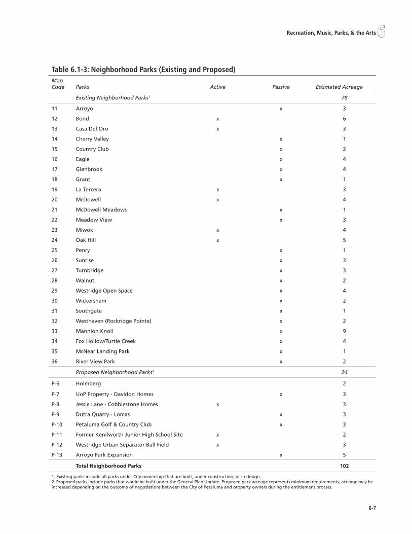
6-�
6Recreation, Music, Parks, & the Arts
table 6.1-�: neighborhood Parks (Existing and Proposed) Map Code Parks Active Passive Estimated Acreage
Existing Neighborhood Parks1 78
11 Arroyo x 3
12 Bond x 6
13 Casa Del Oro x 3
14 Cherry Valley x 1
15 Country Club x 2
16 Eagle x 4
17 Glenbrook x 4
18 Grant x 1
19 La Tercera x 3
20 McDowell x 4
21 McDowell Meadows x 1
22 Meadow View x 3
23 Miwok x 4
24 Oak Hill x 5
25 Penry x 1
26 Sunrise x 3
27 Turnbridge x 3
28 Walnut x 2
29 Westridge Open Space x 4
30 Wickersham x 2
31 Southgate x 1
32 Westhaven (Rockridge Pointe) x 2
33 Mannion Knoll x 9
34 Fox Hollow/Turtle Creek x 4
35 McNear Landing Park x 1
36 River View Park x 2
Proposed Neighborhood Parks2 24
P-6 Holmberg 2
P-7 UoP Property - Davidon Homes x 3
P-8 Jessie Lane - Cobblestone Homes x 3
P-9 Dutra Quarry - Lomas x 3
P-10 Petaluma Golf & Country Club x 3
P-11 Former Kenilworth Junior High School Site x 2
P-12 Westridge Urban Separator Ball Field x 3
P-13 Arroyo Park Expansion x 5
Total Neighborhood Parks 102
1. Existing parks include all parks under City ownership that are built, under construction, or in design.2. Proposed parks include parks that would be built under the General Plan Update. Proposed park acreage represents minimum requirements; acreage may be increased depending on the outcome of negotiations between the City of Petaluma and property owners during the entitlement process.

6-�
Petaluma General Plan �0�5
property, or in several locations, on City-owned lands within the Urban Separator (U.S.) through formal agreements:
Regional Parks
Sonoma County maintains a parks standard of 5.0 acres of community and neighborhood parks per 1,000 residents, 5.0 acres of regional recreation area per 1,000 residents, and 15 acres of regional open space per 1,000 residents. Helen Putnam Regional Park is considered part of the Sonoma County regional open space network. At 256 acres, Helen Putnam Regional Park serves the City of Petaluma with 4.0 acres of regional open space per 1,000 residents. The purchase of the Tolay Lake property, largely located outside the Planning Referral Area but just southeast of Petaluma, will significantly increase the ratio once public access is achieved. While located at the east edge of the Planning Referral Area, Lafferty Ranch is City-owned property that would provide access to hiking trails on Sonoma Mountain for the greater Sonoma County area, should development of minimal facilities be achieved to allow public access.
creek fronts and the Riverfront
Creeks and the Petaluma River help to define Petaluma’s character and culture, and supply the community with important recreational opportunities. Trails along several of the city’s creeks and portions of the Petaluma River provide pleasant pedestrian and bicycling corridors that are also used as alternative transportation routes. The Petaluma River, in particular, offers numerous recreational amenities and holds the possibility of offering more. The Petaluma River Trail, when fully implemented, will link residential and commercial uses along the riverfront outward to neighborhoods through the creek trail system. Implementation of the Petaluma River Access and Enhancement Plan will further enhance the riverfront environment and its relationship to the surrounding community. The city currently (2005) offers approximately 216 acres of creek and riverfront recreation areas.
In addition to riverfront trails, the Petaluma River offers a unique opportunity for residents and visitors to enjoy and experience the community from the River itself. Providing access points for hand-launched, human-powered watercraft is an important component of realizing this opportunity. Access sites can include locations with developed amenities (ramps, steps, roads, docks, or other improvements) or sites that provide natural features (e.g., beaches, riverbanks, rock outcrops, banks adjacent to bridges, etc.) to reach the water or hand-launch a small boat.
Joint Use Facility Acres1
Petaluma Junior High School 5.5
Petaluma High School 2
Sonoma Mt. Elementary (U.S.)2 4
Casa Grande High School 28
La Tercera Elementary School 4
Miwok Elementary School 2
Bernard Eldridge Elementary School 2
Cherry Valley Elementary School 1
Meadow Elementary School 2.5
McNear Elementary School 1
McDowell Elementary School 2
Kenilworth Junior High School (U.S.)2 4
Corona Creek Elementary School (U.S.)2 4
Total 62
1. Approximate acreage of joint-use facilities.2. Joint -use facility on city-owned land/urban separator.
A multi-use trail bridges over Lynch Creek.
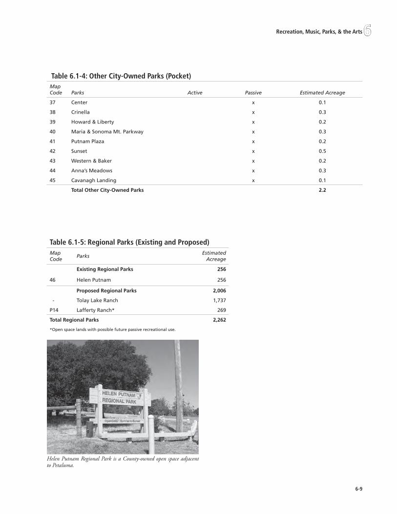
6-�
6Recreation, Music, Parks, & the Arts
table 6.1-�: other city-owned Parks (Pocket)Map Code Parks Active Passive Estimated Acreage
37 Center x 0.1
38 Crinella x 0.3
39 Howard & Liberty x 0.2
40 Maria & Sonoma Mt. Parkway x 0.3
41 Putnam Plaza x 0.2
42 Sunset x 0.5
43 Western & Baker x 0.2
44 Anna’s Meadows x 0.3
45 Cavanagh Landing x 0.1
Total Other City-Owned Parks 2.2
table 6.1-5: Regional Parks (Existing and Proposed)Map Code
ParksEstimated
Acreage
Existing Regional Parks 256
46 Helen Putnam 256
Proposed Regional Parks 2,006
- Tolay Lake Ranch 1,737
P14 Lafferty Ranch* 269
Total Regional Parks 2,262
*Open space lands with possible future passive recreational use.
Helen Putnam Regional Park is a County-owned open space adjacent to Petaluma.

6-10
Petaluma General Plan �0�5
community and Urban separators
Urban separators
The City of Petaluma has obtained title to 157 acres of urban separator lands adjacent to the Urban Growth Boundary. These urban separators serve as open space areas designed to buffer agricultural lands from urban lands as well as providing opportunities for recreation.
In areas where an Urban Separator seems infeasible due to existing development or topography, an Urban Separator path (easement) could provide a means to allow bicycle and pedestrian connections without requiring fee title dedication.
community separators
Community separators in Sonoma County are intended to retain separate, identifiable cities and prevent corridor-style urbanization by preserving rural lands between developed areas. The Sonoma County General Plan 2020 Overview Draft identifies two community separators adjacent to Petaluma: Petaluma/Novato and Petaluma/Rohnert Park. The following is a detailed description of the community separators that surround the Petaluma UGB:
Petaluma/Novato. Approximately 2,755 acres of foothills south of Petaluma, along the Highway 101 corridor. These open hillsides and ridgelines serve as
•
a gateway between Marin and Sonoma Counties.
Petaluma/Rohnert Park. Approximately 3,360 acres of farmland and foothills north of Petaluma, along the Highway 101 corridor. These open grassy areas provide a visual buffer between Petaluma and Cotati/Rohnert Park. Small foothills north of Petaluma, between Old Redwood Highway and Corona Road. These rolling hills divide Petaluma’s urban development from the small, unincorporated Penngrove community.
landscape Assessment districts
Landscape Assessment Districts (LADs) have been used as a financing tool for new residential subdivisions. The LADs fund the provision and maintenance of amenities on public lands within the subdivisions. Costs for the provision and maintenance of amenities are spread equally among all of the private parcels within each district. The City Council sets the annual assessments each July at a noticed public hearing.
Urban centers
In addition to parkland, the City owns and operates other recreational and cultural facilities, such as a swim center, riverfront marina and docks, historical museum, skate park, youth performing arts theater (proposed for restoration), and a community center. These urban centers provide open gathering spaces and unique
•
table 6.1-6: Urban separators (Existing and Proposed)Urban Separators Estimated Acreage
Existing Urban Separators 157
Cader Farms Highlands 10
Cross Creek 14
Wiseman (Not including 21 acres included as Wiseman Park in Table 6.1-2) 7
Graystone (contains Kenilworth Jr. High and Corona Creek playfields) 23
Heritage 8
Kingsmill 4
Mountain Valley (contains playfields) 7
Westridge Knolls 76
Southgate 4
Stratford Place 4
Proposed Urban Separators1 97
Total Urban Separators 2541. Proposed Urban Separators include those areas where parcel size allows for fee title dedication of land to the City (e.g. Davidon property, Petaluma Golf and Country Club, etc.). Acreage of lands with the Urban Separator Path Overlay is not included in this figure.

6-11
6Recreation, Music, Parks, & the Arts
recreational opportunities for city residents. Key City-owned recreational and cultural facilities include:
City HallPetaluma Community CenterJack Cavanagh Recreation Center & PoolPetaluma MarinaPetaluma Historical Library/MuseumPolly Hannah Klaas Performing Arts CenterPetaluma Skateboard ParkPetaluma Swim CenterTeen CenterLibrary (City building and land, County operated)Railroad/Train Depot Buildings (Owned by SMART, restored and maintained by City)Petaluma Adult/Senior Center
special Programs
The City offers a variety of special programs, ranging from pre-school to activities for senior citizens. Both indoor and outdoor recreational programs occur in a combination of school and City facilities. The wide range of recreational and personal enrichment programs overseen by the City include: aquatics, arts and crafts, camps, cooking, dance, health and fitness, music, sports, travel and field trips, and more. Major programs include the Teen Center, the Adult/Senior Center and the Swim Center. Augmenting the City-owned facilities are the Boys and Girls Clubs of Petaluma.
teen center
The Parks and Recreation Department operates a Teen Center that is open to all teenagers grades 7 through 12. Petaluma’s Teen Council and Youth Commission are both administered from the Teen Center.
The Teen Council is comprised of representatives from the city’s Junior and Senior High Schools, Alternative High Schools, and at-large students, appointed by Council and serving one-year terms. The Teen Council works with the Youth Commission to identify the concerns of Petaluma’s youth. The Youth Commission consists of seven members, appointed by Council, serving two-year terms. The goals of the Youth Commission, teen council and youth program staff include, but are not limited to:
•
•
•
•
•
•
•
•
•
•
•
•
Marketable Skills through Effective Education. Development and maintenance of the Youth Employment Programs. This program in partnership with Petaluma City Schools, and Petaluma People Services Center distributes and maintains Pathfinder, a county-wide system that connects the business community with youth and educators to find paid employment, job shadows, and internships.
Healthy Start. Petaluma is highly concerned with the physical and mental health of its youth and families. By working cooperatively, responsible organizations will effectively promote the mental, emotional, and physical well being of the city’s youth and families.
Safe Places and Activities during non-school hours. To support policies that encourage access to and development of safe environments, including public parks and other public places where young people can meet, play and socialize in both structured and unstructured activities.
Community Service. To promote good citizenship and broader personal investment in the community, civic organizations will encourage and provide opportunities for youth to participate in regular community service.
Ongoing Relationships. To promote and encourage the development of supportive relationships between adults and youth in schools, and within families and the community.
Activities and achievements include provision of recreational activities, trips and scholarships.
Adult/senior center
The Senior Citizen Committee and various program committees assist with providing direction for the adult/senior center. Programs include leisure, educational, social, mental, and physical health activities for adults over the age of 55. The mission of the Petaluma Senior Center is “to maintain an atmosphere that encourages independence for seniors; to provide opportunities and to enhance their physical, mental, creative, and social abilities in an environment that promotes individual achievement, satisfaction and self-esteem.” Activities include the following:
•
•
•
•
•

6-1�
Petaluma General Plan �0�5
Leisure activities, which include drop-in programs, crafts, billiards, card games, dances, special events, lounging, and socializing;
Recreational programs that include travel programs, pool and golf tournaments, and art exhibits;
Educational programs that promote continued learning and mental stimulation, which include current events, oral histories, computer classes, and discussion groups;
Health education programs and opportunities that promote a healthy lifestyle, such as exercise classes and health clinics (e.g., blood pressure screening); and,
Information, referral, and clearinghouse to support seniors and their needs.
Boys and Girls clubs of Petaluma
The Boys and Girls Clubs of Petaluma have served Petaluma’s youth since 1958. Their mission is to “inspire and enable all young people to develop positive skills and attitudes, achieve their full potential, become productive, responsible and caring citizens, and enjoy their childhood.” The Boys and Girls Clubs of Petaluma currently operate seven locations within the city: Cavanagh Recreation Center, Lucchesi Park Branch, Round Walk Village, Corona Ranch, Old Elm Village, Downtown River Apartments, and Washington Creek Apartments.
The Boys and Girls Clubs of Petaluma provide after school and summer programs that provide youths with learning, tutoring, computer instruction, and opportunities to express themselves through art, music, athletics and other recreational activities. The Clubs serve more than 3,000 children ages 6 to 18 per year.1
Agency-owned Parks and open space
Associated governmental agencies, such as the County and the State, also operate parks and recreational facilities within the Petaluma Planning Area. Petaluma Adobe State Historic Park, east of the Petaluma city limits, is owned and operated by the California State Parks Department. Helen Putnam Regional Park, located at the western edge of the city, is managed by the Sonoma County Regional Parks Department.
1. www.petaluma.bgc.org.
•
•
•
•
•
sonoma county Agricultural Preservation and open space district
The Sonoma County Agricultural Preservation and Open Space District is an independent special district formed under Government Code Section 65562 et seq. of the California Public Resources Code, and utilizes a dedicated sales tax for the purchase of conservation easements to protect agricultural lands and preserve open space. The District is also authorized to purchase fee title for open space resources.
The Sonoma County Agricultural Preservation and Open Space District’s Acquisition Plan 2000 describes several different open space designations in Petaluma.
Agriculture. The entire Planning Area south of the city’s UGB is designated for coastal agriculture, while all lands north of Adobe Road are designated for greenbelt agriculture. Agricultural areas can include grazing land, active ranches and/or cropland, or community agricultural operations (e.g., farmers market, co-ops).
Greenbelts. All lands north of Adobe Road and east of the city limits are designated as priority greenbelt. Priority greenbelts are defined as highly visible open spaces and agricultural lands, prominent viewsheds, important scenic lands, and greenways along creek channels.
Natural Resources. The Petaluma Marsh Wildlife Area, located south of the UGB along the Petaluma River, is identified as a priority biodiversity area. The Rivermouth is a designated wetland to prevent urban encroachment on sensitive areas home to multiple threatened and endangered species.
conservation Easements
When the Westridge Knolls subdivision was created in Petaluma, the City required open space as a component of the development. The Sonoma Land Trust now holds a conservation easement on the 76 acres, ensuring that this will remain as open space in perpetuity.
The 529 acres of Watson Ranch, along Highway 101 at Pepper Road north of Petaluma, became Sonoma County’s first permanent agricultural preserve in 1979 with the donation of a conservation easement.
Named for the character of the Petaluma River as it borders the property, Cloudy Bend comprises 367
•
•
•

6-1�
6Recreation, Music, Parks, & the Arts
acres protected by a conservation easement now held by Sonoma County Agricultural Preservation and Open Space District. The California State Coastal Conservancy also assisted in the Open Space District’s work to protect the land.
In 1995, Sonoma County Agricultural Preservation and Open Space District assisted the City in the acquisition of Phase I of the McNear Peninsula, now completed and renamed Steamer Landing.
In 2004, with the help of the California Coastal Commission and the Sonoma County Agricultural Preservation and Open Space District, the City acquired a 270-acre parcel of land adjacent to Lakeville Highway for the new Ellis Creek Water Recycling Facility. Construction began on the new water recycling facility in October 2005. While the new facility will occupy approximately 25 acres of the northern portion of the site, the remaining part of the land will be preserved and enhanced under a conservation easement. The site will also contain approximately 2.5 miles of new trails that will connect the water recycling plant site to the Shollenberger Park trail. Construction of the facility will be completed in 2009.
PARks And oPEn sPAcE stAndARds
The City has adopted a citywide parks standard of 5 acres of parkland per 1,000 residents and as of October 2005, the City was providing 5.1 acres of parkland per 1,000 residents.2
future Parks needs
The buildout population under the General Plan estimates a population increase of approximately 16,000 residents between 2005 and 2025. In addition to other new community services and facilities, new parks and open space will need to be provided to meet the City’s adopted parkland standards. The addition of approximately 16,000 residents generates the need for approximately 80 additional acres of new parkland. As detailed in Tables 6.1-2 and 6.1-3 above, the City is proposing approximately 103 acres of new parkland to be constructed under the General Plan, which results in a total of 370 acres of parkland (existing plus proposed) at buildout. With a projected population of 72,707 residents by the year 2025, the City will be providing
2. The parkland ratio was calculated using community, neighborhood, and pocket parks as well as several urban separators. Urban separators included in the parkland acreage are those that provide recreational amenities such as playing fields and/or multi-use trails.
5.3 acres of parkland per 1,000 residents. Table 6.1-7 summarizes the existing and future parkland conditions and provides a comparison with parkland ratios provided in 1985. As Table 6.1-7 demonstrates, the City has made considerable progress toward providing recreational space for its citizens during the last 20 years and will continue its aggressive program to meet the community’s recreational demand.
Table 6.1-9 illustrates the full range of recreational assets available to the community within the Urban Growth Boundary at buildout. The combination of parks, open space lands, joint-use facilities, etc. total over 1,400 acres of land, or 19.5 acres/1,000 residents.
new Parks under the General Plan
The new parks will be fully integrated with the surrounding community and connected to other parks and public facilities through pedestrian trails and bicycle routes. Proposed parks are listed in Tables 6.1-2 and 6.1-3 and are summarized in Table 6.1-8. Approximate locations for these parks are shown in Figure 6-1.

6-1�
Petaluma General Plan �0�5
table 6.1-�: summary of Park standards and Park needs
Population
Citywide Standard (Acres/1,000 residents)
Acreage Required to
Meet StandardAcreage Provided Parkland Ratio
1985 Conditions1 37,300 5.02 187 99 2.6
Existing Conditions (2005) 56,542 5.0 283 2863 5.1
Future Buildout (2025) 72,707 5.0 363 3893 5.31. Based on information provided in the 1987 General Plan.
2. This is the combined standard for neighborhood and community parks. The 1987 General Plan provided separate standards for community (3.0 acres/1,000 residents) and neighborhood (2.0 acres/1,000 residents) parkland. As established in Section 20.34 of the Petaluma Municipal Code (dated 2004), the 2025 General Plan will include a combined community and neighborhood parkland standard of 5.0 acres per 1,000 resident.
3. The parkland ratio was calculated using community, neighborhood, and pocket parks as well as several urban separators. Urban separators included in the parkland acreage are those that provide recreational amenities such as playing fields and/or multi-use trails, located on City-owned property.
table 6.1-�: new neighborhood and community Parks (Under the land Use Plan)Map Code
Park Estimated Acreage
Proposed1 Community Parks 79
P-1 Steamer Landing (future phases) 20
P-2 Johnson Property 7
P-3 Pomeroy/Riverfront Site 7
P-4 East Washington Park Site 25
P-5 Fairgrounds 20
Proposed Neighborhood Parks 24
P-6 Holmberg 2
P-7 UoP Property - Davidon Homes 3
P-8 Jessie Lane - Cobblestone Homes 3
P-9 Dutra Quarry - Lomas 3
P-10 Petaluma Golf & Country Club 3
P-11 Former Kenilworth Site 2
P-12 Westridge Urban Separator Ball Field 3
P-13 Arroyo Park Expansion 5
Total Proposed Parkland 103
1. Proposed parks include parks that will be built under the General Plan. Proposed park acreage represents minimum requirements; acreage may be increased depending on the outcome of negotiations between the City of Petaluma and property owners during the entitlement process.

6-15
6Recreation, Music, Parks, & the Arts
Goal6-G-1:parksandrecreationRetain and expand city-wide park and recreation assets and programs to maintain the quality of life they provide to the community.
Policies and Programs:
6-P-1 Develop additional parkland and recreational facilities in the city, particularly in areas lacking these facilities and where new growth is proposed, to meet the standards of required park acreage.
Develop and implement a Parks Master Plan, including the reevaluation of existing resources to determine best uses for the benefit of the community (e.g. Lucchesi Park Pond).
Through the Parks Master Plan process and the park design process, determine the make-up of any given park (e.g. passive/active and the level and type of park features).
Active Parks: emphasis on athletic fields, aquatics, courts, etc.
Passive Parks: emphasis on pathway, tot lots, informal playfields, etc.
The provision of amenities (e.g. restrooms) based on intensity of use.
C. Work with local, regional, and state agencies to acquire and fund further parkland acquisition and improvements.
D. Undertake a proactive program to acquire necessary land and develop new parks in the locations shown in Figure 6-1, prioritizing areas where new development may occur and park opportunities may be lost, and in underserved neighborhoods.
A.
B.
•
•
•
E. As part of the City’s Development regulations establish common open space requirements for multi-family development. Such open space shall NOT be counted toward public park dedication/in lieu fee requirements for meeting neighborhood and/or community park needs.
F. Require land development along designated trails and pathway corridors to provide sufficient right-of-way for trails and amenities and to ensure that adjacent new development does not detract from the scenic and aesthetic qualities of the corridor.
G. Encourage and support the collaboration of local school districts, non-profit organizations and private parties in the use of public lands for outdoor education opportunities such as: community gardens, riparian or wetland enhancement projects, wildlife study/protection areas, etc.
H. Improve community health and unity by providing community-wide, family-oriented special events that bring the community together (e.g. Movies in the Park, family festivals, etc.).
I. Where feasible, acquire and/or restore, maintain and use for the community’s benefit, local historic assets (e.g. Steamer Landing Livery Stable, McNear Channel, Polly Hannah Klaas Performing Arts Center, etc.).
J. Work collaboratively with affected property owners to dredge the McNear Channel and utilize this protected body of water for small boating in concert with local organizations, including the development of a small boating facility that can house instructional and/or historical programs relating to the Petaluma River and Petaluma’s historical heritage.
table 6.1-�: summary of Recreational Assets at Buildout (Within UGB)Acreage At Buildout Acres/1,000 Residents
Regional Park 256 3.5
Community Park 204 2.8
Neighborhood Park 102 1.4
Pocket Park/Urban Center 2.2 .03
Joint-Use Facilities 62 .85
Urban Separator (Acreage does not include joint-use or parks included above) 254 3.5
Open Space (Acreage does not include golf courses) 548 7.5
TOTAL 1,428 19.6

6-16
Petaluma General Plan �0�5
K. Explore opportunities for the development of a public multi-use, small-craft center providing a venue for recreational and competitive small boaters (e.g. rowing shells, outrigger canoes, kayaks, traditional wooden boats, and other human and sail powered watercraft) on the Petaluma River.
6-P-2 Provide a comprehensive and integrated network of parks and open space and improve access to existing facilities where feasible.
Provide public access and recreational opportunities along the length of the Petaluma River and its tributaries, to every extent possible.
Identify missing links to connect parks and open spaces with neighborhoods and community destinations. Develop prioritization and funding to complete these links.
6-P-3 Connect city parks with other public facilities, open spaces, employment centers, and residential neighborhoods by locating new recreation facilities in proximity to these uses and by fully integrating the parks system with the city’s pedestrian, bicycle, and transit systems.
6-P-4 Proposed parks, and proposed expansion of existing parks, as designated on the General Plan Land Use Map, are parcel specific, and shall be dedicated as a condition of development entitlements, consistent with federal, state and local law. Dedication requirements for development subject to the Quimby Act (Government Code Sec. 66477) shall be consistent with the requirements of that Act.
6-P-5 New parkland or recreation facilities, beyond those identified in the General Plan, may be required as part of a specific project’s development review process.
6-P-6 Achieve and maintain a park standard of 5 acres per 1,000 residents (community park land at 3 acres per 1,000 population and neighborhood park land at 2 acres per 1,000 population) and an open space/urban separator standard of 10 acres per 1,000 population, in order to enhance the physical environment of the city and to meet the recreation needs of the community.
Revise the City’s park in lieu fees/dedication requirements to achieve the General Plan standard of 5 acres per 1,000 residents
A.
B.
A.
(community park land at 3 acres per 1,000 population and neighborhood park land at 2 acres per 1,000 population).
6-P-7 Neighborhood parks shall be donated, constructed, and maintained within the developing property(ies). The formation of landscape assessment districts, or other funding mechanisms, to offset costs associated with developing, upgrading, and maintaining community parks may be imposed as a condition of development. Transfer of density within a project site from donated acreage in excess of dedication/in lieu requirements may be considered.
Review and, if necessary, revise the City’s Municipal Code regarding the payment of community park impact fees to maximize all opportunities for funding community and neighborhood parkland, park improvements and park operation and maintenance through the development entitlement process.
Establish a transfer of development rights (TDR) program that allows project proponents on whose sites new neighborhood parkland locations are designated, to transfer development rights from portions of the site dedicated as public open space/park beyond required dedication/in lieu requirements (2 acres of neighborhood park per 1,000 residents) to the remainder of the site at the base land use designation on the site, subject to approval by the City Council or the adoption of a TDR Program, provided the following criteria are met:
The resulting park area meets the minimum size and location requirements shown in Table 6.1-8 and Figure 6-1;
The park/open space is useful for recreational use, and not just leftover acreage;
The park/open space is physically and perceptually available to the community-at-large, and not internal to the development;
The resulting transfer will not unduly impact the character of the neighborhood where the development is located; and
The park/open space is not at the city’s edge, adjacent to an urban separator.
A.
B.
•
•
•
•
•

6-1�
6Recreation, Music, Parks, & the Arts
6-P-8 In designing park and recreational facilities, recognize that accessibility will vary depending on the location and purpose of the facility, consistent with State and Federal guidelines.
6-P-9 Recognizing that schools are community assets, continue to actively promote and coordinate joint use of school properties as neighborhood parks and recreation program sites to help meet the community’s demand for additional recreational facilities while realizing the cost benefits from the shared use of publicly-owned land.
Create a program for shared renovation and maintenance of all recreational facilities (city and school district lands) through a possible city-wide assessment which will be in addition to current funding provided for renovation and maintenance of those facilities by the responsible agency or authority.
6-P-10 Continue cooperating, and pursue expansion, with the local school districts to allow public use of school open space, playfields and facilities to achieve a ratio of 1 acre per 1,000 residents, to augment the City owned recreational facilities.
6-P-11 Pursue joint use agreements with the Sonoma-Marin Fairgrounds to permit use of grass areas on the fairgrounds as active playfields.
6-P-12 Locate recreation uses (e.g., trails, athletic fields, picnic areas, etc.) in the urban separator on the east and west sides of the city, taking into account terrain, accessibility, links to other parts of the city and related factors in determining whether or not a particular use is appropriate.
6-P-13 Recognize, maintain, and improve aquatics programs as a key element of Petaluma’s Parks and Recreation Services.
If the existing Petaluma Swim Center should be slated for replacement, retain the existing facility until a new, comparable site is identified, acquired, funding secured, and construction completed.
Maintain and improve the current level of aquatics programming in Petaluma by operating Petaluma swim facilities with a season extending from March 1 to October 30, and with the goal of year-round operation. Use an enhanced program mix based on consumer preference, and with continuing efforts to increase patronage at the Swim
A.
A.
B.
Center through marketing, advertising and by promoting website access.
Produce an Aquatic Plan to ensure that a full range of aquatic programs are provided in Petaluma.
The Aquatic Plan shall analyze the projected population and demographic changes in Petaluma and the anticipated impact of those changes on the future demand for aquatic facilities and programs.
The Aquatic Plan shall evaluate the current capacity of Petaluma’s aquatic facilities, taking into consideration the impact of proposed development adjacent to the Petaluma Swim Center site and beyond, and project the viability of those facilities to meet the projected demand. The Aquatic Plan shall also recognize that the Petaluma pool is a unique recreational facility in the North Bay and should be considered in terms of potential programming and economic sustainability.
Based on that evaluation, the Aquatic Plan shall identify improvements, enhancements or replacement of existing facilities, including considerations of disabled access in selecting the location, design and capacity of new facilities.
The Aquatic Plan shall address the potential for leveraging resources from the Petaluma School District, local services agencies, Santa Rosa Junior College District, local employers and other governmental entities to address the project demand.
The Aquatic Plan shall propose the method and strategy for financing the changes necessary to meet the projected programming demand, with separate provisions for capital replacement, routine capital financing and annual maintenance costs.
6-P-14 Work with the Sonoma County Regional Parks Department and the Sonoma County Board of Supervisors to encourage the development of Tolay Lake as an open space asset for the residents of Petaluma and southern Sonoma County, and to provide regional active parks (athletic fields) in close proximity to Petaluma.
C.
•
•
•
•
•

6-1�
Petaluma General Plan �0�5
6-P-15 Work with the Sonoma County Regional Park Department, the Sonoma County Open Space Authority, the Sonoma County Agricultural Preservation and Open Space District, the Sonoma County Water Agency, the Sonoma Land Trust, the Sonoma County Watershed Council, the California State Parks Department, and the California State Coastal Conservancy and other entities to develop common goals for open space beyond the Urban Growth Boundary, and coordinate acquisition efforts and priorities.
Continue to maintain Lafferty Ranch as City-owned open space for possible future passive public use.
6-P-16 Should expansion beyond the 1998 Urban Growth Boundary occur, priority shall be given to identification and development of adequate park lands to meet identified standards and community needs.
Goal6-G-2:parksandrecreationEnsure park and recreational assets are maintained to allow safe access and use.
Policies and Programs:
6-P-17 Recognizing that the maintenance of City assets is a matter of civic pride, priority and safety, the City shall work with citizens, businesses, schools, organizations, and public agencies to fund an acceptable level of maintenance for all city-owned park and recreational facilities.
Create opportunities and incentives, such as public acknowledgements plaques and signs, for other agencies, non-profits, private businesses, and user groups to participate in the provision, development and maintenance of parks, open space, and recreation facilities.
Establish a program to work with adjacent neighborhoods to take responsibility for their neighborhood parks and urban separators, including the possibility of assuming maintenance needs or costs. Neighborhood parks ‘adopted’ by the residents shall remain publicly owned and accessible by the community.
6-P-18 Development that occurs adjacent to designated trails and pathway corridors shall be required to install and maintain the publicly owned and accessible trail, in perpetuity.
A.
A.
B.
Goal6-G-3:parksandrecreationincrease public knowledge and understanding of the importance of sustaining a healthy urban for-est for the well-being of the entire community.
Policies and Programs:
6-P-19 Support efforts by the City’s Tree Advisory Committee to disseminate current information to the public advocating the use of Best Management Practices for the care and perpetuation of the urban forest, including issues such as strategic tree planting that considers site conditions as well as shading in selection and placement of trees, proper planting and pruning techniques, and the importance of using Integrated Pest Management practices in order to minimize the use of chemicals harmful to the environment.
Development plans shall be reviewed to ensure adequate growing space and conditions for trees and other vegetation is provided, and that plant species choices are adaptable to the proposed planting environment.
Provide tree-related information on the City’s website for public reference (e.g. street tree planting procedures and guidelines, approved street tree list, heritage tree applications, etc.).
Review and update existing tree regulations and development procedures relating to trees and provide periodic education for city field staff regarding issues relating to care and proper pruning of trees.
Educate and celebrate the value and importance of trees to the Petaluma community including celebrating Arbor Day with a community tree planting day or community clean up day. Review, update and publish tree walking tours of Petaluma, identify trees of significance to the community.
The City of Petaluma shall strive to retain its designation as a “Tree City USA” by the National Arbor Day Foundation. This designation recognizes Petaluma’s commitment to maintaining a healthy urban forest.
6-P-20 Where trees, larger than 8” in diameter, must be removed to accommodate development, they shall be replaced at a ratio established in the Development Code. Replacement trees may be planted on, or in the vicinity of, the
A.
B.
C.
D.
E.

6-1�
6Recreation, Music, Parks, & the Arts
6.2 tHearts
The arts play an important economic, educational and social role in the life of Petaluma. Art can be defined as music, theater, dance, visual, and/or literary pursuits. Public art and community cultural activities contribute to Petaluma’s identity and livability as well as boosting the economy through tourism. Arts and cultural programs celebrate and build on the city’s rich mix of cultural and ethnic diversity. Art in educational programs provide skills to develop creative and critical thinking in the work force and contribute to guiding the city’s youth in positive directions. Centralized cultural facilities enhance the city’s image, pride, and identity. These gathering places contribute to a vital business climate and serve as a draw for tourism. Arts facilities help revitalize and strengthen the historic downtown and bring increased tax revenue to the City.
The City supports a variety of cultural activities throughout the year, including, but not limited to:
The annual Petaluma Butter and Eggs Day, which showcases music and cultural events in the historic Downtown; The annual Petaluma Waterfront Jazz Festival, held at Foundry Wharf in the Downtown, which utilizes the River as a focal point for community and cultural events; Cinnabar Theater hosts the Petaluma Summer Music Festival during the month of August and presents opera, drama, concerts, and children’s theater year round;McNear’s Mystic Theater and Music Hall and the Phoenix Theater both host live music and entertainment in Petaluma;
•
•
•
•
development site, subject to approval by the Community Development Department or through the discretionary approval process.
6-P-21 Develop an Urban Forestry Program to consolidate the various City policies and ordinances regarding tree planting and removal and to incorporate the goals of the California Climate Action Team Report to plant 5 million trees in urban areas by 2020 to provide energy conservation and reduce greenhouse gas emissions.
Goal6-G-4:specialprogramssupport and value the health, education, social ac-tivities and overall well-being of our citizens, re-gardless of age.
Policies and Programs
6-P-22 It is the City’s policy to support and value the health, education, social activities and overall well-being of our youth. To that end, the city shall include the components of the Youth Master Plan into its deliberations when considering the implementation of any public policy or decision impacting the youth of our community.
6-P-23 Recognize the unique needs of Petaluma youth.
Develop a Youth Master Plan.
Continue to utilize the Teen Council and Youth Commission to ensure the voice of our youth is included in governance.
Maintain and expand the Teen Center facilities and programs.
6-P-24 Recognize the unique needs of Petaluma seniors.
Maintain the Adult/Senior Center and continue to support senior activity programs.
Renovate the Cavanagh Recreation Center in order to expand recreational programming including activities for adults/seniors.
Continue to work with public agencies and non-profit organizations to meet the needs of seniors.
6-P-25 Recognize the value of having excellent childcare facilities to serve residents and employees in Petaluma.
A.
B.
C.
A.
B.
C.
Continue to allow small and large childcare facilities within neighborhoods and employment centers.
Within the Development Code allow childcare centers in all districts.
Within the Development Code, allow the consideration of a formula for granting a bonus in intensity of use from commercial or industrial uses that provide child care facilities.
Within the Development Code, encourage the use of public facilities, schools, churches, and spaces within other facilities for child care facilities.
A.
B.
C.
D.

6-�0
Petaluma General Plan �0�5
and philanthropic organizations.
6-P-28 Support established and new events through the provision of city services during festivals and other cultural events, when appropriate and financially feasible.
6-P-29 Integrate the arts into the planning process in the city and encourage the arts as an integral part of development proposals and capital improvement projects.
6-P-30 Place public art in areas that are interactive and accessible to the public and at the city’s gateways.
6-P-31 Support the development of centrally located facilities to house visual and performing arts activities such as exhibitions, studio/classrooms, performance and theater/lecture space. Include outdoor locations that encourage cultural events such as outdoor performance and amphitheater space.
6-P-32 Work cooperatively with local school districts and community groups to encourage the development of art and cultural programs for all ages.
6-P-33 Dedicate a certain percentage of Transient Occupancy Tax (TOT) to be spent on cultural arts programs.
6-P-34 Offer and encourage opportunities for partnerships among public, non-profit and private organizations that sponsor art activities and programs. Explore grant possibilities from State and Federal agencies.
The Petaluma Arts Council sponsors El Dia de los Muertos (Day of the Dead) activities each fall;Petaluma Arts Association’s Annual “Art in the Park” held at Walnut Park and “Art on the River”.Annual Quilt ShowArt and Garden FestivalArt Trails – Open StudiosThe Poetry WalkHistoric Tours of Petaluma
High School Band Review
Goal6-G-5:theartsRecognize the inherent value to Petaluma’s qual-ity of life provided through music, theater, dance, visual, and literary arts, and cultural programs.
Policies and Programs:
6-P-26 Encourage, develop and support arts programs throughout the community that provide for the continued success of musical, theatrical, artistic, and cultural traditions and events in Petaluma.
Identify, renovate and/or expand places for music, art, and cultural activities to take place (such as, but not limited to, the Polly Hannah Klaas Performing Arts Center and the Petaluma Arts Center).
Work with the school districts to ensure the success of music and the arts programs for all ages.
6-P-27 Utilize the Public Art Committee to implement the City’s public art program and increase art throughout Petaluma.
Work with the Public Art Committee and local organizations to establish strategic planning programs for expansion of the arts community in Petaluma.
Develop a funding strategy to ensure adequate funding to support arts and culture programs.
Develop and maintain a dynamic and concise Arts and Culture Master Plan.
Utilize the Public Art In-Lieu Fee to implement long-range public art goals.
Pursue grants from State and Federal agencies
•
•
•
•
•
•
•
•
A.
B.
A.
B.
C.
D.
E. A public art installation at Lucchesi Park.

Public facilities, services, and education are essential to creating a healthy and balanced community in Petaluma. Provision of these facilities and services creates opportunities for residents to come together for personal enrichment, growth, and development, to share community assets, and to engage in cultural, social, and educational activities.
Community Facilities, Services,
and Education

7-�
Petaluma General Plan �0�5
7.1 publicFacilitiesandservices
City FaCilitiES
Public facilities provide important amenities to Petaluma residents. City facilities, excluding recreational, include City Hall, which houses city offices and public meeting rooms, the Transit Maintenance Yard, the Petaluma Historical Museum and Library, the Petaluma Regional Library, the Petaluma Animal Services facility, the Corporation Yard, the Water Recycling Facility, the Petaluma Municipal Airport, the Department of Water Resources and Conservation building, and the Petaluma Marina.
table 7.1-1: City-Owned Public Facilities in PetalumaFacility Address
City Hall Complex 11 English Street
22 Bassett Street
25 Howard Street
27 Howard Street
Petaluma Municipal Airport 601 Sky Ranch Drive
Petaluma Animal Services 840 Hopper Street
Petaluma Marina 781 Baywood Drive
Transit Maintenance Yard 555 N. McDowell Blvd.
Petaluma Historical Museum and Library (Former Carnegie Library)
20 Fourth Street
Petaluma Regional Library 100 Fairgrounds Drive
Corp Yard 840 Hopper Street
Wastewater Treatment Plant/ Pumping Station 950 Hopper Street
Ellis Creek Water Recycling Facility 4000 Lakeville Hwy
Department of Water Resources and Conservation 202 N. McDowell Blvd.
Mary Isaak Center 900 Hopper Street
Family Shelter/PPSC Office 1500 Petaluma Blvd. South
Transitional Housing (5 Units)
Petaluma Kitchen 301 Payran Street (will move to Mary Isaak Center in 2009)
Petaluma Community Center 320 N. McDowell Blvd.
Petaluma Senior Center 211 Novak Drive
Petaluma Swim Center 900 E. Washington St.
Petaluma Teen Center 150 Fairgrounds Drive
Cavanagh Center 426 8th Street
Fire Station #1 198 “D” Street
Fire Station #2 1001 N. McDowell Blvd.
Fire Station #3 831 S. McDowell Blvd.
Police Department 969 Petaluma Blvd. North
Polly Hannah Klaas Performing Arts Theater Western Ave. at English St.
Source: City of Petaluma, December 2005.
Petaluma Municipal airport
Petaluma has its own small-craft airport, which generates its own revenues. The facility includes a terminal with a lounge, offices, restrooms, kitchen, and telephones. There is one runway that is 3,600 feet long and 75 feet wide for general aviation, business, and corporate aircraft. There are 103 City-owned hangers, and 22 privately-owned hangers, as well as two helicopter pads, and approximately 65 aircraft tie-down spaces. Completed in 2006, six additional structures increased the total hangar capacity to 158 aircraft. Daily operations (takeoffs and landings) at Petaluma Municipal Airport are estimated at 145 per day.
7-�
Petaluma General Plan �0�5

7-�
7Community Facilities, Services, and Education
Figure 7-1

7-�
Petaluma General Plan �0�5

7-5
7Community Facilities, Services, and Education
Petaluma Marina
The 198-berth Petaluma Marina was constructed in 1987 with money loaned by the State. Just over half of the Marina’s berths are usually rented out. The Marina suffers from low occupancy due to a design that favors small transferable vessels. The need is for larger slips housing watercraft in excess of 35 feet. A contributing factor for sailboats is the fact that it is 14 miles upriver from the San Pablo Bay; with slow speeds required to protect the river banks and wildlife, the trip to the bay can typically exceed two hours..
Other Public Facilities
Other public facilities include City Hall, where some city offices and public meetings are held, the Petaluma Historical Museum, the Petaluma Regional Library, as well as several public services buildings (Water Recycling Facility, Corporation Yard) and community facilities (Petaluma Community Center, Petaluma Swim Center).
Also shown in Figure 7-1, Table 7.1-1 fully lists City-owned facilities in Petaluma. Recreational facilities are addressed in Chapter 6: Recreation, Music, Parks, and the Arts.
SErviCES and PrOGraMS
The City of Petaluma and other governmental and non-profit agencies provide a wide range of public services and programs designed to meet the needs of the community and of special groups such as youth, single parents, seniors, homeless, and disabled. Examples of such initiatives include the City’s Affordable Housing Program; the County’s Women, Infants, and Children
7-5
Petaluma General Plan �0�5
The 198-berth Petaluma Marina was constructed in 1987.
Supplemental Nutrition Program; youth camps; and Petaluma Community Access. Many of the services and programs offered relate directly to housing needs in the community. Housing services and programs are outlined in greater detail in Chapter 11: Housing Element. Recreation-related programs are addressed in Chapter 6: Recreation, Music, Parks, and the Arts.
Goal7-G-1:publicFacilitiesandservicesEnsure adequate public facilities and services ex-ist and are maintained to meet the needs of the community for an array of high quality services and programs
Policies and Programs:
7-P-1 Coordinate with other agencies, such as theSonomaCountyLibrary,toensurethatfacilitiesplans are implemented in concert with Cityplans tobestmeet the facilitiesneedsof thecommunity.
7-P-2 Continue to support the revenue-generatingoperationsof thePetalumaMunicipalAirportby upgrading and expanding the facility tomeetthedemandandneedsofusersandthecommunity.
7-P-3 Investigate alternative approaches to makingtheMarinaafinanciallysustainableoperation,including:
Finding an appropriate private buyer for the Marina. Transferring ownership of the Marina would free up funds that could be used to support other public facilities, services, or programs.
Leasing the facility to a private entity. This would enable the City to transfer responsibility for day-to-day operations, but retain ownership of the site for future use.
Implement the Marina Workout Plan to increase the numbers of large berths to meet demand.
Expand services to include small-craft and recreational programs such as rowing, paddling, and sailing.
Developing an aggressive marketing program. Filling all boat berths could enable the Marina to earn a profit and support it and other public facilities.
•
•
•
•
•

7-�
Petaluma General Plan �0�5
tEChnOlOGy
The City has leveraged technology at every opportunity to meet the needs of the organization. By 2006, the following services have been achieved:
Networking of all City computers, internet access, and e-mail for all users.Data storage needs/warehouse of City information.Accounting/Finance- City budgets are managed with advanced accounting software.Emergency Services- Computer Aided Dispatch (CAD), fingerprinting, identification tracking, data and communication/radio, crime prevention and crime reporting.Traffic Management (signal control).Web presence and web-based applications.
Public access to the City is provided through Petaluma Community Access (PCA). Many of the schools are linked to each other and to School Administration facilities. Local industry is linked to the community through grass roots efforts to insure that students have access to information and career possibilities.
Goal7-G-2:technologyEncourage the development of infrastructure and services to allow equal access to all who live work, and study in Petaluma to utilize new technologies to communicate with individuals and institutions from the local to global level.
Policies and Programs:
7-P-7 Planforthehighestandbestleveloftechnologyavailable given the purpose of the service,the ability to provide that service, and fiscalreality.
Reassess the existing compensation structure for use of City right-of-way for communication systems.
Explore the feasibility of the City becoming a participant or leader in the provision of WI-FI facilities in the community.
Utilize means of collecting data, such as a survey to ascertain Internet usage and access.
•
•
•
•
•
•
A.
B.
C.
7-P-4 Assistotherlocalandregionalpublicandnon-profitagenciesandserviceprovidersinlocatingfacilities and resources needed to maintain,improve,andexpandcommunityservicesandprograms that address specific needs in thePetalumacommunity.
7-P-5 Upgrade and expand public facilities suchas the Fire and Police stations, the satellitecorporation yards and Animal Shelter toeffectivelyandefficientlymeetfutureneedsofthecommunityresidentsandtheanimals.
7-P-6 Design public places to reflect the needs ofchildren, youth, families, seniors, personswithdisability,andasappropriateanimals,toprotecttheirsafety.

7-7
7Community Facilities, Services, and Education
7-P-8 Anticipate, plan for, and react to changes intechnology.
Develop a telecommunications infrastructure that is not dependent on any single medium, but incorporates a variety of media such as fiber optics and wireless.
Expand as necessary to insure that adequate spectrum capacity is maintained for emergency management and disaster response services.
Encourage the creation of public and private teleconferencing facilities.
Encourage new industrial and business development to incorporate the highest level of electronic communication technology available.
Encourage new residential development to provide for the maximum reasonable band width connectivity to each unit.
Consider amending City standards to ensure the highest level feasible of media is provided to new and existing development.
Work with the technology industry and local media provider(s) to expand the service levels and growth potential in the community in an attempt to obtain 100% geographical access.
Goal7-G-3:technologyEncourage the development of technology to in-crease participation in local governance and im-prove access to City information.
Policies and Programs:
7-P-9 Utilizetechnologytoenhancethetransparencyofthelocaldecisionmakingprocesses.
Continue and expand the use of web-based streaming and archiving of public meetings.
Train City staff, appointed officials and elected officials in the use of electronic communications tools, applications, and modern information technologies.
Update City Council Chambers to provide a high standard of technological use.
7-P-10 Use technology as a tool to encourageparticipation in governance at all age levels,particularlyinvolvingyouth.
Encourage provision of public access terminals and wireless hotspots at convenient sites
A.
B.
C.
D.
E.
F.
G.
A.
B.
C.
A.
throughout the community.
Provide computer access points, training and print capability to low income and access-limited residents at service sites, City Hall, libraries, the senior center and other appropriate public sites.
Support and encourage Petaluma Community Access (PCA) television and KPCA radio in the broadcast of public Council, Commission and Committee meetings. Encourage and support use of PCA television and KPCA radio as a pubic education tool and as an emergency communication tool. Support links to the Emergency Alert System and the Petaluma Emergency Operations Center.
Expand the content and opportunities for access to recreation, parks and music programs through technological advances. System improvements should allow interaction between the public and community assets.
7-P-11 Use technology to facilitate the exchange ofinformation between local government andthepublic.
Continue to expand the services which allow the public to interact with the City, particularly for providing payment for services (i.e. permits, recreational programs, boat berthing, etc.).
Continue to utilize and expand the City’s Geographic Information System (GIS) for use by City departments, citizens, and corporate users. As feasible, expand the use of the City GIS to add layers for historic, cultural, and environmental data and infrastructure assets.
Encourage cooperation between public agencies, schools, and nonprofits to share media content with the public.
Explore the development of recommended practices for communicating with the public.
B.
C.
D.
A.
B.
C.
D.

7-�
Petaluma General Plan �0�5
NcNear and La Tercera are two elementary schools serving Petaluma.
7.2 schools,education,andchildcare
ElEMEntary and SECOndary SChOOlS
Schools are integral to the vitality and quality of life in Petaluma. The City of Petaluma is served by four elementary school districts—Cinnabar, Old Adobe (OASD), Petaluma City (PCESD), and Waugh. All of the city’s secondary schools belong to the Petaluma Joint Union High School District (PJUHSD) which serves populations both within and outside of the city limits. PJUHSD and PCESD operate under one umbrella agency called Petaluma City Schools (PCS).
Within the city limits, PCS runs eight elementary schools, including two charter schools and one alternative school; two junior high schools; one community day school for grades seven and eight; and six high schools, including three small continuation schools and one alternative school. PCS is also responsible for the functions of the Petaluma Adult School which served approximately, 2,826 residents in 2004 through basic education and fee-based classes.
Although PCS operates the majority of the schools in Petaluma, OASD operates an additional four elementary schools, Waugh School District operates two, and the Cinnabar School District operates one. Petaluma is also home to two private elementary schools and one private high school.
Jurisdictional Boundaries
The boundaries of the PJUHSD and Petaluma’s elementary school districts do not align with the City limits or the Urban Growth Boundary (UGB). Figure 7-2 illustrates school district boundaries and their proximity to the UGB. The PJUHSD encompasses an area significantly larger than the City limits and serves high school students residing both in the City of Petaluma and in the surrounding areas. Similarly, the elementary school districts’ boundaries do not coincide with Petaluma’s city boundaries. With the exception of PCESD, the elementary school districts that serve Petaluma serve small, localized areas that often straddle other jurisdictional boundaries.
Existing Enrollment and Capacity
In the 2004–2005 school year, 5,329 students were enrolled in public elementary schools located within and near the city’s UGB. This enrollment utilized 86 percent of the enrollment capacity available in Petaluma’s public elementary schools.
Petaluma Joint Union High School District’s school facilities were at 98 percent capacity during the 2004–2005 school year with a district-wide enrollment of 5,663 students. Recent capacity increases, including the provision of rented portable classrooms, at several of the school sites ensured that capacity exceeded enrollment needs. The PJUHSD intends to replace all temporary structures with permanent facilities in the near future. Table 7.2-1 lists Petaluma schools and their current enrollment and capacity.

7-�
7Community Facilities, Services, and Education
Figure 7-2

7-10
Petaluma General Plan �0�5

7-11
7Community Facilities, Services, and Education
Projected Elementary and Secondary School Enrollment and Capacity
While the population in Sonoma County and Petaluma is projected to increase, an aging population is causing a shift in composition, producing strikingly differing results for enrollment at various levels. Based on General Plan buildout population, Sonoma County age class projections and grade-level enrollment projections, elementary school enrollment is expected to actually decline slightly by 2025. As shown in Table 7.2-1, however, enrollment will slightly increase in two school districts where new growth is projected (Petaluma and Old Adobe), and decline in others where growth will be limited (Cinnabar, Waugh, and Wilmar). The projected 2025 public elementary school enrollment would utilize 85 percent of the total 2004–2005 capacity of elementary schools located within and near the city boundaries.
Because PJUHSD serves an area much larger than the city, future public secondary school enrollment projections require consideration of the entire population served by the district instead of just the
population within Petaluma. Based on US Census 2000 population data for the area served by the district, Sonoma County population projections and grade-level enrollment projections, a significant decline (15%) in public secondary school enrollment is expected during the years covered by the General Plan. Petaluma City Schools anticipates the decline in enrollment to begin in the 2006–2007 school year and to be similar in pattern to the enrollment decline experienced by school districts in Petaluma in the late 1970s and 1980s. Public secondary school enrollment estimates are shown in Table 7.2-1.
Projected School needs
Projected elementary and secondary enrollment is expected to decline, with the result that no new schools are anticipated to be needed during the life of this General Plan. However, elementary enrollment at the Petaluma City Unified School District is projected to exceed current capacity by a small (175 students) number; capacity enhancement toward the end-life of this General Plan, or alternatively, arrangement
table 7.�-1: Estimated Public School Enrollment (�005 and �0�5)Current
Enrollment (2004–05)
Estimated Buildout
Enrollment
Estimated Change (2005-
Buildout)
Current Capacity
(2005)
Capacity-Buildout
Enrollment
TotalElementary(K-6) 5,329 5,2811 -48 6,215 934
Cinnabar School District 232 166 -66 325 159
Old Adobe Union School District 1,909 2,041 132 2,165 124
Petaluma City Unified School District2 2,092 2,640 548 2,465 -175
Waugh School District 881 422 -459 950 528
Wilmar Union Elementary 215 12 -203 310 298
TotalSecondary(K-12) 5,663 4,8143 -849 5,791 977
Petaluma Joint Union High School District
1. Enrollment resulting from 2025 population within UGB. Population age structure in Petaluma in 2025 assumed to correspond to Sonoma County age structure, as projected by California Department of Finance. Future estimates for elementary enrollment within the UGB calculated by multiplying the Petaluma 2025 elementary-age population by the percent of elementary school age residents enrolled in public school in Sonoma County in 2004-2005, as reported by the California Department of Education. For further details, see Petaluma General Plan Draft EIR.
2. Numbers do not include Penngrove Elementary School, as it is not proximate to the Petaluma UGB.
3. Enrollment estimates for all areas served by the PJUHSD (including outside the Petaluma UGB), calculated by multiplying the estimated 2025 population served by the PJUHSD by the percent of secondary school age residents enrolled in public school in Sonoma County in 2004–2005 as reported by the California Department of Education. The 2025 PJUHSD population was calculated by projecting US Census 2000 data using demographic trends forecasted for Sonoma County by the California Department of Finance.
Source: CBEDS 2004-2005 Enrollment by Grade and School for schools in Petaluma (California Department of Education); City of Petaluma, General Plan 2000-2020: Education Response Forms ECT; Dyett & Bhatia.

7-1�
Petaluma General Plan �0�5
with other school districts experiencing decreasing enrollment might be needed. Additionally, while overall elementary school capacity is unlikely to be exceeded during the life of this General Plan, schools located in areas where growth is anticipated may experience capacity limitations. This limitation could be mitigated through redistribution of enrollment among elementary schools throughout the city. Should urban development occur, through an expansion beyond the UGB, impact analysis should study the potential need for additional school sites.
Despite the projected decline in secondary school enrollment, PCS has no planned closures for any secondary school sites because of the perceived cyclical nature these declines, and their relatively short duration. PCS expects secondary enrollment to decline for approximately 10 years, beginning in 2006–2007, before starting to increase once again.
PCS and the other Petaluma school districts do not have projections that extend across the time period covered by the General Plan. It is widely accepted that enrollment projections should be re-evaluated as more reliable demographic trends and data become available. The 20-year projections presented here have been conducted to provide a broad estimate of future enrollment trends in Petaluma to evaluate need for additional facilities. New projections should be conducted periodically to ensure needs are anticipated and met.
hiGhEr EduCatiOn
Santa Rosa Junior College (SRJC) currently operates a 40 acre satellite community college campus in Petaluma. The Petaluma Campus offers general education and occupational courses and corporate training programs for local and regional businesses. In 2005, the enrollment capacity for the Petaluma Campus stood at approximately 7,000 students.
The University of Northern California (UNC) is a private university that maintains a smaller Petaluma campus with an enrollment capacity of 100 students.
Additionally, Sonoma State University is located seven miles north of Petaluma in Rohnert Park. Part of the California State University system, Sonoma State University has an enrollment of about 6,400. It offers residents extended education courses in addition to its regular undergraduate and master’s degree programs.
Colleges and universities in Sonoma County are experiencing rapid growth and need to respond with facilities and staff for their increasing student populations. SRJC is currently implementing plans to expand the Petaluma Campus. The new facilities and improvements, construction of which is scheduled to be complete in 2007-2008, is expected to nearly double the current enrollment capacity to approximately 12,000 students. The master plan for UNC also calls for expansion over the next few years, and the school is looking for dormitory space for its out-of-state and international students.
ChildCarE/PrESChOOl
Many of Petaluma’s families and working parents depend upon the availability of childcare and after-school services. Childcare services range from informal situations such as baby-sitters to more formal situations such as day care centers. There is a need to complement the growth of employment opportunities and residential development within Petaluma with additional childcare facilities. Locating childcare facilities in proximity to employment has proven to be successful (i.e. Redwood Business Park II).
tranSPOrtatiOn
Promoting safe, convenient, and affordable transportation options to and from schools is important to a community’s quality of life. Increasing the opportunities and appeal of car-alternative transportation for students can also contribute to the development of environmentally friendly traveling habits and the creation of a more sustainable way of life.
Elementary and secondary school districts, as well as both local colleges, report a very low proportion of students walking, bicycling, or bussing to school. Improvements to the city’s transportation network could provide safe bicycling and walking paths between neighborhoods and school sites, as well as convenient transit routes and stops that deliver students to school. These improvements will in turn decrease traffic congestion during peak commute hours. Chapter 5: Mobility further addresses provision of transportation alternatives within Petaluma.

7-1�
7Community Facilities, Services, and Education
Goal7-G-4:schools,educationandchildcareSupport efforts to provide superior educational opportunities for children and all members of the community.
Policies and Programs:
7-P-12 Workwithschooldistrictstoensureavailabilityofappropriate sites forall schoolsneedsandtoidentifyalternativeshortorlongtermusesforschoolfacilitiesandsitesthatmaynotbeneededbecauseofdecreasedenrollment.
Work with the Petaluma school districts to undertake a comprehensive, long-range (10 – 20 years) assessment of enrollment, school sites, and capacities.
7-P-13 Work with higher education institutions inPetaluma to integrate facilities expansionsand increased student populations into thecommunityforthebenefitofall.
Work with Santa Rosa Junior College and other post secondary institutions to ensure and coordinate the availability of affordable housing and support amenities and services to meet the needs of the student population.
Evaluate the transportation and recreational needs brought on by an increase in higher education school students.
7-P-14 Recognize the continued need for expandedchildcareservices.
Include in updated Development Codes permissive standards for establishing small and large day-care facilities.
Encourage schools to offer after-school recreation programs and before and after school based care.
Consider the impact of residential and commercial development projects on the supply of child care.
Encourage child care facilities in city government buildings, new housing or office/industrial developments.
A.
A.
B.
A.
B.
C.
D.
7-P-15 Improve and expand safe pedestrian, bicycle,and transit access to all school sites andcampuses.
Implement the City Pedestrian and Bike Plan.
Continue support for the schools’ Safe Routes to Schools Program.
Utilize the development review process to complete gaps in existing routes serving the proposed development.
Encourage an increase in transportation services for the developmentally disabled to schools.
7-P-16 ShouldexpansionoftheUGBoccurapriorityshallbegiventoanalyzingwhethernewschoolsitesareneeded;andifneededlandforfutureschoolsitesshallbesetasideordesignatedforfutureschooldevelopment.
A.
B.
C.
D.
This day-care facility and preschool was built as part of Redwood Business Park in an effort to provide convenient childcare for employees of the adjacent businesses as well as the community as a whole.
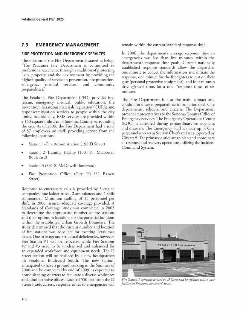
7-1�
Petaluma General Plan �0�5
7.3 emerGencymanaGement
FirE PrOtECtiOn and EMErGEnCy SErviCES
The mission of the Fire Department is stated as being: “The Petaluma Fire Department is committed to professional excellence through a tradition of protecting lives, property, and the environment by providing the highest quality of service in prevention, fire protection, emergency medical services, and community preparedness.”
The Petaluma Fire Department (PFD) provides fire, rescue, emergency medical, public education, fire prevention, hazardous materials regulation (CUPA) and response/mitigation services to people within the city limits. Additionally, EMS services are provided within a 160-square-mile area of Sonoma County surrounding the city. As of 2005, the Fire Department had a total of 57 employees on staff, providing service from the following locations:
Station 1–Fire Administration (198 D Street)
Station 2–Training Facility (1001 N. McDowell Boulevard)
Station 3 (831 S. McDowell Boulevard)
Fire Prevention Office (City Hall/22 Bassett Street)
Response to emergency calls is provided by 3 engine companies, one ladder truck, 2 ambulances and 1 shift commander. Minimum staffing of 15 personnel per shift, in 2006, assures adequate coverage provided. A Standards of Coverage study was completed in 2003 to determine the appropriate number of fire stations and their optimum locations for the potential buildout within the established Urban Growth Boundary. The study determined that the current number and location of fire stations was adequate for meeting Petaluma’s needs. Due to its age and structural deficiencies, however, Fire Station #1 will be relocated while Fire Stations #2 and #3 need to be modernized and enhanced for an expanded workforce and equipment needs. The D Street station will be replaced by a new headquarters on Petaluma Boulevard South. The new station, anticipated to have a groundbreaking in the Summer of 2008 and be completed by end of 2009, is expected to house sleeping quarters to facilitate a diverse workforce and administrative offices. Located 550 feet from the D Street headquarters, response times to emergencies will
•
•
•
•
remain within the current/standard response time.
In 2006, the department’s average response time to emergencies was less than five minutes, within the department’s response time goals. Current nationally established response standards allow the dispatcher one minute to collect the information and initiate the response, one minute for the firefighters to put on their gear (personal protective equipment), and four minutes driving/travel time, for a total “response time” of six minutes.
The Fire Department is also the main contact and conduit for disaster preparedness information to all City departments, schools, and citizens. The Department provides representatives to the Sonoma County Office of Emergency Services. The Emergency Operations Center (EOC) is activated during extraordinary emergencies and disasters. The Emergency Staff is made up of City personnel who act as Section Chiefs and are supported by City staff. The primary duties are to plan and coordinate all response and recovery operations utilizing the Incident Command System.
Fire Station 1 currently located on D Street will be replaced with a new facility on Petaluma Boulevard South.

7-15
7Community Facilities, Services, and Education
Goal7-G-5:FireprotectionProtect lives, property, and the environment by providing the highest quality of service in prevention, fire protection, emergency medical services, and community preparedness.
Policies and Programs:
7-P-17 Achieveandmaintainaminimumratioofone fire suppression personnel per 1,000population served or a similar level ofresponse service to meet increased callvolumes.
Fund additional staff to insure minimum ratio is maintained as population increases occur.
7-P-18 Ensurefacilities,equipmentandpersonnelareadequatetomaintainqualityofservicedemandsofthecommunity,includingbutnotlimitedto:firesuppression,AdvancedLifeSupport(ALS),rescue,fireprevention,education,CUPA,anddisasterpreparednessandmanagement.
Expand Fire staffing to provide a Training Officer to insure maintaining compliance to Federal and State safety mandates.
Continue education and training programs to maintain technical proficiency.
Maintain and modernize emergency response facilities, including fire stations, as needed to accommodate population growth.
Expand, as needed, staffing in the Fire Prevention Bureau to keep pace with increasing development and fire safety inspection impacts.
Maintain safety department responsiveness to changes in community demographics (i.e. age, ethnicity).
Retain a current computed-based records management system to allow monitoring and evaluation of program performance.
Continue to upgrade means of communication between emergency response personnel and emergency service facilities.
Continue to upgrade communication systems to maintain responsiveness to wireless calls for service.
A.
A.
B.
C.
D.
E.
F.
G.
H.
Encourage communication compatibility between local and regional systems.
7-P-19 Maintainafourminutetraveltimeforatotalof 6-minute response time for emergencieswithintheCity.
Require that properties outside of the four-minute (travel) response radii utilize fire-resistant materials and maintain fire breaks surrounding residences.
Ensure that transportation improvements are provided for additional development so as not to adversely impact emergency response times.
7-P-20 Strivetomaintainan InsuranceServiceOffice(ISO)ratingofClass3orbetter.
Work cooperatively with other City departments to insure applicable upgrades and updating of city infrastructure occur in a timely manner.
7-P-21 MaintainandexpandtheAmbulanceEnterpriseSystem to meet continued needs in theDistrict.
Provide a third ALS ambulance within the Petaluma Fire Department.
Establish and implement an ambulance replacement program.
Maintain current EMS training to meet industry standards.
7-P-22 Ensure emergency response equipment andpersonneltrainingareadequatetofollowtheprocedures contained within the EmergencyOperations Plan for a major event, throughmaintaining and updating, as appropriate,the City’s emergency preparedness programs,plans,andprocedurestoensurethehealthandsafety of the community in the event of anearthquakeorotherdisaster.
Review and update City department Disaster Operation Guides (DOGs) as needed.
Provide training to all City personnel to remain current with all State and Federal mandated training for disaster preparedness (i.e. NIMS).
Conduct training exercises for city personnel to simulate man-made or natural disasters.
Consider the need, and fiscal feasibility, of providing a dedicated Disaster Coordinator.
I.
A.
B.
A.
A.
B.
C.
A.
B.
C.
D.

7-1�
Petaluma General Plan �0�5
The Fire Department should provide the training and organization for community based volunteers who can provide localized assistance within their neighborhoods during an emergency.
7-P-23 ContinuetoutilizetheEmergencyOperationsCenter(EOC)toprovideearlywarningofandresponsetoalllife-threateninghazards,suchasearthquakes,floods,landslides,severestorms,andhazardousmaterialsincidents.
Evaluate the effectiveness of the EOC facility and consider relocation to other city facilities to improve emergency operations and coordination.
Support the establishment of, and publicize a low power FM radio station with links to the Emergency Alert system and the Petaluma Emergency Operations Center to keep the public informed during emergencies and disasters. Coordinate operation of this station with KPCA.
7-P-24 Ensurethatcriticalfacilities,includingmedicalcenters, school facilities, and other structuresthat are important to protecting health andsafety in the community, remain operativeduringemergencies.
Work with local hospitals and school districts to coordinate planning, communication and response.
7-P-25 Reduce the potential for a catastrophic fireevent in the historic Downtown and otherareas.
Complete the fire sprinkler retrofit installation within the historic Downtown business area.
Maintain and update the business fire safety inspections and pre-incident planning documents (Pre-Plans).
Explore requirements and opportunities for direct-link fire alarms.
7-P-26 Recognize the value of providing publiceducation in fire safety, first aid/CPR, andaccidentprevention.
Continue early childhood programs.
Add programs to meet the needs of the elderly (e.g. Senior Safety Program).
Hire a dedicated, part-time Public Education specialist.
E.
A.
B.
A.
A.
B.
C.
A.
B.
C.
Utilize Petaluma Community Access television and KPCA radio to create and broadcast educational programs regarding disaster preparedness, fire safety, first aid and other public safety issues.
7-P-27 Reducetheimpactsofwildlandfires.
Develop a program and standards to address the increased fire risk associated with development within the Urban Interface areas to the West.
Continue the annual Weed Abatement Program.
Continue the regulation of fireworks city wide.
Consider the prohibition of the sale and use of fireworks within the City, with the exception of city sanctioned and permitted events with appropriate City standards in place.
Conduct regular reevaluation of City-lands designated as Very High or High Fire Hazard Severity Zones.
7-P-28 Expand the capabilityof theFireDepartmenttorespondtoRiverrelatedemergencies.
With revitalization of the Downtown and the Petaluma River corridor, along with increased river activities, purchase a new rescue/fire boat and relocate it on the River for better response times and increased opportunities for emergency response.
7-P-29 Consider the feasibility of pursuing nationalaccreditationthroughtheCommissiononFireDepartmentAccreditationInternational.
7-P-30 Maintain cooperative agreements for mutualaidataStatelevelandautomaticaidatalocallevel.
Review and update as needed to maintain an acceptable level of service within the District.
D.
A.
B.
C.
D.
E.
A.
A.

7-17
7Community Facilities, Services, and Education
POliCE SErviCES
The Petaluma Police Department (PPD) provides police services to the City of Petaluma. As of 2005, the PPD had a total of 95 full-time employees, including the Chief, one Captain, three Lieutenants, 11 Sergeants, 53 Officers, five Community Service Officers, two Parking Enforcement Officers, and other support staff. Additionally, the Department has D.A.R.E. Officers, School Resource Officers, a Traffic Unit with a Serious Traffic Offender Program (S.T.O.P.), a K-9 Unit, Bicycle and Motorcycle Patrol, a SWAT Team, a Hostage Negotiation Team, Gang Enforcement and Street Crimes Units, an Investigation Unit, and a volunteer Reserve Community Service Officer Program. The police station is located at 969 Petaluma Boulevard North. The current Police building is beyond its useful capacity for office space, storage space, and locker space for personnel. City growth, technology growth, additional personnel, and the need for a larger Emergency Operations Center, will increase the need to expand the police facility within the next few years. The existing 1.8-acre site could accommodate a major expansion of the police services facility, but only if the facility were relocated to allow complete reconstruction of the site.
With a total of 74 police officers (including Sergeants, Lieutenants, Captains, and the Chief ) the PPD offers a service ratio of 1.3 officers per 1,000 residents. This is consistent with the current nationally-accepted standard service ratio of 1.25 officers per 1,000 residents. The PPD also has a recommended emergency response time of three minutes.
The guiding philosophy of the Police Department has been to expand beyond the traditional incident based policing model to a proactive community policing and problem solving model. The COPPS (Community Oriented Policing and Problem Solving) philosophy recognizes the value of education and crime prevention programs as being more effective and less costly in reducing crime than the costs of apprehending, prosecuting and incarcerating criminals.
Goal7-G-6:policeservicesProvide police services that are responsive to citi-zens’ needs to ensure a safe and secure environ-ment for people and property in the community.
Policies and Programs:
7-P-31 Maintain a minimum standard of 1.3 policeofficersper1,000populationorasimilarlevelofcoveragetomeetincreasedservicecalls.
Provide additional staff to ensure the minimum ratio is maintained as the population increases.
7-P-32 Develop and use the City’s ComputerAided Dispatch System (CAD) and RecordsManagement System (RMS) for analysis ofissues,crimetrendsandresponsetimes.
7-P-33 Pursue a long-term strategy for fundingeducation and crime prevention programsrecognizing that the costs of education andpreventionaremoreeffectiveinreducingcrimethan the costs of apprehending, prosecutingandincarceratingcriminals.
7-P-34 Plan for expanding or replacing the policestation with a facility (either on-site orelsewhere) of sufficient size to accommodatepolice operations, community requirementsand anticipated population growth. Fundingof expanded facilities should be addressedthrough the implementation of adequatePublic Facilities fees as identified in theImplementationPlan.
7-P-35 Incorporate, into new development to theextent deemed appropriate and feasible, theDevelopment Code Urban Design Standardsforcrimeprevention.
7-P-36 Ensureadequatepolice staff toprovide rapidand timely response to all emergencies andmaintain the capability to have minimumaverageresponsetimes.Actionsthatcouldbetaken toensure rapidand timely response toallemergenciesinclude:
Analyze and monitor factors affecting response time (population growth, police staffing, and community policing programs) and average response times as guidelines based on past experience.
A.
A.

7-1�
Petaluma General Plan �0�5
Maintain, train, and equip special response teams for extraordinary or extremely hazardous emergency incidents.
7-P-37 Consider expansion of leadership staffallocation to provide a sufficient number ofcommand personnel to manage operations,provideadministrativeoversightandlogisticalsupport.
B.
Crime Prevention through design
With the appearance of Oscar Newman’s Defensible Space in 1972 as well as Jane Jacobs’ The Death and Life of Great American Cities (1961), a new urban design approach to crime prevention was established. “Defensible space,” or what has come to be known as Crime Prevention through Environmental Design (CPTED), is based on the premise that the proper design and use of the physical environment can lead to a reduction in the occurrence and fear of crime, thereby improving the quality of life.
The three key principles of CPTED include:
Natural surveillance. Building on Jacobs’ notion of “eyes on the street,” this strategy focuses on designing the built environment in a manner that promotes visibility of public spaces and areas. Natural surveillance limits the opportunity for crime by taking steps to increase the perception that people can be seen, including possible intruders. Design features that maximize visibility include doors and windows that look onto streets and other common areas, front porches, low landscaping, adequate lighting, see-through fencing, and windowed stairwells. Allowing for a mix of uses can also facilitate natural surveillance as it ensures activity 24 hours a day, seven days a week.
Natural Access Control. This strategy refers to the use of doors, fences, and gates to control access. The idea is to create a perception of risk
•
•
to a perpetrator, thereby deterring access to a crime target or victim. Natural access control depends on the uses of sidewalks, pavement, gates, lighting, and landscaping to clearly guide the public to and from entrances and exits. Fences and signage also guide people to appropriate buildings and entry ways while directing them away from private areas.
Territorial Reinforcement. Territorial reinforcement promotes control by clearly demarcating private from public spaces, as well as by creating a sense of ownership. The sense of owned space creates an environment where strangers or intruders are more easily identified. The use of physical features that express ownership such as fencing, pavement treatments, signage, and landscaping help distinguish between public and private areas and helps users exhibit signs of ownership.
Other aspects of CPTED include maintenance and activity support. Proper maintenance of public areas encourages use of the space for its intended purpose and discourages abnormal or criminal use. Crime is less likely in public spaces that are well designed, well managed, and well maintained. In addition, placing appropriate activities in an area increases surveillance and enhance access control. Activity support involves filling functional spaces, such as recreational facilities and common areas, with legitimate users so that any potential abusers are discouraged from entering.
•
7-P-38 Continueparticipation in theSonomaCountyLaw Enforcement Computer Aided DispatchMobileDataTerminalConsortium.
7-P-39 Considerfundingadditionalstafftoestablishacrimeanalysisunit.
7-P-40 Expand capability of the Police Departmentto respond to and effectively deal with riverrelatedcrimesandemergencies.

7-1�
7Community Facilities, Services, and Education
hOSPitalS and hEalth CarE FaCilitiES
Petaluma currently has four health care facilities—Petaluma Valley Hospital, Petaluma Health Center, Kaiser Permanente and the Hospice of Petaluma. Demand for health care will likely increase as Petaluma’s population ages over the General Plan time frame. The Petaluma Health Center is planning to expand to meet the needs of a growing service area population. Other hospitals and health care facilities may also desire to expand or relocate during the General Plan time frame.
Goal7-G-7:hospitalsandhealthcareFacilitiesrecognize the importance of maintaining, and ex-panding, health Care Facilities serving the commu-nity.
Policies and Programs:
7-P-41 Maintain communication with the variousmajor health care facilities (Petaluma ValleyHospital, Kaiser) to ensure that adequatemedical facilitiesandservicesareprovidedtomeetthevaryingneedsofthecommunity.
Work with the Petaluma Health Care District to achieve superior health care and emergency care facilities.
Support expansion of health care facilities to match the growing population and changing demographics of the community.
7-P-42 Recognize the health benefit of a ‘walkable’communitywithneighborhoodaccesstoparksandtrails.
As development occurs, ensure that connectivity is established to recreational amenities and retail opportunities.
Maintain communication with the health care industry to incorporate new means of sustaining a healthy community environment.
A.
B.
A.
B.
Petaluma Valley Hospital (above) and Kaiser Permanente (below) are two major health care facilities currently located in Petaluma.

7-�0
Petaluma General Plan �0�5
This page intentionally left blank.

The Water Resources Element brings four components (Water Supply and Demand, Recycled Water, Wastewater, and Surface Water) of Petaluma’s water systems to the forefront, equal in weight to the other elements, rather than obscured within an element covering a multitude of community facilities topics. As quoted by Mark Twain “Whiskey’s for drinking, water’s for fighting”; water has been the source of the most intensive part of the work effort of this Plan, and certainly much of the controversy and public discussion. The approach to the community’s water resources, through direction from the City Council, has been to address water related issues holistically. Recognizing the scarcity of the resource and the need to use water in the most environmentally sensitive and responsible manner has resulted in an element that offers innovative solutions to meet the community’s needs now and well into the future.
Water Resources

8-�
Petaluma General Plan �0�5
8.1 WATERSUPPLYANDDEMAND
IntRoductIon
The Water Supply and Demand section of the Water Resources Element presents a plan for providing Petaluma’s residents and businesses with a safe, reliable, and high quality source of water through 2025 and beyond, using a mix of imported water purchased from the Sonoma County Water Agency (SCWA), recycled water, water conservation and groundwater. A challenging and more complex environment requires development of a new approach towards water supply through the General Plan period. Modest population growth translates into water demands increasing from 3,600 million gallons per year (11,000 acre-feet per year) in the baseline year of 2002, to approximately 5,139 million gallons per year (15,775 acre-feet) in 2025. Regulatory and environmental issues have delayed the SCWA’s expansion of its water transmission system. Consequently, projected demands will exceed the amount of water the SCWA can provide without expanding its water transmission system. Should the SCWA complete expansion of the water transmission system prior to 2025, the City may revisit this plan , particularly regarding the volume of tertiary recycled water provided for offset.
BackGRound & context
Petaluma’s water supply prior to 1961 was provided by local groundwater, supplemented by water from Lawler Reservoir and the Station #7 filter plant. Water quality concerns prompted the City to investigate alternate water supplies. On May 9, 1960, the City of Petaluma and the North Marin Water District entered into an agreement with the SCWA for the annual delivery of 4,500 acre-feet and 10,000 acre-feet of water, respectively. In response, the SCWA began construction of the Petaluma Aqueduct, which included a 16-1/2 mile long 24-inch and 33-inch diameter pipeline from Santa Rosa to Petaluma, a booster pumping plant, and a six million gallon reservoir near Lake Ralphine.
The Petaluma Aqueduct began operating in December 1961. The superior quality aqueduct water quickly became the City’s primary source of water. The City continues to maintain and operate local wells to meet peak demands and emergency needs. Today, the Santa Rosa Aqueduct and the Russian River-Cotati Intertie carry Russian River water from SCWA diversion facilities located in the Wohler and Mirabel areas to Petaluma via the Petaluma Aqueduct. In addition,
SCWA operates three groundwater wells in the Santa Rosa Plain that supplement the water supply from the Russian River. Treatment is provided by chemical addition for disinfection and corrosion control.
Petaluma’s primary source of water continues to be Russian River water purchased from the SCWA. The SCWA supplies water to Petaluma and seven other water contractors under the Restructured Agreement For Water Supply. Under the Restructured Agreement, Petaluma’s monthly water supply entitlement from the SCWA is an average-day maximum month supply of 21.8 mgd and an annual supply limit of 13,400 acre-feet per year (4,366 million gallons)1. The SCWA also supplies water to Petaluma and other water contractors under the Temporary Impairment Memorandum of Understanding (MOU). The MOU governs allocation of water during periods of Temporary Impairment. Under the MOU, Petaluma is obligated to use its best efforts to limit its demand on the Transmission System to 17.1 mgd. The MOU supersedes the Restructured Agreement. The City supplies approximately 68 percent residential and 32 percent non-residential customers, which include commercial, institutional, and industrial customers. In the baseline year of 2002, the City delivered more than 3,600 million gallons (11,000 acre-feet) of potable water to Petaluma’s residents and businesses.
Water Rights and Supply
The State Water Resources Control Board (Board) is the agency with authority over water rights in California. California water rights permits often contain terms limiting rates of direct diversion and re-diversion. Direct diversion refers to water diverted directly from stream flows. Re-diversion refers to water that has first been diverted to storage in a reservoir, then released and diverted again (re-diverted) at a point downstream. The Agency operates its facilities under four (4) separate Board permits. The combined direct diversion and re-diversion under all four permits is limited to 75,000 acre-feet (24,400 million gallons) per year, with a maximum diversion rate of 180 cubic feet per second.
As reported in the SCWA’s Water Supply Workshop Report (November 2004), the objective of the Water Project is to provide a safe, economical, and reliable water supply to meet the defined current and future water supply needs in the Agency’s service area. The EIR 1 Annual entitlement limits were not included in the water supply
agreements prior to the 11th Amended Agreement.
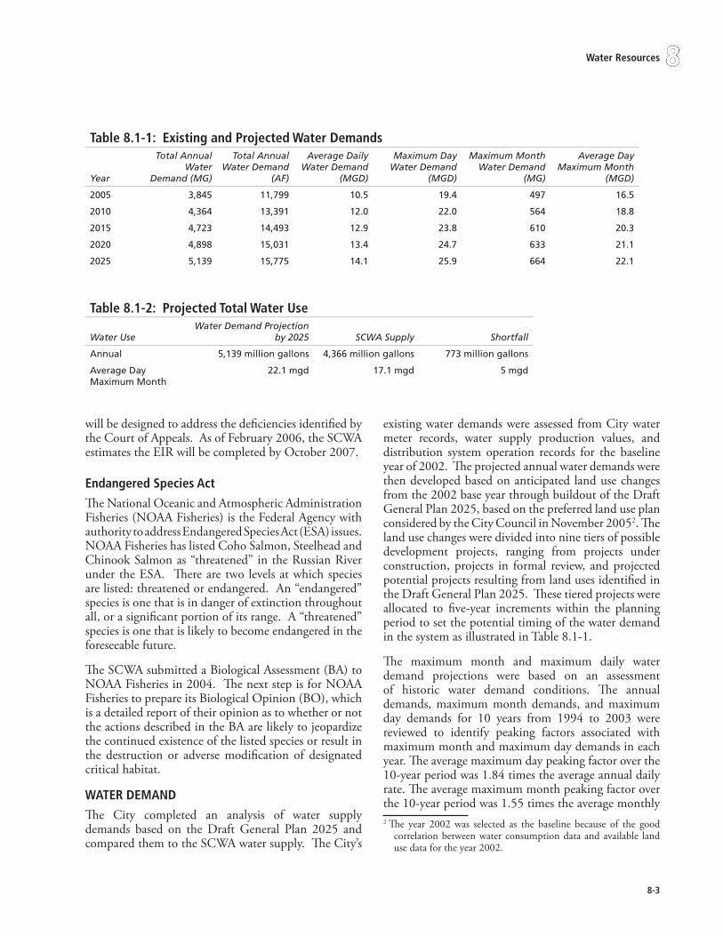
8-�
8Water Resources
will be designed to address the deficiencies identified by the Court of Appeals. As of February 2006, the SCWA estimates the EIR will be completed by October 2007.
endangered Species act
The National Oceanic and Atmospheric Administration Fisheries (NOAA Fisheries) is the Federal Agency with authority to address Endangered Species Act (ESA) issues. NOAA Fisheries has listed Coho Salmon, Steelhead and Chinook Salmon as “threatened” in the Russian River under the ESA. There are two levels at which species are listed: threatened or endangered. An “endangered” species is one that is in danger of extinction throughout all, or a significant portion of its range. A “threatened” species is one that is likely to become endangered in the foreseeable future.
The SCWA submitted a Biological Assessment (BA) to NOAA Fisheries in 2004. The next step is for NOAA Fisheries to prepare its Biological Opinion (BO), which is a detailed report of their opinion as to whether or not the actions described in the BA are likely to jeopardize the continued existence of the listed species or result in the destruction or adverse modification of designated critical habitat.
WateR demand
The City completed an analysis of water supply demands based on the Draft General Plan 2025 and compared them to the SCWA water supply. The City’s
existing water demands were assessed from City water meter records, water supply production values, and distribution system operation records for the baseline year of 2002. The projected annual water demands were then developed based on anticipated land use changes from the 2002 base year through buildout of the Draft General Plan 2025, based on the preferred land use plan considered by the City Council in November 20052. The land use changes were divided into nine tiers of possible development projects, ranging from projects under construction, projects in formal review, and projected potential projects resulting from land uses identified in the Draft General Plan 2025. These tiered projects were allocated to five-year increments within the planning period to set the potential timing of the water demand in the system as illustrated in Table 8.1-1.
The maximum month and maximum daily water demand projections were based on an assessment of historic water demand conditions. The annual demands, maximum month demands, and maximum day demands for 10 years from 1994 to 2003 were reviewed to identify peaking factors associated with maximum month and maximum day demands in each year. The average maximum day peaking factor over the 10-year period was 1.84 times the average annual daily rate. The average maximum month peaking factor over the 10-year period was 1.55 times the average monthly 2 The year 2002 was selected as the baseline because of the good
correlation between water consumption data and available land use data for the year 2002.
table 8.1-1: existing and Projected Water demands
Year
Total Annual Water
Demand (MG)
Total Annual Water Demand
(AF)
Average Daily Water Demand
(MGD)
Maximum Day Water Demand
(MGD)
Maximum Month Water Demand
(MG)
Average Day Maximum Month
(MGD)
2005 3,845 11,799 10.5 19.4 497 16.5
2010 4,364 13,391 12.0 22.0 564 18.8
2015 4,723 14,493 12.9 23.8 610 20.3
2020 4,898 15,031 13.4 24.7 633 21.1
2025 5,139 15,775 14.1 25.9 664 22.1
table 8.1-�: Projected total Water use
Water UseWater Demand Projection
by 2025 SCWA Supply Shortfall
Annual 5,139 million gallons 4,366 million gallons 773 million gallons
Average Day Maximum Month
22.1 mgd 17.1 mgd 5 mgd

8-�
Petaluma General Plan �0�5
demand. These 10-year average peaking factors were applied to the annual projections to obtain maximum month and maximum day projections.
Through build-out of the Draft General Plan 2025, Petaluma’s total demand by 2025 is projected to be approximately 5,139 million gallons annually (15,775 acre-feet). Petaluma’s current (2006) entitlement of 4,366 million gallons (13,400 acre-feet) per year from SCWA alone will not be sufficient to meet the growth projected through 2025. The analysis also shows that by 2025, the average day maximum month (ADMM) demand, or peak demand, will be 22.1 mgd, which exceeds the Temporary Impairment MOU limit of 17.1 mgd.3 By 2025, this analysis indicates there will be an 3 The Average Day Maximum Month, or ADMM, is the average
daily flowrate for the month with the most water use.
annual demand shortfall of 773 million gallons (2,371 acre-feet) per year and an ADMM demand shortfall of 5 mgd. The analysis further indicates that the shortfall in ADMM may begin occurring during peak demand periods as early as 2007 and the annual demand shortfall may begin occurring as early as 2010.4 The projected demands are presented in Table 8.1-2.
4 With Rooster Run using recycled water beginning in 2006, the shortfall in ADMM could occur in 2008, and an annual shortfall could occur in 2011.
table 8.1-�: current and Projected annual Water Supply Annual Supply Conditions Total Annual Water Supply in Million Gallons
2005 2010 2015 2020 2025
SCWA 3,845 4,055 4,212 4,240 4,364
Recycled Water 0 217 331 431 464
Water Conservation 0 91 180 228 250
Groundwater 0 0 0 0 61
Total Supply Sources 3,845 4,363 4,723 4,899 5,139
Annual Supply Conditions Total Annual Water Supply in Acre-Feet
SCWA 11,799 12,443 12,923 13,009 13,397
Recycled Water 0 667 1,017 1,322 1,425
Water Conservation 0 280 553 700 767
Groundwater 0 0 0 0 186
Total Supply Sources 11,799 13,391 14,493 15,031 15,775
Source – Dodson Engineers, 2006
table 8.1-�: current and Projected maximum month Water SupplyADMM Supply Conditions Average Daily Flow During Maximum Month in Million
Gallons per Day
2005 2010 2015 2020 2025
SCWA 16.5 16.8 16.9 16.6 16.7
Recycled Water 0.0 1.5 2.5 3.4 3.6
Water Conservation 0.0 0.5 0.9 1.1 1.3
Groundwater 0.0 0.0 0.0 0.0 0.5
Total Supply Sources ADMM
16.5 18.8 20.3 21.1 22.1
Source – Dodson Engineers, 2006

8-5
8Water Resources
WateR SuPPly
The Water Supply and Demand Analysis Report is a long-term plan that increases the use of recycled water, expands the water conservation program, and includes the moderate use of groundwater to meet increasing potable water demands, until such time as the SCWA is able to expand its water transmission system. These opportunities translate into viable water supply options that were evaluated by the City with the goal of identifying the appropriate mix of water supply that allow the City to meet its long-term water supply needs. The planned mix of water supply sources to meet projected annual and maximum month water demands are illustrated in Tables 8.1-3 and 8.1-4 respectively.
Recycled WateR
Water recycling is the treatment and management of municipal, industrial, or agricultural wastewater to produce water that can be reused for beneficial uses, and offset demands for drinking water supplies (potable water). Water recycling provides an additional source of water that can be used for purposes such as irrigation or environmental restoration. While historically, the City of Petaluma has used recycled water primarily for agricultural irrigation, the City now has an opportunity to use recycled water as a water supply that can offset current and future potable water demands. For additional information see the Water Supply and Demand Analysis Report (Dodson 2006).
The City is constructing the Ellis Creek Water Recycling
Facility (WRF), expected to come on line in 2009. The facility will produce tertiary recycled water in accordance with California Department of Health Services (DHS) Title 22 requirements for unrestricted use. Allowable irrigation uses for tertiary recycled water include parks and playgrounds, schoolyards, residential landscaping, unrestricted access golf courses, food crops, and other uses permitted by the DHS through the California Code of Regulations.
The recycled water program consists of a least cost combination of tertiary and secondary treatment scenarios that, in combination, distribute all recycled water from the City’s Ellis Creek Water Recycling Facility during the period of restricted discharge into the Petaluma River, provide system flexibility, and create sufficient potable use offset. Potable offset is defined as current potable water use that is replaced by tertiary water use.
table 8.1-5: Summary tertiary Recycled Water customers Customer Type Total ADMM
Flowrate (mgd)Number of
Customers/Sites
Golf Course 1.0 2
Open Space 0.2 3
Park 1.3 37
School 1.0 19
Turf 0.1 1
Total 3.6 62
The Ellis Creek Water Recycling Facility, nearing completion,will provide tertiary recycled water to offset potable demand.
8-�
Petaluma General Plan �0�5
The Water Resources Plan calls for a phased approach to further implement the use of recycled water throughout the City of Petaluma. The first customer is the Rooster Run Golf Course which uses approximately 138 MG/year of water for irrigation of 126 acres. Since the Rooster Run Golf Course can be supplied with secondary recycled water by the existing recycled water system, the backbone pipeline was designed and built to be in use by summer 2006. The pipeline will temporarily connect to the existing secondary recycled water system to serve Rooster Run Golf Course until the tertiary system goes online in Year 2009. A summary of the type of customers and potable offset demands are summarized in Table 8.1-5.
The tertiary recycled water distribution system will eventually be expanded to serve irrigation needs in all four quadrants of the City. Service to these areas will require significant capital improvements including a new pipeline distribution system, two 1.0 MG reservoirs, pump station and eventually an increase in the tertiary treatment capacity of the Ellis Creek WRF. The system would be expanded incrementally through 2025.
WateR conSeRvatIon
The City’s water conservation program focuses on thirteen best management practices (BMPs) or water demand management measures. The City utilizes water conservation BMPs as a method to reduce water demands, thereby reducing water supply need for the City.
The City is a member of the California Urban Water Conservation Council (CUWCC). The CUWCC was created to assist in increasing water conservation statewide, under a Memorandum of Understanding (MOU). As signatory to the MOU, the City has pledged their good faith effort towards implementing BMPs identified in the CUWCC MOU Regarding Urban Water Conservation. The City signed the CUWCC MOU on January 31, 2002, and submits annual BMP reports to the CUWCC in accordance with the MOU. The MOU requires that a water utility implement only the BMPs that are economically feasible. If a BMP is not economically feasible, the utility may request an economic exemption for the BMP. The City has not requested economic exemption from any of the BMPs at this time.
Table 8.1-6 includes the CUWCC BMPs currently performed by the City. The CUWCC BMP 10,
Wholesale Agency Assistance Programs, does not apply to the City since the City does not wholesale water to another entity.
The City’s continued implementation of the thirteen water conservation BMPs will provide water use reductions throughout the planning period. However, to increase water conservation in the future to meet projected water demands, seven additional BMPs will be implemented and are listed in Table 8.1-7. The additional BMP program is scheduled to start in 2008.
The new water conservation measures will supplement the City’s existing water conservation program, and will be phased in over the years 2008 – 2025. The new measures are projected to boost annual savings by approximately 250 million gallons, and reduce peak day demands by 1.28 mgd. The estimated total cost is $8.3 million5. In October 2005, the City began work on a Water Conservation Plan to identify potential water conservation measures and programs that are beyond the scope of the BMPs. This effort will conclude in Fall 2006, and will include a program for additional water conservation savings.
The proposed water conservation program, combined with the proposed recycled water program, will save a total of 714 million gallons of potable water annually, and reduce peak day demands by 4.85 mgd. The remaining potable water shortfall through build-out of the Draft General Plan 2025 of 59 million gallons annually and a peak day demand of 0.15 mgd may need to be met through the measured use of groundwater.
GRoundWateR
The City intends to use groundwater primarily for standby or emergency conditions and will meet all normal demands from surface water (SCWA), recycled water, and conservation in the near term (Dodson Engineers, 2006). The City’s intent is to continue to provide minimum month average day demands from its well supply as a short-term emergency, drought, or SCWA supply containment source of water. Following past practices, groundwater use may be utilized during the planning period to meet peak water demands in the summer months. In 2006 the City had six active wells and nine inactive wells. Groundwater will also serve as a water supply if SCWA deliveries are curtailed.
At the end of the planning period in years 2024 and 2025, the water supply available to the City from SCWA, in combination with recycled water and water
5 Present worth, 2006 dollars.

8-�
8Water Resources
table 8.1-�: city Water conservation Best management PracticesBest Management Practices, BMP
BMP 01:Water Survey Programs for Single-Family and Multi-Family Residential Customers
BMP 02:Residential Plumbing Retrofit
BMP 03:System Water Audits, Leak Detection, and Repair
BMP 04:Metering with Commodity Rates for all New Connections and Retrofit of Existing
BMP 05:Large Landscape Conservation Programs and Incentives
BMP 06:High-Efficiency Washing Machine Rebate Programs
BMP 07:Public Education Programs
BMP 08:School Education Programs
BMP 09:Conservation Programs for Commercial, Industrial, and Institutional Accounts
BMP 10:Wholesale Agency Assistance Programs
BMP 11:Conservation Pricing
BMP 12:Conservation Coordinator
BMP 13:Water Waste Prohibition
BMP 14:Residential and Commercial Ultra Low Flow Toilet (ULFT) Replacement Programs
table 8.1-�: additional city Water conservation Best management PracticesMeasure Description
Recirculating Hot Water System for New Developments
Require all new single family and multi family housing units to have a recirculating hot water system installed. This includes a recirculation pump and insulated hot water pipes. An alternative may allow a tankless, instant hot water system.
High Efficiency Toilet Installation Provide free contractor installation of high efficiency toilets, either dual flush (6/3 liter) or 4 liters-per-flush toilets.
Rain Sensors Provide sensors to customers for their automatic irrigation system (controller). Users install sensors themselves.
Landscape Education Training Combination of three types of training classes: (1) Xeriscape, (2) Homeowner Irrigation, and (3) Promotion of water efficient plants.
ET Controller Rebates Provide rebates for purchase of weather adjusting (ET) irrigation controllers to customers. Users install controllers themselves.
Landscape Requirements Establish and enforce new landscape requirements for new non-single family landscaping.
Commercial Urinal Rebates Selectively provide rebates to businesses to convert to efficient (0.5 gallons/flush) or waterless urinals subject to high use, such as restaurants, theaters, schools, etc.
conservation may not be sufficient to meet annual or maximum month demands. This assumes buildout of the General Plan, which may or may not occur by 2025 based on market, growth management, and interim policies. The potential shortfall is estimated at 186 acre-feet per year, which is available by pumping approximately four of the existing wells. A combination of existing wells delivering an average of 0.5 MGD over the course of the four summer months would satisfy the annual supplemental supply condition of 186 acre-feet
(60.75 million gallons). Existing well stations will be rehabilitated and individual wellhead treatment will be provided to meet water quality standards in place at that time. These flow rates are significantly below the City’s historic groundwater pumping levels.
The groundwater would also continue to be used to supplement the maximum month demands. Combining SCWA water, recycled water and water conservation as described above leaves a peak day demand shortfall of

8-8
Petaluma General Plan �0�5
GOAL8-G-1:WaterSupplyandDemandProvide a safe, reliable, high-quality, economical and sustainable source of water to meet the community’s needs.
Policies and Programs:
8-P-1 Optimizetheuseof importedwaterfromtheSCWAtoprovideadequatewater forpresentandfutureuses.
Prepare, implement, and maintain long-term, comprehensive water supply plans and options in cooperation with the appropriate state and federal agencies, regional authorities, water utilities, and local governments.
Support regional efforts towards ensuring that imported water is reliable, cost-effective, and is of high quality.
8-P-2 Continue to work to maintain water supplyagreements with SCWA to ensure adequatepotablewater.
8-P-3 WorkwiththeSonomaCountyWaterAgencyon the South Transmission System Projectto develop the parallel aqueduct along theCity’spreferredeastsidealignmentinordertoimprovereliabilityofwatersupplies.
8-P-4 TheCityshallroutinelyassessitsabilitytomeetdemandforpotablewater.
A.
B.
The City shall continue to monitor the demand for water for projected growth against actual use, and ensure that adequate water supply is in place prior to, or in conjunction with, project entitlements.
The City planning staff will discuss water supply with the developer for each new development early in the planning process and inform Water Resources staff of upcoming demands as provided by the applicant.
The City shall maintain a tiered development record to monitor pending and projected developments to allow a reasonable forecast of projected water demand.
The City shall upgrade utility billing software as necessary to provide the ability to efficiently track and project water demand trends including, but not limited to, the following parameters.
Land use categories
Customer classifications
8-P-5 Develop alternative sources of water tosupplementimportedsupply.
Expand the use of recycled water to offset potable demand.
Expand water conservation to further improve the efficient use of potable water.
Continue to use groundwater to meet emergency needs.
8-P-6 The City shall utilize the Water Demand andSupply Analysis Report, June 2006 and anyamendmentsthereto,formonitoring,assessingand improving the City’s municipal watersupply.
Require implementation of adopted Water Master Plan through conditions of approval for all public and private development.
8-P-7 Limit the provision of potable water serviceto lands within the Urban Growth Boundarywiththeexceptionof theprovisionsoutlinedin the Urban Growth Boundary measure andincorporatedintoChapter2LandUse,GrowthManagement,andtheBuiltEnvironment.
A.
B.
C.
D.
•
•
A.
B.
C.
A.
about 0.15 MGD at the end of the planning period. This peak demand can be met by the 0.5 MGD pumping of groundwater to meet annual demands during this period, reducing the surface water deliveries to less than the maximum month limit. This would provide additional flexibility and reliability in meeting maximum daily demands with either surface water or groundwater during the month.
Additional opportunities for water conservation, beyond those provided above, could be evaluated for applicability such as permitting gray water systems, composting toilets, drywells for drinking fountains; or other best management practices developed in the future. Any service or system connected or receiving service from the municipal source must be in full compliance with public health and safety regulations.

8-�
8Water Resources
Goal8-G-2:WaterSupplyandDemandcontinue to maintain a high level of customer service and satisfaction.
Policies and Programs:
8-P-8 Provide timely responses to customerservice requests and improve educationalopportunities.
Implement monthly utility billing.
Convert to an automated meter reading system (AMR).
Provide additional information to customers on their water use through utility billing and new technology, such as web-based service programs. Additional information shall include amount of water used by tier for the current billing period, charge for each tier, amount of water used for wastewater charge during the current billing period, and recent water use history.
Expand community service programs such as:
Conducting customer statistical analyses.
Conducting consumer surveys.
Providing customer leak detection services.
Participating in the Business Water Project by the Business Environmental Alliance.
Developing a community recognition program that recognizes efforts to implement Best Management Practices.
Goal8-G-3:RecycledWatermaximize the use of recycled water as a potable water offset to manage water demands, and meet regulatory requirements for wastewater discharge.
Policies and Programs:
8-P-9 Provide tertiary recycled water for irrigationofparks,playfields, schools,golf coursesandotherlandscapeareastoreducepotablewaterdemand.
Expand the Ellis Creek Water Recycling Facility to provide tertiary and secondary recycled water as outlined in the Recycled Water Master Plan.
Operate and maintain the Ellis Creek Water
A.
B.
C.
D.
•
•
•
•
•
A.
B.
Recycling Facility to produce recycled water to meet or exceed current regulatory standards.
8-P-10 TheCitymayrequiretheuseofrecycledwaterthroughtheCitydevelopmentreviewprocess.
New development may be required to install a separate recycled water system as deemed necessary and appropriate by the City to offset potable demand.
Evaluate where the most appropriate potable water offset improvements can be implemented.
Determine the appropriate means of potable offset. Individual project systems may be required in addition to City-required improvements and/or fees relating to the recycled water offset system.
8-P-11 TheCitymaycontinuetoworkwithagriculturalusers to reuse secondary recycled water. Inaddition, the City may purchase land as abackup reuse site, if deemed necessary andappropriatetomeetsystemneeds.
8-P-12 Providewaterofadequatequalityandquantitytomeetcustomerneeds.TheCity,atits’solediscretion,duringtheenvironmentalreviewandentitlementprocess,willdeterminewhetheragivencustomer’ssupplywillbepotablewater,tertiary recycled water, secondary recycledwater, groundwater, or a combination ofthese.
8-P-13 Work to convert existing potable watercustomersidentifiedundertheCity’sRecycledWater Master Plan to tertiary recycled wateras infrastructure and water supply becomesavailable.
Require implementation of adopted Recycled Water Program improvements through conditions of approval for all public and private development.
A.
B.
C.
A.

8-10
Petaluma General Plan �0�5
Goal8-G-5:WaterConservationmaximize water conservation measures to improve water use efficiency and reduce overall water demand.
Policies and Programs:
8-P-18 Reduce potable water demand throughconservationmeasures.
Implement the Water Conservation Plan that incorporates conservation measures beyond the Best Management Practices developed by the California Urban Water Conservation Council.
Continue to expand the application of Water Conservation Best Management Practices.
Implement the City’s Water Drought Contingency Plan to assist citizens in reducing water use during periods of water shortages and emergencies.
Revise the City’s Landscape Ordinance to encourage, or as appropriate require, the use of water-efficient landscaping.
Regularly update regulations, codes and agreements to implement water conservation and discourage wasteful use of water.
Enforce conservation measures that eliminate or penalize wasteful uses of water.
A.
B.
C.
D.
E.
F.
Goal8-G-4:Wastewatermanage the wastewater collection and treatment system to address 100 percent capture and treatment of the city’s wastewater in an economically and ecologically sound manner.
Policies and Programs:
8-P-14 The water recycling facility shall be operatedand maintained in compliance with all StateandFederalpermitrequirements.
8-P-15 Capacity of the water recycling facility shallbemaintained,andexpandedasnecessary,tokeeppacewiththecity’sgrowth.
Require implementation of adopted Water Recycling Facility master Plan and distribution program improvements through conditions of approval for all public and private development.
8-P-16 Comply with the current Statewide GeneralWaste Discharge Requirements concerningthe operation and maintenance of the City’ssanitarysewercollectionsystem.
Perform condition assessment of existing facilities.
Survey facilities and maintain current system maps.
Perform regular cleaning and inspection to help eliminate sanitary sewer overflows.
Fund collection system infrastructure replacement on a 100-year life cycle.
Regularly update the sanitary sewer flow model and make improvements necessary to support development.
8-P-17 Maintain and expand public access andeducational opportunities at the Ellis Creek
WaterRecyclingFacility.
A.
A.
B.
C.
D.
E.

8-11
8Water Resources
Goal8-G-6:GroundwaterSupplyPreserve and maintain the city’s groundwater resources.
Policies and Programs:
8-P-19 Ensure adequate water supply duringemergencysituationsbydevelopingpotentialgroundwater resources and aquifer storagecapacity,combinedwithmanagementofsurfacewater,tomeetoverallemergencywatersupplyobjectives. The City’s groundwater resourcesshall be preserved to meet emergency needsandtooffsetpeakdemands.
The City will develop additional wells to supply the average minimum month water demand.
Work cooperatively with the County of Sonoma to protect and preserve Petaluma groundwater resources, including the preservation and enhancement of significant recharge areas within the watershed.
Evaluate the need and feasibility of developing limited wellhead treatment facilities to insure water quality requirements.
Preserve oak woodlands, upland native grassland, and wetland areas identified as contributing to groundwater recharge; at a minimum for areas identified within the Groundwater Feasibility Study, Technical Memo 4, dated February 2004 (Technical Appendix Volume 4).
8-P-20 Manage groundwater as a valuable andlimitedsharedresourcebyprotectingpotentialgroundwaterrechargeareasandstreamsidesfromurbanencroachmentwithinthePetalumawatershed.
See, at a minimum, those areas defined as possible recharge areas set forth in Technical Appendix Volume 4, Groundwater Feasibility Study, 2004, or revisions thereto.
Control construction of impervious surfaces in groundwater recharge areas. Potential recharge area protection measures at sites in groundwater recharge areas include, but are not limited to:
Restrict coverage by impervious materials;
Limit building or parking footprints;
Require construction of percolation ponds on site.
A.
B.
C.
D.
A.
•
•
•
Require surface drainage swales
B. Urge the County when reviewing development applications, to examine the combined impacts of new septic tanks placed in proximity to wells and the ability to maintain adequate protection of groundwater resources. The County should examine the cumulative impacts of the allowed development densities in the West Petaluma Specific Plan area and compare the results to established water quality standards. Test wells should be required prior to issuing any building permits.
8-P-21 Protect groundwater quality from surfacecontamination by requiring 100 foot sanitarysealsonallnewmunicipalwatersupplywells.
•

8-1�
Petaluma General Plan �0�5
Goal8-G-7:WaterDistributioncontinue to invest in the city’s storage and distribution system to insure reliable delivery of high quality water to meet daily and emergency needs.
Policies and Programs:
8-P-22 Invest in the maintenance, repair andreplacementofthewaterutilityinfrastructure.
Fund pipeline infrastructure replacement based on a 100-year life cycle.
8-P-23 Provide storage facilities to serve twice theaveragedailywaterdemand.
Design and construct additional storage facilities as necessary.
8-P-24 Water quality shall be maintained to meetlocal,State,andFederalstandards.
Maintain water storage reservoir coatings on a 20-year life cycle
Continue to perform routine directional water main flushing and testing.
8-P-25 Work with SCWA to provide and improveemergency measures to ensure adequatewater, storageanddistributionduringsupplyinterruptions.
8-P-26 Encourage continued development of theCity’swatersupplyanddistributionsystemtomeetestablishedsystempressureandfireflowstandards (including reservoirs, mains, andhydrants).
The City will implement water distribution improvements identified in the Water Distribution System Master Plan to provide design pressure and flows to each part of the City’s water distribution system.
8-P-27 Maintain existing and future water supply,storage, treatment and distribution facilitieswith minimal or no adverse impact to theenvironment.
A.
A.
A.
B.
A.
8.2PETALUMA’SWATERDiSTRibUTiONSYSTEM
The major water distribution facilities owned and operated by the City consist of approximately 200 miles of pipeline, ten treated water reservoirs which provide 13 million gallons of storage, and eight booster pump stations. The City’s existing water distribution system is divided into five pressure zones. Zones 1, 2, and 4 are supplied by turnouts along the Petaluma Aqueduct. The higher elevation areas which comprise Zones 3 and 5 are supplied by booster stations that draw water from Zone 2. Transmission mains are mostly 10 and 12 inches in diameter, although pipes with diameters of up to 16 inches exist as well as pipe diameters as small as 4-inch diameter pipe. Most of the distribution mains are 6 to 10 inches in diameter. The Water Distribution System Master Plan (July 2006) provides a comprehensive evaluation of existing and projected system improvements. The City maintains a groundwater supply system which is reserved for standby or emergency situations, and to provide peak day demands that cannot be met through SCWA water.
Petaluma’s water conservation program, established in 1998, has been and continues to be effective in promoting permanent water savings. The program now accounts for approximately 66 million gallons of potable water savings each year, primarily through implementation of the California Water Urban Conservation Council’s Best Management Practices.
Paula Lane Reservoir.

8-1�
8Water Resources
8.3 SURFACEWATERMANAGEMENT
IntRoductIon – exIStInG condItIonS (�00�)
The Petaluma River watershed includes an area of approximately 146 square miles. The City lies within the watershed along the Petaluma River and is located approximately 12 miles north of San Pablo Bay. The City constitutes 13.6 square miles with approximately 16.1 square miles within the Urban Growth Boundary. The City’s surface water drainage system includes the Petaluma River, open creek channels, conduits, culverts, bridge openings, detention ponds, and control structures such as weirs. At locations throughout the City, these elements act to convey storm water runoff toward the Petaluma River and eventually to San Pablo Bay.
The topography of the area also plays an important role in surface drainage. The City is located in a broad bowl, bounded by the Sonoma Mountains to the east and a range of low hills to the west. The ground surface elevation in the City varies from essentially sea level in the area around the Petaluma River to approximately 400 feet above sea level in the hills within the City limits.
chaRacteR of SuRface WateR dRaInaGe SyStem
The hills that surround the City drain via numerous creeks and streams that make their way through the City on their way to the Petaluma River. Drainage ways that convey these flows have been modified as the area around the Petaluma River has developed. At many locations within the City these creeks and streams have been converted to buried conduits. The addition of impervious areas within the City has also changed the local hydrology. Runoff conveyed over paved streets, parking lots, and rooftops into open channels or pipes that carry flows to the Petaluma River will reach the River more quickly, generally creating higher peak flows than runoff conveyed through natural streams or through native vegetation.
Important characteristics to consider when analyzing a surface drainage system include the climatic conditions of the local area; the most important climatic characteristic is precipitation, which generates runoff.
open/natural channels/ Biological Resources
Approximately 10.85 miles (57,300 linear feet) of open channels and natural creeks exist within the City
of Petaluma. The Petaluma River separately consists of approximately 7.14 miles (37,700 feet) of channel inside the City limits. The riverbank composition varies greatly as the River meanders through the City. An inventory of this environment was undertaken in 2002 to include natural waterways, piped sections, biotechnical and bioengineered banks, riprap banks, floodwalls, and structures (see Biological Resources Review, TM3, GP EIR Appendix).
Preservation and enhancement of the natural channels offers an excellent opportunity to improve the flood conveyance capacity and enhance habitat values. Utilizing and implementing the River Access and Enhancement Plan (1986), setting aside the Petaluma River Corridor, and utilizing the Restoration, Design and Management Guidelines for maintenance activities will ensure the protection of the natural environment while meeting the flood flow capacity needs for the Petaluma Watershed Basin.
Existing physical and natural constraints may limit the ability to achieve containment of the 100-year design storm within the Petaluma River Corridor. The intent is to maximize the carrying capacity of the river corridor while reducing depths within the surrounding floodplain to the greatest extent possible. Implementation of the River Access and Enhancement Plan establishes and/or enhances the river corridor primarily through the introduction of flood terraces and low-flow channels, along with habitat restoration and associated vegetation management. The flood-terraces and low-flow channels are envisioned to be sized and situated for compatibility with the existing topography and describable landscape features, while still allowing for future adjacent development where appropriate. Under the 1% (100-year) design flow conditions, the flood terraces are expected to vary in width up to 200’ from centerline in order to provide the desired beneficial effects on hydraulic capacity, floodwater elevation, and water quality improvement.
engineered/Piped System
The City’s piped storm water drainage system ranges in size from less than 6 inches to greater than 6 feet in diameter. A total of approximately 4,480 pipe segments exist in the City (2006). Of these pipe segments, approximately 3,260 are less than 24 inches in diameter and approximately 1,220 are 24 inches in diameter or larger (a pipe segment is defined as any pipe originating

8-1�
Petaluma General Plan �0�5
and terminating at a manhole, catch basin or open channel). There are also approximately 70 locations within the City where open channel flows are conveyed under roadways via bridges or culverts.
flows / capacity
Floods in the Petaluma River Basin are normally of short duration, lasting 3 to 4 days, or less. Tributaries of the Petaluma River can begin to rise within hours after a heavy storm event has begun if antecedent soil moisture content is already high. Typically floods occur between December and March.
Flooding has taken place in the City, to the extent that at least some street flooding occurs, on average once per year over the past twenty or so years. Recent significant flooding events (meaning street and property flooding) have occurred in Petaluma in 1982, 1983, 1986, 1995, 1996, 1998, and 2005. The largest flood of record in the City of Petaluma occurred from January 3 through 5, 1982. A significant flood event occurred on December 30-31, 2005, over-taxing both piped and open channel systems.
Including the Petaluma River, there are approximately 18 miles of channels that have been studied in detail by the Federal Emergency Management Agency (FEMA) within the City. Based on the historic records of flood events and the detail to which streams have been studied and floodplains delineated within the City by FEMA, it is clear that flooding is a significant problem.
The City has put forth significant effort to address its flooding problems. Evidence of this is the City’s involvement in the National Flood Insurance Program (NFIP) Community Rating System (CRS). Community participation in the CRS is voluntary. There are 10 CRS classes based on a point system that assigns a rating: Class 1 requires the most credit points and gives the greatest premium reduction; Class 10 receives no premium reduction. A minimum of 500 points is required to receive a CRS classification of Class 9. A table describing activities and their point values is included in Appendix D of this memorandum (FEMA, 1999). Petaluma is currently rated as Class 5.
The City of Petaluma maintains a NWS Automated Local Evaluation in Real Time (ALERT) emergency flood warning system which provides real-time water level conditions for the Petaluma River and Willow Brook Creek during flood events. The ALERT system consists of nine precipitation gages distributed
throughout the watershed and eight river stage gages. Alarms are triggered if either the water surface elevation exceeds the set point or if the rate of rise exceeds the set rate for a particular gaging station location. Members of the Department of Water Resources and Conservation maintenance crews are paged when the trigger values are reached.
Surface Water modeling/floodway mapping
The City utilizes a surface water management model (XP-SWMM) as a tool to provide hydrologic and hydraulic solutions for the Petaluma watershed. Future use of the model will include evaluation of changes to the watershed and conveyance system and the effects of those changes, model or simulate modifications or improvements to test their effectiveness or impacts, project review, verification of applicant submitted watershed impact reports, and prioritization of City capital improvement projects. The XP-SWMM model will also be used for the remapping of the regulatory Floodway and Floodplain through the Federal Emergency Management Agency (FEMA), when additional work is concluded to allow the remapping process to proceed. Until that remapping occurs, the 1989 FEMA Flood Insurance Rate Maps (FIRMs) will remain as the City’s regulatory means to delineate the Floodway and Floodplain. The creation of the Petaluma River Corridor (PRC) within this General Plan provides for designating the area of concern for preservation of habitat and flood conveyance improvements.
Water Quality
The United States Environmental Protection Agency’s (EPA) Clean Water Act regulates discharge from storm drain systems in order to reduce surface water pollutants and improve water quality. The Phase II National Pollutant Discharge Elimination System (NPDES) rule, adopted by the EPA and administered by the San Francisco Bay Regional Water Quality Control Board, requires operators of small municipal separate storm sewer systems to obtain a NPDES permit and implement programs and activities to reduce pollutants in storm water runoff. The City of Petaluma, as an operator of a municipal storm drain system prepared a Storm Water Management Plan and began implementation of this Plan in March 2003, in order to comply with the Phase II NPDES requirements. The Plan acts as the City’s permit, describing actions that include best management practices, measurable goals, and timetables for implementation six minimum control measures, as

8-15
8Water Resources
follows:
Public Education and OutreachPublic Participation/InvolvementIllicit Discharge Detection and EliminationConstruction Site Storm Water Runoff ControlPost-Construction Storm Water ManagementPollution Prevention for Municipal Operations
Implementation of the Plan, as it relates to existing and future land uses, including the development of a dedicated funding mechanism, is necessary to ensure water quality is protected and improved through the planning period.
oPeRatIonS & maIntenance
Responsibility for maintenance of the open channels within the City is shared between the City and SCWA. SCWA has also previously been involved in planning efforts and produced the Petaluma River Watershed Master Drainage Plan, which was completed in 1986, updated in 2003 and is still used today as a guide for development of channel improvement projects within the watershed.
The open channels within the City range from heavily vegetated, as in the case of the Petaluma River downstream of the Corona Road Bridge, to concrete lined channels, as in the case of portions of East Washington Creek. Maintenance of these channels historically included clearing vegetation from the bottom of the natural channels by SCWA with heavy equipment to maintain hydraulic capacity. SCWA discontinued that practice in 1987 at the request of the California Department of Fish and Game (DFG). As a result of this reduction of in-channel maintenance work, hydraulic capacity has been reduced as the channels become choked with vegetation and debris, thereby exacerbating flooding problems. The change in maintenance practices for open channels has undoubtedly resulted in reductions in the conveyance capacities of those channels. There are numerous locations where the amount of vegetation in the main channel is as dense as that in the overbank areas. As proposed development and habitat enhancement projects continue, this change in character of the open channels will need to be addressed to ensure that the current true hydraulic capacity of these conveyances is taken into account for future planning, design and implementation.
•
•
•
•
•
•
Current City of Petaluma standards for storm drainage are as follows:
10-year storm - The entire area needs to drain into a pipe.
25-year storm - Runoff can pond in streets.
100-year storm (FEMA BFE) - Needs to stay out of habitable areas (finished floors must be above 100-year flood level). The 100-year storm is 6 inches of rainfall in 24 hours.
Designated areas (upstream of Payran Street bridge) - Floors need to be 2 feet above 100-year flood. (Approach is similar to FEMA requirements.)
There is an option to provide detention storage to offset increased runoff.
The City adopted a Storm Water Management Program on March 3, 2003 as part of its application for a National Pollution Discharge Elimination System (NPDES) Storm Water Phase II Permit. The City’s application was accepted by the San Francisco Bay Regional Water Quality Control Board; therefore the City now operates under the Statewide General Stormwater Permit.
The City also maintains Storm Drain Design and Construction Standards and Specifications. These include guidance for design and construction of manholes, catch basins, sidewalk underdrains and other items appurtenant to storm drainage systems. The Restoration Design and Management Guidelines for the Petaluma River Watershed is to provide reference information, procedures and guidelines for the integrated management and maintenance of stream corridors and flood control channels within the Petaluma River Watershed. The goal of the document was to provide a reference document for those involved in day-to-day maintenance and management (Questa, 1996). In Volume I, “Restoration and Revegetation Design”, vegetation, wildlife, and revegetation techniques within the Petaluma Watershed are described and an assessment and inventory of those resources is presented. Volume II, “Management for Stream Corridors”, predominantly concentrates on riparian vegetation including landscape maintenance practices and streambank stabilization guidelines.
Dredging. Currently, the USACE dredges the Petaluma River from the head of the navigable waters located at
•
•
•
•
•

8-1�
Petaluma General Plan �0�5
The Turning Basin in downtown Petaluma, on a four year cycle. The tonnage of commercial products moved on the River is the USACE method for determining if dredging for navigation is economically justified. Recreational use of the river, which is significant, is not a part of the Corps economic justification criteria. In the future, as property values increase, some industries may relocate away from the riverfront, thereby reducing the annual commercial shipping tonnage. Without industrial shipping there may not be enough justification for continued navigation maintenance dredging on the Petaluma River. If navigation channel maintenance dredging were discontinued, this would negatively impact the hydraulic capacity of the new Payran flood control project as sediment accumulates without periodic removal. The locations where dredging spoils are placed on the shore require periodic maintenance work to prevent erosion of the banks. Alternative funding, through the creation of an Assessment District, should be pursued to guarantee dredging is performed, in perpetuity.
caPItal ImPRovement PRoGRam / ReStoRatIon
Sonoma County Zone 2-A funds pay for some storm water capital improvement projects within the City. The Southern Sonoma County Resource Conservation District, (RCD) the local component of the Natural Resources Conservation Service of the U.S. Department of Agriculture (USDA) also conducts small watershed restoration projects in the Petaluma watershed. The Petaluma Watershed Enhancement Plan is the guiding document for RCD’s activities within the watershed. Completed in 1999 by the RCD, the enhancement plan did not use the 1986 SCWA master plan as a starting point, and is significantly different in nature. The following four goals are identified in the enhancement plan:
Goal A- Establish a local watershed council for residents and other organizations to fund and coordinate watershed enhancement activities and keep one another informed.
Goal B- Improve water quality and groundwater recharge in the Petaluma Watershed with the ultimate purpose of removing the Petaluma River from the RWQCB impaired water body list 303d.
Goal C- Support the viability of agriculture in the community.
1.
2.
3.
Goal D- Conserve and enhance existing wildlife habitat.
A Surface Water Operation and Maintenance Plan (SWOMP) has been developed as a part of an overall Surface Water Master Plan. The SWOMP describes the requirements for personnel, equipment, materials and other budget expenditure estimates necessary to properly maintain the surface water system (System) and meet the requirements of the U.S. Environmental Protection Agency Storm Water Phase II Final Rule. Benefits beyond providing storm water conveyance systems will also be gained from the City’s SWOMP. Improvements can be expected in overall water quality within the system and to downstream areas. Proper design of stream channels combined with the improved maintenance activities can also result in better protection of riparian habitats, provide necessary facilities for preservation of fish and other aquatic species, provide for recreational and groundwater recharge opportunities.
See Also Chapter 4: The Natural Environment for discussion on the Petaluma River, natural environs and preservation/restoration goals and policies.
Goal8-G-8:SurfaceWaterManagementProvide surface drainage and flood protection facilities to meet the community’s needs of reducing flood hazards and potential property damage.
Policies and Programs:
8-P-28 TheareaupstreamoftheCorpsweir,andbelowtheconfluenceofWillowBrookCreekwiththePetalumaRiver,locatedwithinthe1989FEMAfloodplain(andanyamendmentsthereto)andadjacent to the Petaluma River, shall includea Petaluma River Corridor (PRC) set aside forthedesignandconstructionofafloodterracesystem to allow the River to accommodate a100-yearstormeventwithinamodifiedRiverchannel, to theextent feasiblegivenexistingphysicalandnaturalconstraints.
The Water Resources and Conservation Department shall work with the Community Development Department to insure the PRC is implemented.
Maintenance, in perpetuity, of the PRC and applicable flood terrace, storm water flow capacity, environmental habitat and public access improvements shall be maintained,
4.
A.
B.

8-1�
8Water Resources
through a funding mechanism approved by the City.
8-P-29 TheCityofPetaluma,SCWA,SonomaCountyand other responsible agencies shall beencouragedtoworktogetherinordertocreateandadoptafloodmanagementplan,orplanamendmenttothePetalumaRiverWatershedMaster Drainage Plan (SCWA, June 2003), forthe Petaluma River watershed implementingthefollowingregionalsurfacewatersolutions;orareasonablesegmentthereof:
Establish a Petaluma River and creek corridor setback for the design and construction of a flood terrace system to allow the Petaluma River (Corona and Denman Reaches), along with Willow Brook, Marin, and Liberty Creeks to accommodate a 1% (100-year) storm event within a modified channel section to the extent possible given existing natural and physical constraints.
Work with Sonoma County to create interim development standards for that setback area until such time as studies are concluded and approved by Sonoma County, the SCWA, the City of Petaluma, and other responsible agencies. Thereafter all lands affected shall set aside the necessary river and/or creek corridor areas and, as development occurs, shall undertake the identified surface water containment enhancement improvements to accommodate improvements envisioned in Program A, above. The following components, at a minimum, shall be included in the interim development standards called for above:
Compliance with No Net Fill.
Elevation of finished floor at least two feet above Base Flood Elevation (BFE).
Construction of a flood terrace in the setback area to convey the 1% (100-year) design storm, to the extent possible, in accordance with City and SCWA requirements.
Payment of an hydraulic/hydrology model update fee for evaluating the proposed project, the cumulative impacts and the related mitigations, to the regional surface water conveyance system.
Payment of a proportionate share of regional flood reduction mitigation costs.
C. The City will work with the County to ensure that zero net fill policies are enforced within
A.
B.
•
•
•
•
•
the unincorporated area for areas within the regulatory floodplain of the Petaluma River and its tributaries.
D. Working with Sonoma County, the City shall develop a plan and identify funding opportunities to acquire and remove existing structures within the regulatory floodway of the Petaluma River and its tributaries. The Plan shall be updated as needed to maintain consistency with changes in regulatory mapping of the floodway.
E. Participate with the County in implementation of the regional components of the Petaluma River Watershed Master Drainage Plan (SCWA, June 2003), Petaluma River Floodplain Management Plan (City of Petaluma, October 2001, Petaluma River Access and Enhancement Plan (City of Petaluma, May 1006, Sonoma County General Plan 2020 (Public Safety Element) and the City of Petaluma General Plan 2025.
8-P-30 Within a 200’ setback from centerline of thePetalumaRiver,withintheUGB,noadditionaldevelopment shall be permitted on landswithin that 400’ wide corridor, given naturalandphysical constraints,unless theproposeddevelopment fully complies with the interimdevelopmentstandardsasdefinedin8-P-29B,untilsuchtimeasthestudyreferredtoinPolicy8-P-29-B is concluded and approved by theSCWAandCityofPetaluma.Thereafteralllandsaffectedshallsetasidethenecessaryriverand/or creek corridor areas and, as developmentoccurs, shall undertake the identifiedsurface water containment enhancementimprovements.
The watershed model, XP-SWMM or updates thereto, shall be maintained, in cooperation between the City and SCWA, to assist in the evaluation of development proposals and in the design of regional watershed improvements to reduce flood elevations.
Proposed development applications may be charged a model update fee to cover costs associated with evaluating a specific proposal for project specific and cumulative impacts to the regional surface water system.
On-site and off-site improvements, deemed necessary by the City of Petaluma, to reduce the surface water impacts associated with a specific development proposal shall be designed, constructed, and maintained in perpetuity at the cost of the development associated with said impacts.
A.
B.
C.

8-18
Petaluma General Plan �0�5
8-P-31 Inaccordancewiththestudiesundertakenforthe Corps Flood Protection Project, existingareas subject to periodic surface waterinundationandcontainment,withintheCoronaandDenmanReaches(LynchCreekconfluencewith thePetalumaRiverupstreamto theOldRedwood Highway over-crossing of WillowBrookCreek),shallbepreservedandenhancedwherefeasibletoreducelocalizedflooding.
The Department of Water Resources and Conservation shall work with the SCWA and the Community Development Department to insure the protection afforded by the Payran Corps Flood Protection Project is not compromised by proposed development.
Continue to work with SCWA for the on-going efforts to maintain or improve historic channel capacity for flood waters.
8-P-32 Areas within the Petaluma watershed,outside of the City of Petaluma, which aresubject to periodic surface water inundationand containment, should not be modifiedin any manner to reduce the historic storagecharacteristicsandcapacity.
Department of Water Resources & Conservation shall work with Sonoma County, SCWA, and other responsible agencies to preserve and expand detention basin capacity within the Petaluma River watershed and maintain or reduce peak discharge volumes from Willow Brook, Marin, Liberty and Lichau Creeks.
The City shall work with the County of Sonoma to establish a zero net fill policy for detention basins and areas within the regulatory floodplain within the Petaluma River watershed in order to preserve and enhance basin capacity and to ensure no detrimental impact to downstream flows, including the increase in peak discharge volumes in the downstream areas.
8-P-33 TheCityshallcontinuetoimplementmandatoryzero-netfillupstreamofthePayrantransitionweir, and when appropriate utilize zero-netrunoff, to assess site-specific impacts andidentificationofmitigations.
The Development Code shall be amended to include the dirt, existing or fill, between the regulatory 100-year flood elevation and the required minimum elevation for the first finished floor in the calculation of zero-net
A.
B.
A.
B.
A.
fill displacement or placement. Any project within an area subject to inundation in a 1% (100-year) storm event shall include site specific analysis of impacts and identification of mitigations.
8-P-34 Utilizing XP-SWMM, the City shall diligentlypursue the remapping and updating of theregulatoryFloodwayandFloodplain, throughtheCorpsofEngineers.
Goal8-G-9:SurfaceWaterManagement:Preserve the design conveyance capacity of the surface water drainage system.
Policies and Programs:
8-P-35 Protect private and public properties andcapital investments including those designedtominimizefloodingpotential.
Work with SCWA, regulatory agencies, and/or property owners, as appropriate given maintenance authority, to insure maintenance of the engineered channels, natural creeks, and enclosed surface water system.
Support continuation of Zone 2A parcel tax for funding regional surface water improvements.
Work with regulatory and advisory agencies to facilitate preservation and environmental enhancement of the natural corridor for species of importance and native to the area.
Promote public education and stewardship of the riparian corridors.
Work with the U.S. Army Corps of Engineers to dredge the river channel downstream of the transition weir to maintain the 100-year design conveyance capacity and navigable channel.
Initiate the formation of an Assessment District, or other funding mechanism, to ensure periodic dredging occurs and the dredge materials disposal site is maintained.
The City shall continue to inspect and maintain the conveyance capacity of open channels and the piped system within our authority.
The City shall facilitate and advise property owners to ensure the maintenance of privately owned creeks and channels (e.g. Kelly Creek). Assistance may include facilitation of regulatory permitting and design standards.
Continue to evaluate, and take appropriate action, to monitor and maintain the adequacy,
A.
B.
C.
D.
E.
F.
G.
H.
I.

8-1�
8Water Resources
safety, and strength of existing berms and levees and other flood protection/reduction facilities.
The Development Code shall require the identification of any disposal site for excavated soil and require that any disposal be located outside the regulatory floodplain within the Planning Referral Area.
Monitor changes in tide elevations and related effects on Petaluma River tidal levels over time in order to determine if there is a trend that increases the level of Mean Higher High Water, as determined by the Corps of Engineer.
Assess the effect of any such trend or changes on habitable structures in the regulatory floodplain.
L. Require flood protection of new or significantly remodeled first floor habitable structures within the regulatory floodplain.
M. Continue to monitor precipitation data in order to maintain current data in the XP-SWMM model.
N. Improve the data available for the XP-SWMM model. Add stream level gages at the following locations:
Petaluma River at Petaluma Blvd. (southbound bridge)
Petaluma River at the railroad trestle bridge downstream of Corona Creek
Corona Creek at McDowell Blvd.
Capri Creek at McDowell Blvd.
Adobe Creek at Lakeville Road
Lynch Creek at Maria Dr.
Lynch Creek at McDowell Blvd. or HWY 101 (northbound)
Washington Creek at McDowell Blvd. or HWY 101 (northbound)
East Washington Creek at Washington St.
Petaluma River at HWY 101 (southbound bridge)
8-P-36 Require development on sites greater than1/4acreinsizetodemonstratenonetincreaseinpeakdaystormwaterrunoff, totheextentdeemedpracticalandfeasible.
8-P-37. No new inhabited structure or developmentshall be permitted within that portion ofproperties containing areas of water depthsexceeding one foot as illustrated in Figure 8-
J.
K.
•
•
•
•
•
•
•
•
•
•
•
2, unless mitigation and/or on-site or off-siteimprovements are constructed to reduce the100-yearflooddepthtolessthanonefoot.
The City shall maintain a 2-D model of the Petaluma River within the City of Petaluma and continue to work with SCWA to achieve a 2-D model for the Petaluma Watershed.
Utilizing the 2-D model, the City of Petaluma will work with SCWA to identify, design, fund, and construct regional solutions to minimize the flooding impacts associated with historic and increasing out-of-bank flows which occur from increasing storm flow and velocity from out-of-City areas into the City.
Working with Sonoma County, the City will continue to ensure that zero net fill policies are enforced within the unincorporated area for areas encumbered by the regulatory floodplain of the Petaluma River.
Utilizing an approved modeling tool, the City shall diligently pursue the remapping of the regulatory Floodway and Floodplain, through the Corps of Engineers, following the completion of the Payran Reach Corps project.
Working with Sonoma County, the City shall develop a plan and identify funding opportunities to acquire and move, relocate, or demolish housing, which remain located within the regulatory Floodway, once remapping occurs.
Until remapping of the regulatory floodplain occurs, new residential development in the 100-year flood boundary area as illustrated in Figure 8-1, with depths of less than one foot of water during a 100-year storm event will be required to elevate the lowest floor two feet (2’) above the BFE as determined by the City 2-D model.
New non-residential development in the 100-year flood boundary area, identified in Figure 8-1, with less than one foot of water depth during a 100-year storm event will be required to provide flood protection at least 1 foot above the BFE, or elevate the lowest floor two feet above the BFE.
Residential development shall be prohibited on the first floor of new structures within the regulatory floodplain after remapping of the FEMA floodway/floodplain.
After remapping the City should pursue acquisition of properties in the regulatory Floodway and seek funding
A.
B.
C.
D.
E.
F.
G.
H.
I.
8-�0
Petaluma General Plan �0�5
for implementation of surface water improvements and riparian habitat enhancements.
Consider development of a program whereby projects may acquire property(ies) and construct planned flood terracing and/or detention/retention facilities as mitigation for surface water impacts. The result of the improvements must result in an improvement to the pre-project conditions by way of a net reduction in storm water elevations and downstream flows.
Goal8-G-10:WaterQualityReduce pollutant load in surface water runoff, thereby improving water quality within the Petaluma River and its tributaries.
Policies and Programs:
8-P-38 Alldevelopmentactivitiesshallbeconstructedand maintained in accordance with Phase2 National Pollutant Discharge EliminationSystem(NPDES)permitrequirements.
The Water Resources and Conservation Department shall review, and have the authority to conditionally approve, all development permits to insure compliance with NPDES Phase 2 requirements.
Maintain, update as needed, and implement the City’s Storm Water Management Plan to retain a current storm water discharge permit with the California Regional Water Quality Control Board.
A funding mechanism, such as a storm water utility fee, shall be implemented by the City to insure a dedicated source of funds is available for all surface water drainage system maintenance and improvement needs.
Goal8-G-11:SustainableSitePlanningImprove natural hydrologic functions and water quality through sustainable site planning.
Policies and Programs:
8-P-39 Consider, to the extent practicable, requiringsustainable site design practices as outlinedin the ‘Sustainable Site Planning’ text boxcontainedherein.
J.
A.
B.
C.

8-�1
8Water Resources
Sustainable Site Planning
Sustainable site planning practices—sometimes also referred to as Low-Impact Design (or LID)—are designed to maintain or restore the natural hydrologic functions on a site with the goal of reducing the impact of development. The goal is to structure the development of a site—through arrangements of buildings, roads, parking areas, site features, and storm water management plans—to detain, filter, treat and reduce runoff, and reduce urban heat island impacts. By reducing water pollution and increasing groundwater recharge, sustainable site design helps to improve the quality of receiving surface waters and to stabilize the flow rates of nearby streams, potentially minimizing flooding impacts and benefiting wildlife habitats.
Sustainable site design exploits every surface in the infrastructure—natural and hardscape—to perform a beneficial hydrologic function. The surfaces are used to retain, detain, store, change the timing of, or filter runoff in a number of different configurations and combinations through techniques including1 (see Water Resources Element for additional guidance and policies):
Reduce imperviousness by limiting building footprint, and using permeable paving or landscaping to break up expanses of impervious surfaces.
Cluster development on sites to minimize disturbance.
Use canopy trees to absorb rainwater and slow water flow.
Direct runoff into or across vegetated areas to help filter runoff and encourage groundwater recharge.
Preserve, or design into the infrastructure, naturally vegetated areas that are in close proximity to parking areas, buildings, and other impervious expanses in order to slow runoff, filter out pollutants, and facilitate infiltration.
1. Modified and adapted from www.wbdg.org
•
•
•
•
•
Reduce street widths for internal circulation.
Remove curbs and gutters from streets, parking areas, and parking islands, where appropriate, to allow storm water sheet flow into vegetated areas.
Use devices such as bioretention cells, vegetated swales, infiltration trenches, and dry wells to increase storage volume and facilitate infiltration.
Grade to encourage sheet flow and lengthen flow paths to increase the runoff travel time in order to reduce the peak flow rate.
Disconnect impervious areas from the storm drain network and maintain natural drainage divides to keep flow paths dispersed.
Disconnect roof downspouts and direct storm water into vegetated areas or into water collection devices.
Install cisterns or sub-surface retention facilities to capture rainwater for use in irrigation and non-potable uses.
Install “eco-roofs” (vegetated or garden roofs).
Use native plants (or adaptable species) to establish an adaptable and low maintenance landscape that requires less irrigation and are appropriate for the climatic conditions.
Use naturally occurring bio-chemical processes in plants located in tree box filters, swales, and planter boxes.
Divert water away and disconnect from the storm drain using correctional drainage techniques
•
•
•
•
•
•
•
•
•
•
•

8-��
Petaluma General Plan �0�5
This page intentionally left blank.

Economic Health & Sustainability
Petaluma’s earliest economic activity was concentrated in trade clustered around the Petaluma River—the Petaluma area supplied basic agricultural and timber products to the San Francisco Bay Area. Petaluma’s economy has greatly expanded to include telecommunications, research and development, manufacturing, retail trade, services, and tourism as well as agricultural products.
Petaluma’s economy in the last two decades shows several persistent characteristics: 1) there has been almost continuous employment growth and 2) local employment growth has outstripped that of the region, as Chart 9-1 illustrates.
Petaluma’s employment growth has been diverse. The five-sector economic classification system used by the Association of Bay Area Governments (ABAG) shows that employment growth during the 1990s was dramatic in three areas: the services sector grew by 70 percent; the manufacturing and wholesale trade sector grew by 33 percent, and “other” (including the subsectors of transportation, finance, and government) grew by 30 percent.
The natural resources sector (agriculture and mining) remained about the same. Retail employment change has been negligible locally (and retail employment has

9-�
Petaluma General Plan �0�5
actually declined regionally since 1990): increases in retail sales have resulted in higher retail sales per worker rather than an increase in the number of retail jobs.
In 2006’s regional economy, Petaluma competes with other local areas (both those more central and those more remote) for economic development. It also supplies workers to places of employment in other communities and imports workers to jobs in Petaluma from other communities. In this context, Petaluma must establish its own priorities for economic development—how much? what types? where?—and work to attract the development it seeks, recognizing that other communities may be competing for the same economic activities.
This element provides a framework for the City to convey its commitment to and establish its priorities for economic development. These priorities are broadly based on the values that participants in the General Plan workshops and respondents to the General Plan survey expressed in the early stages of the General Plan update process. They call for Petaluma to:
Foster economic vitality, diversity and opportunity;Further community sustainability;Strengthen and expand the local retail sector; Enhance the vibrancy and attractiveness of Downtown Petaluma; andPursue fiscal soundness.
•
•
•
•
•
9.1 ECONOMICVITALITYANDOPPORTUNITY
Within an economic region such as the nine-county Bay Area, the locational requirements of many economic activities would be equally well met in any number of locations. In this context, Petaluma must actively seek economic development of the types that would be advantageous to the community by capitalizing on (and publicizing) local assets and eliminating (or offsetting) the conditions that may discourage businesses from remaining in or relocating to the City.
Advantages Petaluma offers to business that distinguish it from other Bay Area communities include access to a major north/south highway (US 101) and to the Petaluma River, an inviting physical setting, and an appealing quality of life, including a context that offers agricultural lands, open space, and access to outdoor recreation.
At the same time, challenges are presented by a limited supply of land for new development, housing costs, traffic congestion, and gaps in the array of support businesses that might be required to facilitate new economic activity.
With these advantages and constraints influencing its options, Petaluma seeks to:
Retain and attract “basic” economic activities that bring dollars into the local economy by exporting products and services to the outside;
Provide an array of employment opportunities to existing and future residents by assuring diversity in Petaluma’s industry and enterprise mix;
Realize adequate City revenues from its economic base to sustain the public services and infrastructure needed by industry and business; and
Establish the informational and planning capacity needed to define, encourage, and support sustainable economic development. (See Section 9.2.)
To achieve these goals, Petaluma must ascertain the types of economic activities that will support its objectives, track the development conditions that will influence future progress, and assure that the City has the physical and institutional capacity to retain and attract business activities.
•
•
•
•
Source: Projections 2002 (for 1990) and 2005 (for 2005), Association of Bay Area Governments.
Chart 9-1: Percent Change in Employment, 1990-�005
0%10%20%30%40%50%60%70%80%90%
100%
PETALUMA SONOMA REGION

9-�
9Economic Health & Sustainability
Keys to a Comprehensive Economic Strategy
The keys to a comprehensive economic strategy comprise the heart of this Economic Health and Sustainability Element. In sum, these keys are:
Retention, attraction, and incubation of existing businesses that provide jobs for local residents or inputs for other local businesses, or that use as inputs the products of other local businesses, and/or contribute to the City’s revenue base.
Identification of industry clusters that meet these requirements and that are growing in the Petaluma area, or for which Petaluma offers advantages compared to other communities.
Identification of the conditions required by these clusters to locate and grow in Petaluma.
Support for economic development by assuring the availability of physical, institutional, and social capacity to respond to the needs of business.
Physical capacity includes the availability of sites (land and/or buildings) that are of adequate size and in appropriate locations, served with urban infrastructure (roads and utilities).
Institutional capacity includes the ability of local government to respond in a timely
•
−
−
•
−
−
manner to applications for development, expansion, and relocation of economic activities that are consistent with the community’s goals, and to proactively seek such development.
Social capacity includes the availability of housing at prices that can be afforded by employees, educational opportunities that provide needed skills, and other social systems and amenities (health care, recreation, etc.) that maintain the current overall high quality of life
Provision of incentives for economic development that is consistent with sustainability principles. Examples to be considered include reductions in utility connection fees for development on infill sites and expedited permit processing for development that is con-sistent with economic goals and objectives.
Outreach to the business community with a goal of fostering positive relationships between the City and its businesses, and a positive image that will help to attract new businesses.
Policies that would implement some of these keys are located in the Land Use and Growth Management Element and the Mobility Element of this General Plan. The Economic Health and Fiscal Sustainability Element includes only those policies that explicitly address economic activity in Petaluma.
−
•
•

9-�
Petaluma General Plan �0�5
9.2 ECONOMICSUSTAINABILITY
Sustainable development is generally defined as “development that meets the needs of the present without compromising the ability of future generations to meet their own needs.” It focuses on improving the quality of life without increasing the use of natural resources beyond the capacity of the environment to supply them indefinitely. A community’s local economy is sustainable to the degree that its mix of activities facilitates the development of uses that interact with each other in a manner that minimizes the use of natural resources (especially raw materials and energy) and, at the same time, maximizes the economic well-being of the people who live there.
Sustainability therefore requires a broad view of the interactions among economic, environmental and social systems with the goal of recapturing and recycling activity within the local area. Ideally, it means consuming locally-produced goods and services as much as possible, so that the dollars spent are used to support local jobs and local households. In practice, it means having an economy in which the “basic” businesses rely substantially on local inputs to produce the products that they export to the rest of the region and elsewhere.
The successful attraction, incubation and retention of economic activities that interact with each other both functionally and geographically—that is, businesses that obtain inputs (including materials and labor) from local sources, including other businesses—is key
to a sustainable economy. Functional and geographic interaction requires that those activities be located near each other, and all economic activities must have access to both their employment bases and their ultimate markets. Given these needs, economic sustainability dictates a mix of land uses, with sufficient housing (prices of housing units as well as number and types) to accommodate the work force.
To be environmentally sustainable, economic activity must not only interact with other activities, but must also be developed in an appropriate arrangement of land uses with appropriate site design and building technology. This criterion takes a variety of forms: in an urban area, it may require dense, multi-story construction to minimize land absorption and maximize the potential for pedestrian activity and support for public transit; in a less-developed area, it may require solar orientation, onsite accommodation of stormwater runoff, and similar environmentally-friendly features.
To support fiscal sustainability—that is, the ability of the City of Petaluma to continue to provide public services of the types and at the levels desired by City residents —economic development must also be sensitive to the revenue needs of the community. In today’s fiscal context, activities that generate sales taxes or transient occupancy taxes are highly desirable, because these sources are not constrained and are not dependent on voter approval.1 However, while retail and hotel/motel uses are fiscally beneficial, their wage scales may not support their employees’ local housing costs: one example of the potential for friction among the various policies of the General Plan. Thus, the community will be challenged to resolve competing priorities as it pursues sustainable economic development within the framework established by the General Plan.
This Economic Health and Sustainability Element expresses Petaluma’s commitment to a sustainable economic future, calling for:
Economic development that is environmentally, socially, and fiscally sustainable.
Housing, transportation, and infrastructure systems that support economic sustainability.
1. Increases in the levy rates are subject to a vote, but the amount of revenue is more dependent on economic cycles and market conditions than on the levy rate itself.
•
•
New businesses in Petaluma tend to have a higher intensity of workers than traditional industrial operations (Cisco building on North McDowell Boulevard shown).
9-5
9Economic Health & Sustainability
9.3 STRENGTHENEDRETAILSECTOR
Retail trade is an important element of the Petaluma economy. Existing retail businesses meet the daily needs of most local residents and many of their needs beyond the everyday. However, the range and variety of local shopping opportunities for more specialized products and for purchases that call for comparison of prices and features are limited. Dated retailing formats and a pattern of retail location that lacks focus further limit the appeal (and patronage) of the local retail sector. The result is less than optimal both for residents, who travel elsewhere for many shopping needs, and for the City, which collects less retail sales tax than it would with a more fully developed retail sector.
The retail sector’s local contributions can be more than economic. Retail as a land use, properly located and developed, can enliven the setting in which it is located, contributing to a sense of vitality in Downtown Petaluma and elsewhere.
These pluses can result in a push to include a retail component in new development of many types and in many locations. But such a push carries risks that can include overbuilding (more space than the existing market can economically support) or location of retail space in unsupportable locations, cannibalization (reduction in sales of existing retail by duplication of retail types), and, simply, excess (a sense of imbalance among the array of local land uses).
Retail Strategy
Petaluma commissioned a Leakage and Sustainable Retail Strategy Study (Thomas Consultants Inc.) in June 2004. The underlying purpose of the study was to identify the “missing pieces” in Petaluma’s retail offerings and provide a strategy to complete the retail fabric by filling the gaps in terms of the array of retail goods, types of retail formats, and locations of retail opportunities.
The study identified retail groups in which half or more of local expenditures are being made outside Petaluma. Focusing new retail on these sectors would minimize competition with existing retail uses while filling the current gaps, which include:
Large format general merchandise, value apparel/footwear, or discount department store,
Large format house-and-home retailer,
Large format electronic/home entertainment retailer),
National retailers with established brand names, and
Certain complementary uses.
An enriched retail mix would not only provide better shopping for residents, but also reduce the outflow of Petaluma retail expenditures to other retail areas and attract outside dollars to Petaluma.
•
•
•
•
•
The strategy addressed what kinds of stores should go where in Petaluma to give the City’s retail environment greater focus:
Downtown would remain strong in specialty retail and the “leisure shopping” market, including tourist oriented retail, entertainment, antiques and arts, small locally-owned specialty stores, and restaurants.
The Washington Core would add retail at Golden Eagle Plaza and in the Station Area, which would be redeveloped with mixed-use, street-oriented lifestyle retailers, while the Kenilworth site is seen as suitable for a node featuring larger format retailers (the type of retailing that could also be appropriate for the Fairgrounds site at some future time).
The McDowell Boulevard centers and the northern gateway (along Old Redwood Highway) would continue as retail corridors but with an intensification of existing uses.
Neighborhood convenience centers would continue in their current functions.
Updates to the Leakage and Retail Strategy Study should be conducted as appropriate to ensure the City’s retail strategy remains current with community goals and market trends.
•
•
•
•

9-�
Petaluma General Plan �0�5
Source: Petaluma Leakage & Sustainable Retail Strategy Study, June 2004, p. E8.
Retail in Mixed Use Areas
“Mixed Use” is a land use classification that supports multiple uses at a single site. Such uses may include residential, retail, service commercial and office (see the Land Use Element, Land Use Classification). Mixed use projects are part of the land use array in many communities, where they may be developed at reuse sites in areas that already have densities above suburban levels or in newly developing areas, as way of assuring urban densities (for example, in areas with superior access to transit).
The retail portion of mixed use projects is usually made up of convenience shopping, food service, and personal and business services, oriented primarily toward the residential and business occupants of the development: there is a synergy between retail and non-retail in a mixed use project. Retail is normally limited to the ground floor, which assures access and a degree of visibility.
For particular mixed use projects proposing a retail component, the following considerations should be addressed:
Is the area already well-supplied with similar retail uses? If so, new retail may founder, or may cannibalize on existing retail in the area, resulting in less-than-optimal returns.
Is the type of retail proposed appropriate? Retail in mixed use projects should not be of a type that would constitute a significant draw Downtown or in a shopping center/area): such uses should be located in areas where retail use is the focus.
•
•
Is the provision for ground floor retail premature in light of existing overall densities in the area? Few areas outside the centers of major cities are dense enough even at buildout to support continuous ground floor retail use. For a small-scale mixed use project, the scale of non-retail use may be too small to yield an adequate customer base for the retail proposed. In such a case, retail may not be a desirable project component. Alternatively, ground floor space may be designed and constructed for interim use as office or residential while awaiting the “ripening” of retail demand in the neighborhood.
Will the project design avoid a sense of “sameness” among mixed use projects? Many mixed use projects have a cookie cutter appearance: same face to the street, same types of occupants, same structural arrangements. Project design should provide the access that the retail component needs while avoiding an undesirable sameness in mixed use projects (for example, the retail use could be oriented primarily to the majority residential and/or office uses in the project rather than to the street).
Will the expansion of retail opportunities to dispersed mixed use sites dilute the vitality of existing (or desired) retail focal points? Prevention of such an outcome could be addressed by restricting retail in some mixed use projects.
•
•
•

9-�
9Economic Health & Sustainability
9.4 VIBRANCYANDATTRACTIVENESSOFDOWNTOWNPETALUMA
The Central Petaluma Specific Plan, adopted by the City in 2003, provides guidance about the mix of uses and physical form that is to be the objective of future development in the Downtown area. Planning concepts for the area include:
Redirecting growth into central Petaluma;Reconnecting the City to and along the river;Encouraging diversity in transportation modes;Reinforcing the working character of Petaluma’s waterfront;Enhancing physical structure and identity; andPromoting sustainable development.
This General Plan recognizes those concepts, and guides the implementation of the Central Petaluma Specific Plan within the larger framework of this Plan.
•
•
•
•
•
•
Promoting Downtown
Downtown can be supported by both public and private efforts, including the following:
Supporting the ambience of Downtown as a high-amenity shopping area.
Highlighting Downtown in tourism promotions.
Assuring continued support of historic preservation in Petaluma’s central area, both the Downtown district and adjoining residential areas with vintage buildings.
Assuring the availability of indoor and outdoor venues for cultural and arts events Downtown.
Incorporating small public areas within the Downtown fabric for casual meetings and outdoor relaxation.
Sponsorship and/or support of special events.
Strengthening Downtown’s signage to provide direction and information, advance Petaluma’s image, and promote Downtown.
Continuing to improve and promote the Riverfront as an attraction and amenity associated with Downtown.
•
•
•
•
•
•
•
•
Strengthening Downtown’s signage will provide direction and information while advancing Petaluma’s image.
A framework for retail land use can help avoid these risks by determining the overall retail need supportable by the market, identifying the gaps in existing retail uses and formats that can beneficially be filled, and providing direction on the scale and type of retail uses to be sought for certain kinds of locations. Petaluma has taken steps to create such a framework by commissioning a Retail Leakage and Strategy Study, the findings of which have informed the General Plan Economic Element. (See discussion box on “Retail Strategy.”)

9-�
Petaluma General Plan �0�5
9.5 FISCALHEALTH
Sustainable development requires that the City of Petaluma maintain fiscal solvency; that is, that it continue to collect revenues in amounts great enough to cover the costs of providing public services to its residents and businesses.
While new development projects are typically required to make capital improvements to infrastructure that are needed to serve them, there is no mechanism in place to provide funding for improvements or new facilities that would serve the City as a whole.
Most ongoing costs of service delivery—e.g., for fire and police protection, street maintenance, parks and recreation, and general government functions—are typically covered by a variety of taxes, fees, and service charges. These revenues are collected in the general fund. In recent years, California cities have faced increasing stress on their general fund resources, as revenues have not kept up with the cost of providing services. Constrained by a prohibition against operating at a deficit, cities have continually found ways to reduce costs: they have reduced staffing ratios, rescheduled park and street maintenance, reduced street lighting, or adopted other strategies to balance costs with expected revenues. At times, it is necessary to draw down the reserve fund to maintain fiscal balance.
In this fiscal environment, it is critical for cities to maintain awareness of their fiscal prospects—that is, the anticipated balance between revenues and costs— and to identify strategies for increasing revenues so that the most basic public services can be maintained. New development can help achieve and maintain fiscal solvency if it generates revenues that equal or exceed the costs of service provision over time. For residential development, future increases in property tax may be expected from owner-occupied units, which are likely to be sold (and, therefore, reassessed) periodically. For nonresidential development, property tax increases are less likely, as properties are sold less often; instead, the most fiscally advantageous types of development will be those that generate sales taxes (which are distributed in California based on “point of sale”) or transient occupancy taxes.
While fiscal health is a critical issue for all California cities, each city must establish its criteria for fiscal screening of proposed new development projects. Some types of projects may bring benefits that are not fiscal, but that are important to the community (for example, cultural facilities); others may function as “loss leaders” on the fiscal front (for example, office uses may not be fiscally beneficial by themselves unless they house “point of sale” sales offices, but a critical mass of offices may create a market for hotels, which generate transient occupancy taxes).
Mixed use infill projects, shown on West Payran Street, provide one way to help improve economic health and achieve fiscal sustainability

9-9
9Economic Health & Sustainability
FiSCAl CHAllEnGES
Petaluma’s goal of sustainability requires that the City be able to pay for the public facilities and services needed by its residents and businesses.
In California, cities are required to adopt balanced budgets; that is, they may not borrow to cover operating expenses. Therefore, the cost of ongoing services – such as fire and police protection, park and street maintenance, and recreation programs – may not exceed the amount of ongoing revenues collected by the City.
When revenues fall short, either new sources of funds must be found or costs must be reduced.
Existing laws limit the City’s ability to increase taxes or establish new sources of revenue.
•
•
•
Cost reductions are typically achieved by cutting back services. First, “nonessential” services – such as recreation programs; services to youths and seniors; street lighting; maintenance of parks, street trees, and roads; and staffing for community development services (planning, building, engineering) – are trimmed. Services considered essential, such as fire and police protection, are reduced as a last resort.
Any service reductions will be seen by some residents as diminishing their quality of life, and some service reductions will be widely viewed as compromising everyone’s quality of life.
The City’s challenge is to attract new development that will contribute revenues to help cover the cost of public services. Such development, in turn, is most likely to be attracted to a City that presents an image of a well-maintained, well-served place to live and do business.
•
•

9-10
Petaluma General Plan �0�5
Goal9-G-1:EconomicHealth&SustainabilityEstablish a diverse and sustainable local economy that meets the needs of the community’s residents and employers.
Policies and Programs:
EconomicVitalityandOpportunity
9-P-1 Retain and attract ‘basic’ economic activitiesthat bring dollars into the local economy byexportingproductsandservices.
Regularly assess and identify economic activities that are locally desirable. Employment uses that advance the objective of a sustainable economy are particularly desirable. Techniques for enhancing local economic sustainability include:
Utilizing inputs (goods, services, etc.) that can be obtained locally,
Serving unmet local demands for goods, services, and intermediate products,
Generating revenue for the City to sustain and expand City services as deemed appropriate and necessary by the community,
Providing jobs for un- and under-employed segments of the work force,
Avoiding pollution of air or water resources,
Paying wages commensurate with the cost of living in Petaluma,
Working to ensure that diverse employment opportunities exist for residents,
Other employment uses that do not violate the economic sustainability objectives listed above.
Support training programs that promote career ladders.
B. Target desirable and diverse economic activities for recruitment and retention. Survey such uses where they exist in the Bay Area and adjoining counties to determine:
Their location needs,
The provision of educational opportunities,
A.
•
•
•
•
•
•
•
•
•
•
•
Skills, qualifications, and attributes of our local work force,
The appropriateness of Petaluma sites for their operations,
Desirable components of an economic development program targeted to such activities. (See discussion in box, “Keys to a Comprehensive Economic Strategy.”), and,
The relative and economic advantage of our area and the availability of a diverse work force.
9-P-2 Ensurenewcommercialdevelopmentwillhaveanetpositive impactonPetaluma’seconomy,existingbusinesses,cityfinancesandqualityoflife.
Consider the need when reviewing commercial development proposals over a specific size in building area per occupant to obtain a fiscal/economic analysis, as a component of the project’s entitlement process, of the impacts on Petaluma’s economy, existing businesses, local workforce and city finances.
Develop a means to track, monitor, and analyze the ongoing health and diversity of Petaluma’s retail assets and opportunities.
9-P-3 Provideanarrayofemploymentopportunitiesto existing and future residents by assuringdiversityinPetaluma’sindustryandenterprisemix.
Encourage the retention of existing businesses including, but not limited to:
Maintaining open channels of communication between the business community and City government so that City staff and policy makers will remain informed of the needs of employers.
Formulating guidelines for planned intensification of employment sites, to encourage expanding businesses to remain. Such guidelines would permit employment densification at suitable sites including, potentially, increases in FAR and/or facilitation of multi-level parking.
9-P-4 Establish the informational and planningcapacity needed to define, encourage, andsupportsustainableeconomicdevelopment.
Identify and track employment indicators, including employment by sector and
•
•
•
•
A.
B.
A.
•
•
A.

9-11
9Economic Health & Sustainability
unemployment by labor force segment, and patterns of in- and out-commuting. Identify and track business indicators, including:
Sales and use tax revenues
Property tax revenues
Transient occupancy tax (TOT) revenues
Business licenses (for new businesses)
Business license revenues (for changes in status or economic condition of existing businesses)
Employment (e.g. by North American Industry Classifications)
Business investment
Per-capita income
B. Identify and track residential and nonresidential market indicators, including:
Number of housing units built per year;
Number of housing units (new and existing) sold per year;
Housing prices;
Residential land prices;
Supply of housing in price ranges affordable to Petaluma workers in all income ranges;
Office, retail, and industrial rents;
Amount of new nonresidential building space completed per year;
Office, retail, and industrial vacancy rates.
Development trends including, but not limited to, land absorption rates and density/intensity yields.
C. Identify constraints inhibiting desired development are promptly identified by monitoring development conditions, including:
The supply of sites for economic development to assure that Petaluma has a sufficient supply of land suitable for desired types of commercial and industrial uses in the desired locations (see Land Use Element).
The transportation network to assure that it is adequate to accommodate desired amount and pattern of growth. In particular, assure that sufficient capacity is available to support centers of economic activity (see Mobility Element).
•
•
•
•
•
•
•
•
•
•
•
•
•
•
•
•
•
•
•
Infrastructure conditions to maintain sufficient capacity for expected growth.
Implementation of regional and local flood elevation reduction facilities (e.g. flood terracing and/or retention/detention ponds) to maintain current flood depth data illustrated on Figure 8-2.
D. Annually prepare an “Asset Status Report,” for consideration and review by the City Council on the monitoring of economic indicators and development conditions, commenting on Petaluma’s competitiveness, and identifying obstacles to desired development by type (e.g. housing, employment) and in identified areas of special interest (e.g., Downtown, the riverfront, the Washington Street corridor, etc.), and suggesting corrective responses.
9-P-5 Monitor availability of adequate land,transportation, and infrastructure for desiredtypes of growth to meet the community’seconomicvitalitygoal.
Identify sites for future employment uses. Implementation may include the following:
Inventory recent major employment development projects in Petaluma and in other North Bay communities (e.g., Novato, Rohnert Park, Santa Rosa, Napa) to determine the characteristics of sites that have attracted these uses.
Assess Petaluma’s site inventory in terms of its attractiveness for recent developments that (a) respond to suitability concerns and (b) have been developed in the North Bay in recent years.
Identify particularly developable sites for the types of uses most desired; e.g., employment uses of higher employment densities (>1 employee: 350 sq. ft. and/or FAR exceeding 0.4), because such uses 1) offer more employment opportunities per unit of land and 2) generally have higher building values per unit of land than uses with lower employment densities. Directive planning tools (area plans or zoning) can be used to encourage higher density development in these areas.
Implement design guidelines in the CPSP; and create guidelines for non-residential areas outside the CPSP where significant new development is expected, for the
•
•
A.
•
•
•
•

9-1�
Petaluma General Plan �0�5
purpose of strengthening the concept of Petaluma as a distinct environment for employment, retail, and tourism activities.
B. Facilitate development for economic activity on appropriately-designated sites.
Review zoning requirements and design guidelines to identify obstacles to economic development of the types desired.
Provide an expedited approval process for projects that conform to City development guidelines and design criteria.
Monitor the project approval process and revise it, as necessary, to assure that it is business-friendly.
9-P-6 Realize adequate City revenue from itseconomic base to sustain the public servicesandinfrastructureneededbylocalresidential,commercialandindustrialactivities.
Maintain master plans for utilities and other infrastructure systems to assure sufficient coverage and capacity for future economic development.
Identify funding sources for infrastructure improvements and community facilities that benefit the City as a whole (in contrast to specific development projects); assure the availability of funding for those upgrades and facilities, including continued maintenance. (See box “Funding Sources.”)
Formulate and adopt a financing strategy for infrastructure expansions to assure sufficient ongoing capacity, giving priority to economic development by type (e.g., basic economic uses, activities meeting sustainability criteria, etc.) and by area (within designated redevelopment areas) that reflect the community’s economic goals.
Formulate a strategy for assuring future maintenance of the Petaluma River as a navigable waterway (i.e., dredging) in the event that existing large industrial users relocate to non-river-based sites. Such a strategy would include, for example, monitoring of navigability, funding sources for dredging and other maintenance needs, etc.
Encourage an adequate supply of workforce housing (see Housing Element).
•
•
•
A.
B.
C.
D.
E.
Funding Sources for infrastructure Serving new Development
Infrastructure extensions, expansions, and upgrades may be needed to serve sites accommodating new or intensifying economic development. Sources of funding for such infrastructure programs may include the following:
Allocation of existing general fund revenues. (This source is unlikely, as general fund revenues are typically fully committed to ongoing operating costs.)
Increase in the levy rate for an existing tax. For example, transient occupancy taxes and real property transfer taxes (also known as documentary transfer taxes) are often reviewed with an eye toward possible adjustments in the levy rates.
Adoption of a new ongoing revenue source, either a general tax or a special tax, to provide funding for capital improvements. For example, Petaluma could adopt a utility users tax (in use by 149 California cities in 2002-03, the most recent year for which comprehensive data are available). A parcel tax —that is, a flat tax on each parcel of record—would be another type of new revenue.
Adoption of a new city- or community-wide benefit assessment district. Various forms are available for the structure of such a district. In general, the City must demonstrate that each property in the district will receive a benefit from the improvements that is equal to or greater than the amount of the assessment on that property.
•
•
•
•

9-1�
9Economic Health & Sustainability
EconomicandSocialSustainability9-P-7 Planjointlyforeconomicdevelopment,housing,
andtransportationtoassurethatthecollectiveeffect of change in each area will supportmovement toward enhanced sustainabilityovertheplanninghorizon.
Promote and enhance inter-connectivity and communication between City departments, community organizations, businesses, utilities, and citizens to insure economic goals are achieved.
9-P-8 Pursueeconomicdevelopmentthatisconsistentwith and supportive of Petaluma’s quality oflife.
9-P-9 IncorporatesustainabilityasacharacteristicofPetaluma’simage.
Attract/retain/expand businesses that incorporate the concept of sustainability in their operation:
Adapt criteria to the City’s green building program.
Consider incentives for proposals that meet the City’s criteria.
9-P-10 Encourage economic development that willenhance job opportunities for existing Cityresidentsbyprovidingincentivesforproposalsthat:
Provide jobs that match the skills (occupations) of unemployed or underemployed workers who live in Petaluma, and/or
Commit to first-source hiring for workers who live in Petaluma, and/or
Pay wages that enable workers to live in Petaluma.
9-P-11 Encouragelocaleducationfacilitiestoidentifyanddevelopopportunitiestoimprovetheskillsandeducationofthelocallaborforce.
RetailSector9-P-12 MaintainandexpandDowntownasahubof
commercialandretailactivitywithresidentialopportunities.
Downtown is Petaluma’s landmark retail center. The vitality of Downtown as an area of retail, restaurant, civic, river orientation and
A.
A.
•
•
•
•
•
access, and visitor use is important in itself and as an influence on the perception of Petalu-ma’s overall retail strength. Downtown policies are presented in Section 9.4.
Reinforce the role of Downtown Petaluma as the City’s economic center.
Encourage the establishment and viability of arts and cultural attractions and programs to support and complement retail activity.
Identify types of retail and office uses that are particularly suited to and supportive of the Downtown area, and encourage those uses to locate Downtown.
Increase Downtown’s current level of concentration by continuing to encourage ground-floor retail while increasing intensity of use (office, visitor-serving, housing) on upper floors.
Maintain Downtown’s image as Petaluma’s center.
Reinforce Downtown’s “central place” role by strengthening visual and pedestrian connections to the Riverfront and the neighborhoods, sponsoring public events and cultural events, expanding visitor-related uses, retaining City offices in the Downtown area, and enforcing an urban design character that maintains the area’s image.
Maintain Downtown’s role by encouraging specialized uses and activities appropriate to Downtown (e.g. boutique hotel, farmer’s market, etc.) and discourage these uses from locating elsewhere in Petaluma.
Strengthen Downtown’s ability to attract shoppers and visitors.
Improve access by auto and non-auto travel modes.
Monitor the adequacy of parking availability.
Support promotion efforts on behalf of Downtown Petaluma. (See box: “Promoting Downtown.”)
I. Retain and identify new Downtown sites for community and cultural facilities.
J. Require new development projects to maintain or increase the current intensity of use in order to enhance the distinctiveness of Downtown Petaluma’s urban form.
K. Encourage the development of higher-density residential uses and tourist lodging establishments in the Downtown area.
A.
B.
C.
D.
E.
F.
G.
H.
•
•
•

9-1�
Petaluma General Plan �0�5
L. Within the Redevelopment Project Area, focus application of Redevelopment funds on projects that will benefit Downtown. Projects may include:
Investment in establishing conditions of developability; for example, environmental cleanup, site assembly, and infrastructure improvements.
Capital improvements that enhance the experience of the Downtown user/visitor, such as:
Streetscape/pavement enhancements,
An integrated program of signage and visual cues that incorporates directional, informational (e.g., historic), and promotional purposes.
Attractive open spaces for informal or formal use by a variety of user types (including different age groups), and
A well-articulated network of access routes into the Downtown and connecting the heart of Downtown with and along the river.
M. Formulate and adopt a strategy to prioritize and guide redevelopment expenditures. Such a strategy would include, for example, a comparison of proposed projects to adopted goals, objectives, and programs for each redevelopment project area.
9-P-13 ExpandanddiversifyPetaluma’sretailbase.
Adopt a strategy to consider, select, and attract retail uses. Such a strategy should address, for example, criteria for:
Attracting desired new businesses that expand and enhance the diversity of retail options.
Determining where to encourage new occupancies by local businesses vs. regional or national chains.
Placing appropriate kinds of retail uses in appropriate settings (as called for in the consultant’s report, Leakage and Sustainable Retail Strategy Study).
Monitoring the evolving retail environment to adjust targeted retail uses when goals are met.
B. Implement the strategy of Program A by targeting types of retail stores and activities to attract to Petaluma that would expand local
•
•
−
−
−
−
A.
•
•
•
•
choice in types of retail enterprises.
Identify targeted types of retail stores and activities to be attracted to Petaluma using the City’s retail strategy as a guide.
Identify the criteria used by major retailers to select new locations, the type of store format (size, etc.) they would use locally, and whether they would be interested in a Petaluma location (and, if so, in what time frame).
Determine site requirements of interested retailers and identify suitable sites.
C. Put in place mechanisms to assist in placing the desired kinds of retailers at locations suitable for them; for example, by:
Prioritizing projects by location.
Adjusting parking requirements (such as by allowing for shared parking arrangements, or facilitating construction of parking structures).
9-P-14 Plan and locate retail uses appropriately totheirtypesandthesitesavailable.
Target sites for new retail uses and activities.
Develop neighborhood centers at multiple locations to focus commercial activity close to residential uses.
Consider appropriate retail uses for key infill locations (including Downtown) and new development sites, including:
Arterial corridors, including Petaluma Boulevard North.
Lakeville Highway at Casa Grande Road.
Along East Washington Street in the Washington Core subarea.
Adjacent to the Petaluma Marina.
At any new transit station/centers, as part of higher-intensity, transit-oriented development.
As part of new mixed use developments. (See box “Retail in Mixed Use Areas”)
D. Locate Community Commercial in areas with appropriate regional mobility access.
9-P-15 Considerretailamongpossibleusesinamixeduse area on the County Fairgrounds site, inthe event the Fairgrounds should relocate orconsolidateuses intoasmallerportionofthesite.
9-P-16 Strengthen existing retail concentrations.
•
•
•
•
•
A.
B.
C.
•
•
•
•
•
•

9-15
9Economic Health & Sustainability
PoliciesintheLandUseElementprovidefor:
Encouraging expansion of the existing commercial center at Petaluma Boulevard North at West Payran Street to provide a wider range of products.
Fostering intensification and redevelopment of existing Community Commercial centers in the McDowell Boulevard corridor.
Strengthen and reinforce existing local commercial areas serving Petaluma’s residential neighborhoods (see Land Use Element)
9-P-17 Incorporate access and amenity features intoretailrehabilitationandintensificationprojects,includingstreetscapeimprovements,relocationof parking behind buildings to add visualappeal, and improved bicycle and pedestrianconnections between existing and new retailareas and to adjoining neighborhoods topromotenon-autoaccess.
9-P-18 Strengthenthetourismsector:
Consider Petaluma visitors as an important retail market segment.
Work with the Chamber of Commerce and the Visitor’s Bureau to conduct periodic surveys and follow-up of visitors to identify Petaluma’s existing tourist attractions and provide information about how the City can enhance its tourist appeal.
Where possible, locate visitor service uses (including lodgings, restaurants, and entertainment uses) in visual and physical relationship to retailing uses.
B. Encourage a greater variety of visitor-serving retail, attractions and facilities.
Promote and retain a “local” quality in Petaluma’s retail offerings.
Encourage the establishment and viability of smaller, locally-owned businesses.
Encourage local manufacturers and processors to establish local retail outlets for their goods.
Establish and give emphasis to a distinctive local character in Petaluma retailing through a comprehensive signage program.
Encourage the hosting of special events
•
•
•
A.
•
•
•
•
•
•
•
and conferences.
Continue to preserve Petaluma’s unique historic and cultural resources to expand the success of heritage tourism and its benefits to the local economy.
C. Identify and encourage retail activities that enhance local agricultural businesses and local agricultural products.
The PCDC may use redevelopment powers to assist major agriculture-related businesses to expand and/or relocate in Petaluma.
Work with representatives of agricultural support businesses to receive recommendations on what the City can do to increase their viability.
FiscalHealth9-P-19 Insurethelong-termfiscalhealthofPetaluma,
astheCitycontinuestodevelop,balancingfiscalconcernswitheconomic,social,environmental,andculturalvalues.
Assemble data on the relationships between land use and City service costs and between land use and City revenues.
Prepare periodic citywide and project-specific fiscal impact studies to provide information about pressures on the City’s fiscal resources.
Formulate a strategy to guide the fiscal consideration of proposed development projects. Such a strategy should recognize that not every project will generate net revenues (that is, revenues exceeding costs) for the City, and should provide a framework for consideration of projects in the larger context of the full array of their economic, social, cultural, and environmental impacts on the City.
In expanding Petaluma’s business base, seek economic activities that yield net fiscal benefits to the City.
Maintain a catalogue of strategies for increasing operating revenues if constraints on the City budget would require unacceptable service reductions, and work with the residents of Petaluma to authorize increases should the need arise.
Encourage the use of local contractors and sub-contractors.
•
•
•
A.
B.
C.
D.
E.
F.

9-1�
Petaluma General Plan �0�5
This page left intentionally blank.

The Health and Safety Element seeks to minimize risks posed by environmental hazards that may impact Petaluma resident’s health, safety, and welfare. These include geologic and seismic hazards, noise, and hazardous materials and waste. This element also addresses emergency preparedness and management, including fire and police protection, hospitals, and health care facilities.
Health and Safety

10-�
Petaluma General Plan �0�5
10.1 naturalHazards
GeoloGic HazardS
In the Petaluma Planning Area, the composition of geologic material, topography, and groundwater conditions affect geologic hazards. The main hazards confronting development in Petaluma include slopes and landslide potential in the foothills, and expansive soils along the River valley. Other hazards include soil erosion, subsidence, and settlement.
Slopes and landslides
The most common type of ground failure in Sonoma County is landslides, the downslope movement of soil and rock debris.� Landslide susceptibility is a function of several factors, including earthquake-induced ground shaking, rainfall conditions, rock and soil types, steepness and orientation of slope, bedrock orientation, vegetation, and human disturbance (i.e., road cuts, grading, construction, removal of vegetation, and changes in drainage). General slope instability determinants can be based on the fact that landslides occur most often on slopes steeper than �5 percent in Petaluma’s hillsides, in areas with a history of land sliding, and in areas underlain by geologic units that have demonstrated stability problems in the past.
expansive Soils
Soils within the Petaluma Planning Area are primarily clayey and sandy loams and loams with high shrink-swell (expansive) potential and low strength.� Expansive soils have the potential to significantly shrink or swell with changes in moisture content, depending on the type and amount of silt and clay content in the soil. Expansive soils are most likely to be found in basins and basin rims, and any structure (e.g. buildings, utilities, and roads) located on expansive soils can be significantly damaged should the soil suddenly shrink or swell. Found throughout the Planning Area, Los
�. Sonoma County Permit and Resource Management Department, Sonoma County General Plan 2020 (CAC Overview Draft), Public Safety Element, section 2.1, p. 225.
�. United States Department of Agriculture, Natural Resources Conservation Service (NRCS, formerly the Soil Conservation Service), Soil Survey of Sonoma County, California, �97�, General Soil Map, scale �:380,�60.
Osos, Clear Lake-Reyes, and Haire-Diablo clays have also been rated as having a high potential to corrode uncoated steel and concrete.3
Subsidence and Settlement
Land subsidence, the vertical displacement of the ground surface, is common in California in areas where the subsurface consists of compressible silt and clay, and mostly due to the withdrawal of groundwater or natural gas. For the most part, these activities are not conducted within the UGB and therefore are not significant in Petaluma. There are lands within the UGB, however, that currently rely on wells for water. In addition, the City maintains a network of wells currently used only for emergencies. The damaging effects of subsidence can include gradient changes in transportation, utility, and flood control facilities.
Settlement, on the other hand, is the gradual downward movement of an engineered structure (e.g., a building or road) due to the compaction of the unconsolidated material below the foundation. Because of the gradual, long-term nature of subsidence and settlement, these phenomena do not pose a life-safety hazard but do result in property losses. Based on a review of subsurface conditions within the Planning Area, the possibility of settlement should be investigated during early planning stages prior to any project’s construction.
SeiSmic HazardS
In Petaluma, as in much of California, earthquakes are a constant threat to life and property. Two active faults—the San Andreas Fault and the Healdsburg-Rodgers Creek Fault—can be expected to affect the Petaluma Planning Area. The major fault zones of the San Andreas Fault System have been the source of almost all the earthquakes felt in Petaluma and are expected to be the sources of future felt earthquakes.�
3. Miller, V.C., Soil Survey of Sonoma County, California, �97�, USDA, NRCS (formerly the Soil Conservation Service) in cooperation with the University of California Agricultural Experiment Station.
�. Jenning, C.W., Fault Activity Map of California and Adjacent Areas, with locations and ages of Recent Volcanic Eruptions, Geologic Data Map No. 6, California Division of Mines and Geology, �99�, scale �:750,000, accompanied by 9� pages of explanatory text.
10-�
10Health & Safety
The United Stated Geological Survey has concluded that there is a 6� percent probability of a strong earthquake striking the San Francisco Bay region within the 30-year period between �003 and �03�.5 During this time frame, the probability of having a large earthquake (magnitude 6.7 or greater) generated from the Healdsburg-Rodgers Creek Fault is estimated at about �7 percent and �� percent for the San Andreas Fault.6
Potential hazards related to major earthquakes include ground shaking, surface rupture along the fault zone, and related secondary ground failures. Typical seismically-induced ground failures include liquefaction, lateral spreading, ground lurching, landslides, inundation, and settlement.
Ground Shaking
Ground shaking is the most noticeable phenomenon of seismic activity and the one people associate most closely with earthquakes. Using the Modified Mercalli Scale, the Association of Bay Area Governments (ABAG) has developed maps presenting the ground shaking intensities for cities, based on the proximity to faults and soil characteristics. Maps for Petaluma for earthquakes from different active faults in the region illustrate that ground shaking intensities in the city can be light, moderate, strong, or very strong. In the event of a magnitude 7.� earthquake on the Rodgers Creek fault, for example, most of the eastern half of the city would experience an intensity level VIII (very strong), while the western half is projected to experience ground shaking of intensity VII (strong).
Surface rupture
Surface rupture occurs when movement on a fault deep within the earth breaks through to the surface. Rupture almost always occurs along preexisting faults, which are zones of weakness. No known faults, however, lie within the City of Petaluma or the Planning Area. Consequently, neither surface rupture nor fault creep should pose a hazard in Petaluma.
5. Working Group on California Earthquake Probabilities, “Earthquake Probabilities of Large Earthquakes in the San Francisco Bay Region: �00�-�03�,” United States Geological Survey Report 03-���, �003, p. � (Executive Summary).
6. Ibid., p. 3.
liquefaction and lateral Spreading
Liquefaction is the rapid transformation of saturated, loose, fine-grained sediment to a fluid-like state because of earthquake ground shaking. Liquefaction has resulted in substantial loss of life, injury, and damage to property. Most of the lowland areas of Petaluma, particularly along the Petaluma River, potentially have high liquefaction hazards.
Lateral spreading, or lurching, is another problem often caused by liquefaction. Lateral spreading is the horizontal movement of loose, unconsolidated sedimentary deposits and imported fill material. It may be present where open banks and unsupported cut slopes provide a free face, or in areas of artificial fill. The liquefaction of a soil increases the horizontal force on a structure such as a retaining wall. While this may be more prevalent when liquefied, such a state is not absolutely necessary and lateral spreading can occur solely due to the increased horizontal forces brought about by the ground shaking.
landslides
Landslides can result from ground shaking and may occur in areas of gentle slopes because of liquefaction of subsurface materials (see previous section on Geologic Hazards).
Seismically-induced inundation
Earthquakes and other kinds of geologic movement can cause tsunamis (“tidal waves”) and seiches (oscillating waves in enclosed bodies of water). The Planning Area is not subject to risks stemming from seiche or tsunami because there are neither any lakes nor reservoirs where a seiche can form nor is there risk from a tsunami because the city is not near enough to the ocean or the San Francisco and San Pablo bays.
Settlement
Structural settlement is the gradual downward movement of the ground surface beneath an engineered structure (e.g., a building) caused by the compaction of the unconsolidated material below the foundation (see previous section on Geologic Hazards).

10-�
Petaluma General Plan �0�5
naturalHazardsPolicies and Programs:
10-P-1 Minimize risks of property damage andpersonalinjuryposedbynaturalhazards.
Require geotechnical studies prior to development approval in geologic and/or seismic hazard areas. Require or undertake comprehensive geologic and engineering studies for critical structures regardless of location. Critical structures are those most needed following a disaster or those that could pose hazards of their own if damaged. They include utility centers and substations, water reservoirs, hospitals, fire stations, police and emergency communications facilities, and bridges and overpasses.
On sites with slopes greater than 30 percent, require all development to be clustered outside of the 30 percent slope areas (and preferably on land less than 15 percent in slope) where possible.
Regulate the grading and development of hillside areas for new urban land uses, by instituting a Hillside Overlay or other similar mechanism in the Development Code. Ensure that new development on hillsides is constructed to reduce erosion and landslide hazards and in compliance with any City hillside regulations, including, but not limited to:
Limit cut slopes to 3:1, except where an engineering geologist can establish that a steeper slope would perform satisfactorily over the long term.
Encourage use of retaining walls or rock-filled crib walls as an alternative to high cut slopes.
Ensure revegetation of cut-and-fill slopes to control erosion. Plant materials for revegetation should not be limited to hydro-seeding and mulching with annual grasses. Trees add structure to the soil and take up moisture while adding color and diversity.
Ensure blending of cut-and-fill slopes within existing contours, and provision of horizontal variation, in order to mitigate the artificial appearance of engineered slopes.
A.
B.
C.
•
•
•
•
Ensure structural integrity of sites previously filled before approving redevelopment.
See also Chapter 2: Land Use, Growth Manage-ment, and the Built Environment and Chapter 3: Community Design Character and Sustain-able Building for additional hillside policies and programs.
D. Adopt and amend as needed updated versions of the California Building Code (CBC) so that optimal earthquake-protection standards are used in construction and renovation projects.
Earthquake-resistant design and materials must meet or exceed the current seismic engi-neering standards of the CBC Seismic Zone 4 requirements.
E. Explore programs that would encourage, assist, or provide incentives to property owners to retrofit their buildings for seismic safety, such as the successful Unreinforced Masonry (URM) program.
10-P-2 Protect the community from risks associatedwith seismically induced surface ruptures,ground-shaking, ground failure, slopeinstabilityleadingtomudslidesandlandslides,subsidence, liquefaction, and other seismic,geologic,andfirehazards.
Adopt and maintain a Hazard Mitigation Plan (HMP) in compliance with applicable state and federal regulations.
10.2 noise
Noise can be defined as a sound or series of sounds that are intrusive, irritating, objectionable and/or disruptive to daily life. Noise varies widely in its scope, source, and volume, ranging from individual occurrences such as a barking dog, to the intermittent disturbances of overhead aircraft, to the fairly constant noise generated by traffic on Highway �0�.
It is important to measure the level of noise in the community as many uses are noise sensitive, such as residences, schools, churches, and hospitals. The known effects of noise on humans include hearing loss, communication interference, sleep interference, physiological responses, and annoyance. The purpose of this section is to set forth policies that regulate the ambient noise environment and protect residents from exposure to excessive noise.
•
A.

10-5
10Health & Safety
Arterial streets. Major arterial streets with substantial noise levels include Washington Street, Lakeville Highway, Petaluma Boulevard/Old Redwood Highway, McDowell Boulevard (including southern extension), Adobe Road (along Petaluma’s northern boundary), and Sonoma Mountain Parkway/Ely Road corridor. In general, auto traffic volumes will increase by �0�5, along with greater noise levels.
Railroad Noise. Petaluma is traversed by two railroad alignments owned by the Northwestern Pacific Railroad Authority (NWPRA). The main line track carries all through traffic in and out of Petaluma, while the second line, which is not a continuous track, provides freight service to businesses along the Petaluma River. The infrequency of train activity results in loud, but sporadic noise events, and therefore, does not have a significant effect on overall noise levels in Petaluma.
As mentioned in Chapter 5, SMART’s North Bay commuter rail system is proposed to run through Petaluma, with two stations planned within the city. According to the project’s DEIR, only grade crossing horn noise impacts would be potentially significant. Without mitigation, train horn noises would impact approximately 60 residences in Petaluma.
In addition to future NWPRA operations, the Petaluma Trolley, which ran from �90� to �93�, is proposed to be brought back as Heritage Trolley Service along the old Petaluma and Santa Rosa electric rights-of-way from Downtown Petaluma to the Factory Outlets. Trolley service would include weekend and holiday service, and it is anticipated that trolley operations would generate noise levels below those generated by U.S. �0� and the NWPRA railroad.
Petaluma Municipal Airport. Annual operations (takeoffs and landings) at Petaluma Municipal Airport were estimated in �00� at over 53,000, averaging approximately ��5 flights per day. Year �0�0 forecasts for the airport predict 95,000 operations, 30 percent of which will be itinerant operations, and 70 percent local operations.7 Figure �0-� shows CNEL noise contours at the
� Sonoma County Airport Land Use Commission, Comprehensive Airport Land Use Plan for Sonoma County, January �00�.
•
•
•
NoiSe SourceS aNd ProjectioNS
Future development within the city’s Planning Area will result in new roads and increased traffic volumes, thus increasing noise levels in some areas. Continued growth and congestion on the Highway �0� corridor has led to plans to expand the highway to six lanes. Increased traffic volumes on the highway will result in increased noise exposure for all adjacent development. Additionally, continued growth of the city—residential as well as commercial and industrial uses—will further increase traffic and noise levels on arterial roadways both leading to and crossing over Highway �0�. Sensitive receptors along Washington Street, Petaluma Boulevard, Lakeville Highway, and McDowell Boulevard will be impacted by increased noise exposure.
The major sources of noise in Petaluma throughout the General Plan time frame include:
U.S. Highway 101. The predominant noise source in Petaluma is motor vehicle traffic on U.S. �0�, which dissects the city from northwest to southeast. Continued growth and congestion in the U.S. �0� corridor has led to plans to expand the highway from four to six lanes. Increased traffic on U.S. �0� and on Petaluma’s arterial streets can be expected to increase noise exposure for sensitive receptors along these thoroughfares.
•
The predominant noise source in Petaluma is traffic on Highway 101. Continued growth and expansion of the highway will increase noise exposure for sensitive receptors along this thoroughfare.
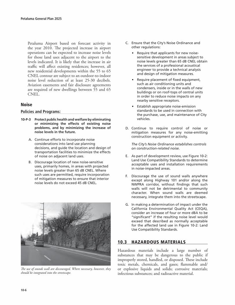
10-�
Petaluma General Plan �0�5
Petaluma Airport based on forecast activity in the year �0�0. The projected increase in airport operations can be expected to increase noise levels for those land uses adjacent to the airport to the levels indicated. It is likely that the increase in air traffic will affect existing residences; however, all new residential developments within the 55 to 65 CNEL contour are subject to an outdoor-to-indoor noise level reduction of at least �5-30 decibels. Aviation easements and fair disclosure agreements are required of new dwellings between 55 and 65 CNEL.
noisePolicies and Programs:
10-P-3 Protectpublichealthandwelfarebyeliminatingor minimizing the effects of existing noiseproblems, and by minimizing the increase ofnoiselevelsinthefuture.
Continue efforts to incorporate noise considerations into land use planning decisions, and guide the location and design of transportation facilities to minimize the effects of noise on adjacent land uses.
Discourage location of new noise-sensitive uses, primarily homes, in areas with projected noise levels greater than 65 dB CNEL. Where such uses are permitted, require incorporation of mitigation measures to ensure that interior noise levels do not exceed 45 dB CNEL.
A.
B.
Ensure that the City’s Noise Ordinance and other regulations:
Require that applicants for new noise-sensitive development in areas subject to noise levels greater than 65 dB CNEL obtain the services of a professional acoustical engineer to provide a technical analysis and design of mitigation measures.
Require placement of fixed equipment, such as air conditioning units and condensers, inside or in the walls of new buildings or on roof-tops of central units in order to reduce noise impacts on any nearby sensitive receptors.
Establish appropriate noise-emission standards to be used in connection with the purchase, use, and maintenance of City vehicles.
D. Continue to require control of noise or mitigation measures for any noise-emitting construction equipment or activity.
The City’s Noise Ordinance establishes controls on construction-related noise.
E. As part of development review, use Figure 10-2: Land Use Compatibility Standards to determine acceptable uses and installation requirements in noise-impacted areas.
F. Discourage the use of sound walls anywhere except along Highway 101 and/or along the NWPRA corridor, without findings that such walls will not be detrimental to community character. When sound walls are deemed necessary, integrate them into the streetscape.
G. In making a determination of impact under the California Environmental Quality Act (CEQA), consider an increase of four or more dBA to be “significant” if the resulting noise level would exceed that described as normally acceptable for the affected land use in Figure 10-2: Land Use Compatibility Standards.
10.3 HazardousMaterials
Hazardous materials include a large number of substances that may be dangerous to the public if improperly stored, handled, or disposed. These include toxic metals, chemicals, and gases; flammable and/or explosive liquids and solids; corrosive materials; infectious substances; and radioactive material.
C.
•
•
•
The use of sounds wall are discouraged. Where necessary, however, they should be integrated into the streetscape.

10-�
10Health & Safety
Figure 10-1

10-�
Petaluma General Plan �0�5

10-�
10Health & Safety
Figure 10-�: land use compatibility Standards
SOURCE: California Governor’s Office of Planning and Research, 1990.
Residential - Low Density Single Family,Duplex, Mobile Homes
Residential - Multifamily
Transient Lodging - Motels, Hotels
Schools, Libraries, Churches, Hospitals,Nursing Homes
Auditorium, Concert Halls, Amphitheaters
Sports Arena, Outdoor Spectator Sports
Playgrounds, Neighborhood Parks
Golf Courses, Riding Stables,Water Recreation, Cemeteries
Office Buildings, Business Commercialand Professional
Industrial, Manufacturing Utilities,Agriculture
55 60 65 70 75 80
COMMUNITY NOISE EXPOSURELdn or CNEL, dB
INTERPRETATION:
CONDITIONALLY ACCEPTABLENew construction or development should beundertaken only after a detailed analysis ofthe noise reduction requirements is madeand needed noise insulation featuresincluded in the design. Conventionalconstruction, but with closed windows andfresh air supply systems or air conditioningwill normally suffice.
NORMALLY ACCEPTABLESpecified land use is satisfactory, basedupon the assumption that any buildinginvolved is of normal conventionalconstruction, without any special noiseinsulation requirements.
NORMALLY UNACCEPTABLENew construction or development shouldgenerally be discouraged. If newconstruction or development doesproceed, a detailed analysis of the noisereduction requirements must be madeand needed noise insulation featuresincluded in the design.
CLEARLY UNACCEPTABLENew construction or developmentshould generally not be undertaken.
Petaluma General Plan 2025Figure 10-3 Land Use Compatibility Standards

10-10
Petaluma General Plan �0�5
exiStiNG HazardouS materialS aNd WaSte HazardS
Existing hazardous materials and/or wastes within Petaluma include underground storage tanks, Polychlorinated Biphenyls (PCBs), asbestos, and pesticides. Leaking Underground Storage Tank (LUSTs), the leading cause of soil and groundwater contamination in the county, are dispersed throughout the city. Reuse and intensification of former industrial and commercial areas, particularly in Central Petaluma, could potentially contain one or more hazardous materials. The City is currently conducting a citywide assessment of brownfield sites and other areas with hazardous substances, the report is expected in �007. Remediation of these hazards is necessary before rehabilitation or construction can begin.
HazardouS WaSte StoraGe aNd diSPoSal
There are no hazardous waste disposal sites within the City of Petaluma. The Sonoma County Waste Management Agency (SCWMA), however, conducts a range of hazardous waste programs. A new Households Toxics Facility recently opened at the Central Landfill, where county households and businesses can drop off hazardous materials. In addition, community toxic collections are conducted once a week in a different city within the county. These services are available to households and businesses that qualify as small-quantity generators (i.e., generate a maximum of �00 kilograms [�7 gallons or ��0 pounds] or less of hazardous waste per month). Residential pick-up service is also available through appointments.
HazardouS WaSte maNaGemeNt
Hazardous waste management in Petaluma is administered by the Sonoma County Waste Management Agency (SCWMA) through the Countywide Integrated Waste Management Plan (CoIWMP). As required by State law, this planning document includes the Source Reduction and Recycling Element (SRRE), Household Hazardous Waste Element (HHWE), Non-Disposal Facility Element (NDFE), as well as the Siting Element.
In addition, State law requires that communities form a Consolidated Unified Protection Agency (CUPA) to manage the acquisition, maintenance, and control of hazardous waste by industrial and commercial business. In Petaluma, the Fire Marshal’s Office has
the responsibility for administering CUPA programs. As a CUPA, the Fire Department regulates all aspects of hazardous materials storage, use, and waste disposal. This includes policy, training of personnel, and procedures for processing the various elements of the CUPA program.
HazardousMaterialsSee Chapter 4: Natural Environment for policies relating to solid waste management.
Policies and Programs:
10-P-4 Minimizetherisktolifeandpropertyfromtheproduction,use,storage,andtransportationofhazardous materials and waste by complyingwithallapplicableStateandlocalregulations.
Require compliance with Sonoma’s Countywide Integrated Waste Management Plan (CoIWMP) as well as all of the Consolidated Unified Protection Agency (CUPA) program elements.
Prepare and maintain an inventory of environmentally contaminated sites to educate future landowners about contamination from previous uses. Work directly with landowners in the cleanup of these sites, particularly in areas with redevelopment potential The U.S. Environmental Protection Agency (EPA) in 2005 awarded the City of Petaluma two grants to assess potential brownfield properties within the city. In addition, the City has applied to the EPA for a revolving loan fund grant to help developers, non-profits, and the City clean up brownfield sites.
Establish special zoning designations and environmental review processes that limit the location of industry, research, and business facilities using hazardous materials. Require safe distances between these sites and residential areas, groundwater recharge areas (see Chapter 8: Water Resources), and waterways.
A.
B.
C.

Housing
NOTE: The Housing Element is unique in that it is the only element of the General Plan that requires outside review and certification by the California State Department of Housing and Community Development (HCD) and is on a State mandated time frame. Petaluma’s current Housing Element is valid from 2009-2014 and is available as a separate document. The current Housing Element was adopted in June 2009. It is bound separately from the General Plan 2025.
http://cityofpetaluma.net/cdd/pdf/housing-element-2009-2014.pdf


G-1
Glossary
GLOSSARY OF TERMS
100-Year Flood. That flood event that has a one-percent chance of occurrence in any one year.
Acoustical Engineer. An engineer specializing in the measurement and physical properties of sound. In environmental review, the acoustical engineer measures noise impacts of proposed projects and designs measures to reduce those impacts.
Acoustics. The physical qualities of a room, enclosure, or space (such as size, shape, and amount of noise) that determine the audibility and perception of sound.
Acre, Gross. Area of a site calculated to the centerline of bounding streets and other public rights-of-way.
Acre, Net. The portion of a site that can actually be built upon. Not included in the net acreage of a site are public or private road rights-of-way, public open space, and floodways.
ADA. Americans with Disabilities Act. ADA guarantees equal opportunity for individuals with disabilities in public accommodations, employment, transportation, State and local government services, and telecommunications.
Adaptive Reuse. The conversion of obsolescent or historic buildings from their original or most recent use to a new use. For example, the conversion of former hospital or school buildings to residential use, or the conversion of an historic single-family home to office use.
Affordable Housing. Housing capable of being purchased or rented by a household with very low or low income, based on a household’s ability to make monthly payments necessary to obtain housing. Housing is considered affordable when a household pays less than 30 percent of its gross monthly income (GMI) for housing including utilities.
Agriculture. Use of land for the production of food and fiber, including the growing of crops and/or the grazing of animals on natural prime or improved pastureland.
Air Pollution. Concentrations of substances found in the atmosphere that exceed naturally occurring quantities and are undesirable or harmful in some way.
Airport-related Use. A use that supports airport operations including, but not limited to, aircraft repair and maintenance, flight instruction, and aircraft chartering.
Ambient. Surrounding on all sides; used to describe measurements of existing conditions with respect to traffic, noise, air and other environments.
Annex. To incorporate a land area into an existing district or municipality, with a resulting change in the boundaries of the annexing jurisdiction.
Apartment. (1) One or more rooms of a building used as a place to live, in a building containing at least one other unit used for the same purpose. (2) A separate suite, not owner occupied, which includes kitchen facilities and is designed for and rented as the home, residence, or sleeping place of one or more persons living as a single housekeeping unit.
Aquifer. A natural underground formation that is saturated with water, and from which water can be withdrawn.
Archaeological. Relating to the material remains of past human life, culture, or activities.
Army Corps of Engineers. A federal agency responsible for the design and implementation of publicly supported engineering projects. Any construction activity that involves filling a watercourse, pond, lake (natural or man-made), or wetlands (including seasonal wetlands and vernal pools), may require an ACOE permit.
Arterial. A vehicular right-of-way whose primary function is to carry through traffic in a continuous route across an urban area while also providing some access to abutting land. Major arterials are typically divided (have raised medians), have more travel lanes, and carry more traffic than minor arterials.
Assessment District. A special district formed by a local government agency (County, City, Water District, etc.) and includes property that will receive direct benefit from the construction of new public improvements or from the maintenance of existing public improvements. The most common types of public improvements financed include roads, sidewalks, sewer facilities and water facilities.
Attainment Area. An area determined to have met federal or State air quality standards, as defined in the federal Clean Air Act or the California Clean Air Act. An area may be an attainment area for one pollutant and a non-attainment area for others.
Auto-oriented Uses. Land uses designed to accommodate customers who use autos to travel to the site, including automobile sales and service, building supplies and

G-2
Petaluma General Plan 2025
materials and drive-up or drive-through uses.
Bike Paths (Class I facilities). Paved facilities that are physically separated from roadways used by motor vehicles by space or a physical barrier and are designated for bicycle use.
Bike Lanes (Class II facilities). Lanes on the outside edge of roadways reserved for the exclusive use of bicycles, so designated with special signing and pavement markings.
Bike Routes (Class III facilities). Roadways are roadways recommended for use by bicycles and often connect roadways with bike lanes and bike paths. Bike routes are designated with signs.
Bikeways. A term that encompasses bicycle lanes, bicycle paths, and bicycle routes.
Building. Any structure used or intended for supporting or sheltering any use or occupancy.
Buildout. That level of development characterized by full occupancy of all developable sites in accordance with the General Plan; the maximum probable level of development envisioned by the General Plan under specified assumptions about densities and intensities. Buildout does not necessarily assume parcels are developed at maximum allowable intensities.
California Environmental Quality Act (CEQA). A State law requiring State and local agencies to regulate activities with consideration for environmental protection. If a proposed activity has the potential for a significant adverse environmental impact, an Environmental Impact Report (EIR) must be prepared and certified as to its adequacy before taking action on the proposed project. General Plans require the preparation of a “program EIR.”
Caltrans. California Department of Transportation.
Capital Improvement Program (CIP). A program, administered by the City of Petaluma and approved by its City Council, which schedules permanent improvements, for a minimum of five years in the future, to fit the projected fiscal capability of the City. The program is reviewed annually, for conformance to and consistency with the General Plan by the Planning Commission.
Carbon Monoxide (CO). A colorless, odorless gas formed by the incomplete combustion of fuels, which is toxic because of its tendency to reduce the oxygen-
carrying capacity of the blood.
Census. The official decennial enumeration of the population conducted by the federal government.
Characteristic Earthquake. The moment magnitude of the seismic event considered representative of a particular fault segment, based on seismologic observations and statistical analysis of the probability that a larger earthquake would not be generated during a given time frame. In the Bay Area, the characteristic earthquake for the Peninsula segment of the San Andreas fault has a moment magnitude (Mw) of 7.1; the Hayward fault, a Mw of 7.3; and the Healdsburg-Rodgers Creek fault, Mw 7.1. The term “characteristic earthquake” replaces the term “maximum credible earthquake” (see below) as a more reliable descriptor of future fault activity.
Clustered Development. Development in which a number of dwelling units are placed in closer proximity than usual, or are attached, with the purpose of retaining an open space area.
Collectors. Streets designed to move traffic between local streets and the arterial street system, and to handle trips within or between neighborhoods. Collector streets are typically considered local type streets. Residential collector street volumes should not exceed 3,000 vehicles per day. Collectors typically have two lanes, with curb parking allowed, and traffic signals and turning lanes at major intersections. Not all collectors are shown on the General Plan Diagram.
Commercial. A land use classification that permits facilities for the buying and selling of commodities and services.
Community Care Facility. A facility, place or building which is maintained and operated to provide non-medical residential care, day care, and home finding services for children, adults, or children and adults, including, but not limited to the physically challenged, mentally impaired, or incompetent persons, developmentally challenged, mentally disordered children and adults, court wards and dependents, neglected or emotionally disturbed children, alcohol or drug-addicted children or adults, battered adults or children, and aged persons. A small community care facility serves 6 or fewer persons and is considered a single family residential use. A large community care facility serves 7 to 12 persons.
Community Noise Equivalent Level (CNEL). A 24-hour energy equivalent level derit prove catastrophic.

G-3
Glossary
Community Park. Land with full public access intended to provide recreation opportunities beyond those supplied by neighborhood parks. Community parks are larger in scale than neighborhood parks but smaller than regional parks.
Community Separator. Largely open, natural areas with low intensity development between cities and communities in Sonoma County and/or Marin County.
Community Shopping Center. A complex of retail and service enterprises anchored by a supermarket and/or a super-drugstore, and serving a local clientele. Restaurants, theatres, and shops offering convenience goods are typical.
Compatible. Capable of existing together without conflict or ill effects.
Connectors. Streets that provide low-speed/medium-volume access within and between neighborhoods and nearby collector and arterial streets.
Conservation. The management of natural resources to prevent waste, destruction, or neglect. The state mandates that a Conservation Element be included in the general plan. Conservation is addressed in both the Natural Environment (Chapter 4) and Community, Deisign, Character and Ssutainable Building (Chapter 3) Elements.
Consistent. Free from variation or contradiction. Programs in the General Plan are to be consistent, not contradictory or preferential. State law requires consistency between a general plan and implementation measures such as the zoning ordinance.
Convenience Goods. Retail items generally necessary or desirable for everyday living, usually purchased at a convenient nearby location. Because these goods cost relatively little compared to income, they are often purchased without comparison shopping.
Creek. Natural or once natural flowing waterway. Some creeks are channelized and used as stormwater drainage systems.
Critical Structure/Facility. Facilities housing or serving many people, which are necessary in the event of an earthquake or flood, such as hospitals, fire, police, and emergency service facilities, utility “lifeline” facilities, such as water, electricity, and gas supply, sewage disposal, and communications and transportation facilities.
Curb Cut. The opening along the curb line at which point vehicles or other wheeled forms of transportation may enter or leave the roadway. Curb cuts are essential at street corners for wheelchair users.
Day-Night Average Sound Level (Ldn). The A-weighted average sound level in decibels during a 24-hour period with a 10 dB weighing applied to nighttime sound levels (10 p.m. to 7 a.m.). This exposure method is similar to the CNEL, but deletes the additional weight given in that measurement to noise during the evening time period (7 p.m. to 10 p.m.).
Decibel (dB). A unit used to express the relative intensity of a sound as it is heard by the human ear. The decibel measuring scale is logarithmic. Zero (0 dB) on the scale is the lowest sound level that a normal ear can detect under very quiet (“laboratory”) conditions and is referred to as the “threshold” of human hearing. On the logarithmic scale, 10 decibels are 10 times more intense, 20 decibels are 100 times more intense, and 30 decibels are 1,000 times more intense than 1 decibel.
Decibel “A-Weighted” (dBA). The scale for measuring sound in decibels that weights or reduces the effects of low and high frequencies in order to simulate human hearing. See also Decibel.
Dedication. The turning over by an owner or developer of private land for public use, and the acceptance of land for such use by the governmental agency having jurisdiction over the public function for which it will be used. Dedications for roads; parks, school sites, or other public uses often are made conditions for approval of a development by a city or county.
Density, Gross. The number of dwelling units per gross acre of developable residential land..
Density, Net. The number of dwelling units per net acre (that is, exlusive of existing public streets and other rights-of-way) of developable residential land.
Design Capacity. The capacity at which a street, water distribution pipe, pump or reservoir, or a wastewater pipe or treatment plant is intended to operate.
Design Storm. A hypothetical storm event, which is used for modeling within the Petaluma Watershed (e.g.: 50-year, 100-year). For the purpose of General Plan policies, the 100-year storm event is typically referenced as the design storm.
Development. The physical extension and/or construction of urban land uses. Development activities
G-4
Petaluma General Plan 2025
may include, but not be limited to: subdivision of land; construction or alteration of structures, roads, utilities, and other facilities; grading; deposit of refuse, debris, or fill materials; and clearing of natural vegetation cover (with the exception of agricutlural activities).
Development Code. The City ordinance which divides Petaluma into districts and establishes regulations governing the use, placement, spacing, and size of buildings, open spaces, and other facilities.
Development Fees. Direct charges or dedications collected on a one-time basis for a service provided or as a condition of approval being granted by the local government.
Development Permit. The granting of approval to undertake development activities in accordance with all adopted laws, regulations, and policies.
Disabled. A person determined to have a physical impairment or mental disorder expected to be of long or indefinite duration. Many such impairments or disorders are of such a nature that a person’s ability to live independently can be improved by appropriate housing conditions.
DOF. California Department of Finance.
Easement. A right given by the owner of land to another party for specific limited use of that land. An easement may be acquired by a government through dedication when the purchase of an entire interest in the property may be too expensive or unnecessary.
Emission Factor. The rate at which pollutants are emitted into the atmosphere by one source or a combination of sources.
Endangered Species, California. A native species or subspecies of a bird, mammal, fish, amphibian, reptile, or plant, which is in serious danger of becoming extinct throughout all or a significant portion of its range, due to one or more factors, including loss in habitat, change in habitat, over-exploitation, predation, competition, or disease. The status is determined by the State Department of Fish and Game together with the State Fish and Game Commission.
Endangered Species, Federal. A species which is in danger of extinction throughout all or a significant portion of its range, other than the species of the Class Insect determined to constitute a pest whose protection under the provisions of the 1973 Endangered Species Act, as amended, would present an overwhelming and
overriding risk to humans. The status is determined by the US Fish and Wildlife Service and the Department of the Interior.
Environment. The physical conditions in an area, including land, air, water, minerals, flora, fauna, ambient noise, and objects of historical or aesthetic significance, which will be affected by a proposed project. The area involved shall be the area in which significant effects would occur either directly or indirectly as a result of the project. The “environment” includes both natural and man-made conditions.
Environmental Impact Report (EIR). A document used to evaluate the potential environmental impacts of a project, evaluate reasonable alternatives to the project, and identify mitigation measures necessary to minimize the impacts. The California Environmental Quality Act (CEQA) requires that the agency with primary responsibility over the approval of a project (the lead agency) evaluate the project’s potential impacts in an Environmental Impact Report (EIR).
EPA. Environmental Protection Agency.
Equivalent Noise Level (Leq). A single-number representation of the fluctuating sound level in decibels over a specified period of time. It is a sound-energy average of the fluctuating level.
Erosion. The process by which material is removed from the earth’s surface (including weathering, dissolution, abrasion, and transportation), most commonly by wind or water.
Fault. A fracture in the earth’s crust forming a boundary between rock masses that have shifted.
FEMA. Federal Emergency Management Agency.
FIRM. Flood Insurance Rate Map.
Floodplain. The relatively level land area on either side of the banks of a stream subject to flooding. That part of the flood plain subject to a one percent chance of flooding in any given year is designated as an “area of special flood hazard” by the Federal Insurance Administration.
Flood Terrace. The creation of flat platforms, either natural or artificial, on either side of a river. Flood terraces are designed as a method of flood management by increasing the capacity of the river within certain areas.
Floor Area, Gross. The total horizontal area in square

G-5
Glossary
feet of all floors within the exterior walls of a building, but not including the area of unroofed inner courts or shaft enclosures.
GIS, Geographic Information System. A computer-based database to organize spatial information.
Habitat. The natural environment of a plant or animal.
Hazardous Material. A material or form of energy that could cause injury or illness to persons, livestock, or the natural environment.
Hazardous Waste. Waste which requires special handling to avoid illness or injury to persons or damage to property. Includes, but is not limited to, inorganic mineral acids of sulfur, fluorine, chlorine, nitrogen, chromium, phosphorous, selenium and arsenic and their common salts; lead, nickel, and mercury and their inorganic salts or metallo-organic derivatives; coal, tar acids such as phenol and cresols and their salts; and all radioactive materials.
Historic; Historical. An historic building or site is one that is noteworthy for its significance in local, state, or national history or culture, its architecture or design, or its works of art, memorabilia, or artifacts.
Historic Preservation. The preservation of historically significant structures and neighborhoods until such time as, and in order to facilitate, restoration and rehabilitation of the building(s) to a former condition.
Hotel. A facility in which guest rooms or suites are offered to the general public for lodging with or without meals and for compensation, and where no provision is made for cooking in any individual guest room or suite.
Household. Person or persons living in one housing unit.
Housing Unit, Multifamily. Units with two or more housing units in one structure sharing a common floor/ceiling.
Housing Unit, Single-Family Attached. Single-family units that are attached to other units with adjoining walls extending from ground to roof that separate it from other adjoining structures and form a property line. Each unit has its own heating system.
Housing Unit, Single-Family Detached. Single-family units that are detached from any other house with open space on all four sides.
Impact. The effect of any direct man-made actions or indirect repercussions of man-made actions on existing physical, social, or economic conditions.
Impact Fee. A fee, also called a development fee, levied on the developer of a project by a city, county, or other public agency as compensation for otherwise-unmitigated impacts the project will produce. California Government Code Section 66000 et seq specifies that development fees shall not exceed the estimated reasonable cost of providing the service for which the fee is charged. To lawfully impose a development fee, the public agency must verify its method of calculation and document proper restrictions on use of the fund.
Impervious Surface. Any material which prevents absorption of water into land.
Indirect Source. Any structure or installation which attracts an activity which creates emissions of pollutants. For example, a major employment center, a shopping center, an airport, or a stadium can all be considered to be indirect sources.
Industrial. The manufacture, production, and processing of consumer goods. Industrial is often divided into “heavy industrial” uses, such as construction yards, quarrying, and factories; and “light industrial” uses, such as research and development and less intensive warehousing and manufacturing.
Infill. The development of new housing or other buildings on scattered vacant lots in a built-up area or on new building parcels created by permitted lot splits.
Infrastructure. Permanent utility installations, including roads, water supply lines, sewage collection pipes, stormwater collection systems, and power and communications lines.
Intersection Capacity. The maximum number of vehicles that has a reasonable expectation of passing through an intersection in one direction during a given time period under prevailing roadway and traffic conditions.
Jobs-Employed Residents’ Balance. Total jobs divided by total employed residents (i.e. people who live in the area, but may work anywhere). A ratio of 1.0 indicates a balance. A ratio greater than 1.0 indicates a net in-commute; less than 1.0 indicates a net out-commute.
Jobs-Housing Balance. Total jobs divided by total housing units. A more appropriate measure is the jobs/employed residents’ ratio.

G-6
Petaluma General Plan 2025
Land Use. The purpose or activity for which a piece of land or its buildings is designed, arranged, or intended, or for which it is occupied or maintained.
Landmark. Refers to a building, site, object, structure, or significant tree, having historical, architectural, social, or cultural significance and marked for preservation by the local, state, or federal government.
Landscaping. Planting-including trees, shrubs, and ground covers-suitably designed, selected, installed, and maintained as to permanently enhance a site or roadway.
Landslide. A general term for a falling mass of soil or rocks.
Level of Service (LOS). A quantitative measure of the effect of traffic flow factors such as special travel time, interruptions, freedom to maneuver, driver comfort, and convenience, and indirectly, safety and operating cost. Levels of service are usually described by a letter rating system of A through F, with LOS A indicating stable traffic flow with little or no delays and LOS F indicating excessive delays and jammed traffic conditions. It is typically utilized to indicate the traffic condition during a limited time period during the AM or PM peak hour of traffic conditions.
Liquefaction. A sudden large decrease in the shearing resistance of a cohesionless soil, caused by a collapse of the structure by shock or strain, and associated with a sudden but temporary increase of the pore fluid pressure.
Maximum Credible Earthquake (MCE). The largest Richter magnitude (M) seismic event that appears to be reasonably capable of occurring on a given fault under the conditions of the presently known geological framework. This term has been replaced by “characteristic earthquake,” (see above) which is considered a better indicator of probable seismic activity on a given fault segment within a specific time frame.
Median. The dividing area, either paved or landscaped, between opposing lanes of traffic on a roadway.
Mitigation Measure. Action taken to reduce or eliminate environmental impacts. Mitigation includes: avoiding the impact altogether by not taking a certain action or parts of an action; minimizing impacts by limiting the degree or magnitude of the action and its implementation; rectifying the impact by repairing, rehabilitating, or restoring the affected environment;
reducing or eliminating the impact over time by preservation and maintenance during the life of the action; and compensating for the impact by replacing or providing substitute resources or environments.
Mobile Home. A structure, transportable in one or more sections which is built on a permanent chassis and designed to be used as a dwelling unit, with or without a permanent foundation when connected to the required utilities.
Mobile Sources. A source of air pollution that is related to transportation vehicles, such as automobiles or buses.
Modified Mercalli Intensity (MMI) Scale. A 12-point scale of earthquake intensity based on local effects experienced by people, structures, and earth materials. Each succeeding step on the scale describes a progressively greater amount of damage at a given point of observation. Effects range from those which are detectable only by seismicity recording instruments (I) to total destruction (XII). Most people will feel Intensity IV ground motion indoors and Intensity V outside. Intensity VII frightens most people, and Intensity VIII causes alarm approaching panic. The scale was developed in 1902 by Giuseppi Mercalli for European conditions, adapted in 1931 by American seismologists Harry Wood and Frank Neumann for conditions in North America, and modified in 1958 by Dr. Charles F. Richter to accommodate modern structural design features.
Neighborhood Traffic Management Program (NTMP). A comprehensive approach designed to provide consistent, citywide policies to neighborhood traffic management.
Neighborhood Shopping Centers. A small retail center, typically with up to 120,000 square feet of space on an 8-12 acre site serving a trading area population of 5,000 to 15,000. The principal tenant typically is a supermarket.
Nitrogen Dioxide (NO2). A reddish brown gas that is a byproduct of the combustion process and is a key to the ozone production process.
Noise Contour(s). Isolines (a line on a map or chart along which there is a constant value) representing noise, measured in decibels. See also Community Noise Equivalent Level.
No Net Fill. Any material brought on to a project site within a floodplain area that would displace flood waters. All fill up to the required minimum elevation for

G-7
Glossary
the first finished floor shall be offset by the removal of a like amount of material. This material may be removed from a portion of the project site; or it may be removed from a site in the immediate area where the removal of compensating material from the off-site location can be determined, to the satisfaction of the City Engineer and the Sonoma County Water Agency, to result in a reasonable equivalence of hydrology and hydraulics to the situation before the development. For purposes of compliance, one or more individual parcels or an entire reach may demonstrate a “zero net fill” balance.
Non-point Source. A pollutant source introduced from dispersed points and lacking a single, identifiable origin. Examples include automobile emissions or urban run-off.
NPDES. National Pollution Discharge Elimination System.
Open Space. Any parcel or area of land or water which is essentially unimproved and devoted to an open-space use as defined in the General Plan or designated on a local, regional, or state open-space plan as one of the four types of open space defined by state planning law.
Oxidant. The production of photochemical reactions in the atmosphere between reactive organic gases and oxides of nitrogen.
Ozone. A compound consisting of three oxygen atoms, that is the primary constituent of smog. It is formed through chemical reactions in the atmosphere involving volatile organic compounds, nitrogen oxides, and sunlight. Ozone can initiate damage to the lungs as well as damage to trees, crops, and materials. There is a natural layer of ozone in the upper atmosphere, which shields the earth from harmful ultraviolet radiation.
Parcel. A lot, or contiguous group of lots, in single ownership or under single control, usually considered a unit for purposes of development.
PCD. Planned Community District.
Peak Day Stormwater Runoff. The peak discharge for a 100-year storm lasting 24 hours.
Peak Hour. The busiest one-hour period for traffic during a 24-hour period. The PM peak hour is the busiest one-hour period of traffic during the evening commute period. The AM peak hour is the busiest one-hour period during the morning commute.
Pedestrian-oriented Development. Development
designed with an emphasis on the street sidewalk and on pedestrian access to the building, rather than an auto access and parking areas.
Percent Slope. A common way of expressing the steepness of the slope of terrain, which is derived by dividing the change in elevation by the horizontal distance traversed. For example, an increase of 20 feet elevation over a 100-foot distance is a 20 percent slope.
Planning Referral Area. The City and the land outside its boundaries that bear relation to its planning.
PM-10. The current standard for measuring the amount of solid or liquid matter suspended in the atmosphere (“particulate matter including dust”). Refers to the amount of particulate matter over 10 micrometers in diameter. The smaller PM-10 particles penetrate to the deeper portions of the lung, affecting sensitive population groups such as children and people with respiratory diseases.
PUD. Planned Unit District
Point Source. A source of pollutants which may be traced to a discrete point of emission.
Rare Species. A condition in which a species or subspecies, although not currently threatened with extinction, exists in such small numbers throughout its range that it may be endangered if the quality of its environment worsens.
Reactive Organic Gases (ROG). Classes of hydrocarbons (olefins, substituted aromatics, and aldehydes) that are likely to react with ozone and nitrogen dioxide in the atmosphere to form photochemical smog.
Recreation, Active. A type of recreation or activity that requires the use of organized play areas including, but not limited to, softball, baseball, football and soccer fields, tennis and basketball courts and various forms of children’s play equipment.
Recreation, Passive. Type of recreation or activity that does not require the use of organized play areas, including, but not limited to walking and hiking trails and observation and sitting areas.
Recycling. Any of a variety of processes whereby waste is separated for reuse or reprocessing into a useful form.
Response Time. The amount of time for an emergency service response, measured from the time of the distress call until arrival on the scene.

G-8
Petaluma General Plan 2025
Richter Magnitude Scale. A logarithmic scale developed in 1935 and 1936 by Dr. Charles F. Richter and Dr. Beno Gutenberg to measure earthquake magnitude (M) by the amount of energy released, as opposed to earthquake intensity as determined by local effects on people, structures, and earth materials (for which, see Modified Mercalli Intensity Scale). Each whole number on the Richter scale represents a 10-fold increase in amplitude of the waves recorded on a seismogram and about a 31-fold increase in the amount of energy released by the earthquake. Because the Richter scale tends to saturate above about M 7.5, it is being replaced in modern seismologic investigations by the moment magnitude (Mw) scale (see above).
Ridgeline. A line connecting the highest points along a ridge and separating drainage basins or small-scale drainage systems from one another.
Right-of-Way (ROW). A continuous strip of land reserved for or actually occupied by a road, crosswalk, railroad, electric transmission lines, oil or gas pipeline, water line, sanitary storm sewer or other similar use.
Riparian. Pertaining to the bank of a natural course of water, whether seasonal or annual. Riparian habitat is defined by the surrounding vegetation or presence of known wildlife movement pathways; it borders or surrounds a waterway.
Second Unit. A self-contained living unit, either attached to or detached from, and in addition to, the primary residential unit on a single lot. Sometimes called “Granny Flat.”
Sedimentation. Process by which material suspended in water is deposited in a body of water.
Seismic. Caused by or subject to earthquakes or earth vibrations.
Sensitive Receptors. Persons or land users that are most sensitive to negative effects of air pollutants. Persons who are sensitive receptors include children, the elderly, the acutely ill, and the chronically ill. The term “sensitive receptors” can also refer to the land use categories where these people live or spend a significant amount of time. Such areas include residences, schools, playgrounds, child-care centers, hospitals, retirement homes, and convalescent homes.
Solid Waste. General category that includes organic wastes, paper products, metals, glass, plastics, cloth, brick, rock, soil, leather, rubber, yard wastes, and wood. Organic wastes and paper products comprise about 75
percent of typical urban solid waste.
Sonoma Marin Area Rail Transit (SMART). The SMART District is charged with planning, engineering, evaluating and implementing passenger train service and corridor maintenance from Cloverdale to a Ferry Terminal that connects to San Francisco.
Sphere of Influence (SOI). City of Petaluma as established by the City and adopted by the Sonoma County LAFCO.
Stationary Source. A source of air pollution that is not mobile, such as a heating plant or an exhaust stack from a laboratory.
Subdivision. The division of a tract of land into defined lots, either improved or unimproved, which can be separately conveyed by sale or lease, and which can be altered or developed. “Subdivision” includes a condominium project as defined in Section 1350 of the California Civil Code and a community apartment project as defined in Section 11004 of the Business and Professions Code.
Subsidence. The gradual sinking of land as a result of natural or man-made causes.
Sulfur Dioxide (SO2). A heavy, pungent, colorless air pollutant formed primarily by the combustion of fossil fuels. It is a respiratory irritant, especially for asthmatics and is the major precursor to the formation of acid rain.
Threatened Species, California. A species of animal or plant is endangered when its survival and reproduction in the wild are in immediate jeopardy form one or more causes, including loss of habitat, change in habitat, over-exploitation, predation, competition, disease, or other factors: or when although not presently threatened with extinction, the species is existing in such small numbers that it may become endangered if its environment worsens. A species of animal or plant shall be presumed to be rare or endangered as it is listed in: Sections 670.2 or 670.5, Title 14, California Code of Regulations; or Title 50, Code of Federal Regulations Sections 17.11 or 17.12 pursuant to the Federal Endangered Species Act as rare, threatened, or endangered.
Threatened Species, Federal. A species which is likely to become an endangered species within the foreseeable future throughout all or a significant portion of its range.
Topography. Configuration of a surface, including

G-9
Glossary
its relief and the position of natural and man-made features.
TOT. Transient Occupancy Tax. Levied on those staying in overnight facilities such as hotels, to help defray provision of City services related to the occupancy.
Tourism. The business of providing services for persons traveling for pleasure, tourism contributes to the vitality of the community by providing revenue to local business. Tourism can be measured through changes in the transient occupancy tax, or restaurant sales.
Traffic Calming. Techniques to slow traffic including physical design modifications such as directive landscaping, narrow streets, traffic islands, speed bumps, innovative traffic enforcement, and other innovative methods.
Transfer of Development Rights (TDR). A land use regulatory tool under which landowners can transfer the right to develop one parcel of land, or a portion thereof, to a different parcel of land.
Transportation Demand Management (TDM). Measures designed to reduce demand for automobile trips, typically focused on peak-periods.
Trees, Street. Trees strategically planted – usually in parkway strips, medians, or along streets--to enhance the visual quality of a street.
Trip Generation. The number of vehicle trip ends associated with (i.e., produced by) a particular land use or traffic study site. A trip end is defined as a single vehicle movement. Roundtrips consist of two trip ends.
Urban Growth Boundary (UGB). Boundary adopted in 1998, and extended in 2010 by the City of Petaluma voters, within which all urban development is to be contained until 2025.
Use Permit. The discretionary and conditional review of an activity or function or operation on a site or in a building or facility.
Vacant. Lands or buildings that are not actively used for any purpose.
Viewshed. The geographic area visible from a fixed point.
Wetlands. An area at least periodically wet or flooded; where the water table stands at or above the land surface (bogs and marshes). Also those areas that are inundated
or saturated by surface or groundwater at a frequency and duration sufficient to support, and that under normal circumstances do support, a prevalence of vegetation typically adapted for life in saturated soil conditions. Wetlands generally include swamps, marshes, bogs, and similar areas.
Wildlife Corridors. A primary means for linking fragmented wildlife habitat areas, allowing species to move between otherwise isolated areas. Especially important for migratory animals and animals with large home ranges. Contributes to maintaining biodiversity, population intrbreeding and continuation of species, and accessing other habitats.
Wildlife Refuge. An area maintained in a natural state for the preservation of both animal and plant life.
Zero Net Fill. See No Net Fill.
Zero Net Runoff. Minimal increase in the peak discharge and no increase in pollutant load immediately downstream of the site and no increase in peak discharge further downstream (including downstream tributaries) when compared to existing conditions.

G-10
Petaluma General Plan 2025
This page intentionally left blank.