Embed Size (px)
Citation preview

City of North Liberty, Iowa Comprehensive Plan
Approved November 2013

2013 North Liberty Comprehensive Plan
City of North Liberty 1 Comprehensive Plan
Acknowledgments Table of Contents Page Introduction 2 Where We’re at Today Comprehensive Planning 3 Current Land Use 3 Population Estimates 4 Significant Ordinances 4 Specific plans and related ordinances adopted 5 Goals and Policies Introduction 6 General Community Goals 7 Policies 8 Natural Environment 8 Land Use 9 Transportation 11 Community Facilities 11 Economic Development 12 Operations and Administration 13 The Plan Land Use Plan Directions 15 Transportation 15 Transportation Major Corridors 15 Undeveloped Incorporated Land 16 Land Use Types Mix 16 Rural and Agricultural Uses 16 Residential Uses 17 Commercial Uses 17 Industrial Uses 17 Extraterritorial Concepts 17 New High School 18 Land Use Plan Map (text) 19 Plan Schedule and Future Tasks 19 Land Use Map 20 Appendix (Large documents referenced in the Plan, available digitally on Website) Existing Land Use Map – 2013 Growth Boundaries – 2013 Target Directions – 2013 Highway 965 Corridor Master Plan - 2008 Parks Plan – 2009 Sanitary Sewer Service Study – 2011 Trails Plan Resolution and Map – 2013 Water System Supply Plan – 2013 Wastewater Treatment Plant Facility Plan Update - 2013

2013 North Liberty Comprehensive Plan
City of North Liberty 2 Comprehensive Plan
Introduction to the Comprehensive Plan The purpose of the Comprehensive Plan is to guide development and redevelopment policy for the City of North Liberty, focusing on land use planning. That is particularly important this year, 2013, as the City contemplates annexation and growth into land east of the current corporate limits. Although the City has updated its Land Use Plan on an ongoing basis in response to changing conditions, this reexamination will ensure that stated policies are consistent with those updates and that the anticipated new City growth will fit into the overall Land Use Plan. Special attention has been given to reducing the bulk and complexity of the previous plan to make it more user-friendly. This streamlining is possible in part because of the great number of stand-alone planning studies undertaken by the City since the time of the previous plan, providing reliable direction for many basic decisions. Though not specifically cited in the text, smart growth principles as identified in Iowa Code Section 18B.1 were considered in the development of the plan. The Comprehensive Plan is organized into three main sections. The first is “Where We’re at Today,” which provides a snapshot of important progress the City has made in the recent past and cites significant plans, ordinances, and adopted policies that need to be understood for a complete planning perspective. The second section, “Goals and Policies,” is the recitation of guidelines for both day to day decisions and further refinement of the plan in section three, “The Plan.” This section establishes the general physical planning ideals for the community, broken down into more detailed recommendations. No plan could possibly foresee every issue that will arise during the planning period, but the plan should be used as a guide for growth and development. Some developments will inevitably differ from the vision of the plan, and in such cases, the plan may need to be updated. In addition, the plan will be reviewed periodically to ensure that the goals, policies, recommendations and maps are reflective of the latest trends in the community. The Planning Commission also meets periodically with the City Council to review current trends and to ensure that the Plan is working properly with the City’s other development tools, such as the zoning and subdivision ordinances. The planning process should be an ongoing endeavor, and the City has a robust process of updating ordinances and studies to ensure that they stay relevant and current.

2013 North Liberty Comprehensive Plan
City of North Liberty 3 Comprehensive Plan
Where We’re at Today Comprehensive Planning. The most recent Comprehensive Plan was adopted in June of 2005, and much has happened in North Liberty since that time. New, essential plans have been prepared and adopted by the City Council, and regulations and policies have been implemented to support the recommendations in those plans to guide the City forward. Growth has been phenomenal, fueled by a number of factors including location, relatively low land prices, the City responding to market pressure for higher-density housing starts, and most recently by stable and efficient government. In response to the change, the Plan has been amended several times since 2005, most recently in October of 2011.
Current Land Use. An important part of planning for the future is understanding where we’re at today. North Liberty has established an ongoing GIS-based existing land use database system to provide decision-makers with the information needed to make good decisions. Periodic updates are provided to Planning Commission and City Council members, most recently in June of 2013, and housing data are provided showing not only existing but also future statistics based on approved development densities. The map produced from this data is included in the digital version of this document. Some examples of relevant information include:
Use Built # Units Acres Units/AcreDuplex Yes 1,159 177.4 6.5 1,277 total duplex unitsDuplex No 118 18.2 6.5 6.5 total units per acreMulti-family Yes 2,420 246.3 9.8 3,254 total multi-family unitsMulti-family No 834 60.6 13.8 10.6 total units per acreMobile Home 531 total mobile home unitsMobile Home Yes 531 88.5 6.0 6.0 total units per acreSingle-family Yes 2,599 978.3 2.7 3,262 total single family unitsSingle-family No 663 307.2 2.2 2.5 total units per acreCurrent Units 6,709 Buildout Units* 8,324
Units/Acre by Type, Built & Unbuilt
*Buildout Units figure includes all existing units plus units calculated for existing zoning and site plans, but does not include those areas identified as Agricultural/ID Zoning on the Existing Land Use Map because zoning type and density has not yet been established.

2013 North Liberty Comprehensive Plan
City of North Liberty 4 Comprehensive Plan
Population Estimates. Utilizing the current land use data and 2010 Census information, and employing various assumptions, the City has estimated population growth into the short-term and mid-term future. Some of the assumptions cited in the forecast graph below are related to growth areas identified by the City and referenced later in this plan.
In any scenario, growth is forecasted to continue into the foreseeable future and needs to be adequately planned for. Significant Ordinances. North Liberty has adopted or amended significant ordinances since the time of the previous Comprehensive Plan, including: Zoning Ordinance Design Standards. New and updated standards for new and
redeveloped properties. Subdivision Ordinance. Rewrite of the previous ordinance to update and clarify.

2013 North Liberty Comprehensive Plan
City of North Liberty 5 Comprehensive Plan
Storm Water Management Ordinance. New regulations regarding how development and redevelopment is required to control the quantity and quality of storm water leaving any site.
Construction Design Standards. Adopted the state-wide standards (SUDAS) to promote high standards with construction industry familiarity.
Communication Towers. Updated ordinance to better control placement and site design of towers.
Noise Ordinance update. Annexation Agreements. Annexation agreements have been adopted with the cities of
Tiffin and Coralville. Specific Plans. Many inter-related specific plans have been completed over the past several years, including: Sanitary Sewer Service Study (2011). This important document examined drainageways
in the North Liberty vicinity and provides the City with maximum annexation limits based on future ability to provide sanitary sewer services. It also estimates costs to provide sewer services to various drainage areas, leading to prioritization for growth directions. A map from this large document showing the ultimate reasonably sewerable area is
presented in the reduced form below.

2013 North Liberty Comprehensive Plan
City of North Liberty 6 Comprehensive Plan
Trails Plan (2009, updated 2013). A plan establishing standards and locations for trails in North Liberty. A resolution was also passed in 2013 to more formalize the trails network and development standards. A map of the trail locations is shown below.
Water System Facility Plan (2013). A plan for keeping up with anticipated water treatment and supply demand associated with continuing City growth.
Wastewater Treatment Plant Facility Plan Update (2013). A plan for keeping up with anticipated wastewater treatment and supply demand associated with continuing City growth.
Parks Plan (2009). A plan identifying needs and possible actions to address growing needs for outdoor recreation in North Liberty.
Highway 965 Corridor Master Plan (2008). Highway 965 is major corridor through North Liberty and carries a significant and growing number of trips. The City, in conjunction with Johnson County and Coralville, adopted the corridor plan for capacity and service improvements, including pedestrian accommodations where none has existed in the past.
Goals and Policies The reason most comprehensive plans have a section with policies is to outline general directions to be taken by the community as time goes by. These goals and policies present the

2013 North Liberty Comprehensive Plan
City of North Liberty 7 Comprehensive Plan
basic and fundamental guidelines for the development of North Liberty, and their purpose is to provide a decision-making framework. They should not, however, be interpreted as an implementation programming of actions and responses, nor should a single goal be extracted from the whole and used to validate an outlying point of view. While in some instances a single policy may define and outline a course of action or decision, it is more commonly the case that several policies apply to a given situation. Reactions to individual policies should therefore be tempered pending consideration of all applicable statements. The Policy Plan is intended to be adaptable and flexible, and to be used as the basis for planning and decision-making in unanticipated situations that emerge.
Goals: Goals are generalized end products that will ultimately result in achieving the quality of life desired. Goals are often described using the terms “maintain”, “encourage”, “ensure”, “develop”, and “establish.”
Policies: Policies are more definite courses of action that lead toward goal achievement. Additionally, policies are guides for helping to make present and future decisions consistent with stated goals. Policies are described by using the phrase “shall be.” This gives policy statements a definitive meaning rather than one that is implied.
General Community Goals The role and function of local government is the improvement and maintenance of the community for an orderly, safe, productive and enhanced living and working environment. Within this context, the following is a list of basic fundamental goals that North Liberty is organized to achieve. The goals are intended to work together and should not be construed to have greater value over each other: • Encourage continued but orderly growth in North Liberty.
In order to maintain a strong economic and social base for North Liberty, growth and diversification are viewed as positive; however, this growth and diversification needs to be accomplished in an orderly, organized and coordinated fashion in order to preserve North Liberty’s reputation for having a "small-town" family-friendly atmosphere. The City should pursue projects and guide growth in ways that will preserve and encourage the small city character while accommodating additional, orderly development.
• Enhance and improve North Liberty's sense of community and self-identity. In order to strengthen and enhance the City’s image and self-identity, it is essential that a
sense of community is nurtured. North Liberty’s basic character is that of a small but rapidly growing community. Residents of the City have stated that the features and amenities that comprise North Liberty’s “small city” character should be preserved and maintained even though the actual population continues to increase. Since most of North Liberty has developed after the time most Iowa cities were established with traditional business districts and grid-pattern subdivisions, our City reflects more recent societal and business trends. The most obvious of those is the focus of commercial activity in the Highway 965 and Penn Street corridors rather than in a traditional “downtown” area. In place of a centralized downtown area, North Liberty can be characterized by a high-quality community center, varied residential areas, and commercial centers and individual
Goals and Policies
Land Use Concepts
Target Directions
Land Use Map

2013 North Liberty Comprehensive Plan
City of North Liberty 8 Comprehensive Plan
buildings located along the two major transportation arterials with good pedestrian and trail access and firm control of vehicular access (turning movements) and commercial design. Additionally, the City is working toward creation of a public services campus area to include the community center, fire department, police department, and administrative services.
• Provide a diversity of land use opportunities within the City to ensure a wide range of employment and consumer options, as well as housing choices. A variety of housing levels and styles, including low to high value homes, are needed to provide a diversity of homeowners, varying in household size, age and financial means.
• Maintain desirable community character, public health and safety, and economic vitality by ensuring that development that takes place in North Liberty is of premium quality and blends well with the small town urban atmosphere of the community. North Liberty should pay special attention to a variety of development types and relationships, and base its plans for support systems and services upon those uses that attain optimal land use. Related ordinance controls should reflect and enforce the characteristics of development as specified in the plan. The City should provide for the development and maintenance of functional land use and structural patterns, and an orderly and functional transportation system to serve and connect, but not disrupt, various use concentrations.
• Ensure that the Comprehensive Plan promotes a responsible fiscal balance on an ongoing basis. The Goals and Policies are intended to outline the community's desires and set forth guidelines as to how these desires are to be achieved. These desires must be continually assessed in terms of value compared to costs incurred by the City for implementation. Indicators of value shall include, but not be limited to, potential revenue, image enhancement, and common good of the community.
General community goals are further refined in the development of the following policies, which move the reader and user a step closer to day-to-day decision-making guidance: 1. Policies related to the natural environment Environmental awareness is an important issue in modern city life. Environmentally sensitive development will preserve the health and welfare of North Liberty citizens, attract a more diverse economic base, and minimize the need for future public investments in clean up or beautification. Specific target preservation areas include areas of steep slopes, existing vegetation, and natural drainageways. The policies and provisions of the Comprehensive Plan, as well as the City’s Zoning and Subdivision Ordinances, are the vehicles through which North Liberty can protect defined environmentally sensitive areas within the municipal boundaries. Protect all environmentally sensitive areas and unique physical features within the
municipal boundaries. Ensure that urban development and agricultural operations are compatible with features
of the natural environment and can be accommodated without destroying environmental features and natural amenities.
Maintain and, where feasible, improve the natural and aesthetic quality of the region's water resources.

2013 North Liberty Comprehensive Plan
City of North Liberty 9 Comprehensive Plan
Ensure that development within the City is contiguous to existing development to the maximum extent possible, while acknowledging that property ownership and other characteristics can drastically affect contiguous development.
Require all new development to manage all on-site storm water generation to minimize downstream flooding and poor water quality.
2. Policies related to land use Land use policies create a vehicle to determine, organize, and define the character and intensity of activity in North Liberty. The policies address both existing and desirable future patterns of development. Develop and implement a cohesive, efficient land use pattern that ensures compatibility,
functional relationships, and complementary adjacent activities among land uses. Ensure that the Comprehensive Plan, including long term and interim policies, promotes
a responsible fiscal balance between revenue and service costs on an ongoing basis. Ensure land use allocations are balanced with economic market demands and service
availability. Establish and maintain an advantageous property tax situation and pursue a
strengthened and sound tax base through a diversification of land uses, including commercial and industrial development, as well as a variety of residential options.
Provide for extensions of the corporate boundaries and related community services as necessary to accommodate new desirable growth, and in conformance with infrastructure service studies.
Ensure that public gathering places, schools, and other institutional uses are compatible and complementary to neighboring uses.
Encourage the development of a variety of dwelling unit types, styles and sizes, and balanced housing stock to satisfy the needs, desires, and income levels of all people and household sizes.
Provide safe, convenient, attractive and accessible commercial and industrial development that is viable and responsive to the needs of the community and surrounding market area.
Promote the economic growth and development of the community as an active participant in cooperation with the private sector.
Protect property values through logical placement of land uses and streets, through protection of natural features and through strong property maintenance regulations.
Protect neighborhoods from speeding and non-local traffic to the maximum extent possible.
Support high density and medium density housing in close proximity to commercial and service centers to provide intensity-of-use buffers for low density residential uses.
Control growth and development by means of properly administered Zoning, Subdivision and Building/Property Maintenance Ordinances and follow up inspection and enforcement.
Guide the aesthetically pleasing development of the community through the use of strong design standards.

2013 North Liberty Comprehensive Plan
City of North Liberty 10 Comprehensive Plan
Enhance the attractiveness of the community through a continuing program of civic beautification activities such as tree planting; enforced maintenance of private property; ongoing maintenance of streets; continuing parks and public landscape area maintenance; and other measures.
Create and implement programs and incentives for continuing privately initiated property maintenance and improvements and redevelopment of questionable land use.
Utilize physical barriers, distances, screens, sizing of building units, and/or proper physical orientation of lots and buildings to minimize conflicts from incompatible land uses. Wherever possible, changes in types of land use shall occur either at center, or mid-block points so that similar uses front on the same street, or at borders of areas separated by major man-made or natural barriers.
Protect residential neighborhoods from encroachment or intrusion of incompatible higher use types by adequate buffering and separation. This policy is not to be interpreted to imply that new development must match existing development in cost, density, or character; but instead to mean that gross incompatibilities shall be minimized and mitigated where unavoidable.
Reinforce, maintain, and upgrade the character of individual residential neighborhoods. Allow home occupations only if they do not interfere with the residential character of the
neighborhood. Aggressively eliminate violations of property maintenance that infringe upon residential
neighborhood quality, pose public health and safety problems or threaten neighboring property values.
Concentrate higher density, apartment-type housing in proximity to areas that offer a wide range of existing supportive services, commercial and recreational facilities.
Ensure connections between new and existing subdivisions. Encourage development of commercial and service centers as cohesive, highly
interrelated and coordinated units with adequate off-street parking, appropriate regulated points of access, internal circulation, and pedestrian-scale improvements.
Locate highway commercial development in areas of high traffic counts. Locate industrial development so that land use compatibility is maintained, servicing
capabilities are adequate and not over-extended, and long term development objectives and policies are achieved. Require adequate screening and appropriately landscaped industrial areas to protect surrounding properties.
Prohibit traffic generated by industrial activity from penetrating residential neighborhoods.
Uniformly enforce Nuisance and Zoning codes to ensure proper upkeep and constant improvement of economic development areas.
Encourage continued expansion of the City’s industrial and commercial tax base to assist in paying for needed services and in reducing tax impact on housing costs.
Promote only industrial development that maximizes the return on City investments in public facilities and services and can reasonably be served by existing infrastructure.
Confine keeping of animals to the rural designated areas of the community or farming operations.

2013 North Liberty Comprehensive Plan
City of North Liberty 11 Comprehensive Plan
3. Policies related to transportation The North Liberty transportation system is composed of differing modes that respond to the access needs of the community. Full attention is required to all modes within the system to ensure a balanced operation as well as a system that properly responds to the requirements of all individuals. Factors affecting transportation are the placement and type of uses and activities that generate service needs. Within the context of the above considerations, the following goals and policies are provided for transportation planning and development. Approach transportation in a comprehensive manner, giving attention to all modes and
related facilities. Construct streets with the highest possible standards for safety and durability. Provide for the safe and convenient circulation needs of the pedestrian and the bicyclist. Support utilization and development of mass transit systems and other such
economically-viable measures that will minimize the need for individual automobile travel.
Coordinate transportation planning and implementation with neighboring and affected jurisdictions.
Provide adequate local streets, bicycle trails and pedestrian facilities that complement the regional highway system.
Prohibit access to property from major streets, which include those designated as expressways, arterials, and collectors, wherever possible. Side streets are to provide access for properties fronting such streets and roads.
Design all residential streets to prevent penetration of through traffic and to direct traffic to collector or arterial streets, while ensuring an adequate network of major and residential streets to carry traffic without bottlenecks and congestion caused by limited route options.
Ensure construction of all new streets, whether public or private, is of concrete with concrete curb and gutter.
Utilize street and other public place safety through the appropriate use of street lighting and sign controls.
Strictly enforce standards and controls for business and advertising signing and lighting in order to prevent driver distraction and potential hazards.
Ensure that any new development or expansion of existing development includes adequate off-street parking. Parking requirements imposed shall be constantly reviewed and studied to ensure supply is reflective of demand.
4. Policies related to community facilities Community facilities include those lands, buildings, services and systems that are provided on a public or semi-public basis in the interest of the residents of the community. Such facilities typically include public utilities, parks, open space, and administrative services. Their importance should not be underestimated in that they are offered as a necessity for sustaining quality life within the urban environment and are, therefore, a major determinant of the quality and safety of urban living.

2013 North Liberty Comprehensive Plan
City of North Liberty 12 Comprehensive Plan
Maintaining quality community services and facilities while experiencing major population increases is an important consideration for North Liberty. Sustainable growth of these important facilities must be carefully planned and implemented. In addition, public utilities are an important factor in regulating development patterns within the City. To discourage sprawling or premature development, the City should continue to require that all public utilities such as sanitary sewer, water, and storm sewer, are in place prior to subdivision approvals. Community facilities policies are: Extend and maintain facilities and services necessary to meet the needs and interests of
the community. Plan for public facilities and services in a coordinated and cost effective manner that is
consistent with the nature of development and possible pending problems within the community.
Minimize costs for public facilities and services by encouraging full utilization of existing and available service system elements.
Constantly monitor and maintain all public and private sewer and water utility systems to assure a safe and high quality standard of service.
Require underground installation of all new utility services, and when economically feasible, the conversion of existing overhead systems to underground systems.
Promote cooperation and coordination between governmental units in the provision of public utilities and services.
Develop, improve and maintain all public facilities to the highest adopted standards of design and performance.
Promote and encourage coordination with the local School Boards regarding anticipated growth and expansion plans for future School facilities.
Provide and maintain adequate neighborhood and community recreational facilities for the enjoyment and use of North Liberty residents.
5. Policies related to economic development Maintaining a proper balance of commercial and industrial uses in relationship with a solid residential base is important to establishing a healthy tax base within the community. The following goals and policies serve as a reference for economic development in North Liberty. Maintain a stable economy through the establishment of a diversified economic base. Maintain and expand the City’s employment base in order to provide both living and
working opportunities for North Liberty residents. Recognize and include existing and established businesses within the City as part of a
comprehensive economic development effort. Utilize public assistance tools and programs such as tax increment financing to
encourage those developments that meet the City’s long range planning objectives and provide substantial benefits for the economy of the City.
Promote economic development projects that assist in the redevelopment and/or restoration of substandard and deteriorating property within the City.
Maintain strong industrial and commercial performance standards to ensure high quality, high valued development.

2013 North Liberty Comprehensive Plan
City of North Liberty 13 Comprehensive Plan
Utilize strong code enforcement to promote upkeep and maintenance of commercial and industrial areas to preserve property values.
Appropriately plan for the development of commercial properties in the critical I-380, Highway 965, and Penn Street corridors.
6. Policies related to operations and administration As a consequence of the implementation aspects and orientation of the North Liberty Comprehensive Plan, operational and administrative goals and policies are a prime concern. All people involved need to have a clear understanding of how development and redevelopment in the City will be achieved. To this end, the following are the operational and administrative goals and policies: Promote private development and civic projects that enhance the community’s image on
a regional basis, as well as improve the sense of community identity within the City. Ensure that all development and/or redevelopment that occurs in the community is in
accordance with the Comprehensive Plan. The Comprehensive Plan and related ordinances should be amended as necessary to reflect changing community needs and priorities.
Maintain a responsible fiscal balance. Draft and amend ordinances as necessary to meet modern standards and needs of the
community. Provide opportunities for active and direct participation of residents, business owners,
and property owners within the community. Review the Comprehensive Plan regularly to ensure that it is current and reflective of the
community’s interest and changing needs. Monitor federal and state programs for possible assistance with implementing the
Comprehensive Plan and meeting the needs of the community. Monitor legislative changes and new requirements in ordinance and city control
responsibilities. Determine all economic, physical, social and service demand implications of
development proposals. Utilize developer fees to fund City costs associated with new development rather than
having the City as a whole assume the burden. Utilize special assessments and tap-on fees in assigning costs for public improvements
to benefiting parties. Require land dedication, easement establishment, and other means at the time of
subdivision and development to ensure the adequacy of public/semi-public utilities and improvements.
Maintain communication and continued coordination between the City and neighboring and related governmental jurisdictions.
Promote private development of the highest quality to increase North Liberty’s attractiveness in the regional market.
Consider community and neighborhood identity in the siting of public facilities. Pursue public trails and an open space system which connect areas of the City and
promote pedestrian and bicycle transportation.

2013 North Liberty Comprehensive Plan
City of North Liberty 14 Comprehensive Plan
Formulate ordinances which govern the minimum and proper maintenance of private property within the City. Such property maintenance regulations shall be applied to all types of uses within development and redevelopment areas.
Utilize existing business and civic organizations to communicate and inform project area landowners and tenants of area plans and accomplishments.
Utilize public media to keep citizens informed of all development projects. Coordinate fringe-area developments with Johnson County to ensure that the long term
goals and objectives of both governmental jurisdictions are being met.

2013 North Liberty Comprehensive Plan
City of North Liberty 15 Comprehensive Plan
The Plan The Plan describes the physical strategy for the community. It further defines and establishes direction for the basic elements that comprise and influence the community. In the case of North Liberty and the surrounding extra-territorial jurisdiction area, these categorical elements are the natural environment, land use, transportation, and community facilities. This section of the Plan is divided into two parts: Land Use Plan Directions and the Land Use Map. The Land Use Directions section represents the general physical planning ideals for the community. This section provides guidelines for how specific policies presented within the Policy Plan may be applied, and detailed recommendations. In total, the Plan, in conjunction with the Goals and Policies, provides the basic and fundamental tool for guiding and managing change and improvement within the community. Land Use Plan Directions Based on the foundation established in the policies section, this Plan section provides the framework to guide and direct future community growth and improvement, the basic concepts that impact North Liberty’s future development.
Transportation. A key physical element in the Development Framework is transportation. Specific components include a desired compatibility between various transportation modes and recognition of the roadway classification system as the network that provides the primary connection between the various geographic areas of the community and beyond. The following listing of functional classifications refers to the role each type of roadway performs and helps determine street widths, speed limits, intersection controls and the number of access points that should be permitted. Generally, trip length, speed, and right-of-way needs are greatest on expressways and decreases down the list; while access is greatest at the local street and decreases up the list.
Expressway. Interstate 380, located at the current western boundary of North Liberty, provides a high level of mobility between cities. Direct access to the interstate from the City at the Penn Street interchange has been of great benefit in the steady growth and development of North Liberty. Major / Minor Arterial Streets. Major arterials collect and distribute traffic to and from major activity centers, collector streets and expressways. Direct lot access to all arterial streets is generally prohibited to protect the capacity of those facilities. Minor arterials function in the same manner as major arterials only with smaller traffic counts. Collector Streets. Collector streets serve to connect neighborhoods with activity centers or the arterial street system, and direct access points are discouraged. Local Streets. Local streets serve to provide direct lot access to individual land uses.
It is imperative for the convenience of residents that development proposals incorporate planned arterial and collector streets as well as planned trails. Transportation Major Corridors. Interstate 380 is the dominant transportation facility in North Liberty, and while access is restricted and it cannot be defined as a “gateway” to the City, it creates significant impacts including noise and traffic congestion near the interchanges. Penn Street and Highway 965 are important, high traffic volume streets, connecting I-380 through North Liberty and on to large commercial areas and Interstate 80 to the south, and do serve as gateways to the City. While driveway access points are limited for those streets to preserve their traffic capacity, commercial and mixed-use developments

2013 North Liberty Comprehensive Plan
City of North Liberty 16 Comprehensive Plan
that present a welcoming and high-quality image are important. Significantly, a new interchange with I-380 at Forevergreen Road has been planned and is included in the metropolitan planning agency’s long range transportation plan. Undeveloped Incorporated Land. There is a substantial amount of undeveloped land already in North Liberty, as seen on the Existing Land Use Map following this section; however, much of this property is controlled by only a few owners, which can significantly impact land availability for near-term development and helps justify growth through annexation of new areas. Land Use Types Mix. The pie chart below shows the mix of land uses in North Liberty at the time of this plan preparation. Noteworthy are the amount of agricultural land and the
large amount of commercial land not built compared to commercial land built. Looking at residential uses separately because the housing mix has been an ongoing topic of conversation in North Liberty, there is a high proportion of multi-family and 2-family housing compared to single-family detached housing, as shown on the pie chart below this paragraph. This mix is due to a number of factors, including many plans approved in the early years of the City’s growth boom
before the proportion was as obvious, modern demand for lower-cost housing alternatives as single-family prices have risen, and North Liberty’s status as a “newer” city without a large stock of older housing which would normally help fill the lower-cost needs. Even with the number of multi-family units, owner-occupancy in the city was shown in the 2010 Census to be comparable to other similar cities. Rural and Agricultural Uses. Guidelines for determining what types of land would

2013 North Liberty Comprehensive Plan
City of North Liberty 17 Comprehensive Plan
qualify as premature for development and undesirable for urban infrastructure are generally: Lack of adequate stormwater drainage capacity. Lack of an adequate or safe water supply. Lack of adequate access, roads or highways to serve the subdivision or development. Lack of adequate sewage disposal facilities. Lack of adequate public support facilities such as parks, police and fire protection. Residential Uses. The Plan promotes the development of a diversified housing stock that is affordable to a wide range of incomes. Even though general planning goals include limiting residential uses along arterials and in some cases even collector streets, the miles of such frontages within the City make strict adherence to those goals impractical, and landscape buffers, limited access, and smart neighborhood street layouts are utilized to minimize traffic impacts. Higher density residential development is considered to be somewhat of a transitional buffer between office/commercial development and lower density residential neighborhoods, in part because it is practical to locate the greater numbers of residents found in the higher density developments closer to the commercial services they need. Commercial Uses. The highest densities of more locally-oriented commercial uses are generally planned along Penn Street and along Highway 965. Interstate-related large scale office and mixed-use developments are planned for the Kansas Avenue corridor, especially between Kansas and I-380 and near the planned Forevergreen Road interchange. High visibility from the I-380 corridor presents an excellent opportunity to introduce high-quality office and commercial uses in this “front door” area, that may serve both the external demand associated with the I-380 proximity and access and the internal demand generated by substantial recent and planned residential development in the area. Industrial Uses. Historically North Liberty has seen only light industrial development uses. These uses include light manufacturing and processing, lumber yards, research and development, warehousing, mini-storage, and transport operations. The Future Land Use Map identifies the eventual phasing out or redevelopment of spot industrial properties located within the City’s central growth area, which will minimize compatibility concerns and allow for more appropriate uses in these locations. Extraterritorial Concepts. Any development located outside the municipal boundary but within identified growth areas should be annexed. Property within the growth areas that cannot be annexed by the City due to lack of City services, or due to annexation issues such as contiguity, shall be considered premature until such issues can be overcome. The area surrounding North Liberty is governed by the Johnson County Rural Land Use Plan and Unified Development Ordinance; however, the City and County have adopted a formal Fringe Area Agreement that allows the City to review and comment on development proposals in the extra-territorial area to ensure they protect the City’s long-term growth potential while representing a logical staging of growth in order to preserve farmlands and minimize service costs. In addition to the Fringe Area Agreement with Johnson County, the City has “annexation moratorium agreements,” the language used in the Iowa Code, to establish future growth boundaries with our neighboring cities of Tiffin and Coralville. North Liberty is in close proximity to the Iowa River and substantial amounts of Federally-owned land associated with the Coralville Lake, not logical for annexation both because they are unlikely to ever be built on and because they are environmentally sensitive. Near these
2013 North Liberty Comprehensive Plan
City of North Liberty 18 Comprehensive Plan
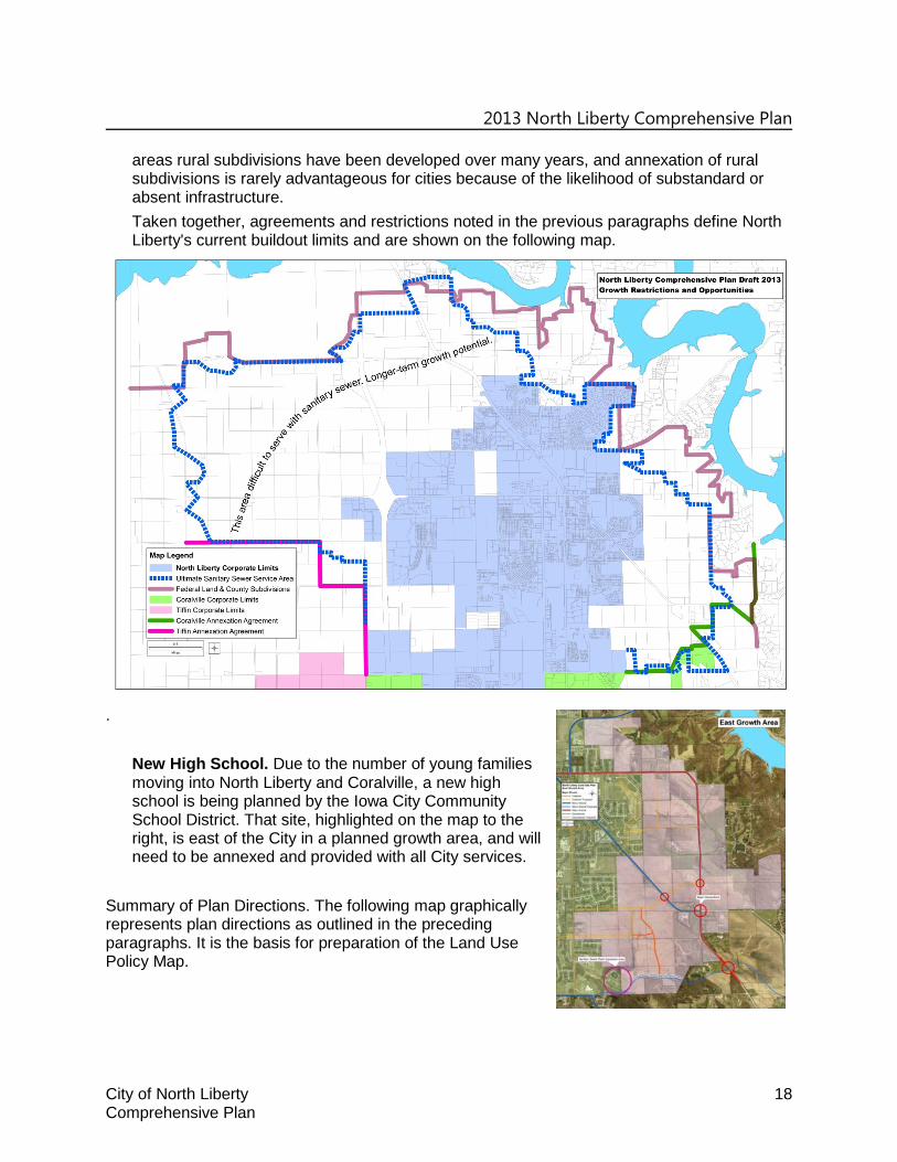
areas rural subdivisions have been developed over many years, and annexation of rural subdivisions is rarely advantageous for cities because of the likelihood of substandard or absent infrastructure. Taken together, agreements and restrictions noted in the previous paragraphs define North Liberty's current buildout limits and are shown on the following map.
.
New High School. Due to the number of young families moving into North Liberty and Coralville, a new high school is being planned by the Iowa City Community School District. That site, highlighted on the map to the right, is east of the City in a planned growth area, and will need to be annexed and provided with all City services.
Summary of Plan Directions. The following map graphically represents plan directions as outlined in the preceding paragraphs. It is the basis for preparation of the Land Use Policy Map.

2013 North Liberty Comprehensive Plan
City of North Liberty 19 Comprehensive Plan
Land Use Plan Map The Land Use Plan Map is a graphic representation of existing development, Goals and Policies, and Plan Directions presented in previous sections of this plan. Implementation of the Proposed Land Use Plan will be primarily accomplished through the City’s development regulations, especially the Zoning and Subdivision Ordinances. The plan map, when used in conjunction with land use narrative and ordinances, provides a visualization of future land uses within the community and the extra-territorial jurisdiction area. The residential designations that are shown on the Land Use Plan map represent housing density as opposed to actual housing types. The Future Land Use Map should serve as a graphic guide, general in nature. No specific delineation of borders between use types is intended. Specific development proposals and related land use decisions, while generally directed by the Future Land Use Map, are to be based primarily upon the goals and policies established as part of the Policy Plan chapter. PLAN UPDATE SCHEDULE AND FUTURE TASKS No plan could possibly foresee every issue that will arise during the planning period, and periodic updates based on joint Planning Commission – Council discussions are expected and considered healthy. The planning process is an ongoing endeavor. Some long-standing issues that need to be discussed in greater detail in the near term future, probably incrementally because of their nature, include:

2013 North Liberty Comprehensive Plan
City of North Liberty 20 Comprehensive Plan
analysis of the oversized areas designated for commercial and industrial land uses, review of large area designated for park and open space east of I-380 just north of the
corporate limits, examination of park needs in the growth areas, and extension of the trails plan to the growth areas.