Embed Size (px)
Citation preview
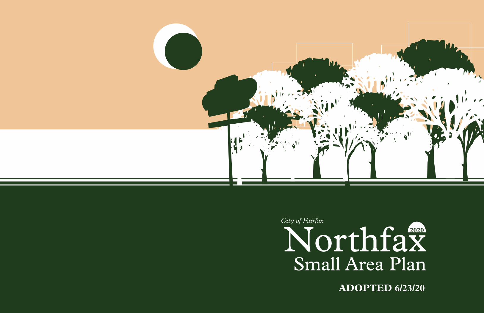
Northfax Small Area Plan
City of Fairfax2020
ADOPTED 6/23/20

NORTHFAX INTRODUCTION
A Small Area Plans are neighborhood-level plans intended to provide the City with guidance on each of its five Activity Centers defined in the 2035 Comprehensive Plan.
While the Comprehensive Plan advises the Activity Center’s development at a high level, Small Area Plans provide more specific guidance for each Activity Center, including desired mix of uses, recommended height and density, building typologies, street locations, multi-modal connections, infrastructure improvements, parking, and open space.
As a historical and present-day gateway intersection to the City of Fairfax, Northfax is a critically important study area. The 2035 Comprehensive Plan highlights this area as an Activity
Center, appropriate for mixed-use development and placemaking.
The plan was developed through extensive stakeholder meetings, community charrettes and town halls, consultations with city staff, property owners and other stakeholders. The result is a new vision for Northfax that both respects the historical past while planning for an exciting future.
The Small Area Plan effort re-imagines Northfax as a dynamic, mixed-use center with a sensitivity and connection to nature. Northfax is located at a topographical low point and sits in the Accotink Creek watershed. Today it is marked by suburban commercial development, substantial impervious paving and a lack of a sense of place.
Northfax is adjacent to undeveloped natural areas as well as established residential neighborhoods. Northfax represents a future where all of these elements can be integrated into a vivid sense of place and harmony with nature.
The existing land uses in Northfax - commercial retail, office, hotels and others - can be greatly enhanced by additional uses, to broaden the study area into a true mixed-use activity center. New residential typologies, such as market-rate apartments, affordable housing, senior living and other typologies, are recommended. New public amenities, open space and transportation infrastructure are recommended to enhance the quality of life for the Northfax community.
ACKNOWLEDGMENTS
CITY COUNCIL Mayor David L. Meyer
Councilmember Michael J. DeMarco
Councilmember So P. Lim
Councilmember Janice B. Miller
Councilmember Jennifer E. Passey
Councilmember Jon R. Stehle, Jr.
Councilmember Sang H. Yi
PLANNING COMMISSION Janet Jaworski, Chair
Mark Angres, Vice Chair
Tom Burrell
Paul Cunningham, PC Rep for Board of Architectural Review
Amir Eftekhari, PC Rep for Parks and Recreation Advisory Board
James Feather, PC Rep for Facade Improvement Program
Matthew Rice
Karen Wheeler-Smith (former)
Joseph Harmon (former)
CONSULTANT TEAM Cunningham Quill Architects, Urban Design and Planning
Bolan Smart Associates, Economic
Kittelson & Associates, Transportation
Oculus, Landscape Architecture
Walter L Phillips, Civil Engineers
CONTENTS
Introduction 1
Plan Vision 4 The Development Plan 5 Key Idea One: A 6 New Identity
Key Idea Two: The 7 Linear Park Key Idea Three: A Balanced, 9 Mixed Use Activity Center Key Idea Four: Bridging 10 Community and Nature
Urban Design 11
Street and Block Plan 12 and Retail Frontage Typical Street Sections 13
Public Open Space 14 And Green Space
The Linear Park Details 15
Economic Contest 20
Building Heights 22 And Setback
Building Heights 23 And Land Use
Introduction
Building on Past Studies Listening & Informing
Market Factors Opportunity One: Updating Zoning to Reflect Plan & Market Opportunity Two: Towards a Better Pedestrian Realm Opportunity Three: Connecting the City Opportunity Four: Sustainability & Watershed Infrastructure
45 46
47
49 54
55
56
57
EXISTING CONDITIONS: THE CITY
A
Introduction
Historic District And Design Oversight
National Register District
Windshield Survey Inventory
68
69
70
71
HISTORIC RESOURCES ANALYSIS
C
Table of Contents
Market Supplements And Reports Design Research Supplements
Transportation Supplements
Community And Stakeholder Feedback
79
80
85
90
110
OTHER APPENDICES
D
Introduction
History And Identity
A Changing Northfax
Land Use Highlights
Northfax And the Watershed
Economic Opportunities & Constraints
Transportation in Northfax
Key Observations
59
60
61
62
63
64
65
66
EXISTING CONDITIONS: NORTHFAX
B
APPENDICES
Transportation 24 Northfax Transportation 25 Stitching Together 26 Neighborhoods
Chain Bridge Road and 27 Orchard Street Fairfax Boulevard 28 Eaton Place 30 Parking Management 31 The Spine 32
Implementation and Details 34 Northfax West Details 35
Northfax East Details 36 Phasing and Economics 37 Sustainability 38 Placemaking and 39 Automotive Uses Utility Recommendations 40 Zoning and Regulatory 43 Recommendations
NORTHFAX SMALL AREA PLAN
4
PLA
N V
ISIO
N
PLAN VISION
The Development Plan 5 Key Idea One: A 6 New Identity
Key Idea Two: The 7 Linear Park Key Idea Three: A Balanced, 9 Mixed Use Activity Center Key Idea Four: Bridging 10 Community and Nature
5
PLA
N V
ISIO
N
eaton place
Ch
ain
Bri
dge
Rd
Fairfax Boulevard University D
rive
Orchard street
mcl
ean
ave
Far
r av
e.
Willow Wood Plaza
1122
33
44
55
55
55
66
Cobbdale park
77
11
88
88
99
99
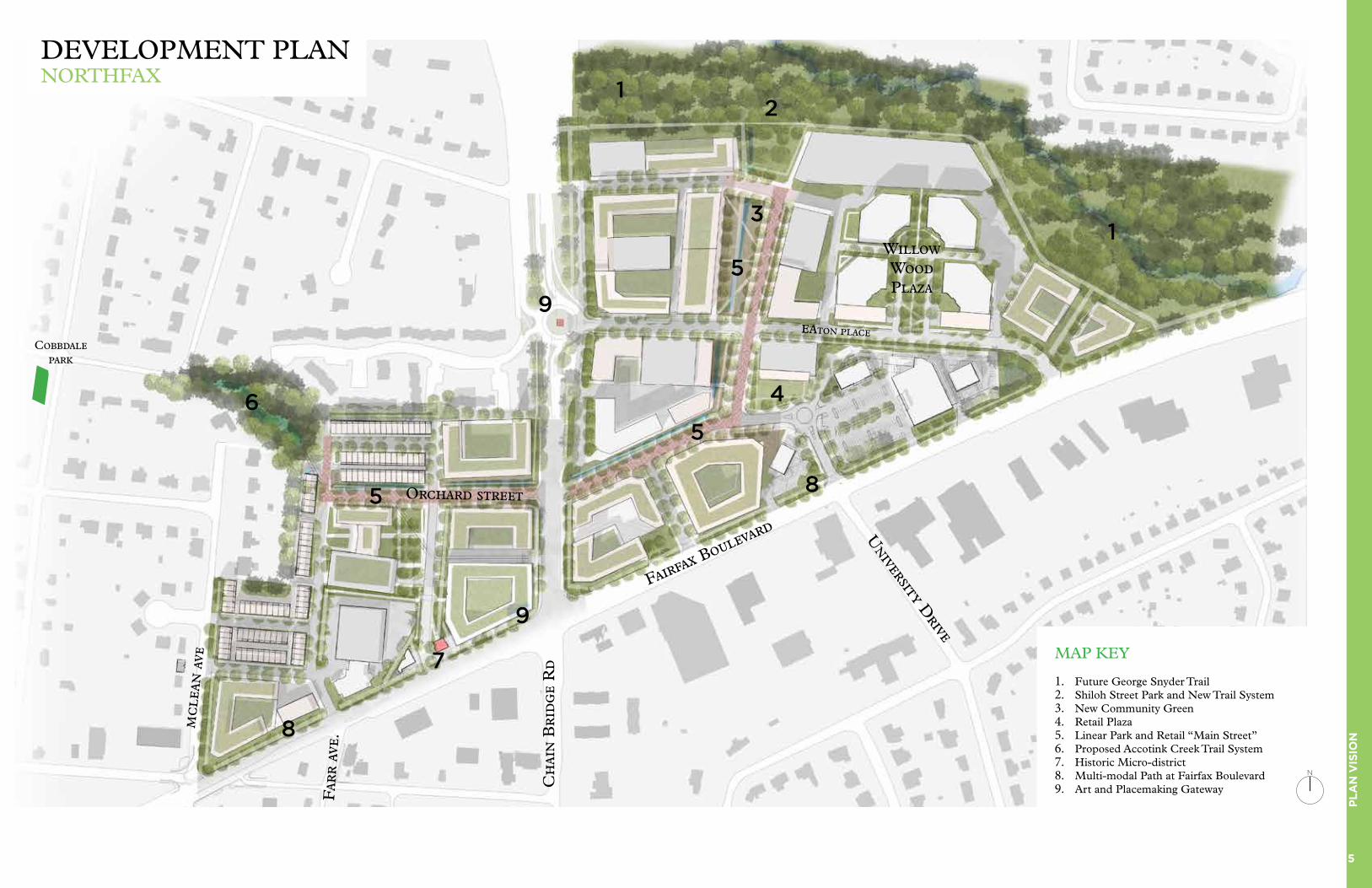
MAP KEY
1. Future George Snyder Trail2. Shiloh Street Park and New Trail System3. New Community Green 4. Retail Plaza5. Linear Park and Retail “Main Street”6. Proposed Accotink Creek Trail System7. Historic Micro-district8. Multi-modal Path at Fairfax Boulevard9. Art and Placemaking Gateway
DEVELOPMENT PLANNORTHFAX
N

6
PLA
N V
ISIO
N
As noted in the 2035 Comprehensive Plan, Northfax has the potential to transform from a collection of dormant land uses into a dynamic mixed-use Activity Center. Today, the study area contains more than 75% impervious surfaces, much of which is car parking and storage lots. These land uses are located at a topological low-point in the Accotink Creek watershed, creating potential stormwater runoff quantity and quality problems.
Because of its history and location, Northfax would benefit tremendously from new development patterns. Establishing a commitment to ecologically-sensitive development would not only improve the watershed health, but also provide a strong identity to differentiate itself from the region.
Northfax is envisioned to be a place of forward-thinking and experimentation for the City of Fairfax,
with a focus on implementation and realistic land development.
New ideas for Northfax include: a new linear park that connects the community with the Accotink Creek watershed and nature, transforming existing “superblocks” into a connected street and block grid, new public open space for outdoor activities including plazas and greens, a new retail center with restaurants and other social
gathering spaces, housing typologies that are not well represented in Fairfax, such as senior living, market-rate apartments, condominiums and affordable housing, and a proactive city involvement in the planning and development process, including public amenities and balanced regulations for better environmental outcomes.
KEY IDEA #1: A NEW IDENTITYNORTHFAX - AN ECOLOGICALLY SENSITIVE PLACE
Photos of the Accotink Creek watershed within the Northfax study area
7
PLA
N V
ISIO
N
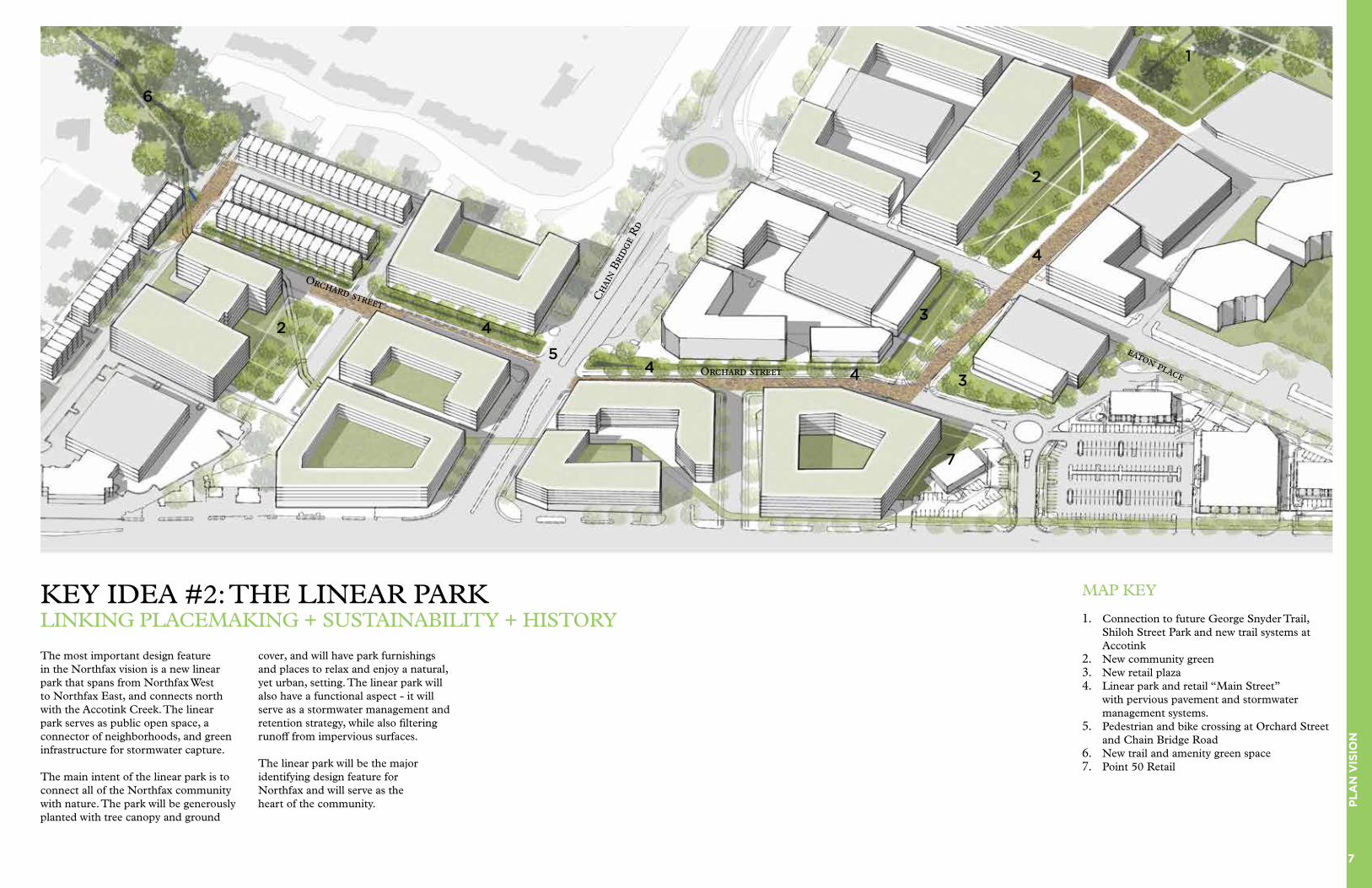
KEY IDEA #2: THE LINEAR PARKLINKING PLACEMAKING + SUSTAINABILITY + HISTORY
The most important design feature in the Northfax vision is a new linear park that spans from Northfax West to Northfax East, and connects north with the Accotink Creek. The linear park serves as public open space, a connector of neighborhoods, and green infrastructure for stormwater capture.
The main intent of the linear park is to connect all of the Northfax community with nature. The park will be generously planted with tree canopy and ground
cover, and will have park furnishings and places to relax and enjoy a natural, yet urban, setting. The linear park will also have a functional aspect - it will serve as a stormwater management and retention strategy, while also filtering runoff from impervious surfaces.
The linear park will be the major identifying design feature for Northfax and will serve as the heart of the community.
Cha
in B
ridg
e R
d
Orchard street
Orchard street
eaton place
MAP KEY
1. Connection to future George Snyder Trail, Shiloh Street Park and new trail systems at Accotink
2. New community green 3. New retail plaza4. Linear park and retail “Main Street”
with pervious pavement and stormwater management systems.
5. Pedestrian and bike crossing at Orchard Street and Chain Bridge Road
6. New trail and amenity green space7. Point 50 Retail
11
22
33
33
44
44
4422
66
4455
77

8
PLA
N V
ISIO
N
PUBLIC OPEN SPACEThe linear park addresses a major need in Northfax - the lack of public open space. The park will widen in two key areas : 1) a Retail Plaza next to the retail node at Point 50, and 2) North of Eaton Place where it connects to the Accotink Creek. The open spaces are envisioned to be publicly accessible and provide a framework for a variety of activities, including outdoor walking, exercise, pet walking, outdoor dining, public events, relaxation, landscape appreciation and others. Considering the context today, the quality of life in Northfax will be greatly enhanced by the addition of open space.
GREEN INFRASTRUCTURE
The linear park shall have a continuous greenway across multiple properties that serves as a stormwater capture strategy, such as a bio-retention area or vegetated bioswales. The minimum greenway shall be generally 15 feet wide minimum in cross-section, adjacent to Orchard Street, and shall be bolstered with generous landscaping and street furniture. Trees should be generously planted within the greenway zone, with a minimum of 500 cubic feet soil volume per tree. Native plant species are highly recommended.
KEY IDEA #2: THE LINEAR PARKDETAILS
+/- 10’ +/- 20’ 10’ -12’ 7’-8’ 10’-11’ 10’-11’ 7’-8’ +/- 5’ 20’ MIN+/- 5’
9
PLA
N V
ISIO
N
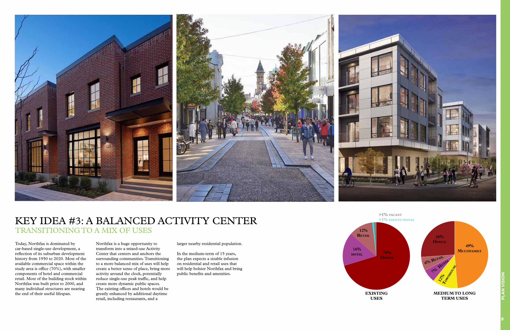
KEY IDEA #3: A BALANCED ACTIVITY CENTERTRANSITIONING TO A MIX OF USES
Today, Northfax is dominated by car-based single-use development, a reflection of its suburban development history from 1950 to 2020. Most of the available commercial space within the study area is office (70%), with smaller components of hotel and commercial retail. Most of the building stock within Northfax was built prior to 2000, and many individual structures are nearing the end of their useful lifespan.
Northfax is a huge opportunity to transform into a mixed-use Activity Center that centers and anchors the surrounding communities. Transitioning to a more balanced mix of uses will help create a better sense of place, bring more activity around the clock, potentially reduce single-use peak traffic, and help create more dynamic public spaces. The existing offices and hotels would be greatly enhanced by additional daytime retail, including restaurants, and a
larger nearby residential population.
In the medium-term of 15 years, the plan expects a sizable infusion on residential and retail uses that will help bolster Northfax and bring public benefits and amenities.
MEDIUM TO LONG TERM USES
49% MULTIfaMILy
26% OffIcE
6% RETaIL
12%
T
Ow
Nh
OU
SE
7% h
OTEL
70% OffIcE
EXISTING USES
16% hOTEL
12%RETaIL
>1% vacaNT
>1% INSTITUTIONaL

10
PLA
N V
ISIO
N
KEY IDEA #4: BRIDGING COMMUNITY TO NATURESTITCHING TOGETHER NEIGHBORHOODS
One of the most unique features of Northfax is its location atop and adjacent to the Accotink Creek watershed. The watershed is a natural feature containing streambeds and a surrounding forest that stands in stark contrast with the suburban highway character of Fairfax Boulevard.
Over several meetings, the Northfax community expressed a strong desire to connect with the watershed and have a deeper connection with nature. Fairfax
Boulevard and Chain Bridge Road are high-volume traffic arterials and serve as strong barriers between neighborhoods and the study area. Additionally, the current properties serve as impenetrable “superblocks” with fenced private uses and few public streets or spaces.
A key idea of the Northfax vision is to bridge the divides between Northfax and the surrounding neighborhoods and to connect with the Accotink Creek
watershed. The vision recommends new pedestrian crossings at Chain Bridge Road and Fairfax Boulevard, as well as better pedestrian and bicycle facilities on major streets. The vision also proposes a new street and block plan and brings in new public streets and open spaces to interconnect the broader context.
MOSBY WOODS
COBBDALE
ASSEMBLY
UNIVERSITY DRIVE COMMUNITY
FAIRFAX ACRES
Newly Connected Residential Areas
New Pedestrian & Bike Connections
Green spaces
Photo of existing Accotink Creek watershed within the Northfax study area

11
UR
BA
N D
ES
IGN
URBAN DESIGN
Street and Block Plan 12 and Retail Frontage Typical Street Sections 13
Public Open Space 14 And Green Space
The Linear Park Details 15
Economic Contest 20
Building Heights 22 And Setback
Building Heights 23 And Land Use

12
UR
BA
N D
ES
IGN
STREET AND BLOCK PLAN ACTIVE AND MINOR STREETS
Commercial Mains
Linear Park Street
Active Street
Alley / Minor StreetRecommended Retail Frontage
As future development comes into Northfax, it is important to create a street and block network within the boundaries of the study area. Currently, both Northfax West and Northfax East serve as “superblocks” with very little public access through private properties. It is important to coordinate future street types and street layouts among multiple properties.
Outside of the existing major through-ways (Fairfax Boulevard, Chain Bridge Road, and Eaton Place), the development plan considers three major
types of new streets within Northfax:
1) Linear Park Streets: These streets are the major connections through Northfax and contain the Linear Park greenway. The street has a curb-less design, two way traffic, bicycle facilities, on-street parking and generous sidewalks. Retail frontage and primary building facades are expected on these streets.
2) Active Streets: These streets are designed to provide major connectivity for pedestrians and vehicles to the properties within the study area. These
streets have two-way traffic, potential bike facilities, on-street parking and narrower sidewalks. Retail frontage is not required on these streets, but is optional. Typical Active Street section details are shown on the following page.
3) Alleys/Minor Streets: These streets are designed for service and loading, as well as additional vehicular connectivity for specific properties. These streets may have one or two-way traffic, do not have on-street parking or bicycle facilities, and have narrow or no sidewalks.
RETAIL FRONTAGEBUILDING ORIENTATION
While the Northfax study area has capacity for dynamic retail, there are limitations on the quantity and location of retail frontage in the study area. Studies have shown that retail works best in concentrated nodes of no more than two to three urban blocks, and in traditional two-sided walkable pedestrian-friendly streets and continuous retail frontage. Public open space can be advantageously used by adjacent retail uses.
While Chain Bridge Road and Fairfax Boulevard have high visibility to through traffic, the pedestrian unfriendliness and
one-sided nature of these major roads make them better suited for signage and secondary building facades.
The development plan concentrates retail along Orchard Street and next to the Point 50 shopping center. The existing concentration of retail at Point 50 provides a foundation to build additional retail frontage. Orchard Street also has the advantage of having the Linear Park, which can have additional outdoor seating and activities to synergize with retail programming.
Due to the limited amount of sustainable retail possible, it is important that retail is generally not spread out and fragmented across the entire study area.
Some opportunities outside the recommended retail zones, to serve a particular need or create a unique experience, can function and enhance the study area significantly. Retail outside the recommended areas should be analyzed with the context of the study area and its impact on the local retail market.
N N

13
UR
BA
N D
ES
IGN
TYPICAL STREET SECTIONS ACTIVE STREETS
Typical street section for active streets, with retail Typical street section for active streets, with residential
Above are sections of typical streets in the Northfax study area that could support a vibrant, pedestrian oriented mixed use community. These typical sections should be used in conjunction with the previous highlighted placemaking moments in the plan to guide typical road networks and urban design.
To the left is a typical street section for a new retail oriented active street. Critical in retail areas is ample space for outdoor retail uses in front of or businesses and accessible to sidewalks. This zone is where activity such as outdoor sales, cafe seating, signage, and other retail can occur. This both builds a vibrant street land cultural
life, visual interest for pedestrians, and also helps support the viability of retail. Urban design should support glass frontages so that retailers can display products and pedestrians have a variety of visual experiences. Other supporting elements include street trees for shade, street furniture for gathering spaces, on-street parking to protect pedestrians, adequate sidewalk widths to allow people to stroll, and travel lanes that can support cars, bicycles, and other modes of travel.
To the right is a typical street section for a new residential oriented active street. The urban design of buildings should be outward focused
with porches, balconies, and stoops that can create publicly interactive outdoor spaces for the residential uses. This helps create vibrancy on the street.
Similarly, supporting elements include street trees for shade, street furniture, on-street parking to protect pedestrians, adequate sidewalk widths to allow people to stroll, and travel lanes that can support cars, bicycles, and other modes of travel.
14
UR
BA
N D
ES
IGN
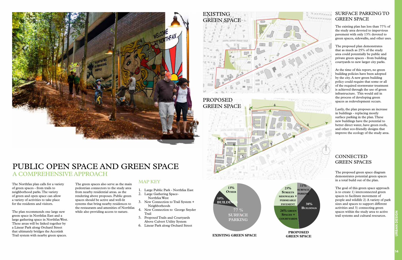
PUBLIC OPEN SPACE AND GREEN SPACE A COMPREHENSIVE APPROACH
11% SURfacE paRkING
38% BUILDINGS
26% GREEN
SpacES + cOURTyaRDS
25% STREETS
SIDEwaLkS + pERMEaBLE pavEMENT
pROpOSED
GREEN SpacE
SURFACE PARKING TO GREEN SPACE
The existing plan has less than 77% of the study area devoted to impervious pavement with only 13% devoted to green spaces, sidewalks, and other uses.
The proposed plan demonstrates that as much as 25% of the study area could potentially be public and private green spaces - from building courtyards to new larger city parks.
At the time of this report, no green building policies have been adopted by the city. A new green building policy could require that some or all of the required stormwater treatment is achieved through the use of green infrastructure. This would aid in the process of developing green spaces as redevelopment occurs.
Lastly, the plan proposes an increase in buildings - replacing mostly surface parking in the plan. These new buildings have the potential to better direct water, have green roofs, and other eco-friendly designs that improve the ecology of the study area.
CONNECTED GREEN SPACES
The proposed green space diagram demonstrates potential green spaces in a total build out of the plan.
The goal of this green space approach is to create 1) interconnected green spaces to facilitate movement of people and wildlife 2) A variety of park sizes and spaces to support different activities and 3) connecting green spaces within the study area to active trail systems and cultural resources.
77 % SURFACE PARKING
10%BUILDINGS
13%OThER
EXISTING GREEN SpacE
EXISTING GREEN SPACE
The Northfax plan calls for a variety of green spaces - from trails to neighborhood parks. The variety of green and open space can allow a variety of activities to take place for the residents and visitors.
The plan recommends one large new green space in Northfax East and a large gathering space in Northfax West. These areas will be linked together by a Linear Park along Orchard Street that ultimately bridges the Accotink Trail system with nearby green spaces.
The green spaces also serve as the main pedestrian connectors to the study area from nearby residential areas. as the rendering above proposes. Public green spaces should be active and well-lit systems that bring nearby residences to the restaurants and amenities of Northfax while also providing access to nature.
MAP KEY
1. Large Public Park - Northfax East 2. Large Gathering Space-
Northfax West3. New Connection to Trail System +
Neighborhoods4. New Connection to George Snyder
Trail5. Proposed Trails and Courtyards
Above Culvert Utility System6. Linear Park along Orchard Street
PROPOSED GREEN SPACE
1
2
3
4
4
5
5
5
5
5
6
66
4
N
N
15
UR
BA
N D
ES
IGN
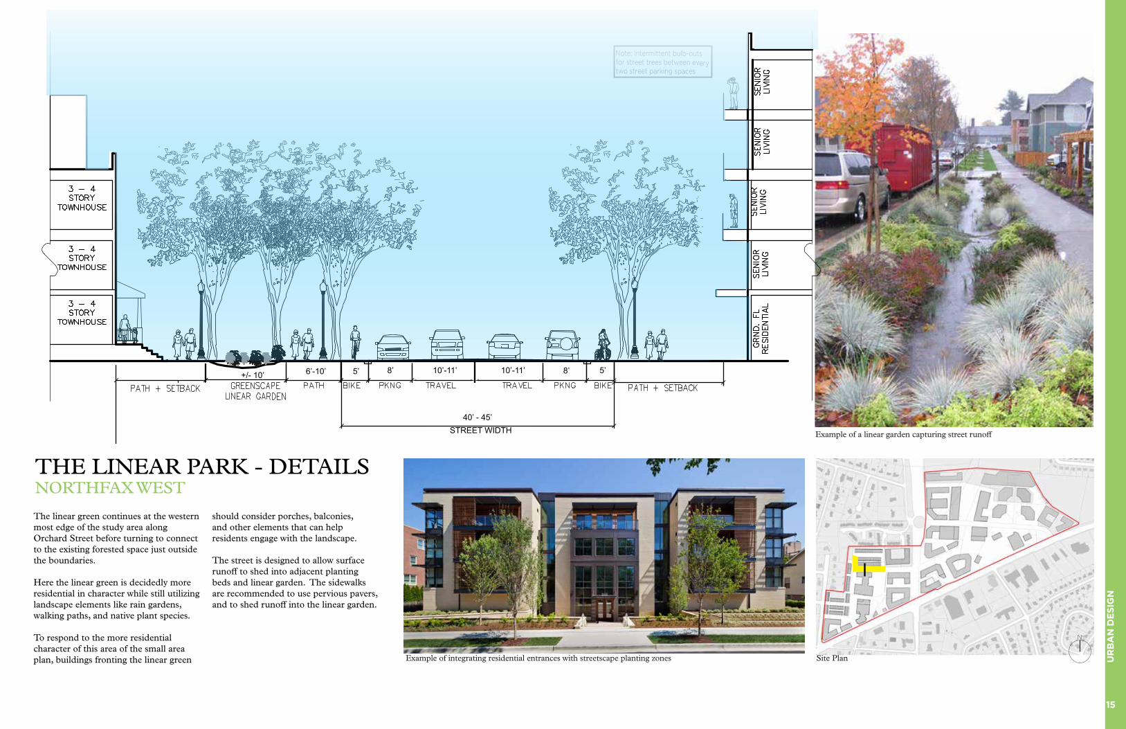
The linear green continues at the western most edge of the study area along Orchard Street before turning to connect to the existing forested space just outside the boundaries. Here the linear green is decidedly more residential in character while still utilizing landscape elements like rain gardens, walking paths, and native plant species.
To respond to the more residential character of this area of the small area plan, buildings fronting the linear green
should consider porches, balconies, and other elements that can help residents engage with the landscape.
The street is designed to allow surface runoff to shed into adjacent planting beds and linear garden. The sidewalks are recommended to use pervious pavers, and to shed runoff into the linear garden.
THE LINEAR PARK - DETAILS NORTHFAX WEST
Example of integrating residential entrances with streetscape planting zones
Example of a linear garden capturing street runoff
Site Plan
N
+/- 10’ 6’-10’
STREET WIDTH
8’ 10’-11’ 10’-11’ 8’
40’ - 45’
5’5’
16
UR
BA
N D
ES
IGN
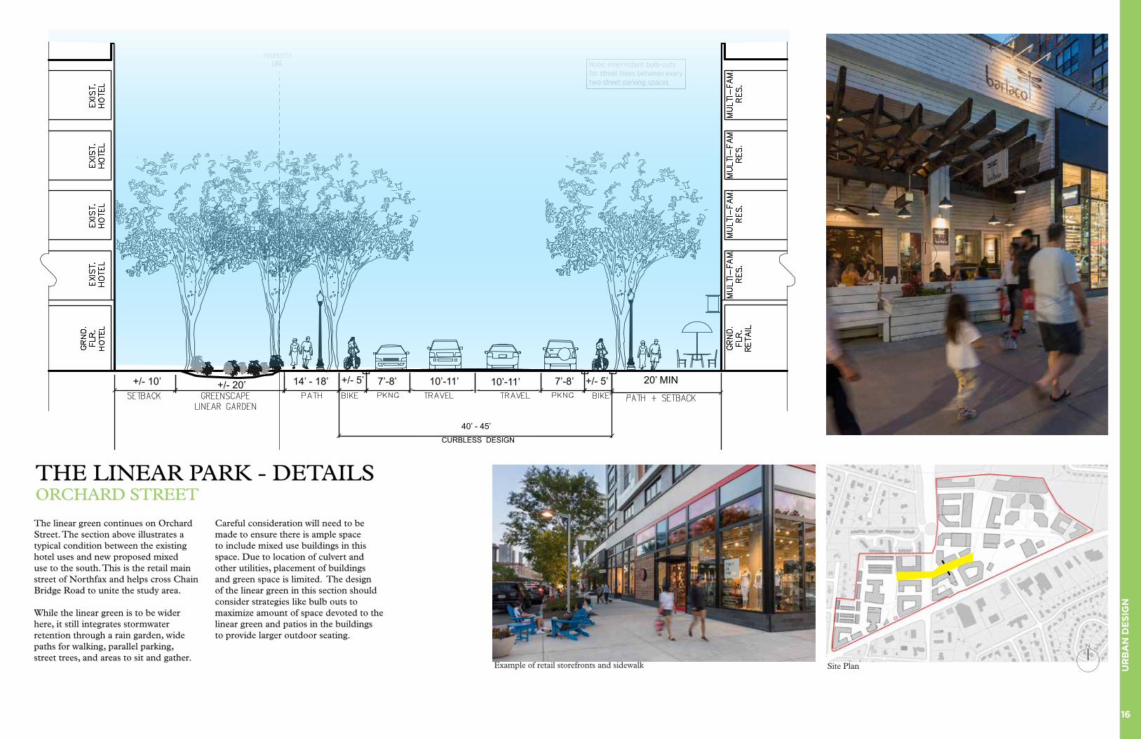
The linear green continues on Orchard Street. The section above illustrates a typical condition between the existing hotel uses and new proposed mixed use to the south. This is the retail main street of Northfax and helps cross Chain Bridge Road to unite the study area.
While the linear green is to be wider here, it still integrates stormwater retention through a rain garden, wide paths for walking, parallel parking, street trees, and areas to sit and gather.
Careful consideration will need to be made to ensure there is ample space to include mixed use buildings in this space. Due to location of culvert and other utilities, placement of buildings and green space is limited. The design of the linear green in this section should consider strategies like bulb outs to maximize amount of space devoted to the linear green and patios in the buildings to provide larger outdoor seating.
THE LINEAR PARK - DETAILS ORCHARD STREET
Example of retail storefronts and sidewalk Site Plan
N
N
+/- 10’ +/- 20’ 14’ - 18’ 7’-8’ 10’-11’ 10’-11’ 7’-8’ +/- 5’ 20’ MIN
40’ - 45’CURBLESS DESIGN
+/- 5’
17
UR
BA
N D
ES
IGN
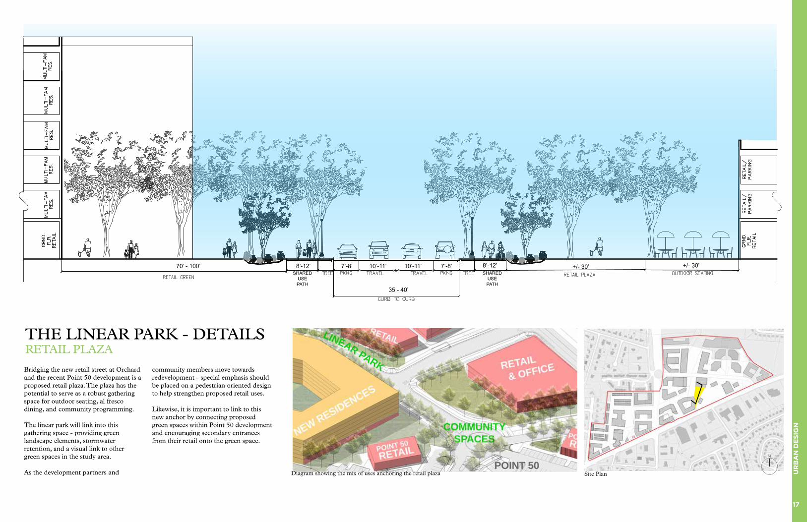
Bridging the new retail street at Orchard and the recent Point 50 development is a proposed retail plaza. The plaza has the potential to serve as a robust gathering space for outdoor seating, al fresco dining, and community programming.
The linear park will link into this gathering space - providing green landscape elements, stormwater retention, and a visual link to other green spaces in the study area.
As the development partners and
community members move towards redevelopment - special emphasis should be placed on a pedestrian oriented design to help strengthen proposed retail uses.
Likewise, it is important to link to this new anchor by connecting proposed green spaces within Point 50 development and encouraging secondary entrances from their retail onto the green space.
THE LINEAR PARK - DETAILSRETAIL PLAZA
Site Plan
N
70’ - 100’
35 - 40’
8’-12’ 7’-8’ 10’-11’ 10’-11’ 7’-8’ 8’-12’ +/- 30’ +/- 30’SHARED
USE PATH
Diagram showing the mix of uses anchoring the retail plaza
SHARED USE PATH

18
UR
BA
N D
ES
IGN
The linear green will start at Eaton Place and the entry into the Point 50 development and continue all the way across Chain Bridge Road towards the westernmost part of the study area eventually linking to green space there.
The linear green in Northfax West should be more retail in character- emphasizing its usage as a mixed use shopping district for the community.
At this area, near to Point 50 and the retail plaza there is the greatest opportunity for wider sidewalks for cafe seating or wider green spaces.
THE LINEAR PARK - DETAILS NORTH OF ORCHARD STREET
A curb-less street is outfitted with native plants in tree boxes to help promote sustainable local ecology and stormwater retention Site Plan
N
35’ - 40’
8’-12’ 7’-8’ 10’-11’ 10’-11’ 7’-8’ 8’-12’ +/- 13’ +/- 20+/-35’+/-SHARED
USE PATH
SHARED USE PATH
19
UR
BA
N D
ES
IGN
THE LINEAR PARK - DETAILSNORTH OF EATON PLACE
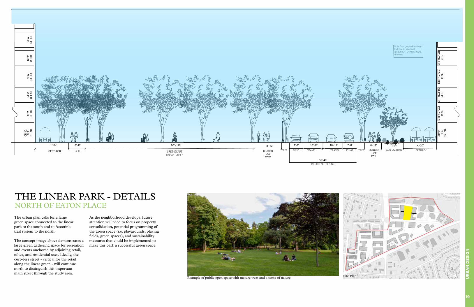
The urban plan calls for a large green space connected to the linear park to the south and to Accotink trail system to the north.
The concept image above demonstrates a large green gathering space for recreation and events anchored by adjoining retail, office, and residential uses. Ideally, the curb-less street - critical for the retail along the linear green - will continue north to distinguish this important main street through the study area.
As the neighborhood develops, future attention will need to focus on property consolidation, potential programming of the green space (i.e. playgrounds, playing fields, green spaces), and sustainability measures that could be implemented to make this park a successful green space.
Example of public open space with mature trees and a sense of nature Site Plan
N
+/-20’ 8’-12’ 90’ -110’ 7’-8’ 10’-11’ 7’-8’10’-11’
35’-40’
8’-12’ 8’-12’ +/-15’ +/-20’
SETBACK SHARED USE PATH
SHARED USE PATH
20
UR
BA
N D
ES
IGN
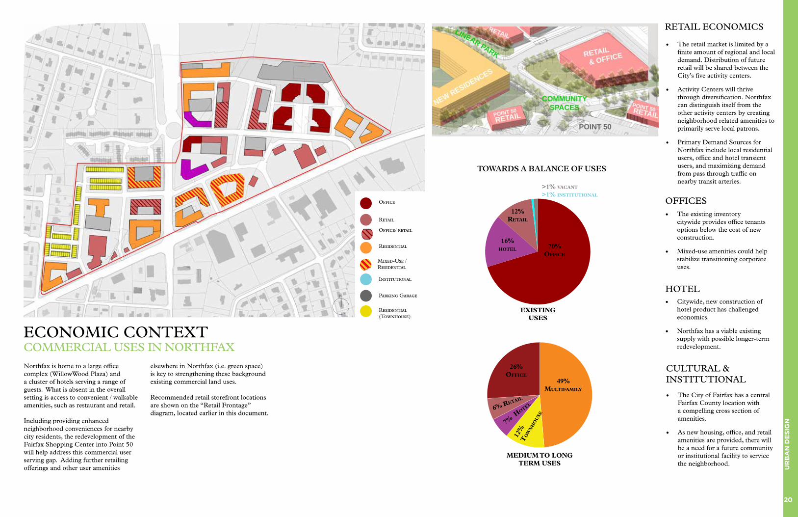
ECONOMIC CONTEXTCOMMERCIAL USES IN NORTHFAX
HOTEL
OFFICES• The existing inventory
citywide provides office tenants options below the cost of new construction.
• Mixed-use amenities could help stabilize transitioning corporate uses.
• Citywide, new construction of hotel product has challenged economics.
• Northfax has a viable existing supply with possible longer-term redevelopment.
CULTURAL & INSTITUTIONAL
• The City of Fairfax has a central Fairfax County location with a compelling cross section of amenities.
• As new housing, office, and retail amenities are provided, there will be a need for a future community or institutional facility to service the neighborhood.
RETAIL ECONOMICS
• The retail market is limited by a finite amount of regional and local demand. Distribution of future retail will be shared between the City’s five activity centers.
• Activity Centers will thrive through diversification. Northfax can distinguish itself from the other activity centers by creating neighborhood related amenities to primarily serve local patrons.
• Primary Demand Sources for Northfax include local residential users, office and hotel transient users, and maximizing demand from pass through traffic on nearby transit arteries.
TOWARDS A BALANCE OF USES
MEDIUM TO LONG TERM USES
49% MULTIfaMILy
70% OffIcE
26% OffIcE
6% RETaIL
12%
T
Ow
Nh
OU
SE
7% h
OTEL
EXISTING USES
16% hOTEL
12%RETaIL
>1% vacaNT
>1% INSTITUTIONaL
Northfax is home to a large office complex (WillowWood Plaza) and a cluster of hotels serving a range of guests. What is absent in the overall setting is access to convenient / walkable amenities, such as restaurant and retail.
Including providing enhanced neighborhood conveniences for nearby city residents, the redevelopment of the Fairfax Shopping Center into Point 50 will help address this commercial user serving gap. Adding further retailing offerings and other user amenities
elsewhere in Northfax (i.e. green space) is key to strengthening these background existing commercial land uses.
Recommended retail storefront locations are shown on the “Retail Frontage” diagram, located earlier in this document.
Office
Retail
Residential
Institutional
Parking Garage
Residential (Townhouse)
N
Mixed-Use / Residential
Office/ retail
21
UR
BA
N D
ES
IGN
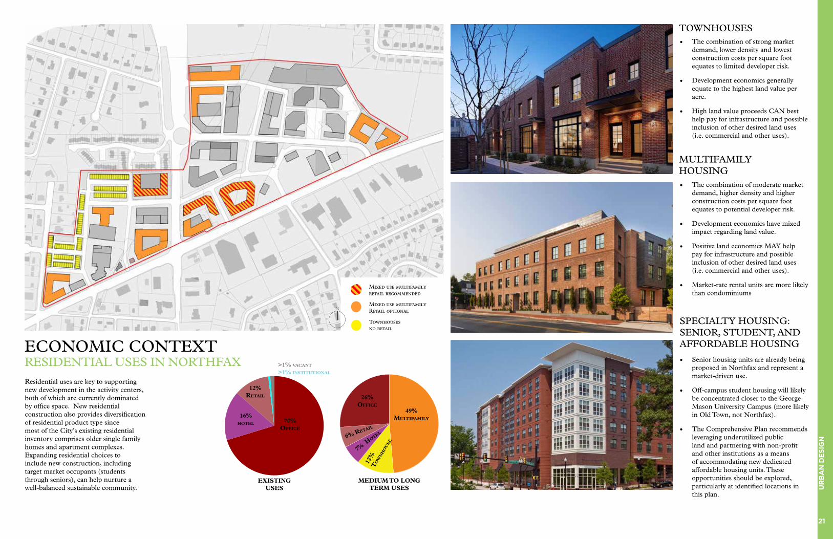
ECONOMIC CONTEXTRESIDENTIAL USES IN NORTHFAX
TOWNHOUSES
MULTIFAMILY HOUSING
SPECIALTY HOUSING: SENIOR, STUDENT, AND AFFORDABLE HOUSING
• The combination of strong market demand, lower density and lowest construction costs per square foot equates to limited developer risk.
• Development economics generally equate to the highest land value per acre.
• High land value proceeds CAN best help pay for infrastructure and possible inclusion of other desired land uses (i.e. commercial and other uses).
• The combination of moderate market demand, higher density and higher construction costs per square foot equates to potential developer risk.
• Development economics have mixed impact regarding land value.
• Positive land economics MAY help pay for infrastructure and possible inclusion of other desired land uses (i.e. commercial and other uses).
• Market-rate rental units are more likely than condominiums
• Senior housing units are already being proposed in Northfax and represent a market-driven use.
• Off-campus student housing will likely be concentrated closer to the George Mason University Campus (more likely in Old Town, not Northfax).
• The Comprehensive Plan recommends leveraging underutilized public land and partnering with non-profit and other institutions as a means of accommodating new dedicated affordable housing units. These opportunities should be explored, particularly at identified locations in this plan.
PRECEDENT
PRECEDENT
PRECEDENTResidential uses are key to supporting new development in the activity centers, both of which are currently dominated by office space. New residential construction also provides diversification of residential product type since most of the City’s existing residential inventory comprises older single family homes and apartment complexes. Expanding residential choices to include new construction, including target market occupants (students through seniors), can help nurture a well-balanced sustainable community.
MEDIUM TO LONG TERM USES
49% MULTIfaMILy
26% OffIcE
6% RETaIL
12%
T
Ow
Nh
OU
SE
7% h
OTEL
70% OffIcE
EXISTING USES
16% hOTEL
12%RETaIL
>1% vacaNT
>1% INSTITUTIONaL
Townhouses no retail
Mixed use multifamilyRetail optional
Mixed use multifamily retail recommended
N

22
UR
BA
N D
ES
IGN
A major goal of the Small Area Plans is to articulate a development vision using realistic patterns of development, with building typologies and land uses based on current market research and regional context. According on this research, the current zoning and other regulations may be hindering optimal land development patterns.
The Small Area Plans are also tasked with making recommendations for modifying existing zoning regulations, including land use, massing and height, to allow for better long-term development outcomes.
Currently, most of the properties within the Northfax study area are zoned CR (Commercial Retail), as well has a smaller amount of RM (Residential Medium) zoned properties. CR zoning historically has been used to develop car-oriented commercial office and retail uses, such as the existing developments on site. CR zoned properties are currently limited to 5 stories in height.
As articulated in the 2035 Comprehensive Plan and other market research, quality mixed-use developments that are appropriate for Activity Centers need a critical mass of height, density and public amenities in order to be achievable. Based on development history within the region, it is generally expected that a fraction of the study area will redevelop at higher heights and densities over the next 15 years.
In this diagram, the Small Area Plan project team recommends a tailored approach to height limits by establishing a lower height limit setback of (4 stories) closer to adjacent residential communities. Areas not close to adjacent residential structures are recommended to have a (7 story) height limit. Hybrid transition areas are designated with a (5 story) height limit.
BUILDING HEIGHT AND SETBACKSA TAILORED APPROACH
7 story maximum
5 story maximum
4 story maximum
N
23
UR
BA
N D
ES
IGN
The diagram above illustrates the goals of the small area plan to provide a transition from the nearby neighborhoods to the new Northfax community. The plan proposes areas near to the existing single family and townhouse neighborhoods to be residential in character. Mixed use is limited to areas adjacent to major thoroughfares along Chain Bridge Road. In this zone, building heights or setbacks for mixed use buildings
should be no more than 4 stories.
As the one moves away from the proposed residential areas, a transitional zones of medium scale heights of 5 stories maximum is proposed. These transitional zones are found in areas where busy roads or retail corridors are adjacent to lower scale, primarily residential uses.
As Northfax is designed as a mixed use center for the city, the bulk of the
plan focuses on the neighborhood core use. Here, a variety of uses from office to multifamily to retail to hotel uses are proposed. The height limit here will range from 5-7 stories. The bulk of parcels with this designation are in the Northfax east area - away from existing adjacent residential neighborhoods The character of these zones will focus on the Northfax’s role as a mixed use neighborhood core and retail hub.
BUILDING HEIGHTS & LAND USETRANSITIONING FROM NEIGHBORHOOD TO MIXED USE CORE
RESIDENTIAL ADJACENT ZONES
Typical land uses• Residential townhouse• Limited mixed use / multifamily• Parks + green spaces
Height limit• 4 story maximum
Character• Residential zones that are harmonious to neighboring Single family and townhouse uses
TRANSITIONAL ZONES
Typical land uses• Residential townhouse• Multifamily residential• Mixed use• Retail/offices• Parks + green spaces
Height limits• 5 story maximum
Character• Mixed use transitioning from lower scale development to neighborhood hub
NEIGHBORHOOD CORE
Typical land uses• Multifamily residential• Mixed use• Retail/offices• Parks + green spaces• Hotel
Height limits• 7 story maximum
Character• Mixed use neighborhood core • Includes retail nodes
NEIGHBORING EXISTING USES
Typical land uses• Residential townhouse• Single Family Homes• Low Scale Retail
Height limit• 3 story maximum
Character• Residential neighborhoods
NORTHFAXADJACENT NEIGHBORHOOD
N
24
TR
AN
SP
OR
TAT
ION
TRANSPORTATION
Northfax Transportation 25 Stitching Together 26 Neighborhoods
Chain Bridge Road and 27 Orchard Street Fairfax Boulevard 28 Eaton Place 30 Parking Management 31 The Spine 32

25
TR
AN
SP
OR
TAT
ION
NORTHFAX CONTEXT
Transportation Context in Northfax
Transportation connectivity is limited in Northfax due to large block sizes, limited route options and barriers created by wide high-speed and high-traffic volume roadways. These roadways include Chain Bridge Road and Fairfax Boulevard, which serve as the area’s primary north-south and east-west connections, respectively. Fairfax Boulevard and Chain Bridge Road, with connection to I-66, are major roadways that carry regional automobile trips.
While the roadways are designed to accommodate regional traffic, local connectivity, especially for people walking and biking, is close to non-existent. There are no dedicated bicycle facilities in the area, the existing sidewalks are narrow, and most crossings are limited to wide signalized intersections. These conditions all contribute to creating an uncomfortable environment for people currently walking and biking and discourages others from attempting to walk and bike.
Sidewalks are present along the main roadways in Northfax. However, sidewalk widths throughout Northfax are very narrow, with many sidewalks not wide enough to be compliant with ADA legislation that requires sidewalks to be four to five feet in width to accommodate wheelchairs and other mobility devices.
The City has invested significant resources in Northfax in the past few years. In addition to implementing drainage and utility infrastructure projects, the City is planning new transportation improvements, including a connection to the George Snyder Trail and a new roundabout at the intersection of Eaton Place and Chain Bridge Road.
With the proposed commercial and retail establishments along with surrounding residential neighborhoods, Northfax has the potential to serve as a unique
Activity Center for the City’s residents, employees, and visitors. However, the lack of connectivity and comfortable facilities for people who walk, bike, or ride transit, as well as lack of public spaces and amenities such as parks, plazas, and trails, limit the area’s appeal to anyone but those arriving by car or truck.
Existing streets and new streets can be redesigned to create a close-knit block and street network that enhances walkability. This includes rethinking the public right-of-way to include comfortable bicycle facilities, wider sidewalks with street trees, landscaping, and other amenities such as sidewalk cafes, benches, street lighting, and space for convenient pick-ups/drop-offs, bicycles, scooters, and on-street parking. A vibrant community center envisioned by participating residents and business owners is created in a mixed-activity environment where people are present throughout the day, and all transportation modes and users are accommodated comfortably, safely, and efficiently.
Managing Traffic
The Northfax area is currently characterized by large superblocks containing automobile-oriented land uses and separated by wide arterial streets. Its proximity just south of I-66 and the presence of regional thoroughfares, Fairfax Boulevard and Chain Bridge Road, create a feeling of congestion in the area. Transportation improvements are unlikely to “solve” this peak congestion without unintended consequences. The approach of this plan is to manage the traffic impacts of redevelopment through an array of multi-modal transportation and land use strategies while enhancing the overarching goals of making Northfax an attractive, walkable, mixed-use Activity Center.
The following strategies describe the approach in managing traffic:
• Leverage a mix of uses to increase internal trips
• Create a street network
• Connect to surrounding neighborhoods
• Establish a Transportation Demand Management (TDM) program
Leverage a mix of uses to increase internal trips
Mixed-use redevelopment built as walkable districts invite more local travel and produce much higher rates of “internal capture” than typical single-use automobile-dependent developments. Internal trips are defined as trips that start and end within the district. For example, with the right balance of housing and office uses, more employees could choose to live close to where they work, restricting their commute within the district. Similarly, trips to retail uses such as restaurants, coffee shops, dry cleaners, etc. can become internal trips, if these uses are designed near housing and offices within the district. These internal trips are often shorter than external trips and can be made on foot or a bike. A high-level analysis of Northfax has shown that the internal trip capture rate can be between 13% to 29% in the weekday AM and PM peak hours. The Northfax redevelopment plan proposed creates a better balance and mix of land uses to increase the potential for travel to and within the area and surrounding neighborhoods.
A planning-level analysis of the traffic that is likely to be generated due to these proposed plans is presented in the Appendix. A more detailed traffic analysis will be required in the future as specific development is proposed to identify specific traffic impacts and offer appropriate mitigation options.
Create a street network
This plan proposes new street connections to create more walkable blocks with a grid of connected streets. Not only is pedestrian connectivity enhanced by the creation of smaller blocks and higher intersection density, but a well-connected network allows choice for travelers to filter through a grid of streets and potentially shorten travel distances. With these new connections, people destined for Northfax will have choices other than traveling on Chain Bridge Road and Fairfax Boulevard, particularly those living nearby. The street grid will result in providing options for people to use alternative streets and may reduce additional traffic at the Chain Bridge Road and Fairfax Boulevard intersection than otherwise would be added in the absence of a new network.
Connect to surrounding neighborhoods
New street and trail connections are proposed to the surrounding neighborhoods such as Cobbdale, Fairfax Woods, and Mosby Woods around Northfax. These new connections will help provide a more direct option for current residents to walk and bike much shorter distances to get to new destinations like grocery stores or restaurants. Currently, many neighborhoods around Northfax end in cul-de-sacs and do not have direct connections. This lack of connectivity results in much longer travel distances that end up being car trips.
Establish a Transportation Demand Management (TDM) program
Travel Demand Management, particularly with many new and emerging travel choice options, is influencing people’s behavior to use the existing and planned infrastructure in more efficient ways. TDM strategies provide information and incentives, so the
City is responsive to transportation needs using all available options rather than past solutions responsive only to single-occupancy vehicle travel. TDM encourages the use of existing excess capacity before adding additional capacity. Excess capacity often exists in transit vehicles, sidewalks, trails, and bike lanes. Parking is often oversupplied, located in areas not best suited to efficiently leverage demand and the value of the land it occupies.
A comprehensive and dynamic TDM program should be developed for the City with a focus on redeveloping areas like Northfax. The strategies should provide data-informed insights that engage businesses and developers and tailor strategies to changing needs and opportunities. Some of the common TDM strategies relevant to the Northfax Activity Center include the following:
Encouraging active modes of transportation:
• Provide comfortable sidewalks and street crossings throughout the Activity Center
• Develop a complete network of safe and comfortable bicycle facilities linked to destinations beyond the Activity Center
• Establish bike-share and scooter-share programs
• Enhance transit facilities and provide coordination for frequent bus service and stops with shelter, bench, and real-time arrival information.
Collaborating with employers:
• Establish employee transit benefits and subsidies
• Provide showers, changing rooms, and secure bike parking to help employees’ bike to work
• Organize vanpools and carpools
• Provide priority parking for carpools
• Eliminate or reduce free parking
• Allow flexible work schedules and encourage telework
Providing incentives to developers:
• Allow developers to offer transit passes, a bike-share membership, shuttles in lieu of meeting parking requirements
• Allow developers to fund public parking or other forms of access infrastructure in lieu of meeting parking requirements
• Require developers to provide bike parking or bike storage as part of the design review or the entitlements process
• Require developers to provide or contribute to new street or trail connections to the surrounding neighborhoods to enhance overall connectivity as part of the design review or the entitlements process
• Allow developers a more streamlined review process if the proposed development fits within the proposed land uses. This includes minimizing TIA requirements and allowing developers to contribute to a fund providing transportation improvements to the entire Northfax area rather than specific to the proposed development.

26
TR
AN
SP
OR
TAT
ION
STITCHING TOGETHER NEIGHBORHOODSENHANCING CONNECTIVITY
Existing Disconnected Network in Northfax Recommended Connected Network in Northfax
One of the key recommendations of the Northfax Small Area Plan is enhancing the Activity Center’s internal and external connectivity. The plan recommends redeveloping the superblocks into smaller blocks with new internal street connections to improve walkability within Northfax. New street connections can be designed as complete streets with inviting public realms.
Beyond the improvements within the superblocks, there are many opportunities for Northfax to connect to adjacent
neighborhoods through new pedestrian and bicycle trail connections or new streets. The new links will allow residents in surrounding communities such as Cobbdale, Fairfax Woods, and Mosby Woods, a more direct route to access new destinations and amenities in Northfax. Shorter and more direct trips will give residents the choice to walk, bike, or scoot rather than drive along Fairfax Boulevard or Chain Bridge Road.
Environmental assets near Northfax offer unique opportunities to expand
the City’s off-street trail network. New trails and natural open space for passive recreation along Accotink Creek should connect the activity Center to its natural surroundings. The plan incorporates the proposed George Snyder Trail along Accotink Creek, just to the north of Northfax, and further recommends additional trail spur connections to connect the new development and open spaces to the proposed trail.
Gateways can be used to create an identity and designate Northfax as a
distinct area within Fairfax City. The proposed plan incorporates the planned roundabout at Eaton Place and Chain Bridge Road and highlights its potential to act as a gateway feature as people enter the City from I-66 to the north. A system of wayfinding signs to direct and inform visitors of notable locations within walking or biking distance, could include distances to travel on comfortable routes to parks, trails, Old Town, and George Mason University.
NN

27
TR
AN
SP
OR
TAT
ION
CHAIN BRIDGE ROAD AND ORCHARD STREETPEDESTRIAN CROSSING
The proposed Activity Center master plan for Northfax envisions Orchard Street as a new internal main street with a linear park on both sides of Chain Bridge Road. Currently, there are no marked pedestrian crossings at the intersection of Orchard Street and Chain Bridge Road. Apart from the proposed master plan, there are current redevelopment projects proposed on both sides of Chain Bridge Road. The ‘Point 50’ retail development is under construction on the eastern side of Northfax, while the ‘Northfax West’ development that includes townhomes
and senior housing is proposed on the western side of Northfax. With retail and housing on either side of Chain Bridge Road, there is going to be a much higher demand for a safer, more comfortable pedestrian crossings across Chain Bridge Road at Orchard Street.
A new marked and signalized pedestrian crossing should be added across the southern leg of Chain Bridge Road and Orchard Street intersection. The pedestrian crossing can be added by converting the existing partial
signal into a full signal. The new full signal can be coordinated with the current signal at the intersection of Fairfax Boulevard and Chain Bridge Road to mitigate traffic impacts.
Chain Bridge Road is a major six-lane divided arterial roadway that currently acts as a barrier between the eastern and western parts of Northfax. Existing pedestrian crossing opportunities are limited to two signalized intersections along Chain Bridge Road at Fairfax Boulevard and Eaton Place. This
recommendation will add to the other transportation projects planned along Chain Bridge Road and will enhance pedestrian crossing opportunities. Other planned projects include a new signal at the intersection of the proposed George Snyder Trail and Chain Bridge Road, and a multi-lane roundabout at the intersection of Eaton Place and Chain Bridge Road. Pedestrian crossings will be designed across all legs of the roundabout. With the addition of pedestrian crossings at the George Snyder Trail crossing, Eaton Place, Orchard
Street, and Fairfax Boulevard - Chain Bridge Road in Northfax will transform into a more urban place with a series of pedestrian crossings approximately 500 feet apart, as recommended in the City’s Multimodal Transportation Plan.
Shared-use paths are also recommended on both sides of Chain Bridge Road from the planned George Snyder Trail crossing to Fairfax Boulevard. With proposed redevelopment fronting Chain Bridge Road on both sides, there is an opportunity to extend
the pedestrian realm and install 10 to 12 foot-wide shared-use paths on both sides of Chain Bridge Road by extending the right-of-way or requiring easements on private properties.
A planning-level traffic analysis for the intersection of Chain Bridge Road and Orchard Street is included in the Appendix. A more detailed signal timing effort will need to be undertaken as part of the engineering design to confirm the feasibility of this recommendation.
Recommended pedestrian crossing at Chain Bridge Road and Orchard Street intersection Photo of existing intersection without pedestrian crossingN
28
TR
AN
SP
OR
TAT
ION
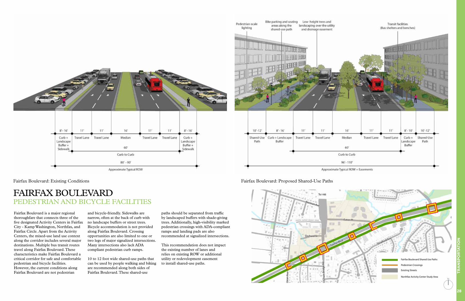
FAIRFAX BOULEVARDPEDESTRIAN AND BICYCLE FACILITIES
Fairfax Boulevard is a major regional thoroughfare that connects three of the five designated Activity Centers in Fairfax City - Kamp Washington, Northfax, and Fairfax Circle. Apart from the Activity Centers, the mixed-use land use context along the corridor includes several major destinations. Multiple bus transit routes travel along Fairfax Boulevard. These characteristics make Fairfax Boulevard a critical corridor for safe and comfortable pedestrian and bicycle facilities. However, the current conditions along Fairfax Boulevard are not pedestrian
and bicycle-friendly. Sidewalks are narrow, often at the back of curb with no landscape buffers or street trees. Bicycle accommodation is not provided along Fairfax Boulevard. Crossing opportunities are also limited to one or two legs of major signalized intersections. Many intersections also lack ADA compliant pedestrian curb ramps.
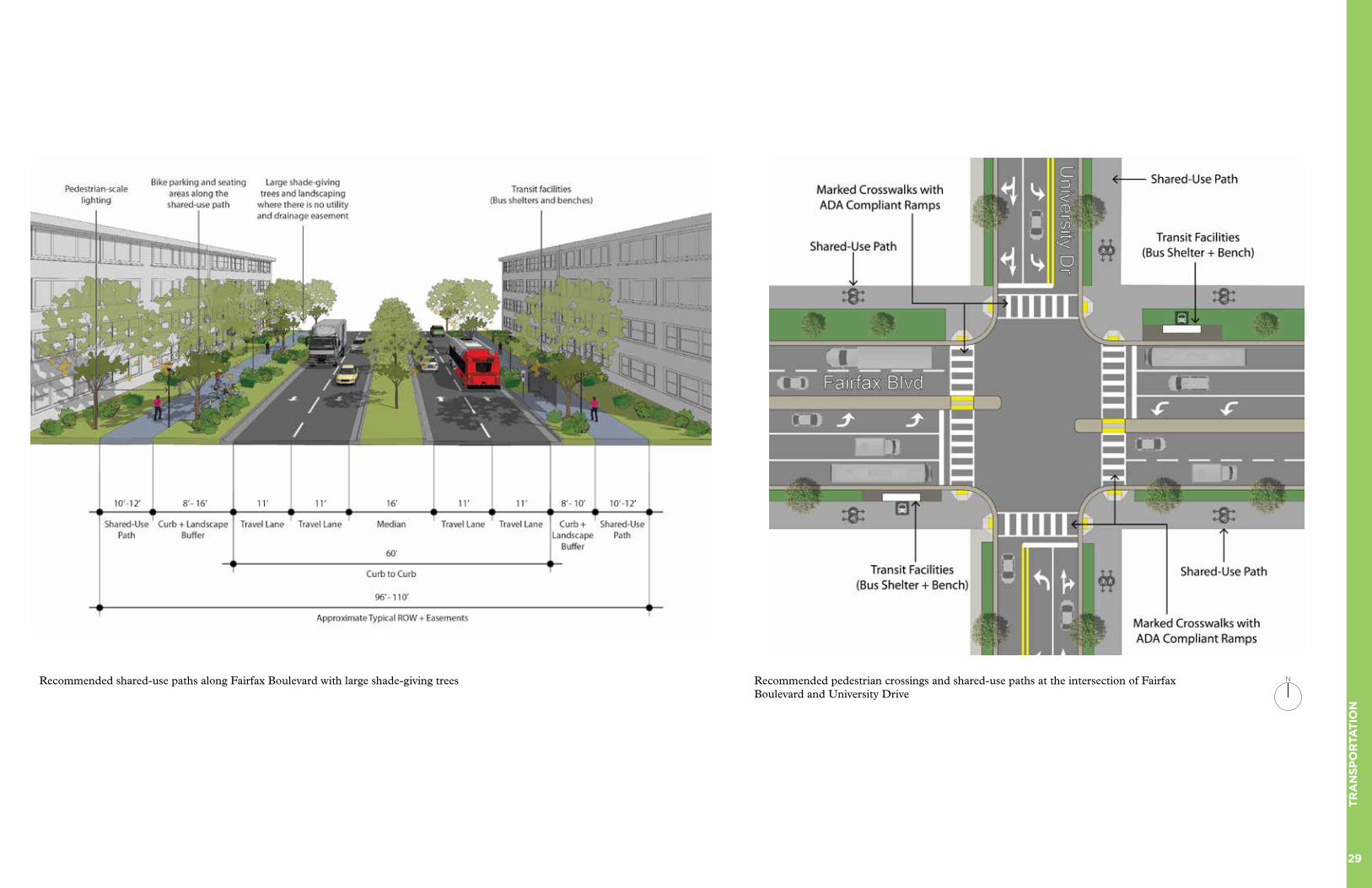
10 to 12 foot wide shared-use paths that can be used by people walking and biking are recommended along both sides of Fairfax Boulevard. These shared-use
paths should be separated from traffic by landscaped buffers with shade-giving trees. Additionally, high-visibility marked pedestrian crossings with ADA-compliant ramps and landing pads are also recommended at signalized intersections.
This recommendation does not impact the existing number of lanes and relies on existing ROW or additional utility or redevelopment easement to install shared-use paths.
Fairfax Boulevard: Proposed Shared-Use Paths Fairfax Boulevard: Existing Conditions
N
29
TR
AN
SP
OR
TAT
ION
Recommended shared-use paths along Fairfax Boulevard with large shade-giving trees Recommended pedestrian crossings and shared-use paths at the intersection of Fairfax Boulevard and University Drive
N
30
TR
AN
SP
OR
TAT
ION
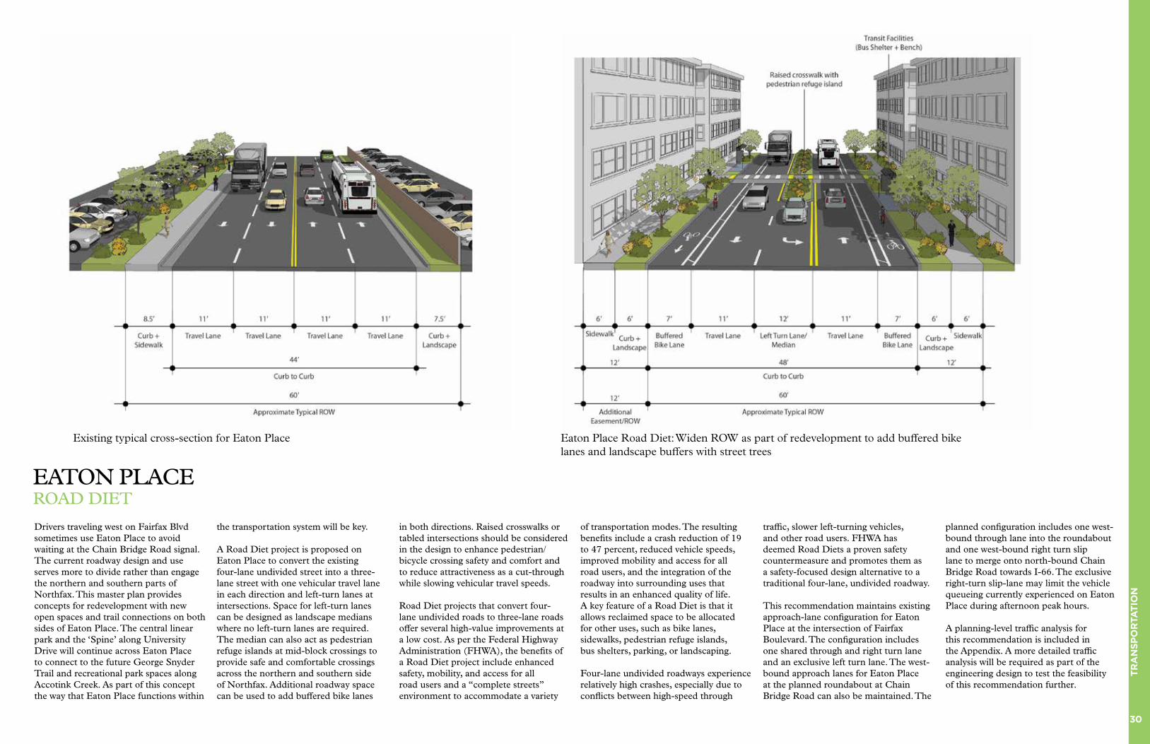
EATON PLACEROAD DIET
Drivers traveling west on Fairfax Blvd sometimes use Eaton Place to avoid waiting at the Chain Bridge Road signal. The current roadway design and use serves more to divide rather than engage the northern and southern parts of Northfax. This master plan provides concepts for redevelopment with new open spaces and trail connections on both sides of Eaton Place. The central linear park and the ‘Spine’ along University Drive will continue across Eaton Place to connect to the future George Snyder Trail and recreational park spaces along Accotink Creek. As part of this concept the way that Eaton Place functions within
the transportation system will be key.
A Road Diet project is proposed on Eaton Place to convert the existing four-lane undivided street into a three-lane street with one vehicular travel lane in each direction and left-turn lanes at intersections. Space for left-turn lanes can be designed as landscape medians where no left-turn lanes are required. The median can also act as pedestrian refuge islands at mid-block crossings to provide safe and comfortable crossings across the northern and southern side of Northfax. Additional roadway space can be used to add buffered bike lanes
in both directions. Raised crosswalks or tabled intersections should be considered in the design to enhance pedestrian/bicycle crossing safety and comfort and to reduce attractiveness as a cut-through while slowing vehicular travel speeds.
Road Diet projects that convert four-lane undivided roads to three-lane roads offer several high-value improvements at a low cost. As per the Federal Highway Administration (FHWA), the benefits of a Road Diet project include enhanced safety, mobility, and access for all road users and a “complete streets” environment to accommodate a variety
of transportation modes. The resulting benefits include a crash reduction of 19 to 47 percent, reduced vehicle speeds, improved mobility and access for all road users, and the integration of the roadway into surrounding uses that results in an enhanced quality of life. A key feature of a Road Diet is that it allows reclaimed space to be allocated for other uses, such as bike lanes, sidewalks, pedestrian refuge islands, bus shelters, parking, or landscaping.
Four-lane undivided roadways experience relatively high crashes, especially due to conflicts between high-speed through
traffic, slower left-turning vehicles, and other road users. FHWA has deemed Road Diets a proven safety countermeasure and promotes them as a safety-focused design alternative to a traditional four-lane, undivided roadway.
This recommendation maintains existing approach-lane configuration for Eaton Place at the intersection of Fairfax Boulevard. The configuration includes one shared through and right turn lane and an exclusive left turn lane. The west-bound approach lanes for Eaton Place at the planned roundabout at Chain Bridge Road can also be maintained. The
planned configuration includes one west-bound through lane into the roundabout and one west-bound right turn slip lane to merge onto north-bound Chain Bridge Road towards I-66. The exclusive right-turn slip-lane may limit the vehicle queueing currently experienced on Eaton Place during afternoon peak hours.
A planning-level traffic analysis for this recommendation is included in the Appendix. A more detailed traffic analysis will be required as part of the engineering design to test the feasibility of this recommendation further.
Existing typical cross-section for Eaton Place Eaton Place Road Diet: Widen ROW as part of redevelopment to add buffered bike lanes and landscape buffers with street trees

31
TR
AN
SP
OR
TAT
ION
PARKING MANAGEMENTSTRATEGIES AND RECOMMENDATIONS
Parking supply and how it is managed affects congestion, pollution, pedestrian comfort and safety, the feel of a place and the value of its open space and business activity. It is a critical driver of how people choose to get around. The cost and perceived availability to find parking must be carefully balanced to the demands of new uses and building an attractive, walkable Activity Center. Parking management for the Activity Center relies on the following five strategies:
• Create a park-once and walk district
• Encourage shared parking
• Establish district-wide parking regulations
• Encourage the use of on-demand mobile parking apps
• Manage curbside space
Create a park-once and walk district
Northfax is a major mixed-use destination that will invariably attract visitors who do not live within walking or biking distance. Most of these visitors are likely to drive to Northfax and require parking. The key to managing this parking need while maintaining an attractive and walkable district is to design Northfax as a park-once and walk district. With multiple uses within the Activity Center, visitors may need to visit more than one destination, resulting in more trips. With a park-once district environment, the additional trips can be made on foot along walkable streets, while the car is parked in a centralized parking location.
In a park-once environment, people are encouraged to park their car in one centralized place and then make stops on foot rather than driving from one destination to another within the district, unlike in a car-oriented single-use area. Creating the type of environment where
it is easy for people to walk between destinations involves both good urban design and parking policies. If each destination is required to provide its own off-street parking, and each building is required to provide parking on all sides, dead zones of surface parking lots are created between destinations that make walking distances longer and the walking experiences less pleasant, thereby incentivizing people to get back in the car to drive to other nearby destinations.
As part of the Small Area Plan, there are several shared parking garages designed to accommodate parking needs at the district level. This consolidation of parking along a few major streets enables the creation of a walkable internal street network that will result in a park-once district.
Encourage shared parking
Shared parking is a strategy that optimizes parking capacity by allowing complementary land uses to share parking spaces, rather than developing separate spaces for separate uses. This strategy leverages synergies between adjacent land uses that requires parking at different times within a 24-hour period. Mixed-use walkable districts can leverage this difference by sharing parking spots and reducing overall parking inventory.
Parking demands operate on a peak and off-peak schedule dependent on the related land use. Distinct but complementary patterns, such as “office parking” that is generally empty in the evenings and on weekends and “residential parking” that is usually fuller in the evenings, offers an opportunity to better meet parking requirements without increasing supply.
Research has shown that deploying shared parking strategies could reduce the need for parking spaces by up to 38% as compared to providing separate parking for each individual property or
land use type. The City should consider creating a parking management district for Northfax to encourage shared parking and maximize parking resources while minimizing excess parking supply.
Establish district-wide parking regulations for the Activity Center area
Most of the time, developers have to provide minimum parking spaces stipulated in the City’s development code resulting in a site-by-site parking supply that typically exceeds demand, cannot be shared, and takes considerable space for the utility of storing cars. Fairfax City’s Zoning Ordinance recognizes this effect and has set parking maximums for commercial and industrial uses as well as encourages shared parking. However, the City has several requirements that may limit the use and location of shared parking strategies. . In mixed-use activity centers, parking should be considered as a shared resource, and regulations should allow sharing of centrally located parking in-lieu of on-site parking requirements, especially for commercial and retail land uses. The City should develop a comprehensive district-wide parking regulation for the Activity Center area to provide clarity and predictability of parking requirements throughout Northfax. These regulations can include a methodology to calculate shared parking ratios by land use type and implementation framework that can allow developers to pay into a fund to build centrally located shared parking garages in lieu of on-site parking requirements.
Encourage the use of on-demand mobile parking apps
Advances in technology have also enabled more efficient use of existing parking inventory. Mobile apps such as Spot Hero, Parking Panda, ParkMobile, among others, allow users to reserve a parking spot on demand and in advance at a specific location.
These mobile apps open up publicly and privately owned parking spaces to be shared as public parking spaces, increasing the available supply without any additional cost to the City. The distributed nature of parking supply that is made possible by the use of such technologies also mitigates the traffic congestion that can be caused by a single large parking lot or garage.
As part of the overall TDM program, the City should consider organizing educational or marketing campaigns to make residents, employees, and visitors aware of these additional parking options.
Manage curbside space
The City’s curbside space is one of its most valuable resources, especially in the Activity Centers. Proper management of this resource results in greater access, increasing the efficiency and functionality of the space for residents, visitors, and business owners alike. This, in turn, produces economic and quality of life benefits for everyone. The City’s curbside environment is utilized by a diverse range of users in cars, on bikes, scooters, in buses, and in commercial vehicles. The boom in online shopping and ride-hail services has contributed to an uptick in commercial and individual demand for pick-up/drop-off zones and curbside loading zones. Along with ride-hail applications, new transportation options like shared scooters and other micromobility modes are simultaneously expanding access to the City’s Activity Centers and surrounding neighborhoods resulting in increasing demand for already limited curbside space.
Often, these competing demands outstrip the amount of available space, requiring proactive management. Competing demands need to be balanced by analyzing tradeoffs and looking closely at the local context. A solution that works in Old Town may not be appropriate for Northfax or any other Activity Centers.
The City should develop a specific curbside management plan for each Activity Center clearly identifying pick-up/drop-off spaces, loading areas, bike-share and scooter-share parking, and on-street parking with various regulations by streets and block faces.

32
TR
AN
SP
OR
TAT
ION
“THE SPINE”CONNECTING THE CITY
One of the key recommendations of this Small Area Plan is developing ‘The Spine’ - a safe and comfortable pedestrian and bicycle connection linking Northfax, Old Town, and the George Mason University (Mason) campus. George Mason Boulevard and University Drive form a prominent north-south connector within Fairfax City. This alignment provides a direct connection between Mason, Old Town, and Northfax. Despite the lack of continuous comfortable facilities for people who walk and bike, many students and residents mentioned that they use these streets to walk and bicycle between the university campus, Old Town, and Northfax. The Spine along George Mason Boulevard and University Drive
can serve as the City’s main north-south multi-modal link that provides a continuous, comfortable, and vibrant route that accommodates all users.
The Spine could be a context-sensitive pedestrian and bicycle facility along George Mason Boulevard from Patriot Circle to Armstrong Street and University Drive from Armstrong Street to Eaton Place. Northfax and Mason are both separated from Old Town by about a mile to the north and south, respectively. A one-mile distance can be comfortably traversed on foot or a bike with the availability of safe and comfortable facilities.
The City, beginning to realize the multi-modal potential of the corridor, has implemented a road diet project on University Drive from Armstrong Street to Sager Avenue, just south of Old Town. This project added a center-running two-way left turn lane and dedicated bicycle lanes by re-purposing one vehicular lane in each direction. The City is also planning a neighborhood traffic calming project along University Drive, north of Old Town, from Layton Hall Drive to Stratford Avenue. The Spine will build on these previous and ongoing efforts to create an attractive and branded connection that serves people who walk and bike.
The City should consider developing the Spine as a branded connection with consistent design elements such as street furnishings, benches, paving patterns, landscaping, and wayfinding signage for the entire length. However, the specific pedestrian/bicycle facility types could change as the land use and street context changes. There is an opportunity to widen existing sidepaths and sidewalks to create a 10 to 12-foot wide shared-use path along the west side of George Mason Boulevard and University Drive from Mason to Old Town. University Drive from Old Town to Northfax is a residential neighborhood street where bicycle boulevard treatments would be more appropriate. Bicycle boulevard
treatments will build on the City’s traffic calming project to add bicycle shared lane or sharrow markings along with specific wayfinding and branding signs. Bicycle boulevards are streets with low motorized traffic volumes and speeds, designated and designed to give bicycle travel priority. Bicycle boulevards use signs, pavement markings, and traffic calming measures to create comfortable streets for people on bicycles to share the lanes with low-speed automobiles.
Wide shared-use paths, traffic-calmed bicycle boulevards, and well-designed crossings would provide more comfortable facilities for people who walk and bike and encourage
active transportation. Certain areas around significant intersections could be designed with gateway treatments to create small plazas or parklets with seating areas. Improved pedestrian crossings would encourage people of all ages and abilities to use the corridor for commuting, recreation, and exercise. With consistent branding and wayfinding design, The Spine can become an iconic pedestrian and bicycle connector within Fairfax City.
N
33
TR
AN
SP
OR
TAT
ION
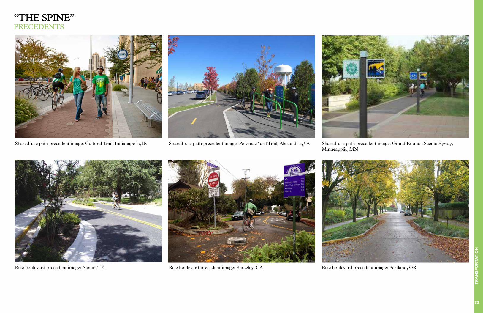
“THE SPINE”PRECEDENTS
Shared-use path precedent image: Cultural Trail, Indianapolis, IN Shared-use path precedent image: Potomac Yard Trail, Alexandria, VA Shared-use path precedent image: Grand Rounds Scenic Byway, Minneapolis, MN
Bike boulevard precedent image: Austin, TX Bike boulevard precedent image: Berkeley, CA Bike boulevard precedent image: Portland, OR

34
IMP
LE
ME
NTA
TIO
N
IMPLEMENTATION
AND DETAILS
Northfax West Details 35
Northfax East Details 36 Phasing and Economics 37 Sustainability 38 Placemaking and 39 Automotive Uses Utility Recommendations 40 Zoning and Regulatory 43 Recommendations

35
IMP
LE
ME
NTA
TIO
N
NORTHFAX WESTPLAN DETAILS AND EXPECTATIONS
New Commercial Construction (Car dealership):
• New street connection to Orchard St.
• Increased Pervious Surface Area and Improved Stormwater Capture
• Formation of Street Edge and Increased Sidewalk Widths at Fairfax Boulevard
Primarily Residential Building:
• 5 story height limit
• Streetscape and orientation towards Fairfax Boulevard
• Consolidation with neighboring property recommended
Townhouses:
• 4 story height limit to transition to neighbors to the west and north
Trail Connection:
• Publicly accessible path connection from Perry St. to Orchard St.
• Lighting and pathway provided
Linear Park at Orchard Street
• 12 foot width minimum
• Curb-less street design and special paving for street and sidewalk
Senior Living Housing:
• 7 story building with integrated parking garage
• Landscaped open spaces on east and west sides of the building
Historic “Microdistrict”:
• Preservation of Historic Resources (Diner, Bridge, Car Repair Shop)
• Potential adaptation of buildings into new commercial uses (e.g. restaurant)
Mixed-Use Building with Ground Floor Retail:
• 7 story height limit
• Architectural design matches prominent location at Chain Bridge Road and Orchard St.
• Structure may bridge over existing underground stormwater culvert
Mixed-Use Building with Ground Floor Retail:
• 7 story height limit, but the building massing steps down in height to 4 stories along the north edge of the property
This diagram is a short summary of the expected land uses, building typologies and special details within the Development Plan. These details were based on major stakeholder outreach (including property owners), market research, and urban design best practices.
The buildings and land uses depicted here serve as a conceptual build out for the Small Area Plan framework in Northfax. Although the core ideas should remain consistent, the plan also recognizes that land uses, building typologies, and specific designs may change in the future.
N

36
IMP
LE
ME
NTA
TIO
N
NORTHFAX EASTPLAN DETAILS AND EXPECTATIONS
New Commercial Construction (Retail Center):
• Grocery store anchor with local-serving retail
• New street to be integrated with neighboring property
New Public Plaza
• Open space integrated with retail frontage
• Specialized design to accommodate outdoor activities, including play areas, events and casual seating
Primarily Residential Buildings:
• 7 story height limit
• Underground and integrated Parking
• Structure may bridge over existing underground stormwater culvert
Office Park:
• Preservation of some office uses are recommended in the mixed-use activity center
• Existing buildings are good candidates for renovation and repositioning
Mixed-Use Buildings with Ground Floor Retail:
• 7 story height limit
• Underground and integrated Parking
Hotel:
• Renovation and expansion
• Addition of ground floor retail along Orchard St.
New Commercial Construction (Office or Mixed-Use):
• 7 story height limit
• Potential district-serving parking garage
Trail Connection:
• Publicly accessible path connection from the Linear Park to the George Snyder Trail
• Lighting and pathway provided
New Commercial Construction (Hotel, Office or Mixed-Use):
• 7 story height limit
• Potential area for housing, including affordable and other types
Linear Park and Community Green at Orchard Street
• 20 foot width minimum, 30+ feet recommended
• Curb-less street design and special paving for street and sidewalk
This diagram is a short summary of the expected land uses, building typologies and special details within the Development Plan. These details were based on major stakeholder outreach (including property owners), market research, and urban design best practices.
The buildings and land uses depicted here serve as a conceptual build out for the Small Area Plan framework in Northfax. Although the core ideas should remain consistent, the plan also recognizes that land uses, building typologies, and specific designs may change in the future.
N
37
IMP
LE
ME
NTA
TIO
N
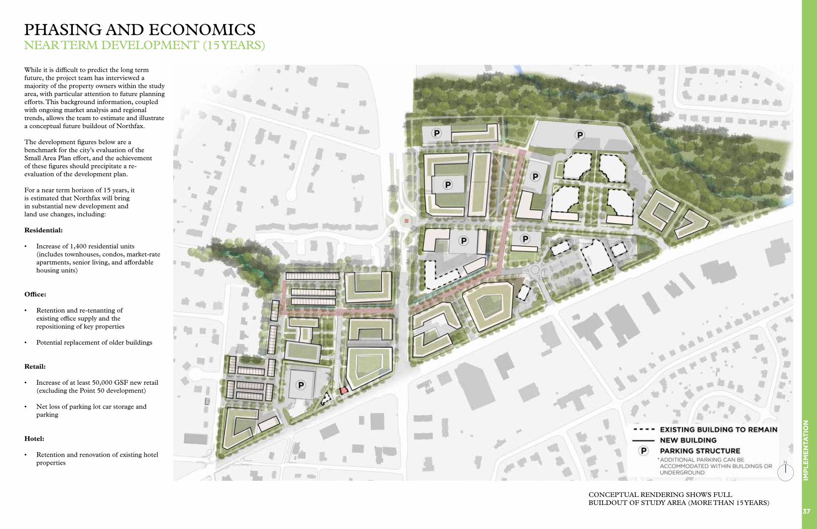
PHASING AND ECONOMICSNEAR TERM DEVELOPMENT (15 YEARS)
While it is difficult to predict the long term future, the project team has interviewed a majority of the property owners within the study area, with particular attention to future planning efforts. This background information, coupled with ongoing market analysis and regional trends, allows the team to estimate and illustrate a conceptual future buildout of Northfax.
The development figures below are a benchmark for the city’s evaluation of the Small Area Plan effort, and the achievement of these figures should precipitate a re-evaluation of the development plan.
For a near term horizon of 15 years, it is estimated that Northfax will bring in substantial new development and land use changes, including:
Residential:
• Increase of 1,400 residential units (includes townhouses, condos, market-rate apartments, senior living, and affordable housing units)
Office:
• Retention and re-tenanting of existing office supply and the repositioning of key properties
• Potential replacement of older buildings
Retail:
• Increase of at least 50,000 GSF new retail (excluding the Point 50 development)
• Net loss of parking lot car storage and parking
Hotel:
• Retention and renovation of existing hotel properties N
CONCEPTUAL RENDERING SHOWS FULL BUILDOUT OF STUDY AREA (MORE THAN 15 YEARS)
38
IMP
LE
ME
NTA
TIO
N
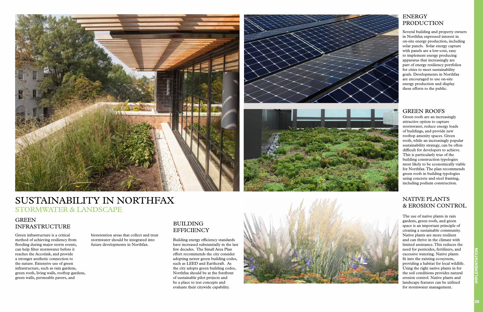
SUSTAINABILITY IN NORTHFAXSTORMWATER & LANDSCAPE
Green roofs are an increasingly attractive option to capture stormwater, reduce energy loads of buildings, and provide new rooftop amenity spaces. Green roofs, while an increasingly popular sustainability strategy, can be often difficult for developers to achieve. This is particularly true of the building construction typologies most likely to be economically viable for Northfax. The plan recommends green roofs in building typologies using concrete and steel framing, including podium construction.
The use of native plants in rain gardens, green roofs, and green space is an important principle of creating a sustainable community. Native plants are more resilient and can thrive in the climate with limited assistance. This reduces the need for pesticides, fertilizers, and excessive watering. Native plants fit into the existing ecosystem, providing a habitat for local wildlife. Using the right native plants in for the soil conditions provides natural erosion control. Native plants and landscape features can be utilized for stormwater management.
GREEN INFRASTRUCTURE
GREEN ROOFS
NATIVE PLANTS& EROSION CONTROL
Green infrastructure is a critical method of achieving resiliency from flooding during major storm events, can help filter stormwater before it reaches the Accotink, and provide a stronger aesthetic connection to the nature. Extensive use of green infrastructure, such as rain gardens, green roofs, living walls, rooftop gardens, green walls, permeable pavers, and
bioretention areas that collect and treat stormwater should be integrated into future developments in Northfax.
PHOTO GREEN ROOF
PHOTO NATIVE PLANTS
ENERGY PRODUCTION
Several building and property owners in Northfax expressed interest in on-site energy production, including solar panels. Solar energy capture with panels are a low-cost, easy to implement energy producing apparatus that increasingly are part of energy resiliency portfolios for cities to meet sustainability goals. Developments in Northfax are encouraged to use on-site energy production and display these efforts to the public.
Building energy efficiency standards have increased substantially in the last few decades. The Small Area Plan effort recommends the city consider adopting newer green building codes, such as LEED and Earthcraft. As the city adopts green building codes, Northfax should be at the forefront of sustainable pilot projects and be a place to test concepts and evaluate their citywide capability.
BUILDING EFFICIENCY
39
IMP
LE
ME
NTA
TIO
N
While recent surveys of Northfax have not identified any new significantly intact historic resources in the study area beyond the 29 Diner, there are still opportunities to link the new plan to the past while also supporting a robust street grid and pedestrian connections.
The southern corner of the western edge of Northfax, have a buildings and landscape elements that could be adapted to provide a sense of place that links to the automotive history of the area.
If property owners to the north, consolidated with the city owned parcel at the corner- a new mixed use building could replace the largely surface parking found there now. Even if consolidation does not occur or happens in the more distant future - adaptive reuse of existing mid-century automotive uses could help create a more active retail destination for the neighborhood.
Future studies should investigate public activation of his area to potentially incorporate elements such as placemaking signage, adaptive reuse of buildings, and better pedestrian connectivity.
TROLLEY PATH & BRIDGE REMAINS
Automotive related retail buildings and uses in Northfax may remain in the near term. This significant identity can be celebrated or re-imagined in terms of placemaking.
Recent historic surveys have shown there are no architecturally intact historic mid-century automotive resources in Northfax. Despite this, opportunities remain to adapt these buildings to serve as new retail hubs, community institutional buildings, or other placemaking focused use. Reuse of these resources could also help bridge the half century history of the site as an automotive hub to a green future.
ADAPTIVE REUSE OF MID-CENTURY & AUTOMOTIVE BUILDINGS
PLACEMAKING & AUTOMOTIVE USESHISTORIC & CULTURAL RESOURCES IN NORTHFAX
Various reminders of railroads and their infrastructure remain in Northfax- particularly near to the 29 Diner. While research has not highlighted these as major historic resources, the plan recommends finding opportunities to celebrate and commemorate their contribution to placemaking in Northfax.
THE DINER
The 29 Diner is a celebrated historic resource. With any potential redevelopment of the parcel the plan recommends the resource be preserved in situ or preserved and relocated at a nearby location. As currently, shown, the diner serves as the terminus of a new residential street in Northfax and can help serve as a wayfinding and iconic community hub.
PRECEDENT PHOTO
MAP KEY1. 29 Diner2. Trolley Bridge Preservation / Memorial3. Mid-century Building Adaptive Reuse
Opportunities4. Wayfinding Opportunity5. Future Road Extension for Site Access
1
2
34
5
NE
W S
TR
EE
T
COMMERCIAL BUILDING
AUTOMOTIVE RETAIL
SENIOR HOUSING
PLANNED CULVERT
FAIRFAX BOULEVARD
The 29 Diner - a national register historic resource for Northfax
The adaptive reuse of an automotive shop into a coffee shop
An existing automotive retail shop in Northfax
N

40
IMP
LE
ME
NTA
TIO
N
NORTHFAX SMALL AREA PLANSTORM INFRASTRUCTURE EXHIBIT
SCALE: 1" = 150'DATE: 05/19/2020
WLPINC.com
NORTHFAX SMALL AREA PLANSTORM INFRASTRUCTURE EXHIBIT
SCALE: 1" = 150'DATE: 05/19/2020
WLPINC.com
This Northfax drainage shed drains to one primary point, to the North Fork Accotink Creek to the east. This drainage shed also receives runoff from residential neighborhoods to the west and north and commercial and residential areas south of Fairfax Blvd. Proposed storm culverts planned for installation associated with CLOMR 15-03-0043R and CLOMR 18-03-2239 should address the downstream drainage capacities of much of the Northfax drainage shed.
Overall, existing and planned storm sewer infrastructure within this plan area is expected to be adequate to accommodate future redevelopment. One possible exception to this expectation is a roughly 400 linear foot segment of existing storm sewer within Chain Bridge Road. This segment may be undersized and may require upgrades or replacement.
UTILITIES - STORMWATERRECOMMENDATIONS
ACCOTINK CREEK
N
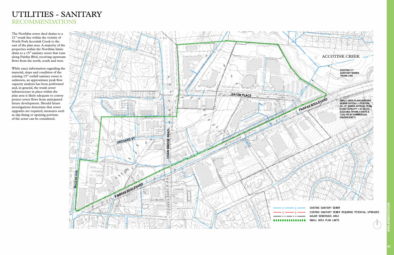
41
IMP
LE
ME
NTA
TIO
N
NORTHFAX SMALL AREA PLANSANITARY INFRASTRUCTURE EXHIBIT
SCALE: 1" = 150'DATE: 05/19/2020
WLPINC.com
NORTHFAX SMALL AREA PLANSANITARY INFRASTRUCTURE EXHIBIT
SCALE: 1" = 150'DATE: 05/19/2020
WLPINC.com
The Northfax sewer shed drains to a 21” trunk line within the vicinity of North Fork Accotink Creek to the east of the plan area. A majority of the properties within the Northfax limits drain to a 15” sanitary sewer that runs along Fairfax Blvd, receiving upstream flows from the north, south and west.
While exact information regarding the material, slope and condition of the existing 15” outfall sanitary sewer is unknown, an approximate peak flow capacity analysis has been performed and, in general, the trunk sewer infrastructure in place within the plan area is likely adequate to convey project sewer flows from anticipated future development. Should future investigations determine that sewer upgrades are required, measures such as slip-lining or upsizing portions of the sewer can be considered.
UTILITIES - SANITARYRECOMMENDATIONS
N
ACCOTINK CREEK

42
IMP
LE
ME
NTA
TIO
N
NORTHFAX SMALL AREA PLANOVERHEAD UTILITY EXHIBIT
SCALE: 1" = 150'DATE: 5/7/2020
WLPINC.com
NORTHFAX SMALL AREA PLANOVERHEAD UTILITY EXHIBIT
SCALE: 1" = 150'DATE: 5/7/2020
WLPINC.com
Within this plan area, there is approximately 6,750 linear feet of existing overhead utilities. The plan recommends that future developments be encouraged to place existing overhead utilities underground. This could be accomplished through enforcement of existing zoning ordinance provisions.
Based on the review of cost data across a variety projects in this region, it is estimated that costs for undergrounding can vary from $1,300 to $2,000 per linear foot. This significant variation in potential costs is due to the wide range of complexity levels depending on the extent of undergrounding and how the lines to be undergrounded function within the larger utility grid. Based on this estimate, undergrounding of all overhead lines within the plan area over time could cost $8,800,000 to $13,500,000. For a less dense area such as this plan area, it is estimated that undergrounding costs may fall in the middle or low end of this estimated range.
UTILITIES - OVERHEAD LINESRECOMMENDATIONS
N
ACCOTINK CREEK
43
IMP
LE
ME
NTA
TIO
N
The Small Area Plan outlines a long-term development vision for Northfax and implementing this vision will require adjustments to current zoning and regulations.
1. Zoning (Land Use) – Currently, most of Northfax is zoned CR (Commercial Retail), which does not permit residential and hotel uses without special exception. The plan recommends that all properties in the study area be rezoned to also allow for residential, hotel and mixed-use. The Commercial Urban (CU) zone is a potential solution for the study area, as it has more flexibility in allowable land uses.
2. Zoning (Building Height) – Currently, CR (Commercial Retail) uses are limited to 5 stories / 60 feet. The plan recommends that properties within the study areas have a tailored height limit based on the plan vision (see Building Height and Setbacks) instead of the zoning height restrictions.
3. Stormwater Regulations - With Northfax sited on top of an important watershed, stormwater management is one of the most critical aspects of redevelopment. Currently, the land uses utilize substantial impervious surfaces (like parking lots) and most developments pre-date modern stormwater regulations. Redevelopment in general will help improve the quantity and quality of stormwater runoff due to conformance to state regulations. The plan recommends increasing stormwater requirement metrics by 15% beyond state minimums in both quantity and quality for all development within Northfax. Additionally, developments are strongly recommended to utilize green stormwater infrastructure
technologies that are visible to the public, so they can be used as educational pieces about how the areas is helping the city achieve their sustainability goals in Northfax.
4. Street Tree / Public Tree Standards – The plan recommends increased planting bed standards in Northfax for urban and open space trees. Each property should incorporate continuous planting beds with soil volumes that exceed 500 cu ft per tree, when possible. These standards are particularly important for trees within the Linear Park.
5. Green Buildings – The plan recommends that the City explore a green building standard for all construction within Northfax. Examples of commonly used green building standards include LEED and Earthcraft. Northfax would be appropriate for a minimum green building standard of LEED-New Construction - Silver (or similar).
6. Community Education - Each development is recommended to have a public educational display showing on-site sustainability initiatives, such as stormwater capture, energy production, alternative transportation, green building, and others. A critical mass of developments in Northfax displaying sustainability initiatives will help shape the environmental identity and sustainability aspirations of Northfax.
Realizing a new revitalized Northfax will require an ongoing commitment by all stakeholders towards the implementation of key ideas.
Key Idea #1: Northfax as an Ecologically Sensitive District
1. The formation of a Northfax Guidance Committee – this group should be coordinated by City staff and should oversee the implementation the Northfax vision over time. It should be comprised of city staff, community leaders, environmental leaders and property owners. This group should meet quarterly to give updates, coordinate planning, and to promote the efforts and implementation of the Small Area Plan.
2. New incentives – City to explore capital investment in public open space and transportation infrastructure within the study area, such as the Linear Park, the Public Plaza and Orchard Street.
3. New regulations for development, such as increased stormwater and tree standards. These regulation recommendations are designed to establish better sustainability outcomes for Northfax, while promoting needed redevelopment that transitions from existing uses.
4. Establish an identity – As change occurs, it is important to publicize and highlight these efforts as widely as possible. There is real value for all stakeholders (including property owners) in marketing Northfax as a desirable place to live, work and enjoy. Examples include: publicizing sustainability efforts (green infrastructure, stormwater strategies, sustainability education)
and promoting upcoming projects.
Key Idea #2: A New Linear Park
1. Follow up coordination meetings with property owners – communicate expectations for each property with key elements, finalize design parameters, including width and design, as well as coordination of site stormwater strategy. If needed, work out city-owner agreements for public space easements.
2. City to consider offering incentives, including increased height and density, to property owners for increased public space beyond minimum requirements, as needed by the design goals.
3. Have a unified design team to coordinate landscape design across multiple properties and timelines (includes planting standards, open space design, phasing, etc).
4. Establish a unified stormwater strategy and detailing for the entire linear park. This will help ensure consistency across varied properties and timelines.
Key Idea #3: Promoting Balanced Land Use
1. City staff to track data as new land uses come in to replace older ones, and analyze the long-term economic, fiscal, transportation and environmental impacts. This data should be used to help guide future planning efforts.
Key Idea #4: Stitching Together Neighborhoods
1. City transportation staff to advance the pedestrian crossing (Chain
Bridge Road pedestrian crossing at Orchard Street) concept plans into design development. The timing of the intersection construction should be coordinated with development of Northfax West and Northfax East properties, as well as the Linear Park design.
2. City transportation staff to further monitor and develop complete pedestrian crossings recommended intersections on Fairfax Boulevard within Northfax. The goal is to better connect the neighborhoods south of Fairfax Boulevard with the study area.
3. The plan vision recommends key trail connections from Northfax to the adjacent communities: Northfax West connecting to Perry Street, the Linear Park connecting to the George Snyder Trail (north of Eaton Place), and Willowwood property connecting to the George Snyder Trail. As these specific properties develop, ensure expectations that these trail connections are prioritized and integrated into the site plans.
City Owned Properties
The City of Fairfax owns property within the small area plan boundaries. Consideration has been given as to how these properties can be best integrated into overall plan recommendations and other City priorities. Factors evaluated as part of this analysis include, but are not limited to:
• Property specific characteristics such as location, parking, traffic impacts, etc.
• Market opportunities• Supporting plan goals
and objectives• Synergistic factors with
adjacent land uses• Community benefit• Fiscal impact• Possible City partnering tools
Proposed treatment of City-owned property contemplates possible future site redevelopment, both as stand-alone sites and if planned in conjunction with adjacent properties, to effectuate the most beneficial reuse of the property. See the Appendix for details for these properties.
City-Owned Property: 10500 Fairfax Boulevard
Plan Recommended Uses:
Stand Alone - Signage or arts potential. Block Consolidation - Convey to adjoining land owner for signage or arts potential. Possible transfer of density to other properties.
ZONING AND REGULATORY RECOMMENDATIONS
IMPLEMENTATION OF KEY IDEAS