Embed Size (px)
Citation preview

City of Dayton Shoreline Master Program – ORD. 1910 Exhibit 1 Page 1
City of Dayton, Washington
Shoreline Master Program
DAYTON COMPREHENSIVE PLAN
SHORELINE ELEMENT
Final Adoption – ORD 1910 May 8, 2017
Exhibit 1
This policy document was funded through a
grant from the Washington State Department of Ecology.

City of Dayton Shoreline Master Program – ORD. 1910 Exhibit 1 Page 2
Acknowledgements
Craig George, Mayor, 2017
Councilmembers
Delphine Bailey, 2017
Kathy Berg, 2017
Christine Broughton, 2017
Art Hall, 2015
Byron Kaczmarski, 2017
Dain Nysoe, 2017
Mike Paris, 2017
Zac Weatherford, 2017
Dayton Planning Commission
Gregory Abramson 2017
Joe Huether, Chair, 2017
Candace Jones, 2015
Byron Kaczmarski, 2017
Carol (Eslick) Rahn, 2017
City Staff
Trina D. Cole, City Clerk-Treasurer, 2017
Jim Costello, Public Works Director, 2017
Karen J. Scharer, AICP, Planning Director, 2017
Consultants
Noah Herlocker, PWS, AECOM
Raymond Oligher, RLO Assoc.
Dept. of Ecology
Jeromy Sikes, Shoreline Specialist, 2017
Jaime Short, Shoreline Specialist, 2015

City of Dayton Shoreline Master Program – ORD. 1910 Exhibit 1 Page 3
Table of Contents 1 GENERAL PROVISIONS AND SMP ELEMENTS ........................................................... 5
1.01 Adoption .................................................................................................................. 5
1.03 Purpose ................................................................................................................... 5
1.04 Shoreline Elements ................................................................................................. 5
2 SMP DEFINITIONS ......................................................................................................... 8
3 SHORELINE PROJECT REVIEW AND PERMITTING .................................................... 8
3.02 Substantial Development Permits ........................................................................... 9
3.03 Exemptions ............................................................................................................. 9
3.04 Variances ................................................................................................................ 9
3.05 Conditional Use Permits .......................................................................................... 9
3.06 Unclassified Uses and Activities ............................................................................ 10
3.07-.14 General Permit Processing ............................................................................. 10
4 SHORELINE MANAGEMENT AREAS........................................................................... 10
4.01 Shoreline Environmental Designations ................................................................. 10
4.02 Management of Native Conservation Areas (NCAs) of the Environmental
Designations ...................................................................................................................... 17
Native Conservation Area Minimum Widths ....................................................................... 18
4.03 City of Dayton Environmental Designations Map .................................................. 18
5 GENERAL SHORELINE POLICIES ............................................................................... 18
5.01 Background ........................................................................................................... 18
5.02 Environmental Policies .......................................................................................... 19
5.03 Environmentally Sensitive Area Policies within the Shoreline Management Area . 23
5.04 Public Access ........................................................................................................ 24
6 SPECIFIC SHORELINE USE POLICIES ........................................................................ 25
6.01 General Overview ................................................................................................. 25
6.02 Existing Structures ................................................................................................ 26
6.03 Existing Uses ........................................................................................................ 26
6.05 Standards for Permitting within Shoreline Environmental Designations ................ 26
6.06 Shoreline Stabilization (Armoring) ......................................................................... 26
6.07 Fill ......................................................................................................................... 30

City of Dayton Shoreline Master Program – ORD. 1910 Exhibit 1 Page 4
6.08 Dredging and Dredge Material Disposal ............................................................... 30
6.09 Vegetation Management ....................................................................................... 31
6.10 Boating Facilities ................................................................................................... 31
6.11 Forest Practices .................................................................................................... 32
6.12 Industrial Development ......................................................................................... 32
6.13 Institutional Development ...................................................................................... 32
6.14 Mining ................................................................................................................... 32
6.15 Recreational Development .................................................................................... 32
6.16 Residential Development ...................................................................................... 33
6.17 Signs ..................................................................................................................... 34
6.18 Parking .................................................................................................................. 34
6.19 Transportation ....................................................................................................... 35
6.20 Railroads and Rail Corridors ................................................................................. 35
6.21 Nonresidential Development ................................................................................. 35
6.22 Utilities................................................................................................................... 36
APPENDIX A ........................................................................................................................ 37

City of Dayton Shoreline Master Program – ORD. 1910 Exhibit 1 Page 5
1 GENERAL PROVISIONS AND SMP ELEMENTS
1.01 Adoption
The Shoreline Master Program (SMP) was adopted on May 8, 2017 by Ordinance 1910 in
accordance with the Shoreline Management Act (SMA)(chapter 90.58 RCW) and the State
Shoreline Guidelines (chapter 173-26 WAC). Hereafter, it is be commonly referred to as the
SMP.
1.03 Purpose
The purpose of this SMP is to:
Promote the public health, safety, and general welfare of the community;
Manage shorelines in a positive, effective, and equitable manner;
Achieve no net loss of the ecological functions of the City of Dayton’s shorelines;
Assume and carry out the responsibilities established by the Shoreline Management Act (SMA);
Adopt and foster the policies contained in chapter 90.58 of the Revised Code of Washington (RCW), the State SMA, for shorelines of the State; and
Provide assurance that proposed regulatory or administrative actions do not unconstitutionally infringe upon private property rights.
To implement Dayton’s SMP, the City adopted the Shoreline Management Code (SMC) Title 15 of the Dayton Municipal Code, hereafter referred to as the Shoreline Code or SMC.
1.04 Shoreline Elements
RCW 90.58.100(2) states that SMPs shall, when appropriate, include the following elements:
Economic Development Land Use
Public Access Conservation
Recreation Historic/Cultural Values
Circulation Flood Hazard Reduction

City of Dayton Shoreline Master Program – ORD. 1910 Exhibit 1 Page 6
Shoreline Element Goals with Related Objectives and Actions
Goals and objectives have been considered in the preparation of this SMP for the City of Dayton. The goals and objectives established for these elements reflect community ideals as presented in local visioning meetings and provide the basis for policies, actions and regulations included in this SMP and Shorelines Code.
ECONOMIC DEVELOPMENT
Goal SMP-1 Balance the amount of land available for shoreline economic development with land available for conservation purposes to ensure opportunities for economic growth while maintaining the current ecological characteristics and functions within the shoreline jurisdiction.
Objective SMP 1.1 Use the current state of ecological conditions, as found in the most recent Shoreline Inventory and Characterization Report, when determining buffer widths.
Objective SMP 1.2 Craft regulations to create a preference for water-dependent and water-oriented development within the shoreline zone.
PUBLIC ACCESS
Goal SMP-2 Maintain and improve current levels of access to the river while protecting private property.
Objective SMP-2.1 Provide notice when private property is crossed by levee paths.
Action SMP-2.1.1 Inform citizens that the levee paths and stretches of the river cross private property at different points.
Action SMP-2.1.2 Place signage along levee paths where public property stops and private property begins.
Objective-SMP-2.2 Limit vehicle traffic along levee paths to only authorized users.
Objective SMP-2.3 Identify opportunities for increased access.
Commentary - Where shorelines policies and codes require that public access be provided, the
requirement shall be construed to be limited to the extent of the lawful and constitutional
authority of the City to require public access or to require the easement, fee ownership, or interest
requested.

City of Dayton Shoreline Master Program – ORD. 1910 Exhibit 1 Page 7
RECREATION
Goal SMP-3 Retain or improve current levels of shoreline access and walkability.
Objective SMP-3.1 Support projects to explore, extend, and improve levee path system and shoreline access.
Action SMP-3.1.1 Explore feasibility of pedestrian bridge near Smith Hollow School.
Action SMP-3.1.2 Explore feasibility of trail system near Rock Hill.
LAND USE
See Goals SMP-2 and SMP-5.
CONSERVATION
Goal SMP-4 Identify and protect areas of high value shoreline habitat and support ongoing watershed enhancement projects in Dayton and upstream of the City to ensure that the net shoreline ecological functions are preserved or enhanced throughout the future shoreline planning period.
Objective SMP-4.1 Discourage development or land-altering shoreline uses within areas identified as habitat conservation areas in the Shoreline Inventory and Characterization Report.
Objective SMP-4.2 Minimize pollutants to the river in coordination with the Touchet River Total Maximum Daily Load allocation.
Objective SMP-4.3 Support fish recovery efforts within and upstream of the City by coordinating with federal Fish and Wildlife agencies, Columbia County, and the Salmon Recovery Board on grant applications and encourage such projects in the regulations.
Objective SMP-4.4 Explore feasibility to save dying trees near the “east end ditch” drainage.
Objective SMP-4.5 Explore feasibility of adding native vegetation landward of levee on the west side of the Touchet River that will improve riparian habitat.

City of Dayton Shoreline Master Program – ORD. 1910 Exhibit 1 Page 8
FLOOD HAZARD REDUCTION
Goal SMP-5 Maintain current levels of flood control.
Objective SMP-5.1 Maintain levee integrity to prevent flood damage.
Action SMP-5.1.1 Follow recommended actions on levee maintenance, including dredging increased shoaling areas and controlling vegetation.
Objective SMP-5.2 Explore public/private partnerships for debris removal in Patit Creek beyond managed area.
Objective SMP-5.3 Do not lose U.S. Army Corps of Engineers (USACE) levee certification.
Action SMP-5.3.1 Work with USACE to increase amount of vegetation allowed on, or at base of, levee.
2 SMP DEFINITIONS
The adopted SMP definitions are contained in the Shorelines Code, DMC Title 15. The SMP and Shoreline Code must be implemented according to the definitions contained in DMC Title 15. Where definitions contained in Title 15 conflict or differ from definitions contained in the Shorelines Management Act (SMA), the definitions in chapter 90.58 RCW and WAC 173-26-020 will prevail.
3 SHORELINE PROJECT REVIEW AND PERMITTING
3.01 This chapter defines general provisions for implementation of the SMC referenced in association with project review and permitting. The development regulations in the SMC are intended to make shoreline development responsive to specific design needs and opportunities along the City's shorelines, while protecting the public's interest in the shorelines' recreational and aesthetic values and the ecological function of the shoreline and riparian area.
PERMITS
A permit, or an exemption declared by the Director, is required for any development within the Shoreline Management Area. Per WAC 173-27-040(1)(b):
“an exemption from the substantial development permit process is not an exemption from compliance with the act or the local Master Program, nor from any other regulatory requirements. To be authorized, all uses and developments must be consistent with the policies and provisions of the applicable Master Program and the Shoreline Management Act. A development or use that is listed as a conditional use pursuant to the local Master

City of Dayton Shoreline Master Program – ORD. 1910 Exhibit 1 Page 9
Program or is an unlisted use, must obtain a conditional use permit even though the development or use does not require a substantial development permit. When a development or use is proposed that does not comply with the bulk, dimensional and performance standards of the Master Program, such development or use can only be authorized by approval of a variance.”
3.02 Substantial Development Permits
Substantial development as defined by RCW 90.58.030 and the Shoreline Code shall not be undertaken by any person on Shorelines of the State without first obtaining a substantial development permit from the Director, unless the use or development is specifically allowed with a letter of exemption.
3.03 Exemptions
The Director is authorized to approve or deny requests for written statements of exemption from the substantial development permit requirement for uses and developments within the Shoreline Management Area that are specifically listed in RCW 90.58.030(3)(e) and WAC 173-27-040. The written statement must indicate the specific exemption of WAC 173-27-040 that is being applied to the development and must provide a statement of the consistency of the project with the SMC, SMP and the SMA. The statement shall include any conditions required to assure compliance with the above. When filing for a written statement of exemption, only forms provided by the City may be used.
3.04 Variances
The purpose of a variance is to grant relief from specific bulk or dimensional requirements set forth in the SMP and Shoreline Code where there are extraordinary or unique circumstances relating to the property such that the strict implementation of the SMP and Shoreline Code would impose unnecessary hardships on the applicant or diminish the policies set forth in RCW 90.58.020. Variance criteria for approval is contained in Title 15. Variances are Type III actions as defined in DMC Title 10.
3.05 Conditional Use Permits
The purpose of a shoreline conditional use permit is to allow greater flexibility in the application of the use policies and regulations of the SMP and Shoreline Code in a manner consistent with the policies of RCW 90.58.020. Conditional use permit approval criteria is contained in Title 15. Conditional use permits are Type III actions as defined in DMC Title 10.

City of Dayton Shoreline Master Program – ORD. 1910 Exhibit 1 Page 10
3.06 Unclassified Uses and Activities
All uses and activities proposed in the Shoreline Management Area that are not classified by provisions in the SMC shall require a conditional use permit.
3.07-.14 General Permit Processing
1. Permits required under the SMC must be processed consistent with the provisions and the criteria of the SMC.
2. No permit will be approved unless the proposed development is consistent with the provisions of the SMP, SMC, SMA, and the rules and regulations adopted by the Washington State Department of Ecology.
3. Notice procedures, per WAC 173-27-110 and DMC Title 10 must be followed when issuing notice via newspaper, mailing to nearby property owners and posting of the property.
4. An open record pre-decision hearing is required for conditional use permits and variances. The Director, per WAC 173-27-200, must file the city’s decision with the Department of Ecology for their final approval, approval with conditions, or denial.
5. The Director must provide a Notice of Final Decision for all applications per chapter 10-01 DMC to all parties. Pursuant to RCW 90.58.140(6), the Director must also send the final decision, including findings and conclusions to the Washington State Department of Ecology and Washington State Attorney General.
6. Appeals of the final decision by the city with regard to shoreline permits are governed by the provisions of RCW 90.58.180. Pursuant to RCW 90.58.140 review by the Shorelines Hearings Board may be available by filing a petition for review within twenty-one (21) days of the date of filing of the decision with Ecology.
Commentary – See SMC Chapter 15.03; Administration of Development Regulations Title 10,
chapter 90.58 RCW and WAC 173-27-110 for further details regarding permit processing, notices,
and appeals.
4 SHORELINE MANAGEMENT AREAS
4.01 Shoreline Environmental Designations
The Shoreline Management Area for the City of Dayton includes:
1. The area between the OHWM and two hundred (200) feet landward;
2. Areas extended beyond 200 feet due to the critical areas on the land; and
3. The river between the banks’ OHWMs.

City of Dayton Shoreline Master Program – ORD. 1910 Exhibit 1 Page 11
These areas as separated into six environmental designations. These designations, listed below contain unique development and use standards tailored to the underlying shoreline conditions.
4.01 A. AQUATIC ENVIRONMENT (AE)
Purpose: The purpose of the "aquatic" environment (AE) is to protect, restore, and manage the unique characteristics and resources of the areas waterward of the OHWM.
Designation Criteria: Assign an “aquatic” environment designation to lands waterward of the OHWM. Additionally, local governments may assign an "aquatic" environment designation to wetlands.
Management Policies for AE:
Policy SMP-1 Allow new over-water structures only for water-dependent uses, public access, or ecological restoration.
Policy SMP-2 The size of new over-water structures should be limited to the minimum necessary to support the structure’s intended use.
Policy SMP-3 In order to reduce the impacts of shoreline development and increase effective use of water resources, multiple use of over-water facilities should be encouraged.
Policy SMP-4 Uses that adversely impact the ecological functions of critical freshwater habitats should not be allowed except where necessary to achieve the objectives of RCW 90.58.020 and then only when their impacts are mitigated according to the sequence described in WAC 173-26-201.
Policy SMP-5 Shoreline uses and modifications should be designed and managed to prevent degradation of water quality and alteration of natural hydrological conditions.
Policy SMP-6 Local governments should reserve shoreline space for shoreline-preferred uses. Such planning should consider upland and in-water uses, water quality, and presence of aquatic vegetation, critical habitats, aesthetics, public access, and views.
4.01 B. HIGH INTENSITY ENVIRONMENT (HIE)
Purpose: The purpose of the "high-intensity" environment (HIE) is to provide for high-intensity water-oriented commercial, transportation, and industrial uses while protecting existing ecological functions and restoring ecological functions in areas that have been previously degraded.
Designation Criteria: Assign a “high-intensity” environment designation to shoreline areas within incorporated municipalities, urban growth areas, and commercial “limited areas of more intensive rural development” as described by RCW 36.70A.070, if they currently support high-intensity uses related to commerce, transportation, or are suitable and panned for high-intensity water-oriented uses.

City of Dayton Shoreline Master Program – ORD. 1910 Exhibit 1 Page 12
Management Policies for HIE:
Policy SMP-7 In regulating uses in the “high-intensity” environment, first priority should be given to water-dependent uses. Second priority should be given to water-related and water-enjoyment uses. Nonwater-oriented uses should not be allowed except as part of mixed-use developments. Nonwater-oriented uses may also be allowed in limited situations where they do not conflict with or limit opportunities for water-oriented uses or on sites where there is no direct access to the shoreline.
Policy SMP-8 Full utilization of existing urban areas should be achieved before further expansion of intensive development is allowed. Reasonable long-range projections of regional economic need should guide the amount of shoreline designated “high-intensity.” However, consideration should be given to the potential for displacement of nonwater-oriented uses with water-oriented uses when analyzing full utilization of urban waterfronts and before considering expansion of such areas.
Policy SMP-9 Policies and regulations shall assure no net loss of shoreline ecological functions as a result of new development. Where applicable, new development shall include environmental cleanup and restoration of the shoreline to comply with relevant state and federal law.
Policy SMP-10 Where feasible, visual and physical public access should be required.
Policy SMP-11 Aesthetic objectives should be implemented by means such as sign control regulations, appropriate development siting, screening and architectural standards, and maintenance of natural vegetation buffers.
4.01 C. NATURAL ENVIRONMENT (NE)
Purpose: The purpose of the "natural" environment (NE) is to protect those shoreline areas that are relatively free of human influence or that include intact or minimally degraded shoreline functions intolerant of human use. These systems require that only very low intensity uses be allowed in order to maintain the ecological functions and ecosystem-wide processes. Consistent with the policies of the designation, local government should include planning for restoration or degraded shorelines within this environment.
Designation Criteria: A "natural" environment designation should be assigned to shoreline areas if any of the following characteristics apply:
1. The shoreline is ecologically intact and therefore currently performing an important, irreplaceable function or ecosystem-wide process that would be damaged by human activity;
2. The shoreline is considered to represent ecosystems and geologic types that are of particular scientific and educational interest; or

City of Dayton Shoreline Master Program – ORD. 1910 Exhibit 1 Page 13
3. The shoreline is unable to support new development or uses without significant adverse impacts to ecological functions or risk to human safety.
Such shoreline areas include largely undisturbed portions of shoreline areas such as wetlands, estuaries, unstable bluffs, coastal dunes, spits, and ecologically intact shoreline habitats. Shorelines inside or outside urban growth areas may be designated as "natural."
Ecologically intact shorelines, as used here, means those shoreline areas that retain the majority of their natural shoreline functions, as evidenced by the shoreline configuration and the presence of native vegetation. Generally, but not necessarily, ecologically intact shorelines are free of structural shoreline modifications, structures, and intensive human uses. In forested areas, they generally include native vegetation with diverse plant communities, multiple canopy layers, and the presence of large woody debris available for recruitment to adjacent water bodies. Recognizing that there is a continuum of ecological conditions ranging from near natural conditions to totally degraded and contaminated sites, this term is intended to delineate those shoreline areas that provide valuable functions for the larger aquatic and terrestrial environments that could be lost or significantly reduced by human development. Whether or not a shoreline is ecologically intact is determined on a case-by-case basis.
The term "ecologically intact shorelines" applies to all shoreline areas meeting the above criteria ranging from larger reaches that may include multiple properties to small areas located within a single property.
Areas with significant existing agriculture lands should not be included in the "natural" designation, except where the existing agricultural operations involve very low intensity uses where there is no significant impact on natural ecological functions and where the intensity or impacts associated with such agriculture activities is unlikely to expand in a manner inconsistent with the "natural" designation.
Management Policies for NE:
Policy SMP-12 Any use that would substantially degrade the ecological function or natural character of the shoreline area should not be allowed.
Policy SMP-13 The following new uses should not be allowed in the “natural” environment:
a. Commercial uses
b. Industrial uses
c. Nonwater-oriented uses
d. Roads, utility corridors, and parking areas that can be located outside of “natural” designated shorelines
Policy SMP-14 Single-family residential development may be allowed as a conditional use within the "natural" environment if the density and intensity of such use is limited as necessary to protect ecological functions and be consistent with the purpose of the environment.

City of Dayton Shoreline Master Program – ORD. 1910 Exhibit 1 Page 14
Policy SMP-15 Commercial forestry may be allowed as a conditional use in the "natural" environment provided it meets the conditions of the State Forest Practices Act and its implementing rules and is conducted in a manner consistent with the purpose of this environment designation.
Policy SMP-16 Agricultural uses of a very low intensity nature may be consistent with the natural environment when such use is subject to appropriate limitations or conditions to assure that the use does not expand or alter practices in a manner inconsistent with the purpose of the designation.
Policy SMP-17 Scientific, historical, cultural, educational research uses, and low-intensity water-oriented recreational access uses may be allowed provided that no significant ecological impact on the area will result.
Policy SMP-18 New development or significant vegetation removal that would reduce the capability of vegetation to perform normal ecological functions should not be allowed. Do not allow the subdivision of property in a configuration that, to achieve its intended purpose, will require significant vegetation removal or shoreline modification that adversely impacts ecological functions. That is, each new parcel must be able to support its intended development without significant ecological impacts to the shoreline ecological functions.
Policy SMP-19 Uses that adversely impact the ecological functions of critical freshwater habitats should not be allowed except where necessary to achieve the objectives of RCW 90.58.020 and then only when their impacts are mitigated according to the sequence described in WAC 173-26-201.
Policy SMP-20 Shoreline uses and modifications should be designed and managed to prevent degradation of water quality and alteration of natural hydrological conditions.
Policy SMP-21 Local governments should reserve shoreline space for shoreline-preferred uses. Such planning should consider upland and in-water uses, water quality, and presence of aquatic vegetation, critical habitats, aesthetics, public access and views.
4.01 D. SHORELINE COMMERCIAL ENVIRONMENT (SCE)
Purpose: The "shoreline commercial" environment (SCE) is designed to accommodate existing and future commercial development and accessory structures. Commercial parcels west of Main Street, extending to Commercial Street on the north bank of the Touchet River and from Commercial Street to Willow Street on the south bank, are placed within the SCE environment.
Designation Criteria: Assign a SCE designation to shoreline areas if they are inside existing commercial areas and to land zoned for commercial growth. Include multi-lot and single lot commercial development.

City of Dayton Shoreline Master Program – ORD. 1910 Exhibit 1 Page 15
Management Policies for SCE:
Policy SMP-22 Regulatory standards for density or minimum frontage width, setbacks, lot coverage limitations, buffers, shoreline stabilization, vegetation conservation, critical area protection, and water quality shall be set to assure no net loss of shoreline ecological functions, taking into account the environmental limitations and sensitivity of the shoreline area, the level of infrastructure and services available, and other comprehensive planning considerations.
Policy SMP-23 Access, utilities, and public services should be available and adequate to serve existing needs and/or planned future development.
Policy SMP-24 Standards should be established for detailing the range of shoreline modifications allowed within the "shoreline commercial" environment. These standards should ensure that development, or use patterns, do not result in a reduction of shoreline ecological functions or further degrade other shoreline values.
Policy SMP-25 The shoreline should be monitored for erosion, either from activities occurring on land or on the water. Action should be taken when such erosion occurs to reduce negative effects.
Policy SMP-26 Preference shall be given first to water-dependent commercial uses over nonwater-dependent commercial uses and second to water-related commercial uses over nonwater-dependent commercial uses.
4.01 E. SHORELINE RESIDENTIAL ENVIRONMENT (SRE)
Purpose: The "shoreline residential" environment (SRE) is designed to accommodate existing, small-lot residential development and accessory structures. Residential development north of the Touchet River and west of Commercial Street to the western City limit, plus a portion of development south of the Touchet River immediately west of the Commercial district, is placed within the SRE environment. The confluence of Patit Creek and the Touchet River is included within the SRE environment.
Designation Criteria: Assign a SRE designation to shoreline areas if they are inside urban growth areas, predominantly small-lot single-family or multi-family residential development, or are planned and platted for such residential development.

City of Dayton Shoreline Master Program – ORD. 1910 Exhibit 1 Page 16
Management Policies for SRE:
Policy SMP-27 Regulatory standards for density or minimum frontage width, setbacks, lot coverage limitations, buffers, shoreline stabilization, vegetation conservation, critical area protection, and water quality shall be set to assure no net loss of shoreline ecological functions, taking into account the environmental limitations and sensitivity of the shoreline area, the level of infrastructure and services available, and other comprehensive planning considerations.
Policy SMP-28 Multifamily and multi-lot residential and recreational developments are not preferred uses in the SRE.
Policy SMP-29 Standards should be established for detailing the range of shoreline modifications allowed within the SRE. These standards should ensure that development, or use patterns, do not result in a reduction of shoreline ecological functions or further degrade other shoreline values.
Policy SMP-30 The shoreline should be monitored for erosion, either from activities occurring on land or on the water. Action should be taken when such erosion occurs to reduce negative effects.
4.01 F. URBAN CONSERVANCY ENVIRONMENT (UCE)
Purpose: The “urban conservancy” environment (UCE) is designed to provide for public access, either physical or view, while maintaining or improving the ecological functions of the shoreline. The purpose of the UCE is to protect and restore ecological functions of open space, floodplain, and other sensitive lands where they exist in urban and developed settings, while allowing a variety of compatible uses.
Designation Criteria: Assign an UCE designation to shoreline areas appropriate and planned for development that are compatible with maintaining or restoring of the ecological functions of the area, that are not generally suitable for water-dependent uses, and that lie in incorporated municipalities, urban growth areas, or commercial or industrial "limited areas of more intensive rural development" if any of the following characteristics apply:
1. They are suitable for water-related or water-enjoyment uses;
2. They are open space, floodplain or other sensitive areas that should not be more intensively developed;
3. They have potential for ecological restoration;
4. They retain important ecological functions, even though partially developed; or
5. They have the potential for development that is compatible with ecological restoration.
6. Undesignated shoreline areas are automatically placed in the UCE until a determination is made for permanent assignment.

City of Dayton Shoreline Master Program – ORD. 1910 Exhibit 1 Page 17
Management Policies for UCE:
Policy SMP-31 Uses that preserve the natural character of the area or promote preservation of open space, floodplain, or sensitive lands, either directly or over the long term, should be the primary allowed uses. Uses that result in restoration of ecological functions should be allowed if the use is otherwise compatible with the purpose of the environment and the setting.
Policy SMP-32 Standards should be established for shoreline stabilization measures, vegetation conservation, water quality, and shoreline modifications within the urban conservancy designation. These standards shall ensure that new development does not result in a net loss of shoreline ecological functions or further degrade other shoreline values.
Policy SMP-33 Public access and public recreation objectives should be implemented whenever feasible and significant ecological impacts can be mitigated.
Policy SMP-34 Water-oriented uses should be given priority over non-water-oriented uses.
4.02 Management of Native Conservation Areas (NCAs) of the Environmental Designations
Management of NCAs within Environmental Designations Management of the State’s shorelines is described in the following policy statements in the Act, RCW 90.58.020, “This policy contemplates protecting against adverse effects to the public health, the land and its vegetation and wildlife, and the waters of the state and their aquatic life, while protecting generally public rights of navigation and corollary rights incidental thereto.” To further clarify this policy, WAC 173-28-186(8) states, “the act makes protection of the shoreline environment an essential statewide policy goal consistent with the other policy goals of the act. It is recognized that shoreline ecological functions may be impaired not only by shoreline development subject to the Shoreline Substantial Development Permit requirement of the act but also by past actions, unregulated activities, and development that is exempt from the act’s requirements.”
To provide for a higher level of protection of the ecological functions of the shoreline within the City, buffers of the Touchet River, herein called Native Conservation Areas (NCAs), have been established for each environmental designation. These NCAs are based upon an analysis of the impacts of development on shorelines and the available science. For a deeper understanding of the impacts that development has on shorelines and how it is expected to affect the City of Dayton’s shorelines, please consult the Cumulative Impacts Analysis report prepared for this SMP update.
Multiple factors are considered when determining the proper width for the NCA, which are described in the Shoreline Inventory and Characterization Report.

City of Dayton Shoreline Master Program – ORD. 1910 Exhibit 1 Page 18
Based upon a review of these factors, the City has determined that different NCA widths are appropriate for each individual Shoreline Environmental Designation in order to preserve the ecological condition the Touchet River and its shorelines:
Native Conservation Area Minimum Widths
Environmental Designation
Native Conservation Area Width
Aquatic N/A
High Intensity 50 ft. Shoreward from OHWM
Natural 200 ft. Shoreward from OHWM
Shoreline Commercial 75 ft. Shoreward from OHWM (1)
Shoreline Residential 100 ft. Shoreward from OHWM (1)
Urban Conservancy 125 ft. Shoreward from OHWM (1)
(1) Mitigation required for any development within the NCA
4.03 City of Dayton Environmental Designations Map
The Environmental Designation Map is adopted as part of the Shoreline
Management Code (SMC), Title 15. It is also contained within Appendix A of the
SMP.
5 GENERAL SHORELINE POLICIES
5.01 Background
The General Policies and Regulations apply to all uses and activities that may occur within the City’s Shoreline Management Area regardless of the SMP Environmental Designation. These policies and regulations provide the overall framework for the management of the shoreline. Use these general regulations in conjunction with chapter 15-06 DMC, Specific Use and Modification Policies and Regulations.
Chapter 90.58 RCW raises the status of shorelines of statewide significance in two ways. First, the Act sets specific preferences for uses of Shorelines of Statewide Significance. RCW 90.58.020 states:

City of Dayton Shoreline Master Program – ORD. 1910 Exhibit 1 Page 19
"The legislature declares that the interest of all of the people shall be paramount in the management of shorelines of statewide significance. The department, in adopting guidelines for shorelines of statewide significance, and local government, in developing master programs for shorelines of statewide significance, shall give preference to uses in the following order of preference which:
1. Recognize and protect the statewide interest over local interest;
2. Preserve the natural character of the shoreline;
3. Result in long term over short term benefit;
4. Protect the resources and ecology of the shoreline;
5. Increase public access to publicly owned areas of the shorelines;
6. Increase recreational opportunities for the public in the shoreline;
7. Provide for any other element as defined in RCW 90.58.100 deemed appropriate or necessary."
Second, the Act calls for a higher level of effort when implementing the Act’s objectives on Shorelines of Statewide Significance. RCW 90.58.090(5) states:
“The department shall approve those segments of the master program relating to shorelines of statewide significance only after determining the program provides the optimum implementation of the policy of this chapter to satisfy the statewide interest.”
Optimum implementation involves special emphasis on statewide objectives and consultation with State agencies. The State's interests may vary, depending upon the geographic region, type of shoreline, and local conditions. Optimum implementation may involve ensuring that other comprehensive planning policies and regulations support Act objectives.
Because shoreline ecological resources are linked to other environments, implementation of ecological objectives requires effective management of whole ecosystems. Optimum implementation places a greater imperative on identifying, understanding, and managing ecosystem-wide processes and ecological functions that sustain resources of statewide importance.
5.02 Environmental Policies
The Act is concerned with the environmental impacts that any development, use, or activity may have on the Shorelines of the State. Development and certain uses or activities within the Shoreline Management Area may degrade the shoreline and its waters and may damage or inhibit important species and their habitat.
5.02 A. General Environment
Policy SMP-35 The adverse impacts of shoreline developments and activities on the natural environment, critical areas, and habitats for proposed, threatened, and endangered species

City of Dayton Shoreline Master Program – ORD. 1910 Exhibit 1 Page 20
should be avoided and, if necessary, minimized and mitigated during all phases of development (e.g., design, construction, operation, and management).
Policy SMP-36 After impacts have been avoided and, if necessary, minimized to the greatest extent possible, remaining adverse impacts should be mitigated with an amount of restoration or other mitigation action sufficient to replace the adversely impacted resources.
Policy SMP-37 In cases where on-site mitigation would be unable to compensate for expected impacts, on-site or off-site compensatory actions should be required.
Policy SMP-38 Shoreline developments that protect and/or contribute to the long-term restoration of habitat for proposed, threatened, and endangered species are consistent with the fundamental goals of this SMP. Shoreline developments that propose to enhance critical areas, other natural characteristics, resources of the shoreline, and/or provide public access and recreational opportunities to the shoreline are consistent with the fundamental goals of this SMP and should be encouraged.
5.02 B. Water
Policy SMP-39 Shoreline development and activities should result in no net loss of ecological functions.
Policy SMP-40 Development and regulated activities should avoid and minimize impacts to hydro geologic processes, wetlands, surface water drainage, and groundwater recharge.
Policy SMP-41 Measures should be incorporated into the development, use, or activity to protect water bodies and wetlands from all sources of pollution, including, but not limited to, sediment and silt, petrochemicals, and wastes and dredge spoils.
Policy SMP-42 Adequate provisions to prevent water runoff from contaminating surface and groundwater should be included in development design. The Director may specify the method of surface water control and maintenance programs. Surface water control must comply with the adopted stormwater manual.
Policy SMP-43 All measures for the treatment of surface water runoff for the purpose of maintaining and/or enhancing water quality should be conducted on-site. Off-site treatment facilities may be considered if on-site treatment is not feasible.
Policy SMP-44 Point and non-point source pollution should be managed on a basin-wide basis to protect water quality and support the goals of the water quality implementation plan to maintain shoreline ecological functions.

City of Dayton Shoreline Master Program – ORD. 1910 Exhibit 1 Page 21
5.02 C. Plant and Animal
Policy SMP-45 In general, this Shoreline Master Program should strive to protect and restore native plant and fish resources along the Touchet River within the City.
Policy SMP-46 Shoreline development, uses, and activities shall be:
a. Located and conducted in a manner that avoids and minimizes impacts to existing ecological values and natural resources of the area, conserves properly functioning conditions, and ensures no net loss of shoreline ecological functions;
b. Scheduled to protect biological productivity and to minimize interference with fish and wildlife resources including migration, spawning/nesting, and rearing activity;
c. Designed to avoid the removal of trees in shorelines wherever practicable, and to minimize the removal of other woody vegetation. Where vegetation in the Native Conservation Area is removed, measures to mitigate the loss of vegetation shall be implemented to ensure no net loss; and
d. Designed to minimize impacts to the natural character of the shoreline as much as possible.
5.02 D. Noise
Policy SMP-47 Noise levels should not interfere with the quiet enjoyment of the shoreline.
5.02 E. Public Health
Policy SMP-48 All development within the regulated shoreline should be located, constructed, and operated so as not to be a hazard to public health and safety.
5.02 F. Land Use
Policy SMP-49 The size of the shoreline development and the intensity of the use should be compatible with the surrounding environment and uses. The City may prescribe operation intensity, landscaping, and screening standards to ensure compatibility with the character and features of the surrounding area.
Policy SMP-50 Shoreline developments should minimize land use conflicts to properties adjacent to, upstream, and downstream of the proposed site.
Policy SMP-51 Land uses not allowed by the underlying zoning regulations should be prohibited.

City of Dayton Shoreline Master Program – ORD. 1910 Exhibit 1 Page 22
5.02 G. Aesthetic
Policy SMP-52 Where practical, development should be designed to minimize the negative aesthetic impact structures have on the shoreline by avoiding placement of service areas, parking lots, and/or view-blocking structures adjacent to the shoreline. Consideration should be given to views both from and towards the water.
5.02 H. Historical/Cultural Policies
Provisions for historic, cultural, and archaeological site preservation, restoration, and education should be incorporated in site development plans whenever compatible and possible. Cooperation among involved private and public parties is encouraged to achieve this Program’s Archaeological, Historical, and Cultural Element goals and objectives.
Any proposed site development or associated site demolition work should be planned and carried out to avoid impacts to the protected resource. Impacts to neighboring properties and other shoreline uses should be limited.
Owners of property containing previously identified historic, cultural, or archaeological sites are encouraged to make development plans known well in advance of application, so that appropriate agencies, such as the affected Tribe(s), Washington State Department of Archaeology and Historic Preservation (DAHP), and others may have ample time to assess the site and make arrangements to preserve historical, cultural, and archaeological findings.
Policy SMP-53 If development or demolition is proposed adjacent to an identified historical, cultural, or archaeological site, then the proposed development should be designed and operated to be compatible with continued protection of the site.
Policy SMP-54 Sites should be protected in collaboration with appropriate tribal, state, federal, and local governments. Cooperation among public and private parties is to be encouraged in the identification, protection, and management of cultural resources.
Policy SMP-55 When or where appropriate, access to such sites should be made available to parties of interest. Access to such sites must be designed and managed in a manner that gives maximum protection to the resource.

City of Dayton Shoreline Master Program – ORD. 1910 Exhibit 1 Page 23
5.03 Environmentally Sensitive Area Policies within the Shoreline Management Area
5.03 A. Development.
Policy SMP-56 Development should strive to:
a. Preserve and protect unique, rare, and fragile natural and man-made features and wildlife habitats;
b. Enhance the diversity of aquatic life, wildlife, and habitat within the Shoreline Management Area;
c. Conserve and maintain designated open spaces for ecological, educational, and recreational purposes;
d. Recognize that the interest and concern of the public is essential to the improvement of the environment, and sponsor and support public information programs; and
e. Discourage intensive development of shoreline areas that are identified as hazardous or environmentally sensitive.
Commentary - The level of public access should be appropriate to the degree of uniqueness or fragility of the geological and biological characteristics of the shoreline (e.g., wetlands, steep slopes, spawning areas).
5.03 B. Native Conservation Areas
The SMP establishes Native Conservation Areas (NCAs) to preserve the ecological functions within the highest functioning portions of the shoreline jurisdiction. The NCAs are intended to restrict land alteration and disruptive uses within sensitive shoreline habitat areas that provide key ecological functions, as identified in the City of Dayton Shoreline Inventory and Characterization Report. The NCAs are located between the OHWM and the developable area upland beyond the NCAs. The widths of NCAs are based upon the underlying environmental designations, which are based upon existing conditions and the goals and policies of this SMP.
Policy SMP-57 The establishment of NCAs will not affect existing development. New modifications to existing development in the shorelines jurisdiction may be affected, depending on the proposed activity and distance from the OHWM.
5.03 C. Critical Areas
Policy SMP-58 The Critical Areas Code (DMC Title 17) will continue to apply to the shorelines jurisdiction with few exceptions. Once the SMP update has been approved by the Department and adopted by the City Council, the following provisions of DMC Title 17 shall apply to any use, alteration, or development both inside and outside the Shoreline Management Area:
Chapter 17-01, Administration
Chapter 17-02, Frequently Flooded Areas

City of Dayton Shoreline Master Program – ORD. 1910 Exhibit 1 Page 24
Chapter 17-03, Aquifer Protection Areas
Chapter 17-04, Geologically Hazardous Areas
Chapter 17-05, Wetland Protection Areas
Chapter 17-06, Fish and Wildlife Habitat Conservation Areas
5.04 Public Access
Public access to the shoreline is the physical ability of the general public to reach and touch the water's edge and/or the ability to have a view of the water and the shoreline from upland locations. There are a variety of types of and components to public access, such as picnic areas, pathways and trails, promenades, street ends, ingress, and egress.
The Act requires, in RCW 90.58.100(2)(b), that shoreline master programs shall include, when appropriate, the following: “A public access element making provisions for public access to publicly owned areas.” The City encourages private landowners to provide public access opportunities when appropriate.
Policy SMP-59 Development uses and activities on or near the shoreline should not impair or detract from the public's visual or physical access to the water.
Policy SMP-60 Public access to the shoreline should be sensitive to the unique characteristics of the shoreline, should preserve the natural character and quality of the environment, and should assure no net loss of ecological functions.
Policy SMP-61 Where appropriate, water-oriented public access should be provided as close as possible to the water's edge without adversely affecting a sensitive environment.
Policy SMP-62 Except for access to the water, the preferred location for placement of public access trails is outside the NCA. If that is not possible, the trails should be as close to the furthest landward edge of the NCA as practical, and mitigation is required to replace any vegetation. Public access facilities should provide auxiliary facilities, such as parking and sanitation facilities, when appropriate, and shall be designed for accessibility by people with disabilities. Publicly owned shorelines should be limited to water-dependent or public recreation uses, otherwise such shorelines should remain protected open space.
Policy SMP-63 Public access afforded by public right-of-way street and alley ends adjacent to the shoreline should be preserved, maintained, and enhanced.
Policy SMP-64 Public access on private property, when provided, should be designed to provide for public safety and to minimize potential impacts to private property and individual privacy, which may include consideration by the City of legal and reasonable mitigating circumstances or variances from otherwise applicable land use or development standards, such as providing a physical separation to reinforce the distinction between public and private space, providing adequate space, through screening with landscape planting or fences, or other means.

City of Dayton Shoreline Master Program – ORD. 1910 Exhibit 1 Page 25
Policy SMP-65 Public views from the shoreline upland areas should be enhanced and preserved.
Policy SMP-66 Public access facilities should be constructed of environmentally friendly materials and support healthy natural processes, whenever financially feasible and possible.
Policy SMP-67 Public access facilities should be maintained to provide clean, safe access, and to protect the environment.
Policy SMP-68 Public access to publicly owned shoreline areas should be increased through acquisition of rights or interests in real property located in shoreline areas where topography, natural, cultural, and aesthetic features warrant. Commercially reasonable means should be used when acquiring such rights or interests.
Policy SMP-69 Development should be constructed as far landward as possible.
6 SPECIFIC SHORELINE USE POLICIES
6.01 General Overview
Specific shoreline use policies are more detailed than those listed in General Policies. These policies establish the shoreline management principles that apply to each type of use and serve as a bridge between the various elements listed on Page and the SMC.
Shoreline modification policies and regulations are intended to prevent, reduce, and mitigate the negative environmental impacts of proposed shoreline modifications consistent with the goals of the Act. A proposed development must meet all of the regulations for both applicable uses and activities as well as the general and environment designation regulations.
The following policies apply to specific types of development that may be proposed in the Shoreline Management Area of the City. A proposal can consist of more than one type of development. In addition, all specific shoreline development must be consistent with the following SMP Shoreline Environmental Designations, the goals and objectives of the SMC, and the general policies and regulations contained in both the SMP and SMC.

City of Dayton Shoreline Master Program – ORD. 1910 Exhibit 1 Page 26
6.02 Existing Structures
New SMC regulations are not retroactive, so legally established residential and industrial structures can remain in place. Local zoning regulations and the SMC will regulate whether an addition to an existing and legally established residential or industrial structure located in the Shoreline Management Area may be built, where it can be built, and what mitigation measures may be required. Mitigation measures will be required for any development within the Shoreline Management Area in order to offset impacts of new development and achieve the no net loss standard.
6.03 Existing Uses
Uses that are not allowed under the new SMC but exist in relation to legally established residential or industrial structures become nonconforming uses at the time of enactment of the SMP and SMC.
6.05 Standards for Permitting within Shoreline Environmental Designations
The specific types of permitting and processing for uses and development are contained in SMC
15-06.050. The permit processes for are as follows and :
SD: Shorelines Substantial Development permit required.
CU: Shorelines Conditional Use permit required.
X: Prohibited and not eligible for Shorelines Variance or Shorelines Conditional Use permit.
E: Written Statement of Shorelines Exemption required.
Need for Shorelines Variances are determined by type and extent of non-compliance with SMC
6.06 Shoreline Stabilization (Armoring)
6.06 A. Shoreline Modification – General
Shoreline modification involves developments that provide bank stabilization or flood control. The purpose of the modification is to reduce adverse impacts caused by natural processes, such as current, flood, tides, wind, or wave action. Shoreline stabilization includes all structural and nonstructural means to reduce flooding and/or erosion of banks.
Nonstructural methods include setbacks of permanent and temporary structures; relocation of the structure to be protected; groundwater management; planning; bioengineering, or “soft” engineered solutions; and regulatory measures to avoid the need for structural stabilization.
"Hard" structural stabilization measures refer to those with solid, hard surfaces, such as concrete bulkheads, while "soft" structural measures rely on natural materials such as biotechnical vegetation or shore enhancement. Generally, the harder the construction measure,

City of Dayton Shoreline Master Program – ORD. 1910 Exhibit 1 Page 27
the greater the impact on shoreline processes, including sediment transport, geomorphology, and biological functions. New structural shoreline stabilization also often results in vegetation removal, as well as damage to near shore habitat and shoreline corridors. Measures ranging from soft to hard include the following:
Vegetation enhancement
Upland drainage control
Bio-technical measures
Beach enhancement
Anchor trees
Gravel placement
Rock revetments
Retaining walls and bluff walls
Bulkheads
Note: As applied to shoreline stabilization measures, "normal repair" and "normal maintenance" include the patching, sealing, or refinishing of existing structures; the replenishment of sand or other material that has been washed away; or replacement of less than twenty percent (20%) of the structure. Normal maintenance and normal repair are limited to those actions that are typically done on a periodic basis. Construction that causes significant ecological impacts is not considered normal maintenance and repair. “Replacement" means the construction of a new structure to perform a shoreline stabilization function that an existing structure can no longer adequately perform. Additions to existing shoreline stabilization measures shall be considered new structures, with the exception that levee length and height may be increased in the SCE, SRE, and UCE designation if a geotechnical report concludes that it is necessary or promotes better design.
The following policies and regulations apply to activities that modify the shoreline for the purposes of preventing erosion or flooding. Following these general requirements, specific policies and regulations are provided for the following:
Bulkheads
Revetments
Land Disturbing Activities
Docks
Landfilling
Dredging and Dredge Material Disposal
Policy SMP-70 Biostabilization and other bank stabilization measures should be located, designed, and constructed primarily to prevent damage to the existing primary structure.

City of Dayton Shoreline Master Program – ORD. 1910 Exhibit 1 Page 28
Policy SMP-71 All new development should be located and designed to prevent or minimize the need for shoreline stabilization measures and flood protection works. New development requiring shoreline stabilization shall be discouraged in areas where no preexisting shoreline stabilization is present.
Policy SMP-72 Shoreline modifications are only allowed for mitigation or enhancement purposes, or when and where there is a demonstrated necessity to support or protect an existing primary structure or legally existing shoreline use that is otherwise in danger of loss or substantial damage.
Policy SMP-73 Proposals for shoreline modifications should be designed to protect life and property without impacting shoreline resources.
Policy SMP-74 Shoreline modifications that are natural in appearance, compatible with ongoing shoreline processes, and that provide flexibility for long-term management, such as protective berms or vegetative stabilization, should be encouraged over structural means such as concrete bulkheads or extensive revetments, where feasible.
Policy SMP-75 Structural solutions to reduce shoreline damage should be allowed only after it is demonstrated that nonstructural solutions would not be able to withstand the erosive forces of the current and waves.
Policy SMP-76 The design of bank stabilization or protection works should provide for the long-term use of shoreline resources and public access to public shorelines.
Policy SMP-77 In the design of publicly financed or subsidized works, consideration should be given to providing pedestrian access to shorelines for low-impact outdoor recreation.
Policy SMP-78 New flood protection measures should be placed landward of the natural flood boundary and landward of any wetlands, which are directly interrelated and inter-dependent with water bodies.
Policy SMP-79 If through construction and/or maintenance of shoreline modification developments, the loss of vegetation and wildlife habitat will occur, mitigation should be required.
6.06 B. Bulkheads
Bulkheads are walls usually constructed parallel to the shore, whose primary purpose is to contain and prevent the loss of soil by erosion, wave, or current action. Bulkheads are typically constructed of poured-in-place concrete, steel or aluminum sheet piling, wood, or wood and structural steel combinations.
City of Dayton Shoreline Master Program – ORD. 1910 Exhibit 1 Page 29
The Act only exempts the construction of a normal protective bulkhead associated with an existing single-family residence from the substantial development permit requirement. However, these structures are required to comply with all the policies and development standards of this Shoreline Master Program.
Policy SMP-80 Bulkheads constructed from natural materials, such as protective berms, beach enhancement, or vegetative stabilization are strongly preferred over structural bulkheads constructed from materials such as steel, wood, or concrete. Proposals for bulkheads should demonstrate that natural methods are unworkable.
Policy SMP-81 Bulkheads should be located, designed, and constructed primarily to prevent damage to the existing primary structure. New development that requires bulkheads is not permitted except as specifically provided under this Shoreline Master Program.
Policy SMP-82 Shoreline uses should be located in a manner so that a bulkhead is not likely to become necessary in the future.
Policy SMP-83 Bulkheads should not be approved as a solution to geo-physical problems such as mass slope failure, sloughing, or landslides. Bulkheads should only be approved for the purposes of preventing bank erosion.
6.06 C. Revetment
A revetment is a sloped shoreline structure built to protect an existing eroding shoreline or newly placed fill against currents. Revetments are most commonly built of randomly placed boulders (riprap) but may also be built of sand bags, paving or building blocks, or other systems and materials. The principal features of a revetment, regardless of type, is a heavy armor layer, a filter layer, and toe protection. The extensive levee system along the Touchet River is a revetment.
Policy SMP-84 The use of armored structural revetments should be limited to situations where it is determined that nonstructural solutions such as bioengineering, setbacks, buffers or any combination thereof, will not provide sufficient shoreline stabilization.
Policy SMP-85 Revetments should be designed, improved, and maintained to provide public access whenever possible.
6.06 D. Land Disturbing Activity
Policy SMP-86 Land disturbing activities should only be allowed in association with a permitted shoreline development.
Policy SMP-87 Land disturbing activities should be limited to the minimum necessary to accommodate the shoreline development or a landscape plan developed in conjunction with permitted shoreline development.

City of Dayton Shoreline Master Program – ORD. 1910 Exhibit 1 Page 30
Policy SMP-88 Erosion should be prevented and sediment should not enter waters of the state.
6.07 Fill
Landfilling is the placement of soil, rock, existing sediment or other material (excluding solid waste) in order to raise the elevation of upland areas or to create new land area along the shoreline below the OHWM. This section includes policies and regulations that apply to all areas within the shoreline jurisdiction.
Policy SMP-89 The perimeter of landfilling should be designed to avoid or eliminate erosion and sedimentation impacts, during both initial landfilling activities and over time.
Policy SMP-90 Where permitted, landfilling should be the minimum necessary to provide for the proposed use and should be permitted only when conducted in conjunction with a specific development proposal that is permitted by the Shoreline Master Program. Speculative landfilling activity should be prohibited.
6.08 Dredging and Dredge Material Disposal
Policy SMP-91 Dredging waterward of the OHWM for the primary purpose of obtaining fill material is prohibited.
Policy SMP-92 Dredging waterward of the OHWM for the primary purpose of shoreline enhancement requires a substantial development permit.
Policy SMP-93 Dredging waterward of the OHWM for the primary purpose of removal of flood hazard debris requires a substantial development permit.
Policy SMP-94 Dredging operations should be planned and conducted to minimize interference with navigation, avoid creating adverse impacts on other shoreline uses, properties, and ecological shoreline functions and values, and avoid adverse impacts to habitat areas and fish species.
Policy SMP-95 Dredge spoil disposal in water bodies shall be prohibited except for shoreline enhancement or habitat improvement projects.
Policy SMP-96 Dredge spoil disposal on land should occur outside the Shoreline Management Area.

City of Dayton Shoreline Master Program – ORD. 1910 Exhibit 1 Page 31
6.09 Vegetation Management
Native plants help to reduce erosion by protecting soils from the erosive forces of the wind, rain, and waves. The roots of plants help to hold soils in place, reduce frost penetration, reduce the force and quantity of precipitation falling on and eroding the soil, reduce surface/storm water volumes by evapo-transpiration, and increase the absorptive capacity of the soil. Native vegetation also shades the river to keep water cool for native fish and serves as habitat and food for a variety of terrestrial species.
As detailed in WAC 173-26-221(5)(b), the SMP and SMC shall include planning provisions that address vegetation conservation and restoration and regulatory provisions that address conservation of vegetation as necessary to assure no net loss of shoreline ecological functions and ecosystem-wide processes, to avoid adverse impacts to soil hydrology, and to reduce the hazard of slope failures or accelerated erosion.
Policy SMP-97 Conservation of native vegetation within the NCA is necessary to protect the local soils as well as provide habitat and food for resident plant and animal species.
Policy SMP-98 Care should always be taken when developing within the NCA to not disturb the root systems of native plants, shrubs, and trees.
Policy SMP-99 Development within the NCA may be allowed depending on the nature of the work.
Policy SMP-100 For every tree cut down within the NCA, it is preferred that the trunk shall remain on the ground to serve as nurse log habitat. Dead trees and stumps should be allowed to remain since they are desirable elements in the shoreland environment.
Policy SMP-101 Vegetation removal along existing utility corridors and levees should be allowed under ongoing maintenance activities. However; the City should continue to participate in the regional levee roundtables and seek updates from the USACE on alternate levee maintenance strategies that would decrease the amount of vegetation that needs to be removed around the levees for continued flood certification.
6.10 Boating Facilities
Facilities in support of motorized boats, including boat launch ramps, wet and dry boat storage, and related sales and service for pleasure and commercial watercraft are not allowed.
Policy SMP-102 Facilities supporting motorized boats can have a significant impact on habitat and are not allowed.
Policy SMP-103 Non-motorized watercraft impacts must be reviewed thoroughly before they may be permitted in the shoreline jurisdiction.

City of Dayton Shoreline Master Program – ORD. 1910 Exhibit 1 Page 32
Policy SMP-104 Existing occasional use trails that are used for the launching of portable, non-motorized watercraft may be maintained as is as long as such trails are not expanded without a Shorelines Substantial Development Permit.
6.11 Forest Practices
Forest practice refers to the business of growing and logging trees for sale. Forest practices are prohibited in all shoreline environments, SMC 15-06.130.
6.12 Industrial Development
Policy SMP-105 Priority of any industrial development should be given to water-dependent uses.
Policy SMP-106 Over-the-water industrial development should be prohibited.
Policy SMP-107 Industrial development in the Shoreline Management Area should include landscaping to enhance the shoreline area.
Policy SMP-108 Preference shall be given first to water-dependent industrial uses over nonwater-dependent industrial uses and second to water-related industrial uses over nonwater-oriented industrial uses.
6.13 Institutional Development
See 6.21 - Non-Residential Development
6.14 Mining
Mining is prohibited in all shoreline environments.
6.15 Recreational Development
Recreational development provides for low-impact activities, such as hiking, photography, viewing, and fishing; or more intensive uses such as parks. This section applies to both publicly and privately owned shoreline facilities.
Policy SMP-109 The coordination of local, state, and federal recreation planning should be encouraged so as to mutually satisfy recreational needs. Shoreline recreational developments should be consistent with all adopted parks, recreation, and open space plans.
Policy SMP-110 Parks, recreation areas, and public access points, such as hiking paths, bicycle paths, and scenic drives should be linked.

City of Dayton Shoreline Master Program – ORD. 1910 Exhibit 1 Page 33
Policy SMP-111 Recreational developments should be located and designed to preserve, enhance, or create scenic views and vistas.
Policy SMP-112 All recreational developments should make adequate provisions for:
a. Vehicular and pedestrian access, both on-site and off-site;
b. Proper water, solid waste, and sewage disposal methods;
c. Security and fire protection for the use itself and for any use-related impacts to adjacent private property;
d. The prevention of overflow and trespass onto adjacent properties; and
e. Buffering of such development from adjacent private property or natural areas.
6.16 Residential Development
6.16 A. General
1. Residential development does not include hotels, motels, or any other type of overnight or transient housing or camping facilities.
2. A substantial development permit is not required for construction of a single-family residence, if the home is being built by an owner, lessee, or contract purchaser for personal and/or family use. Single-family residential construction and accessory structures must otherwise conform to this Shoreline Master Program.
3. A variance or conditional use permit may be required for residential development for situations specified in the SMP.
4. Uses and facilities associated with residential development, which are identified as separate use activities in this SMP, are subject to the regulations established for those uses in this section. Land disturbing activities may be exempted from the substantial development permit requirement, provided activities are associated with an exempted single family residence are confined to the construction site and excavation does not exceed the currently resolved State Environmental Policy Act categorical exemption amounts as determined by the City.
5. Minor maintenance and/or repair of lawfully established structures that does not involve additional construction, earthwork, or clearing are allowed without a shoreline permit or letter of exemption. Examples include painting, trim or facing replacement, re-roofing, etc. Construction or replacement of structural elements is not covered in this provision, but may be covered under an exemption in DMC 15-03.030.

City of Dayton Shoreline Master Program – ORD. 1910 Exhibit 1 Page 34
6.16 B. Residential Development Policies
Policy SMP-113 In accordance with the Public Access requirements in DMC 15-05.040, residential developments of more than four (4) dwelling units should provide dedicated and improved public access to the shoreline.
Policy SMP-114 Residential development and accessory uses should be prohibited over the water.
Policy SMP-115 New subdivisions should be encouraged to cluster dwelling units in order to preserve natural features, minimize physical impacts, and provide for public access to the shoreline.
Policy SMP-116 In all new subdivisions and detached single-family development, multi-family development, and recreational development with five (5) or more dwelling units, public access to joint-use shoreline facilities should be required.
Policy SMP-117 Accessory uses and structures should be designed and located to blend into the site as much as possible. Accessory uses and structures should be located landward of the principal residence when feasible.
6.17 Signs
A sign is defined as a device of any material or medium, including structural component parts, which is used or intended to be used to attract attention to the subject matter for advertising, identification, or informative purposes. The following provisions apply to any commercial or advertising sign directing attention to a business, professional service, community, site, facility, or entertainment, conducted or sold either on or off premises.
Policy SMP-118 Signs should be designed and placed so that they are compatible with the natural quality of the shoreline environment and adjacent land and water uses.
Policy SMP-119 Signs should not block or otherwise interfere with visual access to the water or shorelands.
6.18 Parking
Policy SMP-120 Parking within the Shoreline Management Area should be minimized.
Policy SMP-121 Parking within the Shoreline Management Area should directly serve an adjacent permitted use on the same or adjacent property.
Policy SMP-122 Parking in the Shoreline Management Area should be located and designed to minimize adverse impacts including those related to stormwater runoff, water quality, visual qualities, public access, private property, vegetation and habitat maintenance.

City of Dayton Shoreline Master Program – ORD. 1910 Exhibit 1 Page 35
Policy SMP-123 Landscaping should consist of native vegetation in order to enhance the habitat opportunities within the shoreline area and contribute to the total no net loss provisions of the Shoreline Environment Designation.
6.19 Transportation
Transportation facilities are those structures and developments that aid in land and water surface movement of people, goods, and services. They include roads and highways, bridges and causeways, bikeways, trails, and railroad facilities.
Policy SMP-124 New roads within the Shoreline Management Area should be minimized and located as close to the landward edge of the area within jurisdiction as feasible. New roads within the NCA are prohibited.
Policy SMP-125 Roads and railroad locations should be planned to fit the topographical characteristics of the shoreline such that alteration of natural conditions is minimized.
Policy SMP-126 Pedestrian and bicycle trails should be encouraged.
Policy SMP-127 When existing transportation corridors are abandoned, they should be reused for water-dependent use or public access.
Policy SMP-128 Alternatives that minimize new roads or road expansion in the Shoreline Management Area should be considered as a first option.
Policy SMP-129 Joint use of transportation corridors within the Shoreline Management Area for roads, utilities, and motorized forms of transportation should be encouraged.
Policy SMP-130 New roads should be designed to accommodate bicyclists, pedestrians, and transit, where feasible.
6.20 Railroads and Rail Corridors
See 6.19- Transportation.
6.21 Nonresidential Development
Nonresidential development includes a variety of development types, some of which may be located in one or more of the environmental designations. Industrial Development is a type of non-residential development and is further regulated in 15-06.240.
Policy SMP-131 Priority of any nonresidential development should be given to water-dependent and water-enjoyment uses. Examples of allowed uses may include restaurants that provide a water view to customers, motels and hotels that provide walking areas for the public

City of Dayton Shoreline Master Program – ORD. 1910 Exhibit 1 Page 36
along the shoreline, and office buildings and retail sales buildings that have a waterfront theme with public access to the shore or water views.
Policy SMP-132 Over-the-water nonresidential development should be prohibited.
Policy SMP-133 Nonresidential development should be required to provide on-site physical or visual access to the shoreline, or offer other opportunities for the public to enjoy Shorelines of Statewide Significance. If on-site access cannot be provided, off-site access should be required. Off-site access could be procured through the purchase of land or an easement at a location appropriate to provide the access deemed necessary. Nonresidential developments should include multiple use concepts such as open space and recreation.
Policy SMP-134 Nonresidential development in the Shoreline Management Area should include landscaping to enhance the shoreline area.
6.22 Utilities
Primary utilities include substations, pump stations, treatment plants, sanitary sewer outfalls and lift stations, electrical transmission lines greater than fifty-five thousand (55,000) volts, water, sewer or storm drainage mains greater than eight (8) inches in diameter, gas and petroleum transmission lines, and submarine telecommunications cables.
Accessory utilities include local public water, electric, natural gas distribution, public sewer collection, cable and telephone service, and appurtenances.
Policy SMP-135 Utilities should utilize existing transportation and utility sites, rights-of-way, and corridors whenever possible. Joint use of rights-of-way and corridors should be encouraged. Policy SMP-136 Unless no other feasible alternative exists, utilities should be prohibited in the Shoreline Management Area, wetlands, and other critical areas.
Policy SMP-137 New utility facilities should be located so as not to require extensive shoreline modifications.
Policy SMP-138 Whenever possible, utilities should be placed underground or alongside or under bridges. Above ground placement of electrical transmission lines with a capacity of fifty-five thousand (55,000) volts or more is allowed if no other feasible alternative exists.
Policy SMP-139 Solid waste disposal activities and facilities should be prohibited in the Shoreline Management Area.
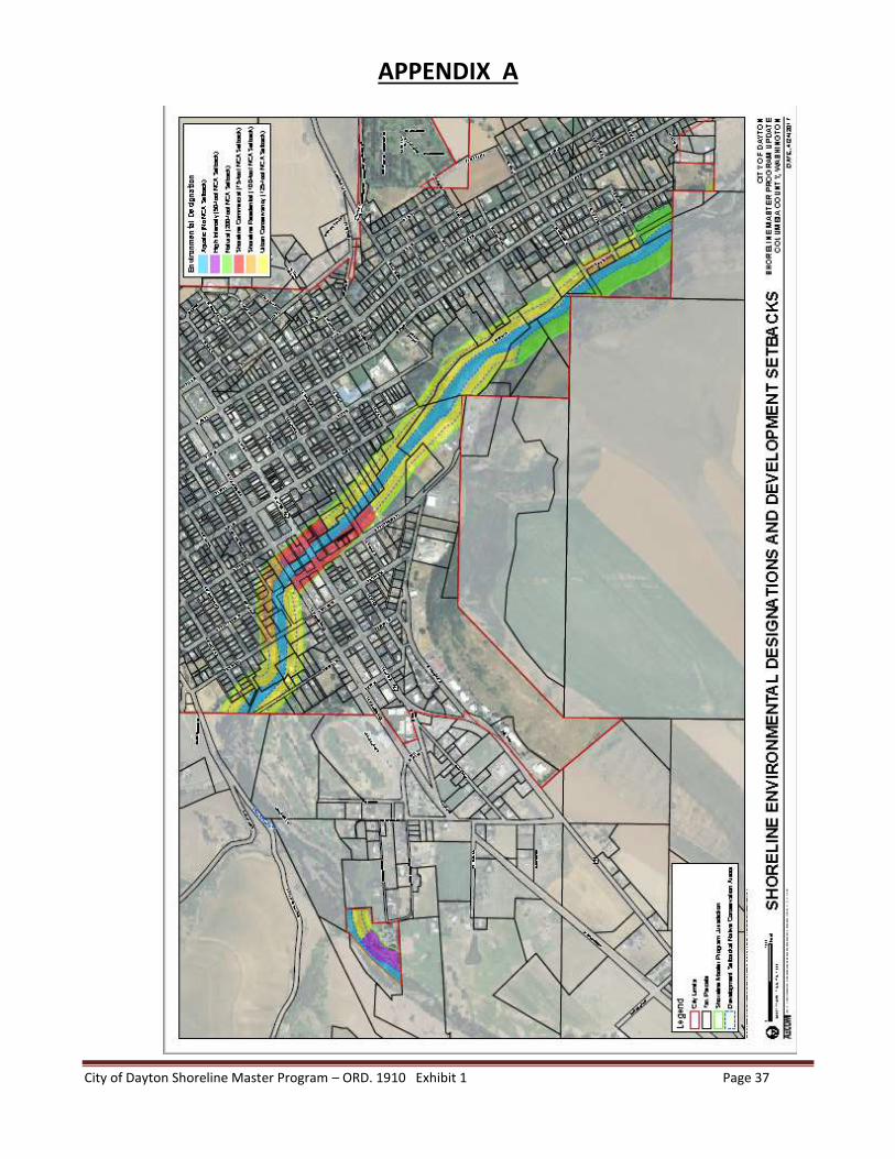
City of Dayton Shoreline Master Program – ORD. 1910 Exhibit 1 Page 37
APPENDIX A