Embed Size (px)
Citation preview

CITY LEVEL PROJECTS
AYA NAGAR URBAN DEVELOPMENTPlanned Development of Unauthorized Colonies
Delhi Urban Art Commission
Raj Rewal Chairman
Satish Khanna MemberSonali Bhagwati MemberEric P. Mall MemberD. Diptivilasa Member & Addl. Secretary, Ministry of Urban DevelopmentVinod Kumar Secretary
DUAC Staff
Rajeev Kumar Gaur, Raghvendra Singh, Amit Mukherji, V. K.Tyagi, Siddharth Sagar, Neelam Bhagat, Manju Anjali, Indu Rawat, Nihal Chand
Senior ConsultantM N Ashish Ganju
Advisory ConsultantSandeep Goel
ConsultantsPritika MandalJuhi MehtaRahul
Acknowledgements
It is said that for an artist to join establishment is a kiss of death. I was fully aware of this
aphorism when the Minister of Urban Development, Mr. Kamal Nath, asked me to be the
Chairman of the Delhi Urban Art Commission. I had three conditions before accepting
the assignment and one of these was that DUAC should be allowed to carry out site
specific studies for improving slums and unauthorized colonies. Subsequently, the Minister
along with the then Lieutenant Governor of Delhi, Mr. Tejendra Khanna, and Secretary,
Ministry of Urban Development, Dr. Sudhir Krishna, approved the proposal to carry out
three dimensional studies for improving slums and unauthorized colonies. I am grateful for
their support.
I would like to thank other members of the Commission, Eric P. Mall, Satish Khanna, Sonali
Bhagwati and D. Diptivilasa for helping to make success of problematic urban design
exercises and charting new paths.
I take this opportunity to thank senior consultants, architects, urbanists and planners as
well as younger colleagues who have been working full time. DUAC Secretary, Vinod
Kumar, and other permanent staff have enthusiastically supported us and guided us
through government procedures. Many thanks to all of them.
Raj Rewal Chairman
DELHI URBAN ART COMMISSION with gratitude duly acknowledges the valuable
contributions of the following Government organizations in making this report:
Ministry of Urban Development
Delhi Development Authority
Government of National Capital Territory of Delhi
North Delhi Municipal Corporation
East Delhi Municipal Corporation
South Delhi Municipal Corporation
New Delhi Municipal Council
Geospatial Delhi Limited
Delhi Metro Rail Corporation
Delhi Urban Shelter Improvement Board
BSES Rajdhani Power Limited
BSES Yamuna Power Limited
RWA’s and Area Councillors
Preface
Half of Delhi lives in ramshackle slums and shabby unauthorized colonies. This state of
affairs is a serious blot on the face of the city which has great historical monuments and
aspires to be a world class city. The centre of New Delhi is lined with leafy trees and can
boast of superb example of contemporary architecture but its growth under exploding
population has disintegrated into shanty towns.
My first memory of Delhi is that of a child going in a tonga from the railway station
to our government quarter in New Delhi around a square which became our home
for several years. The squares were built near Birla temple and when my father was
promoted in the government hierarchy, he was offered an independent house with a
larger area but my mother refused to move as she had developed kinship with families
around the square. This was my first lesson in neighbourhood “mohalla” as an urban
phenomenon.
In fact the word ‘urb’ in Latin stands for neighbourhood space. It was a period when
Connaught Place was the leisurely centre for social, shopping and cultural activities and
the Old Delhi was lively and still gracious, dominated by Jama Masjid and Red Fort. Delhi’s
monuments like Humayun’s Tomb, Qutab Minar and Lodhi Garden were favourite places
for picnics.
Seventy years have passed since the tonga ride, Delhi has dramatically changed as the
population of Delhi has exploded from under a million before partition in 1947 to about
twenty million today.
As a Professor in the School of Planning and Architecture in Delhi, I had ample scope
of studying typology of Indian cities which helped me to design Asian Games Village in my
mid-career around 1980 as a series of clusters (mohalla neighbourhood) woven around
pedestrian pathways, segregated from road networks. This was a low rise high density
housing built within the framework of 150 FAR (FSI 1.5).
Delhi has changed even more drastically during the last thirty years since the Asian
Games Village was built, but the idea of a city as a series of sympathetic, humane
interconnected neighbourhood building blocks interspersed with social, cultural and
educational facilities has remained embedded in my mind.
Delhi Urban Art Commission was established to preserve, develop and maintain the
aesthetic quality of urban and environmental design within Delhi. During the last 40 years
of its existence, DUAC has not received any three dimensional exercises which visualizes
neighbourhoods, wards etc. The emphasis has often been only appraising individual
buildings and complexes submitted through local municipal agencies. After taking over the
direction of DUAC in 2011, members of the Commission arranged meetings with wide
spectrum of advisors and formulated principles on which a building can be automatically
and speedily approved and decided to take over the job of visualization and three
dimensional planning for various aspects of the site specific designs which need to be
urgently developed if Delhi has to maintain standard as a world capital city.
A large part of Delhi lives in unauthorized colonies and slums and even the Master Plan
of Delhi had suggested a detailed design proposal to augment the Master Plan based on
ground realities.
In order to fulfil the requirements of neighbourhoods, wards, the DUAC has
undertaken a few pilot projects which can be eventually developed in a manner that the
local municipal agencies can implement them. In order to carry out these studies, DUAC
developed in its own office a core group of architects and urban planners. This was done
on the basis of DUAC mandate that “the Commission may suo motu promote and
secure the development, re-development of which no proposals in that behalf have been
received from any local body”.
The studies involve the visual tools for ground studies combined with extra assistance
of Google images. It is hoped that the proposals and their conclusions would be
evolved to such an extent that a process can be worked out with the resident welfare
associations to make meaningful designs for the neighbourhood upgradation for the
different kind of wards.
The DUAC’s site specific designs are the seeds which can grow and it is hoped that
economic principles would be evolved to implement the meaningful neighbourhood
upgradation for the different kind of slums and wards. India cannot remain shabby and
ramshackle forever and solutions have to be found for shanty towns.
Raj RewalChairman, DUAC
January 2014
Contents1 Introduction 6 1.1 Unauthorized Colonies of Delhi 6
1.2 Regional Connectivity 7
2 Existing Situation 8 2.1 Boundaries 8 2.1.1 Zone Boundaries 8 2.1.2 Ward Boundaries 9 2.1.3 Aya Nagar Boundaries 10
2.2 Topography 11
2.3 Urban Growth in Recent Years 12
2.4 Physical Infrastructure 13 2.4.1 Water Supply and Drainage 14 2.4.2 Electric Supply 14 2.4.3 Solid-Waste Provisions 14
2.5 Social Infrastructure 15
2.6 Urban Morphology 16 2.6.1 Natural Features & Open Space 16 2.6.2 Streetscape 17 2.6.3 Housing 18
3 Analysis and Development Methodology 20 3.1 Analysis 19
3.2 Development Methodology 20 3.2.1 Physical Infrastructure - Drainage Scheme & Mobility 20 3.2.2 Social Infrastructure - Additional Community Facilities 20 3.2.3 Sustainability Criteria / Characteristics - Energy Assessment 20 3.2.4 Physical Infrastructure 21 3.2.5 Social Infrastructure 21
4 Proposed Interventions 22 4.1 Drainage Scheme 22
4.2 Redesign of Road and Facilities Building on Gram Sabha Land 28
4.3 Festival Ground 30
4.4 Redevelopment of the Johar 32
4.5 Housing Development Proposals 34
5 Sustainability Criteria 35 5.1 Urban Morphology 35
5.2 Environmental and Economic 36
5.3 Social 37
5.4 Governance / Policy 37
Summary
The spread of unauthorized construction in our cities has assumed significant proportions.
It is estimated that in Delhi, the population resident in unauthorized colonies is over 4
million.
Five years ago the governments, of the National Capital Territory of Delhi issued
‘provisional regularization’ certificates to 1,639 unauthorized colonies to start the
process of redevelopment/renewal to bring them into the urban mainstream. However,
the morphology and urban structure of these colonies is different from the ‘greenfield’
planned development guided by the Delhi Master Plan.
A new paradigm is required to address and resolve the complex set of environmental,
cultural, and legal issues arising from this ‘spontaneous’ development.
A representative ‘provisionally regularized’ unauthorized colony is Aya Nagar, situated
on the southwestern edge of Delhi. The original Aya Nagar settlement was a village
populated largely by the indigenous Gujjar community. Over the last three decades
the village has grown to become home for migrants from all parts of the country. The
population is now over a lakh and a half of people mostly from a low-income background.
The settlement is now a microcosm of urbanizing India, and it can serve as a model for
understanding the morphology of such ‘spontaneous’ urban developments taking place in
most cities of the country.
Our research has revealed that the development methodology should have four main
drivers: community action, habitat design, recording the process of work, and raising of
resources, both human and financial.
The present study has identified three main components for effective planning
and development action. These are: improving physical infrastructure by making a
decentralized, in situ, self-sustaining sewerage and drainage provision; by ensuring
safety in mobility; evaluating the community’s requirement of social infrastructure and
making provision for additional community facilities; making an assessment of the energy
requirements and identifying sustainability criteria for the settlement.
Intr
oD
uC
tIo
n
6 CITY LEVEL ProjECT
Intr
oD
uC
tIo
n
7AYA NAGAr UrBAN DEVELoPMENT
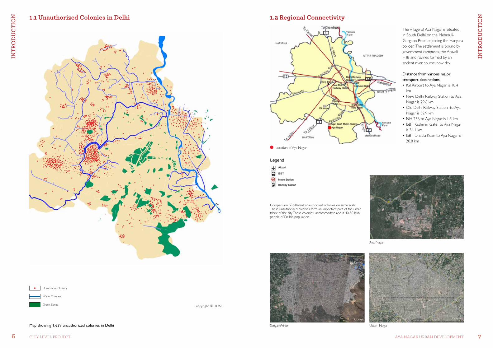
Aya Nagar
Uttam NagarSangam Vihar
Unauthorized Colony
Water Channels
Green Zones copyright © DUAC
Location of Aya Nagar
1.1 Unauthorized Colonies in Delhi
The village of Aya Nagar is situated in South Delhi on the Mehrauli-Gurgaon Road adjoining the Haryana border. The settlement is bound by government campuses, the Aravali Hills and ravines formed by an ancient river course, now dry.
Distance from various major transport destinations•IGIAirporttoAyaNagaris18.4
km•NewDelhiRailwayStationtoAya
Nagar is 29.8 km•OldDelhiRailwayStationtoAya
Nagar is 32.9 km•NH236toAyaNagaris1.5km•ISBTKashmiriGatetoAyaNagar
is 34.1 km•ISBTDhaulaKuantoAyaNagaris
20.8 km
Comparision of different unauthorised colonies on same scale. These unauthorized colonies form an important part of the urban fabric of the city. These colonies accommodate about 40-50 lakh people of Delhi’s population.
1.2 Regional Connectivity
Map showing 1,639 unauthorized colonies in Delhi
ExIS
tIn
g S
Itu
AtIo
n
8 CITY LEVEL ProjECT
ExIS
tIn
g S
Itu
AtIo
n
9AYA NAGAr UrBAN DEVELoPMENT
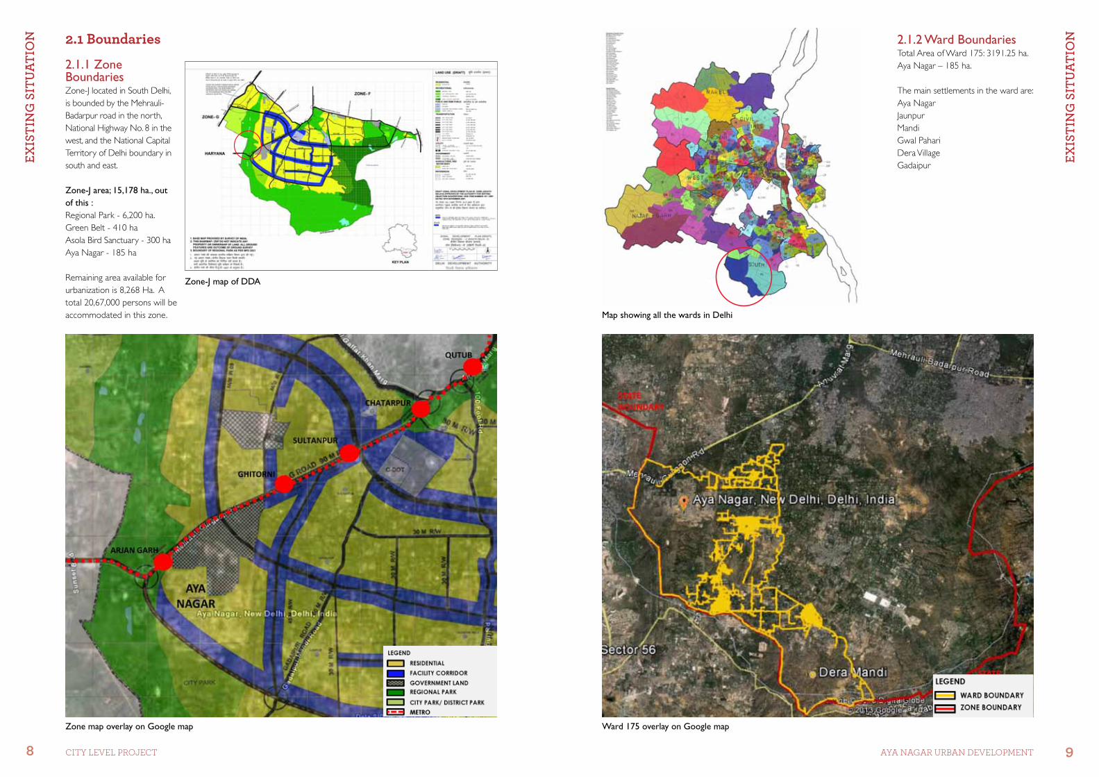
2.1.2 Ward BoundariesTotal Area of Ward 175: 3191.25 ha.Aya Nagar – 185 ha.
The main settlements in the ward are:Aya NagarJaunpurMandi Gwal PahariDera VillageGadaipur
Ward 175 overlay on Google map
2.1 Boundaries
2.1.1 Zone BoundariesZone-J located in South Delhi, is bounded by the Mehrauli-Badarpur road in the north, National Highway No. 8 in the west, and the National Capital Territory of Delhi boundary in south and east.
Zone-J area; 15,178 ha., out of this :Regional Park - 6,200 ha. Green Belt - 410 haAsola Bird Sanctuary - 300 ha Aya Nagar - 185 ha
Remaining area available for urbanization is 8,268 Ha. A total 20,67,000 persons will be accommodated in this zone.
Zone-J map of DDA
Zone map overlay on Google map
Map showing all the wards in Delhi

ExIS
tIn
g S
Itu
AtIo
n
10 CITY LEVEL ProjECT
ExIS
tIn
g S
Itu
AtIo
n
11AYA NAGAr UrBAN DEVELoPMENT
The topography presents a number of special conditions like slopes, valleys and water bodies created by bunds.
The area was primarily agricultural land and the main occupation of the people was cattle rearing and agriculture.
In 1970-72, government intervention brought electricity and water supply facilities, and a bus terminus connecting the village to the city of Delhi.
The spontaneous development of the new colony mimics contemporary urban patterns giving rise to a variety of problems generated by a planning paradigm which imposes systems of vehicular roads and piped services on unfamiliar topography.
2.1.3 Aya Nagar BoundariesThe indigenous Gujjar community originally settled in Aya Nagar village which developed as an organically evolved habitat.
Parts of Aya Nagar village along Mehrauli-Gurgaon Road were acquired by the Central Government and made into planned developments for security related establishments.
In the 1980s the village started to grow with the influx of low-income migrants from different parts of the country. The new residential colony established on the once agricultural lands has a different environmental typology which can be best described as a spontaneous development.
Bird’s-eye view of spontaneous settlement
Map showing Aya Nagar boundaries Topographical map of Aya Nagar
View of Pahari from Phase 5 Ravines
Village Johar Village Johar
2
4
3
1
1
3
2
4
2.2 Topography
ExIS
tIn
g S
Itu
AtIo
n
12 CITY LEVEL ProjECT
ExIS
tIn
g S
Itu
AtIo
n
13AYA NAGAr UrBAN DEVELoPMENT
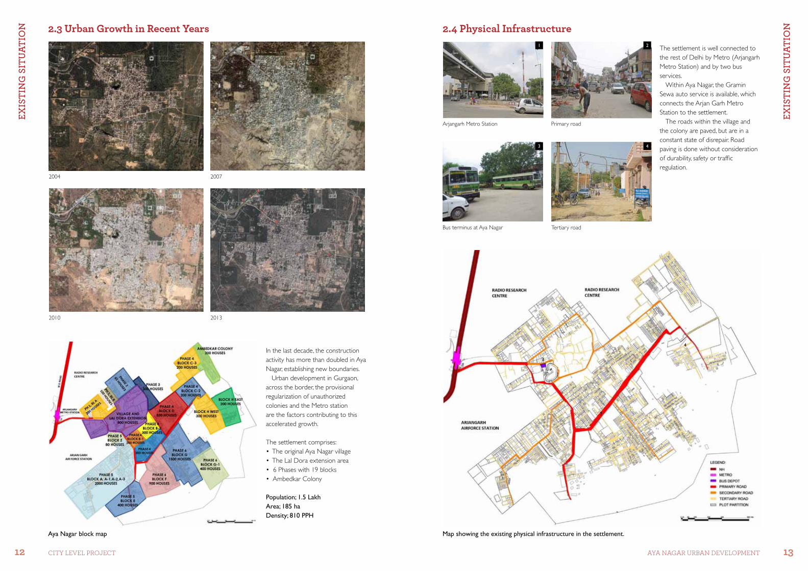
In the last decade, the construction activity has more than doubled in Aya Nagar, establishing new boundaries.
Urban development in Gurgaon, across the border, the provisional regularization of unauthorized colonies and the Metro station are the factors contributing to this accelerated growth.
The settlement comprises:•TheoriginalAyaNagarvillage•TheLalDoraextensionarea•6Phaseswith19blocks•AmbedkarColony
Population; 1.5 LakhArea; 185 haDensity; 810 PPH
2004 2007
2010 2013
Aya Nagar block map Map showing the existing physical infrastructure in the settlement.
Arjangarh Metro Station Primary road
Tertiary road Bus terminus at Aya Nagar
The settlement is well connected to the rest of Delhi by Metro (Arjangarh Metro Station) and by two bus services.
Within Aya Nagar, the Gramin Sewa auto service is available, which connects the Arjan Garh Metro Station to the settlement.
The roads within the village and the colony are paved, but are in a constant state of disrepair. Road paving is done without consideration of durability, safety or traffic regulation.
1
3
2
4
2
3
1
4
2.3 Urban Growth in Recent Years 2.4 Physical Infrastructure

ExIS
tIn
g S
Itu
AtIo
n
14 CITY LEVEL ProjECT
ExIS
tIn
g S
Itu
AtIo
n
15AYA NAGAr UrBAN DEVELoPMENT
2.4.1 Water Supply and DrainageWater supply is mainly through borewells by Delhi Jal Board. There are approximately 80 borewells in the entire settlement.
Delhi Jal Board Borewells Open Drains
Transformer on the road Electric wires on street
Garbage dumped in the Johar Garbage dumped on open plots
2.4.2 Electric SupplyThere is provision of electricity in the entire settlement by the government, but not as per standards.
2.4.3 Solid-Waste ProvisionsThere is no sewage system in the settlement. The sewage and wastewater from the households runs in open drains along the streets. There is no planned provision for solid-waste management. The Johar, open drains and empty plots are used to dump garbage from the households.
Map showing the existing social infrastructure in the settlement.
Government Sarvodaya Vidhyalaya Temple along the Johar
Government Healthcare FacilitySunday Market Road
The settlement has only one primary and one senior secondary government school. There are about 12 private primary schools which have been developed by the residents of the settlement.
There is only one healthcare facility recently opened by the government. There are about 8-10 small private clinics and dispensaries.
The Gram Sabha land presently available in the settlement is a small fraction of the original reservation.
Most of the Gram Sabha land is encroached upon by the villagers and the encroachment is still in progress.
There are no community facilities like a community hall, Barat Ghar, green parks and playgrounds for the children.
1
3
2
4
3
4
2
1
2.5 Social Infrastructure
ExIS
tIn
g S
Itu
AtIo
n
16 CITY LEVEL ProjECT
ExIS
tIn
g S
Itu
AtIo
n
17AYA NAGAr UrBAN DEVELoPMENT
2.6.2 StreetscapeThe streets are an essential part of the open space pattern in the settlement. They are not only traffic networks but also commercial spaces and community areas. •Thevillagestreetsarenarrow,
ranging between 3 and 6 m. •Theprimaryroadsarebetween20
and 30 m wide. •Thesecondaryroadsarebetween
8 and 10 m wide. •Thetertiaryroadsarebetween3
and 6 m wide.
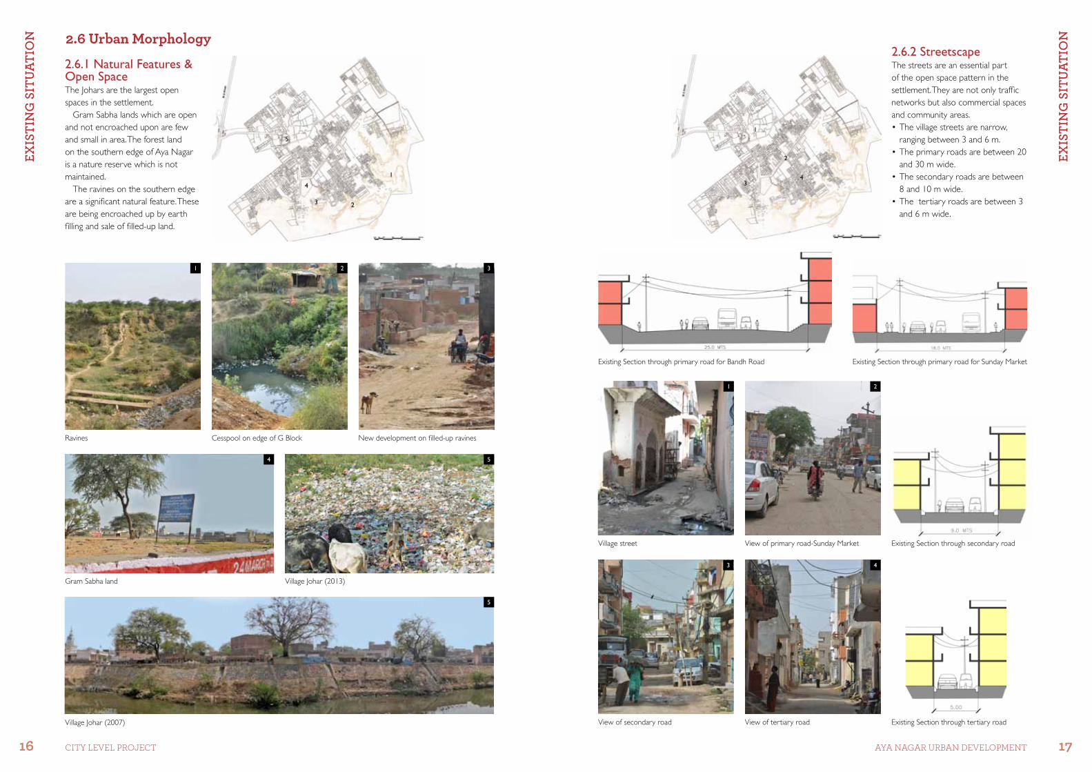
2.6.1 Natural Features & Open SpaceThe Johars are the largest open spaces in the settlement.
Gram Sabha lands which are open and not encroached upon are few and small in area. The forest land on the southern edge of Aya Nagar is a nature reserve which is not maintained.
The ravines on the southern edge are a significant natural feature. These are being encroached up by earth filling and sale of filled-up land.
Ravines Cesspool on edge of G Block New development on filled-up ravines
Gram Sabha land Village Johar (2013)
Village Johar (2007)
Village street View of primary road-Sunday Market
Existing Section through primary road for Bandh Road Existing Section through primary road for Sunday Market
Existing Section through secondary road
Existing Section through tertiary roadView of tertiary roadView of secondary road
1 2
4
3
5
5
2
341
23
4
51
1 2
3 4
2.6 Urban Morphology
ExIS
tIn
g S
Itu
AtIo
n
18 CITY LEVEL ProjECT
An
Aly
SIS
An
D D
EvEl
oPM
Ent
MEt
ho
Do
log
y
19AYA NAGAr UrBAN DEVELoPMENT
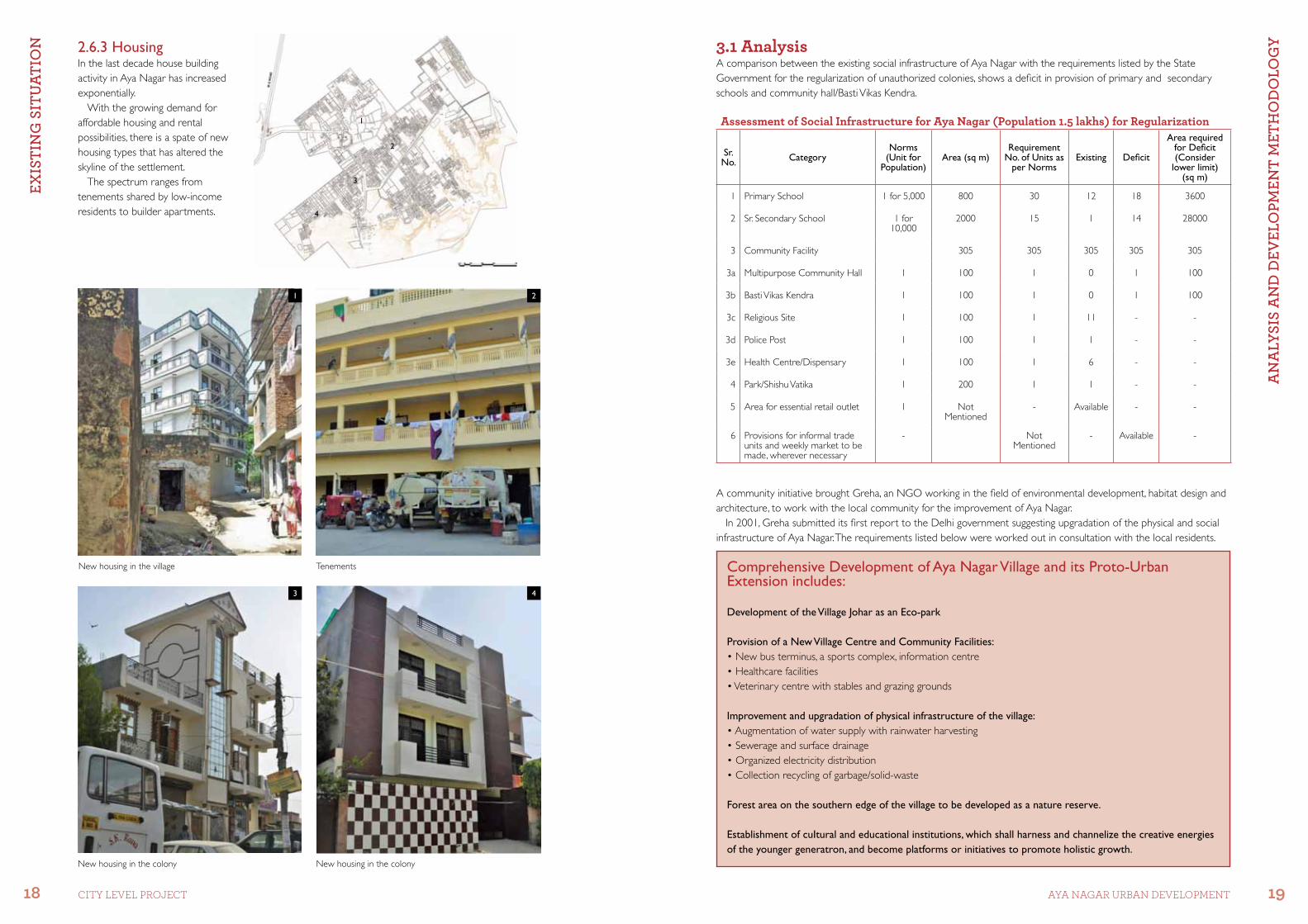
2.6.3 HousingIn the last decade house building activity in Aya Nagar has increased exponentially.
With the growing demand for affordable housing and rental possibilities, there is a spate of new housing types that has altered the skyline of the settlement.
The spectrum ranges from tenements shared by low-income residents to builder apartments.
3.1 AnalysisA comparison between the existing social infrastructure of Aya Nagar with the requirements listed by the State Government for the regularization of unauthorized colonies, shows a deficit in provision of primary and secondary schools and community hall/Basti Vikas Kendra.
A community initiative brought Greha, an NGO working in the field of environmental development, habitat design and architecture, to work with the local community for the improvement of Aya Nagar.
In 2001, Greha submitted its first report to the Delhi government suggesting upgradation of the physical and social infrastructure of Aya Nagar. The requirements listed below were worked out in consultation with the local residents.
Comprehensive Development of Aya Nagar Village and its Proto-Urban Extension includes:
Development of the Village Johar as an Eco-park
Provision of a New Village Centre and Community Facilities:•Newbusterminus,asportscomplex,informationcentre•Healthcarefacilities•Veterinarycentrewithstablesandgrazinggrounds
Improvement and upgradation of physical infrastructure of the village:•Augmentationofwatersupplywithrainwaterharvesting•Sewerageandsurfacedrainage•Organizedelectricitydistribution•Collectionrecyclingofgarbage/solid-waste
Forest area on the southern edge of the village to be developed as a nature reserve.
Establishment of cuItural and educational institutions, which shall harness and channelize the creative energies of the younger generatron, and become platforms or initiatives to promote holistic growth.
New housing in the village Tenements
New housing in the colonyNew housing in the colony
1
3
2
4
1
2
3
4
Assessment of Social Infrastructure for Aya Nagar (Population 1.5 lakhs) for Regularization
Sr. No. Category
Norms (Unit for
Population)Area (sq m)
Requirement No. of Units as
per NormsExisting Deficit
Area required for Deficit (Consider
lower limit) (sq m)
1 Primary School 1 for 5,000 800 30 12 18 3600
2 Sr. Secondary School 1 for 10,000
2000 15 1 14 28000
3 Community Facility 305 305 305 305 305
3a Multipurpose Community Hall 1 100 1 0 1 100
3b Basti Vikas Kendra 1 100 1 0 1 100
3c Religious Site 1 100 1 11 - -
3d Police Post 1 100 1 1 - -
3e Health Centre/Dispensary 1 100 1 6 - -
4 Park/Shishu Vatika 1 200 1 1 - -
5 Area for essential retail outIet 1 Not Mentioned
- Available - -
6 Provisions for informal trade units and weekly market to be made, wherever necessary
- Not Mentioned
- Available -

An
Aly
SIS
An
D D
EvEl
oPM
Ent
MEt
ho
Do
log
y
20 CITY LEVEL ProjECT
Pro
PoSE
D In
tErv
EntI
on
S
21AYA NAGAr UrBAN DEVELoPMENT
3.2.4 Physical Infrastructure Drainage scheme for a residential neighbourhood - Phase 5 Redesign existing road sections
3.2.5 Social Infrastructure Community faclity building complex with training centres, offices, post office, banks, dispensary/ clinics, retail facilities,
restaurants and civic offices . Redevelopment of Village Johar as a Eco-Park Development of community Festival Ground on open Gram Sabha land. New housing development Privately owned open land proposed for development of Barat Ghar. New location for bus terminus. Nursing home/ dispensary Proposed plot for composting as part of solid-waste management scheme.
The three main components of the project which have been identified for detailed working are;-
3.2.1 Physical Infrastructure - Drainage Scheme & MobilityA de-centralised, self-sustaining, in-situ drainage scheme has been proposed for each block/neighbourhood to be developed on the model of public-private partnership. Treatment of road surfaces and pathways is an essential feature of the proposal. A pilot project for implementation is being proposed in one neighbourhood, which will serve as a model for the entire settlement.
3.2.2 Social Infrastructure - Additional Community FacilitiesAs there are no precedents of planning practices in unauthorized colonies, there is a need to re-assess / re-establish planning norms in such settlements. These will serve as a basis for making proposals which not only address immediate issues of the settlement but provide a basis for future development.
3.2.3 Sustainability Criteria / Characteristics - Energy Assessment An assessment of the energy use in the settlement indicates a carbon footprint which is much lower than for the new developments in Gurgaon and New Delhi. A detailed study of the urban patterns in Aya Nagar and such spontaneous settlements is required to establish urban development sustainability criteria.
Source: Greha report 2006
3
4
5
6
7
10
9
8
1
2
3.2 Development Methodology
Pro
PoSE
D In
tErv
EntI
on
S
22 CITY LEVEL ProjECT
Pro
PoSE
D In
tErv
EntI
on
S
23AYA NAGAr UrBAN DEVELoPMENT
Diagram showing the process of sewage treatment
Septic tank used for first level treatment of black water from households.
* This is done after testing the system over a period of time.
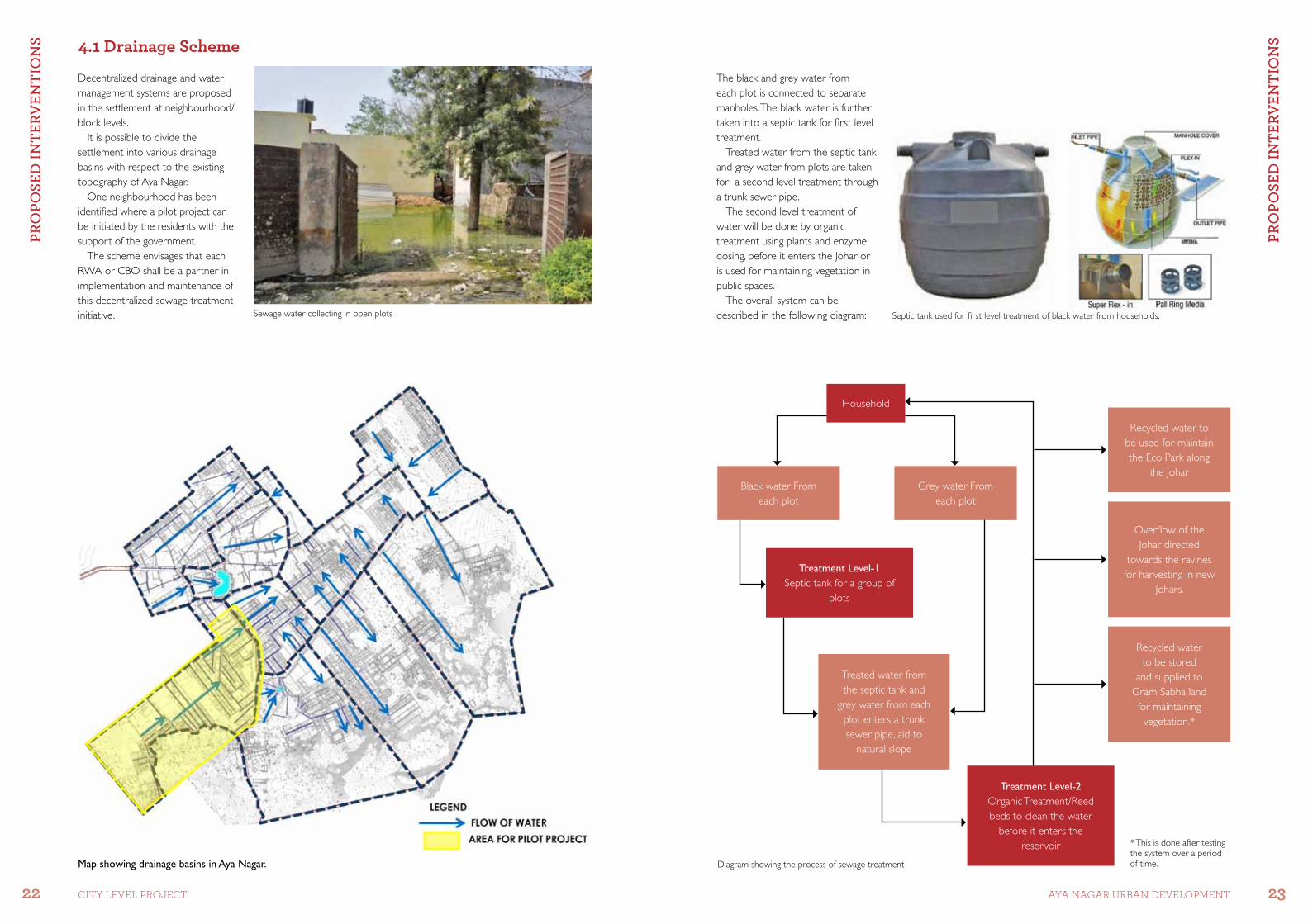
The black and grey water from each plot is connected to separate manholes. The black water is further taken into a septic tank for first level treatment.
Treated water from the septic tank and grey water from plots are taken for a second level treatment through a trunk sewer pipe.
The second level treatment of water will be done by organic treatment using plants and enzyme dosing, before it enters the Johar or is used for maintaining vegetation in public spaces.
The overall system can be described in the following diagram:
Household
Treated water from the septic tank and
grey water from each plot enters a trunk sewer pipe, aid to
natural slope
Treatment Level-2Organic Treatment/Reed beds to clean the water
before it enters the reservoir
Grey water From each plot
Black water From each plot
Treatment Level-1Septic tank for a group of
plots
Recycled water to be used for maintain the Eco Park along
the Johar
Overflow of the Johar directed
towards the ravines for harvesting in new
Johars.
Recycled water to be stored
and supplied to Gram Sabha land for maintaining vegetation.*
4.1 Drainage Scheme
Decentralized drainage and water management systems are proposed in the settlement at neighbourhood/block levels.
It is possible to divide the settlement into various drainage basins with respect to the existing topography of Aya Nagar.
One neighbourhood has been identified where a pilot project can be initiated by the residents with the support of the government.
The scheme envisages that each RWA or CBO shall be a partner in implementation and maintenance of this decentralized sewage treatment initiative. Sewage water collecting in open plots
Map showing drainage basins in Aya Nagar.

Pro
PoSE
D In
tErv
EntI
on
S
24 CITY LEVEL ProjECT
Pro
PoSE
D In
tErv
EntI
on
S
25AYA NAGAr UrBAN DEVELoPMENT
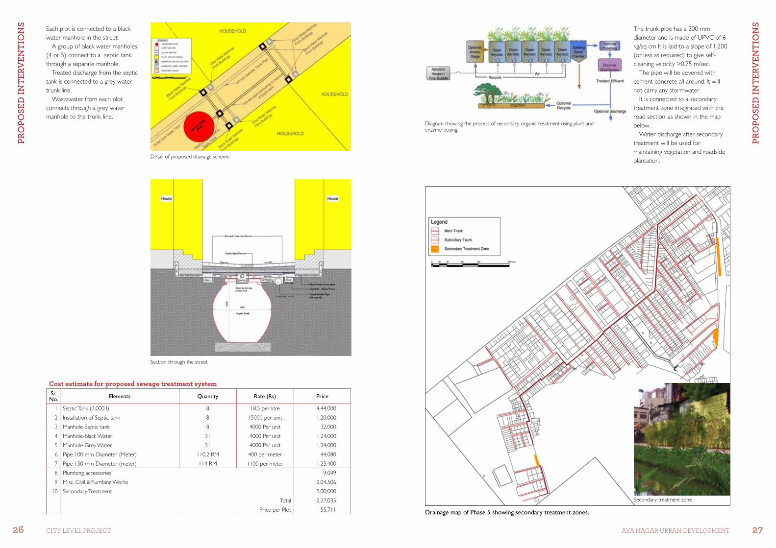
To minimize cost and increase efficiency, grey water and black water are treated separately.
Each septic tank is serving four plots (with full occupancy as G+3).
The sewer pipe from each street will connect to main trunk line and further to secondary level treatment.
Cost of proposed sewage treatment system for each plot is around Rs. 55,711 only.
Assumptions and Calculations for Sample Street
1 Total number of Plots (Houses) 31
2 Total Number of Existing Floor/Family 61
3 Average Size of Household 5
4 Existing Population of Street 305
5 Projected Population (assuming each plot G+3) 620
6 Total quantity of waste water generated (135Ipcd) 83700
7 Total quantity of wastewater generated including safety factor
0.9 75330
8 Grey Water (70 %) 52731
9 Black Water (30 %) 22599
10 Available minimum capacity of Septic Tank (Its) 3000
11 Total Numbers of Septic Tank (Proposed) 8
View of sample street
Drainage plan for sample street
Phase 5 has been identified as the area for the pilot project to be initiated in Aya Nagar.
Further, within Phase 5 a street has been identified, and a detailed scheme is developed for the demonstration of a community-led project.
This public-private partnership will serve as a test-run for the entire settlement.
Drainage map of Phase 5
Map showing Phase 5 block in Aya Nagar
Pro
PoSE
D In
tErv
EntI
on
S
26 CITY LEVEL ProjECT
Pro
PoSE
D In
tErv
EntI
on
S
27AYA NAGAr UrBAN DEVELoPMENT
Each plot is connected to a black water manhole in the street.
A group of black water manholes (4 or 5) connect to a septic tank through a separate manhole.
Treated discharge from the septic tank is connected to a grey water trunk line.
Wastewater from each plot connects through a grey water manhole to the trunk line.
Section through the street
Diagram showing the process of secondary organic treatment using plant and enzyme dosing.
The trunk pipe has a 200 mm diameter and is made of UPVC of 6 kg/sq cm It is laid to a slope of 1:200 (or less as required) to give self-cleaning velocity >0.75 m/sec.
The pipe will be covered with cement concrete all around. It will not carry any stormwater.
It is connected to a secondary treatment zone integrated with the road section, as shown in the map below.
Water discharge after secondary treatment will be used for maintaining vegetation and roadside plantation.
Detail of proposed drainage scheme
Secondary treatment zone
Cost estimate for proposed sewage treatment systemSr. No. Elements Quantity Rate (Rs) Price
1 Septic Tank (3,000 I) 8 18.5 per litre 4,44,000
2 Installation of Septic tank 8 15000 per unit 1,20,000
3 Manhole-Septic tank 8 4000 Per unit 32,000
4 Manhole-Black Water 31 4000 Per unit 1,24,000
5 Manhole-Grey Water 31 4000 Per unit 1,24,000
6 Pipe 100 mm Diameter (Meter) 110.2 RM 400 per meter 44,080
7 Pipe 150 mm Diameter (meter) 114 RM 1100 per meter 1,25,400
8 Plumbing accessories 9,049
9 Misc. Civil &Plumbing Works 2,04,506
10 Secondary Treatment 5,00,000
Total 12,27,035
Price per Plot 55,711 Drainage map of Phase 5 showing secondary treatment zones.
Pro
PoSE
D In
tErv
EntI
on
S
28 CITY LEVEL ProjECT
Pro
PoSE
D In
tErv
EntI
on
S
29AYA NAGAr UrBAN DEVELoPMENT
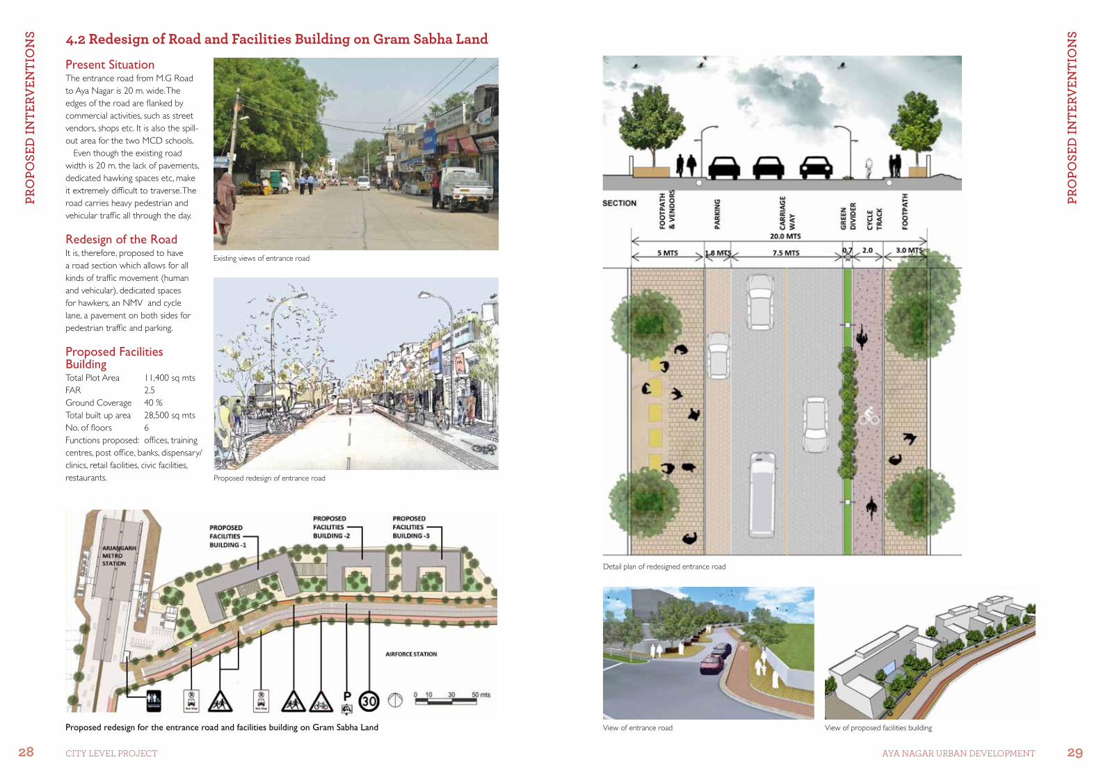
Present SituationThe entrance road from M.G Road to Aya Nagar is 20 m. wide. The edges of the road are flanked by commercial activities, such as street vendors, shops etc. It is also the spill-out area for the two MCD schools.
Even though the existing road width is 20 m. the lack of pavements, dedicated hawking spaces etc, make it extremely difficult to traverse. The road carries heavy pedestrian and vehicular traffic all through the day.
Redesign of the RoadIt is, therefore, proposed to have a road section which allows for all kinds of traffic movement (human and vehicular), dedicated spaces for hawkers, an NMV and cycle lane, a pavement on both sides for pedestrian traffic and parking.
Proposed Facilities BuildingTotal Plot Area 11,400 sq mtsFAR 2.5Ground Coverage 40 %Total built up area 28,500 sq mtsNo. of floors 6Functions proposed: offices, training centres, post office, banks, dispensary/ clinics, retail facilities, civic facilities, restaurants.
View of entrance road View of proposed facilities buildingProposed redesign for the entrance road and facilities building on Gram Sabha Land
Existing views of entrance road
Proposed redesign of entrance road
Detail plan of redesigned entrance road
4.2 Redesign of Road and Facilities Building on Gram Sabha Land
Pro
PoSE
D In
tErv
EntI
on
S
30 CITY LEVEL ProjECT
Pro
PoSE
D In
tErv
EntI
on
S
31AYA NAGAr UrBAN DEVELoPMENT
4.3 Festival Ground
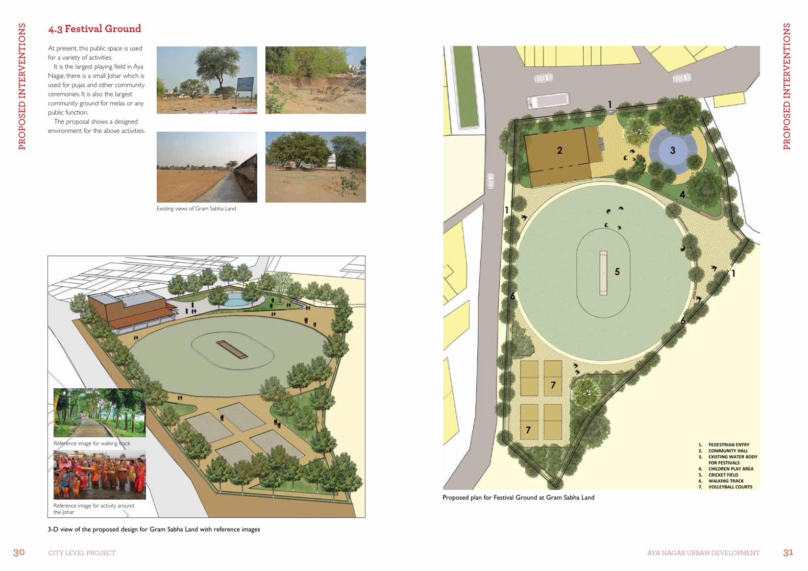
At present, this public space is used for a variety of activities.
It is the largest playing field in Aya Nagar, there is a small Johar which is used for pujas and other community ceremonies. It is also the largest community ground for melas or any public function.
The proposal shows a designed environment for the above activities.
Existing views of Gram Sabha Land
Proposed plan for Festival Ground at Gram Sabha Land
3-D view of the proposed design for Gram Sabha Land with reference images
Reference image for walking track
Reference image for activity around the Johar

Pro
PoSE
D In
tErv
EntI
on
S
32 CITY LEVEL ProjECT
Pro
PoSE
D In
tErv
EntI
on
S
33AYA NAGAr UrBAN DEVELoPMENT
Redesigning Street – Sunday MarketThe Sunday Market Road is an extremely busy and active public space.
It is proposed to make this road pedestrian friendly and use the road width for including provisions for NMV traffic and shaded green areas for parking.
Existing view of Sunday Market Road
4.4 Redevelopment of the Johar
Present SituationAya Nagar is one of the few villages in Delhi which has managed to retain the original village Johar (rainwater harvesting pond). However, the Johar which once was the symbolic centre of the village, is now left neglected and used as a garbage dump.At present the area around the Johar is being used for a range of activities. Proper planning and sensitive design can transform the Johar into an active public space.
Proposed Redevelopment of the Johar•InterceptingthesewageflowingintotheJohar,anditsrevitalizationasarainwaterharvestingpond.•Partoftheareatobeusedforcompostingthesolid-wastecollectedinthesurroundingareas.•Spacetobedevelopedforcommunityrecreationactivity.•Edgesalongthemarkettobedevelopedfora‘haat’.•Facilityforpublicmeetings/performanceswhichcanbeintegratedwiththeneighbouringSarvodyayaSchool(in
future).
Proposed plan for redevelopment of Johar Detail Plan of Sunday Market Road Treatment of road surface
Parking along roadside
Detail of tree planting bed
Pro
PoSE
D In
tErv
EntI
on
S
34 CITY LEVEL ProjECT
SuSt
AIn
ABI
lIty
CrI
tErI
A
35AYA NAGAr UrBAN DEVELoPMENT
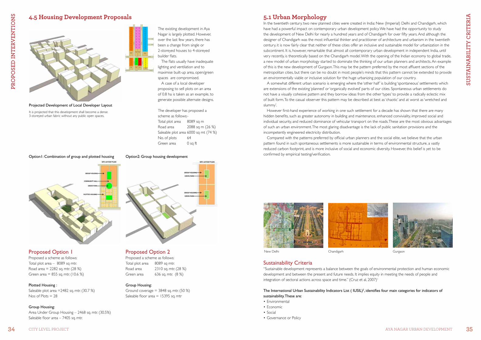
5.1 Urban MorphologyIn the twentieth century, two new planned cities were created in India: New (Imperial) Delhi and Chandigarh, which have had a powerful impact on contemporary urban development policy. We have had the opportunity to study the development of New Delhi for nearly a hundred years and of Chandigarh for over fifty years. And although the designer of Chandigarh was the most influential thinker and practitioner of architecture and urbanism in the twentieth century, it is now fairly clear that neither of these cities offer an inclusive and sustainable model for urbanization in the subcontinent. It is, however, remarkable that almost all contemporary urban development in independent India, until very recently, is theoretically based on the Chandigarh model. With the opening of the Indian economy to global trade, a new model of urban morphology started to dominate the thinking of our urban planners and architects. An example of this is the new development of Gurgaon. This may be the pattern preferred by the most affluent sections of the metropolitan cities, but there can be no doubt in most people’s minds that this pattern cannot be extended to provide an environmentally viable or inclusive solution for the huge urbanizing population of our country.
A somewhat different urban scenario is emerging where the ‘other half ’ is building ‘spontaneous’ settlements which are extensions of the existing ‘planned’ or ‘organically evolved’ parts of our cities. Spontaneous urban settlements do not have a visually cohesive pattern and they borrow ideas from the other ‘types’ to provide a radically eclectic mix of built form. To the casual observer this pattern may be described at best as ‘chaotic’ and at worst as ‘wretched and slummy’.
However first-hand experience of working in one such settlement for a decade has shown that there are many hidden benefits, such as greater autonomy in building and maintenance, enhanced conviviality, improved social and individual security, and reduced dominance of vehicular transport on the roads. These are the most obvious advantages of such an urban environment. The most glaring disadvantage is the lack of public sanitation provisions and the incompetently engineered electricity distribution.
Compared with the patterns preferred by official urban planners and the social elite, we believe that the urban pattern found in such spontaneous settlements is more sustainable in terms of environmental structure, a vastly reduced carbon footprint, and is more inclusive of social and economic diversity. However, this belief is yet to be confirmed by empirical testing/verification.
Sustainability Criteria“Sustainable development represents a balance between the goals of environmental protection and human economic development and between the present and future needs. It implies equity in meeting the needs of people and integration of sectoral actions across space and time.” (Cruz et al, 2007)1
The International Urban Sustainability Indicators List ( IUSIL)2, identifies four main categories for indicators of sustainability. These are: •Environmental•Economic•Social•GovernanceorPolicy
It is projected that this development shall become a dense 3-storeyed urban fabric without any public open spaces,
Proposed Option 1Proposed a scheme as follows:Total plot area – 8089 sq mtr.Road area = 2282 sq. mtr. (28 %)Green area = 855 sq. mtr. (10.6 %)
Plotted Housing :Saleable plot area =2482 sq. mtr. (30.7 %)Nos of Plots = 28
Group Housing:Area Under Group Housing – 2468 sq. mtr. (30.5%)Saleable floor area – 7405 sq. mtr.
Proposed Option 2Proposed a scheme as follows:Total plot area 8089 sq mtr.Road area 2310 sq. mtr. (28 %)Green area 636 sq. mtr. (8 %)
Group Housing:Ground coverage = 3848 sq. mtr. (50 %)Saleable floor area = 15395 sq. mtr
Option2: Group housing developmentOption1: Combination of group and plotted housing
Projected Development of Local Developer Layout
New Delhi Chandigarh Gurgaon
The existing development in Aya Nagar is largely plotted. However, over the last few years, there has been a change from single or 2-storeyed houses to 4-storeyed builder flats.
The flats usually have inadequate lighting and ventilation and to maximise built-up area, open/green spaces are compromised.
A case of a local developer proposing to sell plots on an area of 0.8 ha is taken as an example, to generate possible alternate designs.
The developer has proposed a scheme as follows:-Total plot area 8089 sq mRoad area 2088 sq m (26 %)Saleable plot area 6000 sq mt (74 %)No. of plots 64Green area 0 sq ft
4.5 Housing Development Proposals
SuSt
AIn
ABI
lIty
CrI
tErI
A
36 CITY LEVEL ProjECT
SuSt
AIn
ABI
lIty
CrI
tErI
A
37AYA NAGAr UrBAN DEVELoPMENT
Existing System
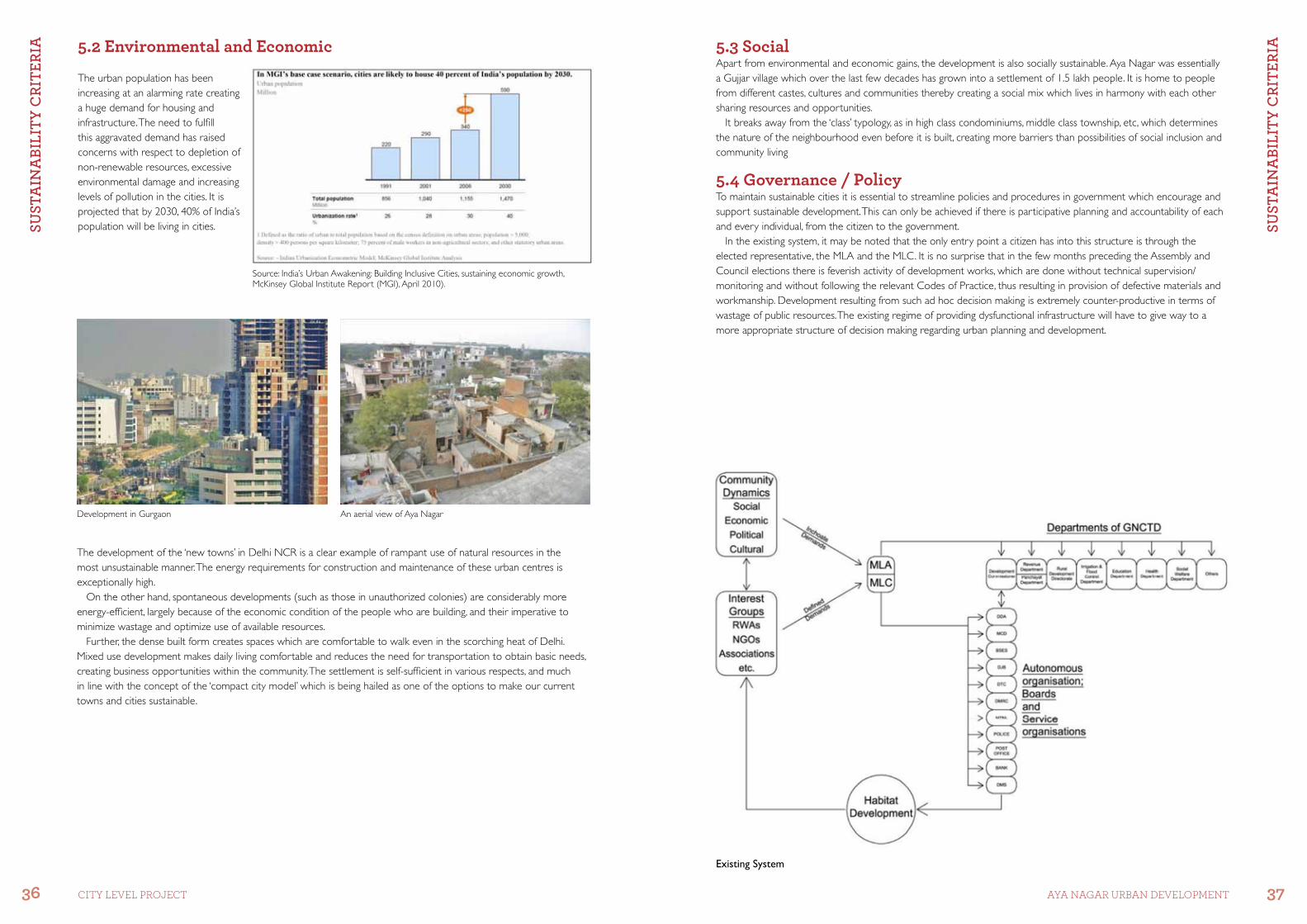
The urban population has been increasing at an alarming rate creating a huge demand for housing and infrastructure. The need to fulfill this aggravated demand has raised concerns with respect to depletion of non-renewable resources, excessive environmental damage and increasing levels of pollution in the cities. It is projected that by 2030, 40% of India’s population will be living in cities.
The development of the ‘new towns’ in Delhi NCR is a clear example of rampant use of natural resources in the most unsustainable manner. The energy requirements for construction and maintenance of these urban centres is exceptionally high.
On the other hand, spontaneous developments (such as those in unauthorized colonies) are considerably more energy-efficient, largely because of the economic condition of the people who are building, and their imperative to minimize wastage and optimize use of available resources.
Further, the dense built form creates spaces which are comfortable to walk even in the scorching heat of Delhi. Mixed use development makes daily living comfortable and reduces the need for transportation to obtain basic needs, creating business opportunities within the community. The settlement is self-sufficient in various respects, and much in line with the concept of the ‘compact city model’ which is being hailed as one of the options to make our current towns and cities sustainable.
Development in Gurgaon An aerial view of Aya Nagar
Source: India’s Urban Awakening: Building Inclusive Cities, sustaining economic growth, McKinsey Global Institute Report (MGI), April 2010).
5.3 SocialApart from environmental and economic gains, the development is also socially sustainable. Aya Nagar was essentially a Gujjar village which over the last few decades has grown into a settlement of 1.5 lakh people. It is home to people from different castes, cultures and communities thereby creating a social mix which lives in harmony with each other sharing resources and opportunities.
It breaks away from the ‘class’ typology, as in high class condominiums, middle class township, etc, which determines the nature of the neighbourhood even before it is built, creating more barriers than possibilities of social inclusion and community living
5.4 Governance / PolicyTo maintain sustainable cities it is essential to streamline policies and procedures in government which encourage and support sustainable development. This can only be achieved if there is participative planning and accountability of each and every individual, from the citizen to the government.
In the existing system, it may be noted that the only entry point a citizen has into this structure is through the elected representative, the MLA and the MLC. It is no surprise that in the few months preceding the Assembly and Council elections there is feverish activity of development works, which are done without technical supervision/monitoring and without following the relevant Codes of Practice, thus resulting in provision of defective materials and workmanship. Development resulting from such ad hoc decision making is extremely counter-productive in terms of wastage of public resources. The existing regime of providing dysfunctional infrastructure will have to give way to a more appropriate structure of decision making regarding urban planning and development.
5.2 Environmental and Economic
SuSt
AIn
ABI
lIty
CrI
tErI
A
38 CITY LEVEL ProjECT
SuSt
AIn
ABI
lIty
CrI
tErI
A
39AYA NAGAr UrBAN DEVELoPMENT
It is proposed that the key element in a new dispensation is the inclusion of the local residents in the decision-making process. This would be a radical departure from the present system wherein the public is subjected to a rigid ‘type’ plan approach or a policy of studied neglect.
An alternative framework of governance is, therefore, to be rooted in participation of an informed public. This is possible by the introduction of planning and architectural professionals into the developmental matrix, who will represent the general public and better inform the elected political representative’s role at present.
The proposed system introduces a set of institutional modifications in the present governance structure to ensure an active and informed community role in decision making.
An empowered people’s parliament (PP) and a local planning board will increase citizen input and accountability of the government. It is possible that this framework could extend to other parts of the urban region where the present system of planned development has become patently dysfunctional. This would be the ideal scenario for the integration of the ‘planned’ and ‘spontaneous’ portions of the urban habitat, and its linkage with the ‘organically evolved’ villages now embedded within the expanding metropolis.
References:-1. Cruz, R.V., H. Harasawa, M. Lal, S. Wu, Y.Anokhin, B. Punsalmaa, Y. Honda, M. Jafari, C. Li and N. Hu Ninh (2007): Asia. Climate Change, 2007: Impacts, Adaptation and Vulnerability. Contribution of Working Group II to The Fourth Assessment Report the Intergovernmental Panel on Climate Change, M.L.Parry, O.F. Canziani, J.P. Palutikof, P.J. van der Linden and C.E. Hanson Eds, Cambridge University Press, Cambridge, U.K. 469-506.2. Li-Yin Shena, J. Jorge Ochoaa, Mona N. Shahb, Xiaoling Zhanga (2011): Habitat International The application of urban sustainability indicators - A comparison between various practices
Proposed System
An ecologically viable alternative at Eco Options in Aya Nagar
Perhaps the most substantial gain from this changed scenario will be a new respect for the State and its institutions by the public at large.


SuSt
AIn
ABI
lIty
CrI
tErI
A
42 CITY LEVEL ProjECT