Embed Size (px)
Citation preview

1
Bradford District Local Plan
City Centre AreaAction PlanBaseline Report (Draft)

2
Contents
1.0 Introduction 031.1 An Overview of Bradford City Centre 031.2 Bradford City Centre Area Action Plan 051.3 Purpose of the Baseline Report 051.4 Structure of the Baseline Report 06
2.0 Setting the Context: City Centre Regeneration 072.1 The Big Plan- Sustainable Community Strategy for Bradford 072.2 Bradford City Centre Masterplan and NDFs 082.3 Bradford City Centre Design Guide 102.4 Bradford Learning Quarter Design and Delivery Framework 112.5 The City Plan 122.6 City Centre Growth Zone 132.7 Super Connected Cities Programme 15
Bradford City Centre Baseline Information
3.0 Built Form and Character 163.1 City Centre Townscape 163.2 Key Landuse Character Areas 173.3 Built Heritage 19
4.0 Social and Demographic Information 214.1 Population 214.2 Housing 224.3 Education and Health Facilities 234.4 Other Community Facilities 244.5 Transport and Movement 25
5.0 Environmental Information 285.1 Air Quality 295.2 Flood Risk 335.3 Biodiversity and Wildlife 345.4 Open Spaces 355.5 Archaeology 36
6.0 Economic Information 366.1 Office Market Profile 376.2 Residential Market Profile 386.3 Retail Profile 396.4 Leisure and Tourism Market Profile 40
7.0 Conclusion 44Appendix: List of documents reviewed 45
3
1.0 Introduction
This report sets out the baseline position for the Bradford City Centre, including the keyissues and parameters which will inform the preparation of the Bradford City Centre AreaAction Plan (BCCAAP).
The BCCAAP will provide the long term framework for development and change in BradfordCity Centre. It will co-ordinate development interests and will include proposals for thedevelopment of sites for shopping, commercial, leisure, education, community use, strategicemployment, mixed-use housing areas, transport initiatives and environmental protection.
It is important that the policies and proposals of the BCCAAP are based on an up-to-date,robust and reliable evidence base to ensure a thorough understanding of the needs,opportunities and any constraints of the area.
The Council has drawn on a range of information about the important aspects of BradfordCity Centre including housing, the local economy, environment, transportation andcommunity facilities to form the evidence base for the AAP. These pieces of work provide apicture of the Bradford City Centre in terms of key issues and also their spatial relevance.
1.2 An Overview of Bradford City Centre
Bradford City Centre is at the heart of a district of around 467,665 people (Source: Census2001). It started life in Saxon times as a small settlement, then known as ‘Broad Ford’, whichwas based around Ivegate, Kirkgate and Westgate, the medieval street pattern of which stillremains.
The city centre is set in a natural bowl which marks the confluence of a number of streams,including Bradford Beck. As a result the city centre is characterised on all sides by the steephills which surround it.
This ‘bowl’ was formed in the ice age, and was rich in natural resources such as soft water,sandstone, iron ore and coal. The exploitation of these natural resources helped to fuel therapid expansion of Bradford during the Industrial Revolution when it became the WoolCapital of the World. During this period, thousands of people migrated here, including manyfrom Ireland, to work in the woollen mills. The city boomed and the population swelled from13,000 to 280,000 during the 19th Century.
In order to accommodate this growth the streams were culverted and built over. A new canallink was constructed, later followed a railway for moving goods and materials between thecity centre and the wider region. The railway still remains today but the Canal, becameredundant and heavily polluted, and was drained in 1867.
The rapid industrialisation of the city caused problems such as squalor and environmentaldegradation. However many of the buildings from this era reflect the prosperity and

4
confidence in the city at the time. Much of this built heritage still remains today including CityHall, the Wool Exchange and the merchant’s quarter of Little Germany.
By the 20th Century the woollen trade in Bradford had started to decline resulting in a long,drawn out period of decline. However people still continued to migrate here, this time fromfurther a field, from Italy and Eastern Europe, and from Commonwealth countries in theCaribbean and Indian sub-continent.
Large parts of the city centre were rebuilt during 1960’s, and some of the architecturalheritage was swept away and replaced by buildings which on the whole have not worn well.This, together with big new road schemes, has created a fragmented city centre, which doesnot fit together well and is awkward for pedestrians to move around.
At the start of the 21st Century the city centre was experiencing a difficult period, andstruggling to find a new role for itself.
Apart from the National Media Museum and the Alhambra Theatre there was little to attractpeople to the city centre in terms of its shopping and leisure offer. Also, as an industrial city,it has never had a strong office sector, or a tradition of people living a fashionable urbanlifestyle in the city centre. The riots of 2001 were a further setback but since this time therehas been an upturn in fortunes as Bradford tries to reinvent itself and reclaim its position asone of the UK’s leading regional cities.
This is now an exciting time for Bradford. In 2003 an Urban Regeneration Company was setup and a Masterplan produced to facilitate the renaissance of the city centre. Marketconfidence has returned to the centre, particularly with regard to residential development,whilst the new Broadway development will vastly improve the shopping offer in the citycentre. Once again Bradford is seeing an influx of migrants into the city, this time from allover the world, including Europe, Africa, and Asia.
Here are some current statistics relating to the city centre. There are:
3,744 people living in the city centre. 2,000 businesses employing 42,800 people in the city centre. 305,000m2 of office floorspace and 527,000m2 of industrial floorspace. 501 shops totalling 110,000m2, of which 129 units are vacant. 1.2 million visitors per year to the top 5 tourist attractions, including the Alhambra and
National Media Museum. 9,822 people studying at the University. 10,600 people travelling into the centre daily by train, and 19,200 by bus. 10 public open spaces. 100 (approx) Listed Buildings.
*These statistics are based on the Bradford Centre Regeneration Boundary using datacorrect up to March 2005 (Source BCR Performance Framework, Genecon, 2006).

5
1.2 Bradford City Centre Area Action Plan (BCCAAP)
The Bradford City Centre Area Action Plan will set out planning policies to guidedevelopment proposals in the city centre, along with details of how these proposals will bedelivered, looking as far ahead as 2028. It will also be used to make decisions when peopleapply for planning permission in the city centre.
The City Centre Area Action Plan will seek to identify future issues and specify policies andallocations in order to:-
Deliver proposed growth of the city centre Stimulate Regeneration Protect built heritage whilst accommodating new development Ensure developments are of appropriate scale, mix and quality
Bradford District is made of 5 Parliamentary Constituency areas – Bradford North, BradfordSouth, Bradford West, Keighley, Shipley. The Bradford District is composed of 30 ElectoralWards. Bradford City Centre is within Bradford West Parliamentary Constituency and the CityWard.
The study area boundary linestarting from the west runs alongShearbridge Road, ListerhillsRoad, Norcroft Street across toJowett Street, down Westgatethen across to Drewton Road,along Hamm Strasse, up ValleyRoad around Bradford BusinessPark, down along Canal Road theacross to Shipley Airedale Roadto Wakefield Road and thenacross Caledonia Street, then upalong Manchester Road, SeniorWay across to Great Horton Roadto the junction with Shearbridge Road.
1.5 Purpose of the Baseline Report
It is critical that the City Centre Area Action Plan is based upon a robust evidence base. Thisreport describes the core baseline conditions and context that will inform these documents.This baseline report has been prepared on the basis of a desk top study and analysis ofpublished information and strategies, discussion with key stakeholders, bespoke researchand site survey.
In accordance with good practice advice by the Planning Advisory Service, including theonline Plan Making Manual, Bradford Council considers the gathering of evidence as an
Fig 01: Bradford City Centre

6
iterative process which must be continued throughout the plan preparation process. Thereason for this is because the evidence base is key to other aspects of plan productionincluding, Sustainability Appraisal, Options Generation and Community Engagement. Thediagram below explains the linkages between these different areas (Source: PAS March2008).
Fig 02: Relationship between different elements of plan production
This report therefore has been deliberately left in ‘Draft’ and will be supplemented withadditional information during the course of the preparation of the Area Action Plan. As part ofthe ongoing consultation process, this report is made publicly available for statutoryconsultees and other stakeholders for comments and review.
In preparing this report, we have not sought to replicate all published and unpublisheddocuments and data, but to identify and describe key issues and findings that are raised. Inconsidering the overall ‘Evidence Base’ that informs the emerging Area Action Planreference should be made to the individual documents, strategies and data sources that areidentified in each chapter.
A list of all the documents reviewed as a part of this baseline analysis is attached asappendix 1.
1.6 Structure of the Baseline Report
This report seeks to identify and review the key baseline information thematically under fourbroad headings, as follows:

7
Setting the City Centre Regeneration Context – This section identifies and reviews arange of current and emerging plans, strategies and regeneration initiatives thatwould affect future developments in the city centre.
Built Form and Character- This section provides an assessment of the physical formand structure of the city centre including an analysis of the cityscape andassessment of the historic buildings, streets and spaces.
Social and Demographic Information– This part of the report contains an appraisal ofthe demographic and social context of Bradford city centre. This includes briefreviews on city centre population, housing, community facilities, transport andmovement.
Environmental Information- This section provides an overview of the environmentaland historic elements within the city centre including air quality, flood risk, builtheritage and biodiversity.
Economic Information- This section analyses the current and potential commercialand business activities within the city centre which includes detail assessments of theoffice, retail, residential and leisure market profile of the city centre.
2.0 Setting the Context: City Centre Regeneration
Bradford City Centre is the main focus for economic, educational, administrative and culturalactivity within the district. With 1 in 5 jobs in Bradford district located in this area the citycentre offers real potential as an engine for growth and regeneration. It is therefore importantto understand the various regeneration plans and strategies that have been prepared toinfluence development in the City Centre. It is also crucial to reflect the findings andrecommendations of those studies to ensure that any future plan for the city centre does notoccur in a vacuum and creates a synergy that can be more powerful to deliver sustainablechanges in the area.
Some of the key plans and strategies that have been reviewed as a part of this baselinestudy are:
2.1 The Big Plan- Sustainable Community Strategy for Bradford
The Big Plan is the District’s Sustainable Community Strategy which sets out clear objectivesto face the emerging challenges that reflect changing circumstances. The new challengesare to- Regenerate the city and our major towns to create opportunities and impetus for
sustained economic growth Improve education outcomes to prepare people for an active and prosperous life Improve skills at all levels to meet the needs of business and build a knowledge
economy.

8
These challenges have led to the identification of regeneration priorities for the District. TheCouncil is now refreshing its Sustainable Community Strategy and evidence in this study willhelp shape its priorities.
The Big Plan has identified four regeneration priority areas to deliver sustained economicgrowth and regeneration in the district. These are the City Centre, Airedale, Manninghamand the Canal Road Corridor. Further information can be viewed at:http://www.bradford.gov.uk/bmdc/bdp/our_work/community_strategy/the_big_plan
2.2 Bradford City Centre Masterplan and NDFs
The Bradford City Centre Masterplan was produced by Alsop Architects in 2003 and set outa new vision for the future of the city centre. The big idea of the Masterplan is to create anew city centre park that will change people’s perceptions of Bradford and differentiate itfrom other cities.The key objectives of the masterplan were to:
Define the current and future role of Bradford. Identify what potential the City Centre has in terms of attracting and developing
economic activity in ll sectors including retail, leisure, commerce and housing. Clarify what the City should deliver in order to retain, capture and maximise activity;
and articulate how the masterplan can be used in partnership with the variousagencies and local communities for mutual benefit.
Big Plan Regeneration and Prosperity Priorities
Promoting business growth support manufacturing and key growth sectors such as financial services, health,
environmental, tourism, digital, cultural and creative industriesShaping quality places
progress delivery of the masterplans for Bradford city centre, Airedale, Manninghamand the Canal Road Corridor focussing on transformational priority projects
Sustainable and affordable housing ensure an adequate supply of land for housing development in places with good
transport links, through the LDF and a revised Housing StrategyEnhanced transport and connectivity
progress the Shipley Eastern Bypass and Canal Road improvements seek further investment to ensure better rail and bus integration, and improve
interchange facilities at Shipley and Bingley increase accessibility for all, improving public transport and promoting cycling and
walking and access to footpaths and bridleways through the use of ‘active design’principles
Improving perceptions of the district, its neighbourhoods and cultural life Bring derelict land back into use for new businesses or housing

9
The idea is based on exploiting Bradford’s topography – the city lies in a bowl formed by thevalley of Bradford Beck. The Masterplan proposes rediscovering the ‘Bradford Bowl’ bygetting rid of poor quality buildings which we do not need and forming a new city centre park.This would be a series of linked spaces, landscapes and water features, which breathes newlife into the city’s historic fabric.
The Masterplan identifies four separate neighbourhoods or ‘fingers of intervention’:
1. The Bowl2. The Channel3. The Market4. The Valley
Figure 03: City Centre Masterplan areas
Each of these areas was subject to a Neighbourhood Development Framework.
The Bowl: The Masterplan proposed a lake around City Hall symbolising its position as anatural meeting point for the city. The pool was bounded by a Business Forest of new officesand a Pier built into the pool accommodated screens for digital performances. A strategy wasexplored to implement the lake by creating a ‘mirror pool’.
The Channel: The Masterplan proposed a new urban village in the Channel along areopened canal. As part of the NDF, the Channel Urban Village together with a new gatewaydevelopment around Forster Square Station and proposals for Festival Square in LittleGermany and the Cathedral Quarter Urban Village.

10
The Market: The Masterplan proposed the World Mile as a new shopping destinationtogether with a Garden of Tranquillity over Drewton Road. The strategy within the NDF isbased on improving the public realm between these poles, particularly through RawsonSquare together with the creation of an urban village around the northern fringe of the area.
The Valley: The plan proposed a valley park along the Bradford Beck, framed by the twotowers of the Odeon. The park included ecology areas, an orchard and space for discovery,experimentation and learning. A learning bridge over the park linked the university andcollege to the city centre.
Further information can be found at:http://www.investinbradford.com/develop-bradford/bradfordmasterplans/Bradford+Masterplan
On 16th January 2007, the City of Bradford Metropolitan District Council consideredconsultation responses to the NDFs and resolved that comments would be accepted asevidence for inclusion in the preparation of the City Centre Area Action Plan.
On 7th February 2007, the City of Bradford Metropolitan District Council’s Regulatory &Appeals Committee resolved that: the four Neighbourhood Development Frameworks for theCity Centre be treated as material considerations in the determination of planningapplications pending the adoption of the Bradford City Centre Action Area Plan.
In addition to the above, a number of background and feasibility studies have beencompleted as part of the masterplanning process which has informed this Baseline Reportand the Issues and Options Report. A number of delivery plans are also in the process ofbeing produced for the city centre, namely the Learning Quarter Design and DeliveryFramework and the Markets Area Delivery Framework.
2.3 Bradford City Centre Design Guide
In 2005 a consultancy team led by Urbed was commissioned to produce a Design Guide forthe city centre. The purpose of the Guide is to articulate the Masterplan vision for the citycentre into a set of design rules. This includes guidance on tall buildings, the character ofstreets, enclosure of space and public realm.
The Guide is used to assess the design of new development proposals in the city centre. Itwas adopted by the Council in March 2006 as a Supplementary Planning Document (SPD)following public consultation. As an SPD, the guide is a material consideration whendetermining any planning applications within the city centre.
The Bradford City Centre Design Guide can be viewed at –http://www.bradford.gov.uk/NR/rdonlyres/29F06299-EB7E-4DF5-920C-A7A5106293FB/0/CityCentreDesignGuide080307.pdf
11
In 2006 consultants Landscape Projects was commissioned to take the public realmguidance within the City Centre Design Guide further and produce a Streetscape DesignManual for the city centre. This provides a set of rules and specifies a palette of materials fornew public realm works. The manual is available at:http://www.investinbradford.com/Resources/Invest%20In%20Bradford/Documents/BCR_Streetscape_leaflet.pdf
2.4 Bradford Learning Quarter Design and Delivery Framework
Farrell and Clark Architects were commissioned by the University of Bradford to produce amasterplan for the University campus area. The study aimed to bring together a number ofdevelopment ideas in a format that demonstrates to others the intent of the University. Itseeks to illustrate the possibility for improvements to the public realm by improving andclarifying the spaces around buildings, improving physical links and routes and allowing thedevelopment of landscaping where appropriate.
The study undertakes an analysis of the area, covering 11 key themes:
1. Green Spaces2. Car Parking3. Vehicular Circulation4. Pedestrian Routes5. Key Buildings/Pedestrian Space6. Bus Routes7. Space Use Analysis8. Building Heights and Topography9. Street Patterns10. Links to College and Coty11. Cycle Provision
The study recognises a number of issues in these key themes:
Mixed quality green space Car dominance Inconsistent poor quality pedestrian routes Mixed quality public realm No direct link between bus stops and circulation routes Poor land use planning Weak links to the City Centre
The University has also produced an Estate Strategy, 2004-2014. This sets out theUniversity’s vision for what the campus should look like in the next 10 years (from 2004). Thestrategy covers key themes of Security, Landscaping, student facilities, conference facilitiesand student accommodation.

12
2.5 The City Plan
Under the current economic downturn the prospect of attracting significant investment in thecity centre for large schemes appears difficult, suggesting that a renewed approach tostimulating regeneration in the city centre is needed. The City Plan provides a deliveryframework for Bradford City Centre aiming to stimulate economic development, investmentand regeneration in the area over the next decade.
The idea behind the plan is to develop a shared long-term view with partners on the type ofcity centre that is desirable and what they should be working towards. It is intended to be alocal approach to city centre regeneration while building on existing policy documents andstrategies.
Expected outputs from the plan will be:
Enhanced and increased delivery and investment in the city centre. Development of specific actions to achieve outcomes identified in the city plan. Greater alignment of delivery and service provision in the city centre. Alignment of existing priorities and strategies to maximise impact on city centre. A strategic approach to investment for the city centre. A city centre partnership approach to aligning activity and supporting community
participation and engagement. Short, medium and long term delivery targets to measure progress and impact.
The plan will be split into four areas – people, place, prosperity and property. Taken togetherthese will provide a holistic approach to delivering the aims of the plan.
People – will focus on how people live, work and enjoy the city centre and include specificelements of delivery including the city centre residential offer, how we use culture andevents, diversification of the city centre offer and the night time economy, education andskills, health and well-being, social networking and community development.
Place – will build on the planning framework being developed through the Area Action Planto ensure we make the best use of space in the city centre and create a place that supportspeople to live, work and enjoy. The plan will focus on specific delivery such as the approachto listed buildings, use of upper floors, approach to design, public realm, sustainability andaccess to green space. Place will also involve identifying how a flexible planning frameworkcan be introduced to encourage economic growth and engagement, such as meanwhileuses. The place plan will focus on creating a smart and sustainable city
Prosperity – The prosperity plan is the binding element of the plan where both the Districtseconomy and the City’s economy are woven. The prosperity plan will answer the question asto how will Bradford, its City and District earn its living, both now and in the future. The planwill aim to identify measures to increase the wealth and economic well-being of the City andits residents. It will focus on employment growth though investment and private sectorexpansion in the city centre, innovation, and encouraging enterprise and entrepreneurship.
13
The prosperity plan will focus on the delivery of the economic potential and current strengthsof Bradford as a Producer City; a city which creates, makes and trades all within a widerproducer district.
Property – focuses on how to create the mechanisms for investment and create a city whichis capable of making decent financial returns on development investment. It will alsoarticulate how to work with developers and key local partners, such as the Property Forum,to maximise usage of our immense historical legacy by reducing vacancies and so increasingthe vibrancy of the City.
Approval to start the production and delivery of the City Plan has been endorsed by theCouncil’s Executive Committee in December 2012. Initial work will be taken to develop a setof guiding principles for the plan which will be shared and refined through engagement withCouncil Leadership, Local Politicians, partners and stakeholders and local people. This willoccur through formal and informal consultation methods as outlined above. These principleswill then form the basis for the city plan which will bring together a range of products,projects, policies, plans and programmes into a single coherent and focused approach toregeneration of the city centre.
2.6 City Centre Growth Zone
The City Centre Growth Zone is a 170ha investment area, covering Bradford city centre andsome of the district’s major economic assets (rail stations, University of Bradford, BradfordCollege, Theatres and the National Media Museum etc). It provides a targeted approach toincreasing market confidence, drive up footfall and support investment in the city centre. Thezone has a range of development and commercial opportunities, offering incentives tobusiness to relocate or expand within it.
The city-centre growth zone has been launched in November 2012. The move, whichinvolves an investment of £17.2m from Bradford Council and £17.6m from the Governmentthrough the Regional Growth Fund, includes rate rebates for new and existing businessesthat create jobs within the zone. Among the other incentives are skills programmes andaccess to super fast broadband. Additionally, some £5 million is being spent on public realmworks in the city, while £4.4 million will be spent on the first steps in the redevelopment of theformer police station.
The zone is made up of a number of parts, taken together these create an ‘offer’ for businessthat makes investing or expanding more attractive. Businesses will benefit from:
1 Super-fast broadband and city centre Wi-Fi.Through the super-connected cities programme residents and businesses will be able toaccess superfast broadband (speeds up to 100mbs) along with a city centre Wi-Fi offer. Thesuper-connected cities programme is focused on the city centres of Bradford and Leeds, theconnecting corridor between the two cities and the growth areas of Shipley-Airedale inBradford and the Leeds City Region Enterprise Zone (Aire Valley Leeds).

14
2 Access to employment and skills support.The Get Bradford Working Programme has been developed to ensure local people canaccess jobs,and employers can get staff with the skills they need. The programmeincludes an intermediate job ceation fund, industrial centres of excellence and proposals foran apprenticeship training agency (ATA). This programme operates at a district level. Furtherinformation will be made available when the Get Bradford Working scheme is launched.
3 A responsive and flexible planning system.The growth zone provides a range of development and commercial opportunities, suitable fora range of city centre uses. The Local Planning Authority are committed to ensuring theseopportunities are maximised and guarantee a flexible and responsive approach to planning,including a comprehensive pre-application service and a fast track approach to processingcity centre planning applications. For more information visit: -www.bradford.gov.uk/planning.
4 City Centre Business Growth Scheme.Businesses that create new, additional jobs (see ‘Additionality’ and ‘Displacement’ indefinition of terms at the end of this briefing) will be able to benefit from a business ratesrebate scheme. In short, every new full time equivalent job created by an eligible businesswithin the growth zone will be worth a rebate of up to £16,000 on their annual rates payablebill. Businesses that bring disused space back into permanent commercial use as a result ofcreating new jobs will also be able to access a one off rebate to cover any increased ratesbills from the new space.
5. Physical infrastructure and public realm improvementsCapital investment to begin the re-development of the Tyrls area and to improve the linksbetween Westfield and the wider city centre also form part of the zone.

15
As noted before, the growth zone is supported by a range of funding streams includingCouncil resources and Government funding, including £17.6m from the Government’sRegional Growth Fund (RGF).
The scheme is anticipated to generate significant job outputs within the city centre byincentivising job creation and investment across the city centre – over the lifetime of the RGFprogramme we anticipate 2,600 full time equivalent jobs will be created across a range ofsectors. This figure includes the projected jobs created by Westfield as well as across thewider growth zone. As per RGF criteria employment impacts will be monitored until 2021/22.This is in recognition from Government that employment impacts may ramp up more slowlythan RGF spend.
2.7 Super Connected Cities Programme
In December 2010, the Government launched the National Broadband Strategy setting outthe vision for broadband in the UK, aiming to ensure the country has the best superfastbroadband in Europe by 2015. As part of the implementation, Bradford Council has beendeveloping the Super Connect Cities programme, aiming for Bradford and Leeds to be thefirst two cities outside London with large-scale access to free Wi-Fi and an open accessinfrastructure delivering ultrafast broadband.
The Government has recently confirmed that £14.4m will be invested in both Bradford andLeeds broadband capabilities through Super Connected Cities programme. This will act as acatalyst for new ways of delivering public services and stimulating economic growth in boththese cities.
In Bradford, the scheme will provide speeds of 100Mbps or more to all premises within thecore area – the city centre, out towards Shipley, the transport corridor into Bradford, and theAire Valley.
The first phase of the project is to bring free public wi-fi to both Leeds and Bradford citycentres and it is expected to be in place early next year. Virgin Media Business hasconfirmed that it will be installing the “small cell” technology in time to go live from January2013 with the free wi-fi which is three times the speed of 3G services.
The first locations to benefit from the services will be Bridge Street in Bradford and Briggatein Leeds in time for the new year, followed by City Park in Bradford and Millennium Square inLeeds early in 2013.
Ultra-fast broadband will offer high-tech and digital companies the infrastructure they need,allowing Bradford to compete for business, investment and jobs. It also offers free city centrewide Wi-Fi service, Wi-Fi connectivity for passengers on trains and buses between Bradfordand Leeds, and Wi-Fi community hubs focusing on libraries.

16
Bradford City Centre Baseline Information
3.0 Built Form and Character
3.1 City Centre Townscape
The townscape and built form of Bradford City Centre varies quite dramatically depending onlocation. The building and street forms are very varied in their ages, styles, layout, footprints,heights, materials, condition and general appearance. The topography of the City Centre isalso varied.
The city was built at the confluence of four streams flowing northwards into the BradfordBeck. These streams create a natural bowl in a valley that flows down from the west to arelatively flat area around City Hall before flowing onwards down the valley to the north.
Figure 04: Topography of Bradford City Centre Source: City Centre Design Guide

17
The market area of the city centre is to the west and built on a spur of land jutting onto thevalley. The market is almost at the top of the hill and the land falls away steeply towardsThornton Road and beyond Manor Row. To the east of the centre the land rises again upChurch Bank and Little Germany. There is a similar hill to the south west rising up to theUniversity and a further hill to the south east.
The oldest roads into Bradford come over these four hills. However the roads built in theVictorian era travel along the valley bottoms, notably Manchester Road, Leeds Road, ValleyRoad and Thornton Road. Because of the topography of the city, most of these arrival routesdo not provide good views of the centre. By contrast the high roads provide commandingviews on arrival to the city centre.
The most important of the main tall buildings in the city centre is City Hall which stands in thecentre of the bowl. The tower of City Hall rises from the lowest part of the city centre –somewhat like an upturned drawing pin. This is important because City Hall is generally seenagainst a backdrop of the city, rather that the sky. Most of the other tall buildings keep clearof the view of City Hall, the main exception being Arndale House, which is out of scale withits surroundings. Most of the social housing tower blocks are out of the centre and relativelyunobtrusive.
While it is difficult to generalise, there is a tendency for the higher buildings to be in thevalleys. This tends to smooth out the effects of topography so that the buildings appear to fillup the alley areas. In Little Germany and Goitside the buildings stack up the hill creatingdramatic long views. By contrast to the east of Manor Row the slope is too steep and thebuildings on the ridge create a dramatic cliff-like edge.
3.2 Key Landuse Character Areas
Traditionally the city centre was a dense mix of commercial and industrial developmentalongside workers’ housing, administrative functions, cultural uses and shopping. In the last50 or so years the housing and industrial uses have all but disappeared while the retailing,commerce and administrative uses have broadly held their own and uses such as theuniversity and cultural facilities have expanded.
Administrative and cultural uses: These are concentrated in the southern part of the citycentre. City Hall stands in the heart of the administrative quarter together with the policestation and Magistrates Courts (both of which are to be relocated as part of the City CentreMasterplan). The main Council Offices are in Jacob’s Well, Britannia House and on NelsonStreet. Cultural facilities are grouped around City Hall including the Alhambra Theatre, St.Georges Hall, the National Media Museum and the Central Library.
Commercial uses: This is perhaps where the greatest change has taken place. The city’scommercial trade was dominated by the worsted industry including the ‘stuff’ warehouses ofThornton Road where textiles were stored and processed and the ‘piece’ warehouses ofLittle Germany where the textiles were traded. Textiles have now been replaced by sectorssuch as banking, financial services and mail order mostly located in new offices around the

18
edge of the centre and outside the town with plentiful parking. This has left vacant officespace in the centre that could be used for other uses such as housing. The ‘Stuff’warehousing has tended to remain in low rent occupation while in Little Germany there hasbeen some success in letting space to small and creative businesses.
Figure 05: City Centre Landuse Map Source: City Centre Design Guide
Housing: The last of the slum housing was cleared in the 1960s and for years the only citycentre housing was on Church Bank and Chain Street. A city centre housing market hasbeen late developing in Bradford however schemes have been successful in areas like LittleGermany and the market is expanding rapidly as residential developers explore both newbuild and refurbishment schemes in centre.
Retailing: The retail core runs from Well Street between Cheapside and Westgate to St.John’s Market. This area has declined in recent years and there are advanced proposals to

19
redevelop the entire eastern part of the area as the Broadway Shopping Centre. There isalso some unsympathetic ‘big box’ retailing stretching up Valley Road to the north.
Education: The University and College are based on a campus to the west of the city centre.Both institutions have promoted masterplans to reassess their relationship with the centre.
3.3 Built Heritage
The built heritage of Bradford City Centre straddles the very interface between two historicvisions of Bradford: the Bradford predominantly of the Victorian age and the Bradfordpredominantly of the post-war age.
Bradford’s Victorian legacy in particular is of national significance. Although its roots go backto medieval times, it was rebuilt mostly during the second half of the 19th century during theboom years of Bradford’s economic development as an international centre of the wool trade.At its best Bradford’s Victorian townscape rivals any of the great cities in the UK. Much of thishistoric form still remains intact, reflected in the fact that there are around 100 ListedBuildings and four separate conservation areas within the city centre.
The present built environment in the city centre, however, is very much influenced by thepost war redevelopment and has resulted in the loss of some of its historical character. Themajority of the post war redevelopment in the City Centre area, with a few exceptions, hasgenerally been of a lower quality. From the 1960s onwards it has mainly been unsympatheticto Bradford as a place in terms of its scale, style and material. These recent developmentsrejected the use of continuous building frontages in favour of free standing building within anopen landscape that eventually created unrelated and haphazard composition of buildingsbreaking up the spaces and cutting off potentially dramatic view of the townscape.
Spatially, the City Centre can be split roughly into two equal parts- the northern half featuringBradford’s Victorian legacies and the southern half representing mostly the post warredevelopment. The northern half is defined by the conventional urban blocks and streets ofthe City Centre Conservation Area and contains many of Bradford’s key heritage and ListedBuildings. The southern half is defined by free-standing post Second World War buildingssitting within isolated plots, with ill-defined streets and in part isolated from each other by theinner-city highway network. The resulting urban fabric in the northern half of the City Centreis relatively consistent in terms of the pattern of streets and spaces, the height of buildingsand the spacing of blocks, in contrast to the southern half where there is a lack of definedstreets and spaces. The greatest contrast is the latter’s predominance of open space butalmost all of the wrong kind: large areas of inaccessible roadside verges and surface carparks on waste ground.
The conservation areas in Bradford City Centre comprise a dense network of relativelynarrow streets and tall Victorian buildings creating a coherent civic quarter. Although muchhas changed around them, the City Centre architectural heritage remains anchored by theiconic city hall and the other adjacent St Georges Hall, Little Germany, Cathedral Precinct,Goitside Area- all reflecting the grand heritage of the district.
20
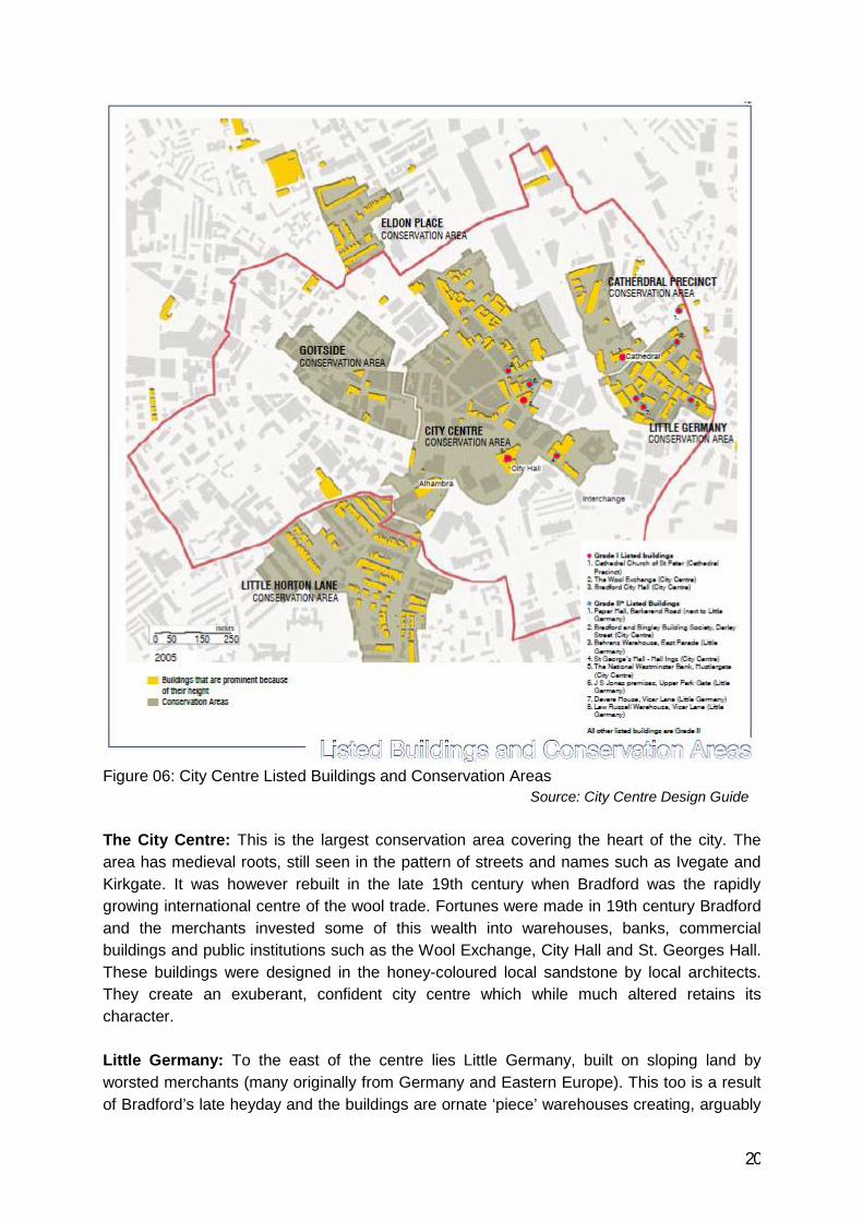
Figure 06: City Centre Listed Buildings and Conservation AreasSource: City Centre Design Guide
The City Centre: This is the largest conservation area covering the heart of the city. Thearea has medieval roots, still seen in the pattern of streets and names such as Ivegate andKirkgate. It was however rebuilt in the late 19th century when Bradford was the rapidlygrowing international centre of the wool trade. Fortunes were made in 19th century Bradfordand the merchants invested some of this wealth into warehouses, banks, commercialbuildings and public institutions such as the Wool Exchange, City Hall and St. Georges Hall.These buildings were designed in the honey-coloured local sandstone by local architects.They create an exuberant, confident city centre which while much altered retains itscharacter.
Little Germany: To the east of the centre lies Little Germany, built on sloping land byworsted merchants (many originally from Germany and Eastern Europe). This too is a resultof Bradford’s late heyday and the buildings are ornate ‘piece’ warehouses creating, arguably

21
the finest merchant’s quarter in the country. 55 of the area’s 85 buildings are listed and itscharacter is based on sloping streets with the warehouses getting higher lower down the hillto create a dramatic townscape.
Cathedral Precinct: This is one of the oldest parts of Bradford and the Cathedral is perhapsthe most important building. The area was one of the first parts of the city to industrialise withthe arrival of the Bradford Canal in the 1770s. The lower part includes some importantcommercial buildings while the slopes west of this were once housing and are now surfaceparking. There are 16 listed buildings in the area.
Goitside: To the west of the city centre the Goitside conservation area takes in many of the‘stuff’ warehouses. The Goit is a medieval water channel built to power a corn mill and thearea was already industrialised at the start of the 19th century. It was completely redevelopedin the late 19th century since when it has remained largely untouched. It contains only 6listed buildings, however the group value of the buildings is far greater because it remains alargely complete urban landscape, typical of 19th century Bradford.
Detail Conservation Area Assessments for the four conservation areas in the city centre canbe found at: www.bradford.gov.uk/conservationassessments. Bradford’s listed buildingdescriptions can be found at www.bradford.gov.uk/listedbuildings.
4.0 Social and Demographic Information
4.1 Population
The population of the wider city centre is estimated to be approaching 4,000. Theseresidents are primarily located in social housing to the North West and North East of the citycentre. However, since 2001 increasing numbers of privately rented and owner occupiedapartments are being developed in the north of the city centre and Little Germany.
Continued growth in the employment demands and opportunities, change in the type andcapacity of residential development and increasing number of student population have madeit difficult to draw a firm conclusions on the typical characteristics of the city centrepopulation.
Population change in the city centre as a whole is expected to be influenced byseveral factors including the growth in the size and type of residential property and the limitsplaced on this by planning policy. The Genecon (2007)1 study assumes that with apredicted increase in the proportion of 1/2 bedroom property the population of the citycentre could increase by approximately 7,500 by 2014.
1 Genecon (2007). BCR Performance Framework: Second Annual Update 2005/06-Final report.Report Dated August 2007. Genecon Consultancy Ltd.

22
The 2001 census shows that the resident population is ethnically diverse, mostly of workingage (20-39 years old) with a very small percentage of children and families and with a highproportion of single individuals. In a report produced by DTZ and Tescom2 in 2005 showsthat 40% of the city centre residents are aged between 20 and 29 years and 70% of themlive in single person household. So evidently, continued growth in the city centre residentpopulation will increase the demands for services within the centre, with the most likelyrequirement being for shops and leisure facilities rather that for child or health care services.
4.2 Housing
City Centre residents are primarily located in social housing to the north-west and north-east of the city centre. However, since 2001 increasing numbers of privately rentedand owner occupied apartments are being developed in the north of the city centreand in Little Germany to accommodate the growing population. Continued growth in theemployment demands and opportunities, change in the type and capacity of residentialdevelopment and increasing number of student population have made it difficult to draw afirm conclusions on the typical characteristics of the city centre population. The currenthousing stocks however comprise a large number of small properties with a low level ofhigher value properties offering little diversity in the stock.
The majority (82%) of the existing housing in the city centre is flats with nominal amounts ofterraced and semi detached units. Young, single person or small households are the keymarket for city centre housing as 70% of the existing housing stock is comprised of singleperson accommodation. Housing tenure across owner occupation (30%), private renting(34%) and social renting (32%) are broadly similar.
In terms of tenure, the level of home ownership (36%) in the city centre is lower than thedistrict as a whole and the majority of the housing stock is rented in private (34%) and social(32%) sector. This points to a limited available choice for a large percentage of city centrepopulation and gives an indication of the affordability problem in the City Centre.
At present, there are no housing allocations in the city centre and no target has been set fornew housing in the city centre. The types of housing being built in the city centre are beingleft to the market to decide and the market trend still remains on developing high densityflatted accommodation in one and two-bed apartments. There have been some three-bedapartments but these are in the minority. According to the 2001 Census, over 80% of alldwellings are flats, conversions or shared dwellings.
To date most of Bradford’s city living residential stock has been developed throughconversion of old and underused mill buildings, most notably in Little Germany and theManor Row area and partly in other similar areas such as Goitside. However, more recentlya number of new build residential developments have come to the market such as the 133unit Gatehaus scheme and the Empress, a new scheme comprising 45 one and two
2 DTZ and Tescom (2005). Creating a Balanced City Centre Housing Market in Bradford: Final Report.Report Dated November 2005. DTZ Pieda Consulting and Tescom Research and Consultancy Ltd.

23
bedroom luxury units situated in the heart of Bradford, and overlooking the attractiveCentenary Square. Works has also started on the Aspire Citygate project at the bottom ofManchester Road. York-based developer Skelwith Group is to build 75 homes as part ofphase one of the project. There is also plans to build 362 apartments on a vacant plot atTrafalgar Street and Snowden Street, near the junction of Manningham Lane and HammStrasse.The proposed residential development is split into three buildings and includes a 14-storeytower, 164 studio apartments, 109 one-bed and 89 two-bed apartments, shops, cafes, officesand leisure units.
The city centre may offer sites large enough to accommodate family housing, however, thisuse would be more suited to sites in the peripheral areas due to competition for land in thecity centre and the requirement to maximise density for optimum return.
4.3 Education and Health Facilities
There are no primary and secondary education facilities within the City Centre boundary.However, there are a good number of schools, academies and free schools within a mileradius from the city centre. The city centre also falls within the catchment of private andvoluntary run further education facilities and contains adult training centres.
The demand for school places is very much depended on the increase of the city centrepopulation and whether this population includes children. Currently, only a small fraction ofhouseholds within the city centre are home to school-going children which means that thereare no imminent issues regarding the provision of schooling in the city centre. At themoment, the children who live in the city centre travel out to the surrounding area for theirschooling. However, it has been predicted that the city centre population is likely to increase,mainly be due to the increase in the 20-39 age group, and the provision of education facilitiesand their accessibility will only become more of an issue if this gives a rise in the number offamilies with children in the city centre.
In terms of higher and further education, the University of Bradford and Bradford College areboth located within the city centre. Together they attract thousands of students from a varietyof location, ethnicity and culture into the city centre. There is also easy communication fromthe City Centre to Leeds to access Leeds University and Leeds Metropolitan University. TheCathedral Centre also offers adult vocational training facilities within the area.
There are three GP surgeries within Bradford city centre. Two are located close to theUniversity and the other is in the Market Neighbourhood, which is currently reviewing theservice it offers in the area and may choose to close down in the future. In terms of dentalsurgeries, the offer in the City Centre is poor; however, there are at least three surgerieswithin 1.5km of City Hall. There are also several chemists within walking distance ofthe residential areas. These services and facilities have been established based on currentlevels of demand and it is recognised that as the city centre population grows, additional

24
provisions are likely to follow. The Bradford Royal Infirmary and the St Luke Hospital arealso within 10 minutes driving distance from the city centre.
4.4 Other Community Facilities
In terms of local, small-scale convenience shopping facilities there is a clear lack of this typeof retail offer in the city centre close to the residential areas. There are a few small shops inLittle Germany and close to the University. The newly opened Tesco Express on Sunbridgeroad has also increased small-scale convenience retail offer in the city centre. Morrisons isthe only supermarket to be located in the city centre and this is likely to have an effect on thepresence of smaller convenience retailers in close proximity. However, this store does notopen on Sundays and in 2006 it was announced that it was to close. It remains to be seen ifanother retailer is to take over this site.
The city centre is also home to two post offices (although these service facilities hadseriously been reduced with the closure of the largest post office on Bank Street since 19November 2005), two major hotel chains, leisure exchange (Cineworld leisure complex), thecentral bus station (the interchange) and two rail stations.
The Bradford South police station is based at Trafalgar House on Nelson Street borderingthe Southest boundary of the city centre. The Bradford South Division of the police work withcouncil and other partners to promote community safety and provide enjoyable reassuredvisit to city centre. The nearest Fire Station is located on Leeds Road, only 1.3 miles awayfrom the heart of the city centre.
Bradford Central Library is located on Princes Way, next to the National Media Museum.Both of these establishments together with the country’s only ‘colour museum’ attract largenumber of visitors daily from all over the districts.
Culture Fusion, a new £6.9m state of the art youth facility, is also located in the city centre. Itco-locates a range of services: Bradford city centre Connexions Centre, Information Shop forYoung People and City of Bradford YMCA. The 3000 sqm building also provides a widerange of open access services for young people during the day and runs as a ‘youth club’with a wide range of activities during the evenings and weekends. Facilities include: musicstudio, performance area, dance studio, activity rooms, youth café and youth hostel.
Bradford City Football Club Stadium is on Manningham Lane, approximately half a mile fromthe city centre, which attracts a large number of fans and visitors alike on every match day.
The nearest household waste recycle centre is also on the periphery of the city centre- justover half a mile away from the northern boundary.

25
4.5 Transport and Movement
The transport network into and out of Bradford City Centre is extensive, well usedand consists of various different modes travelling on many different routes anddirections towards, within and away from the City Centre.
City Centre Road Network
The original roads into Bradford were on the high ground. Westgate / Wakefield Road wereoriginally a Roman Road and crossed the river at the ‘Broad Ford’ from which Bradford takesits name. Later in the Victorian era the valley bottom was developed and new roads werebuilt. These together with the dense network of minor roads created the shape of the city - ahuge spider’s web of connected streets tying the city together. This street layout is verypermeable and there is also a strong hierarchy of routes.
There are nine main routes into the city centre from the outlaying towns and suburbsof Bradford and surrounding areas. These vary in terms of quality, capacity and usage andare detailed as follows:
1) Canal Road/Shipley Airedale Road – this route takes traffic to/from towns ofShipley, Bingley, Keighley and Ilkley and all other suburbs to the north as well as consistingof the main A650 accommodating a vast amount of traffic travelling to/from thenorthwest of England.
2) Barkerend Road – this route brings traffic from the north eastern suburbs of Bradford andalso acts as one of the main routes to/from Leeds Bradford International Airport.
3) Leeds Road – comes into the City from the Leeds direction and forms one ofbusiest routes into Bradford
4) Wakefield Road – one of two routes bringing traffic from the motorway network into thecity centre from the southeast
5) Manchester Road - intersects the city centre from the south and is the secondroute bringing traffic from the motorway network.
6) Little Horton Lane – provide the routes out of the city the densely developed residentialareas in the west of the district and to the settlements of Clayton and Queensbury beyond.
7) Thornton Road – A very busy route taking traffic from the City to the western suburbs andthe villages beyond
8) Westgate / Toller Lane – a route taking traffic to the east to Manningham, Heaton and themore outlying settlements of Allerton, Sandy Lane, Cullingworth and beyond.

26
9) Manningham Lane – this route takes traffic through an area of Manningham towardsthe towns of Shipley, Bingley and Keighley as well as other settlements in the north-west of Bradford District
Bradford city centre has two ring roads – the Central Ring Road which offers car access intothe very heart of the city and the City Ring which takes traffic out of the centre.
The Central Ring Road was built in the 1960s diverting traffic around the city centre butcutting the central area off from its surroundings. The City Ring has been developed morerecently to take through traffic out of the centre altogether. The western leg of this has notbeen completed although there are plans to extend it to Thornton Road. The result is thatlarge amounts of traffic still pass through the city centre proper.
The central part of City Centre is further fragmented by predominance of major roads runningthrough the centre, namely Princes Way, Hall Ings and Manchester Road. Hall Ings/PrincesWay forms a major roundabout of fast moving vehicles and has the effect of cutting off cityhall from the surrounding area and demoting the public realm.
Due to the current level of development interest in the city centre the amount of traffic usingthe centre is likely to grow, which could lead to increased congestion.
Public Transport
Bradford Interchange acts as the principal transportation hub in the city centre that allows foreasy changeovers between buses and trains. The Interchange, sited between Croft Street,Bridge Street, Hall Ings and Nelson Street and opened in the 1970s contains the main citycentre bus terminus and one of two city centre rail stations. The other station is at the ForsterSquare to the north.
Bradford Interchange station is the more strategically significant for the city providing railconnections to cities south, east and west. The station itself sits on the upper side of thesouthern boundary of the city centre, which introduces passengers to the city from anelevated position. The immediately adjacent bus station concourse is at the same level butthere is no direct level access from bus to rail. Instead passengers need to travel down ontoa lower concourse before climbing back up onto the bus or rail platform level.
This bus terminus hosts virtually all of the bus routes in the city although some services layover on Hall Ings, Channing Way and Market Street. The current bus station was remodelledin the 1990s when the lower deck of the then station was changed to commercial use, whilethe upper deck was rationalised, reducing the footprint of the bus lay over areas andconstructing a new covered passenger waiting area.
First Group presently run the majority of the local bus network around Bradford, including thehigh-frequency core ‘Overground’ network, and services to Leeds, Halifax and Huddersfield.Other services are run by:

27
Arriva operate longer distance services to Dewsbury, Wakefield and Sheffield, Keighley and District Travel operate the local Keighley network including a number of
Bradford connections, Black Prince Buses operate a number of services to Leeds.
In addition, National Express and Megabus operate long distance coach services fromBradford Interchange.
The majority of buses access the interchange from Manningham Lane via Manor Row,Cheapside, Market Street and Bridge Street. Westgate, Sunbridge Road and Hall Ings alsoact as major bus corridors, and a number of services approach Bradford via Barkerend andChurch Road from the east and via Manchester Road from south.
Buses currently enjoy good penetration into the city centre dropping people off close toshops and facilities. Aside from the Interchange, Market Street and Hall Ings act as otherprincipal city centre hubs, due their proximity to the main retail and leisure destinationscompared with the Interchange.
A free city bus operates around the city centre, the route covers Interchange, ForsterSquare, Kirkgate Shopping Centre, the Markets, Centenary Square, the University andCollege and the National Media Museum. The buses run every ten minutes from 7am to7pm Monday to Friday and 8am to 5:30pm on Saturdays to cover the route, which has 14stops. All journeys are free and each vehicle is fully accessible and can carry onewheelchair or buggy at a time.
Car Parking
Parking provisions in the city centre consists of multi storey car parks, surface car parks andon street parking with both short and long stay facilities and they are spread throughout thecentre in a random manner. There is also a good deal of free unrestricted parking,particularly in the north of the city centre. However, following a recent review of city centrecar parking provisions both the number and time limit of some of the free parking provisionshave been changed. Many of the vacant sites in and around the city centre have also beentransformed to be used as pay and display surface car parks.
The central shopping area is served by two multi-storey car parks along with five surface carparks. The largest car park is at the Kirgate Centre (608 spaces) which is accessed by acomplex route via Darley Street. The Oastler Centre car park (246 spaces) is accessed fromWestgate and is wrapped around the Morrison’s food store and market. Off street retailparking at the Forster Square (1040 spaces) and Manningham Lane (154 spaces) retailparks also serve a large number of people visiting the city centre everyday. There are also anumber of public car parks around the central shopping area that provides short and longstay parking for shoppers and city centre visitors. NCP car parks on Thornton Road and HallIngs, car parks at Jacobs Well and central library-all are very well located to serve car bornevisitors from outside the city centre.

28
Further from the centre, surface car parks on the former gas works site and along WiganStreet provide commuter car parking spaces for city centre workers, as well as providingpublic car parking for visitors. The level of usage is variable. The gas works site, which isowned and run by the Council, is generally well used, but other surface car parks such asWigan Street are under-used, with typically no more than a quarter of spaces beingoccupied. Car parking facilities within the higher education campus to the south-west of thecity centre are predominantly on street spaces with variable waiting restrictions.
Cycling
The National and Local Cycle Network passes through city centre and there are somespecialist cycle lanes. However these are not comprehensive and as a result cycling into andaround the city centre is not a pleasant experience. The topography is generally unhelpful forcyclists, especially for journeys which involve crossing the valley. Whilst overall the existinglevel of cycle usage is not high, both Thornton Road and Sunbridge Road corridorsincorporate cycle lanes and provide suitable routes for commuter cyclists.
5.0 Environmental Information
5.1 Air Quality
The Environment Act 1995 introduced the National Air Quality Strategy and the requirementfor local authorities to determine if statutory air quality objectives are likely to be exceeded.All local authorities now report to DEFRA on an annual basis, and have the obligation todeclare Air Quality Management Areas and develop action plans for improvement of airquality if objectives are likely to be exceeded.
The most recent assessment submitted to DEFRA by the District concluded that our pollutantof concern in Bradford is nitrogen dioxide produced mainly by traffic. The study has furtheridentified four areas of Bradford that require declaration of an Air Quality Management Area:
Thornton Road (Near the junction with Princes Way and Godwin Street within the City Centre area) Shipley Airdale Road and Otley Road Junction Mayo Avenue Manchester Road junction Junction of Manningham Lane and Queens Road
Although the last two areas in the list falls outside the City Centre boundary, the air qualityscenario in those spots are very much influenced by the volume of traffics moving in and outof and passing through the City Centre area. This need to be addressed in the overallstrategic approach to tackle the City’s Air Quality problem. Separate Action Plans are beingproduced to reduce the levels of pollutants to the required standard in these sites.

29
5.2 Flood Risk
Flood risk is a real and also a perceived issue throughout Yorkshire, not only in Bradfordwhere demand and potential for further development, particularly in new housing sectors, areincreasing every year. Major flooding incidents have often resulted in the Council and othersmaking policy and operational changes to water management in order to reduce the risk offurther floods or to reduce the damage caused. The local authority together with theenvironment agency is therefore working towards improving the standard of protection of theexisting communities and infrastructures. The government also has developed a strategy inthe form of National Planning Policy Framework (NPPF) that aims to use the planningsystem to reduce the demand for further flood defences by protecting natural floodplainsfrom development, and to steer investment away from areas of high flood risk.
In December 2002 JBA Consulting were commissioned by CBMDC to undertake a StrategicFlood Risk Assessment (SFRA) for the Bradford district. Primarily using existing datasources, and in consultation with the Environment Agency and Yorkshire Water, thisStrategic Flood Risk Assessment provides information on the nature of flood risk in thedistrict, and its potential consequences with respect to the allocation of proposeddevelopment sites. Regarding the city centre, this report highlights specific flood risk issuesin the area including an assessment of the ordinary watercourses, topography and the natureof potential flood risks.
The report highlights that the delineation of the high-risk zone within the Bradford city centreis relatively straightforward, and does not warrant significant hydraulic modelling for thepurpose of a general risk assessment. Whilst the accuracy of the floodplain extents needs tobe improved, and a programme of hydraulic model improvements is underway by theEnvironment Agency, the delineation of the floodplain is well understood as a result of recentflood events.
The EA interactive floodplain maps shows that most of the areas of floodrisk within Bradfordcity centre are located in the subcatchment areas of the Bradford Beck (including Eastbrook)which is designated as an ‘Critical Ordinary Watercourse’ (Ordinary Watercourses are thoserivers and streams that are not designated ‘main rivers’, however reflects a known issue withrespect to flooding, and generally associated with (for example) channel capacity, channelconstrictions and/or a poor maintenance regime).

30
Map 01 : Environment Agency Floodplain map for Bradford City Centre
Flooding from rivers or sea without defences Extent of extreme flood
Floodplain
A floodplain is the area thatwould naturally be affected byflooding if a river rises aboveits banks, or high tides andstormy seas cause flooding incoastal areas.There are two different kindsof area shown on the FloodMap. They can be describedas follows:-
Dark blue shows the areathat could be affected byflooding, either from rivers orthe sea, if there were noflood defences. This areacould be flooded: from thesea by a flood that has a0.5% (1 in 200) or greaterchance of happening eachyear or from a river by aflood that has a 1% (1 in100) or greater chance ofhappening each year.
Light blue shows theadditional extent of anextreme flood from rivers orthe sea. These outlying areasare likely to be affected by amajor flood, with up to a0.1% (1 in 1000) chance ofoccurring each year.
These two colours show theextent of the naturalfloodplain if there were noflood defences or certainother manmade structuresand channel improvements.
Flooding has historically resulted in considerable damages and an unacceptably high risk tolife and livelihood within Bradford City Centre. In order to alleviate this problem, a substantialflood alleviation scheme was constructed in 1993, effectively diverting Bradford Beck andWestbrook (Bradford West) away from the city centre flood risk area. It is emphasised thatthe current indicative floodplain map does not account for the presence of this scheme.

31
Although the Bradford Beck diversion certainly have reduced the extent and severity offlooding that could be expected within the identified flood risk area (denoted by the currentIFM), a proportion of the city remains within the high risk zone. The flood affected area is notconsidered functional floodplain, however is also not defended to an appropriate standard.The precise zoning is therefore difficult to categorise, however as a default has been adoptedas Zone 3a.3
Currently there are no specific site allocations situated within the flood zone, though it isunderstood that considerable capital investment is proposed as part of the city centreregeneration process. Developments within this zone are likely to be supported by thecouncil but the floor levels must be situated above the 1% (1 in 100 year) flood level.
The actual extent and severity (i.e. depth) of the flooding within Bradford city centre iscurrently uncertain, and therefore The SFRA recommended that a detailed investigation isundertaken in a holistic manner to provide a consistent and equitable assessment of floodrisk across the City Centre area (as opposed to analyses undertaken on a site-by-site basis).It should include a detailed assessment of the Bradford Beck system (within the city centre)to determine conclusively the extent and severity of flood risk within the catchment.
Finally, the topography of the Bradford district is such that all surrounding areas drain directlyor indirectly into the Bradford Beck system. As such, any future development and/orredevelopment of allocations within the catchment may potentially represent a worsening ofexisting flooding conditions downstream. So in the current circumstances, it is recognisedthat an existing risk of flooding remains in the city centre. Until such time as a suitablescheme can be implemented to alleviate the risk however, all future developments must beassessed with due regard to their potential contributory impact upon existing floodingproblems lower in the catchment.
Bradford Beck and City Centre Flood History
The Beck begins to the west of Bradford in a village known as Wells Head. It flows east fromhere through the villages of Thornton and School Green to Clayton where it joins the LidgetBeck to the south and becomes known as Clayton Beck.
From here it collects various tributaries such as Pitty Beck to the north and continues east toBradford. As it travels through Bradford, it is joined by Westbrook and Eastbrookwatercourses and becomes Bradford Beck. When the Beck reaches the City Centre, itmakes an abrupt turn to the north and exits Bradford via Shipley where it flows into the RiverAire on its route to the Rivers Ouse and Humber.
Historically, Bradford’s sewage and waste materials from the various mills and otherindustries in the area discharged into the River Beck, in addition water was taken from theBeck to feed the then new Leeds Liverpool canal. In consequence, during and after the
3 BMDC (2003) Bradford Strategic flood Risk Assessment. Report dated March 2003. JBA Consulting.

32
industrial revolution the Beck became stagnant and polluted, as did the canal, which it fedand became a breeding ground for diseases such as choler and typhoid.
As a result the Beck was culverted at the turn of the 19th century. The Beck now goes intoculvert in the west of the city in the region of Prince Royd Way and emerges once again inthe north of the city centre at poplar crescent. This culvert follows the route of the originalbeck and is approximately 1.8m x 4.8m in size.The Bradford drainage basin is relatively small (approximately 43-58 sq km4). It is steep anddensely populated. As the catchment of the Beck is very heavily urbanised it is veryresponsive to rainfall, with potentially fast flows and high sediment concentrations beingrapidly obtained.
Some of the flood incidents in Bradford city centre over the last century have been recordedin articles and commentaries such as “goodbye Bradford river stink” and “counting the cost ofthe floods of’46 ”. In addition, the website www.bradfordtimeline.co.uk contains reference tothe local, national and international events affecting Bradford since 1900. A analysis of allthese data sources has revealed that since 1915 there have been six major incidents offlooding Bradford city centre.
Table 01: Incidents of Reported Flooding in Bradford City Centre
Data Source Flood date Flood ExtentAssociatedRainfall(mm/month)
PeaksOverThreshold(cumecs)
BradfordTimeline
August 1911 Flooding to ChappelLane
20.4
BradfordTimeline/Bradford DailyTelegraph
July 1914 City Centre floodedincluding ThorntonRoad. Last serious floodin 1900; Article includesa reference that theBeck has been liable toflood since 1700’s.
40.8
BradfordTimeline
August 1915 Chappel Lane flooded 100.6
Bradford DailyTelegraph
November 1923 City Centre flooded toThornton Road andMarket Street
121.2
BradfordTimeline/Bradford DailyTelegraph
September1946
City Centre floodedfrom Thornton Roadand Canal Road
135
4 Waterman Burrow Crocker (2003) Flood Risk Assessment-Foster Square, Bradford. Report datedMarch 2003. Waterman Burrow Crocker.

33
BradfordTimeline
1947- Full dateunknown(possiblyFebruary as anarticle at thistime relates toelectricity cutdue to weather)
City Centre flooded. 117
BradfordTimeline
January 1959 City Centre flooded toThornton Road
76
BradfordTimeline
July 1968 City Centre flooded 91 178
CBMDC 1980’s to date No record of city centrefloods due to the Beck.
Source: Flood Risk Assessment for Foster Square, Bradford (March 2003) by WatermanBurrow Crocker
5.3 Biodiversity and Wildlife
Biodiversity conservation and caring for the district’s wildlife and their natural habitats isimportant from both global and local points of view, and this has direct implications for thehealth and quality of life of local people. Bradford has a wide range of ecosystems fromPennine uplands to lowland pasture, woodland, parkland, river floodplain and numerousreservoirs. While these environments have suffered degradation, such as habitat andspecies loss to development and agricultural practices, they still support a rich diversity ofnative plant and animal species.
A Local Biodiversity Action Plan for the Bradford District (draft) was prepared in 2003. ActionPlans have been prepared for local species and habitats that have been highlighted for theirconservation concern. The LBAP gives in-depth descriptions of the different habitats andspecies that can be found within the District, which include uplands, woodlands, wetlands,watercourses, grasslands; and flora, mammals, birds, amphibians, fish and invertebrates,respectively.5
The LBAP acknowledges the Council’s role in the protection of these environments, andstates that ‘site and species protection policies, negotiations as part of the developmentcontrol process and the using of planning conditions and Section 106 Agreements all providemechanisms to protect, manage and enhance existing areas of wildlife importance andestablish new areas for wildlife’.
Currently the council does not hold any database on the plant and wildlife within the citycentre, but generally it has been acknowledged that there is a good variety of trees and
5 BMDC (2007) Sustainability Appraisal Scoping report for the Open Space and Recreational BuiltFacilities SPD. Report dated March 2007. CBMDC.

34
wildlife species present in the city centre that enriches as well as adds a feel-good factor tothe natural environment. This diversity needs management and protection and has greatpotential for enhancement. Natural and semi- natural areas and their fauna and flora willbenefit from a protected linked network and the provision of corridors to allow the migrationof animal and plant species throughout the District and across the region. Such a system of‘greenways’ has potential for improved recreation, “active transport” and other communityand economic benefits.
5.4 Open Spaces
In terms of public open spacesthe city centre has relatively fewopen spaces. Unlike manyvalley towns, where the valleysides become parkland, theindustrialisation of Bradford leftlittle scope for open space. Thefine Victorian parks such asLister Park, Bowling Park andPeel Park provide relief from theindustrial city but are welloutside the city centre leavingno significant open spaceswithin the centre of Bradford.
According to the Genecon(2007) study the city centrecontains approximately 29,502sqm of public realm and openspace areas at 12 locationsthroughout the city centre. They are:
1. Bridge St Civic Precinct (3,099 m2)2. Centenary Square (2,973 m2)3. Queen Victoria Memorial (6 m2)4. Princes Way War Memorial (3 m2)5. Hall Ings (3,465 m2)6. Norfolk Gardens (3,347 m2)7. Morley St Monument (1,376 m2)8. The Tyrls (8,445 m2)9. St Mary’s RC school playing fields (829 m2)10. Exchange Square (3,835m2)11. St Blaise Square (1,024m2)12. Oastler Square (1,100m2)

35
However, most of the open space in the city centre is less attractive and useful. Althoughthere are a number of areas of formal landscaping around the city centre (Norfolk Garden,spaces around the Magistrate Court etc), most of the active spaces exist as urban publicsquares. Today the main public square is Centenary Square and the City Park to the north ofCity Hall. Other public squares are small and insignificant such as Rawson Square(dominated by traffic), Festival Square in Little Germany (used as a car park) and ExchangeCourt in front of the Crown Courts. However the new Broadway Shopping centre will recreateForster Square along with two further public spaces.
5.5 Archaeology
Up until now most of the existing knowledge about Bradford city centre's past has come fromwritten records and surviving maps. A historical map surviving from the 1720s, as well asdescriptions from earlier records, was the only sources to provide an impression of Bradfordas it might have appeared at the end of the Middle Ages:
Map 02 : Bradford City Centre c1720
Although Bradford was a bustling place in medieval times its earlier layout was almostcompletely masked by the city's dramatic growth in the 19th century. Even its mainwatercourse, the Bradford Beck, together with the 'broad ford' which is widely regarded tohave given the settlement its name, is hidden beneath today's streets and buildings.
The demolition of the 1960s buildings and an archaeological evaluation undertaken by theWYAS in the Forster Square Area was the first of its kind in Bradford city Centre and itdiscovered historical evidences about the streets in 17th and 18th century Bradford and theindustrial activities around the site. The archaeologists excavated an area between ForsterSquare and Cheapside near the site of the bridge which replaced the ford. Beneath themodern cables and piping, and even the remains of a 19th century pub, traces of what areprobably 16th century buildings were discovered. Smaller finds included coins, pottery, claytobacco pipes, a bone spoon and a bone toothbrush. Remains of buildings with some hint of

36
some industrial processes going on down by the beck, a good water source there forindustrial activity, were also found. It was the earliest archaeological evidence found inBradford6.
Earlier, in 2000 a desk-based assessment of the same site was carried out by WYAS.7
Several artefacts (mostly coins) were found in the area date to the Romano-British periodsuggesting the possibility of an early settlement in the vicinity of the city centre. In addition, apossible late Roman/early Saxon empty stone coffin was found near Leeds road. Thepresence of early medieval settlement, suggested by documentary evidence, is supported bythe presence of Anglo-Saxon masonry within the cathedral walls.
By the 14th century the town centre was flourishing with buildings erected surrounding thecathedral. Documentary evidence shows that the occupied area extended from Berkerend inthe east towards Kirkgate and Westgate in the west. During the post-medieval periodBradford city centre was affected by a dramatic increase in wealth and population caused bythe growth of the textile industry. This lead to the expansion of the town centre and also tothe redevelopment of the medieval core. The current city centre therefore should containsignificant medieval and post-medieval remains.
The expansion and redevelopment of the town centre continued during the 19th and 20th
centuries, possibly destroying the evidences of earlier activity. However, documentaryevidence regarding the 20th century development of the area (i.e. the extent of cellarage),combined with the results of a recent test-pitting investigation at the junction of Kirkgate andQueengate, confirm the existence of undisturbed archaeological deposits in the city centre.
In summery, although the city centre has not been greatly disturbed in the past, the area isknown to be of archaeological potentials that could be uncovered in the future throughmodern disturbances because of the huge amount of development in the city centre. Thearchaeological excavations in the Forster Square site were the first real field excavations inthe city centre and indicate that medieval or earlier remains may still be well-preserved insmall pockets in some areas within the city centre.
6.0 Economic Information
Bradford’s economy is a low value economy when compared to regional and national outputfigures. Bradford’s share of the regional economic output has fallen consistently since 1995although growth rates have improved since 2005. Productivity levels are on a par withregional levels but are low against comparable cities. The economy must address challengesthat have developed over the long term as well as the shorter term impacts of the recession.
6 BBC (2008). Beneath Bradford’s Streets! [online]. BBC [cited 19 June 2008]. Accessed on:<http://www.bbc.co.uk/bradford/content/articles/2006/04/28/archaeology_forster_square_bradford_feature.shtml>
7 Keith, K. (2000). Broadway Centre, Hall Ings, Bradford, West Yorkshire: Desk-based Assesment.Unpublished WYAS report (R778, 2 vols).

37
The city centre, with 36,000 jobs which is one in six of all employee jobs in Bradford, is thekey economic driver for the district. Bradford’s city centre has been suffering from marketfailure. Its retail offer is limited and its central business district needs recreating to appeal to21 st century businesses and attract new investment. Recent action and investment on theground has been focused on improving the quality of the public realm, including the CityPark. This will act as a catalyst for a new central business district by raising land values andencouraging investment.
Despite the recession some large developments have been completed in the city centre andthere are schemes currently underway. This section provides a locational overview on thecurrent situation regarding office, retail, residential and leisure development throughout thecity centre and includes details of some of those recently completed commercial schemes. Italso includes a review of the supply and range of existing premises and briefly assesses thefuture market potential of the main business activities.
6.1 Office Market Profile
Bradford suffers from a lack of quality office space within its centre and is also lacking aclearly defined office core typical of other centres of its size. The current office market isoccupied by a variety of businesses with a wide range of needs. However, the office stock islargely secondary, in many cases refurbished, which does not meet the needs of the modernoffice occupier. In recent years, although additional stock has come to the market, some ofthe larger stock has been removed, possibly through demolition (Broadway) or byrefurbishment and conversion to alternative uses.
Bradford has historically possessed a large number of frequently converted mill buildings astraditional office blocks. While in many cases these buildings are externally attractive,frequently listed, this type of provision does not meet the modern office user’s requirements.Even where possible, it can be difficult and expensive to install modern technologies,conveniences and services such as air conditioning, under floor wiring, open plan layout andcomputer networking, in to a old building. Mill buildings especially, with their columns andpillars, do not lend themselves to office use where function affects value more thanaesthetical appearance.
Bradford City centre has seen very little such office development since the completion of ‘No1 The Interchange’ in 2006 and no speculative office development has been undertaken.The latest pre-let office development is at Southgate where Provident Financial has takenoccupation of 120,000 sq ft of design and build grade A offices. Work to relocate theMagistrates court is ongoing, but with restrictions in funding the short term deliverability ofthis scheme is in question. In the longer term there is a desire to promote Bradford citycentre as a destination for office occupiers rather than the outer areas of the city which hasbeen the preferred location for HQ office developments during the last 15 years.
Bradford has always promoted itself as offering a viable alternative to Leeds in terms of officerents. At the height of the boom this may have been the case, but with the recession and the
38
introduction of empty property rates there has been an increase in the incentives offered bylandlords in terms of extensive rent free periods and also reductions in headline rents tosecure tenants. This will have a knock on effect for the Bradford office market and promotingBradford over Leeds due to cost may not now be a sound strategy.
The city centre remains the priority regeneration area for the District and its success ispivotal to the prosperity of the whole city and the district overall. The completion of the CityPark has improved the public realm around City Hall, and it could act as a catalyst for thedevelopment of a new central business district which will encompass the proposed mixeduse development on former Odeon building site and build on the recent Southgatedevelopment which is now home to Provident Financial’s Head Office. In addition, TheWestfield Shopping Centre will be able to accommodate office accommodation insubsequent phases. These two locations are the priorities within the city centre and newdevelopments in these areas will offer opportunities for reuse of sites in other areas.
In April 2012 retail giant Freeman Grattan Holdings has also secured a deal to open a newhead office and house around 300 staff in the centre of Bradford. The mail order and onlineretailer will transfer office staff from its Lidget Green base, where Grattan has had apresence since 1934, to a Grade II-listed former wool warehouse on the edge of LittleGermany
Creation of a new central business district will bring transformational change for businesses,investors and Bradford citizens. Key steps have already been taken including assemblingland, putting in place the planning and design framework, agreeing a commercial strategy,and preparing business cases. Delivering a development platform and subsequent Grade Aoffice accommodation is a priority for the city centre.
6.2 Residential Market Profile
In recent years Bradford has seen an upsurge in city centre housing, which looks set tocontinue. Although housing in the city centre has increased in both quality and quantity overthe last few years, with recent residential developments such as the warehouse conversionsto apartments in Little Germany and new apartments off Centenary Square, the population ofBradford City Centre still remains relatively low. This is due to a number of issues, includingaffordability, suitability and image of housing in the city centre.
The housing that currently exists in the city centre consists of new build apartments andconversions, and older post war social housing tower block developments. Many of thesepost war housing developments have not stood the test of time, either architecturally orstructurally. However, the growth in the city centre residential market is continuing andexpected to play an important role in the regeneration of the area.
To date most of Bradford’s city living residential stock has been developed throughconversion of old and underused mill buildings, most notably in Little Germany, an area ofdistinctive stone nineteenth century buildings which contains many listed properties.However, more recently a number of new build residential developments have come to the

39
market such as the 133 unit Gatehaus scheme and the Empress, a new scheme comprising45 one and two bedroom luxury units situated in the heart of Bradford, and overlooking theattractive Centenary Square. Works has also started on the Aspire Citygate project at thebottom of Manchester Road. York-based developer Skelwith Group is to build 75 homes aspart of phase one of the project. There is also plans to build 362 apartments on a vacant plot atTrafalgar Street and Snowden Street, near the junction of Manningham Lane and Hamm Strasse.The proposed residential development is split into three buildings and includes a 14-storey tower,164 studio apartments, 109 one-bed and 89 two-bed apartments, shops, cafes, offices andleisure units.
Although there are some concerns over the sustainability of the residential market generally,Bradford City Centre’s residential market remains relatively stable. Bradford is expected toexperience the strongest rate of household growth in West Yorkshire over the next decade.The emerging Local Plan Core Strategy plans for at least 3500 new homes in the City Centreby 2028. A substantial proportion of these additional households is expected to be comprisedof smaller family units and single people, potentially well-suited to city centre living.However, there are also concerns emerging from the fact that the lack of variation in tenureand property type could result in an unbalanced, unsustainable city centre housing market inthe long term, as the supply of accommodation may not be met by a subsequent demand.Over supply and lack of variation is therefore a major property market issue in the city centre.
6.3 Retail Profile
Bradford shopping centre is identified as being of regional significance. It is ranked 99th
nationally by Venuescore in 2011 (a decline of 10 in the national rankings since 2005) and iswithin the top 5% of all UK shopping venues. The defined Central Shopping Area contains449 retail outlets occupying 99,340 sq m of retail floorspace (March 2012). The proportion ofconvenience provision within the city centre is limited whereas the comparison goods sectoris the most prolific in terms of floorspace, although it contains a wide variety of othercommercial retail and leisure uses. It also performs a range of civic and cultural services,containing Council Offices, Law Courts, a public library, the Alhambra Theatre, the NationalMedia Museum, St. George’s Concert Hall and a Tourist Information Centre. It is significantto note that the total amount of retail floorspace in the centre has dropped by more than10,000 sq m over the 2001 to 2011 period. This can be attributed to the demolition of anumber of retail outlets in the Broadway and Petergate area to make way for the BroadwayShopping Centre redevelopment.
In terms of the diversity of uses in Bradford, the city centre is well provided for in terms of thenumber and amount of comparison and financial and business service units. However, incomparison with the respective national average figures, there is an identified shortfall in theprovision of convenience, retail service and leisure service operators. In terms of vacancyrates, Bradford is performing poorly, with both the proportion of units and vacant floorspaceabove the UK average figures. The vacant units are dispersed throughout the centre andvary in size from 10 sq.m to 3,090 sq.m.

40
A health check assessment has also been carried out as a part of the Retail and LeisureStudy and it has identified that Bradford city centre is performing relatively well and has agood provision of retail and leisure services. There have been several new developments inthe city, notably the city Park south of the defined Central Shopping Area, the Travelodgehotel on Mill Street which has opened in May 2012, the Southgate complex which includes anew headquarters for Provident Financial and Jurys Inn Hotel which opened in 2011 and thePremier Inn Hotel, Vicar Lane which opened in 2011. The new Tesco Express store onSunbridge Road and the refurbishment of the Morrisons store on Westgate provide animproved level of convenience floorspace in the centre. Public realm improvements havealso taken place to a number of shopping streets including Darley Street, Bank Street, TyrrelStreet, Huslergate which were completed in 2010, while improvements are currently takingplace to Ivegate and Upper Millergate. However, the delays associated with the Westfieldscheme and the uncertainty as to the future timescales for the project is affecting investorconfidence in the city. Similarly, the high level of vacancies in Bradford also adversely affectits environmental quality, with the closure of the TJ Hughes building in particular, making thisarea appear run-down. In contrast, the four Retail Parks to the north of the centreaccommodate a strong provision of national operators which appear to be trading well.
Considering the size of Bradford’s population and catchment area, the city has traditionallybeen poorly represented by national multiples, with a below average volume and quality ofretail provision. The Bradford Retail and Leisure Study (2012) found that whilst there isstrong demand for representation in the City Centre, there is a lack of suitable, high qualityretail outlets to meet that demand. Furthermore, the business survey revealed that retailersfelt the centre contains too many discount retailers and that there was a general lack ofquality retailers in the centre. A weak night-time economy is also a reason for the city centrefailing to retail visitors for a substantial amount of time. The delays associated within theimplementation of the Broadway Westfield scheme was identified by the majority ofbusinesses (68%) as having a direct impact on their business.
In conclusion, whilst Bradford can be seen as a strong comparison goods and leisuredestination, its future growth could be restricted unless new high quality, large retail outletscan be brought into the city centre. The Broadway Shopping Development should deliverthese, although currently the inactivity on this site has led to a significant decline in retailfloorspace within the city centre. Furthermore, as noted by agents many retailers werecurrently refraining from investing in the centre until this development is complete. Once thedevelopment is completed, careful management will be required to ensure that the whole ofthe centre benefits from the development. It will also be necessary to ensure that the existingKirkgate and Oastler Shopping Centres remain important retail destinations.
6.4 Leisure and Tourism Market Profile
Historically, for a city this size, Bradford has been under provided for in terms of leisure. Theonly leisure offer was:
The Odeon Cinema offering 3 screens now closed and the site of a proposed mixeduse development

41
Pub circuit with nightclub on the outskirts of the city centre on Manningham Lane. Indian restaurants, again located on the edge of the urban core.
Due to Bradford’s proximity to Leeds and the excellent public transport links with late busesand trains after midnight, Bradford’s residents have traditionally travelled to Leeds with itsdefined leisure circuit around Greek Street, late bars, nightclubs and restaurants. In additionto losing its traditional office core and stagnation of its retailing offer, Bradford was losing itsnight scene throughout the 1980’s and 1990’s with the city centre becoming increasinglylifeless.
Enhancing the provision of leisure uses has therefore become an important element of theCity Centre Masterplan and most of the major city centre (re)development proposals hasincorporated elements of leisure uses within the plan, adding liveability and vitality to thearea. Bradford city centre has also become increasingly successful in attracting people to thecity centre thanks to the opening of a number of leisure-based schemes during the last fewyears. The Leisure Exchange was conceived and developed in 2000 opening in September2001. The 205,000 sq ft leisure scheme is the tenth largest in the UK, with tenants includingCineworld, Gala Casino, a bowling alley, as well as a number of restaurants. Located closeto Bradford Interchange Railway & Bus Stations as well as the main Ring Road, The LisureExchange provides easy access to those living in and around Bradford and a real alternativeoffer to the traditional leisure opportunities around Leeds.
The most recent leisure scheme, developed by Asda St James, is Centenary Square whichis situated opposite the City Hall. The development has gone some way to addressing thelack of restaurant provision within the city centre. With its outside seating and big screenentertainment, the Centenary Square provides a real café culture within the heart of Bradfordand the beginnings of a leisure circuit from The Leisure Exchange down towards CentenarySquare and towards the west end which is now established as a leisure destination in its ownright underpinned by bar offers.
The development of city living within Bradford in particular, Little Germany and along theCanal Road Corridor will ensure the significant new customer base for leisure opportunitieswithin Bradford whilst the creation of the new business district within The Bowl will not onlyprovide a definitive core to the city but lunch time and business trade for the restaurants andbars. There is also a large concentration of leisure service uses including the AlhambraTheatre, the National Media Museum, the IMAX Cinema and a number of bars, publichouses and restaurants in the City’s West End area close to the University and Collegecampuses. Consequently, the wider city centre area is considered to adequately serve theneeds of visitors, and has a lot to offer in the leisure service sector8.
There is limited up to date information available on city centre tourism industry. Day tourism,short city leisure break and business travel are the main source of city centre visit and theseare increasingly gaining attention in regeneration priorities. According to the latest statistics,
8 WYG (2008) Bradford District Retail and Leisure Study. Report Dated June 2008. White YoungGreen.

42
staying visitors are estimated to have accounted for 10% of all visits to Bradford and 30% oftotal tourism expenditure in Bradford. Although the two main reasons for staying visits toBradford are for a holiday and to visit friends and relatives, visiting Bradford for businessreasons has become more popular since 2003 and now accounts for nearly a quarter of allspending trips to the city and about a third of all spend.9
But in contrast to national and regional experience, the hotel sector in Bradford has not beenperforming very well in recent years. There is a lack of quality and scale of hotel offer inBradford which is a critical factor for weaker business tourism as well as for holding backinvestment in the area.
9 Locum (2008) The Bradford Destination Assessment. Report dated April 2008. Locum Consulting.
Table 02: Purpose of StayingVisitors to Bradford
2003 2005 2006AllHolidays
48 % 47 % 44 %
Business
15 % 18 % 23 %
VFR 35 % 32 % 30 %Other 2 % 3 % 3 %Study 0 % 0 % 1 %
Table 03: Staying Visitor Spend inBradford
2003(%)
2003(£)
2006(%)
2006(£)
AllHolidays
45 % £51m 35 % £44m
Business
28 % £31m 32 % £40m
VFR 23 % £26m 25 % £32mOther 3 % £3m 4 % £5mStudy 1 % £1m 4 % £5m
Source: The Bradford Destination Assessment (April, 2008)
Table 04: Bed and Room Occupancy RatesBed Occupancy Room Occupancy
Year
BradfordYorkshire
BradfordYorkshire
2000
33.6 % 38 % 56.2 % 53 %
2001
42.8 % 39 % 70.4 % 60 %
2002
42.2 % 40 % 58.9 % 57 %
2003
38.6 % 42 % 54.0 % 57 %
2004
37.8 % 44 % 55.5 % 59 %
2005
33.9 % 44 % 52.2 % 59 %
2006
36.3 % 45 % 54.1 % 57 %
Source: Yorkshire Tourist Board OccupancyTrends 1996 – 2006

43
The city is also low by comparison to others in terms of its hotel provision and none of itshotels are listed in the Good Hotel Guide for Bradford.
Raising the quality and quantity of hotel accommodation has to play a key part in the plannedregeneration of Bradford city centre. Business tourism has underpinned the investment innew hotels seen in most UK cities in recent years and Bradford has got a similar opportunityto develop one of the region’s best urban destination offers. A number of other operators areknown to be looking at Bradford city centre for hotel development. The Tomahawk HotelGroup has already committed to Bradford, having recently restored the Great Victoria Hotelto its former glory. This four star boutique hotel is currently unique in Bradford and itspopularity is indicative of how the city can explore this concept further.
Table 05: Number of hotels and rooms in City CentreLocations 2007
Location1–2*
3* 4* 5* Lodges Total Rooms
Manchester CityCentre
4 11 12 4 31 4465
Liverpool CityCentre
3 11 4 1 12 31 2599
Bristol City Centre 5 9 8 4 26 2538Nottingham CityCentre
7 10 8 7 32 2498
Newcastle CityCentre
12 11 5 3 31 1865
Leeds City Centre 3 3 4 1 4 15 1742Coventry CityCentre
1 5 1 3 10 866
Derby City Centre 2 5 7 14 760Norwich CityCentre
4 6 3 3 16 692
Portsmouth CityCentre
1 5 1 4 11 661
Southampton CityCentre
2 4 1 3 10 504
Bradford CityCentre
2 4 1 1 8 440
Source: Hotel Data Annual Directory 2006 – 7

44
7.0 Conclusion
The key issues identified within this baseline analysis report will be addressed through theapproach being undertaken to prepare the BCC AAP. This combines a collaborativeconsultation process and evaluation to prepare the emerging development options. Thebaseline analysis and the evaluation of key issues will help determine development prioritiesfor the city centre and influence spatial distribution of the planned growth proposed by theAAP.
As part of the ongoing consultation which is being undertaken, this report will be madepublicly available for comment and review. Any additional information, factual corrections orfurther thoughts will be welcomed by Bradford Metropolitan District Council. Any commentsshould be forwarded to:
Bradford Local Plan TeamFloor 2 SouthJacob’s wellBRADFORDBD1 5RW
Or by hand at any planning office at Bradford, Keighley or Ilkley.
Or by Fax to: 01274 433767
At the present time, this report has been deliberately left in ‘Draft’ and will be supplementedwith additional information during the course of the preparation of the BCC AAP submissionreport. This report and its findings will be the subject of further extensive public consultationand engagement.

45
Appendix: List of documents reviewed
The State of the District (CBMDC, 2006-07, 2010) Bradford District Economic Assessment (CBMDC, 2010) Bradford District Economic Strategy (CBMDC, 2011) Bradford Local Investment Plan 2011-2020(CBMDC, 2011) Bradford District Local Infrastructure Plan-draft (CBMDC, 2011) Bradford City Centre regeneration Masterplan (Allsop, 2003) Bradford City Centre Neighbourhood Development Frameworks Bradford Positioning Statement (Regeneris, 2005) BCR Performance Framework ( Genecon, 04/05-05/06, 2009/10) Bradford City Centre Balanced Housing Market Study (DTZ, 2005) Bradford District Joint Housing Strategy 2008-2020 Bradford City Centre Market Activity Report (Knight Frank, 2007 and 2008) Bradford Property Market Overview - Part of NDF Technical Appendices (Donaldson,
2005) Socio-Economic Baseline Report- part of NDF Technical Appendices (Arup, 2005) Sport and Recreation Facilities Assessment (CBMDC, Feb 2008-Draft) Bradford Open Space, Sport and Recreation Study (CBMDC, July 2006) Bradford City Centre Design Guide (Urbed, 2007) City Centre Conservation Area Assessment (CBMDC, 2005) Cathedral Precinct Conservation Area Assessment (CBMDC, 2005) Goitside Conservation Area Assessment (CBMDC, 2005) Little Germany Conservation Area Assessment (CBMDC, 2005) Archaeological Evaluation of the Broadway Centre Site (WYAS, 2002) The Good, the Bad and the Ugly (Bradford Building Preservation Trust, 2004) Bradford District Retail and Leisure Study (WYG, 2008 and 2012 update) Bradford Employment land Review (Arup, 2007) Bradford Office Audit (Donaldsons, 2007) The Bradford Destination Assessment (Locum, 2008) Bradford District Transport Strategy 2006-2021(CBMDC, 2007) The West Yorkshire Local Transport Plan 2011-2006 (Wyltp, 2011) WYLTP Bradford Local Implementation Plan 2011-2014 Bradford Channel and Market NDFs Transport Report (Ove Arup & Partners Ltd, 2005) Bradford City Centre Pedestrian Survey (CBMDC, 2008/09/10) City Centre Utilities and Drainage Study (Arup, 2005) Bradford Strategic Flood Risk Assessment: Final Report ( BMDC, March 2003) Flood Risk Assessment of Forster Square (Waterman, Burrow, Crocker, 2003) Bradford District Carbon Management Programme 2007-12 (BMDC, 2007)

46
Produced by theCity of Bradford Metropolitan
District Council
Local Plan Team
December 2012