Embed Size (px)
Citation preview

Citizen Scientist Observations2010-2014
by Barbara CharryConservation Biologist/GIS Manager
MAINE AUDUBON
Wildlife Road Watch

Interstate 295
Table of Contents
Project Summary 1
Wildlife Observations 2
Statewide Overview of Roads Analyzed 3
Interstates & Highways 4 - 20
Endangered Species Road Watch 21
Endangered Species Road Watch Routes 22 - 34
Author & Acknowledgements 35

Project Summary
Maine Audubon Wildlife Road Watch (WRW) is a citizen science project developed in partnership with Maine Department of Inland Fisheries and Wildlife, Maine Department of Transportation, and University of California, Davis Road Ecology Center. Volunteers record their observations of wildlife crossing roads — both dead and alive — on the WRW website (wildlifecrossing.net/maine/).
Wildlife need to move across the landscape to find food and water and areas to rest, breed, and raise their young. Roads and traffic can make it difficult or impossible for animals to move safely. Wildlife populations can be reduced or even go locally extinct due to collisions, as well as, the inability to move to necessary habitats. Wildlife movement has become even more important for
population survival as habitats shift due to climate change and animals must adapt by moving to find more suitable habitat. Wildlife-vehicle collisions are also a serious safety issue for drivers.
Understanding and identifying where animals are moving both successfully and unsuccessfully across roads can help wildlife and road managers, at both the Maine Department of Transportation and local town level, know where to implement wildlife crossings and road enhancements to help animals cross roads safely and protect driver safety. This can include wildlife crossing underpasses, overpasses, fencing and signs. See “Conserving Wildlife On and Around Maine’s Roads” for more information. (maineaudubon.org/publications-resources/)
Maine Audubon Wildlife Road Watch
Wildlife Road Watch Results Interactive Web Map
1
To view an interactive map of all identified High Density and Hotspot locations and to see the surrounding landscape characteristics, go to: maineaudubon.org/roadwatch
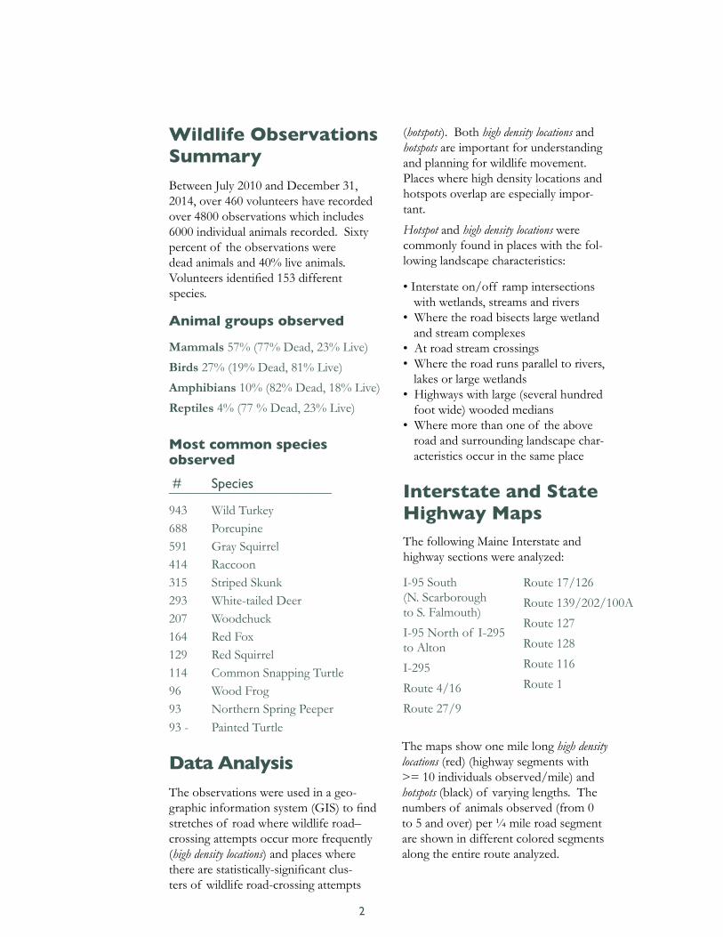
Wildlife Observations SummaryBetween July 2010 and December 31, 2014, over 460 volunteers have recorded over 4800 observations which includes 6000 individual animals recorded. Sixty percent of the observations were dead animals and 40% live animals. Volunteers identified 153 different species.
Animal groups observed
Mammals 57% (77% Dead, 23% Live)
Birds 27% (19% Dead, 81% Live)
Amphibians 10% (82% Dead, 18% Live)
Reptiles 4% (77 % Dead, 23% Live)
Most common species observed
# Species _________________________
943 Wild Turkey688 Porcupine591 Gray Squirrel414 Raccoon315 Striped Skunk293 White-tailed Deer207 Woodchuck164 Red Fox129 Red Squirrel114 Common Snapping Turtle96 Wood Frog93 Northern Spring Peeper93 - Painted Turtle
Data AnalysisThe observations were used in a geo-graphic information system (GIS) to find stretches of road where wildlife road–crossing attempts occur more frequently (high density locations) and places where there are statistically-significant clus-ters of wildlife road-crossing attempts
(hotspots). Both high density locations and hotspots are important for understanding and planning for wildlife movement. Places where high density locations and hotspots overlap are especially impor-tant.
Hotspot and high density locations were commonly found in places with the fol-lowing landscape characteristics:
• Interstate on/off ramp intersections with wetlands, streams and rivers
• Where the road bisects large wetland and stream complexes
• At road stream crossings• Where the road runs parallel to rivers,
lakes or large wetlands• Highways with large (several hundred
foot wide) wooded medians• Where more than one of the above
road and surrounding landscape char-acteristics occur in the same place
Interstate and State Highway MapsThe following Maine Interstate and highway sections were analyzed:
I-95 South (N. Scarborough to S. Falmouth)
I-95 North of I-295 to Alton
I-295
Route 4/16
Route 27/9
2
Route 17/126
Route 139/202/100A
Route 127
Route 128
Route 116
Route 1
The maps show one mile long high density locations (red) (highway segments with >= 10 individuals observed/mile) and hotspots (black) of varying lengths. The numbers of animals observed (from 0 to 5 and over) per ¼ mile road segment are shown in different colored segments along the entire route analyzed.

Statewide Overview of Roads Analyzed
3
I 95
Route One

I-95I-9510 miles with 129 observations (12.9 observations/mile)
4
Map 1 of 3
High Density Locations & Hotspots Overlap
South Portland to Warren Avenue Jetport & Congress Street/Route 22 (Stroudwater River and Long Creek Hotspot section)
Portland/Falmouth (Exit 52 Interchange & Presumpscot River & Meander Brook)

98 miles with 227 observations (2.3 observations/mile)
I-95
5
Map 2 of 3
High Density Locations & Hotspots Overlap
Benton/Fairfield (Kennebec River Crossing at Exit 132, Route 201)
Hotspot
Clinton (South of Burnham)

98 miles with 227 observations (2.3 observations/mile)
Hotspots
Bangor (North of Exit 186 to North of Chase Rd)
Orono (Exit 193)
I-95
6
Map 3 of 3
53 miles with 382 observations (7.2 observations/mile)
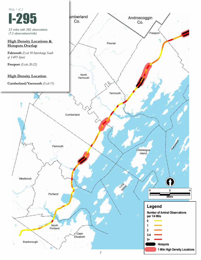
I-295High Density Locations & Hotspots Overlap
Falmouth (Exit 10 Interchange South of I-495 Spur)
Freeport (Exits 20-22)
High Density Location
Cumberland/Yarmouth (Exit 15)
7
Map 1 of 2
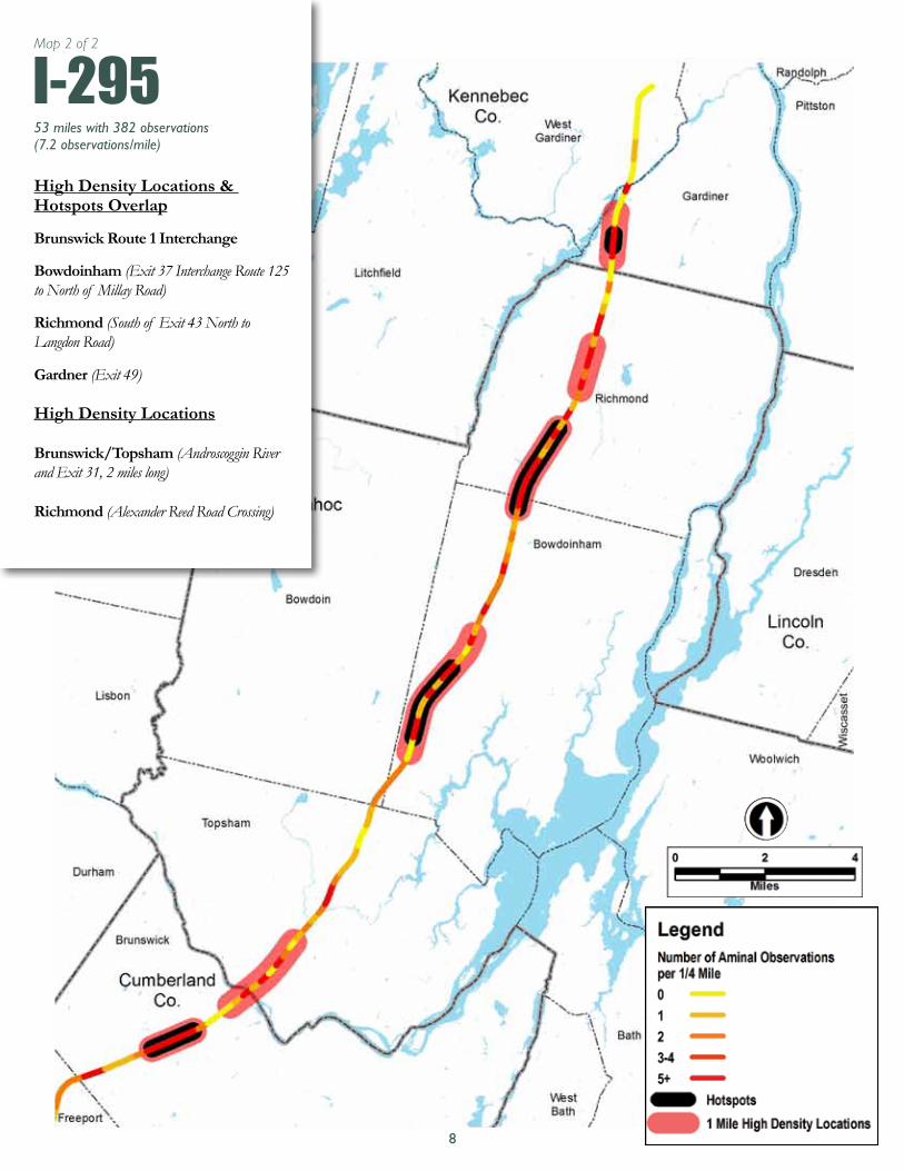
53 miles with 382 observations (7.2 observations/mile)
I-295High Density Locations & Hotspots Overlap
Brunswick Route 1 Interchange
Bowdoinham (Exit 37 Interchange Route 125 to North of Millay Road)
Richmond (South of Exit 43 North to Langdon Road)
Gardner (Exit 49)
High Density Locations
Brunswick/Topsham (Androscoggin River and Exit 31, 2 miles long)
Richmond (Alexander Reed Road Crossing)
8
Map 2 of 2

53 miles with 382 observations (7.2 observations/mile).
53.7 miles, 86 records with 278 observations (5.2 observations/mile)
Rte 4/16High Density Locations & Hotspots Overlap
Linclon PLT (Route 16 Magalloway River)
Rangeley Route 16 (Cupsuptic Lake)
Rangeley Route 4/16 (Hunter Cove/ Dodge Pond)
High Density Location
Phillips Route 4
9

23 miles, 79 observations (3.4 observations/mile)
Hotspot
Chelsea
Rte 27/9
10
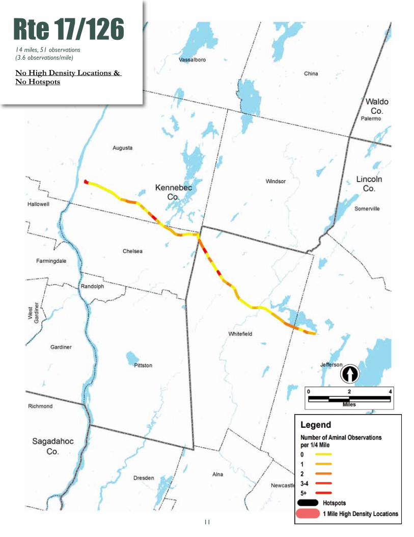
14 miles, 51 observations (3.6 observations/mile)
No High Density Locations & No Hotspots
Rte 17/126
11

Rte 139/202/100AHigh Density Locations & Hotspots Overlap
Unity Route 139
Troy Route 202
High Density Locations
Winslow/Benton Route 100A
Benton to Unity
Unity to Troy, Route 202
24.8 miles, 298 records with 336 observations (13.5 observations/mile)
12

Route 127
Route 128
High Density Location & Hotspots Overlap
Dresden
High Density Locations
Dresden
Woolwich
15.2 miles, 92 records with 215 observations (14.1 observations/mile)
Rte 128
High Density Location & Hotspots Overlap
Dresden
Woolwich
High Density Location
Woolwich, Nequasset Lake
12.75 miles, 58 records with 136 observations, (10.7 observations/mile)
Rte 127
13

21.4 miles, 45 records with 61 observations (2.9 observations/mile)
High Density Locations & Hotspots Overlap
Argyle Twp
Edinburg
Rte 116
14

Rte 1317 miles, 295 observations (0.9 observations/mile)
No High Density Locations & No Hotspots
15
Map 1 of 6
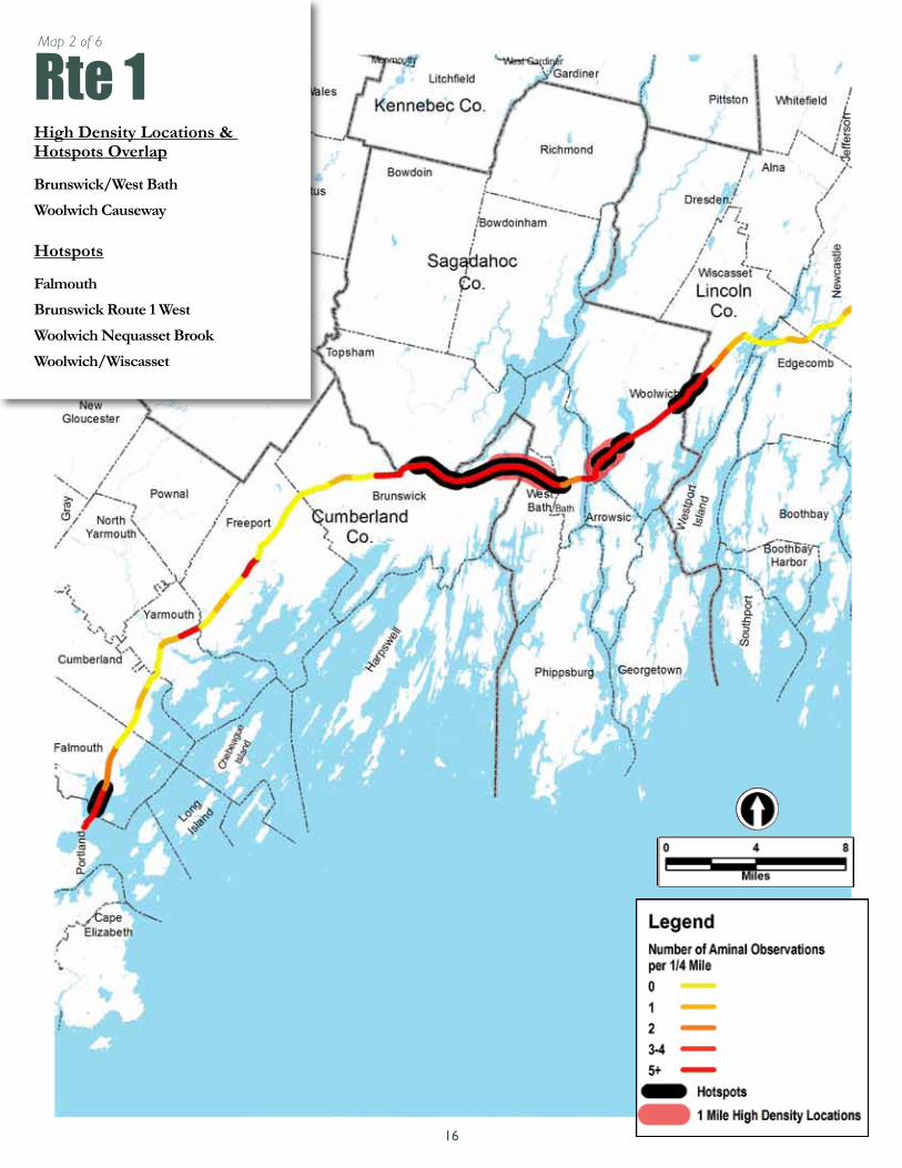
Rte 1High Density Locations & Hotspots Overlap
Brunswick/West Bath
Woolwich Causeway
Hotspots
Falmouth
Brunswick Route 1 West
Woolwich Nequasset Brook
Woolwich/Wiscasset
16
Map 2 of 6

Rte 1No High Desnity Locations & No Hotspots
17
Map 3 of 6

Rte 1 Hotspot
Hancock
Route 1-East 158 miles, 89 observations, 0.6 observations/mile
18
Map 4 of 6

Rte 1No High Desnity Locations & No Hotspots
19
Map 5 of 6

Rte 1 Hotspots
East Machias
Whiting
Edmunds Twp
20
Map 6 of 6
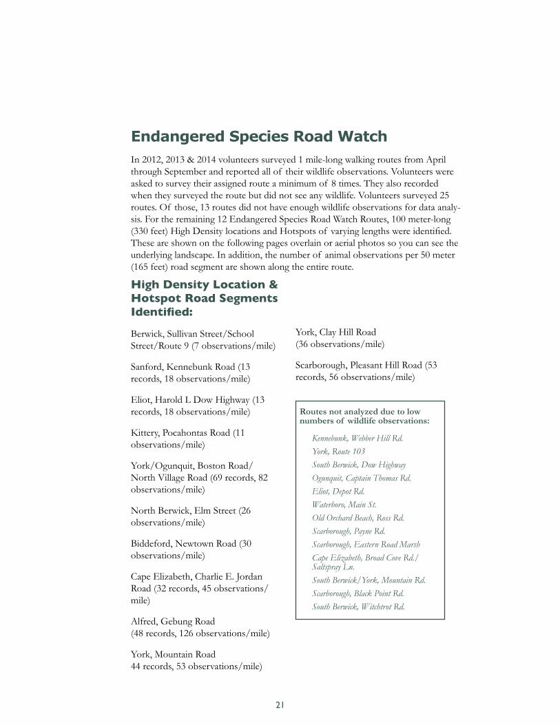
Routes not analyzed due to low numbers of wildlife observations:
Kennebunk, Webber Hill Rd. York, Route 103 South Berwick, Dow Highway Ogunquit, Captain Thomas Rd. Eliot, Depot Rd. Waterboro, Main St. Old Orchard Beach, Ross Rd. Scarborough, Payne Rd. Scarborough, Eastern Road Marsh Cape Elizabeth, Broad Cove Rd./ Saltspray Ln. South Berwick/York, Mountain Rd. Scarborough, Black Point Rd. South Berwick, Witchtrot Rd.
Endangered Species Road Watch
In 2012, 2013 & 2014 volunteers surveyed 1 mile-long walking routes from April through September and reported all of their wildlife observations. Volunteers were asked to survey their assigned route a minimum of 8 times. They also recorded when they surveyed the route but did not see any wildlife. Volunteers surveyed 25 routes. Of those, 13 routes did not have enough wildlife observations for data analy-sis. For the remaining 12 Endangered Species Road Watch Routes, 100 meter-long (330 feet) High Density locations and Hotspots of varying lengths were identified. These are shown on the following pages overlain or aerial photos so you can see the underlying landscape. In addition, the number of animal observations per 50 meter (165 feet) road segment are shown along the entire route.
High Density Location & Hotspot Road Segments Identified:
Berwick, Sullivan Street/School Street/Route 9 (7 observations/mile)
Sanford, Kennebunk Road (13 records, 18 observations/mile)
Eliot, Harold L Dow Highway (13 records, 18 observations/mile)
Kittery, Pocahontas Road (11 observations/mile)
York/Ogunquit, Boston Road/North Village Road (69 records, 82 observations/mile)
North Berwick, Elm Street (26 observations/mile)
Biddeford, Newtown Road (30 observations/mile)
Cape Elizabeth, Charlie E. Jordan Road (32 records, 45 observations/mile)
Alfred, Gebung Road (48 records, 126 observations/mile)
York, Mountain Road 44 records, 53 observations/mile)
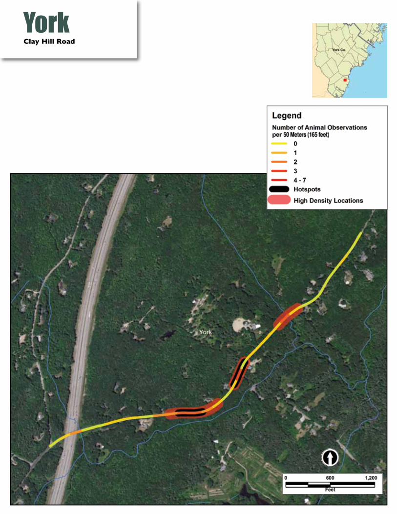
York, Clay Hill Road (36 observations/mile)
Scarborough, Pleasant Hill Road (53 records, 56 observations/mile)
21

This map shows the 25 routes surveyed by citizen science volunteers.
12 red segments were analyzed and data are shared in this report.
13 black segments were not analyzed due to low numbers of wildlife observations (problem locations for wildlife may still occur, but were not determined.)
Endangered Species Road Watch Routes
22

BerwickSullivan Street/School Street/Route 9
23

#
SanfordKennebunk Road
24

EliotHarold L. Dow Highway
25

KitteryPocahontas Road
26

York/Ogunquit
27
Boston/North Village Road
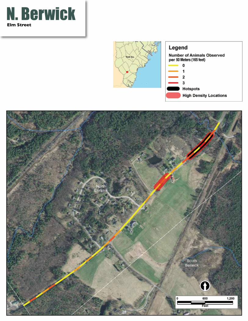
N. BerwickElm Street
28

BiddefordNewtown Road
29

Cape ElizabethCharlie E. Jordan Road
30
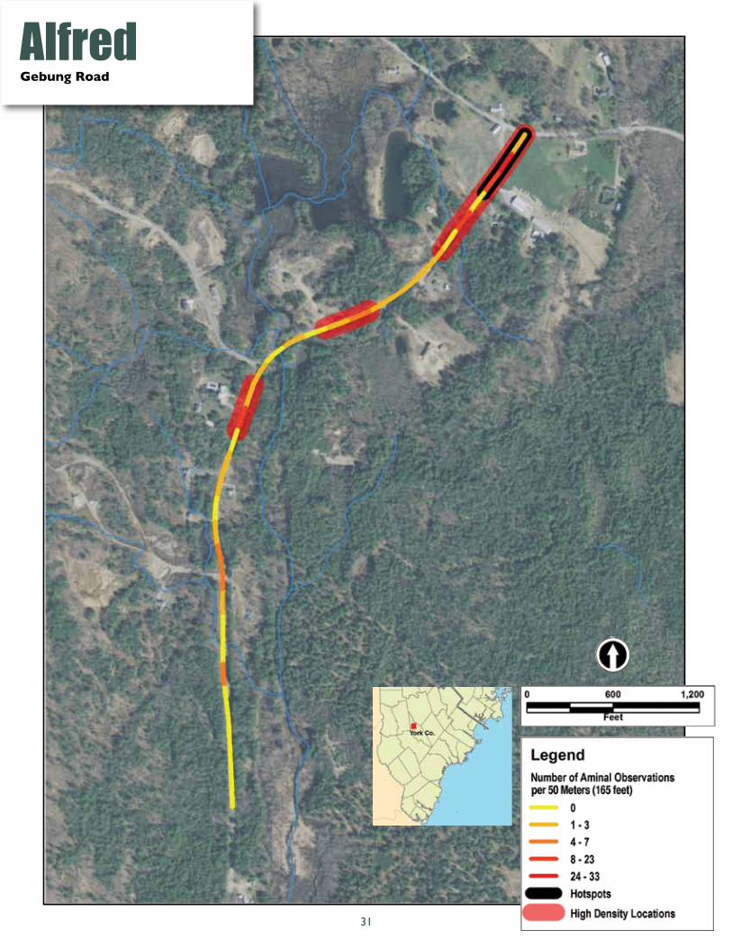
AlfredGebung Road
31
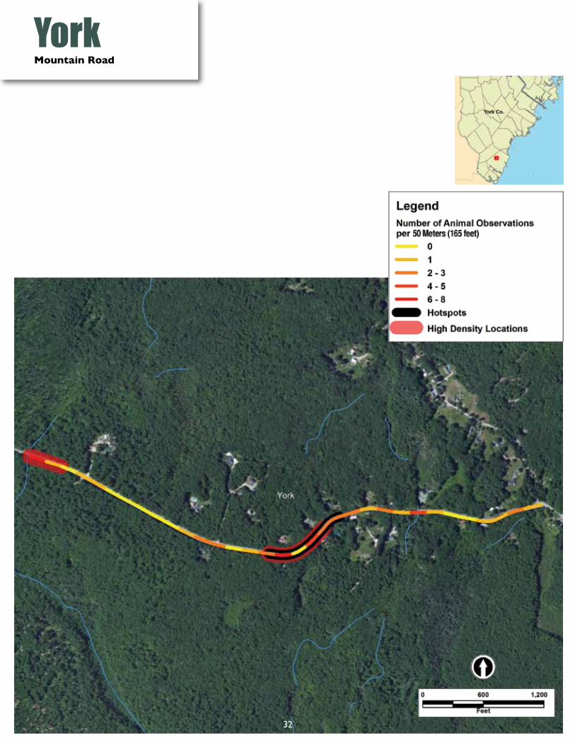
YorkMountain Road
32
#
YorkClay Hill Road
33

Scarborough
34
Pleasant Hill Road
AcknowledgementsThank you to all the volunteers who have kept their eyes peeled while out driving or walking along the Maine roads and recorded all their sightings onto the website. Your cumulative work is invaluable. A special thank you to Dr. Fraser Shilling, UC Davis California, for making it possible for Maine to become the second state in the country to have a statewide wildlife-road reporting system modeled on the California program, as well as for his generous time and expertise guiding analysis of the data and many other questions along the way. Thank you to Dr. Dave Waetjin, UC Davis California, for his technical expertise in developing the website on a shoestring and making endless modifications to customize it for Maine with patience and good humor. Thank you to Richard Bostwick, Maine Department of Transportation, Jonathan Mays, Maine Inland Fisheries and Wildlife (now in Florida), and Susan Gallo, Maine Audubon for your guidance developing this citizen science program. Funding from Toyota Together Green, the TransWild Alliance and the Maine Outdoor Heritage Fund provided essential support in making this project possible.
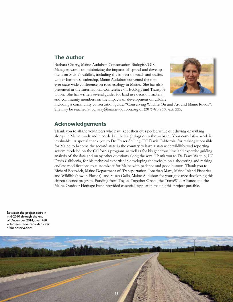
The AuthorBarbara Charry, Maine Audubon Conservation Biologist/GIS Manager, works on minimizing the impacts of sprawl and develop-ment on Maine’s wildlife, including the impact of roads and traffic. Under Barbara’s leadership, Maine Audubon convened the first-ever state-wide conference on road ecology in Maine. She has also presented at the International Conference on Ecology and Transpor-tation. She has written several guides for land use decision makers and community members on the impacts of development on wildlife including a community conservation guide, “Conserving Wildlife On and Around Maine Roads”. She may be reached at [email protected] or (207)781-2330 ext. 225.
Between the project start in mid-2010 through the end of December 2014, over 460 volunteers have recorded over 4800 observations.
35

20 Gilsland Farm RoadFalmouth, ME 04105
maineaudubon.org
Conserving Maine’s wildlife.