Embed Size (px)
Citation preview

Christmas Creek Groundwater Operating Strategy
Water Management
28/06/2013 CC-PH-HY -0003
• Fortescue The New Force in Iron Ore

Christmas Creek Groundwater Operating Strategy
CC-PH-HY -0003_Rev0
Disclaimer:
Page 2 of 94
This document is protected by copyright, no part of this document may be reproduced or adapted without the consent of the originator/company owner, all rights are reserved. This document is "uncontrolled when printed", refer to electronic copy for up to date version.
Christmas Creek Groundwater Operating Strategy CC-PH-HY-0003
Revision Number REVO
28/06/2013 Status IFU -ISSUED FOR USE
~
-:;?_ -..::::
€fr 2f6/bl /3 Author Paul Ricketts A " i s· r(!i
Checked Jardin Barclay ~ lrl/6(13
Approved Bobak Willis-Jones '(SJ\,~ ) . 28/b/13 Signalure
PUBLIC USE (ACCESS TO D Yes Confidentiality
ALL) Publish on Extranet
1:8:1 No
Review Date
Revision History
Author Checker Approver Rev
Status Issued Date No.
P Ricketts J Barclay B Willis-Jones 0 IFU 28/06/2013
•11 Fortescue~
Christmas Creek Groundwater Operating Strategy Page 3 of 94
CC-PH-HY-0003_Rev0.
TABLE OF CONTENTS
1. INTRODUCTION .............................................................................................................. 7
1.1 Background ......................................................................................................... 7
1.2 Approvals ............................................................................................................. 8
1.3 Document Scope ................................................................................................. 8
2. ADMINISTRATIVE REQUIREMENTS ........................................................................... 11
3. CHRISTMAS CREEK OPERATING PLAN .................................................................... 13
3.1 Project Development ........................................................................................ 13
3.2 Dewatering System ........................................................................................... 13
3.3 Conveyance System ......................................................................................... 14
3.3.1 Transfer and settlement ponds .............................................................. 14
3.3.2 Bulk flow and conveyance ..................................................................... 14
3.4 Water Supply System ....................................................................................... 14
3.4.1 Ore processing and tailings ................................................................... 15
3.4.2 Dust suppression................................................................................... 15
3.5 Injection System ................................................................................................ 15
3.5.1 Brackish injection .................................................................................. 15
3.5.2 Saline injection ...................................................................................... 15
3.6 Christmas Creek Village water system and potable water system .............. 16
3.7 Contingency Operations .................................................................................. 16
3.7.1 Alternative Water Supply ....................................................................... 16
3.7.2 Cloudbreak and Christmas Creek Connectivity ..................................... 16
3.7.3 Water supply optimisation ..................................................................... 16
3.7.4 Water level optimisation ........................................................................ 17
4. OPERATING RULES ..................................................................................................... 18
4.1 Mine water balance ........................................................................................... 18
4.2 Abstraction Licence Allocation ....................................................................... 19
4.3 Injection Licence Allocation ............................................................................. 19
5. WATER INFRASTRUCTURE MONITORING, CONTROL AND MAINTENANCE ........ 20
5.1 Monitoring and controls ................................................................................... 20

Christmas Creek Groundwater Operating Strategy Page 4 of 94
CC-PH-HY-0003_Rev0.
5.1.1 Bulk pipelines and storage ponds ......................................................... 20
5.1.2 Leak detection ....................................................................................... 20
5.2 Maintenance schedule ...................................................................................... 20
6. DEWATERING/INJECTION SYSTEM MONITORING PROGRAM ............................... 21
7. ENVIRONMENTAL IMPACT MANAGEMENT .............................................................. 23
7.1 Potential environmental impacts ..................................................................... 23
7.1.1 Overall environmental management approach ..................................... 23
8. TRIGGER LEVELS AND CONTINGENCY PLANS ....................................................... 24
8.1 Project zoning ................................................................................................... 24
8.2 Two-tiered trigger level system ....................................................................... 24
8.3 Framework for selecting appropriate trigger values ..................................... 25
8.3.1 Groundwater level and EC triggers ....................................................... 25
8.3.2 Near-marsh water level assessment ..................................................... 25
8.4 Trigger Level Response ................................................................................... 29
8.5 Contingency plans ............................................................................................ 30
8.5.1 Insufficient brackish water ..................................................................... 30
8.5.2 Insufficient injection capacity ................................................................. 30
9. EFFICIENT WATER USE INITIATIVES ......................................................................... 31
10. MANAGEMENT COMMITMENTS SUMMARY .............................................................. 32
11. REFERENCES ............................................................................................................... 37
12. GLOSSARY .................................................................................................................... 38

Christmas Creek Groundwater Operating Strategy Page 5 of 94
CC-PH-HY-0003_Rev0.
List of Tables
Table 1: Key regulatory issues addressed in the Operating Strategy ..................... 9
Table 2: Scope changes for this Operating Strategy ............................................... 10
Table 3: Administrative requirements ....................................................................... 11
Table 4: Reporting requirements ............................................................................... 11
Table 5: Summary site water balance ....................................................................... 18
Table 6: Groundwater abstraction licence details ................................................... 19
Table 7: Groundwater injection licence details ........................................................ 19
Table 8: Christmas Creek monitoring summary ...................................................... 21
Table 9: Near marsh bore assessment process ....................................................... 26
Table 10: Trigger level framework ............................................................................... 27
Table 11: Summary of licensee’s commitments ........................................................ 32
Table 12: Environmental Impact Management ........................................................... 33

Christmas Creek Groundwater Operating Strategy Page 6 of 94
CC-PH-HY-0003_Rev0.
LIST OF FIGURES
Figure 1: Regional location plan .................................................................................... 39
Figure 2: Existing Christmas Creek water management infrastructure ......................... 41
Figure 3: Hydrogeological section ................................................................................. 43
Figure 4: Regional production bores .............................................................................. 45
Figure 5: Injection locations ........................................................................................... 47
Figure 6: Monitoring location plan .................................................................................. 49
Figure 7: Christmas Creek trigger level zones and bores .............................................. 51
LIST OF APPENDICES
Appendix 1: Groundwater abstraction licence
Appendix 2: Tenements
Appendix 3: No pit-region abstraction bore details
Appendix 4: Pit region abstraction bore setup
Appendix 5: Injection bore details
Appendix 6: Proposed abstraction rates at Christmas Creek
Appendix 7: Christmas Creek conceptual water balance
Appendix 8: Monitoring locations
Appendix 9: Project trigger levels
Appendix 10: Trigger reporting procedure

Christmas Creek Groundwater Operating Strategy Page 7 of 94
CC-PH-HY-0003_Rev0.
1. INTRODUCTION
The Cloudbreak mine (Cloudbreak) and Christmas Creek mine (Christmas Creek) are located
on the southern slopes of the Chichester Range and north of the Fortescue Marsh. Collectively,
the two mine sites are referred to as the Chichester Operations. This Groundwater Operating
Strategy (OS) relates to Christmas Creek only, for further details on operations at Cloudbreak,
approximately 30 km west of Christmas Creek mine (Figure 1), see Cloudbreak Groundwater
Operating Strategy (FMG, 2012).
1.1 Background
The water quality in the Christmas Creek area (between the Fortescue Marsh and Chichester
Range) is variable due to the influence and mixing of both topographic-driven Chichester Range
brackish water and density driven Fortescue Marsh-saline water. Groundwater in the resource
area is generally brackish and becomes increasingly saline towards the Fortescue Marsh and
with depth, as shown in Figure 3. Based on the water quality distribution and beneficial use
considerations, two classes of groundwater quality are defined for the purpose of groundwater
management:
Brackish: ≤60001 milligrams per litre (mg/L), total dissolved solids (TDS), which occurs in shallow aquifer zones within the mineralised Marra Mamba Formation (MMF) and overlying Tertiary Detritals sediments located on the upper slopes of the Chichester Range.
Saline - hypersaline: ≥6000 mg/L to 150,000 mg/L TDS, where the lower limit applies to recharge areas, with an increase in salinity within all aquifers found further south and at greater depth. The aquifer within the Oakover Formation, which overlies the MMF to the south of the resource area, is entirely of saline quality (monitored up to 150,000 mg/L).
Dewatering and injection activities commenced at Christmas Creek in 2011. Groundwater is
abstracted under Department of Water (DoW) 5C licence GWL167593. This OS supersedes
the previous version dated 21 May 2012 and has been updated to document compliance,
monitoring and reporting requirements relating to the water management scheme as specified
by DoW (RIWI & Policy 5.08). Where applicable parallel licencing and statutory requirements
are also referenced (DEC (L8454/2010/1) and EPA (MS871)). It is the intention, that through
this OS, abstraction and injection volumes be aligned with MS871 (50 gigalitres per annum
(GL/a) of dewatering and up to 42.5 GL/a of groundwater injection).
To assist in managing the operational requirement of additional dewatering, the Christmas
Creek Water Management Scheme has been developed with the following objectives:
manage excess groundwater;
1 Up to 10,000 mg/L in certain end-use situations such as OPF use. 6,000 mg/l is approximately equal to 9,000 µs/cm, 10,000 mg/l is approximately equal to 14,000 µs/cm.

Christmas Creek Groundwater Operating Strategy Page 8 of 94
CC-PH-HY-0003_Rev0.
minimise potential environmental impacts; and
conserve the groundwater resource.
The key component of this scheme is the disposal of abstracted water via injection into nearby
suitable aquifers.
Further updates to the OS will be in accordance with any approved changes required by the
DoW or as a result of a significant change to the development and operation of the Christmas
Creek water management scheme.
1.2 Approvals
Fortescue Metals Group Limited (Fortescue) has commenced operation of the Pilbara Iron Ore
and Infrastructure Project (the Project), which consists of several iron ore mines and associated
rail and port infrastructure in the Pilbara region of Western Australia (Figure 1). The primary
environmental approvals for the Project have been obtained for the following:
two iron ore mines in the eastern Pilbara (Christmas Creek and Mindy Mindy) and an east-west spur rail line connecting to the Stage A railway (approved under Ministerial Statement 707);
Christmas Creek iron ore mine (approved under Ministerial Statement 707 (MS707)); and
the water management scheme (approved under Ministerial Statement 871 (MS871).
1.3 Document Scope
This document outlines the planned operation of dewatering, injection and water supply
systems at the Christmas Creek Mine and the management systems that will be employed to
monitor and mitigate potential impacts. This OS is anticipated to be relevant for a period of 12
months from the date of approval.
Fortescue is required to produce a detailed OS due to the Project operating in an
environmentally sensitive area and its large water allocation. The OS has been prepared to
meet the requirements of Operational Policy 5.08 Use of Operating Strategies in the Water
Licensing Process (DoW, 2010) and ensure monitoring and compliance requirements specified
in Part IV and Part V approvals are addressed. The relevant issues highlighted in the DoW 2010
policy and Part IV and Part V approvals and the corresponding sections of this OS that address
each issue are outlined in Table 1. Scope changes from the previous revision of the OS are
presented in Table 2.

Christmas Creek Groundwater Operating Strategy Page 9 of 94
CC-PH-HY-0003_Rev0.
Table 1: Key regulatory issues addressed in the Operating Strategy
Operating Strategy Key Regulatory Issues Addressed
1. Introduction Outlines the scope of operations including abstraction and injection volumes.
RIWI - Addresses administrative requirements (Section 1) of DoW Policy 5.08.
2. Administrative Requirements
Provides details of key personnel responsible for implementation of the operating strategy and the key reporting deliverables and frequencies.
RIWI - Addresses administrative requirements (Section 1) of DoW Policy 5.08.
Part IV - MS871 – Conditions 6.3, 6.4, 6.6, 7.3, 7.4, 7.6, and 10.4.
Part V - L8454/2010/1 – DEC CCWMS requirements.
3. Christmas Creek Operating Plan
Provides a high level outline of the water management scheme and key definitions.
RIWI - Addresses administrative requirements (Section 1) and Water source description (Section 2) of DoW Policy 5.08.
Part V - L8454/2010/1 – DEC CCWMS requirements.
4. Operating rules Outlines how the water management scheme will be operating in order to comply with existing regulatory requirements and provides an overview of project development.
RIWI - Addresses the water source description (Section 2) and monitoring and reporting (Section 5) requirements of DoW Policy 5.08.
Part IV - MS871 – Conditions 6.1, 7.1, 8.1, and 10.1.
Information required for the Department of Environment and Conservation (DEC) to assess the works in accordance with Part V of the Environmental Protection Act 1986 (EP Act) are included in the Water Management Scheme Document (FMG2013).
5. Water Infrastructure Monitoring, Control and Maintenance
Sections 5 & 6 outline the monitoring and control measures which are in place to ensure continued operation and compliance of the system. Details are also provided of the locations, parameters and frequency of monitoring across the whole system.
RIWI - Addresses the identifying and managing impacts (section 3) and monitoring and reporting (Section 5) requirements of DoW Policy 5.08.
Part IV - MS871 – Conditions 6.2, 7.2.
Part V - L8454/2010/1 – DEC CCWMS requirements.
6. Groundwater Monitoring Programme
7. Environmental Impact Management
Outlines the potential environmental risks associated with the project and mitigation measures which are in place to ensure compliance with regulatory guidelines.
RIWI - Addresses the identifying and managing impacts (Section 3) and environmental impact management (Section 6) requirements of DoW Policy 5.08.
Part IV - MS871 – Conditions 6.1, 7.1, 8.1, and 10.1.
Part V - L8454/2010/1 – DEC CCWMS requirements.
8. Trigger levels and Contingency Plans
Outline the rational and logic for the monitoring network, the methodology for assessment and reporting procedure for exceedances. Contingency plans are also discussed to ensure impacts are mitigated.
RIWI - Addresses the monitoring and reporting (Section 5) and the contingency programme (Section 7) requirements of DoW Policy 5.08.
Part IV - MS871 – Conditions 6.1, 6.4, 7.1, 7.2, 7.4, 8.1, 10.1, and 10.4.
Part V - L8454/2010/1 – DEC CCWMS requirements.
9. Efficient Water Use Initiatives
Water efficiency initiative, currently in place and proposed, are presented.
RIWI - Addresses the water use efficiency (Section 9) requirements of DoW Policy 5.08.
10. Management Commitments Summary
Summary of environmental commitments presented in this document.
Addresses the summary of licensee’s commitments (Section 12) of DoW Policy 5.08.
Part IV - MS871.
Part V - L8454/2010/1 – DEC CCWMS requirements.

Christmas Creek Groundwater Operating Strategy Page 10 of 94
CC-PH-HY-0003_Rev0.
Table 2: Scope changes for this Operating Strategy
Scope Change Description
Addition of Hillside East Hillside East is now covered by this OS and has been removed from the Cloudbreak Water Management Scheme Operating Strategy (FMG, 2012a).
Improvements to trigger network .
(Sections 7 and 9)
Shallow near-marsh bores have been assigned new Class 1 triggers to align with MS871 (see Section 8.3.2).
Deep near-marsh bores no longer have a Class 1 trigger as the influence of saline injection is realised. Locations will still be monitored and assessed monthly to ensure water level variation is in line with predictions.
All new saline injection area monitoring bores have been assigned water level and (where applicable) quality triggers (previously, only a selection of saline injection area monitoring bores were included in the trigger network).
The Class 1 trigger for monitoring bores in the deep saline injection area have been amended to 2.2mbgl to allow greater operational flexibility. Deep monitoring bores are used to control flow rate into associated injection bores, probes are calibrated to automatically shut injection units down if water level in the adjacent monitoring bore reaches 2.2mbgl.
Zone A now extends from the northern fringe of Fortescue Marsh to the 410 m elevation contour to reflect the positioning of monitoring sites outlined in MS871.
Brackish injection bulk flow has now been assigned a Class 1 trigger of 9,000 µS/cm. This is to ensure the quality of brackish injection is monitored and controlled (Section 9).
Zone B monitoring bores screening the shallow aquifer (alluvium and Tertiary Detritals) have been assigned Class 1 water quality triggers, to increase brackish aquifer monitoring. (Section 9).
Addition of new injection pipeline sample points
A number of previously monitored samples points have now become redundant or no longer exist. Additional injection pipelines have also been constructed since the last OS. As a result, a new list of representative injection sample points has been compiled (Section 6).
Addition of pastoral bores Pastoral bores that are currently being monitored have been included (see Section 6).
Alignment of monitoring to licence requirements
Monitoring commitments have been aligned to ensure EPA, SEWPaC and DEC requirements relating to brackish and saline injection are adhered to (see Section 6 and 8).
Chemical sampling Bores sampled biannually for chemical analysis have been listed and analytes specified.

Christmas Creek Groundwater Operating Strategy Page 11 of 94
CC-PH-HY-0003_Rev0.
2. ADMINISTRATIVE REQUIREMENTS
Christmas Creek currently operates under a Ground Water Licences (GWLs) to abstraction an
allocation of 48 GL/a (Appendix 1). Through the production of this document, Fortescue is
seeking approval under the Rights in Water and Irrigation Act 1914 (RIWI Act) to operate the
system at Christmas Creek, abstracting up to 50 GL/a from existing mining areas and injecting
up to 42.5 GL/a at locations to south of the mining area (saline), and to the Hillside East and
Spinifex Pigeon borefields (brackish).
The required administrative arrangements to ensure compliance with this OS are outlined below
in Table 3.
Table 3: Administrative requirements
Requirement Administrative Arrangement
Duration 12 months from the date of approval
Contact details of persons responsible for implementation of this document
Mining Services Manager, Utilities Department, Christmas Creek
Mr Wally Lombard
Definition of water year 1 August – 31 July
Reporting commitments See Table 4
Review As required
Reporting will be conducted as outlined in Table 4. The reports will be prepared in accordance
with the Operational Policy 5.08 in Use of Operating Strategies in the Water Licensing Process
(DoW, 2010).
Table 4: Reporting requirements
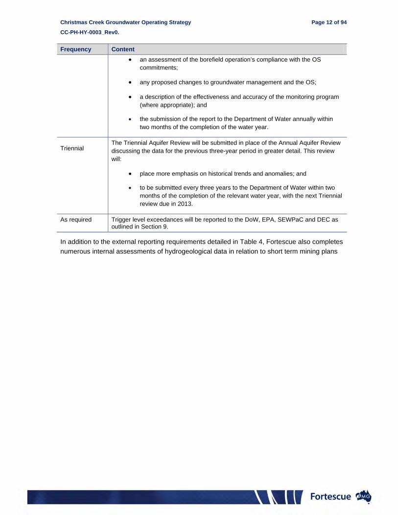
Frequency Content
Quarterly monthly monitoring data, including groundwater levels, water quality and abstraction and injection volumes;
groundwater trigger level compliance;
groundwater level contour plans; and
any proposed changes to groundwater management.
Annual2 a compilation and hydrogeological assessment of the quarterly report data;
an assessment of the borefield operation’s compliance with the Groundwater Licence (GWL) terms and conditions;
2 Fortescue’s Environment Team is also required to produce an Annual Environmental Report for the DEC and EPA by 31st March each year. This is to include an assessment of groundwater monitoring data and monthly monitoring/assessment of the near marsh bores (MS871) as described in Section 9.3.2 of this OS. Quarterly and annual aquifer review reports will be utilised to satisfy the requirements of this reporting.
Christmas Creek Groundwater Operating Strategy Page 12 of 94
CC-PH-HY-0003_Rev0.
Frequency Content
an assessment of the borefield operation’s compliance with the OS commitments;
any proposed changes to groundwater management and the OS;
a description of the effectiveness and accuracy of the monitoring program (where appropriate); and
the submission of the report to the Department of Water annually within two months of the completion of the water year.
Triennial
The Triennial Aquifer Review will be submitted in place of the Annual Aquifer Review discussing the data for the previous three-year period in greater detail. This review will:
place more emphasis on historical trends and anomalies; and
to be submitted every three years to the Department of Water within two months of the completion of the relevant water year, with the next Triennial review due in 2013.
As required Trigger level exceedances will be reported to the DoW, EPA, SEWPaC and DEC as outlined in Section 9.
In addition to the external reporting requirements detailed in Table 4, Fortescue also completes
numerous internal assessments of hydrogeological data in relation to short term mining plans

Christmas Creek Groundwater Operating Strategy Page 13 of 94
CC-PH-HY-0003_Rev0.
3. CHRISTMAS CREEK OPERATING PLAN
Groundwater is abstracted from dewatering borefields to enable dry pits, to provide water for
mine dust suppression, ore processing, civil works and potable water supply for the Mine
Village. Excess groundwater abstracted from the dewatering operation is injected into suitable
aquifers (managed aquifer recharge (MAR)), in accordance with the Operational Policy 1.01
Managed Aquifer Recharge in Western Australia (DoW, 2011).
3.1 Project Development
The location of existing water infrastructure is shown on Figure 2. A high level description of the
system is provided below. Water infrastructure has been and will be developed to meet the
needs of the business, the environment and stakeholders whilst aiming to maximise flexibility in
operations. Planned expansion of the dewatering and injection system over the next 12-18
months is outlined in the Christmas Creek Water Management Scheme (FMG 2013).
3.2 Dewatering System
The dewatering system includes up to three water streams: the brackish, the saline and sump
water. Separate systems exist for both brackish and saline dewatering systems. Dewatering
bores and interconnecting pipelines are located along mine pit perimeters and in some cases
within mine pits.
For the purpose of this OS groundwater abstraction bores are classified as:
General purpose water supply bores: bores establised for purpose of dust suppression and construction purposes (Appendix 3)
Potable water supply bores: bores established for purpose of potable water supply only (Appendix 3)
Pit dewatering bores; bores established for purpose of mine dewatering. These bores generally have a short life span.
This differentiation is adopted based on the short life of dewatering, whereby pit-region bores
can be ‘mined out’ (decommissioned) within about six months, rendering a list of pit-region
bores out of date before it is published. Fortescue’s pit-region dewatering methodology and set-
up is described in Appendix 4. The tenements from which water will be abstracted and used
are highlighted in Appendix 2.
The location of regional abstraction bores are shown on Figure 4. More detailed information on
the hydrogeology of the Christmas Creek area can be found in the Hydrogeological Assessment
for the Christmas Creek Water Management Scheme (FMG, 2010) produced as part of primary
approvals.

Christmas Creek Groundwater Operating Strategy Page 14 of 94
CC-PH-HY-0003_Rev0.
3.3 Conveyance System
The conveyance system is designed to move water across the site from areas of abstraction
(dewatering system) to areas of injection (injection system) or use (water supply system). Water
is conveyed through separate brackish, saline and sump pipelines via ponds.
3.3.1 Transfer and settlement ponds
Transfer ponds and settlement ponds consist of water storage facilities for the purpose of
facilitating bulk flow transfer and/or settlement of suspended material. Separate facilities exist
for handling of brackish, saline and sump water.
3.3.2 Bulk flow and conveyance
Pipeline sizes and routes have been designed to:
optimise hydraulic performance in combination with pump duties;
meet connectivity requirements; and
comply with relevant regulatory approvals and licence requirements.
3.4 Water Supply System
Average predicted water demand throughout the next 12 month period is expected to be
relatively constant. Maximum annual water demand is estimated to be up to 15 GL/a (480 L/s).
Given the climatic variation within the Pilbara (directly related to dust suppression) and the
variable operational requirement, actual operational water demand is likely to range between 4
GL/a and 15 GL/a (for water balance purposes 7.5 GL/a has been used).
Water for mine use is principally derived from the dewatering operation. However, given
uncertainty of abstracted water quality a number of alternate supply sources have been
established, including:
Inter-mine transfer movement of surplus water between the Cloudbreak and Christmas
Creek mine sites to manage supply/demand at a Chichester scale. This will allow
Fortescue to minimise groundwater abstraction across operations.
Managed aquifer recharge (MAR): water previously injected into brackish injection borefields will be recovered by abstracting water from existing or newly constructed abstraction locations.
Other borefields: utilise existing production bores (not for active dewatering) across Christmas Creek to supplement water demand.

Christmas Creek Groundwater Operating Strategy Page 15 of 94
CC-PH-HY-0003_Rev0.
3.4.1 Ore processing and tailings
A bulk flow conveyance line delivers water to process water ponds adjacent to the OPF for use
in ore processing operations. The transfer ponds receive raw water from the brackish
conveyance system and from the tails decant water.
Supernatant water from tailings is/will be collected using decant systems such as decant towers
and returned to the system via water infrastructure for reuse across the site.
3.4.2 Dust suppression
For dust suppression, water cart fill points are maintained across the Christmas Creek area.
These systems are supplied by the water conveyance system. A pump and standpipe assembly
is used to fill the water trucks.
3.5 Injection System
Excess groundwater abstracted from the dewatering operation is returned to compatible
aquifers by injection methods in accordance with the DoW’s Operational Policy in Managed
Aquifer Recharge (DoW, 2011). Injection systems consist of networks of injection bores and
interconnected pipelines. Water is injected to the bore via a downhole flow control valve, which
eliminates air from entering the bore. Details of bores used for injection are presented in
Appendix 5. The location of injection bores are displayed in Figures 5.
3.5.1 Brackish injection
Aquifer storage via injection is undertaken with brackish water in areas east and west of the
active mining area and typically targets the Marra Mamba Formation (MMF). There are currently
two areas identified for brackish injection: the Hillside East and Spinifex Pigeon injection
borefields.
3.5.2 Saline injection
Saline injection is undertaken between the southern limit of the resource area and the northern
limit of the Fortescue Marsh. The Oakover Formation is the target aquifer of the injection. The
Oakover Formation has high transmissivity due to the presence of calcretes and silcretes.
The saline network is being developed and expanded to meet the increasing injection
requirement, outlined in the Christmas Creek Water Management Scheme (FMG 2013).

Christmas Creek Groundwater Operating Strategy Page 16 of 94
CC-PH-HY-0003_Rev0.
3.6 Christmas Creek Village water system and potable water system
At the camp, potable water supply is treated at the camp RO plant and is sourced from four
local bores CCCP01, CCCP02, CCCAP03 and CCCAP04. Currently, the water is stored in a
separate tank and fed across the mine via an independent distribution network.
At the mine, a water treatment facility is located adjacent to the process water tanks for
treatment of water for potable use. Potable water is stored in a separate tank and fed across the
mine via its own distribution network.
3.7 Contingency Operations
3.7.1 Alternative Water Supply
Moving forward, with continuing increase in salinity of water from the dewatering system,
additional options may be required to ensure suitable water supply to operations. These
options may include;
External borefield: consideration for a long term (life of mine) abstraction borefield remote to operations; or
Reverse osmosis (RO): On-site RO plant which will reduce the salinity of abstracted water for ongoing brackish supply.
3.7.2 Cloudbreak and Christmas Creek Connectivity
The integration of Christmas Creek and Cloudbreak water systems offers significant opportunity
to address optimisation of water management at the Chichester operations to meet both
operational and environmental objectives. This optimisation is delivered through operational
planning and review. Two key areas identified for optimisation are: conservation of the brackish
water resource and management of water levels.
3.7.3 Water supply optimisation
Operations and activities at Christmas Creek require low EC, brackish water. As dewatering
operations progress abstracted water is becoming increasingly saline. If the water management
strategy described above is unable to supply a sufficient source of brackish water for
operations, a series of contingency water supply programmes have been developed, including
the transfer of water between adjacent mine sites, see Section 3.7.1.

Christmas Creek Groundwater Operating Strategy Page 17 of 94
CC-PH-HY-0003_Rev0.
3.7.4 Water level optimisation
The water management strategy utilises groundwater injection as the main destination for
excess water from operations. For compliance reasons (water level and volume limits), if
injection capacity is limited or reduced, the following contingency measures will be
implemented:
blend water within system to allow alternative use/disposal route;
transfer water between sites3;
review mine plan to reduce dewatering requirement; and
discuss with regulatory authorities potential to increase injection volume.
Both of Fortescue’s Chichester Range mines (Cloudbreak & Christmas Creek) are designed to
operate independently. However, the contingency to transfer water between sites will not only
improve operational flexibility but also allow increased environmental protection to the Marsh.
3 Primary approval for this activity is currently being sought. The distribution of saline water for injection purposes will not commence until all approvals are in place.

Christmas Creek Groundwater Operating Strategy Page 18 of 94
CC-PH-HY-0003_Rev0.
4. OPERATING RULES
For the purpose of this document, operating rules describe:
The planned water balance in terms of volumes and water quality for the duration of the OS;
Abstraction licence allocation requirements; and
Injection licence allocation requirements.
Specific requirements with regards to the groundwater and infrastructure monitoring and maintenance requirements are detailed in Section 5 and Section 6, respectively.
4.1 Mine water balance
Bores are operated in accordance with the terms and conditions of the relevant 5C licence
(Section 2). Abstraction during the respective licence periods is undertaken within the
prescribed annual water entitlement. Proposed water abstraction and usage rates for Christmas
Creek mine are presented in Appendix 6 and a conceptual mine water balance is presented in
Appendix 7. A summary tabular water balance for the site is provided in Table 5.
Table 5: Summary site water balance
Water Year Date
Dewatering System Water Supply System Injection System
Abstraction Rate (ML/d)
Cumulative Volume (ML)
Consumption Rate (ML/d)
Cumulative Volume (ML)
Injection Rate (ML/d)
Cumulative Volume (ML)
20
13
Jul-3 126 34,000 21 10,368 105 23,631
201
4
Aug-13 112 3,368 21 625 91 2,743
Sep-13 113 6,743 21 1,250 92 5,493
Oct-13 103 9,818 21 1,875 82 7,943
Nov-13 103 12,893 21 2,500 82 10,393
Dec-13 103 15,968 21 3,125 82 12,843
Jan-14 163 20,843 21 3,750 142 17,093
Feb-14 163 25,718 21 4,375 142 21,343
Mar-14 163 30,593 21 5,000 142 25,593
Apr-14 163 35,468 21 5,625 142 29,843
May-14 163 40,343 21 6,250 142 34,093
Jun-14 163 45,218 21 6,875 142 38,343
Jul-14 159 50,000 21 7,500 139 42,500

Christmas Creek Groundwater Operating Strategy Page 19 of 94
CC-PH-HY-0003_Rev0.
4.2 Abstraction Licence Allocation
Details for the Ground Well Licences (GWLs) are listed in Table 6 and a copy of the existing
licence is presented in Appendix 1.
Table 6: Groundwater abstraction licence details
Licence No Area Purpose Aquifer Allocation (GL/a) Expiry Date
GWL 167593 Christmas Creek
Dewatering and site usage
East Pilbara Hamersley -Fractured Rock
48 11 July 2013
This OS requests that the allocation under GWL167593 be increased to 50GL/a in line with
Ministerial statement 871.
4.3 Injection Licence Allocation
The injection of surplus brackish and saline groundwater at Christmas Creek is licensed by the
Department of Environment and Conservation (DEC). Details of the DEC groundwater injection
licence are presented in Table 7. This OS reflects a recent request that the allocation under
L8454/2010/1 be increased to 42.5 GL/a in line with Ministerial statement 871.
As part of Fortescue’s DEC licence commitments, selected monitoring bores in the brackish
(Zone C) and saline (Zone B) injection areas have been assigned relevant Class 1 and 2
triggers (see Section 7 and 9).
Table 7: Groundwater injection licence details
Licence no. Area Purpose Allocation (GL/a) Expiry date
L8454/2010/1 Christmas Creek
Injection of surplus groundwater
30 22 August 2015
Details of brackish and saline injection bores operated at Christmas Creek are outlined in
Appendix 5 and locations presented in Figure 5

Christmas Creek Groundwater Operating Strategy Page 20 of 94
CC-PH-HY-0003_Rev0.
5. WATER INFRASTRUCTURE MONITORING, CONTROL AND MAINTENANCE
5.1 Monitoring and controls
Fortescue monitors abstraction, injection and water consumption via a network of flow meters at
abstraction and injection bores, sumps, pipelines, water-use points and transfer ponds.
Fortescue uses telemetry and automated data collection in conjunction with electromagnetic
flow meters and downhole water level sensors for critical infrastructure. The automated and
telemetry systems are currently being further developed to assist with operational control and
monitoring of all appropriate water systems. Initial development is anticipated to be complete
by June 2014.
5.1.1 Bulk pipelines and storage ponds
Valves are regularly installed along bulk lines to allow for isolation of sections should damage
occur, or for maintenance activities. Flow meters and pressure gauges in the transfer pipelines
provide the ability to assess leak detection. Flow meters located throughout the water delivery
and distribution network are installed in accordance with the DoW Guidelines for Water Meter
Installation (DoW, 2009).
5.1.2 Leak detection
Leak detection is undertaken via regular visual inspections of pipework, ponds and fittings.
Comparison of meter readings at various points between abstraction and consumption points
are used to identify losses from the system.
5.2 Maintenance schedule
The following maintenance schedules have been implemented:
All water storage facilities and water conveyance infrastructure are inspected daily by the maintenance personnel, checking for water leaks, controls and condition of containment dams4. Problems are rectified as they arise; and
flow meters on all bores are tested to accuracy and calibrated by in-situ validation, twice a year or as per manufacturer specifications
4 The frequency of inspections will be reviewed with the implementation of telemetry systems and completed as appropriate.

Christmas Creek Groundwater Operating Strategy Page 21 of 94
CC-PH-HY-0003_Rev0.
6. DEWATERING/INJECTION SYSTEM MONITORING PROGRAM
The Mining Services team are responsible for monitoring as outlined in Table 8. The locations of
monitoring sites are shown on Figure 6. Monitoring bore locations, not included on the trigger
network, are provided in Appendix 8.
In addition to the monitoring summary outlined in Table 8 additional near pit monitoring is
undertaken at frequencies ranging from daily to weekly to assess the success and ongoing
requirements for dewatering operations.
Table 8: Christmas Creek monitoring summary
Frequency Monitoring parameter Comments Monitoring locations
Injection Pipelines
Daily Visual inspection
As a DEC requirement, injection pipelines are visually inspected daily, monitored monthly for EC and flow rate, and sampled biannually.
Active10 injection pipeline infrastructure
Monthly Field electrical conductivity
See Appendix 8
Volumes
Biannual5
Chemical analysis.
Major ions: (Na, K, Ca, Mg, Cl, alkalinity, SO4 and NO3),
Metals: (Al, B, Fe, Cu, Zn, Ag, As, Cr, Pb, Cd, Hg, Ni, Sn, Se, Mn),
Electrical conductivity, field pH, lab pH, total dissolved solids and total suspended solids.
Abstraction & Injection Bores
Monthly
Field electrical conductivity Bore head works will be equipped with water quality measurement points Active
production/injection bores
Volumes Via bore meter data
Bore status (flow) If the bore is currently operational
Monitoring Bores
Monthly
Groundwater level monitoring For drawdown/mounding assessments
See Appendix 9
Field electrical conductivity At a designated measurement depth
Biannual5
Chemical analysis.
Major ions: (Na, K, Ca, Mg, Cl, alkalinity, SO4 and NO3),
Metals: (Al, B, Fe, Cu, Zn, Ag, As, Cr, Pb, Cd, Hg, Ni, Sn, Se, Mn),
Electrical conductivity, field pH,
As a DEC requirement and to assist in characterising hydrogeological conditions.
See Appendix 8
5 Biannual samples are collected nominally in February and August.

Christmas Creek Groundwater Operating Strategy Page 22 of 94
CC-PH-HY-0003_Rev0.
Frequency Monitoring parameter Comments Monitoring locations
lab pH, total dissolved solids and total suspended solids
Water Use Volumes
Monthly
Meter readings for each water use type
Sub-metering will be implemented where possible to assist in quantifying water use at individual locations across the mine site.
See Appendix 8
Sub-meter reading with monthly abstraction volumes
Monitoring bores/inactive production bores6
Fortnightly7 Groundwater level
Water levels monitored fortnightly at selected monitoring bores and inactive production bores to assist in hydrogeological understanding and numerical model calibration.
See Appendix 8
Pastoral bores
Monthly
Groundwater level Selected pastoral bores are monitored monthly to assist in hydrogeological understanding and ensure the water resource is maintained.
See Appendix 8 Field electrical conductivity
Contingency discharge monitoring
Varying times and frequencies
Field electrical conductivity As a DEC requirement in the event that reuse, injection, in pit disposal and temporary storage are not available or have been exhausted.
Refer to the Christmas Creek Pit Flood Response Plan. (Fortescue Metals Group, 2012b).
See Appendix 8
Nephelometric turbidity (NTU)
Flow meter readings
Groundwater levels are measured using a field groundwater probe. Salinity is measured using a
field electrical conductivity (EC) measurement probe that is lowered to a designated depth
within the screen interval. In some cases, automatic bore loggers are also deployed.
6Sampling and monitoring of monitoring bores and inactive production bores does not form a regulatory requirement but provides essential information to operate and optimise the dewatering system. The location of these key bores will change with expansion and development of pits and active areas of dewatering. 7 Frequency of monitoring will be determined by water level response and importance of pit region.

Christmas Creek Groundwater Operating Strategy Page 23 of 94
CC-PH-HY-0003_Rev0.
7. ENVIRONMENTAL IMPACT MANAGEMENT
The Christmas Creek Water Management Scheme is operated to prevent or minimise any
potential environmental impacts. Environmental values that may be affected by groundwater
abstraction activities are detailed in the following sections.
7.1 Potential environmental impacts
Fortescue has submitted an application to the Environmental Protection Authority (EPA) for the
Christmas Creek Water Management Scheme Environmental Review (FMG, 2011). The
document described the potential environmental impacts associated with the scheme and the
management measures to be implemented to mitigate these impacts.
The primary environmental issues likely to result from construction and operation of the
infrastructure comprise of vegetation clearing, dust and changes to hydrology. Other potential
impacts include vegetation impacts due to drawdown and mounding, and surface water flow
disturbance. A summary of the management and mitigation strategies which are to be applied
are described in Section 10.
7.1.1 Overall environmental management approach
The groundwater management infrastructure is located within Fortescue’s Chichester Range
operations area and will be managed in accordance with environmental management plans for
this area. Plans of particular relevance include the following8:
Chichester Operations Surface Water Management Plan (45-PL-EN-0015)
Chichester Operations Groundwater and Bore Management Plan (45-PL-EN-0005)
Groundwater Discharge Management Plan (45-PL-EN-0019)
Significant Flora and Vegetation Management Plan (45-PL-EN-0017)
Fortescue Marshes Management Plan (45-PL-EN-0009);
Weed Management Plan (45-PL-EN-0013);
Chichester Operations Fauna Management Plan (45-PL-EN-0007);
Chemical and Hydrocarbon Management Plan (45-PL-EN-0011);
Mine and Rail Dust Management Plan (45-PL-EN-0030);
Bushfire Management Plan (45-PL-EM-0001).
These and other management plans for the Christmas Creek area are available at
www.fmgl.com.au.
8 Environmental management plans are constantly being reviewed and updated. The management of operations will be based on the latest iteration of each document.
Christmas Creek Groundwater Operating Strategy Page 24 of 94
CC-PH-HY-0003_Rev0.
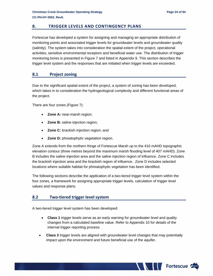
8. TRIGGER LEVELS AND CONTINGENCY PLANS
Fortescue has developed a system for assigning and managing an appropriate distribution of
monitoring points and associated trigger levels for groundwater levels and groundwater quality
(salinity). The system takes into consideration the spatial extent of the project, operational
activities, sensitive environmental receptors and beneficial water use. The distribution of trigger
monitoring bores is presented in Figure 7 and listed in Appendix 9. This section describes the
trigger level system and the responses that are initiated when trigger levels are exceeded.
8.1 Project zoning
Due to the significant spatial extent of the project, a system of zoning has been developed,
which takes in to consideration the hydrogeological complexity and different functional areas of
the project.
There are four zones (Figure 7):
Zone A: near-marsh region;
Zone B: saline injection region;
Zone C: brackish injection region; and
Zone D: phreatophytic vegetation region.
Zone A extends from the northern fringe of Fortescue Marsh up to the 410 mAHD topographic
elevation contour (three metres beyond the maximum marsh flooding level of 407 mAHD). Zone
B includes the saline injection area and the saline injection region of influence. Zone C includes
the brackish injection area and the brackish region of influence. Zone D includes selected
locations where suitable habitat for phreatophytic vegetation has been identified.
The following sections describe the application of a two-tiered trigger level system within the
four zones, a framework for assigning appropriate trigger levels, calculation of trigger level
values and response plans.
8.2 Two‐tiered trigger level system
A two-tiered trigger level system has been developed:
Class 1 trigger levels serve as an early warning for groundwater level and quality changes from a calculated baseline value. Refer to Appendix 10 for details of the internal trigger reporting process.
Class 2 trigger levels are aligned with groundwater level changes that may potentially impact upon the environment and future beneficial use of the aquifer.

Christmas Creek Groundwater Operating Strategy Page 25 of 94
CC-PH-HY-0003_Rev0.
Appropriate triggers are assigned to both the shallow aquifer (alluvium and Tertiary Detritals)
and to the deeper aquifers (Marra Mamba, Oakover and Wittenoom Formations).
8.3 Framework for selecting appropriate trigger values
The framework builds on the project zoning and the two-tier trigger value system which provides
a means for determining if Class 1 or Class 2 trigger levels are appropriate at each monitoring
point. This framework is presented in Table 10.
8.3.1 Groundwater level and EC triggers
The basis for assigning Class 2 trigger level values in each project zone takes into
consideration baseline conditions, estimates of uncertainty and impact assessments. Table 10
summarises the basis for each of the Class 2 trigger values assigned.
Class 1 groundwater level triggers are an early warning indication of change such that a Class 2
breach will be avoided.
The ‘baseline’ value from which EC triggers are assessed are based on data that is first ‘pre-
conditioned’ (checked for veracity), then assessed statistically (average, maximum, minimum,
etcetera). A baseline level is set based on the maximum value over the ‘pre-conditioned’ data
range. Groundwater quality trigger levels are established only for bores with a statistically valid
number of measurements.
8.3.2 Near‐marsh water level assessment
A monthly hydrogeological assessment of near-marsh monitoring bores is undertaken for both
Christmas Creek and Cloudbreak. This assessment includes a comparison of observed water
level against baseline data as well as individual bore trends against regional, non-abstraction-
and non-injection related groundwater trends. A number of techniques are adopted to complete
this assessment; one of these techniques is described below. Other assessment
methodologies may also be employed where appropriate and these procedures are reviewed
regularly.
Seasonal trend
Fortescue generates seasonal trends of all data in the near marsh zone to ensure individual
locations are not showing trends outside of the regional response. This process is described in
Table 9.

Christma
CC-PH-H
Table 9:
1. Initial
2. Reduchydrogracommon
3. Calcuof all dat
4. Subtrafrom dat
5. Assesagainst t
as Creek Gro
HY-0003_Rev0
Near ma
Step
data
ce all aphs to a n datum
late averageta
act average a
ss trend trigger levels
undwater Op
0.
arsh bore ass
Monitorin
Subtract Decembegroundwamonitorin
e Where dausing a sdata, datdays’ dat
The aver
Subtracte
s
In this syexceedan
perating Strat
sessment pro
Descr
ng data collat
the time serier 2011) grouater changesng data are o
ata are recorsymmetrical 5um are averata.
rage measure
ed the averag
nthetic examnce
tegy
ocess
ription (togeth
ted
ies groundwaundwater levs that commeoverlayed on
rded at a res5-day movingaged with the
ement for ea
ge from each
mple, Bore 2
her with a pic
ater levels frvel for each rence at zero the same gr
solution higheg filter. For ee preceding
ach similar-aq
h bore’s time
(red) is trend
ctorial represe
rom a set poirespective bo
at this set praph and ass
er than montexample, for dtwo days’ an
quifer datum
e series data
ding towards
P
entation)
nt in time (cuore. This resuoint in time.
sessed in this
thly, data aredaily-measund the followi
is then calc
s a Class 1 tr
Page 26 of 94
urrently ults in These s manner.
e averaged rement ing two
ulated.
rigger
4

Christmas Creek Groundwater Operating Strategy Page 27 of 94
CC-PH-HY-0003_Rev0.
Rport
Table 10: Trigger level framework
Zone Region Aquifer Groundwater level trigger
Water quality trigger Trigger Basis
Class 1 Class 2 Class 1
A Near-marsh Tertiary Detrital
Absolute change of ±0.65 m from
baseline having regard for season
variation
Change of ±1 m (±1.5 m for CCFMM01_S) from baseline having
regard for season variation
N/A9
Class 1 groundwater level trigger to provide early warning and to signal potential future Class 2 conditions
Class 2 groundwater level trigger as stipulated in Condition 7 of MS871 (Fortescue Marsh)
‘the proponent shall manage the injection of surplus water to ensure that groundwater levels do not rise more than 1.5 metres at MB1 and 1 metre at MB2, MB3 and MB4 from the baseline groundwater level.’
B Saline
injection
Tertiary Detrital
3 m below ground level
2.2 m below ground level
9,000 µS/cm (unless the baseline10 is higher than 6,000 µS/cm, then
50% increase from baseline)11
Class 1 groundwater level trigger to provide early warning and to signal potential future Class 2 conditions
Class 2 groundwater level trigger as stipulated in Condition 8-1 of MS871 (groundwater mounding)
‘the proponent shall manage the injection of surplus water to ensure that mounding of the groundwater level within the impact zones but outside the exclusion area’.
Oakover Formation
2.2 m below ground level
N/A N/A
C Brackish injection
Tertiary Detrital
3 m below ground level
2.2 m below ground level
9,000 µS/cm (unless the baseline19 is higher than 6,000 µS/cm, then
50% increase from baseline)20
Class 1 groundwater level trigger to provide early warning and to signal potential future Class 2 conditions
Class 2 groundwater level trigger as stipulated in Condition 6 of MS871 (groundwater mounding). See above.
Class 1 EC trigger assigned to ensure baseline aquifer water Marra Mamba
Formation 3 m below ground
level N/A
9 Baseline EC at the near Marsh monitoring locations is above 9,000 and hence no trigger to be applied. 10 Baseline EC based on pre-injection and/or pre-dewatering-impact time series data. 11 If baseline groundwater quality is greater than 9,000 µS/cm no trigger is applied.

Christmas Creek Groundwater Operating Strategy Page 28 of 94
CC-PH-HY-0003_Rev0.
Zone Region Aquifer Groundwater level trigger
Water quality trigger Trigger Basis
Class 1 Class 2 Class 1
Bulk flow N/A N/A 9,000 µS/cm
quality is maintained as required by DEC (L8454/2010/1).
D Phreatophytic vegetation12
Tertiary Detrital
16 m below ground level
18 m below ground level
50% increase from baseline19
Class 1 groundwater level trigger to provide early warning and to signal potential future Class 2 conditions
Class 2 groundwater level defined to prevent environmental impact at areas where phreatophytic vegetation may be susceptible to drawdown.
Groundwater level where phreatophytic vegetation may be susceptible to drawdown of the groundwater level of more than 20 m from the ground surface. Ecoscape’s impact assessment for dewatering (Ecoscape, 2009). A 10% precautionary factor has been applied.
Class 1 E.C. trigger assigned to ensure baseline aquifer water quality is maintained as required by DEC (L8454/2010/1).
Marra Mamba Formation
16 m below ground level
18 m below ground level
50% increase from baseline19
Misc.
Roy Hill/Fortescue
tenement boundary
Tertiary Detrital
Change of ±1.25 m from seasonally varying water
levels
Change of ±1.5 m from seasonally
varying water levels
N/A
Class 1 groundwater level trigger to provide early warning and to signal potential future Class 2 conditions
Class 2 groundwater level trigger as stipulated in Condition 10 of MS871 (Reinjection impacts to other mines)
‘The proponent shall manage the reinjection of surplus water to ensure that it does not cause a significant increase in dewatering requirements at other non-proponent approved mining operations.’
Marra Mamba
Formation
Change of ±1.25 m from
seasonally varying water
levels
Change of ±1.5 m from seasonally
varying water levels
12 Other assessment techniques such as projected canopy cover and remote sensing technology are being developed to help assess the impact to phreatophytic vegetation zones and compliment this groundwater monitoring data.

Christmas Creek Groundwater Operating Strategy Page 29 of 94
CC-PH-HY-0003_Rev0.
Rport
8.4 Trigger Level Response
Due to the large volume of data being captured, Fortescue’s groundwater database (Envirosys)
has an automated tracking system to identify trigger level exceedances. Trigger level
exceedances will be reported quarterly to the DoW as part of the quarterly aquifer review
outlined in Table 4. The assigned trigger levels are presented in Appendix 9 and the locations of
the trigger monitoring bores are shown Figure 7.
Where a trigger level is exceeded, parameter(s) are re-measured to confirm the exceedance.
Where the reading is confirmed, Fortescue will implement the following where a:
Class 1 trigger level is exceeded;
initiate a hydrogeological assessment with the objective of determining the reason(s) for the divergence and if necessary increase monitoring frequency or extent;
if necessary, implement changes to the water management system; and
explore improvements in the trigger levels based on new data;
Class 2 trigger level is exceeded;
initiate a hydrogeological assessment with the objective of determining the reason(s) for the trigger level breach;
modify operational activities to ensure that the groundwater level and or salinity changes do not continue to breach the trigger value. This may include;
o reduce volumes of water piped to the affected area by redirecting water to other injection areas;
o redirect water from the appropriate transfer pond and other injection areas where drawdown exceeds the trigger in the phreatophytic zones (Zone D);
o redirect disposal to transfer and/or infiltration ponds;
o redirect disposal to void mine pits (where available); and
o implement the Captured Rainfall Emergency Discharge Procedure allowing the discharge of up to 20,000 kL/day (FMG, 2009).
For Class 2 triggers associated with the Zone A (near-marsh) monitoring bores (CCFMM01_S,
CCFMM02_S, CCFMM03_S, CCFMM04_S and CCFMM05_S), any exceedance will initiate a
thorough review of the vegetation health assessment and efforts will be made to maintain, or
improve, the divergent groundwater level. Should adverse vegetation health be detected, the
DEC will be informed.

Christmas Creek Groundwater Operating Strategy Page 30 of 94
CC-PH-HY-0003_Rev0.
The DoW will be notified within 72 hours and the matter will be reported in the annual
groundwater review. Appendix 10 further outlines Fortescue’s trigger reporting procedure and
protocol.
8.5 Contingency plans
Should unforseen demands and/or situations for the following events occur contingencies have
been developed to ensure that potential for impact to the environment is minimised.
8.5.1 Insufficient brackish water
If it is found that the brackish water supply from dewatering varies from the expected volume
and is insufficient to meet demand, the demand may be met by:
abstraction from current brackish injection borefields and/or existing exploratory bores;
movement of excess brackish water provided from/to Christmas Creek; and/or
approval may be sought for alternate sources such as external borefields.
8.5.2 Insufficient injection capacity
If it is found that either brackish or saline water injection capacity and/or licensed disposal
volume is insufficient for the volume abstracted, Fortescue’s contingency plans are as follows:
initiate a hydrogeological assessment with the objective of determining the reason(s) for the divergence;
movement of excess water between Cloudbreak and Christmas Creek13;
discuss with regulatory authorities potential to increase injection volume; and
if necessary, implement changes to operations to ensure volume of water for injection can be managed with existing injection infrastructure.
13 Primary approval is being sought to allow the transfer of saline water and injection at the adjacent site. The transfer and injection of brackish water is currently managed through the Hill Side East injection borefield.

Christmas Creek Groundwater Operating Strategy Page 31 of 94
CC-PH-HY-0003_Rev0.
9. EFFICIENT WATER USE INITIATIVES
A number of measures are utilised to reduce the demand on brackish water for dust
suppression at the mine site. These include:
the use of non-toxic, biodegradable dust suppression additives such as Rainstorm;
utilising lower-quality water for road dust suppression where possible;
the use of treated wastewater for dust suppression activities;
process water recycling (associated with crushing and screening);
ongoing investigations into further use of treated wastewater around the mine site; and
the use of low-flow taps, shower head and sprinkler systems.
The site water balance will be assessed by the Water Management Team on an annual basis
and together with the Mining Services Team. Any potential improvements to water efficiency will
be investigated and implemented where practical.

Christmas Creek Groundwater Operating Strategy Page 32 of 94
CC-PH-HY-0003_Rev0.
10. MANAGEMENT COMMITMENTS SUMMARY
Tables 11 and 12 highlight the environmental commitments that have been made by Fortescue
throughout the content of this document.
Table 11: Summary of licensee’s commitments
Section Subject Commitment Timing
2 Reporting
requirements
Fortescue will fulfil various reporting requirements to the
DoW on the operation of the System on a quarterly,
annual, triennial, and as required basis. See Section 4 for
details.
On a quarterly, annual,
triennial or as required
basis after System
commencement.
4.2
Compliance
with 5C
licence
Abstraction bores will be operated in accordance with the
terms and conditions of relevant 5C licences.
Abstraction levels during the relevant licence periods will
be within the respective prescribed annual water
entitlement.
Ongoing after
commencement.
5.2
Maintenance
of the
System
All water storage facilities and other water infrastructure
associated with the System are inspected weekly by
maintenance personnel checking for water leaks, controls
and condition of containment dams with problems rectified
as they arise.
Water meters on all bores are tested as per
manufacturer’s specifications to ensure accuracy.
Weekly or as per
manufacturer’s
instructions.
5
Operations
monitoring
program
Fortescue will fulfil various monitoring requirements on a
monthly or six monthly basis in respect of abstraction
bores, monitoring bores and water use volumes.
On a monthly or six
monthly basis after
commencement.
8 Groundwater
trigger levels
As part of groundwater monitoring, Fortescue will
implement a trigger system to initiate, where necessary,
changes to abstraction. See Section 8 for specific details.
Ongoing after
commencement.
8
Electrical
Conductivity
trigger levels
Trigger levels will be included for recently commissioned
bores within six months of commissioning.
Ongoing after
commencement.

Christmas Creek Groundwater Operating Strategy Page 33 of 94
CC-PH-HY-0003_Rev0.
Rport
Table 12: Environmental Impact Management
Trigger Zone Environmental
Factor Operating Strategy Management
Objectives Existing Environment
Management Strategies / Proponent Commitments
Zo
ne
A –
Ne
ar
Ma
rsh
Groundwater
The proponent shall manage the injection of surplus water to ensure that groundwater levels do not rise more than 1.5 metres at MB1 and 1 metre at MB2, MB3 and MB4 from the baseline groundwater level having regard for seasonal variation.
There are two aquifers in the vicinity of the Fortescue Marsh, Shallow alluvium and the Wittenoom Dolomite at depth.
Class 1 groundwater level trigger to provide early warning and to signal potential future Class 2 conditions
Class 2 groundwater level trigger as stipulated in Condition 7 of MS871 (Fortescue Marsh) to ensure protection of identified vegetation, flora, fauna and heritage areas.
Vegetation & Flora
Samphire and marsh communities, which are locally significant and are associated with the Fortescue Marsh PEC (P1).
Conservation and Natural Heritage
Areas
The Fortescue Marsh is listed on the Register of National Estate as an unusual type of wetland, its conservation significance to waterbirds and other cultural values, both indigenous and non-indigenous (DSEWPC 2010a).
In addition, the Fortescue Marsh has been identified as a ‘Nationally Important Wetland’ as it a good example of an extensive, inland floodplain system which is regularly inundated and is a unique wetland in Western Australia (DSEWPC 2010b).
Matters of National
Environmental Significance
Only one Migratory species of National Significance has been confirmed as being present in the Proposal area.
Zo
ne
B –
Sa
line
Inje
ctio
n
Groundwater
The proponent shall manage the injection of surplus water to ensure that groundwater level within the impacted zones but outside of the exclusion area does not result in groundwater levels rising within 2 meters of the surface.
The proponent shall manage groundwater abstraction and disposal (dewatering and injection) for the project in a manner that ensures:
1. There is no adverse impact on native vegetation communities attributable to the project outside
There are two aquifers in the vicinity of Zone B, shallow Alluvium and the Wittenoom Dolomite. The Nammuldi member of the Marra Mamba Iron formation is expected at depth but has not been intersected.
Class 1 groundwater level trigger to provide early warning and to signal potential future Class 2 conditions
Class 2 groundwater level trigger as stipulated in Condition 8-1 of MS871 (groundwater mounding)
Class 1 EC trigger assigned to shallow aquifer to ensure baseline aquifer water quality is maintained.
Vegetation & Flora
Vegetation types mapped in Zone B are consider to be locally significant, including:
Mulga communities, which are potentially sheet flow
dependent;
Samphire and marsh communities, which are locally
significant and are associated with the Fortescue Marsh
PEC (P1).

Christmas Creek Groundwater Operating Strategy Page 34 of 94
CC-PH-HY-0003_Rev0.
Trigger Zone Environmental
Factor Operating Strategy Management
Objectives Existing Environment
Management Strategies / Proponent Commitments
Fauna
the predicted impact areas; and
2. Within the proposed impact area there is no mortality of keystone plant species or significant change sin habitat characteristics attributable to the project.
Two fauna habitat types – Mulga and Coolibah/River Red Gum communities have the potential to be affected by the Proposal. These habitat types are not restricted to the Proposal area and are generally widely represented throughout the region.
Zo
ne
C –
Bra
ckis
h In
ject
ion
Groundwater
See Zone B above.
There are two aquifers in the vicinity of Zone C shallow Alluvium and the Nammuldi member of the Marra Mamba Iron formation.
Class 1 groundwater level trigger to provide early warning and to signal potential future Class 2 conditions
Class 2 groundwater level trigger as stipulated in Condition 8-1 of MS871 (groundwater mounding)
Class 1 EC trigger assigned to shallow aquifer to ensure baseline aquifer water quality is maintained.
Vegetation & Flora
Vegetation types mapped in Zone C are consider to be locally significant, including:
Mulga communities, which are potentially sheet flow
dependent;
Fauna
Two fauna habitat types – Mulga and Coolibah/River Red Gum communities have the potential to be affected by the Proposal. These habitat types are not restricted to the Proposal area and are generally widely represented throughout the region.
Zo
ne
D –
Ph
rea
toph
ytic
Ve
ge
tatio
n
Groundwater The proponent shall manage groundwater abstraction and disposal (dewatering and injection) for the project in a manner that ensures:
1. There is no adverse impact on native vegetation communities attributable to the project outside the predicted impact areas; and
2. Within the proposed impact area there is no mortality of keystone plant species or significant change sin habitat characteristics attributable to the project.
There are two aquifers in the vicinity of Zone D shallow Alluvium and the Nammuldi member of the Marra Mamba Iron formation.
Class 1 groundwater level trigger to provide early warning and to signal potential future Class 2 conditions
Class 2 groundwater level defined to prevent environmental impact at areas where phreatophytic vegetation may be susceptible to drawdown.
Class 1 E.C. trigger assigned to ensure baseline aquifer water quality is maintained as required by DEC (L8454/2010/1).
Vegetation & Flora
Vegetation types mapped in Zone D area are consider to be locally significant, including:
Mulga communities, which are potentially sheet flow
dependent;
Potentially groundwater dependent species.
Fauna
Two fauna habitat types – Mulga and Coolibah/River Red Gum communities have the potential to be affected by the Proposal. These habitat types are not restricted to the Proposal area and are generally widely represented throughout the region.

Christmas Creek Groundwater Operating Strategy Page 35 of 94
CC-PH-HY-0003_Rev0.
Trigger Zone Environmental
Factor Operating Strategy Management
Objectives Existing Environment
Management Strategies / Proponent Commitments
Mis
c. –
Ro
yhill
B
ou
nda
ry
Groundwater
The proponent shall manage the reinjection of surplus water to ensure that it does not cause a significant increase in dewatering requirements at other non-proponent approved mining operations.
There are two aquifers in the vicinity of the boundary with Royhill, shallow Alluvium and the Nammuldi member of the Marra Mamba Iron formation.
Class 1 groundwater level trigger to provide early warning and to signal potential future Class 2 conditions
Class 2 groundwater level trigger as stipulated in Condition 10 of MS871 (Reinjection impacts to other mines)

Christmas Creek Groundwater Operating Strategy Page 36 of 94
CC-PH-HY-0003_Rev0.
This page has been left blank intentionally

Christmas Creek Groundwater Operating Strategy Page 37 of 94
CC-PH-HY-0003_Rev0.
Rport
11. REFERENCES
Department of Minerals and Energy, 1999, Guidelines on the safe design and operating
standards for tailings storage, Department of Minerals and Energy, Western Australia
Department of Water, 2009, Guidelines for water meter installation, Department of Water, Perth.
Department of Water, 2010, Operational policy 5.08 Use of operating strategies in the water
licensing process, DWPF 5.08, Department of Water, Perth.
Department of Water, 2011, Operational Policy 1.01 Managed aquifer recharge in Western
Australia. Department of Water, Perth
Ecoscape, 2009, Flora and vegetation impact assessment for dewatering at Fortescue
Cloudbreak mine (Revised), report prepared for Fortescue Metals Group Limited.
Fortescue Metals Group, 2010, Hydrogeological assessment for Christmas Creek water
management scheme, Document No. CC-RP-HY-004, Fortescue Metals Group, Perth.
Fortescue Metals Group, 2011, Christmas Creek Water Management Scheme Environmental
Review, CC-RP-EN-0011-Rev2, Fortescue Metals Group, Perth.
Fortescue Metals Group, 2012a, Cloudbreak Groundwater Operating Strategy, CB-PH-HY-
0009, Fortescue Metals Group, Perth.
Fortescue Metals Group, 2012b, Christmas Creek Pit flood Response Plan: Water
Management, Document No. CC-PL-WM-0001, Fortescue Metals Group, Perth.
Fortescue Metals Group, 2013, Christmas Creek Water Management Scheme, Part V Licence
L8454/2010/1 Supporting Document, CC-RP-EN-0052, 24 May 2013.
Christmas Creek Groundwater Operating Strategy Page 38 of 94
CC-PH-HY-0003_Rev0.
12. GLOSSARY
Acronym Description
mbgl Metres Below Ground Level
DEC Department of Environment and Conservation
DoW Department of Water
EC Electrical Conductivity
EPA Environmental Protection Authority
EP Act Environmental Protection Act 1986
Fortescue Fortescue Metals Group Limited
GL/a Gigalitres Per Annum
GDP Ground Disturbance Permit
GWL Groundwater Licence
ha Hectare
HDPE Heavy Density Polyethylene
kL Kilolitre
km Kilometres
L/s Litres Per Second
m Metres
mm Millimetres
MMF Marra Mamba Formation
mg/L Milligrams per Litre
ND Nominal diameter (measured in Millimetres)
μS/cm Microsiemens per Centimetre
Operating Strategy Christmas Groundwater Operating Strategy
OPF Ore Processing Facility
PN Pressure Nomination (measured in Bar at 20oC)
PVC Polyvinyl Chloride
The Project Pilbara Iron Ore and Infrastructure Project
RO Reverse Osmosis
RIWI Act Rights in Water and Irrigation Act 1914
SP Settlement Pond
The System Cloudbreak Dewatering and Injection
TDS Total Dissolved Solids
TN Turkey Nest
TP Transfer Pond

Christmas Creek Groundwater Operating Strategy Page 39 of 94
CC-PH-HY-0003_Rev0.
Figure 1: Regional location plan

Christmas Creek Groundwater Operating Strategy Page 40 of 94
CC-PH-HY-0003_Rev0.
This page has been left blank intentionally

-------------------------------------------------
-------------------------------------------------
-------------------------------------------------
-------------------------------------------------
-------------------------------------------------
-------------------------------------------------
-------------------------------------------------
FFFFFFFFFFFFFFFFFFFFFFFFFFFFFFFFFFFFFFFFFFFFFFFFF
FFFFFFFFFFFFFFFFFFFFFFFFFFFFFFFFFFFFFFFFFFFFFFFFF
FFFFFFFFFFFFFFFFFFFFFFFFFFFFFFFFFFFFFFFFFFFFFFFFF
FFFFFFFFFFFFFFFFFFFFFFFFFFFFFFFFFFFFFFFFFFFFFFFFF
FFFFFFFFFFFFFFFFFFFFFFFFFFFFFFFFFFFFFFFFFFFFFFFFF
FFFFFFFFFFFFFFFFFFFFFFFFFFFFFFFFFFFFFFFFFFFFFFFFF
FFFFFFFFFFFFFFFFFFFFFFFFFFFFFFFFFFFFFFFFFFFFFFFFF
FFFFFFFFFFFFFFFFFFFFFFFFFFFFFFFFFFFFFFFFFFFFFFFFF
FFFFFFFFFFFFFFFFFFFFFFFFFFFFFFFFFFFFFFFFFFFFFFFFF
FFFFFFFFFFFFFFFFFFFFFFFFFFFFFFFFFFFFFFFFFFFFFFFFF
FFFFFFFFFFFFFFFFFFFFFFFFFFFFFFFFFFFFFFFFFFFFFFFFF
FFFFFFFFFFFFFFFFFFFFFFFFFFFFFFFFFFFFFFFFFFFFFFFFF
FFFFFFFFFFFFFFFFFFFFFFFFFFFFFFFFFFFFFFFFFFFFFFFFF
FFFFFFFFFFFFFFFFFFFFFFFFFFFFFFFFFFFFFFFFFFFFFFFFF
-21.5 °
11
8 °
11
8.5
°
11
9 °
12
0.5
°
12
0 °
-20 °
-20.5 °
11
9.5
°
-21 ° -21 °
-20.5 °
-20 °
-23.5 °
-23 °
11
9 °
11
8.5
°
11
8 °
11
9.5
°
-22 °-22 °
-23 °
-22.5 ° -22.5 °
12
0 °
12
0.5
°
-23.5 °
-21.5 °
Fortescue Marshes
Christmas CreekChristmas CreekChristmas CreekChristmas CreekChristmas CreekChristmas CreekChristmas CreekChristmas CreekChristmas CreekChristmas CreekChristmas CreekChristmas CreekChristmas CreekChristmas CreekChristmas CreekChristmas CreekChristmas CreekChristmas CreekChristmas CreekChristmas CreekChristmas CreekChristmas CreekChristmas CreekChristmas CreekChristmas CreekChristmas CreekChristmas CreekChristmas CreekChristmas CreekChristmas CreekChristmas CreekChristmas CreekChristmas CreekChristmas CreekChristmas CreekChristmas CreekChristmas CreekChristmas CreekChristmas CreekChristmas CreekChristmas CreekChristmas CreekChristmas CreekChristmas CreekChristmas CreekChristmas CreekChristmas CreekChristmas CreekChristmas CreekChristmas CreekFortescue Marshes
DE
GR
EY
RIV
ER
ST
RE
LLE
Y R
IVE
R E
AS
T
RIDLE
Y RIV
ER
TU
RN
ER
RIV
ER
CO
ON
GA
N R
IVE
R
PEAR CREEK
SHAW
RIVE
R
TURNER RIVER EAST
WA
RR
ALO
NG
CR
EEK
MCPH
EE CR
EEK
TALG
A R
IVE
R
MI R
ALG
A C
RE
EK
CAMEL CREEK
YANDICO
OG
INA C
REEK
YULE RIVER
SANDY CREEKYILGALONG C
REEK
SH
ER
LOC
K R
IVE
R
PIL
BA
DD
Y C
RE
EK
WE
ST Y
ULE
RIV
ER
WALL
CREE
K
D
NULLAGINE RIVER
FO
RT
ES
CU
E R
IVE
R (
SO
UT
HE
RN
BR
AN
CH
)
ST
OC
K R
OU
TE C
RE
EK
BE
LLAR
Y C
RE
EK
TUREE CREEK
WEELI WOLLI CREEK
TUREE CREEK EAST BRANCHFORTESCUE RIVER
WESTERN C
REEKSPEARHOLE CREEK
KIRENIA CREEK
WA
RR
AW
AN
DA
CR
EE
K
OAKOVER RIVER
ANGELO RIVER
TA
BB
A T
AB
BA
CR
EE
K
PE
AW
AH
RIV
ER
TUR
NER
RIV
ER
EA
ST BR
ANC
H
MARBLE BARMARBLE BARMARBLE BARMARBLE BARMARBLE BARMARBLE BARMARBLE BARMARBLE BARMARBLE BARMARBLE BARMARBLE BARMARBLE BARMARBLE BARMARBLE BARMARBLE BARMARBLE BARMARBLE BARMARBLE BARMARBLE BARMARBLE BARMARBLE BARMARBLE BARMARBLE BARMARBLE BARMARBLE BARMARBLE BARMARBLE BARMARBLE BARMARBLE BARMARBLE BARMARBLE BARMARBLE BARMARBLE BARMARBLE BARMARBLE BARMARBLE BARMARBLE BARMARBLE BARMARBLE BARMARBLE BARMARBLE BARMARBLE BARMARBLE BARMARBLE BARMARBLE BARMARBLE BARMARBLE BARMARBLE BARMARBLE BAR
NEWMANNEWMANNEWMANNEWMANNEWMANNEWMANNEWMANNEWMANNEWMANNEWMANNEWMANNEWMANNEWMANNEWMANNEWMANNEWMANNEWMANNEWMANNEWMANNEWMANNEWMANNEWMANNEWMANNEWMANNEWMANNEWMANNEWMANNEWMANNEWMANNEWMANNEWMANNEWMANNEWMANNEWMANNEWMANNEWMANNEWMANNEWMANNEWMANNEWMANNEWMANNEWMANNEWMANNEWMANNEWMANNEWMANNEWMANNEWMANNEWMAN
PARABURDOOPARABURDOOPARABURDOOPARABURDOOPARABURDOOPARABURDOOPARABURDOOPARABURDOOPARABURDOOPARABURDOOPARABURDOOPARABURDOOPARABURDOOPARABURDOOPARABURDOOPARABURDOOPARABURDOOPARABURDOOPARABURDOOPARABURDOOPARABURDOOPARABURDOOPARABURDOOPARABURDOOPARABURDOOPARABURDOOPARABURDOOPARABURDOOPARABURDOOPARABURDOOPARABURDOOPARABURDOOPARABURDOOPARABURDOOPARABURDOOPARABURDOOPARABURDOOPARABURDOOPARABURDOOPARABURDOOPARABURDOOPARABURDOOPARABURDOOPARABURDOOPARABURDOOPARABURDOOPARABURDOOPARABURDOOPARABURDOO
PORT HEDLANDPORT HEDLANDPORT HEDLANDPORT HEDLANDPORT HEDLANDPORT HEDLANDPORT HEDLANDPORT HEDLANDPORT HEDLANDPORT HEDLANDPORT HEDLANDPORT HEDLANDPORT HEDLANDPORT HEDLANDPORT HEDLANDPORT HEDLANDPORT HEDLANDPORT HEDLANDPORT HEDLANDPORT HEDLANDPORT HEDLANDPORT HEDLANDPORT HEDLANDPORT HEDLANDPORT HEDLANDPORT HEDLANDPORT HEDLANDPORT HEDLANDPORT HEDLANDPORT HEDLANDPORT HEDLANDPORT HEDLANDPORT HEDLANDPORT HEDLANDPORT HEDLANDPORT HEDLANDPORT HEDLANDPORT HEDLANDPORT HEDLANDPORT HEDLANDPORT HEDLANDPORT HEDLANDPORT HEDLANDPORT HEDLANDPORT HEDLANDPORT HEDLANDPORT HEDLANDPORT HEDLANDPORT HEDLAND
TOM PRICETOM PRICETOM PRICETOM PRICETOM PRICETOM PRICETOM PRICETOM PRICETOM PRICETOM PRICETOM PRICETOM PRICETOM PRICETOM PRICETOM PRICETOM PRICETOM PRICETOM PRICETOM PRICETOM PRICETOM PRICETOM PRICETOM PRICETOM PRICETOM PRICETOM PRICETOM PRICETOM PRICETOM PRICETOM PRICETOM PRICETOM PRICETOM PRICETOM PRICETOM PRICETOM PRICETOM PRICETOM PRICETOM PRICETOM PRICETOM PRICETOM PRICETOM PRICETOM PRICETOM PRICETOM PRICETOM PRICETOM PRICETOM PRICE
NULLAGINENULLAGINENULLAGINENULLAGINENULLAGINENULLAGINENULLAGINENULLAGINENULLAGINENULLAGINENULLAGINENULLAGINENULLAGINENULLAGINENULLAGINENULLAGINENULLAGINENULLAGINENULLAGINENULLAGINENULLAGINENULLAGINENULLAGINENULLAGINENULLAGINENULLAGINENULLAGINENULLAGINENULLAGINENULLAGINENULLAGINENULLAGINENULLAGINENULLAGINENULLAGINENULLAGINENULLAGINENULLAGINENULLAGINENULLAGINENULLAGINENULLAGINENULLAGINENULLAGINENULLAGINENULLAGINENULLAGINENULLAGINENULLAGINE
MOUNT GOLDSWORTHYMOUNT GOLDSWORTHYMOUNT GOLDSWORTHYMOUNT GOLDSWORTHYMOUNT GOLDSWORTHYMOUNT GOLDSWORTHYMOUNT GOLDSWORTHYMOUNT GOLDSWORTHYMOUNT GOLDSWORTHYMOUNT GOLDSWORTHYMOUNT GOLDSWORTHYMOUNT GOLDSWORTHYMOUNT GOLDSWORTHYMOUNT GOLDSWORTHYMOUNT GOLDSWORTHYMOUNT GOLDSWORTHYMOUNT GOLDSWORTHYMOUNT GOLDSWORTHYMOUNT GOLDSWORTHYMOUNT GOLDSWORTHYMOUNT GOLDSWORTHYMOUNT GOLDSWORTHYMOUNT GOLDSWORTHYMOUNT GOLDSWORTHYMOUNT GOLDSWORTHYMOUNT GOLDSWORTHYMOUNT GOLDSWORTHYMOUNT GOLDSWORTHYMOUNT GOLDSWORTHYMOUNT GOLDSWORTHYMOUNT GOLDSWORTHYMOUNT GOLDSWORTHYMOUNT GOLDSWORTHYMOUNT GOLDSWORTHYMOUNT GOLDSWORTHYMOUNT GOLDSWORTHYMOUNT GOLDSWORTHYMOUNT GOLDSWORTHYMOUNT GOLDSWORTHYMOUNT GOLDSWORTHYMOUNT GOLDSWORTHYMOUNT GOLDSWORTHYMOUNT GOLDSWORTHYMOUNT GOLDSWORTHYMOUNT GOLDSWORTHYMOUNT GOLDSWORTHYMOUNT GOLDSWORTHYMOUNT GOLDSWORTHYMOUNT GOLDSWORTHY
AUSKI ROADHOUSEAUSKI ROADHOUSEAUSKI ROADHOUSEAUSKI ROADHOUSEAUSKI ROADHOUSEAUSKI ROADHOUSEAUSKI ROADHOUSEAUSKI ROADHOUSEAUSKI ROADHOUSEAUSKI ROADHOUSEAUSKI ROADHOUSEAUSKI ROADHOUSEAUSKI ROADHOUSEAUSKI ROADHOUSEAUSKI ROADHOUSEAUSKI ROADHOUSEAUSKI ROADHOUSEAUSKI ROADHOUSEAUSKI ROADHOUSEAUSKI ROADHOUSEAUSKI ROADHOUSEAUSKI ROADHOUSEAUSKI ROADHOUSEAUSKI ROADHOUSEAUSKI ROADHOUSEAUSKI ROADHOUSEAUSKI ROADHOUSEAUSKI ROADHOUSEAUSKI ROADHOUSEAUSKI ROADHOUSEAUSKI ROADHOUSEAUSKI ROADHOUSEAUSKI ROADHOUSEAUSKI ROADHOUSEAUSKI ROADHOUSEAUSKI ROADHOUSEAUSKI ROADHOUSEAUSKI ROADHOUSEAUSKI ROADHOUSEAUSKI ROADHOUSEAUSKI ROADHOUSEAUSKI ROADHOUSEAUSKI ROADHOUSEAUSKI ROADHOUSEAUSKI ROADHOUSEAUSKI ROADHOUSEAUSKI ROADHOUSEAUSKI ROADHOUSEAUSKI ROADHOUSEChristmas CreekChristmas CreekChristmas CreekChristmas CreekChristmas CreekChristmas CreekChristmas CreekChristmas CreekChristmas CreekChristmas CreekChristmas CreekChristmas CreekChristmas CreekChristmas CreekChristmas CreekChristmas CreekChristmas CreekChristmas CreekChristmas CreekChristmas CreekChristmas CreekChristmas CreekChristmas CreekChristmas CreekChristmas CreekChristmas CreekChristmas CreekChristmas CreekChristmas CreekChristmas CreekChristmas CreekChristmas CreekChristmas CreekChristmas CreekChristmas CreekChristmas CreekChristmas CreekChristmas CreekChristmas CreekChristmas CreekChristmas CreekChristmas CreekChristmas CreekChristmas CreekChristmas CreekChristmas CreekChristmas CreekChristmas CreekChristmas CreekChristmas Creek
BHP YandiBHP YandiBHP YandiBHP YandiBHP YandiBHP YandiBHP YandiBHP YandiBHP YandiBHP YandiBHP YandiBHP YandiBHP YandiBHP YandiBHP YandiBHP YandiBHP YandiBHP YandiBHP YandiBHP YandiBHP YandiBHP YandiBHP YandiBHP YandiBHP YandiBHP YandiBHP YandiBHP YandiBHP YandiBHP YandiBHP YandiBHP YandiBHP YandiBHP YandiBHP YandiBHP YandiBHP YandiBHP YandiBHP YandiBHP YandiBHP YandiBHP YandiBHP YandiBHP YandiBHP YandiBHP YandiBHP YandiBHP YandiBHP YandiBHP Yandi
HI YandicooginaHI YandicooginaHI YandicooginaHI YandicooginaHI YandicooginaHI YandicooginaHI YandicooginaHI YandicooginaHI YandicooginaHI YandicooginaHI YandicooginaHI YandicooginaHI YandicooginaHI YandicooginaHI YandicooginaHI YandicooginaHI YandicooginaHI YandicooginaHI YandicooginaHI YandicooginaHI YandicooginaHI YandicooginaHI YandicooginaHI YandicooginaHI YandicooginaHI YandicooginaHI YandicooginaHI YandicooginaHI YandicooginaHI YandicooginaHI YandicooginaHI YandicooginaHI YandicooginaHI YandicooginaHI YandicooginaHI YandicooginaHI YandicooginaHI YandicooginaHI YandicooginaHI YandicooginaHI YandicooginaHI YandicooginaHI YandicooginaHI YandicooginaHI YandicooginaHI YandicooginaHI YandicooginaHI YandicooginaHI YandicooginaHI Yandicoogina
Mining Area CMining Area CMining Area CMining Area CMining Area CMining Area CMining Area CMining Area CMining Area CMining Area CMining Area CMining Area CMining Area CMining Area CMining Area CMining Area CMining Area CMining Area CMining Area CMining Area CMining Area CMining Area CMining Area CMining Area CMining Area CMining Area CMining Area CMining Area CMining Area CMining Area CMining Area CMining Area CMining Area CMining Area CMining Area CMining Area CMining Area CMining Area CMining Area CMining Area CMining Area CMining Area CMining Area CMining Area CMining Area CMining Area CMining Area CMining Area CMining Area CMining Area C
West AngelasWest AngelasWest AngelasWest AngelasWest AngelasWest AngelasWest AngelasWest AngelasWest AngelasWest AngelasWest AngelasWest AngelasWest AngelasWest AngelasWest AngelasWest AngelasWest AngelasWest AngelasWest AngelasWest AngelasWest AngelasWest AngelasWest AngelasWest AngelasWest AngelasWest AngelasWest AngelasWest AngelasWest AngelasWest AngelasWest AngelasWest AngelasWest AngelasWest AngelasWest AngelasWest AngelasWest AngelasWest AngelasWest AngelasWest AngelasWest AngelasWest AngelasWest AngelasWest AngelasWest AngelasWest AngelasWest AngelasWest AngelasWest AngelasWest Angelas
MarandooMarandooMarandooMarandooMarandooMarandooMarandooMarandooMarandooMarandooMarandooMarandooMarandooMarandooMarandooMarandooMarandooMarandooMarandooMarandooMarandooMarandooMarandooMarandooMarandooMarandooMarandooMarandooMarandooMarandooMarandooMarandooMarandooMarandooMarandooMarandooMarandooMarandooMarandooMarandooMarandooMarandooMarandooMarandooMarandooMarandooMarandooMarandooMarandooMarandoo
YarrieYarrieYarrieYarrieYarrieYarrieYarrieYarrieYarrieYarrieYarrieYarrieYarrieYarrieYarrieYarrieYarrieYarrieYarrieYarrieYarrieYarrieYarrieYarrieYarrieYarrieYarrieYarrieYarrieYarrieYarrieYarrieYarrieYarrieYarrieYarrieYarrieYarrieYarrieYarrieYarrieYarrieYarrieYarrieYarrieYarrieYarrieYarrieYarrieYarrie
CloudbreakCloudbreakCloudbreakCloudbreakCloudbreakCloudbreakCloudbreakCloudbreakCloudbreakCloudbreakCloudbreakCloudbreakCloudbreakCloudbreakCloudbreakCloudbreakCloudbreakCloudbreakCloudbreakCloudbreakCloudbreakCloudbreakCloudbreakCloudbreakCloudbreakCloudbreakCloudbreakCloudbreakCloudbreakCloudbreakCloudbreakCloudbreakCloudbreakCloudbreakCloudbreakCloudbreakCloudbreakCloudbreakCloudbreakCloudbreakCloudbreakCloudbreakCloudbreakCloudbreakCloudbreakCloudbreakCloudbreakCloudbreakCloudbreakCloudbreak
ChannarChannarChannarChannarChannarChannarChannarChannarChannarChannarChannarChannarChannarChannarChannarChannarChannarChannarChannarChannarChannarChannarChannarChannarChannarChannarChannarChannarChannarChannarChannarChannarChannarChannarChannarChannarChannarChannarChannarChannarChannarChannarChannarChannarChannarChannarChannarChannarChannarChannar
JimblebarJimblebarJimblebarJimblebarJimblebarJimblebarJimblebarJimblebarJimblebarJimblebarJimblebarJimblebarJimblebarJimblebarJimblebarJimblebarJimblebarJimblebarJimblebarJimblebarJimblebarJimblebarJimblebarJimblebarJimblebarJimblebarJimblebarJimblebarJimblebarJimblebarJimblebarJimblebarJimblebarJimblebarJimblebarJimblebarJimblebarJimblebarJimblebarJimblebarJimblebarJimblebarJimblebarJimblebarJimblebarJimblebarJimblebarJimblebarJimblebarJimblebar
LocationMap
Kalgoorlie
PERTH
ProjectProjectProjectProjectProjectProjectProjectProjectProjectProjectProjectProjectProjectProjectProjectProjectProjectProjectProjectProjectProjectProjectProjectProjectProjectProjectProjectProjectProjectProjectProjectProjectProjectProjectProjectProjectProjectProjectProjectProjectProjectProjectProjectProjectProjectProjectProjectProjectProject"Port Hedland
Fortescue Metals Group LtdFortescue Metals Group Ltd
Confidentiality: 1
Scale: 1:1750000
Revision: 6
Date: 24/02/2011
Regional Project Location
Author: MYC
Projection: Longitude / Latitude (WGS 84)
Drawn By: HW
Doc No: CC_MP_HY_0061
0 25
kilometres
50
Mine SitesFFFFFFFFFFFFFFFFFFFFFFFFFFFFFFFFFFFFFFFFFFFFFFFFF
Towns.................................................
FMG Railway
Roads
Major Creek/Drainage
Other Railways

[This page has been left blank intentionally]

Christmas Creek Groundwater Operating Strategy Page 41 of 94
CC-PH-HY-0003_Rev0.
Figure 2: Existing Christmas Creek water management infrastructure

Christmas Creek Groundwater Operating Strategy Page 42 of 94
CC-PH-HY-0003_Rev0.
This page has been left blank intentionally

")
")
")
")
")
")
")
")
")
")
")
")
")
")
")
#*
#*#*#* #*#*
#*#*#*#* #*#*#*#*#* #*
#*#*#* #*#*#*
#*#*#*
#*
#
#
###
### # #
##
#
#
##
#
# #
#
##
#
##
#
#
####
#
Roy
Hill
ten
emen
t bou
ndar
y
Spinifex Pigeon injection borefield
Fortescue Marsh
Hillside East brackish
injection borefield
Future Connection to Cloudbreak
760,000
760,000
770,000
770,000
780,000
780,000
790,000
790,000
800,000
800,000
7,5
00,0
00
7,5
00,0
00
7,5
10,0
00
7,5
10,0
00
7,5
20,0
00
7,5
20,0
00
7,5
30,0
00
7,5
30,0
00
0 1,750 3,500 5,250 7,000
metres
±LEGEND#* Existing brackish injection bores
# Existing saline injection bores
Active Production Bore
Existing brackish settlement pond
Existing saline settlement pond
Existing brackish transfer pond
Existing saline transfer pond
") Existing turkeys nests
Existing brackish conveyance corridor
Existing saline conveyance corridor
Abstraction region
CC2 mine plan
CC1 mine plan
Roy Hill tenement boundary
Fortescue Marsh
Life of mine resource outline
M Short
Water Management
Christmas CreekExisting water infrastructure
0
Projection: GDA 1994 MGA Zone 50
Date: 13/06/2013
Doc Name: Figure 2 - Exisiting Infrastructure
Size: A3L
Scale:1:120,000
Drawn By:
Requested By:
Confidentiality: 1
Revision:


Christmas Creek Groundwater Operating Strategy Page 43 of 94
CC-PH-HY-0003_Rev0.
Figure 3: Hydrogeological section

Christmas Creek Groundwater Operating Strategy Page 44 of 94
CC-PH-HY-0003_Rev0.
This page has been left blank intentionally
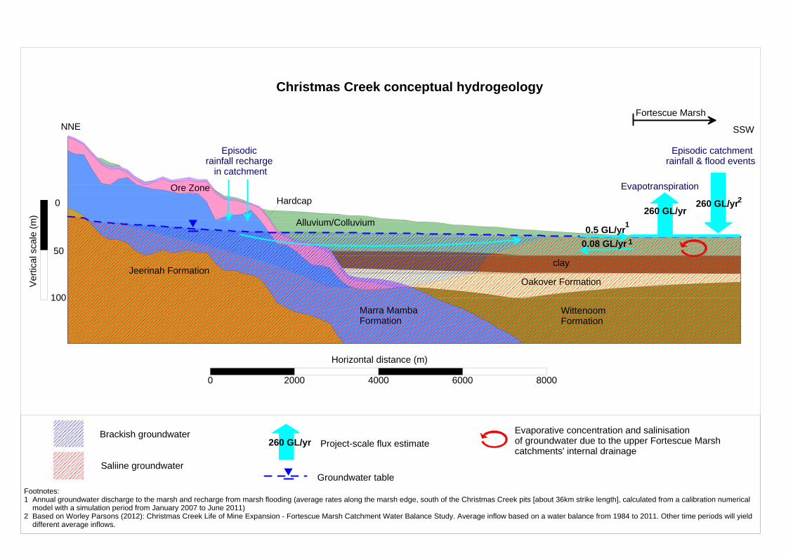
NNE SSW
Horizontal distance (m)
Ver
tical
sca
le (
m)
Ore ZoneHardcap
Alluvium/Colluvium
Oakover Formation
Wittenoom Formation
Jeerinah Formation
Marra Mamba Formation
clay
Episodic rainfall recharge
in catchment
0 2000 4000 6000 8000
Episodic catchment rainfall & flood events
Evapotranspiration
0.5 GL/yr
260 GL/yr260 GL/yr
Project-scale flux estimate260 GL/yrBrackish groundwater
Saliine groundwater
Fortescue Marsh
Groundwater table
0
50
100
Christmas Creek conceptual hydrogeology
Evaporative concentration and salinisationof groundwater due to the upper Fortescue Marsh catchments' internal drainage
0.08 GL/yr
1
1
2
Footnotes:1 Annual groundwater discharge to the marsh and recharge from marsh flooding (average rates along the marsh edge, south of the Christmas Creek pits [about 36km strike length], calculated from a calibration numerical model with a simulation period from January 2007 to June 2011)2 Based on Worley Parsons (2012): Christmas Creek Life of Mine Expansion - Fortescue Marsh Catchment Water Balance Study. Average inflow based on a water balance from 1984 to 2011. Other time periods will yield different average inflows.

[This page has been left black intentionally]

Christmas Creek Groundwater Operating Strategy Page 45 of 94
CC-PH-HY-0003_Rev0.
Figure 4: Regional production bores

Christmas Creek Groundwater Operating Strategy Page 46 of 94
CC-PH-HY-0003_Rev0.
This page has been left blank intentionally

SPI01 to SPI06
HEI01 to HEI05
CCP24
CCP23CCP17
CCP16CCP10
CCP09
CCP08
CCP07
CCE18
CCE16CCE14
CCE12
CCE10
CCE05
CCE04
CCE02
CCE01
CCP22CCE13
WS20P3WS19P3
WS19P2
CCE02T
WS21P3
WS21P1
WS20P1&2
CCE41T
CCE19T
CCCP02CCCP01
CCP08-d
Wild Bore
Thor Bore
Meagan Bore
6 Mile Bore
Francos Bore
10 Mile Bore
Charlton Bore
Warri Outcamp Well
CCCAP03&4
760,000
760,000
770,000
770,000
780,000
780,000
790,000
790,000
800,000
800,000
7,5
00,0
00
7,5
00,0
00
7,5
10,0
00
7,5
10,0
00
7,5
20,0
00
7,5
20,0
00
0 1,700 3,400 5,100 6,800
metres
±LEGEND
Production bore
Water conveyance infrastructure
Roy Hill tenement boundary
Fortescue Marsh
Life of mine resource outline
M Short
Water Management
Christmas CreekChristmas Creek Production Bores
0
Projection: GDA 1994 MGA Zone 50
Date: 14/06/2013
Doc Name: Figure 4 - Production Bore Non Pit Region
Size: A3L
Scale:1:120,000
Drawn By:
Requested By:
Confidentiality: 1
Revision:


Christmas Creek Groundwater Operating Strategy Page 47 of 94
CC-PH-HY-0003_Rev0.
Figure 5: Injection locations

Christmas Creek Groundwater Operating Strategy Page 48 of 94
CC-PH-HY-0003_Rev0.
This page has been left blank intentionally

#*#*
#*#*
#*#* #*#*#*#*
#*
#*
#*
#* #*#*
#*#*
#*
#* #*#*
#*#*
#* #*
#* #* #* #*
#*
#*
#*
#*#*
#* #*
#*
#*
#*#*#*
#*#*#* #* #*
#*#*
#*
#*
#*
#*
#*
#*#*
#*
#*
#*
#*
#*#*
#*
#*
#*#*#*#*
#*
#*
#*#*#*#*#*
#*#*
#*#*#*
#*#*
#*
#*#*
Fortescue Marsh
HEI04 E:773378 N:7523169.6
HSB62 E:770969 N:7523234.6
HSB60 E:769616.4 N:7523186
HSB53 E:766796.5 N:7523481
HSB49 E:765209.8 N:7523799
HSB48 E:764809.2 N:7523563
HEMB05_S E:774490 N:7523249
HEI05 E:774510.7 N:7523245.6
HEI03 E:773046.7 N:7523357.6
HSB59 E:769203.6 N:7523572.7
HSB58 E:768801.8 N:7523483.2
HSB56 E:768001.5 N:7523261.7
HSB52 E:766403.5 N:7523613.2
HSB45 E:763582.8 N:7524086.2
HSB43 E:762818.3 N:7523979.3
SPM04 E:791981 N:7518776
SPI02 E:792475.8 N:7518417
CCSP0008 E:792132 N:7517759
SPI04 E:791989.8 N:7518758.5
SAI05
SAI04
SAI03
SAI02
SAI01
SAI22
SAI21
SAI23
SAI08
SAI09
SAI10
SAI07
SAI06
SAI11
SAI12
SAI13SAI14SAi15
SAI17SAI16
SAI18SAI20
SAI19
SAI20b
SAI16aSAI15a
SAI14aSAI13a SAI12a
SAI12b
SAI01A
SAI04A
760,000
760,000
770,000
770,000
780,000
780,000
790,000
790,000
7,5
10,0
00
7,5
10,0
00
7,5
20,0
00
7,5
20,0
00
0 1,200 2,400 3,600 4,800
metres
±LEGEND#* Saline injection bore
#* Brackish injection bore
Existing brackish conveyance corridor
Existing saline conveyance corridor
Life of mine resource outline
Fortescue Marsh
M Short
Water Management
Christmas CreekInjection Bores
0
Projection: GDA 1994 MGA Zone 50
Date: 28/06/2013
Doc Name: Figure 5 - Injection Locations
Size: A3L
Scale: 1:85,000
Drawn By:
Requested By:
Confidentiality: 1
Revision:


Christmas Creek Groundwater Operating Strategy Page 49 of 94
CC-PH-HY-0003_Rev0.
Figure 6: Monitoring location plan

Christmas Creek Groundwater Operating Strategy Page 50 of 94
CC-PH-HY-0003_Rev0.
This page has been left blank intentionally
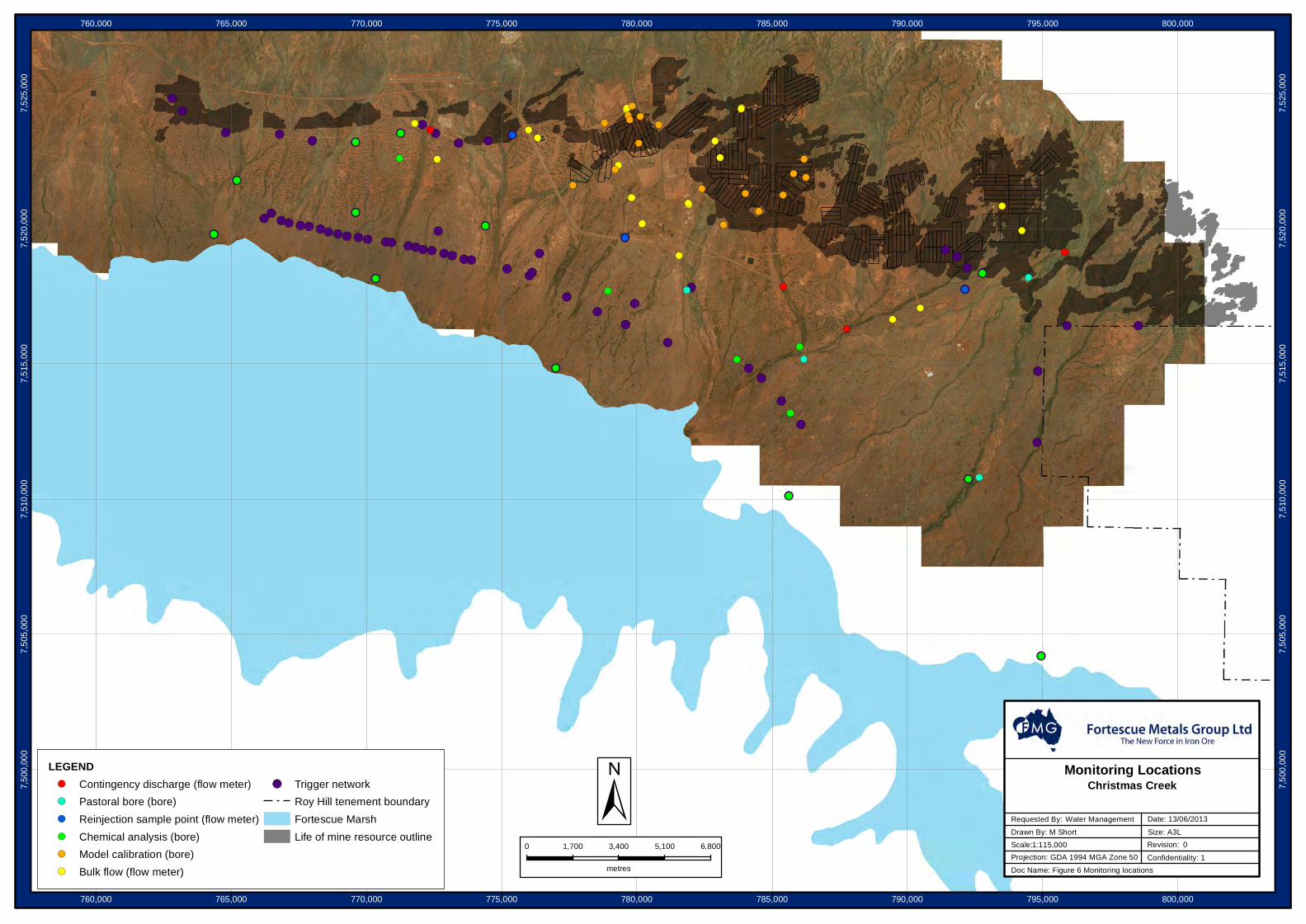
!(
!(
!(
!(
!(
!(
!(
!(
!(
!(!(
!(
!(
!(!(
!(!(!(!(!(!(!(!(
!(!(!(
!(!(
!(
!(!(!(!(!(!(!(!(!(!(!( !(
!(
!(!(
!( !(
!(!(
!( !(!(
!(!(
!(!(
!(!(
!(
!(
!(
!(
!( !(
!(
!(
!(
!(
!(
!(
!(
!(
!(
!(
!(!(
!(!(
!(!(
!(!(
!(
!(
!(
!(!(
!(!(!(
!(!(
!(
!(
!(
!(
!(
!(!(!(!(
!(
!(
!(
!(!(!(!(
!(
!(
!(
!(
!(
!(
!(
!(
!(
!(
!(!(
!(!( !(!(
!(!(
!(!(
!(!(
!( !(
!(
!(
!(
!(
!(
!(
!(
!(
!(
!(
!(
!(
!(
!(
!(
760,000
760,000
765,000
765,000
770,000
770,000
775,000
775,000
780,000
780,000
785,000
785,000
790,000
790,000
795,000
795,000
800,000
800,000
7,5
00,0
00
7,5
00,0
00
7,5
05,0
00
7,5
05,0
00
7,5
10,0
00
7,5
10,0
00
7,5
15,0
00
7,5
15,0
00
7,5
20,0
00
7,5
20,0
00
7,5
25,0
00
7,5
25,0
00
0 1,700 3,400 5,100 6,800
metres
±LEGEND!( Contingency discharge (flow meter)
!( Pastoral bore (bore)
!( Reinjection sample point (flow meter)
!( Chemical analysis (bore)
!( Model calibration (bore)
!( Bulk flow (flow meter)
!( Trigger network
Roy Hill tenement boundary
Fortescue Marsh
Life of mine resource outline M Short
Water Management
Christmas CreekMonitoring Locations
0
Projection: GDA 1994 MGA Zone 50
Date: 13/06/2013
Doc Name: Figure 6 Monitoring locations
Size: A3L
Scale:1:115,000
Drawn By:
Requested By:
Confidentiality: 1
Revision:


Christmas Creek Groundwater Operating Strategy Page 51 of 94
CC-PH-HY-0003_Rev0.
Figure 7: Christmas Creek trigger level zones and bores

Christmas Creek Groundwater Operating Strategy Page 52 of 94
CC-PH-HY-0003_Rev0.
This page has been left blank intentionally

#*
#*
#*
#*
SPM10
SPM09SPM08
SPM07
SPM06
SPM01
SAM01
SAM03
SAM05
SAM06
SAM12
SAM16
SAM17
SAM19
SAM21
SAM22
SAM23
SAM24
SAM25
SAM26
SAM27SAM28
SAM29
SAM30
SAM32
SAM33
SAM34
SAM35
SAM48
SCX01
SCX06
SPM05
HEMB01
HEMB02
HEMB04HEMB05
HSMB24
HSMB25
HSMB26
HSMB27
HSMB28
HSMB29
CCFMM01
CCFMM02
CCFMM03
CCFMM04
CCFMM05
SCX05_S
SCX03_D
CCF07B_S
CCF03B_S
CCE10MB_I
CCE02MB_I
CCSP0001
CCSP008
CCSP0011
SAM38
SAM39
SAM40SAM41
SAM42
SAM44
SAM45
SAM46
SAM47
SAM49
SPM03CCSP0015
760,000
760,000
765,000
765,000
770,000
770,000
775,000
775,000
780,000
780,000
785,000
785,000
790,000
790,000
795,000
795,000
800,000
800,000
7,5
00,0
00
7,5
00,0
00
7,5
05,0
00
7,5
05,0
00
7,5
10,0
00
7,5
10,0
00
7,5
15,0
00
7,5
15,0
00
7,5
20,0
00
7,5
20,0
00
7,5
25,0
00
7,5
25,0
00
0 1,700 3,400 5,100 6,800
metres
±LEGEND
Zone A
Zone B
Zone C
Zone D
Misc
#* Sample Point
Mine plan
Fortescue Marsh
Zone_A_polygon
Saline_polygon
Brackish_polygon
Phreatophytic vegetation region
Roy Hill tenement boundaryM Short
Water Management
Christmas CreekProject Trigger Zones
0
Projection: GDA 1994 MGA Zone 50
Date: 13/06/2013
Doc Name: Triggers June 2013
Size: A3L
Scale:1:115,000
Drawn By:
Requested By:
Confidentiality: 1
Revision:


Christmas Creek Groundwater Operating Strategy Page 53 of 94
CC-PH-HY-0003_Rev0.
Appendix 1: Groundwater abstraction licence

Christmas Creek Groundwater Operating Strategy Page 54 of 94
CC-PH-HY-0003_Rev0.
This page has been left blank intentionally

Government of Western Australia Department of Water
Sean McGunnigle
~~~~TIW~~ ~
BY:--------------------
Project: C..C Sub-Project/Facility:
-.--~~
Our ref7ookifW=~S'I'CCJ'11 our water needs
WRD158510
Enquiries: Kevin Hopkinson Telephone: (08) 9144 0214
Fortescue Metals Group Limited Level2 87 Adelaide Terrace EAST PERTH WA 6004
Doc Type: POW @ s17 s26d s45c !.38 [)e (Wks App) DeC (lie) DeC (Re a)
Application: YES Approval : CC -eN- OOs:t,- y S othe :.lfM~ed erwt- t G. 1 ~<93(6) tt-f ur~s
Dear Mr. McGunnigle,
Re: Fortescue Metals Group Limited (FMG) Licence: GWL 167593(5) Expiry: 11th July, 2013 Property: Christmas Creek
I refer to your application for a 5C Licence to amend (GWL 167593-04) the taking of Water which was received by the Department of Water on the 29th March, 2012 requesting to increase the licensed allocation to 48GL from the East Pilbara Hamersley Fractured Rock Aquifer for dewatering, dust suppression, processing, and camp purpose as part of the Christmas Creek Operations.
It was noted during assessment that there are registered sites of Aboriginal Heritage Significance in close proximity to the designated exploration areas. Please be advised that it is Fortescue Metals Group Limited's responsibility to ensure appropriate consultation with any affected Traditional Owners and adequate referral to the Department of Indigenous Affairs (DIA) is made, to ensure full compliance with the Aboriginal Heritage Act 1972.
There is Priority 1 flora and endangered Fauna located within the project area. Additionally, the project area is within an Environmentally Sensitive Area. If you have any queries, please contact the Department of Environment and Conservation on (08) 9182 2000 for further information
Please find enclosed your Licence to Take Water, issued under section 5C of the Rights in Water and Irrigation Act 1914. This licence entitles you to take water, subject to certain terms, conditions or restrictions. It does not absolve the licensee from responsibility for compliance with the requirements of all Commonwealth and State legislation.
It is important that you read the conditions of your licence carefully. If you do not understand your licence, please contact the Department as soon as possible, as there are penalties for failing to comply with all of your licence conditions . Under Section 26GG(2) of the Rights in Water and Irrigation Act 1914, you have a right to apply to the State Administrative Tribunal for a review of the decision to issue a Licence to Take Water. You have 28 days from the date you received this letter to request that the decision be reviewed .
For further information please contact the State Administrative Tribunal:
State Administrative Tribunal 12 St Georges Terrace PERTH WA 6000
Pilbara Region Lot 4608 Cherratta Road KIE
Karratha Western Australia 6714
PO Box 836 Karratha Western Australia 6714
Telephone (08) 9144 0200 Facsimile (08) 9144 2610
www.water.wa.gov.au
wa.gov.au ! !il

GPO Box U1991 PERTH WA 6845
Telephone: (08) 9219 3111 Toll-free: 1300 306 017 Facsimile: (08) 9202 1180 www.sat.justice.wa.gov.au
Under section 21 of the State Administrative Tribunal Act 2004, you have a right to request a written statement of reasons for the decision to issue a Licence to Take Water. This request must be made, in writing, to the Department of Water within 28 days after the day on which you received this letter.
If you wish to continue taking water after this Licence to Take Water expires, it is your responsibility to apply to the Department of Water for its renewal. If this licence expires and you have not applied to renew it, then the taking of water must cease, or you will be in breach of the Rights in Water and Irrigation Act 1914. It is suggested that an application for renewal be made at least one month in advance of the Licence to Take Water expiry date.
You may apply to amend or transfer the Licence to Take Water at any time. The Department may also amend, suspend or cancel this licence in certain circumstances.
An extract of this licence has been placed in the public register and is available for viewing by appointment at Department of Water offices.
If you have any queries relating to the above matter, please contact Kevin Hopkinson on telephone number (08) 9144 0214.
Yours faithfully
~/~: Dr. Hamid Mohsenzadeh Regional Manager Department of Water Pilbara Region
13 July 2012
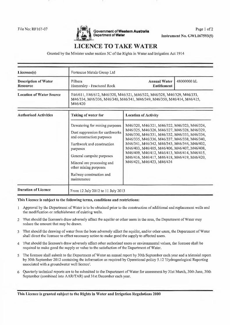
File No: RF167-07 Government of Western Australia Department of Water
LICENCE TO TAKE WATER
Page 1 of2
Instrument No. GWL167593(5)
Granted by the Minister under section 5C of the Rights in Water and Irrigation Act 1914
Licensee(s)
Description ofWater Resource
Location of Water Source
Authorised Activities
Duration of Licence
Fortescue Metals Group Ltd
Pilbara Hamersley - Fractured Rock
Annual Water 48000000 kL Entitlement
E46/611, E46/612, M46/320, M46/321, M46/322, M46/328, M46/329, M46/333, M46/334, M46/336, M46/340, M46/341, M46/349, M46/350, M46/414, M46/415, M46/420
Taking of water for
Dewatering for mining purposes
Dust suppression for earthworks and construction putposes
Earthwork and construction putposes
General campsite putposes
Mineral ore processing and other mining putposes
Railway construction and maintenance
From 12 July 2012 to 11 July 2013
Location of Activity
M46/320, M46/321, M46/322, M46/323, M46/324, M46/325, M46/326, M46/327, M46/328, M46/329, M46/330, M46/331, M46/332, M46/333, M46/334, M46/335, M46/336, M46/337, M46/338, M46/340, M46/341, M46/342, M46/343, M46/344, M46/402, M46/403, M46/405, M46/406, M46/407, M46/408, M46/409, M46/412, M46/413, M46/414, M46/415, M46/416, M46/417, M46/418, M46/419, M46/420, M46/421, M46/423, M46/424
This Licence is subject to the following terms, conditions and restrictions:
1 Approval by the Department of Water is to be obtained prior to the construction of additional and replacement wells and the modification or refurbishment of existing wells.
2 That should the licensee's draw adversely affect the aquifer or other users in the area, the Department of Water may reduce the amount that may be drawn.
3 That should the drawing of water from the bore adversely affect the aquifer, and/or other users, the Department of Water shall direct the licensee to effect necessary action to make good the supply to affected users.
4 That should the licensee's draw adversely affect other authorised users or environmental values, the licensee shall be required to make good the supply or value to the satisfaction of the Department ofWater.
5 The licensee shall submit to the Department of Water an annual report by 30th September each year and a triennial report by 30th September 2012 containing the information as required by Operational policy 5.12 'Hydrogeological Reporting associated with a groundwater well licence'.
6 Quarterly technical reports are to be submitted to the Department of Water for assessment by 31st March, 30th June, 30th September (combined into AAR/T AR) and 31st December each year.
This Licence is granted subject to the Rights in Water and Irrigation Regulations 2000

File No: RF167-07 Government of Western Australia Department of Water
LICENCE TO TAKE WATER
Page 2 of2
Instrument No. GWL167593(5)
Granted by the Minister under section 5C of the Rights in Water and Irrigation Act 1914
This Licence is subject to the following terms, conditions and restrictions:
7 The licensee must install a cumulative water meter of a type approved under the Rights in Water and Irrigation (Approved Meters) Order 2009 to each water draw point under this licence.
8 The meter(s) must be installed in accordance with the provisions of the document entitled "Guidelines for Water Meter Installation 2009" before any water is taken under this licence.
9 The annual water year for water taken under this licence is defined as 12:00 pm at 31 July to 12:00 pm at 31 July twelve months later.
10 The licensee shall comply with the 'Christmas Creek Groundwater Operating Strategy (Rev 5- dated 14th May 2012)' as prepared by Fortescue Metals Group Limited and approved by the Department of Water on 30 May 2012, including any modifications to the 'Christmas Creek Groundwater Operating Strategy (Rev 5- dated 14th May 2012)' as approved during the term of the licence.
11 Should the monitoring at any time indicate a need for prompt action to prevent or reduce the effect of the licensee's draw on the underground resource, the licensee shall immediately report this to the Department of Water and advise the corrective measures proposed.
End of terms, conditions and restrictions
This Licence is granted subject to the Rights in Water and Irrigation Regulations 2000
Christmas Creek Groundwater Operating Strategy Page 55 of 94
CC-PH-HY-0003_Rev0.
Appendix 2: Tenements

Christmas Creek Groundwater Operating Strategy Page 56 of 94
CC-PH-HY-0003_Rev0.
This page has been left blank intentionally

Christmas Creek Groundwater Operating Strategy Page 57 of 94
CC-PH-HY-0003_Rev0.
Tenements – Abstraction Tenements – Water use Tenements – Injection
L46/99
M46/320
M46/321
M46/322
M46/323
M46/324
M46/325
M46/326
M46/327
M46/328
M46/329
M46/330
M46/331
M46/332
M46/333
M46/334
M46/335
M46/336
M46/337
M46/338
M46/339
M46/340
M46/341
M46/342
M46/343
M46/344
M46/345
M46/346
M46/347
M46/348
M46/349
M46/350
M46/351
M46/352
M46/402
M46/403
M46/405
M46/406
M46/412
M46/413
M46/414
M46/415
M46/416
M46/417
M46/418
M46/419
M46/420
M46/421
M46/422
M46/423
M46/424
L46/99
M46/320
M46/321
M46/344
M46/345
M46/349
M46/350
M46/402
M46/403
M46/406
M46/412
M46/413
M46/414
M46/415
M46/416
M46/417
M46/423
M46/424

Christmas Creek Groundwater Operating Strategy Page 58 of 94
CC-PH-HY-0003_Rev0.
This page has been left blank intentionally

Christmas Creek Groundwater Operating Strategy Page 59 of 94
CC-PH-HY-0003_Rev0.
Appendix 3: No pit-region abstraction bore details

Christmas Creek Groundwater Operating Strategy Page 60 of 94
CC-PH-HY-0003_Rev0.
This page has been left blank intentionally

Christmas Creek Groundwater Operating Strategy Page 61 of 94
CC-PH-HY-0003_Rev0.
Bore Name Date Drilled GDA94, Zone 50 Tenement Casing Diameter (ND, mm)
Total Bore
Depth (m)
Maximum Pumping Rate
Easting Northing kL/day L/s
CCCP01 30-Aug-08 776,025 7,523,984 M46/320 200 mm PVC PN12 42 2000 23.1
CCCP02 01-Sep-08 776,803 7,524,202 M46/320 200 mm PVC PN12 47.4 2000 23.1
CCE01 08-Aug-09 772,734 7,522,410 M46/415 200 mm PVC PN12 78 1728 20
CCE02 09-Aug-09 772,659 7,519,894 E46/612 200 mm PVC PN12 78 2160 25
CCE02T 22-Mar-05 782,204 7,520,769 M46/328 155 mm PVC PN12 82 346 4
CCE04 19-Jul-09 777,617 7,521,608 M46/322 200 mm PVC PN12 70 432 5
CCE05 27-Aug-09 779,207 7,522,202 M46/322 200 mm PVC PN12 78 1037 12
CCE10 24-Aug-09 781,134 7,515,812 E46/612 200 mm PVC PN12 85 2592 30
CCE12 26-Aug-09 784,800 7,519,819 E46/334 200 mm PVC PN12 90 2592 30
CCE13 15-Aug-09 787,424 7,519,229 M46/336 200 mm PVC PN12 80 864 10
CCE14 19-Aug-09 789,204 7,517,564 M46/341 200 mm PVC PN12 126 1728 20
CCE16 05-Sep-09 794,336 7,517,807 M46/350 200 mm PVC PN12 57 1296 15
CCE18 02-Sep-09 792,278 7,510,766 E46/611 200 mm PVC PN12 80 2592 30
CCE19T 29-Mar-05 787,410 7,518,529 M46/336 155 mm PVC PN12 66 432 5.0
CCE41T 24-Mar-05 794,037 7,519,273 M46/349 155 mm PVC PN12 70 605 7.0
CCP07 26-Aug-08 782,380 7,522,812 M46/329 200 mm PVC PN12 65.1 2000 23.1
CCP08 06-Sep-08 782,395 7,522,312 M46/329 200 mm PVC PN12 71.8 2000 23.1
CCP09 09-Sep-08 782,389 7,521,908 M46/329 200 mm PVC PN12 72 2000 23.1
CCP10 13-Sep-08 782,387 7,521,485 M46/329 200 mm PVC PN12 71 2000 23.1
CCP16 04-Sep-08 785,609 7,520,783 M46/333 200 mm PVC PN12 59.5 3024 35.0
CCP17 17-Sep-08 782,367 7,519,909 M46/328 200 mm PVC PN12 78 2419 28.0
CCP22 13-Sep-08 789,215 7,519,204 M46/340 200 mm PVC PN12 64 1728 20.0
CCP23 22-Sep-08 789,210 7,518,880 M46/340 200 mm PVC PN12 60 3024 35.0
CCP24 18-Feb-09 789,207 7,518,611 M46/341 200 mm PVC PN12 70.5 3024 35.0
Charlton Bore 08-Dec-06 782,868 7,523,207 M46/329
155 mm PVC PN12 85 1728 20.0

Christmas Creek Groundwater Operating Strategy Page 62 of 94
CC-PH-HY-0003_Rev0.
Bore Name Date Drilled GDA94, Zone 50 Tenement Casing Diameter (ND, mm)
Total Bore
Depth (m)
Maximum Pumping Rate
Easting Northing kL/day L/s
Francos Bore ~1 Oct 06 769,253 7,524,413 M46/414
155 mm PVC PN12 70 800 9.3
HEI01 14-Feb-11 772,078 7,523,831 M46/415 300 mm steel & open hole
54.5 1296 15
HEI02 13-Feb-11 772,543 7,523,536 M46/416 300 mm steel & open hole
60.5 1296 15
HEI03 24-Apr-11 773,047 7,523,358 M46/416 300 mm steel & open hole
58 1296 15
HEI04 22-Apr-11 773,378 7,523,170 M46/416 300 mm steel & open hole
61 1296 15
HEI05 19-Apr-11 774,511 7,523,246 M46/416 300 mm steel & open hole
62 1296 15
Thor Bore ~1 Jun 06 794,453 7,517,621 M46/350 155 mm PVC PN9 41 200 2.3
SPI01 23-Sept-11 792,758 7,518,365 M46/344 300 mm steel & open hole
69 1296 15
SPI02 19-Sept-11 792,476 7,518,417 M46/345 300 mm steel & open hole
67 1296 15
SPI03 18-Sept-11 792,217 7,518,554 M46/345 300 mm steel & open hole
69 1296 15
SPI04 16-Aug-11 791,990 7,518,759 M46/345 300 mm steel & open hole
52 1296 15
SPI05 12-Sept-11 791,835 7,518,953 M46/345 300 mm steel & open hole
64 1296 15
SPI06 09-Sept-11 791,416 7,519,204 M46/345 300 mm steel & open hole
70 1296 15
Wild Bore ~1 Jun 06 795,604 7,519,278 M46/349 155 mm PVC PN12 71 180 2.1
WS19P2 21-Aug-08 770,249 7,524,371 M46/414 200 mm PVC PN12 73.5 1037 12.0
WS19P3 15-Aug-08 769,989 7,523,986 M46/414 200 mm PVC PN12 76 1296 15.0
WS20P1 15-Aug-08 776,170 7,523,732 M46/320 200 mm PVC PN12 66 1296 15.0
WS20P2 15-Aug-08 776,514 7,523,852 M46/320 200 mm PVC PN12 66 1296 15.0
WS20P3 15-Aug-08 775,633 7,523,526 M46/321 200 mm PVC PN12 66 1296 15.0
WS21P1 03-Aug-08 781,565 7,518,964 M46/420 200 mm PVC PN12 60 520 6.0
WS21P3 15-Aug-08 781,523 7,518,416 M46/420 200 mm PVC PN12 90 1382 16.0

Christmas Creek Groundwater Operating Strategy Page 63 of 94
CC-PH-HY-0003_Rev0.
Appendix 4: Pit region abstraction bore setup

Christmas Creek Groundwater Operating Strategy Page 64 of 94
CC-PH-HY-0003_Rev0.
This page has been left blank intentionally

Christmas Creek Groundwater Operating Strategy Page 65 of 94
CC-PH-HY-0003_Rev0.
Infrastructure Key Characteristics Comment
End-of-strip pit perimeter bores
Typically up to 110 m depth. ND = 200, 300 or 350mm. Typically screened from the watertable to about 15 m below the base of ore.
Installed prior to below-watertable mining. Typically mine out (decommissioned) in a timeframe of about six months.
Strip-edge dewatering points In-pit abstraction
bores
Typically up to 40 m depth. ND = 200, 300 or 350 mm. Typically screened from the top hardcap to about 15 m below the base of ore.
Resistant to blasting if sufficient distance is maintained from the edge of the blasting front
In-pit sumps
Excavated with existing mining fleet. Typically up to 5 m deep. Suction pump use to abstract sump water to settlement pond.
The excavation of sumps is the responsibility of the mining contractor
Strip-edge abstraction bores
Typically up to 110 metres depth. ND = 200, 300 or 350mm. Typically screened from the watertable to about 15 m below the base of ore.
Installed prior to below-watertable mining. Typically have a longer active abstraction period compared to end-of-strip perimeter bores.
Connecting pipeline
Brackish Typically >=ND110 mm HDPE poly-welded pipelines. Typical pressure rating range is from pressure nomination (PN) of 6.3 bar at 20oC (PN6.3) to PN12.5
The bulk of initial-mining connecting pipeline
Saline May be installed at a later stage if/when saline up coning is evident
Sump Separated due to its extra requirement of sediment-settling prior to injection
Settlement ponds Sump/brackish Typically 160 x 100 m
May also be used to break the pressure of non-sump abstraction Saline
Mining strip Typically 150 m wide and 700 m long. Surface miners require that at least two ore strips be open at one time (within the one mining region).
Various strip orientations

Christmas Creek Groundwater Operating Strategy Page 66 of 94
CC-PH-HY-0003_Rev0.
This page has been left blank intentionally

Christmas Creek Groundwater Operating Strategy Page 67 of 94
CC-PH-HY-0003_Rev0.
Appendix 5: Injection bore details

Christmas Creek Groundwater Operating Strategy Page 68 of 94
CC-PH-HY-0003_Rev0.
This page has been left blank intentionally

Christmas Creek Groundwater Operating Strategy Page 69 of 94
CC-PH-HY-0003_Rev0.
Bore name
MGA94 Zone 50
Tenement Casing diameter
(nominal) Total bore depth (m)
Open hole
interval (mbgl)
Easting Northing H
ills
ide
Ea
st
Ex
ten
sio
n HEI01 772,078 7,523,831 M46/415
300 mm steel &
open hole
54.5 31 - 52
HEI02 772,543 7,523,536 M46/416 60.5 45 - 59
HEI03 773,047 7,523,358 M46/416 58 46 - 70
HEI04 773,378 7,523,170 M46/416 61 40 - 58
HEI05 774,511 7,523,246 M46/416 62 47 - 64
Hill
sid
e E
as
t
HSB42 762,808 7,524,817 M46/403
300 mm steel &
open hole
60 30 - 60
HSB43 762,818 7,523,979 M46/406 60 30 - 60
HSB44 763,187 7,524,369 M46/403 60 30 - 60
HSB45 763582 7524,086 M46/403 60 30 - 60
HSB46 764,425 7,524,090 M46/412 60 30 - 60
HSB47 764,832 7,523,992 M46/412 60 30 - 60
HSB48 764,809 7,523,563 M46/412 60 30 - 60
HSB49 765,209 7,523,799 M46/412 60 30 - 60
HSB50 765,614 7,523,980 M46/412 60 30 - 60
HSB51 765,583 7,523,559 M46/412 60 30 - 60
HSB52 766,403 7,523,613 M46/412 60 30 - 60
HSB53 766,796 7,523,481 M46/413 60 30 - 60
HSB54 767,195 7,523,247 M46/413 72 48 - 72
HSB56 768,001 7,523,262 M46/413 66 42 - 66
HSB57 768,499 7,523,477 M46/413 64 46 - 64
HSB58 768,801 7,523,483 M46/413 69 54 - 69
HSB59 769,203 7,523,573 M46/414 66 36 - 66
HSB60 769,616 7,523,186 M46/414 65 42 - 65
HSB61 770,004 7,523,545 M46/414 77 42 - 77
HSB62 770,969 7,523,235 M46/414 76 48 - 76

Christmas Creek Groundwater Operating Strategy Page 70 of 94
CC-PH-HY-0003_Rev0.
Bore name
MGA94 Zone 50
Tenement Casing diameter
(nominal) Total bore depth (m)
Open hole
interval (mbgl)
Easting Northing
HSB63 771,247 7,523,519 M46/414 72 42 - 72
Sp
inif
ex P
ige
on
SPI01 792,758 7,518,365 M46/344
300 mm steel &
open hole
69 53 -69
SPI02 792,476 7,518,417 M46/345 67 51 - 67
SPI03 792,217 7,518,554 M46/345 69 45 - 69
SPI04 791,990 7,518,759 M46/345 52 34 - 52
SPI05 791,835 7,518,953 M46/345 64 52 - 64
SPI06 791,416 7,519,204 M46/345 70 52 - 70
Sal
ine
SAI01 776,041 7,518,262 L49/99
300 mm steel &
open hole
70 49 - 70
SAI01A 782,895 7,515,538 L49/99 80 52 - 80
SAI02 780,795 7,516,788 L49/99 70 47 - 70
SAI03A 781,438 7,516,373 L49/99 69 46 - 69
SAI04 782,195 7,515,947 L49/99 77 40 - 77
SAI04A 777,722 7,518,352 L49/99 76 40 - 76
SAI05 783,665 7,515,128 L49/99 69 46 - 69
SAI06 784,097 7,514,831 L49/99 69 35 – 69
SAI07 784,961 7,514,075 L49/99 46 34 - 46
SAI08 785,318 7,513,638 L49/99 57 33 - 57
SAI09 785,680 7,513,212 L49/99 65 39 - 65
SAI10 786,033 7,512,760 L49/99 41 29 - 41
SAI11 775,195 7,518,540 L49/99 68 40 - 68
SAI12 773,596 7,518,891 L49/99 74 43 - 74
SAI12a 773,912 7,518,807 L49/99 68 40 - 68
SAI12b 773,189 7,518,979 L49/99 68 40 - 68
SAI13 772,086 7,519,252 L49/99 65 44 - 65
SAI13a 772,428 7,519,136 L49/99 68 40 - 68

Christmas Creek Groundwater Operating Strategy Page 71 of 94
CC-PH-HY-0003_Rev0.
Bore name
MGA94 Zone 50
Tenement Casing diameter
(nominal) Total bore depth (m)
Open hole
interval (mbgl)
Easting Northing
SAI14 771,539 7,519,383 L49/99 66 46 - 66
SAI14a 771,850 7,519,270 L49/99 68 40 - 68
SAI15 770,711 7,519,532 L49/99 72 40 - 72
SAI15a 770,954 7,519,438 L49/99 68 40 - 68
SAI16 769,265 7,519,746 L49/99 67 46 - 67
SAI16a 769,731 7,519,636 L49/99 68 40 - 68
SAI16b 768,972 7,519,754 L49/99 68 40 - 68
SAI17 768,586 7,519,902 L49/99 75 37 - 75
SAI17b TO BE SURVEYED L49/99 68 40 - 68
SAI18 767872 7,520,108 L49/99 66 40 - 66
SAI18a TO BE SURVEYED L49/99 68 40 - 68
SAI19 767,138 7,520,233 L49/99 64 42 - 64
SAI20 766,732 7,520,308 L49/99 68 40 - 68
SAI20a TO BE SURVEYED L49/99 68 40 - 68
SAI20b 766,482 7,520,528 L49/99 68 40 - 68
SAI21 779,596 7,516,456 L49/99 68 40 - 68
SAI22 778,552 7,516,951 L49/99 68 40 - 68
SAI23 77,410 7,517,531 L49/99 68 40 - 68

Christmas Creek Groundwater Operating Strategy Page 72 of 94
CC-PH-HY-0003_Rev0.
This page has been left blank intentionally

Christmas Creek Groundwater Operating Strategy Page 73 of 94
CC-PH-HY-0003_Rev0.
Appendix 6: Proposed abstraction rates at Christmas Creek

Christmas Creek Groundwater Operating Strategy Page 74 of 94
CC-PH-HY-0003_Rev0.
This page has been left blank intentionally

Christmas Creek Groundwater Operating Strategy Page 75 of 94
CC-PH-HY-0003_Rev0.
Source Use Estimate volume
(kL/year)
CCCP01 CCCP02
CCCAP03
CCCAP04 Accommodation
Village 500,000
Pit-region bores & sumps
CCE12
CCE18
CCE02
CCE10
WS20P1
WS20P2
WS20P3
CCE04
CCE05
CCE02T
CCP17
CCP07
CCP08
CCP09
CCP10
Charlton Bore
CCP16
CCE13
CCE19T
CCP22
CCP23
CCE14
CCP24
CCE41T
Wild Bore
CCE16
Thor Bore
WS19P2
WS19P3
CCE01
WS21P1
WS21P3
HEI01
HEI02
HEI03
HEI04
HEI05
SPI01
SPI02
SPI03
SPI04
SPI05
SPI06
Dust Suppression
&
Construction
Up to 50,000,000

Christmas Creek Groundwater Operating Strategy Page 76 of 94
CC-PH-HY-0003_Rev0.
This page has been left blank intentionally

Christmas Creek Groundwater Operating Strategy Page 77 of 94
CC-PH-HY-0003_Rev0.
Appendix 7: Christmas Creek conceptual water balance

Christmas Creek Groundwater Operating Strategy Page 78 of 94
CC-PH-HY-0003_Rev0.
This page has been left blank intentionally

Christmas Creek Groundwater Operating Strategy Page 79 of 94
CC-PH-HY-0003_Rev0.
Rport
CHRISTMAS CREEK CONCEPTUAL SCHEMATIC ANNUAL MINE WATER BALANCE JULY 2013- JULY 2014
I
I I
I I
- -
-
Cloudbreak minesite
•1·2 GL
r
Hill-si-de East borefield
I 13L
I I Abstraction locatio()
~I -=::::: tnjeotion location
Water use/destination
Flinders Pits
12 GL - - -
DEWATERING ABSTRACTION
Wlndlch Pits
-
25GL
Ore Proeess1ng Facility"
SGL
I Saline injection
4 1.5G4
Young Pits I 12.5GL
- - - -
Oust suppression Change in storage, seepage & evaporation
I 2 GL 0.5GL
Camp bores Accommodation ~ village
L_ _ _::;O·.:;.S .::.GL::.J 0.5 Gl
• includes office & workshop use in the ere processing facility
I
I I I
- I
Splnifex borefleld
OGL

Christmas Creek Groundwater Operating Strategy Page 80 of 94
CC-PH-HY-0003_Rev0.
CATEGORY AREA (RATE) ML/d Jul-13 Aug-13 Sep-13 Oct-13 Nov-13 Dec-13 Jan-14 Feb-14 Mar-14 Apr-14 May-14 Jun-14 Jul-14
DE
WA
TE
RIN
G (
ML
/Da
y) Flinders 60 40 40 30 30 30 30 30 30 30 30 30 27
Windich 65 71 72 72 72 72 72 72 72 72 72 72 72
Young 0 0 0 0 0 0 60 60 60 60 60 60 60
Camp supply 1 1 1 1 1 1 1 1 1 1 1 1 1
Total (ML/d) 126 112 113 103 103 103 163 163 163 163 163 163 159
Monthly Total (ML/m) 3,780 3,368 3,375 3,075 3,075 3,075 4,875 4,875 4,875 4,875 4,875 4,875 4,782
Cumulative Total (ML) 34,000 3,368 6,743 9,818 12,893 15,968 20,843 25,718 30,593 35,468 40,343 45,218 50,000
INJ
EC
TIO
N (
ML
/Da
y) Hillside East 11 0 0 0 0 0 0 0 0 0 11 11 11
Spinifex 0 0 0 0 0 0 0 0 0 0 0 0 0
Saline Injection 94 91 92 82 82 82 142 142 142 142 131 131 128
Total (ML/d) 105 91 92 82 82 82 142 142 142 142 142 142 139
Monthly Total (ML/m) 3,149 2,743 2,750 2,450 2,450 2,450 4,250 4,250 4,250 4,250 4,250 4,250 4,157
Cumulative Total (ML) 23,631 2,743 5,493 7,943 10,393 12,843 17,093 21,343 25,593 29,843 34,093 38,343 42,500
SIT
E U
SE
(M
L/D
ay
)
CC OPF 16 15 15 15 15 15 15 15 15 15 15 15 15
Dust Suppression & Camp Supply
5 5 5 5 5 5 5 5 5 5 5 5 5
Seepage/Storage/Evaporation 1 1 1 1 1 1 1 1 1 1 1 1 1
Total (ML/d) 21 21 21 21 21 21 21 21 21 21 21 21 21
Monthly Total (ML/m) 631 625 625 625 625 625 625 625 625 625 625 625 625
Cumulative Total (ML) 10,368 625 1,250 1,875 2,500 3,125 3,750 4,375 5,000 5,625 6,250 6,875 7,500
Christmas Creek Groundwater Operating Strategy Page 81 of 94
CC-PH-HY-0003_Rev0.
Rport
Appendix 8: Monitoring locations

Christmas Creek Groundwater Operating Strategy Page 82 of 94
CC-PH-HY-0003_Rev0.
This page has been left blank intentionally

Christmas Creek Groundwater Operating Strategy Page 83 of 94
CC-PH-HY-0003_Rev0.
Sample point Sample point type Easting (m) Northing (m)
CCSP0001 (Hillside East)
Reinjection discharge pipeline
775,392 7,523,460
CCSP0008 (Spinifex Pigeon) 792,132 7,517,759
CCSP0011 (saline injection - direct) 779,560 7,519,662
CCSP0015 (saline injection - Crank TP outflow) 776,123 7,518,386
CCF01B_S
Monitoring bore (chemical analysis)
786,016 7,515,638
CCF03B_S 792,255 7,510,749
CCFMM01_D 764,360 7,519,791
CCFMM01_S 764,360 7,519,791
CCFMM02_D 770,340 7,518,161
CCFMM02_S 770,340 7,518,161
CCFMM03_D 777,000 7,514,851
CCFMM03_S 777,000 7,514,851
CCFMM04_D 785,610 7,510,127
CCFMM04_S 785,610 7,510,127
CCFMM05_D 794,939 7,504,202
CCFMM05_S 794,939 7,504,202
HSMB29_D 771,257 7,523,532
HSMB29_S 771,257 7,523,532
SAM02_D 785,673 7,513,186
SAM02_S 785,673 7,513,186
SAM07_D 783,697 7,515,171
SAM07_S 783,697 7,515,171
SAM13_D 778,927 7,517,701
SAM13_S 778,927 7,517,701
SCX01_S 769,599 7,520,601
SCX03_S 769,596 7,523,206
SCX04_S 771,221 7,522,594
SXC05_D 774,400 7,520,100
SCX05_S 774,400 7,520,100
SCX06(All) 765,200 7,521,790
SCX06_D 765,200 7,521,790

Christmas Creek Groundwater Operating Strategy Page 84 of 94
CC-PH-HY-0003_Rev0.
Sample point Sample point type Easting (m) Northing (m)
SXC06_S 765,200 7,521,790
SPM01_D 792,770 7,518,354
SPM01_S 792,770 7,518,354
CCFM0001 (Hillside East)
Flow meter (water use volumes)
772,613 7,522,566
CCFM0003 (OPF TN) 780,201 7,520,207
CCFM0006 (Codgers inflow) TO BE SURVEYED
CCFM0007 (Rubys TN standpipe) 775,994 7,523,653
CCFM0008 (Erin TN standpipe) 783,075 7,522,622
CCFM0009 (CC construction) 771,791 7,523,888
CCFM0010 (Caspian TN standpipe) 783,866 7,524,470
CCFM0011 (Caspian TN standpipe) 783,847 7,524,428
CCFM0012 (Ollie TN standpipe) 779,603 7,524,410
CCFM0013 (Ollie TN standpipe) 779,621 7,524,460
CCFM0014 (U Road standpipe) 789,454 7,516,652
CCFM0015 (Batn TN standpipe) 781,552 7,519,007
CCFM0016 (Baltic TN standpipe) 779,314 7,522,344
CCFM0017 (Elvis TN standpipe) 781,919 7,520,890
CCFM0018 (Elvis TN standpipe) 781,898 7,520,941
CCFM0019 (Flinders SP outflow) 779,781 7,521,144
CCFM0020 (Flinders SP inflow) 779,813 7,521,148
CCFM0021 (Charlton standpipe) 782,891 7,523,242
CCFM0022 (OPF standpipe) 780,190 7,520,179
CCFM0023 (Eyre standpipe) 793,501 7,520,835
CCFM0024 (Airport construction) 790,471 7,517,062
CCFM0025 (Codgers outflow) 776,325 7,523,361
CCFM0026 (M16 TN standpipe) 794,230 7,519,927
CCFM0032 (Crank inflow - north) TO BE SURVEYED
CCFM0033 (Crank inflow - south) TO BE SURVEYED
CCE04MB_S Monitoring bore (model calibration)14 777,634 7,521,609
14 Location and frequency of monitoring for model calibration purposes will change with development of dewatering activities and numerical model certainty.
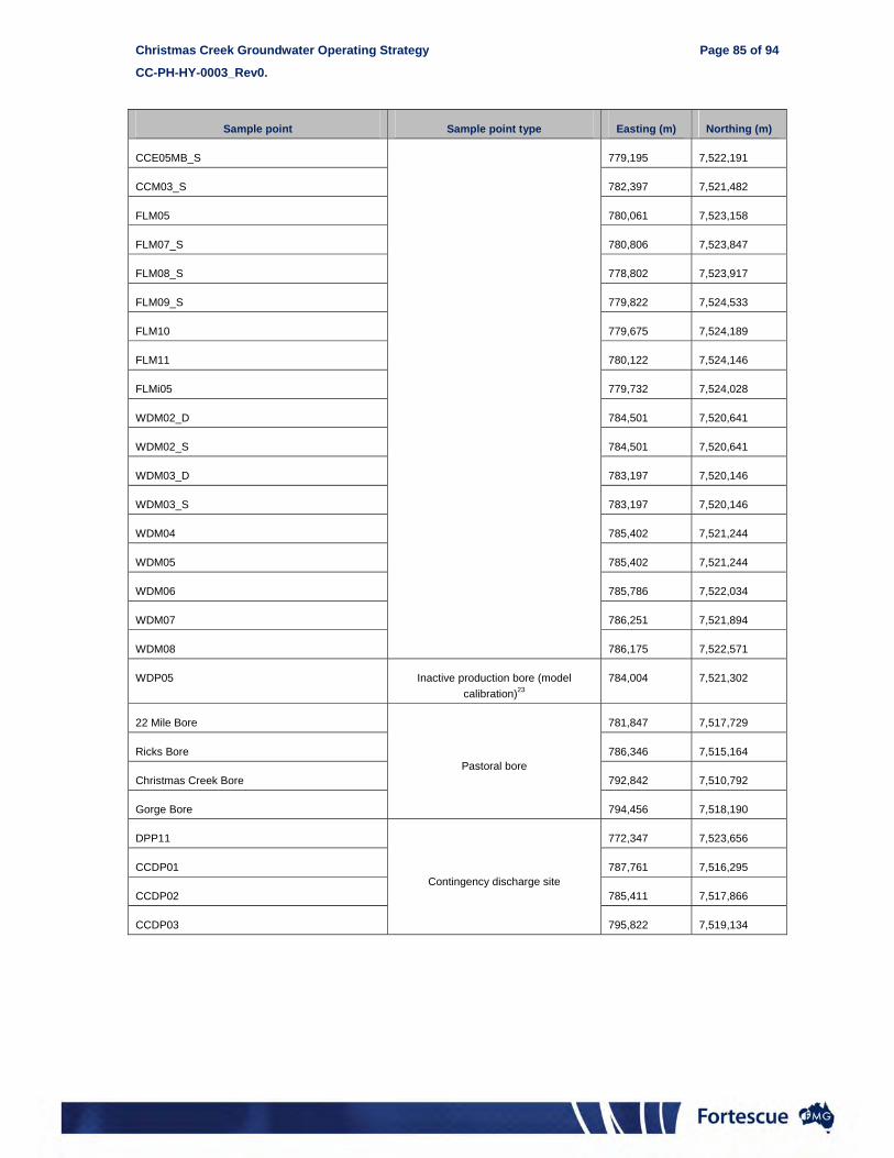
Christmas Creek Groundwater Operating Strategy Page 85 of 94
CC-PH-HY-0003_Rev0.
Sample point Sample point type Easting (m) Northing (m)
CCE05MB_S 779,195 7,522,191
CCM03_S 782,397 7,521,482
FLM05 780,061 7,523,158
FLM07_S 780,806 7,523,847
FLM08_S 778,802 7,523,917
FLM09_S 779,822 7,524,533
FLM10 779,675 7,524,189
FLM11 780,122 7,524,146
FLMi05 779,732 7,524,028
WDM02_D 784,501 7,520,641
WDM02_S 784,501 7,520,641
WDM03_D 783,197 7,520,146
WDM03_S 783,197 7,520,146
WDM04 785,402 7,521,244
WDM05 785,402 7,521,244
WDM06 785,786 7,522,034
WDM07 786,251 7,521,894
WDM08 786,175 7,522,571
WDP05 Inactive production bore (model
calibration)23
784,004 7,521,302
22 Mile Bore
Pastoral bore
781,847 7,517,729
Ricks Bore 786,346 7,515,164
Christmas Creek Bore 792,842 7,510,792
Gorge Bore 794,456 7,518,190
DPP11
Contingency discharge site
772,347 7,523,656
CCDP01 787,761 7,516,295
CCDP02 785,411 7,517,866
CCDP03 795,822 7,519,134

Christmas Creek Groundwater Operating Strategy Page 86 of 94
CC-PH-HY-0003_Rev0.
This page has been left blank intentionally

Christmas Creek Groundwater Operating Strategy Page 87 of 94
CC-PH-HY-0003_Rev0.
Appendix 9: Project trigger levels

Christmas Creek Groundwater Operating Strategy Page 88 of 94
CC-PH-HY-0003_Rev0.
This page has been left blank intentionally

Christmas Creek Groundwater Operating Strategy Page 89 of 94
CC-PH-HY-0003_Rev0.
Rport
Zone Monitoring Bore
Easting Northing Bore depth
Trigger target aquifer ³
Groundwater level trigger Groundwater quality trigger
(mE) (mN) (mbgl) Baseline groundwater
level (mAHD) Class 1 trigger (+/- m) Class 2 trigger (+/- m) Baseline EC (µS/cm)
Class 1 trigger (µS/cm) 2
Zone A CCFMM01_S 764360 7519791 18.2 Tertiary Detritals 405.2 - 406 0.65^ 1.5^ 118,320 -
Zone A CCFMM02_S 770340 7518157 13.7 Tertiary Detritals 404.8 - 405.2 0.65^ 1^ 69,442 -
Zone A CCFMM03_S 777000 7514851 13.2 Tertiary Detritals 404.5 - 405.9 0.65^ 1^ 74,265 -
Zone A CCFMM04_S 785610 7510127 14.7 Tertiary Detritals 405.1 - 405.8 0.65^ 1^ 87,629 -
Zone A CCFMM05_S 794939 7504202 18.5 Tertiary Detritals 404.7 - 405.7 0.65^ 1^ 109,248 -
Zone Monitoring Bore
Easting Northing Bore depth
Trigger target aquifer ³
Groundwater level trigger Groundwater quality trigger
(mE) (mN) (mbgl) Baseline groundwater level
(mbgl) Class 1 trigger (mbgl) Class 2 trigger (mbgl) Baseline EC (µS/cm)
Class 1 trigger (µS/cm) 2
Zone B CCE02MB_I 772649 7519912 64.0 Oakover Fmn. 8.71 2.2 1 - 181,473 -
Zone B CCE02MB_S 772649 7519912 27.0 Tertiary Detritals 7.19 3 1 2.2 1 19,841 -
Zone B CCE10MB_I 781132 7515791 64.0 Oakover Fmn. 9.85 2.2 1 - 137,000 -
Zone B CCE10MB_S 781132 7515791 36.0 Tertiary Detritals 10.43 3 1 2.2 1 37,926 -
Zone B SAM01_D 786064 7512762 37.0 Oakover Fmn. 7.01 2.2 1 - 37,320 -
Zone B SAM03_D 785346 7513627 50.9 Oakover Fmn. 5.82 2.2 1 - 124,400 -
Zone B SAM03_S 785346 7513627 21.8 Tertiary Detritals 7.15 3 1 2.2 1 41,851 -
Zone B SAM05_D 784602 7514474 46.4 Oakover Fmn. 5.47 2.2 1 - 94,653 -
Zone B SAM05_S 784602 7514474 21.7 Tertiary Detritals 7.92 3 1 2.2 1 17,308 -
Zone B SAM06_D 784124 7514832 57.1 Oakover Fmn. 6.12 2.2 1 - 141,092 -
Zone B SAM06_S 784124 7514832 20.6 Tertiary Detritals 9.69 3 1 2.2 1 15,261 -
Zone B SAM12_D 779920 7517232 66.1 Oakover Fmn. 14.86 2.2 1 - 171,484 -
Zone B SAM12_S 779920 7517233 29.1 Tertiary Detritals 13.67 3 1 2.2 1 104,001 -
Zone B SAM16_D 776396 7519078 76.7 Oakover Fmn. 13.05 2.2 1 - 181,790 -
Zone B SAM16_S 776396 7519078 52.7 Tertiary Detritals 12.65 3 1 2.2 1 160,319 -
Zone B SAM17_D 776023 7518262 64.0 Oakover Fmn. 6.1 2.2 1 - 153,118 -
Zone B SAM17_S 776023 7518262 28.6 Tertiary Detritals 9.68 3 1 2.2 1 36,597 -
Zone B SAM19_D 775193 7518518 68.1 Oakover Fmn. 3.16 2.2 1 - 136,700 -
Zone B SAM19_S 775193 7518518 23.0 Tertiary Detritals 7.9 3 1 2.2 1 71,567 -
Zone B SAM21_D 773603 7518870 63.2 Oakover Fmn. 3.64 2.2 1 - 144,100 -
Zone B SAM21_S 773603 7518870 30.2 Tertiary Detritals 5.74 3 1 2.2 1 74,040 -
Zone B SAM22_D 772864 7519082 65.0 Oakover Fmn. 4.16 2.2 1 - 164,811 -
Zone B SAM22_S 772864 7519082 30.4 Tertiary Detritals 7.19 3 1 2.2 1 52,700 -
Zone B SAM23_D 772090 7519230 60.2 Oakover Fmn. 7.73 2.2 1 - 135,300 -
Zone B SAM23_S 772090 7519230 23.9 Tertiary Detritals 6.06 3 1 2.2 1 23,669 -
Zone B SAM24_D 771544 7519360 64.8 Oakover Fmn. 2.9 2.2 1 - 153,600 -
Zone B SAM24_S 771544 7519360 23.9 Tertiary Detritals 5.31 3 1 2.2 1 48,123 -
Zone B SAM25_D 770716 7519512 66.0 Oakover Fmn. 1.46 2.2 1 - 149,400 -

Christmas Creek Groundwater Operating Strategy Page 90 of 94
CC-PH-HY-0003_Rev0.
Zone Monitoring Bore
Easting Northing Bore depth
Trigger target aquifer ³
Groundwater level trigger Groundwater quality trigger
(mE) (mN) (mbgl) Baseline groundwater level
(mbgl) Class 1 trigger (mbgl) Class 2 trigger (mbgl) Baseline EC (µS/cm)
Class 1 trigger (µS/cm) 2
Zone B SAM25_S 770716 7519512 26.0 Tertiary Detritals 6.49 3 1 2.2 1 76,157 -
Zone B SAM26_D 770043 7519607 70.0 Oakover Fmn. 4.73 2.2 1 - 138,833 -
Zone B SAM26_S 770043 7519607 23.9 Tertiary Detritals 5.07 3 1 2.2 1 55,733 -
Zone B SAM27_D 769271 7519727 75.1 Oakover Fmn. 3.09 2.2 1 - 167,270 -
Zone B SAM27_S 769271 7519727 24.2 Tertiary Detritals 4.82 3 1 2.2 1 86,010 -
Zone B SAM28_D 768590 7519882 60.3 Oakover Fmn. 1.2 2.2 1 - 133,272 -
Zone B SAM28_S 768590 7519882 28.6 Tertiary Detritals 6.19 3 1 2.2 1 95,075 -
Zone B SAM29_D 767874 7520085 69.4 Oakover Fmn. 5.24 2.2 1 - 196,190 -
Zone B SAM29_S 767874 7520085 16.0 Tertiary Detritals 6.68 3 1 2.2 1 8,181 12,272
Zone B SAM30_D 767137 7520209 0.0 Oakover Fmn. 2.86 2.2 1 - 185,875 -
Zone B SAM30_S 767137 7520209 0.0 Tertiary Detritals 6.03 3 1 2.2 1 45,465 -
Zone B SAM32_D 766214 7520382 54.4 Oakover Fmn. 2.17 2.2 1 - 139,033 -
Zone B SAM32_S 766214 7520382 17.1 Tertiary Detritals 5.47 3 1 2.2 1 30,441 -
Zone B SAM33_D 779572 7516458 52.7 Oakover Fmn. 8.85 2.2 1 - 14,055 -
Zone B SAM33_S 779572 7516458 22.0 Tertiary Detritals 9.61 3 1 2.2 1 33,409 -
Zone B SAM34_D 778537 7516929 76.0 Oakover Fmn. 11.12 2.2 1 - 144,900 -
Zone B SAM34_S 778537 7516929 22.0 Tertiary Detritals 10.81 3 1 2.2 1 51,100 -
Zone B SAM35_D 777410 7517478 73.1 Oakover Fmn. 10.58 2.2 1 - 169,181 -
Zone B SAM35_S 777410 7517478 25.0 Tertiary Detritals 10.59 3 1 2.2 1 61,306 -
Zone B SAM38_D 773882 7518838 62.8 Oakover Fmn. 6.45 2.2 1 - 170,482 -
Zone B SAM38_S 773883 7518838 23.0 Tertiary Detritals 5.2 3 1 2.2 1 46,138 -
Zone B SAM39_D 773165 7519006 59.5 Oakover Fmn. 4.9 2.2 1 - 124,400 -
Zone B SAM39_S 773165 7519006 26.0 Tertiary Detritals 4.9 3 1 2.2 1 72,000 -
Zone B SAM40_D 772416 7519186 0.0 Oakover Fmn. 1.42 1.136 1 - 61,246 -
Zone B SAM40_S 772416 7519186 0.0 Tertiary Detritals 5.82 3 1 2.2 1 15,608 -
Zone B SAM41_D 771827 7519314 0.0 Oakover Fmn. 4.85 2.2 1 - 167,600 -
Zone B SAM41_S 771827 7519314 0.0 Tertiary Detritals 3.37 3 1 2.2 1 62,463 -
Zone B SAM42_D 770936 7519492 0.0 Oakover Fmn. 4.02 2.2 1 - 165,795 -
Zone B SAM42_S 770934 7519495 0.0 Tertiary Detritals 6.06 3 1 2.2 1 63,210 -
Zone B SAM44_D 769702 7519675 64.0 Oakover Fmn. 3.47 2.2 1 - 127800 -
Zone B SAM44_S 769702 7519675 24.0 Tertiary Detritals 3.47 3 1 2.2 1 92500 -
Zone B SAM45_D 768944 7519799 68.0 Oakover Fmn. 3.06 2.2 1 - 136800 -
Zone B SAM45_S 768944 7519799 22.0 Tertiary Detritals 3.6 3 1 2.2 1 89700 -
Zone B SAM46_D 768301 7519991 53.3 Oakover Fmn. * 2.2 1 - * -
Zone B SAM46_S 768301 7519991 0.0 Tertiary Detritals * 3 1 2.2 1 * -
Zone B SAM47_D 767562 7520114 #N/A Oakover Fmn. * 2.2 1 - * -
Zone B SAM47_S 767562 7520114 #N/A Tertiary Detritals * 3 1 2.2 1 * -

Christmas Creek Groundwater Operating Strategy Page 91 of 94
CC-PH-HY-0003_Rev0.
Zone Monitoring Bore
Easting Northing Bore depth
Trigger target aquifer ³
Groundwater level trigger Groundwater quality trigger
(mE) (mN) (mbgl) Baseline groundwater level
(mbgl) Class 1 trigger (mbgl) Class 2 trigger (mbgl) Baseline EC (µS/cm)
Class 1 trigger (µS/cm) 2
Zone B SAM48_D 766849 7520298 #N/A Oakover Fmn. * 2.2 1 - * -
Zone B SAM48_S 766849 7520298 #N/A Tertiary Detritals * 3 1 2.2 1 * -
Zone B SAM49_D 766483 7520571 #N/A Oakover Fmn. * 2.2 1 - * -
Zone B SAM49_S 766483 7520571 #N/A Tertiary Detritals * 3 1 2.2 1 * -
Zone B SCX01_S 769599 7520601 49.0 Oakover Fmn. 5.03 3 1 2.2 1 74,660 -
Zone B SCX06_D 765200 7521790 85.0 Marra Mamba Fn. 8.04 2.2 1 - 133,597 -
Zone B SCX06_S 765200 7521790 72.0 Oakover Fmn. 5.46 3 1 2.2 1 80,064 -
Zone C HEMB01_D 772070 7523841 31.6 Marra Mamba Fn. 15.57 3 1 - 4,615 9,000
Zone C HEMB01_S 772070 7523841 28.9 Tertiary Detritals 15.56 3 1 2.2 1 2,232 9,000
Zone C HEMB02_D 772554 7523521 59.2 Marra Mamba Fn. 15.98 3 1 - 6,345 9,518
Zone C HEMB02_S 772554 7523521 30.0 Tertiary Detritals 15.8 3 1 2.2 1 2,931 9,000
Zone C HEMB04_D 773399 7523160 60.7 Marra Mamba Fn. 17.08 3 1 - 3,953 9,000
Zone C HEMB04_S 773399 7523160 24.6 Tertiary Detritals 16.97 3 1 2.2 1 2,545 9,000
Zone C HEMB05_D 774490 7523249 61.1 Marra Mamba Fn. 17.2 3 1 - 9,656 -
Zone C HEMB05_S 774490 7523249 32.3 Tertiary Detritals 17.06 3 1 2.2 1 1,768 9,000
Zone C HSMB24_D 762820 7524818 66.2 Marra Mamba Fn. 20.57 3 1 - 8,386 12,579
Zone C HSMB24_S 762820 7524818 0.0 Tertiary Detritals 20.78 3 1 2.2 1 1,086 9,000
Zone C HSMB25_D 763201 7524360 53.9 Marra Mamba Fn. 19.57 3 1 - 7,961 11,942
Zone C HSMB25_S 763201 7524360 35.2 Tertiary Detritals 19.57 3 1 2.2 1 7,048 10,572
Zone C HSMB26_D 764799 7523552 60.2 Marra Mamba Fn. 13.08 3 1 - 5,521 9,000
Zone C HSMB26_S 764799 7523552 0.0 Tertiary Alluvium 13.05 3 1 2.2 1 1,376 9,000
Zone C HSMB27_D 766788 7523490 66.0 Marra Mamba Fn. 15.32 3 1 - 7,013 10,520
Zone C HSMB27_S 766788 7523490 0.0 Tertiary Detritals 15.3 3 1 2.2 1 4,804 7,206
Zone C HSMB28_D 767997 7523252 60.0 Marra Mamba Fn. 15.61 3 1 - 10,846 -
Zone C HSMB28_S 767997 7523252 0.0 Tertiary Detritals 15.63 3 1 2.2 1 7,272 10,908
Zone C HSMB29_D 771257 7523532 60.0 Marra Mamba Fn. 17.98 3 1 - 16,142 -
Zone C HSMB29_S 771257 7523532 0.0 Tertiary Detritals 18.09 3 1 2.2 1 6,116 9,174
Zone C SCX03_D 769596 7523206 61.0 Marra Mamba Fn. 16.26 3 1 - 3,737 9,000
Zone C SCX03_S 769596 7523206 31.0 Tertiary Detritals 16.27 3 1 2.2 1 772 9,000
Zone C SPM01_D 792770 7518354 64.4 Marra Mamba Fn. 22.26 3 1 - 7,436 11,154
Zone C SPM01_S 792770 7518354 50.3 Tertiary Detritals 23.26 3 1 2.2 1 7,057 10,586
Zone C SPM03 792211 7518568 62.6 Marra Mamba Fn. 23.11 3 1 - 1,760 9,000
Zone C SPM05 791825 7518967 52.1 Marra Mamba Fn. 26.67 3 1 - 6,117 9,176
Zone C SPM06_D 791403 7519218 57.6 Marra Mamba Fn. 27.56 3 1 - 6,796 10,194
Zone C SPM06_S 791403 7519218 30.3 Tertiary Detritals 27.91 3 1 2.2 1 1,621 9,000
Zone D CCF03B_S 792255 7510749 0.0 Tertiary Detritals 14.16 16 18 4,474 9,000
Zone D CCF07B_S 782008 7517828 0.0 Tertiary Detritals 14.11 16 18 4,388 9,000
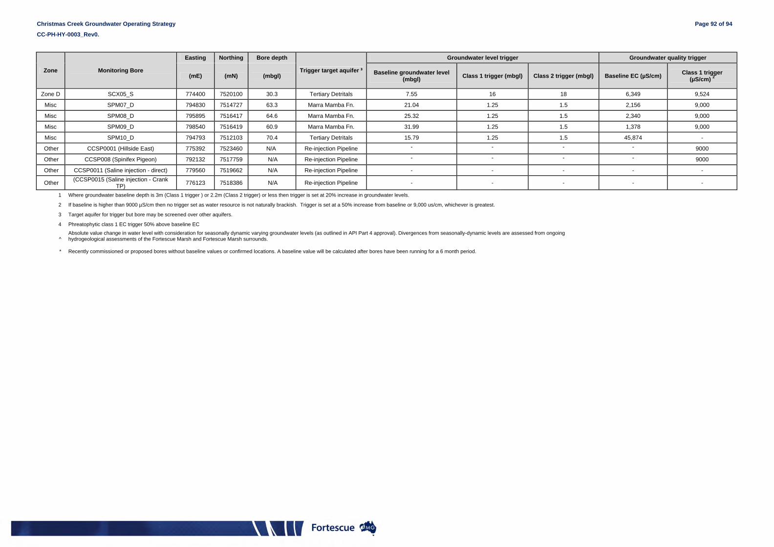
Christmas Creek Groundwater Operating Strategy Page 92 of 94
CC-PH-HY-0003_Rev0.
Zone Monitoring Bore
Easting Northing Bore depth
Trigger target aquifer ³
Groundwater level trigger Groundwater quality trigger
(mE) (mN) (mbgl) Baseline groundwater level
(mbgl) Class 1 trigger (mbgl) Class 2 trigger (mbgl) Baseline EC (µS/cm)
Class 1 trigger (µS/cm) 2
Zone D SCX05_S 774400 7520100 30.3 Tertiary Detritals 7.55 16 18 6,349 9,524
Misc SPM07_D 794830 7514727 63.3 Marra Mamba Fn. 21.04 1.25 1.5 2,156 9,000
Misc SPM08_D 795895 7516417 64.6 Marra Mamba Fn. 25.32 1.25 1.5 2,340 9,000
Misc SPM09_D 798540 7516419 60.9 Marra Mamba Fn. 31.99 1.25 1.5 1,378 9,000
Misc SPM10_D 794793 7512103 70.4 Tertiary Detritals 15.79 1.25 1.5 45,874 -
Other CCSP0001 (Hillside East) 775392 7523460 N/A Re-injection Pipeline - - - - 9000
Other CCSP008 (Spinifex Pigeon) 792132 7517759 N/A Re-injection Pipeline - - - - 9000
Other CCSP0011 (Saline injection - direct) 779560 7519662 N/A Re-injection Pipeline - - - - -
Other (CCSP0015 (Saline injection - Crank
TP) 776123 7518386 N/A Re-injection Pipeline - - - - -
1 Where groundwater baseline depth is 3m (Class 1 trigger ) or 2.2m (Class 2 trigger) or less then trigger is set at 20% increase in groundwater levels.
2 If baseline is higher than 9000 µS/cm then no trigger set as water resource is not naturally brackish. Trigger is set at a 50% increase from baseline or 9,000 us/cm, whichever is greatest.
3 Target aquifer for trigger but bore may be screened over other aquifers.
4 Phreatophytic class 1 EC trigger 50% above baseline EC
^ Absolute value change in water level with consideration for seasonally dynamic varying groundwater levels (as outlined in API Part 4 approval). Divergences from seasonally-dynamic levels are assessed from ongoing hydrogeological assessments of the Fortescue Marsh and Fortescue Marsh surrounds.
* Recently commissioned or proposed bores without baseline values or confirmed locations. A baseline value will be calculated after bores have been running for a 6 month period.

Christmas Creek Groundwater Operating Strategy Page 93 of 94
CC-PH-HY-0003_Rev0.
Rport
Appendix 10: Trigger reporting procedure

Christmas Creek Groundwater Operating Strategy Page 94 of 94
CC-PH-HY-0003_Rev0.
This page has been left blank intentionally

Operating Strategy Trigger NetworkPERTH HYDRO
Class 1 Trigger Class 2 Trigger
Reported to DoW within 72 hours
PERTH ENVIRO
Reported to EPA & SEWPaC within 7 days
PERTH ENVIRO
Report emailed and filed internallyPERTH HYDRO
Report entered into BMS
PERTH ENVIRO
Reported in Groundwater
Monitoring ReviewPERTH HYDRO
Monitoring & Sampling
MINING SERVICES
Internal data QA/QC
MINING SERVICES
Data Upload to Envirosys
MINING SERVICES
Potential trigger exceedance identified
PERTH HYDRO
Data cross checked and validated
MINING SERVICES
Data Error Trigger exceedance
Database Correction
MINING SERVICES
Bore resampledMINING SERVICES
Trigger exceedanceNo trigger exceedance
End
Investigation undertaken & report compiled
PERTH HYDRO