Embed Size (px)
Citation preview
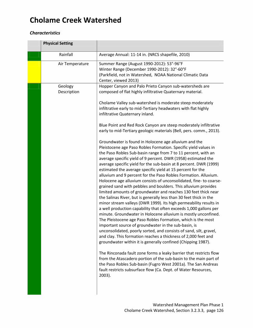
Cholame Creek Watershed
Watershed Management Plan Phase 1 Cholame Creek Watershed, Section 3.2.3.3, page 125
Hydrologic
Unit Name
Water Planning Area
Acreage Flows to Groundwater Basin(s)
Jurisdictions
Estrella 17
Cholame WPA 15
151,701 acres total with 47,300 acres in San Luis Obispo County
Estrella River– to Salinas River and Pacific Ocean (Monterey bay National Marine Sanctuary)
Paso Robles County of San Luis Obispo, Shandon (ptn)
Description:
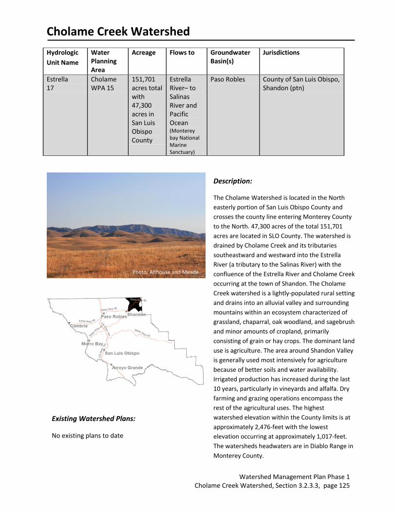
The Cholame Watershed is located in the North
easterly portion of San Luis Obispo County and
crosses the county line entering Monterey County
to the North. 47,300 acres of the total 151,701
acres are located in SLO County. The watershed is
drained by Cholame Creek and its tributaries
southeastward and westward into the Estrella
River (a tributary to the Salinas River) with the
confluence of the Estrella River and Cholame Creek
occurring at the town of Shandon. The Cholame
Creek watershed is a lightly-populated rural setting
and drains into an alluvial valley and surrounding
mountains within an ecosystem characterized of
grassland, chaparral, oak woodland, and sagebrush
and minor amounts of cropland, primarily
consisting of grain or hay crops. The dominant land
use is agriculture. The area around Shandon Valley
is generally used most intensively for agriculture
because of better soils and water availability.
Irrigated production has increased during the last
10 years, particularly in vineyards and alfalfa. Dry
farming and grazing operations encompass the
rest of the agricultural uses. The highest
watershed elevation within the County limits is at
approximately 2,476-feet with the lowest
elevation occurring at approximately 1,017-feet.
The watersheds headwaters are in Diablo Range in
Monterey County.
Existing Watershed Plans:
No existing plans to date
Photo: Althouse and Meade
Cholame Creek Watershed
Watershed Management Plan Phase 1 Cholame Creek Watershed, Section 3.2.3.3, page 126
Characteristics
Physical Setting
Rainfall Average Annual: 11-14 in. (NRCS shapefile, 2010)
Air Temperature Summer Range (August 1990-2012): 53°-96°F Winter Range (December 1990-2012): 32°-60°F (Parkfield, not in Watershed, NOAA National Climatic Data Center, viewed 2013)
Geology Description
Hopper Canyon and Palo Prieto Canyon sub-watersheds are composed of flat highly infiltrative Quaternary material. Cholame Valley sub-watershed is moderate steep moderately infiltrative early to mid-Tertiary headwaters with flat highly infiltrative Quaternary inland. Blue Point and Red Rock Canyon are steep moderately infiltrative early to mid-Tertiary geologic materials (Bell, pers. comm., 2013). Groundwater is found in Holocene age alluvium and the Pleistocene age Paso Robles Formation. Specific yield values in the Paso Robles Sub-basin range from 7 to 11 percent, with an average specific yield of 9 percent. DWR (1958) estimated the average specific yield for the sub-basin at 8 percent. DWR (1999) estimated the average specific yield at 15 percent for the alluvium and 9 percent for the Paso Robles Formation. Alluvium. Holocene age alluvium consists of unconsolidated, fine- to coarse-grained sand with pebbles and boulders. This alluvium provides limited amounts of groundwater and reaches 130 feet thick near the Salinas River, but is generally less than 30 feet thick in the minor stream valleys (DWR 1999). Its high permeability results in a well production capability that often exceeds 1,000 gallons per minute. Groundwater in Holocene alluvium is mostly unconfined. The Pleistocene age Paso Robles Formation, which is the most important source of groundwater in the sub-basin, is unconsolidated, poorly sorted, and consists of sand, silt, gravel, and clay. This formation reaches a thickness of 2,000 feet and groundwater within it is generally confined (Chipping 1987). The Rinconada fault zone forms a leaky barrier that restricts flow from the Atascadero portion of the sub-basin to the main part of the Paso Robles Sub-basin (Fugro West 2001a). The San Andreas fault restricts subsurface flow (Ca. Dept. of Water Resources, 2003).
Cholame Creek Watershed
Watershed Management Plan Phase 1 Cholame Creek Watershed, Section 3.2.3.3, page 127
Hydrology
Stream Gage Yes; USGS 11147800 (Cholame Creek near Highway 41)(USGS, viewed August 2013) Last data recorded in 1973
Hydrology Models Yes; CCRWQCB. 2011. Synthetic flow record to determine Pathogen TMDL; SLO County Flood Control and Water Conservation District, 2008, Paso Robles Groundwater Sub-basin Water Banking Feasibility Study. Limited Information for Cholame Valley Basin, Study area is Paso Sub-basin as a whole
Peak Flow 750 cfs (USGS, 1959-73) (USGS, viewed August 2013).
Base Flow 5.79 cfs (USGS, 1959-1972) (USGS, viewed August 2013).
Flood Reports No source identified
Flood Control Structures
Bridges: 2 over Cholame Creek on Cholame Valley Road and N. Bitterwater Road (PWD Bridges GIS Layer)
Areas of Flood Risk No data available
Biological Setting
Vegetation Cover Primarily non-native annual grassland with cropland, blue oak-foothill pine consisting mainly of blue oak, coastal scrub consisting mainly of California sagebrush, montane hardwood consisting mainly of oak (SLO County vegetation shapefile, 1990). Data limited by age of shapefile
Wetlands, perennial grasslands, and riparian woodland are also present in this watershed (Althouse and Meade, 2013). There is a great diversity of plant communities including Central Coast Scrub, Serpentine Scrub, Coast Live Oak Woodland, and Central Coast Cottonwood-Sycamore Riparian Forest in addition to vast areas of non-native grassland. (U.S. Department of
Transportation, 2006) Data limited to observations, not complete inventory
Invasive Species Invasive species known to occur in this watershed include: Tree of Heaven (Ailanthus altissima), Tamarisk (Tamarix spp.), Russian knapweed (Acroptilon repens), Russian thistle (Salsola tragus) (Althouse and Mead, 2013). Data limited to observations, not complete inventory
Special Status Wildlife and Plants
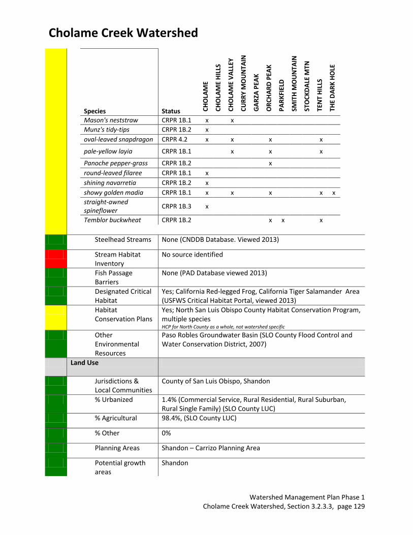
Key: FE - Federal endangered, FT - Federal threatened, SE - State endangered, ST - State threatened, SSC - State Species of Special Concern; FP- Fully Protected, SA – Special Animal, CRPR – CA rare plant rank (CNDDB, viewed August, 2013) Locations listed refer to USGS 7.5’ quadrangle names. Only the portion overlapping the watershed boundary was considered.
Cholame Creek Watershed
Watershed Management Plan Phase 1 Cholame Creek Watershed, Section 3.2.3.3, page 128
Data limited to observations, not complete inventory
Special Status Species Status CH
OLA
ME
CH
OLA
ME
HIL
LS
CH
OLA
ME
VA
LLEY
CU
RR
Y M
OU
NTA
IN
GA
RZA
PEA
K
OR
CH
AR
D P
EAK
PA
RK
FIEL
D
SMIT
H M
OU
NTA
IN
STO
CK
DA
LE M
TN
TEN
T H
ILLS
THE
DA
RK
HO
LE
Animals
American badger SSC x x
bank swallow ST x
burrowing owl
SSC (Burrow sites, some wintering sites)
x x
California red-legged frog
FT x x
California tiger salamander
FT; ST x x x
coast horned lizard SSC x x x
giant kangaroo rat FE; SE x
grasshopper sparrow SSC (Nesting)
x
mountain plover SSC (Wintering)
x x
Nelson's antelope squirrel
ST x
pallid bat SSC x x x x x x
prairie falcon SA (Nesting) x x x x x x x x x x x
San Joaquin kit fox FE; ST x x
San Joaquin whipsnake SSC x
silvery legless lizard SSC x
Tulare grasshopper mouse
SSC x x
western pond turtle SSC x x
western spadefoot SSC x x x
Plants
delicate bluecup CRPR 1B.3 x
Eastwood's buckwheat CRPR 1B.3 x x
Hall's tarplant CRPR 1B.1 x x x x
Hernandez spineflower CRPR 1B.2 x
Indian Valley bush-mallow
CRPR 1B.2 x
Lemmon's jewel-flower CRPR 1B.2 x x x
Cholame Creek Watershed
Watershed Management Plan Phase 1 Cholame Creek Watershed, Section 3.2.3.3, page 129
Species Status CH
OLA
ME
CH
OLA
ME
HIL
LS
CH
OLA
ME
VA
LLEY
CU
RR
Y M
OU
NTA
IN
GA
RZA
PEA
K
OR
CH
AR
D P
EAK
PA
RK
FIEL
D
SMIT
H M
OU
NTA
IN
STO
CK
DA
LE M
TN
TEN
T H
ILLS
THE
DA
RK
HO
LE
Mason's neststraw CRPR 1B.1 x x
Munz's tidy-tips CRPR 1B.2 x
oval-leaved snapdragon CRPR 4.2 x x x x
pale-yellow layia CRPR 1B.1 x x x
Panoche pepper-grass CRPR 1B.2 x
round-leaved filaree CRPR 1B.1 x
shining navarretia CRPR 1B.2 x
showy golden madia CRPR 1B.1 x x x x x
straight-awned spineflower
CRPR 1B.3 x
Temblor buckwheat CRPR 1B.2 x x x
Steelhead Streams None (CNDDB Database. Viewed 2013)
Stream Habitat Inventory
No source identified
Fish Passage Barriers
None (PAD Database viewed 2013)
Designated Critical Habitat
Yes; California Red-legged Frog, California Tiger Salamander Area (USFWS Critical Habitat Portal, viewed 2013)
Habitat Conservation Plans
Yes; North San Luis Obispo County Habitat Conservation Program, multiple species HCP for North County as a whole, not watershed specific
Other Environmental Resources
Paso Robles Groundwater Basin (SLO County Flood Control and Water Conservation District, 2007)
Land Use
Jurisdictions & Local Communities
County of San Luis Obispo, Shandon
% Urbanized 1.4% (Commercial Service, Rural Residential, Rural Suburban, Rural Single Family) (SLO County LUC)
% Agricultural 98.4%, (SLO County LUC)
% Other 0%
Planning Areas Shandon – Carrizo Planning Area
Potential growth areas
Shandon
Cholame Creek Watershed
Watershed Management Plan Phase 1 Cholame Creek Watershed, Section 3.2.3.3, page 130
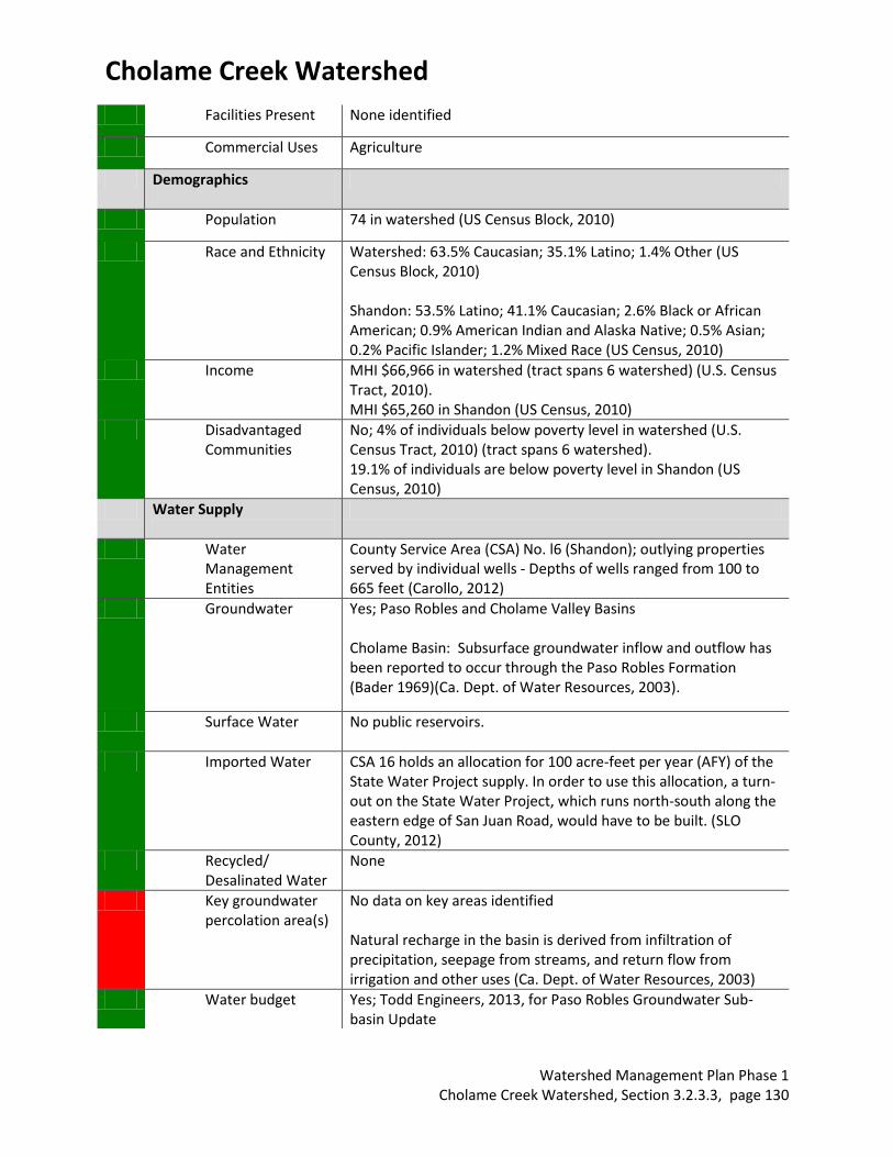
Facilities Present None identified
Commercial Uses Agriculture
Demographics
Population 74 in watershed (US Census Block, 2010)
Race and Ethnicity Watershed: 63.5% Caucasian; 35.1% Latino; 1.4% Other (US Census Block, 2010) Shandon: 53.5% Latino; 41.1% Caucasian; 2.6% Black or African American; 0.9% American Indian and Alaska Native; 0.5% Asian; 0.2% Pacific Islander; 1.2% Mixed Race (US Census, 2010)
Income MHI $66,966 in watershed (tract spans 6 watershed) (U.S. Census Tract, 2010). MHI $65,260 in Shandon (US Census, 2010)
Disadvantaged Communities
No; 4% of individuals below poverty level in watershed (U.S. Census Tract, 2010) (tract spans 6 watershed). 19.1% of individuals are below poverty level in Shandon (US Census, 2010)
Water Supply
Water Management Entities
County Service Area (CSA) No. l6 (Shandon); outlying properties served by individual wells - Depths of wells ranged from 100 to 665 feet (Carollo, 2012)
Groundwater Yes; Paso Robles and Cholame Valley Basins Cholame Basin: Subsurface groundwater inflow and outflow has been reported to occur through the Paso Robles Formation (Bader 1969)(Ca. Dept. of Water Resources, 2003).
Surface Water No public reservoirs.
Imported Water CSA 16 holds an allocation for 100 acre-feet per year (AFY) of the State Water Project supply. In order to use this allocation, a turn-out on the State Water Project, which runs north-south along the eastern edge of San Juan Road, would have to be built. (SLO County, 2012)
Recycled/ Desalinated Water
None
Key groundwater percolation area(s)
No data on key areas identified Natural recharge in the basin is derived from infiltration of precipitation, seepage from streams, and return flow from irrigation and other uses (Ca. Dept. of Water Resources, 2003)
Water budget Yes; Todd Engineers, 2013, for Paso Robles Groundwater Sub-basin Update
Cholame Creek Watershed
Watershed Management Plan Phase 1 Cholame Creek Watershed, Section 3.2.3.3, page 131
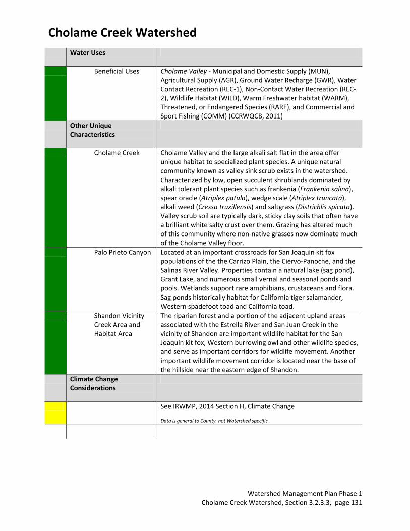
Water Uses
Beneficial Uses Cholame Valley - Municipal and Domestic Supply (MUN), Agricultural Supply (AGR), Ground Water Recharge (GWR), Water Contact Recreation (REC-1), Non-Contact Water Recreation (REC-2), Wildlife Habitat (WILD), Warm Freshwater habitat (WARM), Threatened, or Endangered Species (RARE), and Commercial and Sport Fishing (COMM) (CCRWQCB, 2011)
Other Unique Characteristics
Cholame Creek Cholame Valley and the large alkali salt flat in the area offer unique habitat to specialized plant species. A unique natural community known as valley sink scrub exists in the watershed. Characterized by low, open succulent shrublands dominated by alkali tolerant plant species such as frankenia (Frankenia salina), spear oracle (Atriplex patula), wedge scale (Atriplex truncata), alkali weed (Cressa truxillensis) and saltgrass (Districhlis spicata). Valley scrub soil are typically dark, sticky clay soils that often have a brilliant white salty crust over them. Grazing has altered much of this community where non-native grasses now dominate much of the Cholame Valley floor.
Palo Prieto Canyon Located at an important crossroads for San Joaquin kit fox populations of the the Carrizo Plain, the Ciervo-Panoche, and the Salinas River Valley. Properties contain a natural lake (sag pond), Grant Lake, and numerous small vernal and seasonal ponds and pools. Wetlands support rare amphibians, crustaceans and flora. Sag ponds historically habitat for California tiger salamander, Western spadefoot toad and California toad.
Shandon Vicinity Creek Area and Habitat Area
The riparian forest and a portion of the adjacent upland areas associated with the Estrella River and San Juan Creek in the vicinity of Shandon are important wildlife habitat for the San Joaquin kit fox, Western burrowing owl and other wildlife species, and serve as important corridors for wildlife movement. Another important wildlife movement corridor is located near the base of the hillside near the eastern edge of Shandon.
Climate Change Considerations
See IRWMP, 2014 Section H, Climate Change Data is general to County, not Watershed specific
Cholame Creek Watershed
Watershed Management Plan Phase 1 Cholame Creek Watershed, Section 3.2.3.3, page 132
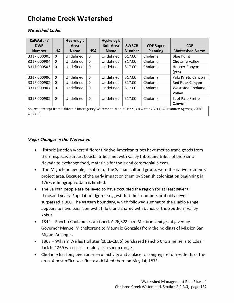
Watershed Codes
CalWater / DWR
Number HA
Hydrologic Area
Name HSA
Hydrologic Sub-Area
Name SWRCB Number
CDF Super Planning
CDF Watershed Name
3317.000903 0 Undefined 0 Undefined 317.00 Cholame Blue Point
3317.000904 0 Undefined 0 Undefined 317.00 Cholame Cholame Valley
3317.000503 0 Undefined 0 Undefined 317.00 Cholame Hopper Canyon (ptn)
3317.000906 0 Undefined 0 Undefined 317.00 Cholame Palo Prieto Canyon
3317.000902 0 Undefined 0 Undefined 317.00 Cholame Red Rock Canyon
3317.000907 0 Undefined 0 Undefined 317.00 Cholame West side Cholame Valley
3317.000905 0 Undefined 0 Undefined 317.00 Cholame E. of Palo Preito Canyon
Source: Excerpt from California Interagency Watershed Map of 1999, Calwater 2.2.1 (CA Resource Agency, 2004 Update)
Major Changes in the Watershed
Historic junction where different Native American tribes have met to trade goods from
their respective areas. Coastal tribes met with valley tribes and tribes of the Sierra
Nevada to exchange food, materials for tools and ceremonial pieces.
The Migueleno people, a subset of the Salinan cultural group, were the native residents
project area. Because of the early impact on them by Spanish colonization beginning in
1769, ethnographic data is limited.
The Salinan people are believed to have occupied the region for at least several
thousand years. Population figures suggest that their numbers probably never
surpassed 3,000. The eastern boundary, which followed summit of the Diablo Range,
appears to have been somewhat fluid and shared with bands of the Southern Valley
Yokut.
1844 – Rancho Cholame established. A 26,622 acre Mexican land grant given by
Governor Manuel Micheltorena to Mauricio Gonzales from the holdings of Mission San
Miguel Arcangel.
1867 – William Welles Hollister (1818-1886) purchased Rancho Cholame, sells to Edgar
Jack in 1869 who uses it mainly as a sheep range.
Cholame has long been an area of activity and a place to congregate for residents of the
area. A post office was first established there on May 14, 1873.
Cholame Creek Watershed
Watershed Management Plan Phase 1 Cholame Creek Watershed, Section 3.2.3.3, page 133
The Jack Ranch Café was built in 1923, serving locals and travelers alike. A clump of
ailanthus (tree of heaven) trees marks the spot of the former Cholame-Orange
schoolhouse.
In November 1966, Howard Jack sold the 21,450 hectares (53,000 acres) Cholame Ranch
to the Hearst Corp., which still owns and operates the Jack Ranch as it is commonly
known.
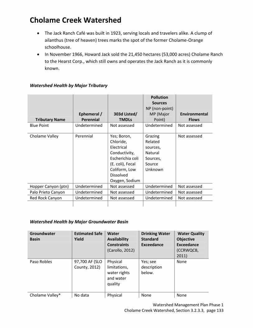
Watershed Health by Major Tributary
Tributary Name Ephemeral /
Perennial 303d Listed/
TMDLs
Pollution Sources
NP (non-point) MP (Major
Point) Environmental
Flows
Blue Point Undetermined Not assessed Undetermined Not assessed
Cholame Valley Perennial Yes; Boron, Chloride, Electrical Conductivity, Escherichia coli (E. coli), Fecal Coliform, Low Dissolved Oxygen, Sodium
Grazing Related sources, Natural Sources, Source Unknown
Not assessed
Hopper Canyon (ptn) Undetermined Not assessed Undetermined Not assessed
Palo Prieto Canyon Undetermined Not assessed Undetermined Not assessed
Red Rock Canyon Undetermined Not assessed Undetermined Not assessed
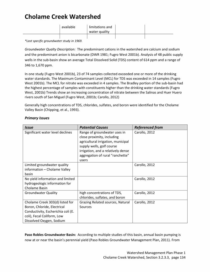
Watershed Health by Major Groundwater Basin Groundwater Basin
Estimated Safe Yield
Water Availability Constraints (Carollo, 2012)
Drinking Water Standard Exceedance
Water Quality Objective Exceedance (CCRWQCB, 2011)
Paso Robles 97,700 AF (SLO County, 2012)
Physical limitations, water rights and water quality
Yes; see description below.
None
Cholame Valley* No data Physical None None
Cholame Creek Watershed
Watershed Management Plan Phase 1 Cholame Creek Watershed, Section 3.2.3.3, page 134
available limitations and water quality
*Last specific groundwater study in 1969.
Groundwater Qualty Description: The predominant cations in the watershed are calcium and sodium
and the predominant anion is bicarbonate (DWR 1981; Fugro West 2001b). Analysis of 48 public supply
wells in the sub-basin show an average Total Dissolved Solid (TDS) content of 614 ppm and a range of
346 to 1,670 ppm.
In one study (Fugro West 2001b), 23 of 74 samples collected exceeded one or more of the drinking water standards. The Maximum Contaminant Level (MCL) for TDS was exceeded in 14 samples (Fugro West 2001b). The MCL for nitrate was exceeded in 4 samples. The Bradley portion of the sub-basin had the highest percentage of samples with constituents higher than the drinking water standards (Fugro West, 2001b) Trends show an increasing concentration of nitrate between the Salinas and Huer Huero rivers south of San Miguel (Fugro West, 2001b; Carollo, 2012)
Generally high concentrations of TDS, chlorides, sulfates, and boron were identified for the Cholame Valley Basin (Chipping, et al., 1993).
Primary Issues
Issue Potential Causes Referenced from Significant water level declines Range of groundwater uses in
close proximity, including agricultural irrigation, municipal supply wells, golf course irrigation, and a relatively dense aggregation of rural “ranchette” users
Carollo, 2012
Limited groundwater quality information – Cholame Valley basin
Carollo, 2012
No yield information and limited hydrogeologic information for Cholame Basin
Carollo, 2012
Groundwater Quality high concentrations of TDS, chlorides, sulfates, and boron
Carollo, 2012
Cholame Creek 303(d) listed for Boron, Chloride, Electrical Conductivity, Escherichia coli (E. coli), Fecal Coliform, Low Dissolved Oxygen, Sodium
Grazing Related sources, Natural Sources
Carollo, 2012
Paso Robles Groundwater Basin: According to multiple studies of this basin, annual basin pumping is
now at or near the basin’s perennial yield (Paso Robles Groundwater Management Plan, 2011). From
Cholame Creek Watershed
Watershed Management Plan Phase 1 Cholame Creek Watershed, Section 3.2.3.3, page 135
1997–2009, water levels declined on average of 2–6 feet per year, depending on the location. A Todd
Engineering monitoring report (2007) indicated that the Basin was not approaching the safe yield level
and some areas were experiencing significant declines in groundwater elevations. A later study
completed in 2009 suggested groundwater pumping was approaching the safe yield level of the Basin.
The 2010 Resource Capacity Study prepared by the San Luis Obispo County Planning Department stated
that the Basin is now near or at perennial yield levels. The County Board of Supervisors certified a Level
of Severity III for the Paso Robles Basin in October, 2012, due to declining water levels. In August 2013,
the County Board of Supervisors adopted an urgency ordinance to limit new draws from the Paso Robles
Groundwater basin.
The Paso Robles Groundwater Basin encompasses an area of approximately 790 square miles and is the
primary, and in many places the only, source of water available to property owners throughout
Northern San Luis Obispo County. The basin extends from the Garden Farms area south of Atascadero to
San Ardo in Monterey County, and from the Highway 101 corridor east to Shandon. The basin supplies
water for 29% of SLO County’s population and an estimated 40% of the agricultural production of the
County (Paso Robles Groundwater Basin Blue Ribbon Committee, 2013).
Paso Robles, Atascadero, and Templeton draw their water from the groundwater basin (primarily the
Atascadero sub-basin), the underflow of the Salinas River and from the Nacimiento Pipeline Project. The
remaining communities (Shandon, San Miguel, Creston, Bradley, Camp Roberts, Whitley Gardens, and
Garden Farms) are entirely dependent on the groundwater basin for their water supply.
An established bi-annual well monitoring program overseen by the SLO County Flood Control and Water
Conservation District reported these water declines in groundwater dependent communities (Through
April, 2013):
a. Shandon: Water levels have dropped approximately 17 feet from 2011 to 2013.
b. Creston: Water levels have dropped approximately 25 feet from 2011 to 2013.
c. Estrella: Water levels have dropped approximately 25 feet from 2011 to 2013.
d. San Juan: Water levels have dropped approximately 5 feet from 2012 to 2013.
Bibliography
Technical Reports
Althouse and Meade, Inc. 2000-2013. Published and Unpublished field notes.
Althouse and Meade, Inc. 2000-2013. Field photos for use with permission.
Bell, Ethan. (2013). Personal Communication.
Cholame Creek Watershed
Watershed Management Plan Phase 1 Cholame Creek Watershed, Section 3.2.3.3, page 136
CAL FIRE/San Luis Obispo County Fire. (2013). Unit Strategic Fire Plan.
http://www.calfireslo.org/Documents/Plans/UnitFirePlan/SLU_Unit_Fire_Plan_v13_1_(Complet
e).pdf
California Department of Water Resources. (2003). California’s Groundwater Bulletin 118 Update 2003.
http://www.water.ca.gov/pubs/groundwater/bulletin_118/california's_groundwater__bulletin_
118_-_update_2003_/bulletin118_entire.pdf
California Regional Water Quality Control Board Central Coast Region. (2011). Total Maximum Daily Load
for Fecal Indication Bacteria for the Cholame Creek Watershed, San Luis Obispo and Monterey
Counties, California.
http://www.waterboards.ca.gov/centralcoast//water_issues/programs/tmdl/docs/cholame/cho
lame_fib_tmdl_proj_rpt.pdf
Carollo. (2012). San Luis Obispo County Master Water Report.
http://www.slocountywater.org/site/Frequent%20Downloads/Master%20Water%20Plan
Chipping, D. H. (1987). The Geology of San Luis Obispo County: A Brief Description and Guide. Cal Poly
Press. San Luis Obispo, CA.
Fugro West, Inc. (2010). Paso Robles Groundwater Basin Water Balance Review and Update.
http://www.slocountywater.org/site/Water%20Resources/Reports/pdf/Paso%20Robles%20Gro
undwater%20Basin%20Water%20Balance%20Review%20and%20Update.pdf
Paloprietoconservationbank.com. 2013.
Paso Robles Groundwater Basin - Groundwater Advisory Committee. (2011). Paso Robles Basin
Groundwater Management Plan.
http://www.slocounty.ca.gov/Assets/PL/PR+Groundwater/gwp.pdf
Regional Water Quality Control Board Central Coast Region 3. (2002). Watershed management Initiative.
http://www.waterboards.ca.gov/centralcoast/water_issues/programs/wmi/docs/wmi2002_fina
l_document_revised_1_22_02.pdf
San Luis Obispo County Flood Control and Water Conservation District. (2005). Water Years 2001-02 and
2002-03 Hydrologic Report.
http://www.slocountywater.org/site/Water%20Resources/Reports/pdf/Hydrologic%20Report%
202002.pdf
San Luis Obispo County General Plan. (2011).
http://www.slocounty.ca.gov/planning/General_Plan__Ordinances_and_Elements.htm
San Luis Obispo County Board of Supervisors. (2011). Water Supply in the Paso Robles Groundwater
Basin. http://www.slocounty.ca.gov/Assets/PL/PR+Groundwater/rcs.pdf
Cholame Creek Watershed
Watershed Management Plan Phase 1 Cholame Creek Watershed, Section 3.2.3.3, page 137
San Luis Obispo County. (2012). Shandon-Carrizo Area Plan.
http://www.slocounty.ca.gov/Assets/PL/Area+Plans/Shandon-Carrizo+Inland+Area+Plan.pdf
San Luis Obispo County. 2012. Shandon Community Plan Update.
http://www.slocounty.ca.gov/planning/General_Plan__Ordinances_and_Elements/Plans_in_Pro
cess_and_Draft_Plans/Shandon_Community_Plan_Information/shandon.htm
San Luis Obispo County. (2013). North County Area Plan.
http://www.slocounty.ca.gov/Assets/PL/Draft+Plans/North.pdf
Stillwater Sciences. (2011). Development and Implementation of Hydromodification Control
Methodology. Watershed Characterization Part 1: Watershed Charcterization Part 1.
Precipitation and Landscape.
http://www.waterboards.ca.gov/rwqcb3/water_issues/programs/stormwater/docs/lid/hydrom
od_lid_docs/watershed_character_part_1.pdf
Storke, Y.A. (1891). A Memorial and Biographical History of the Counties of Santa Barbara, San Luis Obispo, and Ventura, California. http://www.rootsweb.ancestry.com/~cagha/history/sanluisobispo/creeks.txt
Todd Engineers, Geoscience. (2013). Paso Robles Groundwater Basin Water Budget. Approach and
Methodology for Water Balance Estimation, Paso Robles Groundwater Basin Model Update.
http://www.slocountywater.org/site/Water%20Resources/Water%20Forum/pdf/DRAFTWaterB
alanceEstApprMethod.pdf
U.S. Department of Transportation. (2006). Route 46 Corridor Improvement Project.
http://safer46.dot.ca.gov/pdf/FEIRVol1_web.pdf
U. S. Environmental Protection Agency. (2011). Climate Change Handbook for Regional Water Planning.
http://www.water.ca.gov/climatechange/CCHandbook.cfm
GIS Layers
Aerial Information Systems. (2008). San Luis Obispo County Vegetation Polygons. National Hydrography Dataset. (2013). San Luis Obispo County Streams. San Luis Obispo County Environmental Division. (2013). San Luis Obispo County Mines. San Luis Obispo County Planning and Building Geographic Technology and Design. (2013). Various GIS
shapefiles and layers. State Water Resources Control Board. (2013). Water Rights/Fully Appropriated Streams. United States Census Bureau Master Address File/Topologically Integrated Geographic Encoding and
Referencing Database. (2013). 2010 Census Tracts.
Cholame Creek Watershed
Watershed Management Plan Phase 1 Cholame Creek Watershed, Section 3.2.3.3, page 138
United States Department of Agriculture. (2013). Soil Survey Geographic Database
Databases
Department of Fish and Game. (2013). California Natural Diversity Database.
http://www.dfg.ca.gov/biogeodata/cnddb/
National Atlas of the United States. (2013). Streamer. http://www.nationalatlas.gov/streamer
National Oceanic and Atmospheric Administration. (2013). National Climatic Data Center.
http://www.ncdc.noaa.gov/
Surface Water Ambient Monitoring Program. (2013). CalWater 2.2.1
http://swamp.mpsl.mlml.calstate.edu/resources-and-downloads/database-management-
systems/swamp-25-database/templates-25/gis-shapefile-layers
U. S. Fish and Wildlife Service. (2013). Critical Habitat Portal. http://criticalhabitat.fw.gov/crithab
U. S. Fish and Wildlife Service. (2013). National Wetlands Inventory. http://www.fws.gov/wetlands/
U.S. Geological Survey. (2013). California Water Science Center. http://ca.water.usgs.gov/
U.S. Geological Survey. (2013). Protected Areas Database. http://gapanalysis.usgs.gov/padus/
Significant Studies in Progress:
None identified