Embed Size (px)
Citation preview

Prepared by M/s Udaipur Min-Tech Pvt. Ltd.
Smt. Roshni Devi River Bed Mining (Sand, Bajri & Stone).
STUDY PERIOD-APRIL-2012 TO JUN-2012 SURVEY N0. 189 & 60
- EXECUTIVE SUMMARY (ENGLISH & HINDI)
- ENVIRONMENTAL IMPACT ASSESSMENT
&
-ENVIRONMENTAL MANAGEMENT PLAN
FOR RIVER BED MINING PROJECT OF MINOR MINERALS
(SAND,BAJRI & STONE) Inter state Boundary of Punjab & H.P. falls in buffer zone(10km radius) of lease area
NAME OF THE RIVER – CHIKANNI
AREA–15.20 Hect. (190.01 Bighas), CATEGORY- ΄A΄ Purpose- lease renewal / Production Enhancement,
Production Capacity –58750TPA (ROM)
At: Mauza / Village-Jahndian, P.O.-Keori,
Tehsil-Nalagarh, Distt.-Solan, Himachal Pradesh.
APPLICANT EIA CONSULTANT SMT. ROSHANI DEVI M/S UDAIPUR MIN-TECH PVT. LTD. VILLAGE & P.O.- KHERA, 206-APEKSHA COMPLEX, SECTOR NO.-11
TH.-NALAGARH, DIST.- SOLAN,-174101(H.P.) HIRAN MAGARI, UDAIPUR-313002 (RAJ.)
PH-09816038133 . PH- 91-294-2489672 (OFF.)Mob. 9414167672
E mail :- [email protected],
ACCREDITED BY NABET CATEGORY “A” FOR MINING PROJECT

Prepared by M/s Udaipur Min-Tech Pvt. Ltd.
Smt. Roshni Devi River Bed Mining (Sand, Bajri & Stone).
2
CONTENTS
CHAPTER
NO.
PARTICULAR PAGE NO.
0 CERTIFICATE OF ACCREDITATION FROM
NABET
3
0 COMPLIANCE TO TERM OF REFERENCE (TOR) 11
I INTRODUCTION 17
II PROJECT DESCRIPTION 30
III DESCRIPTION OF THE ENVIRONMENT
47
IV ANTICIPATED ENVIRONMENTAL IMPACTS &
MITIGATION MEASURES
140
V ENVIRONMENTAL MONITORING PROGRAM 157
VI ADDITIONAL STUDIES 160
VII PROJECT BENEFITS 163
VIII ENVIRONMENTAL MANAGEMENT PLAN 164
IX CONCLUSION 171
X DISCLOSURE OF CONSULTANTS ENGAGED 174

Prepared by M/s Udaipur Min-Tech Pvt. Ltd.
Smt. Roshni Devi River Bed Mining (Sand, Bajri & Stone).
3

Prepared by M/s Udaipur Min-Tech Pvt. Ltd.
Smt. Roshni Devi River Bed Mining (Sand, Bajri & Stone).
4
INDEX
Sr.
No.
PARTICULAR PAGE
NO.
CHAPTER – I
INTRODUCTION
1.1 PURPOSE OF REPORT 17– 29
1.2 PROJECT PROPONENT
1.3 LEASE STATUS
1.4 BRIEF PROJECT DESCRIPTION
1.5 LEGAL STATUS OF THE PROJECT
1.6 LOCATION AND COMMUNICATION
1.7 OBJECTIVES OF ENVIORNMENTAL
MANAGEMENT PLAN
1.8 METHODOLOGY FOR EIA
1.9 SCOPE OF THE STUDY
1.10 TERMS OF REFERENCE
CHAPTER – II
PROJECT DESCRIPTION
2.0 PHYSIOGRAPHY 30 – 46
2.1 REGIONAL GEOLOGY
2.2 MINEABLE AREA
2.3 DETAILS OF EXPLORATION
2.4 MINING PROCESS
2.5 ANTICIPATED LIFE OF MINE
2.6 PROPOSED PRODUCTION
2.7 PROPSED METHOD OF MINING
2.8 USE OF MINERAL
2.9 WASTE GENERATION
2.10 UTILITIES AND PROPOSED SITE FACILITIES
CHAPTER – III
DESCRIPTION OF THE ENVIRONMENT
3.1 GENERAL 47 – 139
3.2 STUDY AREA AT A GLANCE

Prepared by M/s Udaipur Min-Tech Pvt. Ltd.
Smt. Roshni Devi River Bed Mining (Sand, Bajri & Stone).
5
3.3 TOPOGRAPHY
3.4 CLIMATIC CONDITION
3.5 PHYSIOGRAPHY
3.6 SEISMICITY OF AREA
3.7 HUMAN SETTLEMENT
3.8 HYDROLOGICAL ASPECT
3.9 ATMOSPHERIC CONDITION
3.10 AMBIENT AIR ENVIRONMENT
3.11 WIND ROSE
3.12 NOISE ENVIRONMENT
3.13 SOIL
3.14 BIOLOGICAL ASPECTS
3.15 LAND ENVIRONMENT
3.16 WATER ENVIRONMENT
3.17 SOCIO – ECONOMIC ENVIRONMENT
CHAPTER – IV
ANTICIPATED ENVIRONMENTAL IMPACTS & MITIGATION MEASURES
4.0 INTRODUCTION 140 -156
4.1 CONSTRUCTION PHASE
4.2 OPERATION PHASE
4.3 IMPACT ON CLIMATE
4.4 IMPACT ON AIR ENVIRONMENT
4.5 IMPACT ON NOISE LEVEL
4.6 IMPACT ON HYDROLOGICAL CONDITION
4.7 IMPACT ON WATER QUALITY
4.8 IMPACT ON FLORA
4.9 IMPACT ON FAUNA
4.10 IMPACT ON LAND ENVIRONMENT
4.11 IMAPCT ON SOIL
4.12 IMPACT ON SOCIO-ECONOMIC ENVIRONMENT
4.13 STRUCTURED ENVIRONMENT MANAGEMENT
ACTION PLAN
CHAPTER – V
ENVIRONMENTAL MONITORING PROGRAMME
5.1 INTRODUCTION 157 –
5.2 ENVIRONMENT MANAGEMENT

Prepared by M/s Udaipur Min-Tech Pvt. Ltd.
Smt. Roshni Devi River Bed Mining (Sand, Bajri & Stone).
6
5.3 RESPONSIBILITIES FOR ENVIRONMENTAL
MANAGEMENT CELL (EMC)
159
5.4 MONITORING SCHEDULE AND PARAMETERS
5.5 BUDGETARY PROVISION FOR ENVIRONMENTAL
MANAGEMENT
CHAPTER – VI
ADDITIONAL STUDIES
6.1 INTRODUCTION 160 –
162 6.2 RISK ASSESSMENT AND DISASTER
MANAGEMENT PLAN
CHAPTER – VII
PROJECT BENEFITS 163
CHAPTER – VIII
ENVIRONMENT MANAGEMENT PLAN 164 –
170
8.0 INTRODUCTION
8.1 LAND USE PATTERN AND RIVER COURSE
ENVIRONMENT
8.2 AIR ENVIRONMENT
8.3 NOISE ENVIRONMENT
8.4 WATER MANAGEMENT
8.5 SOLID WASTE MANAGEMENT
8.6 BIOLOGICAL ENVIRONMENT
8.7 SOCIO – ECONOMIC ENVIRONMENT
CHAPTER –IX
SUMMARY & CONCLUSION
9.0 INTRODUCTION 171 -
173 9.1 AVAILABILITY OF FUNDS FOR
ENVIRONMENTAL PROTECTION MEASURES
9.2 IMPLEMENTATION SCHEDULE
9.3 BUDGETARY PROVISION FOR ENVIRONMENTAL
MANAGEMENT
9.4 RECOMMENDATION
CHAPTER-X

Prepared by M/s Udaipur Min-Tech Pvt. Ltd.
Smt. Roshni Devi River Bed Mining (Sand, Bajri & Stone).
7
DISCLOSURE OF CONSULTANTS ENGAGED 174 –
177
LIST OF TABLES
TABLE
NO.
PARTICULAR PAGE
NO.
1.1 PROJECT DETAIL 20
1.2 PRODUCTION DETAILS 22
1.3 DATA GENERATION 26
2.1 CHARACTERISTICS OF CHIKNI KHAD
CATCHMENT 31
2.2 REGIONAL GEOLOGY 32
2.3 GENERAL GEOLOGY 33
2.4 LITHOLOGY OF THE AREA 35
2.5 AREA FOR MINING 38
2.6 MINERAL SIZE PERCENTAGE 39
2.7 PROPOSED ROTATION PLAN 40
2.8 PRODUCTION & WASTE GENERATION
IN FIVE YEARS 42
2.9 PEAK WATER REQUIREMENT 45
3.1 MEAN TEMPERATURE & RELATIVE
HUMIDITY RECORDS FROM CHANDIGARH
IMD STATIONS
62
3.2 TEMPERATURE RECORDS AND RELATIVE
HUMIDITY AT MINE SITE 63
3.3 LOCATION OF AMBIENT AIR
MONITORING STATIONS 65
3.4 PROCEDURE FOR DETERMINING
VARIOUS AIR QUALITY PARAMETERS 66
3.5 ANALYSIS OF PM10 IN AMBIENT AIR
QUALITY 67
3.6 ANALYSIS OF FREE SILICA IN PM10 67
3.7 ANALYSIS OF SOX IN AMBIENT AIR
QUALITY 68
3.8 ANALYSIS OF NOX IN AMBIENT AIR
QUALITY 69
3.9 COMPARISON OF AIR MONITORING 70

Prepared by M/s Udaipur Min-Tech Pvt. Ltd.
Smt. Roshni Devi River Bed Mining (Sand, Bajri & Stone).
8
RESULTS
3.10 (A)
to (B)
NOISE LEVEL WITHIN THE STUDY AREA 76
3.11 TRAFFIC DENSITY 78
3.12 LOCATION OF SOIL SAMPLING 80
3.12 (A)
& (B)
SOIL SAMPLE ANALYSIS & STANDARD 80 - 81
3.13 LIST OF SAMPLING LOCATION FOR
BIOLOGICAL STUDY 83
3.14 FOREST WITH IN 10 KM RADIUS 87
3.15 FLORA 92-98
3.16 (A)
& (B)
FAUNA 99-100
3.17 LAND USE PATTERN 104
3.18 AGRICULTURAL YIELD IN STUDY AREA 108
3.19 LOCATION OF WATER SAMPLE STATIONS 111
3.20 WATER ANALYSIS 112-117
3.21 LIST OF SAMPLE VILLAGES FOR SOCIO-
ECONOMICS SURVEY 119
3.22 DEMOGRAFIC STRUCTURE 120-124
3.23 DEMOGRAPHIC SUMMARY OF THE STUDY
AREA 125
3.24 INFRASTRUCTURE RESOURCE BASE OF
THE STUDY AREA 130-132
3.25 MAIN WORKER EMPLOYMENT PATTERN 133-134
4.1 CUMULATIVE CONCENTRATION OF PM
DUE TO EMISSIONS FROM MINING
ACTIVITIES (1 KM)
145
4.2 NOISE GENERATED BY DIFFERENT
MACHINERY 147
4.3 FREE NOISE ATTENUATION WITH
DISTANCE 147
4.4 PERMISSIBLE EXPOSURE INCASES OF
CONTINUOUS NOISE 148
4.4.1 AMBIENT AIR QUALITY STANDARD IN
RESPECT OF NOISE 148
4.5 ENVIRONMENT MANAGEMENT MATRIX 156
5.1 MONITORING SCHEDULEE FOR
ENVIRONMENTAL PARAMETERS 158
5.2 COST OF ENVIRONMENTAL PROTECTION 159

Prepared by M/s Udaipur Min-Tech Pvt. Ltd.
Smt. Roshni Devi River Bed Mining (Sand, Bajri & Stone).
9
MESURES
9.1 MONITORING SCHEDULEE FOR
ENVIRONMENTAL PARAMETERS 172
9.2 COST OF ENVIRONMENTAL PROTECTION
MESURES 172
LIST OF FIGURES
FIG NO. PARTICULAR PAGE NO.
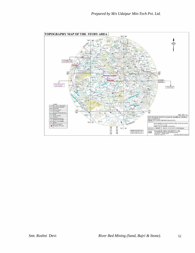
3.1 TOPOGRAPHY MAP OF THE STUDY AREA 52
3.2 DRAINAGE PATTERN OF THE STUDY AREA 56
3.2 A HYDROGEOLOGY CHARACTERISTIC MAP 60
3.3 AIR SAMPLING LOCATION MAP 64
3.4 WIND ROSE (APRIL TO JUN 2012) 73
3.5 TRAFFIC DENSITY AND NOISE MONITORING
LOCATION
74
3.6 SOIL SAMPLING MAP 79
3.7 RF/PF FOREST MAP 84
3.8 BIODIVERSITY FHOTOGRAPHS OF MINE
LEASE
91
3.9 LANDUSE PATTERN OF STUDY AREA BASED
ON SATELLITE IMAGE
105
3.9 A SATELLITE IMAGE OF LEASE AREA 107
3.10 WATER SAMPLLING MAP 110
3.11 POPULATION DISTRIBUTION IN STUDY AREA 126
3.12 EMPLOYMENT PATTERN OF WORKING
POPULATION IN THE STUDY AREA
127
3.13 LATERACY RATE OF THE STUDY AREA 127
3.14 EMPLOYMENT PATTERN OF THE STUDY AREA 135
4.1 SCHEMATIC REPRESENTATION OF GROUND
WATER IN SITE
150

Prepared by M/s Udaipur Min-Tech Pvt. Ltd.
Smt. Roshni Devi River Bed Mining (Sand, Bajri & Stone).
10
LIST OF PLATES
PLATE
NO.
PARTICULAR
1.0 ROUTE MAP
2.0 SURFACE GEOLOGICAL PLAN & SECTIONS
3.0 SURFACE LAYOUT PLAN & SECTIONS
LIST OF ANNEXURES
ANNEXURE NO. PARTICULAR
I COPY OF TOR LETTER
II COPY OF ALLOTMENT OF MINING LEASE FOR
MINOR MINERALS
III COPY OF TRANSFER DEED OF MINING LEASE
IV COPY OF JAMABANDY WITH KHASRA MAP
V COPY OF PRODUCTION DETAILS

Prepared by M/s Udaipur Min-Tech Pvt. Ltd.
Smt. Roshni Devi River Bed Mining (Sand, Bajri & Stone).
11
POINT TO BE CLARIFIED TO THE EXPERT APPRAISAL COMMITTEE,
(EAC), MINISTRY OF ENVIRONMENT & FORESTS (MOEF), NEW DELHI
AS PER THE APPROVED TOR FOR RIVER BED MINING OF MINOR
MINERALS viz. SAND , BAJARI & STONE OF SMT. ROSHNI DEVI,
RIVER- CHIKKANI , VILLAGE JHANDIAN, TALUKA NALAGARH, DIST-
SOLAN (HIMACHAL PRADESH), LEASE AREA –15.2 HECT .
Sl. No.
as
per
MOEF
Description as per MOEF Covered in EIA as per details
I Year-wise production details since
2006 after the EIA Notification,2006
coming into force.
Year-wise production details since 2006
after the EIA Notification, 2006 coming in
to force is given in Table No.1.2 on Page
No.22
Ii A copy of the document in support of
the fact that the proponent is the
rightful lessee of the mine should be
given.
Enclosed annexure-II
iii All documents including approved
mine plan,(eco friendly mine plan),
EIA report and Public hearing should
be compatible with one another in
terms of the mine lease area,
production levels, waste generation
and its management and mining
Technology .
Details are given in chapter-II of
EIA/EMP report.
Iv The terms and condition imposed, if
any, by the Competent Authority in
the state government while granting
mining lease / permit / contract should
be built into the mine plan (eco
friendly mine plan), as well as the EIA
report. It may inter – alia include; area
of working (length and breadth of the
river stretch), mode of working shift,
transportation of mineral, restriction,
if any imposed for working etc.
Details are given in chapter-II of
EIA/EMP report.
V Involvement of forestland, if any, in
the project and status of forestry
clearance should be given.
No forst land involves in mine lease area.
vi The study area will comprise of 10 km
zone around the mine lease from lease
periphery and the data contained in
Plz. Refer Page No. 44 in Chapter No. III of
EIA report.
Prepared by M/s Udaipur Min-Tech Pvt. Ltd.
Smt. Roshni Devi River Bed Mining (Sand, Bajri & Stone).
12
the EIA such as waste generation etc.
should be for the life of the mine / lease
period.
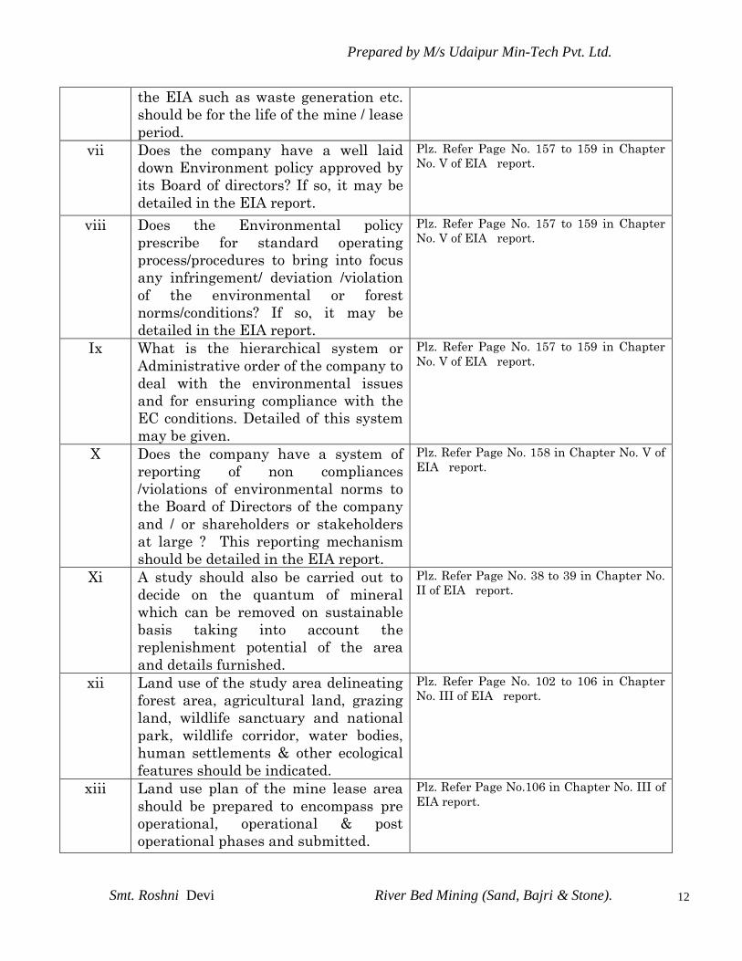
vii Does the company have a well laid
down Environment policy approved by
its Board of directors? If so, it may be
detailed in the EIA report.
Plz. Refer Page No. 157 to 159 in Chapter
No. V of EIA report.
viii Does the Environmental policy
prescribe for standard operating
process/procedures to bring into focus
any infringement/ deviation /violation
of the environmental or forest
norms/conditions? If so, it may be
detailed in the EIA report.
Plz. Refer Page No. 157 to 159 in Chapter
No. V of EIA report.
Ix What is the hierarchical system or
Administrative order of the company to
deal with the environmental issues
and for ensuring compliance with the
EC conditions. Detailed of this system
may be given.
Plz. Refer Page No. 157 to 159 in Chapter
No. V of EIA report.
X Does the company have a system of
reporting of non compliances
/violations of environmental norms to
the Board of Directors of the company
and / or shareholders or stakeholders
at large ? This reporting mechanism
should be detailed in the EIA report.
Plz. Refer Page No. 158 in Chapter No. V of
EIA report.
Xi A study should also be carried out to
decide on the quantum of mineral
which can be removed on sustainable
basis taking into account the
replenishment potential of the area
and details furnished.
Plz. Refer Page No. 38 to 39 in Chapter No.
II of EIA report.
xii Land use of the study area delineating
forest area, agricultural land, grazing
land, wildlife sanctuary and national
park, wildlife corridor, water bodies,
human settlements & other ecological
features should be indicated.
Plz. Refer Page No. 102 to 106 in Chapter
No. III of EIA report.
xiii Land use plan of the mine lease area
should be prepared to encompass pre
operational, operational & post
operational phases and submitted.
Plz. Refer Page No.106 in Chapter No. III of
EIA report.
Prepared by M/s Udaipur Min-Tech Pvt. Ltd.
Smt. Roshni Devi River Bed Mining (Sand, Bajri & Stone).
13
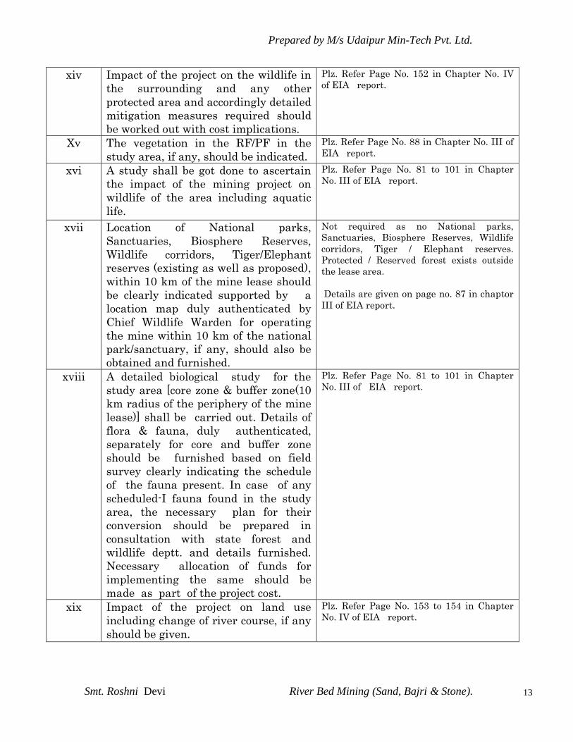
xiv Impact of the project on the wildlife in
the surrounding and any other
protected area and accordingly detailed
mitigation measures required should
be worked out with cost implications.
Plz. Refer Page No. 152 in Chapter No. IV
of EIA report.
Xv The vegetation in the RF/PF in the
study area, if any, should be indicated.
Plz. Refer Page No. 88 in Chapter No. III of
EIA report.
xvi A study shall be got done to ascertain
the impact of the mining project on
wildlife of the area including aquatic
life.
Plz. Refer Page No. 81 to 101 in Chapter
No. III of EIA report.
xvii Location of National parks,
Sanctuaries, Biosphere Reserves,
Wildlife corridors, Tiger/Elephant
reserves (existing as well as proposed),
within 10 km of the mine lease should
be clearly indicated supported by a
location map duly authenticated by
Chief Wildlife Warden for operating
the mine within 10 km of the national
park/sanctuary, if any, should also be
obtained and furnished.
Not required as no National parks,
Sanctuaries, Biosphere Reserves, Wildlife
corridors, Tiger / Elephant reserves.
Protected / Reserved forest exists outside
the lease area.
Details are given on page no. 87 in chaptor
III of EIA report.
xviii A detailed biological study for the
study area [core zone & buffer zone(10
km radius of the periphery of the mine
lease)] shall be carried out. Details of
flora & fauna, duly authenticated,
separately for core and buffer zone
should be furnished based on field
survey clearly indicating the schedule
of the fauna present. In case of any
scheduled-I fauna found in the study
area, the necessary plan for their
conversion should be prepared in
consultation with state forest and
wildlife deptt. and details furnished.
Necessary allocation of funds for
implementing the same should be
made as part of the project cost.
Plz. Refer Page No. 81 to 101 in Chapter
No. III of EIA report.
xix Impact of the project on land use
including change of river course, if any
should be given.
Plz. Refer Page No. 153 to 154 in Chapter
No. IV of EIA report.

Prepared by M/s Udaipur Min-Tech Pvt. Ltd.
Smt. Roshni Devi River Bed Mining (Sand, Bajri & Stone).
14
Xx Impact on topography, drainage,
agriculture fields, cattale fields,
wildlife, water logging leading to water
borne diseases, if any . it may also be
shown whether it will lead to change of
watercourse of the river. Modeling
exercise should also be carried out
through an expert agency to snow the
change in river flow dynamics, if any.
No change in watercourse of the river.
xxi Collection of one season (non-
monsoon) primary baseline data on
ambient air quality (PM10, SO2 and
NOx), water quality, noise level, soil
and flora and fauna site specific
metrological data should also be
collected. The location of the
monitoring stations should be justified.
Date wise collected baseline AAQ data
should form part of EIA and EMP
report. The mineralogical composition
of PM10 particularly for free silica
should be given. There should be at
least one monitoring station within
500 m of the mine lease in the pre-
dominant downwind direction.
Plz. Refer Page No. 61 to 137 in Chapter
No. III of EIA report.
xxii Air quality modeling should be carried
out for prediction of impact of the
project on the air quality of the area. It
should also take in to account the
impact of movement of vehicles for
transportation of mineral. The details
of the model used and the input
parameters used for modeling should
be provided. The Air quality contours
may be shown on the location map
clearly indicating the location of site,
location of sensitive receptors, if any,
and habitation. The wind roses
showing pre-dominant wind direction
may also be indicated on the map. The
impact of stone crusher nearby should
also be taken into account.
The details of the air quality
modeling is given in chapter 4.0,
page- 143 to 144.
The details of the inputs, model
used, receptors and GLC contours
are given in the respective Table 4.1
on page-144.

Prepared by M/s Udaipur Min-Tech Pvt. Ltd.
Smt. Roshni Devi River Bed Mining (Sand, Bajri & Stone).
15
xxiii The water requirement for the project,
its availability and source to be
furnished. A detailed water balance
should also be provided. Fresh water
requirement for the project should be
indicated.
Total water requirement 7.15 KLD .
The availability of water from bore
well outside mine lease area,
therefore No permission is require.
The mining will not intersect ground
water level also. Page no. 42 to 43 in
chapter –II.
xxiv Necessary clearance from the
Competent Authority for drawl of
requisite quantity of water for the
project should be provided.
Total water requirement 7.15 KLD .
The availability of water from bore
well outside mine lease area,
therefore No permission is require.
xxv Impact of the project on the water
quality should be assessed and
necessary safeguard measures, if any
required, should be provided.
No impact on surface as well as
ground water because no waste
water will be discharged due to
mining and mining will be restricted
above ground water.
xxvi Information on site elevation, working
depth, groundwater table should be
provided both in AMSL and bgl. A
schematic diagram should also be
provided for the same.
Schematic diagram is given on page
no. 150 of EIA report.
xxvii Quantity of solid waste generation, if
any, should be estimated and details
for its disposal and management
should be provided.
Plz. Refer Page No. 41 in Chapter
No. II of EIA report.
xxviii Impact on local transport
infrastructure due to the project.
Projected increase in truck traffic as
result of the project in the present road
network (including those outside the
project area) and whether it is
capable of handling the increased
load. Arrangement for improving the
infrastructure, if contemplated,
(including action to be taken by other
agencies such as State Government)
should be covered.
Not much impact on local transport
as only 5 dumpers/ day will be
required for transport of mineral
from mine. Increase in truck traffic
is negligible and capable of handling
the increased load. State govt.
conduct traffic census regularly and
take action accordingly. However
monitoring of traffic density in
table 3.12. on Page 75.
xxix Details of the infrastructure facilities
to be provided for the mine workers
should be furnished.
Office cum store exists adjoined to
the lease area of the same lessee
facilitated with toilet, rest shelter,
first aid room, telephone & safety
equipments like helmets, safety boot
etc.
Prepared by M/s Udaipur Min-Tech Pvt. Ltd.
Smt. Roshni Devi River Bed Mining (Sand, Bajri & Stone).
16
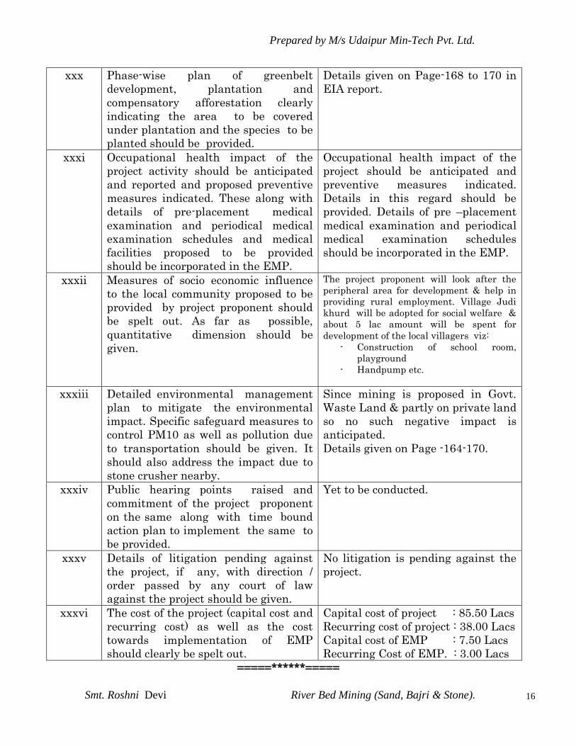
xxx Phase-wise plan of greenbelt
development, plantation and
compensatory afforestation clearly
indicating the area to be covered
under plantation and the species to be
planted should be provided.
Details given on Page-168 to 170 in
EIA report.
xxxi Occupational health impact of the
project activity should be anticipated
and reported and proposed preventive
measures indicated. These along with
details of pre-placement medical
examination and periodical medical
examination schedules and medical
facilities proposed to be provided
should be incorporated in the EMP.
Occupational health impact of the
project should be anticipated and
preventive measures indicated.
Details in this regard should be
provided. Details of pre –placement
medical examination and periodical
medical examination schedules
should be incorporated in the EMP.
xxxii Measures of socio economic influence
to the local community proposed to be
provided by project proponent should
be spelt out. As far as possible,
quantitative dimension should be
given.
The project proponent will look after the
peripheral area for development & help in
providing rural employment. Village Judi
khurd will be adopted for social welfare &
about 5 lac amount will be spent for
development of the local villagers viz:
- Construction of school room,
playground
- Handpump etc.
xxxiii Detailed environmental management
plan to mitigate the environmental
impact. Specific safeguard measures to
control PM10 as well as pollution due
to transportation should be given. It
should also address the impact due to
stone crusher nearby.
Since mining is proposed in Govt.
Waste Land & partly on private land
so no such negative impact is
anticipated.
Details given on Page -164-170.
xxxiv Public hearing points raised and
commitment of the project proponent
on the same along with time bound
action plan to implement the same to
be provided.
Yet to be conducted.
xxxv Details of litigation pending against
the project, if any, with direction /
order passed by any court of law
against the project should be given.
No litigation is pending against the
project.
xxxvi The cost of the project (capital cost and
recurring cost) as well as the cost
towards implementation of EMP
should clearly be spelt out.
Capital cost of project : 85.50 Lacs
Recurring cost of project : 38.00 Lacs
Capital cost of EMP : 7.50 Lacs
Recurring Cost of EMP. : 3.00 Lacs
=====******=====

Prepared by M/s Udaipur Min-Tech Pvt. Ltd.
Smt. Roshni Devi River Bed Mining (Sand, Bajri & Stone).
17
CHAPTER - I
INTRODUCTION
Mining Environment and development have become complimentary to
each other. As a result of developmental activities visible ill-effects
of the environmental degradation are clear and give signals of the
concern. Therefore a sustainable development of the area involving
extraction of mineral wealth vis-à-vis protection of environment is
the ultimate solution for betterment of mankind.
1.1 PURPOSE OF REPORT
The Environmental Management Plan has been prepared to assess
the current environmental scenario of the area and then based on
the activities of mining proposed, to carry out Environmental
Impact Assessment. The plan will identify and address the impacts,
where these are adverse in nature, and thereafter design
mitigative measures to manage such impacts in a manner as to
conserve environment and ecology of the area. The EMP has been
prepared with a view to ultimately ensure that the adverse
impacts are minimized if these cannot be prevented altogether.
Environmental clearance is a statutory requirement for the new
and old establishment of any mining project of which EIA has to be
prepared and submitted to respective agencies of state and center
level in line with EIA Notification, 1994.
As per new EIA Notification Dated 14th Sept. 2006, Environmental
Clearance is required at the time of renewal of mining lease &
enhancement of production where in the area is 5.00 hect & above .
this project fall under category “A”, project or activity -1 (a) 4 as it
attracts the general condition {interstate boundary of Panjab –

Prepared by M/s Udaipur Min-Tech Pvt. Ltd.
Smt. Roshni Devi River Bed Mining (Sand, Bajri & Stone).
18
himachal pradesh at a distance of 5.5 km therefore this project
requires Environment clearance from MOEF New Delhi.
Lessee decided to get Environmental Clearance under renewal of lease
and enhancement of production both categories.
The application for EC was submitted to EAC, MOEF, New Delhi.
Meeting held with the EAC (mining) on dated 21st Oct., 2011 and
issued TOR letter no. J-11015/137/2011-IA.II (M) Dated 09th January,
2012. For preparation of an Environment Impact Assessment (EIA)
Report in respect of the project. (Refer Annexure No.1)
1.2. IDENTIFICATION OF PROJECT AND PROJECT PROPONENT
1.2.1 Identification of Project
Name of the project: River bed mining of sand, bajri &
stone (Miner mineral)
(ML area 15.02 ha) renewal of lease
and production 58750 TPA (ROM).
Location of the project: At khasra no.189 & 60, village- Mauza
Jhandian, Post- Keori, Th.- Nalagarh, Distt.-
Solan.
1.2.2 Identification of Proponent
Applicant: Smt Roshini Devi w/o late sh. Hakam Ram,
Village- Khera, P.O. and Tehsil- Nalagarh,
District- Solan, (H.P.). Pin code-174101.
1.3 LEASE STATUS
Smt Roshini Devi w/o late sh. Hakam Ram, resident of Village-
Khera, P.O. and Tehsil- Nalagarh, District- Solan, has been transferred
a mining lease for extraction of Sand ,Bajri and stones over an area of
190.01 bighas ( 15.320 hectares). The lease was previously granted to

Prepared by M/s Udaipur Min-Tech Pvt. Ltd.
Smt. Roshni Devi River Bed Mining (Sand, Bajri & Stone).
19
Her husband Late Mr. Hakam Ram (applicant) was engaged in minor
minerals mining profession since last 3-4 years. The Applicant was
experienced person in mining profession with a sound financial
background. The applicant has also setup a stone crusher near lease
area to process the stones. The applicant have an unblemished track-
record of doing mining operations absolutely in accordance with the
terms and conditions of lease –deed in safe, scientific and environment
friendly manner.
After the death of Mr. Hakam Ram, the lease was transferred to Smt.
Roshini Devi, as the overall business setup was transferred to her
Name, being his wife.
1.4 BRIEF PROJECT DESCRIPTION
The mining lease for extraction of Sand, Bajri and stone has been
granted for an area of 190.01 bighas ( 15.20 hectares). The area is
situated at Mauza –Jhandian ( Khasra no. 189 & 60) in Tehsil –
Nalagarh, District- Solan, State – Himachal Pradesh.
The area was granted in favor of late Mr.Hakam Ram, vide order no.
Udhyog - Bhu(Khani-4)Laghu-12/07-1074 dated 08.05.2007 of lease
period for manufacture of grit. The lease was registered and executed
on 10.08.2007 for a period from 10.08.2007 up to lease period.
After the death of Mr. Hakam Ram , the lease was transferred to Smt.
Roshini Devi, as the overall business setup was transferred to her
Name, being his wife.
Prepared by M/s Udaipur Min-Tech Pvt. Ltd.
Smt. Roshni Devi River Bed Mining (Sand, Bajri & Stone).
20
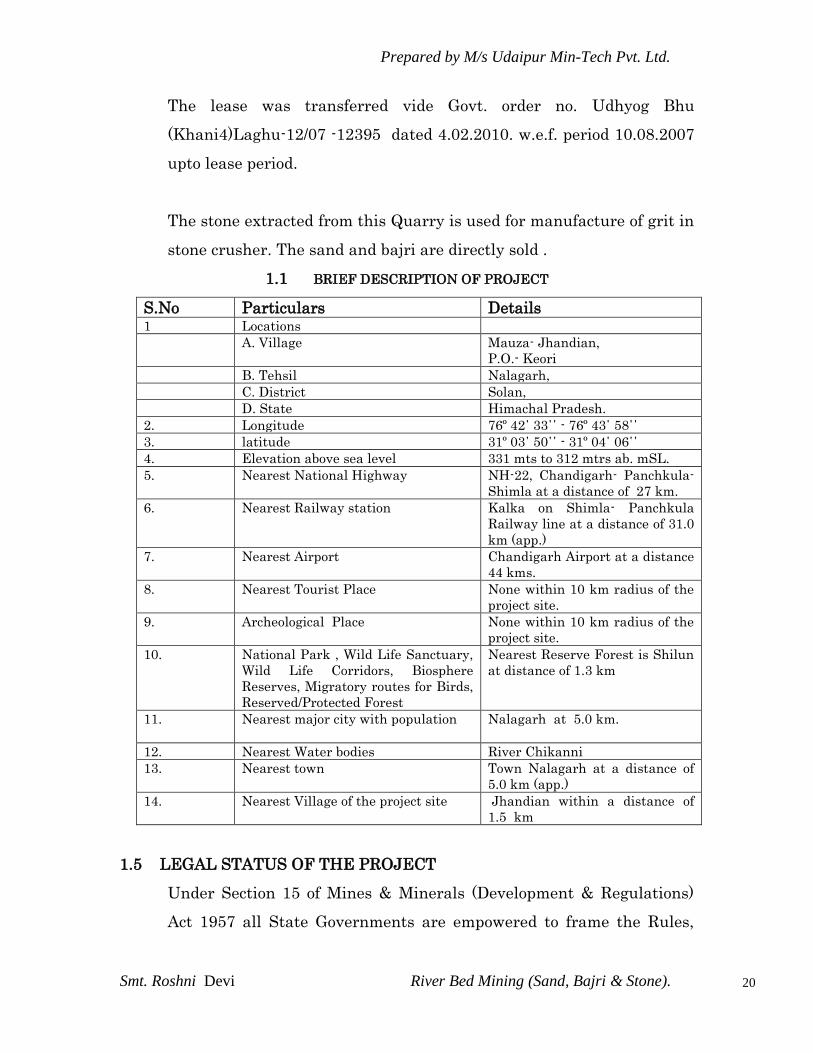
The lease was transferred vide Govt. order no. Udhyog Bhu
(Khani4)Laghu-12/07 -12395 dated 4.02.2010. w.e.f. period 10.08.2007
upto lease period.
The stone extracted from this Quarry is used for manufacture of grit in
stone crusher. The sand and bajri are directly sold .
1.1 BRIEF DESCRIPTION OF PROJECT
S.No Particulars Details 1 Locations
A. Village Mauza- Jhandian,
P.O.- Keori
B. Tehsil Nalagarh,
C. District Solan,
D. State Himachal Pradesh.
2. Longitude 76º 42΄ 33΄΄ - 76º 43΄ 58΄΄
3. latitude 31º 03΄ 50΄΄ - 31º 04΄ 06΄΄
4. Elevation above sea level 331 mts to 312 mtrs ab. mSL.
5. Nearest National Highway NH-22, Chandigarh- Panchkula-
Shimla at a distance of 27 km.
6. Nearest Railway station Kalka on Shimla- Panchkula
Railway line at a distance of 31.0
km (app.)
7. Nearest Airport Chandigarh Airport at a distance
44 kms.
8. Nearest Tourist Place None within 10 km radius of the
project site.
9. Archeological Place None within 10 km radius of the
project site.
10. National Park , Wild Life Sanctuary,
Wild Life Corridors, Biosphere
Reserves, Migratory routes for Birds,
Reserved/Protected Forest
Nearest Reserve Forest is Shilun
at distance of 1.3 km
11. Nearest major city with population Nalagarh at 5.0 km.
12. Nearest Water bodies River Chikanni
13. Nearest town Town Nalagarh at a distance of
5.0 km (app.)
14. Nearest Village of the project site Jhandian within a distance of
1.5 km
1.5 LEGAL STATUS OF THE PROJECT
Under Section 15 of Mines & Minerals (Development & Regulations)
Act 1957 all State Governments are empowered to frame the Rules,
Prepared by M/s Udaipur Min-Tech Pvt. Ltd.
Smt. Roshni Devi River Bed Mining (Sand, Bajri & Stone).
21
Regulations and Guidelines in respect of mining of minor minerals
within the said state. Exercising its powers conferred under section 15
of Mines & Minerals (Development & Regulations) Act 1957, State
Government of Himachal Pradesh framed relevant Minor minerals
Mining rules referred as Himachal Pradesh Minor Minerals
(Concession) Rules 1971 provides method for allotments of Minor
Minerals Concessions as follows:
The mining lease for excavation of minor mineral ( Sand, Bajri and
stones ) will be granted to the persons or parties , who will set up a
industrial crusher in the state for processing of stones to grit, And
this shall be committed by Please holder and will be a primary
condition for grant of the lease.
In accordance of the above the lessee applied for mining lease as well
as proposal for set up of stone crusher to the state Govt.
The area was granted in favor of late Mr.Hakam Ram, vide order no.
Udhyog -Bhu (Khani-4)Laghu-12/07/1074 dated 08.05.2007 for lease
period for mining of minor mineral to be used in manufacture of grit.
After the death of Mr. Hakam Ram, the lease was transferred to Smt.
Roshini Devi, as the overall business setup was transferred to her
Name, being his wife.
The lease was transferred vide Govt. order no. Udhyog-Bhu(Khani-
4)Laghu-12/07 -12395 dated 4.02.2010 .lease period w.e.f.10.08.2007
up to the lease period.
The Transfer of lease was registered and executed on date 26.11.2010.

Prepared by M/s Udaipur Min-Tech Pvt. Ltd.
Smt. Roshni Devi River Bed Mining (Sand, Bajri & Stone).
22
The area was inspected on 08.02.2007 by a joint committee of
revenue officials, pollution control board, and mining department and
other official to verify and assess the viability of the project.
As per New EIA Notification 14th Sept. 2006, Lessee is wants
Environmental Clearance from MoEF, New Delhi, for expansion of
Production capacity of 45000Tons/ Annum to 58750 Tons/ Annum of
Minor Mineral (Sand, Bajri & Stone) for a renewal lease period(5
years).
The mining lease area was applied for renewal on dated 20th June 2012
for next 5 years and lessee made application for Environment
clearance on renewal is pending for same production @ 58750 /- tone
/annum.
The mining method will be opencast and will be carried out
manually. The targeted production of Sand, Bajri & Stone mineral will
about 58750 Tones / annum. Production details from year 2006
onwards:
TABLE NO.1.2 PRODUCTION DETAILS
YEAR Sand, Bajari,& stone (IN MT)
2007-08 2100
2008-09 26943
2009-10 58852
2010-11 63953
1.6 LOCATION AND COMMUNICATION
1.6.1 Location
The mining lease area under reference is situated in village –
Jhandian, Tehsil- Nalagarh, District- Solan of Himachal Pradesh. The
area is approachable by Tar road to Jhandian village from Nalagarh in
NNE direction. The area lies at a distance of 5.00 Kms from Nalagarh

Prepared by M/s Udaipur Min-Tech Pvt. Ltd.
Smt. Roshni Devi River Bed Mining (Sand, Bajri & Stone).
23
Town, in Jhandian village. The river-beds are approached by the
approach road from Jhandian village at a distance of 1.5 Km. The
Nalagarh can be approached by Tar road from Solan ( district H.Q.) at
a distance of 85 kms.
The Nearest Railway station is at Kalka at a Distance 31.0 Km on
Panchkula Shimla Broad Gauge Railway Line. The Nearest National
highway NH-22 is Panchkula- Solan- Shimla at a distance of 27 kms.
1.6.2 Communication
Road link
The area lies at a distance of 5.00 Kms from Nalagarh Town, in
Jhandian village. The river-beds are approached by the approach road
from Jhandian village at a distance of 1.5 Km. The Nalagarh can be
approached by Tar road from Solan ( district H.Q.) at a distance of 85
kms. (Refer Route Map, Plate No. 1)
Rail link
The Nearest Railway station is at Kalka at a Distance 31.0 Km on
Panchkula Shimla Broad Gauge Railway Line. The Nearest National
highway NH-22 is Panchkula- Solan- Shimla at a distance of 27 kms.
Air link
The Nearest Airport is Chandigarh Airport At a Distance of 44.0 kms.
There is regular air service between Mumbai- Chandigarh - Jaipur
– Delhi.

Prepared by M/s Udaipur Min-Tech Pvt. Ltd.
Smt. Roshni Devi River Bed Mining (Sand, Bajri & Stone).
24
1.6.3 Basic Amenities
Power
No electric power supply is available at mine site. In future, if
electricity will require for lighting purpose then lessee will apply
and get connection.
Amenities
The nearest police station and tehsil headquarter is at nalagarh,
which is about 5 Kms from mine.
The Controlling office of Deptt. Of Mines & Geology is at Solan which
is 42 Kms ESE from mine. Telephone facility is available at the mine
office. Drinking water facility by means of dug well situated near
village in the river beds. The analysis of which reveals that the water
is potable in nature.
1.7 OBJECTIVES OF ENVIRONMENTAL MANAGEMENT PLAN
The main objectives of this EMP are listed below:
* To establish the present environmental scenario.
* To anticipate the impacts of proposed future mining
operations on the environment.
* To prepare a detailed action plan for implementation of
mitigative measures.
* To suggest preventive and mitigative measures to
minimize adverse impact and to maximize beneficial
impacts.
* To prepare a compensatory afforestation scheme.
* To suggest a monitoring programmed to evaluate the
effectiveness of mitigative measures.

Prepared by M/s Udaipur Min-Tech Pvt. Ltd.
Smt. Roshni Devi River Bed Mining (Sand, Bajri & Stone).
25
* To suggest the formation of a core group responsible for
implementation of environmental control and protective
measures and monitoring of such implementation.
* To suggest a feedback mechanism enabling to make
Mid - course corrections.
* To prepare a capital cost estimate and annual recurring
cost for Environmental Management Plan.
1.8 METHODOLOGY FOR EIA
M/s. Udaipur Min–Tech Pvt. Ltd. was assigned the job of conduction
of EIA report of the proposed river bed mining project of minor
mineral (sand, bajri, & stone) river –chikkani, near village Jhandian
of Smt. Roshni devi w/o Hakam Ram.
The study was conducted within 10 Km radius from the proposed mine
as centre. The base line data collection involves the data‟s of air
quality, water status, land use, socio-economic structure of the study
area, existing flora, fauna, prevailing noise levels, along with the
physiographical status and meteorological conditions of the area. The
current report is based on the mining technique, air emissions, waste
water generation and discharge, and solid waste management. It also
highlights the storage and safety measures adopted for handling of
explosive.
Effective plans to mitigate the adverse impacts and suggestive
pollution control measures along with environmental management
plan have been summarized.
1.9 SCOPE OF THE STUDY
The terms of reference on the basis of which the EIA has been
prepared are given below:
Prepared by M/s Udaipur Min-Tech Pvt. Ltd.
Smt. Roshni Devi River Bed Mining (Sand, Bajri & Stone).
26
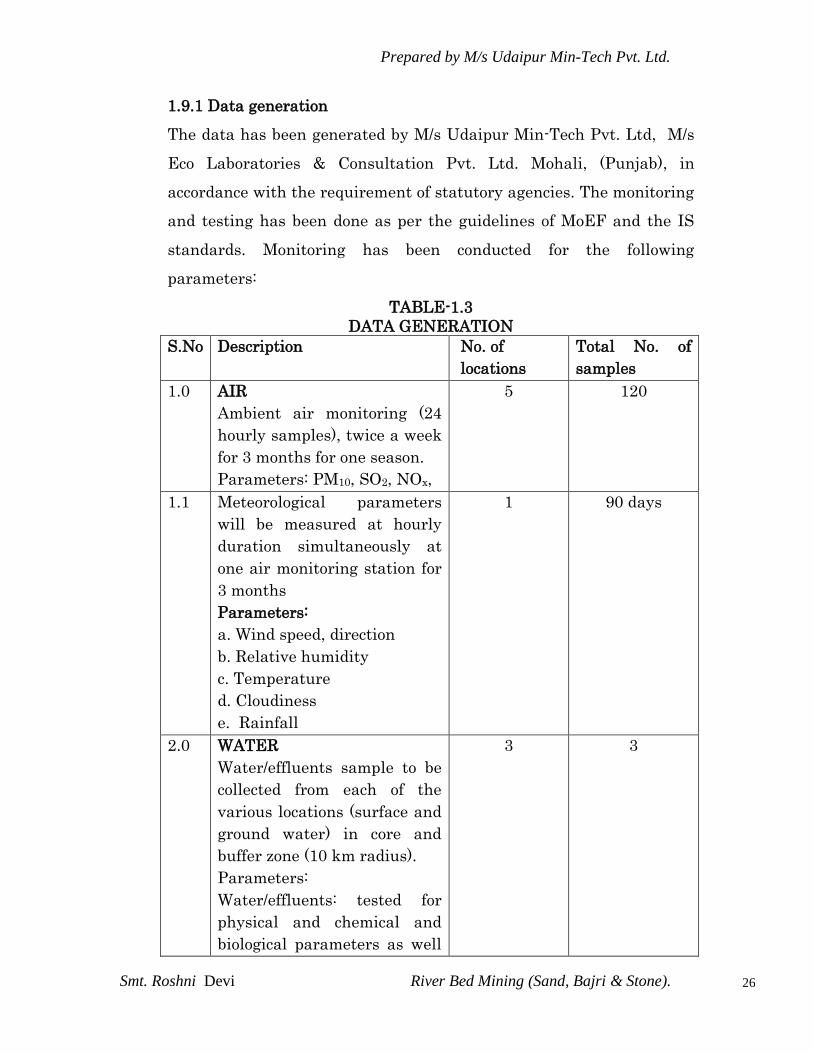
1.9.1 Data generation
The data has been generated by M/s Udaipur Min-Tech Pvt. Ltd, M/s
Eco Laboratories & Consultation Pvt. Ltd. Mohali, (Punjab), in
accordance with the requirement of statutory agencies. The monitoring
and testing has been done as per the guidelines of MoEF and the IS
standards. Monitoring has been conducted for the following
parameters:
TABLE-1.3
DATA GENERATION
S.No Description No. of
locations
Total No. of
samples
1.0 AIR
Ambient air monitoring (24
hourly samples), twice a week
for 3 months for one season.
Parameters: PM10, SO2, NOx,
5 120
1.1 Meteorological parameters
will be measured at hourly
duration simultaneously at
one air monitoring station for
3 months
Parameters:
a. Wind speed, direction
b. Relative humidity
c. Temperature
d. Cloudiness
e. Rainfall
1 90 days
2.0 WATER
Water/effluents sample to be
collected from each of the
various locations (surface and
ground water) in core and
buffer zone (10 km radius).
Parameters:
Water/effluents: tested for
physical and chemical and
biological parameters as well
3 3

Prepared by M/s Udaipur Min-Tech Pvt. Ltd.
Smt. Roshni Devi River Bed Mining (Sand, Bajri & Stone).
27
as according to applicable
standards.
3.0 SOIL 3 3
4.0 NOISE
Hourly readings taken for 24
hours (Leq)
4 4 sets
5.0 TRAFFIC DENSITY 1 1 set
1.9.2 Data Collection
The EIA study is being done for the Mine Lease (core zone) and area
within 10 km radius (buffer zone), both of which comprise the „study
area. The following data, through field survey and other sources, has
been collected by Udaipur Min-Tech Pvt. Ltd, for preparing the
EIA/EMP for the proposed mining area with related facilities.
i Details of wild fauna and flora within a distance of 10 km from the
project site and information about forests, if any.
ii. Eco-sensitive places, sanctuaries, biosphere reserves within 10 km
radius.
iii. Major industries within 10 km radius.
iv. Religious places / historical monuments and tourist places within 10
km radius.
v. Land use pattern within core zone and buffer zone (10 km radius
around the core zone) based on census and satellite image and
cropping pattern.
vi. Demography and Socio-economic based on last available Census data
for entire study area.
vii. Relevant meteorological data, for previous decades from Indian
Meteorological Department (IMD)
viii. Study of present environmental protection and mitigation measures in
nearby operating similar projects, if any.

Prepared by M/s Udaipur Min-Tech Pvt. Ltd.
Smt. Roshni Devi River Bed Mining (Sand, Bajri & Stone).
28
ix. Geo-hydrological aspects based on available data from various
secondary sources.
x. Identification of water bodies, hills, roads etc. within 10 km radius.
1.9.3 Preparation of EMP
The EMP will include the following details:
a. Study of the reports like Geological report, FR or mining plan made
available by the client.
b. Present Environmental Setting
The base line data generated and collected as per para 1.9.1 and 1.9.2
will be used to establish the present environment scenario.
c. Identification, prediction and evaluation of Anticipated Environmental
Impact due to the proposed Mine and related facilities.
The environmental impacts would be anticipated in core and buffer
zone on:
- Topography and drainage
- Climate
- Water quality(Surface/Ground)
- Hydro-geological Regime
- Air quality
- Noise Levels
- Flora and Fauna
- Traffic density
- Land-Use
- Socio-Economic Conditions
- Habitat
- Health, culture, human environment including public health,
occupational health and safety
- Sensitive Places/Historical Monuments.
The impacts would be anticipated based on experience of similar
projects.
d. Proposed Environmental Safeguards and Monitoring Mechanism.
Relevant guidelines as per Environment Impact Assessment (EIA)
Notification issued in January 1994 and subsequently on 14th
September 2006 under the Environment (Protection) Act, 1986 will be
kept in mind while spelling out mitigation measures.
Prepared by M/s Udaipur Min-Tech Pvt. Ltd.
Smt. Roshni Devi River Bed Mining (Sand, Bajri & Stone).
29
The following aspects would be covered
i. Reclamation of areas disturbed during mining but not required for any
activity after exhaustion of reserves.
ii. Measures to control the surface and ground water pollution due to
various effluents to be discharged, if any.
iii. Measures to control air pollution due to proposed activities/operation.
iv. Green belt development plan and reclamation plan of mine.
v. Measures to contain noise pollution & mitigate adverse impact on
workers and habitat in core and buffer zone.
vi. Pronounce the improvement in socio-economic conditions & benefits
the people will get on implementation of the project.
vii. Measures to control health hazard of workers and surrounding
population.
viii. Total and specific cost of control measures.
ix. Environmental monitoring, implementation organization and feedback
mechanism to effect mid-course corrections.
x. Identification of flora species which can be planted in and around the
project.
1.10 TERMS OF REFERENCE
The term of reference have been issued by Expert Appraisal
Committee (EAC) of MoEF, New delhi and are enclosed as Annexure
No. I. The response to the terms of reference has been given on page on
11-16.
========*******=========

Prepared by M/s Udaipur Min-Tech Pvt. Ltd.
Smt. Roshni Devi River Bed Mining (Sand, Bajri & Stone).
30
CHAPTER - II
PROJECT DESCRIPTION
2.0 PHYSIOGRAPHY
The area falls in village – Jhandian, Tehsil – Nalagarh , District-
Solan of Himachal Pradesh is located in between latitudes 31º 03΄
50΄΄ - 31º 04΄ 06΄΄ N and between longitude 76º 42΄ 33΄΄ - 76º 43΄ 58΄΄
E , having a temperature range of 6°-45°. The climate in the district is
moderate humid and tropical with annual rainfall of app. Averaged at
910 mm. River-beds of the district are suitable for mining of minor
minerals in mixed form. Area in Solan district lies in the upper most
corner of Sirsa- Chikanni khad doab. River Sirsa is a tributary of
Sutlaj River, both lies to west of the area. The mining lease area is
situated in Chikanni Khad which is tributary of Sirsa Khad. The
general flow of Sirsa River in this stretch in SE to NW.
Solan district lying within the lesser Himalaya and the Siwalik
foothill comprises rocks ranging in age from Proterozoic to
quarternary. The oldest rocks of undifferentiated Proterozoic age
belongs to the Jutog group comprising Carbonaceous Phyllites,
Schists, Gniesses, Quarzites and Marble. The Alluvium may be
differentiated onto Older Alluvium consisting of oxidized (Brown,
yellow, and khaki color) sediments and Newer Alluvium comprising of
unoxidized (grey and khaki colour) sediments.
District Solan has number of rivers passing through it. Due to this
geographical advantage, District Solan is the main supplier of mixed
state minerals in whole of north india including complete NCR.
Current mining lot falls in the river bed of the river & completely
suitable for mining of mixed state minerals as identified by the state
government.
Prepared by M/s Udaipur Min-Tech Pvt. Ltd.
Smt. Roshni Devi River Bed Mining (Sand, Bajri & Stone).
31
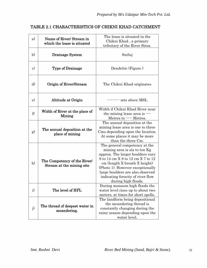
TABLE 2.1 CHARACTERISTICS OF CHIKNI KHAD CATCHMENT
a)
Name of River/ Stream in
which the lease is situated
The lease is situated in the
Chikni Khad , a primary
tributary of the River Sirsa.
b)
Drainage System Sutluj
c)
Type of Drainage Dendritic (Figure )
d)
Origin of River/Stream The Chikni Khad originates
e)
Altitude at Origin ---------- mts above MSL
f)
Width of River at the place of
Mining
Width if Chikni Khad River near
the mining lease area is ----
Metres to ----- Metres.
g)
The annual deposition at the
place of mining
The annual deposition at the
mining lease area is one to three
Cms depending upon the location.
At some places it may be more
than the three Cm.
h)
The Competency of the River/
Stream at the mining site
The general competency at the
mining area is six to ten Kg
approx. The larger boulders vary
9 to 14 cm X 8 to 12 cm X 7 to 12
cm (length X breath X height)
(Photo 1). However exceptionally
large boulders are also observed
indicating ferocity of river flow
during high floods.
i)
The level of HFL
During monsoon high floods the
water level rises up to about two
meters, at times for short spells.
j)
The thread of deepest water in
meandering.
The landform being depositional
the meandering thread is
constantly changing during the
rainy season depending upon the
water level.

Prepared by M/s Udaipur Min-Tech Pvt. Ltd.
Smt. Roshni Devi River Bed Mining (Sand, Bajri & Stone).
32
2.1 REGIONAL GEOLOGY
Solan District lies within the lesser Himalaya and the Siwalik foothills
comprises rocks ranging in age from Proterozoic to quarternary. The
oldest rocks of Proterozoic belongs to Jutog group comprising
carbonaceous phyllite, Schists, Gniesses, quartzites and marble.
In the western side of the Solan District Shimla groups of rocks are
exposed. It is divisible into four formations on the basis of certain
characterstic litho- logical association and order of super position. Out
of four formation , three are exposed in the Solan District.
TABLE – 2.2
Formation Members Lithology Remarks
Sanjauli Upper
lower
Conglomerate,arkosic
sandstone,
protoquartzites, grey
and purple shales
Greywacke sandstone,
greywacke siltstones,
shales orthoquartzites
Exposed in Shimla.
Chhaosa Shales and siltstone
alteration with siltstone
and orthoquartzites
Kunihar Shales and siltstone
alterations with
limestones
Basantpur D Thick bedded to platy
greyish blue l.stone with
interbedded shales
C Massive to bedded
limestones- dolomite
Partially exposed in
Shimla district and
partially exposed in
Solan Dist.
B Shales, siltstone with
interbeds of lenticular
limestones,shales
carbonaceous, bands of
quartzites and dolomite.
A Greyish white
quartzites and
conglomerate.
In the eastern side of the Solan District, Shimla sequences are
succeeded by a younger sequence of formation as Blaini, Infra Krol and
Krol forming two parallel and apparently independent belts. These are
Prepared by M/s Udaipur Min-Tech Pvt. Ltd.
Smt. Roshni Devi River Bed Mining (Sand, Bajri & Stone).
33
respectively referred as outer Krol belt over the Shimla group and the
inner krol belt over the Jaunsar group.
ii) General Geology and Local Geology :-
General Geology :
The general trend of the rock is NW-SE and E-W direction with dip
varying from 100 to 400 on either side. Beside main boundary fault,
krol, Giri, chail and Jutogh Thrust, two major synformal axes running
NW-SE also passes through Krol and Tal Group of rocks.
Nalagarh, Barsar and bilaspur thrusts are in general parallel to the
MBT.
The Pinjaur dun is developed between the detached anticlinal ridges of
siwalik molassas (mainly Upper Siwalik Formation )in the south and
Lower Tertiary (Dagshani, kasauli and subathu)/ (Lower and Middle
Siwalik) rocks in the North, Sabathu, Dagshni and Kasauli formation
occur within foot-hill palaeogene belt are termed as sirmour group of
rocks. They extend from the ravi to the Yamuna in the Himachal
Himalaya.
Lithostratigraphic classification of the sirmour Group
TABLE – 2.3
Formation Member Lithology
Kasauli Massive sandstone, subordinate shale
Dagshai Pabo Alternation of sandstone and clay.
chimnum Red and purple clay – stone with
subordinate silt –stone.
subathu B. Red, green and indigo blue coloured
mudstone, shale, quartzarenite.
A. Green shale, foraminiferal limestone and

Prepared by M/s Udaipur Min-Tech Pvt. Ltd.
Smt. Roshni Devi River Bed Mining (Sand, Bajri & Stone).
34
oyster marls, quartzarenit, local
carbonaceous shale, calcareous sandstone.
In the main belt, the base of the subathu formation is exposed at
subathu town, there is considerable tectonisation along the contact.
The subathu of the himachal Foot – hill Palaeogene belt at places
contain phosphatic nodules with olive green shales. This sequence
contains fossils like gastropods and divergent terrestrial vertebrates.
The Dagashai formation overlies the subathu formation along a
gradational contact. No break in sedimentation is noticed. The rocks of
this formation are characterized by the presence of purple sandstone
and clays with pink clay conglomerate and also grey sandstone. This
formation is well development / exposed at kasauli.
The close of sedimentation of the sirmour basin almost coincided with
the development of a new foredeep to its south form a new cycle of
sedimentation of the siwalik group. The period witnessed a southward
migration of the Cenozoic basin.
The rocks of the Sirsa catchments are represented by the Siwalik
Group,
Older Alluvium and Newer Alluvium. The stratigraphy of the Sirsa
catchments with lithology of the area is as given below in the table;

Prepared by M/s Udaipur Min-Tech Pvt. Ltd.
Smt. Roshni Devi River Bed Mining (Sand, Bajri & Stone).
35
TABLE NO.-2.4
Group Lithology Age
1. Never
Alluvi
um
1.chhanel-
alluvium
Grey micaceous, fine to coarse
grained sand, silt and clay.
Cyclic sequence grey
micaceous sand, silt and clay.
Quaternary
2 Fan-
alluvim
Brownish grey clay , sand and
gravel boulders.
2.older
Alluviu
m
Dun -
Gravels
Multicyclic sequence of brown
to grey silt, clay with kankar
and reddish brown to grey
micaceous sand with pebbles.
3.Siw
alik
Grou
p:
Upper
Siwalik
B
A
B
Predominantly massive
conglomerate with red and
orange clay as matrix and
minor sandstone and earthy
buff and brown clay stone.
Sandstone, clay and
conglomerate alternation
Massive sandstone with
minor conglomerate and local
variegated claystone.
Middle
A siwalik
Predominantly medium to
coarse grained sandstone and
red clay alternation, soft
pebbly with subordinate
claystone, locally thin prism
of conglomerate.

Prepared by M/s Udaipur Min-Tech Pvt. Ltd.
Smt. Roshni Devi River Bed Mining (Sand, Bajri & Stone).
36
Lower
B Siwalik
A
Alternation of fine to medium-
grained sporadically pebble
sandstone, calcareous cement
and prominent chocolate and
medium maroon claystone in
the middle part
Red and mauve claystone
with thin intercalations of
medium to fine grained
sandstone.
Local Geology : In Solan district the formations exposed are Krol
Sandstones. The black Shales and Slaty Quarzites can be seen in
transition stage in Krol Sandstones. The krol Sandstone formation are
massive formation with pale grey , coarse to medium grained
sandstones. The Sirmour group is represented by a thick pile of
Paleogene sediment exposed in the foothills , bounded by Main
boundary fault Siltstones ,Clay, Sandstones and local Pebble bed. The
Siwalik group of middle Miocene and early Pleistocene age comprises
coarse clastic fluviatile deposits of Sandstones ,Clay and
Conglomerates. The Quarternary Sediments ( Older Alluvium and
Newer Alluvium ) along prominent channels consisting of Sand , Silt ,
Clay , Pebbles and Cobbles of Middle to Late Pleistocene and Holocene
age.
The general trends of the rocks suggests it is NW-SE and E-W
directions with dips varying from 10º to 40º on either side .
The rocks of Sirsa catchments are represented by the Siwalik group,
Older Alluvium and Newer Alluvium.

Prepared by M/s Udaipur Min-Tech Pvt. Ltd.
Smt. Roshni Devi River Bed Mining (Sand, Bajri & Stone).
37
Rock Types:
The nature of rocks and their attitude
The mining lease area is covered with river borne deposit which are
deposited in chikkani khad during flood season. The chikkani khad
receives its sediment load from the disintegration/erosion of the rocks
forming catchment area. The deposits contain sediments of quartzite,
sand stone, with fine nature of sand, silt and clay. The colour of the
coarse aggregates varies from white, off-white to greyish in colour. The
Boulder are sub-rounded to rounded in shape and the surface is
generally smooth.
The nature of rocks along the bank
The banks comprises of terrace deposit of recent in age and exposed
outside the high flood level of river. Hence deposit comparison of
boulders, cobbles, sand, silt and clay.
2.2 Mineable area
To select the mineable area from the total area granted on mining
lease, the provisions made in the Himachal Pradesh Minor Mineral
(concession) Revised Rules, 1971 and guidelines contained in the
River/stream bed mining policy and land form studies was taken in to
consideration. The following points of public utilities/ feature is
available in and around to the mining lease area.
Sr.No. Name of the feature Location
1. Check Dams on the right bank of the khad
2. Check dams / retaining walls according to the river /
stream bed policy guideline about 75 mts. Check Dam / retaining walls
has been left as no mining area.
After leaving the 1/5 area from the banks of the nadi according to the
width, i.e. 50 meters to 80 meters as no mining area from each bank

Prepared by M/s Udaipur Min-Tech Pvt. Ltd.
Smt. Roshni Devi River Bed Mining (Sand, Bajri & Stone).
38
and also leaving area surrounding to public utilities, the left out area
is divided into two parts to carry mining operation in rotation manner,
so that the excavation is carried out in a particular year gets
replenished during the next year. The area towards upstream side is
proposed for mining to be carried out for 2nd and 4th year, whereas the
area towards / stream side as shown in map no.3 is proposed for 1st, 3rd
and 5th year. The year wise area proposed for mining in one block is
calculated based on the production pattern. The following table suggest
the year wise area proposed for mining.
TABLE - 2.5
AREA FOR MINING
YEAR SQ. MTS.
1st year 17000 sq.mts
2nd years 17000 sq.mts
3rd years 18000 sq. mts
4th years 19000 sq. mts
5th years 20000 sq. mts
ESTIMATION OF RESERVES
The order to calculate the mineable reserves, to following points are
taken in to consideration.
1. A geological map on 1 :2000 scales is prepared and main litho- units
were marked on the plan to know the surface spread of each unit.
2. The different constituents of river borne deposits such as boulder,
bajri sand and silt /clay based on size classification were considered
for reserve calculation.
Although it is not possible to mark these units separately on the
geological map as such a pit of 1x1x1 m was got dug in the mining
lease area and material so excavated was separated into different

Prepared by M/s Udaipur Min-Tech Pvt. Ltd.
Smt. Roshni Devi River Bed Mining (Sand, Bajri & Stone).
39
sizes and their percentage was taken in to account during
calculation of reserves. The results of the test pit dug are given in
the following table :
TABLE : 2.6
MINERAL SIZE PERCENTAGE
Name of Mineral Percentage Size
Silt / clay 16 Less then 2mm
Bouder 36 40mm to 60cms
sand 24 2mm to 5mm
bajri 24 5mm to 40 mm
The average specific gravity of 2.5 is taken for calculation of
reserves and one meters depth is taken for calculation of reserve,
and exploration of deposit. The boulder size of more then 60cms is
not included in the calculation of reserves.
3. The mineable reserves calculated as per the production /
requirement are given in the years wise development and
production programme.
REPLENISHMENT
The annual replenishment of the material depends up on the
discharge, grade of river and geology of catchment area. Based on
field studies it is expected that excavated area will be fully
replenished during monsoon season, the carrying capacity of
chikkani khad increases appreciably and excavated area in single
season is filed up. moreover, the mining is planned in a rotation
manner so that excavated area in a single season gets at least one
year for replenishment.

Prepared by M/s Udaipur Min-Tech Pvt. Ltd.
Smt. Roshni Devi River Bed Mining (Sand, Bajri & Stone).
40
The following rotation plan is proposed.
TABLE : 2.7
PROPOSED ROTATION PLAN
YEAR ROTATION
1st year Down Stream Block
2nd years Up Stream Block
3rd years Down Stream Block
4th years Up Stream Block
5th years Down Stream Block
2.3 DETAILS OF EXPLORATION
No specific method of exploration is required as the river borne
sediments are, deposited all along the river-bed and are very well
exposed on the surface. Moreover, these sediments are accumulated/
replenished every year during rainy season by river-waters to almost
the double level depending on the intensity of rains on the upstream
side. Adequate quantity of Sand, Bajri and Boulders in mixed state
reserves is available for meeting consumer demand. Ultimate depth of
mining will be up to 1.0m. During mining the ground water will not be
intersected.
2.4 MINING PROCESS
It has been noticed while carrying out mining of minerals in mixed
form from river bed that minor minerals mining proves to be most
viable and least disturbing to anyone. Conventionally the river bed
mining of minor minerals is carried-out manually with hand tools
except in cases of imminent exigencies when supplies are to be affected
to Government agencies and other requisite parameters of need and
requirement when mechanized mining operations may be resorted to.
In spite of handling huge quantities of minor minerals in mixed form

Prepared by M/s Udaipur Min-Tech Pvt. Ltd.
Smt. Roshni Devi River Bed Mining (Sand, Bajri & Stone).
41
the mine has clean atmosphere and not even a speck of dust can be
seen polluting the air. Environment and ecology of the area remains
undisturbed. Mining will be carried out as per the guidelines issued by
MoEF, New Delhi (Environment Aspects of quarrying of minor
minerals). As per Environmental Impact Assessment Guidance
Manual for -MINING OF MINERALS released by MoEF- the project is
a surface mining.
The project does not involve any processes as overburden removal,
drilling, blasting and processing. The mining will involve collection of
material by simple hand tool, sorting, manual picking, stacking and
loading into trucks/tractor –trolley for transporting. The pits from
where the material is picked shall not be deeper than six meter as
allowed in mining plan. No ballasting is done. The only waste is
silt/clay which is added back to the pits.
Surface Mining
Manual Excavation and Loading
Transportation to the Crusher
Site preparation (Marking Boundary Pillars/ identification Stones

Prepared by M/s Udaipur Min-Tech Pvt. Ltd.
Smt. Roshni Devi River Bed Mining (Sand, Bajri & Stone).
42
2.5 ANTICIPATED LIFE OF MINE
There is no specific life of the mine area as the area under reference is
open and barren river bed of the river Chikanni and whatever quality
of minor minerals are extracted from the said lot during one year; more
than the extracted quantity of the same are automatically replenished
every year by the river Chikanni itself on account of its flow and
velocity.
2.6 PROPOSED PRODUCTION
The proposed production of minor mineral, till the lease period will be
approx. 58750 TPA (ROM). The past and present production for last
lease period is 45000 TPA (ROM,as per previous mining plan).
The proposed production for Minor Mineral per year wise will be –
TABLE : 2.8
PRODUCTION DETAILS
Name of mineral * Production Recovery (%)
Small size boulders 21000 MT 36
Bajri 14500MT 24
Sand 14500MT 24
Clay, silt (rejects) 8750 MT 16
Total 58.750 100
* Note- fractions are rounded off.
The clay and silt in form of under burden / rejects will be generated at
the @ 8750 MT per annum (16% of ROM).

Prepared by M/s Udaipur Min-Tech Pvt. Ltd.
Smt. Roshni Devi River Bed Mining (Sand, Bajri & Stone).
43
2.7 PROPOSED METHOD OF MINING
Mining of the river bed is carried out by scraping up to layer of 1
meter thickness.
Conventionally the river –bed mining is carried –out by manual
method using crow-bar & pickaxe with tractor.
It has been noticed while carrying out mining of minor minerals
in mixed form from river –bed proves to be most viable and least
disturbing of anyone.
2.7.1 EXTENT OF MECHANISATION
Main machines / vehicles used for mining of the river bed deposits are
tipper, Truck, Tractor Trolley & loaders (as when required).
2.7.2 EMPLOYMENT GENERATION:
The mining activity in the lease area will involve contractual labor.
About 12 to 14 persons will be engaged in extraction of stone, bajri and
sand; loading of material into tractor trolleys and tipper trucks. The
stone and bajri shall be transported to the crusher. Thus, for
transportation of material about three to four drivers and equal
number of helpers shall be engaged. At the crusher about 15 skilled
and semiskilled workers are deployed.
2.7.3 TRANSPORTATION
The lease area is having gentle slope with the gradient of 2 to 3
degrees hence, tracks for the movement of tractors can be made and
maintained in any part of the lease area.
The loaded tractor trolleys / tipper trucks would carry the material
to the crusher site, at a distance of about 100m from the mining site.
Prepared by M/s Udaipur Min-Tech Pvt. Ltd.
Smt. Roshni Devi River Bed Mining (Sand, Bajri & Stone).
44
About 370 metric tons of stone and bajri would be required to be moved
daily. Five trucks will be able to move this material.
2.8 USE OF MINERAL
Minor minerals are mainly consumed by infrastructure & housing
industries and development.
Whereas sand and bajri is directly used for all construction
works.
Boulders are consumed by stone crushers and manual crushing
operations for use in roads construction etc.
Virtually there is no construction or infrastructure building work
is possible without these minor minerals, hence the same can be
assumed as back bone of the infrastructural growth of India.
2.9. WASTE GENERATION
During the excavation of stone, bajri and sand from the river bed silt
and clay are also quarried being associated minerals. The clay which
will be generated to the extent of 3500 metric tons per year will be left
in the pits as back fill. The clay being the lightest of the sediment load
in the flowing river water is carried downstream by even the lightest
floods during the onset of monsoons. Clay in the river water are
derived mostly from erosion of soil cover and weathered rocks and are
generally suitable for agricultural field. As clay do not contain any
harmful constituents, therefore their carriage/movement further
downstream would not create any harmful environmental impact.
2.10 UTILITIES AND PROPOSED SITE FACILITIES
2.10.1 a) Power Supply :
The electric power supply is available at mine site for lighting
purpose only.
Prepared by M/s Udaipur Min-Tech Pvt. Ltd.
Smt. Roshni Devi River Bed Mining (Sand, Bajri & Stone).
45
b) Water :
Water requirement for domestic/drinking purpose is fulfilled through
the nearby villages/dug wells in river beds. Therefore there is no
requirement for clearance from the Competent Authority as there will
be no ground water withdrawal by the project proponent.
TABLE 2.8
PEAK WATER REQUIREMENT
Purpose Requirement (KLD)
Drinking 0.10
Dust Suppression 2.00
Plantation 2.00
Total 4.10
WATER BALANCE DIAGRAM
No outflow No outflow
c) Man Power
Total manpower required for the project is approx.15-20 persons.
TOTAL WATER REQUIREMENT 4.10
KLD
Dug well
Dust supper.
2.0 KLD
Sanitation &
Drinking 0.10KLD
0.5 m3 / day
Plantation
2.0 KLD
Septic tank- Soak Pit

Prepared by M/s Udaipur Min-Tech Pvt. Ltd.
Smt. Roshni Devi River Bed Mining (Sand, Bajri & Stone).
46
2.10.2 PROPOSED SITE FACILITIES
i) Office :
The owner has common office cum store available for both the
lease area.
ii) First Aid Room :
Although the river bed mining project does not involve any
major risks but a first aid room with proper equipment will be
maintained as per Mines Act and Mine Rules at the mine site
office. Antidotes in first aid boxes will also be maintained to
counteract poison produced by certain species of small insects, if
any.
iii) Latrine and Urinal :
Latrine and urinal will be provided separately for male and
female worker as per Mine Rules.
======******=======

Prepared by M/s Udaipur Min-Tech Pvt. Ltd.
Smt. Roshni Devi River Bed Mining (Sand, Bajri & Stone).
47
CHAPTER – III
DESCRIPTION OF THE ENVIRONMENT
3.1 GENERAL
3.1.1 Study area
Exploitation of mineral resources from the land through mining
causes environmental and ecological instability, severe land
degradation besides biological physical and socio-economic
imbalance. The impact of the mining activities can be quantified
through Environmental Impact Assessment Studies within the
impact zone. The findings of EIA studies help in preparation of the
environmental management plan for mitigating the adverse
impacts.
For the purpose of studying the baseline status of the environment,
core zone and buffer zone are considered for Impact Assessment.
The core area for the purpose comprises mining lease area of
15.20Hect. The buffer zone comprises a 10 km from around the core
area.
This section contains a description of the existing baseline
environmental status of the area surrounding Chikanni River bed
mine, the data collected has been used to define the environmental
scenario of the area, against which the potential impacts of the project
has been assessed.
3.1.2 Sources of Environmental Data
The baseline information on micro-meteorology, ambient air quality,
water quality, noise levels, soil quality and floristic descriptions are
largely drawn from the data generated by M/s Udaipur Min-Tech Pvt.

Prepared by M/s Udaipur Min-Tech Pvt. Ltd.
Smt. Roshni Devi River Bed Mining (Sand, Bajri & Stone).
48
Ltd, M/s Eco Laboratories & Consultants Pvt. Ltd. Mohali, (Punjab),
(NABL Accredited Lab). Long term meteorological data recorded at the
nearest IMD station, Chandigarh was also collected. Micro-
meteorological data at site was recorded using automatic weather
station. Apart from these, secondary data have been collected from
Census Handbook, Revenue Records, Statistical Department, Soil
Survey and Land use Organization, District Industries Centre, Forest
Department, Central Ground Water Authority, etc. The generation of
primary data as well as collection of secondary data and information
from the site and surroundings was carried out during Summer season
i.e. April -2012 to June -2012.
3.1.3 Aspect Studied
As per the gazette notification dated 14th September 2006 and
guidelines of CPCB, the study area was demarked. The study was
conducted within a radius of 10 km within mine as center. The
study period defined is April 2012, May 2012, June 2012.
The disciplines covered by the baseline data collection programme
includes the following:-
Topography, Physiography, Hydrological aspects, Atmospheric
condition, Biological environment, Land use, Cropping pattern &
Socioeconomic aspects.
3.1.4 Presentation
Each of the aspects listed above considered ahead in a sequential
manner. Data Collected during the baseline study period are given
ahead and provides a sound knowledge of the existing environment.

Prepared by M/s Udaipur Min-Tech Pvt. Ltd.
Smt. Roshni Devi River Bed Mining (Sand, Bajri & Stone).
49
3.2 STUDY AREA AT A GLANCE
The study area includes the villages of Nalagarh Tehsil within 10 Kms.
radius from the mine as center.
1. General Particulars :-
i) Latitude (N) : 31º 03΄ 50΄΄ - 31º 04΄ 06΄΄
Longitude (E) : 76º 42΄ 33΄΄ - 76º 43΄ 58΄΄
ii) Study area (10 Km. radius) : 34766 Hect.
iii) Populations : 26204
iv) District H.Q. : Solan
2. Demography :-
i) Total Population
a) Male : 13899
b) Female : 12305
ii) Literates
a) Male : 9294
b) Female : 5989
iii) No. of Household : 8448
iv) No. of Villages : 69
3. Land use Pattern :-
i) Water bodies : 173.36 Hect.
ii) Plantation : 463.10 Hect.
iii) Forest land : 5650.33 Hect.
iv) Crop land : 3374.73 Hect.
v) Fallow Land : 9730.36 Hect.
vi) Human Settlement : 867.02 Hect.
vii) Industries : 215.56 Hect.

Prepared by M/s Udaipur Min-Tech Pvt. Ltd.
Smt. Roshni Devi River Bed Mining (Sand, Bajri & Stone).
50
viii) Dense Scrub : 4331.12 Hect.
ix) Open Scrub : 8842.88 Hect.
x) Seasonal River : 1087.91 Hect.
xi) Open / Waste Land : 29.95 Hect.
4. Climatology (Chandigarh IMD 2011) :-
i) Total Rain (April 2011 – Jun.2011) : 19.9
ii) Mean monthly maximum temp. : 45.6.°C
iii) Mean monthly minimum temp. : 14.5 °C
iv) Relative humidity : 72 % (Avg.)
3.3 TOPOGRAPHY
3.3.1 Existing Conditions
The Study area has rugged and mountainous topography with highest
point at 1200.00m AMSL and lowest at 300m AMSL. The area lies on
the Chikni khad originates from south of Kasauli ridge at a height of
1926 m AMSL and after travelling through small hillocks it enters in
Nalagarh valley near kalka it roughly flows in EW direction then its
takes a swing towards NW where member of tributaries such on
kiratpur Nadi, Ram nagar nadi, Narkanda Nadi, Surapur choe, Balad
Nadi and Ratta Nadi Joins with it. Ratta Nadi originates from Jatrog
ridge at a height of 1360 m AMSL. This Nadi mostly traverses through
hillocks of Tertiary Formation and it enters in Nalagrah valley near
village Bauni when its height reduce to 510 m AMSL. It joins with
Sirsa river near village Kishanpura.
Prepared by M/s Udaipur Min-Tech Pvt. Ltd.
Smt. Roshni Devi River Bed Mining (Sand, Bajri & Stone).
51
The nearest villages are Jhandian, Palasra Dittu, & Ghansot. These
village are outside of the lease area. The topography of the study area
is shown in Fig 3.1.
Prepared by M/s Udaipur Min-Tech Pvt. Ltd.
Smt. Roshni Devi River Bed Mining (Sand, Bajri & Stone).
52

Prepared by M/s Udaipur Min-Tech Pvt. Ltd.
Smt. Roshni Devi River Bed Mining (Sand, Bajri & Stone).
53
3.4 CLIMATIC CONDITION
The climate is moderate humid and tropical interspersed between cold
weather, hot weather and southwest monsoon. The cold weather
commences in November and continues till the end of February, which
is characterized by cloudless days and very cold nights with much fog
and dew. May and June are usually the hottest months. During
monsoon period (July to September) the weather remains humid. Once
the pollutants are discharged in the atmosphere, the meteorological
factors play an important role in transport dispersion and diffusion
with the environment. Since, these factors show wide fluctuations with
time, it was felt necessary and desirable as part of this EIA study, to
collect meteorological data at nearest available at Tehsil head quarter
Nalagarh and is presented in Table 3.1.
The southwest monsoon sets in by the second half of the July and
withdrawal takes place in October. July to September months are
main rainy months though it continues till October. Cyclones and
sudden storms may occur during May-June. In the post monsoon, a few
thunderstorms occur, especially in October. Thereafter, the weather
clears up and pleasant weather prevails throughout the valley.
Precipitation occurs for some days during December and January.
Rainfall is highly variable in the region due to its rugged topography
and its geographical position. The rainfall generally increases up to the
valleys from southwest to northwest and decreases beyond the highest
range over the northern part of the region. The percentage
contribution of rainfall is less than the southern parts, perhaps due to
decreasing influence of the monsoon. After April, the rainfall gradually
increases till June and thereafter sharply during July and August. It
decreases rapidly after the withdrawal of southwest monsoon in
September. The precipitation occurs during pre-monsoon months is
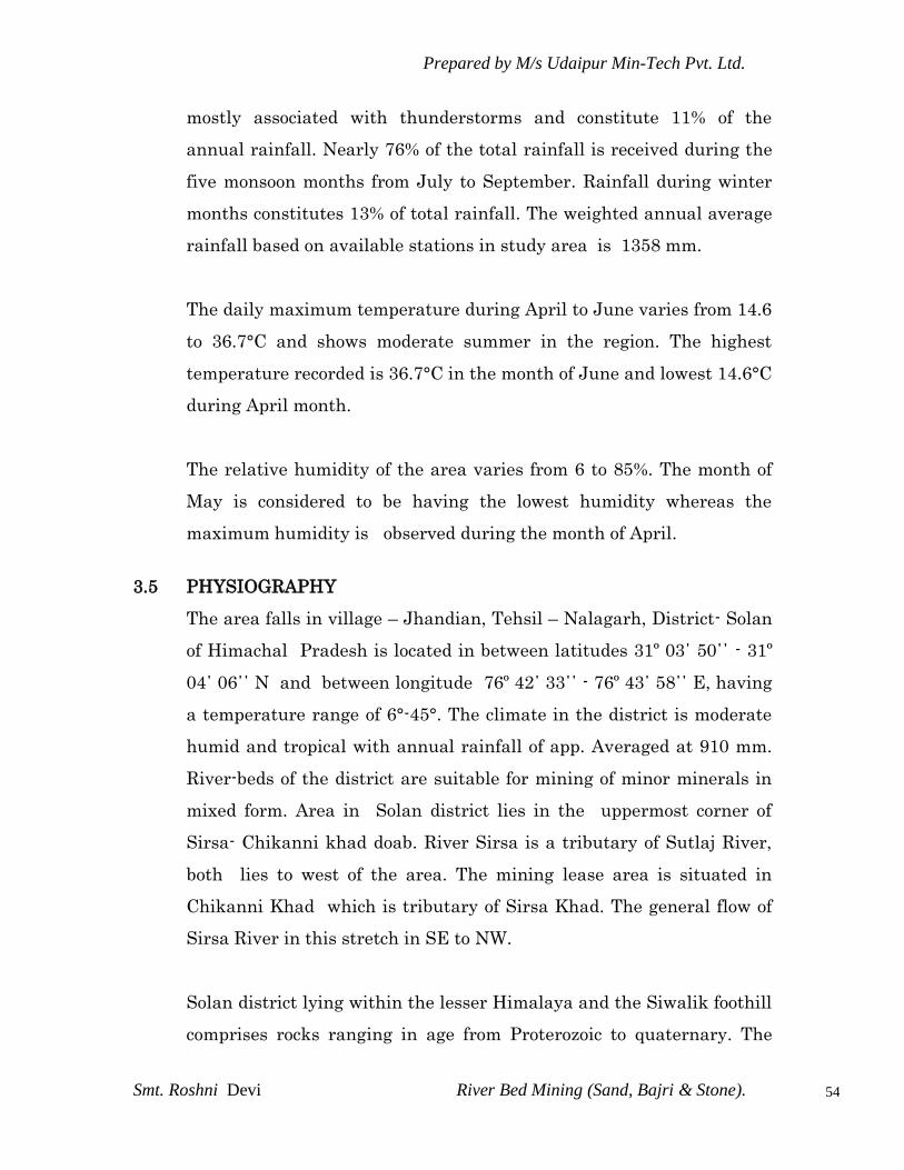
Prepared by M/s Udaipur Min-Tech Pvt. Ltd.
Smt. Roshni Devi River Bed Mining (Sand, Bajri & Stone).
54
mostly associated with thunderstorms and constitute 11% of the
annual rainfall. Nearly 76% of the total rainfall is received during the
five monsoon months from July to September. Rainfall during winter
months constitutes 13% of total rainfall. The weighted annual average
rainfall based on available stations in study area is 1358 mm.
The daily maximum temperature during April to June varies from 14.6
to 36.7°C and shows moderate summer in the region. The highest
temperature recorded is 36.7°C in the month of June and lowest 14.6°C
during April month.
The relative humidity of the area varies from 6 to 85%. The month of
May is considered to be having the lowest humidity whereas the
maximum humidity is observed during the month of April.
3.5 PHYSIOGRAPHY
The area falls in village – Jhandian, Tehsil – Nalagarh, District- Solan
of Himachal Pradesh is located in between latitudes 31º 03΄ 50΄΄ - 31º
04΄ 06΄΄ N and between longitude 76º 42΄ 33΄΄ - 76º 43΄ 58΄΄ E, having
a temperature range of 6°-45°. The climate in the district is moderate
humid and tropical with annual rainfall of app. Averaged at 910 mm.
River-beds of the district are suitable for mining of minor minerals in
mixed form. Area in Solan district lies in the uppermost corner of
Sirsa- Chikanni khad doab. River Sirsa is a tributary of Sutlaj River,
both lies to west of the area. The mining lease area is situated in
Chikanni Khad which is tributary of Sirsa Khad. The general flow of
Sirsa River in this stretch in SE to NW.
Solan district lying within the lesser Himalaya and the Siwalik foothill
comprises rocks ranging in age from Proterozoic to quaternary. The

Prepared by M/s Udaipur Min-Tech Pvt. Ltd.
Smt. Roshni Devi River Bed Mining (Sand, Bajri & Stone).
55
oldest rocks of undifferentiated Proterozoic age belongs to the Jutog
group comprising Carbonaceous Phyllites, Schists, Gniesses, Quarzites
and Marble. The Alluvium may be differentiated onto Older Alluvium
consisting of oxidized (Brown, yellow, and khaki color) sediments and
Newer Alluvium comprising of un oxidized (grey and khaki color)
sediments.
District Solan has number of rivers passing through it. Due to this
geographical advantage, District Solan is the main supplier of mixed
state minerals in whole of north india including complete NCR.
Current mining lot falls in the river bed of the river & completely
suitable for mining of mixed state minerals as identified by the state
government. Refer Fig 3.2).
The crop grows are generally maize, mash, turmeric, caclocasia,
ginger, wheat & kulth etc. Farmers of this area are generally
taking two crops in a year as under :-
AGRICULTURAL YIELD IN STUDY AREA
(10 KM RADIUS FROM MINE SITE)
Sl.
No. Crop
Month of
Sowing
Month of
Harvesting
% of
Cropping
Area
Yield kg per
ha
1. Maize May-June Sept.-Oct. 40% 1800 to 2500
2. Mash June-July Sept.-Oct. 5% 800 to 1000
3. Ginger May-June Dec.-Jan. 15% 10000 to 12000
4. Turmeric May-June Dec.-Jan. 5% 10000 to 13000
5. Calocasia May-June Nov.-Dec. 5% 110000 to 13000
6. Kulth May-July Sept.-Oct. 2% 800 to 900
7. Wheat Oct.-Dec. Apr.-May 80% 1800 to 2500
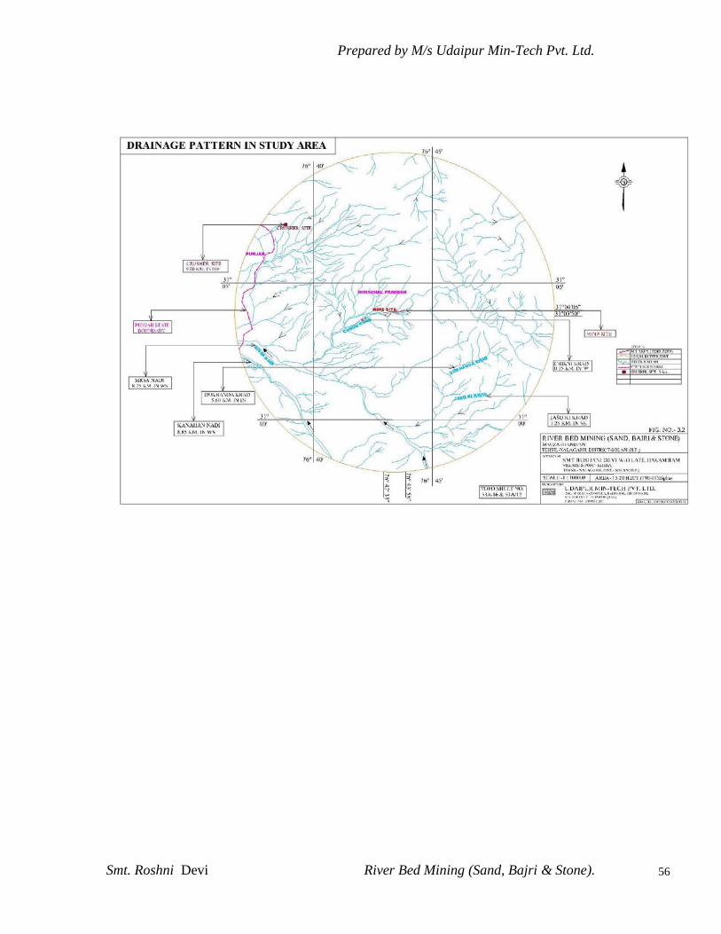
Prepared by M/s Udaipur Min-Tech Pvt. Ltd.
Smt. Roshni Devi River Bed Mining (Sand, Bajri & Stone).
56
Prepared by M/s Udaipur Min-Tech Pvt. Ltd.
Smt. Roshni Devi River Bed Mining (Sand, Bajri & Stone).
57
3.6 SEISMICITY OF AREA
The state of Himachal Pradesh lies almost entirely in the Himalayan
mountains, and is part of the Punjab Himalayas. Due to its location it
weathers dozens of mild earthquakes every year. Large earthquakes
have occurred in all parts of Himachal Pradesh, the biggest being the
Kangra Earthquake of 1905. The Himalayan Frontal Thrust, the Main
boundary Thrust, the Krol, the Giri, Jutogh and Nahan thrusts lie in
this region. Besides that there are scores of smaller faults, like the
Kaurik Fault which triggered the 1975 earthquake. However, it must
be stated that proximity to faults does not necessarily translate into a
higher hazard as compared to areas located further away, as damage
from earthquakes depends on numerous factors such as subsurface
geology as well as adherence to the building codes.
SEISMIC HAZARD
Chamba, Kullu, Kangra, Una, Hamirpur, Mandi, and Bilaspur
Districts lie in Zone V. The remaining districts of Lahual and Spiti,
Kinnaur, Shimla, Solan and Sirmaur lie in Zone IV. Since the
earthquake database in India is still incomplete, especially with
regards to earthquakes prior to the historical period (before 1800 A.D.),
these zones offer a rough guide of the earthquake hazard in any
particular region and need to be regularly updated (Source : GSHAP
Hazard Map for Himachal Pradesh).

Prepared by M/s Udaipur Min-Tech Pvt. Ltd.
Smt. Roshni Devi River Bed Mining (Sand, Bajri & Stone).
58
Earthquake occur in the last 10 years in the region is as follows:
Date and
Year
Place Location Intensity
N E
11 Novemb
er 2004
Bharmou
r,
Kangra
region
32.44
2 N,
76.51
2 E
A moderate earthquake struck
the Kangra Valley and the
Dhauladhar Mountains. It was felt
strongly in the Kangra-Dharamsala
region and event caused minor
damage to buildings in the region. It
had a magnitude of Mb=5.1.
8 October
2005
Kashmir-
Kohistan
,
Pakistan
-India
border,
Mw
7.634
.432
N
73.53
7 E,
A major earthquake struck the
India-Pakistan border on the
morning of 8 October 2005. It had a
magnitude of Mw=7.6 and was
felt strongly in much of Pakistan,
northern India and eastern
Afghanistan.. Tremors from the
earthquake were felt more than a
thousand kilometers away in the
Indian states of Gujarat, Madhya
Pradesh and Uttar Pradesh.
3.7 HUMAN SETTLEMENT
There is no human settlement within the lease area. The
nearest village existing outside of the lease area is Jhandian
which is 1.5 Km away towards ENE of the lease area. Dwelling
houses in the village are far away from the proposed working area.
Total 69 villages with 8448 household within the study area with

Prepared by M/s Udaipur Min-Tech Pvt. Ltd.
Smt. Roshni Devi River Bed Mining (Sand, Bajri & Stone).
59
population of 26204. The population density in the area is 32.23 hect. /
person. (Refer Fig 3.1).
3.8 HYDROLOGICAL ASPECTS
In order to conduct EIA Studies, baseline data pertaining to water
environment of the existing project was carried out evaluating the
basin characteristics, drainage pattern, hydrology. The different
parameters of surface water as well as ground water also analyzed at
different sites.
3.8.1 Introduction
Local hydrological parameters and ground level water levels are
not affected due to mining activity in the area.
3.8.2 Hydrogeology
3.8.3 Ground Water Condition
Geologically, the area is underlain by formations ranging in age from
Quaternary to Pre-Cambrain. Phyllite, slate, quartzite, limestone,
schist, dolomites, granite and gneisses constitute the older (hard rocks)
formations. The valley fills deposits (soft) in the district which
represent the Quaternary deposits and are restricted in the western
part of Bagheri – Kherachak – Baddi area.
Major part of the area is covered by Siwaliks & Tertiary group of rocks.
The district can be divided into porous and fissured formations.
Ground water occurs under water table to semiconfined condition in
porous formations with depth to water level varies from near ground
level to more than 30 m bgl mainly in valley fill/ alluvial areas. In
fissured formations, springs are the major source of water supply.
Springs located along major thrust/ faults (structurally weak planes)
are high yielding.

Prepared by M/s Udaipur Min-Tech Pvt. Ltd.
Smt. Roshni Devi River Bed Mining (Sand, Bajri & Stone).
60
Prepared by M/s Udaipur Min-Tech Pvt. Ltd.
Smt. Roshni Devi River Bed Mining (Sand, Bajri & Stone).
61
3.8.4 Ground Water Condition
The ground water level in the valley of River Sirsa is shallow
and varies on an average from 5.5 meters to 6.3 meters near the
riverbed and increases towards the hills. The tributaries like
Balad Nadi, Ratta Nadi remain dry except monsoon season and
ground water is the only water source for domestic, agricultural
and industrial use. An analysis of long-term fluctuations of the
ground water levels in the study area shows a rising trend of on
an average 0.11 cm/per year for the
last 20 years except for some isolated patches (Central Water
Commission) The ground water levels are thus showing positive
trends.
3.9 ATMOSPHERIC CONDITION
Atmospheric conditions include micro meteorological condition and
ambient air quality of the study area. Meteorological conditions with
respect to wind velocity and direction in the study area was
determined by locating a monitoring station at the mine. The
monitored data is supplemented with meteorological data collected at
Chandigarh. The required data for interpretation the ambient air
quality of the study area was generated by establishing a monitoring
network. Regular field observations as per the norms of MoEF and
CPCB were taken from the established monitoring stations.
3.9.1 Meteorology
3.9.1.1 Introduction
Meteorology plays a vital role in affecting the dispersion of pollutants.
Since meteorological factors show wide fluctuations with time,
meaningful interpretation can be drawn only from long term reliable

Prepared by M/s Udaipur Min-Tech Pvt. Ltd.
Smt. Roshni Devi River Bed Mining (Sand, Bajri & Stone).
62
data. Such source of data is the Indian meteorological Department
(IMD), which maintains a network of meteorological stations at several
important locations. The nearest stations (Nalagarh) to the study area
is located at 05 Km. from mine site. Meteorological information
available for this station are temperature, humidity, rainfall, wind
speed and wind direction.
3.9.1.2 Meteorological Data‟s from Chandigarh.
The data recorded at Chandigarh for the study period Dec. 2011 to
Feb. 2012 are summarized in table 3.1 and table 3.2.
TABLE – 3.1
MEAN TEMPERATURE AND RELATIVE HUMIDITY RECORDS
FROM THE CHANDIGARH IMD STATION
Month Temperature
(0 C)
Relative
Humidity
Wind Speed
(Kmph)
Rainfall
(mm)
Min. Max. Min. Max. Min. Max. Min. Max.
April11 14.6 36.7 17 85 002 009 1.0 19.9
May 11 18.5 26.9 6 58 001 011 0.2 3.7
Jun 11 23.9 45.6 12 73 003 012 0.2 3.7
3.9.1.3 Micro Meteorology At Site
Micro meteorology datas viz. temperature and relative humidity were
recorded at site during the study period which are summarized in the
table 3.2.

Prepared by M/s Udaipur Min-Tech Pvt. Ltd.
Smt. Roshni Devi River Bed Mining (Sand, Bajri & Stone).
63
TABLE – 3.2
TEMPERATURE RECORDS AND RELATIVE HUMIDITY
AT MINE SITE
Month Temp.(°C) Humidity (%) Rainfall In
mm
Prominent wind
direction / wind
speed
(Km./Hr.) Min.
Max.
Min. Max. Min. Max.
April12 15.6 36.2 15 83 2.0 19.4 WNW-NW
2.0 - 19.4
May 12 18.3 27.6 5 57 0.2 3.6 NW-NNW,
0.2- 3.6
Jun 12 24.5 45.1 10 72 0.2 3.6 NW-NNW,
0.2- 3.6
3.10 Ambient Air Environment
To establish the ambient air quality the studies were carried out
during Summer season of the year 20012-13.
3.10.1 Ambient Air Sampling
Ambient air quality sampling was carried out with the help of
Respirable particulate matter Sampler “ Respirable Dust Sampler”
(RDS). The data generated by M/s Eco Laboratories & Consultants Pvt.
Ltd. for ambient air quality status within 10 km. radius of the existing
mine has been compiled along with micrometeorological conditions for
particulars season.
3.10.2. Location of Ambient Air Sampling Stations
Five sampling stations were established around the core zone
within 10 km radius to study the present air quality. The
locations are given in Table 3.3 and the area marked in Fig. 3.3.

Prepared by M/s Udaipur Min-Tech Pvt. Ltd.
Smt. Roshni Devi River Bed Mining (Sand, Bajri & Stone).
64
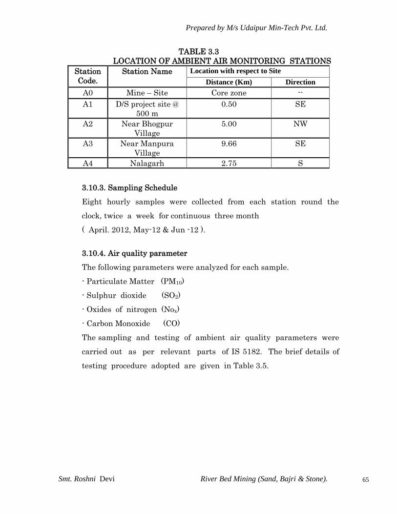
Prepared by M/s Udaipur Min-Tech Pvt. Ltd.
Smt. Roshni Devi River Bed Mining (Sand, Bajri & Stone).
65
TABLE 3.3
LOCATION OF AMBIENT AIR MONITORING STATIONS
Station
Code.
Station Name Location with respect to Site
Distance (Km) Direction
A0 Mine – Site Core zone --
A1 D/S project site @
500 m
0.50 SE
A2 Near Bhogpur
Village
5.00 NW
A3 Near Manpura
Village
9.66 SE
A4 Nalagarh 2.75 S
3.10.3. Sampling Schedule
Eight hourly samples were collected from each station round the
clock, twice a week for continuous three month
( April. 2012, May-12 & Jun -12 ).
3.10.4. Air quality parameter
The following parameters were analyzed for each sample.
- Particulate Matter (PM10)
- Sulphur dioxide (SO2)
- Oxides of nitrogen (Nox)
- Carbon Monoxide (CO)
The sampling and testing of ambient air quality parameters were
carried out as per relevant parts of IS 5182. The brief details of
testing procedure adopted are given in Table 3.5.

Prepared by M/s Udaipur Min-Tech Pvt. Ltd.
Smt. Roshni Devi River Bed Mining (Sand, Bajri & Stone).
66
TABLE 3.4
PROCEDURE FOR DETERMINING VARIOUS AIR QUALITY
PARAMETERS
Parameters Testing Procedure
PM10
Gravimetric method using Respirable particulate
matter Sampler “ Respirable Dust Sampler”
(RDS) IS:5182(Part IV)1973
NOx
Absorption in dil. NaOH and then estimated
calorimetrically with sulphanilamide and N(I-
Nepthyle) Ethylene diamine Dihydrochloride and
Hydrogen Peroxide(IS:5182 1975, Part VI)
SO2
Absorption in Sodium Tetra Chloro-mercurate
followed by Colorimetric estimation using P-
Rosaniline hydrochloride and
Formaldehyde(IS:5182 Part II. 1969)
CO By Electronic CO detector
The detailed results of ambient air quality are given in table 3.6 to 3.9.
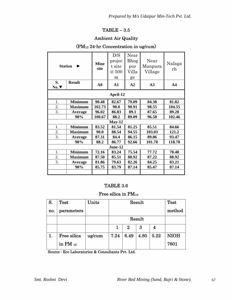
Prepared by M/s Udaipur Min-Tech Pvt. Ltd.
Smt. Roshni Devi River Bed Mining (Sand, Bajri & Stone).
67
TABLE – 3.5
Ambient Air Quality
(PM10 24-hr Concentration in ug/cum)
Station ► Mine
site
D/S
projec
t site
@ 500
m
Near
Bhog
pur
Villa
ge
Near
Manpura
Village
Nalaga
rh
S.
No.▼
Result
A0 A1 A2 A3 A4
April-12
1. Minimum 90.48 82.67 79.09 84.38 81.82
2. Maximum 102.73 90.0 90.91 98.55 104.55
3. Average 96.02 86.83 89.1 87.65 89.28
98% 100.67 88.2 89.09 96.58 102.46
May-12
1. Minimum 83.52 81.54 81.25 85.51 84.66
2. Maximum 90.0 88.54 94.55 103.03 121.2
3. Average 87.31 84.4 86.15 89.86 93.47
98% 88.2 86.77 92.66 101.78 118.78
June-12
1. Minimum 72.16 83.24 75.54 77.72 78.48
2. Maximum 87.50 85.51 88.92 87.22 88.92
3. Average 81.86 79.63 82.26 84.25 83.21
98% 85.75 83.79 87.14 85.47 87.14
TABLE 3.6
Free silica in PM10
S.
no.
Test
parameters
Units Result Test
method
Result
1 2 3 4
1. Free silica
in PM 10
ug/cum 7.24 6.49 4.80 5.22 NIOH
7601
Source : Eco Laboratories & Consultants Pvt. Ltd.
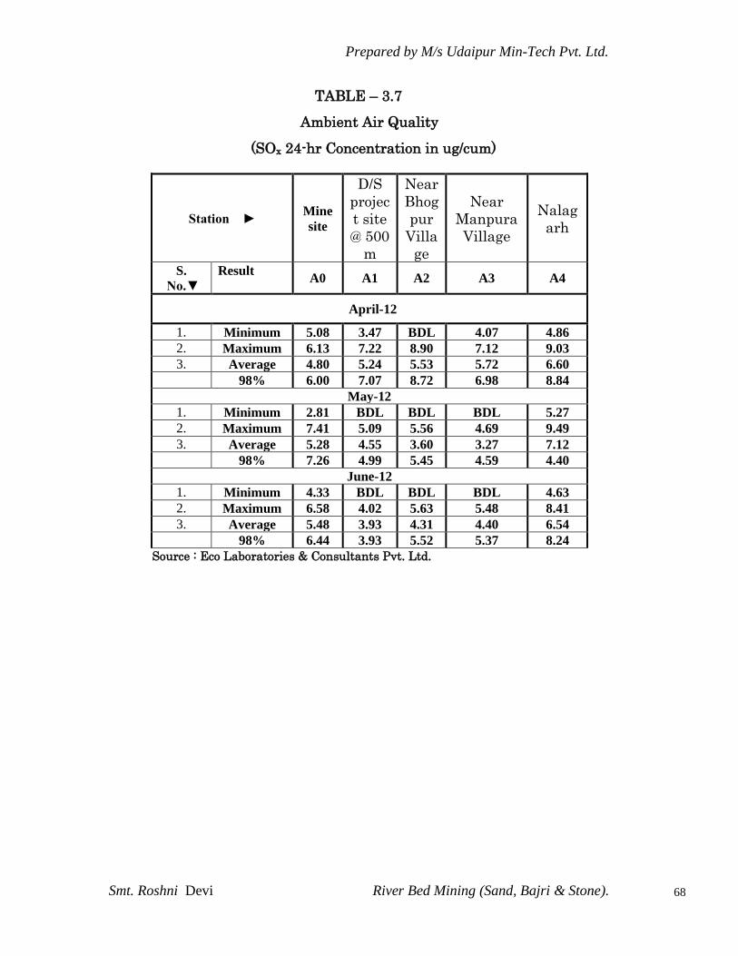
Prepared by M/s Udaipur Min-Tech Pvt. Ltd.
Smt. Roshni Devi River Bed Mining (Sand, Bajri & Stone).
68
TABLE – 3.7
Ambient Air Quality
(SOx 24-hr Concentration in ug/cum)
Station ► Mine
site
D/S
projec
t site
@ 500
m
Near
Bhog
pur
Villa
ge
Near
Manpura
Village
Nalag
arh
S.
No.▼
Result
A0 A1 A2 A3 A4
April-12
1. Minimum 5.08 3.47 BDL 4.07 4.86
2. Maximum 6.13 7.22 8.90 7.12 9.03
3. Average 4.80 5.24 5.53 5.72 6.60
98% 6.00 7.07 8.72 6.98 8.84
May-12
1. Minimum 2.81 BDL BDL BDL 5.27
2. Maximum 7.41 5.09 5.56 4.69 9.49
3. Average 5.28 4.55 3.60 3.27 7.12
98% 7.26 4.99 5.45 4.59 4.40
June-12
1. Minimum 4.33 BDL BDL BDL 4.63
2. Maximum 6.58 4.02 5.63 5.48 8.41
3. Average 5.48 3.93 4.31 4.40 6.54
98% 6.44 3.93 5.52 5.37 8.24
Source : Eco Laboratories & Consultants Pvt. Ltd.
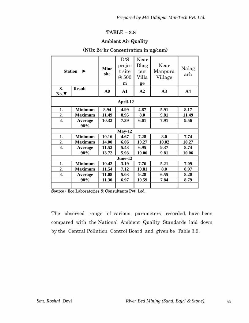
Prepared by M/s Udaipur Min-Tech Pvt. Ltd.
Smt. Roshni Devi River Bed Mining (Sand, Bajri & Stone).
69
TABLE – 3.8
Ambient Air Quality
(NOx 24-hr Concentration in ug/cum)
Station ► Mine
site
D/S
projec
t site
@ 500
m
Near
Bhog
pur
Villa
ge
Near
Manpura
Village
Nalag
arh
S.
No.▼
Result
A0 A1 A2 A3 A4
April-12
1. Minimum 8.94 4.99 4.87 5.91 8.17
2. Maximum 11.49 8.95 8.0 9.81 11.49
3. Average 10.32 7.39 6.61 7.91 9.56
98%
May-12
1. Minimum 10.16 4.67 7.28 8.0 7.74
2. Maximum 14.00 6.06 10.27 10.02 10.27
3. Average 11.52 5.43 6.95 9.37 8.74
98% 13.72 5.93 10.06 9.81 10.06
June-12
1. Minimum 10.42 3.19 7.76 5.21 7.09
2. Maximum 11.54 7.12 10.81 8.0 8.97
3. Average 11.08 5.03 9.28 6.55 8.20
98% 11.30 6.97 10.59 7.84 8.79
Source : Eco Laboratories & Consultants Pvt. Ltd.
The observed range of various parameters recorded, have been
compared with the National Ambient Quality Standards laid down
by the Central Pollution Control Board and given be Table 3.9.
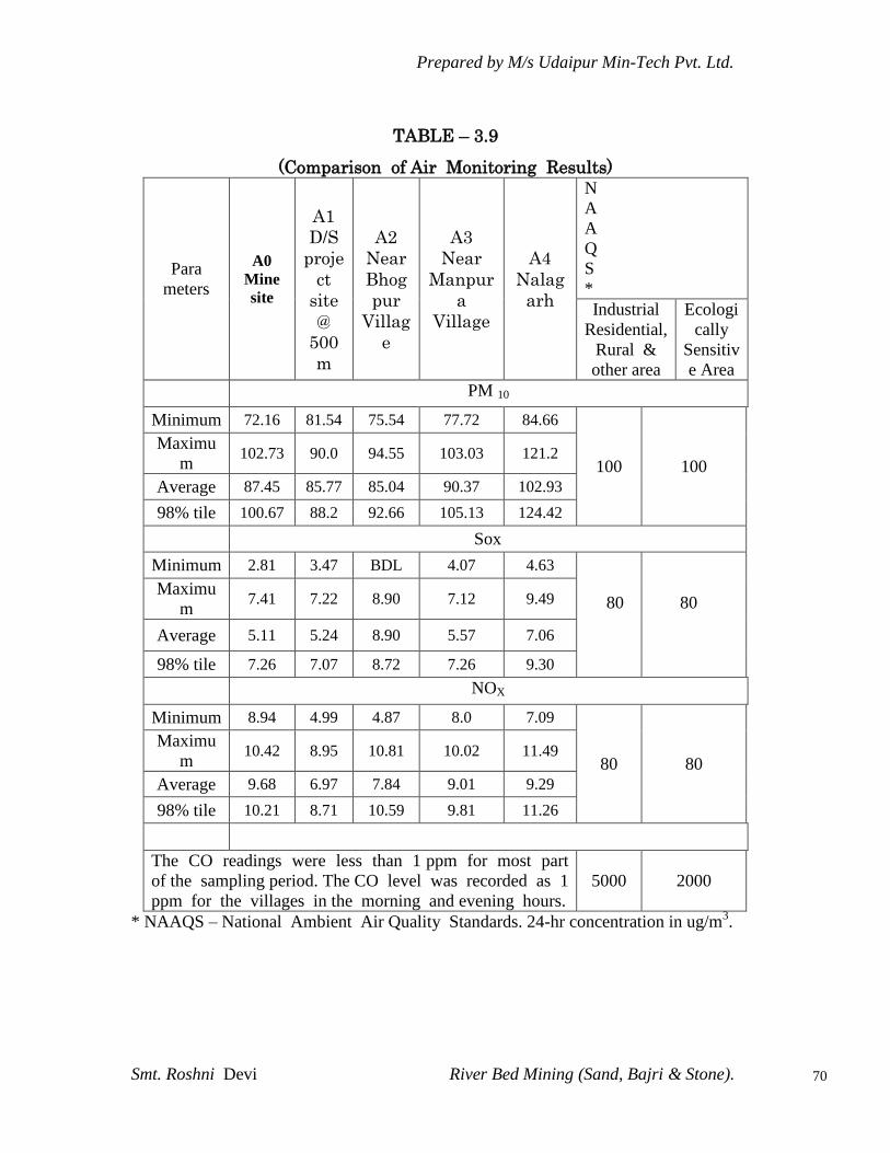
Prepared by M/s Udaipur Min-Tech Pvt. Ltd.
Smt. Roshni Devi River Bed Mining (Sand, Bajri & Stone).
70
TABLE – 3.9
(Comparison of Air Monitoring Results)
Para
meters
A0
Mine
site
A1
D/S
proje
ct
site
@
500
m
A2
Near
Bhog
pur
Villag
e
A3
Near
Manpur
a
Village
A4
Nalag
arh
N
A
A
Q
S
*
Industrial
Residential,
Rural &
other area
Ecologi
cally
Sensitiv
e Area
PM 10
Minimum 72.16 81.54 75.54 77.72 84.66
100 100
Maximu
m 102.73 90.0 94.55 103.03 121.2
Average 87.45 85.77 85.04 90.37 102.93
98% tile 100.67 88.2 92.66 105.13 124.42
Sox
Minimum 2.81 3.47 BDL 4.07 4.63
80
80 Maximu
m 7.41 7.22 8.90 7.12 9.49
Average 5.11 5.24 8.90 5.57 7.06
98% tile 7.26 7.07 8.72 7.26 9.30
NOX
Minimum 8.94 4.99 4.87 8.0 7.09
80 80
Maximu
m 10.42 8.95 10.81 10.02 11.49
Average 9.68 6.97 7.84 9.01 9.29
98% tile 10.21 8.71 10.59 9.81 11.26
The CO readings were less than 1 ppm for most part
of the sampling period. The CO level was recorded as 1
ppm for the villages in the morning and evening hours.
5000 2000
* NAAQS – National Ambient Air Quality Standards. 24-hr concentration in ug/m3.
Prepared by M/s Udaipur Min-Tech Pvt. Ltd.
Smt. Roshni Devi River Bed Mining (Sand, Bajri & Stone).
71
A perusal of Tables 3.10 shows that PM10 is exceed of CPCB limit of
3 stations are (Mine site, Manpur, and Nalagarh), But CO, NOx &
SO2 are well within limits prescribed for areas meant for
“Residential and Rural Use.”
3.10.5 Result
Ambient Air quality monitoring reveals that the minimum &
maximum concentration of PM10 for all the 5 AAQM station were
found to be 72.6 µg/m3 and 121.2 µg/m3 respectively.
PM10 is exceed of CPCB limit of 3 stations (Mine site, Manpur, and
Nalagarh). These are located in and around Baddi-Barotiwala-
Nalagarh Industrial Belt. This belt is a polluted area and hub of
industrialization in Himachal Pradesh. The area is also listed in list of
industrial areas under watch by CPCB. Some of the areas as Judi
Village are actually industrial areas. In addition industries are spread
in individual villages also.
Further for the period April-June to dust levels also increase in this
area due to effect from winds that come from Rajasthan and Punjab.
There is lot of wheat harvesting and farmers burn lot of wheat straw
that contributes to higher dust levels in the region
As far as the gaseous pollutant SO2 and NO2 are concerned, the
prescribed CPCB limit of 80 µg/m3 for residential and rural areas has
never surpassed at any station. The maximum & minimum
concentrations of NO2 were found to be 4.87 µg/m3 & 11.49 µg/m3
respectively.

Prepared by M/s Udaipur Min-Tech Pvt. Ltd.
Smt. Roshni Devi River Bed Mining (Sand, Bajri & Stone).
72
3.10.6 Mineralogical Composition of PM10 in the Environment
Main constituents of PM10 are the inorganic ions, organic compounds,
Carbonaceous species, elemental carbon and organic carbon. Free silica
was found to be Free silica was found to be 4.80 µg/m3 to 7.24 µg/m3.
3.11 Wind Rose
Wind speed of a site plays a vital role in predicting the extent of air
pollution. It gives a clear view about the extent to which air pollutants
are carried before they touch the ground.
Wind rose is diagrammatic representative of wind speed in an specified
direction with its arms representing sixteen direction, each arm gives a
clear frequency distribution of wind speed.
Wind roses are generated with the meteorological information‟s
initially collected. These row dates are processed with certain
interpolation and stability classes and joint frequency function are
developed to eventually reach to the development of wind roses.
Fig 3.4 gives a clear view of wind rose for three month viz. April- 2012
to Jun- 2012 each representing a wind speed per month.
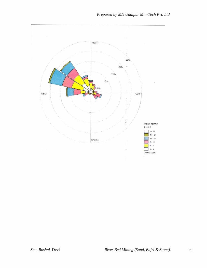
Prepared by M/s Udaipur Min-Tech Pvt. Ltd.
Smt. Roshni Devi River Bed Mining (Sand, Bajri & Stone).
73

Prepared by M/s Udaipur Min-Tech Pvt. Ltd.
Smt. Roshni Devi River Bed Mining (Sand, Bajri & Stone).
74
3.12 NOISE ENVIRONMENT
Noise often defined as unwanted sound, interferes with speech
communication, causes annoyance, distracts from work, disturb sleep,
thus deteriorating quality of human environment. Noise Pollution
survey has therefore been carried out.
Noise levels were measured residential areas and other settlements
located within 10 km radius around the site.
3.12.1 Noise Analysis within the study area
The noise analysis within the study area was recorded using 4-20,
sound level meter. The analysis reveals that the noise‟s well within
the permissible range. The location of Noise level monitoring is
presented in Table 3.10 (A) & the levels recorded are as stated in Table
3.10 (B).
TABLE 3.10(A)
LOCATION OF NOISE MONITORING STATIONS
Station
Code.
Station Name Location with respect to Site
Distance (Km) Direction
N0 Mine – Site Core zone --
N1 D/S project site 0.50 SE
N2 Near Bhogpur Village 5.00 NW
N3 Near Manpura Village 9.66 SE
N4 Near NalagarhVillage 2.75 S
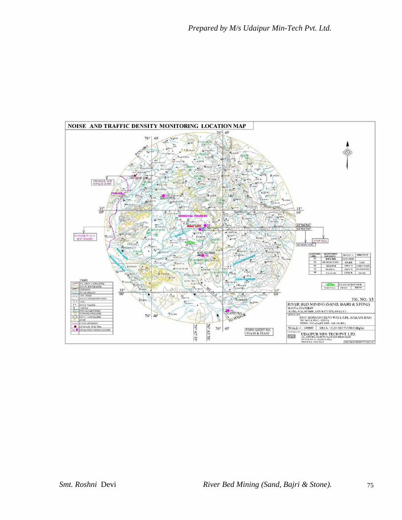
Prepared by M/s Udaipur Min-Tech Pvt. Ltd.
Smt. Roshni Devi River Bed Mining (Sand, Bajri & Stone).
75

Prepared by M/s Udaipur Min-Tech Pvt. Ltd.
Smt. Roshni Devi River Bed Mining (Sand, Bajri & Stone).
76
TABLE 3.10(B)
NOISE LEVEL WITHIN THE STUDY AREA
(Unit – dBA)
TABLE 3.10(C)
CPCB NOISE STANDERD
Category of Zones Leq in dB (A)
Day Night
Industrial 75 70
Commercial 65 55
Residential 55 45
Silence Zone 50 40
S.
No
Location Result Test Test Method
Day Night
1. Project
Boundary
53.7 40.8 1Hour
Leq
IS:9989 : 1981
R -2002
2. Near D/S
project site
52.1 44.8 1Hour
Leq
IS:9989 : 1981
R -2002
3. Near Bhogpur 51.7 43.2 1Hour
Leq
IS:9989 : 1981
R -2002
4. Near Manpura 54.7 48.3 1Hour
Leq
IS:9989 : 1981
R -2002
5. Near Nalagarh 58.1 48.7 1Hour
Leq
IS:9989 : 1981
R -2002

Prepared by M/s Udaipur Min-Tech Pvt. Ltd.
Smt. Roshni Devi River Bed Mining (Sand, Bajri & Stone).
77
1. Day time is from 6.00 Am to 10.00PM.
2. Night time is reckoned between 10.00 PM to 6.00AM
3. Silence zone is defined as an area up to 100m around premises of hospitals,
educational institution and courts. Use of vehicle horn, loudspeaker and
bursting of crackers is banned in these zones.
Note : Mixed categories of areas be declared as one of the four above mentioned
categories by the competent Authority and the corresponding standards shall
apply.
3.12.2 Result
According to B.L.MOD, Ambient noise levels were measured at 5
locations around the site. Noise levels varies from 51.7 to 58.1 Leq
dB(A) during day time and during night time noise levels ranges from
40.8 to 48.7 Leq dB(A). Thus noise levels at all locations were observed
to be within the prescribed limits.
From the above study and discussions it can be concluded that noise
levels in the study area are well within the prescribed limits as
prescribed by the CPCB.
3.12.3 Traffic density
Traffic density measurements were performed at one location at
village Dottowal,(Nalagarh – Panjaira State Highway) Location of
these stations are marked on the map in Fig.3.5. The monitoring was
performed in Jan., 2012.
Traffic density measurement were made continuously for 24 hours
by visual observation and counting of vehicles under three categories,
viz., heavy motor vehicles, light motor vehicles and two/three
wheelers. As traffic densities on the roads are high, two skilled
persons were deployed simultaneously at each station during each
shift- one person on each of the two directions for counting the
traffic. At the end of each hour, fresh counting and recording was
undertaken. Total numbers of vehicles per hour under the three
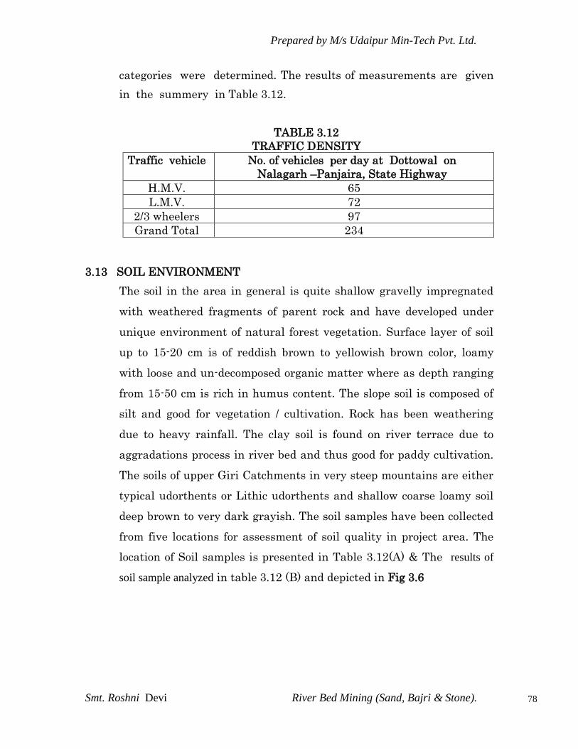
Prepared by M/s Udaipur Min-Tech Pvt. Ltd.
Smt. Roshni Devi River Bed Mining (Sand, Bajri & Stone).
78
categories were determined. The results of measurements are given
in the summery in Table 3.12.
TABLE 3.12
TRAFFIC DENSITY
Traffic vehicle No. of vehicles per day at Dottowal on
Nalagarh –Panjaira, State Highway
H.M.V. 65
L.M.V. 72
2/3 wheelers 97
Grand Total 234
3.13 SOIL ENVIRONMENT
The soil in the area in general is quite shallow gravelly impregnated
with weathered fragments of parent rock and have developed under
unique environment of natural forest vegetation. Surface layer of soil
up to 15-20 cm is of reddish brown to yellowish brown color, loamy
with loose and un-decomposed organic matter where as depth ranging
from 15-50 cm is rich in humus content. The slope soil is composed of
silt and good for vegetation / cultivation. Rock has been weathering
due to heavy rainfall. The clay soil is found on river terrace due to
aggradations process in river bed and thus good for paddy cultivation.
The soils of upper Giri Catchments in very steep mountains are either
typical udorthents or Lithic udorthents and shallow coarse loamy soil
deep brown to very dark grayish. The soil samples have been collected
from five locations for assessment of soil quality in project area. The
location of Soil samples is presented in Table 3.12(A) & The results of
soil sample analyzed in table 3.12 (B) and depicted in Fig 3.6

Prepared by M/s Udaipur Min-Tech Pvt. Ltd.
Smt. Roshni Devi River Bed Mining (Sand, Bajri & Stone).
79

Prepared by M/s Udaipur Min-Tech Pvt. Ltd.
Smt. Roshni Devi River Bed Mining (Sand, Bajri & Stone).
80
TABLE – 3.12 (A)
LOCATION OF SOIL QUALITY MONITORING STATIONS
Station
Code.
Station
Name
Description Location with respect to Site
Distance (Km) Direction
S1 Project Site Ag. Land 0.50 SE
S2 Near
Bhogpur
Ag. Land 5.00 NW
S3 Near
Manpura
Ag. Land 9.66 SE
TABLE – 3.12 (B)
SOIL SAMPLE ANALYSIS
S.
No
Parameters Unit Proje
ct
Site
S1
Near
Bhog
pur
S2
Near Man
pura
S3
Test Method
1. pH (1 : 2.5) - 6.12 6.92 7.01 Soil & Solid Waste
Analysis Manual-
P.K.Behera
2. Electrical
Conductivity
Saturation
Extract (1:2)
Micro-
mhos/
cm
110 136 256
--
3. Soil moisture
Content
% 32.6 40.6 42.1
--
4. Soil Texture -- Sandy
Clay
Silty
Clay
Loam
Clay loam
--
5. Bulk Density gm/cc 1.1 1.2 1.3
--
6. Organic
Matter
% 0.23 0.32 0.16
--
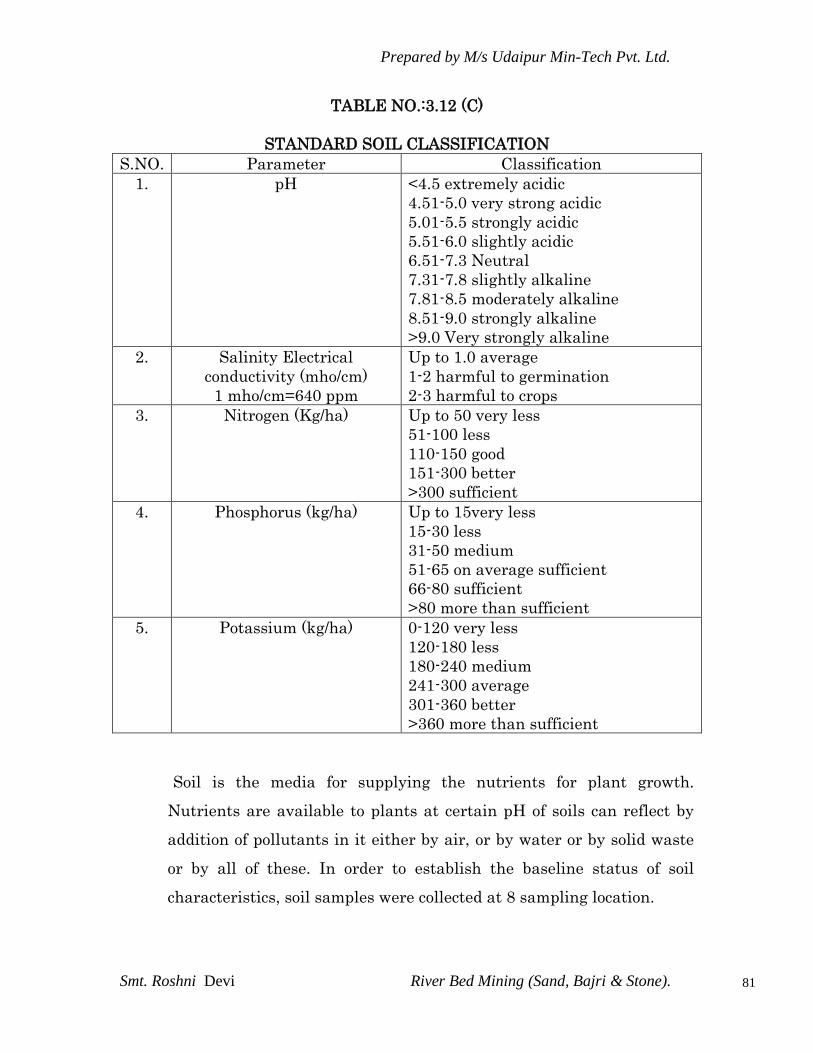
Prepared by M/s Udaipur Min-Tech Pvt. Ltd.
Smt. Roshni Devi River Bed Mining (Sand, Bajri & Stone).
81
TABLE NO.:3.12 (C)
STANDARD SOIL CLASSIFICATION
S.NO. Parameter Classification
1. pH <4.5 extremely acidic
4.51-5.0 very strong acidic
5.01-5.5 strongly acidic
5.51-6.0 slightly acidic
6.51-7.3 Neutral
7.31-7.8 slightly alkaline
7.81-8.5 moderately alkaline
8.51-9.0 strongly alkaline
>9.0 Very strongly alkaline
2. Salinity Electrical
conductivity (mho/cm)
1 mho/cm=640 ppm
Up to 1.0 average
1-2 harmful to germination
2-3 harmful to crops
3. Nitrogen (Kg/ha) Up to 50 very less
51-100 less
110-150 good
151-300 better
>300 sufficient
4. Phosphorus (kg/ha) Up to 15very less
15-30 less
31-50 medium
51-65 on average sufficient
66-80 sufficient
>80 more than sufficient
5. Potassium (kg/ha) 0-120 very less
120-180 less
180-240 medium
241-300 average
301-360 better
>360 more than sufficient
Soil is the media for supplying the nutrients for plant growth.
Nutrients are available to plants at certain pH of soils can reflect by
addition of pollutants in it either by air, or by water or by solid waste
or by all of these. In order to establish the baseline status of soil
characteristics, soil samples were collected at 8 sampling location.

Prepared by M/s Udaipur Min-Tech Pvt. Ltd.
Smt. Roshni Devi River Bed Mining (Sand, Bajri & Stone).
82
3.13.1 Result
The results of soil sample analyzed during Summer period (April.
2012) are presented in Table 3.13(B) for physical and chemical
parameters. The result of soil analysis shows that it is slightly acidic in
nature having pH values from 6.12 to 7.01. The soil texture varies from
coarse sandy clay to clay loam having predominantly Sand. The Soil
density varies from 1.1 to 1.3. The micronutrients have been found in
all the samples.
3.14 BIOLOGICAL EVIRONMENT
The basic purpose to exploring the biological environment under
Environmental Impact Assessment (EIA) is to assist in the decision
making process and to ensure that the project options under
consideration are bio-environmental-friendly. EIA identifies ways of
improving project environmentally by preventing, minimizing,
mitigating or compensating for adverse impacts before construction
and after construction phase. The present study on the floral
assessment of the proposed project is based on field survey of the area
supported by secondary data from various governmental and non-
governmental sources.
3.14.1 Study Area
The entire tract of the study area is hilly, lies between altitudes of 500
m to 2000 m. The slopes vary considerably and are generally
moderated to slightly steep. The climate in the study area varies from
sub tropical to moist temperate.
10 km (radial distance from the proposed mining lease) study area was
taken for the assessment of terrestrial ecology of flora and fauna based
on topography, land use, vegetation pattern, etc. The observations
were taken in agriculture fields, hills, plain area, and village

Prepared by M/s Udaipur Min-Tech Pvt. Ltd.
Smt. Roshni Devi River Bed Mining (Sand, Bajri & Stone).
83
wasteland prescribed by the objectives and guidelines for Preliminary
Environmental Examination. All observations were taken during the
month of May 2012. A list of sampling locations taken during the
survey is given in Table 3.13.
Table 3.13
LIST OF SAMPLING LOCATIONS FOR BIOLOGICAL ENVIRONMENT
Sr.
NO.
Village
Direction Distance
1 KATLI N 6.50 KM.
2 GHAT NE 9.75 KM.
3 KATAL N 4.45 KM.
4 MAHADEO EN 7.85 KM.
5 MANGUWAL WS 3.60 KM.
6 SHAHPUR SW 7.75 KM.
7 KANGANWAL WS 4.85 KM.
8 GOL JAMALA NW 2.70 KM.
9 BHATIAN W 4.15 KM.
10 BHOGPUR NW 5.00 KM.
11 NAWAN GRAON NW 9.00 KM.
12 SANEHR W 2.00 KM.
13 NALAGARH S 2.75 KM.
14 DHANG WS 4.85 KM.
15 DOTTOWAL WS 2.00 KM.
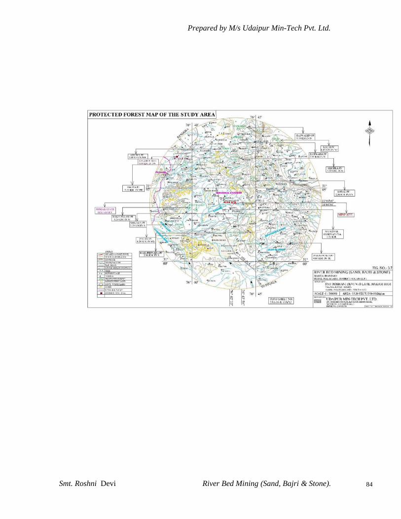
Prepared by M/s Udaipur Min-Tech Pvt. Ltd.
Smt. Roshni Devi River Bed Mining (Sand, Bajri & Stone).
84

Prepared by M/s Udaipur Min-Tech Pvt. Ltd.
Smt. Roshni Devi River Bed Mining (Sand, Bajri & Stone).
85
3.14.2 Survey Methodology
Flora
The present study on the floral assessment for the proposed project
activity is based on extensive field survey of the area. The study has
been conducted in summer season. The plant species were identified
with the help of taxonomists of related fields and nearby Institutions.
Besides the collection of plant species, information was also collected
with vernacular names of plant species made by local inhabitants. In
this process the whole study area was divided into different sections to
get the maximum diversity of plant species. The sampling sites were
selected based on land use pattern, topography and floristic
composition of the study area. The other relevant data on bio-diversity,
like economically important plant species and medicinal plant, Rare
and endangered species in the study area have been collected from
secondary sources like forest and wild life departments.
Fauna
The study of fauna takes substantial amount of time to understand the
specific faunal characteristics of the area. The assessment of fauna
have been done on the bases secondary data collected from different
government offices like forest department, wildlife department etc. The
presence of wildlife was also confirmed from the local inhabitants
depending on the animal sightings and the frequency of their visits in
the project area. In addition review of secondary data was another
source of information for studying the fauna of the area. In addition the following
sources were also used.
Sighting during ecological studies
Animal call
Foot mark and excreta

Prepared by M/s Udaipur Min-Tech Pvt. Ltd.
Smt. Roshni Devi River Bed Mining (Sand, Bajri & Stone).
86
Avifauna
During Birds survey actual counts of birds were made following the
standard survey technique. Observations were made during a walk
through in the chosen transect for sighting birds. The number of birds
observed in each sampling location was directly counted and listing
was made. Birds were noted, counted and identified with the help of
8X40 “Optima Zenith” binocular and standard field identification
guides.
3.14.3 Forest and forest types observed in the study area
According to the revised classification of the forest types of India by
Champion and Seth (1968) the following forest types are generally
observed in the study area.
a) Group 5- Tropical dry deciduous forest
(Sub group 5B-Northern tropical dry deciduous forest)
b) Group 9- Sub tropical pine forest
(Sub group C, - Himalayan sub-tropical forest)
c) Group 12- Himalayan moist temperature forest
These forests occur almost in the entire tracts of the study area. The
forests are characterized by the presence of entirely broad leaved
deciduous trees. Anogeissus latifolia (chal) is an important species in
this type. Other dominant species found in the study area are Acacia
catechu, Bauhinia variegata, Bombax ceiba, Cassia fistula, Emblica
officinalis, Terminalia belerica, Terminalia chebula and Terminalia
tomentosa etc.
The understory consists of shrubby undergrowth with some evergreen
xerophtic species. The lantana bushes found to be dominant all over
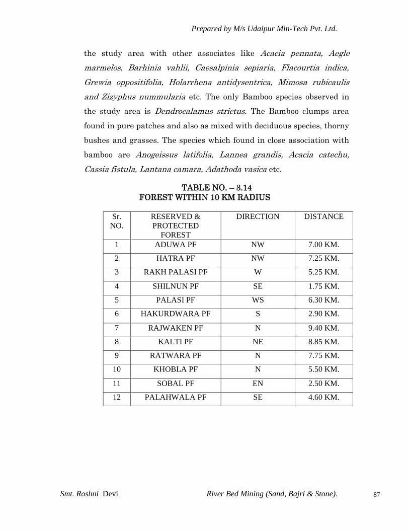
Prepared by M/s Udaipur Min-Tech Pvt. Ltd.
Smt. Roshni Devi River Bed Mining (Sand, Bajri & Stone).
87
the study area with other associates like Acacia pennata, Aegle
marmelos, Barhinia vahlii, Caesalpinia sepiaria, Flacourtia indica,
Grewia oppositifolia, Holarrhena antidysentrica, Mimosa rubicaulis
and Zizyphus nummularia etc. The only Bamboo species observed in
the study area is Dendrocalamus strictus. The Bamboo clumps area
found in pure patches and also as mixed with deciduous species, thorny
bushes and grasses. The species which found in close association with
bamboo are Anogeissus latifolia, Lannea grandis, Acacia catechu,
Cassia fistula, Lantana camara, Adathoda vasica etc.
TABLE NO. – 3.14
FOREST WITHIN 10 KM RADIUS
Sr.
NO.
RESERVED &
PROTECTED
FOREST
DIRECTION DISTANCE
1 ADUWA PF NW 7.00 KM.
2 HATRA PF NW 7.25 KM.
3 RAKH PALASI PF W 5.25 KM.
4 SHILNUN PF SE 1.75 KM.
5 PALASI PF WS 6.30 KM.
6 HAKURDWARA PF S 2.90 KM.
7 RAJWAKEN PF N 9.40 KM.
8 KALTI PF NE 8.85 KM.
9 RATWARA PF N 7.75 KM.
10 KHOBLA PF N 5.50 KM.
11 SOBAL PF EN 2.50 KM.
12 PALAHWALA PF SE 4.60 KM.

Prepared by M/s Udaipur Min-Tech Pvt. Ltd.
Smt. Roshni Devi River Bed Mining (Sand, Bajri & Stone).
88
3.14.4. Floral diversity in Study Area
Core Zone
The core zone of the study area is the mining lease area which is
situated in river androlla River. The river has been found to be dry
throughout the year except for the rainy season when in flow of rain
water from surrounding mountainous area has been reported. The core
area is having some grasses and very little shrubby vegetation. Only
few Acacia spp. were observed near the boundary of the mine lease
area. The shrubs like Parthenium spp., Ipomea spp. were observed in
few numbers in the mine lease area. The river side vegetation is
relatively dense with species like Dalbergia sisoo, Acacia spp.,
Azadirachta indica, Eucalyptus spp., Albizzia lebbek, Mangifera indica
and Melia azadirach were observed during the survey.
Buffer Zone
The entire tract of the buffer zone is hilly, the slopes vary considerably
and are generally moderated to slightly steep. The plane areas were
dominated by agriculture fields. During the floral survey, the tree
species observed in the buffer zone are Anogeissus latifolia, Acacia
catechu, Bombax ceiba, Butea monosperma, Cassia fistula, Dalbergia
sissoo, Emblica officinalis, Eucalyptus globules, Ficus bengalensis,
Ficus glomerata, Ficus religiosa, Mangifera indica, Melia azadirach,
Morus alba, Populous ciliate, Syzygium cumini, Terminalia arjuna etc.
The undergrowth which are observed during the survey are Nerium
indicum, Adathoda vasica, Agave Americana, Cassia tora, Calotropis
procera, Cochlospermum gossypium, Datura stramonium, Euphorbia
royaleana, Jatropha curcas, Lantana camara, Zizyphus jujube and
Vitex negundo etc. The grasses and bamboo species observed in the
study area are Andropogon Spp, Aristida depressa, Bambusa
arundinacea, Arundinaria falcate, Cymbonpogon martini and

Prepared by M/s Udaipur Min-Tech Pvt. Ltd.
Smt. Roshni Devi River Bed Mining (Sand, Bajri & Stone).
89
Dendrocalamum strictus etc. The list of plant species recorded in the
study area is given in Table 3.15.
3.14.6 Threatened Plant Species
Not a single species were observed to be threatened in the study area.
4.14.6.1 Fauna
Faunal assessment provides a basis for determining relative
abundance and rarity of each species which is important for assessing
the diversity of fauna of a particular area. Since animals are capable of
movements from one place to another, this makes their study entirely
different. Different animals prefer different types of habitat for food
and shelter. The animal life of an area is dependent upon the
vegetation and there are countless relationships between the species
composing an animal community.
The study area has variety of wildlife due to the diversity of vegetation
type that occurs due to the altitudinal variation. During the survey the
species like squirrels, Langur, Field rat, mongooses were observed
around the mine lease area and in buffer area. species like siyar, lomri,
jungli suar, kakkar are sometimes observed in the study area as
narrated by local people. Common reptiles found in the study area are
house lizard, Garden lizard, rock lizard etc. other reptiles which are
infrequently observed in the study area are rat snake, common Indian
crait, Indian cobra etc. During the faunal investigation no Schedule-I
species observed in the study area. The list of faunal elements found in
the study area is given in Table no. 3.16
3.14.6.2 Avifauna
A total of 18 birds were observed in the study area. The common birds
which are observed during the survey are Indian myna, Green bee-

Prepared by M/s Udaipur Min-Tech Pvt. Ltd.
Smt. Roshni Devi River Bed Mining (Sand, Bajri & Stone).
90
eater, dove, kingfisher, House sparrow, House crow; flycatcher,
warblers, parakeet‟s etc. List of birds available in the study area are
presented in Table 3.17.
Endangered & Vulnerable Animals
A comprehensive central legislation namely Wild Life (Protection) act
was enforced in 1972. This law provides protection to wild animals and
for matters related to their ancillary or incidental death. Not a single
species were observed to be threatened in the study area.
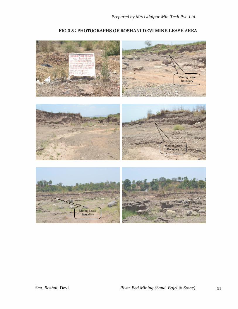
Prepared by M/s Udaipur Min-Tech Pvt. Ltd.
Smt. Roshni Devi River Bed Mining (Sand, Bajri & Stone).
91
FIG.3.8 : PHOTOGRAPHS OF ROSHANI DEVI MINE LEASE AREA
Mining Lease Boundary
Mining Lease
Boundary
Mining Lease
Boundary

Prepared by M/s Udaipur Min-Tech Pvt. Ltd.
Smt. Roshni Devi River Bed Mining (Sand, Bajri & Stone).
92
TABLE 3.15
LIST OF COMMON FLORA OBSERVED IN THE STUDY AREA
Sr.
No. Botanical Name Local Name Family
Trees
1. Acacia catechu Khair Leguminosae-Mimosae
2. Aegle marmelos Bel Rutaceae
3. Aesculus indica Khanor Urticaceae
4. Albizzia chinensis Siris Leguminosae-Mimosae
5. Albizzia lebbek Siris Leguminosae-Mimosae
6. Albizzia odoratissima Kala Siris Leguminosae-Mimosae
7. Albizzia procera Safed Siris Leguminosae-Mimosae
8. Anogeissius latifolia Chhal, Dhau,
Bakli
Combretaceae
9. Azadirachta indica Neem Meliaceae
10. Bauhinia purpurea Lal Karal Leguminosae-
Caesalpinieae
11. Bauhinia racemosa Karal Leguminosae-
Caesalpinieae
12. Bauhinia variegate Kachnar,
Papri
Leguminosae-
Caesalpinieae
13. Bombax ceiba Semal Malvaceae
14. Butea monosperma Dhak, Palah Leguminosae-
Papilioneae
15. Campsis grandiflora Delaun Bignoniaceae
16. Casearia elliptica Gotlu, Chilla Samydaceae
17. Cassia fistula Amaltas Leguminosae-
Caesalpinieae
18. Cedrela serrata Dauri Meliaceae
19. Cedrela toona Toon Meliaceae
20. Cedrus deodara Deodar Prinaceae
21. Celtis australis Khirik Urticaceae
22. Cordial dichotoma Lasura Boraginaceae
23. Cornus capitata Thumbi Cornaceae
24. Cupressus torulosa Saru Coniferae
25. Dalbergia sissoo Shisham Leguminosae-
Prepared by M/s Udaipur Min-Tech Pvt. Ltd.
Smt. Roshni Devi River Bed Mining (Sand, Bajri & Stone).
93
Sr.
No. Botanical Name Local Name Family
Papilioneae
26. Dendrocalamus strictus Bans Graminae
27. Ehretia laevis Chamror Boraginaceae
28. Ehretia serrata Pandayan Boraginaceae
29. Elaeodendron glaucum Morindu,
Mirgu
Celastraceae
30. Emblica officinalis Amla Leguminosae-Mimoseae
31. Engelhardtia
colebrookiana
Samma Juglandaceae
32. Erythrina suberosa Dhaul,
Padiara
Legumimosae
33. Eucalyptus globules Safeda Myrtaceae
34. Eugenia jambolana var.
Caryophyllifolia
Kathaman Myrtaceae
35. Ficus bengalensis Bar, Bargad Urticaceae
36. Ficus glomerata Fagura Urticaceae
37. Ficus palmate Dhura, Fegra Urticaceae
38. Ficus religiosa Peepal Urticaceae
39. Flacourtia indica Kangu Bixaceae
40. Garuga pinnata Kharpat Burseraceae
41. Grewia oppositifolia Dhaman, Biul Tiliaceae
42. Grewia populifolia - Tiliaceae
43. Hamiltonia sauveolans - Rubiaceae
44. Holarrhena
antidysentrica
Maror phalli Apocynaceae
45. Jacaranda
mimosaefolia
Jacaranda Scrophulariaceae
46. Juglans regia Akhrot Juglandaceae
47. Kydia calycina Pula Malvaceae
48. Lagerstroemia indica Harsinghar Lythraceae
49. Lannea grandis Jhingan Anacardiaceae
50. Limonia acidissima Barnasi Rutaceae
51. Litsea glutinosa Chandana Lauraceae
52. Lyonia ovalifolia Ayar, Ailan Ericaceae
53. Machilus odoratissima Bajhaul Lauraceae

Prepared by M/s Udaipur Min-Tech Pvt. Ltd.
Smt. Roshni Devi River Bed Mining (Sand, Bajri & Stone).
94
Sr.
No. Botanical Name Local Name Family
54. Maesa indica Burkain Myrsinaceae
55. Mallotus philippinensis Kamal,
Kamela
Euphorbiaceae
56. Mangifera indica Aam Anacardiaceae
57. Melia azadirach Drek Meliaceae
58. Milletia auriculata Shama Meliaceae
59. Mitragyna parviflora Kaem, Phaldu Rubiaceae
60. Moringa oleifera Sanjna Moringaceae
61. Morus alba Shahtoot urticaceae
62. Morus serrata Toot Urticaceae
63. Morus nagi Kaphal Myricaceae
64. Nerium indicum Kaner Apocynaceae
65. Olea cuspidate Kahu Oleaceae
66. Olea glandulifera Jharinu Oleaceae
67. Oroxylum indicum Tat-palanga Bignoneaceae
68. Ougenia oojeinensis Sandan Leguminosae-
Papilipneae
69. Persea gamblei Bhadrol Lauraceae
70. Phoenix sylvestris Khajoor Palmae
71. Pinus roxburghii Chil, Chir Coniferae
72. Populous ciliate Poplar Salicaceae
73. Prunus armeniaca Khumani Rosaceae
74. Prunus persica Aru Rosaceae
75. Prunus puddum Paja Rosaceae
76. Prunus granatum Daru Lythraceae
77. Putranjiva roxburghii Jaipota Euphorbiaceae
78. Pyrus communis Nashpati Rosaceae
79. Pyrus pashia Kainth Rosaceae
80. Quercus glauca Bani Cupuliferae-Quercineae
81. Quercus
leucotichophora
Ban Cupuliferae-Quericineae
82. Robinia pseudoacacia Rubinia Leguminosae-
Caesalpinieae
83. Salix alba Badah Salicaceae
84. Schleichera oleosa Kusum Sapindaceae

Prepared by M/s Udaipur Min-Tech Pvt. Ltd.
Smt. Roshni Devi River Bed Mining (Sand, Bajri & Stone).
95
Sr.
No. Botanical Name Local Name Family
85. Syzygium cumini Jamun Myrtaceae
86. Terminalia arjuna Arjun Combretaceae
87. Terminalia belerica Bahera Combretaceae
88. Terminalia chebula Harar Combretaceae
89. Terminalia tomentosa Sain Combretaceae
90. Trewia nudiflora Gamhar Euphorbiaceae
91. Zizyphus mauritiana Ber Rhamnaceae
Shrubs and Herbs
1. Adathoda vasica Basuti Bcanthaceae
2. Agave Americana Ram Ban Amaryllidaceae
3. Agave cantala -do- Amaryllidaceae
4. Arisaema wallichianum Cobra plant Asteraceae (Compositae)
5. Arundinaria falcate Nar, Piuli Gramineae
6. Asparagus racemosus Sataron,
Sansarmul
Liliaceae
7. Bambusa arundinacea Kanta bans Gramineae
8. Berberis chitria Kasmal Berberidaceae
9. Berberis lyceum Kashmal Berberidaceae
10. Bergenia ligulata Pathal Tor Saxifragaceae
11. Caesalpinia decapitata - Leguminosae-
Caesalpinieae
12. Calotropis procera Aak Asclepiadaceae
13. Cannabis sativa Bhang, wild
hemp
Urticaceae
14. Carissa opaca Karaunda Apocynaceae
15. Cassia tora Ailu Leguminosae-
Caesalpinieae
16. Clerodendron
phlomidis
Dhak, Kari Verbenaceae
17. Cochlospermum
gossypium
Kumb Bixaceae
18. Coriaria nepalensis Nachhar Coriariaceae
19. Cotoneaster
microphylla
Chamror Rosaceae
20. Daphne cannabina Satbarna Thymelaeaceae
Prepared by M/s Udaipur Min-Tech Pvt. Ltd.
Smt. Roshni Devi River Bed Mining (Sand, Bajri & Stone).
96
Sr.
No. Botanical Name Local Name Family
21. Datura stramonium Dhatura Solanaceae
22. Desmodium
tiliaefolium
Matoi Leguminosae-
Papilioneae
23. Dodonea viscose Mehndar Sapindaceae
24. Elsholtzia fruticosa Potha Labiatae
25. Euonymus pendulus Bharmela Celastraceae
26. Euphorbia royaleana Thor Euphorbiaceae
27. Fragaria indica - Ranunculaceae
28. Gerardiana
heterophylla
Bichhu buti Urticaceae
29. Glycosmis pentaphylla Ban Nimbu Rutaceae
30. Hippophae rhamnoides Gaihiu Elaeagnaceae
31. Llex dipyrena Kanderu Hicaceae
32. Indigofera gerardiana Kathi Leguminosae-
Papilioneae
33. Indigofera hirsute Kathi Leguminosae-
Papilioneae
34. Indigofera pulchella Kathi, Nil Leguminosae-
Papilioneae
35. Iris nepalensis - Liliaceae
36. Jasminum humile Malti Oleaceae
37. Jasminum multiforum Ban Malti Oleaceae
38. Jasminum officinale Dhur malti Oleaceae
39. Jatropha curcas Jamalghota Euphorbiaceae
40. Lantana camara Phul Lakri Verbenaceae
41. Loranthus longiflorous Narate Loranthaceae
42. Menthe arvensis Ban Pudina Labiatae
43. Mimosa rubicaulis Karingan Leguminosae-Mimoseae
44. Murraya koenigii Gandhela Rutaceae
45. Myrsine Africana Jhunjhra Myrsinaceae
46. Nyctanthes arbour-
tristis
Harsingar,
Kura
Oleaceae
47. Opuntia dillenii Nagphani Cactaceae
48. Plectranthus rugosus Chhichari,
Kathal
Labiatae

Prepared by M/s Udaipur Min-Tech Pvt. Ltd.
Smt. Roshni Devi River Bed Mining (Sand, Bajri & Stone).
97
Sr.
No. Botanical Name Local Name Family
49. Polygonum capitatum - Polygonaceae
50. Prinsepia utilis Bhekhal Rosaceae
51. Randia dumetorum Rara Rubiaceae
52. Randia tetrasperma Jundru Rubiaceae
53. Rhamnus virgata Thalta Rhamnaceae
54. Rhus cotinus Tung Anacardiaceae
55. Rhus punjabensis Tittar Anacardiaceae
56. Rhus semialata Bankhor Anacardiaceae
57. Rosa moshata Kuja Rosaceae
58. Rubus ellipticus Heer Rosaceae
59. Rubus macilentus Akha Rosaceae
60. Rumex hastatus Chulmora Polygonaceae
61. Rumex nepalensis Jungli Palak Polygonaceae
62. Salvia glutinosa Makhiar Labiatae
63. Solanum indicum Ban Tambaku Solanceae
64. Vitex negundo Bana Verbanaceae
65. Viola canescens Banafsha Violaceae
66. Woodfordia floribunda Dhai Lythraceae
67. Zizyphus jujube Beri Rhamnaceae
Bamboos and Grasses
1. Andropogon Spp. Graminae
2. Agropyron
longearistatum
Graminae
3. Agrostis tenuis Graminae
4. Aristida depressa Lambi Graminae
5. Arundinaria falcate Nirgaal Graminae
6. Arundinella nepalensis Graminae
7. Bambusa arundinacea Kanta bans Graminae
8. Bothriocloa pertusa Graminae
9. Brachiaria villosa Graminae
10. Bromus Spp. Graminae
11. Chrysopogon fulvus Dholu Graminae
12. Chrysopogon gryllus Dholu Graminae
13. Chrysopogon montanus Dholu Graminae

Prepared by M/s Udaipur Min-Tech Pvt. Ltd.
Smt. Roshni Devi River Bed Mining (Sand, Bajri & Stone).
98
Sr.
No. Botanical Name Local Name Family
14. Cymbonpogon martini Makora Graminae
15. Cynodon dactylon Dub Graminae
16. Dendrocalamum
strictus
Bans/Male
Bamboo
Graminae
17. Dendrocalamus
hamiltonii
Magar bans Graminae
18. Dicanthium annulatum Graminae
19. Eulatiopsis binata Bhabbar Graminae
20. Festuca Spp. Graminae
21. Hemarthria compresa Graminae
22. Heteropogon contortus Lamb, Sariala Graminae
23. Pennisetum orientale Graminae
24. Phalcaris tuberose Graminae
25. Phylostachys chinensis Chinese
bamboo
Graminae
26. Poa pratensis Graminae
27. Saccharum
Spontaneum
Kans Graminae
28. Sehima notata Graminae
29. Sorghum nitidum Lungi Graminae
30. Themeda arudinacea Graminae
31. Themeda anathera Graminae
Source : Forest Department , Observations during survey and Public
consultation
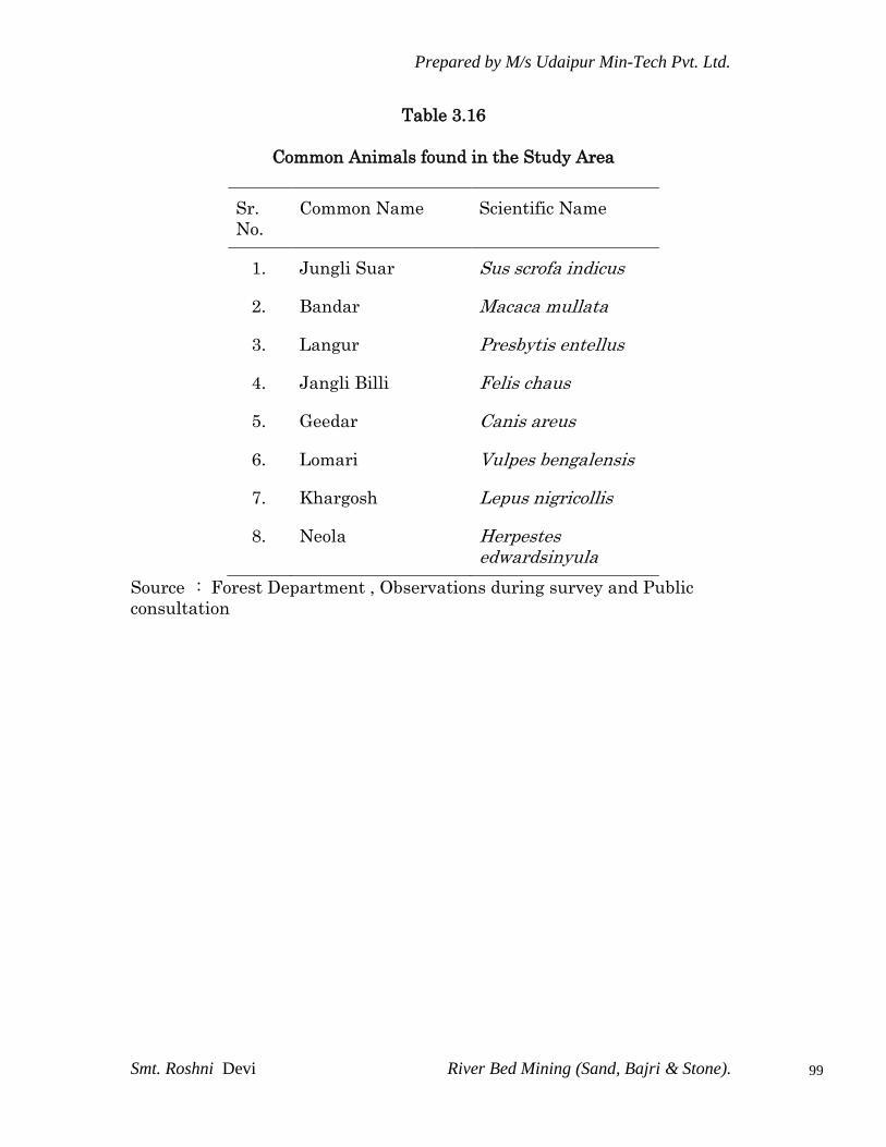
Prepared by M/s Udaipur Min-Tech Pvt. Ltd.
Smt. Roshni Devi River Bed Mining (Sand, Bajri & Stone).
99
Table 3.16
Common Animals found in the Study Area
Sr.
No.
Common Name Scientific Name
1. Jungli Suar Sus scrofa indicus
2. Bandar Macaca mullata
3. Langur Presbytis entellus
4. Jangli Billi Felis chaus
5. Geedar Canis areus
6. Lomari Vulpes bengalensis
7. Khargosh Lepus nigricollis
8. Neola Herpestes edwardsinyula
Source : Forest Department , Observations during survey and Public
consultation

Prepared by M/s Udaipur Min-Tech Pvt. Ltd.
Smt. Roshni Devi River Bed Mining (Sand, Bajri & Stone).
100
TABLE 3.17
LIST OF BIRD SPECIES OBSERVED IN THE STUDY AREA
Sr.
No Common Name Zoological Name
Birds
1. Jungli murga Gallus gallus
2. Mor Pavo cristatus
3. Dhaula teetar Francolinus pondicerianus
4. Kala teetar Francolinus Francolinus
5. Bater Prodecula asiatica
6. Ghuggi Streptopediachinensis
7. golden backed Wood pecker Dinopium benghalense
8. Yellow fronted pied or
Maratha wood pecker
Picoiaes mahrattenses
9. Black WingedKite Elanus carruleus
10. Black backed woodpecker Chrysocolaptes pondiceria
11. Gray partridge Francolinus pondiceria
12. Pied Bush Chat* Saxicola caprata
13. White Breasted kingfisher* Halcyon smyrnensis
14. Pied Kingfisher* Ceryle rudis
15. Koel, Cuckoo* Eudynamys scolopiea
16. House Crow* Corvus splendens
17. Grey Wagtail* Motacilla caspica
18. Yellow cheeked Tit Parus zanthogenys
19. Redvented bulbul* Pycnonotus cafer
20. King Crow, Black Drongo* Dicrurus adsimilis
21. Indian tree pie Dendrocitta vegabanda
22. Crow pheasant Centropus sinensis
23. King Vulture Torgos calvus
24. Grey tit Parus major
25. Purple Sunbird* Nectarinia asiatica

Prepared by M/s Udaipur Min-Tech Pvt. Ltd.
Smt. Roshni Devi River Bed Mining (Sand, Bajri & Stone).
101
26. Magpie robin* Copsychus saularis
27. Jungle Babbler* Turdoides striartus
28. Cattle Egret* Bubulcus ibis
29. House Sparrow* Passer domcshticus
30. Indian Robin* Saxicoloides fulicata
31. Common Pariah Kite Milvus migrans
32. Common Kingfisher* Alcedo atthis
33. Jungle Crow* Corvus macrorhynchos
34. Roseringed Parakeet* Psittacula krameri
35. Common Myna* Acridotheres Grisea
36. White Wagtail Motacilla alba
37. Wagtail Yellow Motacilla flava
38. Indian Roller or Blue Jay* Coracias benghalensi
39. Green Bee eater* Merops orientalis
40. Redwhiskered Bulbul* Pycnonotus Jocosus
Source : Forest Department , Observations during survey and Public consultation
Plant and animal communities are indicators of the environment. They
respond not only to one environmental factor but also to an interacting
group of factors. These communities influence and react sensitively to
change in the balance of environmental stresses. Depletion of
biodiversity is mainly due to intense anthropogenic pressure owing to
“Population Explosion” mainly for expansion of agriculture, over
exploitation of forests for day to day needs, over grazing and illicit
felling, shifting cultivation, development activities like, irrigation,
construction of hydro-electric dams, road construction including
mining activities- all leading to dysgenic selection. Rational use of the
resources is therefore, quite important in the management of
biodiversity, the habitat, species and gene pools prevalent in an area,
because once it is lost, it becomes an uphill task to reverse the process.
Therefore, a detailed knowledge of the diversity of the area definitely
helps in managing the area properly following suitable practices.
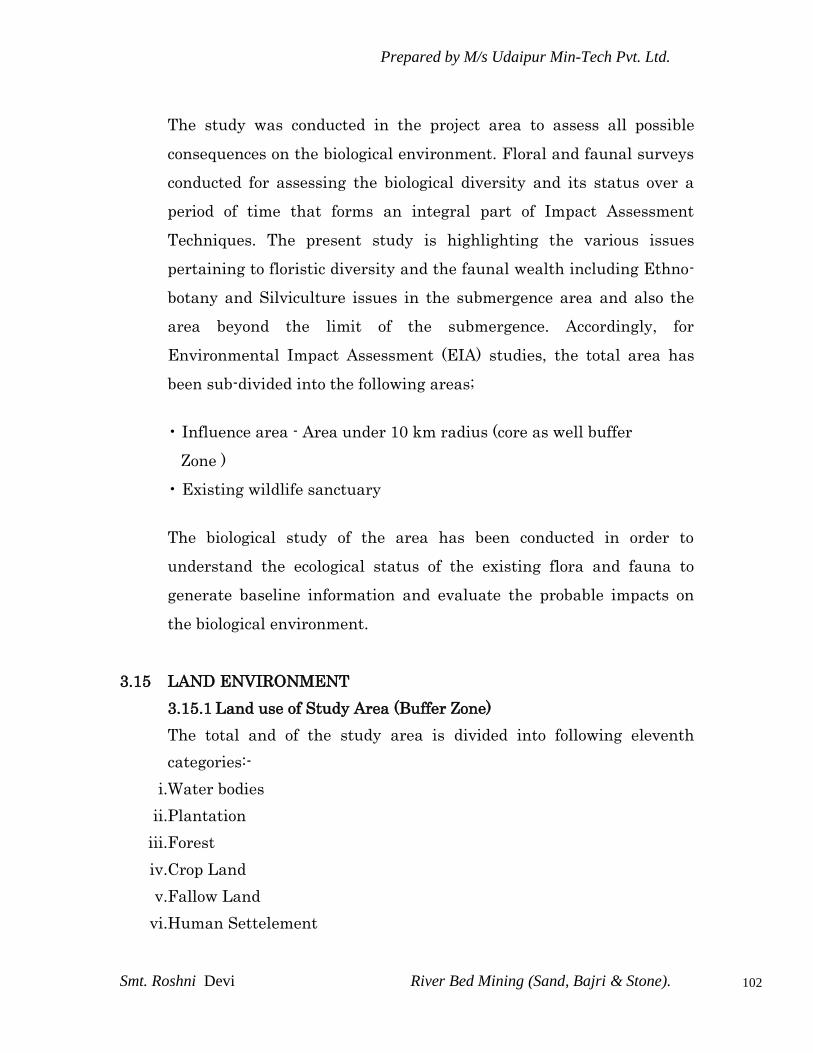
Prepared by M/s Udaipur Min-Tech Pvt. Ltd.
Smt. Roshni Devi River Bed Mining (Sand, Bajri & Stone).
102
The study was conducted in the project area to assess all possible
consequences on the biological environment. Floral and faunal surveys
conducted for assessing the biological diversity and its status over a
period of time that forms an integral part of Impact Assessment
Techniques. The present study is highlighting the various issues
pertaining to floristic diversity and the faunal wealth including Ethno-
botany and Silviculture issues in the submergence area and also the
area beyond the limit of the submergence. Accordingly, for
Environmental Impact Assessment (EIA) studies, the total area has
been sub-divided into the following areas;
• Influence area - Area under 10 km radius (core as well buffer
Zone )
• Existing wildlife sanctuary
The biological study of the area has been conducted in order to
understand the ecological status of the existing flora and fauna to
generate baseline information and evaluate the probable impacts on
the biological environment.
3.15 LAND ENVIRONMENT
3.15.1 Land use of Study Area (Buffer Zone)
The total and of the study area is divided into following eleventh
categories:-
i.Water bodies
ii.Plantation
iii.Forest
iv.Crop Land
v.Fallow Land
vi.Human Settelement
Prepared by M/s Udaipur Min-Tech Pvt. Ltd.
Smt. Roshni Devi River Bed Mining (Sand, Bajri & Stone).
103
vii.Industries
viii.Dense Scrub
ix.Open Scrub
x.Seasonal River
xi.Open / Waste Land
3.15.1.1 DATA INPUT
IRS LISS3 Multispectral digital FCC (False Color Composite) data
from NRSC Bhuwan Portal has been used for preparation of Land use/
Land cover thematic map of study area. Project site mine plan map &
Google maps and Toposheet has been used as a reference map for
preparation of base layer map like road, rail network, project site
boundary, landmarks point etc.
Technical Details
Satellite Image IRS LISS3
Band Combination 2,3,4
DIP Software ERDAS Imagine 9.2 & Arc GIS 9
3.15.1.2 METHODOLOGY
Land use / Land cover map preparation, Base map creation; and
Geometric correction of satellite image has been processed using
ERDAS Imagine 9.2 Software.
The methodology used for Land use pattern of study area is explained
in following headings.
3.15.1.3 GEOREFERENCING OF TOPOMAPS
SOI toposheet has been geo-referenced in geographic lat/long
coordinate system using ERDAS Imagine Software.
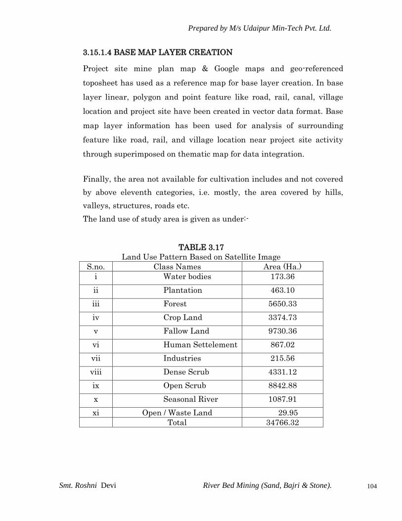
Prepared by M/s Udaipur Min-Tech Pvt. Ltd.
Smt. Roshni Devi River Bed Mining (Sand, Bajri & Stone).
104
3.15.1.4 BASE MAP LAYER CREATION
Project site mine plan map & Google maps and geo-referenced
toposheet has used as a reference map for base layer creation. In base
layer linear, polygon and point feature like road, rail, canal, village
location and project site have been created in vector data format. Base
map layer information has been used for analysis of surrounding
feature like road, rail, and village location near project site activity
through superimposed on thematic map for data integration.
Finally, the area not available for cultivation includes and not covered
by above eleventh categories, i.e. mostly, the area covered by hills,
valleys, structures, roads etc.
The land use of study area is given as under:-
TABLE 3.17
Land Use Pattern Based on Satellite Image
S.no. Class Names Area (Ha.)
i Water bodies 173.36
ii Plantation 463.10
iii Forest 5650.33
iv Crop Land 3374.73
v Fallow Land 9730.36
vi Human Settelement 867.02
vii Industries 215.56
viii Dense Scrub 4331.12
ix Open Scrub 8842.88
x Seasonal River 1087.91
xi Open / Waste Land 29.95
Total 34766.32

Prepared by M/s Udaipur Min-Tech Pvt. Ltd.
Smt. Roshni Devi River Bed Mining (Sand, Bajri & Stone).
105
Prepared by M/s Udaipur Min-Tech Pvt. Ltd.
Smt. Roshni Devi River Bed Mining (Sand, Bajri & Stone).
106
3.15.1.5 INTERPRETATION OF SATELLITE IMAGE
Hybrid technique has been used i.e. visual interpretation and digital
image processing for identification of different land use and vegetation
cover classes based on spectral signature of geographic feature.
Spectral signature represents various land use class. Image
interpretation keys are developed based on image characteristics like
color, tone, size, shape, texture, pattern, shadow, association etc, which
enables interpretation of satellite images for ground feature.
Ground Truth Data Collection for validation of Land Use Plan Ground
truth data on geographic features of the study area has collected by
site visit to the area for verification of information of the different
doubtful features of the study areas, which were found to be
responsible for the occurrence of specific spectral reflectance
behavioral patterns. Ground truth has been carried out for verification
of the ground features (esp. one in doubt) interpretation accuracy and
reliability of remotely sensed data.
CONCLUSION
All vector layer superimposed on land use land cover map for final map
composition and used for analysis and study of area.

Prepared by M/s Udaipur Min-Tech Pvt. Ltd.
Smt. Roshni Devi River Bed Mining (Sand, Bajri & Stone).
107
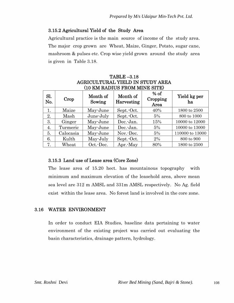
Prepared by M/s Udaipur Min-Tech Pvt. Ltd.
Smt. Roshni Devi River Bed Mining (Sand, Bajri & Stone).
108
3.15.2 Agricultural Yield of the Study Area
Agricultural practice is the main source of income of the study area.
The major crop grown are Wheat, Maize, Ginger, Potato, sugar cane,
mashroom & pulses etc. Crop wise yield grown around the study area
is given in Table 3.18.
TABLE –3.18
AGRICULTURAL YIELD IN STUDY AREA
(10 KM RADIUS FROM MINE SITE)
Sl.
No. Crop
Month of
Sowing
Month of
Harvesting
% of
Cropping
Area
Yield kg per
ha
1. Maize May-June Sept.-Oct. 40% 1800 to 2500
2. Mash June-July Sept.-Oct. 5% 800 to 1000
3. Ginger May-June Dec.-Jan. 15% 10000 to 12000
4. Turmeric May-June Dec.-Jan. 5% 10000 to 13000
5. Calocasia May-June Nov.-Dec. 5% 110000 to 13000
6. Kulth May-July Sept.-Oct. 2% 800 to 900
7. Wheat Oct.-Dec. Apr.-May 80% 1800 to 2500
3.15.3 Land use of Lease area (Core Zone)
The lease area of 15.20 hect. has mountainous topography with
minimum and maximum elevation of the leasehold area, above mean
sea level are 312 m AMSL and 331m AMSL respectively. No Ag. field
exist within the lease area. No forest land is involved in the core zone.
3.16 WATER ENVIRONMENT
In order to conduct EIA Studies, baseline data pertaining to water
environment of the existing project was carried out evaluating the
basin characteristics, drainage pattern, hydrology.

Prepared by M/s Udaipur Min-Tech Pvt. Ltd.
Smt. Roshni Devi River Bed Mining (Sand, Bajri & Stone).
109
3.16.1 Surface Water Quality
The project itself is a part of surface water body. The lease falls in river
chikanni, near Village Jhandian, Tehsil Nalagarh, District Solan,
State Himachal Pradesh. Apart from said river sirsa. The water is not
polluted and bears a lot of dissolved oxygen in it. The natural
treatment of the water current takes places for a considerable length
from the place of origin as the ultraviolet radiation due to sun is quite
high in the upper reaches. In addition to this water of the river is not
exposed to sewerage in general although, some sewerage during
monsoon is brought by different streams passing through the
inhabitation, during high flood season. The area is free of industrial
pollutants as the industrial base is none existent. In view of the above
the water environment of the basin is chikanni benign.
3.16.1.1 Ground Water Quality Assessment
The sources of potable water are the hand pumps, tub-wells & dug well
in the area. Sample were collected from the available water resources
around the mine leases area. The samples were collected from the
available water resources around the lease area. The samples were
collected & tested from different sites.
The quality of ground water was studied by collecting five water
samples from representative open dug wells, tube wells & hand pumps.
The details of water quality sites are given in Table 3.19 & results in
Table 3.20(A) to 3.20 (C) & location shown in Fig 3.10. The samples
were collected during Summer (April. 2012).
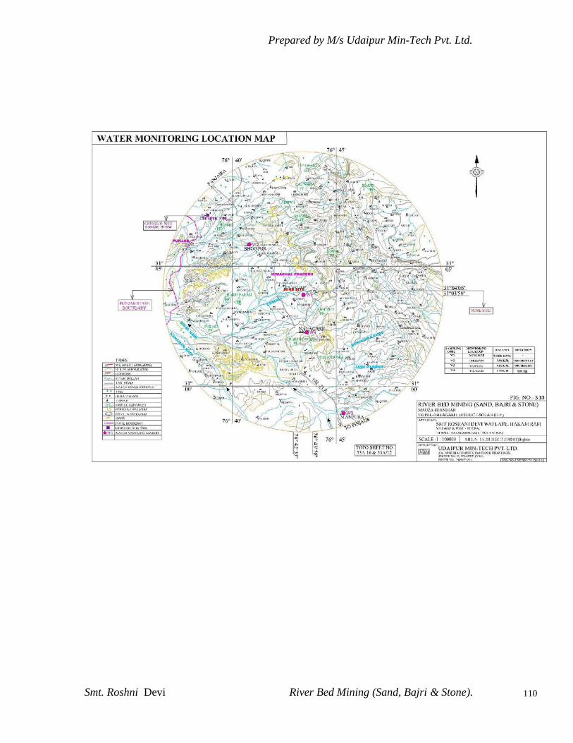
Prepared by M/s Udaipur Min-Tech Pvt. Ltd.
Smt. Roshni Devi River Bed Mining (Sand, Bajri & Stone).
110

Prepared by M/s Udaipur Min-Tech Pvt. Ltd.
Smt. Roshni Devi River Bed Mining (Sand, Bajri & Stone).
111
TABLE – 3.19
LOCATION OF VARIOUS WATER SAMPLE STATIONS
Station
Code.
Station
Name
Description Location with respect to
Site
Distance (Km) Direction
GW1 Near Bhogpur Ground water 5.00 NE
GW 2 Near Manpur Ground water 9.66 SE
GW 3 Near
Nalagarh
Ground water 2.75 S
u/s – upstream d /s – downstream
Samples from surface /ground water sources were collected by
adopting grab sampling method. The sample was filled into a
sampling bottle. The physico-chemical quality of water samples were
characterized by adopting the relevant parts of IS:3025, “Standard
Methods for Water Analysis” and the methods prescribed under
IS:10500.

Prepared by M/s Udaipur Min-Tech Pvt. Ltd.
Smt. Roshni Devi River Bed Mining (Sand, Bajri & Stone).
112
TABLE - 3.20 (A) WATER QUALITY ANALYSIS
Name of Location:- Near Bhogpur S.No Test
Parameters
Units Results Requirements
Test Method
Desirable
Limits
In Absence
of Alternate
Source
1. Colour -- < 5 Max 5 Max 25 IS: 3025(P-
4)1983 R-2002
2. Odour -- Unobjectionable Unobjectiona
ble
-- IS: 3025(P-
5)1983 R-2002
3. Taste -- Agreeable Agreeable -- IS: 3025(P- 7/8)
1984 R-2002
4. Turbidity NTU < 1 Max 5 Max 10 IS: 3025 (P- 10)
1984 R-2002
(DL= 2 NTU)
5. pH value -- 7.09 6.5 to 8.5 No
relaxation
IS: 3025(P-11)
1983 R-2002
6. Total
Hardness
(as CaCO3)
mg/l 209.8 Max 300 Max 600 IS: 3025(P-521)
1983R2002 Ad.
1(MDL= 0.1 mg/l)
7. Iron (as Fe) mg/l 0.19 Max 0.3 Max 1.0 IS: 3025(P-53):
2003
(DL=0.1 mg/l)
8. Chlorides (as
Cl)
mg/l 28.35 Max 250 Max 1000 IS: 3025 (P-32):
1988R 1999
(DL=1 mg/l)
9. Total
Dissolved
solids
mg/l 350 Max 500 2000 IS: 3025 (P-16):
1984R2002
Ad.1 (DL=5
mg/l)
10. Calcium (as
Ca)
mg/l 80 Max 75 200 IS: 3025 (P-40):
1991R 1998
(DL=1 mg/l)
11. Magnesium
(as Mg.)
mg/l 2.5 Max 30 100 IS3025 (P-46) 1994
R 1999 Ad.2
(DL=2 mg/l)
12. Copper (as
Cu)
mg/l BDL Max 0.05 1.5 IS: 3025 (Part 42):
1992R 1998
(DL= 0.02 mg/l)
13. Manganese
(as Mn)
mg/l BDL Max 0.1 0.3 IS: 3025 (part-
59 ): 2006
(DL= 0.05 mg/l)
14. Sulphate (as
SO4)
mg/l 30.6 Max 200 400 IS3025 (P-
24)1986R 1998
(DL= 1 mg/l)
15. Nitrate (as
NO3)
mg/l 0.58 Max 45 No
Relaxation
IS: 3025 (P-
34)1988 R 1999
(DL= 0.1 mg/l)
16. Fluoride (as F) mg/l
0.12 Max 1.0 1.5 APHA 21ST
ED.
2005-4500D
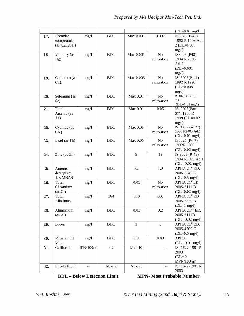
Prepared by M/s Udaipur Min-Tech Pvt. Ltd.
Smt. Roshni Devi River Bed Mining (Sand, Bajri & Stone).
113
(DL=0.01 mg/l)
17. Phenolic
compounds
(as C6H5OH)
mg/l BDL Max 0.001 0.002 IS3025 (P-43)
1992 R 1998 Ad.
2 (DL=0.001
mg/l)
18. Mercury (as
Hg)
mg/l BDL Max 0.001 No
relaxation
IS3025 (P48)
1994 R 2003
Ad. 1
(DL=0.001
mg/l)
19. Cadmium (as
Cd).
mg/l BDL Max 0.003 No
relaxation
IS: 3025(P-41)
1992 R 1998
(DL=0.008
mg/l)
20. Selenium (as
Se)
mg/l BDL Max 0.01 No
relaxation
IS3025 (P-56)
2003
(DL=0.01 mg/l)
21. Total
Arsenic (as
As)
mg/l BDL Max 0.01 0.05 IS: 3025(Part
37): 1988 R
1999 (DL=0.02
mg/l)
22. Cyanide (as
CN)
mg/l BDL Max 0.05 No
relaxation
IS: 3025(Part 27):
1986 R2003 Ad.1
(DL=0.01 mg/l)
23. Lead (as Pb) mg/l BDL Max 0.05 No
relaxation
IS3025 (P-47)
1992R 1999
(DL=0.02 mg/l)
24. Zinc (as Zn) mg/l BDL 5 15 IS 3025 (P-49)
1994 R1999 Ad.1
(DL= 0.02 mg/l)
25. Anionic
detergents
(as MBAS)
mg/l BDL 0.2 1.0 APHA 21st ED.
2005-5540 C
(DL=0.5 mg/l)
26. Total
Chromium
(as Cr)
mg/l BDL 0.05 No
relaxation
APHA 21st
ED.
2005-3111 B
(DL=0.02 mg/l)
27. Total
Alkalinity
mg/l 164 200 600 APHA 21st ED
2005-2320 B
(DL=1 mg/l)
28. Aluminium
(as Al)
mg/l BDL 0.03 0.2 APHA 21ST
ED.
2005-3111D
(DL= 0.02 mg/l)
29. Boron mg/l BDL 1 5 APHA 21st ED.
2005-4500 C
(DL=0.5 mg/l)
30. Mineral Oil,
Max.
mg/l BDL 0.01 0.03 APHA
(DL= 0.01 mg/l)
31. Coliforms MPN/100ml < 2 Max 10 -- IS: 1622-1981 R
2003
(DL= 2
MPN/100ml)
32. E.Coli/100ml -- Absent Absent -- IS: 1622-1981 R
2003
BDL – Below Detection Limit, MPN- Most Probable Number.

Prepared by M/s Udaipur Min-Tech Pvt. Ltd.
Smt. Roshni Devi River Bed Mining (Sand, Bajri & Stone).
114
TABLE - 3.20 (B) WATER QUALITY ANALYSIS
Name of Location:- Near Manpur
S.No Test
Parameters
Units Results Requirements
Test Method
Desirable
Limits
In Absence
of Alternate
Source
1. Colour -- < 5 Max 5 Max 25 IS: 3025(P-
4)1983 R-2002
2. Odour -- Unobjecti
onable
Unobjecti
onable
-- IS: 3025(P-
5)1983 R-2002
3. Taste -- Agreeable Agreeable -- IS: 3025(P- 7/8)
1984 R-2002
4. Turbidity NTU < 1 Max 5 Max 10 IS: 3025 (P- 10)
1984 R-2002
(DL= 2 NTU)
5. pH value -- 7.18 6.5 to 8.5 No
relaxation
IS: 3025(P-11)
1983 R-2002
6. Total
Hardness
(as CaCO3)
mg/l 211.86 Max 300 Max 600 IS: 3025(P-521)
1983R2002 Ad.
1(MDL= 0.1 mg/l)
7. Iron (as Fe) mg/l 0.21 Max 0.3 Max 1.0 IS: 3025(P-53):
2003
(DL=0.1 mg/l)
8. Chlorides (as
Cl)
mg/l 32.92 Max 250 Max 1000 IS: 3025 (P-32):
1988R 1999
(DL=1 mg/l)
9. Total
Dissolved
solids
mg/l 360 Max 500 2000 IS: 3025 (P-16):
1984R2002
Ad.1 (DL=5
mg/l)
10. Calcium (as
Ca)
mg/l 80.8 Max 75 200 IS: 3025 (P-40):
1991R 1998
(DL=1 mg/l)
11. Magnesium
(as Mg.)
mg/l 2.37 Max 30 100 IS3025 (P-46) 1994
R 1999 Ad.2
(DL=2 mg/l)
12. Copper (as
Cu)
mg/l 0.04 Max 0.05 1.5 IS: 3025 (Part 42):
1992R 1998
(DL= 0.02 mg/l)
13. Manganese
(as Mn)
mg/l BDL Max 0.1 0.3 IS: 3025 (part-
59 ): 2006
(DL= 0.05 mg/l)
14. Sulphate (as
SO4)
mg/l 34.2 Max 200 400 IS3025 (P-
24)1986R 1998
(DL= 1 mg/l)
15. Nitrate (as
NO3)
mg/l 0.72 Max 45 No
Relaxation
IS: 3025 (P-
34)1988 R 1999
(DL= 0.1 mg/l)
16. Fluoride (as F) mg/l
0.14 Max 1.0 1.5 APHA 21ST
ED.
2005-4500D
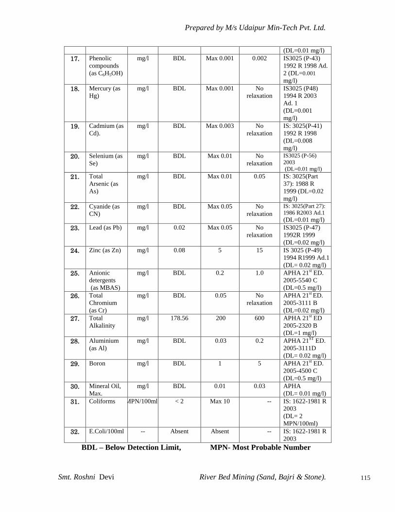
Prepared by M/s Udaipur Min-Tech Pvt. Ltd.
Smt. Roshni Devi River Bed Mining (Sand, Bajri & Stone).
115
(DL=0.01 mg/l)
17. Phenolic
compounds
(as C6H5OH)
mg/l BDL Max 0.001 0.002 IS3025 (P-43)
1992 R 1998 Ad.
2 (DL=0.001
mg/l)
18. Mercury (as
Hg)
mg/l BDL Max 0.001 No
relaxation
IS3025 (P48)
1994 R 2003
Ad. 1
(DL=0.001
mg/l)
19. Cadmium (as
Cd).
mg/l BDL Max 0.003 No
relaxation
IS: 3025(P-41)
1992 R 1998
(DL=0.008
mg/l)
20. Selenium (as
Se)
mg/l BDL Max 0.01 No
relaxation
IS3025 (P-56)
2003
(DL=0.01 mg/l)
21. Total
Arsenic (as
As)
mg/l BDL Max 0.01 0.05 IS: 3025(Part
37): 1988 R
1999 (DL=0.02
mg/l)
22. Cyanide (as
CN)
mg/l BDL Max 0.05 No
relaxation
IS: 3025(Part 27):
1986 R2003 Ad.1
(DL=0.01 mg/l)
23. Lead (as Pb) mg/l 0.02 Max 0.05 No
relaxation
IS3025 (P-47)
1992R 1999
(DL=0.02 mg/l)
24. Zinc (as Zn) mg/l 0.08 5 15 IS 3025 (P-49)
1994 R1999 Ad.1
(DL= 0.02 mg/l)
25. Anionic
detergents
(as MBAS)
mg/l BDL 0.2 1.0 APHA 21st ED.
2005-5540 C
(DL=0.5 mg/l)
26. Total
Chromium
(as Cr)
mg/l BDL 0.05 No
relaxation
APHA 21st
ED.
2005-3111 B
(DL=0.02 mg/l)
27. Total
Alkalinity
mg/l 178.56 200 600 APHA 21st ED
2005-2320 B
(DL=1 mg/l)
28. Aluminium
(as Al)
mg/l BDL 0.03 0.2 APHA 21ST
ED.
2005-3111D
(DL= 0.02 mg/l)
29. Boron mg/l BDL 1 5 APHA 21st ED.
2005-4500 C
(DL=0.5 mg/l)
30. Mineral Oil,
Max.
mg/l BDL 0.01 0.03 APHA
(DL= 0.01 mg/l)
31. Coliforms MPN/100ml < 2 Max 10 -- IS: 1622-1981 R
2003
(DL= 2
MPN/100ml)
32. E.Coli/100ml -- Absent Absent -- IS: 1622-1981 R
2003
BDL – Below Detection Limit, MPN- Most Probable Number
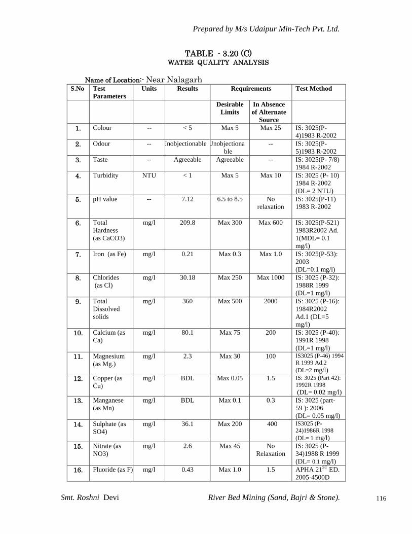
Prepared by M/s Udaipur Min-Tech Pvt. Ltd.
Smt. Roshni Devi River Bed Mining (Sand, Bajri & Stone).
116
TABLE - 3.20 (C) WATER QUALITY ANALYSIS
Name of Location:- Near Nalagarh
S.No Test
Parameters
Units Results Requirements
Test Method
Desirable
Limits
In Absence
of Alternate
Source
1. Colour -- < 5 Max 5 Max 25 IS: 3025(P-
4)1983 R-2002
2. Odour -- Unobjectionable Unobjectiona
ble
-- IS: 3025(P-
5)1983 R-2002
3. Taste -- Agreeable Agreeable -- IS: 3025(P- 7/8)
1984 R-2002
4. Turbidity NTU < 1 Max 5 Max 10 IS: 3025 (P- 10)
1984 R-2002
(DL= 2 NTU)
5. pH value -- 7.12 6.5 to 8.5 No
relaxation
IS: 3025(P-11)
1983 R-2002
6. Total
Hardness
(as CaCO3)
mg/l 209.8 Max 300 Max 600 IS: 3025(P-521)
1983R2002 Ad.
1(MDL= 0.1 mg/l)
7. Iron (as Fe) mg/l 0.21 Max 0.3 Max 1.0 IS: 3025(P-53):
2003
(DL=0.1 mg/l)
8. Chlorides
(as Cl)
mg/l 30.18 Max 250 Max 1000 IS: 3025 (P-32):
1988R 1999
(DL=1 mg/l)
9. Total
Dissolved
solids
mg/l 360 Max 500 2000 IS: 3025 (P-16):
1984R2002
Ad.1 (DL=5
mg/l)
10. Calcium (as
Ca)
mg/l 80.1 Max 75 200 IS: 3025 (P-40):
1991R 1998
(DL=1 mg/l)
11. Magnesium
(as Mg.)
mg/l 2.3 Max 30 100 IS3025 (P-46) 1994
R 1999 Ad.2
(DL=2 mg/l)
12. Copper (as
Cu)
mg/l BDL Max 0.05 1.5 IS: 3025 (Part 42):
1992R 1998
(DL= 0.02 mg/l)
13. Manganese
(as Mn)
mg/l BDL Max 0.1 0.3 IS: 3025 (part-
59 ): 2006
(DL= 0.05 mg/l)
14. Sulphate (as
SO4)
mg/l 36.1 Max 200 400 IS3025 (P-
24)1986R 1998
(DL= 1 mg/l)
15. Nitrate (as
NO3)
mg/l 2.6 Max 45 No
Relaxation
IS: 3025 (P-
34)1988 R 1999
(DL= 0.1 mg/l)
16. Fluoride (as F) mg/l
0.43 Max 1.0 1.5 APHA 21ST
ED.
2005-4500D

Prepared by M/s Udaipur Min-Tech Pvt. Ltd.
Smt. Roshni Devi River Bed Mining (Sand, Bajri & Stone).
117
(DL=0.01 mg/l)
17. Phenolic
compounds
(as C6H5OH)
mg/l BDL Max 0.001 0.002 IS3025 (P-43)
1992 R 1998 Ad.
2 (DL=0.001
mg/l)
18. Mercury (as
Hg)
mg/l BDL Max 0.001 No
relaxation
IS3025 (P48)
1994 R 2003
Ad. 1
(DL=0.001
mg/l)
19. Cadmium (as
Cd).
mg/l BDL Max 0.003 No
relaxation
IS: 3025(P-41)
1992 R 1998
(DL=0.008
mg/l)
20. Selenium (as
Se)
mg/l BDL Max 0.01 No
relaxation
IS3025 (P-56)
2003
(DL=0.01 mg/l)
21. Total
Arsenic (as
As)
mg/l BDL Max 0.01 0.05 IS: 3025(Part
37): 1988 R
1999 (DL=0.02
mg/l)
22. Cyanide (as
CN)
mg/l BDL Max 0.05 No
relaxation
IS: 3025(Part 27):
1986 R2003 Ad.1
(DL=0.01 mg/l)
23. Lead (as Pb) mg/l BDL Max 0.05 No
relaxation
IS3025 (P-47)
1992R 1999
(DL=0.02 mg/l)
24. Zinc (as Zn) mg/l 0.52 5 15 IS 3025 (P-49)
1994 R1999 Ad.1
(DL= 0.02 mg/l)
25. Anionic
detergents
(as MBAS)
mg/l BDL 0.2 1.0 APHA 21st ED.
2005-5540 C
(DL=0.5 mg/l)
26. Total
Chromium
(as Cr)
mg/l BDL 0.05 No
relaxation
APHA 21st
ED.
2005-3111 B
(DL=0.02 mg/l)
27. Total
Alkalinity
mg/l 174.84 200 600 APHA 21st ED
2005-2320 B
(DL=1 mg/l)
28. Aluminium
(as Al)
mg/l BDL 0.03 0.2 APHA 21ST
ED.
2005-3111D
(DL= 0.02 mg/l)
29. Boron mg/l BDL 1 5 APHA 21st ED.
2005-4500 C
(DL=0.5 mg/l)
30. Mineral Oil,
Max.
mg/l BDL 0.01 0.03 APHA
(DL= 0.01 mg/l)
31. Coliforms MPN/100
ml
2 Max 10 -- IS: 1622-1981 R
2003
(DL= 2
MPN/100ml)
32. E.Coli/100ml -- Absent Absent -- IS: 1622-1981 R
2003
BDL – Below Detection Limit, MPN- Most Probable Number
Analysis results of ground water reveal the following:-

Prepared by M/s Udaipur Min-Tech Pvt. Ltd.
Smt. Roshni Devi River Bed Mining (Sand, Bajri & Stone).
118
pH varies from 7.09 to 7.18
Total Hardness varies from 209.8 to 211.86 mg/l
Total Dissolved Solids varies from 209.8 to 350 mg/g
A review of the above chemical analysis that there is some
variation in chemical composition of water tapped from different
open wells tube wells and hand pimps, but the ground water
from all sources remains suitable for drinking purposes as all
the constituents are within the limits prescribed for drinking
water standards promulgated by Indian standard IS:10500.
3.14 SOCIO-ECONOMIC ENVIRONMENT
3.14.1 Baseline Status
Baseline information is collected in order to delineate apply the socio-
economic profile of the study area. The process related database thus
generated includes:
Demographic structure
Infrastructure base in the area
Economic structure
Health status
Cultural attributes
Public awareness and their concern about the project
According to R.Deshmukh, the primary socio economic data was
collected through field survey in sample villages in study area
(Roshani Devi River Bed Mining) as well as the observations by the
survey team. It has been subs tainted with relevant socioeconomic data
from secondary sources of various official records. viz., Census records,
District statistical abstract, district health office, District industry
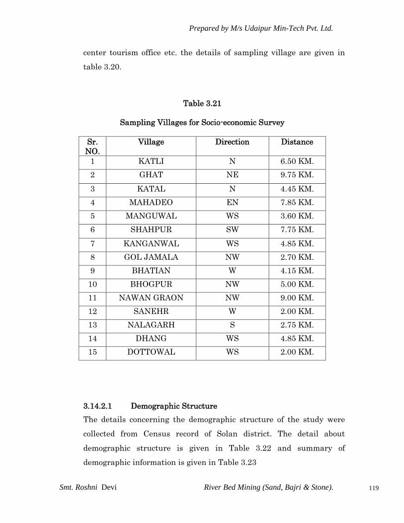
Prepared by M/s Udaipur Min-Tech Pvt. Ltd.
Smt. Roshni Devi River Bed Mining (Sand, Bajri & Stone).
119
center tourism office etc. the details of sampling village are given in
table 3.20.
Table 3.21
Sampling Villages for Socio-economic Survey
Sr.
NO.
Village
Direction Distance
1 KATLI N 6.50 KM.
2 GHAT NE 9.75 KM.
3 KATAL N 4.45 KM.
4 MAHADEO EN 7.85 KM.
5 MANGUWAL WS 3.60 KM.
6 SHAHPUR SW 7.75 KM.
7 KANGANWAL WS 4.85 KM.
8 GOL JAMALA NW 2.70 KM.
9 BHATIAN W 4.15 KM.
10 BHOGPUR NW 5.00 KM.
11 NAWAN GRAON NW 9.00 KM.
12 SANEHR W 2.00 KM.
13 NALAGARH S 2.75 KM.
14 DHANG WS 4.85 KM.
15 DOTTOWAL WS 2.00 KM.
3.14.2.1 Demographic Structure
The details concerning the demographic structure of the study were
collected from Census record of Solan district. The detail about
demographic structure is given in Table 3.22 and summary of
demographic information is given in Table 3.23
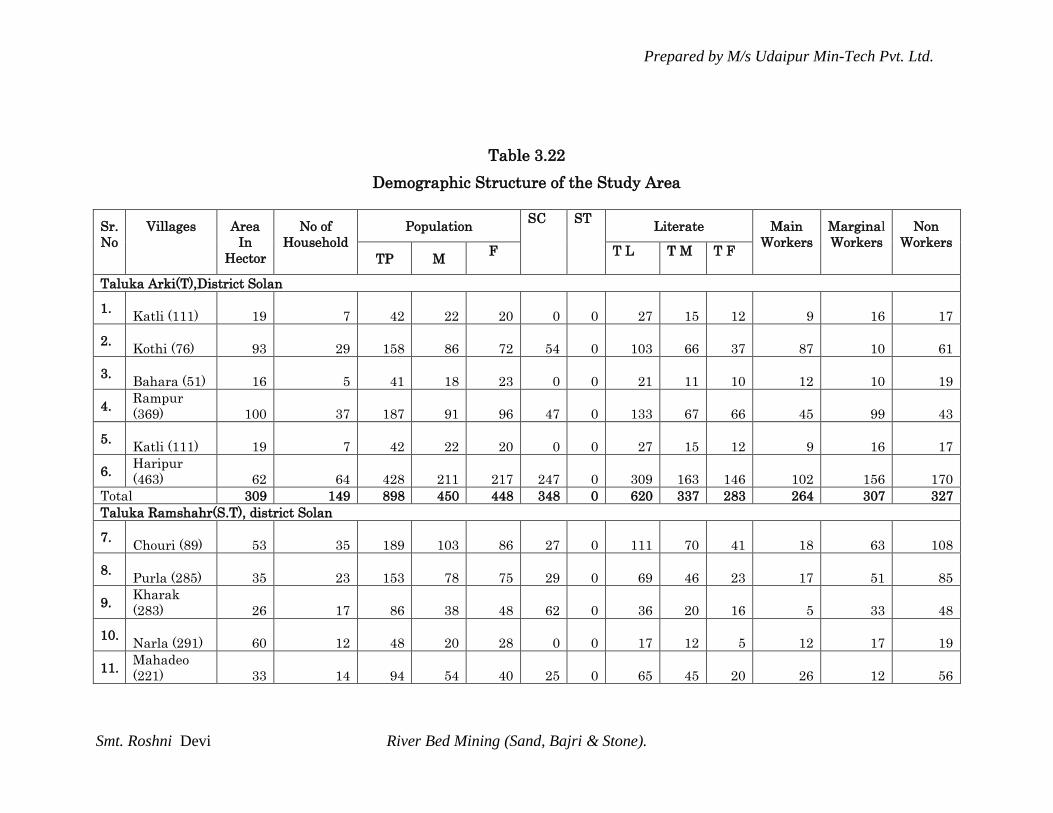
Prepared by M/s Udaipur Min-Tech Pvt. Ltd.
Smt. Roshni Devi River Bed Mining (Sand, Bajri & Stone).
Table 3.22
Demographic Structure of the Study Area
Sr.
No
Villages Area
In
Hector
No of
Household
Population SC ST
Literate Main
Workers
Marginal
Workers
Non
Workers
TP M F T L T M T F
Taluka Arki(T),District Solan
1. Katli (111) 19 7 42 22 20 0 0 27 15 12 9 16 17
2. Kothi (76) 93 29 158 86 72 54 0 103 66 37 87 10 61
3. Bahara (51) 16 5 41 18 23 0 0 21 11 10 12 10 19
4. Rampur
(369) 100 37 187 91 96 47 0 133 67 66 45 99 43
5. Katli (111) 19 7 42 22 20 0 0 27 15 12 9 16 17
6. Haripur
(463) 62 64 428 211 217 247 0 309 163 146 102 156 170
Total 309 149 898 450 448 348 0 620 337 283 264 307 327
Taluka Ramshahr(S.T), district Solan
7. Chouri (89) 53 35 189 103 86 27 0 111 70 41 18 63 108
8. Purla (285) 35 23 153 78 75 29 0 69 46 23 17 51 85
9. Kharak
(283) 26 17 86 38 48 62 0 36 20 16 5 33 48
10. Narla (291) 60 12 48 20 28 0 0 17 12 5 12 17 19
11. Mahadeo
(221) 33 14 94 54 40 25 0 65 45 20 26 12 56
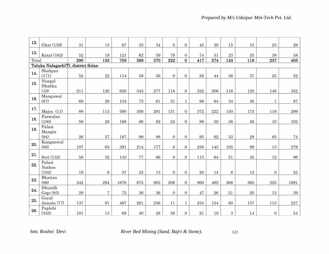
Prepared by M/s Udaipur Min-Tech Pvt. Ltd.
Smt. Roshni Devi River Bed Mining (Sand, Bajri & Stone).
121
12. Ghat (159) 31 13 67 33 34 0 0 45 30 15 15 23 29
13. Katal (162) 52 19 121 62 59 79 0 74 51 23 25 38 58
Total 290 133 758 388 370 222 0 417 274 143 118 237 403
Taluka Nalagarh(T), district Solan
14. Shahpur
(171) 52 22 114 58 56 0 0 82 44 38 37 25 52
15. Nangal
Dhakka
(19) 211 120 620 343 277 118 0 322 206 116 120 148 352
16. Manguwal
(87) 69 29 134 73 61 31 1 98 64 34 36 1 97
17. Majra (11) 88 113 590 309 281 131 0 372 222 150 173 118 299
18. Paswalan
(100) 59 28 168 86 82 24 0 86 50 36 56 10 102
19. Palasi
Mangta
(94) 26 37 187 99 88 0 0 95 62 33 28 85 74
20. Kanganwal
(88) 107 63 391 214 177 0 0 250 145 105 99 13 279
21. Sori (132) 58 32 143 77 66 0 0 115 64 51 45 12 86
22. Palasi
Nathoo
(102) 19 6 37 22 15 0 0 20 14 6 12 0 25
23. Bhatian
(86) 542 294 1678 875 803 206 0 860 492 368 362 225 1091
24. Dhundli
Gopi (85) 29 7 72 36 36 0 0 47 26 21 20 13 39
25. Goyal
Jamala (77) 137 91 497 261 236 11 1 234 154 80 157 113 227
26. Paplohi
(335) 101 13 68 40 28 58 0 21 18 3 14 0 54

Prepared by M/s Udaipur Min-Tech Pvt. Ltd.
Smt. Roshni Devi River Bed Mining (Sand, Bajri & Stone).
122
27. Reru Jhiri
Wala (74) 180 104 543 303 240 235 0 347 219 128 133 148 262
28. Bhanglan
(72) 261 195 1122 623 499 385 0 587 369 218 482 171 469
29. Bhogpur
(73) 295 155 891 430 461 145 0 568 315 253 312 155 424
30. Reru Uperla
(75) 155 125 774 399 375 140 70 413 266 147 398 8 368
31. Nawan
Graon (55) 222 172 962 507 455 241 0 526 323 203 258 338 366
32. Dolowal
(69) 62 53 322 166 156 11 0 199 123 76 58 95 169
33. Bhipar
(337) 55 24 161 83 78 0 0 91 63 28 44 0 117
34. Aduwal
Jandori
(66) 580 156 899 457 442 319 0 417 252 165 518 3 378
35. Larkot (319) 66 15 86 40 46 37 0 40 20 20 38 27 21
36. Ratwari
(308) 332 89 540 288 252 166 0 284 183 101 52 232 256
37. Nawan
Nagar (65) 98 28 144 75 69 38 0 80 47 33 52 21 71
38. Bara (44) 8 4 24 13 11 5 0 12 8 4 5 4 15
39. Kaulanwala
(52) 66 138 738 392 346 234 0 446 270 176 190 95 453
40. Ambwala
(63) 244 154 867 450 417 217 0 510 312 198 262 238 367
41. Baglehr
(50) 375 202 1102 596 506 391 0 611 362 249 301 289 512
42. Raiya (48) 147 92 572 293 279 173 0 364 204 160 292 19 261
43. Nangal
Kuhl (37) 48 25 153 82 71 0 0 102 56 46 84 1 68

Prepared by M/s Udaipur Min-Tech Pvt. Ltd.
Smt. Roshni Devi River Bed Mining (Sand, Bajri & Stone).
123
44. Kalianpur
(201) 173 140 444 359 85 36 0 376 324 52 311 5 128
45. Baruna (10) 137 117 709 375 334 34 0 472 286 186 72 347 290
46. Raipur (5) 77 2 14 7 7 0 0 12 6 6 7 0 7
47. Chak (13) 47 13 77 32 45 27 0 51 25 26 41 16 20
48. Karsoli (4) 229 192 1178 627 551 282 14 747 455 292 455 125 598
49. Basowal
Sultani (41) 39 60 366 190 176 0 0 227 131 96 102 85 179
50. Jhajra (56) 107 41 260 134 126 14 0 151 91 60 75 123 62
51. Hatra (58) 109 70 359 184 175 119 0 206 128 78 15 83 261
52. Kashmirpur
Gujra (42) 44 58 319 170 149 120 0 187 117 70 91 86 142
53. Androla
Nihla (46) 74 29 187 97 90 0 0 114 67 47 62 53 72
54. Malpur (4
Malpur (45) 56 37 215 116 99 36 0 115 76 39 63 98 54
55. Phalahi (7) 152 35 235 129 106 83 3 133 83 50 92 41 102
56. Pater
Phaloo (57) 76 37 185 99 86 14 0 106 69 37 57 69 59
57. Bagheri
(18) 199 154 908 489 419 185 0 533 319 214 281 233 394
58. Tikri (17) 368 142 834 421 413 153 0 473 270 203 203 235 396
59. Nangal
Dhakka
(19) 211 120 620 343 277 118 0 322 206 116 120 148 352
60. Kulari (16) 169 121 668 335 333 142 0 434 241 193 244 23 401

Prepared by M/s Udaipur Min-Tech Pvt. Ltd.
Smt. Roshni Devi River Bed Mining (Sand, Bajri & Stone).
124
Source: Primary Census Abstract CD and village Directory CD 2001, Solan District, Himachal Pradesh State
3.14.2.1.1 Salient features are as follows:
Total population of the region as per 2001 census is 26204 out of which 13899 are male and 12305 are
female. Total population distribution of the study area with male female is shown in Fig 3.11 is given
below:
61. Saori (295) 143 47 286 141 145 157 0 153 92 61 159 0 127
62. Jogon (32) 157 160 789 432 357 111 1 520 326 194 150 67 572
63. Thana (14) 25 12 79 37 42 0 0 49 26 23 13 22 44
64. Bairchha
(21) 263 118 639 336 303 70 0 348 216 132 184 197 258
65. Patta (25) 66 26 218 139 79 91 29 78 47 31 9 138 71
66. Abhipur (2) 94 44 273 135 138 0 0 183 95 88 159 0 114
Total 7707 4361 24461 13017 11444 5108 119 14189 8649 5540 7603 4801 12057
Krishangarh(S.T), Solan district
67. Nara (243) 35 6 22 13 9 0 0 16 11 5 9 9 4
68. Majher
(244) 17 4 24 12 12 0 0 16 10 6 4 14 6
Total 52 10 46 25 21 0 0 32 21 11 13 23 10
Taluka Solan(T), Solan district
69. Gara (56)
90 10 41 19 22 34 0 25 13 12 10 14 17
Grand total 8448 4663 26204 13899 12305 5712 119 15283 9294 5989 8008 5382 12814
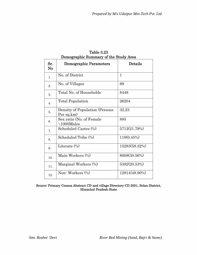
Prepared by M/s Udaipur Min-Tech Pvt. Ltd.
Smt. Roshni Devi River Bed Mining (Sand, Bajri & Stone).
Table 3.23
Demographic Summary of the Study Area
Sr.
No
Demographic Parameters Details
1. No. of District 1
2. No. of Villages 69
3. Total No. of Households 8448
4. Total Population 26204
5. Density of Population (Persons
Per sq.km)
32.23
6. Sex ratio (No. of Female
\1000Males
885
7. Scheduled Castes (%) 5712(21.79%)
8. Scheduled Tribe (%) 119(0.45%)
9. Literate (%) 15283(58.32%)
10. Main Workers (%) 8008(30.56%)
11. Marginal Workers (%) 5382(20.53%)
12. Non- Workers (%) 12814(48.90%)
Source: Primary Census Abstract CD and village Directory CD 2001, Solan District,
Himachal Pradesh State

Prepared by M/s Udaipur Min-Tech Pvt. Ltd.
Smt. Roshni Devi River Bed Mining (Sand, Bajri & Stone).
126
Fig 3.11: Total Population distributed by Male Female ratio in study
area
Out of the total population Scheduled Caste 5712 (21.79%) and
Scheduled Tribe population is 119(0.45%) respectively.
Sex ratio (number of male per thousand female) in the region is
885 this shows that male population is higher in the region
as compared with the female population
Total main worker population is 8008 (30.56%), 5382 (20.53%)
come under marginal worker category and 12814 (48.90%) belong
to non workers category. Employment pattern is shown in Fig
3.12
0
5000
10000
15000
20000
25000
30000
TOT_P TOT_M TOT_F
26204
1389912305
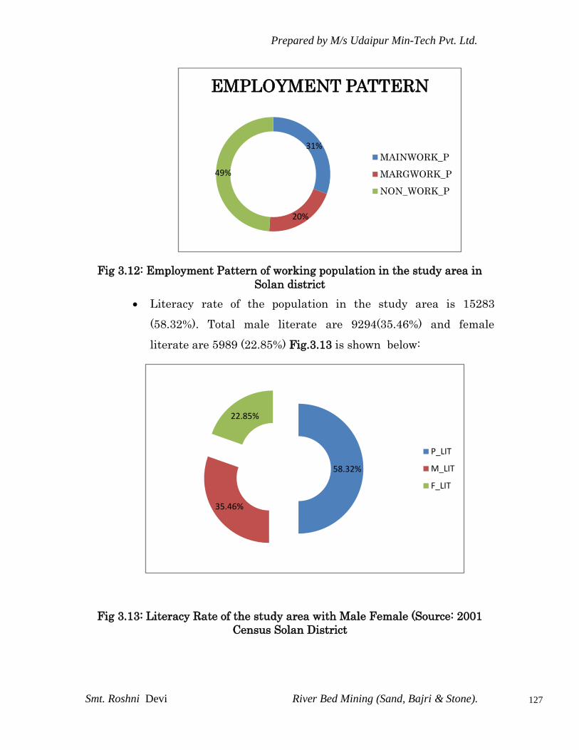
Prepared by M/s Udaipur Min-Tech Pvt. Ltd.
Smt. Roshni Devi River Bed Mining (Sand, Bajri & Stone).
127
Fig 3.12: Employment Pattern of working population in the study area in
Solan district
Literacy rate of the population in the study area is 15283
(58.32%). Total male literate are 9294(35.46%) and female
literate are 5989 (22.85%) Fig.3.13 is shown below:
Fig 3.13: Literacy Rate of the study area with Male Female (Source: 2001
Census Solan District
31%
20%
49%
EMPLOYMENT PATTERN
MAINWORK_P
MARGWORK_P
NON_WORK_P
58.32%
35.46%
22.85%
P_LIT
M_LIT
F_LIT

Prepared by M/s Udaipur Min-Tech Pvt. Ltd.
Smt. Roshni Devi River Bed Mining (Sand, Bajri & Stone).
128
3.17.2.2 Infrastructure Resource Base
The infrastructure resources base of the study area with reference to
education, medical facility, water supply, post and telegraph,
transportation and communication facility and power supply etc is
presented in Table 3.24 the infrastructure resources details have been
abstracted from Housing, Household Amenities and Assets CD 2001 of
HP state, Solan District are described below:
Education: As per 2001 village directory record, all villages having
education facility in the form of primary school. It indicates that in
education field the study area having better facility. The study area is
linked with Solan city by well-constructed road. It is a good facility for
students to take various courses because they can travel adequately for
education purpose.
Water Facility: For the survival of humanity, none occupies a higher
place then water .that is why a very well recognized fact that adequate
protected and wholesome drinking water is a primary need of
community. The water supply in the region is in good condition. Water
system is available in the form of tap, well, hand pumps, rivers and
other allied sources.
Communication and Transportation: After independence, considerable
progress has been made in the field of transport and communication
because of implementation of 5 years plan. In respect of development of
road transport especially as regards passenger services, the state has
made commendable progress. Communication facility is fine in this
region. Near about 60% are far from any communication facility.
Villages having Transportation facility is in excellent condition. The
entire region is connecting with bus and navigable waterway. Road
approach is in all form like mud road, footpath, navigable river,
navigable waterway etc.

Prepared by M/s Udaipur Min-Tech Pvt. Ltd.
Smt. Roshni Devi River Bed Mining (Sand, Bajri & Stone).
129
Power Supply: Electric power is one of the basic and key
infrastructures in the growing economy. It occupies a distinct role in
the development of industry and agriculture. It is also a key factor in
the socio-economic transformation in rural areas. All villages are
electrified in the region and electricity is available for all-purpose.
Medical/Primary Health Care: sound health is the first requirement of
happy life and to enjoy a long and healthy life. Mankind has been
constantly fighting against diseases and epidemics, which seriously
affect health. The care of the sick is the responsibility of the state.
Medical facilities in terms of community health workers are available
in some of the villages. Primary health center and primary health sub
centers are adding medical facility in most of the village.

Prepared by M/s Udaipur Min-Tech Pvt. Ltd.
Smt. Roshni Devi River Bed Mining (Sand, Bajri & Stone).
130
Table 3.24
Infrastructure Resource Base of the study Area
Sr
.
No
Villages Education
Institution
s
Medical
Facilities
Drinking Water
Supply
Communicatio
n
Transportation
s
Approac
h Road
Power
Suppl
y
Taluka Arki(T),District Solan
1. KATLI (111) - - T PH(4) - FP ED
2.
KOTHI (76)
- -
T PH(7) BS
ED,E
O
3. BAHARA
(51)
- -
T,HP PH(3) BS MR,FP ED
4. RAMPUR
(369) P
-
T,HP,R,S PH(13) BS
PR,MR,F
P ED
5. KATLI (111) - T PH(4) - FP, ED
6. HARIPUR
(463) P
-
T PH(35) BS PR,MR ED
Taluka Ramshahr(S.T), district Solan
7.
Chouri (89) AC
-
T,R,S
-
MR,FP
ED,E
O
8. Purla (285) P,M - T,S PH(1) - FP ED,
9. Kharak
(283)
- -
T PH(1)
-
FP ED,
10. Narla (291) - - T,S - FP ED,
11. Mahadeo
(221) P
-
T,HP PH(2) BS PR
12.
Ghat (159)
- -
T,S PH(2)
-
FP
ED,EA
G
13. Katal (162) - - T PO - MR,FP EA
Taluka Nalagarh(T), district Solan
14. Shahpur
(171)
- -
T,W,HP,S PH(5) BS
PR,MR,F
P EA
15. Nangal
Dhakka
(19)
- -
T,W,TK,HP PH(7) BS PR,FP ED
16. Manguwal
(87)
- -
T,W,TW,R PH(9) BS
PR,MR,F
P EA
17.
Majra (11)
- -
T,W,TW,HP, PH(11) BS
PR,MR,F
P EA
18. Paswalan
(100)
- -
W,TW PH(1) BS
PR,MR,F
P EA
19. Palasi
Mangta (94)
- -
W PH(3) BS
PR,MR,F
P EA
20. Kanganwal
(88) P
CWC,PHS,
CHW T,W,TK,TW,R PH( 12) -
PR,MR,F
P EA
21.
Sori (132)
- -
T,W,HP,R PH(7) BS
PR,MR,F
P EA
22. Palasi
Nathoo
(102)
- -
W,TW,HP PH(5) - MR,FP EA

Prepared by M/s Udaipur Min-Tech Pvt. Ltd.
Smt. Roshni Devi River Bed Mining (Sand, Bajri & Stone).
131
23.
Bhatian (86) P(2),M, PHS,RMP T,W,TW,R PO,PH(72) BS
PR,MR,F
P EA
24. Dhundli
Gopi (85)
- -
T,W,TK,TW,R PH(11) -
PR,MR,F
P EA
25. Goyal
Jamala (77) P - T,HP,S PH(1) BS
PR,MR,F
P EA
26. Paplohi
(335)
- -
T,S
- -
FP ED
27. Reru Jhiri
Wala (74) PHS,RMP T,HP PH(7) BS PR,FP EA
28. Bhanglan
(72) P DA,PHS T,W,TK,TW,HP PH(21) BS
PR,MR,F
P EA
29. Bhogpur
(73) P
PHS,FWC,
RMP,CHW T,W,TK,TW,HP PO,TO,PH(28) BS PR,FP EA
30. Reru Uperla
(75) P,M,S RMP T,W,,HP PO,PH(30) BS,
PR,MR,F
P EA
31. Nawan
Graon (55) P(5),M PHS T,W,TW,HP PH(11) MR,FP EA
32. Dolowal
(69) P
-
T,W,,HP PO BS MR,FP EA
33. Bhipar
(337) P(2)
-
T,HP,S PH(11) BS
PR,MR,F
P EA
34. Aduwal
Jandori (66)
-
T,W,TK,TW,HP PH(5) BS MR,FP EA
35. Larkot (319) P,M DA T,S BS MR,FP EA
36. Ratwari
(308)
- -
T,W,TK,R,S PO
-
MR,FP ED
37. Nawan
Nagar (65)
- -
W,R PH(1)
-
MR,FP EA
38. Bara (44) - - T - BS FP ED
39. Kaulanwala
(52)
- -
T,TK,HP, PH(6) BS PR,FP EA
40. Ambwala
(63) P PHS,CHW T,TK,HP,R PH(6) BS
PR,MR,F
P EA
41. Baglehr
(50) T,W,TK,HP PH(16) BS
PR,MR,F
P EA
42. Raiya (48) RMP,SMP T,W PH(10) BS PR,FP EA
43. Nangal
Kuhl (37)
- -
T,W,TK PH(12) -
PR,MR,F
P ED
44. Kalianpur
(201)
P(3),M,S,P
UC - T,W,TW,R PH(8) BS
PR,MR,F
P EA
45. Baruna (10) - - T,W,TK,TW,HP PO,PH(15) - PR,FP EA
46. Raipur (5) - - T,W,TK,TW,HP PH(2) - MR,FP EA
47.
Chak (13) P(2),M, PHS,CHW T,W,TK,TW,HP PH(3) BS
PR,MR,F
P EA
48. Karsoli (4) T,W,TK,TW,HP PH(23) BS PR EA
49. Basowal
Sultani (41)
- -
T PH(8) BS
PR,MR,F
P EA
50. Jhajra (56) - - T,W,TK,HP,R PO,PH(4) MR,FP EA
51. Hatra (58) - - T,W,TW PH(2) BS, FP EA
52. Kashmirpur
Gujra (42)
- -
T,W,TK,TW PH(3) BS, PR,MR EA

Prepared by M/s Udaipur Min-Tech Pvt. Ltd.
Smt. Roshni Devi River Bed Mining (Sand, Bajri & Stone).
132
53. Androla
Nihla (46) P
-
T,W,TW,HP BS, MR,FP
ED,EA
G
54. Malpur (4
Malpur (45)
- -
T,W,TW,HP PH(2) - MR,FP
ED,EA
G
55. Phalahi (7) - - T,R PH(1) BS MR,FP EA
56. Pater
Phaloo (57) P,M,S
-
T,W PH(3) BS
PR,MR,F
P EA
57. Bagheri
(18) P
-
T,W,HP PH(20) BS PR
ED,EA
G,EO
58.
Tikri (17) -
-
T - BS
PR,MR,F
P
ED,EA
G,EO
59. Nangal
Dhakka
(19) P
-
T,W,TK,HP PH(7) BS PR,FP ED
60.
Kulari (16) P
-
T,W PH(12)
PR,MR,F
P EA
61.
Saori (295) - PHC,RMP T BS FP
ED,EA
G
62. Jogon (32) - - T,W,TK,R PO,PH(25) BS PR, ED
63. Thana (14) P - T BS PR, ED
64. Bairchha
(21) - - T,TK,TW,HP PH(18) PR,FP
ED,EA
G
65. Patta (25) - - T,S PH(2) BS FP ED
66.
Abhipur (2)
- -
T,W, PH(8)
BS PR,MR,F
P EA
Krishangarh(S.T), Solan district
67. Nara (243) - - T - - MR ED
68. Majher
(244)
- -
T,S
- -
FP EA
Taluka Solan(T), Solan district
69. Gara (56)
- -
T,S
- -
FP ED
3.14.2.3 Economic Attributes
Economic resource base of any region mainly depends upon its
economically active group i.e. the working population involved in
productive work. Work- Work may be defined as participation in any
economically productive activity. Such participation may be physical or
mental in nature. Work involves not actual work but also effective
supervision and direction of work. It also includes unpaid work on farm
or in family enterprise.
The employment pattern of worker and Main worker the study area is
described below and presented in Table 3.25.

Prepared by M/s Udaipur Min-Tech Pvt. Ltd.
Smt. Roshni Devi River Bed Mining (Sand, Bajri & Stone).
133
Table 3.25
Main Worker Employment Pattern Sr. No Village MAIN_CL_P MAIN_AL_P MAIN_HH_P MAIN_OT_P
Taluka Arki(T),District Solan
1. KATLI (111) 6 0 0 3
2. KOTHI (76) 47 0 1 39
3. BAHARA (51) 9 0 0 3
4. RAMPUR (369) 18 0 0 27
5. KATLI (111) 6 0 0 3
6. HARIPUR (463) 12 1 0 89
Taluka Ramshahr(S.T), district Solan
7. Chouri (89) 0 0 2 16
8. Purla (285) 12 0 0 5
9. Kharak (283) 4 0 0 1
10. Narla (291) 12 0 0 0
11. Mahadeo (221) 12 0 2 12
12. Ghat (159) 10 0 0 5
13. Katal (162) 22 0 0 3
14. Shahpur (171) 23 0 0 14
15. Nangal Dhakka
(19) 97 0 0 23
16. Manguwal (87) 13 0 0 23
17. Majra (11) 97 3 2 71
18. Paswalan (100) 33 0 0 23
19. Palasi Mangta
(94) 5 0 0 23
20. Kanganwal (88) 48 0 0 51
21. Sori (132) 9 1 0 35
22. Palasi Nathoo
(102) 7 0 0 5
23. Bhatian (86) 205 2 5 150
24. Dhundli Gopi
(85) 16 0 0 4
25. Goyal Jamala
(77) 76 0 2 79
26. Paplohi (335) 10 4 0 0
27. Reru Jhiri Wala
(74) 51 0 2 80
28. Bhanglan (72) 96 3 3 380
29. Bhogpur (73) 237 0 2 73
30. Reru Uperla
(75) 355 1 1 41
31. Nawan Graon
(55) 171 33 9 45
32. Dolowal (69) 40 0 0 18
33. Bhipar (337) 41 0 0 3
34. Aduwal Jandori
(66) 486 0 0 32
35. Larkot (319) 23 6 6 3
36. Ratwari (308) 30 0 0 22
37. Nawan Nagar 42 0 1 9
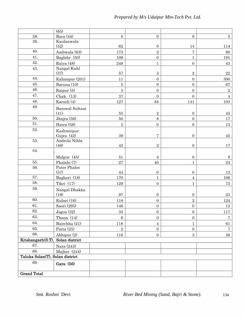
Prepared by M/s Udaipur Min-Tech Pvt. Ltd.
Smt. Roshni Devi River Bed Mining (Sand, Bajri & Stone).
134
(65)
38. Bara (44) 0 0 0 5
39. Kaulanwala
(52) 62 0 14 114
40. Ambwala (63) 173 2 7 80
41. Baglehr (50) 109 0 1 191
42. Raiya (48) 248 1 0 43
43. Nangal Kuhl
(37) 57 3 2 22
44. Kalianpur (201) 11 0 0 300
45. Baruna (10) 5 0 0 67
46. Raipur (5) 5 0 0 2
47. Chak (13) 37 0 0 4
48. Karsoli (4) 127 84 141 103
49. Basowal Sultani
(41) 55 2 0 45
50. Jhajra (56) 50 8 0 17
51. Hatra (58) 2 0 0 13
52. Kashmirpur
Gujra (42) 39 7 0 45
53. Androla Nihla
(46) 43 2 0 17
54. Malpur (4
Malpur (45) 51 4 0 8
55. Phalahi (7) 27 40 1 24
56. Pater Phaloo
(57) 44 0 0 13
57. Bagheri (18) 170 1 4 106
58. Tikri (17) 129 0 1 73
59. Nangal Dhakka
(19) 97 0 0 23
60. Kulari (16) 118 0 2 124
61. Saori (295) 146 0 0 13
62. Jogon (32) 33 0 0 117
63. Thana (14) 6 0 0 7
64. Bairchha (21) 118 4 1 61
65. Patta (25) 2 0 0 7
66. Abhipur (2) 118 0 3 38
Krishangarh(S.T), Solan district
67. Nara (243)
68. Majher (244)
Taluka Solan(T), Solan district
69. Gara (56)
Grand Total
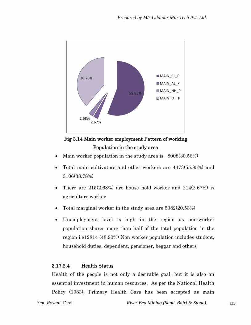
Prepared by M/s Udaipur Min-Tech Pvt. Ltd.
Smt. Roshni Devi River Bed Mining (Sand, Bajri & Stone).
135
Fig 3.14 Main worker employment Pattern of working
Population in the study area
Main worker population in the study area is 8008(30.56%)
Total main cultivators and other workers are 4473(55.85%) and
3106(38.78%)
There are 215(2.68%) are house hold worker and 214(2.67%) is
agriculture worker
Total marginal worker in the study area are 5382(20.53%)
Unemployment level is high in the region as non-worker
population shares more than half of the total population in the
region i.e12814 (48.90%) Non-worker population includes student,
household duties, dependent, pensioner, beggar and others
3.17.2.4 Health Status
Health of the people is not only a desirable goal, but it is also an
essential investment in human resources. As per the National Health
Policy (1983), Primary Health Care has been accepted as main
55.85%
2.67%2.68%
38.78%MAIN_CL_P
MAIN_AL_P
MAIN_HH_P
MAIN_OT_P

Prepared by M/s Udaipur Min-Tech Pvt. Ltd.
Smt. Roshni Devi River Bed Mining (Sand, Bajri & Stone).
136
instrument for achieving this goal of development and strengthening
rural health infrastructure through a three-tier system, viz., Primary
Health Center (PHCs), Sub Centers and Community Health Center,
which have been established.
Lack of building, shortage of manpower and inadequate provision of
drug supplies are hampering the operationalization of these units. The
standards to be met according to National Health Policy are given
below:
Rural Health Care System in India
Population Infrastructur
e
Personnel
3,000 – 5,000 1 Sub centre 1 ANM
25,000 –
30,000
1 PHC, 6
beds
2 Medical officers
1,00,000 Rural Medical
superintendent
Source: National Health Policy, Year 2005-06
3.17.2.5 Cultural and Aesthetic Attributes
3.17.3 Socio-Economic Survey
3.17.3.1 Sampling Method
A judgmental and purposive sampling method was used for choosing
respondents of various sections of the society i.e. Sarpanch, adult
males and females, teachers, medical practitioners, businessmen,
agriculture laborers, fishermen, unemployed group etc. Judgmental
and purposive sampling method includes the right cases from the total
population that helps to fulfill the purpose of research needs.
Prepared by M/s Udaipur Min-Tech Pvt. Ltd.
Smt. Roshni Devi River Bed Mining (Sand, Bajri & Stone).
137
Data Collection Method
In order to assess and evaluate the likely impacts arising out of any
developmental projects on socio-economic environment, it is necessary
to gauge the apprehensions of the people in the project area. For the
process of data collection through primary and secondary sources
certain methods are used among that are:
Field Survey and Observations
Field Survey and Observations is made at each sampling village and
the quality of life of that region is studied. Visits are made at hospitals,
primary health centers and sub-centers to know the health status of
the region. Various governmental organizations such as statistical
department, department of census operations are visited to collect the
population details of that region.
Interview Method
Structured interview method is used to collect data regarding the
awareness and opinion from the sample selected of the various socio-
economic sections of the community. Structured interviews involve the
use of a set of predetermined questions that includes fixed and
alternative questions. The questionnaire mainly highlights the
parameters such as income, employment and working conditions,
housing, food, clothing, water supply, sanitation, health, energy,
transportation and communication, education, environment and
pollution to assess the quality of life of that particular region and
general awareness and opinion of the respondents about the project.
Prepared by M/s Udaipur Min-Tech Pvt. Ltd.
Smt. Roshni Devi River Bed Mining (Sand, Bajri & Stone).
138
The interview method has the advantage that almost all perfect
sample of the general population can be reached and respond to the
approach. Interview method helps to collect more correct and accurate
information as the interviewer is present during the field survey.
3.17.3 Socio-Economic Survey
Socio-economic survey was conducted with the help of predesigned tool
to measure the socio-economic status of the people in the study area. In
all, there are 69 villages located in all directions with reference to
project site. On the basis of puposive sampling, adult male/female from
these 20 villages was selected to collect the information related to
socio-economic status. Care was taken to have interview of Sarpanch/
Mukhia of each village. In addition to individual interviews with the
adult male/female, common meetings were conducted in which heads of
the villages, panchayat representatives, and other stakeholders like,
school teacher, anganwadi sevika, PHC incharge, gramsewak etc were
present.
The salient socio-economic features observed under the study are:

Prepared by M/s Udaipur Min-Tech Pvt. Ltd.
Smt. Roshni Devi River Bed Mining (Sand, Bajri & Stone).
139
Most of the people in study area use firewood and Kerosene as the
main source of fuel for cooking purpose.
Average literacy level among the people is about 58.32%. Among
women in the study area, literacy level is less, as the educational
facilities available in the study area.
Road conditions are good. There is bus facility available in the
interior villages.
Medical facilities available in the area. Lack of drainage and
control of mosquitoes nuisance, have resulted in higher prevalence
of malaria in the area, especially during rainy season.
Most of the villages Borewell, Hand pump, Tank facilites available
in study area.
Electricity facility is available in few villages but mostly villages
are not electrified. Frequently people in the region are facing power
cut problem.
Mostly, people in the region are having the kaccha and mud houses
Awareness and opinion of the people about the project
For the assessment of awareness about the project activities and
opinion about it, following salient observations were recorded:
During survey it was observed that only near by villagers are aware
and other villagers are not aware about the proposed project
People in the region expect job opportunities and improvement in
educational, transportation and sanitation facility from project
authority.
=======*******=======
Prepared by M/s Udaipur Min-Tech Pvt. Ltd.
Smt. Roshni Devi River Bed Mining (Sand, Bajri & Stone).
140
CHAPTER – IV
ANTICIPATED ENVIRONMRNTAL IMPACTS
AND MITIGATION MEASURES
4.0 INTRODUCTION
Any human activity in any environment produces impact,
modifying it to a status which is considered adverse of beneficial
according to the damage or improvement it brings about in
physical, chemical and biological status of air, water, land
including biota and in socio-cultural life styles and economy of the
populace it affects. Depending on the nature of activities and
existing status, the impacts are assessed for their importance. On
the basis of the impact analysis, the mitigating action and future
monitoring requirement are focused in the Environmental
Management Plan for counting or minimizing adverse impacts.
Effects of this mining project on each of the environmental
parameters are detailed below in accordance with the parameter of
environment likely to be affected.
- Climate
- Air environment
- Land environment
- Ecology
- Water environment
- Noise levels
- Soil
- Socio-economic environment
- Cultural and Heritage environment
Generally, the environmental impacts can be categorized as either
primary or secondary. Primary impacts are those which can be
attributed directly to the project. On the indirect or induced and
Prepared by M/s Udaipur Min-Tech Pvt. Ltd.
Smt. Roshni Devi River Bed Mining (Sand, Bajri & Stone).
141
typically include the associated investments and change patterns of
social and economic by the proposed actions.
4.1 CONSTRUCTION PHASE
There will be no impacts as no construction stage is involved in this
project.
4.2 OPERATION PHASE
4.2.1 IMPACT ON TOPOGRAPHY & DRAINAGE
The mine working will remain confined to river bed lot only and
in no case disturbing any surface area outside which may affect
topography or drainage.
Mining pits will impact river bed topography by formation of
excavation voids. This will be temporary and in first monsoon
itself will be temporary and in first monsoon itself will be
restored to original.
MITIGATION MEASURES
Mining will be done in a planned way i.e. collection of
minerals/working shall be started from the centre dip to rise and
then laterally in 1 meter slice so that the river course will not get
affected.
Unwanted material including mineral or spillage (if any) will not
be stacked on the bank side as it will hinder the flow of water in
monsoon season.
The mining from river bed will not have any impact on natural
drainage of surrounding area as the excavated sand from river
bed is filled with first heavy flow in river during monsoon season.

Prepared by M/s Udaipur Min-Tech Pvt. Ltd.
Smt. Roshni Devi River Bed Mining (Sand, Bajri & Stone).
142
4.3 IMPACTS ON CLIMATE
4.3.1 TEMPERATURE
The temperature pattern is a regional behavior and is not likely to
be affected by the river bed mining activity over a small area. Some
local effect may be perceived due to mining, afforestation and
creation of voids in the lease area.
4.3.2 RAINFALL
The trend of rainfall, as studied and discussed in last chapter,
forms part of a regional pattern, not dependent on the relatively
small area of river bed mining activity. The mining operation,
therefore, is not likely to have any adverse impact on rainfall
pattern.
4.3.3 WIND SPEED
The wind speed in any area is dependent upon local topography
and generation of elevation and depression of pressure changes in
the region. The controlling factors for the pressure changes lie
much beyond the control of small area under mining operations.
Thus, no adverse impact on the regional wind speed is anticipated
due to the mining operations. However, some local ground level
changes may take place due to the buildings, green belt developed
around the mine, etc.
4.3.4 HUMIDITY
The pattern of relative humidity depends mainly on the rainfall,
wind, temperature and other weather phenomenon that regional in
behavior. The mining operation is not likely to have any impact on
the relative humidity in the surrounding.

Prepared by M/s Udaipur Min-Tech Pvt. Ltd.
Smt. Roshni Devi River Bed Mining (Sand, Bajri & Stone).
143
4.4 IMPACT OF AIR POLLUTION
4.4.1 Impact through mathematical modeling for sand mining project
As explained in the previous chapter, the ambient air quality
monitoring results show that all the parameters such as PM10, SO2,
NOx and CO are within the limits prescribed by CPCB for
“Industrial and Mixed use” areas as well as areas meant for
“Residential and Rural” areas. This scenario is with the expansion
already in place.
The major contribution of air pollution is by river bed mining, such as
excavation, loading, transportation, hauling operation and handling of
mineral viz. Sand, Bajri & Boulders. This will lead to momentary rise
in the particulate matter (PM10). The dust liberated in mining and
other related operations is injurious to heath if inhaled in sufficient
quantity. As such there will be no noticeable impact on air quality.
4.4.2 Air Pollution Modeling
The impact of the expansion on the air quality has been predicated
using Fugitive Dust Model(FDM),which is a computerized air
quality model specifically designed for computing concentration
and deposition impacts from fugitive dust sources. The sources may
be point, line or area sources. The model has not been designed to
compute the impacts of buoyant point sources, thus it contains no
plume rise algorithm. The model is generally based on the well
known Gaussian Plume formulation for computing concentrations,
but the model has been specifically adapted to incorporate an
improved gradient transfer deposition algorithm. Emissions for
each source are apportioned by the user into a series of particle

Prepared by M/s Udaipur Min-Tech Pvt. Ltd.
Smt. Roshni Devi River Bed Mining (Sand, Bajri & Stone).
144
size classes. A gravitational setting velocity and a deposition
velocity are calculated by FDM for each class.
4.4.2.1 Pollutants / Model Options Considered for Computations
The model simulations deal with major Pollution Particulate Matter
(PM10) and gaseous emissions viz. SO2 & NO2.
4.4.2.2. Meteorological Data
Data recorded by continuous weather monitoring station on wind
speed, direction, and temperature at one hour interval for the
monitoring period was used as meteorological input.
„
4.4.2.3. Presentation of result
In tha present case model simulations have been carried using the
hourly triple joint frequency data. Short – term simulations were
carried to estimate concentration at the receptors to obtain an
optimum description of variations in concentrations over the site in 10-
km radius covering 16 directions.
The incremental concentration is estimated for the monitoring period.
For each time scale, i.e. for 24 hr. the model computes the highest
concentration observed during the period over all the measurement
points.
The maximum incremental GLCs due to the river bed mining project
for PM10, SO2 and NO2 are superimposed on the maximum baseline
PM10, SO2 and NO2 concentration recorded at the monitoring location
during the field monitoring period. The cumulative concentration
(baseline + incremental) after implementation of the project are
tabulated below in table- table-4.3. The maximum GLCs after
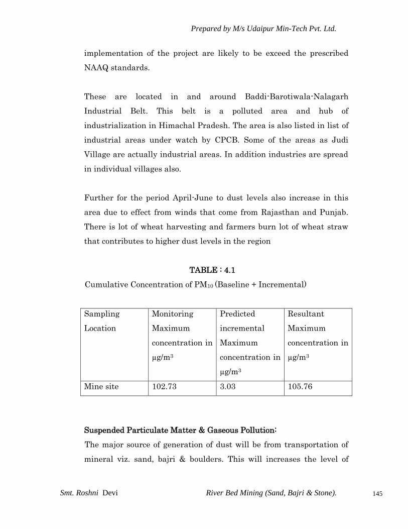
Prepared by M/s Udaipur Min-Tech Pvt. Ltd.
Smt. Roshni Devi River Bed Mining (Sand, Bajri & Stone).
145
implementation of the project are likely to be exceed the prescribed
NAAQ standards.
These are located in and around Baddi-Barotiwala-Nalagarh
Industrial Belt. This belt is a polluted area and hub of
industrialization in Himachal Pradesh. The area is also listed in list of
industrial areas under watch by CPCB. Some of the areas as Judi
Village are actually industrial areas. In addition industries are spread
in individual villages also.
Further for the period April-June to dust levels also increase in this
area due to effect from winds that come from Rajasthan and Punjab.
There is lot of wheat harvesting and farmers burn lot of wheat straw
that contributes to higher dust levels in the region
TABLE : 4.1
Cumulative Concentration of PM10 (Baseline + Incremental)
Sampling
Location
Monitoring
Maximum
concentration in
µg/m3
Predicted
incremental
Maximum
concentration in
µg/m3
Resultant
Maximum
concentration in
µg/m3
Mine site 102.73 3.03 105.76
Suspended Particulate Matter & Gaseous Pollution:
The major source of generation of dust will be from transportation of
mineral viz. sand, bajri & boulders. This will increases the level of
Prepared by M/s Udaipur Min-Tech Pvt. Ltd.
Smt. Roshni Devi River Bed Mining (Sand, Bajri & Stone).
146
particulate matter in the environment i.e. PM10 (8.25 µg/m3) at a
distance of 500 meters near Kaccha Road.
MITIGATION MEASURES
To control the emissions regular preventive maintenance of
equipment will be carried out on contractual basis.
Proper mitigation measures like water sprinkling will be
adopted to control dust emissions.
Plantation will be carried out on approach roads & nearby
vicinity of river bank.
It is being ensured that all transportation vehicles will carry a
valid PUC certificate.
There is no toxic element present in the mineral which may
contaminate the soil.
4.5 IMPACT OF NOISE POLLUTION
The exposures to excessive noise levels can lead to:
Prevention of sleep, insomnia and fatigue.
Decrease in speech reception, communication, distraction
and diminished concentration thus adversely affecting job
performance efficiency.
Chronic psychological disturbance including impaired
hearing.
Irreparable cardiovascular, respiratory and neuralgic
damages in certain extreme cases.
The area is general represents calm surroundings. There is no
heavy traffic, industry or noisy habitation in the area except the
existing mine. The other major industry like minerals grinding and
crusher plants is far away. With the increase in scale of mining
operations, deployment of machinery and vehicles operation and men

Prepared by M/s Udaipur Min-Tech Pvt. Ltd.
Smt. Roshni Devi River Bed Mining (Sand, Bajri & Stone).
147
and noise levels are expected to increase. The noise levels for
different equipment in this mine are given in Table 4.2.
TABLE 4.2
Noise Generated by Different Machinery
S. No. Equipment Noise Level dBA
1. Tractor compressor 85-95
2. Dump Trucks 90-100
The impact of noise intensities at varying distances, derived
mathematically by Spherical Propagation modeling for free
attenuation due to distance only, are given in Table 4.3.
TABLE 4.3
Free Noise Attenuation with Distance
From the above we find that if there noise source of 95,95 and 90
dBA, each at 400m from a receptor, converge at the receptor, their
components would be 35,35 and 30 dBA respectively.
With the resultant value being less than the ambient noise levels,
there is no likelihood of excess addition of noise, from the mine
operation, on the surrounding background noise level.
As derived above and due to the fact that there are no human
settlement within 400m, no impact of noise on habitation is likely.
The same is brought out by the noise measurements carried out
Noise Level at Source
dBA
Distance in
m Noise Level at Receptor dBA
95 100 47
95 200 41
95 300 37
95 400 35
90 100 42
90 200 36
90 300 32
90 400 30

Prepared by M/s Udaipur Min-Tech Pvt. Ltd.
Smt. Roshni Devi River Bed Mining (Sand, Bajri & Stone).
148
which indicate that the noise levels in the vicinity are within
limits.
Through the source would likely cause noise pollution, but since it is
continuous the considerable impact will be in. However the noise levels
in the working environment are compared with standards prescribed
by occupational safety and heath administration (OSHA-USA)&
CPCB-NEW DEHLI, the acceptable limits are presented in table 4.4 &
4.4.1.
TABLE - 4.4
PERMISSIBLE EXPOSURE IN CASES OF CONTINUOUS NOISE (GOI)
S.No Total time of
Exposure
(Continuous or a
number of short
term exposures)
per day in Hours.
Sound
Pressure
(dBA)
Remarks
1 8 90
1. No. exposure in excess of 115
dBA is to be permitted.
2. For any period of exposure falling
in between any figure as
indicated in column 1, the
permissible wound pressure level
is to be determined by
extrapolation on a proportionate
scale.
2 6 92
3 4 95
4 3 97
5 2 100
6 1½ 102
7 1 105
8 ¾ 107
9 ½ 110
10 ¼ 115
TABLE – 4.4.1
AMBIENT AIR QUALITY STANDARD IN RESPECT OF NOISE
Area Code Category of Area
Limits in dB(A) Leq
Day time Night
time
(A) Industrial area 75 70
(B) Commercial area 65 55
(C ) Residential area 55 45
(D) Silence zone 50 40

Prepared by M/s Udaipur Min-Tech Pvt. Ltd.
Smt. Roshni Devi River Bed Mining (Sand, Bajri & Stone).
149
In this mine no person is exposed to very high noise levels of
noise continuously during works. Those working close to noise
generating equipment have been provided with earplugs.
MITIGATION MEASURES
Periodical monitoring of noise will be done.
No other equipments except the transportation vehicles and
Excavator for loading will be allowed.
Noise generated by these equipments by these equipments shall
be intermittent and does not cause much adverse impact.
Proper maintenance of all equipments/ machines will be carried
out which help in reducing noise during operations.
Plantation will be taken up along the approach roads and
vicinity of river bank. The plantation minimizes propagation of
noise and also arrests dust.
4.6 IMPACT ON HYDROLOGICAL CONDITIONS
The study area itself being part of River Sirsa course carries surface as
well as ground water (under current). The flow of surface/ground water
(sub surface flow) is following the trend of topography, which is in the
East to West direction.
The area is part of Chikni khad in sirsa catchment area and remain
dry for more than nine months in a year except for the rainy season.
The sand and stone mining up to the depth of 1mt will have
insignificant impact on water regime.
The ground water table which will be about 5.5m metres below the
surface of river bed in the mining area during the dry seasons will not
be disturbed as ultimate working depth will be 330 mRL from
upstream level and 311 mRL in the downstream boundary. Thus the
mine operation will not affect the hydrological conditions of the area.

Prepared by M/s Udaipur Min-Tech Pvt. Ltd.
Smt. Roshni Devi River Bed Mining (Sand, Bajri & Stone).
150
At the end of mining operations every yearly season, the flood waters
would replenish the mined material, thus it will be positive impact on
the ground water scenario in the subsequent mining period.
SCHEMATIC REPRESENTATION OF SITE ELEVATION, WORKING
DEPTH & GROUND WATER
4.7 IMPACT ON WATER QUALITY
Mining causes lowering of riverbed level as well as river bed water
level resulting in lowering of groundwater table due to excessive
extraction and draining out of groundwater from the adjacent areas, if
general ground water table is higher than riverbed level. In case the
general ground water level is lower than riverbed water level, then it
will have positive impact as ground water table will be recharged
vertically as well as laterally. The former case may cause shortage of
water for the vegetation and human settlement in the vicinity, but in
later case it will help improve situation.
306.0 mRL (Pre monsoon)
309.0 mRL (Post monsoon) WATER TABLE
330mRL (1m bgl) up stream
311.0 mRL (1m bgl) down stream
ULTIMATE DEPTH
321mRL (1m bgl) up stream
312.0 mRL (1m bgl) down stream
GROUND LEVEL
Proposed working will not intersect Ground water.

Prepared by M/s Udaipur Min-Tech Pvt. Ltd.
Smt. Roshni Devi River Bed Mining (Sand, Bajri & Stone).
151
River is recharging the ground water, excessive mining will reduce the
thickness of the natural filter materials (sediments), infiltration
through which the ground water is recharged, so restriction in depth
becomes necessity.
MITIGATION MEASURES
Mining in the area will be done well above the water table as well as
river bed water level therefore; much impact on water regime is not
anticipated. The water table is at 3-6 m below river bed level while the
workings in the area are proposed up to a max. depth of 2m . from
river bed level o.5m slice working is proposed, so that water level is not
touched.
No waste water will be generated from the mining activity of minor
minerals as the project only involves lifting of sand, Bajri & boulders
from river bed.
Mining neither intersect ground water table nor river bed water level.
So not at all disturbing water environment.
4.8 IMPACT ON FLORA
4.8.1 FLORA IN BUFFER ZONE
As the mining activities will be confined to core zone only, no
adverse impact is foreseen on the flora of the forest area.
4.8.2 FLORA IN CORE ZONE
Excavation in the mining area and construction of roads, offices
etc. does not affect the flora in the area where these operations
are carried out.
Plantation will be carried out on approach roads and nearby vicinity
at river banks areas will, over a period of time, upgrade the flora.

Prepared by M/s Udaipur Min-Tech Pvt. Ltd.
Smt. Roshni Devi River Bed Mining (Sand, Bajri & Stone).
152
4.9 IMPACT ON FAUNA
The adverse impacts on fauna are mainly due to :
Human Activity
Noise
Land Degradation
Deforestation
The impact on the fauna of the buffer zone due to the mining
activity will be marginal. As there are very few trees / shrubs in
the area, deforestation will not be significant factor in impact on
fauna.
Fauna in the core zone is minimal, as most of the area is either
unirrigated agricultural land or waste land. Even so, by restricting
mining at any time to small areas, impact on fauna will be kept
to the minimum. Moreover, due to small activity of the past two
decades with machinery has already pushed out whatever minor
fauna was available in this desolate land. However, progressive
plantation activity being undertaken will over a period of time
create conditions favorable for fauna.
4.10 IMPACT ON LAND ENVIRONMENT
4.10.1 LAND USE IN BUFFER ZONE
No adverse impact is anticipated on land use of buffer zone due
to the present mining operations, as all the related activities are
confined to the core zone.
Prepared by M/s Udaipur Min-Tech Pvt. Ltd.
Smt. Roshni Devi River Bed Mining (Sand, Bajri & Stone).
153
4.10.2 IMPACRT ON LAND USE PATTERN INCLUDING CHANGE OF
RIVER COURSE (Refer Plate No.3 & 4)
If the mining is not carried out in a systematic manner by
leaving sufficient safety barriers from bank then it may disturb
the river flow/course.
Stacking of unwanted material including mineral or spillage (if
any) on the bank side of the river will hinder the flow of water
in monsoon season, raise water level upstream, which may lead
to bank cutting or flouting.
Deviation from planned mining procedures can lead to river
channel shifting as well as degradation of surrounding land,
causing loss of properties and degradation of landscape.
Mining within a river bed may have some impact on the
stream‟s physical characteristics, such as channel geometry, bed
elevation in stream roughness of the bed, flow velocity,
discharge capacity, sediment transportation capacity etc.
Alteration or modification of the above attributes may cause
noticeable hazardous impact on ecological equilibrium.
MITIGATION MEASURES
Mineral will be mined out in central position and convex side of
the river channel with leaving sufficient barrier from the river
bank.
Mining of minerals will be started from dip side towards rise at
the centre and also laterally in 1 meter slice so that the river
course will not get affected. Unwanted material or spillage (if
any )will not be stacked by the side of the excavation voids
created. This is to be done so, because it will otherwise hinder
the flow of water in monsoon season.
Mining is to done leaving safety barrier on both sides and
maximum barrier should be on concave side of river preferably
Prepared by M/s Udaipur Min-Tech Pvt. Ltd.
Smt. Roshni Devi River Bed Mining (Sand, Bajri & Stone).
154
the flow channel (excavation void created) should be kept
straight so as to help avoid erosion as side cutting.
4.11 IMPACT ON SOIL
No major impact on soil of the study area is envisaged due to mining
activities as there is no stack emission and fugitive emission shall
remain confined locally within working area and emission at haul road
will be controlled by water sprinkling and plantation.
4.12 IMPACT ON SOIO-ECONOMIC ENVIRONMENT
4.12.1 HUMAN SETTLEMENT
The villages and their inhabitants in the buffer zone will not be
disturbed from their settlements due to the mining operations.
There is no inhabitation within the lease area. Therefore neither
villages nor any part of village or any hamlet will be disturbed
during the entire life of the mine. As the mining operations will
not disturb or relocate any village or settlement, no adverse
impact is anticipated on any human settlement.
4.12.2 EMPLOYMENT
The area is considered as industrially backward. The population in
general do not have opportunities of earning from employment.
The only employment to depend on is agriculture, which is seasonal.
In the absence of any high employment potential activities, the people
are economically backward. The mining operations are providing
employment to 20 persons.
The various indirect employment opportunities have also been
generated. Several persons of the neighboring villages have been
benefited with contract works, employment through contractors,
Prepared by M/s Udaipur Min-Tech Pvt. Ltd.
Smt. Roshni Devi River Bed Mining (Sand, Bajri & Stone).
155
running of jeeps, trucks, tractors and buses on hire, running
canteens, different kind of shops and transport related business
avenues.
4.12.3 ECONOMIC STATUS
There are some people who are engaged in trading of sand, stone and
Bajri. Therefore due to mining of sand, stone, and Bajri the per capita
income of local people have been improved.
The local people have been provided with either direct
employments or indirect employment such as business, contract
works and development work like roads, etc. and other welfare
amenities such as medical facilities, conveyance, free education,
drinking water supply etc.
The job/business opportunities has improved the economic
condition of the persons. They are in a position to utilize this
money for purchase of tractors, trucks, jeeps, etc. which may be put
into use for business purposes. Part of money has also been
utilized in starting of some business as per person‟s skills.
4.12.4 AGRICULTURE
The agricultural activities are seen in the areas where there is
sufficient soil cover. The buffer zone will remain undisturbed and
no adverse impact is envisaged.
4.12.5 SENSITIVE TARGETS
There are no places of Tourist, religious & Historical importance
in core as well as buffer zone of 10-km radius. Therefore, no
adverse impact are anticipated.
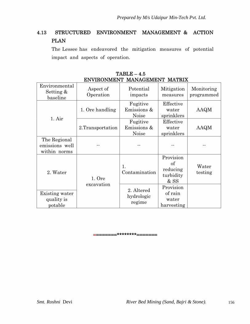
Prepared by M/s Udaipur Min-Tech Pvt. Ltd.
Smt. Roshni Devi River Bed Mining (Sand, Bajri & Stone).
156
4.13 STRUCTURED ENVIRONMENT MANAGEMENT & ACTION
PLAN
The Lessee has endeavored the mitigation measures of potential
impact and aspects of operation.
TABLE – 4.5
ENVIRONMENT MANAGEMENT MATRIX
Environmental
Setting &
baseline
Aspect of
Operation
Potential
impacts
Mitigation
measures
Monitoring
programmed
1. Air
1. Ore handling
Fugitive
Emissions &
Noise
Effective
water
sprinklers
AAQM
2.Transportation
Fugitive
Emissions &
Noise
Effective
water
sprinklers
AAQM
The Regional
emissions well
within norms
-- -- -- --
2. Water
1. Ore
excavation
1.
Contamination
Provision
of
reducing
turbidity
& SS
Water
testing
2. Altered
hydrologic
regime
Provision
of rain
water
harvesting
Existing water
quality is
potable
========********=======

Prepared by M/s Udaipur Min-Tech Pvt. Ltd.
Smt. Roshni Devi River Bed Mining (Sand, Bajri & Stone).
157
CHAPTER – V
ENVIRONMENTAL MONITORING PROGRAMME
5.1 INTRODUCTION
Success of any environmental management programme depends
upon the efficiency of the organizational set up responsible for
implementation of the programme. Post project monitoring is an
essential part to check the impact of any project activity. Hence
monitoring of various environmental parameters will be carried out an
a regular basis to ascertain the following:
To assess environmental impacts.
State of pollution within the mine lease and in its vicinity.
Planning for predictive or corrective actions in respect of
pollution to keep it within permissible limits.
Examine the efficiency of pollution control system adopted at
the site.
Monitoring will be carried out at side as per the statutory
requirements.
Environmental monitoring will be taken up for various
environmental components as per conditions stipulated in
Environmental Clearance Letter issued by MOEF & Consent to
operate issued by the State Pollution Control Board. Compliance
of same will be submitted to respective authorities on regular
basis.
5.2 ENVIRONMRNTAL MANAGEMENT
In order to maintain the environmental quality within the stipulated
standard, regular monitoring of various environmental component is
necessary which will complied as per condition for this an
Environmental Management Cell be constituted.
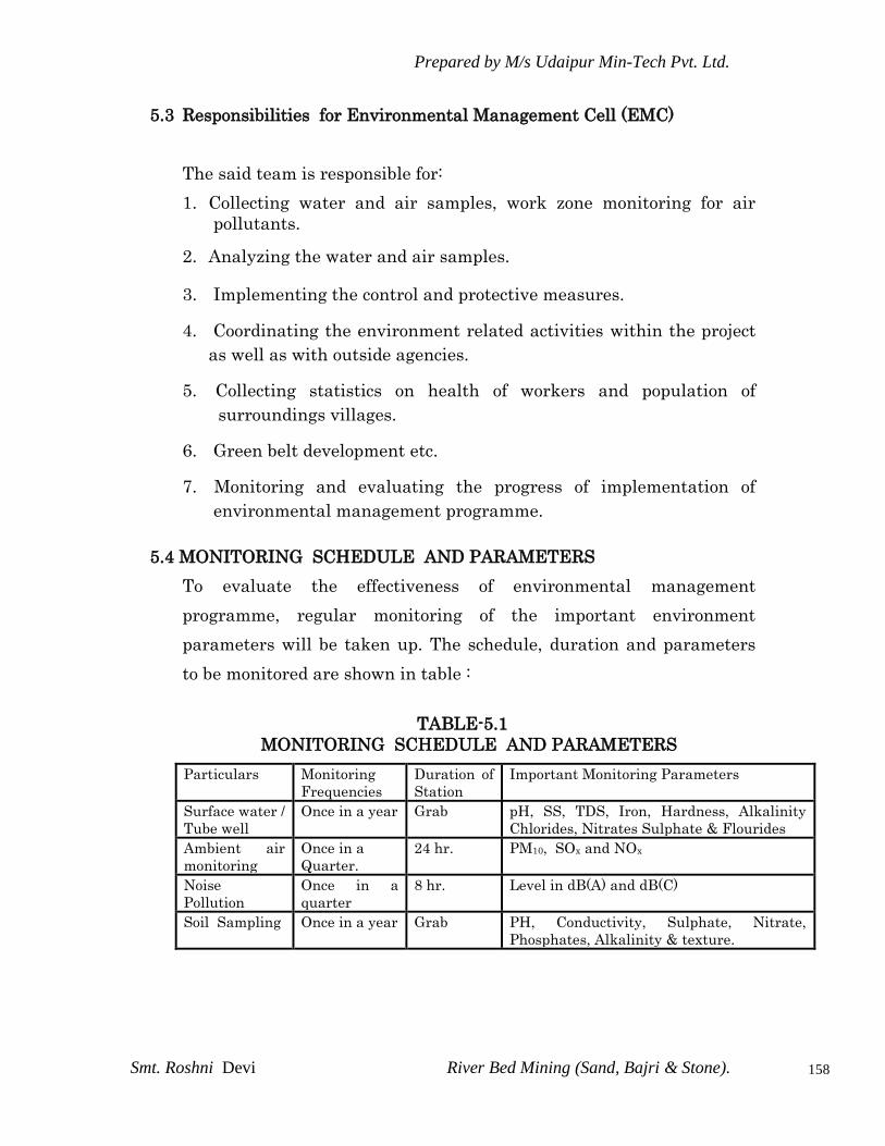
Prepared by M/s Udaipur Min-Tech Pvt. Ltd.
Smt. Roshni Devi River Bed Mining (Sand, Bajri & Stone).
158
5.3 Responsibilities for Environmental Management Cell (EMC)
The said team is responsible for:
1. Collecting water and air samples, work zone monitoring for air
pollutants.
2. Analyzing the water and air samples.
3. Implementing the control and protective measures.
4. Coordinating the environment related activities within the project
as well as with outside agencies.
5. Collecting statistics on health of workers and population of
surroundings villages.
6. Green belt development etc.
7. Monitoring and evaluating the progress of implementation of
environmental management programme.
5.4 MONITORING SCHEDULE AND PARAMETERS
To evaluate the effectiveness of environmental management
programme, regular monitoring of the important environment
parameters will be taken up. The schedule, duration and parameters
to be monitored are shown in table :
TABLE-5.1
MONITORING SCHEDULE AND PARAMETERS
Particulars Monitoring
Frequencies
Duration of
Station
Important Monitoring Parameters
Surface water /
Tube well
Once in a year Grab pH, SS, TDS, Iron, Hardness, Alkalinity
Chlorides, Nitrates Sulphate & Flourides
Ambient air
monitoring
Once in a
Quarter.
24 hr. PM10, SOx and NOx
Noise
Pollution
Once in a
quarter
8 hr. Level in dB(A) and dB(C)
Soil Sampling Once in a year Grab PH, Conductivity, Sulphate, Nitrate,
Phosphates, Alkalinity & texture.
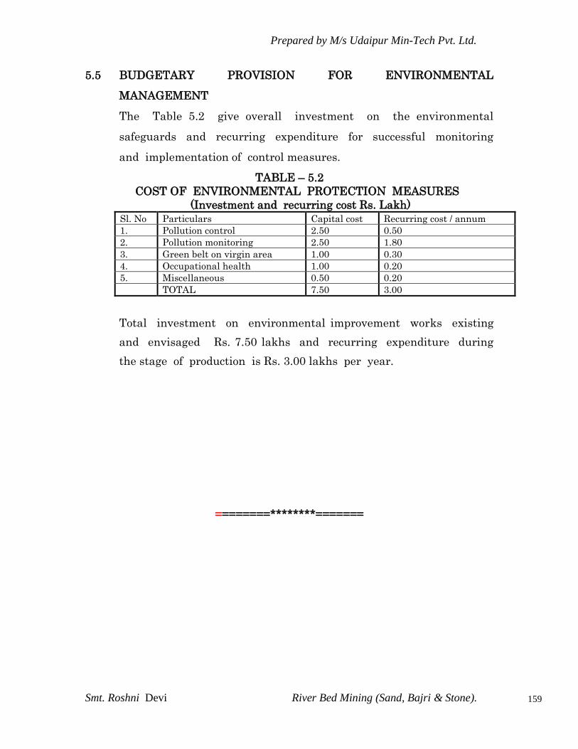
Prepared by M/s Udaipur Min-Tech Pvt. Ltd.
Smt. Roshni Devi River Bed Mining (Sand, Bajri & Stone).
159
5.5 BUDGETARY PROVISION FOR ENVIRONMENTAL
MANAGEMENT
The Table 5.2 give overall investment on the environmental
safeguards and recurring expenditure for successful monitoring
and implementation of control measures.
TABLE – 5.2
COST OF ENVIRONMENTAL PROTECTION MEASURES
(Investment and recurring cost Rs. Lakh)
Sl. No Particulars Capital cost Recurring cost / annum
1. Pollution control 2.50 0.50
2. Pollution monitoring 2.50 1.80
3. Green belt on virgin area 1.00 0.30
4. Occupational health 1.00 0.20
5. Miscellaneous 0.50 0.20
TOTAL 7.50 3.00
Total investment on environmental improvement works existing
and envisaged Rs. 7.50 lakhs and recurring expenditure during
the stage of production is Rs. 3.00 lakhs per year.
========********=======
Prepared by M/s Udaipur Min-Tech Pvt. Ltd.
Smt. Roshni Devi River Bed Mining (Sand, Bajri & Stone).
160
CHAPTER – VI
ADDITIONAL STUDIES: DISASTER MANAGEMENT
6.1 INTRODUCTION
All types of industries face certain types of hazards which can disrupt
normal activities abruptly and to disaster like fires, inundation, failure of
machinery, explosion, to name a few. Similarly Limestone mines also
have impending dangers or risk which need be addressed for which a
disaster management plan has been formulated with an aim of taking
precautionary steps to avert disasters and also to take such action after
the disaster which limits the damage to the minimum.
Nevertheless, the following natural/industrial problems may be
encountered during the mining operation.
1. Inudation- filling of the mine pit due to excessive rains.
2. Slope failures at the mine faces or stacks.
3. Accident due to storage of explosive and blasting.
4. Accident due to fire.
As per proposal made under the mining plan, during proposed working
the area will be developed by means of manuals opencast mining method
with adoption of shallow drilling and mild blasting. Exploitation and
transportation of minerals are to be carried out by manual means. Bench
height & width is maintained at 6.0m. Maximum depth of working will
be 1930 and 1880 mRL from top level(2042 mRL).Water table will not be
touched during processed working. No high risk accidents like landslides,
subsidence flood etc. have been apprehended.
But possibility of accidental disaster is also not ruled out. Therefore,
all the statutory precautions should be taken for quick evacuation as per
the Mines Act 1952, the Mines Rules 1955, MMR-1961 and MCDR-1988.

Prepared by M/s Udaipur Min-Tech Pvt. Ltd.
Smt. Roshni Devi River Bed Mining (Sand, Bajri & Stone).
161
6.2 Risk Assessment And Disaster Management Plan
The possible risk in the case of river bed mining project are bank erosion,
floods, accidents due to transportation etc.
Mining and allied activities are associated with several potential hazards
to both the employees and the public at large. A worker in a mine should
be able to work under condition, which are adequately safe and healthy.
At the same time the environmental should be such as not to impair his
working efficiency. This is possible only when there is adequate safety in
mines. Hence, mine is one of the most essential aspect of any working
mine . safety of the mine and the employees is taken care of by the
mining rules & regulations, which are well defined with laid down
procedure for safety, which when scrupulously followed safety is ensured
not only to manpower but also to machines & working environment.
6.2.1 possible risks due to inundation & its Control
Mining will be done during the non monsoon periods; therefore problem
of inundation is not likely to happen.
6.2.2 Dewatering
Depth of mine is limited to 2m depth only from the river bed level
whereas the ground water flows at 3m to 6m below the bed level. Hence
no dewatering is required.
6.2.3 Possible risks due to failure of pit slope & its control
Pit will be created of limited depth only i.e. 2m thus the chance of failure
of pit slope does not exist.
6.2.4 Possible risks due to failure of waste dump & its control
No waste dump is created therefore the question of failure of waste
dump does not exist.

Prepared by M/s Udaipur Min-Tech Pvt. Ltd.
Smt. Roshni Devi River Bed Mining (Sand, Bajri & Stone).
162
6.2.5 possible risks due to fire & its Control
The operation does not anticipate any fire disaster.
6.2.6 Measures to Prevent Accidents Due to Trucks and Dumpers
All transportation within mining lease working should be carried out
directly under the supervision and control of the management.
The vehicles will be maintained in good condition and checked
thoroughly at least once a month by the competent person authorized
for the purpose by the management.
Road signs will be provided at each and every turning point up to the
main road (wherever required).
To avoid danger while reversing the equipments/ vehicles especially at
the working place / loading points, stopper should be posted to properly
guide reversing/ spotting operating, otherwise no person should be
there within 10 km radius of machine.
A statutory provision of the fences, constant education, training etc.
will go a long way in reducing the incidents of such accidents.
6.2.7 Other Possible Measures to Avoid Risks/ Disaster Due to River Bed
Mining
Unwanted material including mineral or spillage (if any) should not be
stacked on the banks as it will hinder the flow of water in monsoon
season.
Mining of minerals / working shall be started from the centre from dip
to rise and then laterally in ½ Meter slice so that the river course could
not get affected.
The minerals will be mined out in a uniform way so that the river flow/
course shall not get disturbed.
River banks will not be excavated to from access ramps.
Only excavated river gravel should be used to deposit against the river
bank to form access ramps.

Prepared by M/s Udaipur Min-Tech Pvt. Ltd.
Smt. Roshni Devi River Bed Mining (Sand, Bajri & Stone).
163
CHAPTER-VII
PROJECT BENEFITS
7.1 INTRODUCTION
Smt. Roshni Devi w/o late Shri Hakam ram is very much conscious of
their obligation to society at large. The management will help in
overall socio economic development of the area.
7.2 PROMOTION OF SOCIAL & ECONOMIC STATUS
Smt. Roshni Devi w/o late Shri Hakam has contributed to the
economy and social development of the area. It will provide
direct employment to about 45 people and indirect employment
to many more.
The company believes in the philosophy to provide better health
and medical facilities not only to their families but also to
villagers.
7.3 CONCLUSION
The management will recruit the semi-skilled & unskilled workers
from the nearby villagers.
The project activity and the management will definitely support the
local panchayat and provide other from of assistance for the
development of public amenities in this region. The company
management will contribute to the local schools, dispensaries for the
welfare of the villagers.
Green belt development / Plantation will be taken up in the vicinity of
river banks, along the approach roads, around Govt. building, schools.
========********=======

Prepared by M/s Udaipur Min-Tech Pvt. Ltd.
Smt. Roshni Devi River Bed Mining (Sand, Bajri & Stone).
164
CHAPTER-VIII
ENVIRONMENT MANAGEMENT PLAN
8.0 INTRODUCTION
The environmental impact assessment presented in previous chapter is
based on the control measures. It is concluded that the mining
activities having substantial, but reversible impact on environment
and the suggestive measures should be taken so as to minimize the
impacts.
Environmental management plan details the environmental quality
control measures which are proposed for this project to achieve the
production of 58,750 TPA of sand, bajri & boulders (Minor Minerals) by
complying with the stipulated standard limit specified by state
pollution control board and CPCB. The environment for the mined out
river bed area.
Environment Management Plan, which is to be implemented in the
project has detailed under the following heads:
Land use pattern and river course environment
Air Environment
Water Environment
Noise Environment
Solid waste Management
Biological Environment including Plantation Development
Implementation of EMP and monitoring Programme

Prepared by M/s Udaipur Min-Tech Pvt. Ltd.
Smt. Roshni Devi River Bed Mining (Sand, Bajri & Stone).
165
8.1 LAND USE PATTERN AND RIVER COURSE ENVIRONMENT
Mineral will be mined out in central position and convex side of the
river channel with leaving sufficient barrier from the river bank.
Mining will be carried out by scrapping in 1 m slice in the channel
bottom on the rotation basis to left the previous year pit for natural
replenishment.
Unwanted material including mineral will not be stacked by the side of
the excavation voids created.
Five Check dam will be prepared at the banks side to prevent bank
erosion.
Sufficient barrier from the public utility structure i.e road bridge,
industrial shed, temple check dam will be left.
8.2 AIR ENVIRONMENT
In order to minimize impacts of mining on air and to maintain it
within the prescribed limits of CPCB/SPCB, an Environment
Management Plan (EMP) has been prepared. This will help in
resolving all environmental and ecological issues likely to cause due to
mining in the area.
During the course of mining no toxic substances are released into the
atmosphere as such there seems to be no potential threat to health of
human beings.
In river bed mining activities, the only source of gaseous emission is
from the engines of vehicles. The reasons may be quality of fuel,
improper operation of the engine, etc. proper maintenance of engines
will improve combustion process and brings reduction in pollution.
The river bed mining activities, the only source of gaseous emissions is
from the engines of vehicles. The reasons may be quality of fuel,
improper operation of the engine, etc. proper maintenance of engines
will improve combustion process and brings reduction in pollution.

Prepared by M/s Udaipur Min-Tech Pvt. Ltd.
Smt. Roshni Devi River Bed Mining (Sand, Bajri & Stone).
166
The fugitive dust generation during mining and transportation
requires some mitigation.
8.2.1 Prevention and Control of Air Pollution
Proper mitigation measures like water sprinkling on haul roads
will be adopted to control fugitive dust emission.
Plantation will be carried out on approach roads & nearby
vicinity of river bank.
To control the emissions regular preventive maintenances of
equipments will be done to adopt corrective actions wherever
needed.
It is being ensured that all transportation vehicles will carry a
valid PUC certificate.
8.3 NOISE ENVIRONMENT
8.3.1 Noise Abatement and Control
Proper maintenance of all machines is being carried out, which
help in reducing generation of noise during operations.
Cushioned pad at foundation helps reduction in noise
generation.
No other equipments accept the transportation vehicles and
excavator & Loaders (as & when required) for loading is
allowed.
Noise generated by these equipments is intermittent and does
not cause much adverse impact.
Periodical monitoring of noise will be done to adopt corrective
actions wherever needed.
Plantation will be taken up along the approach roads and on
river bank. The plantation minimizes propagation of noise and
also arrests dust.

Prepared by M/s Udaipur Min-Tech Pvt. Ltd.
Smt. Roshni Devi River Bed Mining (Sand, Bajri & Stone).
167
8.4 WATER MANAGEMENT
8.4.1 Surface & Ground Water Management
Mining in the area will be done well above the water table as
well as river bed water level therefore impact on water regime is
not anticipated. The river bed level of lease area is 344 to 351
mRL the river bed water level is at 3-6 m below it. While the
workings in the area are proposed up to a max. depth of 2m.
from river bed level 0.5 slice working is proposed, so that water
level is not touched.
Mining will not intersect the river bed water level or ground
water table of the area. So not at all disturbing water
environment.
The mining from river bed does not have any impact on
topography and natural drainage of surrounding area as no part
of land outside river bed is disturbed and the void formed dust
excavated sand , Bajri & Boulders (Minerals) from river bed is
filled bank generally during monsoon season, more or less
restoring to original position thus not affecting normal drainage
in the river channel also.
8.4.2 Waste Water Management
No waste water is generated from the mining activity of minor
minerals as the project only involves lifting of sand , bajri & Boulders
from river bed in dry state.
8.5 SOLID WASTE MANAGEMENT
No solid waste is generated from the said mining operations.
Unwanted material including mineral or spillage (if any) will
not be stacked on the banks sides as it will hider the flow of
Prepared by M/s Udaipur Min-Tech Pvt. Ltd.
Smt. Roshni Devi River Bed Mining (Sand, Bajri & Stone).
168
water in monsoon season. The same is backfilled in the mined
out area.
There is no toxic element present in the mineral which may
contaminate the soil.
8.6 BIOLOGICAL ENVIRONMENT
8.6.1 Floral and Faunal Environment of the Study Area
The project is only of extraction of minor minerals viz. Sand,
Bajri, & Boulders from the river bed.
There will be no significant impact of the river bed mining
project on the biological diversity found in the 10km. radius of
the site.
The mining lease area is in non-forest land where presence of
fauna is very rere. No endangered species of fauna is found is
and around lease area. As such , there will be no adverse impact
of the mining activity on fauna around the mining lease area.
No adverse impacts will be envisaged on the existing aquatic
flora & fauna if any on downstream side (away from site) as the
mine workings confined to above water level only and at all
touching/disturbing water table.
No adverse impacts will be envisaged on the terrestrial flora and
fauna as the working are restricted to river bed only.
To study the floral and faunal diversity of the 10km radius a
detailed biological study has been carried out and suggested
mitigation measures are proposed there in so that there will be
no impact on the biological diversity of the forests falling in the
proximity of the site.

Prepared by M/s Udaipur Min-Tech Pvt. Ltd.
Smt. Roshni Devi River Bed Mining (Sand, Bajri & Stone).
169
8.6.2 Plantation Development
Plantation is an important sink of air pollutants including
noise. Green cover in mining area not only helps in reducing
pollution level, but also improves the aesthetic and beneficially
influence the microclimate of the surrounding.
It also attracts the animals to re-colonize the area when the
mine is abandoned. However green belt may be developed with
plant species suitable to the area.
The species, selected for plantation should have rapid growth,
evergreen, large crown volume and small/pendulous leave with
smooth surface. In this river bed mining project plantation will
be developed along the approach roads and sides of river bank.
Thick plantation will work as a pollutant arrestor, reduces
floods as well as avoids the situation of erosion of soil during
monsoon season.
8.6.2.1 General Guidelines for Plantation Development
Trees growing upto 5m or more in height will be planted
around the vicinity of river bank.
Trees will be planted along roadsides, to arrest auto – exhaust
and noise pollution, and in such a way that there is no direct
line of sight to the working site when viewed from a point out
side the foliage perimeter.
Since tree trunks are normally devoid of foliage (upto 3mt.), it
will be appropriate to have shrubbery in form of such trees to
give coverage to trunk portion of these trees.
Fast growing trees with thick perennial foliage will be grown,
as it will take many years for other trees to grow to their full
height.

Prepared by M/s Udaipur Min-Tech Pvt. Ltd.
Smt. Roshni Devi River Bed Mining (Sand, Bajri & Stone).
170
In order to facilitate the proper growth of vegetation, limited measures
involving preparation of seedbed with suitable amount of fertilizers
and treatment with mulches will be taken.
Vegetation cover generally helps in:
Stabilizing erodible slopes to minimize pollution.
Control of dust.
Enhancement of aesthetic value.
Maximizing evpo-transpiration, which helps minimizing run
off.
Reducing noise.
For revagetation, the plants and saplings suitable for the existing soils
and site condition may consider. It is recommended to plant fast
growing local plant species, which can adapt to the local climate.
This has to be done in consultation with local government
horticulturist.
8.7 SOCIO – ECONOMIC ENVIRONMENT
8.7.1 Management Plan for Socio-Economic Environment
In general, socio-
The environmental management plan has been developed with a
view to bring down the levels of impacts as discussed in the last
chapter within limits. In each of the areas of impact, measures
have to be taken to reduce potentially significant adverse impacts
and where these are beneficial in nature, such impacts are to be
enhanced/augmented so that the overall adverse impacts are
reduced to as low level as possible.
====*******====
Prepared by M/s Udaipur Min-Tech Pvt. Ltd.
Smt. Roshni Devi River Bed Mining (Sand, Bajri & Stone).
171
CHAPTER – IX
CONCLUSION
9.0 INTRODUCTION
Success of any environmental management programme depends
upon the efficiency of the organizational set up responsible for the
implementation of the programme. Regular monitoring of the
various environmental parameters is also necessary to evaluate the
effectiveness of the management programme so that necessary
corrective measures can be taken in case there are some drawback
in the proposed programme. Since environmental quality
parameters at work zone are important for maintaining safety the
monitoring work forms part of safety measures also.
9.1 AVAILABLITY OF FUNDS FOR ENVIRONMENT PROTECTION
MEASURES
9.1.1 Funds for Green Belt Protection
The management of Roshani Devi river bed Mine is very conscious to
minimize the existing pollution load in the lease area. A thick canopy
cover of green belt is being developed as discussed in the earlier
chapters. Over 100 numbers of trees/year will be invested for
environmental protection measures. A recurring amount of Rs. 20,000
will be spent every year.
9.1.2 Funds for Dust Suppression
Water is spread around the mining area through pipes laid down on
tankers to control the dust suppression. An amount of Rs. 25,000 is
spent every year on dust suppression measures.
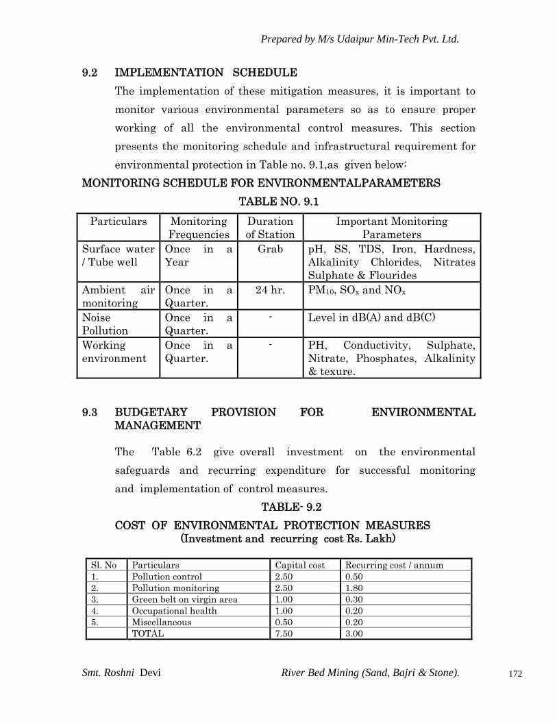
Prepared by M/s Udaipur Min-Tech Pvt. Ltd.
Smt. Roshni Devi River Bed Mining (Sand, Bajri & Stone).
172
9.2 IMPLEMENTATION SCHEDULE
The implementation of these mitigation measures, it is important to
monitor various environmental parameters so as to ensure proper
working of all the environmental control measures. This section
presents the monitoring schedule and infrastructural requirement for
environmental protection in Table no. 9.1,as given below:
MONITORING SCHEDULE FOR ENVIRONMENTALPARAMETERS
TABLE NO. 9.1
Particulars Monitoring
Frequencies
Duration
of Station
Important Monitoring
Parameters
Surface water
/ Tube well
Once in a
Year
Grab pH, SS, TDS, Iron, Hardness,
Alkalinity Chlorides, Nitrates
Sulphate & Flourides
Ambient air
monitoring
Once in a
Quarter.
24 hr. PM10, SOx and NOx
Noise
Pollution
Once in a
Quarter.
- Level in dB(A) and dB(C)
Working
environment
Once in a
Quarter.
- PH, Conductivity, Sulphate,
Nitrate, Phosphates, Alkalinity
& texure.
9.3 BUDGETARY PROVISION FOR ENVIRONMENTAL
MANAGEMENT
The Table 6.2 give overall investment on the environmental
safeguards and recurring expenditure for successful monitoring
and implementation of control measures.
TABLE- 9.2
COST OF ENVIRONMENTAL PROTECTION MEASURES
(Investment and recurring cost Rs. Lakh)
Sl. No Particulars Capital cost Recurring cost / annum
1. Pollution control 2.50 0.50
2. Pollution monitoring 2.50 1.80
3. Green belt on virgin area 1.00 0.30
4. Occupational health 1.00 0.20
5. Miscellaneous 0.50 0.20
TOTAL 7.50 3.00

Prepared by M/s Udaipur Min-Tech Pvt. Ltd.
Smt. Roshni Devi River Bed Mining (Sand, Bajri & Stone).
173
Total investment on environmental improvement works existing
and envisaged is Rs. 7.50 lakhs and recurring expenditure during
the stage of production is Rs. 3.00 lakhs per year.
9.4 RECOMMENDATION
M/s Udaipur Min –Tech Pvt. Ltd. survey reveals that the
management is providing continual improvement of Environment.
The air environment and other emissions are regularly sprinkled
with water. The management has provided ear muffs and helmets
to the workers in the mine and stress on its utilization.
The regular medical check-up of workers is to be carried out.
Green belt development is to be stressed and workers must be
motivated for plantation care.
The general environmental awareness is given to the local workers.
Regular maintenance of vehicle is carried out. Slogans of
Environment, health & safety are recommended for display.
The verbal interactions with neighboring villagers reveals that due
to river bed mining no impact on water level. Hence significantly no
impact is there due to mining activity. However, the mine is
operative since 6 years, but no significant problems are reported
by the villagers. The management must keenly celebrate the
importance of World Environment Day to create awareness amongst
the workers. Conservation of soil and water must be emphasized
not only at works but also at their own place. With
implementation of Environment management plan and providing
continual improvement the mine may be accorded environmental
clearance.
=======********========

Prepared by M/s Udaipur Min-Tech Pvt. Ltd.
Smt. Roshni Devi River Bed Mining (Sand, Bajri & Stone).
174
CHAPTER – X
CONSULTANTS ENGAGED
(RQP/UDP/354/2009/B)
The consultant engaged for the preparation of the EIA/EMP of the
project are M/s Udaipur Min-Tech Pvt. Ltd.. The information about the
company with address are follows:
INTRODUCTION:
Realizing the need for multi disciplinary and pragmatic approach
to mine development and mine environment management, a few
dedicated Mining engineers & Geo-scientists with decades of practical
experience started M/s Udaipur Min-Tech Pvt. Ltd. company as a
consultancy organization in 1994 registered as company with the Registrar
of Companies, Rajasthan and got recognized (RQP/UDP/354/2009/B) from
Indian Bureau of Mines, Ministry of Mines, Govt. of Indiaand ISO 9001
Companyand accreditation by NABET “A‟‟ category for open cast mines.
Today it has grown not only to handle anything in mining of non-fuel
minerals but ready to face any challenging environmental assignment
in the field of mining industry and modification of varied industries and
environmental clearance of diverse industries.
M/s Udaipur Min-Tech Pvt. Ltd. provides services in the field of
Environmental Impact Assessment and Management for all types of
industries
( Chemical, Power Stations, Infrastructure projects, Soda ash, Cement &
Mines), risk analysis, disaster management, environmental health and
safety, socio-economic studies and mine planning.
OUR SERVICES :
We provide wide range of services. These include :-
Prepared by M/s Udaipur Min-Tech Pvt. Ltd.
Smt. Roshni Devi River Bed Mining (Sand, Bajri & Stone).
175
At Mining Services :-
--- Evolution of Mineral property and feasibility studies.
--- Preparation of Mining Plan, Scheme of Mining with Mine
Closure Plan(Progressive & Final) as per MCR 60, MCDR 88 &
GCDR 1999.
--- Up gradation & Processing of Non Metallic Minerals.
--- EIA / EMP report.
At Environmental Services :
---- Monitoring of ambient air quality, Stack emissions, Work
zone air quality, Source monitoring and Control.
---- Monitoring of water, Waste water, Pollution source
identification and control process.
---- Monitoring of Soil quality, Noise level, Solid waste or
Sludge quality.
---- Environmental audit, Industrial risk assessment and risk
management and hazardous waste management.
ACHIEVEMENTS :-
M/s Udaipur Min-Tech Pvt. Ltd. in a short period after its
establishment has prepared more than 500 Mining Plan and Scheme
with Progressive Mine Closure/Final Plan of various minerals in
Rajasthan, Gujarat, Himchal Pardesh & M.P. and more than 450 of them
have already approved from IBM-Udaipur/Dehradoon/Ajmer/ Nagpur,
Deptt. Of Mines & Geology-Rajasthan, Deptt. Of Geology & Mining –
Gandhinagar (Gujarat).
UMT has prepared during year 2004-05 to 2008-09, more
than 100 EIA/EMP report of mineral Soapstone, China Clay, Red ochre,
Laterite, Silica Sand, Quartz & Feldspar, Dolomite, Limestone(Cement as

Prepared by M/s Udaipur Min-Tech Pvt. Ltd.
Smt. Roshni Devi River Bed Mining (Sand, Bajri & Stone).
176
well as Soda Ash) & Granite for Ministry of Environmental & Forestry
and 20 of them have already secured approval & Environmental
clearance.
THE CORE TEAM :-
The key persons of team are
1) Mr. S. S. BIST – M.Sc. (Geology), M.Tech. (Applied Geology) & PG
Diploma in Environment & Ecology, RQP(IBM), MMGI, FGSI etc.having 17
years professional experience of survey and geological mapping,
prospecting & mine planning for various non metallic minerals and mining
of Granite, Marbles etc.
2) Dr. H.S. YADAV – M.Sc. (Geology), Ph.D & having more than 20 years of
professional experience in Mining of Granite & Marbles .
3) Er. B.L. MOD – Diploma in Mining and AMIE(Mining) with First Class
Mine Manager Certificate, Certified Mine Surveyor-Metal(O/P & U/G),
RQP(IBM) having 42 year working experience in field of mining viz
underground as well as opencast mine of various metallic and non-metallic
mineral in India as well as abroad. Preparation of Mining plan/Scheme of
Mining with PMCP/FMCP, preparation of EIA/EMP report.
4) Mr. S. K. Mohta – Diploma in Mining with First Class Mine Manager
having 37 year working experience in field of mining viz underground as
well as opencast mine of various metallic and non-metallic mineral in
India as well as abroad.
5) MR. NARENDRA SINGH NARUKA- M.Phil. (Environment Management),
M.Sc. in (Environment Science), With, Lead Auditor for (ISO14001:2008) EMS,
and Diploma in Industrial Safety having over 8 years of work experience in

Prepared by M/s Udaipur Min-Tech Pvt. Ltd.
Smt. Roshni Devi River Bed Mining (Sand, Bajri & Stone).
177
the Environmental Impact Assessment & Analysis with report writing.
Evaluation and preparation of EIA‟s of industrial, mining, and infrastructure
project for environmental clearance.
Besides, our team of Professionals is given below :
CONTACT PERSON - S. S. BIST
206 “APEKSHA COMPLEX”
HIRAN MAGRI, SECTOR-11
UDAIPUR - 313002(RAJ.)- INDIA
PHONE - +91-294-2489672(OFF), MOBILE - +9194141 67672
e mail : [email protected]
visit us at : www.udrmintech.com
1. Ashok Kumar Pardeshi Diploma in Mining & Certified Surveyor.
2. Dr. Shalini Gupta Ph.D. (Chemistry) and M.Sc. (Ecology and
Environment Science). Diploma in Industrial Safety.
3. Tara Ram M.Sc.(Geology) & M.Sc.(Environment Science).
4. Nileema Sharma M.Sc. (Geology), M.Sc. (Botany).
5. Parul Gupta M.Sc.(Environment Science).
6. Meheruday P. Gujar M. Tech. (Environmental Science & Technology).
M.Sc. (Environmental Biotechnology).
Advance Deploma In Industrial Safety.
7. Rahul Deshmukh MSW & BSW(Social Works).
8. Sameer Despande M.Sc.(Botany).
9. Rajveer Singh M.Sc (Remote sensing)
10. Mahesh Kumar M.Sc. (Geology).
11. Lakshmi Lal Meghwal Diploma in Draftsman &Certified Surveyor.
12. Harish Kumar Pardesi Drafts man & AutoCAD Master.
13. Praveen Koted Computer Operator & AutoCAD Master.
14. Deepak Bhavsar Computer Operator & AutoCAD Master.
15. Anil Damor Computer Operator & AutoCAD Master.
16. Bhupendra Jalora Computer Operator & AutoCAD Master.