Embed Size (px)
Citation preview
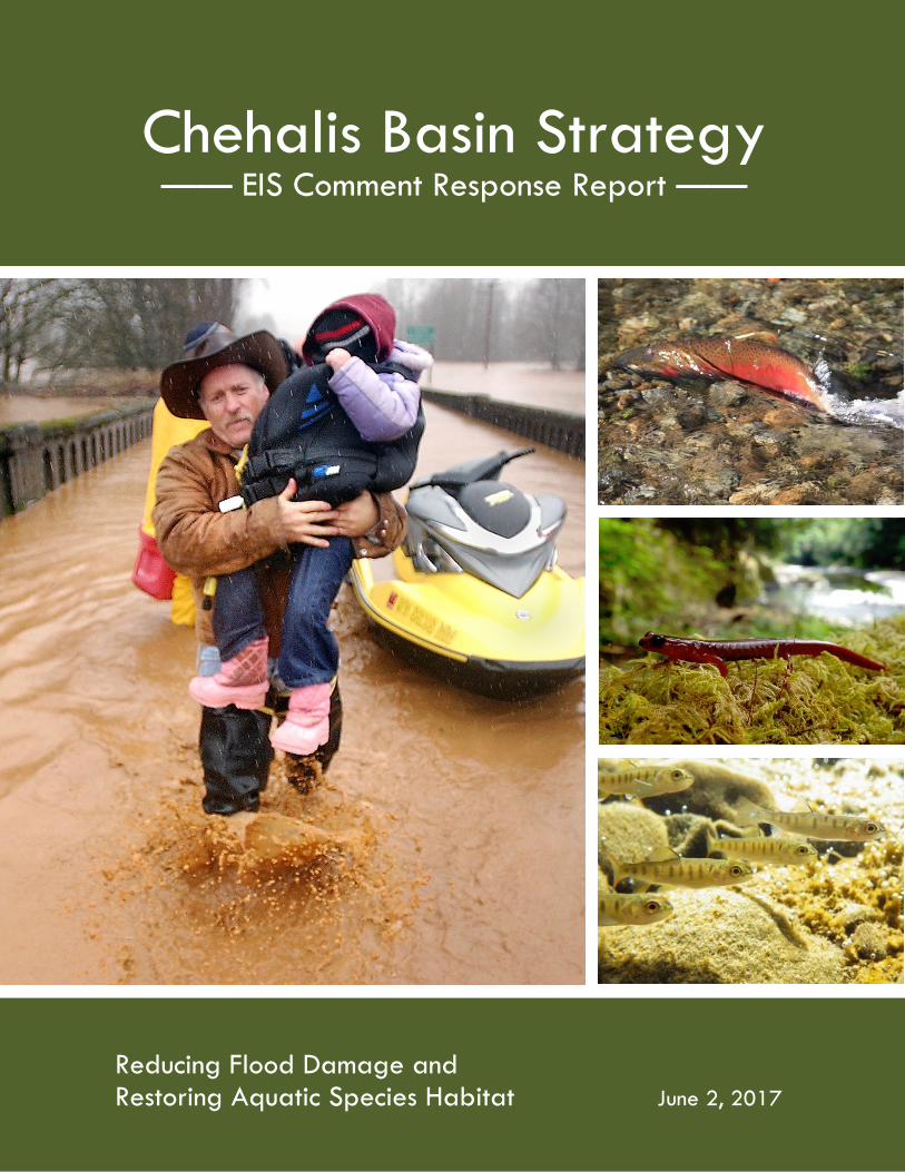
Chehalis Basin Strategy —— EIS Comment Response Report ——
Reducing Flood Damage and Restoring Aquatic Species Habitat June 2, 2017

Cover photography credit: The Chronicle, Centralia, Washington (left); Caitlin McIntyre, Lacey, Washington (center right and bottom right)

Chehalis Basin Strategy EIS Comment Response Report i
TABLE OF CONTENTS
1 INTRODUCTION AND GUIDE ........................................................... 1
1.1 Background ..................................................................................................................................... 1
1.2 Comment Process ........................................................................................................................... 2
1.3 Comment Analysis Process ............................................................................................................. 3
1.4 Guide to this Report ....................................................................................................................... 3
2 COMMENT ANALYSIS ....................................................................... 4
2.1 Draft EIS Commenters .................................................................................................................... 4
2.2 Summary of Commenter Concerns ................................................................................................ 4
3 COMMENT RESPONSES .................................................................... 6
3.1 Purpose and Need .......................................................................................................................... 6
3.2 SEPA Review Process ...................................................................................................................... 7
3.3 Consultation and Coordination .................................................................................................... 11
3.4 Alternatives ................................................................................................................................... 13 3.4.1 Alternatives Development .................................................................................................... 14 3.4.2 Comments Common to All Alternatives ............................................................................... 15 3.4.3 No Action Alternative ........................................................................................................... 19 3.4.4 Alternative 1 ......................................................................................................................... 20 3.4.5 Alternative 2 ......................................................................................................................... 22 3.4.6 Alternative 3 ......................................................................................................................... 24 3.4.7 Alternative 4 ......................................................................................................................... 25
3.5 Ownership, Costs, and Funding .................................................................................................... 28
3.6 Project-level Design and Implementation .................................................................................... 29 3.6.1 Implementation and Sequencing .......................................................................................... 29 3.6.2 Flood Retention Facility ........................................................................................................ 31 3.6.3 Restorative Flood Protection ................................................................................................ 32 3.6.4 Airport Levee Improvements ................................................................................................ 32 3.6.5 I-5 Projects ............................................................................................................................ 33 3.6.6 Aberdeen/Hoquiam North Shore Levee ............................................................................... 33 3.6.7 Local-scale Flood Damage Reduction Actions ...................................................................... 34 3.6.8 Aquatic Species Habitat Actions ........................................................................................... 37
3.7 Economic Study ............................................................................................................................ 39
Chehalis Basin Strategy EIS Comment Response Report ii
3.8 Build Out Analysis ......................................................................................................................... 40
3.9 Forest Practices ............................................................................................................................ 43
3.10 Cumulative Impacts ...................................................................................................................... 45
3.11 Elements of the Environment ....................................................................................................... 47 3.11.1 Water Resources ................................................................................................................... 47 3.11.2 Geology and Geomorphology ............................................................................................... 57 3.11.3 Wetlands and Vegetation ..................................................................................................... 65 3.11.4 Fish and Wildlife ................................................................................................................... 67 3.11.5 Tribal Resources .................................................................................................................... 96 3.11.6 Air Quality ............................................................................................................................. 97 3.11.7 Climate Change ..................................................................................................................... 98 3.11.8 Visual Quality ........................................................................................................................ 99 3.11.9 Land Use ............................................................................................................................. 100 3.11.10 Recreation ........................................................................................................................... 101 3.11.11 Historic and Cultural Preservation ...................................................................................... 102 3.11.12 Transportation .................................................................................................................... 103 3.11.13 Environmental Health and Safety ....................................................................................... 104
3.12 Additional Comments Received on the Draft EIS ....................................................................... 104 3.12.1 Editorial Comments or Philosophical Matters and Opinions ............................................. 105 3.12.2 Support for or Opposition to Specific Alternatives ............................................................. 106
4 REFERENCES ................................................................................. 109
LIST OF TABLES Table 1 Summary of Communications .................................................................................................. 4
LIST OF FIGURES Figure 1 Characterization of Comments Received by Theme ................................................................ 5 Figure 2 EIS Alternatives ....................................................................................................................... 13 Figure 3 Modeled Temperatures Downstream of Flood Retention Facility ......................................... 69
LIST OF ATTACHMENTS Attachment 1 Coded Comment Record
Chehalis Basin Strategy EIS Comment Response Report iii
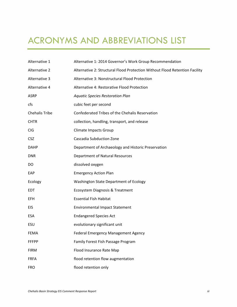
ACRONYMS AND ABBREVIATIONS LIST
Alternative 1 Alternative 1: 2014 Governor’s Work Group Recommendation
Alternative 2 Alternative 2: Structural Flood Protection Without Flood Retention Facility
Alternative 3 Alternative 3: Nonstructural Flood Protection
Alternative 4 Alternative 4: Restorative Flood Protection
ASRP Aquatic Species Restoration Plan
cfs cubic feet per second
Chehalis Tribe Confederated Tribes of the Chehalis Reservation
CHTR collection, handling, transport, and release
CIG Climate Impacts Group
CSZ Cascadia Subduction Zone
DAHP Department of Archaeology and Historic Preservation
DNR Department of Natural Resources
DO dissolved oxygen
EAP Emergency Action Plan
Ecology Washington State Department of Ecology
EDT Ecosystem Diagnosis & Treatment
EFH Essential Fish Habitat
EIS Environmental Impact Statement
ESA Endangered Species Act
ESU evolutionary significant unit
FEMA Federal Emergency Management Agency
FFFPP Family Forest Fish Passage Program
FIRM Flood Insurance Rate Map
FRFA flood retention flow augmentation
FRO flood retention only

Acronyms and Abbreviations List
Chehalis Basin Strategy EIS Comment Response Report iv
GHG greenhouse gas
HCP Habitat Conservation Plan
I-5 Interstate 5
LiDAR Light Detection and Ranging
NEPA National Environmental Policy Act
NOAA Fisheries National Oceanic and Atmospheric Administration Fisheries
OFM Office of Financial Management
PHABSIM Physical Habitat Simulation
PSU Portland State University
RM river mile
SEPA State Environmental Policy Act
USACE U.S. Army Corps of Engineers
USEPA U.S. Environmental Protection Agency
USFWS U.S. Fish and Wildlife Service
USGS U.S. Geological Survey
WAC Washington Administrative Code
WDFW Washington Department of Fish and Wildlife
Work Group Governor’s Chehalis Basin Work Group
WRIA Water Resource Inventory Area
WSDOT Washington State Department of Transportation
Chehalis Basin Strategy EIS Comment Response Report 1
1 INTRODUCTION AND GUIDE
1.1 Background The Washington State Department of Ecology (Ecology) has prepared a State Environmental Policy Act (SEPA) Programmatic Environmental Impact Statement (EIS) at the request of the Governor’s Chehalis Basin Work Group (Work Group). The Work Group has been tasked by the Governor with developing recommendations for an integrated strategy that includes measures to reduce flood damage and restore aquatic species habitat in the Chehalis Basin. The EIS evaluates a suite of actions to address these two challenges. No single action alone will address all the problems—a combination of actions is needed.
This Comment Response Report provides a summary of the comments received during the public comment period for the Draft EIS, and Ecology’s responses. Responses focus on factual corrections and how substantive comments could be addressed or further responded to through subsequent project-level environmental review or future analyses.
The Draft EIS was intended to provide an opportunity for the public, interested tribes, agencies, stakeholders, and other parties to consider the effects of implementing an integrated strategy at a broad, planning level. As further detailed below, more than 500 comments were received during the Draft EIS comment period. Ecology appreciates the time and attention that commenters committed to reviewing the Draft EIS, and the significant public response indicates the EIS was effective in its purpose. The EIS analysis and comments received on the Draft EIS were utilized by the Work Group when considering its recommended work plan and budget for continued development of the strategy in the 2017 to 2019 biennium.
The Final EIS is being published in an addendum format, and consists of this Comment Response Report, an updated Fact Sheet, a final Executive Summary, and the Draft EIS. The entire Draft EIS will not be republished in final form for several reasons:
• The action elements and combined alternatives have not been modified since the Draft EIS was published, and no new alternatives have been developed
• Ecology is not supplementing, improving, or modifying the analyses in the Draft EIS
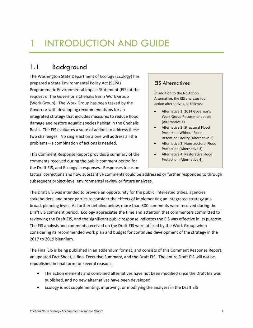
EIS Alternatives
In addition to the No Action Alternative, the EIS analyzes four action alternatives, as follows:
• Alternative 1: 2014 Governor’s Work Group Recommendation (Alternative 1)
• Alternative 2: Structural Flood Protection Without Flood Retention Facility (Alternative 2)
• Alternative 3: Nonstructural Flood Protection (Alternative 3)
• Alternative 4: Restorative Flood Protection (Alternative 4)
Introduction and Guide
Chehalis Basin Strategy EIS Comment Response Report 2
• It would be difficult for readers to independently identify changes throughout the document due its size and complexity
• The results of ongoing and future assessments will be appropriately contained in subsequent project- and site-specific environmental reviews
The Final EIS is being issued under Washington Administrative Code (WAC) 197-11-460 and completes the SEPA process. Except for the Executive Summary and the list of contributors, the Draft EIS has not been updated since the first addendum was published on October 17, 2016.
Sections 1.2 through 1.4 of this Comment Response Report describe the public comment process, how comments were analyzed, and how to navigate this report.
1.2 Comment Process Ecology released the Draft EIS on September 29, 2016, and issued an addendum to the Draft EIS on October 17, 2016. The Draft EIS was originally available for public review and comment until October 31, 2016; however, an extension was granted to extend the review and comment period through November 14, 2016.
Information regarding the publication of the Draft EIS was provided through notices to agencies and tribal governments, postcards to community members within the Chehalis River 100-year floodplain (hereinafter referred to as the Chehalis River floodplain) that could be affected by the proposal, advertisements in The Chronicle (Centralia) and The Daily World (Aberdeen), email through Ecology’s listserv and the Chehalis River Basin Flood Authority’s listserv, and postings at community locations.
Two public hearings were also held during the comment period. The first public hearing was held on October 18, 2016, at the Veterans Memorial Museum in Chehalis, and the second public hearing was held on October 27, 2016, at Montesano City Hall in Montesano. The hearings included informational materials, and Ecology representatives and consultant staff were available to answer questions. A brief presentation provided a description of the EIS alternatives and a summary of the EIS evaluation, followed by public testimony opportunities. Forms were provided for written comments, and court reporters were available to record both private verbal testimony provided individually and open testimony given during the hearing.
The Draft EIS was made available online, with print copies or CDs of the document available by request. TTY and Speech-to-Speech services were also available. During the Draft EIS public comment period, clarifying information was also provided via meetings and a technical blog. Comments on the Draft EIS could be submitted in-person at the hearings, through an online form, or by mail or email.
Introduction and Guide
Chehalis Basin Strategy EIS Comment Response Report 3
1.3 Comment Analysis Process A comment analysis process was developed to organize and track the comments received during the Draft EIS comment period. First, a coding structure was developed to identify each commenter and each of their concerns or questions. Each comment was entered in a database along with these codes, then provided to technical experts for initial comment responses. The comments were then reviewed to identify common topics and issues. Next, issues or questions raised more than once or by multiple commenters were summarized into concern summaries for each topic. Finally, more detailed comment responses were developed for this report.
While the comment analysis process captured the full range of comments received, it is important to note that this report provides a summary of the comments rather than a statistical analysis of general public opinion. The commenting process should not be viewed as a vote-counting process; SEPA emphasizes responding to the content of comments received.
Responses to comments utilize the information available at the time the Draft EIS was published, and identify the analyses proposed to be conducted in the next biennium. Future analyses are intended to address significant issues raised in public comments on the Draft EIS that are project-level or more specific than can be addressed in a broad, programmatic environmental review.
1.4 Guide to this Report Chapter 2 of this report provides summary information gathered during the comment analysis process. Chapter 3 includes comments sorted into groups by common topic and presented as concern summaries. Chapter 3 also includes responses to each concern summary and a list of the comment codes they reflect. Attachment 1 includes a complete record of all the comments, with numbering that corresponds to the comment codes shown in the concern summaries and index information that refers back to the page numbers of this report.
Chehalis Basin Strategy EIS Comment Response Report 4
2 COMMENT ANALYSIS
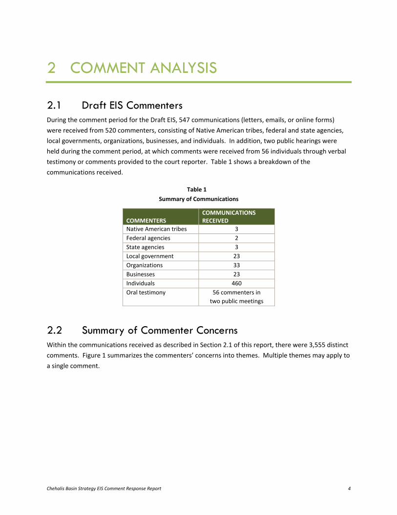
2.1 Draft EIS Commenters During the comment period for the Draft EIS, 547 communications (letters, emails, or online forms) were received from 520 commenters, consisting of Native American tribes, federal and state agencies, local governments, organizations, businesses, and individuals. In addition, two public hearings were held during the comment period, at which comments were received from 56 individuals through verbal testimony or comments provided to the court reporter. Table 1 shows a breakdown of the communications received.
Table 1 Summary of Communications
COMMENTERS COMMUNICATIONS RECEIVED
Native American tribes 3 Federal agencies 2 State agencies 3 Local government 23 Organizations 33 Businesses 23 Individuals 460 Oral testimony 56 commenters in
two public meetings
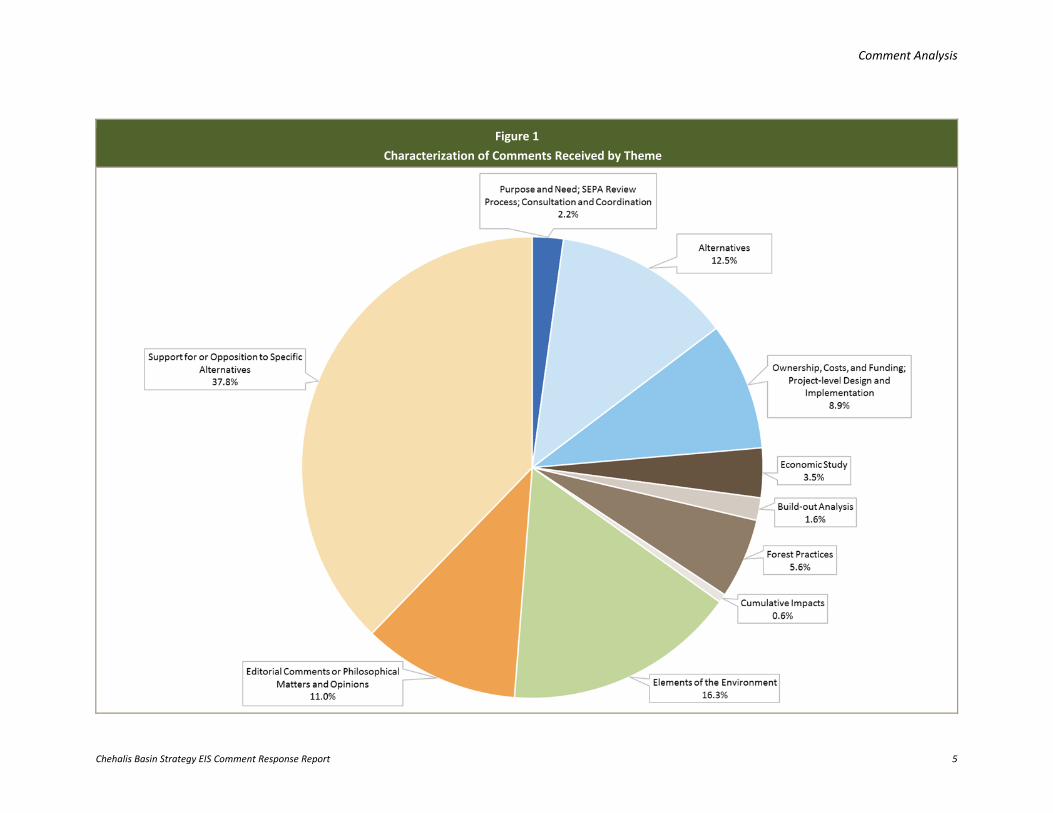
2.2 Summary of Commenter Concerns Within the communications received as described in Section 2.1 of this report, there were 3,555 distinct comments. Figure 1 summarizes the commenters’ concerns into themes. Multiple themes may apply to a single comment.
Comment Analysis
Chehalis Basin Strategy EIS Comment Response Report 5
Figure 1 Characterization of Comments Received by Theme
Chehalis Basin Strategy EIS Comment Response Report 6
3 COMMENT RESPONSES
Ecology reviewed all comments received during the Draft EIS comment period, including those of a technical nature and those related to opinions, feelings, and preferences regarding an action element or combined alternative.
Sections 3.1 through 3.11 of this report provide responses to commenters’ substantive concerns, organized by topic. Issues or questions raised more than once or by multiple commenters were summarized in the concern summaries for each topic. While all comments provided useful input, this chapter’s concern topics and summary statements focus on substantive comments. A complete record of all comments received is provided in Attachment 1 of this report, with numbering that corresponds to the comment codes in this section and index information that refers back to the page numbers of this report.
Substantive comments are those that question a point of fact or analysis in the EIS (such as the accuracy of information or the adequacy of analysis), suggest alternatives to those evaluated in the EIS, or request additional information or studies that are beyond the scope of a programmatic EIS but could be included in future project-level environmental reviews or analyses. Comments concerning typographical errors, editorial comments, or philosophical matters and opinions (including an agency’s or entity’s interest in the Chehalis Basin Strategy) are not considered substantive and have been categorized as “additional comments” in Section 3.12. Comments in support of or in opposition to the alternatives and action elements in the EIS are also included in Section 3.12. These additional comments were reviewed and cataloged, with the understanding that they would also be useful during any subsequent project-level environmental reviews to identify the site- and project-specific impacts associated with the implementation of given actions.
3.1 Purpose and Need The EIS states that to make a meaningful difference, the Chehalis Basin Strategy will need to provide a long-term, Basin-wide, integrated approach to substantially reduce damage from major floods and restore degraded aquatic species habitat in the Chehalis Basin. The two primary objectives of this integrated strategy—flood damage reduction and aquatic species habitat restoration—are intended to address this purpose and need. More information regarding the purpose and need can be found in EIS Section 1.4 (Purpose and Need).
Concern Summary: Commenters believed that combining the Flood Retention Facility (dam) and Aquatic Habitat Species Actions in Alternative 1: 2014 Governor’s Work Group Recommendation (Alternative 1) was an attempt to limit or offset impacts from a dam, or to suggest Alternative 1 would improve fisheries and
Comment Responses
Chehalis Basin Strategy EIS Comment Response Report 7
wildlife or mitigate for impacts from a dam. Other commenters believed that Alternative 1 conflicts with one of the two primary objectives of the Chehalis Strategy: to restore aquatic species habitat. Comment Codes: C142-008, O001-007, O001-014, T001-010, T003-032, T003-035, T003-079, T003-437
Response: As stated in EIS Section 1.4 (Purpose and Need), the Chehalis Basin Strategy has a dual purpose and need: “… the Chehalis Basin Strategy will need to provide a long-term, integrated approach to substantially reduce damage from a major flood and restore degraded aquatic species habitat in the Chehalis Basin.” As stated by Ecology at the public comment period hearings, the strategy is intended to address both flood damage and aquatic species habitat degradation—one problem cannot be solved without addressing the other.
All of the combined alternatives evaluated in the EIS represent a variety of approaches to addressing the dual purpose and need, and are characterized by different combinations of flood damage reduction and aquatic species habitat restoration actions. Modeling results indicate that Alternative 1, when implemented as a comprehensive strategy, could substantially increase the abundance of native aquatic species as compared to the No Action Alternative, primarily due to implementation of the Aquatic Species Habitat Actions. For more information, see EIS Section 5.3.2 (Aquatic Species Habitat Actions Evaluation) and EIS Tables 5.3-4 and 5.3-5 for the potential response in salmonid abundance under various scenarios. EIS Section 5.3 acknowledges, “However, as compared to the other action alternatives, Alternative 1 would result in more impacts on native salmon and aquatic species as a result of permanent and large-scale changes to the Chehalis River and floodplain caused by a Flood Retention Facility.”
3.2 SEPA Review Process As the lead agency, Ecology prepared the EIS to evaluate the Chehalis Basin Strategy alternatives to reduce flood damage and restore degraded aquatic species habitat. The SEPA environmental review process provides a way to identify and assess the possible environmental effects of a proposal (including alternatives, environmental impacts, and mitigation) before deciding whether to proceed. The process helps decision-makers and the public understand how a proposed action would affect the natural and human environment. For the Chehalis Basin Strategy, a planning-level analysis under a programmatic EIS (versus a project-level analysis) is appropriate at this stage in the decision-making process. See EIS Section 1.5 (State Environmental Policy Act Review) for more information on the SEPA process.
Concern Summary: While commenters recognized that the EIS is intended to be programmatic, they believed that the level of detail and specificity used to describe action elements within the EIS is varied and that some action elements were well developed, while others were not. Thus, commenters believed that additional work was required to identify potential environmental impacts of the less-developed
Comment Responses
Chehalis Basin Strategy EIS Comment Response Report 8
action elements and to provide a transparent guide for decision-makers and citizens prior to implementation of any action elements identified in the EIS. Comment Codes: C101-012, C138-003, C185-007, C189-001, F001-34, O002-001, O006-001, O006-002, O014-001, O032-006, O032-008, S002-278, T001-014, T001-015, T002-015, T003-014, T003-015, T003-016, T003-017, T003-018, T003-029, T003-034, T003-036, T003-048, T003-049, T003-085, T003-113, T003-191
Response: The information provided in the EIS was based on the best available information and data for each action element and combined alternative. For example, the dam has been studied since 2013 whereas development of the Restorative Flood Protection action element was initiated as a result of the EIS scoping process in the fall of 2015. As recognized in the SEPA Rules (WAC 197-11-442), there is “normally less detailed information available on environmental impacts [for non-project or programmatic EISs].” While the action elements have been developed to differing levels of detail, Ecology compared them at a roughly similar level for the programmatic EIS to determine the magnitude of potential environmental impacts of each action and combined alternative, as well as each alternative’s ability to meet the dual purpose and need of reducing flood damage and restoring aquatic species habitat. As an example, see EIS Section 5.7 (Comparison of Alternatives).
Consistent with WAC 197-11-055, the EIS was prepared at the “earliest possible point in the planning and decision-making process” when the proposal(s) and their environmental impacts could be “reasonably identified.” Earlier environmental review facilitates a better understanding of those actions that may not be viable and do not warrant further study, versus actions that may require subsequent environmental review or an evaluation of feasibility prior to being committed to for implementation.
All available information was provided in the EIS, in the interest of maintaining transparency and an open public process. As is noted in EIS Section 1.5 (State Environmental Policy Act Review), more quantitative evaluations would occur through subsequent project-level environmental reviews to identify the site- and project-specific impacts associated with implementation of given actions.
Concern Summary: Commenters were concerned about the EIS process, including the perceived “rushed” development of the Draft EIS, public comment period timeframe, availability of supporting documentation, identification of data gaps and uncertainties, and actions of the Legislature and the Governor concerning funding a particular action or alternative until a Final EIS was completed. Comment Codes: C013-003, C101-011, C119-040, C119-044, C119-049, C186-009, C187-010, C205-002, C244-002, C276-012, C276-013, C277-001, C277-002, C277-004, O032-002, O032-022, T003-015, T003-023, T003-024, T003-025, T003-026, T003-027, T003-028
Response: Scoping for the EIS was completed on October 19, 2015, and the Draft EIS was released on September 29, 2016. The development of a draft EIS within 1 year of scoping is reasonable and allowed for careful evaluation of the potential construction and operational impacts of the action elements and
Comment Responses
Chehalis Basin Strategy EIS Comment Response Report 9
combined alternatives at a programmatic level. The schedule for the Draft EIS was also connected to the Work Group’s objectives related to budget recommendations to the Governor and Washington State Legislature for the 2017 to 2019 state biennium budget. As stated in EIS Chapter 6 (Consultation and Coordination), Ecology conducted additional public, agency, and tribal outreach during the development of the Draft EIS to share information and solicit input. This additional outreach was an important part of making sure the Draft EIS was developed with meaningful and comprehensive feedback as well as the best science and information available at the time.
The Draft EIS was published with a 32-day public comment period. On October 17, 2016, Ecology published and circulated an addendum to the Draft EIS. The Draft EIS was updated on the website the same day, and the updated pages included footnotes specifying the information that was added or changed by the addendum. During the Draft EIS comment period, several members of the public requested an extension to the comment period. In response to these requests, Ecology extended the public comment period by 14 days. Some parties commented that an even longer extension would have been necessary to digest the information contained in the Draft EIS and supporting materials; however, SEPA Rules allow for a 30-day comment period for draft EISs, unless extended by the lead agency by up to 15 days (WAC 197-11-502 and 197-11-455). Therefore, the Draft EIS comment period was appropriate and reasonable when considering the Work Group’s purposes for the evaluation, as described previously.
During the Draft EIS public comment period, Work Group members, agencies, tribes, and other interested parties requested clarifying information through meetings and a technical blog. Clarifying information was provided to allow reviewers the opportunity to provide informed comments on the Draft EIS. Ecology does not consider this courtesy to be contrary to the purposes of SEPA.
In the Fact Sheet for the Draft EIS, there is a section titled “Document Availability” with information regarding the website where the Draft EIS was available and how print copies or CDs of the document could be obtained. The document was made available per the SEPA Rules (WAC 197-11-455), which state that a fee may be charged for the Draft EIS (WAC 197-11-504). Notice regarding the publication of the Draft EIS and addendum were provided through a variety of means, including two public meetings (see the Draft EIS Fact Sheet section titled “Public Comment on the Draft Programmatic Environmental Impact Statement”), postcards to community members within the Chehalis River floodplain that could be affected by the proposal, advertisements in The Chronicle (Centralia) and The Daily World (Aberdeen), email through Ecology’s listserv and the Chehalis River Basin Flood Authority’s listserv, and posting at community locations. This outreach, which was conducted prior to and during the Draft EIS public comment period, was meaningful and exceeded the requirements in WAC 197-11-455.
In the Fact Sheet for the Draft EIS, there is a section titled “Location of Background Materials” that lists websites where the background materials used to prepare the Draft EIS are available. In addition, the "Environmental Review" tab of the Chehalis Basin Strategy website (http://chehalisbasinstrategy.com/eis-
Comment Responses
Chehalis Basin Strategy EIS Comment Response Report 10
library) states, “For additional supporting documentation related to the Programmatic EIS, visit the Publications page” and provides a hyperlink. The vast majority of the supporting information was available the day the Draft EIS was published.
Per the SEPA Rules (WAC 197-11-440), known uncertainties were identified in the Executive Summary and throughout the EIS, and would continue to be identified and evaluated during subsequent project-level environmental review.
WAC 197-11-070 outlines the limitations on actions during the SEPA process. This portion of the SEPA Rules lists specific types of actions that a governmental agency cannot take before a final EIS is issued. The Work Group was charged by Governor Inslee with developing budget recommendations for continuation of the Chehalis Basin Strategy. As noted previously, the schedule for publication of the Draft EIS was developed so that the Work Group could consider information provided in the Draft EIS, public comments received on the Draft EIS, and additional requested clarifications throughout the EIS process to develop its budget recommendation, which the Washington State Legislature is currently considering for the 2017 to 2019 state biennium budget. WAC 197-11-070 states that “no action concerning the proposal shall be taken by a governmental agency” that would have an adverse environmental impact or limit the choice of reasonable alternatives. Ecology does not concur that the Work Group making budget recommendations to the Governor or considering such recommendations by the Legislature before a final EIS is issued is in violation of the SEPA Rules, because the budget recommendations are essentially recommendations for further study and do not limit the choice of reasonable alternatives.
Concern Summary: National Oceanic and Atmospheric Administration Fisheries (NOAA Fisheries, also known as the National Marine Fisheries Service) is interested in an independent review of the proposed Chehalis Basin Strategy (and its supporting documents). Comment Codes: F001-37, F001-51
Response: Ecology prepared the Draft EIS at the request of the Work Group. As stated in the Executive Summary of the EIS, the SEPA environmental review provides a formal process to identify and assess the potential environmental effects of a proposal before deciding how to proceed. The process helps decision-makers and the public understand how a proposed action would affect people and the environment. This comment has been communicated to the Work Group, and NOAA Fisheries or other parties are welcome to conduct further independent reviews of the Chehalis Basin Strategy at their own discretion.
Comment Responses
Chehalis Basin Strategy EIS Comment Response Report 11
3.3 Consultation and Coordination Refer to EIS Chapter 6 for details regarding consultation and coordination activities led by Ecology with agencies, tribes, and the public.
Concern Summary: The Quinault Indian Nation submitted comments regarding the effects of the dam on the Public Trust Doctrine, including those resulting from contributions to climate change, and described Ecology’s and the Washington Department of Natural Resources (DNR)’s responsibility to protect public trust interests. Comment Codes: T003-013, T003-489, T003-490, T003-502, T003-503, T003-504, T003-505, T003-506, T003-507, T003-508, T003-509
Response: To the extent the Public Trust Doctrine may apply, environmental review protects the public interest by application of state laws. Specifically, the impacts of a dam on navigation, commerce, fishing, and recreation are described in EIS Sections 4.2.4.2 (Fish and Wildlife), 4.2.5.1 (Tribal Resources), 4.2.7.2 (Climate Change), and 4.2.11.2 (Recreation). Additionally, specific contributions of the reservoir to greenhouse gas (GHG) emissions and climate change are further clarified in Section 3.11.6 of this report. If Alternative 1 is selected, further evaluation would occur during project-level environmental review for a Flood Retention Facility.
Concern Summary: Due to the navigability of the Chehalis River, a comment was received regarding the U.S. Army Corps of Engineers’ (USACE’s) involvement in preparing the EIS. Comment Code: C276-011
Response: Ecology is coordinating with USACE in conjunction with their interests and responsibilities for waters of the United States, which is further described in EIS Section 6.5 (Agency and Tribal Coordination).
“The essence of the [Public Trust] doctrine is that the waters of the state are a public resource owned by and available to all citizens equally for the purposes of navigation, conducting commerce, fishing, recreation and similar uses and that this trust is not invalidated by private ownership of the underlying land. The doctrine limits public and private use of tidelands and other shorelands to protect the public's right to use the waters of the state.” (Ecology 2017). The Public Trust Doctrine specifically protects public use of “navigable” waters and underlying lands and applies to state-owned lands.
Comment Responses
Chehalis Basin Strategy EIS Comment Response Report 12
Concern Summary: The Quinault Indian Nation expressed their desire to protect tribal resources within the Chehalis Basin in cooperation with Washington State. Comment Codes: T003-022, T003-086
Response: Ecology acknowledges the Quinault Indian Nation’s comments and the desire of its people for no negative impacts on their treaty rights and interests.
Concern Summary: The Confederated Tribes of the Chehalis Reservation (Chehalis Tribe) expressed their desire to protect tribal resources within the Chehalis Basin in cooperation with Washington State. Comment Code: T001-001
Response: Ecology acknowledges the Chehalis Tribe's comment and the desire of its people for no negative impacts on their traditional lands.
Concern Summary: The Quinault Indian Nation requested that the EIS consider the Fish and Wildlife Coordination Act and that consultation with U.S. Fish and Wildlife Service (USFWS) occur as part of this proposal. Comment Code: T003-011
Response: The Fish and Wildlife Coordination Act requirement to consult with USFWS and state wildlife agencies applies to federal agencies undertaking an action to impound, divert, or otherwise control or modify waterbodies. Ecology is not required to undertake such consultation, but has involved Washington Department of Fish and Wildlife (WDFW), NOAA Fisheries, and USFWS in the development of the alternatives and during preparation of the EIS. If a federal agency takes the lead in a dam project moving forward, compliance with the Fish and Wildlife Coordination Act would occur as part of the project-level National Environmental Policy Act (NEPA) analysis.
Concern Summary: Comments were received regarding including the legal requirements for the management of state-owned aquatic lands. Comment Codes: S001-04, S002-39
Response: Requirements for Aquatic Use Authorizations were identified in the Fact Sheet of the EIS (under "Permits, Licenses, and Approvals Required”), and DNR’s responsibilities for managing state-owned aquatic lands is recognized in EIS Section 6.5.5 (Washington Department of Natural Resources).
Comment Responses
Chehalis Basin Strategy EIS Comment Response Report 13
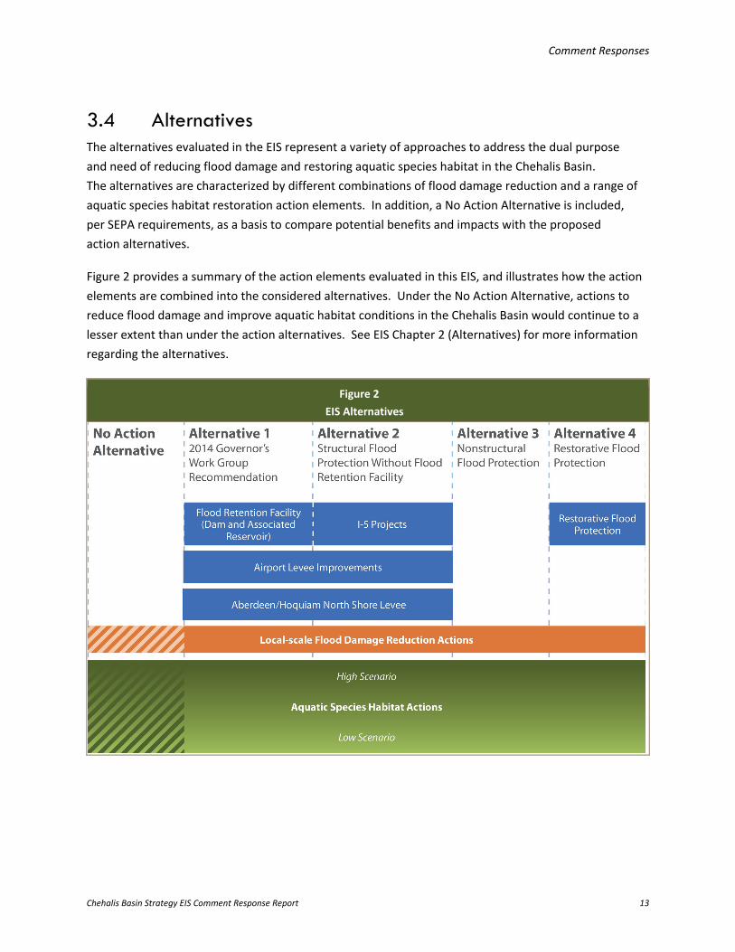
3.4 Alternatives The alternatives evaluated in the EIS represent a variety of approaches to address the dual purpose and need of reducing flood damage and restoring aquatic species habitat in the Chehalis Basin. The alternatives are characterized by different combinations of flood damage reduction and a range of aquatic species habitat restoration action elements. In addition, a No Action Alternative is included, per SEPA requirements, as a basis to compare potential benefits and impacts with the proposed action alternatives.
Figure 2 provides a summary of the action elements evaluated in this EIS, and illustrates how the action elements are combined into the considered alternatives. Under the No Action Alternative, actions to reduce flood damage and improve aquatic habitat conditions in the Chehalis Basin would continue to a lesser extent than under the action alternatives. See EIS Chapter 2 (Alternatives) for more information regarding the alternatives.
Figure 2 EIS Alternatives
Comment Responses
Chehalis Basin Strategy EIS Comment Response Report 14
3.4.1 Alternatives Development
Concern Summary: Commenters requested that different or more combinations of actions be considered as alternatives including adding dredging, raising Interstate 5 (I-5), adding levees to both sides of the river, removing development in the Chehalis River floodplain and imposing additional regulations, or enhancing the nonstructural alternatives (Alternative 3: Nonstructural Flood Protection [Alternative 3] and Alternative 4: Restorative Flood Protection [Alternative 4]). Additionally, some commenters requested that more information be made available on cultural resources, climate change, and cumulative impacts in evaluating the action elements and alternatives. Comment Codes: B006-2, B010-2, C020-001, C033-001, C053-002, C077-011, C077-012, C119-052, C136-001, C138-027, C156-001, C167-005, C167-006, C183-001, C186-001, C187-011, C205-005, C241-001, C257-001, L006-007, O001-008, O005-002, O006-003, O006-020, O014-014, O014-020, O024-004, O024-006, O032-007, O032-010, T002-014, T003-031, T003-032, T003-033, T003-365, T003-381
Response: The process to develop the alternatives evaluated in the EIS is described in EIS Section 2.3.1 (Alternative Development Process).
In 2014, the Work Group recommended the development of a programmatic EIS to evaluate a package of potential actions that would meet flood damage reduction and aquatic species habitat restoration objectives in the Chehalis Basin. The range of potential actions identified by the Work Group for further evaluation in 2014 (Ruckelshaus Center 2014) was refined during the EIS scoping process and assessed in the EIS (Alternative 1). See EIS Chapter 6 (Consultation and Coordination) for more information about the scoping process. Comments received during scoping helped shape the development and evaluation of alternatives and study elements for the EIS, including adding Alternatives 3 and 4, expanding the Aquatic Species Habitat Actions scope, considering water rights and water supply, and evaluating the effects of forest practices on streamflow and landslides. In February 2016, the Work Group requested that Ecology include the Aberdeen/Hoquiam North Shore Levee action element as one of its recommended Large-scale Flood Damage Reduction Actions in Alternative 1 in the EIS.
The action elements were combined into alternatives based on the input received during scoping and during the initial development of the EIS. For example, Alternative 1 included actions in the Work Group’s 2014 Recommendation Report (Ruckelshaus Center 2014) plus the Aberdeen/Hoquiam North Shore Levee, and Alternative 2: Structural Flood Protection Without Flood Retention Facility (Alternative 2) evaluated structural flood protection actions without a dam. As previously mentioned, Alternatives 3 and 4 were created based on scoping comments; those comments requested the evaluation of implementing nonstructural approaches to achieve the purpose and need, and requested the evaluation of an alternative that uses land use changes and limited local flood protection measures to achieve the purpose and need. Because one element of the purpose and need for the Chehalis Basin Strategy is
Comment Responses
Chehalis Basin Strategy EIS Comment Response Report 15
restoring aquatic species habitat, it was important that each alternative include the Aquatic Species Habitat Actions (also see the response to comments in Section 3.1 of this report). The Local-scale Flood Damage Reduction Actions achieve the flood damage reduction element of the purpose and need in a shorter timeframe, which is why these actions are also included in all of the action alternatives (see the response to comments in Section 3.6.7 of this report). The action elements and alternatives evaluated in the EIS are reasonable and include a range of options for accomplishing the purpose and need.
As described in EIS Section 2.3.5 (Elements Considered, but Not Carried Forward in the EIS Alternatives), channel dredging was previously studied by USACE and eliminated from further detailed study because it could result in potentially significant environmental impacts, would require long-term maintenance, would likely affect water quality during construction, and raised potential issues related to permitting feasibility. The Washington State Department of Transportation (WSDOT) determined that only raising and widening I-5 would improve conditions, for approximately 840 buildings, but would have a negative impact for approximately 300 buildings. Therefore, this alternative was not carried forward.
See Section 3.4.2 of this report regarding providing additional information on each action and alternative as part of the programmatic EIS versus a project-level environmental review.
As a factual correction to the EIS, Table 1 in the Draft Economics Study Update (EIS Appendix C) incorrectly showed the I-5 Projects as part of Alternative 1. The I-5 Projects are only included in Alternative 2.
Concern Summary: A comment was received regarding the Skookumchuck Dam’s potential role in flood damage reduction. Comment Code: B003-2
Response: As stated in EIS Section 2.3.5.2 (U.S. Army Corps of Engineers Twin Cities Project and Alternatives), making modifications to the Skookumchuck Dam was an alternative that was evaluated and eliminated from further consideration for the following reason:
Most of the modifications to the Skookumchuck Dam did not appear to be economically justified to USACE, so design work was suspended. A rubber weir option at Skookumchuck Dam was also examined; all of the Skookumchuck Dam modifications were found to have potentially significant environmental impacts including to water quality, instream flows, and habitat.
3.4.2 Comments Common to All Alternatives
Concern Summary: Commenters requested more detail on all the action alternatives, including more information related to the affected environment and impacts on water resources, geology, geomorphology, wetlands and vegetation, fish and wildlife (e.g., various bird species), climate change, cultural resources, land
Comment Responses
Chehalis Basin Strategy EIS Comment Response Report 16
use (e.g., effects to landowners), transportation, and recreation. Additionally, commenters requested more specificity regarding mitigation for short- and long-term impacts for all the action elements and alternatives. Other commenters wanted to know whether or how any of the action alternatives might affect the existing Federal Emergency Management Agency (FEMA) Flood Insurance Rate Maps (FIRMs). Comment Codes: C044-003, C050-002, C050-005, C077-014, C077-021, C138-013, C142-005, C153-003, C153-006, C228-004, C263-001, C264-001, C277-003, C277-008, C277-016, F001-35, F002-05, L021-002, L021-003, L021-005, L021-006, L023-005, O003-012, O003-015, O005-003, O005-006, O005-009, O005-010, O006-001, O014-006, O032-005, O032-009, S001-14, S001-15, S001-16, S001-23, S002-49, S002-58, S002-75, S002-83, S002-124, S002-134, S002-135, S002-140, S002-142, S002-148, S002-178, S002-204, S002-250, S002-274, S002-282, S003-001, T001-011, T003-006, T003-029, T003-143, T003-168, T003-169, T003-170, T003-171, T003-172, T003-176, T003-185, T003-193, T003-194, T003-195, T003-217, T003-237, T003-251, T003-309, T003-321, T003-350, T003-410, T003-486
Response: As described in EIS Section 1.5 (State Environmental Policy Act Review), the impact assessment in a programmatic EIS is more qualitative than a project-specific EIS. Mitigation measures are typically also more general and focus on actions that could be implemented or might be required. The level of analysis provided in the EIS is appropriate at this planning-level stage; see Section 3.2 of this report for additional information regarding this topic.
EIS Sections 1.5 and 5.1 (Combined Alternatives: Impacts and Mitigation) outline that more quantitative evaluations would occur through subsequent project-level environmental reviews to identify the site- and project-specific impacts associated with the implementation of given actions. Therefore, more specificity would be provided if an action element is selected to move forward. For more information related to the various elements of the environment evaluated in the EIS, see Section 3.11 of this report.
Regarding the FEMA FIRMs, the 100-year floodplain on FEMA’s current effective FIRMs was not the Study Area for the EIS. Identification of impacts on FEMA FIRMs (also described in Section 3.6.7 of this report) is beyond the scope of the EIS.
Chehalis River Floodplain
There are many different floodplain maps that illustrate the extent of flooding in the Chehalis Basin, the most common being the FEMA FIRMs. However, to determine impacts from Large-scale Flood Damage Reduction Actions on the Chehalis River floodplain, a model by Watershed Science and Engineering (WSE 2014a) was used. This Chehalis River floodplain differs from the FEMA FIRMs in that the floodplain extent and elevation has been refined based on observed and modeled floods in the Chehalis Basin.
In some cases, the Chehalis River floodplain continues upstream on some tributaries. The floodplain associated with these tributaries represents modeled surface water elevations in the tributaries during a 100-year flood on the Chehalis River.
Comment Responses
Chehalis Basin Strategy EIS Comment Response Report 17
Concern Summary: Commenters described potential limitations of the Ecosystem Diagnosis & Treatment (EDT) model in providing an accurate assessment of impacts on a salmonid population over time or variability in survival because of environmental conditions. Commenters also expressed interest in additional life-cycle modeling or population viability analysis to assess the potential risk of extinction. Additionally, USFWS was interested in an evaluation of the impact of sequential closures of a dam on fish populations. Comment Codes: C077-016, F001-38, F002-16, O010-003, T003-158, T003-435, T003-439, T003-468, T003-469, T003-470, T003-471
Response: The Chehalis EDT model is a salmonid life-cycle habitat model that was combined with a suite of physical models and available data and information to evaluate the impacts of the proposed action elements and combined alternatives on coho salmon (Oncorhynchus kisutch), Chinook salmon (O. tshawytscha), chum salmon (O. keta), and steelhead (O. mykiss; ICF 2016). The model was used to evaluate the potential of aquatic habitat in the Chehalis Basin to support these salmonid species, and to evaluate the impacts of the Flood Retention Facility, Restorative Flood Protection, and Aquatic Species Habitat Actions action elements and selected combined action alternatives, with and without climate change. Each species has a unique set of defined spawning reaches and times, reflecting differences in life history; this information was incorporated into the model with input from WDFW and the Quinault Indian Nation. The EDT model uses this information, along with reach-level information on habitat conditions, to evaluate the potential abundance, productivity, and diversity of salmonids under particular habitat conditions (past, current, or future). However, EDT is not a time-series model. To evaluate the impact of sequential actions, the EDT model would need to be coupled with a time-series model, which was not part of the analysis completed for the EIS.
Based on EIS comments, a modeling effort is proposed to be undertaken to integrate the EDT model with the NOAA Fisheries population model in the 2017 to 2019 biennium. This would allow modelers to evaluate salmonid population and demographic trends over time, including estimates of the effects on salmonid populations of losing a group of salmonids due to a retention event under Alternative 1. The NOAA Fisheries population model could potentially be used to estimate quasi-extinction thresholds to evaluate impacts on salmonids and how the aforementioned action elements could affect populations. Ecology anticipates this information would be publicly available in project-level environmental review or associated documentation in the next biennium.
Concern Summary: Commenters requested modeling and a more detailed assessment of how the impacts of a dam as well as climate change and repeated flooding could result in threatened and endangered species listings. Similarly, commenters requested more information regarding the applicability of the
Comment Responses
Chehalis Basin Strategy EIS Comment Response Report 18
Magnuson-Stevens Fishery Conservation and Management Act, noting that Essential Fish Habitat (EFH) occurs throughout Water Resource Inventory Areas (WRIAs) 22 and 23 (the Chehalis Basin). Comment Codes: C119-008, C153-002, F001-13, F001-29, F001-30, O006-008, T003-005, T003-047
Response: EIS Section 3.4.3.1 (State- and Federally Listed Threatened and Endangered Species) provides a list of the Endangered Species Act (ESA)-listed species managed under the Magnuson-Stevens Fishery Conservation and Management Act that may occur within the Chehalis Basin. No Chehalis River salmonid populations are currently listed as threatened or endangered under ESA, and none have been designated as evolutionary significant units (ESUs) or main population groups under an ESU, as is commonly done for species in need of recovery.
For the No Action Alternative, EIS Section 5.2.2.3 (Climate Change) states that NOAA Fisheries and USFWS are responsible for assessing the possible listing of salmonids under Section 4 of ESA, and would initiate an ESA-listing proposal for endangered or threatened species. For the action alternatives, the predicted impact of select action elements and combined alternatives on salmon productivity was quantified using habitat modeling (EDT; ICF 2016), but no modeling was completed to determine whether ESA listings would occur from the evaluated actions. Nonetheless, the EIS acknowledges that any degradation in Chehalis River salmon population abundance, productivity, diversity, or spatial structure could lead to listing of the species if the population is no longer found to be viable (McElhany et al. 2000; see EIS Section 4.2.4.2.1 [Fish– Long-term Impacts]).
Exploring the potential for ESA listings and effects to EFH could be conducted during project-level environmental review, and would also be analyzed in the Biological Assessment used for ESA/EFH consultations with NOAA Fisheries and USFWS, as applicable. See the previous response in this section regarding the potential to use modeling to assess these effects.
Concern Summary: For all alternatives, commenters requested information on whether the potential decline of far-north migrating fish runs could lead to ESA listings and how the alternatives could have an impact on the contribution to the Alaskan fisheries that encounter Grays Harbor salmon. Other commenters expressed concern regarding the current fish management regime. Comment Codes: C077-021, C015-002, F001-14, F001-15, F001-16, O001-019, O010-009, S002-116, S002-150, T003-167, T003-182
Response: Ecology concurs that a decline in salmon or the ESA listing of salmon that originate from the Chehalis Basin could negatively affect commercial, recreational, and tribal fisheries within WRIAs 22 and 23, along the coast of Washington, and in Alaskan waters. The current harvest rate of salmon from WRIAs 22 and 23 in Alaskan fisheries would warrant further analysis in project-level environmental review to evaluate the impact of specific action elements on Alaskan fisheries.

Comment Responses
Chehalis Basin Strategy EIS Comment Response Report 19
Impacts on tribal fisheries are addressed for tribal resources in Grays Harbor in EIS Sections 4.2.5, 4.3.5, 4.4.5, 4.5.5, 4.6.5, 4.7.5, and 4.8.5. Impacts on non-tribal fisheries are referenced in EIS Sections 4.2.4, 4.3.4, 4.4.4, 4.5.4, 4.6.4, 4.7.4, and 4.8.4. Predicting triggers to ESA listings and changes to fishery regulations in response to the modeled future population size, or forecasting impacts of the effect of ocean conditions in the North Pacific on salmon originating from WRIAs 22 and 23, is beyond the scope of the EIS. The effect of ocean conditions has been highly variable and difficult to predict for different species and stocks of salmon originating from Washington.
Improvements to the current fish management regime and regulations is the responsibility of WDFW and is beyond the scope of the EIS.
3.4.3 No Action Alternative
Concern Summary: Commenters requested clarification regarding whether the No Action Alternative was modeled accurately, including whether it captured the effectiveness of riparian forest area maturation and if managed forests were included in the No Action Alternative. Comment Codes: C119-003, C119-046, S001-21, T003-020, T003-051, T003-055, T003-057, T003-125, T003-126, T003-181, T003-348, T003-349, T003-356, T003-357, T003-362, T003-377, T003-378, T003-379, T003-385, T003-467
Response: The modeled baseline for all comparisons was the “current condition” that captured existing conditions, not conditions that could occur over a 100-year timeframe as part of the No Action Alternative. The effect of climate change in the future was not included as part of the baseline. The current condition included all passage obstructions identified by WDFW that currently affect anadromous salmonids, including some culverts that will be replaced by WSDOT or DNR, habitat characterization information for tributaries and mainstem reaches, modeled flow and water temperature in the mainstem and tributaries reflecting current conditions, and the current fish distribution and spawning data as provided by WDFW. Potential restoration actions to be completed by others were not included in the modeled baseline, nor were potential salmonid habitat benefits from the maturation of riparian areas in managed forests.
Ecology acknowledges commenters’ concerns that comparing the action alternatives to the modeled baseline rather than to the No Action Alternative, with regard to salmonid abundance response, could potentially overestimate the predicted benefit of restoration, because there are other considerations of the No Action Alternative not included in the modeled baseline. For example, potential future
The No Action Alternative is intended to represent the most likely future expected in the absence of implementing an action alternative. As described in EIS Section 5.2, the No Action Alternative includes potential salmonid habitat benefits from the maturation of riparian areas in managed forests compared to current conditions as well as predicted impacts of future climate conditions.
Comment Responses
Chehalis Basin Strategy EIS Comment Response Report 20
development, maturation of riparian areas on managed forestlands, and additional fish passage obstructions could also occur under the No Action Alternative. However, all of the modeled action alternatives were compared to a common baseline, and therefore the analysis for comparing impacts and benefits is consistent across all action alternatives.
The modeled No Action Alternative could be revised in the future for project-level environmental review or other efforts associated with the Chehalis Basin Strategy with input from Ecology, WDFW, DNR, the Quinault Indian Nation, and others.
3.4.4 Alternative 1
Concern Summary: Commenters requested more detailed analysis regarding impacts from the dam on surface water, water quality, groundwater, geology, geomorphic processes, wetlands and vegetation, fish and wildlife, tribal resources, cultural resources, and recreational boating. To evaluate some of these impacts, some commenters requested a spatially explicit surface water, groundwater, and sediment transport model; more modeling to determine impacts on fish and wildlife; and additional fish and wildlife monitoring. Several questions were raised about dam construction and operational details and commenters requested resolution of uncertainties. In addition, more tangible mitigation was requested to address the impacts described in the EIS. For Alternatives 1 and 4, commenters felt that it was important to consider the implications of re-designating land use (such as agricultural and forestlands) and compliance with Lewis County’s Comprehensive Plan under the Growth Management Act. Comment Codes: C077-021, C077-025, C101-002, C101-008, C101-010, C119-004, C119-011, C119-012, C119-013, C119-019, C119-021, C119-026, C138-008, C138-016, C138-040, C138-052, C138-054, C138-066, C142-001, C142-022, C142-023, C142-026, C142-028, C142-031, C185-005, C185-006, C185-009, C185-011, C186-002, C186-010, C186-011, C186-012, C186-013, C186-015, C186-017, C186-019, C186-020, C186-023, C186-025, C186-027, C186-032, C186-034, C186-039, C186-040, C188-009, C188-010, C188-012, C188-013, C188-014, C188-015, C188-016, C188-019, C233-004, C261-002, C261-003, C265-002, C265-003, C266-002, C276-003, C276-004, C276-007, C277-003, C277-006, C277-010, C292-002, F001-18, F001-19, F001-20, F001-40, F001-45, F001-46, F001-50, F002-02, F002-03, F002-04, F002-06, F002-07, F002-08, F002-11, F002-13, F002-15, F002-18, F002-19, L019-001, L023-015, O001-015, O001-023, O001-024, O001-028, O001-039, O001-041, O002-009, O002-010, O002-011, O002-018, O003-010, O003-013, O005-007, O005-008, O006-007, O006-010, O011-008, O014-018, O032-011, S001-19, S001-34, S001-37, S002-156, S002-179, S002-184, S002-193, S002-202, S002-203, S002-210, S002-213, S002-214, S002-219, S002-220, S003-002, T002-002, T002-003, T003-008, T003-010, T003-076, T003-078, T003-080, T003-081, T003-101, T003-103, T003-104, T003-106, T003-108, T003-109, T003-110, T003-128, T003-155, T003-196, T003-198, T003-207, T003-208, T003-211, T003-214, T003-219, T003-220, T003-225, T003-229, T003-233, T003-235, T003-239, T003-240, T003-244, T003-245, T003-246, T003-247, T003-248, T003-249, T003-250, T003-253, T003-254, T003-272, T003-273, T003-274, T003-277, T003-283, T003-285, T003-290, T003-291, T003-292, T003-296, T003-298, T003-300, T003-302, T003-306, T003-307, T003-308, T003-311, T003-312, T003-313, T003-314, T003-315, T003-316, T003-317, T003-319, T003-320, T003-322, T003-323, T003-324,
Comment Responses
Chehalis Basin Strategy EIS Comment Response Report 21
T003-331, T003-333, T003-369, T003-376, T003-393, T003-402, T003-417, T003-464, T003-475, T003-476, T003-477, T003-492
Response: As described in the introduction to Section 3.4 of this report, the dam is one component of Alternative 1; however, the majority of the comments related to Alternative 1 were associated with the dam. Conceptual design of the dam and associated fish passage options was completed prior to initiating the EIS process and refined prior to publication of the Draft EIS. The best available data were used to quantitatively (where feasible) assess the impacts and benefits of the dam. Where quantitative information was not available, a qualitative assessment of impacts of the dam was included in the EIS. As noted in Section 3.2 of this report, less detailed information on environmental impacts is normally available at a non-project or programmatic SEPA evaluation, and mitigation measures are also typically more general and focus on actions that could be implemented or might be required. More quantitative evaluations are anticipated to occur during project-level environmental review. Analyses of impacts on elements of the environment from a dam were also based on studies described or referenced throughout the EIS; see EIS Sections 4.2.1.2 (Water Resources – Long-term Impacts), 4.2.2.2 (Geology and Geomorphology – Long-term Impacts), and 4.2.4.2 (Fish and Wildlife – Long-term Impacts). For additional responses to comments related to potential impacts of the dam, see Section 3.11 of this report.
Based on public comments received on the Draft EIS regarding Alternative 1, the Work Group has recommended—and the Washington State Legislature is currently evaluating—funding development of a draft project-specific EIS and associated studies to evaluate the impacts and determine mitigation for a dam in the 2017 to 2019 state biennium budget. To analyze the range of issues raised during public review of the EIS, additional recommended studies and analyses may include, but are not limited to, the continued refinement of hydraulic and hydrologic modeling; geotechnical analyses; further analysis of potential impacts on salmonids and other aquatic species, cultural resources, and wetlands; water quality and quantity modeling and monitoring; and a refinement of the economic evaluation of costs and benefits (see Section 3.7 of this report). A modeling effort will also be undertaken to integrate the EDT model with the NOAA Fisheries population model to evaluate salmonid population and demographic trends over time (see Section 3.4.2 of this report). Other topics, such as those related to hyporheic exchange and other groundwater impacts, could be qualitatively addressed during project-level environmental review.
An evaluation of compliance with the Growth Management Act could be conducted as part of site-specific, project-level environmental review or feasibility assessments, prior to committing to a
Alternative 1: 2014 Governor’s Work Group Recommendation includes the Flood Retention Facility (FRO or FRFA dam), Airport Levee Improvements, and Aberdeen/Hoquiam North Shore Levee as the Large-scale Flood Damage Reduction Actions. Local-scale Flood Damage Reduction Actions and Aquatic Species Habitat Actions are also included in Alternative 1 (see EIS Table 2.3-1).

Comment Responses
Chehalis Basin Strategy EIS Comment Response Report 22
course of action. Also, see responses in Sections 3.4.7 and 3.6.7 of this report regarding Growth Management Act considerations.
3.4.5 Alternative 2
Concern Summary: A few commenters requested that the analysis of Alternative 2 include modeling of fish and wildlife impacts and effects on tribal and cultural resources, and include additional detail regarding the effects of implementing a program of Local-scale Flood Damage Reduction Actions and their impacts on key infrastructure. Comment Codes: F001-09, F001-22, F001-23, O006-014
Response: Modeling of potential impacts on wildlife was not completed for any of the alternatives, and was therefore not included in the EIS.
The flood damage reduction action elements included in Alternative 2 were not modeled in EDT due to the lesser scale of their potential impact on aquatic habitat relative to larger-scale actions like the Flood Retention Facility, Restorative Flood Protection, and Aquatic Species Habitat Actions. A qualitative assessment of impacts on fish from Alternative 2 is provided in EIS Sections 5.4.1 (Flood Damage Reduction – Alternative 2) and 5.4.2 (Aquatic Species Habitat Actions Evaluation – Alternative 2), with a more detailed discussion of fish and wildlife impacts from individual action elements provided in the relevant sections of EIS Chapter 4 (EIS Sections 4.4.4, 4.5.4, 4.6.4, 4.7.4, and 4.8.4).
While the flood damage reduction actions included in Alternative 2 were not modeled using EDT (see Section 3.4.2 of this report), the predicted salmonid (i.e., chum salmon, spring- and fall-run Chinook salmon, coho salmon, and winter-run steelhead) abundance response to habitat change in the Chehalis Basin from Aquatic Species Habitat Actions was modeled, and results provided in EIS Section 4.8.4.2.1 (Fish – Long-term Impacts – Aquatic Species Habitat Actions). EIS Section 5.4.2 (Aquatic Species Habitat Actions Evaluation) states, “The benefits of combined actions within Alternative 2 to fish, wildlife, and non-salmonid fish have not been modeled but are anticipated to be similar to the Aquatic Species Habitat Action.” The potential response in salmonid abundance to habitat change in the Chehalis Basin under the different action alternatives is discussed in EIS Section 5.7.2 (Restoration of Aquatic Species Habitat).
EIS Section 5.4.1 describes the potential effects of Alternative 2 on tribal and cultural resources, with a more detailed discussion of tribal and cultural resource impacts provided in the relevant action element
Alternative 2: Structural Flood Protection Without a Flood Retention Facility includes the Airport Levee Improvements, I-5 Projects, and Aberdeen/Hoquiam North Shore Levee as the Large-scale Flood Damage Reduction Actions. The rest of the action elements included in Alternative 2 are identified in EIS Table 2.3-1 and in the introduction to Chapter 3 of this report (the Local-scale Flood Damage Reduction Actions and a range of Aquatic Species Habitat Actions).
Comment Responses
Chehalis Basin Strategy EIS Comment Response Report 23
sections of EIS Chapter 4 (Sections 4.4.5, 4.4.12, 4.5.5, 4.5.12, 4.6.5, 4.6.12, 4.7.5, 4.7.12, 4.8.5, and 4.8.12). Those sections pertaining to cultural resources acknowledge the potential impacts for each action element at a programmatic level, and state that coordination with the Washington Department of Archaeology and Historic Preservation (DAHP) and potentially affected tribes during project-level environmental review, including government-to-government consultation, would be necessary to determine the extent of impacts based on the nature of resources present.
EIS Sections 5.1 (Introduction – Combined Alternatives: Impacts and Mitigation) and 5.4 (Alternative 2: Structural Flood Protection Without Flood Retention Facility) describe the geographic areas that would experience a reduction in flooding (see EIS Figures 5.4-1 through 5.4-3 and EIS Table 5.4-1) as a result of implementing Alternative 2. A programmatic discussion of potential impacts on infrastructure like transportation facilities is included in the relevant sections of EIS Chapter 4 (e.g., Sections 4.4.13, 4.5.13, 4.6.13). A more detailed identification of key infrastructure that would not be protected under Alternative 2 could occur as part of project-level environmental review or feasibility assessments for the various action elements.
As stated in EIS Section 5.1, if a combined alternative identified in the EIS moves forward, the resulting actions would be subject to project-level environmental review before being approved for implementation. This would include a more detailed description of impacts on fish and wildlife (see Section 3.11.4 of this report), wetlands (see Section 3.11.3 of this report), tribal resources (see Section 3.11.5 of this report), and cultural resources (see Section 3.11.11 of this report). Except for refinement of the Aquatic Species Habitat Actions action element in Alternative 2, EDT modeling for impacts associated with other actions under Alternative 2 was not included in the Work Group’s recommendation for the 2017 to 2019 state biennium budget. However, if additional modeling is completed for Alternative 2 in the future, such results would be made available to the public.
Ecology is also making a factual clarification to EIS Section 5.4.1.1, which states, “On the west side of the Chehalis River, there would be a 0.1 to 0.9-foot increase in inundation, affecting 14 acres, due to the walls and levees shifting water upstream during a flood.” The EIS incorrectly stated that 14 acres of area would be inundated on the west side of the Chehalis River; the 14 acres of inundation would occur on the west and east sides of the Chehalis River as depicted in EIS Figure 5.4-1.
Comment Responses
Chehalis Basin Strategy EIS Comment Response Report 24
3.4.6 Alternative 3
Concern Summary: NOAA Fisheries requested that the analysis of Alternative 3 include modeling of fish and wildlife impacts, including a description of impacts resulting from the frequency and extent of future flooding, and effects on tribal and cultural resources. Comment Codes: F001-10, F001-25, F001-26
Response: Modeling of wildlife impacts was not completed for any of the alternatives, and was therefore not included in the EIS.
The Local-scale Flood Damage Reduction Actions were not modeled in EDT because of the relatively lesser scale of their anticipated impacts on aquatic habitat in comparison to larger-scale action elements like the Flood Retention Facility, Restorative Flood Protection, and Aquatic Species Habitat Actions. A qualitative discussion of impacts is provided in EIS Sections 5.5.1 (Flood Damage Reduction – Alternative 3) and 5.5.2 (Aquatic Species Habitat Actions Evaluation – Alternative 3), with a more detailed discussion of fish and wildlife impacts provided in the relevant sections of EIS Chapter 4 (EIS Sections 4.7.4 [Fish and Wildlife – Local-scale Flood Damage Reduction Actions] and 4.8.4 [Fish and Wildlife – Aquatic Species Habitat Actions]).
While the flood damage reduction action elements included in Alternative 3 were not modeled using EDT (see Section 3.4.2 of this report), the predicted salmonid (i.e., chum salmon, spring-run and fall-run Chinook salmon, coho salmon, and winter-run steelhead) abundance response to habitat change in the Chehalis Basin from Aquatic Species Habitat Actions was modeled. The results for Alternative 3 are anticipated to be similar, and are provided in EIS Section 5.7.2 (Comparison of Alternatives).
EIS Section 5.5.1 describes the potential effects of Alternative 3 on tribal and cultural resources, with a more detailed discussion of tribal and cultural resource impacts provided in the relevant action element sections of EIS Chapter 4 (Sections 4.7.5, 4.7.12, 4.8.5, and 4.8.12). Those sections pertaining to cultural resources acknowledge the potential impacts for each action element at a programmatic level, and state that coordination with DAHP and potentially affected tribes during project-level environmental review,
Alternative 3: Nonstructural Flood Protection represents a “nonstructural” approach to reducing flood damage and restoring aquatic species habitat. In contrast to the Large-scale Flood Damage Reduction Actions, flood damage would be reduced through a programmatic effort to floodproof or remove existing structures. This alternative includes implementation of all the Local-scale Flood Damage Reduction Actions and a range of Aquatic Species Habitat Actions (identified in EIS Table 2.3-1 and the introduction to Chapter 3 of this report), without any of the Large-scale Flood Damage Reduction Actions (Flood Retention Facility, Airport Levee Improvements, I-5 Projects, Aberdeen/Hoquiam North Shore Levee, or Restorative Flood Protection).
Comment Responses
Chehalis Basin Strategy EIS Comment Response Report 25
including government-to-government consultation, would be necessary to determine the extent of impacts based on the nature of resources present.
As stated in EIS Section 5.1 (Introduction – Combined Alternatives: Impacts and Mitigation), if a combined alternative identified in the EIS moves forward, the resulting actions would be subject to project-level environmental review before being approved for implementation. This would include a more detailed description of impacts on fish and wildlife and tribal and cultural resources (also see Sections 3.11.4, 3.11.5, and 3.11.11 of this report). Except for refinement of the Aquatic Species Habitat Actions in Alternative 3, additional modeling for impacts associated with the actions that comprise Alternative 3 was not included in the Work Group’s recommendation for the 2017 to 2019 state biennium budget. However, if additional modeling is completed for Alternative 3 in the future, such results would be made available to the public.
Section 3.7 of the EIS (Climate Change – Affected Environment) outlines that climate change predictions suggest changes in the quantity, timing, and intensity of precipitation, which would translate to changes in streamflow magnitude and, perhaps, changes in the frequency of floods. Alternative 3 includes the Aquatic Species Habitat Actions, which could potentially buffer the effects of climate change and future flooding on fish and wildlife by restoring habitat function, a topic addressed in EIS Section 4.8.7.2.2 (Effects of Climate Change on Aquatic Species Habitat Actions). While Alternative 3 is not anticipated to directly affect fish and wildlife, it may indirectly affect fish and wildlife by affecting habitat (construction of Local Projects), and by reducing the dispersal of pollutants to the water and changing floodplain inundation patterns (similar to impacts described for the No Action Alternative in EIS Section 5.2.2.1 [Environmental Elements with Minor Adverse Impacts or Benefits]).
3.4.7 Alternative 4
Concern Summary: Commenters requested a more detailed analysis regarding impacts on agriculture and affected communities resulting from the Restorative Flood Protection action element included in Alternative 4. For example, what would the implications be of converting forestland to agriculture and relocating landowners? Requested analyses related to evaluating compliance with the Growth Management Act, DNR’s State Lands Habitat Conservation Plan (HCP), and DNR’s management of trust lands; the availability of suitable land for agricultural uses (including land area, water availability, appropriate soil, and infrastructure); the economic and social costs of relocating landowners (e.g., impacts on schools, the tax base, social fabric); alternative compensation approaches; and more detailed hydraulic modeling. Other commenters believed that Alternative 4 is a viable option for reducing flood damage and restoring aquatic species habitat, especially when considering climate
Comment Responses
Chehalis Basin Strategy EIS Comment Response Report 26
change, and requested more analysis to determine the feasibility of the Restorative Flood Protection action element or the possibility of exploring scaled-down versions of this action element. Comment Codes: C003-002, C004-001, C004-002, C005-001, C005-003, C005-004, C005-005, C005-006, C011-002, C023-002, C034-001, C037-005, C068-004, C108-006, C138-014, C138-015, C138-023, C138-034, C138-043, C138-058, C167-001, C173-001, C190-003, C201-005, C205-006, C214-003, C276-003, C276-006, C276-007, C277-024, C277-025, F001-11, F001-12, F001-43, F001-44, F002-24, L001-001, L003-002, L004-004, L004-005, L014-002, L014-003, L014-004, L014-005, L014-006, L014-007, L014-008, L016-004, L016-005, L018-002, L018-003, L018-004, L018-005, L018-006, L018-007, L018-008, L018-009, L018-010, L018-011, L018-012, L018-013, L018-014, L018-015, L018-016, L018-017, L018-018, L018-019, L020-003, L023-007, L023-008, L023-010, L023-011, O001-057, O003-009, O003-014, O010-005, O011-005, O014-019, O016-003, S001-01, S001-02, S001-03, S001-20, S001-24, S002-25, S002-143, S002-223, S002-224, S002-225, S002-227, S002-234, S002-252, T003-114, T003-335, T003-365, T003-380, T003-483
Response: As mentioned in Section 3.2 of this report, development of the Restorative Flood Protection action element was initiated as a result of the EIS scoping process (September and October 2015). Therefore, a preliminary technical assessment was conducted (Abbe et al. 2016) for the EIS. The best available data and information were used to quantitatively assess impacts and benefits of this action, including increases and decreases in flood extents and depths and benefits to fisheries, using hydrology, hydraulic modeling, and geomorphology data (Abbe et al. 2016) as well as EDT modeling (ICF 2016). Where quantitative information was not available, a qualitative assessment of impacts and benefits is described in the EIS.
As described in previous sections of this report and in the EIS, the impact assessment in a programmatic EIS is more qualitative than a project-specific EIS. Mitigation measures are typically also more general and focus on actions that could be implemented or might be required. The level of analysis provided in the EIS is appropriate at this planning-level stage; see Section 3.2 of this report for additional information regarding this topic.
EIS Sections 1.5 (State Environmental Policy Act Review) and 5.1 (Introduction – Combined Alternatives: Impacts and Mitigation) note that more quantitative evaluations would occur through subsequent
Alternative 4: Restorative Flood Protection includes the implementation of Restorative Flood Protection as a Large-scale Flood Damage Reduction Action. This action element is intended to increase the flood storage capacity of the Chehalis Basin watershed by reconnecting floodplain storage to the Chehalis River, and adding roughness to river and stream channels and floodplains to slow and store the flow of water. This action element accomplishes flood damage reduction by relocating at-risk landowners and uses out of the floodplain, and by reducing flood peaks downstream of the Newaukum River confluence on the mainstem Chehalis River. Alternative 4 also includes the implementation of all the Local-scale Flood Damage Reduction Actions and a range of Aquatic Species Habitat Actions (identified in EIS Table 2.3-1 and the introduction to Chapter 3 of this report). The Restorative Flood Protection action element would be coordinated with and complement the Aquatic Species Habitat Actions within the treatment areas.
Comment Responses
Chehalis Basin Strategy EIS Comment Response Report 27
project-level environmental reviews to identify the site- and project-specific impacts associated with implementation of given actions. For more information related to questions regarding the various elements of the environment, please see Section 3.11 of this report.
One of the comments related to Alternative 4 stated that the Chehalis Basin has been closed to water rights by Ecology and the Supreme Court's October 2016 decision in Hirst vs. Whatcom County “implies that no new exempt wells will be available in closed basins without detailed and costly scientific studies to show that adequate water is available.” To clarify, the entire Chehalis Basin is not closed. However, the instream flow rule hinders the issuance of new water rights directly from the river and from wells. Some surface water sources are closed to further consumptive appropriation. Some water right application requests have been denied based on the hydraulic connection between groundwater and surface water in the Chehalis Basin. Applicability of the Hirst decision, which occurred after the Draft EIS was published, to conditions in the Chehalis Basin could be evaluated during project-level environmental review. The need for water right changes is acknowledged in EIS Section 4.3.1.2.2 (Surface Water Quantity – Restorative Flood Protection). Also, see Section 3.11.1 of this report for additional responses to comments related to water rights.
Based on the public comments received on the Draft EIS regarding Alternative 4, the Work Group has recommended—and the Washington State Legislature is currently evaluating—funding a feasibility analysis for the Restorative Flood Protection action element in the 2017 to 2019 biennium. This analysis would evaluate landowner preferences and further inform a proof of concept in one priority area to understand if the approach is feasible in broader treatment areas (see Section 3.6.1 of this report). If funded, work in the 2017 to 2019 timeframe would include studies and analyses such as two-dimensional hydraulic modeling of the entire Restorative Flood Protection treatment area (upper Chehalis watershed above the Newaukum River); refined analysis of impacts on landowners and the need for floodproofing or relocation; refinement of economic evaluation of costs and benefits (see Section 3.7 of this report); and policy analysis of the regulatory changes that could be required for implementation. A modeling effort will also be undertaken to integrate the EDT model with the NOAA Fisheries population model to evaluate salmonid population and demographic trends over time (see Section 3.4.3 of this report).
An evaluation of compliance with the Growth Management Act could occur as part of project-level environmental review or feasibility assessments prior to committing to a course of action. Also, see responses in Section 3.6.7 of this report regarding Growth Management Act considerations.
Comment Responses
Chehalis Basin Strategy EIS Comment Response Report 28
3.5 Ownership, Costs, and Funding At this stage in development of the Chehalis Basin Strategy, funding for many of the action elements evaluated in the EIS has not been determined, and details regarding who would be responsible for implementing, maintaining, and operating some of the action elements included in the combined alternatives have not been identified.
Concern Summary: Commenters requested information regarding who will be responsible for funding and implementing the action alternatives, including construction, operation, and maintenance of the dam and property acquisition for the action alternatives. Comment Codes: C017-002, C026-001, C026-002, C034-003, C044-002, C044-005, C118-001, C119-015, C119-045, C122-002, C138-004, C138-063, C186-022, C186-038, C232-001, C232-002, C259-002, C266-003, C276-008, C276-009, C277-014, C277-017, C277-018, C277-019, C277-021, C363-004, C460-007, F001-06, L004-002, L020-002, L020-011, L020-012, O001-063, O002-002, O003-006, O014-012, T001-005, T003-121, T003-123, T003-394, T003-438, T003-451, T003-460
Response: Since 2011, there have been significant investments by the Washington State Governor and Legislature to evaluate actions (through continued feasibility, design, and environmental review) that would reduce flood damage and restore aquatic species habitat in the Chehalis Bain (see EIS Section 1.1 [Introduction]). The Washington State Legislature is currently evaluating funding for the continued development and implementation of the Chehalis Basin Strategy in the 2017 to 2019 biennium, as described in Section 3.6.1 of this report. Funding for future years has not been determined.
For the Flood Retention Facility, details related to ownership and acquisition have not been determined at this planning-level stage in the process, as stated in EIS Section 2.3.3.1 (Large-scale Flood Damage Reduction Actions). As with other action elements, it is anticipated that the owner of the Flood Retention Facility would likely be responsible for implementation (i.e., environmental review and permitting, design, construction, and operation and maintenance). For the other actions, it is anticipated that the following would be true:
• The Chehalis-Centralia Airport, which is owned by the City of Chehalis, would be responsible for implementing the Airport Levee Improvements
• WSDOT would be responsible for implementing the I-5 Projects
• The City of Aberdeen and City of Hoquiam would be responsible for implementing the Aberdeen/Hoquiam North Shore Levee (see Section 3.6.6 of this report)
• Various local jurisdictions would be responsible for implementing the Local-scale Flood Damage Reduction Actions (see Section 3.6.7 of this report)
Comment Responses
Chehalis Basin Strategy EIS Comment Response Report 29
WDFW is responsible for implementing the Aquatic Species Habitat Actions in collaboration with the Quinault Indian Nation, Chehalis Tribe, local conservation districts, Chehalis Lead Entity, and willing landowners (see Section 3.6.8 of this report).
3.6 Project-level Design and Implementation 3.6.1 Implementation and Sequencing
Concern Summary: Commenters were interested in a timeline or sequence for implementation of the action elements in each alternative as well as an understanding of when future restoration projects in the Chehalis Basin included in the No Action Alternative would occur. Commenters noted that when estimating these timelines, in-water work windows should be considered. Comment Codes: C044-005, C134-002, C138-005, C138-057, C201-003, C266-004, C276-002, C367-004, C368-004, C369-005, C370-004, C371-004, C372-005, C373-004, C374-004, C375-004, C376-004, C377-004, C378-004, C379-004, C381-004, C382-004, C383-004, C384-004, C385-004, C386-004, C387-004, C388-004, C389-004, C390-004, C391-004, C393-004, C394-004, C395-004, C396-004, C397-004, C398-004, C399-004, C400-004, C401-004, C402-004, C403-005, C404-004, C405-004, C406-004, C407-004, C408-004, C409-004, C410-004, C411-004, C412-004, C413-004, C414-004, C415-004, C416-004, C417-004, C418-004, C420-004, C421-004, C422-004, C423-004, C424-004, C425-004, C426-004, C427-004, C428-004, C429-004, C430-004, C431-005, C432-004, C433-004, C434-003, C435-004, C436-004, C437-004, C438-004, C439-004, C440-004, C441-004, C442-004, C443-004, C444-004, C445-004, C446-004, C447-004, C448-004, C449-004, C450-004, C451-004, C452-004, C453-004, C454-004, C455-004, C456-004, C457-004, C458-004, C459-004, C460-004, C461-004, C462-004, C463-004, C464-004, C465-004, C466-004, C467-004, C468-004, C469-004, C470-004, C471-004, C473-004, C474-004, C475-004, C476-004, C477-004, C478-004, C479-004, C480-004, C481-004, C482-004, C483-004, C484-004, C485-004, C486-004, C487-004, C488-004, C489-004, C490-004, C491-004, C492-004, C493-004, C494-004, C495-004, C496-004, C497-004, C498-004, C499-004, C500-004, C501-004, C502-004, C503-004, C504-005, C505-004, C506-004, C507-004, C509-004, C510-004, C511-004, C512-004, C513-004, C514-004, C515-004, C516-004, F001-17, O001-002, O001-066, O002-003, O002-005, O005-003, O005-005, O005-014, S002-197, S002-222, T003-038, T003-197, T003-463
Response: A timeline or sequence for implementing the No Action Alternative and action alternatives has not been determined, and would be contingent upon available funding. To evaluate the impacts of implementing a selected course of action, the EIS and its supporting analyses (i.e., EDT modeling and Draft Economics Study Update [EIS Appendix C]) assumed that the impact of an action, positive or negative, would be fully in place in year 1 of the 100-year study period.
With regard to the No Action Alternative, EIS Section 2.3.4.1 (No Action) provides background information about known funding sources related to implementation of existing and ongoing projects and programs, and recognizes this funding (and therefore implementation) is often opportunistic.
With regard to the action alternatives and action elements evaluated in the EIS, the Work Group used the Draft EIS—and comments received on the Draft EIS—to develop its proposed 2017 to 2019 biennium budget recommendations for continued development and implementation of the Chehalis
Comment Responses
Chehalis Basin Strategy EIS Comment Response Report 30
Basin Strategy. The Governor included these budget recommendations in his budget proposal, and the following recommendations are being considered by the Washington State Legislature:
• Develop project-specific SEPA and NEPA EISs and associated studies for the dam to address questions raised during public review of the Draft EIS and determine the feasibility of mitigating dam impacts
• Conduct a feasibility analysis for the Restorative Flood Protection action element to evaluate landowners’ preferences and further inform a proof of concept in one priority area to understand if the approach would be feasible in broader treatment areas
• Initiate the next level of design and begin the environmental review process to evaluate environmental impacts and determine feasibility for the Aberdeen/Hoquiam North Shore Levee
• Construct priority Aquatic Species Habitat Actions and projects, including barrier correction, early action reach restoration projects (such as floodplain and channel restoration and side-channel reconnections), and acquisition of critical habitats
• Complete the Aquatic Species Restoration Plan (ASRP), including continued data collection, research, and analyses for salmonids and other aquatic species to develop a more robust and empirically based understanding of the habitat and aquatic species in the Chehalis Basin
• Undertake several of the actions identified as part of the Local-scale Flood Damage Reduction Actions in the EIS, including initiation of the first tier of local projects developed by the Chehalis River Basin Flood Authority, continued work with local governments on improving floodplain management and initiation of a Basin-wide floodproofing program (see Section 3.6.7 of this report)
• Implement a public involvement and outreach strategy for all of the actions and activities within the Chehalis Basin Strategy
The Work Group, which will transition into the Chehalis Board in July 2017, will continue to evaluate the long-term strategy in the Chehalis Basin, including funding and timing of implementation of the various action elements evaluated in the EIS.
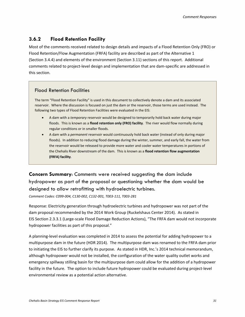
Comment Responses
Chehalis Basin Strategy EIS Comment Response Report 31
3.6.2 Flood Retention Facility Most of the comments received related to design details and impacts of a Flood Retention Only (FRO) or Flood Retention/Flow Augmentation (FRFA) facility are described as part of the Alternative 1 (Section 3.4.4) and elements of the environment (Section 3.11) sections of this report. Additional comments related to project-level design and implementation that are dam-specific are addressed in this section.
Concern Summary: Comments were received suggesting the dam include hydropower as part of the proposal or questioning whether the dam would be designed to allow retrofitting with hydroelectric turbines. Comment Codes: C099-004, C130-002, C132-001, T003-111, T003-281
Response: Electricity generation through hydroelectric turbines and hydropower was not part of the dam proposal recommended by the 2014 Work Group (Ruckelshaus Center 2014). As stated in EIS Section 2.3.3.1 (Large-scale Flood Damage Reduction Actions), “The FRFA dam would not incorporate hydropower facilities as part of this proposal.”
A planning-level evaluation was completed in 2014 to assess the potential for adding hydropower to a multipurpose dam in the future (HDR 2014). The multipurpose dam was renamed to the FRFA dam prior to initiating the EIS to further clarify its purpose. As stated in HDR, Inc.’s 2014 technical memorandum, although hydropower would not be installed, the configuration of the water quality outlet works and emergency spillway stilling basin for the multipurpose dam could allow for the addition of a hydropower facility in the future. The option to include future hydropower could be evaluated during project-level environmental review as a potential action alternative.
Flood Retention Facilities
The term “Flood Retention Facility” is used in this document to collectively denote a dam and its associated reservoir. Where the discussion is focused on just the dam or the reservoir, those terms are used instead. The following two types of Flood Retention Facilities were evaluated in the EIS:
• A dam with a temporary reservoir would be designed to temporarily hold back water during major floods. This is known as a flood retention only (FRO) facility. The river would flow normally during regular conditions or in smaller floods.
• A dam with a permanent reservoir would continuously hold back water (instead of only during major floods). In addition to reducing flood damage during the winter, summer, and early fall, the water from the reservoir would be released to provide more water and cooler water temperatures in portions of the Chehalis River downstream of the dam. This is known as a flood retention flow augmentation (FRFA) facility.
Comment Responses
Chehalis Basin Strategy EIS Comment Response Report 32
3.6.3 Restorative Flood Protection Comments related to design details and impacts from the Restorative Flood Protection action element are described as part of the Alternative 4 (Section 3.4.7) and elements of the environment (Section 3.11) sections of this report.
3.6.4 Airport Levee Improvements
Concern Summary: For the Airport Levee Improvements, WSDOT requested additional information on how this action element would provide protection to the east side of the Chehalis-Centralia Airport, adjacent to I-5. The Quinault Indian Nation provided comments related to compliance with FEMA’s National Flood Insurance Program. Comment Codes: S003-008, T003-478, T003-479, T003-480
Response: Available information related to the protection of the Chehalis-Centralia Airport is provided in EIS Chapter 4 (Action Elements: Impacts and Mitigation); in particular, see EIS Sections 4.4.1.2 (Water Resources), 4.4.10.2 (Land Use), 4.4.13.2 (Transportation), and 4.4.14.2 (Public Services and Utilities). When combined with the dam in Alternative 1 or the I-5 Projects in Alternative 2, hydraulic modeling predicted the airport behind the levee would no longer be inundated. For more information, see EIS Section 5.3.1.1 and EIS Figure 5.3-1 for Alternative 1, and EIS Section 5.4.1.1 and EIS Figure 5.4-1 for Alternative 2.
The next phase of design and environmental review for the Airport Levee Improvements was not part of the Work Group’s recommended work plan for the 2017 to 2019 biennium, and it has not been determined whether it would be implemented with Alternative 1 or Alternative 2, if those alternatives move forward. If this action element moves forward, it would be subject to project-level environmental review before being approved for implementation, and would require coordination with FEMA and compliance with the National Flood Insurance Program, as applicable.
As described in EIS Section 2.3.3.1 (Large-scale Flood Damage Reduction Actions), the Airport Levee Improvements action element consists of improving the Chehalis-Centralia airport levee by elevating the height of the existing levee and raising a portion of Airport Road to provide 100-year flood protection for the Chehalis-Centralia Airport, local businesses, and a portion of I-5.
Comment Responses
Chehalis Basin Strategy EIS Comment Response Report 33
3.6.5 I-5 Projects
Concern Summary: For the I-5 Projects, the Quinault Indian Nation provided a comment related to close coordination with FEMA to change the FIRMs for this action element. Comment Code: T003-481
Response: The Work Group did not recommend moving forward with the I-5 Projects in the next phase of design and environmental review as part of its work plan for the 2017 to 2019 biennium, and it has not been determined whether the I-5 Projects would be implemented with Alternative 2, if that alternative moves forward. If this action element moves forward, it would be subject to project-level environmental review before being approved for implementation and would require coordination with FEMA and compliance with the National Flood Insurance Program, including necessary updates to FIRMs, as applicable.
3.6.6 Aberdeen/Hoquiam North Shore Levee
Concern Summary: For the Aberdeen/Hoquiam North Shore Levee action element, commenters requested additional analysis of impacts based on more detailed design, hydrologic and hydraulic modeling, geotechnical investigations, and associated analyses. This includes impacts on properties due to sea level rise, habitat loss and fish impacts due to levee placement, impacts on transportation systems, and impacts on other natural and built elements of the environment. In addition, specific mitigation for potential impacts was requested with a more comprehensive understanding of cumulative impacts from levees and other flood control projects in Aberdeen and Hoquiam. Comment Codes: B009-1, B009-2, B010-1, C156-002, C183-010, C273-001, C273-003, C273-006, L006-001, L006-002, L006-003, L006-004, L006-005, L006-006, O011-003, S002-237, S002-239, S002-240, S002-241, S002-242, S003-011, T003-482
As described in EIS Section 2.3.3.1 (Large-scale Flood Damage Reduction Actions), the I-5 Projects action element includes the construction of a series of earthen levees and structural floodwalls along I-5, including improvements to the existing airport levee, a new 1-mile-long Chehalis Avenue levee, and bridge replacements over Dillenbaugh and Salzer creeks.
Comment Responses
Chehalis Basin Strategy EIS Comment Response Report 34
Response: A planning-level analysis under a programmatic EIS is appropriate at this stage in the development of the strategy, and would be followed by more quantitative evaluations during subsequent project-level environmental review. Project-level evaluations will identify the site- and project-specific impacts associated with the implementation of given actions. The impact assessment in a programmatic EIS is more qualitative than a project-specific EIS. Mitigation measures are also typically more general and focus on actions that could be implemented or might be required. See EIS Section 1.5 (State Environmental Policy Act Review) for more information about the purpose of this SEPA review.
As part of its 2017 to 2019 state biennium budget request, the Work Group recommended funding the next level of design and environmental review for the Aberdeen/Hoquiam North Shore Levee project (see Section 3.6.1 of this report). The City of Aberdeen is partnered with the City of Hoquiam and will be responsible for completing the design and evaluating environmental impacts in a project-level environmental review. Comments received on the Draft EIS have been provided to the City of Aberdeen’s project manager for consideration in future design and environmental review phases of the project. For more information on this project, see the Chehalis River Basin Flood Authority’s webpage on Aberdeen flood relief projects (https://www.ezview.wa.gov/site/alias__1825/35437/default.aspx).
3.6.7 Local-scale Flood Damage Reduction Actions
Concern Summary: Some commenters believed that implementation of the Local-scale Flood Damage Reduction Actions could occur immediately with the lowest cost. However, no economic analysis was completed for this suite of actions, and there were no prescriptions or mechanisms for implementation. Other commenters wanted more detail on the potential impacts on fish from bank stabilization as part of Local Projects or details regarding how the Local-scale Flood Damage Reduction Actions would comply with FEMA’s National Flood Insurance Program. Comment Codes: O002-022, T003-337, T003-484, T003-485, T003-487
As described in EIS Section 2.3.3.1 (Large-scale Flood Damage Reduction Actions), the Aberdeen/Hoquiam North Shore Levee consists of previously considered smaller projects that were combined into a comprehensive approach to protect Aberdeen and Hoquiam, which would result in a total of approximately 5.8 miles (30,000 linear feet) of levees along Grays Harbor at the mouth of the Chehalis River, Hoquiam River, and Wishkah River—3.5 miles (18,400 linear feet) in Aberdeen and 2.3 miles (11,600 linear feet) in Hoquiam.
A description of the proposed Local-scale Flood Damage Reduction Action Element—Floodproofing, Local Projects, Land Use Management, and Flood Warning System Improvements—is included in EIS Section 2.3.3.2.
Comment Responses
Chehalis Basin Strategy EIS Comment Response Report 35
Response: As outlined in EIS Section 2.3.3.2 (Local-scale Flood Damage Reduction Actions), approximately 75% of the residential homes within the Chehalis River floodplain and 25% of other buildings (commercial, industrial, government, and schools) could feasibly be elevated, retrofitted, or floodproofed through other means. The estimated number of buildings that could be protected and the associated costs, by alternative, are discussed in Section 3.4 of the Draft Economics Study Update (EIS Appendix C). The economic impact of implementing Floodproofing is evaluated in Section 4 of the Draft Economics Study Update. Local Projects, Land Use Management, and Flood Warning System Improvements were not evaluated in the Draft Economics Study Update because information related to the costs and impacts were not available (see also Section 3.7 of this report).
The Build Out Analysis (EIS Appendix L) evaluates Land Use Management, one of the Local-scale Flood Damage Reduction Actions. The analysis considers the effect of Land Use Management implementation on development in the Chehalis River floodplain when combined with other action elements as part of Alternatives 1 and 2 as well as separately.
Based on the flood damage reduction benefits these actions would provide, as described in the EIS, and the public comments received on the Draft EIS, the Work Group has recommended—and the Washington State Legislature is currently evaluating—funding the following Local-scale Flood Damage Reduction Actions in the 2017 to 2019 state biennium budget:
• A Basin-wide Floodproofing program for elevation, acquisition, and other structure retrofit projects; the early focus would likely be in Centralia and Thurston County because these communities have plans and programs in place that identify the most important and opportune areas to implement such actions
• The first tier of Local Projects developed by the Chehalis River Basin Flood Authority, including the Centralia China Creek (Phase II) flood and habitat mitigation project, Montesano Wastewater Treatment Plant Wynoochee River bank protection project, and Thurston County Independence Road flood study
• Improved floodplain management recommendations
As stated in EIS Section 1.5 (State Environmental Policy Act Review), action elements evaluated in the programmatic EIS would be subject to project-level environmental review before being approved for implementation, including Local-scale Flood Damage Reduction Actions. Project-level review would include a more detailed evaluation of the potential for project- and site-specific impacts on fish habitat due to implementation of bank stabilization measures that could occur as part of the Local Projects. Additionally, any actions or projects that move forward would be required to comply with FEMA’s National Flood Insurance Program, where applicable.
Concern Summary: For the Land Use Management action, commenters requested that more stringent restrictions be adopted to preserve open space and minimize or
Comment Responses
Chehalis Basin Strategy EIS Comment Response Report 36
prohibit development and the placement of fill in the Chehalis River floodplain. Additionally, commenters requested a detailed list of land use and zoning changes as well as a description of potential effects to city and county Comprehensive Plans under the Growth Management Act if these recommendations were implemented. Prior to adoption of any new land use management recommendations, commenters wanted to ensure there was a public review process. Comment Codes: C085-002, C101-001, C138-027, C166-004, C186-041, C192-001, C203-002, C233-006, C276-001, C277-020, C330-002, L020-005, L020-010, L021-001, O001-047, O014-005, S002-26, S002-27, T002-005, T003-116, T003-117, T003-118, T003-178, T003-339
Response: Land Use Management involves recommendations for local governments to improve and revise land use regulations and practices to protect remaining floodplain functions and prevent future flood damage by minimizing floodplain development. Some of the recommendations would restrict the creation of developable parcels in the floodplain through open space preservation, subdivision set-asides, and low-density zoning. Other recommendations would increase the cost of future development in the floodplain, and include filling restrictions and freeboard elevation requirements.
EIS Section 2.3.4.2 (Alternative 1: 2014 Governor’s Work Group Recommendation) notes that the specific land use management recommendations evaluated in the EIS originated from the 2014 Work Group Recommendation Report (Ruckelshaus Center 2014). The 2014 report outlines that “A series of recommendations were provided to local jurisdictions through a recent analysis of local floodplain management programs.” Recommendations suggested by commenters that were not included in the 2014 Work Group’s report, such as prohibiting all future development in the floodplain, were not evaluated in the EIS. EIS Section 2.3.3.2 (Local-scale Flood Damage Reduction Actions) articulates that the programmatic evaluation indicates whether, and to what extent, the revised regulations and practices would minimize future floodplain development; also see the Build Out Analysis (EIS Appendix L).
Based on the findings of the Build Out Analysis, the evaluation of Land Use Management in the EIS, and public comments received on the Draft EIS, the Work Group has requested a more comprehensive assessment of land use and floodplain management regulations in the Chehalis Basin. This analysis would identify how current land use plans and floodplain management regulations may protect existing habitat functions within the Chehalis River floodplain, gaps or deficiencies in applicable plans and regulations, and recommendations to address these gaps or deficiencies. Ecology anticipates the
Land Use Management, included as one of the Local-scale Flood Damage Reduction Actions, is described in EIS Section 2.3.3.2. As stated in the EIS, it is based on model ordinance language (French & Associates 2016), and not every provision is appropriate for every community.
Comment Responses
Chehalis Basin Strategy EIS Comment Response Report 37
Chehalis Board will use information from this assessment to consider whether different or additional land use management recommendations may be necessary to achieve the dual objectives of the Chehalis Basin Strategy.
Concern Summary: Comments were received regarding the potential impacts of continued development in the Chehalis River floodplain, including the loss of floodplain connectivity and access for fish. NOAA Fisheries’ Biological Opinion for the ongoing National Flood Insurance Program (NMFS 2008), carried out in the Puget Sound region, was specifically cited relative to these potential impacts (see Section 3.6.1 of this report), and commenters believed that implementation of this Biological Opinion’s measures should be considered in the Chehalis Basin. Comment Codes: T002-006, T002-013, T003-069, T003-070, T003-071, T003-072, T003-087
Response: NOAA Fisheries prepared a Biological Opinion (NMFS 2008) on the effects of the National Flood Insurance Program on ESA-listed species found within the Puget Sound region, which are Puget Sound Chinook salmon, Puget Sound steelhead, Hood Canal summer-run chum salmon, Lake Ozette sockeye salmon (Oncorhynchus nerka), and Southern Resident killer whales (Orcinus orca). The Biological Opinion applies to the aforementioned ESA-listed species and their critical habitat in the following areas within the Puget Sound region: Whatcom, Skagit, Snohomish, King, Pierce, Thurston, Mason, Kitsap, Clallam, Jefferson, Island, and San Juan counties, and the municipal jurisdictions therein. Thurston County is within the Study Area of the EIS (see EIS Figure 1.1); however, there are no ESA-listed salmonids in this area. The referenced Biological Opinion does not apply to the Chehalis Basin.
The take analysis performed by NOAA Fisheries in the referenced Biological Opinion is contextual and involves an interpretation of impacts on ESA-listed species in Puget Sound. Those same listed species may not be jeopardized by the suite of proposed actions in the Chehalis Basin. The programmatic analysis in the EIS is intentionally focused on the Chehalis Basin and the anticipated impacts on habitats and species occurring therein.
3.6.8 Aquatic Species Habitat Actions
Concern Summary: Commenters requested more clarity on the components of the Aquatic Species Habitat Actions and whether they include the ASRP being developed. Additional suggestions were provided regarding the types of restoration activities that could be implemented, including removing culverts or creating better fish passage through existing obstructions, reforesting the Chehalis River floodplain, adding wood to rivers and streams within managed forests, and protecting existing functional habitat. Commenters also questioned the modeled results related to implementation of the Aquatic Species Habitat Actions, given the
Comment Responses
Chehalis Basin Strategy EIS Comment Response Report 38
uncertainties of landowner willingness and the inclusion of bank stabilization as a restoration measure. Comment Codes: C017-003, C026-005, C118-017, C119-003, F001-07, F001-41, F001-42, F001-47, F001-48, L020-001, L020-005, O001-068, O001-070, O002-007, O003-019, O010-008, O011-006, O011-015, O032-003, S002-28, S002-29, S002-31, S002-32, S002-33, S002-36, S002-149, S002-153, T003-037, T003-041, T003-052, T003-054, T003-056, T003-058, T003-092, T003-112, T003-119, T003-120, T003-124, T003-341, T003-343, T003-345, T003-346, T003-351, T003-353, T003-354, T003-428, T003-431, T003-434, T003-488
Response: As noted in the EIS, a range of scenarios for restoring aquatic species habitat in and along river reaches within the Chehalis Basin are evaluated in the EIS. Evaluating low and high restoration scenarios is intended to bracket the potential range of results that could ensue from implementation of the ASRP (see EIS Section 2.3.3.3 [Aquatic Species Habitat Actions]), which is under development.
The low restoration scenario focuses on improving habitat in the middle and upper Chehalis Basin for spring-run Chinook salmon (104 river miles) and would also benefit other species that use the habitat in these areas. The high restoration scenario would occur across a greater geographic area, with improvements to habitat focused on areas with the highest restoration potential for all salmonid species (356 river miles).
Not all of the river reaches included in the low or high scenario are likely to be restored, since restoration would be dependent on landowner willingness and site conditions. To determine benefits, in terms of change in salmonid abundance potential, it was assumed that between 20% and 60% of these river reaches would be effectively restored under either scenario. For the low restoration scenario, this equates to between approximately 21 and 63 river miles (1,150 to 2,900 acres of riparian restoration). For the high scenario, this equates to between approximately 71 and 214 river miles (3,900 to 9,750 acres of riparian restoration). The EDT model was used to estimate the change in salmonid abundance potential for the bounding scenarios: the low restoration scenario with 20% restoration effectiveness and the high restoration scenario with 60% restoration effectiveness. Model results predict that the Aquatic Species Habitat Actions would increase the riparian area along 21 to 214 river miles (1,150 to 9,750 acres), depending on the restoration scenario, when compared to current conditions.
Comments received on this action element have been provided to WDFW for consideration as development of the ASRP continues. Publication of the ASRP is anticipated in January 2019.
A description of the Aquatic Species Habitat Actions, which were developed in collaboration with WDFW, is provided in EIS Section 2.3.3.3.
Comment Responses
Chehalis Basin Strategy EIS Comment Response Report 39
To clarify statements in EIS Section 2.3.3.3 (Aquatic Species Habitat Actions), multiple state agencies (WSDOT, WDFW, and DNR) implement state-wide fish passage restoration programs.
3.7 Economic Study Flooding in the Chehalis Basin has major social and economic costs, as described in EIS Section 1.2 (Flooding). EIS scoping comments were received about the costs of flooding to businesses, including the perception of flood risk making it difficult to lease commercial property and attract new industry to Lewis County. One specific comment requested an evaluation of the economic impact of flood damages under the No Action Alternative. Additionally, farming, forestry, harvesting of shellfish, and fishing continue to be central to the Chehalis Basin economy. Salmon play a major cultural, recreational, and economic role, and the protection and restoration of salmon habitat is a primary goal for many in the Chehalis Basin (see EIS Section 1.3 [Habitat Degradation]).
While a cost-benefit analysis is not required by SEPA (see WAC 197-11-450), a Draft Economics Study Update (EIS Appendix C) was developed in support of the EIS and included as EIS Appendix C. The study updates the economic analysis completed in 2014 (EES and HDR 2014); the information within the 2014 economic analysis was incorporated by reference. The Draft Economics Study Update is an “assessment of the expected impacts of different action alternatives on the costs of flooding and effects on aquatic species,” and was a resource used to help guide the Work Group in preparing budget recommendations for continued development of the Chehalis Basin Strategy (see Sections 3.2 and 3.6.1 of this report for more information).
Concern Summary: Commenters requested more clarity on the contents and information within the Draft Economics Study Update (EIS Appendix C). This included suggestions for employing additional methodologies, evaluating cumulative impacts, and incorporating more detailed cost estimates for the various actions, including the Aberdeen/Hoquiam North Shore Levee, Local Projects, Land Use Management, and Flood Warning System Improvements. Additionally, commenters were interested in the completion of an ecosystem services evaluation and an analysis of socioeconomic impacts. Comment Codes: C002-002, C005-002, C043-002, C046-003, C050-004, C077-001, C077-002, C077-022, C108-005, C138-020, C138-022, C176-002, C182-001, C184-001, C186-008, C186-014, C186-016, C186-018, C186-021, C186-029, C186-035, C220-004, C228-007, C228-008, C259-001, C276-010, C277-013, C363-005, F001-28, L004-001, L021-004, O001-004, O001-005, O001-006, O001-030, O001-058, O001-064, O001-069, O001-071, O002-008, O002-012, O002-013, O002-021, O003-008, O006-006, O006-017, O014-013, O032-004, O032-019, O032-026, S001-35, S001-36, S002-06, S002-297, S002-298, S002-299, S002-300, T001-004, T002-004, T003-042, T003-073, T003-077, T003-082, T003-234, T003-255, T003-258, T003-269, T003-576, T003-577, T003-578, T003-579, T003-580, T003-581, T003-582, T003-583, T003-584, T003-585, T003-586, T003-587, T003-588, T003-589, T003-590, T003-591, T003-592, T003-593, T003-594, T003-595, T003-596, T003-597, T003-598, T003-599, T003-600, T003-601, T003-602, T003-603, T003-604, T003-605,
Comment Responses
Chehalis Basin Strategy EIS Comment Response Report 40
T003-606, T003-607, T003-608, T003-609, T003-610, T003-611, T003-612, T003-613, T003-614, T003-615, T003-616, T003-617, T003-618, T003-619, T003-620, T003-621, T003-622, T003-623, T003-624, T003-625, T003-626, T003-627, T003-628, T003-629, T003-630, T003-631, T003-632, T003-633, T003-634
Response: The information provided in the Draft Economics Study Update (EIS Appendix C)—including construction, operation, and maintenance costs—was based on available data. Information on the costs and economic impacts (positive and negative) of the Aberdeen/Hoquiam North Shore Levee, Local Projects, Land Use Management, Flood Warning System Improvements, and the climate change scenario for the Restorative Flood Protection action element were not available at the time of publication and, therefore, were not included. The Work Group has recommended that the Draft Economics Study Update be revised in the 2017 to 2019 biennium with more complete data and information in response to the comments received on the Draft EIS. The updated economic study will be made available to the public.
The SEPA Rules do not include socioeconomics as an element of the environment to be evaluated. WAC 197-11-448(2) states:
The term "socioeconomic" is not used in the statute or in these rules because the term does not have a uniform meaning and has caused a great deal of uncertainty. Areas of urban environmental concern which must be considered are specified in RCW 43.21C.110 (1)(f), the environmental checklist (WAC 197-11-960) and WAC 197-11-440 and 197-11-444.
However, a social justice analysis has been proposed to determine whether Large-scale Flood Damage Reduction Actions (e.g., the dam and Restorative Flood Protection) would disproportionally affect low-income or minority populations. The results of this analysis will be provided to the Chehalis Board to inform their preparation of a recommended long-term strategy. This information will also be made available to the public. Because it is not a requirement of SEPA, it will not be included in the draft project-level SEPA EIS for the dam.
An ecosystem services valuation is also being developed and is anticipated to be publicly available in January 2019. An ecosystem services valuation places monetary value on various ecosystem types and qualities based on the benefits derived, directly or indirectly, by humans.
3.8 Build Out Analysis A build out analysis was conducted in June 2016 to examine the effect of implementing Land Use Management as part of the Local-scale Flood Damage Reduction Actions (EIS Section 2.3.3.2). The analysis considered the effect that implementing Land Use Management would have on development in the Chehalis River floodplain when combined with other actions as part of Alternatives 1 and 2 as well as separately. The recommendations included as part of Land Use Management reflect model ordinance language for regulatory standards regarding management of floodplain areas that exceed the state and National Flood Insurance Program (NFIP) minimums (French & Associates 2016). The Build Out Analysis
Comment Responses
Chehalis Basin Strategy EIS Comment Response Report 41
(EIS Appendix L) was one resource that informed the evaluation of potential impacts to Land Use in the EIS.
Concern Summary: Comments received questioned why Alternatives 3 and 4 were not included in the Build Out Analysis. Comment Codes: T003-418, T003-569, T003-572, T003-574
Response: As described in Chapter 1 of the Build Out Analysis (EIS Appendix L), Alternative 3 was not analyzed because it does not include Large-scale Flood Damage Reduction Actions that would broadly affect the extent of flooding. Alternative 4 was not included because information necessary to conduct the analysis, including locations that would be developed to accommodate relocated floodplain land uses, was not available.
Concern Summary: Comments received regarding the Build Out Analysis questioned why it did not evaluate development potential across the entire Chehalis Basin rather than just in the floodplain, and expressed a desire for the analysis to consider adverse impacts on aquatic ecosystems in addition to considering the potential for Land Use Management to affect the prospective for future development in the Chehalis River 100-year floodplain. Commenters also stated that further development in the floodplain is contrary to the goal of the Chehalis Basin Strategy to maximize the benefits of flood damage reduction over both the short and long term. Commenters considered the analysis flawed because it utilized Office of Financial Management (OFM) population projections to forecast future population growth in the Chehalis River floodplain, which does not account for future flood control measures that may occur. Therefore, commenters believed it underestimated future development potential. Comments also disagreed with conclusions in the Build Out Analysis that the pattern of development in the Green River floodplain (Kent valley), as a result of flood control measures there, is not anticipated to be replicated in the Chehalis Basin if a Flood Retention Facility were constructed. Comment Codes: C204-002, O002-015, T003-066, T003-067, T003-102, T003-419, T003-420, T003-421, T003-422, T003-423, T003-424, T003-425, T003-426, T003-432, T003-536, T003-537, T003-538, T003-539, T003-540, T003-541, T003-542, T003-547, T003-548, T003-549, T003-550, T003-551, T003-552, T003-553, T003-554, T003-555, T003-556, T003-557, T003-558, T003-563, T003-564, T003-565, T003-566, T003-567, T003-568, T003-570, T003-571, T003-573, T003-575
Response: The purpose of the Build Out Analysis (EIS Appendix L) was to examine the effect of implementing Land Use Management as part of the Local-scale Flood Damage Reduction Actions
Comment Responses
Chehalis Basin Strategy EIS Comment Response Report 42
(EIS Section 2.3.3.2). Land Use Management reflects recommendations from the firm French & Associates, which has been working with Chehalis Basin communities for approximately 4 years on regulatory mechanisms to support the public investments being made to reduce flood risk. The recommended management standards would apply within floodplain areas; therefore, the geographic scope of the Build Out Analysis was limited to the Chehalis River 100-year floodplain. The purpose of the Build Out Analysis was not the consideration of the potential environmental or flood damage impacts of build out in the Chehalis Basin, but rather the evaluation of whether the Land Use Management standards would have the intended effect (minimize development in flood-prone locations). A secondary purpose was to consider, at a programmatic level, whether reduced flooding extents under EIS Alternatives 1 and 2 may increase development pressures in areas where the risk of flooding is substantially reduced when compared to the No Action Alternative.
A range of growth scenarios were presented in the Build Out Analysis to reflect the uncertainty associated with OFM population projections. It is accurate that OFM projections are based on historical patterns, and do not assume a future where growth is induced as a result of flood damage reduction structures. However, OFM projections consider an entire county, not just the portion of a county in the floodplain. In the Chehalis Basin, many communities experience flooding from various sources; a reduction of flood extents on the Chehalis River may have little to no bearing on population growth rates in other floodplain areas or in the county as a whole. Conversations with planners from local governments suggested it is likely that the estimated rate of population growth used in the analysis overestimates actual population growth, so the projections were considered conservative and on the high side (EIS Appendix L, Section 3.2.1). The population estimates were used as the basis to determine the number of structures that could potentially be built in the Chehalis River floodplain in the next 100 years. It did not consider other factors that may be relevant to floodplain population growth and development rates, for example flood insurance requirements and premium rates or future zoning designations.
With regard to flood damage reduction measures influencing rates of floodplain growth or development, the Build Out Analysis and EIS recognize that future floodplain development rates under Alternative 1 may tend toward the high end of the range, as a result of decreased flooding extents and the corresponding increase in development pressure in those locations. However Appendix A of the Build Out Analysis (EIS Appendix L) articulates that “the specific causes of increased growth in the Green River valley cannot be singularly attributed to the installation of the dam, and other factors should be considered when comparing the potential land use impacts of the proposed dam in the Chehalis Basin to the circumstances of Howard Hanson Dam in the Green River valley.” Some of these factors are recognized in the comments received. For example, the diversion or elimination of tributaries to the Green River (White and Black Rivers) resulted in the “flood problem [being] confined to controlling the floods in a single river valley,” the Green River valley. EIS Section 1.2 outlines that flooding in the Chehalis Basin is variable in geographic extent and that floods to not originate or occur in a single river valley. EIS Section 4.2.1.2.2 recognizes that the Flood Retention Facility on the mainstem
Comment Responses
Chehalis Basin Strategy EIS Comment Response Report 43
Chehalis River would not reduce flood elevations or flood damage to structures along tributaries to the Chehalis River, except in the downstream most areas. Additionally, the Growth Management Act, which was passed in 1990, did not exist during the “rush of annexations” and corresponding population growth cited in the comments received. The Growth Management Act prohibits the expansion of Urban Growth Areas into designated floodplains in counties in Western Washington, unless certain conditions are met.
The Work Group has recommended an additional Land Use Assessment to evaluate how land use plans and regulations currently in place protect existing habitat functions in the 100-year floodplain. The results of that assessment are anticipated in summer 2017, and will be made publicly available. The Work Group has also recommended developing a transparent process with local planners to ensure that development in the floodplain will not be encouraged if a dam is pursued. If such a process is developed in the 2017 to 2019 biennium, public involvement and comment would be required.
Concern Summary: Commenters felt the Build Out Analysis, and EIS overall, are incomplete because they consider growth and development only as an impact on land, but disregard the effects of growth and development on a tribal way-of-life and its stewardship principles. Comment Codes: T003-066, T003-543, T003-544, T003-545, T003-546, T003-559, T003-560, T003-561, T003-562
Response: Ecology acknowledges this comment, and recognizes the inherent challenge in the Growth Management Act between accommodating growth and protecting critical areas and natural resource lands.
3.9 Forest Practices During scoping for the EIS, commenters questioned whether forest practices in the Chehalis Basin contributed to flood damage and aquatic species degradation, which comprise the dual purpose and need addressed in the EIS (see EIS Section 6.3.2 [Forest Practices]). Scoping comments requested a literature review of the effects of forest practices on high-flow (flood) and summer low-flow events as well as the potential for forest practices to exacerbate landslides. It was requested that, if the literature review suggests that forest practices exacerbate any of these conditions, Ecology develop and include a suite of modifications to forest practices in the alternatives considered in the EIS. Ecology determined that modification of forest practices was beyond the scope of the EIS; however, Ecology initiated independent literature reviews related to forest practices to: 1) understand potential impacts on flood and low-flow conditions; 2) characterize the contribution of current and past forest practices to flood intensity and frequency and summer low flows; and 3) understand the potential for forest practices in the Chehalis Basin to exacerbate landslides and their contribution of sediment to the Chehalis River and its tributaries.
Comment Responses
Chehalis Basin Strategy EIS Comment Response Report 44
The independent literature reviews in EIS Appendix A (Review of the Potential Effects of Forest Practices on Stream Flow in the Chehalis River Basin) and EIS Appendix E (Evaluation of Forest Practice Effects on Landslides and Erosion in the Chehalis Basin) summarize existing information regarding the potential effects of forest practices within the Chehalis Basin on flood frequency and intensity, summer low-flow events, and landslide occurrences.
Concern Summary: Many people commented about forest management practices. The comments included requests to further document the impacts from past forest management on flooding, and that changes to forest management practices should be considered as part of actions to reduce flood damages and restore aquatic species habitat. Comment Codes: B008-2, C044-004, C102-003, C111-003, C118-003, C118-013, C119-004, C119-050, C119-051, C136-002, C138-024, C144-004, C144-005, C201-006, C233-008, C260-002, C277-026, C367-006, C368-006, C369-007, C370-006, C371-006, C372-007, C373-006, C374-006, C375-006, C376-006, C377-006, C378-006, C379-006, C381-006, C382-006, C383-006, C384-006, C385-006, C386-006, C387-006, C388-006, C389-006, C390-006, C391-006, C393-006, C394-006, C395-006, C396-006, C397-006, C398-006, C399-006, C400-006, C401-006, C402-006, C403-007, C404-006, C405-006, C406-006, C407-006, C408-006, C409-006, C410-006, C411-006, C412-006, C413-006, C414-006, C415-006, C416-006, C417-006, C418-006, C419-002, C420-006, C421-006, C422-006, C423-006, C424-006, C425-006, C426-006, C427-006, C428-006, C429-006, C430-006, C431-007, C432-006, C433-006, C434-004, C435-006, C436-006, C437-006, C438-006, C439-006, C440-006, C441-006, C442-006, C443-006, C444-006, C445-006, C446-006, C447-006, C448-006, C449-006, C450-006, C451-006, C452-006, C453-006, C454-006, C455-006, C456-006, C457-006, C458-006, C459-006, C460-006, C461-006, C462-006, C463-006, C464-006, C465-006, C466-006, C467-006, C468-006, C469-006, C470-006, C471-006, C472-003, C473-006, C474-006, C475-006, C476-006, C477-006, C478-006, C479-006, C480-006, C481-006, C482-006, C483-006, C484-006, C485-006, C486-006, C487-006, C488-006, C489-006, C490-006, C491-006, C492-006, C493-006, C494-006, C495-006, C496-006, C497-006, C498-006, C499-006, C500-006, C501-006, C502-006, C503-006, C504-007, C505-006, C506-006, C507-006, C509-006, C510-006, C511-006, C512-006, C513-006, C514-006, C515-006, C516-006, L020-007, L020-008, O002-023, O005-013, O010-006, O011-004, O011-012, O014-007, O014-015, O016-002, O024-007, S001-05, S001-06, S001-08, S001-10, S001-22, S001-28, S001-30, S001-31, S001-32, S001-33, S001-38, S002-122, T003-043, T003-044, T003-050, T003-053, T003-059, T003-060, T003-061, T003-093, T003-123, T003-181, T003-282, T003-349, T003-358, T003-396, T003-397
Response: Potential modification of Forest Practices rules is beyond the scope of the EIS. The DNR Forest Practices HCP would continue to be implemented on DNR-managed lands, and the Family Forest Fish Passage Program (FFFPP) would continue to be implemented within the Chehalis Basin. The HCP applies to forest practice activities, such as timber harvesting and forest road construction, and maintenance that can affect aquatic and riparian habitat on DNR-managed lands. The FFFPP funds fish barrier removal projects on small forest landowner properties.
As a result of the literature reviews noted above and comments received on the Draft EIS, Ecology understands that further research and modeling would be needed to examine these issues in the Chehalis Basin. To address the questions raised during development and review of the EIS, the Work Group has recommended that DNR conduct an independent study as part of the Forest Practices Board’s
Comment Responses
Chehalis Basin Strategy EIS Comment Response Report 45
adaptive management program to assess the impact of forest practices on hydrology, including potential impacts on high and low flows and aquatic species habitat.
3.10 Cumulative Impacts The cumulative impacts analysis in EIS Section 5.8 (Cumulative Impacts) describes, at a programmatic level, the effects that may result from the incremental impact of actions proposed in the Chehalis Basin Strategy when added to other past, present, and reasonably foreseeable future actions. Because the EIS is programmatic, the cumulative impacts analysis broadly describes potential impacts at a Basin-wide scale. A more detailed cumulative impacts analysis would be prepared during project-level environmental review for specific actions that may move forward.
Concern Summary: Several commenters requested additional documentation of the historical causes of flood damages and habitat degradation in the Chehalis Basin. Commenters cited the impact of past development in the Chehalis River floodplain as the cause of continued flood damage and habitat alteration. Some commenters also requested a detailed analysis of historical fish numbers in the Chehalis Basin to document how habitat degradation has affected fish populations. Comment Codes: S002-248, S002-249, S003-005, S003-006, T003-088, T003-089, T003-388, T003-433, C062-001, C077-015, C086-003
Response: SEPA Rules do not require a detailed description of the historical factors that have created existing conditions. SEPA Rules state that an EIS should describe the existing environment that will be affected by a proposal, but the discussion should be concise and not overly detailed (WAC 197-11-440[6]). The affected environment is described in EIS Chapter 3 (Affected Environment). EIS Section 3.4.1 (Fish) describes the existing conditions for fish in the Chehalis Basin and notes, where appropriate, factors that have affected habitat and fish populations. EIS Sections 1.2 (Flooding) and 1.3 (Habitat Degradation) generally describe factors that have contributed to flooding, flood damage, and habitat degradation in the Chehalis Basin.
Concern Summary: Some commenters questioned the cumulative impacts of the actions proposed in the Chehalis Basin Strategy, specifically whether the EIS adequately evaluates the cumulative impacts of increased development in the Chehalis River floodplain that could result from the individual action elements and combined alternatives. Comment Codes: S001-25, S001-26, S001-27, T002-007, T003-019, T003-021, T003-387
Response: The EIS acknowledges that past development in the Chehalis River floodplain is a contributing factor to the extent of flood damages in the Chehalis Basin and has led to habitat degradation (see EIS Sections 1.3 [Habitat Degradation] and 5.8.1 [Past Actions]). The EIS also acknowledges that
Comment Responses
Chehalis Basin Strategy EIS Comment Response Report 46
current regulations in some communities in the Chehalis Basin will allow for continued development in the Chehalis River floodplain, including fill, and that some of the actions being considered as part of proposed Chehalis Basin Strategy could lead to increased development in the floodplain. EIS Section 5.8.3 (Cumulative Effects of the Alternatives) acknowledges that the alternatives, especially Alternative 1, could lead to additional development in the Chehalis River floodplain if land use management recommendations do not limit future floodplain development, which “could cumulatively affect water resources, fish and wildlife habitat, and increase the future risk of flood damage.”
The Build Out Analysis (EIS Appendix L) evaluates the potential for additional development in the Chehalis River floodplain under Alternatives 1 and 2 in the EIS. EIS Alternative 3 does not include Large-scale Flood Damage Reduction Actions that broadly affect the extent of floodplain flooding, so that alternative was not evaluated in the Build Out Analysis. Information for Alternative 4 was not available at the time of Build Out Analysis publication. The land use management recommendations, which are part of all of the action alternatives, were also evaluated separately in the Build Out Analysis to understand their effect on total development potential in the floodplain, when implemented. A more detailed evaluation of the potential for cumulative impacts associated with individual action elements in the EIS would be conducted as part of project-level environmental review.
Concern Summary: One comment stated that the cumulative impacts analysis should systematically describe the cumulative impacts on each resource. Comment Code: S003-010
Response: The SEPA Rules do not provide guidance on how a cumulative impact analysis should be prepared. Some EISs describe the cumulative impacts of each resource (e.g., water quality, fish, transportation), while others use a more general approach and discuss the cumulative impacts of the entire project, focusing on the key resources that would be affected. Because the EIS for the Chehalis Basin Strategy is programmatic, Ecology chose the more general approach to allow a broad understanding of the issues and tradeoffs throughout the Chehalis Basin. In either approach, the EIS needs to describe cumulative impacts on resources that would be affected, and does not need to evaluate unaffected resources. For example, none of the action elements or alternatives in the EIS would cause long-term noise or air quality impacts; therefore, cumulative impacts with regard to these resources need not be discussed.
Concern Summary: A few commenters were specifically concerned about the cumulative impacts of constructing new levees and floodwalls on the Wishkah and lower Chehalis rivers, which have existing and proposed levees and floodwalls. Comment Codes: C273-002, C273-004, C273-008
Response: A programmatic evaluation of impacts from the proposed Aberdeen/Hoquiam North Shore Levee is included in EIS Section 4.6 (Aberdeen/Hoquiam North Shore Levee). The impact analysis was
Comment Responses
Chehalis Basin Strategy EIS Comment Response Report 47
commensurate with the conceptual level of design available for the proposed levee; the cumulative impacts of constructing additional levees and floodwalls on the Wishkah and lower Chehalis rivers were not specifically evaluated. Impacts associated with the proposed Aberdeen/Hoquiam North Shore Levee would be evaluated during project-level environmental review, and may consider cumulative impacts of all levees on the Wishkah and lower Chehalis rivers (see Section 3.6.6 of this report).
3.11 Elements of the Environment Elements of the environment are defined in the SEPA Rules (WAC 197-11-444), and include natural and built elements such as fish and wildlife or public services and utilities. The EIS identifies potential programmatic-level impacts on these resources from constructing and operating the action elements or combined alternatives. Comments on the Draft EIS specific to elements of the environment were primarily related to the analysis of impacts related to water resources, geology and geomorphology, and fish and wildlife. However, substantive comments were also received on most of the other elements of the environment evaluated in the EIS; no public comments were received regarding noise. Comments on public services and utilities are addressed in Sections 3.4 and 3.12 of this report.
3.11.1 Water Resources
Concern Summary: Commenters requested a more detailed analysis of the impacts of various action elements on junior and senior water rights, including implications of the Hirst decision. Commenters stated that water rights in the Chehalis Basin are over-appropriated, but water use is not quantified. For the dam, commenters stated that water rights are required for the reservoir and secondary uses (flow augmentation for the FRFA facility). They were also concerned about impacts on Pe Ell’s water rights and impacts on all downstream water right holders, including how groundwater well withdrawals would affect existing water rights and how future development (in Hoquiam, for example) would affect municipal inchoate rights. For FRFA flow augmentation, commenters questioned the benefit to aquatic species, given the perceived lack of monitoring water withdrawals and the potential use by senior and junior water right holders and groundwater users downstream of the dam. Comment Codes: C002-003, C026-004, C084-004, C102-002, C138-062, C185-002, C185-003, C185-004, C186-024, C233-002, C242-003, C277-012, L023-009, O001-031, O002-017, O006-018, T001-002, T003-065, T003-209, T003-392, T003-512, T003-513, T003-520, T003-521, T003-522, T003-523, T003-524, T003-525, T003-526, T003-527, T003-528, T003-529, T003-530, T003-531, T003-532, T003-534, T003-535
Response: The Hirst decision affects potential domestic use of permit-exempt wells. Only permit-exempt wells are subject to a county-level decision regarding legal water availability; other water right applications are not.

Comment Responses
Chehalis Basin Strategy EIS Comment Response Report 48
As noted in the EIS Fact Sheet and EIS Section 4.2.1.2 (Long-term Impacts – Water Resources – Flood Retention Facility), a reservoir permit would be required for the FRFA facility. Any use of the stored water for beneficial uses would also require a water right. No impairment of existing water right holders is anticipated because flow would be retained in the reservoir in late fall to early spring when flows are higher and demands are low, because most of the demand is from irrigation during the summer months. During summer and periods of highest demand, there would be either no change in Chehalis River flow (FRO facility) or an increase (FRFA facility).
Additional analysis of water rights would be performed during project-level environmental review, including identifying and evaluating methods to protect instream flow released by the FRFA facility from diversion by downstream senior and junior water right holders.
The EIS assumes Pe Ell's water rights could be transferred to a location in the same waterbody (see EIS Section 4.2.1.2 [Long-term Impacts – Water Resources – Flood Retention Facility]). In response to the impacts of future development on municipal inchoate rights, Hoquiam's water rights do not directly affect the Chehalis Basin. Municipal water law protects these inchoate rights to allow cities reasonable water supply for growth. Future development of municipal inchoate water rights is beyond the scope of the purpose and need of the Chehalis Basin Strategy programmatic EIS.
Concern Summary: Commenters were concerned about the dam’s ability to reduce flooding effects on downstream communities, including the extent of flood reduction, effects in Chehalis River tributaries such as the Newaukum and Skookumchuck watersheds, and impacts at Stowe Creek in Pe Ell. Questions were received about the dam’s ability to store water during extreme precipitation events, the potential for overtopping, and whether the dam can accommodate potential increases in flooding due to more frequent and intense precipitation events predicted by the University of Washington’s Climate Impacts Group (CIG). Comment Codes: C062-002, C101-003, C138-056, C186-006, C186-007, C187-001, C187-006, C238-003, C261-004, O001-033, O003-005, O014-018, O032-012, T003-364, T003-370
Response: EIS Section 4.2.1.2 (Long-term Impacts – Water Resources – Flood Retention Facility) presents the modeled predicted reductions in peak flood flows at Grand Mound (see corrected EIS Table 4.2-2) and reduction in 100-year peak flood elevations at locations downstream along the Chehalis River (EIS Table 4.2-3) as a result of facility operations (both FRO and FRFA). A factual correction to EIS Table 4.2-2 is presented below, where peak flow has been updated based on modeling that was included as part of the EIS climate change evaluation (see EIS Table 4.2-12; Karpack 2016a).
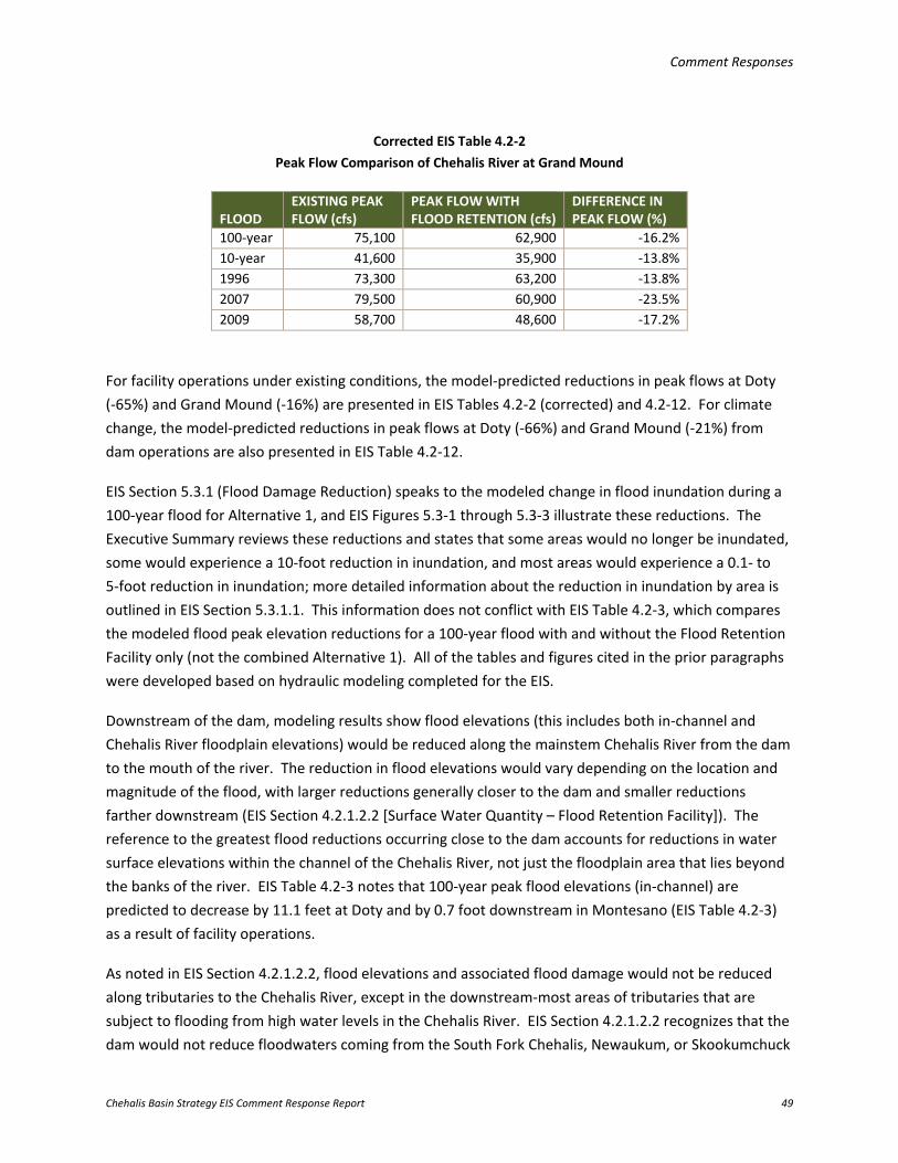
Comment Responses
Chehalis Basin Strategy EIS Comment Response Report 49
Corrected EIS Table 4.2-2 Peak Flow Comparison of Chehalis River at Grand Mound
FLOOD EXISTING PEAK FLOW (cfs)
PEAK FLOW WITH FLOOD RETENTION (cfs)
DIFFERENCE IN PEAK FLOW (%)
100-year 75,100 62,900 -16.2% 10-year 41,600 35,900 -13.8% 1996 73,300 63,200 -13.8% 2007 79,500 60,900 -23.5% 2009 58,700 48,600 -17.2%
For facility operations under existing conditions, the model-predicted reductions in peak flows at Doty (-65%) and Grand Mound (-16%) are presented in EIS Tables 4.2-2 (corrected) and 4.2-12. For climate change, the model-predicted reductions in peak flows at Doty (-66%) and Grand Mound (-21%) from dam operations are also presented in EIS Table 4.2-12.
EIS Section 5.3.1 (Flood Damage Reduction) speaks to the modeled change in flood inundation during a 100-year flood for Alternative 1, and EIS Figures 5.3-1 through 5.3-3 illustrate these reductions. The Executive Summary reviews these reductions and states that some areas would no longer be inundated, some would experience a 10-foot reduction in inundation, and most areas would experience a 0.1- to 5-foot reduction in inundation; more detailed information about the reduction in inundation by area is outlined in EIS Section 5.3.1.1. This information does not conflict with EIS Table 4.2-3, which compares the modeled flood peak elevation reductions for a 100-year flood with and without the Flood Retention Facility only (not the combined Alternative 1). All of the tables and figures cited in the prior paragraphs were developed based on hydraulic modeling completed for the EIS.
Downstream of the dam, modeling results show flood elevations (this includes both in-channel and Chehalis River floodplain elevations) would be reduced along the mainstem Chehalis River from the dam to the mouth of the river. The reduction in flood elevations would vary depending on the location and magnitude of the flood, with larger reductions generally closer to the dam and smaller reductions farther downstream (EIS Section 4.2.1.2.2 [Surface Water Quantity – Flood Retention Facility]). The reference to the greatest flood reductions occurring close to the dam accounts for reductions in water surface elevations within the channel of the Chehalis River, not just the floodplain area that lies beyond the banks of the river. EIS Table 4.2-3 notes that 100-year peak flood elevations (in-channel) are predicted to decrease by 11.1 feet at Doty and by 0.7 foot downstream in Montesano (EIS Table 4.2-3) as a result of facility operations.
As noted in EIS Section 4.2.1.2.2, flood elevations and associated flood damage would not be reduced along tributaries to the Chehalis River, except in the downstream-most areas of tributaries that are subject to flooding from high water levels in the Chehalis River. EIS Section 4.2.1.2.2 recognizes that the dam would not reduce floodwaters coming from the South Fork Chehalis, Newaukum, or Skookumchuck
Comment Responses
Chehalis Basin Strategy EIS Comment Response Report 50
watersheds or from floods originating in the headwaters of those watersheds. However, supporting documentation (WSE 2014b) summarized that all historical extreme floods along the mainstem Chehalis River (measured at the Grand Mound gage) have included large contributions from the upper Chehalis River (at least 6,000 cubic feet per second [cfs], but as high as 34,700 cfs at the reservoir site), which ranges from 16% to 44% of the peak flow at the Grand Mound gage.
The reductions in peak flow stated in EIS Table 4.2-2 are peak reductions; the peak flows are not sustained throughout the storm event. As shown in EIS Appendix H (Figure H-1), a typical flood has a rising limb of increasing flow, a peak flow, and a falling limb of decreasing flow. Peak flows typically last less than 24 hours. After the storm has passed, water stored in the reservoir would be released, and the full capacity would be available after approximately 1 month. Supporting documentation (Anchor QEA 2016a) estimates a 100-year flood would result in up to 48,150 acre-feet of storage in the reservoir, which is less than the retention capacity of 65,000 acre-feet. For the 2007 flood, the reservoir would have stored 60,250 acre-feet, also less than the retention capacity of 65,000 acre-feet. The probability of back-to-back extreme floods when the reservoir is full would be minimal, but could be evaluated during project-level environmental review. The dam and spillway would be designed per Ecology’s dam safety requirements; additional analyses of closed (e.g., malfunctioning) floodgates could also be analyzed during project-level environmental review.
For the modeled 100-year flood with climate change, the entire 65,000-acre-foot flood capacity would be utilized and the reservoir would start discharging flow through the spillway. The spillway elevation would be reached during the falling limb of the storm, and peak flows in the Chehalis River would still be reduced, providing the flood reduction described in the first paragraph of this response. The CIG report concluded that a small decrease in the proportion of rain falling above the dam is expected, but the changes would be relatively small and unlikely to result in significant changes in the distribution of flood risk across the watershed (Mauger et al. 2016). Atmospheric rivers, which cause extreme floods in the Chehalis Basin, were incorporated into the dam design (WSE 2014b; Anchor QEA 2016a).
Concern Summary: Commenters questioned the analysis and results of the FRFA facility’s flow augmentation effects and benefits on water quality and ecological functions and, in one case, compared the effects to the Skookumchuck Dam. In addition, commenters were interested in downstream water temperature impacts for both the FRO and FRFA facilities and whether flow augmentation would meet instream flow requirements. Comment Codes: C119-001, C119-006, C119-018, C119-028, C138-047, C138-064, C153-005, L023-013, O001-036, O006-011, O014-004, S002-161, T002-008, T003-227, T003-466, T003-514, T003-515, T003-516, T003-517
Response: For a programmatic analysis of the potential effects of FRFA and FRO facility operations on water temperature changes, see EIS Section 4.2.1.2.1 (Surface Water Quality – Flood Retention Facility)
Comment Responses
Chehalis Basin Strategy EIS Comment Response Report 51
and EIS Appendix H (Support Documentation: Flood Retention Facility Long-term Impacts and Mitigation). Clarification of water temperature modeling for both the FRO and FRFA facilities is provided here. Impacts on fish and wildlife as a result of predicted temperature changes from facility operations and flow augmentation are addressed in the programmatic analysis in EIS Section 4.2.4.2.1 (Fish – Flood Retention Facility) and Section 3.11.4 of this report; an additional technical analysis with information on spring-run Chinook salmon is provided in EIS Appendix K (Effects of Temperature Reduction and Flow Augmentation on Spring-run Chinook Salmon) and Section 3.11.4 of this report. Further evaluation of water temperatures would be provided during project-level environmental review.
Water Temperature Modeling To clarify the water temperature modeling approach presented in the EIS, the following background information is provided. For the FRO and FRFA facility operations, CE-QUAL-W2 models were used to predict the potential temperatures along the Chehalis River, upstream and downstream of the dam and in the reservoir. The modeling was performed using temperature data collected in the Chehalis River over several years along with data from a meteorological station located adjacent to the proposed reservoir area. The impacts on water temperature were evaluated with temperature models of the reservoir (reservoir model; Anchor QEA 2016b), the current inundated (instream) portion of the mainstem Chehalis River above the proposed dam location (footprint model; PSU 2016), and the mainstem Chehalis River downstream of the dam (downstream model; PSU 2016). These predicted changes in temperature were one of the changes in habitat evaluated to determine the potential impacts on aquatic species, particularly salmonid populations (EIS Section 4.2.4.2.1 and EIS Appendix K). The evaluation of temperature is comprehensive and uses the best available tools to predict water temperatures with facility operations. The footprint model was used for evaluating impacts in the reservoir footprint for the FRO facility (summer conditions) and also provided a simulation of the existing conditions in the reservoir area. The reservoir model was used to evaluate the water quality conditions under both the FRFA (year-round) and FRO (fall through spring) facility scenarios when a flood pool would be present. The downstream model was used for characterizing the current conditions in the Chehalis River downstream of the dam (river mile [RM] 108) through Porter (RM 33) and for evaluating impacts under the FRFA and FRO facility scenarios. Information from this modeling was used to assess the impact on aquatic species, including salmonid species as part of the EDT modeling.
FRFA Facility Operations – Downstream of the Dam Operation of the proposed FRFA (including cool-water flow augmentation during the summer and early fall) and FRO facilities would alter the existing temperature regimes along the mainstem Chehalis River.
As described in EIS Section 4.2.1.2.1, natural flows in the upper Chehalis River are low from late spring to early fall (mid-May to October); median flows range from 10 to 160 cfs. Flow augmentation from the FRFA facility would increase Chehalis River flow with the release of flows ranging from 80 to 160 cfs. This flow would be cooler than existing conditions in summer. FRFA facility operations could bring (based on water quality modeling results) water temperature into compliance with the core summer
Comment Responses
Chehalis Basin Strategy EIS Comment Response Report 52
habitat criteria (16˚C) for an extent of 3 miles downstream of the dam (to approximately RM 105). Downstream of approximately RM 105, FRFA facility operations are predicted to lower river water temperatures below existing conditions to RM 65 (as shown in EIS Figure 4.2-4 and EIS Appendix K, Figure 2). Despite the anticipated cool-water benefits, below RM 105 the predicted reductions in temperature are still not sufficient to meet the applicable temperature criterion (see EIS Appendix D [Surface Water and Groundwater Quality Standards] for applicable water temperature criteria for the Chehalis River), and exceedance of the current water quality standards would continue in the Chehalis River. In the fall, warmer water could potentially be discharged as a result of warming in the upstream reservoir, if cooler water is not available from deeper parts of the reservoir (see EIS Appendix H). This flow would be cooler than existing flows in the mainstem Chehalis River during the late summer through early fall. Further analysis of flow augmentation and its relationships to ecological function and aquatic species would be studied during project-level environmental review.
FRO Facility Operations – Downstream of the Dam An increase in temperature through the reservoir footprint would be caused by the removal of riparian trees, resulting in a predicted 2˚C to 3˚C increase immediately downstream of the dam during summer, declining to a negligible effect below the confluence of the South Fork Chehalis River (RM 88; EIS Section 4.2.1.2.1). Impact criteria categories are presented in EIS Appendix I (Adverse Long-term Impact Indicators). This 2˚C to 3˚C increase was predicted as a moderate adverse impact because of the short duration of increased temperature and limited area of effect, because most of the temperature impact would occur within the first 8 river miles downstream of the dam (EIS Appendix H, Figure H-15).
Skookumchuck Dam Comparison The Skookumchuck Dam is configured and operated differently than how the proposed FRFA facility would be constructed and operated. A comparison with the Skookumchuck Dam operations or temperature effects was not studied for the EIS.
Concern Summary: The Chehalis Tribe was concerned that potential impacts on water quality relative to their tribal water quality standards were not evaluated in the EIS. Comment Code: T001-007
Response: Detailed descriptions of current state water quality standards are included in EIS Section 3.1.2.4 (Chehalis River Water Quality). The applicable water quality standards for the Chehalis River and its tributaries are also identified in EIS Appendix D, Table D-1. EIS Chapter 4 (Action Elements: Impacts and Mitigation) addresses potential impacts on water quality at a programmatic level in for each individual action element as information was available.
Based on the following, Ecology believes the impact assessments in the EIS regarding temperature reflect a conservative approach that encompasses the values and parameters of the Chehalis Tribe’s
Comment Responses
Chehalis Basin Strategy EIS Comment Response Report 53
water quality standards. The Chehalis Tribe’s quantitative water quality standards (Chehalis Tribe 1996) generally reflect Ecology’s previous water quality standards of Class AA (extraordinary), Class A (excellent), Class B (good), and Class C (fair). The Chehalis Tribe’s standards classify the Chehalis River from approximately RM 44.5 to approximately RM 52.5, the extent of the reservation along the Chehalis River, as Class A. The temperature criterion in effect above and below the Chehalis Tribe reservation in this portion of the river (17.5˚C [WAC 173-201A]; Ecology 2012), which were applied in the EIS analysis, are more stringent for temperature than the Class A Chehalis Tribe standard of 18˚C. In addition, the analysis applied Ecology’s supplemental spawning and incubation criterion of 13˚C, in effect from October 1 to May 15, which is also more restrictive. The current criteria that apply above and below the segment of the Chehalis River that includes the Chehalis Tribe reservation, are identified as supporting spawning and rearing aquatic life uses. The Chehalis Tribe’s standards for other parameters such as dissolved oxygen (DO), turbidity, pH, and fecal coliform bacteria are the same as the current Ecology criteria for the segment of the Chehalis River that includes the Chehalis Reservation.
Concern Summary: Several comments were received regarding water quality impacts resulting from the installation of a dam, including those related to pH, DO, phosphorus, algae, hydrogen sulfide, mercury, and heavy metals or pollutants. Comment Codes: C119-029, C119-047, C138-065, C142-005, C142-006, C142-014, C142-015, C142-016, C142-017, C142-020, C142-021, C142-025, C142-032, O001-021, O001-036, O006-012, T003-210, T003-213, T003-223, T003-226, T003-228, T003-286, T003-287, T003-398
Response: For a programmatic analysis of the potential effects of FRFA and FRO facility operations on water quality changes, see EIS Section 4.2.1.2.1 (Surface Water Quality – Flood Retention Facility) as well as EIS Appendix H (Support Documentation: Flood Retention Facility Long-term Impacts and Mitigation) and supporting documentation (Anchor QEA 2014, 2016b). Impacts on fish and wildlife as a result of predicted water quality changes are addressed in the programmatic analysis in EIS Section 4.2.4.2.1 (Fish – Flood Retention Facility), EIS Appendix K (Effects of Temperature Reduction and Flow Augmentation on Spring-run Chinook Salmon), and Section 3.11.4 of this report. Further clarification of existing information related to water quality for both the FRO and FRFA facilities is provided here.
Water Quality Monitoring Water quality conditions in the Chehalis River were characterized by Ecology and through sampling conducted by Anchor QEA, LLC. Sampling details and methodology are presented in a separate water quality studies report by Anchor QEA (2014), which identifies the water quality parameters collected, and the locations and frequency of sampling. Sample collection included temperature, total suspended solids, chlorophyll-a, DO, turbidity, nutrients, and pH. A taxonomic classification of algae was not conducted as part of the baseline sampling. Ecology’s ambient water quality monitoring results for the Chehalis Basin are available on Ecology’s website for two stations (at Dryad and Porter) on the Chehalis River (http://www.ecy.wa.gov/programs/eap/fw_riv/index.html).
Comment Responses
Chehalis Basin Strategy EIS Comment Response Report 54
Effect of the FRFA Facility on Chehalis River Water Quality The Chehalis River would be converted from a free-flowing river to an open-water reservoir upstream of the dam, resulting in significant adverse impacts on water quality and aquatic species habitat, particularly for salmonid species using this reach of river (EIS Section 4.2.4 [Fish and Wildlife – Flood Retention Facility]). Potential changes to water quality include high water temperatures in the reservoir’s surface layer during the summer, low DO concentrations at depth, increased nutrients and algal production, and increased turbidity during and after floods. In addition, the potential exists for methane to be released from decaying organic matter, and increased levels of bioavailable mercury from atmospheric fall-out and sediment delivery (transformed by reservoir conditions), which could accumulate in fish tissue and be a risk to human health. The supporting analyses and documentation are included in Anchor QEA’s Draft Reservoir Water Quality Modeling report (2016b), Portland State University (PSU)’s modeling report (2016), and Anchor QEA’s water quality studies report (2014). To predict water quality changes to the reservoir and Chehalis River, water quality modeling was performed using CE-QUAL-2W to assess the impacts on DO, temperature, total suspended solids, pH, chlorophyll-a, nutrients, and algae (Anchor QEA 2016b). Water quality modeling included nutrient cycling in the reservoir (Anchor QEA 2016b). Water quality analyses proposed for the project-level environmental review would include cyanobacteria.
Reservoir Area The FRFA conservation pool would have varying water temperatures depending on the season and depth within the reservoir. The model-predicted peak temperatures at the surface of the reservoir could be approximately 20˚C to 25˚C, which exceeds the applicable summer core habitat criterion of 16˚C or the supplemental spawning/incubation criterion of 13˚C (in effect from September 15 to July 1; EIS Figure 4.2-2). Predicted DO levels throughout the reservoir pool are shown in EIS Figure 4.2-3. Lower DO levels are expected in the reservoir area due to thermal stratification and oxidation of organic matter in the lower (deeper) waters, where depressed DO conditions would not meet the summer core habitat DO minimum criterion of 9.5 milligrams per liter (at different time periods and depths; EIS Figure 4.2-3). The potential does exist for increased algae and nutrients as a result of the conversion of the Chehalis River to an open-water reservoir. The model predictions show algal growth, which produces oxygen, would be increased in the upper layers of the reservoir from late spring through mid-summer. Model simulations also showed that decomposition of algae (that die and settle from the surface layers) and organic matter (that settles from the watershed) in the reservoir sediments result in increased oxygen demand (i.e., consumption) in the lower layers, resulting in lower DO levels than at the reservoir surface. However, at the reservoir’s outfall, DO would be enhanced through engineered aeration, increasing the concentration at the discharge point (EIS Section 4.2.1.2.1). The reservoir releases would meet DO criterion with aeration.
Comment Responses
Chehalis Basin Strategy EIS Comment Response Report 55
Mercury fall-out and other potential sources that can be converted to methylmercury, and which can accumulate in the food chain and pose an ecological and human health risk, would be further evaluated during the project-level environmental review.
Downstream of the Dam FRFA facility operations would alter existing water quality conditions in the Chehalis River downstream of the dam. Facility operations would affect the downstream flow regime, water temperatures, DO, and turbidity in the mainstem Chehalis River. From the late spring to early fall, natural flows in the upper Chehalis River are low (median range of 10 to 160 cfs). As result of FRFA facility operations, these existing low flows would be augmented with flow releases from the dam, resulting in cooler water that would benefit aquatic species (see benefits to fish and other aquatic species in EIS Section 4.2.4 and EIS Appendix K). With flow augmentation, flows would range from 80 to 160 cfs (at the dam release point). This flow would be cooler than summer temperatures under existing conditions, which often exceed the summer core habitat criterion of 16˚C. Modeling results predict a cool-water benefit of 10˚C downstream of the dam, with a cool-water benefit of 1˚C to 2˚C extending downstream to RM 65 (EIS Figure 4.2-4). Despite the anticipated cool-water benefits, below RM 105 the predicted reductions in temperature would still not be sufficient to meet the applicable temperature criterion (16˚C) for core summer habitat. In the fall, there is a potential for warmer water to be released (1˚C to 2˚C above baseline) from the reservoir due to warming in the reservoir. Additional water temperature modeling would be incorporated during project-level environmental review.
Low DO concentrations are predicted by the model at depth in the reservoir (EIS Figure 4.2-3). DO levels would be enhanced in the outflow through engineered aeration (EIS Section 4.2.1.3.1 [Surface Water Quality – Flood Retention Facility]). Downstream water quality conditions resulting from FRFA outflow (DO, nutrients, pH, and algae) are being further evaluated by PSU. This information would be used during project-level environmental review.
The Chehalis River floodplain would be reduced by about 4,480 acres during a 100-year flood, which is about 10% of the existing floodplain area. With the reduction of inundated area through FRFA facility operations, there is a potential for reduction in downstream pollutant loading because a smaller geographic area (4,480 acres) would be exposed to floodwaters.
Effect of the FRO Facility on Chehalis River Water Quality To clarify the difference in operations of the FRFA and FRO facilities, the FRO facility would operate once every 7 years on average (15% probability of occurring in any given year) whereas the FRFA facility would have a permanent pool. When the FRO facility is not operational, the Chehalis River upstream of the dam would remain a free-flowing river, similar to existing conditions. It is predicted that Chehalis River temperatures would increase through the reservoir footprint because of the removal of vegetation that provides shade. Lower DO levels would occur as a result of these higher water temperatures.
Comment Responses
Chehalis Basin Strategy EIS Comment Response Report 56
These higher water temperatures and lower DO levels have the potential to affect aquatic species within the reservoir footprint area and downstream (see EIS Section 4.2.4). Peak water temperatures exceeding the core summer habitat criterion (16˚C) have been recorded within the Chehalis River in the reservoir pool area and downstream, and are predicted to continue with facility operations.
Concern Summary: Commenters requested factual corrections be made regarding how the affected environment was characterized in the Chehalis Basin. Comment Codes: S002-40, S002-42, S002-44
Response: The following are clarifications to the Draft EIS, based on public comments:
• The Chehalis Basin is mostly rain-dominated; the Wynoochee, Satsop, and Humptulips River sub-basins are somewhat influenced by high, snow-dominated areas in the Olympic Mountains
• Grays Harbor is the second largest coastal estuary in Washington, covering more than 90 square miles from its mouth at Westport to Montesano, and supports a large number of commercial shellfish aquaculture operations
• The lower 20 miles of the Chehalis River are tidally influenced (Burkle 2017)
Concern Summary: Additional questions related to water resources were raised regarding the effect determinations for downstream impacts on waters of the United States (including wetlands and wetland hydrology) and inclusion of channel capacity trends given the potential for sediment delivery to these areas. Comment Codes: O032-014, T003-007, T003-008, T003-009
Response: As stated in EIS Section 4.2.3.2.1 (Wetlands – Flood Retention Facility), downstream of the dam, wetlands in the Chehalis River floodplain could be affected by reduced water inputs from overbank flooding events. Because both the FRO and FRFA facilities are designed to reduce flooding from major floods, many floodplain wetlands would continue to receive floodwater inputs from smaller floods. Wetlands in the outer edges of the Chehalis River floodplain could experience a reduction in the frequency of floodwater inputs; however, flooding there is already infrequent. Hydraulic modeling predicted the areas of decreased flooding from the implementation of Alternative 1; results are described in EIS Chapter 5 (Combined Alternatives: Impacts and Mitigation). Wetland hydrology (including groundwater inputs) would be evaluated further during project-level environmental review.
The relationship between the frequency and intensity of significant precipitation events, sediment initiation and transport, channel conveyance capacity, and the potential for larger and more frequent out-of-bank floods was described in EIS Section 1.2 (Flooding) and EIS Appendix A (Review of the Potential Effects of Forest Practices on Stream Flow in the Chehalis River Basin). The EIS does not specifically analyze impacts on channel capacity; however, sediment transport impacts have been analyzed at a programmatic level and are addressed in EIS Chapter 4 (Action Elements: Impacts and
Comment Responses
Chehalis Basin Strategy EIS Comment Response Report 57
Mitigation) and in supporting documents (Watershed GeoDynamics and Anchor QEA 2014, 2016). Analysis of future sediment transport and flooding risk could be addressed during project-level environmental review.
Concern Summary: Commenters asked how groundwater effects from reduced frequency and inundation of the Chehalis River floodplain in the mid- to lower Chehalis Basin from the FRFA facility were considered. Comment Codes: L023-016, O001-032, T001-006, T003-203, T003-232, T003-236
Response: EIS Section 4.2.1.2.3 (Groundwater – Flood Retention Facility) states, “Downstream of the dam, a reduction in groundwater recharge could occur due to a reduction in the Chehalis River floodplain area that is inundated during floods with a greater than 7-year recurrence interval.” This section also states, “The potential reduction in recharge could be partially offset by higher stages in the river for a longer duration that existing as the reservoir empties, but this has not been quantified to support this programmatic-level analysis.” Further evaluation of the groundwater impacts from changes in floodplain inundation and frequency could be conducted during project-level environmental review as applicable.
3.11.2 Geology and Geomorphology
Concern Summary: Commenters requested additional geologic surveying and testing related to selection of the potential dam site. Some were concerned the site might be unsuitable due to soft marine sediments, weak strength basalt, and/or highly fractured zones in bedrock, and were concerned that the weight of the reservoir water needed to be examined further. A commenter suggested that grout injection to prevent seepage beneath the dam foundation and abutment would be ineffective based on comparisons to the Howard Hansen Dam. Others were concerned that raising groundwater in the hills surrounding the reservoir would affect seepage pathways into the Stowe Creek valley. Comment Codes: C101-009, C185-008, C186-030, C186-031, C186-033, C187-004, C188-005, C188-018, T001-003
Response: The geology impacts evaluation in the EIS for the Flood Retention Facility was informed by field work and studies that have been completed by engineering geologists and geotechnical engineers for the Chehalis Basin Strategy since 2009. As stated in EIS Section 4.2.2.2 (Long-term Impacts – Geology and Geomorphology – Flood Retention Facility), studies include “geologic mapping, landslide identification and analysis, rock quarry material identification and evaluation, seismicity analysis, seismic engineering studies, logging of deep drill holes, downhole and seismic refraction geophysical surveys,
Comment Responses
Chehalis Basin Strategy EIS Comment Response Report 58
rock and soil laboratory testing, and preliminary geotechnical engineering analyses.” The reference documents that present this work include the following:
• Reconnaissance-Level Geotechnical Report, Proposed Chehalis River the South Fork Dam Sites, Lewis County, Washington (Shannon & Wilson 2009)
• Preliminary Desktop Landslide Evaluation (Shannon & Wilson 2014a)
• Quarry Rock Desktop Study (Shannon & Wilson 2014b)
• Landslide Reconnaissance Evaluation of the Chehalis Dam Reservoir (Shannon & Wilson 2015)
• Phase 1 Site Characterization Technical Memorandum (HDR and Shannon & Wilson 2015)
• Phase 2 Site Characterization Technical Memorandum (HDR and Shannon & Wilson 2016)
When studies began in 2009, potential dam sites were evaluated in the South Fork Chehalis River and mainstem Chehalis River near Pe Ell. The mainstem site was determined to be the best site, owing to its narrow bedrock gorge about 1 mile upstream of Pe Ell, and geologic conditions were considered likely to be suitable based on existing geologic maps and preliminary geologic reconnaissance mapping.
Additional information was obtained during two stages of additional reconnaissance on the mainstem Chehalis River site and its surroundings as well as subsurface exploration and testing at the dam site, borrow sites, and landslides. These investigations included: 1) dam site reconnaissance and mapping, 18 deep borings with instrumentation, downhole geophysics for material confirmation and engineering characteristics, and surface seismic refraction for stratigraphic layering; 2) rock borrow site reconnaissance and mapping, two borings at two of the potential sites, and laboratory testing of rock from these sites and two nearby commercial rock pits; and 3) Light Detection and Ranging (LiDAR) analysis and landslide reconnaissance throughout the reservoir area, and borings at four sites in the proposed reservoir area to identify and characterize deep-seated landslides that could potentially be affected by reservoir operations.
The conditions and potential risks related to landslide remediation, fractures in the foundation rock, seepage beneath the dam, strong ground motions, site explorations, and weak rock zones were discovered during the two completed phases of exploration at the dam site and its surroundings by HDR and Shannon & Wilson, Inc. All of these are valid concerns, which have been taken into account as part of the dam design and will continue to be explored in future exploration and any future design stages. Potential risks and uncertainties were considered in the dam siting and design; however, there are standard methods of dealing with these potential risks and uncertainties with appropriate design and construction strategies. The purpose of the exploration and engineering studies is to uncover potential risks and uncertainties, and then design the dam with conventional design and construction methods. To date, there have been no conditions discovered at the proposed dam site that cannot be remedied by conventional dam design and construction methods. Additional explorations would be conducted to support further evaluations in future project-level environmental review.
Comment Responses
Chehalis Basin Strategy EIS Comment Response Report 59
The work program completed to date is in line with protocols for dams of similar type and size worldwide, and are appropriate for the programmatic evaluation in the EIS. Based on evidence from explorations, reconnaissance, and testing, it was determined that geologic conditions are suitable for the dam structure, and the borrow materials are suitable and sufficient for building the dam, based on current dam design and construction practices.
Potential impacts on groundwater in the reservoir footprint area are discussed in EIS Section 4.2.1.2.3 (Groundwater – Flood Retention Facility). See Section 3.11.1 of this report regarding the potential to address groundwater impacts during project-level environmental review.
Concern Summary: Commenters questioned whether earthquakes on the Cascadia Subduction Zone (CSZ) or Doty Fault could lead to damage or failure of the dam structure. Commenters noted that seismicity concerns are a slight but serious risk, and requested information regarding how the dam would be designed to withstand an earthquake of magnitude 6 to 7 and what “four orders of magnitude” means. Some questioned whether the reservoir could trigger slippage of the fault and create an earthquake. More details were requested regarding the impacts of dam failure on downstream residents, and who would be responsible for potential loss of life, damage, or loss of public and private property and infrastructure. One commenter asked what types of evacuation plans and early warning systems would be put in place. Comment Codes: C087-005, C101-005, C101-006, C119-022
Response: EIS Section 4.2.2.2.1 (Geology – Flood Retention Facility) indicates that the dam could be damaged under the extreme conditions of a subduction earthquake on the CSZ while the reservoir was full. While this is a possibility, it represents a highly unlikely combination of events. The CSZ has been studied and its shaking potential is documented by the U.S. Geological Survey (USGS). The characteristics of the Doty Fault are not understood, but are slated to be studied in depth by USGS and the Washington State Geological Survey in the near future. Using current knowledge and conservative engineering values, Shannon & Wilson seismic engineers studied the seismicity and geology of the proposed dam site and surroundings and concluded that the greater ground shaking at the proposed dam site would be from the CSZ, not the nearby Doty Fault (HDR and Shannon & Wilson 2015, 2016). The seismic design ground motions were generated for the site and provided to dam designers. After completing dam stability studies using the seismic design ground motions, dam designers concluded that a roller-compacted concrete dam can safely be constructed at the proposed location.
The dam design criteria consider a very large range of flood and earthquake loading conditions. The dam cross section has been based on the FRFA facility’s size and storage conditions, assuming the conservation pool within the reservoir is full. The cross section is configured so the dam will not

Comment Responses
Chehalis Basin Strategy EIS Comment Response Report 60
catastrophically fail and release reservoir contents following a CSZ earthquake event. Balancing economic considerations while keeping public safety as the prime concern, the dam would receive limited damage from earthquakes, with estimated recurrence intervals in excess of 25,000 years. The design criteria were developed considering the Washington State dam safety criteria (Ecology 1993) and the risk-informed guidance of key federal agencies including USACE and the U.S. Bureau of Reclamation (USACE 2011; Reclamation 2011). The "four orders of magnitude" refers to the Richter scale. In the context of the statement, the dam is being designed for a seismic event on the CSZ 10,000 times greater than an earthquake that could be generated by the weight or volume of water in the reservoir and cause a fault rupture and the release of existing seismic energy in the immediate vicinity of the dam (reservoir-triggered seismicity). The FRO reservoir would be unlikely to induce seismic activity because it would only be temporarily filled with water. In the FRFA reservoir, 65,000 acre-feet of water would be permanent.
There would be the potential for adverse impacts on downstream residents and communities if the dam were to fail (also see Section 3.11.13 of this report). However, the dam design would account for the significant earthquake forces and maximum shaking envisioned on the CSZ. Dam owners are responsible for developing emergency action plans, which include warnings and evacuation plans that are typically implemented by emergency management officials. Accountability for dam failure and associated costs is complicated and would depend on many factors. These factors would continue to be evaluated if dam design, construction, and ownership are further considered over the coming years.
Concern Summary: Commenters noted that the upper Chehalis Basin is prone to landslides, and asked whether recent research by Sarikhan et al. (2008) and Nelson and Dubé (2015) was included in the EIS. Commenters requested clarification of available data, additional planned LiDAR collection, and whether aerial photograph comparisons that showed bare ground, landslides, and debris flow from the 2007 flood above the dam site were examined. Additional investigations were requested to examine the effect on landslides of raising groundwater in the hills surrounding the reservoir, the impact of landslides on sedimentation in the reservoir and reduced water storage capacity, and the effects of road building and timber harvesting on landslides and erosion. A commenter questioned whether models for sediment entrainment would include storm events equivalent to or worse than the 2007 flood. Comment Codes: C119-007, C119-020, C119-050, C187-004, C188-004, C188-017, C228-008, F002-09, O001-042, O032-015, O032-016, O032-017, O032-021, T003-062, T003-063, T003-064, T003-144, T003-282
Response: The Sarikhan et al. (2008) information has been referenced and is included in the EIS. The Nelson and Dubé (2015) paper discusses the sedimentation consequences of the 2007 landslides, and these are taken into account in EIS Section 4.2.2.2.2 (Geomorphology – Flood Retention Facility) and in
Comment Responses
Chehalis Basin Strategy EIS Comment Response Report 61
the background studies used to develop the EIS (Watershed GeoDynamics and Anchor QEA 2014, 2016). The report by Sarikhan et al. states that the upper Chehalis River is prone to landslides. This is true for shallow rapid landslides, mostly due to very steep topography owing to the strong volcanic rocks on the valley walls upstream of the proposed dam site, as shown by the number of landslides that occurred during the 2007 flood. Shallow landslides are unlikely to have a deleterious effect on the dam or the reservoir, because shallow rapid landslides are relatively small and, therefore, would not create a seiche that could deleteriously affect the dam or its intake. Twenty-seven deep-seated landslides were identified using LiDAR hillshade images, most of which were confirmed in the field (some proved not to be landslides), and are shown in EIS Figure 4.2-5. These landslides are also described in the Shannon & Wilson landslide technical reports (2014a, 2015, 2016) referenced in the EIS, along with descriptions of their characteristics, potential to affect the dam/reservoir, and stability under reservoir fluctuation.
LiDAR coverage for most of the potential dam and reservoir was available from the Lewis County 2006 LiDAR flight. This was used in Shannon & Wilson’s 2014 desktop landslide study and incorporated into the EIS. In 2015, a project-specific flight provided LiDAR data for the dam and reservoir area, and was used in the reconnaissance level evaluation of the landslides and incorporated into the EIS. This level of landslide assessment supersedes previous work by the DNR and others. Many more deep-seated landslides were identified in the Shannon & Wilson study than were in the DNR database. Additionally, the landslide identification completed by Shannon & Wilson was reviewed by DNR's landslide expert, who suggested two more sites, which were incorporated into the inventory and field-checked (Slaughter 2016). DNR confirmed that it does not have particular concerns about this area. DNR geologists have been reviewing and commenting on Shannon & Wilson landslide evaluations for this project since 2014 (Slaughter 2016).
The landslide studies performed by Shannon & Wilson (2014a, 2015, 2016) were focused on deep-seated landslides in the proposed reservoir footprint because they could potentially affect the safety of the dam—that is, damage the structure directly or create a seiche (i.e., an oscillating wave in an enclosed body of water) that would damage the dam. To that end, LiDAR images were used to identify deep-seated landslides within or around the footprint of the proposed FRFA reservoir, which was chosen because it has a larger footprint than the FRO reservoir.
As a factual correction to the EIS, EIS Figure 3.2-3 depicts deep-seated landslides (not all landslides) in the upper Chehalis River. Shannon & Wilson’s assessment did not include the identification of shallow landslides because they are not a threat to the dam. They are, however, a source of sediment to the reservoir, as some could become unstable either due to natural influences or the rise and fall of reservoir water. An assessment of the shallow landslides that could be triggered by reservoir fluctuations could be included during project-level environmental review.
It is true that sediment from upstream mass wasting events will either be delivered directly or secondarily to the reservoir footprint. Existing sediment yields in the upper Chehalis Basin (at Doty) are
Comment Responses
Chehalis Basin Strategy EIS Comment Response Report 62
discussed in EIS Section 3.2.4.3 (Sediment and Sediment Transport). The discussion in the EIS is based on more detailed analyses of sediment yield from the Chehalis Basin upstream of the FRO or FRFA facility included in associated reports (Watershed GeoDynamics and Anchor QEA 2014, 2016). The 2016 report did consider the changes in flow and sediment yield that may result from future climate change. This has also been addressed in the facility operations and maintenance section (12.1) of the dam conceptual design memorandum (HDR 2016a), in which it is stated, “The FRFA has no sediment management costs expected, because the reservoir life span assumes that reservoir dead storage volume is adequate to store the bedload generated during the expected life span of the project.” The FRFA and FRO reservoirs both have 65,000 acre-feet of storage capacity. Sedimentation studies (Watershed GeoDynamics and Anchor QEA 2014, 2016) indicate that bedload and 86% to 93% of the suspended load would be trapped in the FRFA reservoir, with an estimated average load of 42 acre-feet per year. Based on preliminary assessments completed for the FRFA facility, using an estimated average sediment load of 42 acre-feet per year, the reservoir area would be about 6% full of sediment after 100 years. At this rate, it would take 1,500 years to fill in the FRFA reservoir. For the FRO facility, only 4.3 to 8.7 acre-feet of bedload would be trapped; therefore, the reservoir would not be affected by the sediment inflow. For the FRFA facility, sediment cannot be removed, whereas sediment can be removed with the FRO facility configuration. Additional detailed information on sediment deposition patterns in and downstream from the reservoir would be addressed during project-level environmental review.
There are several scenarios for treating landslides in the reservoir area, as described in EIS Section 4.2.2.3.1 (Geology – Flood Retention Facility). Additional investigation of high-priority landslides and proposed mitigation would be included in project-level environmental review.
The EIS discusses the substantial changes to geomorphic processes resulting from the operation of either the FRO or FRFA facility. To date, the majority of work has been an analysis of potential future sediment inputs based on past actual (not computer-predicted) landslides that have occurred in the watershed, how those are routed through the stream system, and how the operation of the FRO or FRFA facility would affect transport processes of sediment and large woody material. Stability analyses of shallow landslides within the reservoir footprint based on operation of the reservoirs have not been performed. This could be addressed with more detailed analysis as part of the project-level environmental review.
Landslide hazard related to forest practices (road building and timber harvesting) is related to a wide array of site conditions, including slope, soil strength, groundwater conditions, surface water patterns, antecedent soil moisture, recent precipitation, and root strength. Harvesting of trees (hence, the bare ground referred to in the comment) is just one of the variables that can affect landslides. See EIS Appendix E (Evaluation of Forest Practice Effects on Landslides and Erosion in the Chehalis Basin) for more information regarding this topic.
Comment Responses
Chehalis Basin Strategy EIS Comment Response Report 63
As noted, there does appear to be more bare ground in the 2016 aerial photograph than the 2009 aerial photograph furnished by the commenter; however, this does not necessarily equate to an increase in risk of landslides on steep slopes. Through adaptive management, regulations for cutting timber and building forest roads have been modified and strengthened since the 2007 flood and now require increased geotechnical scrutiny and prescriptions on steep and unstable ground. According to forest practice rules, the steepness of a slope does not automatically eliminate it from being logged or roaded. If a slope is steep, it is further scrutinized by foresters and geologists to determine whether it can be logged or constructed upon and what conditions are applied to the forest activity. Sediment transport and geomorphology studies, prepared as background for the EIS, took into account both more moderate and extreme storms (such as the approximately 500-year 2007 flood), landslide inputs of sediment and wood or debris, and flows, as part of long-term studies and modeling of potential effects of proposed structures on geomorphology and aquatic habitat within the reservoir footprint and downstream (Watershed Geodynamics and Anchor QEA 2014, 2016).
Concern Summary: A variety of comments were received regarding geomorphology, primarily related to hydraulic and sediment transport modeling, the effects of aggradation on channel conveyance capacity, and the channel avulsion and migration events required to create off-channel habitat. Some commenters requested quantification of the upper Chehalis Basin sediment yields, sediment that might be delivered to the reservoir, and effects of sediment deposition on the reservoir and dam. Comments were received regarding how dams affect the movement of sediment and large wood downstream, the size of wood that could pass the dam compared to sizes required for geomorphic function in the stream corridor, and the relationship between sediment starvation and channel incision. There was also some concern from commenters that the extent of tidal influence up the lower Chehalis River stated in the EIS was incorrect. Comment Codes: C084-003, C101-007, C103-005, C192-003, C242-002, C325-002, O001-038, O001-040, O032-018, O032-020, S002-46, S002-47, S002-174, S002-182, S002-266, T001-008, T003-212, T003-222, T003-238, T003-241, T003-242, T003-252, T003-256
Response: For a programmatic analysis of the potential effects of FRFA and FRO facility operations on geomorphology (including sediment and wood transport), see EIS Section 4.2.2.2.2 (Geomorphology – Flood Retention Facility) and EIS Appendix H (Support Documentation: Flood Retention Facility Long-term Impacts and Mitigation). Additional detailed information on sediment transport and sediment deposition would be addressed during project-level environmental review.
Existing sediment yields in the upper Chehalis Basin (at Doty) are discussed in EIS Section 3.2.4.3 (Sediment and Sediment Transport), and the effects of the reservoir on sediment deposition are
Comment Responses
Chehalis Basin Strategy EIS Comment Response Report 64
discussed in EIS Section 4.2.2.2.2. The discussion of sediment yields and potential changes to geomorphic processes is based on more detailed analyses of sediment yield and the FRO or FRFA facility, which is included in the associated reports (Watershed GeoDynamics and Anchor QEA 2014, 2016) and described in EIS Section 4.2.2.2.2. The 2016 report considered the changes in flow and sediment yield that may result from future climate change, and includes a discussion of the effects of sediment retention in the reservoir impoundment areas. The 2014 report analyzed the potential effects of changes in sediment input, transport, and deposition downstream of the dam and included hydraulic and sediment transport modeling. The EIS states that changes to geomorphic processes (i.e., changes in sediment transport) are not anticipated to result in effects below RM 62. This is based on existing sediment transport and geomorphic conditions (EIS Section 3.2.4 [Geomorphology]). The effects of a dam on the bedload supply and flows would be minimized below RM 62 because the upstream bed material load is deposited in the low-gradient section upstream of the bedrock controls. See discussion in Geomorphology and Sediment Transport Technical Memorandum (Watershed GeoDynamics and Anchor QEA 2014). Additional detailed information on sediment transport and sediment deposition patterns in and downstream of the reservoir and the impacts on channel conveyance capacity would be evaluated during project-level environmental review.
A programmatic analysis of downstream impacts from the proposed Flood Retention Facility, including gravel transport, is addressed in EIS Chapters 4 (Action Elements: Impacts and Mitigation) and 5 (Combined Alternatives: Impacts and Mitigation). The EIS states that mitigation to address modifications of sediment transport quantities and timing, and channel and bank erosion, could include gravel augmentation in downstream areas. Operating the FRO facility would alter the timing and rate of sediment transport, and potentially the rate and occurrence of channel migration, due to changes in high flows at which channel and bank erosion occurs. For the FRO facility, the natural flow regime would be altered during operation (predicted to be once every 7 years, on average). During all other times, the natural flow regime would be maintained in the Chehalis River, allowing for natural processes to continue. For the FRFA facility, peak flows, up to a major flood, would be maintained through releases from the dam to allow sediment transport processes to continue (see EIS Section 4.2.2.3.2 (Geomorphology – Mitigation – Flood Retention Facility). Creation of the dam would reduce, but not eliminate, gravels from being transported downstream.
With regard to wood, EIS Section 4.2.2.3.2 states:
• The FRO dam would be designed to pass suspended sediment load, bedload, and most wood (up to 15 feet in length and 3 feet in diameter) at all times except during flood operations …
• To mitigate for the potential interruption of wood transport through the dam, large wood captured in the reservoir could be collected and relocated to an appropriate location downstream of the dam (during both flood and non-flood dam operations)

Comment Responses
Chehalis Basin Strategy EIS Comment Response Report 65
– Locations and placement and quantities would be determined at the time of placement based on channel and habitat conditions present
In response to the remaining comments, avulsions (rapid channel alignment changes) have occurred throughout the Chehalis Basin and can result in large channel shifts and changes in migration extents. Due to reduction in sediment load downstream of the dam, the potential for channel degradation downstream of the dam exists. As noted in EIS Section 4.2.2.2.2, the potential changes in wood and sediment transport processes resulting from implementation of both the FRO and FRFA facilities would have a significant adverse impact on geomorphology due to the interruption of these processes upstream and downstream of the dam.
As clarified in Section 3.11.1 of this report, the lower 20 miles of the Chehalis River are tidally influenced (Satsop River confluence; Burkle 2017).
3.11.3 Wetlands and Vegetation
Concern Summary: Many comments received related to wetlands and vegetation in the EIS were regarding the level of information on existing wetlands and vegetation, with commenters seeking more detailed information on wetland locations and associated potential impacts. Others asked how mitigation for wetland impacts would be implemented and assured. One commenter asked for clarification on conclusions regarding potential impacts (Basin-wide vs. site-specific). A couple of commenters asked for more information on the historical changes in land cover in the Chehalis Basin, including the loss of marshes, and how these past changes can inform potential future impacts on wetlands and vegetation. Finally, several commenters suggested that invasive species management regulations be acknowledged and invasive species management practices be incorporated into management plans. Comment Codes: C119-023, C119-024, C142-002, C142-003, C142-024, C142-027, C142-030, F002-21, L012-001, L013-001, O001-009, O001-010, O001-011, O001-012, O001-029, O001-043, S001-11, S001-12, S001-17, S001-40, S002-52, S002-80, S002-142, S002-148, S002-185, S002-186, S002-189, S002-236, S002-251, T003-009, T003-147, T003-148, T003-149, T003-150, T003-151, T003-164, T003-259, T003-260, T003-261, T003-262, T003-263, T003-264, T003-266, T003-267, T003-268, T003-270, T003-271, T003-301, T003-303, T003-325, T003-405, T003-406, T003-407, T003-408, T003-409, T003-412
Response: With respect to changes in wetlands and vegetation over time, the brief history of the Chehalis Basin presented in EIS Chapter 1 (EIS Overview) acknowledges changes to Chehalis Basin land cover and hydrology with the advent of industry, ports, and agriculture to the region. As part of NOAA’s population model (also see Section 3.4.2 of this report), a quantitative evaluation of the impact of the loss of marsh and wetlands on fish or other wildlife across the Chehalis Basin has been initiated. The

Comment Responses
Chehalis Basin Strategy EIS Comment Response Report 66
results of this study are currently not available. Additional information regarding the watershed assessment analysis and the marsh and wetland loss assessment would be provided during subsequent project-level environmental review and other publicly available means, once final results are available.
Wetlands described in the EIS are based on the 2011 Modeled Wetland Inventory (Ecology 2011). The programmatic evaluation conducted at this point in the planning process does not include detailed wetland impact analyses. No net loss is the assumed standard for addressing wetland impacts at the programmatic level, and the EIS concludes that significant adverse impacts on wetlands and vegetation are anticipated for the FRO or FRFA facility based on existing information. As the state agency responsible for managing wetland resources, Ecology understands the need for jurisdictional wetland identification and delineation prior to project implementation. The existing information on wetlands was adequate for the purpose of evaluating the relative magnitude of potential impacts from the EIS action elements and combined alternatives at a programmatic level. Additional wetland studies would be conducted and incorporated into project-level environmental review, as necessary, to meet specific regulatory requirements.
While the EIS assesses impacts relative to a Basin-wide scale (see EIS Appendix I [Adverse Long-term Impact Indicators]), impacts at a local scale are also noted where applicable. For example, although the potential loss of vegetation associated with a dam may be a small percentage of the existing vegetation with the Chehalis Basin, potential impacts on wetlands and vegetation associated with a dam and reservoir are still considered significant in the EIS due to the substantial loss (greater than 5 acres), disturbance, or conversion of existing habitat.
The assurance for adequate mitigation to address potential impacts would ultimately lie with regulating agencies: USACE, U.S. Environmental Protection Agency (USEPA), and Ecology. The sidebar in EIS Section 4.2.3.3 (Mitigation – Wetlands and Vegetation) provides additional information on the regulatory framework for compensatory mitigation associated with wetland impacts. Additional analysis could occur during project-level environmental review to confirm potential impacts and identify the appropriate level of mitigation necessary. Requirements of regulatory agencies typically include multi-year post-construction monitoring at mitigation sites to ensure performance and no net loss of ecological function. USACE, Ecology, and USEPA wetland mitigation guidance would be adhered to, as stated in EIS Section 4.2.3.3.
While the potential impacts on vegetation resulting from implementation of the FRO and FRFA facility have been identified as significant, a detailed vegetation study has not been completed. Additional vegetation studies would be conducted for project-specific analyses as necessary to provide more details on existing vegetation and the extent and degree of potential impacts. The suggestion to include soil deposition tolerance to evaluate impacts on plant species is appreciated and noted. A general description of a post-construction vegetation management plan for a dam is provided in EIS Section 4.2.3.3. An additional level of detail would be provided during project-level environmental
Comment Responses
Chehalis Basin Strategy EIS Comment Response Report 67
review that includes invasive species treatment, prevention, and follow up; grasses, sedges, ferns, and forbs (in addition to trees and shrubs); and post-construction vegetation management.
Ecology agrees that invasive species management and prevention before, during, and after construction would be incorporated into the Chehalis Basin Strategy and considered during project-level environmental review. Additionally, consistency with plans like the Chehalis Cooperative Weed Management Area's Chehalis Aquatic Weed Management Plan, would be incorporated into project-level environmental review.
Finally, some information to address specific comments on wetland impacts associated with a dam is provided as follows:
• Information on wetland locations for the dam alternatives can be found in EIS Figure 4.2-7
• The area (in acres) of mapped wetlands within the reservoir footprint is provided in EIS Section 4.2.3.2.1 (Wetlands – Flood Retention Facility) and EIS Table 4.2-4 ‒ EIS Section 4.2.3.2.1 anticipates that all of these wetlands would be adversely affected as a
result of conversion, disturbance, and reduction of existing wetland and vegetation communities, or permanent replacement with dam-associated infrastructure
3.11.4 Fish and Wildlife
Concern Summary: Many commenters requested clarity on the analysis of the impact of flow augmentation and water temperature reduction predicted as a result of releases from an FRFA dam and reservoir in summer on fish. Comment Codes: C077-005, C119-002, C119-017, C119-031, C119-042, C119-048, C138-007, C138-010, C138-017, C138-037, C138-048, C138-061, C142-005, C142-032, C217-002, C228-006, F001-39, F002-20, L023-014, O001-009, O001-020, O005-005, O011-009, O014-017, S002-144, S002-157, S002-207, S002-270, S002-324, S002-325, S002-326, S002-327, T003-297, T003-299, T003-416, T003-511, T003-515, T003-518, T003-519
Response: For a programmatic analysis of the potential effects of the FRFA dam on fish, see EIS Section 4.2.4.2.1 (Fish – Flood Retention Facility) and EIS Appendix K (Effects of Temperature Reduction and Flow Augmentation on Spring-run Chinook Salmon). Clarifying information is provided here and in Section 3.11.1 of this report.
Proposed Streamflow and Water Temperature Modulation in the Chehalis River The Chehalis Basin is mostly rain-dominated and, with a lack of a cold water supply from snowpack, water temperatures are relatively warm in late summer compared to other rivers in the Pacific Northwest. With climate change, water temperature is predicted to continue to warm, mean monthly runoff is predicted to decrease slightly (3%) during summer months (WSE 2014c), and thermal refugia (i.e., an area in which a population of organisms can survive through a period of warmer water temperature conditions) is predicted to continue to be a necessary component of habitat for native aquatic species in the Chehalis River.
Comment Responses
Chehalis Basin Strategy EIS Comment Response Report 68
In 2015, an unusually warm year under the current climate regime, water temperatures in the mainstem Chehalis River peaked in mid-July with the following average temperatures, from downstream to upstream: 27°C in the reach from the Skookumchuck River to the Newaukum River, 24°C in the reach from South Fork Chehalis River to Elk Creek, and 22°C in the reach from Elk Creek to Pe Ell (Anchor QEA 2016c).
The FRFA facility would be designed for the purpose of flood retention and fish passage, with added measures intended to reduce, but not eliminate, the adverse impacts on fish. Specifically, the FRFA facility would allow for releases of augmented volumes of cool water from the lower levels of the conservation pool from late spring through early fall. Releases of cool water could allow greater function of habitat downstream of the dam for native fish compared to a dam without any mechanism for temperature reduction or flow augmentation.
With an FRFA facility at RM 107.5 in the upper Chehalis River, temperatures could be reduced by as much as 10°C immediately downstream of the dam (EIS Figure 4.2-4 and EIS Appendix K, Figure 2; reproduced as Figure 3 in this section) with the effect attenuating downstream, resulting in small effects (less than 1°C) downstream of RM 65 (approximately the confluence with the Skookumchuck River; see EIS Section 4.2.1.2.1 [Surface Water Quality – Flood Retention Facility] and EIS Appendix K; PSU 2016). Based on water temperatures modeled for typical water years, the upper Chehalis River currently exceeds core summer salmonid habitat temperature criterion of 16°C and spawning, rearing, and migration criterion of 17.5°C in summer (USEPA 2003).
The effect of the FRFA facility on water temperatures relative to the core summer salmonid habitat criteria is not explicitly stated in the EIS; however, the modeled temperatures downstream of the FRFA dam are depicted in Figure 2 of Appendix K, with core salmonid habitat temperature criterion depicted as thresholds in red. To clarify what is depicted in the figure, operation of the FRFA facility could reduce water temperatures below 16°C across an area of approximately 3 river miles downstream of the dam, and below 17.5°C for an additional 1 to 2 river miles, until approximately the confluence with Elk Creek (EIS Appendix K). The FRFA facility would reduce water temperatures to below approximately 21°C, or the temperature known to create a temperature block for migrating adult salmon, downstream of the dam to the confluence with the South Fork Chehalis River, with diminishing benefit to summer movements of adult salmon below this point (McCullough 1999).
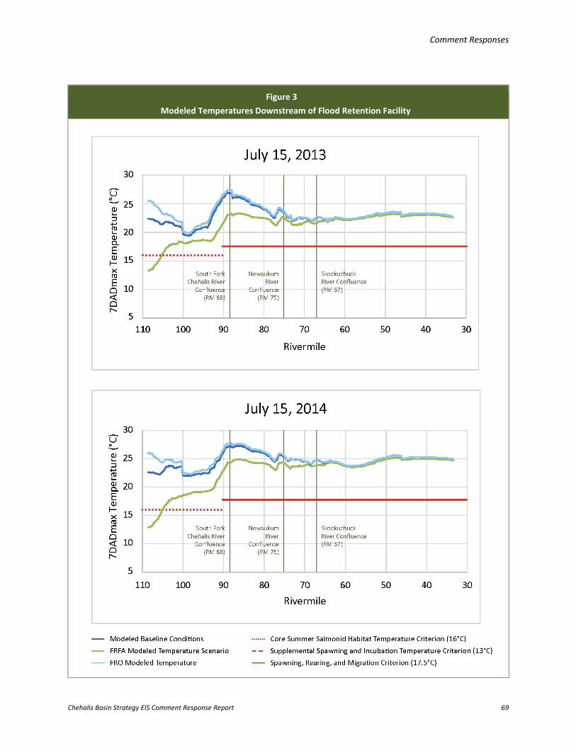
Comment Responses
Chehalis Basin Strategy EIS Comment Response Report 69
Figure 3 Modeled Temperatures Downstream of Flood Retention Facility
Comment Responses
Chehalis Basin Strategy EIS Comment Response Report 70
Some adult spring Chinook salmon migrate to headwater areas in early summer to seek cold-water refuge during pre-spawn holding (Liedke et al. 2016). Habitat models predict that temperature reduction and increased flow in the area just downstream of the dam would improve conditions for salmonids in the reaches from the dam to the South Fork Chehalis River (discussed further in this section). Examples exist where cool-water releases below dams are used to improve conditions for salmonids in other river systems, as described in EIS Appendix K. Many of these cases come from dams that historically contributed to the decline of salmon populations in those systems because the dams lacked features that could have minimized adverse impacts on fish habitat or lacked fish passage structures. In these cases, facility operations were later modified to release cold water from reservoirs to improve conditions for imperiled salmon that were constrained to use areas downstream of the dam.
Effect of FRFA Facility on Fish in the Chehalis River Several native fish and amphibian species are known to occur in the area around the proposed dam site, as described in EIS Section 3.4.1.2 (Other Fish Species). In addition, spring-run Chinook salmon, fall-run Chinook salmon, coho salmon, and winter-run steelhead are known to spawn at the dam site and in the inundation footprint, with large numbers of juvenile trout, coho salmon, and Chinook salmon rearing in the area throughout the summer. The relative spawning area that could be inundated by a reservoir for each of these species is described in EIS Appendix H (Support Documentation: Flood Retention Facility Long-term Impacts and Mitigation).
To estimate the potential effect of the FRFA dam on fish in the upper Chehalis River, quantitative modeling was used to assess the value of the habitat in its current condition compared to a hypothetical future condition with a dam. The type of habitat modeling used for these analyses provides a method for quantitatively estimating the effect of the dam in the absence of a direct experiment and observation—that is, without having to wait to observe the outcome after constructing it.
The response of salmonids to the FRFA facility was quantitatively modeled using the EDT model (ICF 2016). More details on species, life stages, and physical attributes of the environment evaluated using the EDT model are provided in other concern summary responses in this section.
Habitat modeling using EDT accounted for changes in habitat and operations that would release higher and colder flow in summer downstream of the FRFA dam as well as the conversion of stream habitat to reservoir habitat, reduced fish passage around the dam, and other numerous changes to habitat function upstream and downstream of the dam that would result, which are listed in EIS Appendix H, Table H-2. In comparison to salmon, less information on existing conditions and habitat preferences was available to estimate the response of other native aquatic species to the predicted changes in habitat. The response of other key native fishes and western toad (Anaxyrus boreas) to summer flow augmentation and temperature reduction was modeled for the area downstream of the dam using the Physical Habitat Simulation (PHABSIM) model, based solely on changes to flow and temperature without respect to predicted changes in other habitat features or impacts of a reservoir upstream of the dam.
Comment Responses
Chehalis Basin Strategy EIS Comment Response Report 71
Results summarizing the potential of the habitat in different reaches of the Chehalis River to support fish species with the FRFA dam are presented in EIS Section 4.2.4.2.1.
Based on the results of the EDT model, the net impact of an FRFA facility on salmon would be adverse, meaning salmon populations would be less abundant1. This potential net impact accounts for the effects of the reservoir, dam, and downstream changes combined. When the net impact of the FRFA facility is evaluated on the scale of all of WRIAs 22 and 23, the area the EIS addresses, the reduction in overall abundance of all salmonid populations is small relative to the large numbers of salmonids using other tributaries of WRIAs 22 and 23. The net impact of the FRFA facility on anadromous salmonids on the scale of WRIAs 22 and 23 ranges from less than 1% to 3%, depending on the species (see EIS Table 4.2-7).
It is equally important to describe the potential impact of the FRFA facility on fish at a smaller geographic scale, focused on the areas directly affected by a dam, in this case, impacts on fish using the upper Chehalis Basin above the dam and mainstem Chehalis River below it. The effects of the FRFA facility on salmon by river reach are depicted by the purple bars and symbols in EIS Figures 4.2-9a through 4.2-9c. On a reach-by-reach basis, the most significant effects of the FRFA facility on salmon occur upstream of the dam (shown as “Above Crim Creek” in the aforementioned EIS figures) due to inundation by the reservoir and reduced fish passage around the dam, and extend downstream to approximately the reach of the mainstem Chehalis River between the confluences with the South Fork Chehalis and Skookumchuck rivers, with small effects downstream of the Skookumchuck River.
The effect of the FRFA facility is adverse for all five salmonid species evaluated in every stream reach of the mainstem Chehalis River2, with one specific exception. The effect of augmenting flow and lowering water temperature in late spring through early fall is predicted to improve spring-run Chinook salmon abundance in the area immediately downstream of the dam to the confluence with Elk Creek (the Elk to Crim reach). It is important to recognize that the modeled data show a 67% increase in only the number of spring-run Chinook salmon that could use that reach of the river, which at this local scale amounts to an increase of approximately 38 fish (see EIS Table 4.2-8 and EIS Figure 4.2-9b). When impacts are analyzed on a Basin-wide scale and combined with the adverse impacts occurring upstream and downstream of this specific reach, the net impact on spring-run Chinook salmon is negative and amounts to a loss of approximately 56 fish (see EIS Table 4.2-7 and EIS Figure 4.2-8).
1 Note that impacts of a dam alone on fish would be adverse; however, the combined impact of Alternative 1 (the dam with Basin-wide Aquatic Species Habitat Actions) under the current climatic conditions is predicted to result in a net increase in salmonid populations compared to the current degraded state of aquatic habitat (see EIS Section 5.3, EIS Figure 5.3-4a). With changes to the environment forecasted over the next 100 years due to climate change, only the high restoration scenario under Alternative 1 would benefit salmonids (EIS Section 5.3, EIS Figure 5.3-5a). 2 Benefits (less than a 2% increase to subpopulations) predicted for populations spawning in other tributaries, such as the Black, Skookumchuck, and Newaukum rivers, are most likely due to the predicted benefit provided by increased flow and cool water in the mainstem Chehalis River, their main migratory channel.
Comment Responses
Chehalis Basin Strategy EIS Comment Response Report 72
The predicted impact on other, non-salmon, aquatic species was only evaluated downstream of the dam site using an index of usable habitat area based only on flow and temperature (Weighted Usable Area result from PHABSIM model analysis; EIS Table 4.2-9). In general, the area available for the native fish species evaluated would increase with augmented cool-water releases in summer from the FRFA dam, and area available for invasive warm-water associated species would be reduced, with the greatest changes occurring in the reach just downstream of the dam (Pe Ell to Elk Creek), with the effect attenuating downstream. However, based on qualitative analyses of the adverse impacts of a dam and reservoir on other natural habitat-forming processes, the EIS has conservatively assumed that the FRFA dam would present a net significant adverse impact for these other stream-dwelling, native fish and amphibian species, just as it would for anadromous salmonids.
Remaining Uncertainty There is uncertainty around the presumed benefit the FRFA dam could have on spring-run Chinook salmon and other native fish from augmented cool-water releases in summer (see EIS Appendix K regarding uncertainties). The assumption that current temperature profiles not only limit the useable area but also the amount of time in summer that the area could be useful was incorporated into EDT model results. For instance, reducing the temperature in this reach downstream of the dam may increase the usable area for pre-spawn holding and expand the amount of time in which the area is usable for early spawners. However, a survey of adult spring-run Chinook salmon behavior during the pre-spawn holding period (Liedtke et al. 2016) suggested that the Chehalis River spring-run Chinook salmon population is behaviorally adapted to survive relatively warm summers by finding refugia in other areas of the watershed.
Because the EDT model does not accommodate for behavioral adaptations, the modeled responses of adult spring-run Chinook salmon to changes in habitat downstream of the dam would only be valid if the adults ultimately use this reach of the upper Chehalis River for spawning, and potentially for pre-spawn holding, in the future. Four years of snorkel surveys in this area of the river, conducted by WDFW in August (2013 to 2015; Zimmerman and Winkowski 2016), have observed very few adult spring-run Chinook salmon using this area of the river for over-summer rearing. Approximately one adult spring-run Chinook per kilometer was observed in only 30% of the reaches surveyed between the confluence of the east and west forks of the upper Chehalis River (RM 120) to the confluence with the Newaukum River (RM 73) in 2014.
In addition, modifications to flow and temperature may alter the seasonal cues to which native species are adapted. For instance, temperature cues can be important to stimulate juvenile salmonids to migrate, and earlier spawning in spring-run Chinook salmon can subsequently affect incubation and emergence timing of offspring. The benefit to native species also depends on operating the Flood Retention Facility to maintain a natural decline in temperature in late September and October in both average-flow and drought years. These factors have been evaluated and included in the proposed operations as described in the Draft Operations Plan for Flood Retention Facilities (Anchor QEA 2016a).
Comment Responses
Chehalis Basin Strategy EIS Comment Response Report 73
It is uncertain at this time whether the ultimate consequences of altering seasonal temperature and flow signals would be beneficial or adverse for different life stages of all salmonid species. Additionally, due to the diversity of species that use the stream habitat in the Chehalis River, not all native aquatic species would benefit. For example, western toads, which breed instream during the tail of the declining or basal hydrograph, would lose breeding and rearing habitat downstream of the dam. Also, PHABSIM modeling reflects this as a potential decline in the habitat area in reaches downstream of the dam, which is already limited for this species. Flow and temperature are not the only criteria required for usable habitat, and for the FRFA facility to benefit native species, other features of the habitat must be available such as suitable substrate, optimal water chemistry, food supply, and refugia areas.
Conclusion The effects of flow augmentation and temperature reduction from the FRFA facility would be variable for different species, depending on how flow augmentation would affect their habitat downstream of the dam and the temperature preferences of each species. Generally, flow augmentation and temperature reduction in summer would be intended to benefit anadromous salmonids (including spring-run Chinook salmon) if they are able to adapt their behavior to use the affected reach (e.g., to hold prior to spawning), and may disfavor the native western toad and non-native fishes that prefer warmer water, such as smallmouth bass (Micropterus dolomieu). For salmonids, there are two potential responses to the changes in habitat that could occur with the physical outcomes of the FRFA facility. In one case, increased modeled habitat potential could result in an increase in population size. Alternatively, fish may continue to carry out behaviors adapted for the Chehalis River and would not respond to artificial temperature reductions and flow increases.
Concern Summary: Many commenters requested clarity on the fish passage options being considered, the effectiveness of fish passage, and resulting effects anticipated on fish populations. Comment Codes: C119-027, C119-030, C119-033, C119-037, C138-011, C138-012, C138-019, C138-033, C138-067, C142-004, F001-08, F002-10, F002-14, F002-17, O001-022, O001-026, O003-004, O011-002, O032-024, S002-21, S002-201, S002-205, S002-207, T002-009, T002-012, T003-045, T003-160, T003-161, T003-430, T003-450, T003-452, T003-453, T003-454, T003-455, T003-456, T003-457, T003-458, T003-459, T003-461
Response: The fish passage design team (design team) and members of the Chehalis Basin Strategy Flood Damage Reduction Technical Committee (Technical Committee) coordinated and carried out several fish passage subcommittee meetings during the development of fish passage options for the FRO and FRFA dam scenarios. Participants attending these meetings included representatives from WDFW, NOAA Fisheries, Ecology, Quinault Indian Nation, and the project consultant team.
These meetings became forums for information transfer, detailed discussion, and decision-making on the biological and technical aspects of fish passage option development. Of primary importance were the discussion, interpretation, and formulation of design criteria that could be carried forward
Comment Responses
Chehalis Basin Strategy EIS Comment Response Report 74
throughout the design of fish passage options. For the past several years, WDFW has led a field sampling program to collect data and better understand the phenology, abundance, habitat requirements, distribution, and migration patterns of fish within the Chehalis River, and specifically in areas downstream of the dam, under the dam structure, and within the inundation limits of the reservoir. This information was incorporated into EIS Section 3.4 (Fish and Wildlife – Affected Environment) and was used as the basis to evaluate impacts in EIS Chapters 4 (Action Elements: Impacts and Mitigation) and 5 (Combined Alternatives: Impacts and Mitigation). These data were combined with available historical data and used by the design team to develop biological criteria, in coordination with the Technical Committee.
The three primary types of biological design criteria that have the most influence on facility type, size, and configuration are as follows:
• Fish occurrence and distribution: Informs the selection of species and life stages targeted for fish passage design
• Fish migration timing: Informs the seasonality, anticipated hydrologic conditions, and duration of periods when target fish species may be expected to migrate upstream or downstream of the dam
• Fish abundance: Informs the annual number of fish that require passage and the peak daily rate of migration, which in turn influence facility size and operational requirements
To guide the design process, the design team identified the fish occurrence and distribution, migration timing of adult and juvenile life stages, and adult spawning timing information needed for conceptual design development. In addition, WDFW developed estimates of adult and juvenile salmonid abundance for the upper Chehalis River that were used by engineers on the design team to size fish passage, collection, and handling facilities. The estimates were conservative and incorporated expected variability in fish abundance over a period of 75 to 100 years, including the estimated benefits associated with the ASRP.
Bull trout (Salvelinus confluentus) presence has been documented in the lower portions of the Chehalis River (see EIS Section 3.4.3 [Special Status Species]). Bull trout remained a species of consideration throughout the development of fish passage alternatives and conceptual design discussions. Of the species and life stages targeted for upstream passage, juvenile steelhead, salmon, cutthroat trout, and lamprey exhibit the most variable life history, are the weakest swimmers, and represent the most challenging species and life stages for which to design fish passage facilities. The design team determined that the technical design criteria used to target the upstream passage requirements of these species and life stages would also accommodate the passage requirements of bull trout.
Lamprey dam passage technologies are relatively new, and few facilities exist in the western United States that target lamprey for passage or collection and transport above dams. Where applicable, readily available best practices, lessons learned from experimental facilities on the

Comment Responses
Chehalis Basin Strategy EIS Comment Response Report 75
Columbia River, and interviews with researchers who specialize in evaluating lamprey behavior and migration cues were used to inform lamprey passage facility design requirements and anticipated performance. Lamprey passage is described in greater detail in the next concern summary response.
The fish passage design concepts developed for the EIS are at a level appropriate for a programmatic evaluation. The most conservative guidance for fish passage and protection was followed, and the following documents provided the engineering design guidelines used during conceptual design:
• Anadromous Salmonid Passage Facility Design (NMFS 2011)
• Best Management Practices to Minimize Adverse Effects to Pacific Lamprey (Entosphenus tridentatus; USFWS 2010)
• Draft Fish Protection Screen Guidelines for Washington State (Nordlund and Bates 2000)
• Draft Fishway Guidelines for Washington State (WDFW 2000)
• Water Crossing Design Guidelines (Barnard 2013)
Based on the information developed for the conceptual design, and as outlined previously, the design team identified multiple upstream and downstream passage options for both the FRO and FRFA dams. The list of passage options was then narrowed to a few for each dam that the design team considered to be the most feasible, proven, and effective. The different passage options considered and selected are discussed under sections specific to the FRO and FRFA facilities and described in EIS Section 2.3.3.1 (Large-scale Flood Damage Reduction Actions). Total fish passage survival through the selected facilities evaluated during conceptual design for the EIS is presented in EIS Table 4.2-5. The values shown in EIS Table 4.2-5 were based on how designs of similar fish passage facilities have performed at other locations. The information in EIS Table 4.2-5 was also incorporated into the EDT model, and the predicted impact of the FRO and FRFA facilities on salmonid productivity was quantified using habitat modeling (ICF 2016). The modeled current habitat potential for the Chehalis Basin that supports each salmon species is depicted as the number of potential spawners, alongside average estimated total run size and escapement since 1987, and is presented in EIS Table 4.2-6 (further details on salmonid run size can also be found in EIS Table 3.4-4). Effects of the FRO and FRFA facilities on salmonid populations in the Chehalis Basin and on upper Chehalis Basin sub-populations are presented in EIS Tables 4.2-7 and 4.2-8, respectively.
FRO Dam There was one primary fish passage option carried forward in the design process to accommodate both upstream and downstream fish passage for the FRO dam. Fish passage would be provided primarily through the integration of three open tunnels installed at the river bottom at the base of the dam. In general, there are few examples of tunnels through dams that are configured for the purpose of fish passage. No known tunnels of this nature were identified for the purposes of developing upstream passage options. The likely surrogate for a technology of this nature would be fish passage through culverts, which has been studied in detail over the past several decades. Culvert fish passage
Comment Responses
Chehalis Basin Strategy EIS Comment Response Report 76
information exists regarding design rationale, guidelines, and velocity targets for numerous fish species. Passage through long tunnels of this nature can be successful when velocity and depth criteria are met.
The FRO dam is expected to achieve a high level of fish passage performance because the three open tunnels would be designed to meet federal (NMFS 2011) and state (WDFW 2000) fish passage design criteria, at flows less than approximately 2,000 cfs, and to safely pass upstream- and downstream-migrating fish. A three-tunnel option was judged to be more effective than a two-tunnel option, while still providing flow velocities that mimic naturally occurring conditions upstream and downstream of the proposed dam structure (HDR 2016b). The outlet tunnels would be 230 feet in length. They are anticipated to replicate the stream discharge and velocity rating curves exhibited by the natural channel at the dam site (through which fish will or will not pass currently without the dam), up through river discharges of 4,000 cfs. Since the FRO tunnels are designed to match the current grade and meet fish passage criteria, passage effectiveness of adult and juvenile fishes migrating through the tunnels was estimated to be high at flow levels up to approximately 2,000 cfs (see EIS Table 4.2-5).
The frequency and duration of flow events where tunnel flow would exceed 2,000 cfs was estimated based on the hydrologic record from 1989 through 2015 and is described in EIS Appendix H (Support Documentation: Flood Retention Facility Long-term Impacts and Mitigation). Additional analysis showed that the floor of the tunnels would likely be bedded with natural sediment most of the time. This material would naturally begin to sweep clear of the concrete bottom of the outlet tunnels at discharges greater than 2,000 cfs, or whenever the control gates are closing due to higher-velocity flow passing under the gates (HDR 2016b). The efficiency and survival of fish passing through the outlet tunnels at flows greater than 2,000 cfs was not assessed during conceptual design, which focused on passage option selection and design of the primary passage option (open tunnels) under the middle 90% of the range of mean daily flows experienced.
The primary means of upstream and downstream passage at the FRO dam is via the outlet tunnels. However, when water is impounded behind the FRO dam during high-flow events, the tunnels would be closed, and the passage of fish migrating upstream would be provided via a collection, handling, transport, and release (CHTR) facility. The CHTR facility is also commonly referred to as a trap-and-haul facility, which is described in EIS Section 2.3.3.1 (Large-scale Flood Damage Reduction Actions). The CHTR facility would be operated as needed. There are numerous examples of CHTR facilities in the Pacific Northwest that collect and transport adult anadromous salmonids with high levels of performance and with very low levels of injury or direct mortality. The following dams represent some of the examples used by the fish passage design team to design the CHTR facility and develop performance estimates:
• Merwin Dam Adult Collection Facility, Lewis River, Washington
• North Fork Adult Sorting Facility, North Fork Clackamas River, Oregon
• Lower Baker Adult Collection Facility, Baker River, Washington
Comment Responses
Chehalis Basin Strategy EIS Comment Response Report 77
• Cougar Dam Adult Collection Facility, South Fork McKenzie River, Oregon
• Cowlitz Adult Collection Facility, Cowlitz River, Washington
• White River Diversion Dam Adult Collection Facility, White River, Washington
• Minto Adult Collection Facility, North Santiam River, Oregon
• Foster Fish Collection Facility, South Santiam River, Oregon
The addition of a low-volume entrance to the CHTR facility was discussed during conceptual design. The low-volume entrance would be located downstream of, and adjacent to, the traditional high-velocity entrance(s) for adult salmonids. Bulk flow from the adult salmonid entrance(s) would be used to attract lamprey, resident fishes, and juvenile salmonids to the low-volume entrance. Inside the entrance, special equipment and design components for adult lamprey would be installed (this equipment and how the facility would be designed for adult lamprey is described in greater detail in the next concern summary response). Resident fish, juvenile salmonids, and adult lamprey that enter the low-volume entrance would be hoisted to sorting, holding, and transport facilities (similar to those described previously for adult salmonids) and driven above the dam to predetermined release sites in the reservoir or above the reservoir in the Chehalis River or one of its tributaries, and released. A recommendation or decision to incorporate a low-volume entrance into the CHTR facility has not been made, and could be evaluated during project-level environmental review.
The FRO facility would retain river flows temporarily. During the up to 32 days of FRO facility floodwater storage, 300 cfs of water would be released through one open tunnel to maintain instream flows downstream of the dam. Adult and juvenile fish migrating downstream would either reside in the temporary reservoir until it is drawn down to the bottom or pass through the 300 cfs flow. The efficiency and survival of fish through the open tunnels during the 300 cfs flow releases has not been assessed and would be evaluated during project-level environmental review.
After the flood threat has passed, floodwater being stored in the reservoir would be released through one to three of the tunnels that would be opened until the river returns to a free-flowing state. While the reservoir is being drawn down, adult and juvenile fishes holding in the temporary reservoir would either reside there until it is fully drained or pass through the outlet tunnels during drawdown. When the river returns to a free-flowing condition, all three tunnels would be opened to river flow, and fish passage would resume through the tunnels and under the aforementioned conditions that meet design criteria. The efficiency and survival of fish passing through the outlet tunnels during floodwater storage and reservoir drawdown operations was not assessed during conceptual design. Operation of FRO fish passage facilities (CHTR and outlet tunnels) during the ascending limb of flood flows (prior to closure of the outlet tunnel gates) and during drawdown operations (i.e., how and whether to operate the outlet tunnels and CHTR together) was not fully assessed during conceptual design. These elements would be developed during preliminary design and could be incorporated into a project-level environmental review if the information becomes available.
Comment Responses
Chehalis Basin Strategy EIS Comment Response Report 78
FRFA Dam To accommodate fish passage within the FRFA permanent reservoir drawdown, several options were reviewed by the design team. A head-of-reservoir juvenile fish collector was considered but not evaluated further, due this option being conceptual in nature (a prototype is scheduled to be tested in Lake Shasta, California, in 2017). A traditional instream diversion, dewatering, and bypass system located above the reservoir was also considered but not evaluated further, due to concerns over holding and maintaining such a structure in the Chehalis River, and being limited to a design flow capacity of 2,000 cfs. The following fish passage options for the FRFA facility were considered further and evaluated during conceptual design (see EIS Section 2.3.3.1 [Large-scale Flood Damage Reduction Actions]):
• Upstream fish passage: Conventional fish ladder and CHTR facility
• Downstream fish passage: Floating surface collector and fixed multi-port collector
The conventional fish ladder option is intended to provide a route for adult salmonids to volitionally (i.e., swimming and behaving as they choose) pass over the FRFA dam. The conventional fish ladder meets federal and state design criteria for passing adult salmonids, including 1-foot drops across the fish ladder baffles, attraction flows at the entrance greater than 10% of the 5% exceedance flow (a flow of 250 cfs), and a hydraulic drop at the primary entrance gate of 1 to 1.5 feet. A low-volume entrance, similar to that described above for the CHTR associated with the FRO dam, could be incorporated into the ladder entrance design to accommodate the movement of juvenile salmonids, resident fish, and lamprey; this would be considered during project-level environmental review.
The CHTR facility considered for the FRFA dam is nearly identical to what was previously discussed for the FRO dam. There are only minor differences in CHTR facility design between the FRO and FRFA dams: the length of the fish ladder entrance pool and location of the entrance(s) in the stilling basin. Therefore, the information on the CHTR facility design for the FRO dam also applies to the FRFA dam.
The floating surface collector option is intended to collect downstream juvenile salmonid migrants, resident fish, and post-spawn adult steelhead, and safely pass the fish from the FRFA reservoir to a designated release point downstream of the FRFA dam. The floating surface collector system would operate year-round when reservoir elevations are within the anticipated operational range. Juvenile lamprey (macropthalmia) passage performance and survival values for the floating surface collector are expected to be low. This is due to uncertainty associated with their behavior in reservoirs in general, limited information suggesting these fish are bottom-oriented when migrating through run-of-river reservoirs on the Columbia River, and a lack of data on how juvenile lamprey utilize floating surface collectors.
The following floating surface collector facilities were used to develop FRFA facility performance estimates by the fish passage design team:
• Upper Baker and Lower Baker Reservoir, Baker River, Washington
Comment Responses
Chehalis Basin Strategy EIS Comment Response Report 79
• Swift Reservoir, Lewis River, Washington
• North Fork Reservoir, Clackamas River, Oregon
• Cushman Reservoir, Skokomish River, Washington
The fixed multi-port fish collector with a fish bypass conduit option is intended to collect downstream juvenile migrants, resident fish, and post-spawn adult steelhead and pass them safely downstream of the FRFA dam. All multi-port fish collector components would be designed to meet state and federal design criteria for dewatering screens, conduits, and outfalls. The anticipated fish passage performance and survival of the multi-port collector was based on the performance of other fixed fish collection facilities, and then adjusted according to assumptions about conditions unique to a proposed FRFA dam on the Chehalis River. The following fixed collector bypass facilities were used to inform selection of performance and survival values for the multi-port collector (though none are identical to the proposed passage option):
• River Mill fixed collector and bypass, Clackamas River, Oregon
• Pelton-Round Butte fixed collector, Deschutes River, Oregon
• Soda Springs fish bypass facility, Umpqua River, Oregon
• Cowlitz Falls fixed collector and bypass, Cowlitz River, Washington
In addition, the Cle Elum Dam (near Cle Elum, Washington) multi-port fixed collection facility, which incorporates a helical bypass into the design, is currently under construction. Physical modeling results are available through the U.S. Bureau of Reclamation, but only provide information on the design of the helical bypass and do not provide insight into the performance of the collection ports. Similar to the floating surface collector, juvenile lamprey passage performance and survival values for the fixed multi-port fish collector are expected to be low, given the uncertainty and lack of data available for this type of technology.
Remaining Uncertainty The conceptual fish passage design effort was unique in that fish passage and dam design objectives were integrated into the dam designs where feasible. This is different than most fish passage design efforts associated with dams, which design fish passage facilities onto existing structures and work within existing operational constraints. This integration was more prominent with the FRO dam design than the FRFA dam design because of the intermittent operation of the FRO facility. For the FRO dam, fish passage considerations were incorporated into the placement of the outlet tunnels at the base of the dam, grade and sizing of the tunnels, number of tunnels, design of the stilling basin, and development of facility operation plans. For the FRFA dam, fish passage considerations included discussions of how to use discharge through the temperature control tower to attract fish to a surface collector, how to limit the reservoir drawdown range to reduce the vertical range that the floating surface collector or fixed multi-port outlet collector design would have to accommodate, design of the stilling basin, and development of operations plans.

Comment Responses
Chehalis Basin Strategy EIS Comment Response Report 80
Fish passage design concepts and options were developed for the EIS at the conceptual level of engineering design. The fish passage design team concluded that several of the fish concepts reviewed were unfeasible or were too uncertain to consider, and these were eliminated from further consideration. Information developed regarding fish abundance, phenology, and the conceptual design of the passage facilities is being carried forward in the design process. In addition, fish survival through the facilities was estimated based on similar designs used at other dams in the Pacific Northwest. However, there is uncertainty associated with each of the fish passage concepts because the design effort was on a conceptual level and not all design details were fully developed. Engineering design is a step-wise process, and additional evaluations would be needed during project-level environmental review to further inform the effectiveness of the fish passage options and effects of the FRO and FRFA dams on fish species present in the upper Chehalis River. Remaining areas of uncertainty associated with fish passage include, but are not limited to, the following:
• How fish will pass the FRO dam during the ascending limb of the hydrograph before the tunnel outlet gates are closed and during reservoir drawdown operations
• Passage of lamprey, resident fish, and juvenile salmonids in general
• The effectiveness of juvenile salmonid passage systems for the FRFA dam
• Population-level effects on fish species associated with intermittent flood storage operations for both the FRO and FRFA dams
Additional modeling, as described in Section 3.4.2 of this report, regarding fish passage survival would be conducted with available information during project-level environmental review with any updated fish passage designs.
Concern Summary: Commenters requested clarity on the effects of the dam scenarios on lamprey; specific questions related to passage at the dam site, rearing and spawning habitat, and overall population-level effects. Comment Codes: C119-010, C119-025, C119-032, C119-034, C119-035, C119-036, C142-009, O001-018, O001-022, S002-139, S002-208, S002-209, T002-010, T003-199, T003-293, T003-462
Response: Three species of lamprey are present in the Chehalis River (see EIS Table G-8, Appendix G), and potential effects of the FRO and FRFA dams on lamprey are discussed in EIS Appendix H (Support Documentation: Flood Retention Facility Long-term Impacts and Mitigation). Fish passage design efforts focused on passage requirements of the anadromous Pacific lamprey because some engineering design information was available for this species. If key information (e.g., abundance, habitat available in the Chehalis Basin, passage requirements) for river lamprey (Lampetra ayresi) and western brook lamprey (L. richardsonii) becomes available, assessments of potential effects of the Flood Retention Facility on these species could be incorporated during project-level environmental review.
Comment Responses
Chehalis Basin Strategy EIS Comment Response Report 81
Fish passage design concepts developed for the EIS were at a level appropriate for a programmatic evaluation. Total fish passage survival through the facilities was evaluated during conceptual design for the EIS and is presented in EIS Table 4.2-5. The process used to develop fish passage options and estimate the passage effectiveness is described in greater detail in the previous concern summary response.
Additional information on lamprey would be needed for future project-level environmental review, including, for example, a feasibility evaluation for the installation of a low-volume fish entrance downstream of the dam to collect adult lamprey, juvenile salmonids, and other native fishes migrating upstream and transport the fish to upstream release sites.
FRO Dam The FRO dam is expected to achieve a high level of performance for juvenile lamprey passage because the three open tunnels incorporated into the base of the dam are designed to meet federal (NMFS 2011) and state (WDFW 2000) fish passage design criteria at flows less than 2,000 cfs, and safely pass upstream and downstream migrating fish. Design details for the three-tunnel option are described in greater detail in the previous concern summary response.
The efficiency and survival of juvenile lamprey through the outlet tunnels during flood storage minimum flow releases of 300 cfs has not been assessed, but conceptually, the outlets could be accessible to bottom-oriented juvenile lamprey. This would need to be further evaluated during project-level environmental review. While flood storage in the reservoir is drawn down, adult and juvenile fishes could pass through one to three tunnels that would be opened until the river returns to a free-flowing state, at which time all three outlet tunnels would be open for fish passage (depending on river flow levels). The efficiency and survival of juvenile lamprey passage through the open tunnels during drawdown operations has not been assessed for the EIS. Given that the FRO outlet tunnels are designed to match the current grade and meet fish passage criteria, passage effectiveness of adult lamprey migrating upstream through the tunnels was estimated to be high (see EIS Table 4.2-5). Adult lamprey spawn in spring and summer, which is later in the flood season. Therefore, the effects of floods on lamprey will be variable and depend on flood level (i.e., how much the reservoir is inundated) and timing relative to spawn timing.
During flood retention, adult lamprey passage will either be blocked for up to 32 days, or lamprey may pass through a low-volume lamprey entrance to a CHTR system, as discussed previously, if a low-volume entrance is included in the final design. The low-volume entrance would be located downstream of, and adjacent to, a traditional high-velocity entrance for adult salmonids that meets NOAA Fisheries (NMFS 2011) and WDFW (2000) design criteria. In general, adult Pacific lamprey migrate following bulk flow and then look for ways to pass an obstruction by finding suitable routes or attaching to a wet wall and using a series of lunge and attach movements to climb it (e.g., Willamette Falls). Estimated adult Pacific lamprey passage success through the low-volume entrance during flood storage (54%; see
Comment Responses
Chehalis Basin Strategy EIS Comment Response Report 82
EIS Table 4.2-5) was based on discussions within the fish passage design team (described in the previous concern summary response) and with NOAA Fisheries’ lamprey researchers.
FRFA Dam Performance of systems designed to pass juvenile salmon out of the permanent reservoir is expected to be quite low for juvenile lamprey migrating downstream (< 1%; see EIS Table 4.2-5). This is because the floating surface collector or multi-port conduit alternatives developed for salmonids during conceptual design will be surface-oriented, and juvenile lamprey may be bottom- (substrate) oriented. Juvenile lamprey migrating downstream through the reservoir could exit through two outlets located at the base of the FRFA temperature control tower. Water would be released from the reservoir through these outlets during normal (i.e., non-flow augmentation and temperature control) periods to maintain instream flow and draw down the flood pool. During periods of flow augmentation and temperature control operations, water released from the flood pool would come through multiple outlets in the vertical temperature control tower, which could include the bottom two outlets depending on temperature requirements downstream and reservoir stratification levels. The efficiency and survival of juvenile lamprey through the outlet tunnels during minimum flow releases and drawdown operations has not been assessed, but could be evaluated during project-level environmental review.
For the FRFA dam, the total estimated passage survival of adult lamprey through the adult ladder and CHTR alternatives developed during conceptual design is identical (54%; see EIS Table 4.2-5). This is because both dam scenarios would use the same low-volume entrance configuration, which is identical to that described previously for the FRO dam. If a traditional fish ladder is selected as the preferred adult passage option for the FRFA dam, lamprey that use the low-volume entrance would exit the lower ladder pool via the specially designed bypass flume discussed previously, and from there would be collected and transported upstream to release sites. Therefore, lamprey would not have to swim the entire length of the 2,900-foot-long adult salmonid ladder to reach the FRFA reservoir. More information on the design of the traditional fish ladder is provided in the previous concern summary response.
Habitat Any effects on lamprey habitat from periodic flood storage would occur between approximately RM 108 and RM 114 of the mainstem Chehalis River. Habitat requirements for lamprey are discussed in EIS Section 4.2.4.2.1 (Fish – Flood Retention Facility) and EIS Appendix H. While lamprey ammocoetes and redds have been observed in the reservoir reach (Hayes et al. 2016a; Winkowski et al. 2016), the amount of suitable spawning and rearing habitat within the reservoir footprint available to the species has not been quantified. Similar to salmonids, the effect of periodic inundation on lamprey redds and ammocoetes rearing in the reservoir footprint would likely result in mortality to eggs and ammocoetes due to suffocation. The reservoir footprint includes an estimated 71.8 acres of area where the slope is less than 5% (a level identified as having a high risk of stranding juvenile salmonids during reservoir drawdown operations; Anchor QEA 2017). These low-gradient areas could meet Pacific lamprey rearing requirements. Once the flood threat has passed, the reservoir would be drawn down to channel grade.
Comment Responses
Chehalis Basin Strategy EIS Comment Response Report 83
Larval lamprey that survive the flood storage would be vulnerable to stranding because they have poor directional control over their mobility and reside in shallow littoral areas (i.e., close to shore). Based on a dewatering rate of 3 inches per hour in a laboratory study (Liedtke et al. 2015), juvenile lamprey in these areas would be expected to incur a stranding rate of approximately 20%.
Remaining Uncertainty As noted in EIS Appendix H, there is uncertainty regarding the magnitude of the effects associated with how adult and juvenile lamprey will pass through the fish passage structures identified during conceptual design development. At present, there is little or no evidence that lamprey return to their natal stream or river (Hatch and Whiteaker 2009), and this lack of homing has many management implications. Pacific lamprey are likely guided to spawning locations by other factors such as odors from ammocoetes (Yun et al. 2011). In the Chehalis River, there is uncertainty associated with the level of olfactory cues available to adults migrating in the area of the dam, the amount of habitat downstream of the dam site available for lamprey spawning and rearing, and how adult fish will behaviorally respond to a dam and olfactory cues in the area when deciding where and when to spawn. Furthermore, and in contrast with salmon and steelhead, Pacific lamprey lack strong spatial genetic population structure (Clemens et al. 2017), and the structure of Pacific lamprey populations in the Chehalis River is unknown.
The level of impact of the dam on lamprey population(s) was not estimated for the EIS, but could be in the future during project-level environmental review based on additional data collection and modeling.
Concern Summary: Comments were received regarding the distinctions between spring- and fall-run Chinook salmon populations, the status of spring-run Chinook salmon, and whether additional genetic work and modeling are occurring. Comment Codes: F001-38, O032-025, S002-72, T003-046, T003-156, T003-157, T003-299, T003-440, T003-441, T003-442, T003-444, T003-445, T003-446, T003-447, T003-472
Response: The State of Knowledge on Chehalis Basin Spring-run Chinook Salmon The distribution of spring-run Chinook salmon is more limited than other salmonid species in the Chehalis Basin. Currently, SalmonScape data (WDFW 2017) indicate that spring-run Chinook have been documented spawning in mainstem areas of the upper Chehalis River and four major upper watershed tributaries, the Skookumchuck River, Newaukum (North and South Forks) River, South Fork Chehalis River, and Stillman Creek, a tributary to the South Fork Chehalis River. In the mainstem Chehalis River, spawning has been documented upstream of the confluence with Porter Creek, but fish have not been observed spawning in the reach between Centralia and Chehalis. During the development of the EDT model, spawner distribution data were confirmed with WDFW biologists based on observations in the field (ICF 2016). While SalmonScape provides a broad overview of potential spawning based on a sampling of index reaches each year, these data may not represent areas that are consistently used or are of high quality for spawning in all years.

Comment Responses
Chehalis Basin Strategy EIS Comment Response Report 84
Commenters accurately noted that in order to understand the magnitude of the impact of projects on salmon populations, it may be necessary to not only estimate change in terms of numbers of fish, but to understand whether losses to the genetic diversity of species will occur, reducing the ability of species to adapt to variations in climate and environment over time. However, the population structure of Chinook salmon in the Chehalis Basin is uncertain. Specifically, it is not clear whether the observed patterns of variability in the distribution, behavior, and ecology of Chinook salmon in the Chehalis Basin are representative of multiple salmon runs with distinct subpopulations that are reproductively isolated and genetically distinct, or whether spring-run Chinook salmon in the Chehalis Basin is a single population. To resolve this uncertainty, several studies are currently underway to provide clarifying information, including genetic analyses to delineate population structure and identify any subpopulation(s) and their range within the Chehalis Basin. In addition, genetic work is planned by WDFW and collaborators to determine whether spring-run Chinook salmon in the Chehalis Basin are carriers of a unique allele (i.e., form of a given gene) that identifies early-migrating variants of Chinook salmon distinct from later-migrating variants; this will be completed by spring 2019. Also, analyses are being conducted to evaluate life history patterns and better discern whether differences in patterns exist between spring-run and fall-run Chinook salmon (to be completed by WDFW). The Draft EIS relied on the best information available at the time.
Importance of Genetic and Life History Diversity The magnitude of the potential impacts on salmonids are conveyed in the EIS by reporting the change in abundance of adult salmonids that could potentially return to and spawn in the Chehalis River and other tributaries to Grays Harbor. It is important to acknowledge that maintaining genetic and life history diversity within a population is a key factor in the long-term viability of that species. The EIS summarizes available information to characterize the population attributes of spring-run Chinook salmon and other salmonids at a programmatic level. The abundance and diversity of salmon subpopulations, wild-origin and hatchery-origin, are described in greater detail, with historical trends in population sizes in the Chehalis Basin, in the Aquatic Species Enhancement Plan (ASEPTC 2014; accessible on the Chehalis Basin Strategy website). As discussed previously, the current understanding of genetic diversity and population structure is not complete for some species, particularly spring-run Chinook salmon. To fully understand how salmonid populations are affected by actions proposed in the EIS requires delineation of extant population structure and species diversity. The results of the genetic evaluations discussed previously could be incorporated during project-level environmental review, depending on availability of data.
Uncertainty Around the Status of Chehalis Basin Spring-run Chinook Salmon Uncertainty surrounding the population structure of spring-run Chinook salmon in the Chehalis Basin contributes to ambiguity in the stock definition and status. For instance, it can be challenging during spawning surveys in the field to differentiate between spring-run Chinook salmon and the more numerous fall-run Chinook salmon, potentially confounding estimates of the number of fish (escapement) or true distribution of the species. Because the two stocks spawn around the same time
Comment Responses
Chehalis Basin Strategy EIS Comment Response Report 85
in similar areas, the degree to which the two runs are reproductively isolated is not clear. Studies are currently being undertaken that will substantially contribute to our understanding of both stock definition and status. Improvements to methods of classifying spring-run Chinook salmon in the Chehalis Basin will reduce uncertainty around the true status of the species and run size. It is speculative to suggest that the performance of Chehalis Basin spring-run Chinook salmon should be correlated with downward trends in other adjacent spring-run Chinook salmon stocks (e.g., Queets and Hoh rivers stocks). From a productivity perspective, it is possible that the performance of spring-run Chinook salmon in the Chehalis Basin would diverge somewhat from adjacent stocks because of the extent and diversity of habitat present in the Chehalis Basin. In regions with complex, intact salmonid habitats, production levels may vary substantially across different watersheds and sub-watersheds. This pattern is attributed to the biocomplexity that reinforces both resiliency and overall production of salmon in a region (Hilborn et al. 2003).
The results of analyses to better characterize spring-run Chinook salmon populations and genetic markers for early migrants in the Chehalis Basin would significantly improve future evaluations of species viability during project-level environmental review. Characterizing species uniqueness and rarity at the genetic level may also expose their vulnerability to adverse impacts if unique components of these populations are lost, and highlight priority areas for habitat restoration. To expand on the analyses that were carried out for the EIS, additional work to evaluate spring-run Chinook salmon viability will be conducted, including modeling that will estimate the viability of the species over the next 100 years based on habitat condition and species characteristics like genetic diversity (see Section 3.4.2 of this report).
Moving forward, incorporating available information on the diversity, uniqueness, status, and viability of spring-run Chinook salmon into project-level environmental review is critical to accurately characterize the magnitude of the consequences of the proposed alternatives, including the consequence of a diminished population size resulting from a dam. Furthermore, these data would inform project-level environmental review as to whether the status of Chehalis Basin spring-run Chinook salmon is stable and viable or whether the species may require greater regulatory protections, such as listing under ESA (also see Section 3.4.2 of this report).
Comment Responses
Chehalis Basin Strategy EIS Comment Response Report 86
Concern Summary: Commenters requested clarity on what changes to the physical environment were considered in analyses of the impacts of a dam in the upper Chehalis River on fish. Comment Codes: C045-002, C119-014, C119-031, C119-041, C138-017, C138-037, C217-002, F001-08, O014-017, S002-70, T003-279, T003-404, T003-414
Response: Impacts from the FRO and FRFA dams on habitat for anadromous salmonids and other native fishes including lamprey are addressed in EIS Sections 4.2.3.2.1 (Wetlands – Flood Retention Facility) and 4.2.3.2.2 (Vegetation – Flood Retention Facility), with additional technical detail in EIS Appendix H (Support Documentation: Flood Retention Facility Long-term Impacts and Mitigation). For details on how changes to the physical habitat resulting from a dam were analyzed to determine impacts on fish, see EIS Section 4.2.4.2.1 (Fish – Flood Retention Facility), with additional technical analysis in EIS Appendix H. Additional information on the potential impacts on lamprey is provided in a previous concern summary response in this section of this report.
As stated in EIS Section 4.2.4.2.1, the effects of dams in the Pacific Northwest have had far-reaching negative impacts for aquatic systems. For example, the construction of dams in Puget Sound rivers has led to multiple extirpations (e.g., local extinctions) of spring-run Chinook salmon populations (Beechie et al. 2006). In addition, headwater areas, like the upper Chehalis River that would be particularly affected by the proposed dam, are important holding and rearing areas for salmon. The results of analyses in the EIS indicate native fishes in WRIAs 22 and 23, referred to in the EIS as the Chehalis Basin, would also be significantly adversely affected if a dam were constructed in the upper Chehalis Basin.
Proposed Action Elements: Dam Types and Affected Fish Species The FRO and FRFA dams proposed for the Chehalis River would be primarily designed for flood control, but would also be designed to maintain some ecological processes and include mechanisms for fish passage—unlike many dams in the Pacific Northwest where salmon populations have been listed under ESA. As described in EIS Section 2.3.3.1 (Large-scale Flood Damage Reduction Actions), two different types of dams are being evaluated (see EIS Figure 2.3-2). In addition to the removal of vegetation for either dam, tree clearing and vegetation removal would occur within the reservoir area, with the details of the tree clearing and vegetation removal approach provided in a pre-construction vegetation management plan (EIS Appendix J [Technical Memorandum on Proposed Flood Retention Facility Pre-construction Vegetation Management Plan]). One of the goals of the pre-construction vegetation management plan would be to reduce the extent of tree clearing and vegetation removal in the reservoir footprint and the amount of woody material that would accumulate in the reservoir during a flood. Additional information on proposed fish passage facilities is provided in a previous concern summary response in this report.
Several native fish and amphibian species are known to occur in the area around the proposed dam site, described in EIS Section 3.4.1.2 (Other Fish Species). In addition, spring-run Chinook salmon, fall-run
Comment Responses
Chehalis Basin Strategy EIS Comment Response Report 87
Chinook salmon, coho salmon, and winter-run steelhead are known to spawn at the dam site and in the reservoir footprint, with large numbers of juvenile trout, coho salmon, and Chinook salmon rearing in the area throughout the summer. The estimated number of spawning adult salmon that could be affected is noted in EIS Table 3.4-2 and EIS Appendix H.
Habitat Modeling: Translating Changes in the Physical Environment to Changes in Fish Populations To estimate the potential effect of an FRFA dam on fish in the upper Chehalis River, quantitative modeling was used to assess the value of the habitat in its current condition compared to a hypothetical future condition with a dam. The type of habitat modeling used for these analyses provides a method for quantitatively estimating the effect of a dam in the absence of a direct experiment and observation—that is, without having to wait to observe the outcome after constructing it.
The response of anadromous salmonids to both an FRFA dam or an FRO dam was quantitatively modeled using a habitat-based model (EDT; ICF 2016). The EDT model methodology predicts the success of life-history pathways originating from given stream locations based on known habitat conditions through all stages of the life cycle that occur in freshwater, from incubation to juvenile rearing to adult spawning. The EDT model predicts whether or not life-history trajectories that originate from a given reach (that is, originating from fish spawning in a given reach) would be successful.
For the purposes of the programmatic EIS, the results of the EDT model are reported in terms of numbers of fish that a given river reach could support based on the habitat condition, productivity of the habitat, and the number of fish that could use that habitat for spawning and rearing (habitat capacity). Habitat modeling accounted for changes in habitat resulting from the conversion of stream habitat to temporarily or permanently inundated reservoir habitat, changes to habitat-forming processes downstream of the dam, and, in the case of the FRFA dam, increases in flow and decreases in temperature downstream in summer.
Two FRO dam options were analyzed that relate to the extent of habitat alteration above the dam when it is not in operation and the river flows freely. FRO 50 and FRO 100 capture the percentage of the reservoir footprint above the dam, 50% and 100% respectively, that are assumed to be permanently affected by the FRO dam for purposes of this analysis. The flood reduction alternatives were analyzed for coho salmon, fall-run and spring-run Chinook salmon, chum salmon, and winter-run steelhead for the appropriate sub-populations. Several sources of data and models were used to describe the current and potential future physical conditions in the Chehalis River (ICF 2016). The general analytical framework for evaluation of habitat conditions on anadromous salmonids has three components: 1) a description of physical habitat conditions derived from a suite of models, empirical data, and expert knowledge; 2) life history and potential distribution of anadromous salmonids provided by regional fisheries managers; and 3) an interpretation of these physical and biological conditions using the Chehalis EDT model.
Comment Responses
Chehalis Basin Strategy EIS Comment Response Report 88
Current Science: Chehalis River Fish Habitat and Potential Changes with a Dam The best available data and results of recent on-the-ground studies in the Chehalis River were used to describe physical and biological conditions in the Chehalis River and predict the response of salmon to a dam. The changes in habitat that would be likely to occur with each dam type, used to model the magnitude in the reduction in salmon populations, are summarized in EIS Table H-2, Appendix H.
Results of Modeled Impact of a Dam on Chehalis River Fish Based on habitat modeling results, the net impact of a dam in the upper Chehalis Basin on all four anadromous salmonid species would result in a significant adverse impact because salmon populations would be reduced in abundance. This potential net impact considers the effects of the temporary inundation area or permanent reservoir, dam, fish passage around the dam, and, for the FRFA-facility, operations that would release higher and colder flow in summer. When the net impact of each dam type (FRO or FRFA) is evaluated on the scale of all of WRIAs 22 and 23, the affected area addressed by the EIS, the reduction in the overall abundance of salmonid populations ranges from less than 1% to 4%, depending on the species and dam type (see EIS Table 4.2-7 and EIS Appendix I [Adverse Long-term Impact Indicators]).
It is equally important to describe the potential impact of each dam type on fish at a smaller geographic scale, focused on the areas directly affected by a dam. In this case, impacts on fish using the upper Chehalis Basin upstream of the dam and mainstem Chehalis River downstream of the dam. The impact of each dam type on salmon by river reach is depicted in EIS Figures 4.2-9a through 4.2-9c. On a reach-by-reach basis, the major impacts of a dam on salmonids occur upstream of the dam (“Above Crim Creek” in the aforementioned EIS figures), due to temporary or permanent inundation of stream habitat and reduced fish passage around the dam, and extend downstream to approximately the reach of the mainstem Chehalis River between the confluences with the South Fork Chehalis and Skookumchuck rivers, with small effects downstream of the Skookumchuck River. The effect of the FRFA facility is described in a previous concern summary response in this section of this report.
In comparison to previous EDT modeling (ASEPTC 2014), current modeling for the EIS included a better understanding of the adverse impacts on water quality, sediment transport, and riparian zone degradation that could occur with the FRFA facility, both upstream in the reservoir and downstream of the dam. Previous modeling in 2014 predicted a benefit of the FRFA facility to spring-run Chinook salmon overall; however, newer modeling of reservoir and downstream temperatures included in the EIS indicate that the benefit would be restricted to a relatively short stretch of the river, and the magnitude of other adverse impacts caused by the FRFA facility would be greater than the proposed benefit. The effects of flow augmentation and temperature reduction from the FRFA facility would be variable for different species, depending on life-stage timing, how flow augmentation would affect their habitat downstream of the dam, and the temperature preferences of each species. For salmonids, two potential responses to the changes in habitat could occur with the physical outcomes of an FRFA facility. In one case, decreased water temperature increases modeled habitat potential and results in an
Comment Responses
Chehalis Basin Strategy EIS Comment Response Report 89
increase in population size. Alternatively, fish may continue to carry out behaviors adapted for the Chehalis River and would not respond to artificial temperature reductions and flow increases.
In comparison to salmon, less information on existing conditions and habitat preferences was available to estimate the response of other native aquatic species to the predicted changes in habitat. The response of other key native fishes and western toad to summer flow augmentation and temperature reduction was modeled for the area downstream of the dam using the PHABSIM model, based solely on changes to flow and temperature without respect to predicted changes in other habitat features or impacts of a reservoir upstream of a dam. Results summarizing the potential of the habitat in different reaches of the Chehalis River to support fish species with the FRFA dam are presented in EIS Section 4.2.4.2.1 (Fish – Flood Retention Facility).
Remaining Uncertainty In some cases, data was lacking or uncertainty remains around potential adverse impacts that could occur. For this analysis, complex interactions within and among species that drive competition and disease were not assessed. Lower DO in water released from the FRFA facility was assumed in the EDT modeling; however, it is anticipated that DO levels could be enhanced (see EIS Section 4.2.1.3.1 [Surface Water Quality – Mitigation – Flood Retention Facility] and Section 3.11.1 of this report).
Other aspects of water quality not considered were the change in transport of nutrients or algae from the reservoir to the river below, the potential for elevated algal growth in the reservoir to be toxic to fish, or the impact land uses around the reservoir (e.g., managed industrial forests) may have on water quality. The potential impacts of reduced groundwater recharge on fish are expected to be minor, and changes to flow in the hyporheic zone were exceedingly complex to predict for a programmatic EIS. All but major floods would continue to pass through an FRO dam, and high-flow releases from the FRFA facility would emulate frequently occurring floods, providing some habitat-forming processes downstream of the dam. However, the impact on fish and habitat-forming processes of retaining and reducing the largest magnitude floods on the Chehalis River would be further evaluated in project-level environmental review.
These uncertainties could be addressed during project-level environmental review to further improve upon understanding changes to the physical environment and how they affect fish populations.
Concern Summary: Comments were received regarding the characterization of significant impacts on fish due to the installation and operation of the Flood Retention Facility, with a request for more detailed acknowledgment of the upstream and downstream impacts that could occur. Commenters were concerned about the current population levels of native cool-water fish being reduced, given
Comment Responses
Chehalis Basin Strategy EIS Comment Response Report 90
current habitat conditions in the Chehalis Basin, which are projected to further decline with climate change. Comment Codes: C087-003, C111-004, C119-016, C119-038, C138-006, C138-007, C138-009, C138-010, C138-041, O001-025, S001-18, S002-194, S002-200, T003-276, T003-289, T003-448, T003-449
Response: As noted in EIS Section 4.2.4.2.1 (Fish – Flood Retention Facility), anticipated adverse impacts of the Flood Retention Facility on fish would be significant for populations in the Chehalis Basin. While the impacts of a dam alone on fish would be adverse, Alternative 1 would combine the construction of the dam with Basin-wide Aquatic Species Habitat Actions, which models predict would result in an overall benefit to salmonid populations when compared to existing baseline conditions (see EIS Figures 5.3-4a through 5.3-4c). When considering changes to the environment forecasted over the next 100 years as a result of climate change, only the high restoration scenario under Alternative 1 would benefit salmonids (EIS Figures 5.3-5a through 5.3-5c).
The impact on fish would be greatest for populations that use the reach immediately downstream of the dam, primarily because the negative impacts on habitat attenuate downstream with the addition of flows and sediment from tributary rivers. Depending on the location of major floods, a reduction in flood elevations along the entire mainstem Chehalis River (potential attenuation of modeled flood elevation reductions depicted in EIS Table 4.2-3) and changes to sediment transport may affect fish habitat to approximately the confluence with the Skookumchuck River (RM 62; see EIS Section 4.2.2.2.2 [Geomorphology – Flood Retention Facility]). With the FRFA facility, summer flows could increase and water temperature could be reduced to levels that improve conditions for salmonids, by maintaining temperatures below 21°C from the dam downstream to approximately the South Fork Chehalis confluence (discussed in detail in a previous comment response).
The locations of salmonid redds in the inundation footprint are discussed in EIS Appendix H (Support Documentation: Flood Retention Facility Long-term Impacts and Mitigation; Ashcraft et al. 2016; Ashcraft 2016). Lamprey redds have not been surveyed in the inundation area; however, larval lamprey were found in at least 41% of stream reaches surveyed in the inundation footprint. Information on lamprey occurrence (see EIS Section 3.4.1.2 [Other Fish Species] and EIS Section 4.2.4.2.1 [Fish – Flood Retention Facility]) can be found in the Upper Chehalis Instream Fish Study 2015 (Winkowski et al. 2016). Water retention in the inundation area would inundate redds, presenting an adverse impact upstream of the dam. The dam would hold back flood flows and reduce scour of redds downstream. Detailed descriptions of potential facility operations could be evaluated during project-level environmental review and would consider spawn timing of fishes downstream of the FRFA dam. The loss of the ability to restore habitat upstream of the dam was considered in quantifying the impacts on salmon Basin-wide. The impact of the loss of salmonid diversity in the upper Chehalis River could be evaluated during project-level environmental review, supported by ongoing efforts to investigate genetic relationships among Chinook and coho salmon from different Chehalis Basin tributary sub-basins.

Comment Responses
Chehalis Basin Strategy EIS Comment Response Report 91
The estimated number of spawning adult salmon that could be affected for each anadromous salmonid species is noted in EIS Table 3.4-2 and EIS Appendix H (Support Documentation: Flood Retention Facility Long-term Impacts and Mitigation). Some high-quality habitat occurs upstream of the potential reservoir footprint and could continue to be used if passage is provided. Overall, impacts were assessed on a programmatic level, and more specific analyses would occur during project-level environmental review. Under the Aquatic Species Habitat Actions, habitat improvements elsewhere in the Chehalis Basin will be undertaken separately and would not be included as mitigation for the dam.
The magnitude of the adverse impacts of the dams on salmon, estimated using the EDT model, assumed that restoration would be precluded upstream of the dam. Drawdown rates were determined based on landslide risk minimization, not protection of fish. Reservoir drawdown and turbidity in the reservoir/inundation areas were named as adverse impacts on fish, with more information in EIS Appendix H. The adverse impacts of periodic inundation were qualitatively estimated in order to model future salmonid population sizes. The change was modeled as a complete loss of spawning habitat within the inundation area upstream of the dam (for both the FRO facility and the flood pool of the FRFA reservoir), with some spawning habitat still available for steelhead and coho salmon upstream of an inundation footprint. For the FRO facility, a range of salmonid responses was estimated by assuming riparian areas could be degraded from 50% to 100% in the inundation footprint, modeled as two separate scenarios (FRO 50 and FRO 100). The combined impacts of the dam types and restoration relative to existing baseline conditions are depicted in EIS Section 5.3.2 (Aquatic Species Habitat Actions Evaluation), EIS Table 5.3-4, and EIS Figures 5.3-4a to 5.3-4c.
The quantitative assessment of habitat available to salmon after the installation of the dam indicates that some would continue to successfully reproduce in the upper Chehalis Basin above the inundation areas, if provided passage. The predicted resulting size of each upper basin sub-population of salmon species with the dam in the upper Chehalis Basin (e.g., above Crim Creek, and from Crim Creak downstream to Elk Creek) was modeled and is reported in EIS Table 4.2-8 and EIS Figures 4.2-9a through 4.2-9c. The likelihood for salmonids to become extirpated upstream of the reservoir could be evaluated during project-level environmental review. A modeling effort is proposed to be undertaken in the 2017 to 2019 biennium to integrate the EDT model with the NOAA Fisheries population model, which will allow modelers to evaluate salmonid population and demographic trends over time (see previous comment response on life-cycle modeling in Section 3.4.2 of this report).
Temperature impacts of the FRFA dam on salmon were quantitatively analyzed, and impacts on sediment transport were qualitatively evaluated in EIS Section 4.2.2.2 (Long-term Impacts – Geology and Geomorphology). The facility operations plan will be designed to maintain as much gravel recruitment from the upper Chehalis River as possible. It is agreed that for spring-run Chinook salmon to benefit in areas in which cold water is provided, adequate spawning gravels and other key habitat elements for juvenile uses must be present. A field evaluation of the type of substrate and other habitat elements
Comment Responses
Chehalis Basin Strategy EIS Comment Response Report 92
that exists in the reach downstream of the dam, and predicted future conditions, could be incorporated during project-level environmental review.
Water quality in summer would be poor for salmon in the reservoir, both at depth, at certain times, and at the surface, because of both low DO and warm temperatures (also see Section 3.11.1 of this report). The adverse impacts of the reservoir are reflected in EDT modeling, which predicts a decline for salmonid populations that use the area that would be converted to a reservoir as well as areas upstream. Salmon that rear in freshwater for an entire year would be expected to outmigrate prior to peak summer water temperatures, perhaps in response to suboptimal temperatures, rather than reside in the reservoir.
The EIS acknowledges the potential for mercury to enter the food chain as a result of the reservoir (EIS Section 4.2.1.2.1 [Surface Water Quality – Flood Retention Facility]). As noted in the EIS, the complex interactions between reservoir formation/operation and mercury uptake in fish and wildlife species will require more detailed analyses that are beyond the scope of this programmatic analysis. Specifically, the expected concentration of mercury in prey species, temporal overlap between predatory wildlife and prey species, and consumption rates of fish by predators may require additional study during project-level environmental review to assess the impact of mercury. The fact that many of the predatory wildlife species mentioned in the comments are highly mobile or migratory further complicates exposure calculations. Future project-level environmental review could address these issues, including any refinements to reservoir construction/operations that could influence the availability of mercury in the food chain.
For the FRFA facility, it is anticipated that DO levels would be enhanced in the outflow through engineered aeration that would increase DO concentrations to acceptable levels. Low DO in the reservoir would negatively affect fish at certain times of the year, as described in EIS Section 4.2.1.2.1, and this adverse impact was taken in to consideration when modeling the potential changes (reductions) in salmonid populations with the FRFA facility.
The decline in the Basin-wide abundance of salmonid populations caused by the dam is predicted to be low relative to the total number of salmon returning to WRIAs 22 and 23, because a dam would affect a small area of salmon habitat relative to the total area in WRIAs 22 and 23, and the area upstream of the dam site is degraded, relative to its historical state.
The parties that would operate the dam were not considered as part of the EIS (see Section 3.5 of this report). Long-term monitoring and evaluation of facility operations and salmon population size is a typical requirement for the permitting and licensing of dams. In the future, fine-scale, long-term surveys and tracking of salmonids that currently use the upper Chehalis Basin could detect changes to the population that returns to the upper Chehalis Basin with much less error than could be predicted for the entire Grays Harbor escapement. For the EIS, future population sizes were modeled using assumptions
Comment Responses
Chehalis Basin Strategy EIS Comment Response Report 93
about how the habitat would function in the future with the dam compared to how it functions now. The EIS concludes that when all impacts are combined across the entire area affected, the dam would present a significant adverse impact on salmonids.
Concern Summary: Commenters requested clarification between the descriptions of “Grays Harbor Basin” and “Chehalis Basin” salmon, especially as they relate to the number of returning salmon. Comment Codes: S002-85, S002-88, S002-89
Response: Throughout the EIS, the term Chehalis Basin salmon is used to refer to all salmon returning to WRIAs 22 and 23, which include rivers that end in Grays Harbor and are outside of the Chehalis River watershed. Run size in EIS Table 3.4-4 refers to terminal run size, or the estimated number of fish that enter the mouth of Grays Harbor. This terminal run size number includes freshwater and Grays Harbor harvest, but not ocean harvest. As a factual correction to the EIS, the numbers presented in EIS Table 3.4-4 represent, more accurately, Grays Harbor Basin, or WRIAs 22 and 23. Ecology concurs that terminology should be clearly defined and applied more consistently in future analyses.
Concern Summary: Questions were received about why the projected population numbers focus on salmon, and what effects are anticipated—particularly from Alternative 1—on other native fish and species of amphibians, invertebrates, or birds. Comment Codes: C142-028, O001-027, S002-244, S002-267, S002-243, T003-152, T003-174, T003-175, T003-280, T003-305
Response: The EIS addresses impacts on a broad range of aquatic, semi-aquatic, and terrestrial species, including fish, amphibians, reptiles, deer, elk, beaver, other mammals, and birds, at a programmatic level. Unlike salmon, which have been more extensively studied in the Chehalis Basin because of their commercial and cultural importance, baseline population information for many of the other types of wildlife in the Chehalis Basin is not readily available, nor were resources available to collect such information for many of these species at this point in the planning process. In some cases, the EIS refers to recent field surveys that collected data on amphibian and waterfowl occurrence; however, studies are ongoing and quantitative estimates of species numbers or distributions are incomplete. Due to the programmatic nature of the EIS, population impacts on other (non-salmonid) native fish and wildlife were addressed qualitatively. In the future, if relevant wildlife population data are collected for species that could be affected by the proposed alternatives, such data would be incorporated into project-level environmental review.
In addition to the long-term adverse impacts, Alternative 1 could also benefit many classes of wildlife through the implementation of the Aquatic Species Habitat Actions, which could create more wildlife habitat than is lost, and in different locations, as a result of the other Alternative 1 action elements.

Comment Responses
Chehalis Basin Strategy EIS Comment Response Report 94
Concern Summary: Additional information was requested regarding how a dam would affect amphibian populations, and concerns were raised related to extirpation. Commenters were concerned that impacts on western toads could be greater than described in the EIS due to reduction of habitat downstream and changes to the locations of wetlands. Commenters also questioned whether there were listed species of salamander in the area. Comment Codes: C101-010, C142-019, C187-003, C188-020, C188-006, C192-002, S002-139, S002-260, T003-318
Response: As stated in EIS Section 3.4.2.1 (Amphibians and Reptiles), amphibian egg mass and extensive surveys conducted by WDFW in 2014, 2015, and 2016 indicate that western toad breeding in the Chehalis River is largely limited to the upper portions of the watershed and is more widespread in the footprint of the proposed dam and its reservoir than in either upstream or downstream areas. While western toad habitat may be present downstream of the dam, those areas, and especially areas of potential instream off-channel habitat that appear with declines in the streamflow, are not being extensively used by western toad based on the surveys conducted by WDFW.
The potential impacts of the FRFA dam on downstream western toad habitat predicted by the PHABSIM model are acknowledged in EIS Section 4.2.4.2 (Long-term Impacts – Fish and Wildlife – Flood Retention Facility) and would be described in combination with the more widespread habitat loss expected in the reservoir footprint during project-level environmental review. Moreover, no breeding western toad populations were detected in the more than 150 off-channel habitats surveyed in the Chehalis River floodplain. It is not clear why western toad breeding was not detected over this extensive portion of the system. The lack of detection of western toad breeding outside of the reservoir footprint indicates a risk of regional extirpation in the mainstem channel headwaters should facility construction and operation result in significant losses to breeding habitats.
EIS Section 4.2.4.2.2 (Wildlife) states that the temporary and permanent inundation that would occur in the reservoir areas under the FRO and FRFA facility (part of Alternative 1) would eliminate western toad breeding habitat and could lead to extirpation of that species from the upper portion of the Chehalis Basin. These findings were based on information provided in WDFW’s 2016 Chehalis ASRP Instream Amphibian Survey Report: 3rd Progress Report for Post-Feasibility Effort (Hayes et al. 2016b).
None of the salamander species found in the Chehalis Basin are listed as endangered or threatened under ESA. The question about whether listed species of salamander exist is presumed to refer to state-listed species identified by WDFW. Currently, WDFW does not list any salamander species as having an endangered, threatened, or sensitive status. However, one of the stream-associated salamander species that is a candidate species for listing, Van Dyke’s salamander (Plethdon vandykei), has been found in the headwater stream network within the reservoir footprint and occurs in
Comment Responses
Chehalis Basin Strategy EIS Comment Response Report 95
approximately 2% to 24% of sites surveyed across the headwater stream network, depending on the year (Hayes et al. 2016a).
In addition, both Van Dyke’s salamander and Dunn’s salamander (P. dunni), a second stream-associated salamander, are Forests and Fish target species designated for protection under the state-wide Forests and Fish Agreement. It is therefore assumed that these are the species to which the commenter is referring. EIS Section 4.2.4.2.2 also states that the loss of riparian cover and woody material under either the FRO or FRFA facility would impair or eliminate breeding and foraging habitat for terrestrial and stream-associated amphibians, including Van Dyke’s salamander.
Although Dunn’s salamander is not specifically mentioned in EIS Section 4.2.4.2.2, potential impacts on that species are included in the range of potential impacts identified for amphibians. Van Dyke’s salamander and Dunn’s salamander are addressed in WDFW’s 2016 Chehalis ASRP Instream Amphibian Survey: 3rd Progress Report for Post-Feasibility Effort (July 2016) (Hayes et al. 2016b). This report states that suitable habitat for both species would be lost under either the FRO or FRFA facility scenarios. The report further asserts that habitat loss for Dunn’s salamander would be greater than that for Van Dyke’s salamander under either scenario because Dunn’s salamander was more frequently recorded in the reservoir footprint than Van Dyke’s salamander. In addition, Dunn’s salamander more commonly occurs at lower elevations than Van Dyke’s salamander and would, therefore, be more heavily affected by a future facility. The WDFW report does not address the FRO or FRFA facility’s potential contribution to the extirpation of these salamander species and acknowledges that both species are present in tributaries to the mainstem Chehalis River, where habitat for both species is expected to remain if a facility was constructed.
Although the potential impacts of Alternative 1 on these species are not explicitly stated in EIS Section 5.3.1.2 (Impacts of Implementing Flood Damage Reduction Actions), it acknowledges Alternative 1 would generally constrain or eliminate instream breeding and foraging habitat for stream- and stillwater-breeding amphibians in some areas, including the reservoir or inundation area, and that the potential long-term adverse impacts on wildlife, including amphibians, would range from minor to significant. EIS Section 5.3.1.2 also refers the reader to EIS Chapter 4 (Action Elements: Impacts and Mitigation) for an expanded discussion of unavoidable significant adverse impacts expected to occur from the individual action elements included in Alternative 1. EIS Section 4.2.4.2.2 also states that the loss of riparian cover and removal of riparian woody material associated with the dam would impair breeding and foraging habitat for many amphibians, including Van Dyke’s salamander. Additional potential impacts on amphibians are also discussed in that section. Although the EIS does not specifically discuss potential impacts on Dunn’s salamander, that riparian-associated species would be subject to similar impacts as Van Dyke’s salamander.
Besides the dam, Alternative 1 also includes implementation of Aquatic Species Habitat Actions. While it would not be considered mitigation, implementation of Aquatic Species Habitat Actions would restore
Comment Responses
Chehalis Basin Strategy EIS Comment Response Report 96
a considerable amount of riparian habitat, especially in other Chehalis River tributaries that would not be affected by the FRO or FRFA facility. Some of this habitat would be suitable for multiple amphibian species, including western toad and both Van Dyke’s and Dunn’s salamanders if located in the appropriate elevational footprint, and could help ensure the continued existence of these species in the Chehalis Basin. Future project-level environmental review would discuss the potential impacts of the selected alternative on these species and other amphibians more explicitly, and include additional data from WDFW’s ongoing instream and off-channel survey work in the Chehalis Basin.
Potential wetland impacts associated with the construction of the Flood Retention Facility (FRO or FRFA) are addressed in EIS Section 4.2.3.2 (Long-term Impacts – Wetlands and Vegetation). Potential impacts on amphibian populations due to wetland loss are generally discussed in EIS Section 4.2.4.2.2. Due to the lack of quantitative information on amphibian populations in the Chehalis Basin, a qualitative description of the potential impacts of wetland loss on amphibians has been provided in the EIS. Overall, the impact assessment concluded that impacts on wetlands would be significant, and impacts on wildlife, including amphibians, would range from minor to significant. Additional evaluation of the impact of wetland loss on amphibians, invertebrates, and other organisms would occur during project-level environmental review.
3.11.5 Tribal Resources
Concern Summary: Several comments received were related to the extent of potential impacts on fisheries resources and tribal fishing rights. A need for greater understanding of the potential impacts from implementation of the action elements on the treaty fishing rights of Native American tribes was expressed, along with a concern that potential impacts under Alternative 1 may not be recoverable. Other comments on tribal resources provided additional information on tribal fisheries management. Comment Codes: C050-003, C077-010, C077-020, C281-004, F001-01, O006-009, S002-38, S002-215, S002-257, T001-009, T003-001, T003-002, T003-003, T003-004, T003-068, T003-083, T003-165, T003-257, T003-278, T003-284, T003-294, T003-373, T003-374, T003-375, T003-383, T003-443, T003-491
Response: Ecology worked closely with treaty tribes (see EIS Section 2.4.1 [Tribal Authority]) during scoping and preparation of the EIS. Potential impacts on tribal fisheries are acknowledged in each tribal resources section of the EIS (EIS Sections 4.2.5, 4.3.5, 4.4.5, 4.5.5, 4.6.5, 4.7.5, 4.8.5, and 5.2.2.2). The EIS recognizes that the health and productivity of the entire Chehalis Basin affects the treaty fisheries and the non-treaty Chehalis Tribe fishery on the Chehalis Tribe reservation. Within the Chehalis Basin, the impacts of habitat alteration have been estimated for several salmonid species using the EDT model (ICF 2016). The results of the model describe the factors that limit the suitability and availability of habitat (limiting factors) for each salmonid species individually. The state will continue to work with
Comment Responses
Chehalis Basin Strategy EIS Comment Response Report 97
affected tribes to gain additional input and determine the extent of potential impacts from projects, including a dam, on tribal fisheries.
As provided in the comments on the EIS, Ecology acknowledges that the Quinault Indian Nation is a co-manager with WDFW for all fish and shellfish within their usual and accustomed area.
3.11.6 Air Quality
Concern Summary: Several comments were received regarding the potential impacts from the release of GHG emissions, such as methane and carbon dioxide, from a reservoir. Commenters requested that these potential impacts be addressed, and often referred to a recent study (Deemer et al 2016) that reported the increase in GHG emissions from reservoirs is related to nutrient loading and eutrophication, and could be 25% higher than previously reported. A commenter also questioned whether sulfur could be released from the Flood Retention Facility. Comment Codes: C077-006, C084-005, C138-021, C142-007, C142-033, C142-020, C242-004, C292-003, C325-003, C357-003, O001-036, O001-037, O005-011, S002-216, S002-272, T003-326, T003-327, T003-328, T003-493, T003-494, T003-500, T003-501
Response: Methane and Greenhouse Gas Emissions Methane, carbon dioxide, and other associated GHG emissions from the reservoir were not explicitly addressed in the EIS. The pre-construction vegetation management plan (EIS Appendix J [Technical Memorandum on Proposed Flood Retention Facility Pre-construction Vegetation Management Plan]) indicates that non-flood-tolerant tree species would be completely cleared within the reservoir areas that would be flooded for more than 25 days. Under these conditions, GHG emissions resulting from decaying vegetation would be expected to be minimal. Similarly, under the FRO facility alternative, the EIS states that inundation would occur over a short period and would not result in long-term organic matter accumulation.
The Deemer et al. study was issued following the EIS analysis; additional studies would be completed at a project-specific level to evaluate the potential long-term methane emissions release resulting from organic matter in a dam reservoir if that element is carried forward.
Hydrogen Sulfide While hydrogen sulfide may be produced in the reservoir sediments under anoxic conditions (i.e., depletion in the level of oxygen), it is not listed as a primary GHG by USEPA. The primary GHGs are carbon dioxide, methane, and nitrous oxide. The potential for hydrogen sulfide production will be assessed from an evaluation of conditions in similar reservoirs. Results from these findings would be presented during project-level environmental review.
Comment Responses
Chehalis Basin Strategy EIS Comment Response Report 98
3.11.7 Climate Change
Concern Summary: Several comments were received related to climate change and how action elements and alternatives would affect and/or be affected by predicted future climate change. The validity of long-term climate change predictions was questioned by one commenter who wondered if “a few events” constituted a long-term trend. One commenter inquired about how potential impacts on water quantity and quality from temperature increases associated with climate change may affect human and environmental use of water resources, and the commensurate impacts on instream flows. Another commenter suggested modeling and analysis of atmospheric river events be completed to address the primary contribution to flooding in the Chehalis Basin. Comment Codes: C048-001, C138-025, C138-059, C153-006, C167-003, C167-007, C167-004, C167-009, C167-011, C185-010, C186-028, C188-021, C188-022, C277-015, O001-048, O001-059, O032-013, S002-217, S002-218, T003-177, T003-329, T003-494, T003-495, T003-496, T003-497, T003-498, T003-499, T003-533
Response: EIS Section 3.7 (Climate Change – Affected Environment) and the literature cited within that section provides more context on the status of climate change research and forecasts, including how climate change is predicted to affect the magnitude of floods in the Chehalis Basin that have occurred over the past half century.
EIS Section 4.1.3 (Long-term Impacts) discusses the methodology used for climate change forecasts related to streamflow within the EIS. The process for predicting future peak and non-peak streamflows was led by the CIG and involved assimilating and scaling data from existing forecasting models. These models included several hydrologic models, 12 different global climate models, several different future timeframes, and three different GHG emission scenarios—all of which were modified and applied to numerous sites in the Chehalis Basin (Mauger et al. 2016; Karpack 2016b). The variability in the results of CIG modeling is acknowledged, and the results of the modeling produced a range of potential hydrologic responses to climate change. Discussions were held with CIG and the state, and a recommendation to use a single set of hydrologic responses for purposes of the facility operations plan and related studies (and in the EIS) was agreed upon (Karpack 2016b). Additional analyses on the potential effects of climate change on a Flood Retention Facility could occur during project-level environmental review, including potential impacts of storm events during construction.
With respect to future flooding predictions, EIS Section 2.3.3.1 (Large-scale Flood Damage Reduction Actions) clarifies that a Flood Retention Facility would not protect communities from all flooding, but is intended to substantially reduce damages during a major flood.
Streamflow projections within the EIS are preliminary, and more detailed analyses would be prepared during project-level environmental review, as necessary. EIS Table 4.2-12 shows a predicted
Comment Responses
Chehalis Basin Strategy EIS Comment Response Report 99
21% decrease in peak flows during a 100-year flood at Grand Mound with a dam under future climate change conditions. The estimated peak flow at this location for a 100-year flood with climate change is 137,900 cfs without the dam and 108,600 cfs with the dam.
With respect to acknowledging changes in frequency of retention within the reservoir due to climate change, the associated inundation scenarios, and the impact on salmon or other fish species, EIS Section 4.2.7.2.2 (Effects of Climate Change on the Flood Retention Facility) provides future climate change analysis information, which incorporated an increased need for retention. The EDT model included the impact in the inundation area for both a 50% and a 100% reduction in habitat. The frequency of inundation was not accounted for in the model; however, the impact of the inundation (whether every year or infrequently) was modeled. Further analysis would be completed during project-level environmental review. This section of the EIS includes EIS Table 4.2-13, which describes the potential response in salmonid abundance to habitat change in the Chehalis Basin from climate change and Flood Retention Facility types. EIS Table 4.2-13 shows little difference between climate change scenarios with or without a dam for the Basin-wide population of all identified fish species when compared to current conditions.
Change in human and environmental use of water resources considering increased stream temperatures and modeling of atmospheric rivers was not part of the EIS evaluation. Additional analysis to evaluate climate change effects, including long-term sea level rise, on future actions could occur during project-level environmental review.
3.11.8 Visual Quality
Concern Summary: A few comments were received about the impacts of the Restorative Flood Protection action element on visual quality. One commenter asked why restoring the Chehalis River floodplain area to a forest would be a significant impact on visual quality. Another commenter asked why visual quality impacts of the Aquatic Species Habitat Actions were described as being dependent on personal preference, and a similar statement was not included for visual quality impacts of the Restorative Flood Protection action element. Comment Codes: C138-060, T003-205
Response: Both comments refer to summary statements in EIS Section 4.1.4 (Comparison of Long-term Impacts). The potential impacts of the Restorative Flood Protection action element on visual quality are described more fully in EIS Section 4.3.8.2 (Long-term Impacts – Visual Quality – Restorative Flood Protection). This action element would alter the views for many people across a large area. While the area would eventually become forested, the visual quality impacts prior to the establishment of forests and before the stream channels adjusted to the placement of in-channel wood would be significant. It is true that the perception of all impacts on visual quality are dependent on personal preference, but the
Comment Responses
Chehalis Basin Strategy EIS Comment Response Report 100
visual quality impacts of the Restorative Flood Protection action element were considered significant because of their spatial scale.
3.11.9 Land Use
Concern Summary: Many commenters inquired about the potential impacts of forest practices on Chehalis Basin flooding and whether this was included in the EIS analysis. One commenter asked for clarity on the use and meaning of the term “managed forest.” Additionally, some commenters asked for a greater understanding of how local land use requirements may change over time, related to regulating flood-prone areas and focusing development outside of these areas. Comment Codes: C025-002, C026-003, C283-002, C292-004, C392-002, S001-07, T003-030, T003-040, T003-179, T003-180
Response: As described in Section 3.9 of this report, additional information on forest practices and the relationship to flooding can be found in EIS Appendix A (Review of the Potential Effects of Forest Practices on Stream Flow in the Chehalis River Basin). Changes to forest practice rules are beyond the scope of the EIS.
The use of the term “managed forest” in the EIS was most often intended to illustrate the extent of forestland that is currently under active timber management by public and private owners in the Chehalis Basin. All forestland within the Chehalis Basin (as defined in WAC 222-16-010), including land defined as managed forests or otherwise, is subject to forest practice regulations, and such lands are not limited in size.
As described in Section 3.4.7 of this report regarding land use impacts resulting from Alternative 4, the Work Group has recommended, and the Washington State Legislature is currently evaluating, funding a feasibility analysis for the Restorative Flood Protection action element in the 2017 to 2019 biennium. This analysis would refine the analysis of impacts on land use and the need for floodproofing or relocating existing land uses within treatment areas. As stated in the EIS, an evaluation of compliance with the Growth Management Act could be conducted during project-level environmental review, or an evaluation of an action’s feasibility could be conducted prior to committing to a course of action. Also, see responses in Sections 3.4.7 and 3.6.7 of this report regarding Growth Management Act considerations.
As described in Section 3.6.7 of this report, based on findings from the Build Out Analysis and evaluation of the Land Use Management action in the EIS as well as public comments received on the Draft EIS, the Work Group has requested a more comprehensive assessment of land use and floodplain management regulations in the Chehalis Basin. This analysis would identify how current land use plans and floodplain management regulations may affect or protect Aquatic Species Habitat Restoration, existing development, and future development potential within the Chehalis River floodplain. The assessment will identify gaps or deficiencies in applicable plans and regulations to support the Chehalis Basin
Comment Responses
Chehalis Basin Strategy EIS Comment Response Report 101
Strategy’s goal of reducing flood damage and restoring aquatic species habitat, and contain recommendations to address these gaps or deficiencies. Ecology anticipates the Work Group will use information from this report to consider whether different or additional land use management recommendations may be necessary to achieve the dual objectives of the Chehalis Basin Strategy. Further analysis of potential land use-related impacts of action elements could be expected during a project-level environmental review, where local land use regulations could be evaluated under site-specific conditions.
3.11.10 Recreation
Concern Summary: Many comments were received about the impacts of the proposed action elements on recreation, specifically about the impacts of the dam on whitewater recreation at the proposed dam site. Several of the comments asserted that the EIS incorrectly states that impacts on whitewater rafting at the dam site would not be significant because access to the site is currently limited. Some comments stated that Ecology should be working to improve recreational access to the site. Other commenters asked whether new recreational opportunities would be provided at the reservoir, and some noted the potential economic benefits of recreation at the reservoir. One comment stated that American Whitewater had requested a site visit during preparation of the EIS. Comment Codes: C066-002, C105-001, C108-004, C279-003, C280-003, C281-003, C282-003, C283-005, C284-003, C285-003, C286-003, C287-002, C288-003, C289-003, C290-003, C291-003, C293-003, C294-003, C295-003, C296-003, C297-003, C298-003, C299-003, C300-003, C301-003, C302-003, C303-003, C304-003, C305-003, C306-003, C306-004, C307-003, C308-003, C309-003, C310-004, C311-003, C312-001, C313-003, C314-003, C315-003, C316-003, C317-003, C319-003, C319-004, C321-003, C322-003, C323-003, C324-003, C326-003, C327-003, C328-003, C329-003, C331-003, C332-003, C333-003, C334-003, C335-003, C336-003, C337-003, C338-003, C339-003, C340-003, C341-003, C342-003, C343-003, C344-003, C345-003, C346-003, C347-003, C348-003, C349-003, C350-003, C351-003, C352-003, C353-003, C354-001, C354-004, C355-003, C356-003, C356-004, C358-003, C359-003, C361-003, C362-003, C363-003, C364-004, C365-003, C366-004, L016-003, O002-014, O003-011, S002-125, T003-332
Response: Recreation impacts are discussed in EIS Chapter 4 (Action Elements: Impacts and Mitigation) for each action element. Impacts of a dam on whitewater recreation are acknowledged in EIS Section 4.2.11.2 (Long-term Impacts – Recreation – Flood Retention Facility). As described in EIS Section 3.11.4.1 (Upper Chehalis River [Weyerhauser Property]), access to the area for all forms of recreation is currently limited because the area is in private ownership. The EIS states that the dam would permanently foreclose use of the reach for whitewater rafters. This impact was considered moderate because the area is not currently heavily used, due to restricted access; see EIS Appendix I (Adverse Long-term Impact Indicators – Recreation). The issue of access to privately owned forestland is beyond the scope of the EIS.

Comment Responses
Chehalis Basin Strategy EIS Comment Response Report 102
As stated in EIS Section 4.2.11.2, the reservoir would be unavailable for recreational activities. The reservoir area is expected to remain in private ownership, with no developed recreation at the reservoir. Existing access restrictions are expected to remain in place. If the Flood Retention Facility action element moves forward, a future owner or operator could propose to allow access for public recreation or other uses, and would need to evaluate the impacts of such a proposal at that time.
Regarding the request for a site visit, when contacted about whitewater use of the area, a representative of American Whitewater, which was incorrectly referred to as American Whitewater Association in the Draft EIS, was uncertain about the current access and stated that he should go to the site (O’Keefe 2016). The representative of American Whitewater asked if consultants had been to the site or would be interested in a joint trip. That was not considered a formal request for a site visit and no additional information or request for a visit was received.
3.11.11 Historic and Cultural Preservation
Concern Summary: Most commenters on the subject of historic and cultural preservation noted that specific details regarding the presence of cultural resources and historic properties was not presented in the EIS, and therefore it was difficult to understand potential impacts. One commenter provided additional information on cultural resources-related regulations, and another provided information on a potential cultural artifact in the EIS Study Area. Comment Codes: C186-026, C188-003, F001-21, F001-24, F001-27, S002-03, S002-04, S002-05, S002-07
Response: With respect to the depth of information presented on cultural and historic resources, the EIS provided information on known historic buildings or other cultural resources based on information within the DAHP database. The EIS is also clear that additional resource studies and evaluations would be necessary during future project-level evaluations and implementation, under the direction of a federal lead agency and/or DAHP, in order to avoid and/or minimize impacts to historic properties and cultural resources.
The sidebar in EIS Section 4.2.12.2 (Mitigation – Historic and Cultural Preservation) clarifies how potential cultural resources impacts are evaluated on a project-level scale:
… [project-specific] studies would be performed to determine if cultural resources are present within the Area of Potential Effects, and whether the action would have unavoidable significant impacts on these resources. In the case of a NEPA evaluation, a significant cultural resource is defined as any cultural resource eligible for, or listed in, the National Register of Historic Places. In the case of a SEPA evaluation, a significant cultural resource is defined as any archaeological site, or any built environment site that is eligible for the Washington Heritage Register.
Comment Responses
Chehalis Basin Strategy EIS Comment Response Report 103
The cultural resources investigative studies would include background research, field investigations, and consultation with DAHP and affected tribes. If these studies determine that significant cultural resources (including potential traditional cultural properties and designated traditional cultural properties) would be affected, the project consultation process would be used to develop and identify appropriate methods for avoiding or minimizing and mitigating impacts on significant cultural resources. This process and could include the development of a memorandum of agreement or programmatic agreement outlining the steps that would be taken to address impacts.
The moderate to high potential for the presence of historic artifacts and archaeological deposits within the footprint of the reservoir is acknowledged, and will be further examined in future project-specific cultural resource assessments as applicable.
To clarify, additional cultural resource related laws including the Native American Graves Protection and Repatriation Act, Archaeological Resources Protection Act, and American Indian Religious Freedom Act are also relevant for the Chehalis Basin Strategy.
3.11.12 Transportation
Concern Summary: Some people questioned statements in the EIS about reductions in the duration of flooding of I-5 with the different action elements and alternatives. Some questioned the source of the modeling used to determine the reduced duration of flooding. There was some confusion between what is described in the EIS and what was included in the 2014 WSDOT report, Chehalis River Basin I-5 Flood Protection near Centralia and Chehalis. Comment Codes: C101-004, C186-004, C187-013, T001-013
Response: EIS Chapter 4 (Action Elements: Impacts and Mitigation) describes the reduced duration of flooding of I-5 from individual actions, including the dam, Airport Levee Improvements, and I-5 Projects. EIS Chapter 5 (Combined Alternatives: Impacts and Mitigation) describes reductions in the duration of I-5 flooding for the combined action elements in different alternatives. EIS Section 4.2.13.2 (Long-term Impacts – Transportation) states that the dam by itself would reduce closures of I-5 during a 100-year flood, but does not quantify that reduction. Modeling conducted for the EIS did not include an estimate of reduced flooding of I-5 associated with the dam only. Additional modeling to quantify the reduced duration of I-5 closures during a 100-year flood resulting from construction of a dam only could be conducted as part of project-level environmental review.
In the EIS, Alternative 1 would reduce the duration of flooding of I-5 from a combination of the dam and the Airport Levee Improvements. Alternative 1 in the EIS would reduce the duration of flooding during a 100-year flood from 4 days to 1 day (see EIS Section 5.3.1.1 [Benefits from Implementing Flood Damage
Comment Responses
Chehalis Basin Strategy EIS Comment Response Report 104
Reduction Actions]). As cited in the EIS, this estimate is based on modeling conducted for WSDOT’s 2014 report, Chehalis River Basin I-5 Flood Protection near Centralia and Chehalis. Modeling for the WSDOT report was conducted by Watershed Sciences (WSDOT 2014).
The WSDOT report also includes an alternative for protecting I-5 called Alternative 1. This has caused some confusion among commenters on the EIS. Alternative 1 in the WSDOT report includes I-5 levees and walls, raising the airport levee, and a new Southwest Chehalis levee (WSDOT 2014). These actions are part of Alternative 2 in the EIS.
3.11.13 Environmental Health and Safety
Concern Summary: Several people commented about safety issues associated with a dam. Many of those comments were focused on potential dam failure during an earthquake or from increased landslides around a reservoir. Other comments related to the need for evacuation plans for downstream areas. Comment Codes: C099-003, C099-007, C186-005, C187-005, C187-008, C234-005, C270-001, C272-001, C273-007, C276-005, C277-005, C277-007, C277-009, C277-011
Response: The potential for dam failure and mitigation for this potential are described in EIS Sections 4.2.2.2.1 (Geology – Flood Retention Facility) and 4.2.2.3.1 (Geology – Mitigation). The EIS states that an earthquake along the CSZ or the Doty Fault could cause damage to the dam, resulting in a significant adverse impact. Potential downstream impacts from sudden water releases are described in EIS Section 4.2.15.2 (Long-term Impacts – Environmental Health and Safety). As stated in EIS Section 4.2.2.3.1, any dam and appurtenant structures would be designed to withstand the effects of seismic events about four orders of magnitude greater than a seismic event that could be generated by reservoir conditions. Instrumentation would be installed at the dam to measures motions in the structure during a seismic event.
Public safety impacts of dam failure and potential mitigation are described in EIS Sections 4.2.15.2 and 4.2.15.3 (Mitigation – Environmental Health and Safety). In addition to designing the dam to withstand major seismic events, mitigation would include compliance with the dam safety requirements of Ecology’s Dam Safety Office and development of an Emergency Action Plan (EAP). The EAP would include public notification of a seismic event. Evacuation plans would also be developed as part of the EAP. Also see the response in Section 3.11.2 of this report.
3.12 Additional Comments Received on the Draft EIS As detailed in the introduction to Chapter 3 of this report, comments concerning typographical errors and editorial comments or philosophical matters and opinions (including an agency’s or entity’s interest in the Chehalis Basin Strategy) are not considered substantive. Comments that support or oppose the alternatives and action elements in the EIS are also included in this section. These comments were
Comment Responses
Chehalis Basin Strategy EIS Comment Response Report 105
reviewed and cataloged, with the understanding that they would also be useful during subsequent project-level environmental review to identify the site- and project-specific impacts associated with implementation of given actions.
3.12.1 Editorial Comments or Philosophical Matters and Opinions
Concern Summary: Many comments were submitted concerning typographical errors, editorial or philosophical matters, and interest in the Chehalis Basin Strategy. Comment Codes: C001-002, C015-001, C034-002, C040-001, C077-004, C077-009, C099-002, C119-005, C119-009, C119-039, C126-001, C127-001, C138-029, C138-030, C138-032, C138-035, C138-036, C138-042, C138-044, C138-045, C138-049, C138-055, C142-010, C142-013, C142-018, C142-029, C159-001, C167-008, C167-010, C181-001, C183-003, C183-005, C183-007, C183-008, C183-009, C185-001, C186-003, C186-036, C186-037, C187-002, C187-007, C187-009, C187-012, C188-001, C188-002, C188-007, C188-008, C188-011, C205-003, C215-001, C228-005, C233-003, C234-002, C261-001, C265-001, C274-001, C274-002, C283-001, F001-36, F001-49, F002-01, L015-001, L018-001, L020-013, L022-002, L023-001, L023-004, O003-016, O010-002, O011-007, O014-002, O032-001, S001-09, S001-13, S001-29, S001-39, S002-01, S002-08, S002-09, S002-10, S002-11, S002-12, S002-13, S002-14, S002-15, S002-16, S002-17, S002-18, S002-19, S002-20, S002-22, S002-23, S002-24, S002-30, S002-34, S002-35, S002-37, S002-41, S002-43, S002-45, S002-48, S002-50, S002-51, S002-53, S002-54, S002-55, S002-56, S002-57, S002-59, S002-60, S002-61, S002-62, S002-121, S002-63, S002-64, S002-65, S002-66, S002-67, S002-68, S002-69, S002-71, S002-73, S002-74, S002-76, S002-77, S002-78, S002-79, S002-81, S002-82, S002-84, S002-86, S002-87, S002-90, S002-91, S002-92, S002-93, S002-94, S002-95, S002-96, S002-97, S002-98, S002-99, S002-100, S002-101, S002-102, S002-103, S002-104, S002-105, S002-106, S002-107, S002-108, S002-109, S002-110, S002-111, S002-112, S002-113, S002-114, S002-115, S002-117, S002-118, S002-119, S002-120, S00-121, S002-123, S002-126, S002-127, S002-128, S002-129, S002-130, S002-131, S002-132, S002-133, S002-136, S002-137, S002-138, S002-141, S002-145, S002-146, S002-147, S002-151, S002-152, S002-154, S002-155, S002-158, S002-159, S002-160, S002-162, S002-163, S002-164, S002-165, S002-166, S002-167, S002-168, S002-169, S002-170, S002-171, S002-172, S002-173, S002-175, S002-176, S002-177, S002-180, S002-181, S002-183, S002-187, S002-188, S002-190, S002-191, S002-192, S002-195, S002-196, S002-198, S002-199, S002-206, S002-211, S002-212, S002-221, S002-226, S002-228, S002-229, S002-230, S002-231, S002-232, S002-233, S002-235, S002-238, S002-245, S002-246, S002-247, S002-253, S002-254, S002-255, S002-256, S002-258, S002-259, S002-261, S002-262, S002-263, S002-264, S002-265, S002-268, S002-269, S002-271, S002-273, S002-275, S002-276, S002-277, S002-279, S002-280, S002-281, S002-282, S002-283, S002-284, S002-285, S002-286, S002-287, S002-288, S002-289, S002-290, S002-291, S002-292, S002-293, S002-294, S002-295, S002-296, S002-301, S002-302, S002-303, S002-304, S002-305, S002-306, S002-307, S002-308, S002-309, S002-310, S002-311, S002-312, S002-313, S002-314, S002-315, S002-316, S002-317, S002-318, S002-319, S002-320, S002-321, S002-322, S002-323, S003-003, S003-004, S003-007, S003-009, T002-001, T003-090, T003-091, T003-094, T003-095, T003-096, T003-097, T003-098, T003-099, T003-100, T003-105,T003-107, T003-115, T003-122, T003-127, T003-129, T003-130, T003-131, T003-132, T003-133, T003-134, T003-135, T003-136, T003-137, T003-138, T003-139, T003-140, T003-141, T003-142, T003-145, T003-146, T003-153, T003-154, T003-159, T003-162, T003-163, T003-166, T003-173, T003-183, T003-184, T003-186, T003-187, T003-188, T003-189, T003-190, T003-192, T003-200, T003-201, T003-202, T003-204, T003-206, T003-215, T003-216, T003-218, T003-221, T003-224, T003-230, T003-231, T003-243, T003-265, T003-275, T003-288, T003-295, T003-304, T003-310, T003-330, T003-334, T003-336, T003-338, T003-340, T003-342, T003-344, T003-347, T003-352, T003-355, T003-359, T003-360, T003-361, T003-363, T003-366, T003-367, T003-368, T003-371, T003-372, T003-382, T003-384, T003-386, T003-389, T003-390, T003-391, T003-395, T003-399, T003-400, T003-401, T003-403, T003-411, T003-413, T003-415, T003-427, T003-474, T003-510
Comment Responses
Chehalis Basin Strategy EIS Comment Response Report 106
3.12.2 Support for or Opposition to Specific Alternatives
Concern Summary: Many comments were submitted in support of or opposition to specific alternatives or actions. Comment Codes: B001-1, B002-1, B002-2, B003-1, B004-1, B005-1, B006-1, B006-3, B007-1, B007-2, B008-1, B011-1, B012-1, B013-1, B014-1, B015-1, B016-1, B017-1, B018-1, B019-1, B020-1, B021-1, B022-1, B023-1, C001-001, C002-001, C002-004, C003-001, C004-001, C006-001, C007-001, C007-002, C008-001, C009-001, C010-001, C010-002, C011-001, C012-001, C013-001, C013-002, C014-001, C015-003, C016-001, C017-001, C018-001, C019-001, C021-001, C021-002, C021-003, C022-001, C023-001, C023-003, C024-001, C025-001, C025-003, C027-001, C028-001, C029-001, C030-001, C030-002, C030-003, C031-001, C032-001, C035-001, C035-002, C035-003, C036-001, C036-002, C037-001, C037-002, C037-003, C037-004, C037-006, C038-001, C039-001, C041-001, C042-001, C042-002, C043-001, C044-001, C045-001, C046-001, C046-002, C047-001, C048-002, C048-003, C049-001, C050-001, C051-001, C052-001, C052-002, C053-001, C054-001, C055-001, C055-002, C056-001, C057-001, C058-001, C059-001, C060-001, C061-001, C063-001, C064-001, C065-001, C066-001, C067-001, C068-001, C068-002, C068-003, C068-004, C068-005, C068-006, C068-007, C069-001, C070-001, C071-001, C072-001, C073-001, C073-002, C073-003, C074-001, C075-001, C076-001, C077-003, C077-007, C077-008, C077-013, C077-017, C077-018, C077-019, C077-023, C077-024, C077-026, C078-001, C079-001, C080-001, C081-001, C082-001, C083-001, C083-002, C084-001, C084-002, C085-001, C086-001, C086-002, C086-004, C087-001, C087-002, C087-004, C088-001, C089-001, C090-001, C091-001, C092-001, C093-001, C094-001, C095-001, C096-001, C097-001, C098-001, C099-001, C099-005, C099-006, C099-008, C099-009, C100-001, C100-002, C100-003, C100-004, C100-005, C100-006, C102-001, C103-001, C103-002, C103-003, C103-004, C103-006, C104-001, C106-001, C107-001, C108-001, C108-002, C108-003, C108-007, C109-001, C110-001, C110-002, C111-001, C111-002, C111-005, C112-001, C112-002, C112-003, C112-004, C112-005, C113-001, C114-001, C114-002, C115-001, C115-002, C116-001, C117-001, C118-002, C118-004, C118-005, C118-006, C118-007, C118-008, C118-009, C118-010, C118-011, C118-012, C118-014, C118-015, C118-016, C118-018, C118-019, C119-043, C119-053, C120-001, C121-001, C122-001, C122-003, C122-004, C123-001, C124-001, C125-001, C128-001, C129-001, C130-001, C130-003, C131-001, C133-001, C134-001, C135-001, C137-001, C138-001, C138-002, C138-018, C138-026, C138-028, C138-031, C138-038, C138-039, C138-046, C138-047, C138-050, C138-051, C138-053, C139-001, C140-001, C141-001, C142-011, C142-012, C143-001, C144-001, C144-002, C144-003, C145-001, C146-001, C147-001, C148-001, C148-002, C149-001, C150-001, C151-001, C152-001, C153-001, C153-004, C154-001, C155-001, C157-001, C158-001, C160-001, C161-001, C161-002, C162-001, C163-001, C164-001, C165-001, C166-001, C166-002, C166-003, C167-002, C168-001, C169-001, C170-001, C171-001, C172-001, C174-001, C175-001, C176-001, C177-001, C178-001, C178-002, C179-001, C180-001, C183-002, C183-004, C183-006, C183-011, C190-001, C190-002, C191-001, C192-004, C193-001, C194-001, C195-001, C196-001, C197-001, C198-001, C199-001, C200-001, C200-002, C200-003, C201-001, C201-002, C201-004, C202-001, C203-001, C203-003, C203-004, C203-005, C203-006, C204-001, C205-001, C205-004, C205-007, C206-001, C207-001, C208-001, C209-001, C210-001, C210-002, C210-003, C211-001, C212-001, C213-001, C214-001, C214-002, C214-004, C214-005, C214-006, C214-007, C216-001, C217-001, C218-001, C219-001, C220-001, C220-002, C220-003, C221-001, C222-001, C223-001, C223-002, C224-001, C224-002, C224-003, C225-001, C226-001, C227-001, C227-002, C227-003, C228-001, C228-002, C228-003, C228-009, C229-001, C230-001, C231-001, C233-001, C233-005, C233-007, C233-009, C234-001, C234-003, C234-004, C235-001, C236-001, C237-001, C238-001, C238-002, C238-004, C238-005, C239-001, C240-001, C241-002, C242-001, C242-005, C243-001, C244-001, C245-001, C246-001, C246-002, C247-001, C248-001, C249-001, C250-001, C251-001, C252-001, C253-001, C254-001, C255-001, C256-001, C256-002, C256-003, C256-004, C256-005, C258-001, C260-001, C260-003, C262-001, C262-002, C262-003, C265-004, C266-001, C267-001, C268-001, C268-002, C269-001, C271-001, C273-005, C275-001, C275-002, C277-022, C277-023, C278-001, C279-001, C279-002, C280-001, C280-002, C281-001, C281-002, C281-004, C282-001, C282-002, C283-003, C283-004, C284-001, C284-002, C285-001, C285-002, C286-001, C286-002, C287-001, C288-001, C288-002, C289-001, C289-002, C290-001, C290-002, C291-001, C291-002, C292-001, C292-005,
Comment Responses
Chehalis Basin Strategy EIS Comment Response Report 107
C292-006, C293-001, C293-002, C294-001, C294-002, C295-001, C295-002, C296-001, C296-002, C297-001, C297-002, C297-004, C298-001, C298-002, C299-001, C299-002, C300-001, C300-002, C301-001, C301-002, C302-001, C302-002, C303-001, C303-002, C304-001, C304-002, C305-001, C305-002, C306-001, C306-002, C307-001, C307-002, C308-001, C308-002, C309-001, C309-002, C310-001, C310-002, C310-003, C311-001, C311-002, C312-002, C312-003, C313-001, C313-002, C314-001, C314-002, C315-001, C315-002, C316-001, C316-002, C317-001, C317-002, C318-001, C319-001, C319-002, C320-001, C321-001, C321-002, C322-001, C322-002, C323-001, C323-002, C324-001, C324-002, C325-001, C325-004, C326-001, C326-002, C327-001, C327-002, C328-001, C328-002, C329-001, C329-002, C330-001, C330-003, C331-001, C331-002, C332-001, C332-002, C333-001, C333-002, C334-001, C334-002, C335-001, C335-002, C336-001, C336-002, C337-001, C337-002, C338-001, C338-002, C339-001, C339-002, C340-001, C340-002, C341-001, C341-002, C342-001, C342-002, C343-001, C343-002, C344-001, C344-002, C345-001, C345-002, C346-001, C346-002, C347-001, C347-002, C348-001, C348-002, C349-001, C349-002, C350-001, C350-002, C351-001, C351-002, C352-001, C352-002, C353-001, C353-002, C354-002, C354-003, C355-001, C355-002, C356-001, C356-002, C357-001, C357-002, C358-001, C358-002, C359-001, C359-002, C360-001, C360-002, C360-003, C361-001, C361-002, C362-001, C362-002, C363-001, C363-002, C364-001, C364-002, C364-003, C365-001, C365-002, C365-004, C366-001, C366-002, C366-003, C367-001, C367-002, C367-003, C367-005, C368-001, C368-002, C368-003, C368-005, C369-001, C369-002, C369-003, C369-004, C369-006, C370-001, C370-002, C370-003, C370-005, C371-001, C371-002, C371-003, C371-005, C372-001, C372-002, C372-003, C372-004, C372-006, C373-001, C373-002, C373-003, C373-005, C374-001, C374-002, C374-003, C374-005, C375-001, C375-002, C375-003, C375-005, C376-001, C376-002, C376-003, C376-005, C377-001, C377-002, C377-003, C377-005, C378-001, C378-002, C378-003, C378-005, C379-001, C379-002, C379-003, C379-005, C380-001, C380-002, C381-001, C381-002, C381-003, C381-005, C382-001, C382-002, C382-003, C382-005, C383-001, C383-002, C383-003, C383-005, C384-001, C384-002, C384-003, C384-005, C385-001, C385-002, C385-003, C385-005, C386-001, C386-002, C386-003, C386-005, C387-001, C387-002, C387-003, C387-005, C388-001, C388-002, C388-003, C388-005, C389-001, C389-002, C389-003, C389-005, C390-001, C390-002, C390-003, C390-005, C391-001, C391-002, C391-003, C391-005, C392-001, C392-003, C393-001, C393-002, C393-003, C393-005, C394-001, C394-002, C394-003, C394-005, C395-001, C395-002, C395-003, C395-005, C396-001, C396-002, C396-003, C396-005, C397-001, C397-002, C397-003, C397-005, C398-001, C398-002, C398-003, C398-005, C399-001, C399-002, C399-003, C399-005, C400-001, C400-002, C400-003, C400-005, C401-001, C401-002, C401-003, C401-005, C402-001, C402-002, C402-003, C402-005, C403-001, C403-002, C403-003, C403-004, C403-006, C404-001, C404-002, C404-003, C404-005, C405-001, C405-002, C405-003, C405-005, C406-001, C406-002, C406-003, C406-005, C407-001, C407-002, C407-003, C407-005, C408-001, C408-002, C408-003, C408-005, C409-001, C409-002, C409-003, C409-005, C410-001, C410-002, C410-003, C410-005, C411-001, C411-002, C411-003, C411-005, C412-001, C412-002, C412-003, C412-005, C413-001, C413-002, C413-003, C413-005, C414-001, C414-002, C414-003, C414-005, C415-001, C415-002, C415-003, C415-005, C416-001, C416-002, C416-003, C416-005, C417-001, C417-002, C417-003, C417-005, C418-001, C418-002, C418-003, C418-005, C419-001, C420-001, C420-002, C420-003, C420-005, C421-001, C421-002, C421-003, C421-005, C422-001, C422-002, C422-003, C422-005, C423-001, C423-002, C423-003, C423-005, C424-001, C424-002, C424-003, C424-005, C425-001, C425-002, C425-003, C425-005, C426-001, C426-002, C426-003, C426-005, C427-001, C427-002, C427-003, C427-005, C428-001, C428-002, C428-003, C428-005, C429-001, C429-002, C429-003, C429-005, C430-001, C430-002, C430-003, C430-005, C431-001, C431-002, C431-003, C431-004, C431-006, C432-001, C432-002, C432-003, C432-005, C433-001, C433-002, C433-003, C433-005, C434-001, C434-002, C435-001, C435-002, C435-003, C435-005, C436-001, C436-002, C436-003, C436-005, C437-001, C437-002, C437-003, C437-005, C438-001, C438-002, C438-003, C438-005, C439-001, C439-002, C439-003, C439-005, C440-001, C440-002, C440-003, C440-005, C441-001, C441-002, C441-003, C441-005, C442-001, C442-002, C442-003, C442-005, C443-001, C443-002, C443-003, C443-005, C444-001, C444-002, C444-003, C444-005, C445-001, C445-002, C445-003, C445-005, C446-001, C446-002, C446-003, C446-005, C447-001, C447-002, C447-003, C447-005, C448-001, C448-002, C448-003, C448-005, C449-001, C449-002, C449-003, C449-005, C450-001, C450-002, C450-003, C450-005, C451-001, C451-002, C451-003, C451-005, C452-001, C452-002, C452-003, C452-005, C453-001, C453-002, C453-003,
Comment Responses
Chehalis Basin Strategy EIS Comment Response Report 108
C453-005, C454-001, C454-002, C454-003, C454-005, C455-001, C455-002, C455-003, C455-005, C456-001, C456-002, C456-003, C456-005, C457-001, C457-002, C457-003, C457-005, C458-001, C458-002, C458-003, C458-005, C459-001, C459-002, C459-003, C459-005, C460-001, C460-002, C460-003, C460-005, C461-001, C461-002, C461-003, C461-005, C462-001, C462-002, C462-003, C462-005, C463-001, C463-002, C463-003, C463-005, C464-001, C464-002, C464-003, C464-005, C465-001, C465-002, C465-003, C465-005, C466-001, C466-002, C466-003, C466-005, C467-001, C467-002, C467-003, C467-005, C467-007, C468-001, C468-002, C468-003, C468-005, C469-001, C469-002, C469-003, C469-005, C470-001, C470-002, C470-003, C470-005, C471-001, C471-002, C471-003, C471-005, C472-001, C472-002, C473-001, C473-002, C473-003, C473-005, C474-001, C474-002, C474-003, C474-005, C475-001, C475-002, C475-003, C475-005, C476-001, C476-002, C476-003, C476-005, C477-001, C477-002, C477-003, C477-005, C478-001, C478-002, C478-003, C478-005, C479-001, C479-002, C479-003, C479-005, C480-001, C480-002, C480-003, C480-005, C481-001, C481-002, C481-003, C481-005, C482-001, C482-002, C482-003, C482-005, C483-001, C483-002, C483-003, C483-005, C483-007, C484-001, C484-002, C484-003, C484-005, C485-001, C485-002, C485-003, C485-005, C486-001, C486-002, C486-003, C486-005, C487-001, C487-002, C487-003, C487-005, C488-001, C488-002, C488-003, C488-005, C489-001, C489-002, C489-003, C489-005, C490-001, C490-002, C490-003, C490-005, C491-001, C491-002, C491-003, C491-005, C492-001, C492-002, C492-003, C492-005, C493-001, C493-002, C493-003, C493-005, C494-001, C494-002, C494-003, C494-005, C495-001, C495-002, C495-003, C495-005, C496-001, C496-002, C496-003, C496-005, C497-001, C497-002, C497-003, C497-005, C498-001, C498-002, C498-003, C498-005, C499-001, C499-002, C499-003, C499-005, C500-001, C500-002, C500-003, C500-005, C501-001, C501-002, C501-003, C501-005, C502-001, C502-002, C502-003, C502-005, C503-001, C503-002, C503-003, C503-005, C504-001, C504-002, C504-003, C504-004, C504-006, C505-001, C505-002, C505-003, C505-005, C506-001, C506-002, C506-003, C506-005, C507-001, C507-002, C507-003, C507-005, C508-001, C508-002, C509-001, C509-002, C509-003, C509-005, C510-001, C510-002, C510-003, C510-005, C511-001, C511-002, C511-003, C511-005, C512-001, C512-002, C512-003, C512-005, C513-001, C513-002, C513-003, C513-005, C514-001, C514-002, C514-003, C514-005, C515-001, C515-002, C515-003, C515-005, C516-001, C516-002, C516-003, C516-005, F001-02, F001-03, F001-04, F001-05, F001-31, F001-32, F001-33, F002-12, F002-22, F002-23, L001-002, L002-001, L003-001, L004-003, L005-001, L005-002, L007-001, L008-001, L009-001, L010-001, L010-002, L011-001, L014-001, L015-002, L016-001, L016-002, L017-001, L019-002, L020-004, L020-006, L020-009, L021-007, L022-001, L023-002, L023-003, L023-006, L023-012, L023-017, O001-001, O001-003, O001-013, O001-016, O001-017, O001-034, O001-035, O001-044, O001-045, O001-046, O001-049, O001-050, O001-051, O001-052, O001-053, O001-054, O001-055, O001-056, O001-060, O001-061, O001-062, O001-065, O001-067, O001-072, O002-004, O002-006, O002-016, O002-019, O002-020, O002-024, O003-001, O003-002, O003-003, O003-007, O003-017, O003-018, O003-020, O004-001, O005-001, O005-004, O005-012, O005-015, O006-004, O006-005, O006-013, O006-015, O006-016, O006-019, O007-001, O008-001, O009-001, O010-001, O010-004, O010-007, O010-010, O011-001, O011-010, O011-011, O011-013, O011-014, O011-016, O011-017, O011-018, O012-001, O013-001, O014-003, O014-008, O014-009, O014-010, O014-011, O014-016, O014-021, O015-001, O016-001, O016-004, O017-001, O018-001, O019-001, O020-001, O020-002, O020-003, O021-001, O022-001, O022-002, O023-001, O023-002, O023-003, O023-004, O023-005, O024-001, O024-002, O024-003, O024-005, O025-001, O025-002, O026-001, O027-001, O028-001, O029-001, O030-001, O030-002, O030-003, O030-004, O030-005, O030-006, O031-001, O032-023, O033-001, S002-02, T001-012, T002-011, T003-012, T003-039, T003-074, T003-075, T003-083, T003-084, T003-429, T003-436, T003-465, T003-473
Response: The Work Group is considering several factors as it develops a long-term strategy for reducing flood damage and restoring aquatic species habitat in the Chehalis Basin. The comments submitted on the EIS in support of or opposition to different alternatives and actions are one of the factors that will be considered during development of a long-term strategy (see Section 3.6.1 of this report).
Chehalis Basin Strategy EIS Comment Response Report 109
4 REFERENCES
Abbe, T., B. Anderson, C. Carlstad, D.L. Devier, K. Fetherston, S. Dickerson-Lange, L. Embertson, S. Higgins, S. Katz, L. Lestelle, K. Knox Machata, M. Nelson, J. O’Neal, K. Patrick, M.A. Reinhart, C. Riordan, M. Stepp, P. Trotter, R. Ventres-Pake, 2016. Preliminary Summary, Science and Technical Assessment of a Restorative Flood Protection Approach in the Upper Chehalis River Watershed. Natural Systems Design. September.
Anchor QEA, 2014. Chehalis Basin Strategy: Reducing Flood Damage and Enhancing Aquatic Species Water Quality Studies Final Report. Prepared for the Washington State Office of Financial Management. September.
Anchor QEA, 2016a. Draft Operations Plan for Flood Retention Facilities. Prepared for the Chehalis Basin Work Group. September.
Anchor QEA, 2016b. Draft Reservoir Water Quality Model. Prepared for the Chehalis Basin Work Group. September.
Anchor QEA, 2016c. Weighted Usable Area (WUA) Analysis—Chinook Rearing and Spawning for FRFA Reservoir. Chehalis Basin Strategy presentation to the Technical Committee. May 13.
Anchor QEA, 2017. Literature review of fish stranding in reservoir environments. Draft memorandum from J. Ferguson and S. Montgomery (Anchor QEA) to J. Allegro (Washington Department of Fish and Wildlife). January 3.
ASEPTC (Aquatic Species Enhancement Plan Technical Committee), 2014. Aquatic Species Enhancement Plan. Prepared for the Chehalis Basin Work Group. August 29. Available from: http://chehalisbasinstrategy.com/wp-content/uploads/2015/09/Aquatic-Species-Restoration-Program-Report_Final.pdf.
Ashcraft, S., 2016. Adult Salmonids Spawning Above Dam Site. Presentation prepared for the Chehalis Basin Strategy. September 21.
Ashcraft, S., C. Holt, M. Zimmerman, M. Scharf, and A. Weiss, 2016. Upper Chehalis Salmonid Spawner Abundance and Distribution: 2013-2015 Interim Report. Draft report prepared for EIS development. Fish Program, Aquatic Research Section, Washington Department of Fish and Wildlife. July.
Barnard, R.J., J. Johnson, P. Brooks, K.M. Bates, B. Heiner, J.P. Klavas, D.C. Ponder, P.D. Smith, and P.D. Powers, 2013. Water Crossings Design Guidelines. Prepared for Washington State Department of Fish and Wildlife. May 9. Available from: http://wdfw.wa.gov/publications/01501/.
References
Chehalis Basin Strategy EIS Comment Response Report 110
Beechie, T.J., E.R. Buhle, M.H. Ruckelshaus, A.H. Fullerton, and L. Holsinger, 2006. Hydrologic regime and the conservation of salmon life history. Biological Conservation 130:560-572.
Burkle, B. (Washington Department of Fish and Wildlife), 2017. Personal communication with J. Allegro (Washington Department of Fish and Wildlife) regarding upstream extent of tidal influence in the Chehalis. February 6.
Chehalis Tribe (Confederated Tribes of the Chehalis Reservation), 1996. Confederated Tribes of the Chehalis Reservation Surface Water Quality Standards. Resolution 96-2. February 15. Available from: http://www.epadatadump.com/pdf-files/confederated-tribes-chehalis.pdf.
Clemens, B., L. Wyss, R. McCoun, I. Courter, L. Schwabe, C. Peery, C. Schreck, E. Spice, and M. Docker, 2017. Temporal genetic population structure and interannual variation in migration behavior of Pacific Lamprey. Hydrobiologia. DOI 10.1007/s10750-017-3096-4.
Deemer, B.R, J.A. Harrison, S. Li, J.J. Beaulieu, T. Delsontro, N. Barros, J.F. Bezerra-Neto, S.M. Powers, M.A. Dos Santos, and J. Arie Vonk, 2016. Greenhouse Gas Emissions from Reservoir Water Surfaces: A New Global Syntheses. BioScience 66(11):949-964.
Ecology (Washington State Department of Ecology), 1993. Dam Safety Guidelines, Part IV: Dam Design and Construction. July. Available from: https://fortress.wa.gov/ecy/publications/documents/9255d.pdf.
Ecology, 2011. Modeled Wetlands Inventory. Cited November 13, 2015. Available from: http://www.ecy.wa.gov/services/gis/data/biota/wetlands.htm.
Ecology, 2012. Water Quality Standards for Surface Waters of the State of Washington. Publication No. 06-10-091. Revised January 2012.
Ecology, 2017. The Public Trust Doctrine. Cited February 20, 2017. Available from: http://www.ecy.wa.gov/programs/sea/sma/laws_rules/public_trust.html.
EES and HDR (HDR, Inc.), 2014. Chehalis Basin Strategy: Reducing Flood Damage and Enhancing Aquatic Species, Comparison of Alternatives Analysis Final Report. Prepared for the State of Washington. September.
French & Associates, 2016. Recommended Floodplain Management Standards. April.
Hatch, D.R., and J.M. Whiteaker, 2009. A field study to investigate repeat homing in Pacific lampreys. In Biology, management, and conservation of lampreys in North America, edited by L.R. Brown, S.D. Chase, M.G. Mesa, R.J. Beamish, and P.B. Moyle. Bethesda, Maryland: American Fisheries Society Symposium 72.
Hayes, M., J. Tyson, and K. Douville, 2016a. 2016 Chehalis ASRP Stream-Associated Amphibian Survey: 3rd Progress Report (July 2016). Draft report prepared for EIS development. Habitat Program Science Division, Aquatic Research Section, Washington Department of Fish and Wildlife.
References
Chehalis Basin Strategy EIS Comment Response Report 111
Hayes, M., J. Tyson, and K. Douville, 2016b. 2016 Chehalis ASRP Instream Amphibian Survey Report: 3rd Progress Report for Post-Feasibility Efforts. Draft report prepared for EIS development. Habitat Program Science Division, Aquatic Research Section, Washington Department of Fish and Wildlife.
HDR, 2014. Combined Dam and Fish Passage Alternatives Technical Memorandum. Prepared for the State of Washington Office of Financial Management and the Chehalis Basin Work Group. October.
HDR, 2016a. Cost Estimate for Use in EIS Dam Design and Fish Passage Cost Estimate – Draft. Memorandum prepared for Anne Falcon (EES Consulting). August 22.
HDR, 2016b. Fish Passage Conduits Through FRO Dam Alternative. Memorandum prepared for J. Allegro (Washington Department of Fish and Wildlife). August 15.
HDR and Shannon & Wilson, 2015. Phase 1 Site Characterization Technical Memorandum. Prepared for the State of Washington Office of Financial Management and the Chehalis Basin Work Group. September 25.
HDR and Shannon & Wilson, 2016. Phase 2 Site Characterization Technical Memorandum. Prepared for the State of Washington Office of Financial Management and the Chehalis Basin Work Group.
Hilborn, R., T.P. Quinn, D.E. Schindler, and D.E. Rogers, 2003. Biocomplexity and fisheries sustainability. Proceedings of the National Academy of Sciences of the United States of America 100:6564-6568.
ICF (ICF International), 2016. Draft EDT modeling results for Chehalis Basin Strategy Programmatic EIS. Prepared for the Washington State Department of Ecology.
Karpack, L. (Watershed Science and Engineering), 2016a. Email to A. Hill (Anchor QEA) regarding Downstream Flows. August 29.
Karpack, L. (Watershed Science and Engineering), 2016b. Email to C. Carlstad (Carlstad Consulting) regarding climate change modeling. August 9.
Liedtke, T.L., L.K. Weiland, and M.G. Mesa, 2015. Vulnerability of larval lamprey to Columbia River hydropower system operations—Effects of dewatering on larval lamprey movements and survival. U.S. Geological Survey Open-File Report 2015-1157. Available from: http://dx.doi.org/10.3133/ofr20151157.
Liedtke, T.L, M.S. Zimmerman, R.G. Tomka, C. Holt., and L. Jennings, 2016. Behavior and movements of adult spring Chinook salmon (Oncorhynchus tshawytscha) in the Chehalis River Basin, southwestern Washington, 2015. U.S. Geological Survey Open-File Report 2016-1158. Prepared in cooperation with the Washington Department of Fish and Wildlife. September. Available from: https://pubs.er.usgs.gov/publication/ofr20161158.

References
Chehalis Basin Strategy EIS Comment Response Report 112
Mauger, G.S., S.Y. Lee, C. Bandaragoda, Y. Serra, and J.S. Won, 2016. Effect of Climate Change on the Hydrology of the Chehalis Basin. Prepared for Anchor QEA. Seattle: Climate Impacts Group, University of Washington. Available from: https://cig.uw.edu/datasets/hydrology-in-the-chehalis-basin/.
McCullough, D.A., 1999. A Review and Synthesis of Effects of Alterations to the Water Temperature Regime on Freshwater Life Stages of Salmonids, with Special Reference to Chinook Salmon. Seattle: U.S. Environmental Protection Agency, Region 10.
McElhany, P., M.H. Rucklelshaus, M.I. Ford, T.C. Wainwright, and E.P. Bjorkstedt, 2000. Viable salmonid populations and the recovery of evolutionary significant units. U.S. Department of Commerce, NOAA Technical Memorandum NMFS-NWFSC-42. June.
Nelson, A., and K. Dubé, 2015. Channel response to an extreme flood and sediment pulse in a mixed bedrock and gravel-bed river. Earth Surface Processes and Landforms 41(2):178-195.
NMFS (National Marine Fisheries Service), 2008. Endangered Species Act Section 7 Formal Consultation and Magnuson-Stevens Fishery Conservation and Management Act Essential Fish Habitat Consultation for the on-going National Flood Insurance Program carried out in the Puget Sound area in Washington State. HUC 17110020 Puget Sound. NMFS Tracking No 2006/00472.
NMFS, 2011. Anadromous Salmonid Passage Facility Design. Portland, Oregon: NMFS, Northwest Region.
Nordlund, B., and K. Bates, 2000. Draft Fish Protection Screen Guidelines for Washington State. Prepared for the Washington Department of Fish and Wildlife. April 25. Available from: http://wdfw.wa.gov/publications/00050/.
O’Keefe, T. (Pacific Northwest Stewardship Director, American Whitewater), 2016. Email to J. Conquest (ESA Associates) regarding whitewater rafting on the Chehalis River. February 13.
PSU (Portland State University), 2016. Draft Development and Calibration of the Chehalis River CE-QUAL-W2 Water Quality Model.
Reclamation (U.S. Department of the Interior, Bureau of Reclamation), 2011. Interim Dam Safety Public Protection Guidelines. August.
Ruckelshaus Center, 2014. Governor’s Chehalis Basin Work Group: 2014 Recommendation Report. Chehalis Basin Strategy. November 25. Available from: http://ruckelshauscenter.wsu.edu/wp-content/uploads/2014/11/ChehalisBasinWorkGroupRecommendationsReport_Final_0004.pdf.
Sarikhan, I.Y., K.D. Stranton, T.A. Contreras, M. Polenz, J. Powell, T.J. Walsh, and R.L. Logan, 2008. Landslide Reconnaissance Following the Storm Event of December 1-3, 2007, in Western Washington. Washington Division of Geology and Earth Resources Open File Report 2008-5. November. Available from: http://file.dnr.wa.gov/publications/ger_ofr2008-5_dec2007_landslides.pdf.
References
Chehalis Basin Strategy EIS Comment Response Report 113
Shannon & Wilson, 2009. Reconnaissance-Level Geotechnical Report, Proposed Chehalis River and South Fork Dam Sites, Lewis County, Washington. Prepared for EES Consulting, Inc. October.
Shannon & Wilson, 2014a. Preliminary Desktop Landslide Evaluation. Prepared for the Chehalis Basin Work Group.
Shannon & Wilson, 2014b. Quarry Rock Desktop Study. Prepared for the Chehalis Basin Work Group. July.
Shannon & Wilson, 2015. Landslide Reconnaissance Evaluation of the Chehalis Dam Reservoir. Prepared for the Chehalis Basin Work Group. September.
Shannon & Wilson, 2016. Technical Memorandum, Phase 2 Chehalis Dam Landslide Evaluation. Prepared for the Chehalis Basin Workgroup. October.
Slaughter, S. (Department of Natural Resources, Division of Geology and Earth Resources), 2016. Personal communication with B. Laprade (Shannon & Wilson) regarding intent of new LiDAR data and adequacy of landslide identification. November.
USACE (U.S. Army Corps of Engineers), 2011. Engineering Regulation 1110-2-1156, Safety of Dams – Policy and Procedures. October 28.
USEPA (U.S. Environmental Protection Agency), 2003. EPA Region 10 Guidance for Pacific Northwest State and Tribal Temperature Water Quality Standards. EPA 910-B-03-002. Region 10 Office of Water, Seattle, Washington. April.
USFWS (U.S. Fish and Wildlife Service), 2010. Best Management Practices to Minimize Adverse Effects to Pacific Lamprey (Entosphenus tridentatus). April. Available from: https://www.fws.gov/pacificlamprey/Documents/Best%20Management%20Practices%20for%20Pacific%20Lamprey%20April%202010%20Version.pdf.
Watershed GeoDynamics and Anchor QEA, 2014. Geomorphology and Sediment Transport Draft Technical Memorandum. Prepared for the Chehalis Basin Work Group. March 7.
Watershed GeoDynamics and Anchor QEA, 2016. Geomorphology, Sediment Transport, and Large Woody Debris. Draft report in development. September.
WDFW (Washington Department of Fish and Wildlife), 2000. Draft Fishway Guidelines for Washington State. April 25. Available from: http://wdfw.wa.gov/publications/00048/.
WDFW, 2017. SalmonScape Interactive Map. Cited: February 23, 2017. Available from: http://apps.wdfw.wa.gov/salmonscape/map.html.
Winkowski, M., N. Kendall, and M. Zimmerman, 2016. Upper Chehalis Instream Fish Study 2015. Prepared for Washington Department of Fish and Wildlife. FPT 16-11.
WSDOT (Washington State Department of Transportation), 2014. Chehalis River Basin I-5 Flood Protection near Centralia and Chehalis. Final Report. November 26.
References
Chehalis Basin Strategy EIS Comment Response Report 114
WSE (Watershed Science & Engineering), 2014a. Development and Calibration of Hydraulic Model. Memorandum prepared for the Hydrologic and Hydraulic Technical Committee. July 22.
WSE, 2014b. Re-evaluation of Statistical Hydrology and Design Storm Selection for the Chehalis River Basin. Technical memorandum prepared for the Hydrologic and Hydraulic Technical Committee. January 31.
WSE, 2014c. Peer Review of December 2007 Peak and Hydrograph at Doty Gaging Station. Technical memorandum prepared for the Hydrologic and Hydraulic Technical Committee. January 31.
Yun, S., A. Widbill, M. Siefkes, M. Moser, A. Dittman, S. Corbett, W. Li, and D. Close, 2011. Identification of putative migratory pheromones from Pacific lamprey (Lampetra tridentata). Canadian Journal of Fisheries and Aquatic Sciences 68:2194–2203.
Zimmerman, M., and J. Winkowski, 2016. Riverscape Surveys of In-stream Fish Assemblages and Habitat in the Chehalis River. Draft report prepared for EIS development. Fish Program, Aquatic Research Section, Washington Department of Fish and Wildlife. January.