Embed Size (px)
Citation preview
Disaster Mitigation of Debris Flows, Slope Failures and Landslides 749
Characteristics of Slope Failure Induced by the Mid Niigata Prefecture Earthquakeand the Snow Melting after the Snow Term
Kazuya Akiyama,1) Jun-ichi Kurihara2) and Kiichiro Ogawa3)
1) Volcano and Debris Flow Team, Erosion and Sediment Control Research Group, Public Works ResearchInstitute [Present affiliation: Erosion and Sediment Control Division, Research Center for Disaster Risk Man-agement, National Institute for Land and Infrastructure Management, Ministry of Land, Infrastructure andTransport, 1 Asahi, Tsukuba, Ibaraki 305-0804, Japan ([email protected])]2) Volcano and Debris Flow Team, Erosion and Sediment Control Research Group, Public Works ResearchInstitute , 1-6, Minamihara, Tsukuba, Ibaraki 305-8516, Japan ([email protected])3) Asia Air Survey Co., Ltd., 1-2-2, Manpukuji, Aso-ku, Kawasaki-shi, Kanagawa 215-0004, Japan([email protected])
Abstract
The Mid Niigata Prefecture Earthquake (Chuetsu Earthquake) on October 23, 2004 caused multiplelandslides and slope failures in the Chuetsu region of Niigata Prefecture, particularly in the vicinity of theImo River and its tributaries. The Chuetsu region is located in a heavy snowfall area, and shortly after theearthquake there were heavy snowfalls, which raised concerns of landslides and slope failures when the snowsubsequently melted. The aim of this study was to investigate sediment yield by slope failures (excludinglandslides and minor surface exfoliation) associated with the Chuetsu Earthquake and subsequent rainfall andsnow melt in the Imo River basin region. The characteristics of slope failure by the earthquake and meltingof snow were subject to quantitative analysis by comparing aerial photographs with laser profiler data in eachunit basin area. There was little slope failure before the earthquake. However, the statistics show 1,419 slopefailures (covering a total area of nearly 1,480,000 m2) caused by the earthquake in the Imo River basin, andanother 1,448 slope failures (nearly 440,000 m2) by subsequent melting of snow. The majority of slope failurescaused by the earthquake occurred at the top of ridge-type and parallel-type slopes. In the snow-thawingseason, however, collapses also occurred in valley-shaped slopes as well as ridge-type and parallel-type slopes.There were a significant number of spreading collapses in the head or side part of slope failures caused by theearthquake. Slope failures caused by the earthquake accounted for 3.9% of the total land area of the Imo Riverbasin, while slope failures caused by snow accounted for 1.2%. Unit basins with a high area of slope failurescaused by earthquake tended to be a high area of slope failures caused by snow melting, and typically had ageological composition of sand or sand alternating with mud.
Keywords: slope failure, earthquake, snow
Introduction
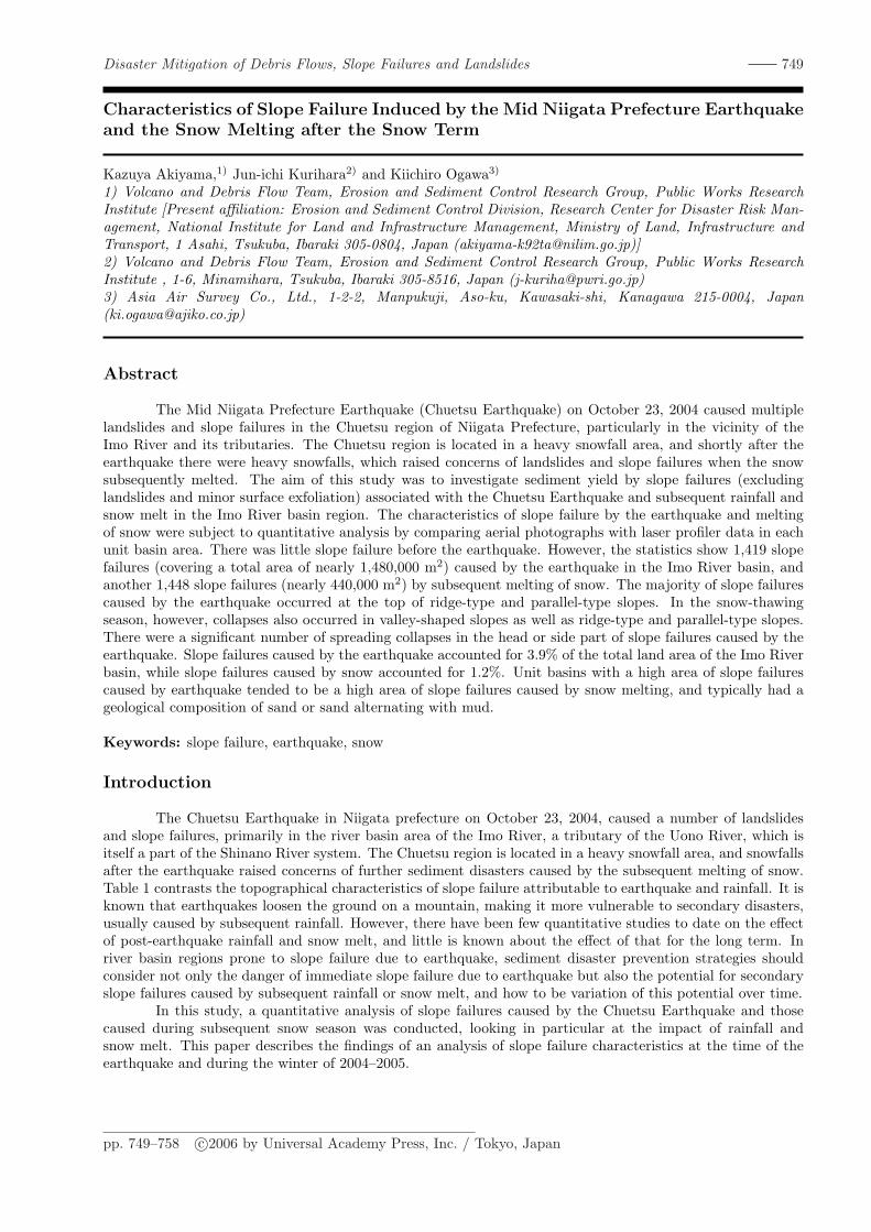
The Chuetsu Earthquake in Niigata prefecture on October 23, 2004, caused a number of landslidesand slope failures, primarily in the river basin area of the Imo River, a tributary of the Uono River, which isitself a part of the Shinano River system. The Chuetsu region is located in a heavy snowfall area, and snowfallsafter the earthquake raised concerns of further sediment disasters caused by the subsequent melting of snow.Table 1 contrasts the topographical characteristics of slope failure attributable to earthquake and rainfall. It isknown that earthquakes loosen the ground on a mountain, making it more vulnerable to secondary disasters,usually caused by subsequent rainfall. However, there have been few quantitative studies to date on the effectof post-earthquake rainfall and snow melt, and little is known about the effect of that for the long term. Inriver basin regions prone to slope failure due to earthquake, sediment disaster prevention strategies shouldconsider not only the danger of immediate slope failure due to earthquake but also the potential for secondaryslope failures caused by subsequent rainfall or snow melt, and how to be variation of this potential over time.
In this study, a quantitative analysis of slope failures caused by the Chuetsu Earthquake and thosecaused during subsequent snow season was conducted, looking in particular at the impact of rainfall andsnow melt. This paper describes the findings of an analysis of slope failure characteristics at the time of theearthquake and during the winter of 2004–2005.
pp. 749–758 c©2006 by Universal Academy Press, Inc. / Tokyo, Japan
750
Table 1. Characteristics of slope failure due by earthquake and rainfall
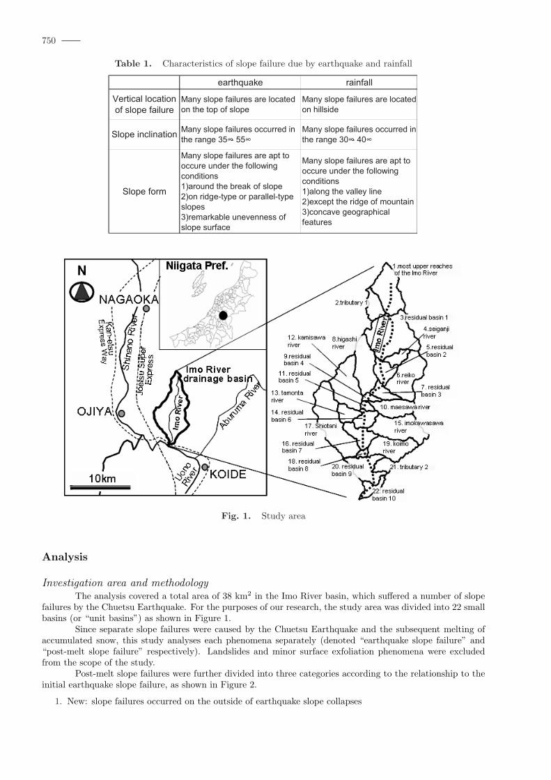
Fig. 1. Study area
Analysis
Investigation area and methodologyThe analysis covered a total area of 38 km2 in the Imo River basin, which suffered a number of slope
failures by the Chuetsu Earthquake. For the purposes of our research, the study area was divided into 22 smallbasins (or “unit basins”) as shown in Figure 1.
Since separate slope failures were caused by the Chuetsu Earthquake and the subsequent melting ofaccumulated snow, this study analyses each phenomena separately (denoted “earthquake slope failure” and“post-melt slope failure” respectively). Landslides and minor surface exfoliation phenomena were excludedfrom the scope of the study.
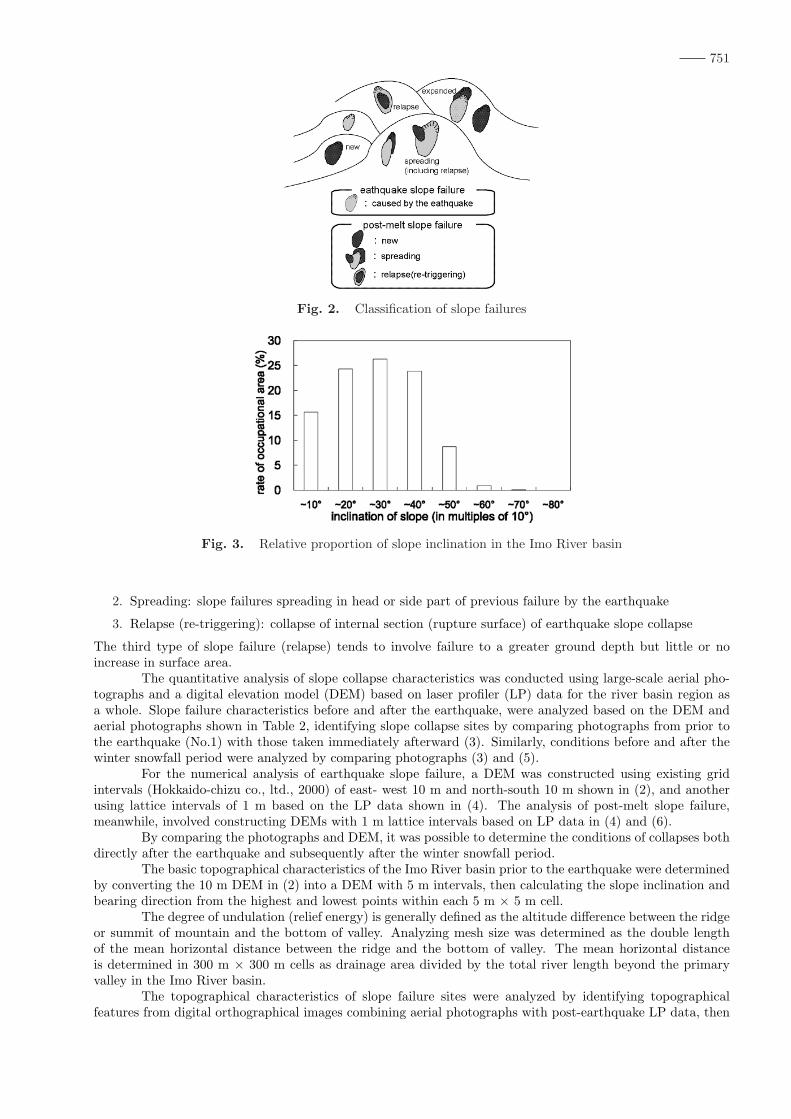
Post-melt slope failures were further divided into three categories according to the relationship to theinitial earthquake slope failure, as shown in Figure 2.
1. New: slope failures occurred on the outside of earthquake slope collapses
751
Fig. 2. Classification of slope failures
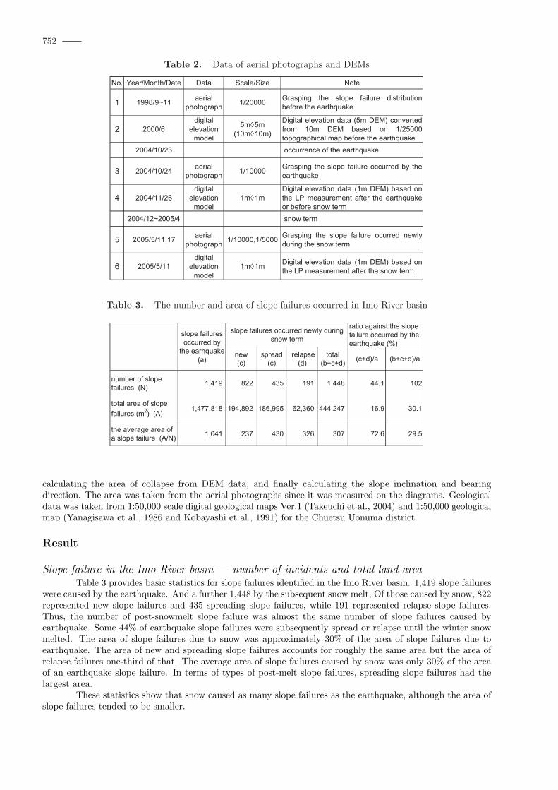
Fig. 3. Relative proportion of slope inclination in the Imo River basin
2. Spreading: slope failures spreading in head or side part of previous failure by the earthquake
3. Relapse (re-triggering): collapse of internal section (rupture surface) of earthquake slope collapse
The third type of slope failure (relapse) tends to involve failure to a greater ground depth but little or noincrease in surface area.
The quantitative analysis of slope collapse characteristics was conducted using large-scale aerial pho-tographs and a digital elevation model (DEM) based on laser profiler (LP) data for the river basin region asa whole. Slope failure characteristics before and after the earthquake, were analyzed based on the DEM andaerial photographs shown in Table 2, identifying slope collapse sites by comparing photographs from prior tothe earthquake (No.1) with those taken immediately afterward (3). Similarly, conditions before and after thewinter snowfall period were analyzed by comparing photographs (3) and (5).
For the numerical analysis of earthquake slope failure, a DEM was constructed using existing gridintervals (Hokkaido-chizu co., ltd., 2000) of east- west 10 m and north-south 10 m shown in (2), and anotherusing lattice intervals of 1 m based on the LP data shown in (4). The analysis of post-melt slope failure,meanwhile, involved constructing DEMs with 1 m lattice intervals based on LP data in (4) and (6).
By comparing the photographs and DEM, it was possible to determine the conditions of collapses bothdirectly after the earthquake and subsequently after the winter snowfall period.
The basic topographical characteristics of the Imo River basin prior to the earthquake were determinedby converting the 10 m DEM in (2) into a DEM with 5 m intervals, then calculating the slope inclination andbearing direction from the highest and lowest points within each 5 m × 5 m cell.
The degree of undulation (relief energy) is generally defined as the altitude difference between the ridgeor summit of mountain and the bottom of valley. Analyzing mesh size was determined as the double lengthof the mean horizontal distance between the ridge and the bottom of valley. The mean horizontal distanceis determined in 300 m × 300 m cells as drainage area divided by the total river length beyond the primaryvalley in the Imo River basin.
The topographical characteristics of slope failure sites were analyzed by identifying topographicalfeatures from digital orthographical images combining aerial photographs with post-earthquake LP data, then
752
Table 2. Data of aerial photographs and DEMs
Table 3. The number and area of slope failures occurred in Imo River basin
calculating the area of collapse from DEM data, and finally calculating the slope inclination and bearingdirection. The area was taken from the aerial photographs since it was measured on the diagrams. Geologicaldata was taken from 1:50,000 scale digital geological maps Ver.1 (Takeuchi et al., 2004) and 1:50,000 geologicalmap (Yanagisawa et al., 1986 and Kobayashi et al., 1991) for the Chuetsu Uonuma district.
Result
Slope failure in the Imo River basin — number of incidents and total land areaTable 3 provides basic statistics for slope failures identified in the Imo River basin. 1,419 slope failures
were caused by the earthquake. And a further 1,448 by the subsequent snow melt, Of those caused by snow, 822represented new slope failures and 435 spreading slope failures, while 191 represented relapse slope failures.Thus, the number of post-snowmelt slope failure was almost the same number of slope failures caused byearthquake. Some 44% of earthquake slope failures were subsequently spread or relapse until the winter snowmelted. The area of slope failures due to snow was approximately 30% of the area of slope failures due toearthquake. The area of new and spreading slope failures accounts for roughly the same area but the area ofrelapse failures one-third of that. The average area of slope failures caused by snow was only 30% of the areaof an earthquake slope failure. In terms of types of post-melt slope failures, spreading slope failures had thelargest area.
These statistics show that snow caused as many slope failures as the earthquake, although the area ofslope failures tended to be smaller.
753
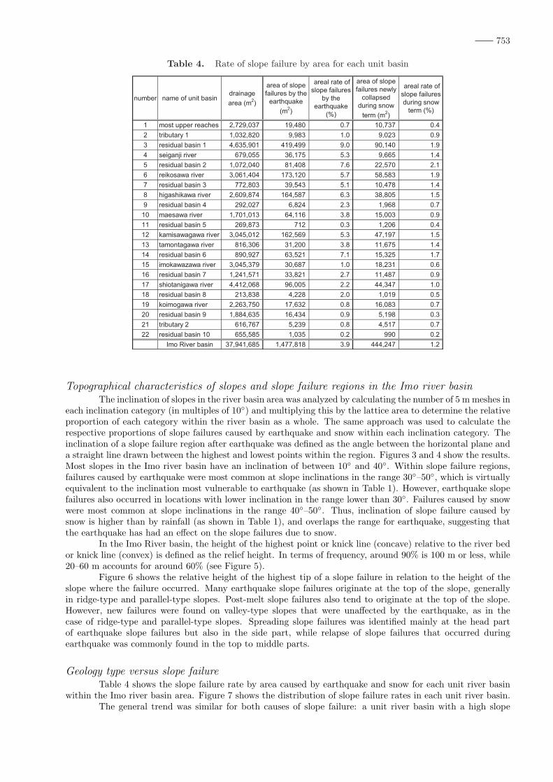
Table 4. Rate of slope failure by area for each unit basin
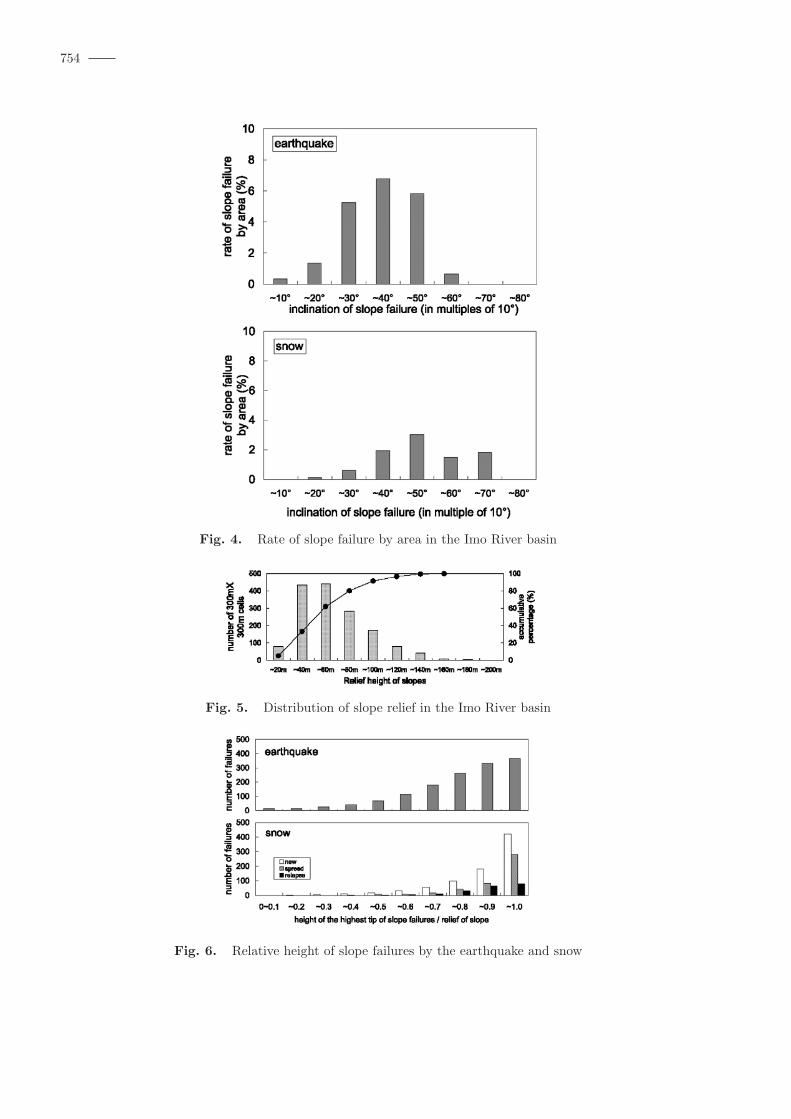
Topographical characteristics of slopes and slope failure regions in the Imo river basinThe inclination of slopes in the river basin area was analyzed by calculating the number of 5 m meshes in
each inclination category (in multiples of 10◦) and multiplying this by the lattice area to determine the relativeproportion of each category within the river basin as a whole. The same approach was used to calculate therespective proportions of slope failures caused by earthquake and snow within each inclination category. Theinclination of a slope failure region after earthquake was defined as the angle between the horizontal plane anda straight line drawn between the highest and lowest points within the region. Figures 3 and 4 show the results.Most slopes in the Imo river basin have an inclination of between 10◦ and 40◦. Within slope failure regions,failures caused by earthquake were most common at slope inclinations in the range 30◦–50◦, which is virtuallyequivalent to the inclination most vulnerable to earthquake (as shown in Table 1). However, earthquake slopefailures also occurred in locations with lower inclination in the range lower than 30◦. Failures caused by snowwere most common at slope inclinations in the range 40◦–50◦. Thus, inclination of slope failure caused bysnow is higher than by rainfall (as shown in Table 1), and overlaps the range for earthquake, suggesting thatthe earthquake has had an effect on the slope failures due to snow.
In the Imo River basin, the height of the highest point or knick line (concave) relative to the river bedor knick line (convex) is defined as the relief height. In terms of frequency, around 90% is 100 m or less, while20–60 m accounts for around 60% (see Figure 5).
Figure 6 shows the relative height of the highest tip of a slope failure in relation to the height of theslope where the failure occurred. Many earthquake slope failures originate at the top of the slope, generallyin ridge-type and parallel-type slopes. Post-melt slope failures also tend to originate at the top of the slope.However, new failures were found on valley-type slopes that were unaffected by the earthquake, as in thecase of ridge-type and parallel-type slopes. Spreading slope failures was identified mainly at the head partof earthquake slope failures but also in the side part, while relapse of slope failures that occurred duringearthquake was commonly found in the top to middle parts.
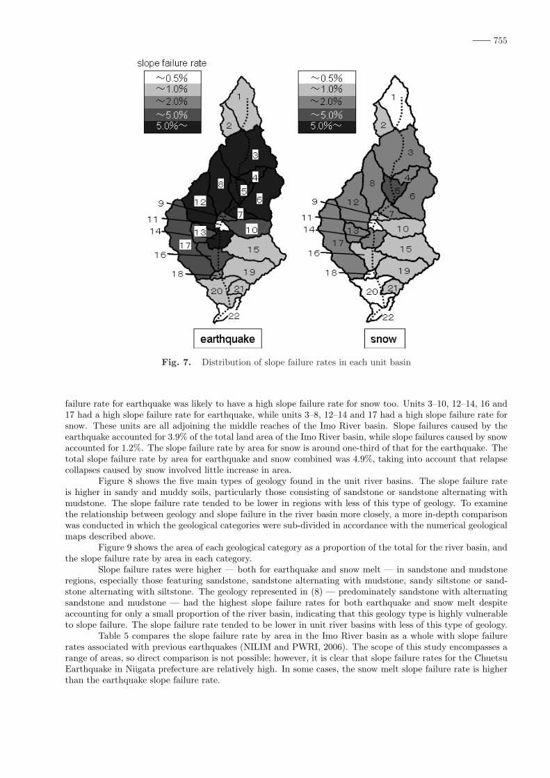
Geology type versus slope failureTable 4 shows the slope failure rate by area caused by earthquake and snow for each unit river basin
within the Imo river basin area. Figure 7 shows the distribution of slope failure rates in each unit river basin.The general trend was similar for both causes of slope failure: a unit river basin with a high slope
754
Fig. 4. Rate of slope failure by area in the Imo River basin
Fig. 5. Distribution of slope relief in the Imo River basin
Fig. 6. Relative height of slope failures by the earthquake and snow
755
Fig. 7. Distribution of slope failure rates in each unit basin
failure rate for earthquake was likely to have a high slope failure rate for snow too. Units 3–10, 12–14, 16 and17 had a high slope failure rate for earthquake, while units 3–8, 12–14 and 17 had a high slope failure rate forsnow. These units are all adjoining the middle reaches of the Imo River basin. Slope failures caused by theearthquake accounted for 3.9% of the total land area of the Imo River basin, while slope failures caused by snowaccounted for 1.2%. The slope failure rate by area for snow is around one-third of that for the earthquake. Thetotal slope failure rate by area for earthquake and snow combined was 4.9%, taking into account that relapsecollapses caused by snow involved little increase in area.
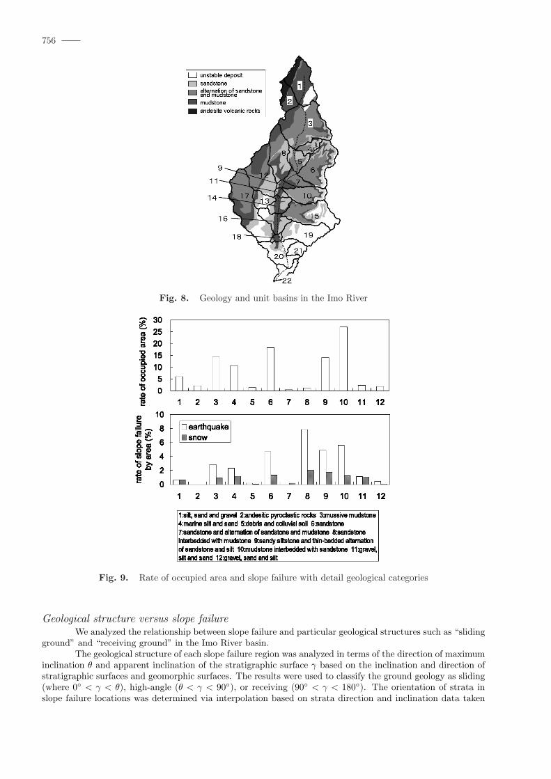
Figure 8 shows the five main types of geology found in the unit river basins. The slope failure rateis higher in sandy and muddy soils, particularly those consisting of sandstone or sandstone alternating withmudstone. The slope failure rate tended to be lower in regions with less of this type of geology. To examinethe relationship between geology and slope failure in the river basin more closely, a more in-depth comparisonwas conducted in which the geological categories were sub-divided in accordance with the numerical geologicalmaps described above.
Figure 9 shows the area of each geological category as a proportion of the total for the river basin, andthe slope failure rate by area in each category.
Slope failure rates were higher — both for earthquake and snow melt — in sandstone and mudstoneregions, especially those featuring sandstone, sandstone alternating with mudstone, sandy siltstone or sand-stone alternating with siltstone. The geology represented in (8) — predominately sandstone with alternatingsandstone and mudstone — had the highest slope failure rates for both earthquake and snow melt despiteaccounting for only a small proportion of the river basin, indicating that this geology type is highly vulnerableto slope failure. The slope failure rate tended to be lower in unit river basins with less of this type of geology.
Table 5 compares the slope failure rate by area in the Imo River basin as a whole with slope failurerates associated with previous earthquakes (NILIM and PWRI, 2006). The scope of this study encompasses arange of areas, so direct comparison is not possible; however, it is clear that slope failure rates for the ChuetsuEarthquake in Niigata prefecture are relatively high. In some cases, the snow melt slope failure rate is higherthan the earthquake slope failure rate.
756
Fig. 8. Geology and unit basins in the Imo River
Fig. 9. Rate of occupied area and slope failure with detail geological categories
Geological structure versus slope failureWe analyzed the relationship between slope failure and particular geological structures such as “sliding
ground” and “receiving ground” in the Imo River basin.The geological structure of each slope failure region was analyzed in terms of the direction of maximum
inclination θ and apparent inclination of the stratigraphic surface γ based on the inclination and direction ofstratigraphic surfaces and geomorphic surfaces. The results were used to classify the ground geology as sliding(where 0◦ < γ < θ), high-angle (θ < γ < 90◦), or receiving (90◦ < γ < 180◦). The orientation of strata inslope failure locations was determined via interpolation based on strata direction and inclination data taken
757
Table 5. Comparison of slope failure rates by area with the previous earthquakes
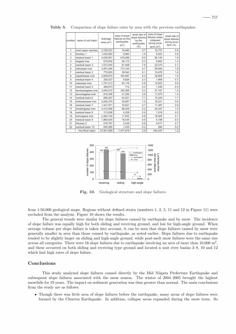
Fig. 10. Geological structure and slope failures
from 1:50,000 geological maps. Regions without defined strata (numbers 1, 2, 5, 11 and 12 in Figure 11) wereexcluded from the analysis. Figure 10 shows the results.
The general trends were similar for slope failures caused by earthquake and by snow. The incidenceof slope failure was equally high for both sliding and receiving ground, and low for high-angle ground. Whenaverage volume per slope failure is taken into account, it can be seen that slope failures caused by snow weregenerally smaller in area than those caused by earthquake, as noted earlier. Slope failures due to earthquaketended to be slightly larger on sliding and high-angle ground, while post-melt snow failures were the same sizeacross all categories. There were 16 slope failures due to earthquake involving an area of more than 10,000 m2,and these occurred on both sliding and receiving type ground and located n unit river basins 3–8, 10 and 12which had high rates of slope failure.
Conclusions
This study analyzed slope failures caused directly by the Mid Niigata Prefecture Earthquake andsubsequent slope failures associated with the snow season. The winter of 2004–2005 brought the highestsnowfalls for 19 years. The impact on sediment generation was thus greater than normal. The main conclusionsfrom the study are as follows:
• Though there was little area of slope failures before the earthquake, many areas of slope failures wereformed by the Chuetsu Earthquake. In addition, collapse areas expanded during the snow term. So

758
slope failures occurred during the snow term were taken an influence by the earthquake strongly.
• The rate of slope failure due to earthquake was 3.9% relative to the total land area of the Imo Riverbasin, while the slope failure rate due to snow was 1.2%. The total combined slope failure rate by areaafter all snow had melted was 4.9%. Snow caused around the same number of slope failures as theearthquake, but the post-melt slope failures were smaller — around 30% the size of earthquake slopefailures.
• Both earthquake and post-snowmelt slope failure rates were higher in areas with sandstone and mudstoneground.
In order to evaluate the impact of earthquake in mountainous regions, it is necessary to perform along-term tracking study of sediment movement, particularly with respect to movement of collapsed groundafter an earthquake.
References
Hokkaido-chizu co., ltd., (2000): GISMAP Terrain (Version 1.00)TAKEUCHI K., YANAGISAWA Y., MIYAZAKI J. and OZAKI M. (2004) : 1:50,000 Digital Geological Map of
the Uonuma region, Niigata Prefecture (Ver.1), GSJ Open-file Report, no. 412, Geological Survey of JapanYANAGISAWA Y., KOBAYASHI I., TAKEUCHI K., TATEISHI M., KAYAHARA K. and KATO H. (1986):
Geological sheet map 1:50000 “Ojiya” and explanatory text, Geological Survey of JapanKOBAYASHI I., TATEISHI M. YOSHIOKA T. and SHIMAZU M. (1991): Geological sheet map 1:50000
“Nagaoka” and explanatory text, Geological Survey of JapanNational Institute for Land and Infrastructure Management, Public Works Research Institute (2006): Report
on Damage to Infrastructures by the 2004 Mid Niigata Prefecture Earthquake, RESEARCH REPORT ofNILIM (No.27) and Research Report of PWRI (No.203), p.39–70. (in Japanese)