Embed Size (px)
Citation preview
CHAPTER XII
MISCELLANEOUS THEATRES
The following maps are relative to this chapter:—
Page
13. Iceland 48014. Malay Peninsula 484
Sketch Maps 15. Greece 48816. Sicily 49817. The Pacific facing 528
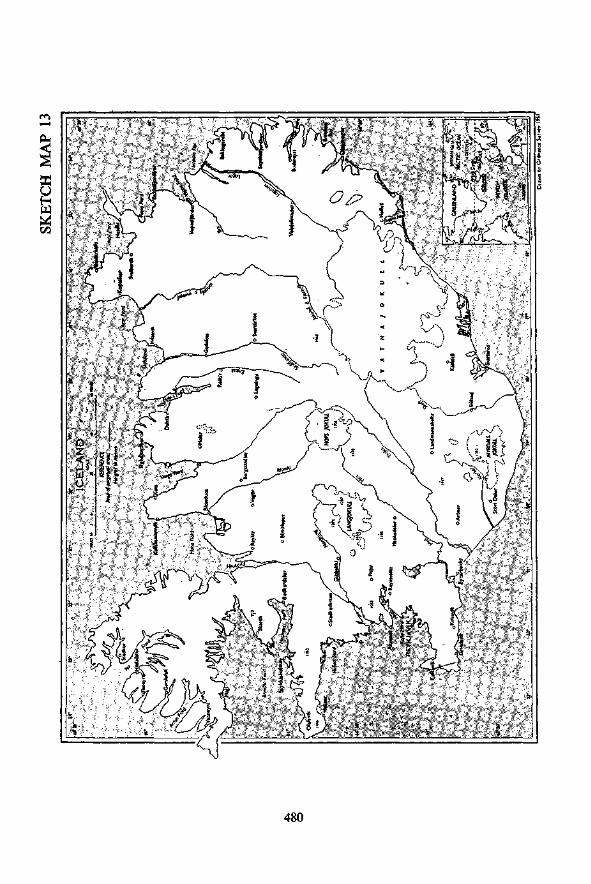
SECTION 1. ICELAND (See Sketch map No. 13)
Strategical BackgroundEarly in April, 1940, German forces invaded Norway. A small British Expe-ditionary Force which was sent over to assist the Norwegians had, by earlyMay, been forced to evacuate, and the enemy was left in control of Norwayand its seaboard.
The maintenance of sea communications between the United States andthe United Kingdom was vital to the prosecution of the war and, with Nor-wegian ports under German control, it was essential that the enemy should notbe permitted to occupy Iceland and establish air-bases there, from which theconvoy routes would be threatened.
In May, 1940, a British force landed in Iceland where, in conjunction withU.S. forces, they ensured its protection from German occupation.
Survey and mapping data available
There was little available in the way of maps or survey data. Some copiesof Icelandic maps on 1/50,000 and 1/100,000 scale had been reproduced by theWar Office in one colour from multi-coloured originals.
The origin of the projection used by the Icelandic Survey was known, butotherwise there were no triangulation data in our possession. The War Officehad prepared tables so that the geographical co-ordinates of trig points, whenthey were known, could be converted to the rectangular grid system which wasto be adopted for the island.
Arrival of 19 Field Survey Company R.E. in IcelandIn view of the lack of maps and other survey data, it was decided to send
out a survey unit. At that time 19 Field Survey Company, which had beenserving in France as a G.H.Q. (Army type) survey unit, had been evacuatedfrom Dunkirk with the remainder of the B.E.F., and was being re-formed.It was reorganized on a reduced establishment for duty in Iceland, and landedthere at the end of July, 1940, under the command of Major R. H. Denniss, R.E.
479
4
480

The unit was organized as follows:—Headquarters
2 Topographical sections.1 Drawing section.1 Printing section.
Transport1 Utility car.5 Motor-cycles.22 Cycles.
Accommodation was scarce, and there was much competition for whatlittle there was. Eventually a suitable building with a concrete floor wasobtained and, as soon as the technical equipment arrived, the printing machinesand ancillary plant were installed. For some time the personnel of the unitlived under canvas. Later on they erected Nissen huts on an open site adjoiningtheir working accommodation.
Triangulation data and field surveys
Early contact was made with H.M.S. Challenger, which was engaged onsurvey work off Reykjavik, the capital, and a most useful liaison was established.Through the Commander, access was obtained to a book which contained acomplete list of all trig points on the island, with their positions given in latitudesand longitudes. These values were converted to rectangular co-ordinates on thelocal grid, and they proved to be a sound basis for all subsequent survey work.
A conference was then held with the artillery staff to decide on a programmeof survey work which would be of assistance to them. The fixation of gunpositions, and the lay-out of bearings in terms of the map grid, was the firsttask undertaken by the topographical sections. Survey and levelling were alsocarried out in connection with airfield construction and the development ofNaval Base projects and artillery ranges.
Most of the trig points listed in the book were well marked by cairns, wereeasily found, and their reliability and accuracy were found to be satisfactory.Unfortunately, some of the cairns were tampered with and damaged by theoccupying troops, who did not realize their significance, and orders wereissued from H.Q. warning all concerned not to interfere with them.
Mapping
1/25000 maps of the Reykjavik area. The first task was to produce 1/25,000maps of the Reykjavik area. For this work the trig control formed a soundfoundation, and the topographical sections surveyed the area, mainly by plane-table methods. The personnel of these sections, as was found in most othertheatres, had little skill or experience in plane-tabling work, and progress onthe first two sheets was very slow. The contouring in somewhat difficult countryseemed to be the main source of difficulty and delay. The experience gainedwhilst doing these first two sheets was, however, invaluable, and succeedingsheets went much more quickly.
The drawing section was employed at first on hut erection until field sheetmaterial became available from the topographical sections, after which theywere fully employed on fair-drawing and map compilation.
Air photographs. When 19 Field Survey Company first arrived in Iceland,there were no R.A.F. units. There was, however, a detachment of the Fleet
481

Air Arm which undertook a small programme of air photography for mappingpurposes. After covering the town of Reykjavik itself, they photographedother small areas including the site for a proposed airfield. These photoswere used for the preparation of a town plan of Reykjavik and, in combinationwith the plane-table field sheets, greatly assisted in the compilation of the1/25,000 maps of the area around the capital.
1/100,000 maps of eastern Iceland. The H.Q. staff was anxious to havemaps covering the eastern coastal area of the island. While on a visit to theState Engineer's office, the O.C. 19 Company saw some new-looking mapsheets lying on a table. These were proofs, which had been received fromDenmark, of a survey covering the area in question which had not yet beenpublished. After some persuasion the State Engineer lent him the material,and this enabled two 1/100,000 sheets to be prepared. When the State Engineerwas given proofs of these new sheets, he was so delighted with them that anyprevious hesitation there may have been to co-operate was at once removed,and material for about 20 more 1/100,000 sheets was forthcoming immediately.
Other mapping projects. Once the unit had got into its stride, and hadshown what it was capable of doing, there was the usual demand for the pro-duction of special maps, overprints, administrative diagrams, technical sketchmaps, etc.
Amongst the many topographical maps published were the following,additional to those referred to above:—
1/50,000. 13 sheets, gridded.1/250,000. 5 sheets (ungridded).1/600,000 (Air). Compiled by the Air Ministry.1/1,000,000. Compiled, printed and issued.1/5,000. Town plan of Reykjavik.
Reproduction
When the printing equipment was received, it was found that the drivingmotors were not suitable for the local power supply. Apparently the unit didnot take its own power generator with it, and was not, therefore, independentof local variations of voltage. A new starter coil had to be ordered from theUnited Kingdom and the unit electrician was able to carry out the necessaryadjustments to the motors.
In the case of the guillotine, which was packed up in two separate cases,it was found that the parts contained in each case belonged to two differenttypes of guillotine with the result that it could not be assembled.
Graining marbles proved a source of difficulty. The small quantity takenout with the equipment soon wore small, none could be obtained locally, anda new supply obtained from home arrived only just in time to prevent a completebreakdown in the printing programme.
Transport
The transport with which the unit was equipped was quite inadequate forthe tasks it had to undertake in Iceland. The push-cycles certainly served auseful purpose for local recreation and for work on the town plan of Reykjavik,but they were quite useless otherwise. The R.A.S.C. were most helpful, anddid their utmost to provide truck transport when it could be spared. In acountry where the weather was very uncertain and where, in winter, the days
482

were so short, the provision of suitable transport for quick movement overdifficult country was essential.
Eventually the unit received further transport though, by the time it arrived,most of the work had been completed.
Final remarks
19 Field Survey Company returned to the United Kingdom from Icelandin the spring of 1941. During its short stay in the island it had, by its workingachievements, and by establishing cordial relations with other units, won itsrightful position as an essential and popular unit of the occupational force.
There was no survey officer on the staff of Force H.Q., and at first therewas, somewhat naturally at that early stage of the war, a certain amount ofignorance and doubt about why a survey unit had been sent there, and whatwere its functions.
Some of the early difficulties might possibly have been avoided or easedif the unit commander, in addition to his duties as such, had been nominated asa survey staff officer at Force H.Q.
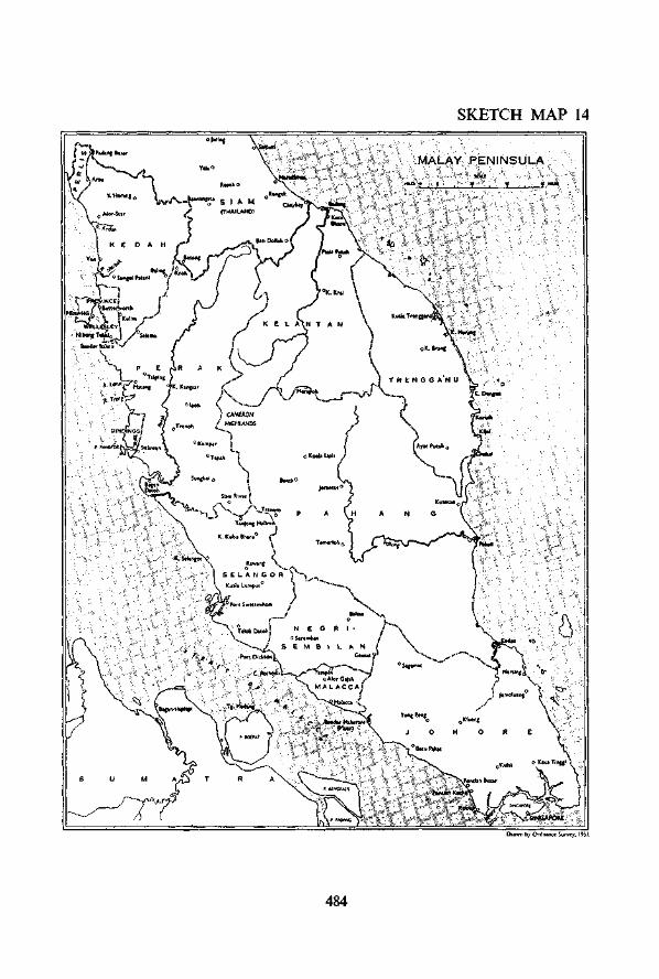
SECTION 2. MALAYA (see Sketch Map No. 14)
Introduction
Until the Japanese occupation in February, 1942, Malaya consisted of thefollowing:—
(a) The Straits Settlements—Singapore, Penang, Malacca, and ProvinceWellesley.
(b) The Federated Malay States—Perak, Selangor, Pahang and NegriSembilan.
(c) The Unfederated Malay States—Johore, Kedah, Perlis, Kelantan andTrengganu.
Pre-war survey organization
PERSONNEL AND FUNCTIONS
The Federated Malay States and Straits Settlements Survey Department,under the Surveyor General, was responsible for all Title Surveys.
For each of the Unfederated Malay States an officer of the SurveyDepartment was appointed by the Surveyor General as Chief Surveyor. Asa result, all surveys in Malaya were, in effect, controlled by the Surveyor Generalwho had his H.Q. at Kuala Lumpur.
The personnel of the department consisted of some 65 Europeans, about800 locally recruited personnel, and nearly 2,000 temporary employees andcoolies.
The principal functions of the department were:—
(a) The execution and maintenance of the trigonometrical framework.(b) Cadastral and topographical surveys.(c) Map production.(d) Provision and custody of survey records for land administration.(e) Meteorological service.( /) Security printing (bonds, currency notes, stamps, etc.).
483
SKETCH MAP 14
Dnwn by Ordnante Surve^, 1951.
484
TRIANGULATION AND TOPOGRAPHY
Most of the geodetic work had been completed before 1941, and the depart-ment was chiefly engaged in cadastral and revenue surveys and topographicalmapping.
The completed geodetic work had left well-constructed beacons on all theprominent hill and mountain tops, and permanent marks along many roadsand railways, thus providing an accurate and fairly dense framework controlfor local surveys.
About 60 per cent of the country had been topographically surveyed andcovered with published maps.
PREPARATIONS FOR WAR
In 1939, when war in Europe seemed to be a foregone conclusion, the Sur-veyor General issued a memorandum outlining action that should be taken inthe event of hostilities spreading to the Far East.
The Military Command in Malaya was notified with regard to thefollowing:—
(a) The existing map position for military purposes.(b) The potential production output of the map production branch.(c) The situation regarding stocks of paper and other printing requisites.(d) The steps planned to be taken, if necessary, to deny maps and repro-
duction material to an enemy.(e) The Department's resources in the way of instrument repair and
recovery.if) The proposals to form a military survey section from personnel of the
Department.
SURVEY CONFERENCE AT NEW DELHI
In January, 1941, the Surveyor General attended a Survey Conference in NewDelhi where plans were discussed for co-operation and the co-ordination ofsurvey and mapping resources between India, Middle East and Malaya. TheSurveyor General agreed to send mapping material to India for the productionthere of certain maps on various scales and of certain types not producedlocally. He stated at the conference that, unless extensive military reinforce-ments arrived in Malaya, it could be regarded as entirely self-supporting inrespect of Malayan maps.
Survey activities during the campaign (December, 1941-February, 1942)The Japanese opened hostilities against the United States when they launched
their air attack against Pearl Harbour on 7th December, 1941, and declaredwar against Britain. During succeeding days they attacked many British andAmerican possessions in the Far East, and Dutch possessions in the EastIndies. Japanese forces landed in north-eastern Malaya on 8th December, andstarted their drive to the south.
Allied operations in Malaya and the Dutch East Indies were co-ordinatedby South West Pacific Command with Headquarters in Java, to which ColonelG. Bomford (from Survey of India) was appointed as D.D. Survey. Thefollowing gives a brief summary of the principal survey activities in connectionwith the short campaign which ended with the surrender of Singapore on 15thFebruary, 1942.
485

(a) Various surveys were undertaken for the Army including the fixationof a large number of bearing pickets for artillery use. These picketswere numbered and tabulated so that bearings could be rapidly obtained.
(b) Practically all the senior officers of the Survey Department were membersof the local volunteer force, local defence corps, or other auxiliaryservice.
(c) Four senior survey officers were sent to India to study air survey mappingmethods, and an air survey expert was recruited who undertook thetraining of selected locally engaged survey officers.
(d) Towards the end of December a Malayan Field Survey Company wasformed. This was recruited from personnel of the Survey Departmentand was intended to serve as a unit of the F.M.S. Volunteer Force.
The establishment of the unit was as under:—H.Q. section,General section,2 ground survey sections,Air survey section,Reproduction section.
numbering 10 officers and about 400 other ranks.Embodiment and training began in December, but the rapid development
of the campaign at that time prevented it from being used in its intendedcapacity. However, with an officer establishment specially increased to 20and some 200 O.R.s, it served efficiently with the British force in Malaya duringthe fighting retirement through the mainland. On reaching Singapore, a detach-ment worked on co-ordinating anti-aircraft battery positions, and mannedobservation posts for flash spotting and counter-battery work.
Map production was carried on in Kuala Lumpur until the tide of warnecessitated a withdrawal to Singapore. At Singapore, maps were rolled offthe presses until a few days before the surrender, when production was stoppedso that the plans for denying maps and machinery to the enemy could be carriedout.
The Survey Company was then disbanded, and a large number of the nativeO.R.s found their way back to their homes on the mainland and managed toevade the prisoner-of-war camps. Almost all the officers were taken prisoner.
In January, 1942, an attempt was made to set up a map production branchin Java, and certain senior officers were sent there for that purpose. Someseven tons of survey records were crated, loaded and despatched to Java. Butthe end came too quickly, and fortunately the survey stores and records werenever uncrated. They were sent to Australia for safety, and were handed overto the Australian forces. At the end of the war in 1945, they were returned toMalaya, and their preservation was of inestimable value towards the post-warreconstruction of the Survey Department.
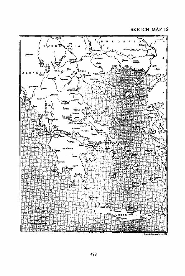
SECTION 3. GREECE (see Sketch Map No. 15)
Summary of survey activities during the campaignThe Italians attacked Greece in the autumn of 1940, and during the winter
months of 1940-41 the Greek Army put up a gallant fight. Then, in the first
486
week of April, 1941, just at a time when the German counter-offensive waslaunched in the Western Desert, German forces invaded Yugoslavia and movedthrough into Greece. A small British Expeditionary Force had, at that difficultmoment, to be sent across from Egypt to assist the Greeks.
The mapping preparations which were undertaken for the campaign, andthe arrangements for map distribution, are described in later paragraphs.Colonel M. Hotine, who had been D.D. Survey with the force in East Africa,was assigned to the Greek Expeditionary Force for survey duties and thefollowing survey units were included in the order of battle:—
Survey Directorate.Mobile Echelon, 512 (Army) Field Survey Company R.E. (less two
sections).517 (Corps) Field Survey Company R.E.9 Field Survey Depot R.E.1 Australian (Corps) Field Survey Company.
1 Australian Field Survey Company, though it never actually reachedGreece, was intended to function as Australian corps troops, but it was agreedin principle that it should remain in the base area under Force control. Thereasons for this decision were the inadvisability of sending heavy trailer-borneprinting equipment forward on bad roads in a campaign which was most likelyto prove very mobile, the necessity for spreading survey resources over the needsof the whole Force, and the fact that local map production would requirematerial at very short notice from the Greek Survey Department in Athens.Actually this unit, which arrived in Egypt too late and without full equipment,did not sail to Greece which, as events turned out, was just as well.
Preceded by a small advanced party, the main body of the Mobile Echelonof 512 Field Survey Company landed in the Piraeus at the end of March. Thetopographical sections were employed on anti-aircraft gun-position surveysnear Athens and the Piraeus, Greek officers assisting in the identification oftrig points. Miscellaneous drawing and computing tasks were undertaken,and some of the personnel was used as reinforcement to the map depots. Airphotographs of the Struma Valley were sorted out and indexed, and existingmaps were revised. Photographic mosaics of selected areas were made up.If the personnel of these topographical sections had been given fuller trainingas draughtsmen and air-photo plotters, more could have been achieved duringthe campaign. Continued experience during the war in other theatres indicatedthat trig surveys, though often essential, do not as a rule provide full-timeemployment, and a wider basis of training for topographical section personnelon less specialist lines was found to be necessary.
512 Field Survey Company packed up for evacuation on 23rd April, but theGerman advance was so rapid that many of the personnel were taken prisoner.
517 Field Survey Company R.E. had arrived in Egypt without its printingequipment, but provisional arrangements were made for the use of local plantin Athens. The unit (less conductors for the technical lorries) sailed in one ofthe later convoys to Greece. Unfortunately, the technical stores of the printingand drawing sections were loaded in another ship and were lost at sea by'enemyaction. Leaving its topographical sections to continue work in Greece, theunit was sent back to Egypt a few days before general evacuation was ordered.Many of the topographical section personnel were taken prisoner.
487
SKETCH MAP 15
OTIRANA
Ordunce Survey. l»l .
488
Mapping preparations by the War Office
For possible operations in Greece the following maps had been includedby the War Office in their mapping programme:—
(a) International 1/1,000,000.(b) GSGS 4088 (1/250,000). 23 sheets covering the Balkans between
approximately the latitudes of Volos and Sofia.(c) GSGS 4087 (1/100,000). 31 sheets between the latitudes of Volos
and the northern frontier of Greece.(d) 1/500,000 air maps covering the Balkans.
Preparation of the 1/250,000 and 1/100,000 maps was started in December,1939, and it was proposed to forward initial stocks of 3,000 copies of each sheetto the Middle East, together with black pulls for local reproduction. Some ofthe sheets and reproduction material had not arrived when the operations inGreece began.
Local mapping investigations in the Middle East
When the Italian offensive started in the autumn of 1940, it seemed possiblethat Greece, and perhaps the Balkans as a whole, might become a major theatreof operations with German forces coming down from the north.
A British Military Mission was sent to Greece to study conditions andcollect information. It was unfortunate that no survey officer accompaniedthis mission. G.H.Q. Middle East did, however, send over a survey officeron short hurried visits to enquire into the latest Greek mapping situation. Heobtained some valuable data from the Greek General Staff and ServiceGeographique, but a good deal of essential information was necessarily missedin the course of these short visits for which the officer could with difficultybe spared from the overworked Survey Directorate in Cairo. It seems a pitythat a qualified survey officer could not have been sent out from the UnitedKingdom to accompany the Mission to Greece. He could have thoroughlyexamined the mapping situation, and eventually have been appointed to theSurvey Directorate which operated there during the campaign. Wisdom afterthe event is easy, but the lesson should not be overlooked on future similaroccasions.
The visiting officer from Cairo obtained reproduction material for foursheets of the 1/400,000 Greek staff map covering Albania, East and WestMacedonia, and western Thrace. Material for local reproduction of theGreek 1/100,000 series was also acquired. It should be noted here that theGSGS 4087 edition of the 1/100,000 series was made up on sheet lines whichwere different from those used by the Greeks themselves. This aspect will beenlarged upon later.
The Greek maps were, of course, printed with the names in Greek characters.As, however, British forces might have to use these maps, arrangements weremade to have the names transliterated. This work started in November, 1940,under a specially appointed gazetteer officer who had experience of similar workin Greece. He completed the four 1/400,000 sheets before being transferred toother duty. The work was then carried on by local Greek personnel.
In January, 1941, a signal from the War Office stated that revised name-traces had been completed and were being flown out. G.H.Q. Middle East
489

was asked to adopt these transliterations so as to avoid differences in names onpublished maps. The maps for which revised name-traces were being sentout from the War Office included three sheets of the 1/400,000 series and the1/250,000 series. The name-traces arrived in Cairo at the end of January,1941, by which time many copies of the current printed stock had already beenissued. It was obvious that many corrections were necessary but the late arrivalof the black pulls delayed the start of the revision programme.
In the meantime, at a conference between the General Staff at G.H.Q.and the Director of Survey, it was decided that the map policy for any operationswhich might take place in Greece would be as follows:—
(a) To use reproductions of the Greek maps as the main supply. Thesewere to include the 1/400,000, 1/100,000 and 1/50,000 (where the latterwere available).
(b) Names would be transliterated into English. The War Office versionwould be used when time permitted, but the Survey Directorate versionwould be adopted to save time in emergency.
(c) Until the local reproductions from the Greek maps were ready, the WarOffice 1/100,000 and 1/250,000 series would be used. These would besuperseded by the Middle East edition when published.
The action taken in Cairo to reproduce the Greek maps consequent on theabove decisions will be described later.
Comments on the G.S.G.S. maps of GreeceThe following comments may afford some lessons for future guidance.Comparison between the G.S.G.S. map series and the mapping material
obtained from Greece itself showed much discrepancy in detail, and the situationwas disturbing even before the operations started.
As in the case of Belgium and Holland, who before the German invasionin 1940 preferred the myth of neutrality to co-operative action, it seems thatthe War Office found that Greece also was unwilling, before the war, to supplyup-to-date mapping material. The G.S.G.S. maps, which were begun late in1939, had therefore to be compiled from whatever Greek maps were availablein the War Office map library and these were in many cases sadly out of date.
As a result the maps were inaccurate with regard to communications.Not only were several important roads omitted, but certain roads were includedas apparently important ones which never existed at all. In any country,especially the Balkans, where good roads are not numerous, it is obvious thataccurate road information is of particular importance. The G.S.G.S. sheetshad apparently not been subjected to any road revision based on recent intelli-gence information.
The first troops to move forward to the concentration area in Greece werean armoured brigade, which commented unfavourably on the 1/100,000 maps,and asked that they should be supplied with copies of the national Greek series.There is often a tendency for British troops operating in a foreign country tojump to the conclusion that the local maps must necessarily be better than thosespecially prepared for them. Generally speaking this criticism is quite un-justified. In this particular case, however, the complaint, which soon becameuniversal, was a fair one. In fact the G.S.G.S. 1/250,000 and 1/100,000 mapsof the same area often disagreed between themselves.
490

It is probable that many of the defects were caused by using provisionalone-colour editions as basic material, when clearer material in colour wasavailable in Greece. The peace-time system of relying solely on the openmap market, or the part-time service of a non-technical Military Attache, toobtain cartographic material of a foreign country was also probably to blame.This is a lesson which will, no doubt, be taken note of when considering post-war policy for collecting map material.
With regard to the sheet-line system for a map series, there have alwaysbeen two schools of thought on the subject. One opinion favours an alterationof the sheet lines bounding the national map sheets so as to conform to thegrid system adopted for the British military maps. By this means the shapeof the sheet.is recast so as to become truly rectangular and bounded by exactgrid lines. This conversion from graticule to grid sheet lines undoubtedlyhas certain conveniences, and amongst these is the fact that large sheets canbe made up which economize in paper and printing time. The opposite schoolof thought favours the retention of the original national sheet lines as they stand.This means that, in some cases, uneconomically small sheets have to be used,and the grid, when incorporated or overprinted on the face of the map, will oftenlie askew to the sheet edges.
Considerable experience during the war has shown that, generally speaking,it is better to retain the national sheet lines. The overriding advantage is that,if and when a more recent edition of a national sheet is obtained, it can berapidly reproduced and used in conjunction with the other sheets of theG.S.G.S. series by simply suppressing the out-of-date sheet concerned.
The decision to discard the national Greek sheet lines made it very difficultto improve the series by the rapid substitution of newer and better sheets whenthey became available. The arguments in favour of altering sheet lines, namelythe convenience of grid as opposed to graticule edges, and the saving of paperand machine-time by making up larger sheets, do not work out in practice.There is no convenience in being forced to use out-of-date maps for militaryoperations, nor is there any economy in drawing, printing and shipping anentire series of maps which may have to be almost immediately superseded.In Greece, the effects of this error of judgment went even deeper than mere waste.Until a sufficient extent of the area of operations had been completely coveredby the newly reproduced Greek sheets, it was necessary to keep both seriesin issue concurrently which, as may be imagined, involved much confusion.
The order in which the sheets were received in the Middle East did not,unfortunately, conform to the changing military situation. Maps of westernThrace were available early, although operations in that area by British troopswere not contemplated, and those of, the Struma, Vardar and Aliakmon valleyswere either not in time, or only just so. For southern Greece no G.S.G.S.maps were produced at all.
Production of Greek maps in the Middle EastWhen active preparations for the campaign in Greece were initiated,
the discrepancies between the G.S.G.S. maps and those obtained from Greecewere not at first fully appreciated. This was owing to the fact that some ofthe most important sheets of the 1/100,000 series had not been received from theUnited Kingdom.
A comparison between available G.S.G.S. sheets and the latest obtainedGreek material was not reassuring. For this reason, as well as to ensure that
491
maps of some sort should be available to cover the areas of those War Officesheets which had not yet arrived, local production started on a new 1/100,000series, on Greek national sheet lines, by direct reproduction from black pullsobtained from the Greek Survey Department. These new sheets carriedtransliterated names and the British grid.
It was decided to extend this new series rapidly so as to replace the G.S.G.S.maps in all likely operational areas. Although this was not done in time forthe concentration period, it was, for the most part, completed in time for activeoperations.
Action was also taken by the Survey Directorate to cover southern Greecewith three new 1/250,000 sheets, priority being given to a large sheet extendingthe G.S.G.S. 1/250,000 series south-eastwards to include Athens. Until thissheet could be made available, stocks of tourist and motor maps were purchasedlocally in Athens for the forward moves of units to the concentration area.There was no time to grid these, which were intended solely for unopposedmovement.
Road sketch maps on a scale of 1/750,000 (with certain forward areas on1/100,000) had been prepared in Athens immediately before the despatch of theExpeditionary Force to Greece, and they were reproduced in Cairo. They werenaturally assumed to be correct and were widely issued. When complaints aboutthese maps from the armoured brigade had been investigated, it was found thatthey had not been based on actual reconnaissance, either by the Military Attacheor by the Military Mission. Road information had been obtained from theGreek Survey Department who, apart from hearsay, did not claim to possess anypositive information later than the last topographical revision. Immediateaction was then taken by the Survey Directorate in Athens to obtain all availablestocks of the Greek Ministry of Communications road maps on 1/500,000 scale,and to issue these maps, in necessarily limited quantities, to all headquarterspending reprint with the British grid. This map was compiled from annualreports of road engineers and could have been brought up to date by calling forspecial reports. By then, however, it was too late to take such action.
On future similar occasions it would seem advisable that a competentsurvey officer should be included in any Military Mission which may be sentto effect liaison with an allied government. Not only would he be well placedto obtain the most up-to-date road information possibly checked by personalreconnaissance; he would also, by close continuous touch with the local SurveyDepartment, be able to secure information and material vital to the formulationof a proper mapping programme and survey plan. It has been proved frommuch war experience that these matters are outside the sphere of the normalIntelligence organization, and the importance of obtaining the most reliabletechnical survey information both for planning and for the subsequent conductof operations can hardly be over-emphasized.
Air photography and large scale mapping
A few odd strips of vertical photographs had been taken for generalreconnaissance purposes before the arrival of the Survey Directorate in Greece.Copies of these were sent to Cairo to assist map revision, and strip-maps wereplotted from them in Cairo.
Arrangements were made for 113 Squadron R.A.F. to photograph probabletarget and counter-battery areas in accordance with the original plan to occupya defensive position behind the Aliakmon River between Veroia and the sea.
492

1/25,000 maps were plotted from these photographs in Cairo, and were dis-tributed just in time. They were not, however, much used because, owing tothe main axis of the German offensive being directed through the MonastirGap, no serious attempt was made to defend this position. Arrangementshad also been made for photography in the Ptolemais area and for certainsections of the Olympus-Aliakmon position, which was seriously defended.But although some of the photographs were taken before the outbreak ofactive hostilities they were not available in time.
The sudden change in the Yugoslav political situation resulted in preparationsbeing ordered for a defensive position west of the R. Struma covering Salonika,and photography of this area was about half-completed. 1/25,000 plottingfrom these photographs in Cairo was, as it turned out, rightly given prioritybelow the Aliakmon area and was not taken up. The photographs were,however, used for the revision of 1/100,000 and 1/50,000 maps. Photographsastride the Axios River, which had been extensively canalized, were also usedfor map revision.
The above photography was carried out by a bomber squadron. Thepilots had not been specially trained for the special type of strip navigationthat is required for survey photography, and there was, in consequence, theusual waste of effort on this account. The ground organization of the squadronalso was inadequate to deal with large areas of photography. If a suitableand properly equipped unit had been available for survey photography at theproper time, that is, well before the emergency arose, all likely areas could havebeen efficiently photographed long before the despatch of the ExpeditionaryForce. As it was, photography had to be improvised too late, and no amountof keen and willing co-operation, which was most certainly afforded in fullmeasure by the squadron, could make up for this. This lesson was a recurrentone in all operational theatres.
In Greece there were no resources for local mapping from air photographs.In any case it would not have been right to have included heavily equippedsurvey units in the early convoys.
Provision of 1/50,000 maps
As an insurance against lack of photography for 1/25,000 mapping and pos-sible non-arrival of new 1/100,000 sheets, it was decided to attempt the provisionof a 1/50,000 series. The original Greek surveys were carried out on a scale of1/50,000, with some areas at 1/20,000. Some of the 1/50,000 sheets, mainly inthe frontier areas had already been drawn in various styles and issued in limitedquantities to the Greek Army. These were reprinted, where required, by theGreek Service Geographique, with an overprint of the British grid, captions,and a few transliterated names, the overprint drawing being done by the fewdraughtsmen available to the Survey Directorate. Where the sheets were inone colour only, considerable clarification was obtained by red overprints ona steel-grey base. Where no 1/50,000 sheets had been drawn, the originalplane-table sheets were assembled and photographed. In all cases, revisionfrom any available photographs was added either on the base map or on theoverprint.
About 50 sheets on 1/50,000 scale were produced in five weeks, and, forthe most part, were used in active operations. They were an instant success.Much praise and credit was due to the spirit of co-operation and technical skill
493

displayed in the publication of this makeshift series by the Greek ServiceGeographique, in spite of its poor equipment.
Air maps
The Air Ministry 1/500,000 series of the Balkans had been prepared primarilyfor navigational purposes. Topographical detail had been simplified andgeneralized almost to diagrammatic form. In war, however, there is more thanease of navigation to be considered. Pre-war ideas regarding the employmentof air forces, particularly in connection with army co-operation, were, by 1941,undergoing radical changes. It was necessary, at little notice, to identifysmall villages or minor cross-roads, whether as targets for air attack, or as keysfor reconnaissance. In France and Belgium, during the B.E.F. operations of1939-40, the air component had largely discarded the use of the 1/250,000Air Series of north-western Europe in favour of oidinary detailed topographicalmaps. Largely for this reason the 1/500,000 Air Ministry maps were not usedin Greece. Another reason was that they carried inaccurate air information,and showed Greek and Turkish airfields, which was prejudicial to security.
The 1/400,000 Greek air map had been reproduced in Cairo and suppliedto the Air Force during the Albanian campaign, since this was the only up-to-date map of Greece on small scale that was then available. For operationsagainst the Germans, however, ordinary military maps on scales ranging from1/1,000,000 to 1/50,000 were mostly used by the R.A.F.
Map distribution
For security reasons, no initial distribution of maps of any sort whateverwas allowed before the embarkation of units from Egypt during the first weekof April, 1941. Consequently, it was necessary to arrange for initial issues tobe made immediately the units disembarked in Greece, and before the head-quarters of subordinate formations were installed. The initial plan covereddisembarkation at the Piraeus, Volos and Salonika; but this was altered, andthe force landed principally at the Piraeus, making map issue somewhat easier.If early disembarkation had taken place at Volos and Salonika as well as atthe Piraeus, map distribution would have offered a very difficult problem, andit might have been necessary to press for initial pre-embarkation issues insealed bundles at Alexandria, as was done for later operations involving a seajourney. Later, however, owing to heavy air attacks on the Piraeus, certainunits did have to be diverted to Volos and Khalkis, and the necessary arrange-ments to issue them with their maps on landing were made by the SurveyDirectorate and No. 9 Field Survey Depot. Neither organization was thenup to strength, and the dispersion of effort was a heavy strain on their resourcesat a time when, owing to air attacks on the ports, map consignments had to becleared quickly, and duplicate map depots established, to minimize the risk oftotal loss of stocks.
Owing to scanty supply, the initial issue was at the rate of about 15 per centof the then current War Office scale of map issues. This allowed about onecopy of each map sheet to each officer. When units had moved forward, issuesof fresh sheets were made through headquarters of formations in the normalway. An advanced map depot was set up in the Australian Corps area andwas controlled from Corps H.Q. where there was survey representation. This
494
facilitated a decentralization of distribution to the forward troops, and workedsatisfactorily during the period of initial contact, the retirement to the Olympus-Aliakmon position, and the ensuing battle. With the prospect of a furtherwithdrawal to the Thermopylae position a fresh problem arose. Units werenot in possession of tactical maps of southern Greece, as these were only justcoming into production. Roads were congested and, even if bulk suppliescould have been got through to the advanced map depot, it seemed unwise torely on this procedure with the situation changing so rapidly. The moraleffect of issuing tactical maps of back areas in the middle of a battle also hadto be considered. It was felt that the proper time and method for issue shouldbe decided, probably at very short notice, by the General Staff at AdvancedForce H.Q.
A mobile map depot was therefore improvised from personnel and transportof 517 (Corps) Field Survey Company R.E. and placed under the direct controlof the General Staff at Advanced Force H.Q. This mobile depot was providedwith bundled maps of the rear positions ready for rapid emergency issue.While the operations were in progress, new and better maps were being producedto replace the orginal issues, and stocks of these new editions were arriving atthe base depot. Contact was maintained with Advanced Force H.Q. so thatit should receive consignments of these new maps, but provision was also madefor a floating detachment of 517 Company to proceed forward to a focal pointon the lines of retreat, so that direct issues could be made to the units as theypassed through. To provide for further emergencies, 517 Company wasauthorized to despatch forward, if considered necessary, further personneland transport of the unit with fresh consignments of maps as they arrived.Under the circumstances this worked as well as might be expected, but itinvolved throwing in most of the surveyors and their transport available in thecountry. This temporary misuse of technical survey personnel and its trans-port was fully justified here, as elsewhere, on an occasion when map issues tothe fighting troops were of such vital importance.
No. 9 Field Survey Depot, which accompanied the Survey Directorate toGreece to handle bulk map stocks and storage, was partly overrun during thelater stages of the German advance into southern Greece, and lost many ofits personnel as prisoners-of-war.
Triangulation (see also Chapter 5, Section 4)
Values for the Greek triangulation stations in northern Greece had been madeavailable to G.H.Q. Middle East some months earlier. Those for southernGreece were obtained early in the campaign. These were based on independentazimuthal projections for each 1/100,000 sheet. Lists of co-ordinates on theBritish Mediterranean Grid had been compiled in Cairo under G.H.Q. arrange-ments and were available in time for operations.
The density of the trig control supplied to R.A. headquarters was suchthat it was unlikely that any assistance from R.E. survey units would berequired. 4 Survey Regiment R.A. had trained their flash spotters andsound rangers to undertake minor triangulation observations, with the resultthat 60 pairs of good observers were available in that unit alone during theinitial occupation of defensive positions.
495

SECTION 4. SICILY (OPERATION "HUSKY")JULY-AUGUST, 1943
Strategical backgroundSoon after the launching of operation "Torch" by allied forces in North
West Africa, and taking into consideration the rapid advance of Eighth Armythrough Libya towards Tunisia, it was necessary to come to a decision regardingsubsequent strategical policy when enemy forces had been driven out of Africa.
At the Casablanca Conference in January, 1943, the following basic majorissues were considered:—
(a) It was agreed that the defeat of the enemy in Europe should hold firstpriority, and that all possible allied resources should be devoted tothis object before concentrating on the defeat of Japan.
(b) It was essential to open up the Mediterranean for allied convoys, andto make secure the lines of communication to the Middle and Far East.
(c) Italy should be defeated as soon as possible, thereby reducing the threatof hostile naval and air action in the Mediterranean.
(d) It was necessary to cause a diversion of German troops from the Russianfront so as to reduce pressure against the Russian armies.
As a first step to attain the above objects it was decided that Sicily shouldbe captured, and that planning for such an operation should be started withoutdelay.
On the assumption that Tunisia would be freed by the end of April, 1943,a provisional target date for the Sicily operation was set. This was to be inJuly on a date when moon conditions would be favourable.
Operational considerationsThe Sicilian operation was under the command and control of General
Eisenhower at A.F.H.Q. in Algiers. Brigadier R. LI. Brown, the Directorof Survey at A.F.H.Q., controlled the mapping and survey arrangements forthe operation and had at his disposal the technical survey resources of theMiddle East under its Director of Survey, Brigadier R. E. Fryer.
In February, 1943, an allied planning headquarters was set up atA.F.H.Q. known as Force 141. This was the embryo of what eventuallybecame H.Q. 15 Army Group, and to start with was a sub-section of G-3(Operations) at A.F.H.Q. It became an operational staff headquarters on15th May, independent of, but subordinate to, A.F.H.Q., and a Survey LiaisonSection was attached to look after its mapping interests.
Meanwhile a British planning staff was set up in Cairo and was known asForce 545. Unfortunately it was not found possible to attach its own SurveyDirectorate to Force 545 in the early stages. D.D. Survey Eighth Army wasnot able to join the planning staff until 29th April, as Eighth Army was engagedin operations in Tunisia. He was joined later by his A.D. Survey. Untilthen, survey planning for "Husky" was organized and controlled by the SurveyDirectorate, G.H.Q. Middle East.
There were to be two Task Forces. The eastern force (545) was to be theBritish Eighth Army, and the western force the U.S. Seventh Army (Force 343).The original plan was that Force 545 should assault in the south-east of theisland, and that this would be followed a few days later by an assault by
496

Force 343 in the south-west to secure the port of Palermo. Shortage of landingcraft was, however, a vital factor, and eventually the plan was altered so as toconcentrate the whole force for an assault landing in the south-east of theisland. This plan embodied a series of simultaneous seaborne assaults whichwould be assisted by airborne landings to seize the ports of Syracuse and Licata,and airfields near the south-east coast. These latter would establish a firmbase for subsequent operations against Augusta, Catania and Gerbini airfields.The landings were to cover about 100 miles of coastline extending from CapMurro di Porco (south of Syracuse) westwards to Licata. The airborneoperations were to include parachute and glider landings by a brigade of1 (British) Airborne Division just south of Syracuse, and a parachute drop by82 (U.S.) Airborne Division in the area behind Gela.
The projected operation involved complicated organization and co-operationbetween various widely separated theatres, as it was necessary to employformations which would come from the Middle East, from North West Africa,and also from the United Kingdom. This wide dispersal of mounting addedgreatly to the difficulties of mapping up the force, as may be realized from themounting plan given below:—
Eastern Force {British)Assault—5 and 50 Divisions and 231 Brigade to be mounted in the
Middle East, the mounting ports including Port Said,Alexandria, Haifa, Beirut, and Benghazi.
1 Canadian Division to be mounted from the UnitedKingdom.
51 Division to be mounted from Tunisia, partly staging iffMalta.
1 Airborne Division to be mounted from Tunisia.Follow-up—78 Division and Canadian Army Tank Brigade to be
mounted in the Sousse-Sfax area in Tunisia.
Western Force (U.S.)1, 3 and 9 Divisions to be mounted from North West Africa.2 Armoured Division and 82 Airborne Division to be
mounted from North West Africa.45 Division to be mounted from U.S.A. but staging in
North West Africa.
The reduction of the island of Pantellaria, which contained important enemyair bases, formed an essential preliminary to the main operation.
The course of operations
The seaborne assault was successfully carried out early in the morningof 10th July, and beach-heads and airfield were established. The plannedobjective for Eighth Army was Messina, the U.S. Seventh Army protectingits left flank by a limited advance only. Within ten days, however, the roles ofthe two armies were reversed. Eighth Army was held up at the east end of theisland on the Catania plain, while Seventh Army pushed rapidly to the north andnorth-west, cut the island in two and, by 22nd July, had captured Palermo.
Early in August, Eighth Army were on the move again and captured Cataniaand Troina. Seventh Army meanwhile was pushing east from Palermo alongthe northern coast road and carried out a series of amphibious landings towards
497 R

498

Messina. Finally, on 17th August, American and British forces enteredMessina, and within 38 days of the initial landing, the whole of Sicily had beensecured.
Survey organizationFull details of the Survey organization at G.H.Q. Middle East (Brigadier
R. E. Fryer), where so much of the planning and other preparations were carriedout, are given in Chapter V.
The Survey organization, apart from that in Cairo, was as follows:—
A.F.H.Q.
H.Q. 15 ArmyGroup
Eighth Army(British)
Seventh Army(U.S.)
Survey Directorate (Brigadier R. LI. Brown).649 Engineer Topographical Battalion (U.S.).516 and 518 Field Survey Companies R.E.11 and 12 Map Reproduction Sections R.E.7, 10 and 12 Field Survey Depots R.E.Detachment 46 Survey Company (South African
Engineer Corps).Atlantic, Mediterranean and Eastern Base Sections
(U.S.).Survey Directorate (Colonel R. P. Wheeler).
Survey Directorate (Colonel V. E. H. Sanceau).13 and 517 Field Survey Companies R.E.20 (Army) Field Survey Depot R.E.Engineer Section.62, 66 and 661 Engineer Topographical Companies.Engineer Map Depot Detachments.
In the case of Eighth Army, each staff branch of Army H.Q. was split beforethe landing. Colonel Sanceau and Lieut.-Colonel Hudson (A.D. Survey)were with the planning staff in Cairo till the end of June. On 24th June, theD.A.D. Survey went to Malta as survey representative with Army H.Q.,followed later by Colonel Sanceau, Lieut.-Colonel Hudson and a small H.Q.detachment. Three days after the assault Colonel Sanceau accompaniedadvanced Army H.Q. to Sicily, the remainder of the Malta detachment arrivingtwo days later. Main H.Q. of the survey branch went over from Tripoli byinstalments.
With H.Q. Seventh U.S. Army there was no separate survey staff organi-zation. In accordance with American practice, the Engineer Section atArmy H.Q. was responsible for all mapping and survey activities.
Map production and supply
(a) War Office. Though the invasion of Sicily was mounted mainly fromNorth West Africa and the Middle East, 1 Canadian Division, plus certainBritish elements, sailed direct from the United Kingdom, and their map supplywas handled by the Directorate of Military Survey, War Office. The pro-cedure followed the same pattern as that for the invasion of North West Africa("Torch"), and the experience gained in that operation resulted in very smoothworking. Unfortunately, however, some of their map stocks were lost by enemyaction on the way out, and had to be made good.
(b) Middle East. With certain small exceptions, all maps for units of
499
Eighth Army which were mounted in the Middle East were printed in Cairo,and details are given in Chapter V, Section 2. Printing of stocks startedon 10th April, about three months before "D"-day, but the bulk of theprinting was done during June. Distribution offered many problems. Notonly had sheets of the normal series to be put on the right ships for distributionafter sailing, but special arrangements had to be made to deliver late editionsof defence overprints to ships at sea.
All maps were in sealed and coded bundles, and distribution for EighthArmy was made to units and formations in almost every port from Suez toAlgiers and also to units in Malta. There were many anxious moments, butall went well, the only troops who were at any time really short of maps beingthose of 1 Canadian Division, who sailed from the United Kingdom direct,who lost a great part of their map stocks by enemy action on the way out.This loss was quickly replenished.
The total number of maps printed in the Middle East for the operation wasapproximately 4,000,000, of which issues to troops before "D"-day numberedabout 400,000.
Maps were made up in rolls of 50 and, for security, the rolls were completelywrapped in old linen-backed maps and securely gummed at the ends and in thecentre. The top map of each roll of 50 was put face downwards so that, inthe event of the linen-backed covering coming off the end of the roll, it wouldnot be easy to detect what the map was.
The rolls were then taken in sacks to a coding hut at G.H.Q., the sacksbeing labelled so that the coding officer could identify the contents. Thisofficer then allotted code letters for each sheet, and these were clearly markedon the rolls by personnel who had not previously handled the maps. Therolls were again placed in sacks and taken to a special issuing departmentsome ten miles from G.H.Q. and four miles from the base map depot. For thisjourney, both transport and escorts were found from non-survey sources.At the issuing depot, the rolls were taken out of the sacks and stacked by sheetsaccording to the code-list to facilitate the rapid and accurate making up of theconsignments. The personnel of the issuing depot and coding hut were keptapart, and were not changed during the course of the work.
The details of distribution to ships were compiled by the survey planningstaff in conjunction with the formations concerned, and lists of requirementswere passed to G.H.Q. Middle East for executive action by the Survey Direc-torate. These lists gave details of the maps required for each ship and theship's official code number, the latter being marked on the sacks to assist thedistributing officer at the port.
No attempt was made to prepare consignments for individual units owingto constant changes in the allocation of troops to ships because of enemy action,breakdowns and delays in ports.
A total bulk consignment was prepared for each ship, to be distributedsubsequently by the O.C. troops on that ship. Distribution was based on thetable of " Scales of Issue," the figure for each ship of any one sheet being roundedoff to the nearest"50." Except in the case of defence overprints, in which therewas some variation, all ships carried the same maps in varying quantities,irrespective of their place of landing.
G.H.Q. Survey Directorate coded the lists of map requirements and gavethem to a "security depot," who made up each ship's consignment from thecoded rolls, which were put into good-quality double sacks, one inside the other
500
and sewn up at the mouths. No binding or banding was used and no woodcrates were available.
The safe movement of maps from the security depot to personnel ships waseffected under the control of survey officers using their own transport. For-tunately the South African Survey Company had just arrived in Cairo fromthe Tunis battle, and was able to assist greatly with both officers and transport.The conducting officers were, as usual, given precise instructions that they mustobtain receipts for their consignments from the O.C. troops on each ship.With high security at stake no risks could be run, and it was vital to check upthoroughly to ensure that every consignment reached its destination completeand in order.
Some of the ships were small, and the issue of all maps in rolls of 50 waswasteful. A proportion of rolls of 20 or even 10 would have been advisable.
Bulk consignments for stocking map depots in Sicily were put on slowmaintenance convoys. The Movements Branch at G.H.Q. called them forwardfor loading ten days or more before the ships actually sailed. It was foundessential for a survey officer to "live almost in the pocket" of the movementsofficer concerned so that the dates could be ascertained in plenty of time. Thefact that the Survey Directorate was located some eight miles from G.H.Q.was a disadvantage.
The following are some of the lessons which were learnt regarding mapdistribution during the mounting stage:—
(a) Survey representatives of the formation carrying out the operationshould be included as an integral part of the planning staff at the earliestpossible date.
(b) Survey Directorates should be located close to the General Staff whichthey serve.
(c) Security measures must be kept simple, and map distribution to shipsshould be handled centrally by the minimum number of officers.Formations can seldom be called on to provide either transport orescorts, and survey units will frequently have to assist. Map code listsshould be made out as early as possible and copies given to all officers ofthe survey planning staff.
(d) Adequate arrangements for mapping up all units in follow-up convoysmust be made. There is a tendency to forget the late starters.
(e) A table of "Scales of Issue" must be prepared well beforehand. Suchtables are a great help when forecasting printing requirements in theproduction stage.
(/) To save printing and freight, and to avoid waste, it is desirable that acertain number of rolls containing less than 50 maps should be madeup, say a proportion of rolls of 20 and of 10.
(c) In North West Africa. Both 649 U.S. Engineer Topographical Battalionand 516 Field Survey Company R.E. were employed under A.F.H.Q. controlon the revision of 1/25,000 maps of Sicily, and 649 Battalion completed aprogramme of 1/25,000 photo-maps of the island so far as photo-cover allowed,and also a 1/500,000 road map.
Bulk stocks of the standard series were sent out from the United Kingdomby convoy, but there was also a great amount of reproduction and printingdone by units within the theatre, partly in the form of new original production,and partly to guard against, and make up for, late arrivals or losses by sea.
501

The forces which had to be mapped up in North West Africa underA.F.H.Q. control included:—
Force 141 (H.Q. 15 Army Group).That portion of Force 545 (Eighth Army) which was mounted from
North West Africa, including 1 Airborne Division.Force 343 (U.S. Seventh Army) including elements of U.S. Navy.North African Air Force.Western Desert Air Force.
Initial issues, which were expected to serve until " D " + 30, amountedroughly to the following:—
Force 545 50 tons (Tunis).Force 343 150 tons (Constantine).
30 tons (Algiers).
The organization available for the distribution of bulk stocks comprisedthe A.F.H.Q. Survey Directorate and 7 Field Survey Depot, the latter beingaugmented by pioneers and elements of two topographical sections of 516Field Survey Company. Road, rail and air were used to transport consignmentsfrom the main depot in Algiers to the depots where unit bundling was to bedone.
For that part of Force 545 which was mounted from North West Africa,bulk stocks were sent to 12 Field Survey Depot at Tunis. There they werebroken down into unit bundles under the control of D.D. Survey First Army,who was also given technical direction of a detachment of 20 (Army) FieldSurvey Depot at Sousse.
For Force 343 (U.S. Seventh Army) the original plan envisaged sending allbulk stocks to a U.S. Map Depot Detachment established at Constantine. Itwas intended that Force 343 should arrange for unit bundling to be done thereand to distribute from there to sub-formations. On 12th June, this plan wasput into action and large consignments were sent by rail from Algiers to Con-stantine. On 18th June, however, representatives of Forces 141 and 343 soughtthe assistance of the Survey Directorate at A.F.H.Q. as their own arrangementsunder Engineer Section control had not been satisfactory.
A plan was therefore evolved whereby the Force 343 Depot at Constantineremained as a bulk stock depot, and breakdown depots were located at con-venient sites for the various ports of embarkation. Force 343 was asked tosupply detailed distribution tables and eventually distribution was effectedup to schedule, but only just in time for the operation.
Map depots move to Sidly
The main body of 20 Field Survey Depot (Eighth Army) was in Tripoliwhen operations started with detachments in Malta and Sousse. A Sicilydetachment opened up at Syracuse on 16th July which was reinforced by theMalta detachment. The remainder of the main depot arrived from Tripolion July 23rd. The rear depot (Palestinian Wing) remained in Tripoli tem-porarily, but was under notice to move to Sicily to take over the Syracuse depotwhen the main depot moved further forward.
502

Control and ground survey in Sicily
Trig information was sparse, being limited mainly to primary points. The1/25,000 maps, however, proved to be good and accurate, and it was foundbest to use map co-ordinates as the basis of the artillery grid, accurate bearingsbeing observed and carried forward with frequent checks to guard against swing.
The field survey plan for the initial operations was to send forward a jointR.A.-R.E. survey reconnaissance party with the assault troops, followed byother elements of the composite batteries and by the rest of the topographicalsections. On 13 Corps front, where 3 Survey Regiment R.A. and 13 FieldSurvey Company R.E. were operating, this plan worked well, but on 30 Corpsfront one topographical section of 517 Field Survey Company was, unfortun-ately, left behind owing to a last-minute change in shipping priorities. The R.E.reconnaissance party consisted in each case of one officer, one trig surveyor, adriver and a jeep.
After the initial landing the battle moved too fast for much survey to berequired in view of the good quality of the maps, but to the north of Catania,sheets of the 1/25,000 series ceased to be available and, in preparation for amove into less well-mapped country, a chain of triangulation covering the wholeof Eighth Army front was begun.
Early in August, the topographical sections of 517 Field Survey Companywere withdrawn for service elsewhere, but the campaign was then drawing toa close, and as the army front was reduced to that of one corps, the topo-graphical sections of 13 Field Survey Company had no difficulty in meeting allrequirements.
Printing in the field
Printing resources in Sicily were limited to those of the field survey com-panies. Their chief task was the printing of the large scale maps and any othermaps or overprints of a special nature which might be asked for not exceedingdemy size.
Air photography
As far back as 1941, when D. Survey, Middle East, first began to considermapping plans for Sicily, requests were made for systematic photography ofthe island. At that time the R.A.F. was preoccupied with the vital task offighting and bombing, and was too ill-equipped to be able to spare suitableaircraft for the job. By early 1943 the situation had improved and the alliedair forces were in the ascendant.
Early in March, 1943, D. Survey, realizing that the air-photo situationwas unsatisfactory, represented the facts to No. 1 Planning Staff (Force 545) inCairo. Force 141 (Algiers) were asked if they could arrange for suitable aircraftto photograph Sicily for survey purposes. At the end of March, it was statedthat no aircraft suitable for survey photography were available in North WestAfrica, but that the Intelligence Branch had ordered reconnaissance photo-coverover the island. This task was undertaken by U.S. "Lightning" single-seaterfighter aircraft equipped with 6-inch cameras. These were not suitable for airsurvey work as their view forward was poor, making navigation difficult, andthey were easily "jumped" by enemy aircraft. This resulted in short randomsorties with much variation in height and considerable tilts. They did, however,obtain a very useful amount of photography which was used for revision.It was estimated that the photography of the south-eastern corner of Sicilywould be completed by 14th April, but there were delays, and the hold-up of
503

the mapping programme was so serious that a request was made for the twoMosquitoes which were operating with 60 Squadron (S.A.A.F.) in Tunisia.On 20th May, Mediterranean Air Command (M.A.C.) threatened to re-equipthe two Mosquitoes for normal photo-reconnaissance work and this actionwas only prevented by the personal intervention of General Leese (ActingArmy Commander) with General Alexander. The two Mosquitoes werereturned on 10th June, and operational sorties began for air survey photographyover Sicily on 13th June and were successfully completed.
SECTION 5. THE PACIFIC (see Sketch Map No. 17 facing p. 528)
Introduction
The conduct and control of operations against Japan in the Pacific was inAmerican hands and, by agreement between the War Office and the WarDepartment, Washington, responsibility for mapping policy, design, andinitial production for the Pacific area was allocated to the United States.
Australian forces took a prominent share in the South West Pacific operationsand an account of their survey and mapping activities is given in Chapter XIII,Section 2.
The following is a brief summary, compiled from the limited records anddata available, of the U.S. topographical organization and its mapping andsurvey activities for supporting the operations in the Pacific resulting in theJapanese surrender on V.J.-day. It is added for general interest to completethe global picture and touches only the fringe of the extensive mapping problemthat had to be solved.
Topographical control
Survey control in the Pacific was at first more complex than it ever was inEurope largely because of the splitting of the vast zone into multiple theatres ofoperations.
In the South West Pacific the Chief Engineer directed the work of thetopographical units, but in the Mid-Pacific area, the Chief Engineer and theNavy shared control and the Joint Army and Navy Intelligence Staff exerciseda general overall control by formulating a comprehensive mapping plan.
Towards the end of the war, the need for centralizing the control of allsurvey activities was realized when General Loper was assigned as Chief ofthe Intelligence Division of the Office of the Chief Engineer, Allied Forces inthe Pacific Area (A.F.P.A.C.). All topographical responsibility throughout thePacific was then placed under his direction.
Topographical unitsSo far as available records show, it would appear that, at the peak of their
strength, the following American topographical units were available in thetheatre:—
China-Burma-India Theatre1 Topographical Battalion (Army).1 Topographical Company (Aviation).
504

1 Map Depot Team.1 Air Force H.Q. Company.
Total strength about 800 all ranks.
The Pacific Theatre
3 Topographical Battalions (Army).8 Topographical Companies (Corps).3 Topographical Battalions (Base).1 Reproduction Company (Base).1 Lithographic Reproduction Platoon.1 Photo-mapping Platoon.2 Survey Platoons.8 Map Depot Teams.4 Model-making Teams.1 Reproduction Team.3 Survey Liaison Teams.5 Aviation Topographical Companies.3 Air Force H.Q. Companies.1 Aviation Reproduction Detachment.
Total strength about 6,800 all ranks.
Early mapping situation
The pressing need for the many and various types of maps essential foreffective planning and operations will be apparent when consideration is givento the military situation in the Pacific at the time when U.S. forces were readyto take the offensive.
Pearl Harbour and after. The Japanese attack on Pearl Harbour took placein December, 1941, and was followed by campaigns against the Japanese inSouth East Asia and Melanesia. U.S. naval forces in the south-western andsouthern Pacific then turned the tide in Papua and the Solomon Islands. TheJapanese penetration into Burma was held by British forces and, at the close ofthis period, an aggressive strategy by allied forces was under consideration.
The Planning Stage during 1942. While planning for an offensive, theplanning staffs were handicapped by lack of adequate map coverage in criticalstrategic areas. In the Solomons, New Guinea and the numerous islands ofthe Pacific the available maps consisted principally of hydrographic chartswhich were out of date and unreliable.
For Java, Sumatra, Malaya and Indo-China there were good maps availableand for these areas the U.S. Army Map Service and British map productionorganizations took action to print bulk stocks. The A.M.S. in Washingtonobtained mapping material at 1/50,000 scale covering most of Japan, from whichmaps were reproduced.
American Mapping Unit in Australia. In March, 1942, 648 Engineer Topo-graphical Battalion took up permanent quarters at Melbourne, Australia.Only a limited amount of low-grade reconnaissance photography was availableat that time, and this restricted their mapping output, but they quickly compiledand printed bulk stocks of hasty sketch maps and photo-maps for use duringthe campaign in Papua and the Australian operations in north-eastern NewGuinea during 1943.
505
Mapping organization in Hawaii. For the Central Pacific Area 64 EngineerTopographical Company was established in Hawaii in June, 1942. This unitprepared maps and compiled topographical intelligence material for amphibiousoperations amongst the Pacific atolls and, in conjunction with an engineer unitoperating in Portland, Oregon, they were engaged on map production for theU.S. forces in the northern Pacific, including operations in the Kurile Islands.
Air photography (1942-44)When mapping units first began to operate in the Pacific, it was apparent
that the procurement of suitable aerial photography for mapping purposeswas going to be a difficult problem. Distances were enormous and, with onlyvery limited quantities of suitable aircraft available, there was difficulty inobtaining sanction for long-distance missions to obtain only a few photographswhen there was a critical need for air reconnaissance to meet immediate tacticaldemands.
In 1944, however, a directive was issued from Washington stressing thevital need for obtaining long-range photography, and this directive specifieddefinite objectives and laid down priorities.
As a result, aircraft from the China Theatre procured valuable photo-coverage of Formosa from which the A.M.S. produced and distributed mapstocks to support any operation that might be undertaken to capture the island.
Carrier-borne aircraft also procured photography of Saipan and Guamfrom which the 29th Engineer Battalion produced topographical maps byMultiplex methods.
Late in 1944, some rather poor photo-coverage was obtained of Okinawaand other parts of the Ryukyu Islands by the use of carrier-borne aircraft, andlong-range aircraft based on Saipan.
Long-range photographic reconnaissance aircraft also began to amassconsiderable coverage of the southern shores of Japan itself when the strategicbombing of Honshu and Kyushu began at the end of 1944. Arrangementswere made for 21 Bomber Command to procure mapping photography inconjunction with bomb assessment.
Mapping plans for 1945A comprehensive mapping plan was drawn up for 1945 in which all areas of
likely operations were considered, and provision made for long-range planning.21 Bomber Command were to follow this plan as a basis for procuring mappingphotography, and the Chief of Staff authorized the plan as representing officialpolicy, and outlined specific operations for the mapping of Japan and itsapproaches.
In the Pacific Ocean Area (P.O.A.) good co-ordination was built up betweenthe staff sections who dealt with aerial photography and mapping. Both thetheatre photographic officer and the theatre mapping officer were responsibledirect to the Assistant Chief of Staff. Photographic specifications and targetdates, which were recommended to the theatre mapping officer by the Engineer,were immediately acted upon by the theatre photographic officer, who hadauthority to assign missions to the appropriate land-based or carrier-based airunits.
Early in 1945, when the Pacific Commands were reorganized into theNaval Forces and the Army Forces, the need for establishing a closer relation-
506
ship between the mapping programmes laid down by the Headquarters of theArmy Forces in Manila and the Pacific Area Command on Guam became anurgent one. A Pacific mapping conference took place therefore, at Oahu in theHawaian Islands on 25th May, attended by air, engineer, naval and marinerepresentatives. The requirements and commitments of all the parties involvedfor the remainder of 1945 and into 1946 were considered and included in thereport, and it became the governing plan until it automatically lapsed upon thecessation of hostilities.
The build-up of topographical resources in the Pacific
By the middle of 1942, U.S. topographical units were being establishedin overseas theatres. The A.M.S. had been organized to replace the formerEngineer Reproduction Plant, and it concentrated on the production of smallscale series of important areas on the assumption that local resources withinthe theatres could produce the large scale mapping required for tactical opera-tions. There was little or no co-ordination of the various mapping proceduresadopted in different areas each under separate control Each individual mappingorganization tended to develop its own particular methods and line of approachto a problem.
In the South West Pacific, the topographical units were working under agreat handicap. Ground and height control for mapping was practically non-existent. Photographs were usually available only just before the target dateof an operation, and even then were generally of poor quality. These delays inacquiring photographs were, of course, owing to the fact that, in almost everycase, the next operation was at the extreme range of the aircraft. Headquartersand mapping groups were slow in moving forward owing to shortages oftransport, men and material. The work produced by these topographic unitsconsisted mostly of map substitutes (photo-maps) and hasty-type maps ofsomewhat doubtful accuracy. Long-range mapping, the theoretical ideal, wasnot possible at the time of these early operations.
Stereo compilation by Multiplex equipment was not practicable in theSouth West Pacific owing to a lack of the special type of photography needed.
In the Pacific Ocean Area, with certain exceptions, the situation was muchabout the same. The planning was more comprehensive, and conformed tothe mobility of the fleet. It was possible to obtain better and more numerousphotographs of it because the fleet was able to organize air-strikes over anobjective considerably in advance of an operation over that particular area.There was also a limited amount of specially flown photography for Multiplexcompilation. To meet the three-sided character of operations in the Pacific OceanArea, mapping suitable for all three forces, land, sea and air, was provided.Multiplex compilation methods were employed whenever possible and, as aresult of proper planning, maps for the whole of the Pacific forces wereeventually provided.
Mapping projects and comments
During the* first six months of the war the Engineer Reproduction Plant(the forerunner of the A.M.S.), assembled and packed all available mapsthat could be utilized by the various Task Forces which were being deployed
507

to the Pacific. Bulk consignments were assembled to stock the first map depotoverseas, and these were shipped to Australia with the Task Force.
There were many mapping problems to be met and resolved before theA.M.S. was in a position to provide adequate quantities of suitable maps ofcritical Pacific areas. Some of the mapping projects undertaken are referredto briefly below:—
1/500,000 of Japan. This was a facsimile reproduction of shaded relieforiginals, and it offered many difficult technical problems in production.The methods used produced a bottleneck in the negative-cutting department,and required a high standard of press-work and press-room conditionsto give a satisfactory result. The absence of a standard transliterationprocedure adversely affected legibility. The finished production was usefulonly for emergency and planning use.
1/1,000,000 Netherlands East Indies. This involved a similar techniquefor facsimile reproduction to that referred to above, and produced a mapwhich was available to the planning staffs and the air forces.
1/50,000 Java and Madura {Dutch series). The original Dutch mapswere of excellent quality, printed in ten colours. It was decided to copythem by process colour-reproduction methods using the Bloom techniqueof continuous tone plate development, and process colour negatives. Thismethod had, however, to be discontinued half-way through the seriesbecause the necessary materials for it were not available for equipping fieldunits. Colour-separation by hand was then adopted.
Reproduction of British maps of the East Indies. By late 1941, somehastily reproduced black and white map coverage of the East Indies wasavailable for distribution. In addition, a substantial quantity of large scalesheets of selected areas of the East Indies were reproduced from kodalinessupplied from British sources. These gave a half-tone grey base of thedetail, overprinted in colour to accentuate streams, roads and names.
Other new series produced early in the war. During the early monthsof the war, several new map series were initiated. Amongst them was a1/500,000 compilation of Japan for the air forces, and a limited emergencyedition covering part of Japan at 1/50,000 scale for planning purposes.There followed a 1/500,000 series of New Guinea, and 1/250,000 maps ofthe Netherlands East Indies.
Compared with later productions these early maps were not of avery high standard mainly owing to a shortage at that time of experiencedcartographic personnel. There was also little efficient cartographicplanning, specifications were not tight enough, there was very little policyregarding place-names, and there was some misinterpretation of originalmaterial.
Mapping projects for the Pacific in 1942-43. During the latter part of1942 and early 1943, a number of medium and small scale series of variousPacific areas were being compiled at the A.M.S. to meet planning needs.Conditions were now rapidly improving, with better map design and speci-fications, a firm policy regarding place names, and a higher standard ofcartographic personnel.
Compilation was started on maps of Korea (1/250,000), China (1/250,000),Sumatra (1/250,000), the Philippines (1/500,000), and Eastern Asia(1/1,000,000).
508

In order to speed up completion of mapping projects, and to prevent agrowing tendency to continue work on a given task indefinitely by incor-porating every piece of new material as it came along and continuallychanging procedure and technique, a more decisive policy was instituted.Stringent target dates were laid down, after which no new compilation datawere to be included unless materially vital, and technical procedure, onceapproved and laid down, was strictly followed. By this means backlogswere eliminated.
Mapping projects for the Pacific during 1943-44. Mapping projectsfor the Pacific were assigned third priority throughout 1943 and well into1944. By July, 1943, the A.M.S. had published approximately 15,000different maps, of which half were of Pacific areas. By 1st July, 1944, thenumber had risen to nearly 28,000, and the 50 per cent quota for the Pacificarea was maintained by producing emergency editions and reprints ofBritish publications of South East Asia.
Cover plans, and the effect of leap-frogging tactics, involved numerousmapping projects which were never wanted or used. Amongst these werethe large scale maps of Sumatra initiated late in 1943, the Formosa projectstarted late in 1944, and the Chou Shan undertaking.
The Philippines. In 1944 representatives from the South West PacificArea visited Washington to discuss plans for mapping requirements in thePhilippines. These involved the preparation of maps at 1/25,000 and1/50,000 scale for specified operations. These requirements were supple-mented by the Chief of Engineers and the A.M.S. who added furtherpublications on lower priority which proved invaluable during subsequentoperations.
To meet the particular needs of beach-landing operations, offshore datawere incorporated in the topographical maps. Most of the original source-material for the Philippines was of poor quality, suitable mapping photo-graphy was practically non-existent, and there was little ground or heightcontrol.
Formosa. Concurrently with the Philippines project there was a demandfrom Pacific Ocean Area for maps of Formosa at 1/25,000 and 1/50,000scales. These were produced by Multiplex compilation. The project wasmuch impeded by the transfer of 29th Engineer Topographical Battalion tothe South West Pacific Area, and the work had to be allotted to otheragencies.
Okinawa. Late in 1944, there was an urgent request for maps of Okinawaon 1/25,000 scale. Lack of suitable photographs was once more the chieffactor which hindered the progress of the work.
The Chou Shan project. This requirement was sandwiched in betweenthe Formosa and Okinawa projects and the many European mappingcommitments on which the A.M.S. was so heavily engaged. Progress wasmuch speeded up by the fact that a good deal of work had already beendone in areas included within this task.
Build-up of"cushion-stocks." In accordance with the policy drawn upat the Oahu mapping conference in 1945, the A.M.S. built up "cushionstocks" of all critical areas. During the month of June, 1945, the A.M.S.produced and shipped 27,000,000 maps. These proved invaluable to meetoccupational requirements subsequent to V.J.-day.
509

Map styles. Styles and scales did not differ materially from those usedin Europe except that the air maps were of the fluorescent type as used bythe U.S.A.A.F., and a target area designation grid was extensively used.
Size of editions (1/25,000 scale). In preparation for the final assaulton Japan, requisitions for 1/25,000 maps reached a figure of approximately90,000 copies of each sheet. In Europe there was, especially during theclose fighting in Normandy, an increasing demand by all arms for largescale maps, which had originally been produced primarily for artillery use.The large demand for this type of map for the Japanese operations givesfood for thought. There were, of course, a large number of troops involved,a number of different places from which the assault operations would bemounted, and an uncertainty of the exact assignment of missions until adate when it would be too late to effect an amended distribution. Therewas also a need for insurance against loss on a long sea-voyage where the useof air transport for bulk stocks was out of the question.
British share in the Japanese mapping programme. In accordance withthe British-United States mapping agreement, the latter were primarilyresponsible for the production of maps of Japan and the Pacific in the sameway as the British were primarily responsible for the European Theatre.As regards Japan, the War Office Survey Directorate undertook a portion ofthe mapping project at the request of Washington. This programme wasnot completed, nor were the results required owing to the sudden cessationof hostilities.
Beach-gradient determination
So far as is known, the determination of beach gradients was not a respon-sibility of topographic units in the Pacific, but was largely a naval task. A greatdeal of general information on beaches was provided by the Office of the Chiefof Engineers, with the help of the Beach Erosion Board, and further detailstudies were made in the field by intelligence agencies of the Army and Navy.
Personal reconnaissance by special naval teams was sometimes possible,and aerial photography in various forms was extensively used during the latterstages of the war. Special beach intelligence units, organized for the purposeof deriving the best possible information on beaches from available data andaerial photographs, were set up towards the end of the war, but never got intofull play. It is understood that they would have operated under G-2(Intelligence), and the topographical units would have participated onlyin drawing and reproducing the results.
Map distribution
For the early "island-hopping" operations, map distribution was effectedby using improvised methods to fit in with the operational plan and the resourcesavailable. Re-supply was handled by using every available form of transpor-tation, from aircraft to refuelling vessels.
For the final operations against Japan it was the intention to adopt asystematic map supply scheme on the European pattern, strengthened by animproved organization. It was recommended that at least one base mapdistribution company should be used, containing at least eight map distributionplatoons and a transportation platoon with approximately 88 tons of truck-lift.There would have been extra facilities for map distribution at all levels.
510