Embed Size (px)
Citation preview
86
CHAPTER VIII TRANSPORTATION
Introduction
Prince George County’s transportation system is comprised of more than just highways. Air
transportation, rail facilities, waterways, bikeways and pedestrian opportunities are all elements
of the County’s transportation network. Together, these allow for the efficient movement of
people and goods. It is essential that the County continually plan for the construction and
enhancement of these transportation elements. Doing so allows the economic viability of the
County to be retained and enhanced well into the future.
It is important to remember the strong reciprocal linkage between land use planning and
transportation planning. A community’s land use decisions will directly impact the adequacy of
existing transportation networks. Conversely, transportation planning decisions have a great
impact on community growth patterns, and the availability and adequacy of public facilities. The
County’s primary transportation system is and will continue to be a rural road network, with an
ever increasing suburban road network adjacent to the Cities of Colonial Heights, Hopewell and
Petersburg.
The Transportation Planning Process
Transportation planning in Virginia is undertaken through a partnership of state, local, and
federal participants. The Tri-Cities Area Metropolitan Planning Organization (MPO) is a
federally mandated planning body comprised of local elected and appointed officials.
Responsible for carrying out both short and long range transportation planning initiatives, it is
staffed by the Crater Planning District Commission. The MPO’s activities and scope of authority
are limited to the cities of Colonial Heights, Hopewell and Petersburg, and the urban portions of
Chesterfield, Dinwiddie and Prince George counties.
The 2035 Tri-Cities Area Transportation Plan consists of a long range element and a short
range element. The long range element is a regionally prioritized listing of recommended
interstate, arterial, collector and some local roadway and intersection improvements. The short
range element of the 2035 Tri-Cities Area Transportation Plan consists of the regional
Congestion Management Process and the 2010 Transit Development Plan. The Congestion
Management Process includes an assessment of current and future roadway segment traffic
volumes and capacities and identifies specific recommended strategies for addressing traffic

87
congestion appropriate for conditions in the Tri-Cities. These recommended strategies include
capacity expansion strategies, such as constructing turn lanes, and travel demand management
strategies, such as ridesharing and mass transit. The 2010 Transit Development Plan includes
an assessment of transit management alternatives and an assessment of current transit route
efficiency and recommendations for new transit service areas.
The Tri-Cities FY12 – FY15 Transportation Improvement Program is a programming document
listing all projects anticipated to receive federal funding over the next 4 year period. All of these
transportation planning and programming documents are required by the federal government to
be fiscally constrained. In other words, the MPO cannot include projects beyond forecasted
revenues for the applicable horizon period.
In addition to various Commonwealth and regional needs assessments, the MPO relies on local
comprehensive plans to help identify future improvement needs. The Commonwealth and/or
federal government provide the majority of funding for any slated improvements. Local
governments also have the responsibility of making wise land use and community facility
decisions that respect the integrity of the existing transportation system and/or anticipate
planned and funded improvements.
Existing Transportation Facilities
Prince George County’s transportation system allows for the efficient and safe movement of
people and goods. The County contains major interstates, several important primary roads, and
a network of secondary roadways that provide adequate travel routes within the County.
Interstates I-95 and I-295 link the County to the national system of interstate highways, and the
County’s five interstate interchanges provide exceptional transportation access for commerce,
tourism, and commuters wishing to visit, live or work within the County.
US Routes 301 and 460 and Virginia State Routes 10, 35, 36, 106, 144, and 156 are the non-
interstate primary highways within the County. By design and function, they provide primary
access to different parts of the County and link the County to adjoining jurisdictions. US Route
460 cuts diagonally across the County, directly connecting Petersburg and areas west, to
Sussex County and the Norfolk area. Virginia Route 36 provides local access to Fort Lee and
direct travel between Hopewell and Petersburg. US Route 301 is a north-south corridor

88
connecting Richmond and areas north to Emporia and North Carolina to the south. Route 144
connects Colonial Heights to the County and to Fort Lee.
The VDOT estimates the County has approximately 925 public highway lane-miles within its
borders. This mileage is broken down as follows:
VDOT Maintained Lane-Miles Prince George County 2004
Interstate
Primary Secondary Frontage1 Total
127 190 583 25 925
Comp Road shows a comprehensive County road inventory with information on number of lanes
and surface materials.
Perhaps the most significant of these planned improvements is the Route 460 PPTA project
which will be a new, four lane, limited access highway. There is no reconstruction of the
existing Route 460 connected with the Route 460 PPTA project. It is uncertain how the 2
roadways will be signed. It is very important that the County continue to monitor on-going
developments related to this fully funded project, especially for the western terminus area and
the proposed interchange at Route 156 in the vicinity of the J.E.J. Moore Middle School.
VDOT has prepared and distributed to localities estimates of lane mile construction costs for
various highway geometric designs. These are listed below:
Cost Per Lane Mile (CPM)
Typical Urban Section
June 2006
Facility Width of Pavement
(Feet)
CPM ($)
1 A frontage road is a non-limited access road running parallel to a higher-speed limited access
highway. Frontage roads provide access to properties along limited access highways.

89
Bikeway 5 540,000
2 Lanes 26-30 3,000,000
3 Lanes 36-40 5,700,000
4 Lanes 40-48 6,800,000
4 Lanes Divided 48 w/16’ raised median 7,600,000
4 Lanes Divided 48 w/28’ raised median 8,200,000
6 Lanes Divided 72 w/ 16’ raised median 9,800,000
6 Lanes Divided 72 w/ 28’ raised median 10,600,000
8 Lanes Divided 96 w/ 16’ raised median 12,200,000
8 Lanes Divided 96 w/ 16’ raised median 12,900,000
Cost Per Lane Mile (CPM)
Typical Rural Section
June 2006
Facility Width of Pavement
(Feet)
CPM ($)
Bikeway 5 240,000
1 Lane 12 330,000
2 Lanes 18 500,000
2 Lanes 20 830,000
2 Lanes 22 990,000
2 Lanes 24 1,400,000
3 Lanes 36 2,900,000
4 Lanes Divided 48 3,900,000
4 Lanes Divided 48 w/16’ raised median 4,100,000
4 Lanes Divided 48 w/28’ raised median 4,900,000

90
6 Lanes Divided 72 5,400,000
6 Lanes Divided 72 w/ depressed median 7,100,000
8 Lanes Divided 96 10,700,000
Railroads
No passenger service is provided within the County, although AMTRAK stations are located
within the region in Ettrick, Henrico County and Richmond. Two rail companies provide freight
service within or near Prince George County. The CSX Corporation, one of the two major rail
systems to connect the Midwest and East Coast, has service adjacent to the County near
Carson. Also serving the County is the Norfolk Southern Railway Corporation. Norfolk Southern
tracks parallel US Route 460 and also serve the Puddledock area of the County. In 2004 the
company announced plans to construct a major intermodal transfer and warehouse facility along
the Route 460 Corridor in Prince George County. Those plans were approved by the Board of
Supervisors in 2005 but, no progress has been made to date on the development plans.
Mass Transit
No mass transit service is based within the County. Petersburg Area Transit (PAT) provides
limited service to Prince George County locations within the Crater Road area of the County,
portions of Ft. Lee, the Crossings Office Park and the Crossings Shopping Center along Route
36 near the City of Hopewell.
Airport Service
Prince George County residents and business travelers benefit from two nearby airports. The
region’s largest airport, Richmond International, has full commercial services. The Dinwiddie
County Airport, located in northeast Dinwiddie County provides air service to residents and
businesses. Aviation Services at this facility are limited to charter, private aircraft, air freight,
maintenance, and flight instruction.
Waterways
The County has approximately 30 miles of navigable water along its coastline, formed by the
Appomattox and James Rivers. Along this coastline, there are only three points of public
access. These are the Jordan Point Marina on the James River and the Appomattox Small Boat
Harbor on the Appomattox River, along with the new Appomattox River Regional Park that
offers a canoe and kayak launch site. Also, two restricted access points exist; the boat ramp at

91
Fort Lee along the Appomattox River and the Tarmac barge facility on the James River. The
James River sea lane links the County to Virginia port facilities in Hampton Roads and at
Richmond’s deepwater terminal. There are no commercial ports within Prince George County.
Bikeways and Pedestrian Opportunities
In 2003, the MPO staff completed an update to the Tri-Cities Area Bikeway Plan. The updated
plan was adopted by the MPO’s Transportation Technical Committee in March of 2004. This
plan is incorporated into this comprehensive plan by reference. The Tri-Cities MPO will begin
updating the current regional bikeway plan in 2013. In addition, the MPO will address the
concept of pedestrian planning with the region for the first time in 2013. Prince George County
currently has no designated bikeways/bike routes within its limits. The County’s 1999
comprehensive plan recommended the preparation of a County bikeway plan with an emphasis
on the County’s more urbanized areas. The Tri-Cities Area Bikeway Plan affirmed this
recommendation and provided specific recommendations for four bikeways/routes within the
County. Prince George County has partnered with VDOT to install additional sidewalks along
Courthouse Road (Route 106) from Beasley Elementary School to the new Roundabout located
at the intersection of Allin and Courthouse Roads. Additional Sidewalks have also been added
to the Prince George County Government Complex that link up with the sidewalks along
Courthouse Road.
Assessment of Highway Facilities
TOP TEN SECONDARY ROADS
RT. # FACILITY NAME Present traffic (2004) Predicted Traffic
(2025)*
630 JEFFERSON PARK ROAD 13,000 20,100
646 MIDDLE ROAD 6,900 13,800
645 RIVER ROAD 5,600 9,000
634 ALLIN ROAD 4,700 7,900
645 PUDDLEDOCK ROAD 4,600 7,800
629 RIVES ROAD 4,600 6,300
616 LAUREL SPRING ROAD 4,200 5,100
630 LAMORE DRIVE 3,500 5,700

92
626 TAVERN ROAD 3,000 6,000
630 BULL HILL ROAD 3,000 4,800
*includes effects of Fort Lee and the Fort Lee Expansion Traffic Study, Michael Baker – 01/2007
Most County secondary roads have very low average daily traffic volumes, with only one road
topping the 10,000 vehicle per day threshold. This data shows that Jefferson Park, Middle and
Rives Roads (Routes 646, 629, and 630) are currently experiencing the highest average daily
demand and are projected to have the highest daily demand in 2030.
Transportation Policy Issues
The following transportation issues emerged during the discussions and analysis undertaken as
part of the preparation of this plan in 2007.
Like many jurisdictions in Virginia, Prince George County’s need for road improvements is
outpacing available funding for roads. Limitations of state transportation funding and competing
priorities for local funds have resulted in the deferral of needed road improvements. A quick
analysis of the County’s Secondary Six-Year Plan shows that fully funding identified road needs
will require fiscal resources from sources not yet identified.
The current fiscal environment for road funding necessitates that the County be proactive in
transportation planning. The following policies are recommended:
County-Wide Access Management Program
The County’s highways are an important public resource and they represent a major public
investment that should be preserved. They provide the means for residents’ trips to work, to
shop, to go to school, to travel. Highways are essential for commerce, trade and tourism. Yet
as land develops along a road, the potential exists for highway corridors to become stripped

93

94
with numerous, closely spaced entrances, traffic signals, and median openings - many of which
do not have proper left and right turn lanes. These deficiencies lead to a high rate of accidents,
congestion, and a reduction in the traffic carrying capacity of the road.
Access Management and Its Benefits
The goal of access management is to achieve a safe and efficient flow of traffic along a roadway
while preserving reasonable access to abutting properties. By applying a set of traffic control
methods, the quality of the County’s network of roads can be maintained and be improved.
Techniques for managing access include:
Standards for the location, spacing and design of driveway entrances;
Median treatments;
Providing exclusive left and right turn lanes;
Connecting the parking lots and streets of neighboring land uses; and,
Increasing the distance between traffic signals.
Localities that have implemented access management controls have reduced traffic related
accidents, injuries, and fatalities; have enhanced the economic vitality of the area by providing a
more efficient movement of both people and goods; and reduced the need for expensive road
widening improvements. For example, studies have demonstrated that a four lane highway with
good access management can serve as many vehicles as a six lane highway. It is less
expensive to control access through access management than to build new highways.
Recommendations
Access management objectives can be achieved through land use strategies that discourage
strip development and promote the grouping of land uses into commercial, office and residential
nodes near existing developed areas and at major highway intersections. The functional
classification of the road network and the location of future land uses should be coordinated so
they complement each other.
Corridor access management plans or overlay districts can be used to prevent future access
problems and to provide solutions to existing issues on high priority corridors. A highway
corridor is analyzed in terms of roadway design, traffic characteristics, existing and future land
use, and existing access points. The study would recommend standards and policies for

95

96
medians, signal location, entrance spacing, inter-parcel connections, turn lanes, and clustering
of land development within the corridor. Certain measures may need to be implemented over
time - for example, the addition of more parking to accommodate an expansion of a business
can be used to consolidate entrances, install turn lanes, and link the adjacent land uses.
A County program would seek to include access management standards in the zoning and
subdivision ordinances: entrance, median crossover, and traffic signal spacing and design
standards; requirements for joint access and inter-parcel connections; minimum lot frontage;
and rules for reverse frontage lots in subdivisions. Enforcement of County standards and
regulations can be achieved through site plan and subdivision plat review. Traffic impact
studies can be required for larger developments during the rezoning process.
Coordination is important at every stage of access management: from the development of the
programs and studies to the review of development proposals. Access management decisions
will involve input from various County Departments, the Crater Planning District Commission,
and the VDOT Residency and District staff. Successful coordination and collaboration between
agencies is necessary to manage access effectively.
Identify and Protect Critical Transportation Corridors
As the population of Prince George County continues to grow, transportation planning will
become increasingly important. Of particular importance will be the identification and protection
of the necessary rights-of-way for new or expanded road corridors. Identifying the need for new
and expanded road corridors is a technical process based upon current traffic volumes and
patterns, and projecting expected increases and road needs due to community growth and
changes in land use patterns. Protecting the identified corridor is a more challenging endeavor.
Funding limitations generally limit local government’s ability to control the rights-of-way in
advance of when they will be required. Zoning and subdivision standards can be used to help
ensure structures and private facilities are not located in areas that will be needed for rights-of-
way.
Recommendations
Prince George County should take the following steps to identify and protect new road corridors
and to identify existing road corridors in need of expansion.

97

98
A. The County should establish minimum rights-of way standards for various road
classifications in the County. These minimum standards should be as follows:
Road Classification Minimum R/W Width Number of Lanes
Interstate 250’ 4+
Primary 120’ 4+
Secondary
Arterial 90’ 2-4
Collector 70’ 2
Local 50-60’ 2
Industrial Access 90-120’ 2-4
B. The County should adopt zoning and subdivision ordinance amendments to require the
reservation of rights-of-way identified as necessary for future road improvements.
C. If new future road corridors are identified in future planning documents, the County
should adopt an amendment to this plan to formally designate each identified corridor.
Promote a Balanced Transportation System
As stated previously, Prince George County’s transportation system is comprised of more than
just highways. Air transportation, rails facilities, and to lesser extent, waterways, bikeways and
pedestrian facilities are all elements of the County’s transportation network.
Recommendations
Prince George County will take the following steps to promote a balanced transportation
system:
A. The County will encourage increased mass transit and rail options for County citizens.

99
B. The County will request that bike lanes, consistent with the adopted bikeway plan, be
incorporated into VDOT road projects. The County’s subdivision and zoning ordinances
will be amended to require bike and pedestrian facilities.
C. New development along the James and Appomattox Rivers shall be encouraged to
provide public access to the waterways.
D. Encourage and look for new ways to improve secondary roads including new funding
sources.
Link Transportation and Land Use Decisions
Understanding the role that land use decisions play in transportation efficiencies is critical if the
County is to have a safe and adequate highway network. The County must evaluate all future
land use decisions partially on the basis of how well the proposed land use preserves the
integrity of the safety and capacity of the transportation system.
Recommendations
Prince George County will take the following steps to link transportation and land use decisions:
A. Work with VDOT to adopt an updated thoroughfare plan that takes into consideration
the land use and growth management recommendations contained in this plan.
B. Adopt new zoning and subdivision ordinances that contain standards and requirements
for access management, traffic calming, and rights–of way dedication.
C. Require traffic impact studies for all new development expected to generate or attract
over 250 vehicle trips per day. (TIAs)
D. Evaluate all rezoning and special exception requests partially on the basis of the
proposed land use impact on the County’s transportation system.
E. Plan and locate major capital facilities partially on the basis of how the facility will affect
the direct and indirect demands on the County’s transportation network.

100
Promote and Implement Traffic Calming Measures for New Subdivisions
Traffic calming techniques are strategies to slow traffic in residential neighborhoods without
restricting access. Prince George should identify and address traffic concerns that may result
from new development. The development review process should ensure that the developer
places emphasis on, and addresses the need to, design street geometrics that make streets
less desirable for speeding and cut-through traffic.

101

102
Chapter IX FUTURE LAND USE
Introduction
The County’s existing land use pattern has been influenced by many factors. Prior to
government intervention, land use patterns in the County were influenced solely by market
demands and the environmental characteristics of land. Later, with the adoption of local
regulatory and policy tools such as subdivision and zoning ordinances; capital improvement
program plan, comprehensive plan, etc., the County began to play a much more active role in
shaping land use patterns. County decisions on public facility locations, specifically public water
and wastewater lines, also have influenced existing growth patterns.
Existing Land Use
The County is approximately 266 square miles. Approximately 89 percent of the County is
forested or in crop production. The Virginia Department of Forestry estimates that approximately
74 percent of the County’s land area is forest land, some of which is commercially owned and
managed. The 2002 Census of Agriculture estimates that approximately 15 percent of the
County’s land area is devoted to cropland. Since most new development occurs on land
previously used for forestry or agricultural purposes, the 89 percent of the County that is
currently “undeveloped “ will likely decrease to accommodate future growth demands. The
remaining 11 percent of the County’s land area is currently devoted to residential, commercial,
industrial, or public uses, with residential consuming most of this 11 percent. Developed areas
are primarily in the north and northwest portions of the County in the Prince George Planning
Area near Hopewell and Petersburg.
The County Land Uses are:
Agriculture – This category includes forestal lands, properties in active agricultural
production, undeveloped properties and properties greater than 20 acres used for single
family purposes.
Residential – This category includes single family dwellings on lots that are 20 acres or
less in size.

103
Residential Multi-Family –This category includes all properties used for multi-family
purposes.
Commercial –This category includes all properties used for commercial purposes,
including office uses.
Industrial - This category includes all properties used for industrial purposes.
Civic- Local Government - This category includes all properties owned and/or used by
Prince George County.
Civic- Other Government This category includes all properties owned and/or used by the
State of Virginia or the Federal Government.
Civic- Other Uses This category includes all non-government properties that are tax
exempt.
Constraints to Future Development
Not all land in the County is suitable for development. Environmental factors play a major role
in delineating an area’s suitability for development. Slope considerations, soil characteristics,
the presence of floodplains and/or wetlands and air and water quality are just some of the many
environmental factors that should be considered when planning for the future growth and
development of the County. These factors, and others, were considered in developing the
future land use map contained in this plan, and should be considered as the County adopts
policy and code changes to implement this plan’s recommendations. They should also be
considered as the County evaluates rezoning requests and specific land development
proposals.
Land Use Policy Issues
A number of land use policy issues emerged during the plan preparation process in 2007. They
emerged from staff discussions, stakeholder interviews, citizen comments, sub-committee
participant discussions and the Commission’s consideration of the County’s demographic
profile. The Commission and staff also considered their monthly experiences evaluating land

104
use requests. These land use policy issues and associated recommendations are presented
below.
Agricultural Land and Open Space Preservation
As Prince George County continues to experience residential, commercial and industrial growth,
there will be continued pressure on the County’s open space, agricultural and forested areas to
be developed for these uses. The rapid population growth of the County, increases in
agricultural and forestal land values, the aging of agricultural land owners, County utility policies,
and the high suitability of many agricultural and forestal lands for development can all be cited
as factors that are contributing to the loss of the County’s agricultural, forestal and open space
resources.
Approximately 37 percent of the County is defined as prime agricultural land. The desire of the
governing body and citizens of the County to protect the agricultural and other critically
important environmental areas of the County places limitations on these lands for normal
development in the residential, commercial and industrial categories.
Prime agricultural land and many environmentally critical areas are also the most desirable for
development. These lands represent a constraint that is associated with the governing body’s
desire to preserve agricultural activity and environmentally sensitive areas rather than any
physical limitation. The County has previously designated certain areas as natural or
environmentally important conservation areas. These areas are considered to be constraints to
development in order to limit the detrimental effect such growth would have on the aesthetic
quality of life.
The challenge for Prince George County is to accommodate future growth demands in a
planned manner that provides for the conservation of these important agricultural and open
space resources. Future residential, commercial and industrial development should be
encouraged to locate in areas of the County where adequate public services are available or
planned. Development that does occur in the rural agricultural and forestal portions of the
County should be designed to incorporate significant open spaces and minimize environmental
impacts on the County’s land, air and water resources.

105
When future development requests require Commission review and Board of Supervisors
approval, the economic and quality of life benefits of open space and agricultural and forest land
uses should be considered, as well as the adequacy of public facilities and services in the area.
The environmental impacts of the development should also be considered. It is important to
maintain a balance between development and preservation objectives throughout the County.
Time will demonstrate whether anticipated regulatory changes and development incentives are
sufficient to influence the market for new housing in the agricultural and forestal areas of the
County. If regulatory changes and incentives do not influence these patterns of rural residential
development, then more agricultural and forested acreage will be lost to subdivision. This is an
inefficient land use pattern that places demands on public services and continues to degrade
the County’s agricultural and forestal land base.
The future land use map in this Chapter should be used as a general guide for future County
development patterns. Implementation of the future land use map recommendations will require
amendments to the County’s development codes to provide both requirements and incentives
for the conservation of land.
Rural Preservation Tools
Zoning, subdivision standards, use value assessments and taxation, and public facility decisions
are the tools most commonly used by counties to influence the timing and location of growth.
Other tools and programs are available to agricultural and rural property owners who wish to
take steps to preserve their land holdings while hopefully obtaining a desired rate of return on
their equity. These programs are voluntary and generally involve a partnership between the
landowner and a governmental agency.
Agricultural and Forestal Districts
Agricultural and forestal districts are rural zones reserved for the production of agricultural and
forestry products. At the request of a property owner, they are established by a local governing
body according to state guidelines. In essence, a district constitutes a voluntary agreement
between landowners and the government that no new, nonagricultural uses will take place in the
district. An agricultural/forestal district provides much stronger protection for farmers and
farmland than does traditional zoning. Districts are established for a set period of time, and can

106
be renewed. During the life of a district, a land owner is prohibited from subdividing or
developing the land for non-agricultural or forest uses. Similarly, a local governing body is
prohibited from rezoning land in a district to a non-agricultural classification, or from making
capital or community facility decisions that endanger the landowner’s ability to maintain the land
for agriculture or forestry use.
Conservation Easements
A conservation easement is a legal agreement in which a landowner retains ownership of
his/her property while conveying certain specified rights to the easement holder. Conservation
easements are usually given to a non-profit, charitable land conservation organization or a
public entity. Easements can be tailored to meet the owner's wishes regarding the future use of
his/her land. They can be for a specific time period, or can be granted in perpetuity. Typically a
conservation easement restricts development or uses that would destroy natural, scenic, or
historic areas while at the same time allowing other traditional uses such as farming. Depending
upon the terms and timing of the easement, significant tax savings can accrue to the property
owner granting the easement.
Riparian Easements
A riparian easement is a special type of conservation easement that applies only to a
streamside or riparian zone mutually agreed upon by the landowner and the easement holder.
Like all easements, a riparian easement is a legal agreement in which the landowner retains
ownership and full control of the property, yet conveys certain specified rights to the easement
holder. Specifically, the landowner agrees to restrict uses that would harm the riparian zone
and works with the easement holder to develop a management plan to ensure riparian zone
protection. Typically this is done by establishing and maintaining vegetation and limiting
livestock access to the stream. Each easement is tailored to the property and the desires of the
individual landowner. Again, depending upon the terms and timing of the riparian easement,
significant tax savings can accrue to the property owner granting the easement.
Designation of County Planning Areas
This plan proposes two planning areas. In the northern portion of the County, the Prince
George Planning Area will continue to be the County’s designated growth area. County codes
and policies will encourage the majority of the County’s residential, commercial and industrial
growth to be located in this area. The southern and eastern portion of the County will be a

107
single planning area known as Rural Conservation Planning Area This area will be the County’s
designated conservation area with codes and policies for this area designed to achieve
conservation and preservation objectives.
The Prince George Planning Area, as designated in this plan, is smaller in acreage than the
PGPA designated in the County’s 1999 plan. Recent analysis by the Crater PDC determined
that under current zoning regulations there is sufficient vacant acreage within the current limits
of the PGPA to accommodate over seventy years of anticipated residential growth. This
acreage includes over 2300 acres of land currently zoned R-1. Reducing the size of the
County’s designated growth area will allow the County to further focus its investments in public
facilities.
County Utility Policies
Current County utility policies require that all new development in the Prince George Planning
Area be connected to public utility services. If services are not currently located at the
development site, the developer bears the financial cost of extending services to the
development site. As the Prince George Planning Area is an “urban service area”, this is a
sound utility and environmental policy. The policy ensures that new development does not run
the risk of septic or well failure, and limits the risk that the County will need to make unplanned
line extensions to neighborhoods with failing private facilities.
The County should maintain its mandatory connection policies for the Prince George Planning
Area. However, modification of the policy should be explored. Specifically the County should
investigate incorporating reimbursement provisions that would allow a developer to be
reimbursed for a portion of off-site costs incurred. Future connection fees on the extended line
would be the source of reimbursement revenue. Many jurisdictions in Virginia use such an
approach to promote equity and compliance with local growth objectives in a positive way.
Road Corridor Development
US Routes 301, and 460 and Virginia State Routes 10, 35, 36, 106, 144 and 156 are the non-
interstate primary highways within the County. These road corridors are critically important in
two respects.

108
First, as major points of access to the County it is critical that these roads maintain a high level
of service. Future development along these roads should be planned and designed to ensure
that the safety and capacity of these roads are maintained and managed.
Second, these routes are the “gateways to the County”. Users of these routes develop
impressions of Prince George County based upon the natural viewsheds and character of
development visible from the roads. Maintenance and enhancement of these gateways can be
critical to the success of the County’s economic development and marketing activities.
Recommendations:
1. Evaluate and amend the County’s zoning and subdivision ordinances to ensure that
future land uses allowed along these corridors are consistent with the future land use
map.
2. Evaluate and amend the access provisions in the County’s zoning and subdivision
ordinances to ensure that new developments along these corridors are allowed
adequate access and that unnecessary or dangerous access points are not permitted.
3. Evaluate future rezoning and special exception requests along these corridors partially
on the basis of proposed access plans and the traffic impacts resulting from the
proposed use.
4. Consider the development of a corridor design policy manual. This manual that would
be used by the Planning Commission and Board of Supervisors as a policy guide when
evaluating the site design and architectural character of development proposals within
these corridors that require Board approval.
5. Explore with VDOT the potential application and use of transportation enhancement
funds to create formal landscaped gateways at specific points along these corridors.
Village Center Areas
Prince George County is a community of communities. Although there are no incorporated
towns in the County, there are a number of smaller unincorporated “villages” that are the center
of community life and community activities in the County. These communities include the
villages of Prince George, Burrowsville, Carson, and Disputanta

109
Zoning in these communities should allow and encourage land uses and development patterns
and densities compatible with these village areas. Permissible residential densities in these
areas should be higher than those allowed in the adjacent agricultural and forestal areas, and
should be limited on the basis of environmental factors such as well feasibility and septic
suitability. Zoning should also allow and encourage the development of land uses that meet the
rural service needs of local residents who reside in the community. Small scale commercial,
personal service and office uses are appropriate land uses in these areas provided site design
and architectural proposals respect the rural character of these village center areas.
Recommendations:
1. Work with the various communities to identify appropriate village center areas and
amend the County’s official zoning map to formally designate the limits of these areas.
2. Adopt village center zoning district standards. Ensure that new standards allow the
County the ability to control the character of development within village center areas,
particularly with respect to density, signage, landscaping, building scale and parking lot
design.
Future Land Use
The Future Land Use Map serves as a general guide for the future development of Prince
George County. The Planning Commission and Board of Supervisors can use this future land
use map as one source of information when planning public facilities or evaluating land use
requests. The map may also serve as a general guide for private investment, indicating the
location and type of future desired development.
This map presents a generalized overview of desired land use locations within the County. The
map is not intended to be parcel specific. As a generalized map, a mixture of land uses may be
found in any designation. The specific location of future land uses will be determined by the
zoning ordinance, and when required by the zoning ordinance, Commission and Board review
of specific land use requests. Such review will consider the compatibility and benefits of the
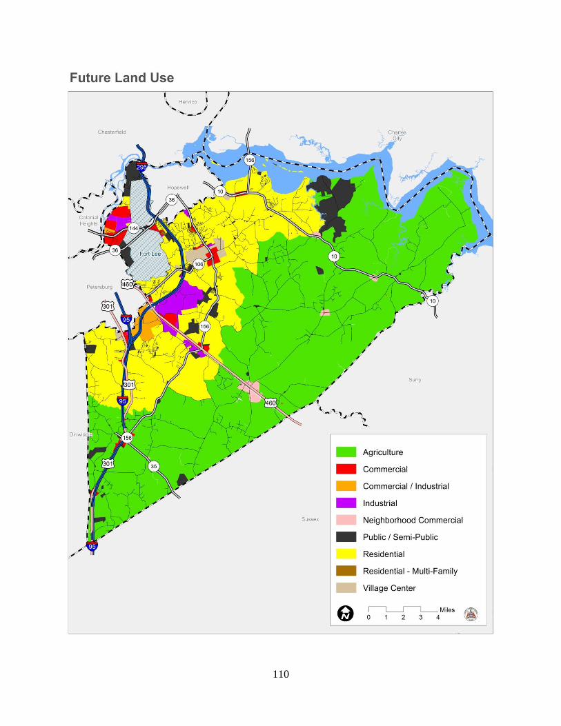
110

111
use, and the land use impacts of a specific use on the surrounding neighborhood and larger
community.
Nine future land use categories are shown on this map:
Agricultural
This category includes land areas in the rural portions of the County where agricultural and
forestal uses are, and should be, the dominant land use. Large lot single family development
may exist within some of these areas. Future residential development of these properties is not
encouraged.
Residential
This category includes areas within the PGPA where small lot residential development is
encouraged. Public water and/or wastewater facilities are available and required for such
development.
Residential- Multi-Family
This category includes areas where residential development such as town homes and
apartments may be suitable. Allowable future densities in these areas should be based upon the
availability and adequacy of public services and facilities and the compatibility
of the proposed land use with surrounding properties. Public water and/or wastewater facilities
typically serve these areas. Most of these areas are and will be located in the PGPA.
Village Center
This category designates those areas of the County in the PGPA that are suitable for a mixture
of residential and small-scale commercial uses to meet the needs of community residents.
Commercial
This category designates areas where commercial developments have occurred and where
future urban and suburban commercial developments are encouraged. Public water and
wastewater facilities are generally available or planned for these areas.

112
Neighborhood Commercial
The category designates those areas where small scale commercial uses are encouraged.
Such uses provide goods and services designed to meet the needs of the surrounding
residential community.
Commercial/Industrial *
This category designates those areas that are suitable for future commercial and/or industrial
economic activities.
Industrial
The category designates those areas where major industrial activities exist and/or are planned.
Public/Semi-Public *
This category includes land areas owned and operated by a federal, state or local government.
*Fine Street Comprehensive Plan Amendment –Adopted February 23, 2010
The Board of Supervisors amended the comprehensive plan to further identity the different
designations between commercial and industrial land use categories at a parcel level scale.
Fine Street contains an existing mix of residential and industrial land uses. However, it appears
that the nature progression along Fine Street will be for the industrial uses to continue to expand
into the residential areas. The Planning Commission and staff discussed the plan area and
were of the opinion that Fine Street is a transitional area. Further, we believe that there will
continue to be a natural progression of commercial and industrial uses to be developed in the
plan area.
Plan Amendment Findings:
Fine Street is an established area with a mixture of dwellings, established businesses,
vacant homes, a mobile home development, industrial businesses and a recreational facility
(marina)
The underlying zoning includes residential, commercial, industrial and agricultural
designations.
It is the opinion of the Planning Commission and staff that as commercial development
increases along Temple Avenue and Puddledock Road, there will be a natural progression

113
of commercial and industrial development in this area and that the existing residences will
either be converted for commercial use (such as offices) or be removed.
Based on the existing uses and continued commercialization and industrialization of this
area, the Planning Commission and staff recommends that the Comprehensive Plan be
amended to designate this area as “Commercial/Industrial.
All properties would continue to be regulated by the underlying zoning. The change in the
Comprehensive Plan would not change the existing use of any property. Nor would it
require that any of the homes be converted to a commercial or industrial use.
Recommendations:
1. The Planning Commission should annually monitor rural development patterns to
determine the location of new development and the rates of growth in these areas.
2. The Planning Commission and Board of Supervisors, through the recommendation and
adoption of this comprehensive plan, should state their commitment to agricultural and
forestal land preservation objectives.
3. The Planning Commission and Board of Supervisors should use the future land use
map contained in this plan as a general guide for determining the desired location of
development.
4. In evaluating development proposals, the Planning Commission and/or Board should
consider the adequacy of existing or planned public services and facilities in the area,
and the impact the development will have on these services and facilities. If necessary
facilities are planned, the timing of the planned new service or facility must be
considered.
5. Commercial and or industrial developments that are approved in the rural portions of the
County should be small in scale and of a design character that is consistent with a rural
environment.
6. The County should research the preservation tools presented in this plan and be willing
to provide information and administrative support to property owners who wish to pursue
a particular preservation strategy.
7. The County’s zoning and subdivision ordinances should be revised to limit subdivision
activity in the rural portions of the County.
8. The County should support the activities of local land trusts and other environmental
organizations in their efforts to voluntarily preserve critical agricultural and open space
areas in the County.

114
9. The County should work closely with the Natural Resources Conservation Service and
the Virginia Department of Forestry to ensure that private timbering operations in the
County are undertaken using approved techniques in an environmentally sensitive
manner.
10. The County should evaluate and adopt zoning and subdivision standards that allow
and/or encourage low impact development techniques as a tool to manage non-point
source environmental pollutants associated with new development.
11. Within the limits of state law, the County should monitor local agricultural practices as
they apply to water quality, and provide resources and assistance to agricultural land
owners who wish to take advantage of conservation opportunities such as riparian buffer
and easement programs.
* 2013 Fort Lee Joint Land Use Study (JLUS) Strategic Plan Recommendations:
1. Develop a formalized regional approach to enhance communication and land use
coordination between Fort Lee and surrounding communities such as Prince George.
2. Pursue the development of a regional Geographic Information System (GIS) database
for monitoring land use changes in the region around Fort Lee.
3. Participating local governments to make information available to the public regarding
the location of noise, safety, and other impacts related to Fort Lee’s training mission.
4. The participating local governments should consider adoption of Comprehensive Plan
amendments in support of the Joint Land Use Study findings and recommendations.
5. The participating local governments should consider adoption of Zoning Ordinance
amendments in support of the Joint Land Use Study findings and recommendations.
6. Fort Lee should continue to develop regular updates to military operational impact
assessments to enhance sustainability of the military missions. The tools for
implementing these recommendations are set forth in the Fort Lee Joint Land
Use Study and they can be found online at www.fortlee-jlus.com or craterpdc.org

115

116
CHAPTER X GOALS, OBJECTIVES AND STRATEGIES
Introduction
This chapter of the Plan presents a series of goals, objectives and strategies designed to guide
public decision making within Prince George County. Guidance is offered in the areas of
community facilities, housing, economic development, transportation, the environment, and land
use. These goals, objectives and strategies should be considered and used in conjunction with
other policy directions and recommendations contained in this plan, specifically those presented
in Chapters V through IX.
The goals, objectives and strategies offered in this chapter are not laws. County ordinances and
the building code are the legal mechanisms by which land development is controlled. Similarly,
planned community services and facilities are a function of the Board of Supervisors’ annual
decisions pertaining to capital and operating expenditures.
However, decisions made in general accordance with a comprehensive plan hold great legal
weight in Virginia. Making decisions that conform to a comprehensive plan demonstrates to the
citizens of a community that elected and appointed officials have thought about the future of
their community and are willing to plan for a future that is desired.
Finally, a comprehensive plan is not a static document. In addition to periodic five year reviews,
a plan may be formally amended at any time to address unanticipated community conditions, or
new or emerging community objectives.
Community Facilities and Services
Goal #1
To plan for, construct, and maintain needed community facilities is a manner that is cost
effective, environmentally sound and consistent with the growth objectives contained in this
plan.
Objective #1
Plan for and fund the County’s capital facility needs.
Strategies

117
1. Continue to prepare and adopt an annual CIP.
2. Annually revise the cash proffer program.
Objective #2
Consistent with this plan, develop and maintain public water and wastewater systems to meet
the needs of a growing commercial, industrial and residential base.
Strategies
1. Prepare an updated water and wastewater master plan for the County.
2. Continue to require public utility connections for all new development within the Prince
George Planning Area.
3. Develop and adopt a revised water and wastewater extension rebate program as an
incentive to encourage developers to extend off-site facilities in the Prince George
Planning Area.
4. Continue to prohibit independent water systems within the County.
Objective #3
Provide the facilities and services required to meet the recreational needs of County citizens.
Strategies
1. Prepare a parks and recreation master plan for the County.
2. Continue current planning for an expanded recreation center on Old Stage Road.
3. Explore and pursue all opportunities to provide additional public access to the James
and Appomattox Rivers.
Objective #4

118
Provide the facilities and services required to meet the public safety, library and school needs of
County citizens.
Strategies
1. Continue to support the system of volunteers who provide the majority of fire and EMS
safety services.
2. Continue to monitor school enrollment projections and renovate existing schools.
3. Continue planning for new library services to be offered at the Prince George Library.
Objective #5
Recognize and promote the historical significance of the County of Prince George.
Strategies
1. Continue to support the development of the Prince George County Courthouse Historic
District.
2. Encourage ongoing support and use of the Prince George County Regional Heritage
Museum on Courthouse Square.
3. Actively promote Prince George County for Tourism. Continue support of the Regional
Tourism Corporation and maintain strong voice within that organization.
4. Schedule initiatives within the growth/development implementation plan to allow
appropriate historical review and recordation.
5. Develop procedures for historical review.
Housing
Goal #1
To promote the creation of residential communities that meet the needs of all County citizens.
Objective #1
119
Identify and remove barriers that limit housing choice in the County.
Strategies
1. Amend the zoning ordinance to allow a full range of housing choice options in the
County including multifamily, townhouses and condominiums.
2. Promote and encourage mixed use developments that contain housing choices.
3. Promote affordable housing through zoning ordinance amendments including possible
density bonuses in exchange for providing affordable units.
4. Promote and encourage well designed manufactured home communities that are
functional, aesthetic, and taxed as real estate.
Objective #2
Explore and participate in housing programs and partnerships designed to assist low and
moderate income families.
Strategies
1. Explore the use of Community Development Block Grant funds to finance infrastructure
improvements in new residential developments that incorporate housing for low to
moderate income residents.
Objective #3
Explore programs and initiatives designed to stabilize and maintain the County’s older housing
stock.
Strategies
1. Initiate a housing quality assessment in selected, older neighborhoods.
2. Encourage and promote restoration, preservation, and new uses for existing structures,
continuing to utilize resources available from the Prince George County Historical
Society and the Virginia Department of Historic Resources.

120
3. Explore the use of Community Development Block Grant funds to finance initiatives
designed to stabilize and maintain the County’s older housing stock.
Economic Development
Goal #1
To enhance the economic base and employment opportunities in Prince George County.
Objective #1
Develop a strong and diversified tax base through guided office, commercial retail and industrial
development.
Strategies
1. Use the future land use map and the zoning map to identify and reserve land areas
suitable for future economic activities.
2. Continue to actively promote and market “ready to go” industrial development sites
within the County.
3. Coordinate closely with other local, regional, and statewide economic development
organizations.
Objective #2
Develop and maintain the County’s community facilities and transportation system.
Strategies
1. Use the CIP as a tool to plan for and finance adequate public facilities and services to
meet the needs of an expanding economic base.
2. Coordinate closely with VDOT and other agencies that can assist with economic
development opportunities associated with new or expanding businesses.

121
3. As resources become available, implement planned public water and wastewater
extension projects and planned road improvements to accommodate future economic
growth consistent with this plan.
4. Seek industrial access funds to provide pubic road access to new industrial areas.
Objective #3
Promote the retention of existing businesses.
Strategies
1. Provide assistance to existing businesses and industries that wish
to expand in the County.
2. Continue to pursue and facilitate work-force training opportunities that will assist new or
expanding businesses.
Transportation
Goal # 1
To develop and maintain a safe and efficient transportation system.
Objective #1
To establish and maintain a level of service of “C” or better for all secondary and primary
highway intersections in the County.
Strategies
1. On an annual basis work with the Virginia Department of Transportation to prepare a 6-
year secondary road improvement plan based upon locally identified needs and
available resources.
2. Maintain a cash proffer system to help fund road improvements necessitated by the
demands of new development.
3. Work with the General Assembly to obtain increased state funding for transportation
enhancement grants.

122
4. Develop and adopt a comprehensive access management program for the County.
5. Continue to consider road adequacy and safety as criteria to be considered when
evaluating rezoning and special exception requests. Require applicants to provide formal
traffic impact studies in accordance with state legislation.
6. Continue to participate as a member of the Tri-Cities Area MPO.
7. Ensure that all established growth areas within the County are connected by arterial
corridors.
8. Continue the Transportation Subcommittee of the County’s Planning Commission as on
on-going/standing committee of the Commission. Ensure membership includes citizen
members and VDOT representatives.
9. Consistent with the recommendations contained in the land use chapter of this plan,
promote an efficient land use pattern that promotes new residential areas within the
Prince George Planning Area.
10. Plan for and require through rezoning actions and subdivision approvals pedestrian and
vehicular interconnectivity between neighborhoods and activity centers such as
shopping areas, schools, libraries, and community centers.
11. Evaluate the need for traffic calming measures to be installed in existing subdivisions,
and establish in the subdivision ordinance traffic calming warrants and acceptable traffic
calming measures for new subdivision streets.
12. As part of the County’s annual CIP and budget process, consider the allocation of
additional local funds for identified transportation system needs.
Goal #2
To encourage a balanced efficient transportation system

123
Objective # 1
Promote transit and van pool ridership in Prince George County.
Strategies
1. Work with Petersburg Area Transit (PAT) to identify cost - effective route extensions
within the County.
2. In accordance with the recommendations contained within the land use chapter of this
plan, promote residential development at densities sufficient to support transit in the
urban service area of the County.
3. Support and promote van pooling opportunities in the County.
Objective # 2
Develop a minimum of ten miles of bike lanes or off-road bike paths within the County within the
next ten years.
Strategies
1. Adopt and implement a Prince George County bikeway plan that shows specific routes,
design standards, funding sources, and a timetable for implementation.
2. Encourage and require bike lanes and bike paths within new residential developments.
3. Request VDOT design and incorporate bikeways into new road projects as designated in
adopted regional and County bikeway plans.
4. Consider bike lanes and bike paths “public facilities” to be considered as part of any
future proffer policy adopted by the County.
Objective #3
Support all rail opportunities within the County

124
Strategies
1. Participate in state rail planning initiatives and identify opportunities for future rail
services/facilities in the County.
2. Work regionally to explore the benefits and feasibility of a light rail system to serve the
County.
3. Encourage local rail providers to support industry requests for new rail facilities and
sidings when such requests are consistent with the land use recommendations
contained in this Plan.
Goal #3
Plan for the County’s future highway needs.
Objective # 1
Identify and protect new highway corridors needed to serve the long term needs of the County.
Strategies
1. Prepare and adopt a 25 year transportation plan that identifies highway needs based
upon expected County and regional growth rates and patterns.
2. Adopt zoning and subdivision ordinance amendments necessary to protect future rights-
of-way needed for new corridors or the improvement of existing corridors.
3. Utilize the County’s official map authority to formally designate future road corridors.
4. Identify alternative funding sources, including cash proffers that might be needed to
acquire planned road corridors.
Environment
Goal #1
To protect and enhance the natural environment.
Objective #1

125
Protect and enhance the County’s surface and ground water resources.
Strategies
1. Amend the zoning and subdivision ordinances to provide incentives for the use of low
impact development techniques.
2. Continue the implementation of Chesapeake Bay Act regulations within the James River
watershed.
3. Consider the county-wide application of Chesapeake Bay Act regulations.
4. Evaluate all new development partially on the basis of its impact on water resources.
5. Adopt zoning and subdivision ordinance provisions that enhance the protection of
wetlands and floodplains on property proposed for development.
Objective #2
Protect and enhance the County’s air quality.
Strategies
1. Promote mixed use developments as a strategy to promote live-work relationships.
2. Evaluate all new development partially on the basis of its impact on air quality.
Land Use
Goal #1
To achieve a balanced land use system that provides sufficient and compatible land areas for
all community land use needs, while protecting sensitive natural environments and important
local historic and cultural resources.
Objective #1
Promote a strong and diversified industrial and commercial base which does not create
significant impacts on residential areas, prime agricultural lands or public facilities.

126
Strategies
1. Use the future land use map contained in this plan as a general guide for future
commercial and industrial land use decisions.
2. Limit new commercial and industrial areas to node locations as shown on the future
land use map.
Objective #2
Discourage scattered development patterns which are incompatible with the County’s ability to
provide adequate and cost effective public services and facilities.
Strategies
1. Through zoning and subdivision ordinance amendments limit by-right subdivision
activity in the A-1 Agricultural zoning district.
2. To the extent allowed by law, limit family division parcels.
3. Amend the County’s zoning and subdivision ordinances to provide incentives for
developments that demonstrate conservation site design principles and/or incorporate
low impact development techniques.
4. Ensure that all planned capital facilities are evaluated partially on the basis of
consistency with the growth objectives of this plan.
5. Ensure that all new water line and wastewater line extensions designed to serve new
development are located within, and only serve areas within, the Prince George
Planning Area.
Objective #3
Enhance the rural and environmental character of the County through the preservation of
agricultural and forestal lands, wetlands, flood hazard areas, and Chesapeake Bay Resource
Protection Areas.

127
Strategies
1. Promote opportunities to educate property owners on the benefits of conservation site
design.
2. Adopt a local agricultural and forestal district ordinance as a first step in establishing
agricultural and forestal districts in the County.
3. Support future efforts of local conservation organizations and the Virginia Outdoors
Foundation to acquire and provide stewardship for locally obtained conservation
easements.
Objective #4
Adopt and maintain appropriate land use ordinances and voluntary programs designed to guide
and implement the provisions of this comprehensive plan.
Strategies
1. Amend the County zoning ordinance to provide enhanced standards for signage, noise,
buffering, and lighting.

128
APPENDIX A CAPITAL IMPROVEMENT PLAN

129

130
APPENDIX B WATER & WASTEWATER STUDY