Embed Size (px)
Citation preview

V-1
CHAPTER V Urban Design
This chapter describes the efforts made to develop an urban design context for the I-64 Build Alternatives. The age, character and social environment of the I-64 corridor created the need to take a more holistic approach to address the visual impact and enhancement of community cohesion within the project corridor. Urban design treatments are based on establishing a common thread throughout the corridor, yet providing for individuality among the three types of areas present along its length. Three levels of treatments are defined throughout the corridor. Although the levels would vary in their visual treatments, they would carry the same themes to offer visual continuity throughout the corridor. These levels are based on a hierarchy of regional, community or neighborhood context for interchanges or overpasses. The hierarchy for the I-64 corridor is shown in Figure V-1.
Interchanges/overpasses throughout the entire rebuilt I-64 corridor would receive aesthetic treatments that would help visually integrate the interchanges / overpasses into the surrounding urban and community fabric. The architectural theme uses the existing bridge designs in a modern interpretation of the streamline modern style. The aesthetic treatments would include elements such as bridge abutments, railings, pedestrian lighting, paving, and landscaping that are cohesive in design and are sensitive to surrounding areas and historical context. Regional interchanges would be constructed primarily as single point urban interchanges (SPUI). These are the largest interchanges in the corridor and accommodate the highest number of vehicles, pedestrians and bicycles. A clear delineation between vehicle, pedestrian and bicycle movements are provided through provision of sidewalks, bicycle paths or lanes and vehicle lanes. An illustration of the regional interchange treatments is provided in Exhibit V-1. Community interchanges accommodate slightly lower volumes of vehicles, pedestrians and bicycles. With lower volume demands, the design of these interchanges are typically not SPUI. A clear delineation between vehicle, pedestrian and bicycle movements are also provided in community interchanges through provision of sidewalks, bicycle paths or lanes and vehicle lanes. An illustration of the community interchange treatments is provided in Exhibit V-2.
Figure V-1 Urban Design Hierarchy

V-2 The New I-64 Final Environmental Impact Statement
Neighborhood interchanges or overpasses provide for lower volume access to I-64 or provide for neighborhood connections across I-64. The physical size of these facilities is the smallest of the three interchange/overpass types. An illustration of the neighborhood interchange/overpass treatments is provided in Exhibit V-3. The hierarchy of urban design treatments also includes the system-to-system interchange at I-64 and I-170. Urban design treatments are shown at this location. However, the function of this interchange is to accommodate vehicle movements only and as such, no pedestrian or bicycle treatments are appropriate. An illustration of urban design treatments at I-170 is shown in Exhibit V-4. The architectural character of the I-64 corridor includes unifying treatments to retaining and sound walls. Different treatments are proposed for the views to the road. On the neighborhood side of the sound walls, different treatments would be used to be compatible with neighborhood character. The highway side of the retaining and sound walls would have a consistent character. The highway side would be consistent with the design theme of the bridges all reflecting the original art deco theme of a number of the existing bridges over I-64. The aesthetic and subcorridor committees provided significant input into the selection and development of this corridor aesthetic theme. An illustration of the unifying elements is shown in Exhibit V-5. A. Greenway Subcorridor
Under the build scenario, the view for drivers on I-64 would remain similar to existing conditions, although widening and a higher profile would create a broad view of the corridor. The view for residents along this stretch of I-64 would change with the loss of vegetation and visual buffers. There are some views in commercial areas that will remain similar to existing views and impacts would be minimal. Proposed Visual Treatments
The visual impact of retaining walls for drivers could be enhanced in two ways. One, the walls would receive aesthetic treatments. Second, the walls would be located, where feasible, to allow green space between the walls and the highway. New landscape plantings within the right-of-way would supplement existing vegetation adjacent to the right-of-way. The new plantings would help retain and restore the visual “greenness” of the corridor. An illustration of the Build Alternative perspective for drivers at I-64 and McKnight Road is shown in Exhibit V-6. The driver’s perspective of the Build Alternative on I-64 at Lindbergh Boulevard is shown in Exhibit V-7. Landscape plantings would seek to restore visual buffer areas through the use of evergreen and deciduous material. The material would be located where it may achieve the greatest level of visual screening. The visual impact of retaining walls facing residential areas would be embellished in two ways. One, the walls would be located to preserve existing vegetation where possible. Second, where existing vegetation must be removed, new plantings would be installed to help screen and visually soften the walls if possible. An illustration of the resident view under the Build Alternative at Ladue Crest appears in Exhibit V-8. An illustration of a commercial area along the study corridor with a view that will remain similar is shown in Exhibit V-9. McKnight Road and Spoede Road interchanges/overpasses would receive neighborhood aesthetic level treatments. The Watson/Clayton Road interchange would receive community

Chapter V – Urban Design V-3
aesthetic level treatment. The Lindbergh Boulevard interchange would receive regional aesthetic level treatments. B. Thruway Subcorridor
The visual impact to drivers on I-64 would be most affected at the interchange of I-64 and I-170 with the broadening of the interchange. Build Alternatives would alter significantly the views of I-64 from areas adjacent to the alignment. This would occur because of the reduction or elimination of vegetative buffers. Retaining walls, ramps and structures on I-64 would be more visible and residential areas would be more open and visible. Proposed Visual Treatments
For drivers, the visual impact of the proposed highway infrastructure would be enhanced through aesthetic treatments of retaining walls, railings, and right-of-way areas. The loss of existing vegetation would be replaced by new landscape plantings where possible, in available green space adjacent to I-64. The visual impact of retaining walls for drivers would be enhanced in two ways. One, the walls would receive aesthetic treatments. Second, the walls would be located, where feasible, to allow green space between the walls and the highway. The replacement and addition of landscape plantings along the corridor would add to the “greenness” of the corridor. For example, reconfigured ramps at Big Bend Boulevard and McCausland Avenue would provide green space to allow the opportunity to soften the visual impact of I-64 with additional landscape plantings. Illustrations of retaining wall treatments and use of green space under the Build Alternatives at Big Bend Boulevard are shown in Exhibits V-10 and V-11. An illustration of the proposed views at the interchange of I-64 and I-170, Option 2 is shown in Exhibit V-12. Illustrations of the driver’s perspective at Hanley Road and I-64 for both Alternative 2/2a and Alternative 3/3a are shown in Exhibits V-13 and V-14, respectively. To provide visual buffers for residents, landscape plantings would seek to restore visual buffer areas through the use of evergreen and deciduous material. The material would be located where it may achieve the greatest level of visual screening. The retaining walls facing residential areas would be located to preserve existing vegetation where possible. Second, where existing vegetation must be removed, new plantings would be installed to help screen and visually soften the walls if possible. C. Parkway Subcorridor
Build Alternatives would result in a lower profile than existing conditions, in some locations. The loss of vegetation could create more open views of the roadway for drivers and the lower profile would increase the visibility of retaining walls.
In some locations in the Parkway, the build alternatives would reduce existing vegetative buffers, although the lower profile would soften the visual impact of I-64 through this section. Views of retaining walls also would be increased for residents. Proposed Visual Treatments
MoDOT will work with local governments to allow them to provide opportunities to visually treat retaining walls, through artistic and aesthetic treatments. Artists and stakeholders would work with retaining wall designers to create images, patterns, and colors on the retaining wall

V-4 The New I-64 Final Environmental Impact Statement
surfaces that would reflect the aesthetic quality of Forest Park and its attractions. Illustrations of early concepts for retaining wall designs along I-64 near the zoo are illustrated in Exhibit V-16. The edge of I-64 would be treated through the use of ornamental fencing to separate the right-of-way of I-64 from adjacent uses. New and replacement landscape plantings in green space adjacent to I-64. Reconfigured ramps at Kingshighway would provide additional green space for Forest Park. Reconfigured ramps at Hampton Avenue would provide the opportunity for additional green space and landscape plantings to soften the visual impact of the ramps. Hampton Avenue is one of the primary entrances to Forest Park. The green space would allow opportunities for Forest Park to further enhance the framing of the gateway into the park. Pedestrian access to Forest Park would be treated through aesthetic treatments to bridges and tunnel walkways as shown in Exhibit V-17. Opportunities for new sloped green space would be created where the current retaining walls are located just west of Taylor Avenue. New ramps and roads at Tower Grove and Boyle would encroach on existing property north of I-64. Some loss of existing vegetation at the edge of the right-of-way would occur along the southern edge of I-64 and in areas near Tower Grove and Boyle. For views toward I-64, the loss of existing vegetation would reduce the limited existing visual buffer between I-64 and adjacent areas. The lower alignment profile would help soften the visual impact through this segment. Along the south edge, I-64 would be up to 20 feet below adjacent areas. At the Kingshighway interchange, the reconfigured ramps would allow additional green space to be turned over to Forest Park. The additional green space would provide a visual buffer of the interchange. Driver views at Kingshighway could be enhanced through the addition of structural elements and pedestrian facilities as shown in Exhibit V-18. For drivers, there would be opportunities on the north side of I-64 to view sloped turf and landscape areas where existing retaining walls exist currently. Along the south side, drivers would view retaining walls up to ten feet in height. Areas where pedestrian-friendly treatments would occur offer the driver as well as residents improved safety, additional green space and the potential for reduced traffic. Illustrations of areas where this could occur are shown in Exhibit V-19 at McCausland and in Exhibit V-20 at Hampton Avenue. Boyle, Newstead, and Taylor interchanges would receive neighborhood level aesthetic treatments. The Tower Grove interchange would receive community level aesthetic treatment. The Kingshighway interchange would receive regional level aesthetic treatments. Retaining walls would receive aesthetic treatments. Retaining walls would be located, when feasible, to allow green space between the walls and the highway. Exhibit V-21 at Clayton/Oakland and Exhibit V-22 at McCausland illustrate potential conceptual treatments to retaining walls. New slopes would receive turf and landscaping. Landscape plantings would seek to restore visual buffer areas through the use of evergreen and deciduous material and locating material where it would achieve the greatest level of visual screening
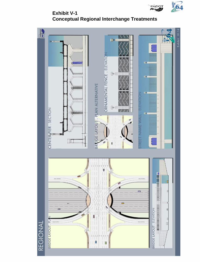
Exhibit V-1Conceptual Regional Interchange Treatments

Exhibit V-2Conceptual Community Interchange Treatments

Exhibit V-3Conceptual Neighborhood Interchange / Overpass Treatment

Exhibit V-4Conceptual System-to-System Interchange Treatment

Exhibit V-5Conceptual Aesthetic Treatments

Exhibit V-6Conceptual Illustrations of Build Alternatives
View Location: I-64 at McKnight Looking East
No Build
Build

Exhibit V-7Conceptual Illustrations of Build Alternatives
View Location: I-64 at Lindbergh Looking East
No Build
Build

Exhibit V-8Conceptual Illustrations of Build Alternatives
View Location: Ladue Crest looking East Toward I-64
No Build
Build

Exhibit V-9Conceptual Illustrations of Build Alternatives
View Location: I-64 at South 40 Hwy Looking West
No Build
Build
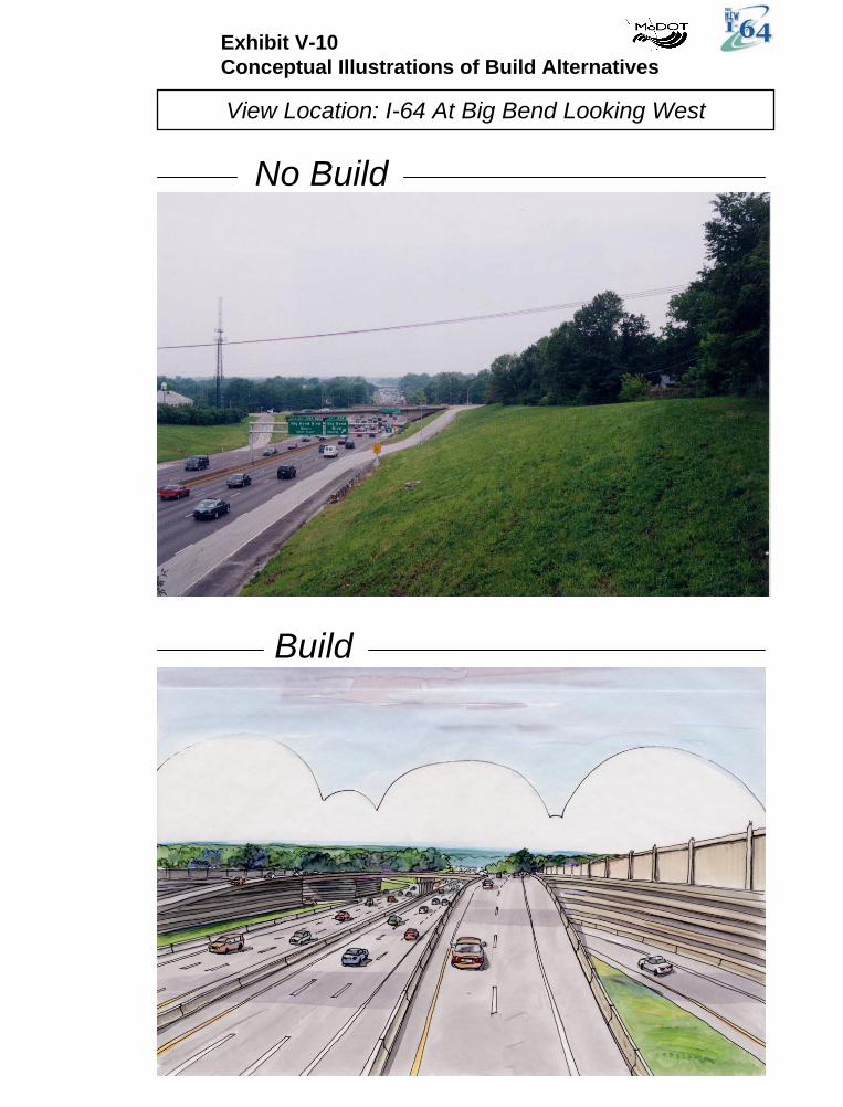
Exhibit V-10Conceptual Illustrations of Build Alternatives
View Location: I-64 At Big Bend Looking West
No Build
Build

Exhibit V-11Conceptual Illustrations of Build Alternatives
View Location: I-64 At Big Bend Looking East
No Build
Build

Exhibit V-12Conceptual Illustrations of Build Alternatives
View Location: I-64 At 170 Looking South
No Build
Build
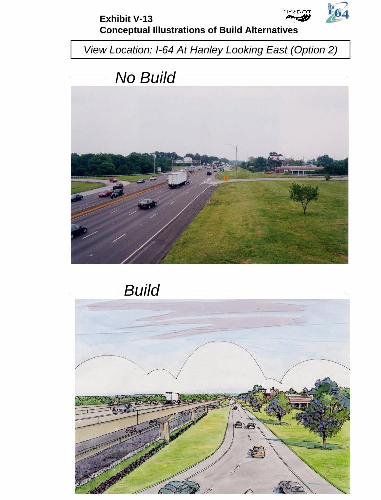
Exhibit V-13Conceptual Illustrations of Build Alternatives
View Location: I-64 At Hanley Looking East (Option 2)
No Build
Build

Exhibit V-14Conceptual Illustrations of Build Alternatives
View Location: I-64 At Hanley Looking East (Option 3)
No Build
Build

Exhibit V-15Conceptual Illustrations of Build Alternatives
View Location: Walls Along I-64 at Zoo
Build

Exhibit V-16Conceptual Illustrations of Build Alternatives
View Location: Proposed Tunnel Walkway into Forest Park Near Zoo
Build

Exhibit V-17Conceptual Illustrations of Build Alternatives
View Location: I-64 At Kingshighway Looking West
No Build
Build

Exhibit V-18Conceptual Illustrations of Build Alternatives
View Location: McCausland
No Build
Build

Exhibit V-19Conceptual Illustrations of Build Alternatives
View Location: I-64 At Hampton Avenue
No Build
Build

Exhibit V-20Conceptual Illustrations of Build Alternatives
View Location: I-64 At Clayton / Oakland Looking East
No Build
Build

Exhibit V-21Conceptual Illustrations of Build Alternatives
View Location: I-64 McCausland Looking East
No Build
Build