Embed Size (px)
Citation preview

CHAPTER III
Indo-Nepal Transboundary Waters: Disputes And
Cooperative Efforts
Nepal is a landlocked country in South Asia, bordered by China to North
and India to the south, east and west. It is located between latitudes
26°22'N-30°27'N and longitudes 80°4'E-88°12'E. Nepal extends 885 km
along the east west with an average width of 193 kilometers along the
north south. The country, covering a total area of 147,480 square
kilometers, has very diverse physical characteristics in its topography,
climate, geology and land use system.
Nepal is predominantly mountainous, with three broad ecological zones
i.e. the Terai plains, Churia hills and High mountains (Middle and
Greater Himalaya), covering respectively about 18, 58 and 24 per cent of
the total land area.
The Terai region is an extension of the Indo Gangetic plain, which is
underlain by fertile soil mantle. Adjacent to the Terai in its north, rising
abruptly, lies the Churia hill ranges. Its average elevation ranges between /
300 m to 500 m. North of Churia lies Mahabharat range (part of middle
Himalaya) with rugged terrain, deep valleys and incised rivers. On the
North lies the Himalayan range whose elevation rises above 4000 mts.
Each region has distinct characteristics, which influences the availability
of water resources.
Drainage System of Nepal
Nepal's dra~nage system consists of four major river basins seven smaller
basins and several smaller sub basins. The first group of rivers has their
sources in the snow and glaciers, in the dry season. The Mahakali, the
Karnali, the Gandaki and the Sapt Kosi are four rivers in the first
category. The second group of rivers originates in the middle mountains,
which are mostly rainfed and have low dry season. Bagmati, West Rapti,
80

Mechi, Kankai, Kamala and Babai are the rivers in the second category.
Rivers in the third category originate in Churia, southern face of the
Mahabharat, or in the Terai. These rivers have small catchment areas.
Tilawe, Sirsia Hardinath, Sunsari and Banganga are some of the rivers in
this group.
The major river basins of Nepal are transboundary in nature and form
the upper catchment of Ganges system.
(1) Mahakali River Basin: The Mahakali River is the maJor nver of this
basin. It forms the western international border of Nepal with India.
Starting from Api-himal the river flows in a gorge section in the upper
region. The Mahakali after it flows into India is known as Sharda,
which meets the Karnali (Ghaghra) in Indian territory. The river basin
has a total drainage area of 15,640 km2, about 34per cent of which
lies in Nepal.
(2) Karnali River Basin: The Karnali river basin drains Nepal's western
region. The Seti and Bheri are the two major tributaries, contributing
to its water resources. The total catchment area within Nepal is
estimated to be 41550km2.
(3) Gandaki Rive~asin: The Gandaki basin also known as Sapt Gandaki
basin has a catchment area of 36000km2 with an additional area of
approximately 4600km2 of Tibet being drained by tributaries of Kali
Gandaki, Burhi Gandaki and Trishuli rivers. The basin is located
along with central alignment of the Himalayas with intrusions into
Indus-Tsangpo Plateau to north and extending to the Ganges
Brahmaputra plain to the South.l
(4) Kosi River Basin: The Sapt Kosi is the biggest river of Nepal. It drains
the region lying east of Gosainsthan and west of Kanchanjunga. The
Kamal Rijal, "Role of Nepalese Water Resources for Meeting Energy Needs in South Asia," in Sridhar K. Khatri [ed.] Energy Policy: National and Regional Implications, NEFAS Publication, Kathmandu, 2002, p. 95.
Ql

total drainage area of the nver basin is 60,400 km2 of which 4 7
percent lies in the Nepal's territory. Sun Kosi, Arun, Indrawati, Dudh
Kosi are the major rivers of the basin.
All these large and small rivers give rise to about 6,000 rivers to totaling
about 45,000 km in length. The drainage density of 0.3 km/km2 of
lateral drainage reflects the closeness of the drainage channels. Surface
water is estimated to occupy 2.7 per cent of the country's area of which
97 per cent is occupied by large rivers.2
The entire area of Nepal lies within the Ganges drainage basins. A
dominant feature of Nepals water resource, however, is that even though
Nepal occupies 13 percent of the total drainage of the Ganges basin its
contribution to the flow of Ganges river is much more significant,
amounting to about 45 percent to its average annual flow at Farakka
barrage. In the dry seasons, Nepals contribution to the total run off is as
much as 70 percent.
Water Resources: Nepal's Critical Resources
The water resource is the most important natural resources of Nepal,
which can form the base of its sustainable economic development and
prosperity. These resources are plentiful, annually renewable and
environmentally safe to be exploited. The development of water resources
can be harnessed for the benefit of people primarily to meet the steadily
growing demands of agricultural and industrial growth, domestic water
supply and energy. The beneficial effects also concern waterway
transportation, recreation, mitigation of damage caused by floods etc.
Water resources projects are often considered as playing vital role in
ensuring social a~d economic development of the country. Increasing
populations demand for more water, food and energy will inevitably lead
2 Bhekh B. Thapa and Bharat B. Pradhan , Water Resources Development: Nepalese Perspective, Konark Publishers, New Delhi, 1995, p. 18-22.
82

to an accelerated development and extensive utilisation of water resource
in the future.
Though the water resources are m abundance, Nepal is seriously
handicapped in their utilisation and management through indigenous
efforts. Nepal's major problem has been lack of capital and technological
resources. Large scale water resource development projects require huge
capital investments and sophisticated technologies. The Nepalese
government has given high priority to the water sector in its investments
plans. During the Eighth Plan period, the government expected to spend
37 percent of the total public development expenditure in the water
sector; 10.5 percent in irrigation, 21 per cent in hydropower, 5.5 percent
in drinking water. But the government was able to find money for only 73
percent of the targeted expenditure in the power sector. The resources
required to launch even a medium sized hydroelectric project are so large
that Nepal has not been able to meet it from its present available
resources. Therefore Nepal has to seek external assistance for this
purpose. Nepal has not been able to effectively utilise its domestic
resource inputs like labour, materials and management expertise in its
water projects.
Further, most of the attractive water resources development sites are not
easily accessible. For the development of these sites, the additional costs
of access roads need to be incurred to connect them with existing
transportation network. Because of lack of accessibility, numerous ideal
sites for water resources development cannot be tapped.
Nepal Water Resource Development: India's Role
Within the Ganga- Brahmaputra basin, Nepal and North Ganges plain lie
geographically juxtaposed. The sinews of numerous transboundary river
courses interweave the boundaries of Nepal and India, tying up their
destiny.
83

The Ganges basin of India compnsmg of Uttar Pradesh, North Bihar,
Uttaranchal and parts of West Bengal has almost all the rivers not only
originating in Nepal but also having considerable catchment areas lying
in Nepal. The region is characterized by low agricultural productivity,
poverty, energy deficit, flood hazards, frequent droughts, water logging
etc., even though there is ample fertile land, groundwater, surface water
and large manpower. This paradox can be resolved and regional
imbalance can be removed by effective management of water resource. 3
Interdependence and complimentarity: There 1s relation of
geographical interdependences and economic complementarities between
the water resources development aspects of India and Nepal.
Nepal has large hydroelectricity generation potential. The demand for and
consumption of electricity in Nepal is likely to grow at a rate much slower
than what its hydropower potential implies.4 Nepal therefore prefers to
view its water resources more as a source of export earnings. On the
other hand India has been suffering from power shortage for quite some
time with constraint of energy becoming acute every year.
The excess hydroelectricity power generated in Nepal may be sold to
India. The availability of power in India would enhance the use of ground
water for irrigation. The development of water and power resources in
Nepal would meet the growing power and irrigation water needs in Nepal
and would also bring in revenues from power sales to India. While Nepal
can exploit a number of medium and mini schemes to meet its domestic
power requirements the more exciting projects that could deliver huge
blocks of energy at low cost must find a market in India or through it too
Bangladesh. Hydropower represents a renewable source of wealth for
Nepal, for it could export this power to India and invest the proceeds in
3 T. Prasad "Water Resources as a Factor in India Nepal Relations" Indian Journal of Nepal Studies, Vol. V and Vol. VI, 1995-96, pp. 76-77.
4 The Rising Nepal, 13 May 1983, p. 2.
84

its own further development and prosperity.s Further, bound by the
mighty Himalaya on its north, Nepal is a landlocked country with access
to world only through its long southern boundary with India. Nepal can
develop inland navigation to approach the waterways of India finally
having access to seaports of Indian Ocean for development of trade and
commerce.
For India, dependence on Nepal in the matter of water resources
management and utilisation emanates primarily from hydrology. As
Nepal is the upstream country optimum and efficient measures of water
resource development can in many cases be taken only in Nepal. The
construction of reservoirs/dams in Nepal would help controlling flooding
and sedimentation in Bihar, West Bengal. Heavy siltation caused by
rivers tumbling down from hills to Ganges basin causes ecological
damage and reduce the effective life of irrigation projects downstream.
Afforestation in upper catchment areas of Nepal is essential for
watershed management measures in common basins of India and Nepal.
Expansion and management of irrigation facilities in the Ganges basin in
India requires cooperation from Nepal. The in-country options that India
may adopt or have adopted in past such as embankments for flood
controls, surface irrigation through barrages, dredging for increasing
channel depth will prove and have proved, grossly inadequate and even
counter productive in some cases. Soil conservation and reforestation in
the upper catchment could help check erosion, assure fuel, fodder and
food security, deter out migration and provide ecological storage by
encouraging infiltration and moderating runoff thus evening out stream
flows year around.
Thus there is complete interdependence between India and Nepal in the
matter of water resources. The relation is highly prospective because of
both immensity and complimentarity of benefits, and can provide the
5 B.G. Verghese "Learning to Say Open Sesame" in David J. Eaton [ed.] The Ganges Brahmaputra Basin: Water resource Cooperation between Nepal, India and Bangladesh, Lyndon B. Johnson School of Public Affairs Publication, Austin, 1992, p. 100.
85

basis for more coherence and cooperation in all other spheres such as in
political, social and economic interactions.
Policy Planning in Retrospect
Although the potential for water resources development between India
and Nepal is considerable, the cooperation between these two countries
on the issues related to water has not been easy and forthcoming, in
particular because of the extreme sensitivities and divergent interests
and approaches of the political parties. The two neighbours, in spite of
this mutual interest, have found it difficult to cooperate with each other
in developing the Himalaya water resources. Their bilateral relations have
been heavily influenced by politics; marked by emphasis on historical
wrongs (real and perceived), failure in understanding each other
sensitivities and interest, aggressive posture, negative approach, inward
looking dynamics of the faction of the political actors in both countries.
To appreciate the ramification of the problems with water resources
between two countries, it is imperative to acknowledge the political
underpinnings of their bilateral relations.
India and Nepal have a long historical, cultural and political relations.
The political relation was formally regularized in the form of Peace Treaty
m 1815, between British India and Nepal. After India gained
independence, the two countries signed a new Treaty of Peace and
Friendship m July 1950. The India Nepal Treaty of Friendship was
predicated m the idea that India and Nepal shared permanently
intertwined destinies. With this in mind Pandit Nehru, facilitated the
process of modernization and development of Nepal very early, offering
advice on social programmes and helping draft a democratic constitution.
The approach was sincere and well intentioned, with an underlying
assumption that Nepal's interests were in unbreakable harmony with
India.6
6 Jagat S. Mehta, "Opportunity Costs of Delay in Water Resource Management between Nepal India and Bangladesh," in David J. Eaton (ed.] The Ganges Brahmaputra Basin, Lyndon. B. Johnson School of Public Affairs, Austin, 1992, p. 5.
86
Pundit Nehru had a vision to jointly utilise water of some of Himalayan
Rivers. In a joint communique issued at the end of his visit to Nepal on
14 June, 1959, it was pointed out that the "geographical contiguity of the
two countries, however makes it inevitable that certain development
projects can be best planned and executed by the joint endeavors of the
two countries". Nehru ji apparently referred towards the cooperation
between the two countries for the development of river waters.
It will be a partial view to analyse the India's 1950 Treaty with Nepal and
development assistance only in the light of security considerations, which
became important in 1949 when China asserted its rights over Tibet and
Nepal emerged as crucial buffer state between China and India.
The effort towards the exploitation of Himalaya river water, to meet the
needs of irrigation, flood and sedimentation control, had begun even
before India's independence. The British Government of India had
exchanged letters with its Nepalese counter parts in 1920 for the
construction of a barrage in the river Mahakali at Banbassa bordering
the present Mahendra Nagar of Nepal and a power station at Khatima. To
help the construction, Nepal offered to give land of her territory in a
chunk (4093.88 acres) and got in return the pieces near different parts
of her territory.7 Nepal also received right of drawing the water, minimum
of 400 cusecs and a maximum of 1000 cusecs from the Sarda canal for
the purpose of irrigation. Some initiatives were taken in order to launch
other mutually beneficial water resources projects, but concrete
development took place only after Indian independence. In post 1950
situation, the Kosi project became the first development project on an
international river presented as mutually benefiting both India and
Nepal.B It is a multipurpose scheme that includes flood control,
hydropower generation and irrigation.
7 Ramesh Prasad Koirala, SAARC: Nepal's Role in Collective Utilization of its Water Resources, The Team Publications, Kathmandu, 1990, p. 60.
8 U.K. Verma, "Socia Economic Renaissance Through Dynamic Indo Nepal Cooperation on Water Resources Development", Water Nepal, Vol. 4, No. 1, 1994, p. 140.
87

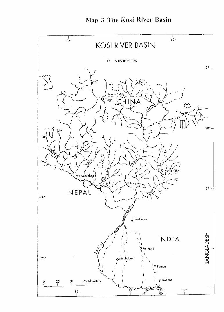
The Kosi Project
The Kosi, Nepal's largest transboundary river originates in Tibet and has
drainage area of 92,538 km2 The Kosi basin is 270 km North-West,
South-East long and about 145 km North East & South West wide with a
catchment area of about 25,000 sq. km3. 9 Downstream it causes
devastating floods in north Bihar Plain of India, thus also called "the
Sorrow of Bihar". Historically, the idea of taping the waters of the Kosi
had been discussed in India as early as 1896.10 But because of the
absence of serious feasibility studies no immediate decision was made.
Though the problem of flood and shifting tendency of the river course has
been engaging the attention of engineers since long, work of surveys and
investigation for the purpose of preparing a project was taken up in the
year 1946. As a result of these surveys, a multipurpose scheme
envisaging construction of (i) a dam at Barakeshetra of a height of 235 mt
to impound 0.85 Mham in the reservoir, and (ii) a barrage at Chatra with
canals offtaking from both sides to annually irrigate 13.90 lakh hectare
in India and Nepal was prepared. However, after further investigations
and series of discussions among experts, the erstwhile Central Water and
Power Commission formulated a project in 1953, which envisaged
construction of (i) a barrage at Hanuman Nagar at a distance of 48 kms.
below Chatra to serve as a controlling structure and to provide gradient
control in the steep reach of the river below Chatra, (ii) flood
embankments on either side of the river to confine it in its existing
course, and (iii) canals on eastern side to provide irrigation in India and
Nepal. An agreement was signed between the Government of India and
HMG Nepal in April 1959 envisaging the construction of a barrage on
Kosi and other components of the Kosi project. 11
9 C.K. Sharma, Treatise on Water Resource of Nepal, Sangeeta Sharma Publication, Kathmandu 1997, p. 47. .
IO P.C. Rawat, India Nepal Economic Relations, National Publishing House, New Delhi, 1974, p. 205.
II Cooperative Development of India-Nepal Water Resources: Theme Paper For Two Day Work Shop 29-30, May 1992, Centre for Water Resources Studies, East Patna, 1992, p. 8.
88
Though, the Kosi project was envisaged as a multipurpose project, the
immediate emphasis was on flood control benefits and to reduce the
recurrent flood devastation in the two countries. For this purpose an
1150-meter barrage was built in Bhimnagar, 5 kms. upstream of
Hanuman Nagar (8 km inside Nepal). 12 The barrage over the Kosi
intended to serve as a gradient control measure for controlling the
meandering behaviour of the river, minimise the erosion of soil and
deposition of silt. The diversion was constructed to feed the two canals,
which took off from either side of the barrage. The canal system were
planned to irrigate lands in India and Nepal. The Eastern Main Canal lies
entirely in the Indian territory. It provides irrigation to 612,500 hectares
of agricultural land in India. A powerhouse with an installed capacity of 4
units of 5000 KW each is located along the canal at a distance of 11 km
from the barrage and generate power by making use of the head drop of
the canal. Nepal is entitled to use 50 per cent of the electricity generated
by any power house situated within a 10 mile radius of the Kosi barrage
but must pay for the right t? use this power at a price fixed by mutual
consent.13
The Western Main Canal passes through a distance of 35 km in Nepal
before entering the Indian territory. This canal provides, irrigation water
to 11,300 hectare of agricultural land in Nepal and 356,610 hectare of
agricultural land in India. Flood control works in Nepal consists of a
Western afflux bund about 12 km long and a 40 km. embankment along
the eastern bank of the river. Extensive embankments, about 220 km
long are constructed on either side of the river in the Indian territory to
confine river flow and protect land beyond from the flood disaster. The
Barrage and the Eastern Main Canal were completed in 1962.The
construction of Westem Main Canal was taken up in 1972 and was put
into use in 1982.
12 Aditya Man Shrestha, Bleeding Mountains of Nepal, Ekta Books, Kathmandu, 1999, p. 157.
13 n. 2, p. 201.
89
86"
··- 27"
-- 26''
0 25 50
86"
Map 3 The Kosi River Basin
88'·
KOSI RIVER BASIN
r
75 Kilometers
0 SELECTED CITIES
(
)
0 Birutnouar
)
I \
r ,.
I ' 0 McJ<lhul><mi
\ I
( )
f'
,, ~I INDIA
l ~
ORanjganj I
\ \
"o Purnea l
l
I _p Kutihur
88'
29·-
27"-
I (/) LU 0 3 0 z <( co

Nepal's Contention Over the Project
Soon after the conclusion of Kosi Treaty, 1954, it was severely criticised
by the opposition political parties in Nepal. The critics assessed that the
project did not benefit Nepal. The conclusion of the Treaty was
specifically objected that it had given extraterritorial rights to India for an
indefinite period, without obtaining adequate compensation and benefits
from the project. It was also alleged that Nepal had to loose its fertile land
without equivalent gains in exchanges of it. 14 It was also voiced in certain
quarters that the scheme was actually designed for the furtherance of
India's own interest and the well-being of Nepalese does not given proper
attention. The Indian officials working on the project were criticised for
their interference in the internal affairs of Nepal and demands were
raised for their removal from the project work.
The opposition focused on two clauses that restricted the use of water
above the project site and the ownership of the acquired land. The loss of
control over the land was interpreted as a loss of Nepal's "sovereignty''.
Some political organization accused Matrika P. Koirala government of
buckling under India's pressure and trading the sovereignty of Nepal.
Others such as B.P. Koirala, leader of the Nepal Congress, commented on
the weakness of the Agreement. IS
Another frequently raised issue was the payment of compensation. India
had been accused for delaying the payment of compensation. The
Government of India was also criticised for delay in the implementation of
rehabilitation scheme and expediting work on those parts of the project,
which were designed to benefits India. It was not merely the India
government, which was criticised, but the Nepalese Government was also
made a target of criticism.
14 B.C. Uprety, Politics of Himalayan River Waters, Nirala Publication, Jaipur, 1993, p. 98.
IS Jagdish C. Pokharel, Environment Resources: Negotiation between Unequal Powers, Vikash Publishing House Pvt. Ltd., New Delhi, 1996, p. 42.
90

Matrika Koirala defended his agreement and justified the project on the
grounds that without the project some Nepali cities and villages in Kosi
would disappear within a few decades. He argued that the sovereignty
and territorial rights of Nepal had not been impaired by the Kosi
Agreement. He criticized the opposition as "politically motivated" and
responsible.
King Mahendra also had defended the project. In 1959, King Mahendra
formally inaugurated the Kosi project in the presence of Jawaharlal
Nehru, the then Prime Minister of India. In his speech, the King justified
the project on humanitarian grounds and highlighted the opportunity for
future cooperation between India and Nepal. Despite assurances by
government the feeling among the Nepali people was that they had not
received fair treatment in the Kosi Agreement.
Revision of The Kosi Agreement
Due to continued criticism of the Kosi Agreement in Nepal in post 1960's
situation and deterioration of political relationship between India and
Nepal, pressure was put on the Indian government to revise the
Agreement. The Indian Power and Irrigation Minister, Mr. K.L. Rao,
visited Nepal during 1962-63 and expressed India's readiness to amend
the Agreement in light to complaints lodged by Nepal. Not satisfied with
mere assurances, Nepal asked Indian authorities to suspend the work on
Western Canal system till further discussions for the revision of the
Agreement. In 1965, during Lal Bahadur Shastri's visit to Nepal further
assurance was given to the Nepalese government of India's readiness for
revision. The Agreement was amended with extensive modifications in
1966 where the spirit and scope of cooperation was broadened. The
Agreement replaced the 1954 Treaty and immediately entered into a
force. The modified aspects of the 1966 Treaty are -
( 1) Bilateral Consultation: The revised Treaty provided that any
construction and other undertaking by India in connection with the
91
project needed to be planned and carried out in consultation with the
Government of Nepal. (Article 1). 16
(2) Operational Aspect: When any survey or investigation m connection
with the Kosi project to be required, the Nepalese Government
provides necessary facilities to the concerned officers or persons
acting under their orders to undertake such surveys and
investigations (Article2). Investigations and surveys necessary for the
general maintenance and operation of the project, inside the project
area, may be done by India after due intimation to Nepal.
(3) Sovereignty Over Land: The land required for the purpose of the
Project was to be acquired by the Nepalese government and
compensation was to be paid by the Government of India.
Compensation in every case shall be tendered by the Union through
the Nepal government to the owners of said land, Art. 3 [111]. Nepal
government will permit India to quarry the construction materials
required for the project from various deposit in Nepal.
The 1954 agreement was severely criticized by Nepalese people
regarding its land ownership issues, as it conferred on India the
ownership of all lands acquired by Nepal and transferred to India for
Kosi project purposes. 1966 Revised Agreement changed ownership to
lease. The Article 5(i) stipulates all the lands acquired by Nepal was to
be leased to the Government of India for a period of 199 years from
the date of signing of amendment, at an annual nominal rate. The rent
and other terms and condition on of land biased will be fixed by
mutual agreement. Article 5(v) enunciates the sovereignty rights and
territorial jurisdiction of HMG (Nepal Government), including the
application and enforcement of the law of Nepal on the leased land will
continue unimpaired by such lease.
16 Text of Amended Agreement between his Majesty's Government of Nepal and Government of India Concerning the Kosi Project, 1966 in C.K. Sharma, Water and Energy Resources of the Himalayan Block, Sangeeta Sharma Publication, 1983, pp. 439-444.
92

[4] Right over of power and water: The Revised Agreement gave more
rights to Nepal over water and power. According to Article 4 (i), the
Nepal government will have every right to withdraw for irrigation and
for any other purpose in Nepal water from Kosi river and Sunkosi
river or any other tributaries of the Kosi river as may be required from
time to time. Indian government will be free to regulate all the balance
of supplies in the Kosi River at the barrage site available from time to
time and to generate power in the Eastern Canal. Article 4 (ii) further
entitled Nepal government to obtain for use in Nepal any portion upto
50 percent of the total hydroelectricity generated by any power house
situated within 10 mile radius from the barrage site, constructed by
or on behalf of India, as Nepal government will from time to time
determine and communicate to India.
[5] Royalty: India's has to pay royalty to Nepal on power generated and
materials used in the project. Article 6 fixed that Nepal government
will receive royalty in lieu of power generated and utilised in the India
at rates to be settled by agreement, however, no royalty to be paid on
the power sold to Nepal. Nepal government is also entitled to receive
royalty from India for stone, gravel and ballast obtained from Nepal
territory. The use of timber from Nepal forests, required for
construction, is permitted on payment of compensation (Article 5 (iv)).
[6] Labour: India committed to give preference to the Nepalese labourers,
personnel and contractors.
[7] Civic Amenities: Subject to the prior approval of Nepal government,
India may in the project area, establish schools, hospitals, water
supply system drainage electric supply systems for the duration of the
construction of the project (Article 13).
[8] Navigation and Fishing Rights: All the fishing rights and navigation
rights in the Kosi River in Nepal rest with Nepal (Article 10 and 11).
Article 10 states that provision shall be made for suitable
arrangements at or around the site of the barrage for free and
93

unrestricted navigation in the Kosi River, if technically feasible. This
article has important implication, as Nepal being a land locked
country, attached great strategic and commercial significances to
access to the see port. 17
[9] Institutional Arrangements for Conflict Resolution: The Revised Treaty
of 1966 made provision for the establishment of Indo Nepal Kosi
Project Commission, for the discussion of problems and for the
purposes of coordination and cooperation between the two
governments with regard to any matter covered in the agreement. The
rules for the composition, jurisdiction etc. of the said commission
shall be mutually agreed upon. The Commission consists of four
representatives from each country to be nominated by the respective
governments. The Commission was expected to consider matters of
common interest concerning the project as land acquisition by Nepal
government for lease to the Union, rehabilitation of displaced
population, maintenance of law and order (Article 15 (ii) c).
Any dispute or difference arising out of construction, meaning of the
1966 Agreement, respective rights/liabilities of the parties, if not settled
by discussion, would be determined by arbitration. Each of the two
parties shall nominate an arbitrator for jointly determining such dispute
or difference and award of the arbitrators would be binding on the
parties.
With the Revised Treaty many of complain of Nepal were taken care of.
Multiple factors were working in signing 1954 Treaty. Small and big
country syndrome was visible. The regional power, India argues that they
have been more than generous. While Nepal thinks that they have been
cheated or outsmarted. In post-colonial era India signed its first treaty
on water resources with Nepal in form of Kosi Treaty 1954. Nepal
negotiated with India without much homework, thus, mistakes were
17 A B. Thapa "Kosi Navigational Canal and the Hooghly River", Spotlight, January 9, Kathmandu, 2004, p.9.
94

unavoidable. India realized that any treaty with smaller neighbouring
states must be dealt with sensitivity towards sovereignty issues and
consensus building approach as well as understanding of their internal
political dynamics.
The Gandak Project
The second multipurpose mutual benefit project undertaken by India and
Nepal was the Gandak project. The Gandak River, also called by the
name of Kali, Krishna Gandaki, Narayani, originates in the Tibetan
plateau at an attitude of 7620 m. After draining the central mountains of
Nepal, the Gandak debouches into the plain of Champaran district of
Bihar at Tribeni. Gandak was a major source of trouble to both India and
Nepal. Every year it damaged crops, property and human lives in vast
areas due to flood in both sides.
A canal was planned on Gandak (Tribeni Canal) as early as 1871, to
harness the large irrigation potential of river Gandak. In 194 7, Dr.
Rajendra Prasad, the then Food and Agriculture Minister wrote to
Government of Bihar to explore the possibilities of constructing a Canal
system from the Gandak for irrigation. Finally an international agreement
was concluded between India and Nepal over Gandak Project on 4th
December 1959. Exchanges of letters were signed in the same day
spelling out some operational details and mentioning provision for the
establishment of a coordination committee.
A barrage has been constructed at the Gandak River near Bhaisalotan to
regulate the flow of water for irrigation and power purposes. Two canals
take off from either side of barrage. The main Eastern Canal lies in the
Indian territory but one of its branches called Don Branc;:h Canal reaches
Indo Nepal border and bifurcates into two canals. Nepal Eastern Canal
constitutes one of them and passes through Bara, Parsa and Rautahat
districts of Nepal respectively. The main Western Canal passes through a
95

Map 4 The Gandaki J{ivcr Basin
8}- 84'
GANDAKI RIVER BASIN
29" ---7.9'
CHINA
28''-
INDIA 27"-
0 SELEGED CITIES
<!) NATIONAl-cAPITAl INDIA
0 25 50 75 Kilomclcrs 26"--26'
!l&' 85'

few kilometers in Nepal before entering the Indian territory.l8 The canal
provides irrigation water to 4, 7000 ha of land in Nepal and 9,30, 100 ha
of land in India. Another canal called Nepal Western Canal takes off from
the western side of the barrage. The command area of this irrigation
canal is 16,000 ha which is wholly in Nepal.
On the main Western Canal at Surajpura, m Nepalese territory, lies
powerhouse, which utilizes the head drop in the canal to generate 15,000
KW of power. This power house is in tended to handed over to Nepal after
a certain demand condition, as stipulated in the agreement is met. This
has since been done.
Benefits to India and Nepal: The annual irrigation from the Gandak
Canal was estimated to be 27.32 lacs acres. The total area to be irrigated
in Nepal was about 1.8 lac acres. Nepal was also to be benefited from the
compensation that India had agreed to pay to the Nepalese for the land
acquired for the construction works. The irrigation facilities provided by
the Gandak project were considered to be the cheapest. 19 Nepal was also
given rights to withdraw the supply of water from the Gandak or its
tributaries, if the requirement of the Gandak project would not be
affected by such withdrawals. Both the countries were also to be
protected from the floods and sedimentation after the construction of the
barrage. The Tirhut Main Canal was opened in 1969 to give irrigation in
the kharif season to 18 thousands hectares·20 The Gandak Agreement
also specified that project was being built by and the cost of the
Government of India.
Protest of Gandak Project
Like the Kosi project, the conclusion of Gandak Project als9 faced
protests from the political parties in Nepal. The construction of barrage in
18 n. 2,p. 208. 19 n. 14, p.104. 2o Surya Nath Bastola, Water Resources Development of the Mighty Himalayan Rivers,
Sunil Bastola Publishers, Kathmandu, 1994, p. 155.

the Nepalese territory was propagated as Indian encroachment on Nepal's
sovereignty and territorial integrity. It was also stated that the Agreement
had undermined the interests of the Nepalese people in general and that
they were unfairly treated. The Gandak agreement came under severe
criticism from those opposed to the B.P. Koirala government and made
an anti Indian tirade to gain public sympathy.21 The opposition parties
raised the issue of the Nepal government's lack of authority to conclude
the Agreement. Late K.I. Singh a former Nepalese Prime Minister during
whose regime discussion on the scheme had actually began issued a
statement on 9 December 1959 "violating the rules of the house of
representative and the sentiments of the entire people of Nepal, the
Koirala government has handed over the Gandak project to the Nehru
government and hurt the sovereignty of the country more than under the
Kosi project. This is highly condemnable and traitorous act, which the
Nepali people will never accept".22
It seems that the protest against the Gandak agreement was politically
motivated, as those political leaders who had been responsible for the
conclusion of a similar Kosi Agreement and had initiated a discussion
over the Gandak Agreement, opposed it. B.P. Koirala defended the project
and argued that criticisms were based on ignorance and was politically
motivated, unrealistic and baseless. King Mahendra also defended the
project and endorsed its viability.
Some aspects of the Gandak Treaty need a close examination.
(a) Land Acquisition: The Agreement provided that the Nepalese
government would acquire all such lands as are required by the
Government of India for the project i.e. for the purpose of investigation
construction and maintenance of the project. The Government of India
was to pay reasonable compensation for such lands acquired or
21 Sangeta Thapliyal ,"Water and Conflict: the South Asian Scenario", Strategic Analysis, October 1996, p. 1044.
22 n.4, p. 106.
97

requisitioned (Article 3). As the Kosi project was protested or the issue
of sovereignty and territorial integrity, Gandak agreement contained
special article on the subject. Article 11, stipulates that nothing in the
agreement was deemed to derogate from the sovereignty and the
territorial jurisdiction of the Nepalese Government in respect of lands
it had acquired and made available to the government of India for
investigation execution and maintenance of project. 23
(b) Irrigation: India was supposed to construct the two canals; Western
Nepal canal and Eastern Nepal canal, at their own cost Article (7). The
canal systems, including the service roads in the Nepalese territory
(except the main Western Canal) were to be handed over to the
government of Nepal for operation and maintenance. According to the
Article 9, Nepalese Government continues to have the right to
withdraw for irrigation or any other purpose from the river or its
tributaries in Nepal such supplies of water as may be required from
time to time.
(c) Power: Under the Gandak Agreement, India agreed to construct one
powerhouse with an installed capacity of 15,000 KW in the territory of
Nepal on the Western Canal. It also agreed to construct a
transmission line from the powerhouse in Nepal to the Bihar border
near Bhaisalotan and from Sugauli to Raxaul in Bihar in order to
facilitate supply of power on any point in the Bihar Grid (Article 8).
(d) Conflict Resolution: Like in the Kosi agreement any dispute or
difference arising out of Agreement/Project, if not settled by
discussion, is to be determined through arbitration.
23 Text of Agreement between his Majesty's Government of Nepal and the Govemment of India on the Gandak Irrigation and Power Project in C.K. Sharma, Water and Energy Resources of the Himalayan Block , Sangeeta Sharma, Kathmandu, 1983, pp. 430-434.
98

Nepal's View on Kosi and Gandak Project
In the case of Kosi and Gandak project, in Nepal there in general feeling
that it failed to get her due share of benefits. 24 Both Kosi and Gandak
projects were planned and implemented entirely by India. Nepals share
lay in facilitating the projects in all possible ways (making available land,
construction material, waiving taxes and duties) on payment of nominal
royalty and compensation. Both agreements were perceived in Nepal as
unilateral initiative, independents, rather than a joint development and a
narrow perspective with little regard to Nepal's legitimate interests for a
reasonable and equitable share in the use of resource.
Nepalese water Resources expert feel that necessary consultations could
not take place between the two sides at different levels during the project
planning phase. Analysis of various alternatives, their impact on the local·
community and the environment as well as, taking due note to the
benefits to both countries, were ignored. Optimization of the benefits was
not the guiding factor in the design of the project. No joint institutional
mechanism was evolved to look into the matter. Regionally optimum
design may have resulted in the barrages being located further upstream,
near Chatra in the case of Kosi and near Narayanghat in the case of
Gandak. The present scheme conceived and implemented by India
produced marginal benefits to Nepal. Nepalese author feel that it is
possible that India wanted to have barrage located as near to its border
as possible to maintain its control over the operation of the barrage.25
Nepal complains that there was lack of conscientious effort to generate
consensus on both sides, through mass awareness programmes
especially at the local level. The absence of the process helped to fuel
suspicion on both sides, which in turn, has resulted in mistrust.
Moreover, Institutional arrangements provided under the treaty were not
24 S.K. Malia, Nepal Country Report- Three Country Study on Water Resources Development of the Ganga Brahmaputra Barak River Basins, liDS Publication, Kathmandu, 1992, p. 6.
2s n. 2, p. 213.
99

effective. Joint Coordination Committee, the main instrument of project
management, did not function in a manner prescribed in the agreement.
The composition of the Committee did not provide for adequate coverage
for representation. Nepal feels that consultation with it on matters related
to the construction of the project, as spelled out in the agreement, was
restrictive in nature. There was lack of regular sharing of information.
Regular meetings which could have helped to dispel several anxieties and
misgivings on both sides not only failed to score anything on this account
but through the deliberations, unintentionally perhaps augmented them.
Asymmetrical benefits and costs
The general feeling in Nepal is that both the Kosi and the Gandak
projects have yielded considerable benefits to India but the benefit to
Nepal has not been consummarate with social and economic cost it had
to incur. Water resources experts point out the social cost of
submergence of the land behind the barrage and the rehabilitation of the
displaced population coupled with economic cost of the natural resource
including the use of construction materials. Nepal contention is that the
projects involved substantial submergence of scarce agricultural land.
Kosi Agreement makes no mention about the irrigation benefits that
Nepal and India are to get from the project. Gandak project agreement
specifies the irrigation benefit to Nepal but remains silent on the benefit
to India. Lack of precise information relating to the sharing of the
benefits and costs of the project during the time of signing of the
agreements can be considered to be one of the important factors for
creation of misunderstanding.
Nepal's Disenchantment
The feeling of being cheated or outsmarted or getting asymmetrical
benefits from these projects led to a disenchantment in Nepal which
engendered the feeling that until it could marshal its own capabilities
wherever possible, it should avoid turning to India for support and
advice. Indeed for a while more nationalist decision makers m
100

Kathmandu confidentially asserted that Nepal should go slow in any
further riparian cooperation with India. Thus for example Nepal turned to
IDA to renovate the Chatra Canal Project [which was originally the part of
the Kosi project] and politely excluded India's participation in its
construction.
Chandra K.Sharma, noted expert on water resources, from Nepal said
"some Nepalese feel that had Nepal been economically strong, it would
have constructed the entire system and sold the benefit at a fair price to
India by utilising her terrain as a resource site". He adds "it is felt that at
present the entire watershed of Nepal is working to tap water for the
benefit of the lower riparians. Any lean towards extra benefit to Nepal at
the time of the Kosi and Gandak agreement would have helped to solve
all the prevailing misunderstanding which unfortunately have permeated
down to the people.Now the situation is such that no politician or
bureaucrat will ever dare to stake his earlier career and fame in dealing
with the sensitive issue of water resource which resolves the question of
sharing between and among the coriparians.26
India's Perspective
Indian water resources expert feel that Nepal's contention about Kosi and
Gandak siting the barrage near the border resulted in some loss of land
to Nepal while the bulk of irrigation and flood control benefits going to
India, is true upto some extent in case of Kosi project. Subsequent Indian
maintenance of certain project canals providing irrigation to Nepal has
not been entirely satisfactory, resulting in irregular supplies during
certain years. They also feel. that irrigation and flood benefits to Nepal
from the Kosi project in particular would have been greater had the
barrage site been located further upstream.
26 B.G. Verghese, Waters Of Hope, Konark Publishers, New Delhi, 1990,p.340.
101

The Indian response 1s, however, that no injury to Nepal was ever
intended.27 The Kosi barrage was part of a phased programme, a
subsequent stage of which was to be a High Dam at Barakhsetra, which
would provide irrigation, flood control and energy to both the countries in
considerable measure. In any event, even the inception embankments
were constructed both upstream and downstream of the Kosi barrage to
anchor the river and provide a confined floodway. The upstream
embankments in Nepal have saved large area from inundation and
brought it under cultivation. The Chatra inundation canal, subsequently
excavated, also provides a measure of irrigation though it still faces
certain problems relating to canal intake and siltation. Both Kosi and
Gandak agreements leave Nepal free to use and divert waters from these
rivers in the upper catchment. They provided a valuable East-West road
link over the two barrages and entire canal networks either constructed
or funded by India.
Moreover, India has assured Nepal that it can use beneficially the water it
requires within the territory. The problem of the small transboundary
rivers can be taken care of by storages and inter -basin transfers or by
groundwater lift. Suitable transitional arrangements can be worked out
to ensure that local farmers on either side of the border are not put to
avoidable hardships. Indian assistance was assured to be forthcoming for
such programmes.
Nepal's contention that the maJor area benefited under the Kosi and
Gandak agreements lie in India must be seen in the context of geography.
Nepal being mountainous has only a limited irrigable area mostly in the
narrow Terai belt below, which the rivers open into vast Ganga plain.
Nevertheless, the point is well taken that, precisely because of the limited
irrigable area within its territory, Nepal should be enabled to irrigate all
of it as soon as possible to meet its growing requirements of farm produce
21 B.G. Verghese et al. [eds.] Converting Water Into Wealth: Regional Cooperation in Harnessing Eastern Himalayan Rivers, Konark Publishers Private Limit~d, New Delhi, 1994,pp. 31-33.
102

and to generate employment and income. A number of medium and mega
projects are on the anvil and as when any of these are taken up, they will
extend the area under irrigation and provide flood protection over a wider
treat.
Further, Indian water resources experts feel that Nepal could justifiably
be compensated for storages within its territory. It can also be assured
some return for measurable downstream benefits in terms of flood
protection and regulated release of water supplied from supplied from its
downs that supplied from supplied from its dams that stabilise or
augment irrigation and power generation in India. There are precedents
for this in Indian and international experience. No uniform rule may
apply, but reasonable agreements can no doubt be negotiated in respect
of each project.
However, India water resources expert agree to the Nepalese complain
about inadequate consultative machinery. The mechanism available in
the Kosi Coordination Committee, set up under earlier Kosi Agreement
was functioning fitfully while the corresponding Gandak Committee had
virtually became defunct. India did not take enough interest in the Kosi
catchment treatment programme earlier agreed upon.
Geopolitical Context of Riparian Politics
Geography is considered as the most important among vanous
determinants of International relations and rightly been called as the
corner stone of international politics. In the context of India's foreign
policy towards Nepal, geography plays a significant role. Nepal is located
in an important strategic position in the Himalayas.28 Lying along the
southern slopes of the central Himalayas it separates the arid Tibetan
plateau from the Indian plains.29
28 Ramakant, "Indo Nepal Relations: Geopolitical Compulsions", South Asian Studies, Vol. VI, No. 1, January, 1971, p. 51.
29 Olaf Caroe, "The Geography and _Ethics of India's Northern Frontiers," The Geographical Journal, Vol. 126, 1960, p. 229.
I 03

The international relations of a country are based on the paradigm of
continuity and change. It has to be based on a realistic appreciation of
the contemporary problems as well as the historical background.
The Britishers considered Nepal and Tibet and the main defence line in
the Himalaya zone. After the establishment of Rana Rule in 1846, the
British succeeded in maintaining peaceful relations with Nepal. But its
foreign affairs continued to be conducted within the broad framework of
the British interests in the region. 30 With Britain's Imperial policy of
exclusive control and influence over landlocked Nepal, the kingdom
assiduously insulated it self from the world at large. When India
concluded the Treaty of Friendship in 1950 with the Rana regime, it gave
proof of its respect for Nepal's international personality and its desire to
continue a special relationship predicated on the economic, ethnic
cultural and scrutiny interdependence of the two countries. After the
overthrow of the Rana regime in 1951, India assisted Nepal to establish
modern communications, enlarging its international horizons and
encouraging it to embark on all round economic development.3 1
In the early 1950's India was the biggest source of economic aid in Nepal.
India recognised that its ecological interests were to tied to Nepal. Thus,
linkages were started in ecological sphere besides political and economic
spheres. Lacking other resources of economic importance, Nepal had to
use its water to generate revenue for development. With increasing
consciousness of resources, conflicts over the fairness with which these
resources were shared also increased. The agreements began to appear
unfair to Nepal.
After the death of King Tribhuban in 1955 his son Mahendra became the
king of Nepal. Mahendra believed in balancing his country's relation with
30 B. C. Uprety, Uneasy Friends: Readings on Indo Nepal Relations, Kalinga Publication, Delhi, 2001, p. 7.
H B.G. Verghese and Ramaswamy R. Iyer, Hamess.ing the Eastern Himalayan Rivers: Regional Cooperation in South Asia, Konark Publishers, New Delhi, 1993, p. 164.
104

India. 32 He began openmg up relations with China. The king has two
objectives in mind: to develop a countervailing force and to develop an
alternative source of economic support for his country and thus decrease
Nepal's dependency on India. In 1956 he appointed a pro Chinese
politician and immediately sent him to China. India criticized Nepal's
move.33 It thought that opening to China would hurt India's national
security.
The relations with China continued to become stronger, even after the
elected government of B.P. Koirala came to power in 1959, but ties with
India did not deteriorate. Immediately after his election B.P. Koirala paid
an official visit to China, signed several agreements or economic and
technical cooperation. The relations with China further expanded when
the Chinese Prime Minister Chou En Lai visited Nepal the same year.
India considered Nepal's ties with China as a breach m the
understanding between the two countries. The determination to
demonstrate that Nepal was not satellite of India came to the surface
more dramatically when Sino India relations deteriorated in 1959. The
democratically elected government led by B.P. Koirala took a neutral
position between Nepal's two neighbours.
A different kind of irritant arose, when India criticized the abrogation of
Nepal's democratic constitution and the dismissal of the Koirala
Government by the King Mahendra in December 1960. India reacted to
the Kings move as a "set back to democracy".34 Thereafter a while Nepal
congress members and sympathisers embarked on raids into Nepal from
the adjoining Indian states. This compounded the fear among some
Nepalese that when it came to Nepal, India was not quite scrupulous in
adhering to the principle of non-interference. The differences continued
32 n.15, p. 45. 33 S.K. Chaturvedi, Indo Nepal Relations in Linkage Perspective, B.R. Publishing
Corporation, New Delhi, 1990, pp. 36-37.
34 Dhurba Kumar "National Security and Foreign Policy of Nepal", in Kamal P. Malla (ed.). Nepal Perspectives on Continuity and Change, CNAS, Kirtipur, 1989, p. 378.
105
to escalate. In April 1962 the King went to China and endorsed the
previously rejected road construction proposal to connect Kathmandu
with Lhasa. India reacted adversely to his decision to allow the road but
the king justified it on the grounds of its economic importance. Indian
policy makers thought the King had opened a crack in India's traditional
security system.
In October 1962, the Indo- China war changed the political power
equation in South Asia. Nepal, officially, remained neutral throughout the
conflict and offered to mediate. The Nepalese experts feel that the event
benefited Nepal as it increased the bargaining power of the kingdom. The
war created a new urgency on the part of India in the political sphere.
The revised Gandak and Kosi agreement bears the testimony of Nepal's
enhanced negotiating power because of the linkage Nepal made between
India's support of the Nepali Congress insurgency and Indo China
relations. 35
In 1963, Indian Home Minister Lal. B.Shastri arrived at Kathmandu to
"redefine the relationship". In a Joint Communique, the visiting Indian
minister emphasized the need of renewed economic and political
cooperation. The visit assuaged the fears of Indian interference, which
had been fostering since 1960. Later, an Indian delegation led by the
Secretary of Irrigation and Power arrived in Nepal to discuss the proposed
hydroelectric and irrigation projects in Nepal. The two countries agreed to
exchange information and data necessary for comprehensive development
of Nepal's water resources.
Trishuli and Devighat Projects
In addition to the Sarda, Kosi and Gandak Projects, India and Nepal have
also cooperated on the development of other water and power projects.
The Trishuli Hydel is one of the major hydroelectric projects built with
Indian cooperation. Though the idea of tapping the river Trishuli for HEP
Js n.l5,p. 61.
106
is as old as 1930, the agreement for the Trishuli project was concluded
between the two countries on 20th November 1958. Diverting the
Trishuli River to a power channel, the project has an installed capacity of
21MW. The project was completed in 1971 and the power was supplied to
Kathmandu and other parts of Nepal.36 The project casted approximately
Rs. 3.5 crores. The Trishuli project undoubtedly played a significant role
in Nepal's development and provides electricity to hill as well as the Terai
region of the Kingdom.
Devighat Hydropower project utilising the tailrace water of Trishuli
project was the second major Indian assisted hydropower project, which
was completed in 1984. The Devighat project, with estimated cost of Rs.
30.00 crores and total capacity of 10,400 KW, was undertaken by
National Hydro Electric Power Corporation of India. The 1,000 KW
hydropower project in Pokhra is another project built with Indian
assistance. The project was built to improve the power situation in the
Central Grid and was completed in 1966.
Apart from these three hydro power projects India had also provided aid
for the installation of some small hydroelectric plants. Surajpur power
house (15 MW) completed in 1981 Kalariya Power house (4.8 MW)
completed in 1977, and Ph ursa Khola power house ( 1 MW) completed in
1983. In addition to these, India has assisted Nepal in the development of
transmission lines also. The 33 KW transmission line from Kataiya
station in Kosi Canal to Rajbiraj and Biratnagar in Nepal has been
constructed as per the agreement.
Lost Decades
Despite development of some small projects, Indo Nepale.se relations in
more meaningful cooperation over water resources remained a virtual
standstill during the period of 1960 to 1990. Nepal was virtually observed
36 Pitamber D. Kaushik, "Water Resources of Nepal: Key to Indo Nepalese Relations", Water Nepal, Vol. 3, NO. 3-4, 1994, p. 277.
107
with a feeling that it has been a looser in the grievous joint ventures.
Nepal began to follow a continuous approach in the case of other
multipurpose in water development projects, which the two countries had
agreed to in principle to undertake. Nepal had become conscious about
its water resource and wanted to ensure maximum benefits from the
utilization of it. While India frequently showed eagerness to undertake
transboundary water resource projects for HEP, flood management, etc.,
Nepal deliberately adopted a low profile in the negotiation to secure more
concessions from India. The Karnali project is the classic example of
tortuous path of trans boundary water resource negotiation between India
and Nepal.
The Karnali Project
The Karnali multipurpose project is primarily a hydroelectric power
generation project on Karnali (called Ghaghra in India), aimed at
exporting power to India for energy starved North Ganga Plain region. The
Karnali project will be located in the Karnali Gorge of Western Nepal
immediately upstream from the point where the Karnali River leaves the
Siwalik foothills. The project also envisages flood control and navigation
benefits for both countries.37 The Karnali project will have comparative
advantages due to large reservoir capacity, high degree of flow regulation,
low incremental generating cost and its relative proximity to major load
centers in northern India.
The much-vaunted Karnali project still remains unimplemented inspite of
four favourable feasibility reports by internationally reputed consulting
agencies over a period of three decades.38
Early investigations for the .Karnali project were conducted in 1962-63 by
the Nippon Koei Co., a Japanese Consulting firm which proposed
37 Arjun P. Shrestha, Hydropower in Nepal: Issues and concepts of Development, Resources Nepal Publication, Kathmandu, 1991, p. 21.
38 Rishikesh Saha, "Politics of Water Power in Nepal", Water Nepal, Vol. 14, No. 1, 1994, p. 286.
108

concrete gravity dam, reservoir at elevation of 370m and a surface power
plant with generating capacity of 1,800 MW at the base of dam. The
Nippon Koei study was reviewed by the Snowy Mountains Hydro electric
Authority in 1968, which recommended another site investigation in
parallel with a study of an embankment dam at downstream site.
Norconsult/Electrowatt in 1975-77 made additional investigations,
primarily at the downstream sites. As the benefits of the project would
accrue to both India and Nepal, there was continuing interest by the two
governments in the development of this project.
India has always been eager to take a Karnali project in the wake of
rising demand of energy in the Ganga plain. 1967, the then Deputy Prime
Minister, Mr. Morarji Desai offered a technical appraisal of the Karnali
project to determine India's interest in it. In 1968, President Zakir
Hussain stated India's willingness with this project m a joint
communique issued at the conclusion of a visit to Nepal.
In July 1977, Mr. Atal Behari Vajpayee the then Foreign Minister visited
Nepal and joint communique issued on this occasion expressed the
agreement about expeditious execution of the Karnali project.
Discussion on the Karnali project continued in stop and go fashion with
one side or other drawing back when the other appeared willing to move
forward.39 Nepal's mistrust after the raw deal it feels it got on the Kosi
and Gandak barrage, particularly the former, have led it to keep out
Indian consultancy and insisted on engaging international consultants.
India was sceptical about international consultants as they may be
favourably disposed towards the smaller country.
Growing demands of energy again led the two countries to. pick the
threads in 1980's. The Karnali Coordination co"mmitted was established
in 1983, comprising representatives from both the countries, for
rev1ewmg and coordinating the technical aspects associated with the
39 n. 30, p. 204.
109

execution of study. The international Development Association (IDA)
provided financing of the study.
Among a number of international consultants and in consultation with
India, Nepal finally chose four Canadian- US firms who formed a
consortium called Himalayan Power Consultants. In their 1989 feasibility
study report, a 270 high gravel fill embankment dam with a total
installed capacity of 10,800 MW was proposed. The capital cost was
estimated at$ 4.89 billion at 1988 price.
However, the stalemate that developed over and the lapsing of the Indo
Nepalese trade and transit programme during 1988-89 interrupted the
discussions. By the time this issue was resolved Nepal was caught up in
it democratic revolution, the formation of an interim government, the
framing of a new constitution and general elections. The general elections
and formation of new government also influenced the negotiations.
1991: A Fresh Beginning on Transboundary Water Resource
Development
An interim government was formed in Nepal, which assumed charge_ on
19th April 1990, with Mr. K.P. Bhattarai as Prime Minister. The new
popular government was keen on pushing forward the Indo Nepal water
resource development. The Indian and Nepalese Prime Minister met in
Kathmandu (Feb. 15, 1991) and agreed upon a comprehensive
programme of economic cooperation. Mr. G.P. Koirala, the Nepalese
Prime Minister of Nepal carried the matter forward when he visited India
in December 1991. During this period both the countries agreed upon
cooperation over water resource development in different sectors. Like ( 1)
Activation of Karnali and Pancpeswhar Committees (2) Considering the
possibility of undertaking several attractive hydro projects on the Burhi
Gandaki, Kali Gandaki and Seti rivers and a joint survey for flood control,
especially on a number of smaller rivers responsible for flash floods. (2)
Considering the idea of high dam for flood storage on the Kamala and 90
MW run of the river hydel project on the Kali Gandaki. (3) Agreement on
110

the preparation of a joint project report on the Pancheswhar (4) Joint
studies and investigations for the Kosi High Dam, a joint field survey of
the Burhi Gandak Project (5) Agreement on expansion of the existing Indo
Nepal power exchange arrangements from 50 MW to about 200 MW to
meet Nepal's growing demands. (6) Schemes for flood protection
embankments along the rivers Kamala, Bagmati, Lal Bakaiya and
Khandu. Nepal also promised to expedite the flood forecasting and
warning scheme proposed four years earlier. Phase I involved the setting
up of 15 stations for which India supplied the equipment and trained
Nepalese technicians.
The Nepalese Prime Minister, K.P. Bhattarai proposed the concept of
"common rivers" from which he meant shared water resources of India
and Nepal. The use of term "common rivers" aroused storm of protest in
certain quarters in Nepal and Mr. Bhattarai government was accused of
selling out Nepal's river to India. The term transboundary or successive
or Himalayan rivers could have been used but Mr. Bhattarai strongly
maintained that the nothing, adverse in the phrase was intended or
implied, which affects the territorial integrity of Nepal.
Article 126 of Nepalese Constitution
A new geopolitical variable was added m the course of Indo Nepalese
relations on water resource development and management. According to
Article 126 of the newly promulgated constitution of Nepal, any
treaty/ agreement of Nepal dealing with security, natural resources
distribution and the utilization; with another country requires
"ratification by a majority of the two thirds of the members present at a
joint sitting of both House of Parliament". However, if any treaty or
agreement is of an ordinary nature, which does not affect the nation
extensively, seriously or in the long term the ratification of, accession of,
or approval of such treaty or agreement may be done at a meeting of the
House of Representatives by a simple majority of the members present.
Further, the Clause 4 reads, "Notwithstanding any thing mentioned in
111

other clauses, no treaty or agreement shall be made which compromises
the territorial integrity of Nepal".
Perhaps the constitutional provision is manifestation of a long harboured
grudge of Nepalese people against India. It is deeply rooted in their
consciousness and is based on the general impression that Nepal had
not had a fair deal from India in water sharing arrangements in the Kosi
and Gandak Agreements.40 The water resources experts from India feel
that the Article 126 is so widely cast as to include any kind of
arrangement concerning water resources, power distribution and
transmission and environmental impacts that any critic might seek to
question because of its pervasively grave or long term implication. Even
the lease or acquisition of lands for appurtenant works on boundary river
or _the risk of bank erosion can be interpreted as compromising the
territorial integrity of Nepal, compelling the government of the day to seek
ratification by a two thirds majority which is not always available.
Therefore, specific objection was taken to the Tanakpur Hydel barrage,
which India has constructed on the Mahakali (Sharda). This is a
boundary river quite some distance, but makes a westward loop into
India which is where the project is located, before turning east again to
resume its border alignment.
The Tanakpur Controversy
The efforts toward utilisation of the Mahaka]i River waters began during
the British Raj. In 1920 British government successfully concluded a
treaty with its Nepalese counterpart, in form of the exchange of letters.
Despite the conclusion of the Sharda Treaty, Nepal was not entirely
satisfied with the quantum of water it obtained under this treaty.
To enhance the cooperation within the Mahakali (Sharda) River area, the
Government of India and Nepal entered into a Memorandum of
Understanding (MOU), commonly referred to as Tanakpur Agreement on
40 n. 36, p. 283.
112
Dec. 6, 1991.41 The Agreement provided for the construction of the left
afflux bund (577 meters long) on Nepalese territory for which Nepal
Government provided 2. 9 hectares of land. This arrangement, unlike
Sharda Treaty of 1920, did not provide for an exchange of land between
Nepal and India.42 The afflux bund is in Nepal and remains under
Nepalese sovereignty. The Tanakpur barrage is located, except the afflux
band, entirely within the Indian territory 2 kms below Tanakpur on
Mahakali River. The Tanakpur Agreement also provided that India would
give Nepal 150 cusec of water from 1,000 cusecs capacity.
Tanakpur head regulator was to be constructed in order to irrigate some
4,000 to 5,000 hectare of land in Nepal. According to the Agreement,
India was supposed to provide Nepal with 20 million units of energy
annually free of charge and to construct a road link from the barrage to
connect with Nepal's East West Highway at Mahendra Nagar. The
Agreement also stated that when there was an increase in the water
supply at the Pancheswar Reservoir, the supply of water to Nepal would
also be increased. The provision of water and electricity by India to Nepal
was seen as the qui pro quo to Nepal for providing India with 2.9 hectares
of land needed to construct the afflux bund. 43
The Tanakpur agreement was beneficial both to India and Nepal and was
made possible by the cordiality shown by both sides. Welcoming the
agreement the Times of India reported "Nepal has adopted a more
positive attitude on sharing water resources than would have seemed
possible a year ago. Hydel power can be sold only to India and will bind
Nepal even closer to India. Fundamental political objections to this seem
to have been overcome.44
41 Memorandum of understanding on The Tanakpur Barrage Project, Dec. 6, 1991, signed by Maheshwar Prasad Singh, Nepalese Minister of Law and Justice, and Madhav Singh Solanki, Indian Foreign Minister.
42 Dipak Gyawali "Interstate Sharing of Water Rights: An Alps Himalaya Comparison, Water Nepal, Vol. 4, No. 1, 1994, p. 233.
43 A.T.S. Ahmed "Challenge of Governance in Nepal: Politics Economic and Ethno Religious Dimensions," Journal ofContemporary Asia, No. 24, 1994, p. 360.
44 The Times of India, Dec. 11, 1991.
113
However in Nepal, the deal, which relinquished 2.9 hectares of Nepalese
land to India, was immediately criticised by most of Nepal's opposition
political parties.45 They opposed the Agreement as an infringement of
Nepal's sovereignty and a denial of equal benefits to Nepal. 46
The left parties condemned the Agreement and tried to pressurize the
government to renegotiate it with India. They argued that Mahakali River
is boundary river between India and Nepal. Therefore both the countries
have equal rights on that river with regard to its water, power to be
generated and other benefits. The Communists made the issue as
political weapon to attack both Nepali Congress and India. Street
agitations and protest were launched against the Tanakpur understating.
Certain Nepalese critics took the matter to the Supreme Court in January
1992, contending that though the government was calling Tanakpur
Agreement an "understanding", it was actually a treaty between the two
countries and therefore, most be ratified by Parliament by a two third
majority under Article 126 of the constitution.
The issue was assigned to a Joint Select Committee (under chairmanship
of Professor Lok Raj Baral) for evaluation. The Baral committee concluded
that Tanakpur Agreement had no major consequences for the water
resources of Nepal, and that Tanakpur Agreement was "simple in nature"
automatically qualifying it under the provisions of the Nepali constitution
for ratification in Parliament by a simple majority. The report recognized
that the Mahakali River is a border river only at few places and "The
place where the Tanakpur barrage is constructed the Mahakali River
flows from the Indian land" and the amount of water received by Nepal
and India is not affected." Even before the construction of the Tanakpur
barrage, Nepalese land used to sink in flood during rainy season.
45 Govind D. Shrestha "Himalayan Waters: Need for a positive Indo Nepal Cooperation" in Water Nepal,Vol.4,No.l, 1994,pp.268-269.
46 The Telegraph, Dec.25, 1991.
114

In order to alleviate Nepalese criticism, when Prime Minister P.V.
Narsimha Rao visited Nepal in October 1992; the Joint Communique
stated the clarification agreed upon regarding the accord on Tanakpur
barrage, first that the Nepalese land to west of the site bund up to the
border "remains under the continued sovereignty and control of Nepal
and Nepal is free to exercise all attendant rights thereto." Secondly, the
barrage project "does not make any consumptive use of water". Neither
side was deprived of its share in the storage products.47
On 15th December 1992 the Nepalese Supreme Court decided that the
Tanakpur agreement was a treaty and it was necessary to present it to
the Parliament for ratification but left it to the Nepali Congress
government to decide whether it needed ratification by a simple majority
or two third majorities. However, despite the conciliatory Supreme Court
judgment, the Nepalese opposition parties continued to condemn
Tanakpur Agreement as a "sell out to India". In December 1993, India's
Water Resources Minister V.C. Shukla visited Nepal to discuss an action
plan on Tanakpur Agreement. But the Nepali Congress government failed
in preventing politicization of Tanakpur project before it fell in July
1994.48
On the water resources issues, the political parties in Nepal hold sharply
contrasting views. The Tanakpur Agreement controversy has had a
snowball effect on the political climate in Nepal and continued to polarize
the political parties on the issue of nationalism. The issue has acquired
emotional overtones and reflects the kinds of problem that Indo Nepalese
water resources cooperation may encounter in the future. Here, the
Nepalese feeling of being outsmarted or cheated by India also needs a
scrutiny. Pashupati Shamsher J.B. Rana, former Nepalese Minister of
47 P.D. Kaushik "Interdependence of India and Nepal in Water Resources Development" in Ramakant and B.C. Uprety (eds.] India and Nepal: Aspects of Interdependent Relations, Kalinga Prakashan, New Delhi. Pp. 272-275.
48 B.C. Uprety ,Uneasy Friends: Readings on Indo Nepal Relations, Kalinga Publication, Delhi, 2001, p. 92.
115

Water Resources reportedly admits "both (Kosi and Gandak) agreements
were revised in the mid sixties providing Nepal with compensatory
benefits. But by the time the compensatory benefits were provided the
Kosi and Gandaki "sell out" had already entered the political lexicon of
Nepal, and has been the basis of several popular movements. 4 9 Many
Nepalese scholars recognize that Tanakpur agreements is favourable to
Nepal but "the higher sensitivities of the Nepalese public opinion of this
legacy (of Kosi and Gandak) is nowhere reflected than on the issue of
Tanakpur project which is a normal situation would have passed off
without generating much controversy.
Role of Media
In water resources development planning, geography, politics and
technology play major role. However, due to the nature of the resource
and development projects, public opinions and interests are not only
formed but also get deeply entrenched. Public perception, thus formed
can be defined as the fourth dimension in water resource development
and management. Information, communication and dissemination, the
elements of the fourth dimension - thus become important in the
development process. But these rarely figure during project planning
stages. Only when a debate and the resulting conflict reach a deed end is
the need for information and communication felt. In many ways disregard
of the role of media has impeded development of water resource for
cooperative bilateral and regional development. Media coverage on water
resources in Nepal is generally replete with sentimentality and concerns.
Many times such sentiments are genuine, but often alarmist too. They
result from popular perceptions of national and bilateral decision making
on water resources projects. so
49 n. 46,p.74. so Binod Bhattarai and Rajendra Dahal "Media: the Missing Fourth Dimension of
Water Resource Development", Water Nepal, Vol. 4, No. 1, 1994,pp 290-293.
116

Senior journalists in Nepal, Binod Bhattarai and Rajendra Dahal writes
"with its technical and political ramifications, the debate on Tanakpur
has careened into an impasse beyond hydro dynamics and socio political
sensitivities. The impasse has been created by a poor sense of social
responsibility among professionals, inadequate information, ill-defined
priorities of the media and political manipulations. The reporting on
Tanakpur in some of the newspapers, which are backed by opposition
political parties, had little to do with water resources. Instead, they read
like campaigns aimed at creating a climate for political vendetta. The
politicisation of the Tanakpur issue, reflexing to what the opposition in
Nepal has changed - "sell out" has masked the basic issues in water
resource development. The politicians have been concerned more with
political overtones of the debate and less with scientific truth. The media
on its parts seem to be grappling with whatever information has been
available". They further add "in Nepal water resource information is also
regarded as a prized commodity. The press on rare occasions has even
been forced to rely on "unofficial sources", though access to information
is a right guaranteed by Nepalese constitution. An established procedure
for dissemination (making documents public etc.) has not been instituted
and transmission occurs mainly though other channels. On the
Tanakpur project, for example, despite increasing public concerns, the
government was reluctant to provide the details of the agreement until
the Supreme Court, while hearing the petition on the validity of
agreement, decreed that the details be made available.
Information management has emerged as one of the pre-requisite m
transboundary water resource development and management in the
Ganga-Brahmaputra basin, for more objective information dissemination.
The impact of information on issues, which have cross border
implications, till now, has been poorly understood. The setting up of
national and regional water resources centers, even one at the
international level could help build trust specially in sharing scientific
information between experts and the media. Such an institution should
117

encourage participation of professionals from the private and NGO sector
in a more productive manner. Further breakthrough may be possible
through increased interaction among the media representatives across
the border. Journalist from Nepal should be encouraged to write and
present their views in Indian papers and vice-versa.
The Mahakali Treaty
It took five years of negotiation and prolonged discussion after the
Tanakpur agreement (1991), to conclude a Treaty between India and
Nepal for the integrated development of water resources on the Mahakali
River. A new chapter in the Indo Nepal relations was opened when the
Mahakali Treaty was signed by then Prime Minister of India Mr. P.V.
Narsimha Rao, and the then Prime Minister of Nepal, Mr. Sher B. Deuba,
in February 1996. The signing of Treaty was preceded not merely by
negotiations between the two governments but also by extensive informal
consultations covering all parties in Nepal so as to facilitate the process
of Parliamentary ratification.
Content of the Treaty
The Mahakali treaty subsumes all other Indo Nepalese agreements
relating to downstream projects on the river, thus, it absorbed the regime
established by the Sharda Treaty, validated the Tanakpur Agreement,
and endorsed the idea of multipurpose Pancheswar Multipurpose Project.
The scope of the preamble of Mahakali Treaty is quite comprehensive.
The treaty aims at "integrated development of the Mahakali River". It
emphasises the determination of India and Nepal to promote and
strengthen their relations of friendship and close neighbourliness for the
cooperation in the development of water resources (Appendix). The
preamble recognises the river as a boundary river on major stretches
between in the two countries to enter into Treaty on the basis of equal
partnership to define their obligations and corresponding rights and
duties with regard to utilisation of water of Mahakali River.
118

Map 5 The Mahakali River Basin
JO•
MAHAKALI RIVER BASIN
AI mora 0
0 Naini Tal
29'
INDIA
80
0 1 0 20 30 40 Kilometers
80'
I \
0Baitodi
81"
CHINA
NEPAL
o SELECTED CITIES
0 Dhangarhi
81" I
JO•
29'

Sharda Barrage: The first part of the Mahakali treaty deals with Sharda
Barrage. Its points out, Nepal shall have the right to supply of 1,000
cusecs of water from the Sharda Barrage in the wet season (May 15 to
October 15), and 150 cusecs in the dry season (Oct. 16 to May 14).
Moreover, India is required to maintain a flow of not less than 350 cusecs
downstream of Sharda Barrage in the Mahakali River to maintain and
preserve the river ecosystem. 51
Tanakpur Barrage: According to the Treaty, Nepal continues to exercise
sovereignty over the land (2.9 hectare) needed for building the eastern
afflux bund, as well as a hectare of the pondage area, The Treaty
provided an enhanced package to Nepal, of 1,000 cusecs of water in the
wet season and 300 cusecs in the dry season, and 70 million Kwhrs of
electricity (as against the earlier agreed figure of 20 million Kwhrs) free of
charge from the Tanakpur power station, with transmission line to its
border. Half the incremental power generated at Tanakpur following
augmentation of river flows with the commissioning of the Pancheswar
dam will also be supplied to Nepal which will however required to bear
half the operational and any additional cost. India will also construct an
all weather road connecting the Tanakpur barrage to the Kingdom's East
West Highway, including several bridges en route. There is provision for
the supply of 350 cusecs of water for the irrigation of Dodhara Chandni
area.
Pancheswar Project
The Mahakali agreement, together with letters exchanged in relation
thereto, provide for a joint Indo Nepal project on the basis of a 50:50 cost
benefit split. The dam will straddle the border, which lies along the
median point of the river. Two power stations are projected, one on either
bank, with an overall installed peaking capacity, between 5,500 and
s1 The World Bank, Salman. A. Salman and Kishor Uprety, Conflict and Cooperation on South Asia's International Rivers: A Legal Perspective, The World Bank Law Justice and Development Series, Washington, D.C., 2002, p. 105.
119

6,480 MW at 20 per cent load factor. A re-regulating dam could be built
either at Poornagiri or further upstream at Rupali Gad to hold the waters
passing through the Pancheswar turbines and provide regulated back
season release to irrigate designated commands in Nepal and India. They
have also agreed to have "equal entitlement in the utilisation of the
waters of the Mahakali river "without prejudice to their respective
existing consumptive uses". Besides, they agreed to implement the
project in all such sectors as power, irrigation, flood control, etc. as per
the Detailed Project Report [DPR] to be prepared jointly by them.s2 The
Pancheswar dam will also provide a modest flood cushion. As
Pancheswar project is a joint project located on boundary, some general
principles applicable to border rivers are laid down, which are further
elaborated in a side letter exchanged by two Prime Ministers. The
principles commit both sides to design and operate the project as a
single, integrated scheme to yield, "the maximum total net benefits
accruing to them". The power benefit is to be assessed on the basis of
saving in costs as compared with the relevant alternatives available.
The treaty envisages basin development under the aegis of a binational
Mahakali Commission, which shall be guided by the principles of
equality, mutual benefit and no harm to either party.
The Pancheswar project is to be implemented by a joint Pancheswar
Development Authority to be set up under an agreed time schedule from
the date of the treaty's entry into forces to develop, execute and operate
the Pancheswar project.
The treaty has a life of 75 years. There are provisions for review after 10
years and independent arbitration of disputes, with the chairperson
being named, if necessary, by the Secretary General of the permanent
Court o·f Arbitration at The Hague. 53
52 Hari Bans Jha, "Mahakali Treaty and Its Implications" in Hari Bans Jha (ed.) Mahakali Treaty: Implications for Nepal Development, FESC Publications, Lalitpur 1996, p. 29.
53 B.G. Verghese Water of Hope: From Vision to Reality in the Himalaya- Ganga Development cooperation, Oxford & IBH Publishing CO.Pvt. Limited, 1999 p. 406.
120

The treaty has been welcomed by large number of people on both sides of
border. Many Nepalese experts view the Treaty has successfully broken
the impasse created by a legacy of entrenched views on national lines on
both sides and finds both sides as winners. Nepal is considered to be
winner on many accounts:
1. Augmented supply of water for irrigation.
2. Sharing of additional power generated as a result of construction of
left afflux bund on Nepali's territory.
3. Additional water to meet the needs of people of Doodhara Chandni.
4. Provision of an institutional mechanism.
5. Additional water supply from Tanakpur, besides the amount of water
Nepal is entitled in Sharda Agreement 1920.54
The treaty is a first in many ways, primarily in laying down the principles
that as a boundary river on large stretches. The principles will influence
inevitably to all future water resource agreements between India and
Nepal. The Mahakali treaty entered into force on June 5, 1997, the date
the instruments of ratification were exchanged by both parties. Although
there are still several unclear provisions and incomplete arrangements,
the Mahakali Treaty has provided in mechanism for reinforced legal
collaboration between India and Nepal on the Mahakali River.
Though the treaty is formally in operation now, but the implementation of
provision has been very slow due to difficulties of some technical and
political nature. The differences that has emerged in the post Treaty
period are:
1. The protection of existing consumptive uses - There is a difference
of opinion among Indian and Nepalese water resource experts about
54 Govind Das Shrestha "Rocky Road to Water Resource Development" in Hari Bans Jha [ed.] Mahakali Treaty: Implications for Nepal's Development, FESC Publications, Lalitpur, 1996, pp. 26-37.
1?1

defining the "existing uses" that must be deemed to be protected by
the Treaty.
The Nepalese experts complain that in the Treaty only the Nepal's
existing consumptive uses have been quantified, without quantifying
India's usage.55 According to the Treaty, the sharing of the capital costs
of the Pancheshwar project would be in he proportion of the relative
incremental benefits, have to be reckoned after protecting existing
consumptive uses of the waters of the Mahakali. Nepal's water demands
present no problem and are to be met in full. India's Upper Sharda
command of 1.6 mha supplied from Banbassa is also protected. Nepal,
however, argues that the 2 mha irrigated from the Lower Sharda Barrage,
160 kms. further downstream, is outside the scope of the "Mahakali"
agreement and not a protected existing use. This system primarily
depends on water diverted from the Karnali (Ghaghra) at Girjapur
through the Sharda Sahayak link for over eight months in the year. But
it indents on Sharda supplies during the monsoon between July and
October when the Karnali carries a lot of silt.
Nepal, however, claims a half share in the incoming river flows between
Pancheswar and Banbassa on the "equal entitlement" principle within
the common boundary segment of the Mahakali. Indian water resource
expert B.G. Verghese feels that Nepal is vaguely asserting the right to
ownership of the natural flows of the river, or the discarded Harmon
Doctrine, which is untenable principle in emerging international water
law. Nepalese water resources experts view that Lower Sarda command
area is well below the common border and treaty covers only the
Mahakali River as a border river. Secondly, this matter was never in the
agenda during the conclusion of the Treaty and was brought before
HMG/N notice only during informal and formal discussion with the
officials in Nepal. Nepalese experts also disagree with India's selective
reference of Helsinki Rules and now new UN convention for the rights of
farmers in the Lower Sarda Canal region, in a situation when India
abstained from the voting. Further, they argue that "Prior Appropriation"
ss S.B. Pun "Sharing the Ganges Waters- The Writings on the Wall", WECS Bulletin, Vol. 10, No. 1&2, April 1999, p. 33.
122

principle has never been advocated in Kosi and Gandak (revised) Treaties
earlier. The absence of quantification of existing water uses of India or
even methodology of assessment in the Treaty are extended as arguments
for rejection of Prior Appropriation principle in case of Mahakali River. 56
These are the reasons why Nepal did not accept India's claim.
However, experts in Nepal like Pashupati S. Rana while explaining why
existing consumptive use of water in India been approved of point out
"according to generally accepted principle of water consumption having
followed for year, the prior right of any country is ipso facto established in
the consumption of such water. Hence the prior right of India has in
principle been established over the water of the Mahakali River that the
country has been consuming from time immemorial. 57
The recognition of existing consumptive use would have implications for
the calculation of irrigation benefit and the "real issue" of sharing the
cost of the Pancheswar Project on the basis of the benefits accruing to
the either party .If India uses more than its half share of
Pancheswar/Mahakali waters it should be prepared to pay a
proportionately larger part of irrigation/water component of the project.
Regarding the apportioning of the cost of Pancheswar project the DPR
report prepared by Nepal indicates about 60 percent of the cost of the
project was to go to hydropower and the remaining 40 per cent to
irrigation and flood control. The corresponding figures prepared by Indian
technical personnel and brought for discussions at the meeting of Joint
Group of Experts (JGEs) are 85 percent and 15 percent respectively,
which has remained a point of difference between the two countries.
There is strong feeling in Nepal that such apportioning is guided by
India's stand on the prior use of water in the command area of the lower
Sarda. 58
56 Anand Bahadur Thapa "The Mahakali Treaty and Existing Water Uses Issue", WECS Bulletin, Vol. 10, No. 1&2,April 1999, p. 37.
57 Pashupati S. Rana "Mahakali Treaty Benefits to Nepal" in Dr. Hari Bans Jha (ed.), Mahakali Treaty Implication for Nepals Development, FESC publication, Lalitpur, 1996, p. 5.
58 Dwarika Dhungel, "Nepal-India Water Resources Relationship: Looking Ahead," Jalsrot, Magh-Faghun, 2060 (2004), pp. 11-17.
123

2 Equal Sharing: In the regard to the Treaty itself there is difference
between the Indian and Nepalese views on what the "equal sharing"
implies. From the fact that Mahakali is a boundary river, the Nepalese
draw the inference that it belongs equally to the two countries, and
therefore that half of the waters of the river belong to Nepal. Treaty
recognises in principle, Nepalese experts argue, that "Each country
own 50 per cent of water", citing the (1) wordings of preamble i.e.
equal partnership to define their obligations and corresponding rights
and duties (2) Article 3 on Pancheswar project, i.e. parties will have
equal entitlement in utilisation of water of Mahakali (3) Article 5, i.e.
water requirement of Nepal shall be given prime consideration in the
utilization of waters of Mahakali. (4) cost sharing formula of project. 59
Indian water resources expert Ramaswamy. R. Iyer argues that (1) "there
is no warrant for drawing this kind of in inference. The river can be used
by the two countries but does not belong to either; (2) any doctrine of
ownership of flowing water and the implied right of the upper riparian to
'sell' the water so owned to the lower riparian (who would in any case
receive that water naturally by gravity flow) seems non maintainable. (3)
Equal sharing really applies to the incremental benefits and costs
attached with Pancheswar project.6o
These divergence of interpretations need to be sorted out through
amicable discussions.
3. The Kalapani Issue: This is a territorial dispute. The Nepalese object
to the Indian military presence in the area called Kalapani. Either the
area in question is part of Indian territory or it is not. Indian experts
feel that "if the area lies in Indian territory the Indian military
presence there is a matter of no consequence to Nepal; if it is a
Nepalese territory, India has no business to be there. This is a matter
59 n. 56, p. 37. 60 Ramaswamy: R. Iyer, "Conflict Resolution: Three River Treaties", Economic and
Political Weekly, June 12, 1999, pp. 1510-1512.
124

to be resolved with reference to old records, documents, maps, survey
reports, etc. The dispute needs to be settled quickly in spirit of good
will and not allowed to fester. 61 Nepalese experts complain that
Indians have misunderstood the Nepali sensitivity on the issue. Nepal
wants India to adhere to status quo position principle, which it
demonstrated on border disputes with Bangladesh and Pakistan.
Nepal seeks return of Indian army to the pre 1968 position.62 Indian
experts argue that nothing is gained by arousing emotion over
Kalapani issue and this has nothing to do with implementation of the
Mahakali Treaty.
4. Phasing of the Project and Site of the Re-regulating structure: A
more technical difference relate to phasing of the project and
preference of site for the re-regulating structure. India initially
conceived of an installed capacity of 2000 MW, rising in one or two
further stages to anywhere between 5000 to 6000 MW. This was
related to need to investigate and construct a re-regulating dam below
the main dam to store and make controlled release of water passing
through the Pancheswar turbines to meet the irrigation schedules of
commands below. Nepal prefers, maximising the estimated 6480 MW
potential in one go to secure "maximum total net benefit".
Two possible sites are being discussed for the re-regulating structure.
The first, at Rupali Gad, would generate 240 MW and have limited
storage on account of its lower height (60 m) and proximity to
Pancheswar. The Indian view is that storage this site offers will not meet
the irrigation demand. Indian experts prefer the further downstream site
at Poornagiri for re-regulating structure as this would permit
construction of a 180m high dam, provide adequate storage and support
a power plant with an installed capacity of 1000 MW. Nepal fears that
dam at Poornagiri would inundate 250,000 hectares of fertile land and
61 Ramaswamy R. Iyer "Delay and Drift On the Mahakali" Himal, 14/6, June 2001, p. 41-42.
62 S.B. Pun, "Some Musings On the Mahakali Treaty", Himal, 14/7, July 2001, pp. 48-94.
125

Map 6 Mahakali River and Nepal's Western Boundary
Area shown in Map
Pancheswar High Dam Height= 315m Capacity = 6480 MW
9 Live Storage = 7 x10 m3
India
Sarada Canal
Limpiya Dhura Pass
·...__ China ., India '
Nepal-India-China trijunction (undefined)
Kalapani Camping Ground of Indian Troops
Lipu Khola
Byas Rishi Himal
-Reservoir --._,· International border =River
Nepal -- East West highway -Canal

displace !)b,UUU people trom Nepal hills.oJ A perceptiOn has emerged m
Kathmandu while Nepal is keen on energy export to India, New Delhi look
Pancheswar project structure basically to irrigate vast tracts of land in
Indian political heartland of Uttar Pradesh.
For the Nepalese, Rupali Gad was the preferred site during the
negotiation of the Treaty. The re-regulating dam sites can be investigated,
detailed project reports prepared and work completed within the eight
years it will take to complete the Pancheswar Dam.
5. Power tariff: The side letter to the Mahakali Treaty says that the
power benefit is to be assessed on the basis of saving is cost as
compared with relevant alternatives available. Nepalese infer it as an
'avoided cost principle' i.e. India has to pay the price according to the
cost of generating the power through alternative means. Dr. Prakash
Chandra Lohani, Nepalese diplomat writes "Nepal sells 3,000 MW
power from Pancheshwar that will be a saving for India. In the
absence of this option, India ought to have generated 3,000 MW of
power from coal, which might be costing four rupees for generating
one kilowatt of power.64
Indians argue that the alternative means can be other HEPs, gas based
projects, thermal projects and not necessarily the thermal source only.
Further, if in fact the generation cost at Pancheswar is lower, the gain
would surely have to be shared between the two countries.
Instead of hypothetical considerations the price of power should be based
on mutual negotiation. The price of power is an economic proposition,
and it will have to be attractive enough to Nepal to warrant the
undertaking of a big project. and affordable enough to India to warrant
purchase from this source.
63 The Himalayan Times, Kathmandu, Feb. 6th, 2004. 64 Dr. Prakash Chandra Lohani "Mahakali Treaty: A Vision for 21st Century" in Dr.
Hari Bans Jha [ed.] The Mahakali Treaty, Implications for Nepal's Development, FESC Publications, Lalitpur, 1996, p. 23.
126
These differences in opinion and interpretation of Mahakali Treaty are
not insurmountable if both countries cooperate in good faith to carry out
the Treaty benefits. Despite several unclear provisions and incomplete
arrangements, the Mahakali Treaty has provided a mechanism for a
reinforced legal collaboration. The Mahakali Treaty has a provision for
the establishment of a joint Indo Nepalese Commission called the
Mahakali River Commission (MRC). The commission is guided by
principle of equality, mutual benefit and no harm to either countries and
has been assigned a broad mandate. Beyond commission the dispute
resolution mechanism envisaged by the Mahakali Treaty is relative
elaborate and advanced.
Unfortunately MRC has not been constituted yet. Once MRC is
constituted we can expect greater standard of efficiency over
implementation of the Treaty, at raising funds, identifying and
recommending solutions to the outstanding issues. 65
Intensive Track II level interaction have been going on between India and
Nepal to supplement the government level interactions and assist in the
resolution of pending issues. Water resources experts from both sides
have been working with great perseverance to urge both government to
take purposeful steps of early implementation of the Mahakali Treaty by
setting a target date for completion of the DPR, including an integrated
Environmental Impact Assessment (EIA) component and siting of the re
regulating dam. An early establishment of the Mahakali Commission will
greatly assist in resolving difference over Treaty implementation. There
is a felt need to build awareness about project benefits and the
opportunity cost of delay at both political and people's level. The political
consensus which led to the signing and ratification of the Mahakali
Treaty, needs to be frequently motivated and strengthened by
institutionalizing a mechanism for regular political contact at both
national and regional levels between the two countries.66 Even in the
65 The Kathmandu Post, Feb. 2, 2003. 66 The Himalayan Times, Feb. 7, 2004.
127
situation of delay in implementation of Treaty, an opportunities lies for
both governments to develop necessary pre investment infrastructure
(like road, communications, townships and the mobilization of equipment
etc.). An early implementation of the Mahakali Treaty offers significant
multipurpose benefits to people of both countries, as it can contribute
immensely towards achievement of common objective of Nepal and India
to alleviate poverty and improve the quality of life of the people living in
one of the most backward regions in either country.67
From Kosi to Mahakali: An overview
Despite huge potentialities and commonalities of objectives, water
resource development has faced many set backs due to technical,
economic and technical factors that acted against the interests of the two
countries. In the past, coordinated actions between the two countries
have not been forthcoming and trust and understanding have been
eroded. The existing water sharing agreements lack specificity, leaving
room for ambiguity and controversy m the interpretation and
enforcement of their provisions. Further, the history of negotiations
regarding water projects on Indo Nepal transboundary waters has been
dominated by controversies primarily due to perceptional difference. The
Nepalese believe that India is draining Nepal's watershed for its own
benefit. The influence of politics in Indo Nepal water resource
development has been disproportionate and troublesome. While Nepalese
have long viewed India as a hegemonic power that arm-twists neighbours
for unfair agreements. India in turn blame Nepal as suffering from small
country syndrome, imaging non existent conspiracies and ignoring
India's contribution in different sector of economy of Nepal. Further,
fragile and unstable political uncertainties in Nepal also played a role in
fueling anti-Indian sentiments.
67 Common Meeting Ground Resolution, IIDS/CPR Workshop on Nepal India Cooperation on Water Resources, Feb. 6-7, 2004, Kathmandu, Nepal.
128

Nepalese also blame that Indian water resources bureaucracy has shown
business as usual approach combined with arrogance of power and a
secretive attitude. However, realisation of water resource projects require
mutual trust, bargaining skill, diplomacy and as astute vision for trade
off on both sides. Instead of putting general and vague view points of
mutual cooperation, clear ideas, explicit methods and tactical approaches
will serve more purpose in the long run. 68
The Mahakali Treaty has shown that water resources technician,
bureaucrats, policy planners have grown more mature m their
understanding of the water issues as well as in the negotiation of legal
instruments. The Kosi and Gandak Treaty should also be seen in an
evolutionary perspective, vis-a-vis the Mahakali Treaty. At a time when
international water rights were essentially based on customary law for
which the importance of river related mainly to consumptive use it was
laudable to have attempted to tackle issues pertaining to non
consumptive uses of water. Further, now we have international
conventions and laws as reference frameworks for negotiation on the
matters of water rights, allocations, management, planned operational
measures and dispute resolution.
A great deal of time and energy has already been wasted in the process of
evolving a framework of cooperation in water resources.
It is high time to take concrete steps to move forward rather than
continue with tired arguments. Besides Mahakali Treaty, India and Nepal
have agreed for joint preparation of a detailed project report on the Sapta
Kosi high dam and Sun Kosi hydro diversions into the Kamala Basin
which is to be financed by India. According to Kosi Study Agreement
1997, India will also bear entire cost of studying feasibility of Kosi
Navigational Canal Project.69
68 A. Ram Chandra Rao and T. Prasad "Water Resource Development of Indo Nepal Region," Water Resources Development, Vol. 10, No. 2, 1994, pp. 169-170.
69 Spotlight, Kathmandu, January 9, 2004.
129

Nepal has opened the door of water resource development for private
parties. American corporations have shown interests in Karnali project
(10,800 MW} and Arun -3 (404 MW}. The Australian Snowy Mountain
Electricity Corporation (SMEC} has come to an agreement with the Nepal
government on building a 750 MW hydro project on the West Seti, a
tributary of Karnali. The regulated flow from west Seti will augment lean
season flows in Karnali, which could be used by India. It can also come
as a package against adverse impacts of downstream in water flows due
to proposed Babai and Kankai projectJO Implementation of West Seti will
also require settling down the differences over the alignment of Saryu
Canal. The Saryu Canal runs about 220 km, close to Indo Nepal border,
which after operation may causes inundation problem in Indian territory
also. 71
In future India and Nepal will require genuine understanding on each
other concern, dialogue with an open mindset, to have meaningful and
fruitful cooperation. Trust and transparency not only help to get rid off
the existing irritants but also facilitates the implementation of agreed
projects or those, which are under study stage. The cooperative and
optimal utilisation of transboundary water of India and Nepal provides
immense possibilities to improve the quality of life of people in both
countries. Further, the water resource development and management can
become the nucleus of wider cooperation in the social economic and
political arena.
70 Verghese B.G. "From Dispute to Dialogue To Doing", in Asit K. Biswas and Juha I. Uitto [eds.] Sustainable development of the Ganges Brahmaputra Meghna Basins, United Nations University Press, Tokyo, 2000,ppl81-183.
71 Spotlight, Kathmandu , March 26, 2004, p. 9.
130