Embed Size (px)
Citation preview
25
CHAPTER II
STUDY AREA AND METHODS OF STUDY
2.1. Study area
The area selected for the present study is a catchment area of Temghar lake
catchment from western Maharashtra. This is one of the minor irrigation projects
under Krishna Khore Vikas Mahamandal. (Krishna Basin Development
Corporation).The Temghar dam commenced in the year 2000. The dam has been
constructed keeping in view the increasing population of Pune city and thus linked to
Khadakwasla irrigation project. The main purpose of these minor/medium projects is
to supply water for Pune city as well as for irrigation in Haveli, Daund, Indapur, and
Baramati tahsils. There is growing consensus regarding rehabilitation problems all
over the country. Lots of procedures involved in terms of rehabilitation of affected
areas and areas where these people has to be rehabilitated.
The present study has been initiated to assess available natural resources in
general and land resource management in particular in the lake catchment area itself
and to ascertain the potential of it to hold these populations in the same catchment.
2.1.1 Geographical setup
2.1.1.1 Location
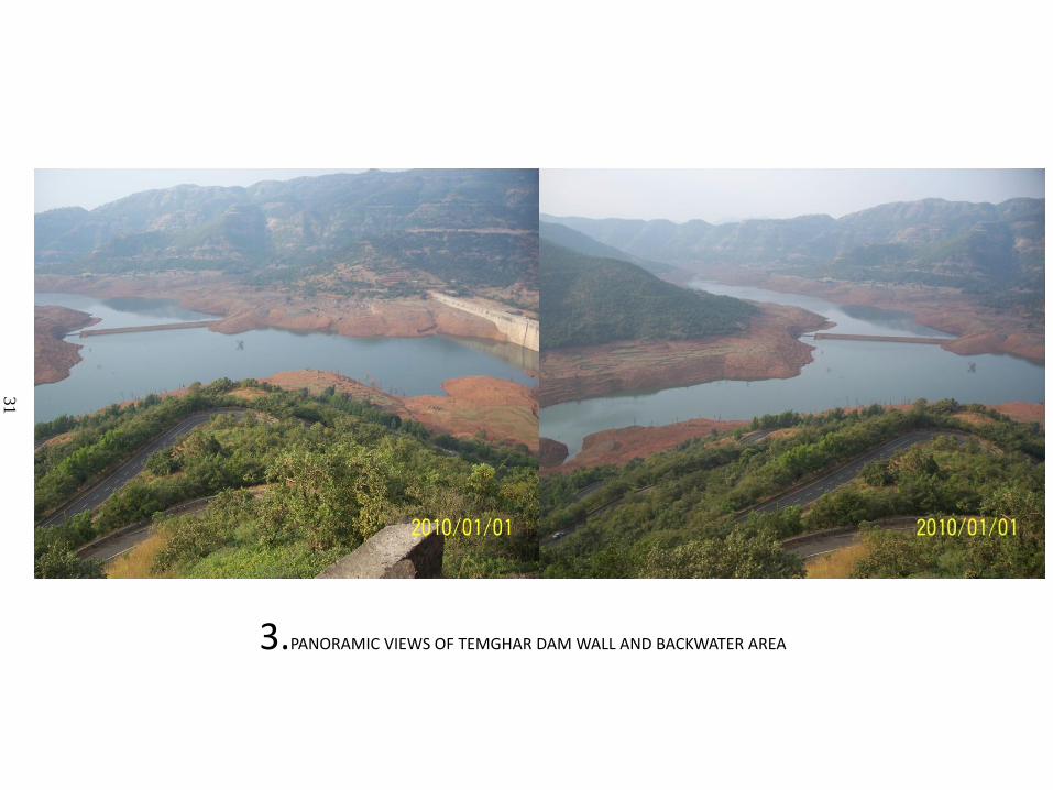
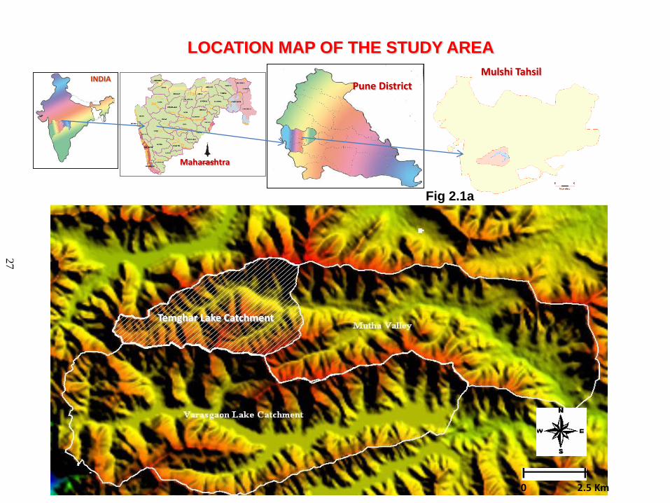
The dam is located near village Temghar across the river Mutha. The study
area is a catchment of Temghar dam and located between 18° 47' 00”N to 18° 38' 00”
latitude and 73° 27 to 73° 32' 00” E longitude. The study area is located about 50 Km.
to the west of Pune city. It is accessible by road only from Pune via Khadakwasala-
Bahuli or via Pirangut - Mutha (S.H-57). The nearest railway station and Airport is
at Pune. The Mutha river is a right bank tributary of the Bhima River in main Krishna
basin. The Mutha river originates in the main Sahyadri ranges in taluka Mulshi,
District Pune and flows through Mulshi and Haveli tahsils before meeting Mula river
in Pune. The dam is located at about 13 km. from the origin of the river Mutha. The
catchment area is 37.7 km2 up to the dam site including water body and area under

26
water body is 4.99 km2. The average gradient of the river at the dam wall location is
35 m/km. the average width of the valley is 4km. (Fig 2.1a, b and photo plates 1 to 7)
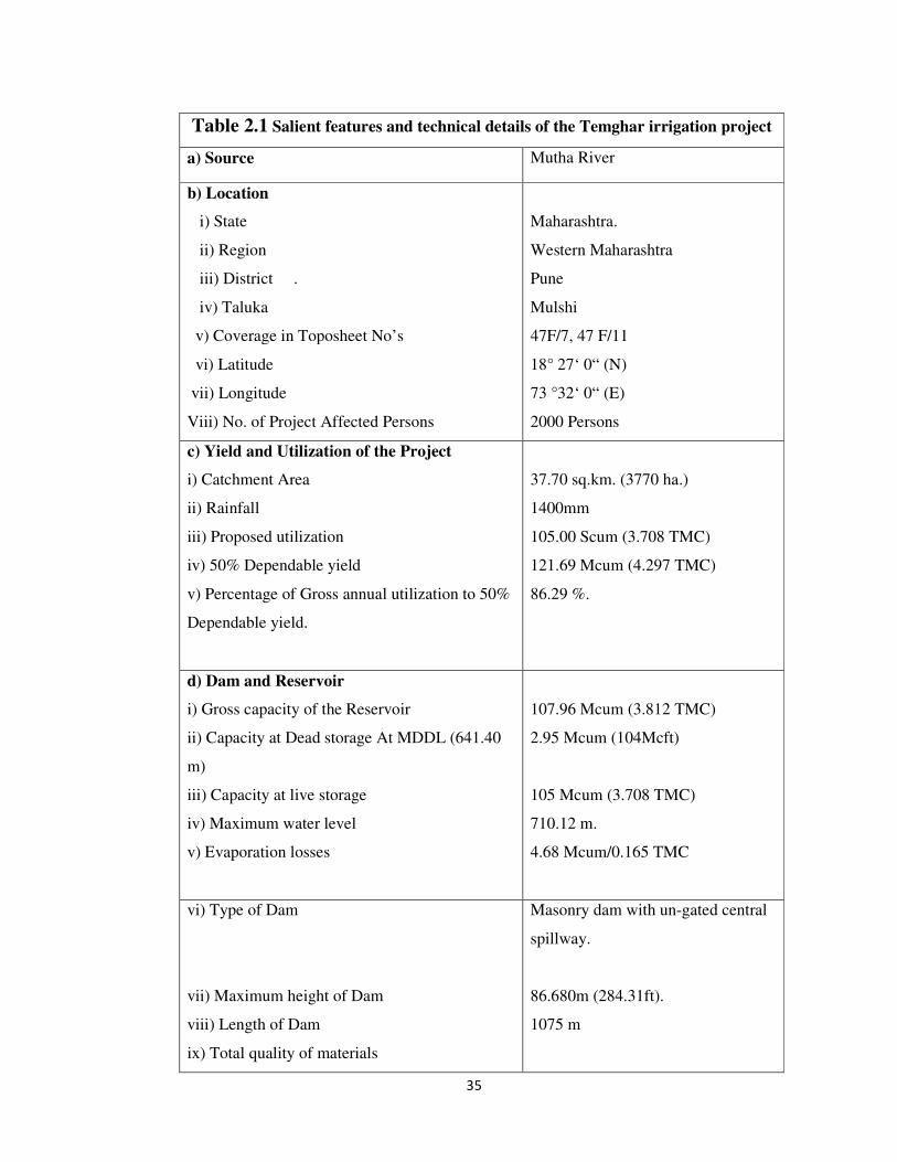
2.1.1.2 Temghar irrigation project technical details
The survey and investigation for the storage dam was undertaken in May 1989
and completed in February 1993.Information collected from district rehabilitation
center Pune reveals that, a project plan was prepared in 1994. However, project was
not undertaken at that time. The project report including costing was subsequently
revised and the revised report was prepared in 1999.The full reservoir level has been
fixed at RL 706.5 m.(Table no.2.1) An area of 499 ha (4.99 km2) is coming under
submergence including 4.50 ha. (0.045 km2) of forest land.(about 0.9% of
submergence land) In principle, forest clearance has already been obtained from
relevant authorities and Ministry of Environment and forest, western regional office,
Bhopal, (wide letter 8B-14/98, FW/C/899 Dated 15/5/98).Technical details of
TheTemghar irrigation project has been given in table 2.1.Land from four villages
acquired for the project has been displayed in table no. 2.2 also depicts the land
acquired from government which is 58.26 ha(0.5826 km2 )and forest land being 4.50
ha(0.0450 km2 ).
2.1.1.3 The details of affected villages and their rehabilitation sites
Total area under submergence is noted to be 499 ha. (4.99km2) and the land
has been acquired from four villages namely Temghar, Lavharde, Wegre and Vedhe.
Out of these four villages, Lavharde and Vedhe are partially affected and Temghar,
Wegre are fully affected villages. Table 2.3 depicts the details of affected villages and
their respective rehabilitation sites with distance.
Temghar irrigation project affected villages has been rehabilitated in five
villages mainly in Khed and Shirur tahsils of Pune district, i.e.Shel-Pimpalgaon (Khed
tahsil), Kondapuri, Rautwadi, Vitthalwadi and Apti (Shirur tahsil).
2.1.1.4 Geology:
The geology of the entire study area consists of dark coloured volcanic lava
flows. Lava flow mostly of the cretaceous time. The major portion of the area is
covered by basaltic lava flows known as “Deccan-Trap “of upper cretaceous to lower

27
Diagram 1

28
Diagram 2

29
Diagram 3

30
Diagram 4

31
Diagram 5

32
Diagram 6

33
Diagram 7

34
Diagram 8

35
Diagram 9

36
Diagram 10

37
Diagram 11

38
Diagram 12

39
Diagram 13

40
Eocene age. The lava were poured out of the long and narrow fissures in the earth’s
crust and are spread in the form of horizontal sheets constituting numerous spurs, hills
and hill ranges; bold, flat topped plateaus with terraces. The landforms generated out
of basalt are dominantly the flat topped elongated and round shaped hills, plateaus/
table lands, pediments, domes, undulating plains, gently sloping plains and ‘v’ shaped
valleys.
The rocks are more or less uniform in composition and texture. The rock is
dominantly basic in composition, very dark and grayish to gray in colour, hard,
compact and tough (Gaikwad L.D.1976).
Most of the bedrock is overlain by overburden with few rocky outcrops
visible. As the region falls in upper reaches of the river, there is absence of older
alluvium commonly found in lower reaches of river. Basalt of two main types is
found to occur viz. the compact or non-vesicular basalts (without gas cavities,) and
the amygdaloidal basalt with gas cavities filled with secondary minerals. The compact
basalt is found to occur as a thick flow up to 25m in thickness.
Amygdaloidal basalt with green or white spots produced by secondary
mineralization also occurs. The white spots signify zeolite while green or black spots
are produced by chlorophaetic mineralization. Fine grained red as well as black
Tachylytic basalts are found as small flows or vein –like intrusions in the compact
basalt.
Volcanic breccias, either with explosion fragments held together by zeolite or
embedded in lava matrix also occurs. The lava matrix may be normal basalt. The
compact basalts are found to be well jointed though there is some variation in pattern
of jointing. The amygdaloidal basalts on the other hand are found to be splited and
hence considered very suitable for foundation. The basaltic flows are of the two
types
1. ‘Pahoehoe’ flow 2. ‘Aa’ flow
The ‘Pahohoe flows’ weathered easily and give rise to mature type of the
topography with smooth hill slope and conical peaks. Broad valleys are common. The
product of the weathering includes small-sub rounded fragments. ‘Aa’ flows main
section comprise of dark grey, fresh basalt over this is found a section of flow braccia
which also consist of angular block of vesicular trap cemented by glass or zeolitic or
very fine grained altered basalt. (Fig. 2.2)

41
Diagram 14

42
2.1.1.5 Climate
Climate is tropical monsoonal type characterized by the well defined seasons
like summer, rainy, October heat, and winter season.
Temperature:-
The months of the summers are March, April and May which are having
variation in range of temperature. The mean annual temperature is 24.6°C while,
mean summer temperature is 27.4°C. There is a significant variation in temperature
conditions in western Maharashtra throughout the year. Seasons mainly summer,
rainy and winters persist more or less four months duration, temperature recorded to
be highest in the month of May which exceeds 38°C where as winter is a season
where temperature is recorded to be minimum generally less than 15°C. Average
condition of temperature variations are displayed in (Fig. 2.3)
In the Temghar catchment, the temperature distribution varies from east to
west. It decreases towards west from 25.9°C to 23.9°C due to the physiographic
variation i.e. undulating nature of the surface.
Rainfall:-
Monsoon starts in the month of June & receives up to the end of September.
Average annual rainfall is 2740 mm. (Fig 2.4). The rainfall variations in the region
show considerable increase towards west. Rest of the months are without spells and
the months April and May sometimes gives torrential rainfall due to local climatic
conditions.
2.1.1.6 Physiography
The area exhibits extremely rough terrain especially in the upper reaches of
area, in fact these valley sides are characterized by numerous terraces on both the
flanks. The region shows rugged topography which can be noticed by the high
variation in the slopes (00 to above 300). General slope of the watershed is from south
to north–east south of the main river and north to south-west at the northern reaches
of the basin. The altitude varies between a minimum of around 648 meters ASL near
the dam wall and a maximum of above 1100 meters ASL on the ridges of the basin

43
Diagram 15

44
Diagram 16
45
boundary mostly at the southern and northern water divide. Hilly undulated area and
hillocks are present particularly in the northern and southern part of watershed.
(Fig.2.5 a, b, c, d, e, f.)
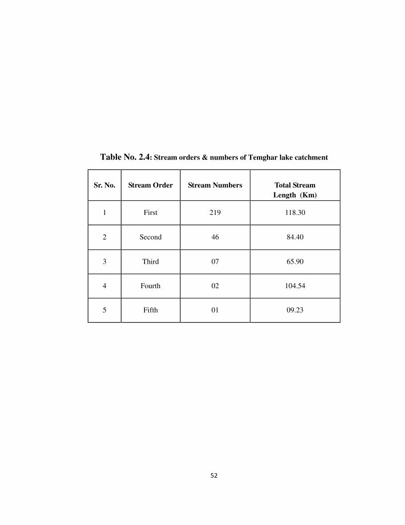
2.1.1.7 Drainage patterns
The area is a well-drained with mostly perennial streams that get their rain
water during the monsoon period (June to August). Most of the streams originate in
the southern part of watershed and flow in a north east direction. These streams
originating from a number of small valleys collect the excess rain water from the hills
and plain areas and finally reach to Mutha river. The drainage network shows
dendritic type of drainage pattern. The details of the stream number and orders are
given in the table no.2.4 and (Fig.2.6).
2.1.1.8 Soil environment
As mentioned earlier, the study area is characterized by various slope
segments. There is a considerable variation in soil properties. Sandy material is
generally confined to higher slopes, whereas agriculture land shows silty, clayey and
loamy and loamy sand in abundance.The general colour of soil along hill slope area is
dark reddish and it is dark brown to yellowish brown in the Mutha valley floor. It
seems the soils in the valley floor are rich in the amount of organic matter and humus
content. Most of the valley floors are presently submerged. Along most of the hill
slopes are barren, devoid of vegetation and thus exhibits very high potential land
surfaces for surface runoff and soil loss, therefore top soil layer is very thin and
almost lost at same places. Higher hill slopes have thin film of soil and it is also less
compact compared to the agricultural soil on the hill slopes wherever forest cover
exists, soils are enriched in organic matter, whereas in plain regions, due to the
mixing of the soil with the other ingredients such as stones, grass, gravel has resulted
in the modification of the soil properties.
2.1.1.9 Natural vegetation
The watershed has mixed deciduous type of vegetation thin shrubs
predominant on hills and hill slopes. Some of the important species are enlisted below
in Table No.2.5.

46
Diagram 17

47
Diagram 18

48
Diagram 19

49
Diagram 20

50
Diagram 21

51
Diagram 22

52
Diagram 23

53
Diagram 24

54
Diagram 25

55
The present study area is hilly and patches of reserved forest are observed
along the hill slopes. Within the forest area itself, there may be occasionally cultivated
patches or grazing land.
2.1.1.10 Total land acquisition
Temghar Lake has been displayed in table 2.2. The study area covers about an
area of 3770 ha. (37.70sq.km) land has been acquired from the four villages for this
project. The village wise break up of geographical area is given below: Table No.
2.2 total land acquisition
2.1.2 Socio-economic aspects:
Out of the four villages, Temghar and Vegre are fully affected, where as
Lavarde and Vedhe are partially affected villages. Settlements are clustered at the
lower basin of Mutha valley where alluvium deposits are quite extensive thus
encouraging villagers to settle in the vicinity indulging in agricultural practices.
Settlement forms a very minor portion of the whole study area and the villages are
poorly linked with mostly unsealed roads. As one moves nearer to the river source,
settlements tend to shrink in size and get dispersed in trend. Moreover the more
rugged topography as one goes higher is inhospitable both for living and agricultural
practices. The erection of two dams in the study area within the past decade has had a
major impact on the lives of people around that area. Many families have been
displaced because of the dam construction and most of the fertile lands in the Mutha
valley got submerged forcing the inhabitants of the area to find other alternative
places to settle down.
The Maharashtra Industrial Development Corporation (MIDC) has recently
developed an industrial area at Kurkumbh in Daund Taluka,as a major centre and with
sub centre’s like Jejuri,Pirangut and Ranjangaon. Many private industries have come
up at Pirangut in Mulshi tahsil. But these industries are having the speciality in the
Information Technology; hence the opportunities of employment for this project
affected people are strictly restricted as their education level is not up to the required
one.
There are no mineral deposits or any other source in the study area for the
employment potentials. The main source of livelihood in this area is agriculture. Other

56
occupations are, to collect fish and crab from the surrounding water sources and to
sale it in nearest market places. Roads- Pune-Pirangut- Mutha—Vegre tar road is
available in the study area. Major railway junction is at Pune, which is near about 50
km. away from the dam site. Major weekly market places are Pirangut and
Khadakwasla. These places are linked with good motorable roads.
In the present study, an overview of socio-economic and cultural aspects has
been taken in to consideration to infer the socio-economic and cultural dimensions of
project affected as well as rehabilitated villages. It is observed that, people still
remained at their native place and are practicing subsistence type of farming and very
much backward in terms of their socio-economic status and standard of living. Most
of them are from Hindu religion and very few are from other religion like,
Budhist.They have still maintained their customs and are in communication with the
people who have been rehabilitated else were. Even today they used to come for
marriage, festivals and annual fairs etc.The relatives of project affected people are still
manages and builds the relationships from the same area. People from rehabilitated
area prefer to build such kind of relationships through marriages from their native
places.
Worshipping a God in festivals and annual fairs is a remarkable cultural
activity being practiced and maintained from both the sides i.e. from affected as well
as rehabilitated sites. Project affected people are facing so many social and cultural
problems in terms of different activities pertaining to annual fairs, festivals etc. They
are not receiving proper education and has to go for long distance for higher
education. An infrastructural development is almost stopped because of less
population in these areas and still has to walk over a long distance to come to city area
like Pune. Agriculture is being practiced and is mainly paddy cultivation and few
millets on inferior soils, thus agriculture has become a restricted activity in this area.
Peoples from rehabilitated sites also facing socio-cultural problems and
willing to go to their native area as their relatives are residing in affected areas. People
where they have been rehabilitated, local ones have not yet accepted them as their
own resident’s and citizens and have to face a problem of confrontation repeatedly.
57
2.2 Hypothesis:
Displacement of people due to infrastructural development has become a
serious issue in India. No efforts have been made till recently, neither by government
authorities nor by private / public sector to systematically restore these affected
populations. There are serious instances took place, while implementing the
rehabilitation policy within the legal framework, therefore it is hypothesized that,
‘Development of rehabilitation model pertaining to minimization of the cost of
rehabilitation and to retain peoples own socio-cultural dimensions within the
framework of Integrated Land Resource Management (ILRM),’ certainly will help in
upgrading and maintaining the natural resources and will also be helpful in
minimizing the degradation of environment as well as restoring the people to their
native places’.
2.3 Major objectives of the study:
The major objective of the present study is to evaluate the available land and
soil resources in the catchment area of a Temghar lake so as to check the availability
of natural resources in general and land resources in particular. Therefore following
objectives have been outlined:-
1. To infer the potential of land resources in the catchment area and to evaluate land
resources and its significance to meet the need of rehabilitation process in the
same piece of land.
2. To analyze land use / land cover in the study area using remote sensing technique
which will help in understanding the general trend of utilization of land resources
in the study area and to identify suitable sites for rehabilitation within the
catchment itself.
3. In order to assess the potential of a terrain in terms of land capabilities and
suitability, soil productivity, soil physiographic relationship pertaining to soils-
cape analysis forms the basis of the present study. This will help to identify and
analyze land forms in terms of their potentials for optimum utilization of
land resources and to identify suitable sites for rehabilitation.
4. To infer the nature and extent of degraded lands in terms of soil loss, surface
runoff and vegetation cover, forms the basis of land evaluation studies therefore
it is ascertained by computing empirical equation and visual interpretation of

58
satellite images this will help in delineation of priority land facets for
conservation planning.
5. To ascertain the present situation and status of rehabilitation process and to infer
the socio-economic status of the project affected people and to understand
general perception of the villagers.
6. To prepare various thematic maps as a basis for further planning and
management of land resource in general and regeneration of wasteland in
particular for the rehabilitation of the project affected people.
2.4 Database and Methodology
2 .4.1 Database:
Data required for the present study has been acquired from various sources.
Data pertaining to various aspects of the study mainly includes primary and secondary
data. Main thrust has been given on collection of first hand information by visiting the
project affected as well as rehabilitated places, which almost cover all the villages
under consideration. Around 100% data has been thus, collected by conducting
extensive house hold surveys. Table 2.6
In addition to this, data from Talathi office, Tahasil office, forest department
of Maharashtra, soil survey department, Maharashtra Engineering Research Institute
(MERI), Nasik. Irrigation department, Pune, District rehabilitation centre, Pune, NGO
etc. forms a major database for the present study. Details are outlined in the following
lines.
2.4.1.1 Primary data collection
2.4.1.1.1 House hold socio-economic survey
In order to conduct a household survey, detailed questionnaire has been
prepared and mainly questions pertaining to the people’s perception of rehabilitation,
has been incorporated. Around 82 families in the catchment and 167 families from the
rehabilitated places were interviewed in detail considering each and every member of
the family.

59
Diagram 26

60
Since the present study intended to synchronize the socio-eco information of
project affected people, very comprehensive questionnaire for house hold survey has
been prepared (Appendix-I)
Around 82 households were interviewed at project affected place and167
households are interviewed at rehabilitation places. This has resulted into determining
very good extract of their problems regarding rehabilitation at rehabilitated places at
the villages Shel-pimpalgaon, Kondhapuri, Vitthalwadi, and Apti. Detailed review of
which has been taken in preceding lines.
2.4.1.1.2 Soil survey:
In order to infer characteristics of soil with respect to topography a detail soil
survey plan has been prepared which involves mainly the soil survey at
reconnaissance level. Soil survey thus conducted mainly includes, soil sample
collection with soil anger, core tube, and infiltrometer. While collecting soil samples;
effective rooting depth of plants has been considered, i.e.upto 25cms.It is also
intended to collect the samples to represent almost all slope segments details are given
in the preceding lines.
2.4.1.2. Secondary data:
Secondary data mainly obtained from talathi office at Temhgar, Paud
panchayat samitee at Paud, Tahsil office at Paud, forest department government of
Maharashtra, soil survey department government of Maharashtra, Maharashtra
Engineering Research Institute (MERI) Nasik, Geological survey of India, Pune
Irrigation department, Pune, Pune district project affected rehabilitation office, Pune,
NGO like Gomukh, Kirloskar consultants, census hand books (Pune districts) 1991,
2001 etc.
2.4.2 Methodology:
2.4.2.1 Fieldwork component:
2.4.2.1.1 Collection of soil sample & field measurements.
Field components of present study mainly composed of observation based on
soil sample collection according to change in the slope along with this field
measurement of hydraulic conductivity and infiltration capacity has also been

61
conducted in the field. Around 31soil samples has been collected and 167 field
observations has been carried out in the field.
2.4 2.1.2 Ground truthing
Remote sensing data mainly used of very high resolution data of sensor SPOT
a true colour image. The extension of features mainly vector in nature has been
verified in the field through ground check on truthing.
2.4.2.2 Laboratory components:
2.4.2.2.1 Preparation of base map:
Base map has been prepared using Toposheet no. 47F/11, 47F/15. Major
operations involved in the preparation of base map are scanning of the toposheet and
geo referencing the same in the GIS environment using toposheets no’s, 47F/11,
47F/15 .After successful rectification of which high resolution SPOT image has been
synchronized and rectified to the same projection and datum.
2.4.2.2.2 Soil analysis:
Soil analysis of the collected soil samples has been performed in the soil
laboratory around 31samples were analyzed and physical properties of the soil, like
determination of soil texture, structure, bulk density % porosity, water holding
capacity etc has been determined. Chemical properties have also been determined
using digital pH meter, Digital conductivity meter, digital colourie meter etc. as well
as titration method has also been performed to determine calcium carbonate, %
organic carbon, % organic matter etc. Soil analysis kit has also been used to determine
nitrogen, phosphorus, potassium (NPK).
2.4.2.2.3 Data analysis and computation of results
Data generated through soil analysis has been processed for statistical
operation. Major derivatives like mean standard deviation, mode, has been determined
to infer the variation in the average characteristics of soil in the Temghar lake
catchment. However these soil characteristics are also useful as basic input parameters
in the soil erosion studies. Soil data in terms of their GPS location has proved to be
62
very useful in determining spatial locations of soil sample as well as to infer the
spatial distribution of various properties and preparation of various thematic maps. An
attempt has also been made to estimate rates of denudation by digitizing Toposheets
contours and aster DEM of 30m resolution.
2.4.2.2.4 Preparation of Thematic maps using RS & GIS
Based on the data collection and data generation various thematic map of
Temghar lake catchment has been prepared. It mainly includes digital elevation
model, absolute relief map, relative relief map, percentage slope map, delineation of
water shed. Table 2.7.
2.4.2.2.5 Software’s used
For the base map preparation and for preparation of various thematic maps,
various GIS software’s like Global Mapper version 12.01, Surfer version 9.01,
Digem, Google earth BASIN-4’, Diva-GIS, ILWIS (Integrated land and water
information system) Adobe Photoshop has been used. Table No 2.8 Methods used for
thematic map preparation.
�
� � � �

63
Diagram 27

���
�
Table No. 2.7: Methods used for thematic map preparation
Sr. No Map Method Source
1 Absolute Relief Map
By superimposing grid (1.5 cm *1.5m)
ASTER Data (30m Resolution)
2 Relative Relief Map
By superimposing grid (1.5 cm *1.5m)
ASTER Data (30m Resolution)
3 Dissection Index Map
By superimposing grid (1.5 cm *1.5m)
ASTER Data (30m Resolution)
4 Slope Map (%) By superimposing grid (1.5 cm *1.5m)
ASTER Data float grid file format
5 Drainage Map Digitization in global Mapper and process in Diva GIS software
Toposheet index no 47F/7 and 47F/11
6 Land use / land cover map
Digitization in global Mapper and process in Diva GIS software
Google image Dec-07
7 DEM model Digitize the contour in Global Mapper and process in surfer software
Toposheet index no. 47F/7 and 47F/11
8 Sub watersheds Basin 0.4 software Arc Ascii file format Aster elevation data
9 Soil properties maps Surfer software Grid operations in surfer

��������������������� �
���� ���� ���� � �������� � ����������� ������������� ������� ��� ������������ ���
������������������
����� � ����
�������������� �
� �����������
���������� ���
�������� �� �������� �������������
�� ������ �� ��
��� ������� ��
��� ������� ���
��������
����� ������
�����������������������
�������������������
�� ��������������������
������� !����"#
��������� ������
$����$% �����
������� ��������
�&'�(� �
������������� � �
��������� ���
��������� �� ���
����
�� ������ ���
�������������������������� �� �� �������� ��������
� �������) ��������� ������
��� ������� ���
��� ����
Table no. 2.6
���������������
� ������������
������� ������) �
������� ������) �
��������� �
� ��*�
������ ������
� ������
� �������) ��������� ������ ��� ����
� �� ��������
����� ���� ���
�� ��� �������
����
������������
� ��������������
�+��� ����� ����
������,���� �
�������,���� �
������������� �������
��������� � �
� ����������� �� ������ ����(��
�� �������������� ����� ��������������
� ������ ���������������������� � �
�����% ��$��������
�����
������������� ��
�����
���������� �
����������
���� ������ ��������(��� �� ������ ������
������� ����������������� ������������������������������������������
���� �� ���������
59

���
�
Table No. 2.5: Species of natural vegetation and shrubs
Sr. No. Local name Botanical name
1 Mango Magnifera Indica
2 Khair Accacia Catheue
3 Hirada Lerminala Chebula
4 Behada Terminalia belerica
5 Umber Ficus recemose
6 Jambhul Enginia Jambulana
7 Phanas Artocarpus ineisa
8 Ain Terminatia formardasa
9 Teak Tectona Grandis
10 Bhabhul Accacia arabica
Shrubs
1 Ghaneri Latana Camera
2 Ghypat Agave Sisolona
3 Rui Calotropis gigntia
���
�
Table No. 2.4: Stream orders & numbers of Temghar lake catchment
Sr. No.
Stream Order Stream Numbers
Total Stream Length (Km)
1 First 219 118.30
2 Second 46 84.40
3 Third 07 65.90
4 Fourth 02 104.54
5 Fifth 01 09.23

���
�
Table No. 2.3: The details of affected villages and their rehabilitation sites
*Village Vedhe has not been rehabilitated due to partial land acquisition (i.e. 42.92 ha)
Source: District rehabilitation center, Pune 2006.
Sr. No.
Name of the affected and to
be rehabilitated village
Tahsil Village where rehabilitation
to be done
Tahsil Distance from affected to
rehabilitation Site (in Km)
1 Temghar Mulshi Shel-Pimpalgaon
Khed 80
2 Temghar and Lavarde
Mulshi Kondhapuri Shirur 103
3 Lavarde Mulshi Raut wadi Shirur 96
4 Vegre Mulshi Vitthalwadi Shirur 102
5 Vegre Mulshi Apti Shirur 84

�
���
�
Table 2.2 Land acquisition for Temghar irrigation project
Source: District rehabilitation center, Pune
Village Area in ha Area in Km2
Temghar 137.28 1.3728
Wegre 219.44 2.1944
Lavharde 105.20 1.0520
Vedhe 42.92 0. 4292
Government land 58.26 0. 5826
Forest land 4.50 0.045
Total 567.600 5.6760
�
���
�
Table 2.1 Salient features and technical details of the Temghar irrigation project
a) Source Mutha River
b) Location
i) State
ii) Region
iii) District .
iv) Taluka
v) Coverage in Toposheet No’s
vi) Latitude
vii) Longitude
Viii) No. of Project Affected Persons
Maharashtra.
Western Maharashtra
Pune
Mulshi
47F/7, 47 F/11
18° 27‘ 0“ (N)
73 °32‘ 0“ (E)
2000 Persons
c) Yield and Utilization of the Project
i) Catchment Area
ii) Rainfall
iii) Proposed utilization
iv) 50% Dependable yield
v) Percentage of Gross annual utilization to 50%
Dependable yield.
37.70 sq.km. (3770 ha.)
1400mm
105.00 Scum (3.708 TMC)
121.69 Mcum (4.297 TMC)
86.29 %.
d) Dam and Reservoir
i) Gross capacity of the Reservoir
ii) Capacity at Dead storage At MDDL (641.40
m)
iii) Capacity at live storage
iv) Maximum water level
v) Evaporation losses
107.96 Mcum (3.812 TMC)
2.95 Mcum (104Mcft)
105 Mcum (3.708 TMC)
710.12 m.
4.68 Mcum/0.165 TMC
vi) Type of Dam
vii) Maximum height of Dam
viii) Length of Dam
ix) Total quality of materials
Masonry dam with un-gated central
spillway.
86.680m (284.31ft).
1075 m

�
���
�
a) Masonry
b) Concrete
c) Excavation
x) Submergence of area
a) Land under submergence at RL
707.25m and require for colony
b) Number of villages affected
xi) Controlling levels
a) Riverbed = 641.56m.
b) MDDL = 661.40m.
c) FRL = 706.50 m.
d) HFL = 710.12 m.
e)TBL = 711.40.m.
1187.772 cum.
44.9430 cum.
8.34.173 cum.
499.034 ha.
4 villages (2 villages fully and 2
villages partially.)
xii) Free board
xiii) Spillway
a) Type Un-gated central spillway with pier and
a bridge to cross the River.
b) Maximum flood discharge
c) Estimated flood capacity
d) Height of Masonry section
e) Foundation level of Spillway.
f) Length of spillway.
Xiv) Outlet
a) Location RD 635.00m.
b) Type Conduit with screws type.
c) Foundation level
d) Full supply discharge.
xv) Canal
Xvi) Command Area
1.26 m.
---
736 Cumecs (25996)
2092 Cumecs (73890 cusecs)
86.68m (284.3ft)
72.00m.
624.720m (Average).
Irrigation cum power
-
-
635.52m (at RD635.00m)
9.91 Cumecs (350 cusecs).
Canals are not proposed. Water will
be let out through ICPO in Mutha
river in the catchment of
Khadakwasla dam.

�
���
�
Source: Irrigation department, (Sinchan Bhavan) Pune
� Gross command area of KT weirs (Down
steam of Khadakwasala Dam and up to back
water of Khad akwasala project)
� Cultivable command area Khadakwasala
project.
� Irrigable Command Area from Khadakwasala
Project
� Intensity of Irrigation over Gross Command
area.
xviii) Total Cost of the project
2000 ha. +18383ha. from
Khadakwasala project
1600ha. +14398ha.from
1000ha. from Mulshi +10830ha
58%
Rs.323.53 Crores.

1. PANORAMIC VIEW OF TEMGHAR DAM AND SURROUNDING
29

2.VIEW OF THE CATCHMENT FROM TEMGHAR DAM WALL - BARE HILLSLOPES ON THE BACKGROUND
30
3.PANORAMIC VIEWS OF TEMGHAR DAM WALL AND BACKWATER AREA
31
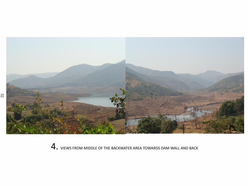
4. VIEWS FROM MIDDLE OF THE BACKWATER AREA TOWARDS DAM WALL AND BACK
32

5.DISTANT VIEW OF TEMGHAR DAM WALL AND SUBMERGED HOUSES AND TREES ON THE FOREGROUND
33
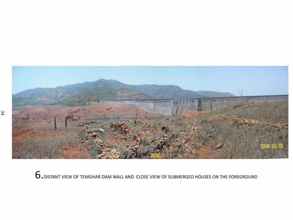
6.DISTANT VIEW OF TEMGHAR DAM WALL AND CLOSE VIEW OF SUBMERGED HOUSES ON THE FOREGROUND
34
Maharashtra
INDIA
Temghar Catchment
0 2.5 Km
Temghar Lake Catchment
Pune District
Mulshi Tahsil
LOCATION MAP OF THE STUDY AREA
Fig 2.1a
27
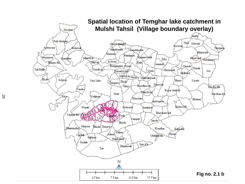
Fig no. 2.1 b
Spatial location of Temghar lake catchment in
Mulshi Tahsil (Village boundary overlay)
28

GEOLOGY MAP
TEMGHAR LAKE CATCHMENT
Fig no. 2.2
41

INDEX (Temp Deg C)
Fig no. 2.3 Source: FAO 2008
43
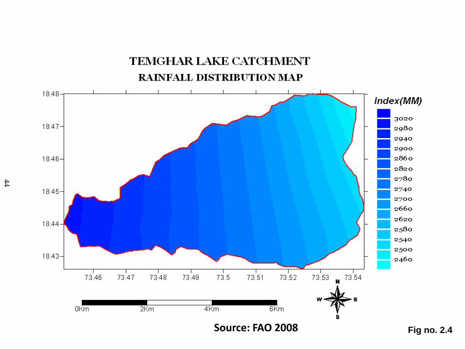
Fig no. 2.4 Source: FAO 2008
44

Fig no. 2.5 a
46

TEMGHAR LAKE CATCHMENT
DEGITAL ELEVATION MODEL
Fig no. 2.5 b
47

Fig no. 2.5c
48

Fig no. 2.5 d
VECTOR MAP
49

Fig no. 2.5 e
50

Fig no. 2.5 f
51

TEMGHAR LAKE CATCHMENT
STREAM ORDER MAP
Fig no. 2.6
53