Embed Size (px)
Citation preview

Chapter II
DIVERSITY OF WOODY-VEGETATION FORMATIONSAND SUMMARY BREAKDOWN
1. THE VARIOUS CLASSIFICATIONS USED
The term ‘dry tropical forest’ can be misleading, because it includes such stands as drydeciduous forests, thickets, open woodlands, savannas and steppes (wooded, tree and shrub).To define the dry tropical forest, authors use such differing concepts as the structure of thevegetation, its appearance, the amount of sunshine, rainfall, evapotranspiration, and thenumber of dry days or months – and even these are defined using different criteria.
Generally speaking, the terms used by different authors, whether they are foresters, botanistsor geographers, derive initially on borrowings from the local languages or dialects. In thesecond stage, the scientists become more consistent and propose classifications which applyworld-wide.
According to FAO terminology, ‘forests’ include closed forests, as well as open woodlands andsavannas with at least 10 percent tree cover.
Ch II - Diversity of woody-vegetation formations and summary breakdown 13

Table 3: Types of vegetation considered in this study
In Table 3, the two left-hand columns are regarded as landmark in the world of forestry.Despite its shortcomings, Yangambi’s classification (Aubréville, 1957) is the result of aconsensus between a large number of French-speaking and English-speaking plantgeographers. Moreover, the terms used are straightforward and full of imagery. They havebeen whenever feasible, related to the FAO 1981 classification.
14 Ch II - Diversity of woody-vegetation formations and summary breakdown
Examples
Dry closed forest in the Sudanian domainDry closed forest in MadagascarBosque bajo caducifoliado (Mexico, Central America)Dry closed forests in India
Open woodlands (Khaya, Isoberlina, etc.) in SudaniandomainMopanes and miombos (Brachystegia, Julbernardiaetc.) in Southern AfricaDipterocarpaceae forests in IndiaCerrado, Sabana arborea in America
Tree savannas or savanna woodland in the Sudaniandomain, under Anogeissus leiocarpusOpen formations in the Sudano-Sahelian domainDry Albizia amara formations in IndiaCampos cerradosSabana abiertaChaco seco
Acacia senegal formations in AfricaCaatingas, ChaparralDegraded patterns in the Chaco (America)Xerophilous formations in India
Combretum formations in AfricaCaatingas agrupadasMatorralChaco (xeromorphic)
FAO (1981)
NHCf=
Closed broad-leaved forest
NHc/NHO=
Mixed broad-leaved Forest-grassland tree formations
NHc/NHO =Mixed broad-leaved
Forest-grassland tree formationsNH =
Essentially shrub formations
NHc/NHO =Mixed broad-leaved Forest-grassland tree formations
NH = Essentially shrub formations
-
Yangambi (1956)
Dry deciduous forest
Woodland
Savanna woodland
Trees savanna
Shrub savanna
Trees and shrub steppe
Dwarf shrub steppe
Thicket

Figure 1: FAO classification of natural woody vegetation
The heavy outline in Figure 1 shows most of the natural, woody-vegetation stands studied in this document.
2. DESCRIPTION OF THE MAIN TYPES OF VEGETATION
This section describes, in very general terms, the main types of vegetation considered in thispaper, including dry deciduous forests, thickets, open woodlands, savanna and steppes. Thedefinitions and Figure 2 are taken from Letouzey (1982).
2.1 Dry deciduous forests
This type of forest is one of the rare, closed forest formations (with thickets) examined in thisstudy. It is a closed stand, with no substantial opening in the crown cover (above 80 percent),the trees are approximately 15-20 m high and they lose their leaves, with few exceptions,during part of the year. The understorey comprises sparse and scattered evergreen or deciduousshrubs, with a few grass tufts.
Ch II - Diversity of woody-vegetation formations and summary breakdown 15
Classification of natural woody vegetation
COMPOSITION
DENSITY(IN NORMAL
CONDITIONS)
ALTERNATIONBY
AGRICULTURE
PRODUCTIONCAPACITY
(WOOD FORINDUSTRY)
MANAGEMENTSTATUS/
PHYSICALACCESSIBILITY
PASTLOGGING
TREES SHRUBS
(predominantly)BROADLEAVED
(predominantly)CONIFEROUS
CLOSEDBROADLEAVED
FOREST
BAMBOOFOREST
MIXED(TREE)
FORESTGRASSLANDFORMATIONS
FOREST FORESTFALLOW FOREST FOREST
FALLOWFOREST FOREST
FALLOW
PRODUCTIVE UN-PRODUCTIVE PRODUCTIVE UN-
PRODUCTIVEPRODUCTIVE UN-
PRODUCTIVE
WITHOUTINTENSIVE
MANAGEMENT
WITHOUTINTENSIVE
MANAGEMENT
FORPHYSICALREASONS
FORLEGAL
REASONS
UN-DISTURBED
LOGGED-OVER
In Africa this formation is only found in the relics of degraded forest stands in the Sudaniandomain running from Guinea-Bissau to the Central African Republic. It is also found in theZambezian domain, which is on the extreme edge (humid) of the area covered by this paper.The stands are still substantial in Madagascar, where they are located to the west and south-western parts of the island with very different specific flora from elsewhere in Africa, andwhere the trees are not more than 15 m high (Figure 2).
In Asia the dry deciduous forests are found in India, in the north-eastern part of the DeccanPlateau (the Shorea robusta forests, with annual rainfall ranging between 1,000 and 1,600 mm,average 20 m high) and in the west (the Tectona grandis and Anogeissus latifolia forests havelower annual rainfalls, but are the same size as the Shorea robusta forests, though they canreach a height of around 40 m in certain parts).
In America, along the Pacific Coast of the Central American isthmus, this type of formationis represented by fairly small forests such as the Selva baja caducifolia. There are also a fewstands in Venezuela, Colombia and particularly in the heart of Amazonia (the Santaremregion).
2.2 Thickets
These are closed, dense formation with crown cover density in excess of 80 percent,comprising only suffrutescent plants and shrubs, both evergreen or deciduous, which aregenerally difficult to penetrate, and do not exceed 8 m in height. There is little or no grasscover. These are generally edaphic formations, mainly found in Africa and South America.Examples are the climbing acacia (Acacia ataxacantha) thickets found in clay depressions, orvarious Combretum spp. stands in the Sahel, Bussea and Pseudoprosopis stands in Tanzaniaand the xeromorphic Ruprechtia triflora thickets in Paraguay.
16 Ch II - Diversity of woody-vegetation formations and summary breakdown

Figure 2: Types of woody (or partially woody) stands
Ch II - Diversity of woody-vegetation formations and summary breakdown 17
Dry deciduous forest
Thicket
Open woodland
Savanna woodland

Source: Letouzey, 1982
2.3 Open woodlands
These are open forest stands with small or medium size trees, and whose crowns are almostcontinuous, but through which light is able to penetrate widely. They have partial grass coverand the tree layer is virtually continuous (10-20m and 40-60 percent cover). The species arevery gregarious, which differentiates these forests from the tree savannas. Nasi (1994) setsthese apart by the fact that they are highly characterized by an Rl/h ratio between the woodybiomass and the herbaceous biomass (open forests Rl/h�3, tree savanna 1 £ Rl/h £ 2).
18 Ch II - Diversity of woody-vegetation formations and summary breakdown
Tree savanna
Shrub savanna
Tree and/or shrub steppe
Thorny shrub steppe

These vegetation formations are often overharvested as a result of overgrazing associated withfuelwood extraction and crop farming, as evidenced in northern Cameroon in the new cottonfields.
In Africa, in the Sudanian domain (Map 4) these are mainly made up of Isoberlinia andUapaca. In the Zambezian domain they are much more developed, mainly the miombo forestscomprising the Brachystegia, Isoberlinia, Julbernardia, Parinari and Uapaca genius, and themopane forests composed of Colophospermum mopane and Acacia genius.
In Asia, the open Dipterocarpaceae woodlands (Dipterocarpus alatus, D. obtusifolius, etc.) arefound in Cambodia, Laos, Thailand and Myanmar. Their grass cover is continuous. The teakforests (Tectona grandis) in the dry areas of India are also open woodlands, as are theHardwickia binata transitional forests to the Deccan thorn series.
2.4 The savannas
The savannas comprise continuous grass cover mainly made up of hardy grasses(graminaceae) and trees or shrubs, varying in density, frequently with twisted stems. In somedepressions, the trees are sufficiently close to be considered open woodland. Open woodland,savanna woodland and tree savanna lie on a continuous scale, which explains why somestands, such as the miombo forest and mopane forest, are classified by some authors as savannaand by others as open woodland. Generally speaking, one might consider that in openwoodland the grass cover is strongly influenced by the woody layer, whereas in the savannathe trees only have a local influence over the grass cover, mainly under the crowns. In asimilar, but more quantified way, one shall speak of woodland when the Rl/h ratio between thewoody biomass (l) and the herbaceous biomass (h) exceeds 3, and use the term tree savannawhen l < Rl/h < 2 and shrub savanna when 0.5 < Rl/h < 1 (Nasi, 1994).
In Africa, and particularly in the Sudanian domain (Map 4), examples include the Anogeissusleiocarpus savanna woodlands which make place in the north, to the Sahelian-Sudanianbiogeographic zone, dominated by tree savanna (Khaya senegalensis, Parkia biglobosa,Butyrospermum paradoxum and various Combretaceae). In the Sudanian and Saheliandomains tree savannas gradually gives way to the Combretum micranthum, Sclerocaryabirrea, Acacia seyal savannas. Further north, in the Sahelian domain stricto sensu, the lattergive way to Mimosaceae (Acacia senegal, A. raddiana), Balanites aegyptiaca, Commiphoraafricana, Boscia senegalensis savannas and steppes.
In America, Krameria and Salvertia savannas are found in the Brazilian cerrados where thetwisted trees, between 4 to 8 m high, grow fairly close, and in the South American campos.
In Asia, in the central Indian regions, there are the Albizia amara, Acacia, Capparis,Anogeissus, etc. savannas.
Ch II - Diversity of woody-vegetation formations and summary breakdown 19

2.5 Steppes
These are open, herbaceous formations with discontinuous grass cover, mainly annual species,and sometimes with woody plants. The woody component is fairly sparse and less than 10 mhigh. Usually a distinction is drawn between tree and/or shrub steppes, thorny shrub steppes,and dwarf-shrub steppes. They are found in the drier areas, bordering the deserts (Sahara,Kalahari, Thar). The succulent, herbaceous and/or graminaceae steppes are not considered inthis study.
In Africa, in the Sahelian domain, particularly with a Sahelian-Saharan climate, the steppesfound are Acacia tortilis ssp. raddiana, A. senegal, A. ehrenbergiana, Balanites aegyptiaca,Calotropis procera, Leptadenia pyrotechnica steppes.
In Central America, the Prosopis juliflora mezquital and the matorral, which is characterizedby Cactus (Cereus, for example), may also be considered as steppes. In Brazil, the caatingaswith Aspidosperma, Piptadenia, Pithecelobium and Zizphus are also steppes as are certainparts of the Chacos in Paraguay, Bolivia and Argentina.
In Asia, in north-west India, one could cite the Prosopis, Acacia, Ziziphus, etc., stands.
It is interesting to compare fairly similar stands spread throughout different continents. Onesuch comparison between the African Sahel and the Brazilian Sertão is described in Box 1.
20 Ch II - Diversity of woody-vegetation formations and summary breakdown

Ch II - Diversity of woody-vegetation formations and summary breakdown 21
Box 1: Comparison between the Sahel in West Africa and the Sertão in north-eastern Brazil
In the Sahel (northern hemisphere) the short rainy season generally runs from late June to September. Therain falls exclusively in the hot season. Rainfall variations are considerable and the mean annual temperaturerange between 27.5 and 30°C. The semi-arid zone of the Sertão (southern hemisphere) has two differentrainfall regimes: in the north, the rainy season is mainly in March, whereas in the south it is concentrated inNovember, December and/or January. Rainfall coefficient of variation reaches 50 percent, which is muchhigher than in the Sahel. Conversely, the alternation between the two seasons, dry and rainy, is not regular.Rain in the Sahel is far more erosive than in the Sertão. Average solar radiation, while being high, is still lowerthan in Africa.
The Brazilian caatinga is a low and dry forest in the full sense of the term, between 2 and 5 m high,continuous and often dense, (with a 90 percent tree and shrub cover in the semi-arid zone of the three north-eastern states (Pernambouc, Paraôba and Alagoas) with sparse grass cover and dominant woody legumes. Thetree and open shrub savanna and the striped bush (brousse tigrée) in the Sahel are very largely made up of agrassy layer which becomes rapidly parched after the rainy season. Under comparable rainfall conditions, thewoody-vegetation densities and biomass are, respectively, in excess of 17 000 individuals/ha and 23 t/ha inthe caatinga, compared with 133 individuals/ha and 1.8 t/ha in Senegal.
The low and extremely variable rainfall prevents a sufficiently large and regular annual food-crop harvest. Inboth cases, the impoverished rural people are forced to practise subsistence farming with a very lowtechnological level, extensive livestock farming and to migrate to the towns. Both regions, which areessentially rural in character, have the same average density of 16 inhabitants/km2. In dry Africa, extensive,manual agriculture is practised in the traditional manner. It is common to burn the fields before cropping eachyear, and to practise mono-cropping. Transhumant livestock husbandry is practised mainly by the Peuhls. Inthe Sertão, crop and livestock farming, which are sedentary activities, complement one another on clearlydefined private land. The most common cropping practices are ploughing by hand or with light animaltraction, along the steepest slope and associated cropping. The fields are rarely burned, and it is not an annualpractice.
The soils in the two dry regions studied here which originated from identical rocks on the same originalcrystalline base, and on different sedimentary rocks, are morphologically similar (vertisols, brown soils,solonetz, rendzines) or morphologically close (latosols-ferralitic soils, regosols and poorly-developedlitholitic soils, and lithosols) and morphologically different (podzolic, tropical ferruginous, cambisols andbrunizens). In north-east Brazil the relief is more rugged and makes it possible in part to appreciate the higherlevel of underground drainage of the internal solutions of the soils in this region. The Sertão soils allow muchmore infiltration than the equivalent soils in Africa, and the storm water is more heavily charged withdissolved salts. Conversely, rain-water running off the impervious crusted sandy clay horizons, whichinfiltrates in slight amounts the poorer soils impoverished with alterable minerals and the deep de-saturatedaltered Sahelian layers, are low in mineral content.
Source: Leprun et al., 1992

3. TYPES OF WOODY-VEGETATION STANDS BY GEOGRAPHIC ZONE
3.1 Africa: The Sudanian and Sahelian domains
The dry zones in West and Central Africa, to use White’s terminology (White, 1983) comprisethe Sudanian Regional Centre of Endemism covering an area of 3.7 million km2, and the SahelTraditional Zone which covers 2.8 million km2. The first zone is dominated by open woodlandsand their degraded patterns. The second is mostly steppe vegetation, with a variety of trees,and thorny bush cover.
3.1.1 Sudanian vegetation
a) The dry deciduous forests
These woody stands without a grass layer only exist in the form of a few relic stands on sitesprotected from forest fires and degradation of anthropogenic origin. There are four types ofstands of this kind.
The semi-humid forests: These are transitional stands between the closed rainforests and theopen woodlands in the regions with a long dry season. In West Africa these forests have a verysimple high forest floristic composition: Parinari excelsa, Erythrophleum guineense,Detarium senegalense and Afzelia africana (total height 10 to 20 m). The trees lose their leavesfor a short period in the dry season. The understorey which can be dense, is made up of shrubsthat can reach 5 m in height. Depending upon site conditions and particularly on climaticconditions (rainfall and the number of dry months) these semi-humid forests vary in structureand flora composition. A distinction can be drawn, for example, between:
- forests where Afzelia africana predominates; and- forests where legumes predominate (Pterocarpus erinaceus, Parkia biglobosa, etc.).
Legume forests: These formations formerly covered vast areas under the Sudano-Guineanclimate (Aubréville, 1949). Today, they have become open woodlands or savanna woodlands,and are often mixed with Isoberlinia doka open woodlands, which are described below. Thefive main species are legumes, sometimes mixed with Anogeissus leiocarpus, varying inheight 10-20 m: Tetrapleura schweinfuthii, Burkea africana, Erythrophleum africanum,Prosopis africana and Daniellia oliveri. The semi-evergreen underbrush is very fire-sensitivein the dry season. All the species found in these forests are also found in the savannawoodlands and open woodlands.
The Anogeissus leiocarpus forests: This species of the Combretaceae family covers anexceptionally large area in boreal Africa, from Senegal to Eritrea. It has a remarkableecological amplitude. It runs from the edges of the closed rainforest to the semi-arid zones. Inthe Sahel, this species is confined to cool/moist soils (swamps and temporary waterways), butin the less dry regions Anogeissus forms forests where it prevails mixed with Isoberlinia orwith the aforementioned legumes. These are closed forests with a thick shrub underbrush. Theoptimum conditions for these formations are those with the most humid features in theSudanian domain (rainfall: 1,400 mm/year). These Anogeissus fire-sensitive forests have beenvery largely destroyed or degraded.
22 Ch II - Diversity of woody-vegetation formations and summary breakdown

Relic formations: Many small dense stands still exist, mostly with one single species. Theseinclude:
- Gilletiodendron glandulosum forests, which are still found in the ravines on theMandingue Plateau near Kita (Mali).
- Guibourtia copallifera forests, which are found scattered between Senegal andCameroon. These forests are generally found near sandstone plateaus (MandinguePlateau, Bamenda Plateau, sandstone massifs in Upper Guinea, etc.).
- Khaya senegalensis and Cola cordifolia forest in Casamance, which is rich in legumes,but has been very largely destroyed by fire and clearing for agriculture. According toVan den Berghen (1984) there are only a few relic stands left in the Kalounayes forest,generally covering less than 2 ha in size. A similar forest has also been described byAdam (1968) in the Niokolo-Koba Park (Senegal).
NB: The Cailcedrat, Khaya senegalensis, is a very valuable mahogany tree which is foundeverywhere, both in the dense formations and the open forests in the Sudanian domain, fromSenegal as far as Sudan and Uganda. This tree is indeed typical of the dry zones of Africa. Itis sometimes found isolated in savanna woodlands, but also in gallery forests and in closedforest stands. In West Africa it can be found abundantly, from the savanna to the semi-moistforests. Cailcedrat generally dominates the other trees. On deep soil it can reach a height of 25-30 m and on light dry soil its bole is shorter but can still be extremely large in diameter. Thisis one of the most characteristic (and sought-after) trees in the Sudanian landscape.
b) Gallery forests and riparian fringe forests
These are extensions of the Guinean dense rainforest in a drier bio-climate. They follow mostof the main waterways and form close strips of closed forest in the midst of open woodlandsand savannas. Depending upon the size of the waterways network they border, two main typesof gallery forests can be distinguished:
- river gallery forests (along the rivers Niger, Bani and Senegal) characterized byCynometra vogelii, Garcinia livingstonei, are of average height, mostly below 12 m;much of their vegetation is suitable for flooded lands;
- backwater gallery forests, characterized by Berlinia grandiflora, Veronia colorata,Cola laurifolia, are generally taller, reaching up to 20-25 m, and are only very rarelyflooded;
- galleries or riparian strips which colonize the banks of the backwaters in the northernpart of the Sudanian Regional Centre of Endemism are characterized by species whichare not riparian at all, but savanna or open woodland species that migrate towards thelower bed as the rainfall progressively declines – Bombax costatum, Daniellia oliveri,Diospyros mespiliformis, Lannea microcarpa, etc.
c) Open woodland
Open woodland comprises many forest stands whose crown cover density is more or lessimportant, depending upon the impact of human interference. The different degrees ofopenness or degradation are similar in terms of the flora, and comprise a comparatively smallnumber of species such as: Detarium senegalense; Daniellia oliveri; Dialium guineense;Afzelia africana; Pterocarpus erinaceus; Isoberlinia doka; and Khaya senegalensis.
Ch II - Diversity of woody-vegetation formations and summary breakdown 23

The open woodland therefore comprises a number of plant profiles, running from the virtuallycompletely closed forest with a thin grass cover to tree savanna or shrub savanna and whoseflora has been, thanks to the ancestral practice of burning, reduced to a very small number ofspecies which have become fairly fire-tolerant. These are known as fire-resilient species.
This adaptation/selection phenomenon is all the more striking that in the event of temporaryor permanent protection of degraded zones, the vegetation recovers with surprising vigourtending to reconstitute an open woodland known as a closed climax forest.
Thus the open woodlands with legumes or with Anogeissus leiocarpus are actually derivedfrom the dry deciduous forests of the same type as those indicated earlier. The mostnoteworthy case is the Isoberlinia and Uapaca forest, or the Sau-Somon forest, which makeup the finest stands in the Sudanian zone.
The Isoberlinia doka open woodlands constitute a large almost uninterrupted strip from Malito Uganda (following a gradient of annual rainfall exceeding 900 mm). In terms of the flora,these are the northern counterpart of the Zambezian African miombo forests. Even thoughIsoberlinia doka is a characteristic species in these stands, it is not always markedly dominant.It is often associated with Uapaca togoensis, Daniellia oliveri, Burkea africana,Erythrophleum africanum, Butyrospermum paradoxum, Diospyros mespiliformis, etc.
In structural terms, these are mixed, woody and herbaceous formations with maximum heightsranging between 12-18 m, whose woody cover often exceeds 50 percent. The grass layer isvery largely dominated by large hardy grass species which are shade-loving or mesophilic,such as Andropogon tectorum and Beckeropsis uniseta.
In the non-degraded zones, these stands colonize virtually all types of soil except the floodedareas, and the outcrops. Unfortunately, the intact forms are becoming increasingly rare, andvery often all that one finds today in place of these open woodlands is a wide open savannalandscape with a few more dense relic bocages . The most beautiful of the Isoberlinia dokaformations are found mostly in Upper Guinea in the very sparsely populated areas in whichriver-blindness is endemic. There are also some fine stands in northern Côte d’Ivoire (theOdienné, Korhogo region), extended by less abundant I. doka formations in Ghana. In thenorth of Nigeria there are also some very extensive stands that are the extension of smallerones in central Togo and Benin. In Cameroon the I. doka open woodlands were probably atone time the dominant plant formation in the Adamaoua and Mandara Mountains, whichtoday support only highly degraded forms. Further up, they extend very widely into southernChad, the Central African Republic, and southern Sudan (Bahr el Ghazal).
d) Undifferentiated open woodlands
In Senegal and north of the 900 mm isohyet, Isoberlinia doka does not exist, or no longerexists. The few open woodlands which subsist in these zones do not have any trulycharacteristic species, which is why they are known as ‘undifferentiated’. These areas, whichare found north of the I. doka open woodlands, are often densely populated and have beenfarmed for a long time. As a result there are only a few areas of genuine open woodland. Arough distinction can be drawn between the following:
24 Ch II - Diversity of woody-vegetation formations and summary breakdown

- Legume open woodland in Senegal, often dominated by Pterocarpus erinaceus andDaniellia oliveri. The dominant height varies 15-20 m, with over 80 percent of woodycover in the best developed forms.
- The Combretaceae-Leguminosae open woodlands which must have been the climaxforests in the areas lying between isohyets 900 and 600 mm. The most frequent speciesare: Acacia sieberiana, A. polyacantha, Anogeissus leiocarpus, Combretum nigricans,C. glutinosum, and Terminalia spp. The vegetation rarely exceeds 10-12 m in height.The few species exceeding this are often the following: Bombax costatum, Pterocarpuserinaceus, Anogeissus leiocarpus, and Diospyros mespiliformis.
e) Savanna woodlands or tree savannas
These formations, deriving from the degraded open woodlands which are often kept in theirpresent state by bush fires, are by far the most common in the whole of the Sudanian RegionalCentre of Endemism. They are characterized by a continuous layer of heliophilous grasses ofthe Andropogonea group (Andropogon chinensis, A. gayanus, Schizachyrium sanguineum,Diheteropogon amplectens), covered by an open woody layer. Their crown cover, which rarelyexceeds 15 percent, is made up of the most tolerant open woodlands species, such as Burkeaafricana, Combretum spp., Terminalia spp., Pterocarpus erinaceus, Bombax costatum,Daniellia oliveri, etc. Box 2 deals specifically with one particularly widespread genus in thesavannas and steppes: Combretum.
3.1.2 Vegetation in the Sahelian zone
a) The southern Sahelian riparian fringes
The edges of the swamplands and the banks of the temporary waterways are generallycolonized by Mitragyna inermis, accompanied by Acacia nilotica and A. seyal.
b) The steppes and shrub savanna
This is the most common vegetation on sandy soils. It is characterized by a very open bush ortree layer, often thorny, over a discontinuous cover of annual grasses (Cenchrus biflorus,Aristida spp., Schoenefeldia gracilis, Eragrostis tremula, etc.).
The most common wood species are:
- in the southern zone (rainfall > 250-300 mm): Acacia senegal, A. laeta, Calotropisprocera, Pterocarpus lucens, Combretum glutinosum, Sclerocarya birrea, Balanitesaegyptiaca, Boscia senegalensis, and Commiphora africana in the predominantlysandy environments, and Acacia seyal, A. nilotica, Anogeissus leiocarpus, and Ziziphusmauritiania in the more alluvial or clay zones; and
- in the northern part (rainfall <250-300 mm): mostly the same species, accompanied byAcacia tortilis, A. erhenbergiana and Leptadenia pyrotechnica.
Ch II - Diversity of woody-vegetation formations and summary breakdown 25

26 Ch II - Diversity of woody-vegetation formations and summary breakdown
Box 2: One of the most important woody savanna genera: Combretum
The genus Combretum is very plentiful in tropical countries, particularly in Africa. It comprisesapproximately 370 species of which 300 are in tropical and southern Africa, some 5 species in Madagascar,25 in tropical Asia and 40 in tropical America. It is absent from Australia.
In West Africa, the arborescent Combretum are all found in the Sahelian steppes and in the Sudanian andGuinean savannas. There are practically none in the closed woodlands. In practice it is possible to recognizeCombretum immediately in the savanna on account of its simple, opposite or vertical leaves, and by itsstrange dry fruit with four membranous green-brown or reddish wings. While this genus is very easy toidentify, the species are often very difficult to name. The difficulties are due to the wide variations in the habit,shape and size of the leaves, the pubescence, etc. These variations are mainly due to the effect of theirabnormal life conditions. Few of the Combretum in the savanna woodland regions reach normal development.Generally, these shrubs come from stump sprouts. Each year, they are partially burnt by bush fires. After thebush fire period, they regrow quickly, but the leafy or blossom-bearing branches they then produce may differfrom what they would normally be at the normal climatic time of resumption of vegetation growth.
Furthermore, the bush fires may be early in the dry season, or late. The shape of the shoots differs as a result.After savanna fire, the trees acquire their new leaves fairly quickly. Most of them blossom at the same time.The samples that can be collected in this period are therefore young twigs, often bearing blossom. There areno leaves or fruits remaining from the previous year, as they have either fallen off or been burnt. In the caseof the Combretum there are very considerable differences between the shape of the young leaves and the adultleaves. This explains why, one may be tempted to consider that we are dealing with two different species,while in reality, these represent two development stages of one and same species.
Some of the Combretum in West Africa are distinctly Sahelian, while others are more Sudanian or Guinean.Around the rim of the Sahara, C. aculeatum appears to be the northernmost species. On the sands of theSahelian zone it is Combretum glutinosum that dominates. In the Sahelian-Sudanian zone there is anabundance of C. nigricans var. elliotii and C. micranthum on clay-sand or lateritic soils. The Sudanian domainis the place where all these same species are found combined with many others such as C. ghazalense, C.geitonophyllum and its crotonoides variety, C. hypopilinum, and C. nioroensis. There are also others, but theseseem to have more affinities with such Guinean species as C. aff. collinum, C. velutinum, and C.lamprocarpum.
Gregarious species are quite rare. Only C. nigricans var. Elliotii, C. micranthum, and C. glutinosum arefound, particularly in the Sahelian-Sudanian domain in large and sometimes almost pure stands. Other speciesare normally found in isolation or in small clumps.
The West African arborescent Combretum are shrubs and small trees. Some individuals occasionally have theappearance of large savanna trees reaching up to 12-15 m high. This is the exceptional case of a few C.glutinosum which do not normally exceed 8 m in height. The species which can occasionally provide fairlytall trees are C. ghazalense and C. velutinum. Conversely C. micranthum, C. aculeatum, C. nioroensis arealways only dwarf shrubs or climbers.
Source: Aubréville, 1944

3.2 Africa: The Zambezian domain
a) Description of forest types
According to Aubréville (1949), the dry deciduous forests and open woodlands on the largecentral plateau of southern Africa, “occupy a continental plateau at an average altitude above1 000 m; the valleys are covered by special formations, more xerophytic. From thesociological point of view, the very marked predominance of one or two species on large areasis one of the main features; these dominant features are mostly legumes (Brachystegia,Isoberlinia, Baikiaea, Cryptosepalum, Burkea), more rarely Euphorbiaceae (Uapaca) andDipterocarpaceae (Monotes). The stands on rich, deep and cool soils are sometimes closed,with presence of undergrowth and liana; the soil is then virtually bare, or with hardyherbaceous plants, but without continuous grass cover; the foliage is sometimes evergreen ordeciduous for a very short period. These are certainly real climax forests. More often than not,on superficial soils, the forest is open without undergrowth or with a sparse discontinuousundergrowth; the soil then is covered with sparse and fairly low savanna, so that bush fireswhich periodically occur in these woodlands in the dry season seem to do little damage. Thefoliage falls in the dry season, but generally only for a short period, or at least much shorterthan the dry season itself. Rainfall varies between 650 and 1 300 mm.”
Over about 40 years, the forest cover has certainly shrunk (as in Madagascar) and the areasdating back to 1949 (Map 3) must be taken with great caution, particularly with regard to thedensity of cover.
Aubréville, at the time, distinguished between nine types of forests on the central plateau ofsouthern Africa:
- “The Brachystegia and Isoberlinia forests, or miombo forests are the largest,characterized on a regional basis by the marked predominance of one or twoBrachystegia species mixed with a dominant species of Isoberlinia; … they are onlyfound on eluvial or colluvial soils, and never on alluvial soils. Generally speaking, thefinest stands are 15-18 m high, with 60-120 trees over 30 cm in diameter per hectare;the most mediocre have an average height of 10-14 m, comprising 15-80 trees of morethan 30 cm in diameter per hectare; in very dry sites they can fall to 3-4 m in height.Ground cover is light. Despite the remarkable shared predominance of up to fivespecies, there are still between 20 and 30 different species per hectare. The regenerationof these forests occurs by seed, sprouts and suckers. Brachystegia and Isoberlinia arein fact extremely invasive species that spread thanks to clearing or bush fires whichopen up other indigenous stands.
- “The Uapaca forests. Uapaca are small trees 10 m high at most. They are often mixedin the Brachystegia and Isoberlinia forests, where they complete admirably thecommunity thanks to their dense (large leaves) fairly low, persistent or sub-persistent,crown cover and their creeping root system and their wonderful aptitude to sprout fromthe stump. On poor soils, Uapaca form often almost pure, closed stands without grass,with high content of humus in soils.
Ch II - Diversity of woody-vegetation formations and summary breakdown 27

- “The Baikiaea plurijuga or teak forests are found on the sandy geological formationsknown as Kalahari sands, in the south-west of Zambia (the Zambezi and OkavangoValleys) and in north-western Zimbabwe. Sometimes closed with a thick undergrowthof small trees and bushes, when they are protected from bush fires; otherwise open.There are two types:
* forests mixed with Copaifera coleosperma and invaded by Brachystegia Hockii;and
* forests with undergrowth made up of Acacia dulcis and climbing Combretumthickets moving, as a result of fires and clearing, to open Burkea africana,Terminalia sericea, and Acacia giraffae forests.
- “Cryptosepalum pseudotaxus forests are low, but often dense stands covering only thesandy soils in the Kalahari to the west and north-west of Zambia.
- “Parinari forests are sometimes closed and sometimes very open stands found inisolated patches. Their distribution is highly fragmented.
- “Monotes forests can be found combined with Brachystegia and Isoberlinia stands, oras pure stands.
- “Burkea africana forests are mixed in many of the stands described above, but inplaces, they become dominant in the stands, particularly on deep and permeable sandysoil mixed with Baikiaea plurijuga in the region lying between Zambezi and theOkavango where the undergrowth is sparse and sometimes absent altogether.
- “Terminalia sericea forests cover the arid areas of the southern central plateau in theBrachystegia forest zone. Rather than being seen as open forests they might beconsidered savanna woodland.
- “Copaifera mopane forests are edaphic-climatic formations of valleys and depressions– sometimes almost pure on large areas, sometimes mixed with other species(Terminalia, Acacia, Commiphora) – forming large stands or thin galleries along thewaterways and around the swamplands. They tolerate flooded soils in the rainy seasonwhich become very dry in the dry season. The Mopani forests are very widespread inthe valleys of the Limpopo and the Zambezi, namely, in all the bottomlands around theMatabele and Machona plateaux (up to approximately 23° latitude south). The southernlimit of this species cuts though the north-eastern sector of Botswana. The Mopaniforests replace the Brachystegia forests in the central southern Africa plateaux whenthe environment is no longer favourable to the Brachystegia. In the bottomlands, theBaobab (Adansonia digitata) is usually found with the Mopani. Rainfall normallyranges from 450 to 700 mm.... The ecological climate of the Copaifera mopane forestsis hotter and dryer than the Brachystegia and Isoberlinia forests, but it is obviously thetopographical conditions which command the presence of the Mopani stands.”
28 Ch II - Diversity of woody-vegetation formations and summary breakdown

Ch II - Diversity of woody-vegetation formations and summary breakdown 29M
AP
2: D
RYPL
AN
TFO
RM
ATIO
NS
MA
P3:
OPE
N F
OR
ESTS
SO
UTH
OF
THE
EQU
ATO
R
Tree
and
/or s
hrub
ste
ppe
Tree
and
/or s
hrub
sav
anna
Ope
n fo
rest
Ope
nm
iom
bofo
rest
Wes
tern
dry
fore
st o
f Mad
agas
car
East
ern
coas
tal l
ow fo
rest
and
bus
h
Sour
ce: M
énau
t, 19
83So
urce
: Aub
révi
lle, 1
949;
Cel
ande
r, 19
83; K
igom
o, 1
995

Celander (1983) only distinguished between three types of miombo forests (Map 3):
- forests found in western Tanzania, most of Zambia, north-east Angola, north-westMozambique and south-east Democratic Republic of the Congo;
- the forests in the high plateaux of Malawi and part of Mozambique, with Brachystegiaboehmi as the dominant species (which can account for over 50 percent in volume); and
- the forests in the south-west of the miombo distribution area (the high plateaux inAngola) dominated by one Dipterocarpacea, Marquesia macroura.
b) Distribution of miombo forests and characteristics
The present distribution of miombo forests discussed below, which is still largely unknownbecause of the recent degradation of these forests, has been provided by Kigomo (1995).Miombo forests cover a vast area in east and southern Africa between 4° N and 22° S (Map 3),and from sea level to an average altitude of 1 600 m in northern and western Zambia. Thesestands are widespread in the regions where annual rainfall is 600-1 200 mm, particularly inKatanga (the Democratic Republic of the Congo).
With very few exceptions, rains fall in one single rainy season. These open woodlands arefound frequently on particularly poor soils which have a surface water deficit. Miombos havebeen quite underpopulated for a long time because of the presence of the tsetse fly (Glossina).
It is vitally important to maintain miombo forests not only for ecological reasons (erosion,micro-climate) but also for economic reasons: timber, fodder and non-wood products (largewild mammals, caterpillars, termites, wild fruit, mushrooms, medicinal products, etc.). Amongthese, the production of honey and wax is vital for the central-southern African populations.The genus Julbernardia is considered to produce top quality honey.
Their present state (Map 3) in the Zambezi area (Map 4) is described by Kigomo (1995) asfollows:
- In the north-west of Zimbabwe, much of western Zambia, the north of Botswana andthat of Namibia, and the south-east of Angola, these open woodlands give way on theKalahari sandy soils to a formation dominated by Baikiaea plurijuga.
- In Kenya, miombo forests are found on the southern coastal strip (Sokoke, Mida Creek,Mwachi and Shimba Hills forests) which are very largely dominated by Brachystegiaspiciformis and Julbernardia magnistipulata. Manilkara zanzibarensis and Hymenaeaverrucosa are commonly found in the Brachystegia open woodlands.
Ch II - Diversity of woody-vegetation formations and summary breakdown 31

- In Tanzania, where miombo forests occupy over 11 million ha, which is just over one-quarter of the total forest area of Tanzania (in 1973, Rodgers estimated that miomboforests covered over 50 percent of Tanzania, in: Celander, 1983), the dominant speciesare Brachystegia spiciformis, Julbernardia globiflora (namely about 80 percent of treecover) associated with Combretum spp. and Pterocarpus angolensis. Dalbergiamelanoxylon is frequent on the dry edges of the open woodlands. Annual rainfall rangesfrom 500 to over 1 000 mm, but is always under 1 500 mm, with a dry season runningfrom November to June. Generally speaking, the miombo forests in Tanzania are onferrallitic or ferruginous soils, which are comparatively poor, but with a level offertility which is reasonably acceptable for agriculture (particularly the ferrisols).
- In Zambia, the eastern plateau lies 1 200-1.850 m above sea level. In the north-west,the northern plateau peaks at about 1 500 m and then declines southwards towards thelower Zambezi Valley (1.300 m). The Kalahari region runs to the west and south-west(altitudes around 1.000 m). Rainfall, which is over 1.250 mm to the west, is 1.000 mmin the north, declining towards the south-west to about 600 mm (Kalahari). Generallyspeaking, the regions above 900 m in altitude are occupied by various forms of openBrachystegi-Julbernardia woodlands, particularly to the east. At lower altitudes othertypes of vegetation, including such species as Afrormosia, Pterocarpus, Combretum,Acacia and the ‘mopane’ or ‘mopani’ (Colophospermum mopane) become increasinglycommon. The centre of the eastern plateau supports a formation of Julbernardiapaniculata-Brachystegia longifolia.
- In the western region of Zambia, moving from north to south, ones passes through theBrachystegia woodlands and then Julbernardia-Brachystegia vegetation whichgradually gives way to mixed forests, mainly of Brachystegia, Burkea, Copaifera andBaikiaea. The latter formation is dominated by B. hockii and such species as Burkeaspp., Pterocarpus angolensis and Baikiaea plurijuga. Further south and south-west, thevegetation is dominated by Baikiaea, Copaifera, Pterocarpus and Ricinodendronrautanenii.
- In Malawi, miombo forests cover 17 percent of the whole country. The mountains andvalleys break up the uniformity of the vegetation, with the result that the openwoodlands in Malawi are not as extensive as in Zambia and Tanzania. The plateauaround Blantyre-Zomba, in the south, is covered with Brachystegia-Uapaca-Cussoniaformations. To the north, between 1 500 and 1 850 m the rainfall is more substantial,ranging 750-1 275 mm. The miombo forests south of Lilongwe have been widelyharvested. Altitude determines the numerous other associations that are too many todescribe in detail here. Most of the open woodlands have been, and are still being,overharvested to provide fuelwood for domestic and industrial (a tobacco-drying plant)uses.
32 Ch II - Diversity of woody-vegetation formations and summary breakdown

Ch II - Diversity of woody-vegetation formations and summary breakdown 33
Source: Menaut, 1983
MAP 4: PHYTO-GEOGRAPHIC DOMAINS
Sahelian domain
Sudanian domain
Mountain regions
Oriental domain
Zambezian domain

- In Zimbabwe, Brachystegia spiciformis miombos cover the ‘Veld’ (high plateau) 1 450-1.680 m (south of Harare) where the annual rainfall is around 1.150 mm. At its lowerlimits, this formation gradually gives way to a Brachystegia boehmii type. This one ismore commonly found in the north-east and south-west of the country, roughly 1.375-1.450 m. At a lower altitude this type of formation gives way on sandy soils to theassociation Burkea africana-Terminalia sericea and on clay soils at lower altitudes toAcacia savannas. The dry Baikiaea plurijuga formation is found in the north and north-west of the country. The other species associated with this dry forest are, inter alia,Burkea africana, Guibourtia coleosperma, Terminalia sericea, Ricinodendronrautanenii, Pterocarpus angolensis and Acacia spp. In the south, approximately 900-1 100 m, with annual rainfall ranging between 250-650 mm, the mopane openwoodlands dominated by Colophospermum are the most common. In the Sabi andLimpopo Valleys, the mopane canopy is not continuous and gives way to savannawoodland.
- In Mozambique, scientific data on miombo forests are more rare. In 1952, two-thirdsof the country were covered by Brachystegia-Pseudoberlinia open woodland, whichconstitutes the extension of the miombo forests in south-east Tanzania. The mostabounding species are Brachystegia spiciformis, B. bussei and B. woodiana. Between600 and 900 m, the Brachystegia-Uapaca open woodlands are most frequent, and atthe foothills this formation gives way to an association of Combretum, Terminalia andProtea. Vegetation in the Zambezi Valley corresponds to an extension of mopanebeginning in the south of Zimbabwe with dominant species of the genera Commiphora,Afzelia, Kirkia, Sterculia, Albizia, Combretum, Diospyros, Tamarindus and Ziziphusjujuba. It should be pointed out that today, also in Mozambique, formations such asmopane and miombo forests are becoming increasingly degraded in order to meet theneeds of agriculture and to supply fuelwood.
3.3 Africa: Madagascar
The primary dry closed forests on the west coast of Madagascar, between sea level and 800 mare characterized by a vertical structure with three strata, and often by the absence of grasscover. The understorey, ranging from 1and 5 m in height, is very dense, with 2 000-10 000stems per ha. The vast majority of its constituents are evergreens. The middle storey is six to12 m in height, and varies in density between 500-2 000 stems per ha. Most of the species areevergreen. The dominant storey is very variable. It can reach as high as 30 m in the mostfavourable sites, but on average does not exceed 15 to 20 m, with 10 to 50 trees per ha. Theyare mostly broadleaf species.
The variations around this typical structure depend on water availability and ground waterreserves. In the more fertile parts, the dominant storey is continuous and comprises numerousspecies which retain their leaves throughout the year, while in the drier parts the structure isreduced to a layer of stunted trees and substantial grass cover.
Ch II - Diversity of woody-vegetation formations and summary breakdown 35

The main ecological conditions on the west coast of Madagascar are:
- A dry tropical climate with two pronounced seasons: a hot rainy season, lasting fromthree to five months from November to March, and a dry season from seven to ninemonths, from April to October. Mean annual rainfall varies form 500 mm in the southand 1 000 mm in the north (Donque, 1975. Rainfall increases as one moves furtherfrom the sea. Rainfall varies sharply from one year to the next and within the same year.Mean annual temperatures are 20-25°C, with temperature variations rising southwardsand towards the interior from the coast. The absolute maximum exceed 40°C while theminimum drops to 7-8°C in July-August (Blaser, 1991).
- The soils in primary forests: varying widely depending upon the parent rock. Generallyspeaking, they have a slightly acidic to neutral pH, good and rapid mineralization oforganic matter, but low chemical reserves (Sourdat, 1977; Felber, 1984;Randriamboavonjy and Bourgeat, 1993). It is their water reserves, which depend on thetexture and the structure, that differentiate them the most.
Two main types of dry deciduous forest can be distinguished according to soil types (Koechlinet al., 1974): forests on alluvial soils and along the waterways; and dry deciduous forests onclay or sandy soils and limestone plateaux.
The first type of forests are found along the waterways and in the alluvial plains. They are mostextensive near the river mouths or the areas of confluence. They are very similar in form tomoist forests, with a large proportion of tall evergreen trees. Many of the alluvial forests havebeen cleared because the edaphic conditions are the best along the west coast for irrigated ricefarming or for dry-cropping such difficult crops as cotton, truck gardening crops (tomatoes,onions) cape peas, maize and sweet potato.
The second type of forests, which are more characteristic of the dry deciduous forests, aredivided into three sub-types depending upon the geological substrate. The sub-types standingon clay or limestone plateaux are mainly found in the northern part along the west coast: theAnkarafantsy forest; and the forests in the Antsohihy region. The sandy soil sub-typedominates along the central and southern coastal plains, from Maintirano to Morombe. Thedry deciduous forests on clay, sandy soils and limestone plateaux have been cleared,particularly over the past 30 years using the shifting cultivation system. The cleared lands areoften used for farming maize, cassava or ground nuts for between one and three years beforebeing left fallow. These fallow lands are rarely farmed again, for the time being. Some speciesof the dominant storey reach remarkable dimensions, such as the baobabs (Adansoniagrandidieri, A. fony, A. za) and Madagascar rosewood (Dalbergia spp.), ramy (Canariummadagascariensis), farafatsy (Givotia madagascariensis), hazomalany (Hernandia voyroni),Khaya madagascariensis, etc. There is a wide botanical diversity (between 100 and 200species per ha).
No recent evaluation of the size of the extension of these forest stands has been carried out.However, they must cover some million hectares in the case of the forests that are only slightlyor not at all degraded, of which about one-fifth can be logged, and a further million hectaresare covered by secondary forests (Deleporte, 1995). The altitude varies between 0 and 800 m,and the relief is generally fairly light except around the edges of the plateaux.
36 Ch II - Diversity of woody-vegetation formations and summary breakdown
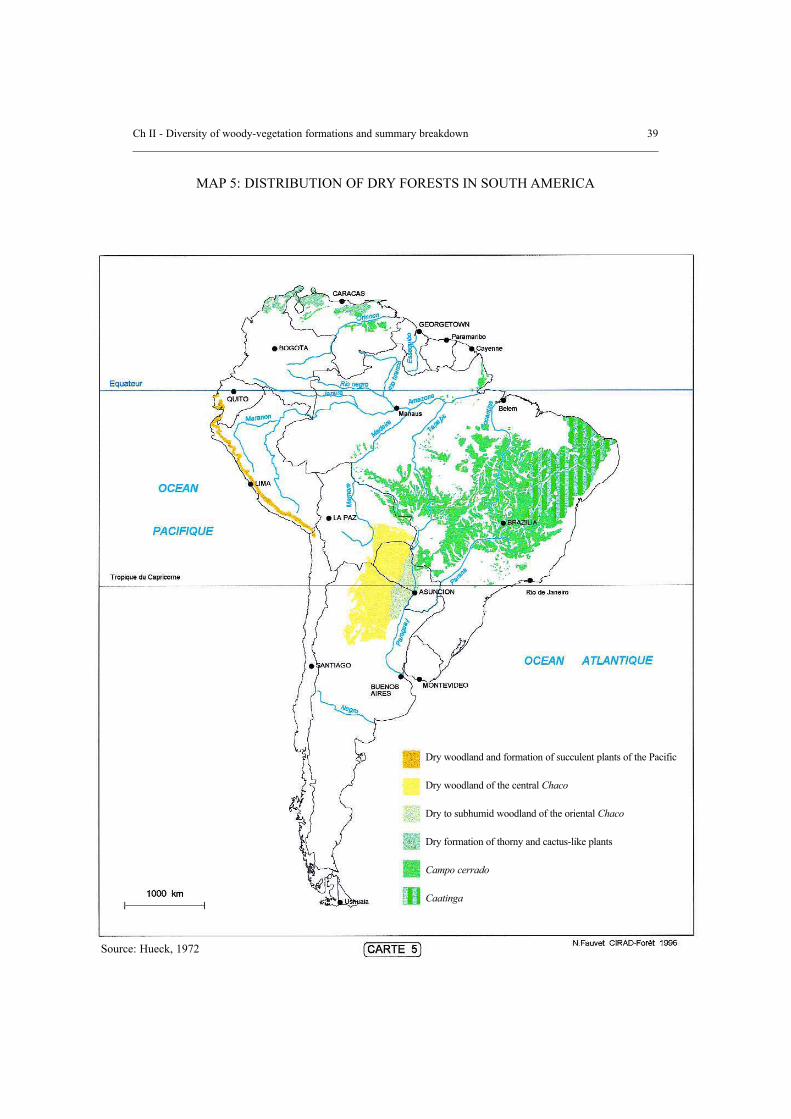
3.4 America
a) The main stands
The most extensive formations are the caatinga and the cerrado, mainly in Brazil, whichexplains their well-known Portuguese name.
These are generic terms. The cerrado is a densely shrubby savanna woodland (sabanaarborea, sabana arbolada in Spanish). The expression campo cerrado is strictly used forsavanna woodland where the tree stands are open or very open (sabana abierta, sabanaarbustiva in Spanish). Caatinga refers to a steppe or thicket (chaparral in Spanish). In thecase of closed woodland patterns the expression used is caatinga agrupada (matorral).
Chaco designates the central plain, which covers more than 1 million km2 betweenArgentina, Paraguay and Bolivia, and also Brazil (the Brazilian Chaco is not very extensiveand follows on from the cerrado). It comprises several types of vegetation of which themost important, Chaco seco is a dry forest with different patterns (detailed below).Particularly in Mexico and Central America there are many dry deciduous forests(corresponding to the African dry deciduous forests or the open woodlands), which areoften fairly small in extension and are seriously degraded. For example, all along thePacific coast from Mexico to Costa Rica one finds the Selva baja cadudifolia, or the lowdeciduous forest in a dry climate (rainfall: 800 mm/year and 7-8 dry months). Burserasimarouba is quite common there, together with Guaiacum sanctum. The trees aregenerally short and twisted, with branches close to the base: the classic degradationpatterns. Some very valuable trees come from these stands: Bombacopsis quinatum;Samanea saman; and Enterolobium cyclocarpum.
Lastly, the dry semi-deciduous forests covering fairly small areas, are found in the heart ofthe Amazonian Basin (for example on the banks of the Tapajoz near Santarem),characterized by Sclerolobium paniculatum and Vochysiacea (Aubréville, 1958).
b) The caatinga
In Brazil, the caatingas zone lies between 3° and 15° S, 34° and 45° W. The climate hastwo different rainfall regimes. In the north and centre the rainfall depends on the movementof the intertropical convergence zone while the southern rainfall is under the influence ofthe cold fronts coming from the south. These two regimes induce different dates for thebeginning of the rainy season, and account for the sharp variability in rainfall, ranging from400-800 mm.
An initial effect of the droughts, particularly when they are prolonged, is the reduction inthe protection of the soil, an increase in water runoff and a reduction in water seepage andin the water reserves available to the plants.
Ch II - Diversity of woody-vegetation formations and summary breakdown 37

There are several types of caatingas, which are generally described as a dwarfed vegetationformation, deciduous in the dry period, comprising many different types of cactus and thorn-bushes which are perfectly suited to drought conditions. Even though they are deciduous, mostof the species do not lose their leaves except when they can no longer meet their vital needs.This explains why the caatingas can stay green throughout most of the year if there issufficient rainfall and if it is well distributed. Even though the grass cover is considered to benegligible, in a year with surplus rainfall, the grass can grow explosively and suddenlydisappear for several years. This regeneration possibility of the caatingas, means that they canrecover perfectly well, within a few years, from the damage caused by climatic changes andfrom over-use and overgrazing by man and his livestock respectively.
“The floristic composition of the caatinga also varies from one edaphic sub-type to another.The most typical shrub species are Caesalpinia pyramidalis, Jatropha phyllacantha, Mimosaspp., Spondias tuberosa, Aspidosperma pirifolium and Ziziphus joazeiro. The trees includeCaesalpinia spp., Schinopsis brasiliensis, Shinus spp., and Cavanillesia.” (Aubréville, 1958)
According to Campello (1995) the dominant species are: Anadenanthera macrocarpa,Astronium urundeuva, Cassia spp., Caesalpinia pyramidalis, Bursera leptophloeos, Tabebuiaspp., Ziziphus joazeiro, Pithecolobium dumosum, Mimosa hostilis, Croton sonderianus,Combretum leprosum, Bauhinia forficata, Aspidosperma pyrifolia and Mimosacaesalpiniafolia.
c) The cerrados and the campos cerrados
In Brazil, the expression cerrado refers to open woodland or savanna woodland, while campocerrado refers to poor savanna woodland or shrub savanna.
The cerrado (sabana abierta) is a mixed tree formation, 10-15 m high with an understorey ofshrubs and grass. The campo cerrado is the result of the degradation of the cerrado. It has asimilar flora composition, but a classic shrub appearance with a few small trees (5-7 m high).
The typical climatic features of the cerrados are an annual rainfall between 1.000 and 2.000mm, concentrated in 6-7 months, in a single season. This is the typical tropical climate withheavy summer rainfall followed by a severe dry season.
These formations are semi-deciduous (various highly degraded forms of thickets areexceptionally completely deciduous) and they are found above all in Brazil (Map 5) in theStates of Goias, Minas Gerais and São Paulo. The cerrado is a very different plant formationthan the steppes and thickets on the caatinga.
“The flora of the cerrado... is climax flora. As in Africa, it comprises many Legumaceae,Annonacea, but above all an abundance of Vochysiacea (Qualea, Vochysia, Salvertia,Calystremma) and Malpighiacea (Brysonima, Curatella)... The cerrado is not economicallyvery valuable. The largest tree is a Legume, Bowdichia virgilioides.” (Aubréville, 1958)
A comparison of the main ecological features that differentiate the cerrado from the caatingais given in Table 4.
38 Ch II - Diversity of woody-vegetation formations and summary breakdown
Ch II - Diversity of woody-vegetation formations and summary breakdown 39
Dry woodland and formation of succulent plants of the Pacific
Dry woodland of the central Chaco
Dry to subhumid woodland of the oriental Chaco
Dry formation of thorny and cactus-like plants
Campo cerrado
Caatinga
MAP 5: DISTRIBUTION OF DRY FORESTS IN SOUTH AMERICA
Source: Hueck, 1972

d) The Chaco seco
Because of its extension, the Chaco comprises many different types of vegetation, from lushforest to dry forest, savanna and swamplands. Particular emphasis will be given here to theChaco seco, a landscape of xeromorphic forests in the north and west of Paraguay. In thecentre, the ecosystem gives way to Chaco humedo, which is a forest-savanna-palm grovemosaic, lying between the Pilcomayo River and the Paraguay River.
The Chaco seco region suffers from a very severe water deficit, with annual rainfall rangingbetween 400 and 800 mm. The rains are extremely variable, because in the space of 24 hoursit is possible for the equivalent of six months’ rainfall. It is the water distribution that mainlydetermines the types of vegetation.
The Chaco forests are comparable to low, thorny and difficult to penetrate woody savannas.The plant cover is very dense except in the humid and sandy areas where it is more open. Theforests have a tree layer, 8-12 m high, a bush stratum 3-8 m high and a poorer understorey.
The trees and bushes generally bloom in the rainy season (September-November) andcomplete their reproductive cycle April-June (winter drought).
Some species are deciduous in winter (Ruprechtia triflora) while others are evergreen(Aspidosperma quebracho-blanco). The grasses develop during the summer rains and theirreproductive cycle takes six to nine weeks. The irregularity of the summer rainfall makes itpossible to achieve a variety of different vegetative and reproductive cycles in one and thesame site.
Three vegetation units exist in the Chaco:
* “The xeromorphic forest (Quebrachal of Aspidosperma quebracho-blanco), a climaxformation which covers most of the dry Chaco, with the layers described above whosemain species are: Aspidosperma quebracho-blanco, Chorisia insignis, Cereusstenogonus, Stetsonia coryne, Schinopsis quebrcho-colorado, Castela coccinea,Prosopis kuntzei, Bulnesia sarmientoi, Cercidium praecox, Capparis tweediana, C.retusa, C. speciosa, Bougainvillea praecox, Ziziphus mistol, Caesalpiniaparaguariensis, …” (Spichiger et al., 1991).
* The xeromorphic thicket (Matorral xeromorfico), which is an impoverished formationderived from the xeromorphic forest. It is characterized by the absence of a tree stratumand an average height ranging between 4-8 m. These are often renewal stands on dried-up river beds, in zones with temporary watercourses. The main species are similar tothose found in xeromorphic forests, but they are lower and the dominant species areRuprechtia triflora, Bromelia spp. and Capparis spp.
* The xero-hygrophile thicket (Matorral xerohigrofilo) on clay/silty soils or clayey,which are subject to temporary and often brackish flooding, is frequently found inminor riverbeds. The labon (Tabebuia nodosa) blooms just before the rains.
Ch II - Diversity of woody-vegetation formations and summary breakdown 41

42 Ch II - Diversity of woody-vegetation formations and summary breakdown
Table 4: Comparison between two vegetable formations
Characteristics Cerrado Caatinga
Central plateau of Brazil
Tabular topography (plateauxwith steep sides separated by flatbottomed valleys; extensiveplateaux with slightly decliningsides slopes)
Mineral portion very poor (weakexchange capacity and weakexchange of acid bases)
Always very deep
750-2 000 mm
600-1 400 mm
From 6-30 m (with someextremes ranging from 3-50 m)
- Tree canopy closed to open withmean heights (7-20 m);- Open woodland or thicket withheights ranging from 7-15 and 3-7 m respectively;- Open or closed thicket (of alldimensions);- Savanna or thicket (0.5-3 m);- Grass savanna
Semi-deciduous (the cerrado israrely sempervirent; the diversethicket forms are rarelycompletely deciduous)
Xeromorphic, stiff, hard orsiliceous, sometimes velvety anddensely hairy
North-east of Brazil (excluding the coastalzone)
Between mountains and plateaux, slightlyincised pediplain supporting inselbergs (peeksand slopes of sandstone plateaux in the Stateof Piaui, north-west of Pernambouc)
Mineral portion poor to relatively rich, neutralto slightly alkaline; humus rare to absent
Superficial to deep
From 300 mm in small areas inside theregion, to 750-800 mm at the western bordercontiguous to the cerrado, or even 1 000 mmto the east and south limits of the forest
From 1 000 mm (at the edge of the Atlanticforest) to 1 400 mm close by the cerrado, toeven higher figures towards the interior
Water table generally absent (it may exist andbe deep within some sandy plateaux of thePiaui State)
- Tree canopy closed to open with averagesizes- Closed thicket of average height (usually 2-5m) with often, small trees emerging to 7-8 m- Open thicket of average height- Savanna and thicket
Totally deciduous (semi-deciduous on thesandy plateaux of Piaui)
Mesomorphic, thin and velvet like
Geographical regionswhere they constitute themain vegetation
Common relief of theregion
Soils (of climaxvegetation)
Effective soil depth
Mean annual rainfall
Mean annual evaporation
Depth of the permanentwater table on highlands
Structure of non-disturbed vegetation
Deciduousness of stands
Foliage consistence onhigher layers

Ch II - Diversity of woody-vegetation formations and summary breakdown 43
Figure 3: A few types of plant formations in Paraguay
Quebrachal (A.q.b. = Aspidosperma quebracho-blanco; Br.h. = Bromelia hieronomi; Br.s. =Bromelia serra; C.i. = Chorisia insignis; Ca. = Capparis spp; R.t. = Ruprechtia triflora; S.c.= Stetsonia coryne; C.st. = Cereus stenogonus)
Peladar, impoverished form of Quebrachal
Espartillar, grass savanna
Source: Romella and Spichiger (1989)
Transitionzone Transition
zone

3.5 Asia
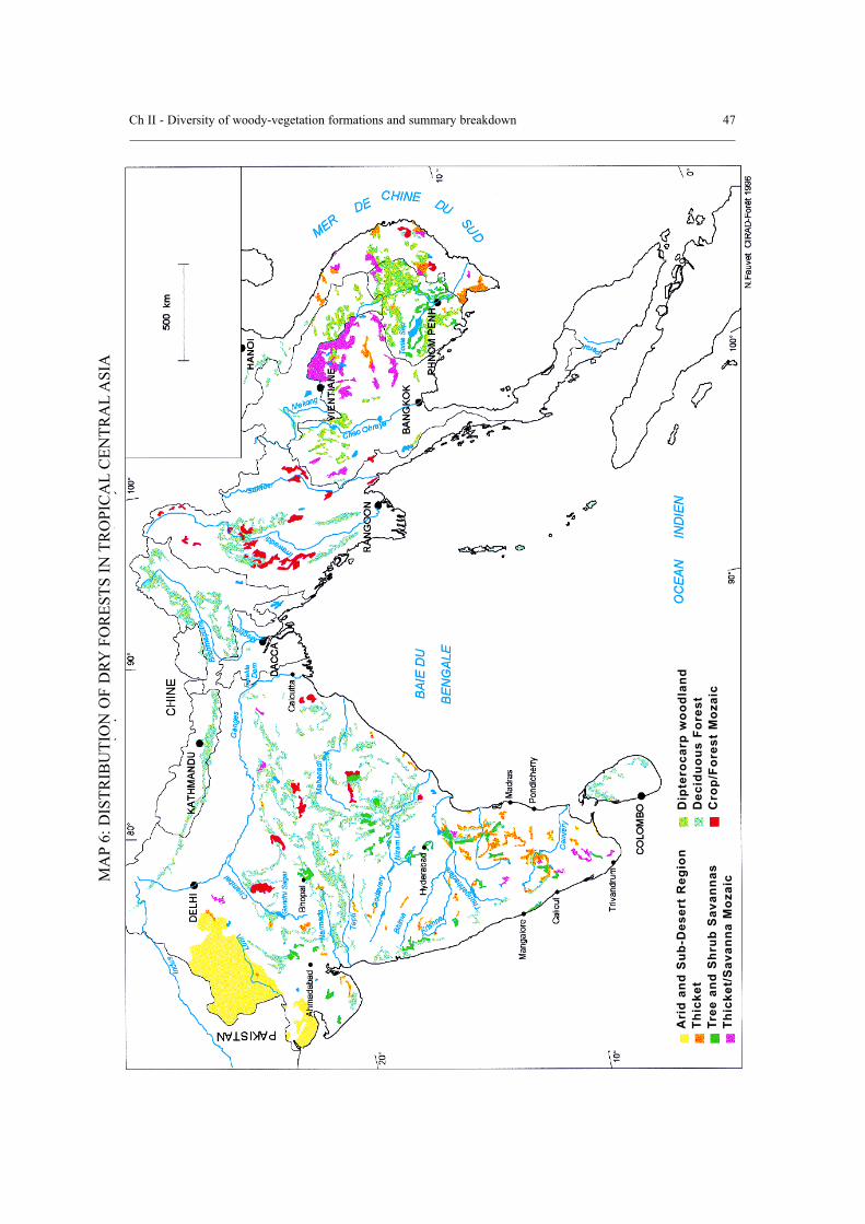
In India, as in other countries in the region, the monsoons beat against the main hills andgenerates bio-climates with fairly plentiful rainfall, and a fairly long dry season. The westernGhats and the coasts receive the most rainfall. The Deccan Plateau in the south-eastern plainsin the Indian peninsula protected by the Ghats undergo fairly long droughts (Map 6).
The following presentation has been based very largely on La végétation de l’Inde, Ecologieet Flore, by Legris (1963).
a) The dry deciduous forests
Dry deciduous forests cover vast areas of central and peninsular India. They are distributedvirtually throughout the whole of the Deccan Plateau. Their extreme limits are the 8th and the32nd parallels. In such a vast region, the climate is obviously not uniform. Even though thereare many types of transitions, the main series are floristically distinct and belong each to a welldetermined bio-climatic range. They share numerous characteristic species and a certainsimilarity in their state of degradation. There are three series which are: the Shorea robusta;the Tectona grandis; and the Hardwickia binata series.
The Shorea-Anogeissus-Terminalia series
This series covers the north-east of the Deccan Plateau, the Bihar and the Siwalik region. Theforests are moderately dense, closed, of average height (20 m) with only one intermediatestratum ranging from 10-15 m in height, sometimes plentiful with bamboo (Dendrocalamus).The sal (Shorea robusta) series gives way to the teak series, extending beyond the borderlineof the areas of both species. There is virtually no mixing between the two species, since theecology of the Tectona grandis is drier as a whole than the sal ecology.
The Tectona-Anogeissus-Terminalia-Pterocarpus series
This series is found in the rest of the Deccan Plateau. It continues southwards at mediumaltitude along the eastern slopes of the Ghats and northwards as far as Rajasthan. There arealso a few forests in Saurasthtra. The teak series is not homogeneous throughout its own area.Three main sub-series are found there:
- Deciduous dry teak series (Tectona grandis);- Harwickia binata series; and- Thorny Acacia series.
Further south, the teak series in contact with the Albizia amara series on the Madras plain.
The Hardwickia-Anogeissus-Terminalia series
Whether or not this is a distinct series is a matter of debate. It is actually a transition betweenthe previous series and the thorny series of the Deccan Plateau. Its ecology, of either bio-climatic or edaphic origin is dry as a whole. The stands are rarely dense. Its scattereddistribution is very largely due to biotic factors.
44 Ch II - Diversity of woody-vegetation formations and summary breakdown

Hardwickia binata becomes dominant in a type of forest common in Andhra Pradesh wherethere is no teak (particularly the districts of Chittoor, Cuddapah and Kurnool). It is a two-layer forest composed of one strata about 20 m high, almost exclusively made up ofHardwickia, which emerges from a layer about 15 m high, made up of common species ofthe deciduous dry series.
The edaphic patterns are the result of the comparative abundance of a few species, whichare found locally within an altogether homogeneous stand. For example, the Santalumalbum pattern deserves special mention here. Sandalwood (including the roots) is usedbecause of its high content of essential oils, and is a small tree that grows extremely slowly.Its distribution area is limited. It is found plentifully in the northern part of the State ofMadras and in Mysore. It is at its best between 600 and 1.200 m in the deciduous dry series.
The dynamism of the deciduous dry series that has just been presented here is very largelyconditioned by the drought of their respective environments. The sal series is found in amore humid environment than the other two. Conversely, the teak series is found mixedwith drier formations of Hardwickia and Acacia, but occupies the better sites. All three areheliophilous, savanna fire-enduring, and sprout well from the stumps.
Shorea robusta, which demands a great deal of light, can endure shade in the first stages ofdevelopment. It is essentially a gregarious species which rapidly colonizes forest clearings.Teak demands full light, and does not tolerate shade in the first stages of development. Thisspecies only takes root on well-drained soil. Its resistance to heat and drought is greaterthan that of the Shorea robusta. It can thrive even in such dry climates as those thatsurround Rajasthan. The stands are open, the trees are stunted, but teak accounts for over50 percent of the crown cover. It does not have the same colonizing power as Shorearobusta. In very dry climates it seems more suitable to self-maintenance than topropagation. Hardwickia binata is an evergreen species with light crown cover, perfectlysuitable for drought, adapted to fire, and resistant to most disturbances. Its deep tap rootsenables it to exploit the groundwater reserves. It can regenerate even on soils that havebeen compacted by livestock. It is found more frequently on very superficial or skeletalsoils. The dominance of this species in very dry formations in the Deccan Plateau is alsodue to its aptitude to sprout from stumps and the facility for young plants to recover evenafter fire damage.
b) Dry thorn-bush formations
These stands are open, ranging from low forest to desert steppe. They are found in all thevery dry and semi-arid regions in India, from the extreme south-east of the peninsula alongthe semi-arid strip of the Deccan Plateau leeward of the Ghats to Rajasthan to the valleysof the Ganges and the Indus.
Despite some floristic and ecological differences, the stands in this group share thefollowing common features: xerophilous vegetation, predominantly thorny, very dry semi-arid or arid climates, generally eroded soils, poor in nutrients or physiologically dry, highlyinfluenced by biotic degradation factors.
Ch II - Diversity of woody-vegetation formations and summary breakdown 45
Some thorn-bush stands are probably replacement series that currently occupy former areaof the more humid series. The flora is quite poor, xerophilous, with many ubiquitousspecies that exist throughout the dry zone towards the east or the south, particularly in thearid and semi-arid areas of Rajasthan. A few rare species, Albizia amara, Anogeissus pendula,Prosopis spicigera and Calligonum polygonoides, limited to small areas or dominant in certaintypes of vegetation, may be selected as typical.
This group includes the following series:
- Albizia amara in southern India;- Acacia catachu, Acacia arabica from the Deccan plain and Gujarat; - Anogeissus pendula in the Aravalli Hills; - Prosopis spicigera and Salvadora oleoides in Rajasthan; - the arid Calligomum polygonoid stands in Thar, Sind and the Indus Valley; and- Acacia stands in the Ganges plain.
46 Ch II - Diversity of woody-vegetation formations and summary breakdown
Ch II - Diversity of woody-vegetation formations and summary breakdown 47M
AP
6: D
ISTR
IBU
TIO
N O
F D
RYFO
RES
TS IN
TR
OPI
CA
LC
ENTR
AL
ASI
A
Ari
d an
d S
ub-D
eser
t R
egio
nTh
icke
tTr
ee a
nd S
hrub
Sav
anna
sTh
icke
t/S
avan
na M
ozai
c
Dip
tero
carp
woo
dlan
dD
ec
idu
ou
s F
ore
st
Cro
p/Fo
rest
Moz
aic