Embed Size (px)
Citation preview

Trop i ca l Cy c l one | Chap t e r Fou r | page 41
Chapter Four :
Tropica l Cyc lone
Trees stripped of leaves and toppled by Cyclone Ingrid on the Coburg Peninsula, Northern Territory, March 2005Photo courtesy: Bureau of Meteorology/Bill Milne.
Tropica l Cyc lone
page 42 | NATURAL HAZARDS IN AUSTRAL IA | Identifying Risk Analysis Requirements
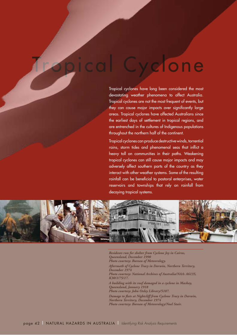
Tropical cyclones have long been considered the most devastating weather phenomena to affect Australia. Tropical cyclones are not the most frequent of events, but they can cause major impacts over significantly large areas. Tropical cyclones have affected Australians since the earliest days of settlement in tropical regions, and are entrenched in the cultures of Indigenous populations throughout the northern half of the continent.
Tropical cyclones can produce destructive winds, torrential rains, storm tides and phenomenal seas that inflict a heavy toll on communities in their paths. Weakening tropical cyclones can still cause major impacts and may adversely affect southern parts of the country as they interact with other weather systems. Some of the resulting rainfall can be beneficial to pastoral enterprises, water reservoirs and townships that rely on rainfall from
decaying tropical systems.
Residents run for shelter from Cyclone Joy in Cairns, Queensland, December 1990 Photo courtesy: Bureau of Meteorology.Aftermath of Cyclone Tracy in Darwin, Northern Territory, December 1974 Photo courtesy: National Archives of Australia/NAA: A6135, K30/1/75/17. A building with its roof damaged in a cyclone in Mackay, Queensland, January 1918 Photo courtesy: John Oxley Library/5107.Damage to flats at Nightcliff from Cyclone Tracy in Darwin, Northern Territory, December 1974 Photo courtesy: Bureau of Meteorology/Noel Stair.

paths than cyclones in other parts of the world. A tropical cyclone can last for a few days or up to three weeks. Movement in any direction, including sharp turns and even loops, is possible (BoM 2007). Most tropical cyclones weaken when they move over land or over cooler waters, but they sometimes interact with mid-latitude weather systems to cause major impacts far from the tropics.
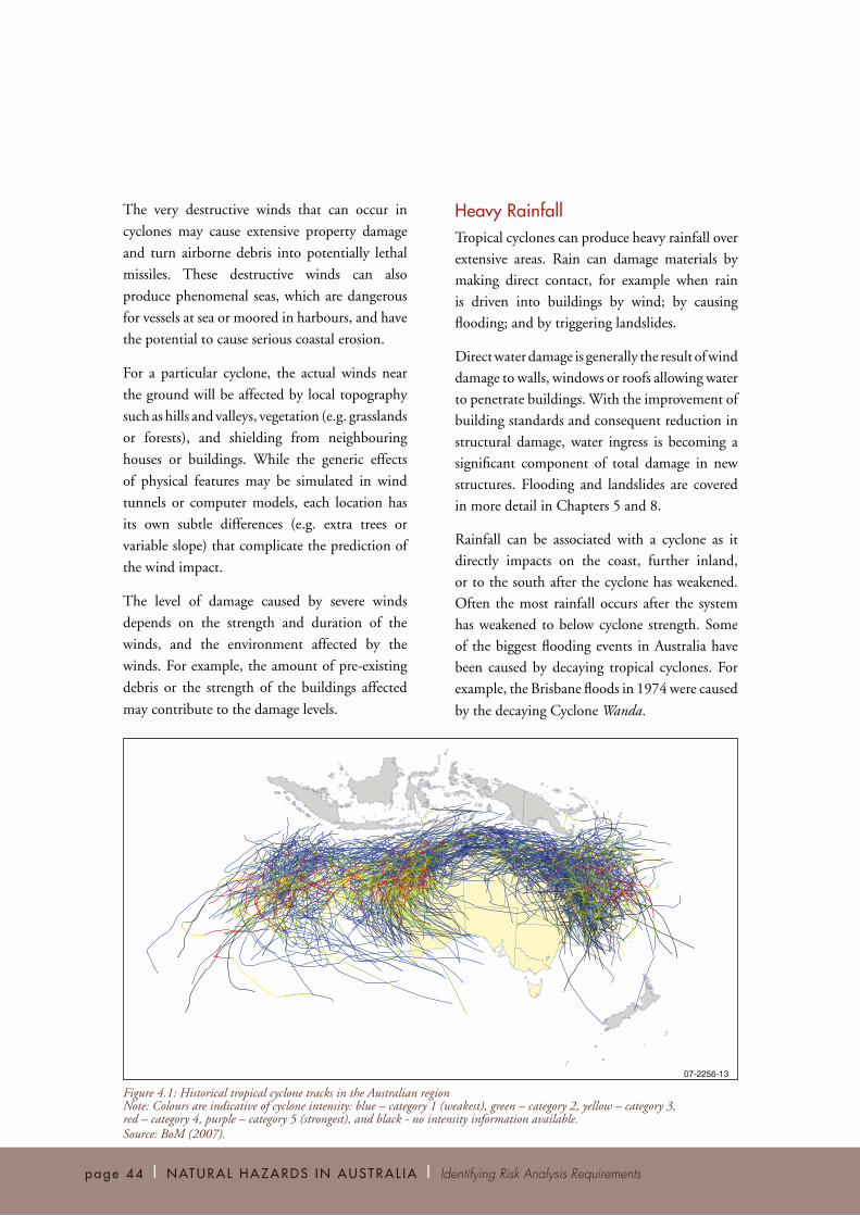
In the Australian region, tropical cyclones occur mostly between December and April. The official tropical cyclone season runs from 1 November to 30 April. In an average season, about 10 tropical cyclones develop over Australian waters, of which approximately six cross the coast, mostly over northwest Western Australia between Exmouth and Broome, and northeast Queensland between Port Douglas and Maryborough (as shown in Figure 4.1).
Tropical cyclones can cause a number of significant phenomena that can adversely (and sometimes favourably) impact on communities and the environment. The most well-known phenomena are destructive winds and heavy rainfall that may lead to flooding. Storm tide (i.e. coastal inundation by seawater) is a lesser-known phenomenon but can be the most dangerous hazard of a cyclone. Though rare in Australia, tornadoes have been reported during tropical cyclone events. The significant phenomena are described in more detail below.
Severe WindTropical cyclones generate wind gusts in excess of 90 kilometres per hour around their core. In the most intense cyclones, gusts exceed 280 kilometres per hour. While the strongest winds are near the centre, damaging winds can extend several hundred kilometres from the centre. The cyclone centre or ‘eye’ can have quite calm winds and clear skies; however, this lull is temporary and is followed by destructive winds from the opposite direction.
From 1967 to 1999, the average annual cost of tropical cyclones was $266 million (BTE 2001). The greatest economic loss from a single tropical cyclone in Australian history was caused by Cyclone Tracy, which struck Darwin in December 1974. More than 2100 people have lost their lives in tropical cyclones, many in shipwrecks (Blong 2005).
The future impact of tropical cyclones will be strongly influenced by the effects of climate change on tropical cyclone behaviour, and this is explored in this chapter. Tropical cyclones may become more intense, and the areas exposed to tropical cyclones may increase in response to climate change (Meehl and others 2007).
This chapter presents information on the hazard posed by tropical cyclones, methods of analysing the hazard, and the data required to learn about the types and levels of risk that tropical cyclones pose. The roles and responsibility of government and industry bodies in reducing the impacts of tropical cyclones are highlighted. Importantly, the media also has a prominent role in reducing the impact of tropical cyclones. The chapter also identifies limitations in risk analysis and gaps in the information on tropical cyclones, and targets areas where more research may be warranted.
Hazard IdentificationA ‘tropical cyclone’ is a low pressure system that develops in the tropics and is intense enough to produce sustained or average gale force winds (at least 63 kilometres per hour) around its perimeter. If the sustained winds reach hurricane force (at least 118 kilometres per hour) it is defined as a ‘severe’ tropical cyclone. Severe tropical cyclones are called hurricanes or typhoons in other parts of the world.
In general, tropical cyclones require favourable broad-scale winds and warm sea surface temperatures (greater than 26°C) to develop.
Research has shown that tropical cyclones in the Australian region tend to exhibit more erratic
Trop i ca l Cy c l one | Chap t e r Fou r | page 43
page 44 | NATURAL HAZARDS IN AUSTRAL IA | Identifying Risk Analysis Requirements
Heavy RainfallTropical cyclones can produce heavy rainfall over
extensive areas. Rain can damage materials by
making direct contact, for example when rain
is driven into buildings by wind; by causing
flooding; and by triggering landslides.
Direct water damage is generally the result of wind
damage to walls, windows or roofs allowing water
to penetrate buildings. With the improvement of
building standards and consequent reduction in
structural damage, water ingress is becoming a
significant component of total damage in new
structures. Flooding and landslides are covered
in more detail in Chapters 5 and 8.
Rainfall can be associated with a cyclone as it
directly impacts on the coast, further inland,
or to the south after the cyclone has weakened.
Often the most rainfall occurs after the system
has weakened to below cyclone strength. Some
of the biggest flooding events in Australia have
been caused by decaying tropical cyclones. For
example, the Brisbane floods in 1974 were caused
by the decaying Cyclone Wanda.
The very destructive winds that can occur in
cyclones may cause extensive property damage
and turn airborne debris into potentially lethal
missiles. These destructive winds can also
produce phenomenal seas, which are dangerous
for vessels at sea or moored in harbours, and have
the potential to cause serious coastal erosion.
For a particular cyclone, the actual winds near
the ground will be affected by local topography
such as hills and valleys, vegetation (e.g. grasslands
or forests), and shielding from neighbouring
houses or buildings. While the generic effects
of physical features may be simulated in wind
tunnels or computer models, each location has
its own subtle differences (e.g. extra trees or
variable slope) that complicate the prediction of
the wind impact.
The level of damage caused by severe winds
depends on the strength and duration of the
winds, and the environment affected by the
winds. For example, the amount of pre-existing
debris or the strength of the buildings affected
may contribute to the damage levels.
07-2256-13
Figure 4.1: Historical tropical cyclone tracks in the Australian region Note: Colours are indicative of cyclone intensity: blue – category 1 (weakest), green – category 2, yellow – category 3, red – category 4, purple – category 5 (strongest), and black - no intensity information available. Source: BoM (2007).
Trop i ca l Cy c l one | Chap t e r Fou r | page 45
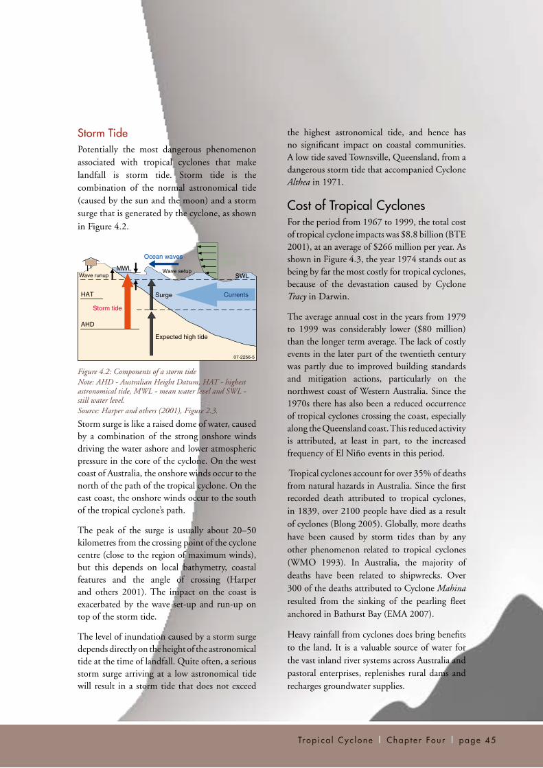
Storm TidePotentially the most dangerous phenomenon associated with tropical cyclones that make landfall is storm tide. Storm tide is the combination of the normal astronomical tide (caused by the sun and the moon) and a storm surge that is generated by the cyclone, as shown in Figure 4.2.
Figure 4.2: Components of a storm tideNote: AHD - Australian Height Datum, HAT - highest astronomical tide, MWL - mean water level and SWL - still water level.Source: Harper and others (2001), Figure 2.3.
Storm surge is like a raised dome of water, caused by a combination of the strong onshore winds driving the water ashore and lower atmospheric pressure in the core of the cyclone. On the west coast of Australia, the onshore winds occur to the north of the path of the tropical cyclone. On the east coast, the onshore winds occur to the south of the tropical cyclone’s path.
The peak of the surge is usually about 20–50 kilometres from the crossing point of the cyclone centre (close to the region of maximum winds), but this depends on local bathymetry, coastal features and the angle of crossing (Harper and others 2001). The impact on the coast is exacerbated by the wave set-up and run-up on top of the storm tide.
The level of inundation caused by a storm surge depends directly on the height of the astronomical tide at the time of landfall. Quite often, a serious storm surge arriving at a low astronomical tide will result in a storm tide that does not exceed
the highest astronomical tide, and hence has no significant impact on coastal communities. A low tide saved Townsville, Queensland, from a dangerous storm tide that accompanied Cyclone Althea in 1971.
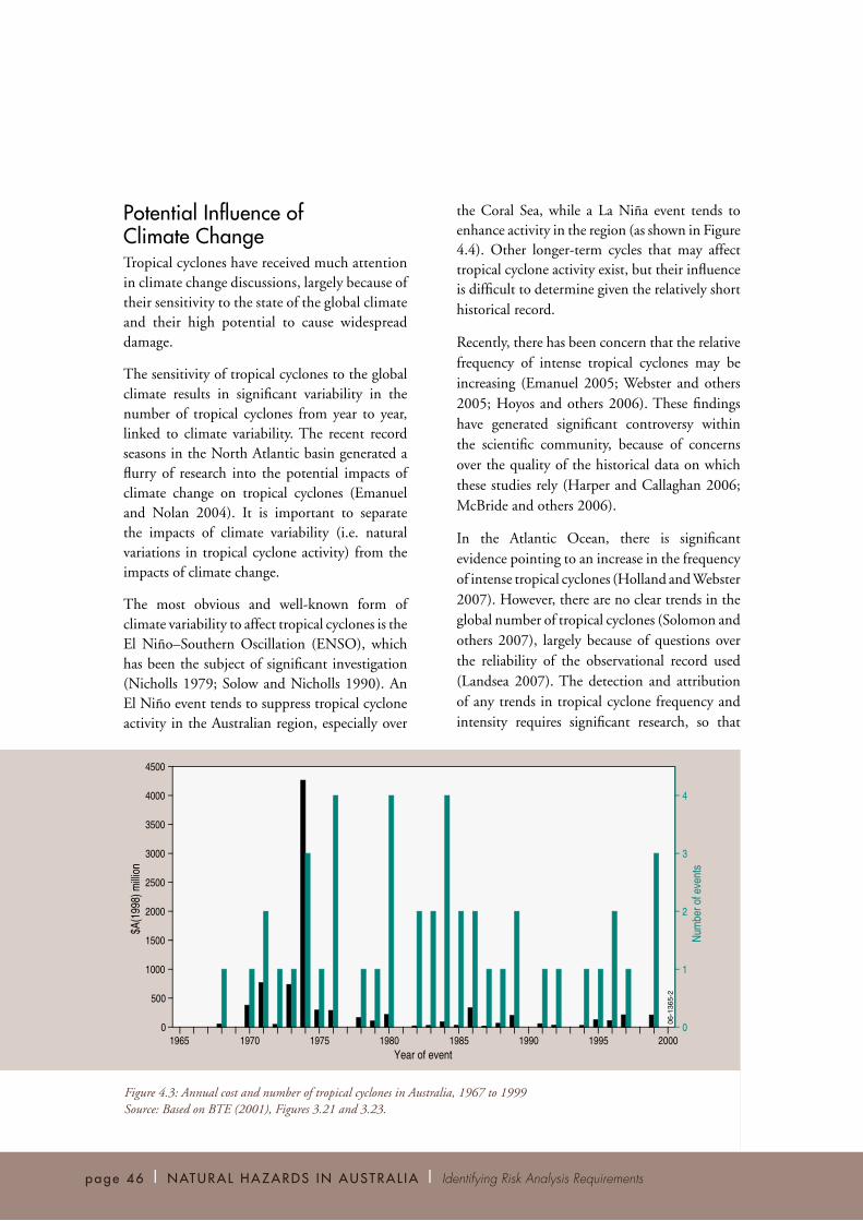
Cost of Tropical CyclonesFor the period from 1967 to 1999, the total cost of tropical cyclone impacts was $8.8 billion (BTE 2001), at an average of $266 million per year. As shown in Figure 4.3, the year 1974 stands out as being by far the most costly for tropical cyclones, because of the devastation caused by Cyclone Tracy in Darwin.
The average annual cost in the years from 1979 to 1999 was considerably lower ($80 million) than the longer term average. The lack of costly events in the later part of the twentieth century was partly due to improved building standards and mitigation actions, particularly on the northwest coast of Western Australia. Since the 1970s there has also been a reduced occurrence of tropical cyclones crossing the coast, especially along the Queensland coast. This reduced activity is attributed, at least in part, to the increased frequency of El Niño events in this period.
Tropical cyclones account for over 35% of deaths from natural hazards in Australia. Since the first recorded death attributed to tropical cyclones, in 1839, over 2100 people have died as a result of cyclones (Blong 2005). Globally, more deaths have been caused by storm tides than by any other phenomenon related to tropical cyclones (WMO 1993). In Australia, the majority of deaths have been related to shipwrecks. Over 300 of the deaths attributed to Cyclone Mahina resulted from the sinking of the pearling fleet anchored in Bathurst Bay (EMA 2007).
Heavy rainfall from cyclones does bring benefits to the land. It is a valuable source of water for the vast inland river systems across Australia and pastoral enterprises, replenishes rural dams and recharges groundwater supplies.
07-2256-5
Currents
Ocean waves Extremewinds
Wave runupWave setup
HAT
AHD
Storm tide
Surge
Expected high tide
MWLSWL
page 46 | NATURAL HAZARDS IN AUSTRAL IA | Identifying Risk Analysis Requirements
Potential Influence of Climate ChangeTropical cyclones have received much attention in climate change discussions, largely because of their sensitivity to the state of the global climate and their high potential to cause widespread damage.
The sensitivity of tropical cyclones to the global climate results in significant variability in the number of tropical cyclones from year to year, linked to climate variability. The recent record seasons in the North Atlantic basin generated a flurry of research into the potential impacts of climate change on tropical cyclones (Emanuel and Nolan 2004). It is important to separate the impacts of climate variability (i.e. natural variations in tropical cyclone activity) from the impacts of climate change.
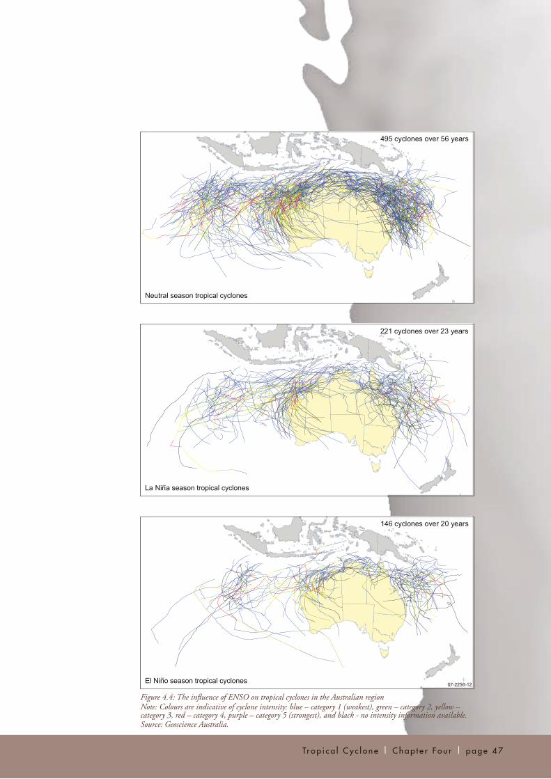
The most obvious and well-known form of climate variability to affect tropical cyclones is the El Niño–Southern Oscillation (ENSO), which has been the subject of significant investigation (Nicholls 1979; Solow and Nicholls 1990). An El Niño event tends to suppress tropical cyclone activity in the Australian region, especially over
the Coral Sea, while a La Niña event tends to enhance activity in the region (as shown in Figure 4.4). Other longer-term cycles that may affect tropical cyclone activity exist, but their influence is difficult to determine given the relatively short historical record.
Recently, there has been concern that the relative frequency of intense tropical cyclones may be increasing (Emanuel 2005; Webster and others 2005; Hoyos and others 2006). These findings have generated significant controversy within the scientific community, because of concerns over the quality of the historical data on which these studies rely (Harper and Callaghan 2006; McBride and others 2006).
In the Atlantic Ocean, there is significant evidence pointing to an increase in the frequency of intense tropical cyclones (Holland and Webster 2007). However, there are no clear trends in the global number of tropical cyclones (Solomon and others 2007), largely because of questions over the reliability of the observational record used (Landsea 2007). The detection and attribution of any trends in tropical cyclone frequency and intensity requires significant research, so that
$A(1
998)
milli
on
1970 1975 1980 1985 1990 1995 2000
3000
2500
2000
1500
500
0
1000
0
1
2
3
4
Num
ber o
f eve
nts
06-1
365-
2
Year of event
4500
3500
4000
1965
Figure 4.3: Annual cost and number of tropical cyclones in Australia, 1967 to 1999Source: Based on BTE (2001), Figures 3.21 and 3.23.
Trop i ca l Cy c l one | Chap t e r Fou r | page 47
~
~
Figure 4.4: The influence of ENSO on tropical cyclones in the Australian region Note: Colours are indicative of cyclone intensity: blue – category 1 (weakest), green – category 2, yellow – category 3, red – category 4, purple – category 5 (strongest), and black - no intensity information available.Source: Geoscience Australia.
page 48 | NATURAL HAZARDS IN AUSTRAL IA | Identifying Risk Analysis Requirements
future changes in tropical cyclone activity can be accurately predicted.
The impact of climate change on tropical cyclones is hotly debated within the research community and continues to be the subject of much investigation. There are significant uncertainties in the projected changes in tropical cyclones, and in the natural modes of variability which modulate cyclone activity (McBride and others 2006). The Intergovernmental Panel on Climate Change Fourth Assessment Report summarised much of the recent research into tropical cyclone activity and concluded there is (Meehl and others 2007, p. 751):
‘a likely increase of peak wind intensities and notably, where analysed, increased near-storm precipitation in tropical cyclones. Most recent published modelling studies investigating tropical storm frequency simulate a decrease in the overall number of storms, though there is less confidence in these projections and the projected decrease of relatively weak storms in most basins, with an increase in the numbers of the most intense tropical cyclones.’
Of studies that have been undertaken specifically for the Australian region, two found no likely
significant change in total tropical cyclone
numbers off the east coast of Australia (Walsh
and others 2004, Leslie and others 2007), while
a third found a significant decrease in tropical
cyclone numbers for the Australian region (Abbs
and others 2006). These climate simulations also
indicated an increase in the intensity of tropical
cyclones in the Australian region (Abbs and
others 2006; Leslie and others 2007).
Storm tide is expected to be directly affected
by climate change because of two aspects: the
potentially increased intensity of tropical cyclone
events, and long-term sea level rise. An increase
in the intensity of landfalling tropical cyclones
would result in a direct increase in the magnitude
of the associated storm surge. Possible southward
changes in the tracks of tropical cyclones may
also increase the exposure of communities to
tropical cyclone impacts.
Sea level rise is likely to be the major contributor
to increased exposure to storm tide. For example,
Hardy and others (2004) studied the changes in
storm tide return periods along Queensland’s
east coast and concluded that the changes were
dominated by the mean sea level rise scenario.
The wreck of the Korean Star after Cyclone Herbie at Cape Cuvier, Western Australia, May 1988 Photo courtesy: Bureau of Meteorology/Mark Kersemakers.

Trop i ca l Cy c l one | Chap t e r Fou r | page 49
Changes in tropical cyclone intensity had less
of an effect and changes in frequency had an
insignificant effect.
Risk AnalysisAs outlined above, there are several hazard
components presented by tropical cyclones:
wind, heavy rainfall and storm tide. Each has the
capacity to cause an adverse impact to population,
buildings or infrastructure. The severity of the
impact will be related to the intensity of the
cyclone event and the exposure and vulnerability
of the community and infrastructure to each of
the hazard components.
Tropical cyclone risk assessments have been
performed in the United States for many years.
Linked to these, several risk models have been
developed (Neumann 1987; Powell and others
2005). The insurance industry has instigated a
large amount of research into tropical cyclone
risk, largely because of its own financial risk
associated with these high-impact events.
Risk assessments for communities along the
Queensland coast have been conducted,
examining the risk from severe winds caused
by tropical cyclones (Harper 2001; Harper and
others 2001). The vulnerability of residential
structures in Australia to impacts from tropical
cyclones has been the subject of significant
research, especially since the devastating impact of
Cyclone Tracy in 1974. Several other assessments
of tropical cyclone hazards and their impacts on
residential property have also been conducted
for Queensland (DNRM 2004).
The following sections describe the components
of likelihood and consequence analyses
for tropical cyclones, and outline the data
requirements for each.
Likelihood AnalysisThe likelihood of impact by a tropical cyclone at a given location can be determined by reviewing the number and intensity of landfalling cyclone events over a given time period.
The annual frequency of tropical cyclones is low, and the historical database in the Australian region is limited. There is less than 100 years worth of data in the database, and information for the earlier years of the period is less reliable and detailed (Trewin and Sharp 2007). This paucity of historical data limits its usefulness in a likelihood analysis (see Figure 4.5).
The likelihood of tropical cyclones can be determined using statistical models (Powell and others 2005) or physically-based models (Emanuel and others 2006). Statistical models depend heavily on having good quality records of tropical cyclone behaviour in the region of interest to generate realistic tropical cyclone events. Physical models require an understanding of the structure and influence of the broad-scale atmosphere on tropical cyclones.
These models are used to generate synthetic event sets which represent thousands to millions of years of tropical cyclone activity and are used to overcome the limits of the historical data. These synthetic event sets can eliminate the perceived gaps in landfall location data and provide a better picture of the likelihood of impact.
Assessing the severe wind hazard from tropical cyclones also requires knowledge of the area affected by damaging winds (i.e. the ‘wind swath’) associated with each tropical cyclone. There are many different empirical models of the tropical cyclone wind swath, and these are continually being reviewed as more data are gathered (Willoughby and others 2006). To accurately represent the swath from a tropical cyclone requires developing a thorough understanding of the structure and life cycle of cyclones in the region being studied, so that an appropriate model can be applied.

page 50 | NATURAL HAZARDS IN AUSTRAL IA | Identifying Risk Analysis Requirements
To determine the local wind hazard, a comprehensive understanding of the influence of topography and terrain on local wind speed (i.e. ‘wind multipliers’) is essential. The effect of terrain and topography can be determined using two-dimensional modelling of the winds, following the methodology outlined in the wind loading standard (Lin and Nadimpalli 2005). Alternatively, three-dimensional modelling tools can be used to capture effects such as funnelling (Ayotte and Taylor 1995).
Heavy rainfall associated with tropical cyclones that results in freshwater flooding is treated similarly to any flooding event. The process of assessing the likelihood of flooding is discussed in Chapter 5.
The magnitude of a storm tide event is sensitive to the combination of coastal topography, bathymetry, astronomical tide and wave set-up. Therefore, to determine the likely inundation associated with tropical cyclones requires a large number of scenarios to be developed for each
location of interest. The surge associated with each scenario is computed using the best available data. The results can be stored as part of an atlas of surges, a useful resource for forecasters in the event of a landfalling cyclone. Results can also be aggregated to provide a ‘maximum envelope of waters’ (MEOW). This MEOW can be used in estimating exposure to the maximum likely storm surge.
In addition to the height of the storm tide, inundation patterns also require consideration. Hydrodynamic models that simulate the ebb and flow of surging water over coastal land (Nielsen and others 2005) can be used to determine inundated regions.
Data requirementsTo assess the probability of impact by tropical cyclones in a particular area, there is a heavy reliance on historical data. Where possible, homogeneous records of tropical cyclones are preferred, providing a uniform assessment of events. For extreme events, newspaper records
07-2
256-
3
Num
ber
0
2
4
6
8
10
12Sy
dney
Bris
bane
Mac
kay
Tow
nsvi
lle
Cai
rns
Cap
e Yo
rk
Burk
etow
n
Nhu
lunb
uy
Dar
win
Wyn
dham
Broo
me
Port
Hed
land
Exm
outh
Ger
aldt
on
Perth
Tropical cyclone landfall locations
Figure 4.5: Number of tropical cyclones making landfall around the Australian coastline, July 1909 to June 2005Note: Major coastal locations are indicated along the horizontal axis. The crossing points were determined by examining the tracks in the Bureau of Meteorology tropical cyclone ‘best track’ archive. Data before the 1950s would be biased to populated areas. Despite being almost a century long, the limited size of the database reveals perceived gaps that may be a reflection of lower impact probability rather than a ‘safe haven’. Source: Geoscience Australia.

Trop i ca l Cy c l one | Chap t e r Fou r | page 51
extending beyond the timescale of the Bureau of Meteorology’s database, which dates back to 1909, will help in the assessment.
High-resolution topographic and terrain multiplier datasets (showing the acceleration of winds due to topographic and terrain variations) are required to accurately determine the level of hazard at a local scale.
To accurately model the hazard of storm tide (and other forms of flooding) requires extremely detailed topographic and bathymetric data. Knowledge of floodplains and elevations of various key locations needs to be developed and maintained by the responsible authorities.
Consequence AnalysisAn analysis of the consequences of a tropical cyclone includes an assessment of the elements exposed to the cyclone and the impact that the hazard components have on the elements. For example, population growth along the Queensland coast, especially in the marginal regions of the Sunshine Coast and the Gold Coast, is increasing the exposure of communities to tropical cyclones. The rapid increase in mining activities in the Pilbara region of Western Australia is increasing not only the population exposure, as more people are employed in the region, but the financial exposure of the mining and resources industries as well.
Power and telecommunications infrastructure assets are often highly exposed—above-ground power lines and telegraph poles are often brought down by high winds in tropical cyclones. Radio communications for emergency services may also be impacted by wind damage to transmission towers. Water supplies and sewerage systems can be affected through loss of power to pumping stations, or directly affected by exposure to storm tide or riverine flooding.
Transport infrastructure (predominantly rail and road) can be vulnerable to riverine flooding,
storm tide and landslides. Landslides are a significant threat along the heavily populated sections of the Queensland coastline, because of the mountainous topography (see Chapter 8 for a general discussion of landslides).
The flow-on impacts of the failure of critical infrastructure elements to other facilities, such as hospitals, evacuation centres and emergency service centres, are also important. Inundation may cut evacuation routes or isolate important resources required in response and recovery operations. It is important to consider exposed locations, and understand which hazards may compromise resources or infrastructure at these locations, when developing risk management plans.
The exposure of buildings and infrastructure to severe winds can vary greatly across a town, because of the effects of terrain, topography and the buildings themselves. A detailed understanding of the variation of exposure to severe winds (and other hazards) is vital to planning considerations for key services, infrastructure and residential buildings.
In some local government areas, zoning for housing is based on the Australian wind loading standard (AS 4055:2006). In other areas, it is the responsibility of designers and builders to comply with the Building Codes of Australia provisions under the appropriate state or territory legislation.
Models of vulnerability relationships for residential buildings are under development, based on an understanding of the wind loads on building elements (Henderson and Harper 2003). These models include an understanding of how buildings resist and transmit wind loading forces, along with the contribution of wind-
borne debris.
Vulnerability models also need to address age-
related changes to building regulations and the
extent of their uptake by the building industry.
page 52 | NATURAL HAZARDS IN AUSTRAL IA | Identifying Risk Analysis Requirements
populated area of the Queensland coast. A large
effort was made to remind people that a severe
cyclone could arrive in the coming season (as
Cyclone Larry did in March 2006).
Data requirementsKnowledge of the spatial distribution of buildings and infrastructure exposed to cyclonic winds, heavy rainfall, riverine flooding, storm tide and other hazards associated with tropical cyclones is imperative. The secondary consequences resulting from failure of critical infrastructure such as power, gas, communications and sewerage require detailed investigation to gain a complete understanding of the community vulnerability.
Vulnerability of buildings varies widely and depends on the material choice, architectural features, standards applicable at the time of construction and subsequent levels of maintenance. Specific data on these key parameters are required to better understand the risk posed by cyclonic wind. Insurance loss data are very valuable to the development and validation of vulnerability models.
Major industry and local commerce organisations need to have records of business contingency plans available. The potential impacts, particularly secondary effects like loss of income and employment, need to be ascertained by
detailed financial analysis.
The contributions of post-cyclone impact survey
activity and the assessment of local wind speeds at
individual infrastructure sites of interest are vital
to developing vulnerability relationship models.
The surveys identify the range and predominance
of failure types, and provide validation data for
the more rigorous engineering approach. As
these tools mature they will provide a means of
assessing the most cost-effective measures for
reducing community risk. The survey activity
following Cyclone Larry has provided valuable
data for advancing the understanding of wind
vulnerability (Edwards and others 2007).
For community members, the impacts of a
tropical cyclone are directly related to their
levels of knowledge and awareness. Negative
consequences can be minimised by residents
knowing how to prepare in advance of a cyclone,
when to evacuate, where to shelter in a house and
when it is safe to venture out after an event.
On the other hand, community complacency can
increase the impact of an event. Complacency
can set in when a community is affected by a
weak tropical cyclone (‘We’ve been through a
cyclone and it wasn’t so bad after all’), or does
not experience a tropical cyclone for many years.
It was recognised before the 2005–2006 cyclone
season that a long time had passed since a severe
tropical cyclone last impacted on a reasonably
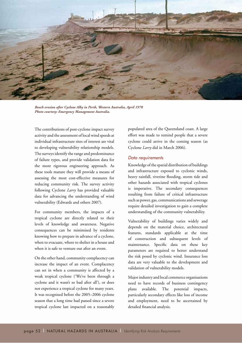
Beach erosion after Cyclone Alby in Perth, Western Australia, April 1978 Photo courtesy: Emergency Management Australia.

Trop i ca l Cy c l one | Chap t e r Fou r | page 53
Information GapsA complete understanding of the risk of tropical cyclones is reliant on filling several gaps in existing information. First and foremost, understanding of tropical cyclone behaviour in the Australian region is incomplete. Economic vulnerability to tropical cyclones is another area that needs further investigation. This section outlines some of the information gaps and details how they may be resolved.
Tropical Cyclone PhysicsIt is important to gain a thorough understanding of the physics of tropical cyclones. This includes identifying and understanding any potential differences in the structure and behaviour of tropical cyclones in the Australian region from those in other regions around the world. A thorough understanding of tropical cyclone physics underpins several other information gaps relating to cyclone risk.
Impacts of climate change on tropical cyclones are fundamentally linked to how cyclones interact with the ocean, the upper atmosphere and the general circulation. The detection and attribution of trends in tropical cyclone activity on global and regional scales are critical in determining future changes in tropical cyclone activity.
A better understanding of the structure and behaviour of tropical cyclones will greatly improve the representation of tropical cyclones in hazard assessment models, for both severe winds and storm tide. This understanding will also help to improve intensity forecasts provided by the Bureau of Meteorology and used in developing community warnings.
The interaction of extreme winds with terrain and steep topography still requires significant research and assessment, and the processes involved are also important in determining the rate at which tropical cyclones weaken once they move over land. Cyclone George crossed the
Western Australian coast near Port Hedland in March 2007 and caused significant damage more than 100 kilometres inland. This highlighted the importance of understanding the weakening of tropical cyclones as they move inland. Although intensity decay models have been developed in the United States (Kaplan and DeMaria 1995), these are region-specific empirical models. Differences in topography and terrain mean these models require more research before they can be applied to Australian tropical cyclones.
Probabilities at the Southern MarginsBoth Perth and Brisbane lie near the margins of the regions of Australia regularly affected by tropical cyclones (see Figure 4.5). However there is a small chance of a severe tropical cyclone impacting directly on Brisbane, and Perth is vulnerable to tropical cyclones undergoing extra-tropical transition. Cyclone Alby in 1978 is an example of a tropical cyclone undergoing extra-tropical transition that caused significant impacts around Perth. Assessing the probability of a significant impact at these marginal but populous areas is difficult, because the historical dataset is limited.
Influence of Climate ChangeThe effect of climate change on tropical cyclone frequencies and intensities remains difficult to accurately assess. The detection and attribution of trends in tropical cyclone activity on global and regional scales are critical in determining future changes in tropical cyclone activity. A better understanding of the impacts of natural climate cycles (such as ENSO) on tropical cyclones, and how these may be affected under a future climate scenario, is critical.
Equally important is the need to objectively reanalyse the existing historical datasets for the very significant changes that have occurred over the past 50 years. Improvements in sensor technologies such as radars and satellites and the intensity estimation tools used by meteorologists have advanced the detection and analysis of tropical cyclones in more recent times.

Vulnerability ResearchThe increase in exposure of major industries, such
as mining and petroleum, to tropical cyclones
forms an important component of assessing the
impacts of tropical cyclones on the Australian
community. Little is known of the costs incurred
as a result of business interruption, closure of ports
to shipping and other secondary consequences
of tropical cyclones. Woodside Energy Ltd has
invested significantly in understanding the
exposure of its oil and gas infrastructure (both
onshore and offshore) to tropical cyclones
(Harper and Callaghan 2006). However, this
work needs to be extended to all industries in
northern Australia, including industries such as
agriculture and tourism. The analysis also needs
to include an understanding of the economic
consequences of an impact.
The range of infrastructure assets present in
typical communities is very broad and there
are numerous gaps in the knowledge of their
vulnerability. There is a need to advance the present
work programme on building vulnerability and
to engage industry in analysing and defining the
vulnerability of key infrastructure elements. This
process will enable targeted research to provide
a more comprehensive range of vulnerability
relationship models and to give a more complete
assessment of wind risk.
page 54 | NATURAL HAZARDS IN AUSTRAL IA | Identifying Risk Analysis Requirements
Roles and ResponsibilitiesThe risks posed by tropical cyclones affect a wide range of groups, including all levels of government, industry groups, businesses and the general community. Each of these groups has a role and responsibility in reducing the risk of tropical cyclones, as described in the following sections.
Australian GovernmentThe Australian Government is responsible for the provision of forecast and warning services for tropical cyclones. The Australian Government also maintains records of past cyclone events and performs scientific study into tropical cyclones and their prediction.
The Australian Government liaises with state agencies in disaster situations, and acts as an overarching policy and educational resource for emergency services across the country. In major disasters, the Australian Government can step in to coordinate the supply of additional resources such as equipment, medical supplies and Defence personnel. Following a disaster, the Australian Government provides financial assistance to those suffering from the impact of the disaster.
The Australian Government also participates in initiatives with state and territory governments to strengthen links between the building industry and government agencies responsible for building regulation.
Damage to papaya crops following Cyclone Larry near Innisfail, Queensland, March 2006 Photo courtesy: Geoscience Australia/Miriam Middelmann.
Trop i ca l Cy c l one | Chap t e r Fou r | page 55
State and Territory GovernmentsState and territory governments are responsible for overarching planning laws and building regulations. This includes administration of the technical Building Codes of Australia, which ensure infrastructure in cyclone-prone areas is built with an acceptable level of resistance to tropical cyclone impact. State and territory governments are also responsible for the emergency services organisations.
Immediately before and during natural hazard events, state and territory governments may provide support to the community in the form of safe shelters, assistance to those in need and, in some states, direction to evacuate or take other preventative action. They also work closely with the community to develop plans of action before events occur to minimise impacts. This includes planning logistics under various scenarios, and developing structured chains of command, robust means of communication and evacuation plans.
States and territories also involve themselves in public education, often face-to-face in public forums and through brochures and media advertising. The focus of this public education is on action plans to reduce the risk of injury or
material loss.
Local Government Local councils are involved extensively in the prevention and preparation phases of tropical
cyclone risk reduction. Issuing local by-laws
and enforcing building regulations that aim to
reduce tropical cyclone impact are important
roles undertaken by local governments. Town
planning is also vital in ensuring that future
development does not increase the vulnerability
of the community. This includes keeping housing
and critical or vulnerable buildings or facilities
in safer locations, for example away from storm
tide zones, as well as ensuring that evacuation
routes exist and are known.
Local authorities also coordinate community
disaster response plans and facilitate the use of
community assets as evacuation and recovery
centres in the event of tropical cyclones. During
the response and recovery phases they play a role
in maintaining or repairing critical infrastructure
for which they are responsible. The increasing
privatisation of infrastructure has meant that
some of these responsibilities now fall to the
private operators.
Industry, Coordinating Groups, Professional Bodies and Research InstitutionsThere are a large number of professional bodies,
coordinating groups and industry bodies that
play an advocacy-type role in tropical cyclone
risk assessment. Several groups also contribute to
the assessment of impacts arising from various
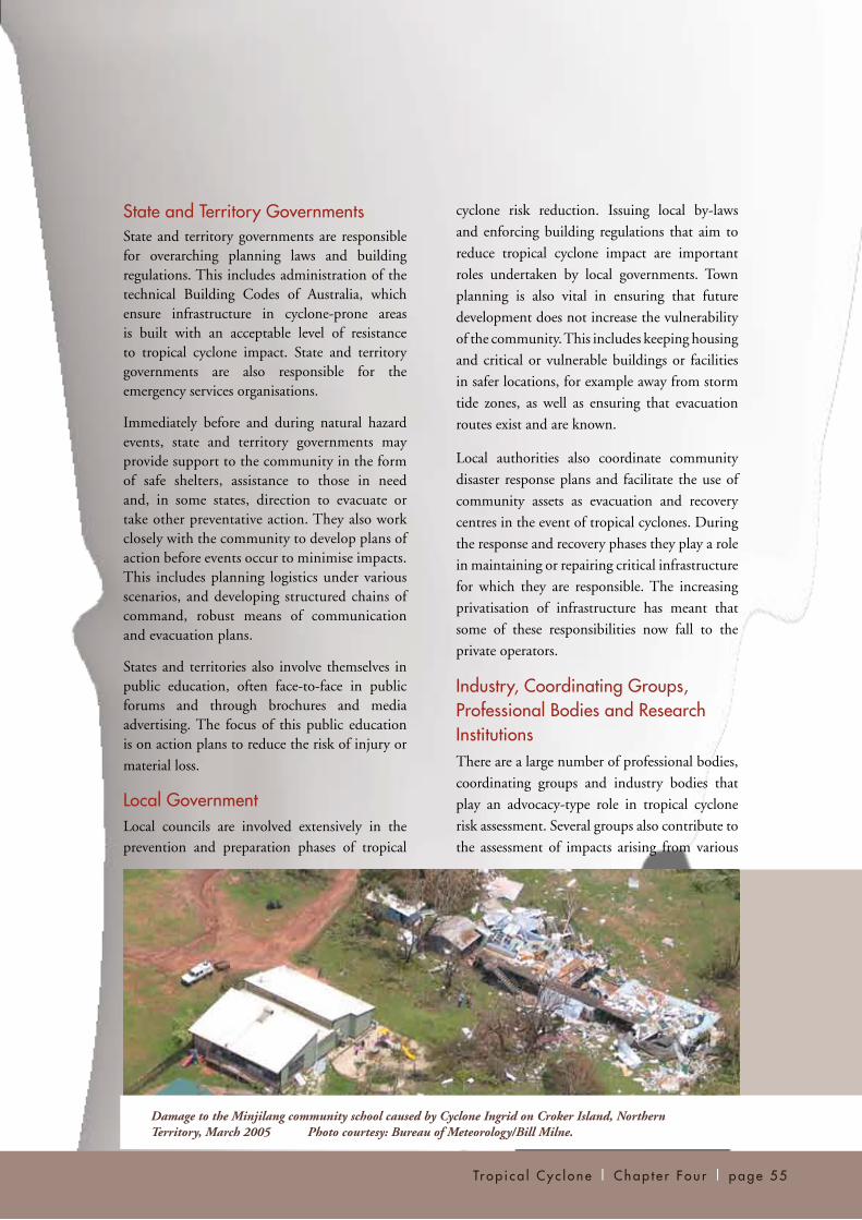
Damage to the Minjilang community school caused by Cyclone Ingrid on Croker Island, Northern Territory, March 2005 Photo courtesy: Bureau of Meteorology/Bill Milne.

hazardous aspects of cyclones, such as wind, flood and storm tide.
The engineering profession, through Engineers Australia and Standards Australia, plays a large role in mitigation, being responsible for conceiving, developing and implementing many of the measures for hazard resistance in buildings. The insurance industry provides a stable financial basis for the community to resist tropical cyclone impacts and contributes greatly to recovery operations through the provision of cash that funds immediate repairs. Numerous consulting companies are involved in wind, flood and storm tide hazard and risk assessment on behalf of government and non-government agencies.
Various universities and CSIRO also conduct research into aspects of cyclone hazard and risk assessment. The Cyclone Testing Station attached to James Cook University in Townsville, Queensland, conducts research and testing and advises industry and governments on building practices which minimise loss and suffering as a result of severe wind events.
Property Developers There is the potential that the spread of urban areas along coastal zones and into beachside settings is creating areas of increased storm tide impact risk. For example, the spiralling cost of hurricane impacts on the United States coast
has been amplified by excessive developments on exposed coastal margins (Pielke and Landsea 1998). While property developers are subject to local government approval processes, the demands to cater for increasing coastal populations place strain on the approvals system. In response, Australian state governments have moved to tighten planning rules for vulnerable environments.
Courts and Legal InstitutionsIn most states, coroners have the power to conduct an inquest into any tropical cyclone event, but such inquests occur only after significant events, such as events in which fatalities have occurred. At a preventative level, courts are often required to ensure that landowners comply with legislative and regulatory requirements concerning provisions for minimising risk.
Coastal defences and other structural efforts to mitigate the impacts of tropical cyclones may detract from the environmental values or aesthetic amenity of an area, and the courts are often required to decide which aspect is more important under apparently contradictory pieces of legislation.
MediaThe media are a critical component of the tropical cyclone warning process. Media outlets provide a means of distributing vital warning and mitigation messages to the community
page 56 | NATURAL HAZARDS IN AUSTRAL IA | Identifying Risk Analysis Requirements
Damaged planes at Darwin Aero Club, following Cyclone Tracy, Darwin, Northern Territory, December 1974 Photo courtesy: National Archives of Australia/NAA: A6135, K13/3/75/23.

immediately before and during an event. They also provide a conduit for public education programmes, through community service announcements and on-air interviews.
It is the responsibility of the media operators to ensure they have robust, self-contained infrastructure and contingency arrangements in place so that they can safely operate during events and distribute important messages to the community. With a growing trend toward national networking based in major metropolitan centres, it is important to take into account the continued local media presence that may be
required during tropical cyclone events.
General Community Individuals have a basic responsibility to be aware of any tropical cyclone risk posed to them. They should also know how to respond effectively to tropical cyclone warnings, including knowing the location of evacuation routes. Individuals should understand that particularly extreme cyclones might occur, which may seriously damage even buildings that have been built to the appropriate standard for their location. Inundation may occur in areas where development has been approved by the local agency, and measures such as structural storm tide and flood mitigation works might not fully alleviate the primary or secondary impacts of a tropical cyclone.
Private properties need to be maintained. It is important for property owners to consider not only the security of themselves and their property, but also the potential impact on others in the community.
Often, structural failure is the result of weaknesses caused by decay and corrosion rather than imperfections in original design or construction. Loose objects or poorly maintained (but ‘expendable’) structures can cause significant damage downwind when propelled by cyclonic winds. Also, there is a need to consider the
storage and protection of hazardous materials that may cause environmental contamination should inundation occur or containment infrastructure be compromised.
ConclusionTropical cyclones can be devastating events, bringing severe winds, heavy rainfall and coastal inundation. They contribute an average of 25% of the annual cost of natural disasters to the Australian economy, behind flood and severe storms ($266 million per year). Tropical cyclones have caused over 2100 deaths since 1839, many of which were a result of shipwrecks.
All levels of government, the media, non-government groups and communities contribute to the risk management process for tropical cyclones. State and territory governments retain responsibility for regulating the building standards which are an important component of managing tropical cyclone risk.
To develop an understanding of the risk posed by tropical cyclones, models of landfall frequency and the structure of tropical cyclones are required. Risk assessment models must also include information on the vulnerability of buildings, other infrastructure elements, agriculture and other industries. However, the historically low frequency of events means our understanding of the structure of tropical cyclones is incomplete. Data on the vulnerability of residential structures and other buildings is also limited by the low frequency of tropical cyclone impacts.
The understanding of the structure and behaviour of tropical cyclones and the influence of climate change on cyclones are key areas requiring further research. The vulnerability of built structures, as well as agriculture and industry, to severe wind, heavy rain and inundation also requires more study, to improve the assessments of risk from tropical cyclones.
Trop i ca l Cy c l one | Chap t e r Fou r | page 57

page 58 | NATURAL HAZARDS IN AUSTRAL IA REPORT | Identifying Risk Analysis Requirements