Embed Size (px)
Citation preview

Volume I
- Highway Design Guide –
National Standards
December 2004
CCHHAAPPTTEERR FFIIVVEE
HHOORRIIZZOONNTTAALL AALLIIGGNNMMEENNTT

5-i December 2004 HORIZONTAL ALIGNMENT Chapter Five TABLE OF CONTENTS Page 5-1 DEFINITIONS ................................................................................................................ 5-1 5-2 RURAL HIGHWAYS AND HIGH-SPEED URBAN HIGHWAYS ............................. 5-2
5-2.01 Types of Horizontal Curves ........................................................................... 5-2 5-2.02 Maximum Degree of Curve ........................................................................... 5-2 5-2.03 Widening of Travelway ................................................................................. 5-6 5-2.04 Length of Curve ............................................................................................. 5-6 5-2.05 Superelevation Development ....................................................................... 5-10 5-2.06 Horizontal Sight Distance ............................................................................ 5-20
5-3 LOW-SPEED URBAN STREETS................................................................................ 5-27
5-3.01 Horizontal Curves ........................................................................................ 5-27 5-3.02 Length of Curve ........................................................................................... 5-27 5-3.03 Superelevation Development ....................................................................... 5-28 5-3.04 Horizontal Sight Distance ............................................................................ 5-33
5-1 December 2004 DEFINITIONS
Chapter Five HORIZONTAL ALIGNMENT
Section 5-2 presents the Department's horizontal alignment criteria for all rural highways and high-speed urban highways (V>45 mph). Section 5-3 presents the Department's criteria for horizontal alignment on low-speed urban streets (V≤45 mph). 5-1 DEFINITIONS 1. Simple Curve. A simple curve is that portion of the arc of a circle which achieves the
desired deflection without using an entering or exiting transition. 2. Compound Curve. A compound curve (with deflections in the same direction) is a
combination of any number of individual simple curves (e.g., 2-centered or 3-centered) and may be symmetrical or asymmetrical.
3. Point of Intersection (PI). The PI is the point of intersection of two tangents. 4. Point of Curvature (PC). The PC is the point of change from tangent to circular curve. 5. Point of Tangent (PT). The PT is the point of change from circular curve to tangent. 6. Deflection Angle (Δ). The deflection angle is the intersection angle between the two
tangents forming the circular curve (also referred to as the central angle of curve). 7. Degree of Curve (D). The degree of curve is the central angle which subtends an arc
length of 100 feet (arc definition). The maximum degree of curve is a limiting value for a given design speed based on the maximum rate of superelevation and maximum allowable side friction factor.
5-2
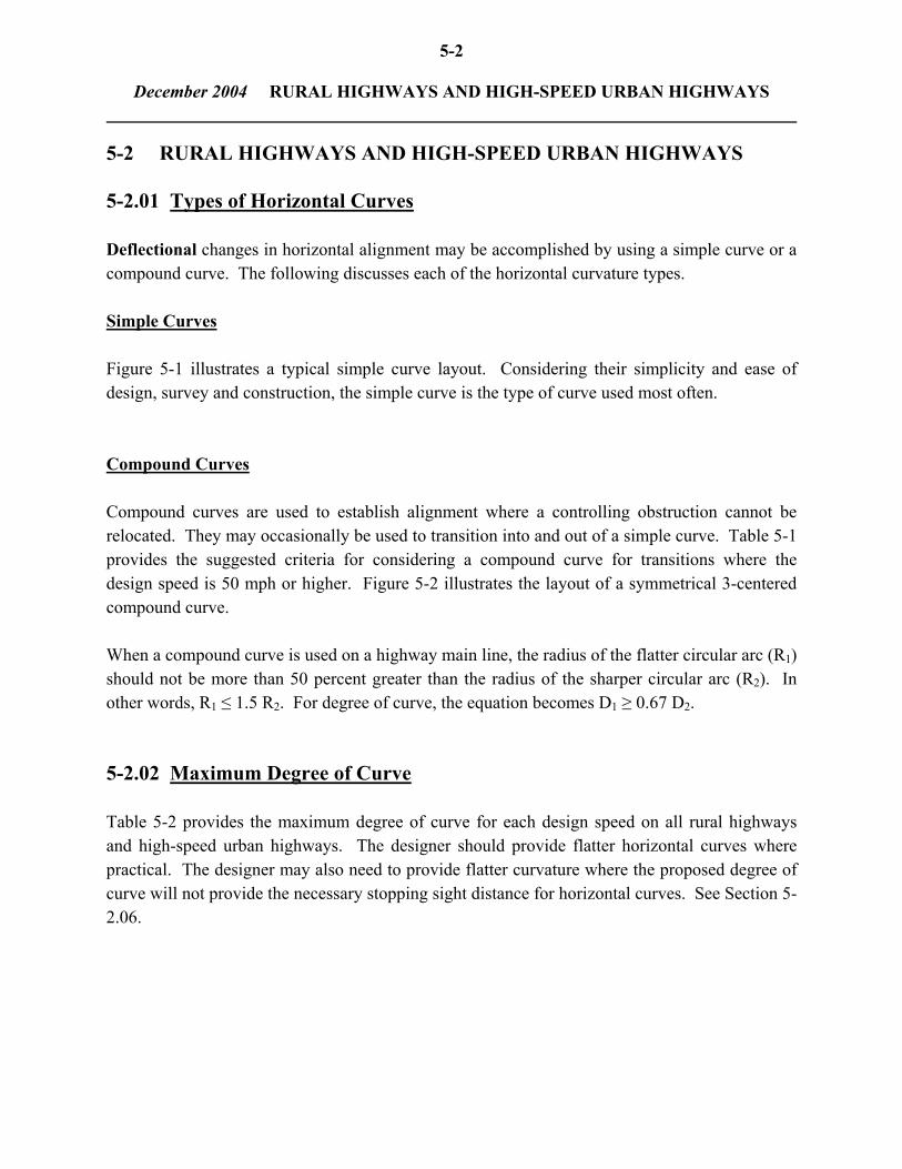
December 2004 RURAL HIGHWAYS AND HIGH-SPEED URBAN HIGHWAYS 5-2 RURAL HIGHWAYS AND HIGH-SPEED URBAN HIGHWAYS 5-2.01 Types of Horizontal Curves Deflectional changes in horizontal alignment may be accomplished by using a simple curve or a compound curve. The following discusses each of the horizontal curvature types. Simple Curves Figure 5-1 illustrates a typical simple curve layout. Considering their simplicity and ease of design, survey and construction, the simple curve is the type of curve used most often. Compound Curves Compound curves are used to establish alignment where a controlling obstruction cannot be relocated. They may occasionally be used to transition into and out of a simple curve. Table 5-1 provides the suggested criteria for considering a compound curve for transitions where the design speed is 50 mph or higher. Figure 5-2 illustrates the layout of a symmetrical 3-centered compound curve. When a compound curve is used on a highway main line, the radius of the flatter circular arc (R1) should not be more than 50 percent greater than the radius of the sharper circular arc (R2). In other words, R1 ≤ 1.5 R2. For degree of curve, the equation becomes D1 ≥ 0.67 D2. 5-2.02 Maximum Degree of Curve Table 5-2 provides the maximum degree of curve for each design speed on all rural highways and high-speed urban highways. The designer should provide flatter horizontal curves where practical. The designer may also need to provide flatter curvature where the proposed degree of curve will not provide the necessary stopping sight distance for horizontal curves. See Section 5-2.06.

5-3
December 2004 RURAL HIGHWAYS AND HIGH-SPEED URBAN HIGHWAYS TYPICAL SIMPLE CURVE LAYOUT
Figure 5-1
D
5729.5780 = R
57.2958ΔR =
DΔ100 = L
2Δ tanR = T
4Δ tanT = E
⎟⎠⎞
⎜⎝⎛ −
2Δcos1 R = M
2Δsin 2R = LC
t²R² R = O −−
)cos(1 R = O φ−
PI = Point of Intersection of tangents PC = Point of Curvature PT = Point of Tangency Δ = Central angle of curve (deflection angle) D = Degree of curvature L = Length of curve (ft); arc length from PC to PT R = Radius of curve (ft) T = Tangent length (ft) from PC to PI or from PT to PI E = External distance (ft) from PI to midpoint of circular arc M = Middle ordinate (ft) connecting midpoints of circular arc and long chord LC = Long chord (ft) from PC to PT φ = Deflection angle from PT to any point on curve t = Tangent distance (ft) from PT to any point on curve along tangent O = Tangent distance (ft) from tangent to any point on curve

5-4
December 2004 RURAL HIGHWAYS AND HIGH-SPEED URBAN HIGHWAYS
Design Speed (mph)
Consider
Compound Curve When
50
R < 1130 ft
55 R < 1455 ft 60 R < 1800 ft 65
70
R < 2175 ft R < 2775 ft
Note: The limiting Radius (R) suggested for a compound curve is based on 75% of the maximum radius for a given design speed.
SUGGESTED CRITERIA FOR CONSIDERING A COMPOUND CURVE
Table 5-1
Design Speed (mph)
Minimum Radius
(ft)
30 40 45 50 55 60 65 70
275 510 660 835 1065 1340 1660 2050
Note: emax = 6.0%
Minimum Radius (Rural Highways and High-Speed Urban Highways)
Table 5-2

5-5
December 2004 RURAL HIGHWAYS AND HIGH-SPEED URBAN HIGHWAYS
Equa
tions
for A
ny T
wo-
Cen
tere
d C
ompo
und
Cur
ves:
I
=
Tota
l Def
lect
ion
Ang
le =
Δ1 +
Δ2
X
=
R2 s
in I
+ (R
1 - R
2) si
n Δ 1
Y
=
R
1 - R
2 cos
I - (
R1 -
R2)
cos Δ
1 T b
=
Y
/ si
n I
T a
=
X -
T b c
os I
Equa
tions
for A
ny T
hree
-Cen
tere
d C
ompo
und
Cur
ves:
I
=
Tota
l Def
lect
ion
Ang
le =
Δ1 +
Δ2 +
Δ3
X
=
(R1 -
R2)
sin Δ 1
+ (R
2 - R
3) si
n (Δ
1 + Δ
2) +
R3 s
in I
Y
=
R1 -
R3 c
os I
- (R
1 - R
2) co
s Δ1 -
(R2 -
R3)
cos (Δ 1
+ Δ
2)
T b
=
Y /
sin
I T a
=
X
- T b
cos
I Eq
uatio
ns fo
r Sym
met
rical
Thr
ee-C
ente
red
Com
poun
d C
urve
(R1 =
R3;
Δ 1 =
Δ3,
as sh
own
in F
igur
e):
I =
To
tal D
efle
ctio
n A
ngle
= 2
Δ1 +
Δ2
X
=
(R1 -
R2)
sin Δ 1
+ (R
2 - R
1) si
n (Δ
1 + Δ
2) +
R1 s
in I
Y
=
R
1 - R
2 cos
I - (
R1 -
R2)
cos Δ
1 - (R
2 - R
1) co
s (Δ 1
+ Δ
2)
T b
=
Y /
sin
I T a
=
X
- T b
cos
I N
ote:
R1 ≤
1.5
R2
Not
e:
This
is o
nly
one
exam
ple
of h
ow a
com
poun
d cu
rve
can
be d
esig
ned.
SYM
ME
TR
ICA
L T
HR
EE
-CE
NT
ER
ED
CO
MPO
UN
D C
UR
VE
Fi
gure
5-2

5-6
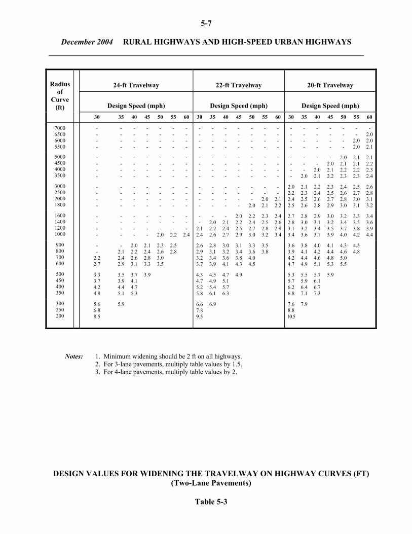
December 2004 RURAL HIGHWAYS AND HIGH-SPEED URBAN HIGHWAYS 5-2.03 Widening of Travelway Widening of the traveled way may be desirable on the inside edge of horizontal curves to make operating conditions on the curves comparable to those on tangent. This feature may be especially applicable to 3R projects (See Chapter Eleven). The designer should evaluate the need for widening on a case-by-case basis considering the functional class, type of shoulder, traffic volumes, truck volumes and urban/rural location. In some cases, it may be warranted to reduce the shoulder width for the purpose of widening the travel lanes. Table 5-3 presents design values of travelway widening on highway curves for 2-lane highways. This applies to either 1-way or 2-way operation. A recommended minimum widening of 2 feet should be used. Widening may be warranted in known problem areas (e.g., where inside shoulder has broken up because of traffic), even when not warranted by the criteria in the table. Widening should be applied to the inside edge of pavement only. Desirably, the transition distance for traveled way widening will equal the superelevation transition length, and it will be applied coincident with the superelevation transition. Figure 5-3 illustrates the application of travelway widening to a horizontal curve. Note also that the figure indicates the proper pavement marking for the curve. 5-2.04 Length of Curve Calculated vs. Minimum The length of a horizontal curve is calculated by:
For small deflection angles, the calculated lengths may produce undesirably short curves. For major roads, it is desirable that the length of curve be approximately 15V regardless of the calculated length (V = design speed in mph). The designer should use a flatter degree of curve to achieve the necessary deflection. Table 5-4 presents recommended criteria for the lengths of horizontal curves, and these should be met if practical.
57.2958ΔR =
DΔ100 = L
5-7
December 2004 RURAL HIGHWAYS AND HIGH-SPEED URBAN HIGHWAYS
24-ft Travelway
22-ft Travelway
20-ft Travelway
Design Speed (mph)
Design Speed (mph)
Design Speed (mph)
Radius of
Curve (ft)
30
35 40 45 50 55 60 30 35 40 45 50 55 60 30 35 40 45 50 55 60
7000 6500 6000 5500
- - - -
- - - -
- - - -
- - - -
- - - -
- - - -
- - - -
- - - -
- - - -
- - - -
- - - -
- - - -
- - - -
- - - -
- - - -
- - - -
- - - -
- - - -
- - - -
- -
2.0 2.0
-
2.02.02.1
5000 4500 4000 3500
- - - -
- - - -
- - - -
- - - -
- - - -
- - - -
- - - -
- - - -
- - - -
- - - -
- - - -
- - - -
- - - -
- - - -
- - - -
- - -
2.0
- -
2.0 2.1
-
2.0 2.1 2.2
2.0 2.1 2.2 2.3
2.1 2.1 2.2 2.3
2.12.22.32.4
3000 2500 2000 1800
- - - -
- - - -
- - - -
- - - -
- - - -
- - - -
- - - -
- - - -
- - - -
- - - -
- - - -
- - -
2.0
- -
2.0 2.1
- -
2.1 2.2
2.0 2.2 2.4 2.5
2.1 2.3 2.5 2.6
2.2 2.4 2.6 2.8
2.3 2.5 2.7 2.9
2.4 2.6 2.8 3.0
2.5 2.7 3.0 3.1
2.62.83.13.2
1600 1400 1200 1000
- - - -
- - - -
- - - -
- - - -
- - -
2.0
- - -
2.2
- - -
2.4
- -
2.1 2.4
-
2.0 2.2 2.6
-
2.1 2.4 2.7
2.0 2.2 2.5 2.9
2.2 2.4 2.7 3.0
2.3 2.5 2.8 3.2
2.4 2.6 2.9 3.4
2.7 2.8 3.1 3.4
2.8 3.0 3.2 3.6
2.9 3.1 3.4 3.7
3.0 3.2 3.5 3.9
3.2 3.4 3.7 4.0
3.3 3.5 3.8 4.2
3.43.63.94.4
900 800 700 600
- -
2.2 2.7
-
2.1 2.4 2.9
2.0 2.2 2.6 3.1
2.1 2.4 2.8 3.3
2.3 2.6 3.0 3.5
2.5 2.8
2.6 2.9 3.2 3.7
2.8 3.1 3.4 3.9
3.0 3.2 3.6 4.1
3.1 3.4 3.8 4.3
3.3 3.6 4.0 4.5
3.5 3.8
3.6 3.9 4.2 4.7
3.8 4.1 4.4 4.9
4.0 4.2 4.6 5.1
4.1 4.4 4.8 5.3
4.3 4.6 5.0 5.5
4.5 4.8
500 450 400 350
3.3 3.7 4.2 4.8
3.5 3.9 4.4 5.1
3.7 4.1 4.7 5.3
3.9
4.3 4.7 5.2 5.8
4.5 4.9 5.4 6.1
4.7 5.1 5.7 6.3
4.9
5.3 5.7 6.2 6.8
5.5 5.9 6.4 7.1
5.7 6.1 6.7 7.3
5.9
300 250 200
5.6 6.8 8.5
5.9
6.6 7.8 9.5
6.9
7.6 8.8 10.5
7.9
Notes: 1. Minimum widening should be 2 ft on all highways. 2. For 3-lane pavements, multiply table values by 1.5. 3. For 4-lane pavements, multiply table values by 2.
DESIGN VALUES FOR WIDENING THE TRAVELWAY ON HIGHWAY CURVES (FT) (Two-Lane Pavements)
Table 5-3

5-8
December 2004 RURAL HIGHWAYS AND HIGH-SPEED URBAN HIGHWAYS
W = Travelway widening value (see Table 5-3) WTL = Width of travel lane on tangent WS = Width of shoulder on tangent
APPLICATION OF TRAVELWAY WIDENING ON HORIZONTAL CURVES Figure 5-3
Notes: 1. Figure applies to both ends of the highway curve. 2. All widening occurs on inside of curve.
3. Solid lines in figure indicate pavement marking.
4. Desirably, the shoulder width will remain constant through the curve. When
the shoulder width is decreased for travelway widening, the pavement structure should be increased accordingly in this area of the shoulder.

5-9
December 2004 RURAL HIGHWAYS AND HIGH-SPEED URBAN HIGHWAYS
Notes: 1. The length of the curve in feet, should be its calculated length (ΔR/57.2958) or (100 Δ/D) or the recommended length in the table, whichever is longer.
2. For Δ < 0° 30´, consider providing no horizontal curve. See discussion in Section 5-2.04
RECOMMENDED MINIMUM LENGTH OF CURVE (FT) (1) (Rural Highways and High-Speed Urban Highways)
Table 5-4
Sharpest Deflection with No Curve For a deflection angle less than about 30 minutes, the designer should evaluate the visual impact of not providing a horizontal curve; i.e., allowing the angle point to remain. The top of a crest vertical curve and a signal-controlled intersection are examples of where a small deflection angle may not be visible and may not impact driver response. These types of locations should be evaluated on a case-by-case basis. However, no angle points should be permitted on bridge structures.
Deflection Angle (Δ) Functional
Class
Design Speed (mph)
< 0° 30'
0° 30' - 5°
> 5°
Arterials
and Freeways
45 50 55 60 65 70
(2) (2) (2) (2) (2) (2)
500 500 500 500 500 500
675 750 825 900 925 1050
Rural Collector and Local Roads
30-60
(2)
300
500

5-10
December 2004 RURAL HIGHWAYS AND HIGH-SPEED URBAN HIGHWAYS 5-2.05 Superelevation Development Definitions 1. Superelevation. Superelevation is the amount of cross slope or "bank" provided on a
horizontal curve to help counterbalance the outward pull of a vehicle traversing the curve. The maximum rate of superelevation (emax) depends on several factors including climatic conditions, terrain conditions and type of area (rural or urban).
2. Superelevation Transition Length. The superelevation transition length is the distance
required to transition the roadway from a normal crown section to the full superelevation needed. Superelevation transition length is the sum of the tangent runout and superelevation runoff.
a. Tangent Runout. AASHTO defines tangent runout as the change from a normal
crown section to a point where the adverse cross slope of the outside lane or lanes is removed (i.e., the outside lane(s) is level).
b. Superelevation Runoff. AASHTO defines superelevation runoff as the change in
cross slope from the end of tangent runout (adverse crown removed) to a section that is fully superelevated.
3. Axis of Rotation. The superelevation axis of rotation is the line about which the
pavement is revolved to superelevate the roadway. This line will maintain the normal highway profile throughout the curve, and it is known as the construction centerline or control edge.
4. Superelevation Rollover. Superelevation "rollover" is the algebraic difference between
the travel lane cross slope and shoulder cross slope on the outside of a horizontal curve. 5. Normal Crown (NC). The typical cross section on a tangent section (i.e., no
superelevation). 6. Remove Crown (RC). A superelevated cross section which is sloped across the entire
traveled way in the same direction and at a rate equal to the typical cross slope on a tangent section (e.g., 2.0%)

5-11
December 2004 RURAL HIGHWAYS AND HIGH-SPEED URBAN HIGHWAYS Superelevation Rate The Department has adopted emax = 6.0% for the design of rural highways and high-speed urban highways (V > 45 mph). Table 5-6 provides superelevation rates for various combinations of curvature and design speed. A horizontal curve with a very small degree of curve does not require superelevation. For a given design speed, the normal crown section (NC) used on tangent sections (2.0%) can be maintained throughout a very flat curve. On sharper curves for the same design speed, a point is reached where a slope across the total pavement width is desirable (RC). Table 5-5 provides the threshold (or maximum) degree of curve for a normal crown section and a remove crown section at various design speeds. Examples 1 and 2 illustrate how to use Tables 5-5 and 5-6 to determine the superelevation rate and cross slope bank for a given degree of curve.
Degree of Curve
Design Speed (mph)
Normal Crown
Remove Crown
See Table
5-6
30 35 40 45 50 55 60 65 70
R > 3185 ft R > 4140 R > 5290 R > 6485 R > 7995 R > 9550 R > 11090 R > 12735 R > 14325
3185 ft >
4140 >5290 >6485 >7995 >9550 >
11090 >12735 >14325 >
R > 2150 ft R > 2795 R > 3580 R > 4465 R > 5370 R > 6485 R > 7640 R > 8595 R > 9825
R < 2150 ft R < 2795 R < 3580 R < 4465 R < 5370 R < 6485 R < 7640 R < 8595 R < 9825
DEGREE OF CURVE FOR NORMAL CROWN SECTION AND REMOVE CROWN SECTION
(Rural Highways and High-Speed Urban Highways)
Table 5-5

5-12
December 2004 RURAL HIGHWAYS AND HIGH-SPEED URBAN HIGHWAYS
SUPERELEVATION RATE (Rural Highways and High-Speed Urban Highways)
Table 5-6
V=
70
(mp
h)
NC
R
C
2.6
3.3
4.6
5.5
5.9
Rm
ax =
20
50
V=
65
(mp
h)
NC
R
C
2.4
3.0
4.1
5.0
5.6
5.9
6.0
Rm
in =
16
60
V=
60
(mp
h)
NC
N
C
2.1
2.7
3.7
4.5
5.1
5.5
5.8
6.0
Rm
in =
13
40
V=
55
(mp
h)
NC
N
C
RC
2.
4 3.
3 4.
0 4.
6 5.
0 5.
4 5.
7 5.
9
Rm
in =
10
65
V=
50
(mp
h)
NC
N
C
RC
R
C
2.8
3.5
4.0
4.5
4.8
5.2
5.6
5.9
R m
inn =
83
5'
V=
45
(mp
h)
NC
N
C
NC
R
C
2.5
3.0
3.5
4.0
4.3
4.7
5.1
5.5
5.8
6.0
Rm
in =
66
0'
V=
40
(mp
h)
NC
N
C
NC
N
C
RC
2.
5 3.
0 3.
4 3.
8 4.
1 4.
6 5.
0 5.
3 5.
6 5.
8 5.
9 6.
0
Rm
in =
51
0'
V=
35
(mp
h)
NC
N
C
NC
N
C
RC
R
C
2.5
2.9
3.2
3.5
4.0
4.4
4.7
5.0
5.3
5.5
5.7
5.8
5.9
6.0
Rm
in =
38
0'
V=
30
(mp
h)
NC
N
C
NC
N
C
NC
R
C
RC
2.
3 2.
6 2.
9 3.
4 3.
8 4.
1 4.
3 4.
6 4.
8 5.
0 5.
2 5.
4 5.
5 5.
8 5.
9 6.
0 6.
0
Rm
in =
27
5'
R
(ft)
22,9
18
11,4
59
7,63
9 5,
730
3,82
0 2,
865
2,29
2 1,
910
1,63
7 1,
432
1,14
6 95
5 81
9 71
6 63
7 57
3 52
1 47
7 44
1 40
9 35
8 31
8 28
6 27
3
D
0° 1
5'
0° 3
0'
0° 4
5'
1° 0
0'
1° 3
0'
2° 0
0'
2° 3
0'
3° 0
0'
3° 3
0'
4° 0
0'
5° 0
0'
6° 0
0'
7° 0
0'
8° 0
0'
9° 0
0'
10°
00'
11°
00'
12°
00'
13°
00'
14°
00'
16°
00'
18°
00'
20°
00'
21°
00'
Key
:
R
=
Rad
ius
of C
urve
V
=
Des
ign
Spee
d, m
ph
e
= S
uper
elev
atio
n R
ate
(%)
N
C =
Nor
mal
Cro
wn
(2.0
% c
row
n sl
ope)
RC
= R
emov
e C
row
n (s
uper
elev
ate
at
norm
al c
row
n sl
ope)

5-13
December 2004 RURAL HIGHWAYS AND HIGH-SPEED URBAN HIGHWAYS
2.02.0) - (2.8 5730382057304045 = e +⎟
⎠⎞
⎜⎝⎛
−−
2.0)(0.88)(0.8 = e +
Example 1 Given: Design speed = 50 mph
Radius = 4045 feet Tangent Cross Slope = 2.0%
Problem: Determine the superelevation rate. Solution: For intermediate superelevation rates between the radius provided in Table 5-6,
use a straight-line interpolation.
From Table 5-5, when R < 5370 ft at v = 50 mph, use table 5-6 From Table 5-6, when R = 4045 ft, it is between; 5730 ft where e = RC (2% in this case) and 3820 ft where e = 2.8% Therefore, when R = 4045 ft e = what?:
e = 0.2704
Use e = 2.7%. Example 2 Given: Design speed = 50 mph
Radius = 2292 ft Two-lane roadway 12 ft travel lanes
Problem: Determine "B," the elevation differential between the edge of travel lanes. Solution: From Table 5-6, the superelevation rate is 4.0% = 0.040 ft/ft. The total horizontal distance from low side of bank to high side of bank is 24 ft.

5-14
December 2004 RURAL HIGHWAYS AND HIGH-SPEED URBAN HIGHWAYS B Total = (0.040 ft/ft) (24 ft) = 0.96 ft = 11.52 in. B/2 = 5.76 in. This distance should be rounded to the nearest ¼”. Therefore, the elevation
differential will be 5¾” from the crown point to the high side edge of travel lane and 5¾” from the crown point to the low side edge of travel lane.
* * * * * * * * * * Superelevation Transition
Superelevation should be introduced and removed uniformly over a length adequate for a given design speed. The superelevation transition length (LT) is the distance measured from the normal crown section to the full superelevation section. It is a function of the pavement width of rotation. Table 5-7 presents the minimum superelevation transition lengths for a 1 or 2 lane width of rotation. The following procedure should be used to determine the distribution of the superelevation transition length between the tangent and curve: Step 1: Determine the minimum superelevation transition length from Table 5-7 for a given
design speed and width of rotation. Step 2: For a 1-lane width of rotation, all curves should have full superelevation from the first
50-foot station occurring a minimum distance of 25 feet after the PC to the last 50-foot station occurring a minimum distance of 25 feet before the PT. For a 2-lane width of rotation, all curves should have full superelevation from the first 100-foot station occurring a minimum distance of 50 feet after the PC to the last 100-foot station occurring a minimum distance of 50 feet before the PT.
Step 3: Locate the beginning of the entering transition. This will be a distance equal to the
superelevation transition length (Step 1) in advance of the station determined in Step 2. The end of the exiting transition will be a distance equal to the transition length (Step 1) beyond the last fully superelevated station determined in Step 2.
Example 3 illustrates the distribution of transition length on a simple horizontal curve.

5-15
December 2004 RURAL HIGHWAYS AND HIGH-SPEED URBAN HIGHWAYS
Width of Rotation
Design Speed (mph)
LT (1 - lane each way)
LT (2 - lanes each way)
V ≤ 55 V > 55
200 ft 250 ft
300 ft 400 ft
Notes: 1. A 1-lane width of rotation applies where 2 lanes are rotated about the centerline.
2. A 2-lane width of rotation applies where 4 lanes are rotated about the centerline or where 3 lanes are rotated about one of the edges of the interior lane or construction centerline.
3. For a 3-lane width of rotation: LT (3 lanes) = 2.0 x LT (1-lane).
4. For a 4-lane width of rotation: LT (4 lanes) = 2.5 x LT (1-lane).
MINIMUM SUPERELEVATION TRANSITION LENGTH (LT) (Rural Highways and High-Speed Urban Highways) Table 5-7 * * * * * * * * * * Example 3 Given: Figure 5-4 illustrates the horizontal curve and stationing.
Design Speed = 50 mph. 2-lane roadway (rotated about the centerline).
Problem: Determine the superelevation transition length and the beginning and ending
stations.

5-16
December 2004 RURAL HIGHWAYS AND HIGH-SPEED URBAN HIGHWAYS Solution: From Table 5-7, the minimum superelevation transition length is 200 ft. Entering transition: From Figure 5-4, the first full 50-ft station at least 25 ft
beyond the PC is station 6+50 (full superelevation). Exiting transition: From Figure 5-4, the last fully superelevated section will be at
station 9+00. Beginning and ending transitions: Measure 200 ft back from station 6+50 to
station 4+50 (begin superelevation transition) and measure 200 ft ahead from station 9+00 to station 11+00 (end superelevation transition).
Data: V = 50 mph LT = 200 ft Rotate about centerline DISTRIBUTION OF SUPERELEVATION TRANSITION LENGTH (Example 3) Figure 5-4 * * * * * * * * * *
5-17
December 2004 RURAL HIGHWAYS AND HIGH-SPEED URBAN HIGHWAYS Reverse Curves
For closely spaced reverse curves, it may not be practical to achieve a normal crown section between the curves. A plane section continuously rotating about its axis (e.g., centerline) can be maintained between the two curves, if they are close enough together. However, the designer should adhere to the superelevation development criteria for each individual curve. The following will apply to reverse curves: 1. The designer should not attempt to achieve a normal crown section between reverse
curves unless the normal section can be maintained for at least 150 feet (45 ≤ V ≤ 55) or 200 feet (V > 55 mph) and the superelevation transition requirements can be met for both curves.
2. When a normal crown section is not provided and 1-lane is being rotated, the minimum
recommended distance between the PT (first curve) and PC (second curve) is 200 feet. The pavement will remain in a plane throughout the tangent section continuously rotating about its axis.
3. When a normal crown section is not provided and two lanes are being rotated, the
minimum recommended tangent distance is 300 feet. The pavement will remain in a plane throughout the tangent section.
Axis of Rotation 1. Undivided Highways. On 2-lane highways and undivided multilane highways, the axis
of rotation will be the centerline of the roadway. Rotation about the centerline profile is illustrated in Figure 5-5. On a 2-lane roadway with an auxiliary lane, such as a climbing lane, the axis of rotation will be the centerline of the two through lanes.
2. Divided Highways. Divided highways with medians require special consideration. Table
5-8 presents the recommended axis of rotation for divided highways based on median widths. The designer should select an axis based on the specific site conditions at the curve.
Shoulder Superelevation The algebraic difference between the travel lane slope and the shoulder slope ("rollover") should not exceed 8.0%. Details of shoulder superelevation are illustrated for various points along the superelevation transition length in Figures 5-5 and 5-6.

5-18
December 2004 RURAL HIGHWAYS AND HIGH-SPEED URBAN HIGHWAYS
Notes: 1. For distribution of transition length, see Section 5-2.05. 2. “Rollover” between travel lane and shoulder should not exceed 8.0%.
ROTATION ABOUT CENTERLINE (Undivided Highways)
Figure 5-5

5-19
December 2004 RURAL HIGHWAYS AND HIGH-SPEED URBAN HIGHWAYS
Notes: 1. For distribution of transition length, see Section 5-2.05. 2. “Rollover” between travel lane and shoulder should not exceed 8.0%. 3. For paved medians less than 20 ft, the shoulder slope rates and median edge profiles may need to
be adjusted for drainage purposes. This adjustment should be achieved in the transition length.
ROTATION ABOUT MEDIAN EDGE OF INSIDE TRAVEL LANE (Divided Highway – M ≤ 40 ft)
Figure 5-6

5-20
December 2004 RURAL HIGHWAYS AND HIGH-SPEED URBAN HIGHWAYS
Median Width
Axis of Rotation
Figure
M ≤ 40 ft
median edge of
inside travel lane
5-6
M > 40 ft
separately
about centerline of each roadway
5-5
Note: For treatment of superelevated curves with median barriers, see Chapter Ten "Roadside Safety."
RECOMMENDED AXIS OF ROTATION (Divided Highways) Table 5-8 5-2.06 Horizontal Sight Distance The designer should evaluate the impact on sight distance of obstructions which are on the inside of horizontal curves. These include walls, cut slopes, wooded areas, buildings and sometimes guardrail. Stopping Sight Distance The designer should provide an adequate "middle ordinate" (M) between the center of the inside travel lane and the sight obstruction. Figures 5-7a, 5-7b and 5-8 provide the criteria for various combinations of curve radius and sight distance. The stopping sight distances (SSD) in both figures are based on the level criteria. To determine the middle ordinate for the grade-adjusted SSD, the equation in the figure may be used directly to calculate the value. The M values from Figures 5-7a, 5-7b and 5-8 apply between the PC and PT. This area should be free of all sight obstructions. In addition, some transition is needed on either side of the curve. This is illustrated in Figure 5-9. The designer should use the following procedure:

5-21
December 2004 RURAL HIGHWAYS AND HIGH-SPEED URBAN HIGHWAYS Where: M = Middle Ordinate, distance from the line of measure (center of inside lane) to the obstruction, ft D = Degree of Curve S = Sight Distance, ft
STOPPING SIGHT DISTANCE AT HORIZONTAL CURVES (Range of Lower Values – D > 5°)
Figure 5-7a

5-22
December 2004 RURAL HIGHWAYS AND HIGH-SPEED URBAN HIGHWAYS
Where: M = Middle Ordinate, distance from the line of measure (center of inside lane) to the obstruction, ft D = Degree of Curve S = Sight Distance, ft
STOPPING SIGHT DISTANCE AT HORIZONTAL CURVES (Range of Upper Values – D < 5°)
Figure 5-7b

5-23
December 2004 RURAL HIGHWAYS AND HIGH-SPEED URBAN HIGHWAYS
M = R ( 1-COS 28.65S ) R
STOPPING SIGHT DISTANCE (RADIUS) ON HORIZONTAL CURVES
Figure 5-8
5-24
December 2004 RURAL HIGHWAYS AND HIGH-SPEED URBAN HIGHWAYS
Example Given: Urban Freeway Design speed = 60 mph
Degree of curve = 2° 15' Radius = 2546 ft Grade = 3% downgrade SSD = 570’ (without grade adjustment) SSD = 600’ (with grade adjustment)
Problem: Determine the stopping sight distance clearance requirements for the horizontal curve for both SSD values.
Solution: From Figure 5-7b, the middle ordinate distance applied between the PC and PT of
the curve is 18 ft for SSD = 600’ and 16 ft for SSD = 570’. The application of the clearance requirements throughout the entire curve, including the entering and exiting transition, is illustrated above.
OR
From Figure 5-8, using V=60 mph or SSD=570 ft yields an M value of 17 ft. MINIMUM CLEARANCE REQUIREMENTS FOR HORIZONTAL SIGHT DISTANCE Figure 5-9 * * * * * * * * * *

5-25
December 2004 RURAL HIGHWAYS AND HIGH-SPEED URBAN HIGHWAYS Step 1: Locate the point which is on the outside edge of shoulder and a distance of SSD/2
before the PC. Step 2: Locate the point which is a distance M measured laterally from the center of the
inside travel lane at the PC. Step 3: Connect the two points located in Steps 1 and 2. The area between this line and
the roadway should be clear of all obstructions. Step 4: A symmetrical application of Steps 1-3 should be used beyond the PT. For application, the height of eye is 3.5 feet and the height of object is 2 feet. The line-of-sight intercept with the obstruction is at the midpoint of the sight line and 2.75 feet above the center of the inside lane. The designer should consider the height advantage afforded by a superelevated curve. As illustrated in Figure 5-10, this elevates the center of the inside travel lane by as much as 1 foot when compared to the edge of the inside shoulder. This will greatly reduce the probability that guardrail will present a sight obstruction on the inside of a horizontal curve. Decision Sight Distance Table 4-3 provides values for decision sight distance. At a horizontal curve, for example, decision sight distance may be appropriate for a traffic signal located just beyond a curve on a rural arterial. Where decision sight distance is used, the designer should use the equation in Figure 5-7a to calculate the clearance requirements. Passing Sight Distance On high-volume, 2-lane roadways, it may occasionally be warranted to provide passing sight distance around horizontal curves to achieve a higher PSD percentage on the highway. Table 4-4 provides values for passing sight distance. These values yield large numbers for the required clearance, and their application should be limited to flat curves where the right-of-way impacts will be a minimum. Where passing sight distance is used, the designer should use the equation to calculate the clearance requirements.
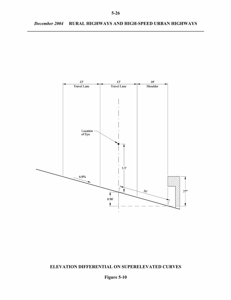
5-26
December 2004 RURAL HIGHWAYS AND HIGH-SPEED URBAN HIGHWAYS
ELEVATION DIFFERENTIAL ON SUPERELEVATED CURVES
Figure 5-10

5-27 December 2004 LOW-SPEED URBAN STREETS 5-3 LOW-SPEED URBAN STREETS The operating conditions on low-speed urban streets (design speed of 45 mph or less) are significantly different from those on rural highways and high-speed urban highways. In addition, urban areas present different physical constraints which should be considered. 5-3.01 Horizontal Curves Criteria and definitions presented in Sections 5-1 and 5-2 will apply to low-speed urban streets. However, the following additional guidance is offered specifically for these facilities: 1. Types of Curvature. The simple curve is the most common type of horizontal curve used
on low-speed urban streets. Compound curves may be warranted where a physical obstruction prevents the use of a simple curve. They will rarely be used for transition purposes.
2. Maximum Degree of Curve. Table 5-9 provides the maximum degree of curve for each
design speed on low-speed urban streets. The designer should provide flatter horizontal curves where possible.
3. Travelway Widening. Travelway widening on curves is rarely warranted on low-speed
urban streets. 5-3.02 Length of Curves Calculated versus Minimum The criteria for "Collector and Local Roads" in Table 5-4 will also apply to low-speed urban streets. An exception to this is the criteria for sharpest deflection with no curve, which is discussed in the following paragraph. Sharpest Deflection with No Curve On low-speed urban streets, a deflection angle of less than 1 degree without a horizontal curve may not have a significant effect on driver response or aesthetics. Therefore, the designer should consider leaving in the angle point when the deflection is less than about 1 degree.

5-28 December 2004 LOW-SPEED URBAN STREETS
Design Speed (mph) Minimum Radius 20
80 ft
25
145 ft
30
230 ft
35
350 ft
40
500 ft
Note: emax = 4.0%
MINIMUM RADIUS (Low-Speed Urban Streets) Table 5-9 5-3.03 Superelevation Development Superelevation Rate The Department has adopted emax = 4.0% for the design of low-speed urban streets. Figure 5-11 provides the criteria for superelevation rates for urban streets based on design speed and radius The designer should exercise special care when the "theoretical" superelevation rate is between -2.0% and +2.0% (typical cross slope). In this range, the curve should be superelevated at the rate of the cross slope (2.0% typical) toward the inside of the curve. This is referred to as remove crown (RC). This range is highlighted on Figure 5-11. Table 5-10 provides the corresponding degree of curve for a normal crown section and a remove crown section for a cross slope of 2.0%. Examples 4, 5 and 6 illustrate the use of Figure 5-11 and Table 5-10 to determine the proper superelevation rate.

5-29 December 2004 LOW-SPEED URBAN STREETS
Notes: 1. emax = 4.0% 2. For curves within the shaded area, superelevate the entire traveled way at the rate of cross slope
(2.0%) toward the inside of the curve. 3. D = Degree of Curve
RATE OF SUPERELEVATION
(Low-Speed Urban Streets)
Figure 5-11

5-30 December 2004 LOW-SPEED URBAN STREETS
Radius Design Speed
(mph)
Normal Crown
Remove Crown*
See Figure 5-11
20 25 30 35 40
R > 95 ft R > 180 R > 300 R > 465 R > 680
95 ft > 180 >300 >465 >680 >
R > 85 ft R > 155 R > 250 R > 375 R > 535
R < 85 ft R < 155 R < 250 R < 375 R < 535
* The flatter curve is based on a theoretical superelevation rate of -2.0%. The
sharper curve is based on a theoretical superelevation rate of +2.0%.
DEGREE OF CURVE FOR NORMAL CROWN SECTION AND REMOVE CROWN SECTION
(Low-Speed Urban Streets)
Table 5-10
* * * * * * * * * * Example 4 Given: Design speed = 30 mph
Radius = 347 ft Cross slope (on tangent) = 2.0%
Problem: Determine the superelevation rate. Solution: Table 5-10 indicates that a normal crown section should be used. Example 5 Given: Design speed = 35 mph
Radius = 425 ft
Problem: Determine the superelevation rate. Solution: From Table 5-10, a remove crown section applies. The pavement should be
superelevated at a rate of 2.0% across the entire pavement.

5-31 December 2004 LOW-SPEED URBAN STREETS Example 6 Given: Design speed = 40 mph Radius = 500 ft Problem: Determine the superelevation rate. Solution: Table 5-10 directs the designer to Figure 5-11 to determine the superelevation
rate. Figure 5-11 yields a required superelevation rate of +3.0%. Therefore, the entire pavement should be transitioned to this rate.
* * * * * * * * * * Superelevation Transition Length For low-speed urban streets, the minimum superelevation transition length for a 1-lane width of pavement rotation is 125 feet. For a 2-lane width of rotation, the transition length is 200 feet. The distribution of transition length on low-speed urban streets should follow the same procedure as discussed in Section 5-2.05. Reverse Curves Reverse curves may be used in urban areas. The designer should not attempt to achieve a normal crown section between curves unless the normal crown section can be maintained for at least 100 feet. See Section 5-2.05 for more information on superelevation transition on reverse curves. Axis of Rotation The criteria in Section 5-2.05 also apply to low-speed urban streets. However, on divided urban streets with median widths less than 15 feet, the axis of rotation will be the centerline. This is illustrated in Figure 5-12. Additionally, on a curbed street, it may occasionally be preferable to rotate about the outside or inside edge of travel lane because of drainage, right-of-way or other considerations.

5-32 December 2004 LOW-SPEED URBAN STREETS
Notes: 1. For distribution of transition length, see Section 5-2.05. 2. “Rollover” between travel lane and shoulder should not exceed 8.0%.
ROTATION ABOUT CENTERLINE (Divided Highway M < 15 ft)
Figure 5-12

5-33 December 2004 LOW-SPEED URBAN STREETS Shoulder Superelevation The criteria in Section 5-2.05 also apply to low-speed urban streets. The designer should note, however, that 4 feet is the minimum shoulder width which should be sloped away from the travel lane on the outside of a superelevated curve. For lesser shoulder widths, or "offsets", the outside shoulder should be sloped in the same direction as the travel lane. 5-3.04 Horizontal Sight Distance The criteria presented in Section 5-2.06 also apply to horizontal sight distance on low-speed urban streets.