Embed Size (px)
Citation preview
England Coast Path | Kingswear to Lyme Regis | Natural England’s Proposals
www.gov.uk/natural-england
Chapter 8:
Sid Estuary to Axe EstuaryEngland Coast Path: Kingswear to Lyme Regis - Natural England’s Proposals
Part 8.1: Introduction
Start Point: Sid Estuary (grid reference: SY 1288 8732)
End Point: Axe Estuary (grid reference: SY 2526 8997)
Relevant Maps: 8a to 8i
Understanding the proposals and accompanying maps:
The Trail:
8.1.1 Follows the existing South West Coast Path as currently walked and managed between the Sid Estuary and the Axe Estuary (route sections KLR-8-S001 to KLR-8-S078). The South West Coast Path mainly follows public rights of way along this length.
8.1.2 Mainly follows the coastline quite closely and generally maintains good views of the sea, apart from near Sidmouth and Seaton where the route moves inland to avoid areas of landslip and private residences.
8.1.3 We propose to adopt the line of the South West Coast Path along this section of coast. There are places where the existing walked route of the South West Coast Path over this length differs slightly from the route originally approved by the Secretary of State, as the path has adapted over time to cope with coastal erosion and other processes. Assuming these proposals are approved, we intend both routes to follow the same line. As explained at part 5a of the Overview, we use a separate variation report to the Secretary of State to change the existing approved route of the national trail line to reflect the approved line of the England Coast Path wherever appropriate.
8.1.4 This part of the coast includes the following sites, designated for nature conservation or heritage preservation (See map C of the Overview):
Sidmouth to West Bay Special Area of Conservation (SAC)
Lyme Bay and Torbay Special Area of Conservation (SAC)
Sidmouth to Beer Coast Site of Special Scientific Interest (SSSI)

England Coast Path | Kingswear to Lyme Regis | Natural England’s Proposals
Prehistoric field system on the cliffs above Littlecombe Shoot Scheduled Ancient Monument (SAM)
Berry Cliff Camp Scheduled Ancient Monument (SAM)
8.1.5 We have assessed the potential impacts of access along the proposed route (and over the associated spreading room described below) on the features for which the affected land is designated and on any which are protected in their own right. The levels and patterns of public access along this length of coast would be unlikely to change significantly as a result of our proposals and we have therefore concluded that our proposals would not be likely to have any significant impact on these features.
In relation to those nature conservation sites listed above, refer to our published Access and Sensitive Features Appraisal for more information.
See part 5b of the Overview ‘Protection of sensitive features’ for more information.
Accessibility:
8.1.6 The proposed route makes use of existing surface paths wherever these meet the criteria in the Coastal Access Scheme.
However, there are places along this length of coast where it may not be entirely suitable for people with reduced mobility because:
The trail would follow an uneven grass or bare soil path along the majority of this stretch;
There are steps along the trail where it would be necessary to ascend/descend, for example at Salcombe Hill Cliff and Weston Mouth.
There are kissing gates at many points along this section including around Branscombe and Berry Cliff,
There are several footbridges with steps including across the river Sid, north of Salcombe Mouth and at Branscombe Mouth.
See part 5a of the Overview ‘Recreational issues’ for more information.
Where we have proposed exercising our discretion:
The discretions referred to below are explained in more detail in Section 3 of the Overview.
8.1.7 Estuary: The report proposes that the trail should extend upstream from the open coast:
as far as Alma Bridge across the River Sid. The bridge is located a very short distance above the transitional water limit and is the first public foot crossing point over the river;
as far as Axmouth Bridge which is the first public foot crossing point over the River Axe.
8.1.8 Landward boundary of the coastal margin: We have used our discretion on some sections of the route

England Coast Path | Kingswear to Lyme Regis | Natural England’s Proposals
to map the landward extent of the coastal margin to an adjacent physical boundary such as a fence line, pavement or track to make the extent of the new access rights clearer. See table 8.2.1 below.
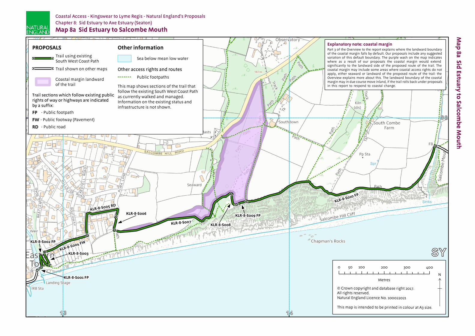
8.1.9 At Salcombe Hill Cliff we have used our discretion to propose the inclusion of an additional, more extensive landward area within the coastal margin (route sections KLR-8-S007 to KLR-8-S009), to secure or enhance public enjoyment of this part of the coast. The owner of this land (National Trust) is content for us to propose this. See map 8a and Table 8.2.1 for more detail.
See also part 3 of the Overview ‘Understanding the proposals and accompanying maps’, for an explanation of the default extent of the coastal margin and how we may use our discretion to adjust the margin, either to add land or to provide clarity. See also Annex C of the Overview ‘Excepted land categories’.
8.1.10 Access rights to the spreading room would be subject to the national restrictions on coastal access rights listed in Annex D of the Overview. These restrictions would not apply to public rights of way.
Establishment and ongoing management of the trail
8.1.11 There are no additional measures that we consider necessary to improve the safety or convenience of the trail on this length of coast.
8.1.12 Ongoing management and maintenance would be necessary in accordance with the general approach described in part 7 of the Overview. The overall need for this is likely to be greater than on some other parts of the stretch, recognising that it will be necessary for the route to roll back from time to time in response to coastal processes, as described below.
See parts 6 ‘Physical establishment of the trail’ and 7 ‘Maintenance of the trail’ of the Overview for more information.
Future Change:
8.1.13 The current footbridge over the River Sid, Alma Bridge, and the cliff it is fixed to are frequently subject to damage and erosion from high tides and storms. Devon County Council are investigating an appropriate solution and have proposed to remove this bridge and relocate the crossing point with a new footbridge positioned inland of the current location. At the time of writing this report the design of the bridge and the exact location are undergoing consultation and therefore yet to be confirmed. When Alma Bridge is removed and the new footbridge is opened, the England Coast Path will roll back and follow this new route across the river.
8.1.14 Part of the route of the trail on this length of coast would be able to change without further approval from the Secretary of State in response to coastal erosion or other geomorphological processes, or encroachment by the sea. This would happen in accordance with the criteria and procedures for ‘roll back’ set out in part 8 of the Overview. See table 8.2.3 below for details of the sections likely to be affected in the foreseeable future.
8.1.15 At the time of preparing the report, we do not foresee any other need for future changes to the access provisions proposed for the length of coast described in this chapter.
See parts 5f ‘Coastal processes’ and 8 ‘Future changes’ of the Overview for more information.

England Coast Path | Kingswear to Lyme Regis | Natural England’s Proposals
Part 8.2: Commentary on Maps
See part 3 of Overview for guidance on reading and understanding the tables below
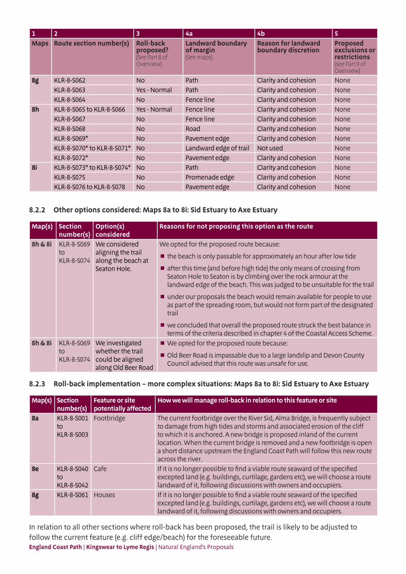
8.2.1 Section Details Maps 8a to 8i: Sid Estuary to Axe Estuary
Notes on table:
Column 2 – an asterisk (*) against the route section number means see also table 8.2.2: Other options considered.
Column 3 – ‘Yes – normal’ means roll-back approach is likely to follow the current feature (e.g. cliff edge/beach) for the foreseeable future.
Column 3 – ‘Yes – see table 8.2.3’ means refer to that table below about our likely approach to roll-back on this part of the route.
1 2 3 4a 4b 5Maps Route section number(s) Roll-back
proposed?(See Part 8 of Overview)
Landward boundary of margin (See maps)
Reason for landward boundary discretion
Proposed exclusions or restrictions(see Part 9 of Overview)
8a KLR-8-S001 to KLR-8-S003 Yes - See table 8.2.3
Fence line Clarity and cohesion None
KLR-8-S004 No Pavement edge Clarity and cohesion NoneKLR-8-S005 No Road Clarity and cohesion NoneKLR-8-S006 No Hedge bank Clarity and cohesion NoneKLR-8-S007 to KLR-8-S009 Yes - Normal Fence line Additional landward area NoneKLR-8-S010 Yes - Normal Landward edge of trail Not used None
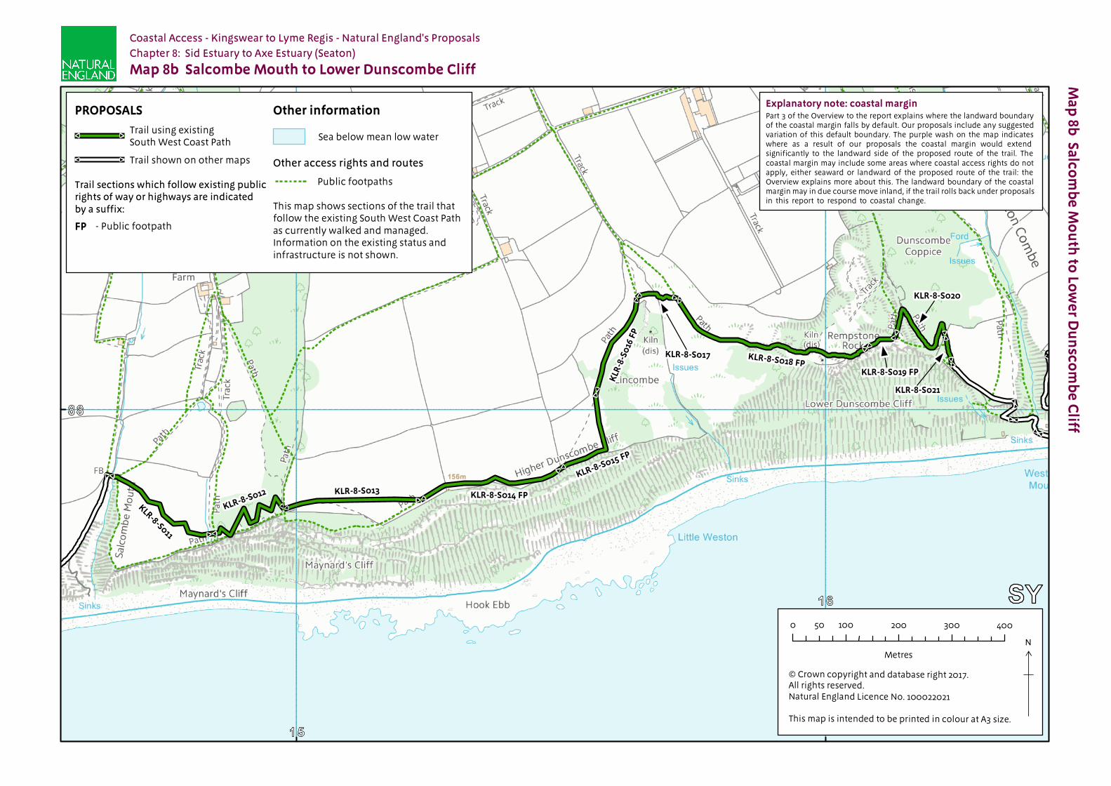
8b KLR-8-S011 to KLR-8-S021 Yes - Normal Landward edge of trail Not used None8c KLR-8-S022 to KLR-8-S024 Yes - Normal Landward edge of trail Not used None
KLR-8-S025 Yes - Normal Landward edge of beach or flat
Not used None
KLR-8-S026 to KLR-8-S027 Yes - Normal Landward edge of trail Not used NoneKLR-8-S028 to KLR-8-S029 Yes - Normal Fence line Clarity and cohesion NoneKLR-8-S030 Yes - Normal Landward edge of trail Not used NoneKLR-8-S031 No Landward edge of trail Not used None
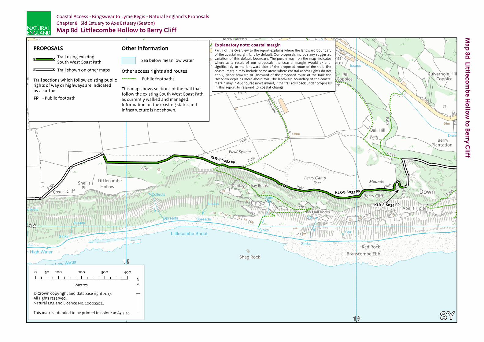
8d KLR-8-S032 Yes - Normal Landward edge of trail Not used NoneKLR-8-S033 Yes - Normal Fence line Clarity and cohesion NoneKLR-8-S034 Yes - Normal Landward edge of trail Not used None
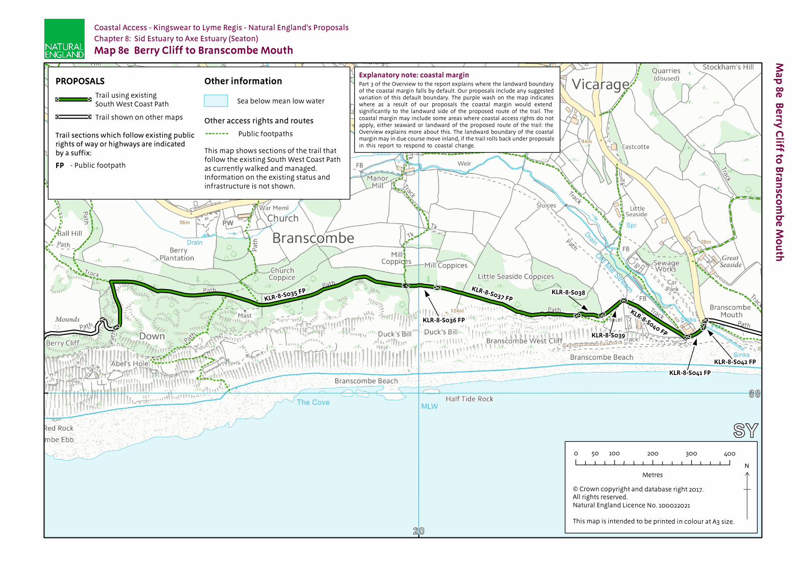
8e KLR-8-S035 Yes - Normal Track Clarity and cohesion NoneKLR-8-S036 Yes - Normal Fence line Clarity and cohesion NoneKLR-8-S037 Yes - Normal Landward edge of trail Not used NoneKLR-8-S038 Yes - Normal Fence line Clarity and cohesion NoneKLR-8-S039 Yes - Normal Landward edge of trail Not used NoneKLR-8-S040 Yes - See table
8.2.3Landward edge of trail Not used None
KLR-8-S041 to KLR-8-S042 Yes - See table 8.2.3
Track Clarity and cohesion None
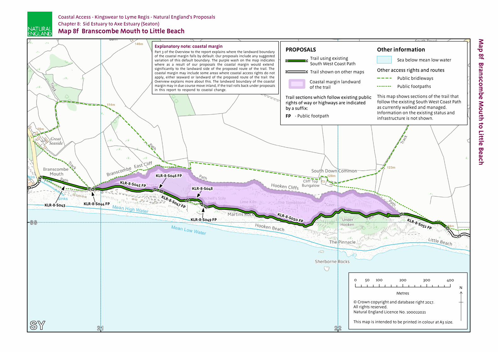
8f KLR-8-S043 Yes - Normal Landward edge of trail Not used NoneKLR-8-S044 Yes - Normal Track Clarity and cohesion NoneKLR-8-S045 to KLR-8-S050 Yes - Normal Landward edge of cliffs Not used NoneKLR-8-S051 Yes - Normal Landward edge of trail Not used None
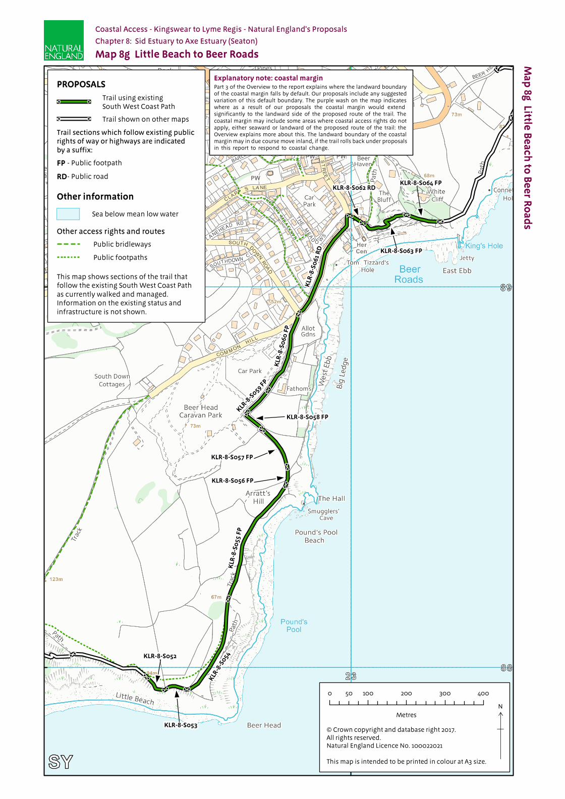
8g KLR-8-S052 Yes - Normal Landward edge of trail Not used NoneKLR-8-S053 Yes - Normal Fence line Clarity and cohesion NoneKLR-8-S054 to KLR-8-S055 Yes - Normal Landward edge of trail Not used NoneKLR-8-S056 Yes - Normal Hedgerow Clarity and cohesion NoneKLR-8-S057 to KLR-8-S060 No Hedgerow Clarity and cohesion NoneKLR-8-S061 Yes - See table
8.2.3Road Clarity and cohesion None
England Coast Path | Kingswear to Lyme Regis | Natural England’s Proposals
1 2 3 4a 4b 5Maps Route section number(s) Roll-back
proposed?(See Part 8 of Overview)
Landward boundary of margin (See maps)
Reason for landward boundary discretion
Proposed exclusions or restrictions(see Part 9 of Overview)
8g KLR-8-S062 No Path Clarity and cohesion NoneKLR-8-S063 Yes - Normal Path Clarity and cohesion NoneKLR-8-S064 No Fence line Clarity and cohesion None
8h KLR-8-S065 to KLR-8-S066 Yes - Normal Fence line Clarity and cohesion NoneKLR-8-S067 No Fence line Clarity and cohesion NoneKLR-8-S068 No Road Clarity and cohesion NoneKLR-8-S069* No Pavement edge Clarity and cohesion NoneKLR-8-S070* to KLR-8-S071* No Landward edge of trail Not used NoneKLR-8-S072* No Pavement edge Clarity and cohesion None
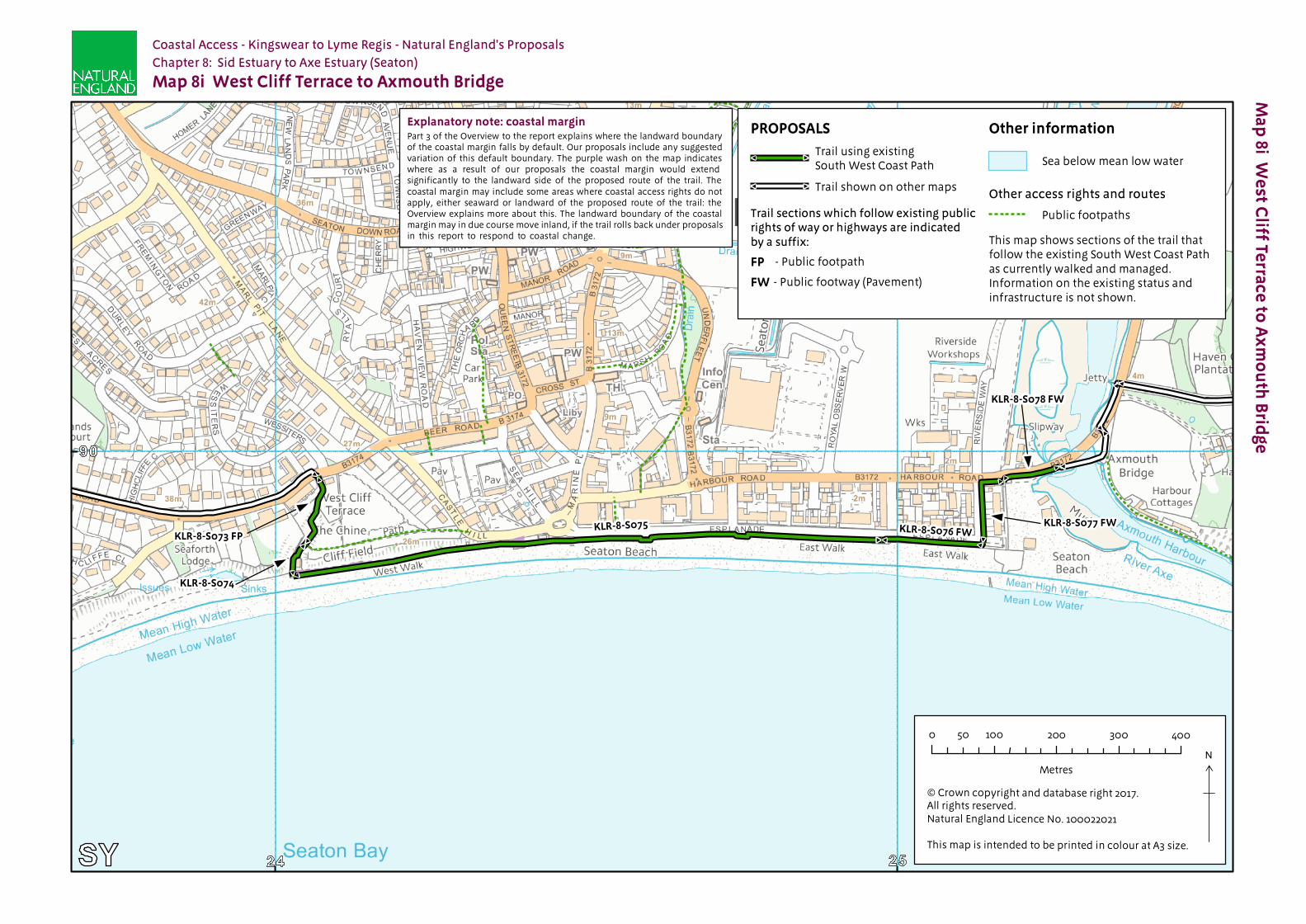
8i KLR-8-S073* to KLR-8-S074* No Path Clarity and cohesion NoneKLR-8-S075 No Promenade edge Clarity and cohesion NoneKLR-8-S076 to KLR-8-S078 No Pavement edge Clarity and cohesion None
8.2.2 Other options considered: Maps 8a to 8i: Sid Estuary to Axe Estuary
Map(s) Section number(s)
Option(s) considered
Reasons for not proposing this option as the route
8h & 8i KLR-8-S069 to KLR-8-S074
We considered aligning the trail along the beach at Seaton Hole.
We opted for the proposed route because:
the beach is only passable for approximately an hour after low tide
after this time (and before high tide) the only means of crossing from Seaton Hole to Seaton is by climbing over the rock armour at the landward edge of the beach. This was judged to be unsuitable for the trail
under our proposals the beach would remain available for people to use as part of the spreading room, but would not form part of the designated trail
we concluded that overall the proposed route struck the best balance in terms of the criteria described in chapter 4 of the Coastal Access Scheme.
8h & 8i KLR-8-S069 to KLR-8-S074
We investigated whether the trail could be aligned along Old Beer Road
We opted for the proposed route because:
Old Beer Road is impassable due to a large landslip and Devon County Council advised that this route was unsafe for use.
8.2.3 Roll-back implementation – more complex situations: Maps 8a to 8i: Sid Estuary to Axe Estuary
Map(s) Section number(s)
Feature or site potentially affected
How we will manage roll-back in relation to this feature or site
8a KLR-8-S001 to KLR-8-S003
Footbridge The current footbridge over the River Sid, Alma Bridge, is frequently subject to damage from high tides and storms and associated erosion of the cliff to which it is anchored. A new bridge is proposed inland of the current location. When the current bridge is removed and a new footbridge is open a short distance upstream the England Coast Path will follow this new route across the river.
8e KLR-8-S040 to KLR-8-S042
Cafe If it is no longer possible to find a viable route seaward of the specified excepted land (e.g. buildings, curtilage, gardens etc), we will choose a route landward of it, following discussions with owners and occupiers.
8g KLR-8-S061 Houses If it is no longer possible to find a viable route seaward of the specified excepted land (e.g. buildings, curtilage, gardens etc), we will choose a route landward of it, following discussions with owners and occupiers.
In relation to all other sections where roll-back has been proposed, the trail is likely to be adjusted to follow the current feature (e.g. cliff edge/beach) for the foreseeable future.

England Coast Path | Kingswear to Lyme Regis | Natural England’s Proposals
Part 8.3: Chapter 8 - Formal Proposals
Below are our formal proposals to the Secretary of State for the length of coast shown on maps 8a to 8i.
They should be read in conjunction with the relevant maps.
The commentary above explains the practical effect of these proposals.
Formal Proposals – Sid Estuary to Axe Estuary
Discretion to include an estuary
8.3.1 Natural England proposes to exercise its functions as if the sea included the estuarial waters of the River Sid as far as the Alma Bridge and the River Axe as far as Axmouth Bridge as indicated by the extent of the trail shown on maps 8a and 8i.
Proposed route of the trail
8.3.2 In relation to route sections KLR-8-S004 to KLR-8-S006, KLR-8-S031, KLR-8-S057 to KLR-8-S060, KLR-8-S062, KLR-8-S064, and KLR-8-S067 to KLR-8-S078 the route is to be at the centre of the line shown on maps 8a, 8c, 8g, 8h and 8i as the proposed route of the trail.
8.3.3 In relation to route sections KLR-8-S001 to KLR-8-S003, KLR-8-S007 to KLR-8-S030, KLR-8-S032 to KLR-8-S056, KLR-8-S061, KLR-8-S063 and KLR-8-S065 to KLR-8-S066 the route, as initially determined at the time the report was prepared, is to be at the centre of the line shown on maps 8a to 8h as the proposed route of the trail.
8.3.4 If at any time any part of a route section listed in the previous paragraph needs, in Natural England’s view, to change as a result of coastal erosion or other geomorphological processes or encroachment by the sea, in order for the overall route to remain viable, the new route for the part in question will be determined by Natural England without further reference to the Secretary of State. This will be done in accordance with the criteria and procedures described under the title ‘Roll-back’ in part 8 of the Overview and section 4.10 of the Coastal Access Scheme. If this happens, the new route will become the approved route for that section for the purposes of the Order which determines where coastal access rights apply.
Landward boundary of coastal margin
8.3.5 Adjacent to route sections KLR-8-S007 to KLR-8-S009 the landward boundary of the coastal margin is to coincide with the existing boundary fence, as indicated by the coastal margin landward of the trail on map 8a.
8.3.6 Adjacent to route sections KLR-8-S001 to KLR-8-S003, KLR-8-S028 to KLR-8-S029, KLR-8-S033, KLR-8-S036, KLR-8-S038, KLR-8-S053 and KLR-8-S064 to KLR-8-S067 the landward boundary of the coastal margin is to coincide with the existing fence line which at the time of writing this report is at the landward edge of the trail shown on maps 8a, 8c, 8d, 8e, 8g and 8h.
8.3.7 Adjacent to route section KLR-8-S006 the landward boundary of the coastal margin is to coincide with the existing hedge bank which at the time of writing this report is at the landward edge of the

England Coast Path | Kingswear to Lyme Regis | Natural England’s Proposals
trail shown on map 8a.
8.3.8 Adjacent to route sections KL6-8-S045 to KLR-8-S050, the landward boundary of the coastal margin is to coincide with the top of the cliff face, which at the time of writing this report is landward of the trail shown on map 8f.
8.3.9 Adjacent to route sections KLR-8-S056 to KLR-8-S060 the landward boundary of the coastal margin is to coincide with the existing hedgerow which at the time of writing this report is at the landward edge of the trail shown on map 8g.
8.3.10 Adjacent to route sections KLR-8-S004, KLR-8-S069, KLR-8-S072 and KLR-8-S076 to KLR-8-S078 the landward boundary of the coastal margin is to coincide with the landward edge of the pavement shown as the trail on maps 8a, 8h and 8i.
8.3.11 Adjacent to route sections KLR-8-S005, KLR-8-S061 and KLR-8-S068 the landward boundary of the coastal margin is to coincide with the landward edge of the road shown as the trail on map 8a, 8g and 8h.
8.3.12 Adjacent to route sections KLR-8-S035, KLR-8-S041 to KLR-8-S042 and KLR-8-S044, the landward boundary of the coastal margin is to coincide with the landward edge of the track shown as the trail on maps 8e and 8f.
8.3.13 Adjacent to route sections KLR-8-S062 to KLR-8-S063 and KLR-8-S073 to KLR-8-S074, the landward boundary of the coastal margin is to coincide with the landward edge of the path shown as the trail on maps 8g and 8i.
8.3.14 Adjacent to route section KLR-8-S075 the landward boundary of the coastal margin is to coincide with the landward edge of the promenade shown as the trail on map 8i.
Local restrictions and exclusions
8.3.15 At the time of writing this report, there are no proposals for local restrictions or exclusions in relation to this length of coast.
Alternative routes
8.3.16 There are no proposals for alternative routes in relation to this length of coast.
#
#
#
#
#
#
#
#
#
#
#
#
#
#
#
#
#
#
#
# #
#
#
#
KLR-8-S001 FP
KLR-8-S004 FW
KLR-8-S003
KLR-8-S002 FP
KLR-8-S007 KLR-8-S008
KLR-8-S005 RD
KLR-8-S006 KLR-8-S009 FP
KLR-8-S010 FP
Ma
p 8
a S
id E
stua
ry to
Sa
lco
mb
e M
ou
th
Explanatory note: coastal marginPart 3 of the Overview to the report explains where the landward boundary of the coastal margin falls by default. Our proposals include any suggested variation of this default boundary. The purple wash on the map indicates where as a result of our proposals the coastal margin would extend significantly to the landward side of the proposed route of the trail. The coastal margin may include some areas where coastal access rights do not apply, either seaward or landward of the proposed route of the trail: the Overview explains more about this. The landward boundary of the coastal margin may in due course move inland, if the trail rolls back under proposals in this report to respond to coastal change.
Map 8a Sid Estuary to Salcombe Mouth
Coastal Access - Kingswear to Lyme Regis - Natural England's Proposals
Chapter 8: Sid Estuary to Axe Estuary (Seaton)
© Crown copyright and database right 2017. All rights reserved.Natural England Licence No. 100022021
This map is intended to be printed in colour at A3 size.
N
×0 100 200 300 40050
Metres
PROPOSALS
Trail shown on other maps#
#
#
# Trail using existingSouth West Coast Path
Trail sections which follow existing public rights of way or highways are indicatedby a suffix:
- Public footpathFP
- Public roadRD
- Public footway (Pavement)FW
Coastal margin landwardof the trail This map shows sections of the trail that
follow the existing South West Coast Path as currently walked and managed. Information on the existing status and infrastructure is not shown.
Other information
Sea below mean low water
Other access rights and routes
Public footpaths
#
#
#
#
#
#
##
#
#
#
#
##
#
#
#
#
#
# #
# #
##
#
#
#
#
##
#
##
# #
KLR-8-S011
KLR-8-S012 KLR-8-S013 KLR-8-S014 FP
KLR-8-S015 FP
KLR
-8-S
016
FP
KLR-8-S021
KLR-8-S017 KLR-8-S018 FPKLR-8-S019 FP
KLR-8-S020
Ma
p 8
b S
alc
om
be
Mo
uth
to Lo
we
r Du
nsc
om
be
Cliff
Explanatory note: coastal marginPart 3 of the Overview to the report explains where the landward boundary of the coastal margin falls by default. Our proposals include any suggested variation of this default boundary. The purple wash on the map indicates where as a result of our proposals the coastal margin would extend significantly to the landward side of the proposed route of the trail. The coastal margin may include some areas where coastal access rights do not apply, either seaward or landward of the proposed route of the trail: the Overview explains more about this. The landward boundary of the coastal margin may in due course move inland, if the trail rolls back under proposals in this report to respond to coastal change.
Map 8b Salcombe Mouth to Lower Dunscombe Cliff
Coastal Access - Kingswear to Lyme Regis - Natural England's Proposals
Chapter 8: Sid Estuary to Axe Estuary (Seaton)
This map shows sections of the trail thatfollow the existing South West Coast Path as currently walked and managed. Information on the existing status and infrastructure is not shown.
Other information
Sea below mean low water
Other access rights and routes
Public footpaths
PROPOSALS
Trail shown on other maps#
#
#
# Trail using existingSouth West Coast Path
Trail sections which follow existing public rights of way or highways are indicatedby a suffix:
- Public footpathFP
© Crown copyright and database right 2017. All rights reserved.Natural England Licence No. 100022021
This map is intended to be printed in colour at A3 size.
N
×0 100 200 300 40050
Metres

#
##
#
##
#
#
#
#
#
#
#
#
#
#
#
#
## #
#
#
# #
#
#
#
KLR-8-S024 FPKLR-8-S025 FP
KLR-8-S023 FP
KLR-8-S022 FPKLR-8-S026 FP
KLR-8-S027
KLR-8-S028 KLR-8-S029 FPKLR-8
-S030 FP
KLR-8-S031 FP
Ma
p 8
c W
esto
n M
ou
th to
Littlec
om
be
Ho
llow
Explanatory note: coastal marginPart 3 of the Overview to the report explains where the landward boundary of the coastal margin falls by default. Our proposals include any suggested variation of this default boundary. The purple wash on the map indicates where as a result of our proposals the coastal margin would extend significantly to the landward side of the proposed route of the trail. The coastal margin may include some areas where coastal access rights do not apply, either seaward or landward of the proposed route of the trail: the Overview explains more about this. The landward boundary of the coastal margin may in due course move inland, if the trail rolls back under proposals in this report to respond to coastal change.
Map 8c Weston Mouth to Littlecombe Hollow
Coastal Access - Kingswear to Lyme Regis - Natural England's Proposals
Chapter 8: Sid Estuary to Axe Estuary (Seaton)
© Crown copyright and database right 2017. All rights reserved.Natural England Licence No. 100022021
This map is intended to be printed in colour at A3 size.
N
×0 100 200 300 40050
Metres
This map shows sections of the trail thatfollow the existing South West Coast Path as currently walked and managed. Information on the existing status and infrastructure is not shown.
Other information
Sea below mean low water
Other access rights and routes
Public footpaths
PROPOSALS
Trail shown on other maps#
#
#
# Trail using existingSouth West Coast Path
Trail sections which follow existing public rights of way or highways are indicatedby a suffix:
- Public footpathFP
#
# #
#
#
#
#
#
#
#
#
#
#
#
KLR-8-S034 FP
KLR-8-S033 FP
KLR-8-S032 FP
Ma
p 8
d Little
co
mb
e H
ollo
w to
Be
rry C
liff
Explanatory note: coastal marginPart 3 of the Overview to the report explains where the landward boundary of the coastal margin falls by default. Our proposals include any suggested variation of this default boundary. The purple wash on the map indicates where as a result of our proposals the coastal margin would extend significantly to the landward side of the proposed route of the trail. The coastal margin may include some areas where coastal access rights do not apply, either seaward or landward of the proposed route of the trail: the Overview explains more about this. The landward boundary of the coastal margin may in due course move inland, if the trail rolls back under proposals in this report to respond to coastal change.
Map 8d Littlecombe Hollow to Berry Cliff
Coastal Access - Kingswear to Lyme Regis - Natural England's Proposals
Chapter 8: Sid Estuary to Axe Estuary (Seaton)
© Crown copyright and database right 2017. All rights reserved.Natural England Licence No. 100022021
This map is intended to be printed in colour at A3 size.
N
×0 100 200 300 40050
Metres
This map shows sections of the trail thatfollow the existing South West Coast Path as currently walked and managed. Information on the existing status and infrastructure is not shown.
Other information
Sea below mean low water
Other access rights and routes
Public footpaths
PROPOSALS
Trail shown on other maps#
#
#
# Trail using existingSouth West Coast Path
Trail sections which follow existing public rights of way or highways are indicatedby a suffix:
- Public footpathFP
#
# #
#
#
#
#
#
#
# #
#
#
#
#
#
## #
#
##
KLR-8-S041 FP
KLR-8-S042 FP
KLR-8-S039
KLR-8-S040 FP
KLR-8-S036 FP
KLR-8-S035 FP KLR-8-S037 FPKLR-8-S038
Ma
p 8
e B
erry
Cliff to
Bra
nsc
om
be
Mo
uth
Explanatory note: coastal marginPart 3 of the Overview to the report explains where the landward boundary of the coastal margin falls by default. Our proposals include any suggested variation of this default boundary. The purple wash on the map indicates where as a result of our proposals the coastal margin would extend significantly to the landward side of the proposed route of the trail. The coastal margin may include some areas where coastal access rights do not apply, either seaward or landward of the proposed route of the trail: the Overview explains more about this. The landward boundary of the coastal margin may in due course move inland, if the trail rolls back under proposals in this report to respond to coastal change.
Map 8e Berry Cliff to Branscombe Mouth
Coastal Access - Kingswear to Lyme Regis - Natural England's Proposals
Chapter 8: Sid Estuary to Axe Estuary (Seaton)
© Crown copyright and database right 2017. All rights reserved.Natural England Licence No. 100022021
This map is intended to be printed in colour at A3 size.
N
×0 100 200 300 40050
Metres
This map shows sections of the trail thatfollow the existing South West Coast Path as currently walked and managed. Information on the existing status and infrastructure is not shown.
Other information
Sea below mean low water
Other access rights and routes
Public footpaths
PROPOSALS
Trail shown on other maps#
#
#
# Trail using existingSouth West Coast Path
Trail sections which follow existing public rights of way or highways are indicatedby a suffix:
- Public footpathFP
#
# # #
#
#
#
#
#
#
#
#
#
# #
#
#
#
# #
# #
#
#
#
#
#
#
#
#
KLR-8-S049 FP
KLR-8-S050 FP KLR-8-S051 FP
KLR-8-S043 KLR-8-S044 FP
KLR-8-S047 FP
KLR-8-S048
KLR-8-S045 FP
KLR-8-S046 FP
Ma
p 8
f Bra
nsc
om
be
Mo
uth
to Little
Be
ac
h
Explanatory note: coastal marginPart 3 of the Overview to the report explains where the landward boundary of the coastal margin falls by default. Our proposals include any suggested variation of this default boundary. The purple wash on the map indicates where as a result of our proposals the coastal margin would extend significantly to the landward side of the proposed route of the trail. The coastal margin may include some areas where coastal access rights do not apply, either seaward or landward of the proposed route of the trail: the Overview explains more about this. The landward boundary of the coastal margin may in due course move inland, if the trail rolls back under proposals in this report to respond to coastal change.
Map 8f Branscombe Mouth to Little Beach
Coastal Access - Kingswear to Lyme Regis - Natural England's Proposals
Chapter 8: Sid Estuary to Axe Estuary (Seaton)
© Crown copyright and database right 2017. All rights reserved.Natural England Licence No. 100022021
This map is intended to be printed in colour at A3 size.
N
×0 100 200 300 40050
Metres
This map shows sections of the trail thatfollow the existing South West Coast Path as currently walked and managed. Information on the existing status and infrastructure is not shown.
Other information
Sea below mean low water
Other access rights and routes
Public bridleways
Public footpaths
PROPOSALS
Trail shown on other maps#
#
#
# Trail using existingSouth West Coast Path
Trail sections which follow existing public rights of way or highways are indicatedby a suffix:
- Public footpathFP
Coastal margin landwardof the trail
#
# #
#
#
#
#
#
#
#
#
#
#
# # #
#
#
#
#
#
#
#
#
#
#
#
#
#
#
#
#
#
#
#
#
#
#
KLR-8-S053
KLR
-8-S
054
KLR-8-S052
KLR
-8-S
055
FP
KLR-8-S056 FP
KLR-8-S057 FP
KLR-8
-S059 F
P
KLR-8-S058 FP
KLR
-8-S
060
FP
KLR
-8-S
061
RD KLR-8-S063 FP
KLR-8-S062 RDKLR-8-S064 FP
Ma
p 8g
Little B
ea
ch
to B
ee
r Ro
ad
s
Explanatory note: coastal marginPart 3 of the Overview to the report explains where the landward boundary of the coastal margin falls by default. Our proposals include any suggested variation of this default boundary. The purple wash on the map indicates where as a result of our proposals the coastal margin would extend significantly to the landward side of the proposed route of the trail. The coastal margin may include some areas where coastal access rights do not apply, either seaward or landward of the proposed route of the trail: the Overview explains more about this. The landward boundary of the coastal margin may in due course move inland, if the trail rolls back under proposals in this report to respond to coastal change.
Coastal Access - Kingswear to Lyme Regis - Natural England's Proposals
Chapter 8: Sid Estuary to Axe Estuary (Seaton)
Map 8g Little Beach to Beer Roads
© Crown copyright and database right 2017. All rights reserved.Natural England Licence No. 100022021
This map is intended to be printed in colour at A3 size.
N
×0 100 200 300 40050
Metres
This map shows sections of the trail thatfollow the existing South West Coast Path as currently walked and managed. Information on the existing status and infrastructure is not shown.
Other information
Sea below mean low water
Other access rights and routes
Public bridleways
Public footpaths
PROPOSALS
Trail shown on other maps#
#
#
# Trail using existingSouth West Coast Path
Trail sections which follow existing public rights of way or highways are indicatedby a suffix:
- Public footpathFP
- Public roadRD

#
#
#
#
#
#
#
##
#
##
#
#
#
#
#
#
#
#
#
#
#
#
#
#
#
#
#
#
KLR
-8-S
065
FP
KLR-8-S067 FP KLR-8-S066
KLR-8-S068 RD
KLR-8-S069 FW
KLR-8-S071
KLR-8-S070
KLR-8-S072 FW
Ma
p 8h
Be
er R
oa
ds to
We
st Cliff Te
rrace
Explanatory note: coastal marginPart 3 of the Overview to the report explains where the landward boundary of the coastal margin falls by default. Our proposals include any suggested variation of this default boundary. The purple wash on the map indicates where as a result of our proposals the coastal margin would extend significantly to the landward side of the proposed route of the trail. The coastal margin may include some areas where coastal access rights do not apply, either seaward or landward of the proposed route of the trail: the Overview explains more about this. The landward boundary of the coastal margin may in due course move inland, if the trail rolls back under proposals in this report to respond to coastal change.
Coastal Access - Kingswear to Lyme Regis - Natural England's Proposals
Chapter 8: Sid Estuary to Axe Estuary (Seaton)
Map 8h Beer Roads to West Cliff Terrace
© Crown copyright and database right 2017. All rights reserved.Natural England Licence No. 100022021
This map is intended to be printed in colour at A3 size.
N
×0 100 200 300 40050
Metres
PROPOSALS
Trail shown on other maps#
#
#
# Trail using existingSouth West Coast Path
Trail sections which follow existing public rights of way or highways are indicatedby a suffix:
- Public footpathFP
- Public roadRD
- Public footway (Pavement)FW
This map shows sections of the trail thatfollow the existing South West Coast Path as currently walked and managed. Information on the existing status and infrastructure is not shown.
Other information
Sea below mean low water
Other access rights and routes
Public footpaths
#
#
#
#
#
# #
#
#
#
#
#
#
# # #
#
# #
#
KLR-8-S074
KLR-8-S073 FPKLR-8-S075 KLR-8-S076 FW
KLR-8-S077 FW
KLR-8-S078 FW
Ma
p 8
i We
st Cliff Te
rrac
e to
Ax
mo
uth
Brid
ge
Explanatory note: coastal marginPart 3 of the Overview to the report explains where the landward boundary of the coastal margin falls by default. Our proposals include any suggested variation of this default boundary. The purple wash on the map indicates where as a result of our proposals the coastal margin would extend significantly to the landward side of the proposed route of the trail. The coastal margin may include some areas where coastal access rights do not apply, either seaward or landward of the proposed route of the trail: the Overview explains more about this. The landward boundary of the coastal margin may in due course move inland, if the trail rolls back under proposals in this report to respond to coastal change.
Map 8i West Cliff Terrace to Axmouth Bridge
Coastal Access - Kingswear to Lyme Regis - Natural England's Proposals
Chapter 8: Sid Estuary to Axe Estuary (Seaton)
This map shows sections of the trail thatfollow the existing South West Coast Path as currently walked and managed. Information on the existing status and infrastructure is not shown.
Other information
Sea below mean low water
Other access rights and routes
Public footpaths
PROPOSALS
Trail shown on other maps#
#
#
# Trail using existingSouth West Coast Path
Trail sections which follow existing public rights of way or highways are indicatedby a suffix:
- Public footpathFP
- Public footway (Pavement)FW
© Crown copyright and database right 2017. All rights reserved.Natural England Licence No. 100022021
This map is intended to be printed in colour at A3 size.
N
×0 100 200 300 40050
Metres