Embed Size (px)
Citation preview
Part 6 Location Specific Development Controls
Chapter 6.22 Glenning Valley
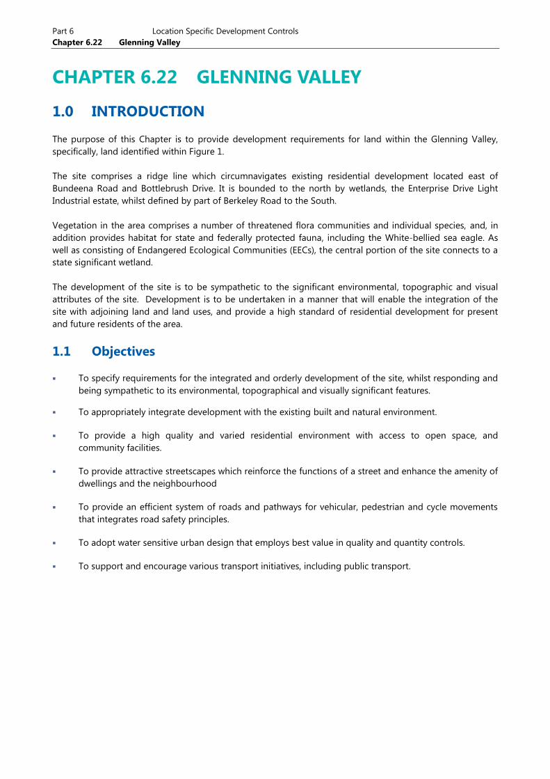
CHAPTER 6.22 GLENNING VALLEY
1.0 INTRODUCTION
The purpose of this Chapter is to provide development requirements for land within the Glenning Valley,
specifically, land identified within Figure 1.
The site comprises a ridge line which circumnavigates existing residential development located east of
Bundeena Road and Bottlebrush Drive. It is bounded to the north by wetlands, the Enterprise Drive Light
Industrial estate, whilst defined by part of Berkeley Road to the South.
Vegetation in the area comprises a number of threatened flora communities and individual species, and, in
addition provides habitat for state and federally protected fauna, including the White-bellied sea eagle. As
well as consisting of Endangered Ecological Communities (EECs), the central portion of the site connects to a
state significant wetland.
The development of the site is to be sympathetic to the significant environmental, topographic and visual
attributes of the site. Development is to be undertaken in a manner that will enable the integration of the
site with adjoining land and land uses, and provide a high standard of residential development for present
and future residents of the area.
1.1 Objectives
To specify requirements for the integrated and orderly development of the site, whilst responding and
being sympathetic to its environmental, topographical and visually significant features.
To appropriately integrate development with the existing built and natural environment.
To provide a high quality and varied residential environment with access to open space, and
community facilities.
To provide attractive streetscapes which reinforce the functions of a street and enhance the amenity of
dwellings and the neighbourhood
To provide an efficient system of roads and pathways for vehicular, pedestrian and cycle movements
that integrates road safety principles.
To adopt water sensitive urban design that employs best value in quality and quantity controls.
To support and encourage various transport initiatives, including public transport.
Part 6 Location Specific Development Controls
Draft Chapter 6.22 Glenning Valley
Development Control Plan 2013 – Development Controls for Wyong Shire Page 2
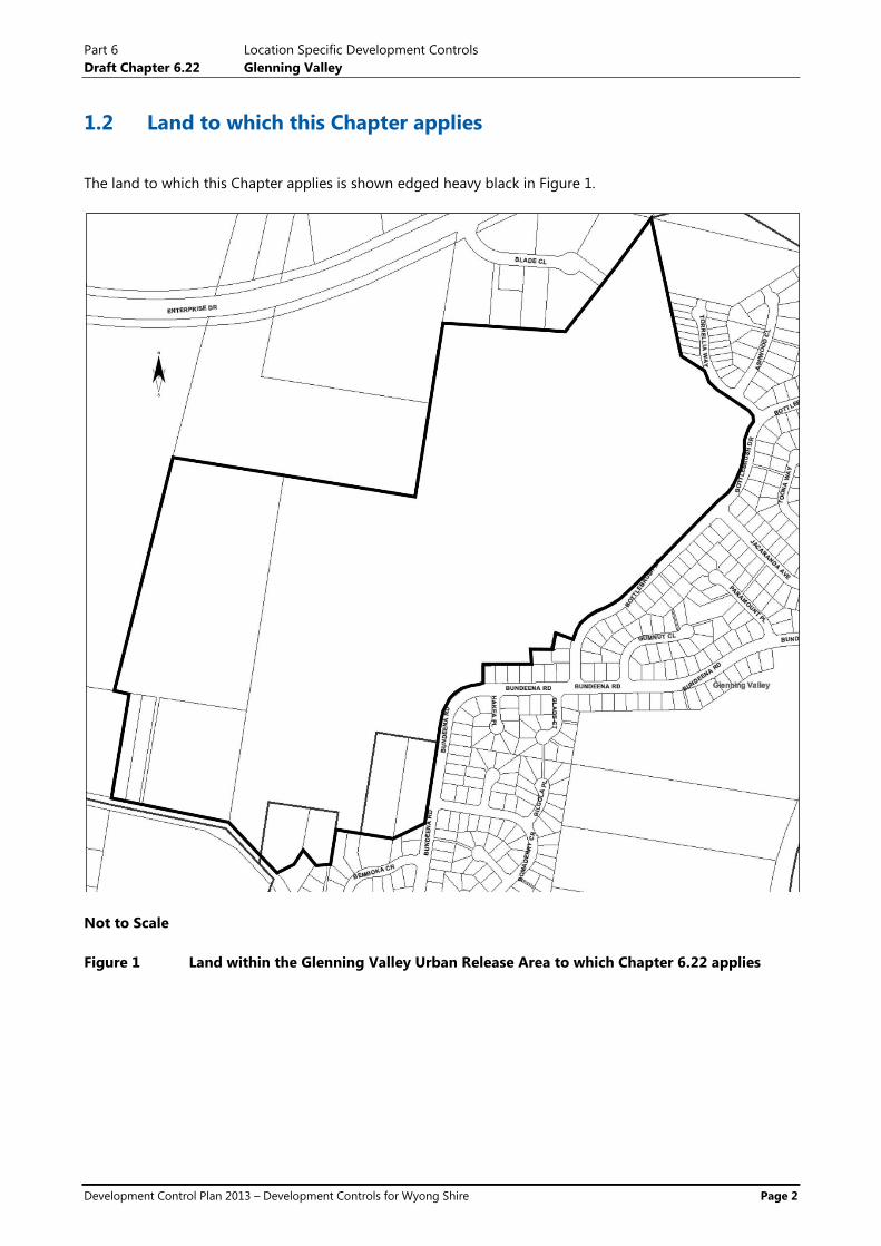
1.2 Land to which this Chapter applies
The land to which this Chapter applies is shown edged heavy black in Figure 1.
Not to Scale
Figure 1 Land within the Glenning Valley Urban Release Area to which Chapter 6.22 applies
Part 6 Location Specific Development Controls
Draft Chapter 6.22 Glenning Valley
Development Control Plan 2013 – Development Controls for Wyong Shire Page 3
1.3 Using this Chapter
This Chapter should be read in conjunction with other relevant Chapters of this Development Control Plan
and other Policy Documents of Council, including but not limited to:
Chapter 2.1 – Housing and Ancillary Structures
Chapter 2.3 – Dual Occupancy Development
Chapter 2.11 – Parking and Access
Chapter 3.6 – Tree and Vegetation Management
Chapter 3.10 – Wetlands Management
Section 4 – Subdivision
Council’s Civil Works Design Guideline and Construction Specification
Flora and Fauna Guidelines for Development
2.0 DEVELOPMENT PRINCIPLES
Land covered by this Chapter should be developed in an orderly and integrated manner.
Applications for subdivision must demonstrate that development of individual landholdings will not
compromise the development potential of neighbouring or adjoining land holdings. Additionally,
applications for subdivisions must also provide for the provision of appropriate servicing, drainage, transport
infrastructure and minimise the impacts if constructions of subsequent stages on the community.
This is to be demonstrated by way of a conceptual plan which indicates a potential layout on neighbouring
or adjoining lands. Such applications for land held in individual ownership must demonstrate that
appropriate consultation has been undertaken with other neighbouring or adjoining landholders.
2.1 Subdivision Design
OBJECTIVES
To ensure that any future development of the site:
Is sympathetic to site constraints including topography, scenic qualities and areas of significant
environmental attributes of the site;
Is sympathetic to style and character of adjoining residential development;
Retains existing visual amenity from adjoining residential development;
Provides transport linkages to surrounding areas and existing community facilities and promotes
healthy living by design.
Includes the consideration of safe systems principles in providing a safer road network for all
users.
To encourage subdivision design of high quality, which controls and mitigates the potential
environmental impacts arising from development
Part 6 Location Specific Development Controls
Draft Chapter 6.22 Glenning Valley
Development Control Plan 2013 – Development Controls for Wyong Shire Page 4
To allow for an appropriate mix of lot sizes to provide for a mix of housing types
To ensure that any subdivision design meets the appropriate requirements of Council
To ensure that the existing and proposed future character of the area is considered in subdivision
works
To ensure the economic and orderly development of land
To ensure the provision of appropriate servicing, drainage, transport infrastructure and minimise the
impacts if constructions of subsequent stages on the community.
REQUIREMENTS
Any applications for the subdivision of the site must:
a Demonstrate how the application addresses the provisions of Part 4 – Subdivision of this DCP (DCP
2013 – Development Controls for Wyong Shire) and Council’s Civil Works – Design Guideline and
Construction Specification, in addition to any other requirements of this Chapter.
b Demonstrate how the application addresses the provisions of Chapter 3.10 – Wetlands Management of
this DCP and any other relevant Chapters or Council policies.
c Include an appropriate staging strategy/plan which:
i Considers the impacts of construction traffic on road networks and the community within the
vicinity of the development and identifies measures to minimise any impacts, including the
nomination of selected routes for construction traffic access which avoids completed stages
where possible;
ii enables the provision of services (including drainage and transport infrastructure) for completed
stages, including provision of turning circles for road based services (e.g. garbage trucks);
iii identifies emergency access and evacuation arrangements for completed and future stages; and
iv identifies how adjoining stages and other adjoining land zoned for residential development are
proposed to be accessed, including potential lot layouts.
d Demonstrate how the application addresses safe system principles.
e Provide for larger shaped lots on steeper slopes to respond to the natural topography, including
drainage lines, and vegetation of the site.
f Minimise the need for vegetation removal, site excavation for roads and housing construction,
significant earthworks; and features such as road cuttings and retaining walls.
g Demonstrate how visual amenity from existing developed areas are to be retained.
h Enable passive surveillance of open space/conservation areas.
i Provide details of any additional drainage, water and sewer supply, traffic, electricity, gas
telecommunication (including National Broadband Network - NBN) infrastructure required to service
the development. Any such infrastructure is to be provided in accordance with the relevant Authority’s
specifications.
j Council will consider subdivision/development proposals that involve independent site servicing such
as Community Title developments. Any such proposal should be discussed with Council prior to
lodgement with specific reference to:

Part 6 Location Specific Development Controls
Draft Chapter 6.22 Glenning Valley
Development Control Plan 2013 – Development Controls for Wyong Shire Page 5
i any impact on the servicing of surrounding land
ii ongoing maintenance
iii the range of services that will be maintained totally independent of Council
2.2 Street Layout and Design
OBJECTIVE
To provide an efficient internal road network addressing safe system principles that respond to the
topography of the site and integrates with the external road network system, including the existing
road network’s environmental capacity.
To provide for alternate transport including viable links with existing public transport services and
collection points.
To provide appropriate access for larger and special purpose vehicles including construction traffic,
garbage trucks, emergency service vehicles, delivery vehicles and buses
To establish a road layout which maximises convenience, connectivity, transportation amenity and road
safety for vehicles, pedestrians and cyclists whilst minimising congestion, and traffic amenity for all
users, including existing road networks.
To provide a legible, connected and permeable modified grid of local streets minimising cross
intersections that are sympathetic to the topography terminating with views to open space
To protect conservation areas through the appropriate location of roads, paths,developable and
construction areas
To ensure ‘Safer by Design’ principles are implemented for personal and property safety and security.
To promote ‘Healthy By Design’ principles in subdivision design, in accordance with the guidelines
issued by the Premiers Council for Active Living (PCAL), the NSW Heart Foundation and NSW Health
REQUIREMENTS
a Any application for subdivision of the site is to include a street and lot layout plan consistent with the
requirements of Part 4 Subdivision of this DCP and Council’s Civil Works – Design Guideline and
Construction Specification.
b Any application for subdivision of the site must be supported by a Traffic Study prepared in
accordance with the Roads and Maritime Services (RMS) ‘Guide to Traffic Generating Developments
2002’, and RMS Supplement TDT 2013/04a, which is to include, but is not limited to:
i Identification of all key vehicular traffic routes and intersections identified by Council or the
RMS.
ii Undertake traffic counts for all of the above traffic routes and intersections.
iii The anticipated vehicular traffic generated from the proposed lots and all developments on the
subject sites.
iv The distribution on the road network of the trips generated by the proposed development. The
predicted traffic flows are to be shown diagrammatically.

Part 6 Location Specific Development Controls
Draft Chapter 6.22 Glenning Valley
Development Control Plan 2013 – Development Controls for Wyong Shire Page 6
v Consideration of the traffic impacts on existing and proposed intersections and the capacity of
the local and classified road network to safely and efficiently cater for the additional vehicular
traffic generated by the proposed development. The existing and future environmental (road
safety) capacity of the existing road network is also required to be addressed Issues to be
considered should include (but are not limited to) additional traffic, vehicle speeds, pedestrians
and cyclists, traffic calming, bus crossings and stops and lot accessibility.
The study shall also give consideration to the cumulative traffic impacts of other proposed and
approved developments in the area.
vi Identify the necessary road network infrastructure upgrades that are required to maintain
existing levels of service on both the local and classified road network. Preliminary concept
drawings shall be submitted with the development application for any identified road
infrastructure upgrades. Any upgrades proposed shall be required to meet the satisfaction of
the Roads and Maritime Services (RMS).
vii Traffic analysis of any major/relevant intersections, using SIDRA or similar traffic model,
including:
Current traffic counts and 10 year background traffic growth projections at an annual
growth rate determined by Council
With and without development scenarios considered
95th
percentile back of queue lengths
Average delay and level of service on all legs for the relevant intersections
Electronic input/output data files.
viii Identify and assess impacts on local, state and regional road networks in the vicinity of the
development (addressing both the movement of people and goods), and
ix identify how it is intended to encourage people from the proposed development to walk, cycle
and use Public Transport in lieu of the private motor vehicle and if possible reduce the demand
for travel by private and commercial vehicle. Documentation is to be provided which
demonstrates consultation with the local Bus Company has been undertaken and the proposed
network is serviceable by busses.
x The study is to include, but not be limited to:
Identifying the package of appropriate transport measures (including infrastructure,
services and demand management initiatives) for the proposed development, that will
help manage the demand for travel to and from the proposed development.
Identifying existing bus stops, shelters and routes.
Identifying pedestrian/cycleway desire lines to Public Transport, schools, shops, parks etc
and distances to these facilities.
c Footpaths and cycleways and or shared pathways are required to be provided in accordance with the
provisions of Part 4 Subdivision of this DCP.
d Cycleways and or shared pathways and footpaths are to be located to provide logical and coherent
linkages to existing residential areas, as well as internal and external community and open space
facilities and as required to address any of the above
Part 6 Location Specific Development Controls
Draft Chapter 6.22 Glenning Valley
Development Control Plan 2013 – Development Controls for Wyong Shire Page 7
e Individual lot access to Berkeley Road is not permitted. All lots which front Berkeley Road are to be
accessed via the internal road network.
f Only one proposed intersection with Berkeley Road for access to the internal road network will be
permitted. The intersection is to be located in a position which provides adequate safe intersection
sight distance and enables safe access and egress to the site, as well as providing for cyclists and
pedestrians (if required)
g The design and construction of roads, drainage, cycleways and or shared pathways and pedestrian
paths is to be in accordance with Part 4 Subdivision of this DCP, Council’s Civil Works Design
Guidelines and Construction Specifications and any relevant Austroads Standards.
2.3 Biodiversity Protection and Management
OBJECTIVES
To ensure the protection and maintain the integrity of Local, State and Federally significant vegetation
and fauna habitats within and adjoining the site.
Protect wildlife corridors, Endangered Ecological Communities and threatened species.
REQUIREMENTS
a Any application for subdivision of the site is to address the requirements of Part 4 Subdivision of this
DCP.
b Any application for subdivision must include a comprehensive Flora and Fauna Assessment prepared in
accordance with Council’s ‘Flora and Fauna Guidelines for Development’. The Assessment must:
i identify the location of any vegetation communities, threatened flora and fauna species and/or
habitat of local, state or Federal significance;
ii include a Squirrel Glider habitat assessment in accordance with Council’s ‘Squirrel Glider
Conservation Management Plan’;
iii identify the potential impacts of the proposal on any vegetation communities, threatened flora
and fauna species and/or habitat of local, state or Federal significance, and the significance of
those impacts;
iv recommend appropriate strategies and/or requirements to ensure the protection and integrity
of all significant habitats and vegetation, within and adjoining the site, consistent with relevant
legislation and best practice methodologies.
c All development is to be consistent with any requirements for Biodiversity Certification or offset
strategy which may (or may not) apply to the site.
d Future development applications may be supported by environmental offset strategies (to improve
certainty of development outcomes). These may involve external offsets to the site which could result
in additional natural areas being set aside.
e All development is to demonstrate consistency with the objectives and requirements of the Chapter
3.10 Wetlands Management of this DCP.
NOTE: The subject land has been rezoned without having an approved environmental offset strategy to achieve
an “maintain/improve outcome”. Impacts arising from developing the residential zoned land will need to be
Part 6 Location Specific Development Controls
Draft Chapter 6.22 Glenning Valley
Development Control Plan 2013 – Development Controls for Wyong Shire Page 8
assessed at the development application and address relevant requirements under Section 5A of the
Environmental Planning and Assessment Act, 1979.
The objective of s. 5A of the Environmental Planning and Assessment Act 1979 (EP&A Act), the assessment of
significance, is to improve the standard of consideration afforded to threatened species, populations and
ecological communities, and their habitats through the planning and assessment process, and to ensure that
the consideration is transparent. If a “significant” impact on threatened species, populations, ecological
communities, or its habitat is likely to occur, the proposal will be required to be supported by a Species Impact
Statement and will require the concurrence of the Office of Environment and Heritage which may result in the
modification of the proposal.
2.4 Drainage, Stormwater and Water Cycle Management
OBJECTIVE
To ensure the protection and maintain the integrity of Local, State and Federally significant vegetation
and fauna habitats within and adjoining the site.
To ensure the integrity and functionality of existing stormwater management devices and systems
within the vicinity of the site.
To provide water quality and quantity control measures that are cost effective and affordable, with
consideration given to safety, ongoing operation and maintenance access and costs.
To safeguard the environment by improving the quality of stormwater run-off to achieve best practice
standards.
To facilitate the inclusion of water sensitive urban design (WSUD) elements into development as an at
source treatment of stormwater whilst balancing with end of line water quality treatment devices.
To limit erosion of watercourses, slopes and banks due to runoff from impervious areas within the
development.
To maintain and improve water quality in receiving waters and groundwater systems.
To manage flood risk in urban areas and downstream water bodies by adopting requirements for
minor and major system flow in accordance with Australian Rainfall & Runoff and risk based best
practice
To protect and restore aquatic and riparian ecosystems and habitats.
To protect the scenic, landscape and recreational values of streams and water bodies.
REQUIREMENTS
a Any application for subdivision of the site is to address the requirements of Part 4 Subdivision of this
DCP and Council’s Civil Works – Design Guideline and Construction Specification.
b Any application for subdivision is to include a Stormwater Management Plan. The plan is to also
include a written report with plans detailing stormwater quality control measures. The report is to
include the following:
i existing drainage pattern, identify receiving environments, flow details, all natural water courses
and channels on site;
ii description and illustration of the proposed development;
Part 6 Location Specific Development Controls
Draft Chapter 6.22 Glenning Valley
Development Control Plan 2013 – Development Controls for Wyong Shire Page 9
iii the location of all points of discharge from the site, overflows and pipes;
iv evaluation of site conditions e.g. soils, groundwater, vegetation etc and documentation of
constraints and opportunities;
v the extents of 1% ARI flood affectation from external gullies, creeks and waterways;
vi identify relevant objectives that apply and demonstrate through modelling results and/or other
means how these objectives have been satisfied;
vii modelling and concept design of stormwater quality, hydrology and waterway stability
measures. Location, size and configuration of stormwater treatment elements are to be specified
together with the proposed or altered drainage pattern. Areas bypassing and treatment are to
be clearly identified; and
viii Identify maintenance requirements for the components including; maintenance frequency,
safety issues, equipment required, vehicular access and maintenance cost estimates.
c WSUD elements must be provided to control suspended solids and nutrients leaving the development
area and the drainage system shall ensure that no runoff leaves residential zoned land other than via
water quality control structures. Placement and construction of drainage, constructed wetlands and
other IWCM infrastructure is to be sensitively located and designed and landscaped to enhance habitat
values for threatened amphibians and mitigate identified Key Threatening Processes (eg Gambusia and
frog chytrid).
2.5 Bushfire Management
OBJECTIVE
To minimise the risk of adverse impact of bushfires on life, property and the environment.
To enable appropriate bushfire protection without unreasonably compromising the biodiversity and
landscape values of the area.
REQUIREMENTS
a Any application for subdivision is to include a Bushfire Risk Management plan. The plan is be
consistent with the provisions and requirements of the following:
i Planning for Bushfire Protection 2006;
ii Australian Standard 3959:2009 (as updated); and
iii Part 4 – Subdivision of this DCP.
b The lot layout plan is to indicate the proposed points of access to the site for emergency access and
point of egress for occupants.
2.6 Visual Significance
OBJECTIVE
To retain the existing bushland views to the subject site area from adjoining residential development
located on Bottlebrush Drive and Bundeena Roads
REQUIREMENTS
Part 6 Location Specific Development Controls
Draft Chapter 6.22 Glenning Valley
Development Control Plan 2013 – Development Controls for Wyong Shire Page 10
a Any application for subdivision of the site which proposes allotments which shares a boundary with
Bundeena Road or Bottlebrush Road is to provide for larger lots to enable vegetation retention on site.
2.7 Public Open Space and Parks, Landscaping and Street Trees
OBJECTIVES
To provide open space for the active and passive recreational needs of residents
To maintain the environmental and visual character of the existing landscape.
To retain native vegetation.
REQUIREMENTS
a Any application for subdivision of the site is to address the requirements of Part 4 Subdivision of this
DCP and Council’s Civil Works – Design Guideline and Construction Specification.
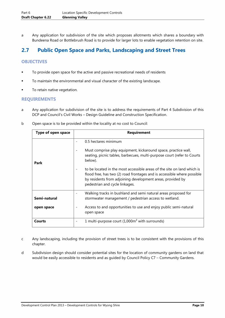
b Open space is to be provided within the locality at no cost to Council:
Type of open space Requirement
Park
- 0.5 hectares minimum
- Must comprise play equipment, kickaround space, practice wall,
seating, picnic tables, barbecues, multi-purpose court (refer to Courts
below).
- to be located in the most accessible areas of the site on land which is
flood free, has two (2) road frontages and is accessible where possible
by residents from adjoining development areas, provided by
pedestrian and cycle linkages.
Semi-natural
open space
- Walking tracks in bushland and semi natural areas proposed for
stormwater management / pedestrian access to wetland.
- Access to and opportunities to use and enjoy public semi-natural
open space
Courts - 1 multi-purpose court (1,000m² with surrounds)
c Any landscaping, including the provision of street trees is to be consistent with the provisions of this
chapter.
d Subdivision design should consider potential sites for the location of community gardens on land that
would be easily accessible to residents and as guided by Council Policy C7 – Community Gardens.

Part 6 Location Specific Development Controls
Draft Chapter 6.22 Glenning Valley
Development Control Plan 2013 – Development Controls for Wyong Shire Page 11
2.8 Noise
OBJECTIVE
To ensure future residents are protected from noise emanating from the Blade Close/Enterprise Drive
Industrial area.
REQUIREMENTS
a Applications for subdivision are to be supported by a satisfactory noise study and report prepared by a
suitably qualified and experienced acoustic consultant.
b The report is to identify any necessary acoustic control measures to be incorporated into the design of
future development to achieve the noise levels that do not compromise the integrity of the overall
development design or the landscape values of the land to which this plan applies.
2.9 Contamination
OBJECTIVE
To ensure that land proposed for development does not prevent a risk to future occupants and is of a
suitable quality for the intended purposed.
REQUIREMENTS
a Any application for the subdivision of Lot 22 DP 740435, Lot 1112 DP 1143167, Lot 52 DP 1039187, Lot
1111 DP 1143167, Lot 21 DP 740435, Lot 455 DP 786675, Lot 513 DP 500951, Lot 4 DP 1078468 and
Lot 511 DP 205919 is to be accompanied by a preliminary Phase 1 Contamination report prepared by a
suitably qualified consultant.
b The report is to be consistent with the requirements of the Managing Land Contamination planning
guidelines, 1998 (as updated) prepared by the (then) Department of Urban Affairs and Planning.
Note: This is supplementary information provided for applicants and landowners. All development proposals
must consider all relevant Council and State Government Policy including SEPP 55- Remediation of Land and
Council Policy P1- Potentially Contaminated Land.
2.10 Residential Development
OBJECTIVES
a To ensure that development applications for development in low density residential areas are
consistent with the relevant plans and polices of Council and are fit for use and encourage
neighbourhood communities.
b To ensure that consideration of the current and future character of the area is adequately considered
in the assessment of Development Applications

Part 6 Location Specific Development Controls
Draft Chapter 6.22 Glenning Valley
Development Control Plan 2013 – Development Controls for Wyong Shire Page 12
REQUIREMENTS
a Development Applications for detached dwellings houses are to adopt the provisions of DCP 2013
Chapter 2.1 –Housing and Ancillary Structures.
b Development Applications for dual occupancy development are to adopt the provisions of DCP 2013
Chapter 2.3 – Dual Occupancy Development.
c Small Lot Development - Development Applications proposing to use the provisions for variation to
minimum lot size requirements for the R2 Zone under WLEP 2013 for development other than dual
occupancy development are to adopt the provisions for Small Lot Housing Development as referred to
under DCP 2013 Part 4 – Subdivision.
Note: Small Lot Housing consists of a minimum of 5 or more development lots
2.11 Aboriginal Heritage
OBJECTIVES
To provide proponents with information that can be used to supplement the requirement to consider
Indigenous Heritage in preparing a development application.
REQUIREMENTS
a Any application for the subdivision must include the results of a review of the Aboriginal Heritage
Information Management System (AHIMS) to identify any known Aboriginal Sites that may by
impacted by the development proposal.
b No development is to be undertaken or approved in the vicinity of identified sites before a Cultural
Heritage Management Plan has been prepared by a suitably qualified person.
Note: Consultation of the AHIMS does not assume other cultural or archaeological evidence does not occur
within the Study area and does not relieve the applicant of the need to undertake appropriate additional
investigations and studies where required.