Embed Size (px)
Citation preview

ESS5Prof. Jin-Yi Yu
Chapter 6: Cloud Development and FormsChapter 6: Cloud Development and Forms
Why Clouds FormStatic StabilityCloud Types
(from “The Blue Planet”)

ESS5Prof. Jin-Yi Yu
Why Clouds Form?Why Clouds Form?
Clouds form when air rises and becomes saturated in response to adiabatic cooling.

ESS5Prof. Jin-Yi Yu
Four Ways to Lift Air UpwardFour Ways to Lift Air Upward
(1) LocalizedConvection
(2) ConvergenceLifting
(3) OrographicLifting
(4) Frontal Lifting
warm front
cold front
(from “The Blue Planet”)

ESS5Prof. Jin-Yi Yu
Orographic Orographic LiftingLifting

ESS5Prof. Jin-Yi Yu
When boundaries between air of unlike temperatures (fronts) migrate, warmer air is pushed aloft.This results in adiabatic cooling and cloud formation.Cold fronts occur when warm air is displaced by cooler air.Warm fronts occur when warm air rises over and displaces cold air.
Frontal LiftingFrontal Lifting

ESS5Prof. Jin-Yi Yu
Involve the direct addition or removal of heat energy.Example: Air passing over a cool surface loses energy through conduction.
DiabaticDiabatic ProcessProcess

ESS5Prof. Jin-Yi Yu
Adiabatic ProcessAdiabatic Process
If a material changes its state (pressure, volume, or temperature) without any heat being added to it or withdrawn from it, the change is said to be adiabatic.
The adiabatic process often occurs when air rises or descends and is an important process in the atmosphere.

ESS5Prof. Jin-Yi Yu
Air Parcel Expands As It RisesAir Parcel Expands As It Rises……
Air pressure decreases with elevation.
If a helium balloon 1 m in diameter is released at sea level, it expands as it floats upward because of the pressure decrease. The balloon would be 6.7 m in diameter as a height of 40 km.
(from The Blue Planet)

ESS5Prof. Jin-Yi Yu
What Happens to the Temperature?What Happens to the Temperature?Air molecules in the parcel (or the balloon) have to use their
kinetic energy to expand the parcel/balloon.
Therefore, the molecules lost energy and slow down their motionsThe temperature of the air parcel (or balloon) decreases with
elevation. The lost energy is used to increase the potential energy of air molecular.
Similarly when the air parcel descends, the potential energy of air molecular is converted back to kinetic energy.
Air temperature rises.

ESS5Prof. Jin-Yi Yu
Dry Adiabatic Lapse RateDry Adiabatic Lapse Rate
(from Meteorology: Understanding the Atmosphere)

ESS5Prof. Jin-Yi Yu
Dry Adiabatic Lapse RateDry Adiabatic Lapse Rate

ESS5Prof. Jin-Yi Yu
Moist Adiabatic Lapse RateMoist Adiabatic Lapse Rate
(from Meteorology: Understanding the Atmosphere)

ESS5Prof. Jin-Yi Yu
Environmental Lapse RateEnvironmental Lapse Rate
The environmental lapse rate is referred to as the rate at which the air temperature surrounding us would be changed if we were to climb upward into the atmosphere.
This rate varies from time to time and from place to place.

ESS5Prof. Jin-Yi Yu
Environmental Lapse RateEnvironmental Lapse RateThe environmental (or ambient) lapse rate is referred to the vertical change in temperature through still air.
The environmental lapse rate is not fixed. It changes from day to day and from place to place.
environmental lapse rate =0.5°C/100m
(from Understanding Weather & Climate)

ESS5Prof. Jin-Yi Yu
Static Stability of the AtmosphereStatic Stability of the Atmosphere
Γe = environmental lapse rateΓd = dry adiabatic lapse rate Γm = moist adiabatic lapse rate
Absolutely StableΓe < Γm
Absolutely UnstableΓe > Γd
Conditionally UnstableΓm < Γe < Γd
(from Meteorology Today)

ESS5Prof. Jin-Yi Yu
Absolutely Stable AtmosphereAbsolutely Stable Atmosphere
(from Meteorology Today)

ESS5Prof. Jin-Yi Yu
Absolutely Unstable AtmosphereAbsolutely Unstable Atmosphere
(from Meteorology Today)

ESS5Prof. Jin-Yi Yu
Conditionally Unstable AtmosphereConditionally Unstable Atmosphere
(from Meteorology Today)

ESS5Prof. Jin-Yi Yu
During the day, surface insolation gains result in greater heating near the surface than aloft.At night, the situation reverses as terrestrial radiation loss causes near surface chilling a temperature inversion.
DaytimeDaytime NighttimeNighttime
Heating/Cooling of Lower AtmosphereHeating/Cooling of Lower Atmosphere

ESS5Prof. Jin-Yi Yu
Cloud Type Based On PropertiesCloud Type Based On Properties
Four basic cloud categories:Cirrus --- thin, wispy cloud of ice.Stratus --- layered cloudCumulus --- clouds having vertical development.Nimbus --- rain-producing cloud
These basic cloud types can be combined to generate ten different cloud types, such as cirrostratus clouds that have the characteristics of cirrus clouds and stratus clouds.
ESS5Prof. Jin-Yi Yu
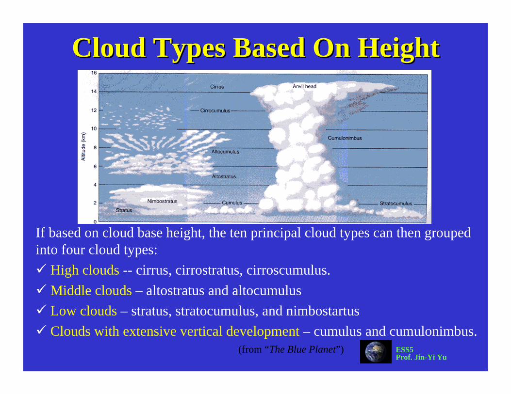
Cloud Types Based On HeightCloud Types Based On Height
If based on cloud base height, the ten principal cloud types can then grouped into four cloud types:
High clouds -- cirrus, cirrostratus, cirroscumulus.Middle clouds – altostratus and altocumulusLow clouds – stratus, stratocumulus, and nimbostartusClouds with extensive vertical development – cumulus and cumulonimbus.
(from “The Blue Planet”)

ESS5Prof. Jin-Yi Yu
Cloud ClassificationsCloud Classifications
(from “The Blue Planet”)

ESS5Prof. Jin-Yi Yu
Cloud TypesCloud Types

ESS5Prof. Jin-Yi Yu
High CloudsHigh Clouds
High clouds have low cloud temperature and low water content and consist most of ice crystal.
1. Cirrus Clouds
2. Cirrostratus Clouds
3. Cirrocumulus Clouds
(from Australian Weather Service)

ESS5Prof. Jin-Yi Yu
Middle CloudsMiddle Clouds
Middle clouds are usually composite of liquid droplets.They block more sunlight to the surface than the high clouds.
5. Altocumulus Clouds4. Altostratus Clouds
(from Australian Weather Service)

ESS5Prof. Jin-Yi Yu
Low CloudsLow Clouds
Low, thick, layered clouds with large horizontal extends, which can exceed that of several states.
6. Stratus Clouds
7. Stratocumulus Clouds
8. Nimbostratus Clouds
(from Australian Weather Service)

ESS5Prof. Jin-Yi Yu
Clouds With Vertical DevelopmentClouds With Vertical Development
They are clouds with substantial vertical development and occur when the air is absolute or conditionally unstable.
9. Cumulus Clouds 10. Cumulonimbus Clouds
(from Australian Weather Service)

ESS5Prof. Jin-Yi Yu
Clouds and FrontsClouds and Fronts
cold fr
ont
warm front
Mid-Latitude Cyclone
(From Weather & Climate)

ESS5Prof. Jin-Yi Yu
Polar Stratospheric Clouds Polar Stratospheric Clouds ((PSCsPSCs))
In winter the polar stratosphere is so cold (-80°C or below) that certain trace atmospheric constituents can condense.These clouds are called “polar stratospheric clouds” (PSCs).The particles that form typically consist of a mixture of water and nitric acid (HNO3).The PSCs alter the chemistry of the lower stratosphere in two ways:(1) by coupling between the odd nitrogen and chlorine cycles(2) by providing surfaces on which heterogeneous reactions can occur.
(Sweden, January 2000; from NASA website)

ESS5Prof. Jin-Yi Yu
Why No Ozone Hole in Artic?Why No Ozone Hole in Artic?
(from WMO Report 2003)

ESS5Prof. Jin-Yi Yu
The Polar VortexThe Polar VortexThe wintertime circulation over the South Pole is characterized by a gigantic whirlpool of cold and dense air, called the polar vortex.The cold and dense cold air in the middle of the vortex is subsiding.The sinking air
i l d

ESS5Prof. Jin-Yi Yu
Ozone DistributionOzone Distribution
The greatest production of ozone occurs in the tropics, where the solar UV flux is the highest.
However, the general circulation in the stratosphere transport ozone-rich air from the tropical upper stratosphere to mid-to-high latitudes.
(from The Earth System)
AntarcticOzone Hole

ESS5Prof. Jin-Yi Yu
Antarctic Ozone HoleAntarctic Ozone Hole
The decrease in ozone near the South Pole is most striking near the spring time (October).During the rest of the year, ozone levels have remained close to normal in the region.
(from The Earth System)
Mean Total Ozone Over Antarctic in October

ESS5Prof. Jin-Yi Yu
The 1997 Ozone HoleThe 1997 Ozone Hole