Embed Size (px)
Citation preview

Habitat Management Strategies and Prescriptions
Appendix B. Habitat Management Plan B-81
Chapter 5. Habitat Management Strategies and Prescriptions
5.1 Development of Management Strategies and PrescriptionsThis chapter identi ies management strategies and prescriptions to address the habitat management goals and objectives discussed in Chapter 4. Management strategies identify the tools and techniques (e.g., burning, mowing, water-level manipulation, chemical application, etc.) utilized to achieve the habitat objectives. Prescriptions provide the details behind the speci ic means by which the strategies will be implemented (e.g., timing, frequency, and location). A review of available literature related to potential strategies and prescriptions was incorporated during their development. The identi ied treatments were selected in consultation with other Refuge biologists, managers, and experts, to ensure their effectiveness. Many environmental factors including wildlife populations, weather, seasonal variations, and habitat conditions affect the selected prescriptions and their ability to achieve objectives from year to year. As such, many of prescription details will be identi ied in the Annual Habitat Work Plan. Prescriptions outlined herein are discussed on a conceptual level. General management prescriptions are also depicted in HMP Maps 8 – 12.
The natural world contains a myriad of extremely complex and dynamic systems. As land stewards and habitat managers, we can never completely understand every aspect of these continually changing systems, but must be ready to react to its ever-changing geophysical, ecological, social, and political factors that in luence status of biodiversity and its conservation. Despite the extensive planning efforts undertaken within this Habitat Management Plan, there will undoubtedly be additional need to address changes to physical, ecological, social, political, and inancial factors that in luence biodiversity and its conservation. Speci ic details concerning implementation of the inventory and monitoring prescriptions will be identi ied in the Inventory and Monitoring Plan. The management prescriptions outlined here represents a comprehensive effort to guide management primarily over the next ifteen years. However, it is impossible to predict the full suite of management strategies and prescriptions required over this period.
5.2 Habitat Management UnitsFor the purpose of meeting habitat management objectives, Prime Hook NWR is divided into four main Refuge Management Units. These Management Unit boundaries were delineated based on physical features, such as a road or large waterway, as well as refuge boundaries. Within these units, individual ields have been delineated through past management actions, and are numbered to correspond with
historical management references. See HMP Maps 3–7 for management unit boundaries and refuge ield numbers.
See HMP Chapter 2 Section 2.2 for a description of NVCS Natural and Anthropogenic Vegetative Community Types represented within each Refuge Management Unit (HMP Maps 2–7). Where appropriate, Natural Plant Communities have been summarized by Refuge Management Unit for each Objective in Section 5.3 below. In the case that desired future condition differs from the current condition within a Refuge Management Unit, additional tables are provided to identify ield and unit numbers and affected acres.
Prime Hook National Wildlife Refuge Comprehensive Conservation Plan
Habitat Management Strategies and Prescriptions
B-82
Map 8. Management Prescriptions - Units I & II
Habitat Management Strategies and Prescriptions
Appendix B. Habitat Management Plan B-83
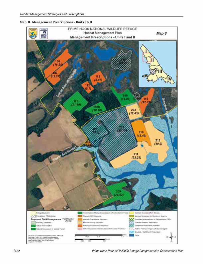
Map 9. Management Prescriptions - Units II & III

Prime Hook National Wildlife Refuge Comprehensive Conservation Plan
Habitat Management Strategies and Prescriptions
B-84
Map 10. Management Prescriptions - Unit III (West)
Habitat Management Strategies and Prescriptions
Appendix B. Habitat Management Plan B-85
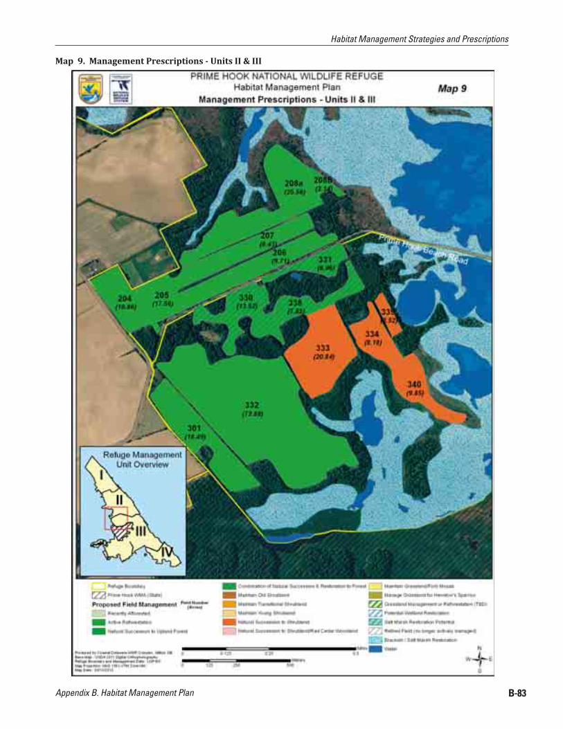
Map 11. Management Prescriptions - Unit III (HQ Area)

Prime Hook National Wildlife Refuge Comprehensive Conservation Plan
Habitat Management Strategies and Prescriptions
B-86
Map 12. Management Prescriptions - Unit IV

Habitat Management Strategies and Prescriptions
Appendix B. Habitat Management Plan B-87
5.3 Management Strategies and Prescriptions by Habitat Objective
Objec tive 1.1 (Overwash, Sandy Beach and Mud lat Habitats)
Table 14. Objective 1.1 Natural Community Types and Acres by Refuge Management Unit
NVCS - Natural Community Unit # Acres
Beachgrass/Panicgrass Dune Grassland
I 12.5II 22.6III 0.0IV 0.0
Overwash Dune
I 5.1II 4.2III 0.2IV 0.0
Total Acres: 44.6
Management Strategies and Prescriptions ● Allow the natural processes of inlet formation, sand migration, and/or overwash development; ● Avoid arti icial dune stabilization to occur where tidal low from the Delaware Bay is naturally
restoring salt marsh habitats; ● Develop a site-speci ic restoration plan for Unit II, with the input of an advisory team of subject
matter experts, which will include recommendations for short-term and long-term shoreline management which will maximize the success of salt marsh restoration efforts (See Objective 3.1);
● Control invasive plant species (mostly Phragmites australis and Salsola kali); ● Seasonally protect beach berm, wrack-line, and associated dune edge, and overwash from human
disturbance and predators to protect listed breeding and migrating shorebirds, establishing and enforcing nesting area closures from March 1st to September 1st;
● Develop a Refuge-speci ic piping-plover contingency management plan should piping plovers establish nesting sites on Refuge over-wash areas;
● Consider the use of enclosures to protect state and federally listed shorebird species that establish nest sites on barrier beach island habitats; and,
● Determine the potential number of nesting pairs of American oystercatcher, piping plover and other focal species that could be supported by available overwash, sandy beach, and dune grassland habitats by 2012, to ine-tune protection prescriptions.
Monitoring ElementsConduct appropriate monitoring and survey programs as funding and staf ing permits to measure our success with respect to our objectives. The results may trigger adjustments to management strategies, or a reevaluation or a re inement of our objectives. Examples of monitoring or surveys that we may implement include:
● To determine number of nesting pairs of American oystercatcher, least and common terns, and piping plover and estimate productivity, conduct annual surveys during the breeding and nesting season;

Prime Hook National Wildlife Refuge Comprehensive Conservation Plan
Habitat Management Strategies and Prescriptions
B-88
● Prevent new invasive species from becoming established by utilizing Early Detection Rapid Response Techniques that detect newly established invasive species and immediately addresses those populations through the appropriate control measure. This approach will incorporate a combination of plant identi ication and inventories, maintaining updates of new invasive species present in the region, as well as having knowledge of the appropriate management techniques prior to conducting control efforts; and,
● Establish annual habitat assessment protocols of overwash areas and mini-inlet openings and closures along Unit I and Unit II strand beach habitats to monitor expansion and contraction of overwash acreages, creation and plugging of mini-inlets, and tidal low changes feeding Unit I salt marshes and Unit II impounded wetlands using GPS/GIS tools;
● Conduct shoreline position and topography monitoring along the full length of refuge coastline, consistent with National Park Service (NPS) protocols and in coordination with other Northeast refuges.
● Conduct surveys to determine presence/absence of Northeastern beach tiger beetles to assess the health of overwash, dune grassland, and sandy beach habitat;
● Develop and implement weekly bird use censusing protocols. Utilize data to document the on-going effectiveness of water level management activities and adjust management protocols as necessary;
● Monitor habitat impacts from public use and impacts to resources of concern during the spring and summer periods;
● To maintain suitable nesting habitat for beach nesting shorebirds, monitor presence of red fox, raccoon, feral cats, and other predators and implement predator removal measures in collaboration with USDA Wildlife Services;
● Work collaboratively with DNREC Coastal Programs to set up physical markers on the ground to establish baseline of overwash formations, sea level rise changes, and changes in tidal low patterns;
● Re-survey and calibrate all refuge water control structures to re lect the true local mean sea level of refuge marshes and water in lows and outlets;
● Reset all gauges to one common vertical datum; and, ● Establish several tides gauges, starting with locations in Slaughter canal in Unit I and Broadkill
River in Unit IV.
Climate Change and Sea Level Rise Adaptation Strategies and Monitoring: ● Train USFWS staff to conduct shoreline survey data as per National Park Service (NPS) protocols
for Northeast Coastal and Barrier Network (NCBN)-Geomorphological Monitoring Protocol for shoreline position (Natural Resource Report (NPS-NCBN-NRR-2010/185). Protocols include a number of highly detailed SOPS that are intended to ensure scienti ic consistency and repeatability; Conduct these surveys in early spring (mid-March to late April) and early fall (mid-September to late October) – a period that coincides with the peak expression of seasonal beach variability.
● Co-ordinate Refuge shoreline monitoring efforts with other R5 Coastal refuges to integrate NCBN database to foster DOI-wide sharing of standardized monitoring data. NPS Vital Signs Program-“Shoreline Position Monitoring Protocol” is the irst of a series protocols being developed by NCBN; Upcoming protocols, such as documenting and monitoring shoreline topography, will be implemented as they are developed by the NPS.
● Staff will seek training and annual refreshers as needed to maintain competency in: Basic Coastal Geomorphology Mission Planning (Seasonal timing/tides/storms/survey windows using long-term
identi ication of neap tide conditions using NOAA tide gauge data)

Habitat Management Strategies and Prescriptions
Appendix B. Habitat Management Plan B-89
Conducting survey, dealing with shoreline perturbations, collecting benchmarks, preparation of equipment, and keeping informed of protocols and SOP changes and improvements
Post-survey Processing of spatial data Update knowledge of improved and new sampling protocols and SOPs
Objective 1.2 Maritime Shrub and Maritime Forested Habitats
Table 15. Objective 1.2 Natural Community Types and Acres by Refuge Management Unit
NVCS - Natural Community Unit # Acres
Atlantic Coast Interdune Swale
I 0.3II 20.1III 15.8IV 30.5
Maritime Red Cedar WoodlandII 1.9III 7.8IV 66.2
Successional Maritime ForestII 71.3III 90.6IV 22.0
Interdunal Switchgrass Brackish DepressionIII 0.7IV 5.7
Mid-Atlantic Maritime Salt Shrub
I 10.8II 7.2III 1.5IV 40.4
Total Acres: 392.8
Table 16. Objective 1.2 Desired Future Condition/Prescription by Refuge Management Unit and Field Number
Habitat Management Prescriptions for all Units (HMP Map 12)
Desired Future Condition Unit #
Field Number
Current Condition Size (acres)
Natural Succession to Shrubland/Red Cedar Woodland
IV408 Interdunal Switchgrass Brackish
Depression6.0
411 Northeastern Successional Shrubland 12.0Total Acres: 18.0
Management Strategies and Prescriptions ● Maintain and/or enhance native vegetation communities using prescribed ire where appropriate;
consult with Service Region 5 ire ecologist to determine, if, when, and where prescribed ire would be appropriate to reduce invasive species, or maintain shrub habitats, or maintain or enhance successional maritime forest community health.

Prime Hook National Wildlife Refuge Comprehensive Conservation Plan
Habitat Management Strategies and Prescriptions
B-90
● Prevent new invasive species from becoming established by utilizing Early Detection Rapid Response Techniques that detect newly established invasive species and immediately addresses those populations through the appropriate control measure;
● Permit natural succession to shrubland/red cedar woodland in prescribed ields (Table 16); ● Eliminate the use of mosquito adulticides over these habitats with the exception of a documented
public health emergency, to reduce negative impacts on non-target invertebrates;
Monitoring ElementsConduct appropriate monitoring and survey programs as funding and staf ing permits to measure our success with respect to our objectives. The results may trigger adjustments to management strategies, or a reevaluations or a re inement of our objectives. Examples of monitoring or surveys that we may implement include:
● Re-evaluate Refuge breeding bird survey points to determine whether they are placed appropriately to monitor birds of conservation concern identi ied in DWAP, BCR 30, and PIF 44 plans, and establish spring, fall, and breeding landbird survey points in these habitats types, where needed;
● Monitor the little wife underwing moth as an indicator of healthy Red Cedar Woodland and Successional Maritime Forested habitats that contain southern bayberry as a vegetative component;
● Conduct annual habitat condition assessments, survey for invasive species problems, and prioritize treatment areas;
● To evaluate achievement of the objective for breeding and migrating birds conduct bird surveys for priority species. Utilize data to document the effectiveness of management activities and adjust management protocols as necessary;
● Prevent new invasive species from becoming established by utilizing Early Detection Rapid Response Techniques that detect newly established invasive species and immediately addresses those populations through the appropriate control measure. This will incorporate a combination of plant identi ication and inventories, maintaining updates of new invasive species present in the region, as well as having knowledge of the appropriate management techniques prior to conducting control efforts;
● Evaluate bird use by conducting point count surveys during spring and fall migration and breeding periods in these habitat types;
● To evaluate the effectiveness of prescribed burning to reduce invasive species or maintain shrub habitats conduct post-burn surveys to measure the area, the intensity, and the success of the burn.
Objective 1.3 (North Atlantic Low and High Salt Marsh Habitats)
Table 17. Objective 1.3 Natural Community Types and Acres by Refuge Management Unit
NVCS - Natural Community Unit # Acres
Spartina High Salt MarshI 75.2IV 7.8
Spartina Low Salt MarshI 982.0IV 774.8
Brackish Tidal Creek Shrubland
I 73.9II 3.3III 1.3IV 17.7
Total Acres: 1,936.0
Habitat Management Strategies and Prescriptions
Appendix B. Habitat Management Plan B-91
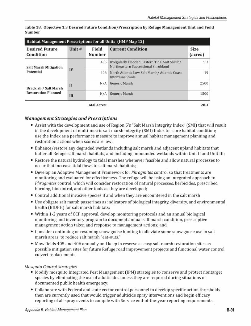
Table 18. Objective 1.3 Desired Future Condition/Prescription by Refuge Management Unit and Field Number
Habitat Management Prescriptions for all Units (HMP Map 12)
Desired Future Condition
Unit # Field Number
Current Condition Size (acres)
Salt Marsh Mitigation Potential IV
405 Irregularly Flooded Eastern Tidal Salt Shrub/ Northeastern Successional Shrubland
9.3
406 North Atlantic Low Salt Marsh/ Atlantic Coast Interdune Swale
19
Brackish / Salt Marsh Restoration Planned
II N/A Generic Marsh 2500
III N/A Generic Marsh 1500
Total Acres: 28.3
Management Strategies and Prescriptions ● Assist with the development and use of Region 5’s “Salt Marsh Integrity Index” (SMI) that will result
in the development of multi-metric salt marsh integrity (SMI) Index to score habitat condition; use the Index as a performance measure to improve annual habitat management planning and restoration actions when scores are low;
● Enhance/restore any degraded wetlands including salt marsh and adjacent upland habitats that buffer all Refuge salt marsh habitats, and including impounded wetlands within Unit II and Unit III;
● Restore the natural hydrology to tidal marshes whenever feasible and allow natural processes to occur that increase tidal lows to salt marsh habitats;
● Develop an Adaptive Management Framework for Phragmites control so that treatments are monitoring and evaluated for effectiveness. The refuge will be using an integrated approach to Phragmites control, which will consider restoration of natural processes, herbicides, prescribed burning, biocontrol, and other tools as they are developed;
● Control additional invasive species if and when they are encountered in the salt marsh ● Use obligate salt marsh passerines as indicators of biological integrity, diversity, and environmental
health (BIDEH) for salt marsh habitats; ● Within 1-2 years of CCP approval, develop monitoring protocols and an annual biological
monitoring and inventory program to document annual salt marsh condition, prescriptive management action taken and response to management actions; and,
● Consider continuing or resuming snow goose hunting to alleviate some snow goose use in salt marsh areas, to reduce salt marsh “eat-outs.”
● Mow ields 405 and 406 annually and keep in reserve as easy salt marsh restoration sites as possible mitigation sites for future Refuge road improvement projects and functional water control culvert replacements
Mosquito Control Strategies ● Modify mosquito Integrated Pest Management (IPM) strategies to conserve and protect nontarget
species by eliminating the use of adulticides unless they are required during situations of documented public health emergency;
● Collaborate with Federal and state vector control personnel to develop speci ic action thresholds then are currently used that would trigger adulticide spray interventions and begin ef icacy reporting of all spray events to compile with Service end-of-the-year reporting requirements;

Prime Hook National Wildlife Refuge Comprehensive Conservation Plan
Habitat Management Strategies and Prescriptions
B-92
● Prepare a Refuge Mosquito Management Plan in collaboration with the state to address human and wildlife health risks to mosquito-borne diseases and use action thresholds that trigger chemical interventions to be incorporated in a refuge decision-making response matrix;
● Allow populations of native mosquito species to exist unimpeded unless they pose a speci ically identi ied threat to wildlife, domestic animals, and/or human health risks supported by documented data;
● Per Mosquito Management Plan thresholds, permit limited use of larvicides in OMWM systems if appropriate data supports the assertion that the OMWM system has failed to function properly and thus is ineffective for controlling mosquitoes;
● OMWM excavation will be limited to the maintenance of currently existing OMWM systems; OMWM projects may not be expanded nor any new projects initiated on Refuge lands until marsh elevation data is collected and analyzed. Additional studies that address effects on obligate saltmarsh passerines may be required before any decision will be made to resume construction of new OMWM treatments in previously grid ditched marshes.
● Educate refuge users and other public audiences about avian diversity and how it can help buffer human populations from mosquito borne and other diseases like Lyme’s disease
Monitoring ElementsConduct appropriate monitoring and survey programs as funding and staf ing permits to measure our success with respect to our objectives. The results may trigger adjustments to management strategies, or a reevaluations or a re inement of our objectives. Examples of monitoring or surveys that we may implement include:
● Develop a salt marsh monitoring program which incorporates the R5 Salt Marsh Integrity (SMI) Index, in accordance with guidance still in development;
● Develop monitoring protocols and an annual biological monitoring and inventory program to document annual salt marsh condition, prescriptive management action taken and response to management actions;
● Prevent new invasive species from becoming established by utilizing Early Detection Rapid Response Techniques that detect newly established invasive species and immediately addresses those populations through the appropriate control measure. This approach will incorporate a combination of plant identi ication and inventories, maintaining updates of new invasive species present in the region, as well as having knowledge of the appropriate management techniques prior to conducting control efforts;
● Continue research using open marsh water management (OMWM) scoring data collected speci ic to PHNWR salt marsh habitat conditions and incorporate in SMI Index assessments;
● Develop habitat monitoring protocols in cooperation with other R5 refuges to quantify impacts (both positive and negative) of snow goose herbivory, like shorebird and waterfowl use of eat-outs, increases/decrease of moist-soil invertebrate production, loss of low marsh acreage, and quantify wintering carrying capacity of Refuge habitats;
● To evaluate achievement of the objective for obligate salt marsh passerines, conduct bird surveys during the breeding season. Utilize data to document the effectiveness of management activities and adjust management protocols as necessary;
● Develop appropriate monitoring elements for mosquito control, in cooperation with DNREC Mosquito Control Section
Climate Change and Sea Level Rise Adaptation Strategies and Monitoring: ● Within 1 to 2 years, establish a Refuge-wide marsh elevation and water monitoring program, to
include the following components and steps:

Habitat Management Strategies and Prescriptions
Appendix B. Habitat Management Plan B-93
Establish 3 monitoring stations within each of two existing salt marsh areas (and an additional 3 stations in each area of impounded wetlands), with surface elevation tables (SETS) and marker horizons, in the same locations of 210Pb and 137Cs radiometric cores currently being monitored on the Refuge; Read SET measurements minimally four times per year (seasonally), but ideally once per month, to track seasonal and periodic storm effects on marsh elevation
Establish a real-time USGS-type tide gauge on Slaughter Canal to begin to monitor localized storm effects on refuge
Establish geodetic benchmarks in select upland refuge sites and calibrate to newly established SETS, tide gauges(s), and staff gauges located on water control structures, all to the same geodetic control (such as NAVD 88)
Conduct RTK-GPS surveys using regional/national protocols to connect prior survey-data points (veg data, groundwater wells, bird points, etc) to same common geodetic control as used above
After a minimum of 3 years, determine if areas of the marsh with SETS are experiencing shallow subsidence – i.e. is the upper marsh horizon, despite accretionary processes, still losing elevation relative to local Sea Level Rise?
● The stresses imposed by climate change and SLR will force a shift in quantity and quality of available waterbird habitat on local and regional scales. As a means to ameliorate the loss, the refuge will employ the protocols and directives of the Integrated Waterbird Management and Monitoring Project, now under development.
● Permit the natural replenishment of sediments (through overwash) to allow the Unit I marsh to keep pace with sea level rise.
● As new research and monitoring results on sea level rise and obligate salt marsh breeding birds come to light, we may in fact wish to ill/restore extant grid ditches and OMWM systems as an adaptation measure in response to climate change.
● Consult with federal and state coastal scientists and other subject matter experts regarding the most effective way to restore salt marsh within the Unit II (and possibly Unit III) wetland impoundments; Restoration options may include addition of supplemental sediment, use of wave attenuating devices or restoration techniques, planting of desirable species, or a host of other strategies. (See Objective 3.1)
Objective 2.1 (Mixed Hardwood Forest Communities)
Table 19. Objective 2.1 Natural Community Types and Acres by Refuge Management Unit
NVCS - Natural Community Unit # AcresSouthern Red Oak Heath III 289.1
Mesic Coastal Plain Oak ForestI 49.6II 99III 43.8
Mid-Atlantic Coastal Loblolly PineIII 41.5IV 9.7
Successional Sweetgum ForestI 31.2II 9.4III 88
Mesic Coastal Plain Mixed Hardwood Forest III 19.2

Prime Hook National Wildlife Refuge Comprehensive Conservation Plan
Habitat Management Strategies and Prescriptions
B-94
NVCS - Natural Community Unit # AcresLoblolly Pine-Sweetgum Semi-Natural Forest III 39Loblolly Pine Plantation III 10.6Pond Pine Woodland III 7.2
Mesic Rich ForestI 10.6III 24.5
Total Acres: 772.4
Management Strategies and Prescriptions ● Manage refuge forest stands to meet the habitat requirements of Delmarva fox squirrels which are
similar enough to also meet habitat requirements of priority forest interior dwelling birds listed as focal forest bird species; Criteria described in Table 20.
● During forest inventories, conduct assessment of potential for each stand to harbor gypsy moth and southern pine beetle using a high, moderate, or low disease hazard rating; assessment should be correlated to habitat suitability for DFS (good, fair, poor);
● Maintain and/or enhance forest health through the development of monitoring protocols for insect/disease vectors
● Treating detected insect or disease infestations may include salvage cuts, thinning, and other mechanical techniques, prescribed ire, and insecticides (e.g., Bacillus thuringiensis var. kurstaki (Btk) or Gypcheck for gypsy moths);
● Participate with other refuges in developing Forest Integrity Index ● Use prescribed ire where appropriate to maintain and enhance habitat structural requirements for
the DFS and migratory birds; ● Increase and/or improve active forest management to enhance habitat quality for targeted
songbirds through sound silvicultural practices such as thinning, selective cuts, and other stand improvement techniques; These stand improvement techniques will occur in small patches less than 5 acres (2 ha);
● Minimize forest fragmentation; in all stand improvement activities avoid fragmenting larger forest patches when possible;
● Regeneration cuts should be designed in a pattern that minimizes edge; circular or square cuts have the least amount of edge produced;
● Leave uncut forested buffers along creeks, ditches, streams, and adjacent to wetlands habitats; the wider the buffer, the more bene it it will provide to forest interior birds.
● Utilize triggers outlined in Table 20 as thresholds for stand improvement interventions to maintain and enhance wildlife habitat needs for priority focal management species;
● Manage bald eagle nest sites in accordance with State and National Bald Eagle Guidelines (USFWS 2007c), utilizing forest management techniques and/or prescribed ire, and observing recommended time-of-year restrictions and buffer zone guidelines;
● Promote consistent annual mast production by using selection cuts where hard mast trees are greater than 15”dbh to develop larger, well-formed crowns and with a species composition target of 1/3 white oak, 2/3 red oak, and a mixture of hickory and walnut trees (McShea and Healy 2002);
● Den trees and trees adjacent to den trees will not be cut during silvicultural treatments. Adjacent trees provide shade the bole of the den tree, keeping it cooler;
● To promote establishment of den sites, trees interfering with mast tree crown development will be left standing and killed by girdling or using systemic herbicides (BNWR 1994);

Habitat Management Strategies and Prescriptions
Appendix B. Habitat Management Plan B-95
● Explore opportunities to supplement the refuge DFS population through translocations; and, ● Field management prescriptions outlined in Table 21, and depicted in HMP Maps 8–11, will add to
existing forested communities, and then be managed according to this objective.
Guidelines listed below for desired future forest stand condition(s), suggest that to provide for regeneration of shade intolerant trees, one to three acre patches should be harvested on ive to ten percent of the stands. Leaving 4 to 6 trees per acre within these small regeneration cuts will maintain some overstory and use of these harvested sites by forest birds will be more likely. Additionally, some of these “seed trees” may develop into super-canopy trees (de ined as large trees > 35 inches dbh with big crowns above the plane of the forest canopy). Patches should be located where regeneration of shade intolerant tree species is present or highly likely. As a general guideline between 30 to 60 percent, preferably 40 to 50 percent, of most stands should be hard mast producing tree species.
Table 20. Objective 2.1 Mixed Hardwood Forest Community Maintenance and Enhancement Prescriptions
Objective 2.1 - Mixed Hardwood Forest Community Maintenance and Enhancement PrescriptionsTarget Forest Conditions Condition to Trigger Mgmt Action>80% canopy cover in the stand < 80% canopy cover in the standBasal area 70 to 90 ft2 / acre (16 to 20 m2/ha) Basal areas > 100 ft2/acres (> 28 m2 / ha)60% to 80% stocking > 100% stockingVines in overstory on 40%-60% of inventory (cruise) plots
Vines in overstory on < 30% of inventory (cruise) plots
“Super-canopy” trees on 10% to 20% of inventory (cruise) plots [= 4 to 6 super-canopy trees per acre]
“Super-canopy” trees < 5% of inventory (cruise) plots
Mid-story canopy cover on 30% to 60% of stand Mid-story canopy on < 20% of standVines in midstory on 50% to 70% of inventory (cruise) plots
Vines in midstory < 30% plots
Understory canopy cover less 30% Understory canopy cover > 30% of stand<30% ground cover occupancy average across inventory (cruise) plots
>30% ground cover occupancy average across inventory (cruise) plots
Regeneration of hard mast tree species (oaks and hickories) on 30% to 50% inventory (cruise) plots
Regeneration of hard mast tree species (oaks and hickories) on < 20% of inventory (cruise) plots
2 to 4 logs/acres that provide coarse woody debris
< 2 logs/acres providing coarse woody debris
4 to 6 cavity trees (snags) > 4 inches dbh/acres < 4 cavity trees (snags) > 4 inch dbh/acres1 to 4 large “den” trees or “unsound cull” trees per 10 acres
< 1 large “den” tree or “unsound cull” tree per 10 acres
We expect that many stands have current conditions or site capabilities that may warrant more restrictive forest management options, or multiple management actions, to achieve desired forest conditions. We recognize that there is no single recipe for achieving desired results. Focal species priorities and forest management objectives are going to require evaluation on a site by site basis that involve the skill of foresters and biologists working together to establish site-speci ic objectives, evaluate current stand conditions, write site-speci ic prescriptions, monitor pre and post habitat conditions and respective wildlife use of treatment sites, and evaluate results.

Prime Hook National Wildlife Refuge Comprehensive Conservation Plan
Habitat Management Strategies and Prescriptions
B-96
Monitoring ElementsConduct appropriate monitoring and survey programs as funding and staf ing permits to measure our success with respect to our objectives. The results may trigger adjustments to management strategies, or a reevaluation or a re inement of our objectives. Examples of monitoring or surveys that we may implement include:
● Prevent new invasive species from becoming established by utilizing Early Detection Rapid Response Techniques that detect newly established invasive species and immediately addresses those populations through the appropriate control measure. This approach will incorporate a combination of plant identi ication and inventories, maintaining updates of new invasive species present in the region, as well as having knowledge of the appropriate management techniques prior to conducting control efforts;
● Establish forest inventory schedules on PHNWR to document stand speci ic information of tree species composition, health of crown overstory trees, regeneration in stands, presence/absence of exotic insects at damaging levels, stocking levels, and map invasive plants to guide future Refuge forest habitat maintenance, management, and reforestation decisions;
● Improve point-count monitoring surveys for listed forest communities in Objective 2.1; include the monitoring of annual habitat condition and characteristics with associated points to assess bird use; monitoring should capture both breeding and migrating forest bird species;
● Monitor changing bald eagle nesting sites and make public use modi ications or other habitat management actions necessary to protect sites during critical nesting periods;
● Use the presence of the long-horned beetle as an indicator species for patch size and environmental health of mature forest stands dominated by oaks; this beetle requires healthy, oak dominated mix-hardwood patch sizes of greater than 250 acres
● Coordinate with the Chesapeake Bay Field Of ice (CBFO) to implement improved Delmarva Fox Squirrel monitoring techniques, such as motion-activated cameras, as well as trapping and/or nest box checks, as recommended.
Climate Change and Sea Level Rise Adaptation Strategies and Monitoring: ● Reduce the impacts of stresses that can exacerbate the effects of climate change, particularly from
wildland ire, insects, and diseases. ● Step up measures to prevent and control the spread of invasive species. ● Prevent or reduce barriers to species migration, such as forest fragmentation. ● Improve forest health monitoring for early detection of climate change impacts. ● Help forests regenerate after disturbances, e.g. through reforestation. ● Support research to better understand forest vulnerability to multiple stressors and to ind ways to
enhance forest resilience. ● Within one year of CCP completion, conduct a complete forest inventory of forest lands and repeat
the monitoring every 10-15 years. ● Consider establishing a continuous forest inventory monitoring system

Habitat Management Strategies and Prescriptions
Appendix B. Habitat Management Plan B-97
Objective 2.2 (Mixed Hardwood Forest Restoration)
Table 21. Objective 2.2 Desired Future Condition/Prescription by Refuge Management Unit and Field Number
Habitat Management Prescriptions for all Units (HMP Maps 8-11)
Desired Future Condition
Unit # Field Number
Current Condition Size (acres)
Active Reforestation
II
204 Agricultural Field 10.8205 Agricultural Field 17.6206 Agricultural Field 9.7207 Agricultural Field 8.4
208a Agricultural Field 25.6208b Northeastern Successional Shrubland 2.1
III
301 Agricultural Field 18.5332 Agricultural Field 72.9351 Agricultural Field 24.2353 Agricultural Field 13.6354 Agricultural Field 8.5356 Agricultural Field 27.4357 Agricultural Field 60
Natural Succession to Upland Forest
I109 Brackish Tidal Creek Shrubland / North
Atlantic Low Salt Marsh12
III
302 –Lead Shot Site
Successional Sweetgum Forest 12.5
303 Successional Sweetgum Forest 0.8304 Successional Sweetgum Forest 6305 Successional Sweetgum Forest 1.9306 Successional Sweetgum Forest 2307 Successional Sweetgum Forest 11.9315 Successional Sweetgum Forest 1.4317 Successional Sweetgum Forest 5.2318 Agricultural Field 20.4321 Agricultural Field 45.2324 Northeastern Successional Shrubland 4
325 Northeastern Successional Shrubland 3.1
327a Successional Sweetgum Forest 11.8356a Agricultural Field 8.3

Prime Hook National Wildlife Refuge Comprehensive Conservation Plan
Habitat Management Strategies and Prescriptions
B-98
Habitat Management Prescriptions for all Units (HMP Maps 8-11)
Natural Succession or Reforestation (TBD) to Upland Forest
I
108b Agricultural Field 10.2111 Agricultural Field/ Northeastern
Successional Shrubland/ Irregularly Flooded Eastern Tidal Salt Shrub/ Successional Sweetgum Forest
21.7
II 209 Agricultural Field/ Northeastern Successional Shrubland
24
III
330 Agricultural Field 13.5331 Agricultural Field 6.1338 Agricultural Field 7.8
Total Acres: 529.1
Management Strategies and Prescriptions ● Reduce fragmentation of Refuge forested habitats through reforestation projects to improve
management of area-sensitive wildlife, especially endangered DFS and breeding songbirds listed as Refuge Priority Resources of Concern in Appendix E of the CCP - Table 6;
● Use Population Viability Analysis (PVA) modeling data to set Refuge DFS population objectives, re ine objectives as new data becomes available and to design core habitat patches for reforestation for the long term viability of Delmarva fox squirrels;
● Design reforestation projects to promote habitat connectivity on the Refuge and improve management of area-sensitive wildlife;
● Work with private landowners and partners to establish safe harbor agreements for DFS; ● Explore opportunities to supplement the refuge DFS population through translocations, as suitable
forest habitat is restored; ● Install speed bumps in refuge entrance road to reduce DFS road mortalities on refuge ● Implement ield restoration prescriptions outlined in Table 21 and depicted in HMP Maps 8–11;
Active reforestation will incorporate planting of seedlings and/or saplings, incorporating recommendations of experienced partners (e.g., USFWS Delaware Bay Coastal Program staff)
In the case of active reforestation, attempts will be made to reforest entire individual ields at one time, for ef iciency
Passive reforestation will involve permitting natural succession, which relies on neighboring seed sources, avian dispersal, etc.
In some ields, additional local analysis will dictate if active reforestation or natural succession is more appropriate
Monitoring ElementsConduct appropriate monitoring and survey programs as funding and staf ing permits to measure our success with respect to our objectives. The results may trigger adjustments to management strategies, or a reevaluation or a re inement of our objectives. Examples of monitoring or surveys that we may implement include:
● Prevent new invasive species from becoming established by utilizing Early Detection Rapid Response Techniques that detect newly established invasive species and immediately addresses those populations through the appropriate control measure. This approach will incorporate a combination of plant identi ication and inventories, maintaining updates of new invasive species present in the region, as well as having knowledge of the appropriate management techniques prior to conducting control efforts;

Habitat Management Strategies and Prescriptions
Appendix B. Habitat Management Plan B-99
● Continue to work with partners to ine-tune population monitoring methodology, habitat assessment techniques and habitat improvement projects;
● Coordinate with the CBFO to implement improved Delmarva Fox Squirrel monitoring techniques, such as motion-activated cameras, as well as trapping and/or nest box checks, as recommended.
● Assess landbird point count monitoring program and, as necessary, locate new points in areas undergoing reforestation, to monitoring bird community response.
Climate Change and Sea Level Rise Adaptation Strategies and Monitoring: ● Consider the impacts of climate change in selecting planting stock and choosing planting methods
(e.g., emphasize sources from lower elevations or latitudes). ● Target riparian areas for reforestation to provide or increase buffers along streams, as well as
promote vital habitat connectivity ● Keep careful inventory of acres reforested (amount and type) to quantify carbon sequestration
contributions of the refuge into the future.
Objective 2.3 (Wetland Forested Communities)
Table 22. Objective 2.3 Natural Community Types and Acres by Refuge Management Unit
NVCS - Natural Community Unit # AcresRed Maple-Seaside Alder Swamp III 699.3Atlantic White Cedar-Seaside Alder Woodland III 9.8
Coastal Plain Depression SwampI 39.9II 47.2III 248.7
Coastal Loblolly Pine Wetland ForestI 34.2III 56.3
Buttonbush Coastal Plain Pond III 0.8Swamp Cottonwood Coastal Plain Pond III 1.5
Total Acres: 1,137.7
Management Strategies and Prescriptions ● Protect large patches (>250 acres) of habitat structural components required by Refuge priority
resources of concern which include yellow-throated vireo, prothonotary warbler, and Acadian lycatcher. Management for these species will also provide critical late winter and early spring
feeding habitats for the DFS, migrating landbirds, and other wetland-forest dependent wildlife; ● Schedule prescribed burns to sustain and enhance Atlantic White Cedar communities with
adequate precautions to protect extant rare faunal and loral species. Consult with Regional Fire Ecologist for the best habitat management recommendations;
● Reduce and/or eliminate factors contributing to site eutrophication of Swamp Cottonwood Coastal Plain community. Enhance existing and create new forested buffer zones and reconnect fragmented blocks of all forested wetland cover-types to mitigate eutrophication inputs from off-refuge sources;
● Treat current areas infested with Japanese stiltgrass, Phragmites, and other problematic invasive plant species. Monitor all cover-types for invasive encroachment on an annual basis and treat when coverage exceeds 10% of the areas;
Prime Hook National Wildlife Refuge Comprehensive Conservation Plan
Habitat Management Strategies and Prescriptions
B-100
● For Phragmites control, develop an Adaptive Management Framework so that treatments are monitored and evaluated for effectiveness. The refuge will be using an integrated approach to phragmites control, which will consider restoration of natural processes, herbicides, prescribed ire, biocontrol, and other tools as they are developed;
● Restore natural hydrology of Coastal Plain Depressions Swamp communities (UNIT III south of Prime Hook Beach Road);
● Consider selective thinning or girdling trees adjacent to sensitive cattail-sedge (Carex typhina, S3) and slender blue- lag iris (Iris prismatica, S2) within the Coastal Plain Depression Swamp community;
● Utilize best management practices and other management actions to protect rare plant communities, such as the Red Maple/Seaside Alder community, southern twayblade orchid, and swamp cottonwood, as is feasible and consistent with other management objectives.
Monitoring ElementsConduct appropriate monitoring and survey programs as funding and staf ing permits to measure our success with respect to our objectives. The results may trigger adjustments to management strategies, or a reevaluation or a re inement of our objectives. Examples of monitoring or surveys that we may implement include:
● Prevent new invasive species from becoming established by utilizing Early Detection Rapid Response Techniques that detect newly established invasive species and immediately addresses those populations through the appropriate control measure. This approach will incorporate a combination of plant identi ication and inventories, maintaining updates of new invasive species present in the region, as well as having knowledge of the appropriate management techniques prior to conducting control efforts;
● Establish point-count monitoring surveys for each habitat cover-type listed in objective 2.3 to determine nesting landbird use of targeted wetland forest resources of concern;
● Obtain GPS location data from Delaware Natural Heritage Program (DNHP) to document rare lora and fauna locations on Refuge GIS database;
● Continue inventories for rare species to better determine their distributions on the Refuge through the establishment of monitoring plots and assess conservation status every 3-5 years.
Objective 3.1 (Wetland-dependent breeding and migrating birds)
Table 23. Objective 3.1 Natural Community Types and Acres by Refuge Management Unit
NVCS - Natural Community Unit # Acres
Marsh
I 33.2II 918.9III 1,314.7IV 4.1

Habitat Management Strategies and Prescriptions
Appendix B. Habitat Management Plan B-101
Table 24. Objective 3.1 Desired Future Condition/Prescription by Refuge Management Unit and Field Number
Habitat Management Prescriptions for all Units (HMP Map 9)
Desired Future Condition
Unit # Field Number
Current Condition Size (acres)
Potential Wetland Restoration II
201 Agricultural Field 62.3202 Agricultural Field 58.8
Brackish / Salt Marsh Restoration Planned
II N/A Generic Marsh 2500III N/A Generic Marsh 1500
Total Acres: 4,121.1
Management Strategies and Prescriptions ● Implement water level management and vegetation control strategies, to the extent conditions
warrant and permit: Unit III water levels, in accordance with deed restrictions, will not be permitted above a level
of 2.8 ft mean sea level (MSL) between October and March 10th; Manage water levels in the 200 acre brackish impoundment in Unit IV to maximize habitat
bene its for migratory shorebirds and waterfowl. Control invasive species using chemical control, prescribed ire and other techniques as
appropriate so that 95% native vegetation is achieved. The exact number of acres treated will depend on funding and management capability;
Restore prior converted wetlands and riparian areas on approximately 250 acres; Restore arti icially drained and ditched upland areas to improve hydrology around vulnerable
communities; Consider planting of a green browse crop, such as clover, over managed areas when
manipulating the soil to set back succession, in order to provide supplemental food for waterfowl;
● Utilize the R5 Impoundment Management Structured Decision Making Model in order to evaluate and validate management options for refuge impoundments.
● Discontinue all management and/or construction of dunes on private land ● In partnership with DNREC Coastal Programs and a private contractor, continue development of a
model to predict the hydrodynamic response of the wetland complex under a variety of different potential restoration scenarios, such as: closed inlets, opened inlets, one inlet opening in response to a storm event, purposeful inlet deepening, Fowler Beach Road removed, Prime Hook Rd culverts closed, additional Prime Hook Rd openings installed, water control structure at Slaughter Canal/Fowler Beach Rd removed, etc. Model will help evaluate what hydrological and vegetation responses may be expected under each scenario.
● Continue consultation with a restoration advisory team consisting of State and Federal coastal scientists, non-pro it organizations, engineering irms, academic scientists, and other subject matter experts, to further explore management options and develop a wetland restoration plan for refuge impoundments
● Host public forums during restoration planning and implementation to describe the process and techniques under consideration and provide the opportunity for public input.
● Within 1-3 years, implement short-term restoration strategies, even as large-scale and long-term restoration plans are developed. These strategies may include some or all of the following:
Prime Hook National Wildlife Refuge Comprehensive Conservation Plan
Habitat Management Strategies and Prescriptions
B-102
Continue development of a hydrological model, as described above, to evaluate long-term restoration options.
Partner with the PDE to plan and implement appropriate application of living shoreline techniques (e.g., coconut logs, Christmas tree fences, oyster shell breakwaters) within the Unit II interior along public roads and neighboring private property to slow wave fetch across large expanses of open water, which may reduce marsh erosion and facilitate the deposition of sediment and establishment of salt marsh vegetation.
Further evaluate the potential applicability and installation of engineered wave dissipation devices, such as pyramid-shaped or spherical concrete structures designed explicitly for moderate or high-energy settings. Examples include GeoTubes, Wave Attenuation Devices, Beach Prisms, Arti icial Reefs.
● Within 15 years, implement a comprehensive restoration plan to restore healthy self-sustaining wetlands in refuge impoundments, utilizing methods determined with the assistance of the restoration advisory team and other experts to be most appropriate and effective; Following establishment of healthy salt marsh, strategies outlined under Objective 1.3 would become applicable. Speci ic potential strategies include:
Explore the potential bene it of constructing temporary dikes or berms to create cells within the impoundments to foster sediment deposition and salt marsh vegetation establishment
Work with the Army Corps of Engineers and DNREC to assess the availability of suitable dredge material to assist in restoring lost elevation within Unit II and/or Unit III, necessary for the establishment of Spartina. DNREC maintains control over the placement of state resource sediment for bene icial use projects throughout the state.
Examine the inancial and ecological feasibility of reintroducing sand from an outside source into the local sediment transport cycle through a modi ied beach nourishment project; it must be clear that such a project would not be conducted to create a static beach or dune, but would restore coastal sediment dynamics by replacing lost sand, which would then be naturally transported into the back barrier wetlands to improve elevations for vegetation growth;
If predicted from hydrodynamic modeling analysis to be bene icial for marsh restoration, work with DelDOT on the abandonment and appropriately-timed removal of Fowler Beach Rd to provide unimpeded tidal low between Unit I and Unit II, or minimally the installation of large openings under the road to increase and improve tidal low. DelDOT has sole authority over decisions regarding Fowler Beach Road.
Determine the potential bene it of clearing internal channels within Unit II, such as the old Slaughter Creek channel, with the cookie cutter, to improve tidal low throughout the Unit.
As areas of suitable growing conditions are achieved in portions of the impoundment complex, through the management strategies above, consider supplementing the vegetation establishment through planting of salt marsh plants (e.g., Spartina spp.).
Cease the treatment of Phragmites in areas that are susceptible to marsh loss; although not a desired vegetation species, its presence in vulnerable areas will help retain sediment elevation and slow conversion to open water. Phragmites would still be treated in areas identi ied in the Fire Management Plan as “zero tolerance” zones.
Work with DelDOT to ensure that improvements to Prime Hook Rd. will permit optimal management and/or restoration of Unit III, based on the outcome of modeling analysis. DelDOT has sole authority over decisions to alter Prime Hook Beach Road.
Monitoring Elements ● Resurvey all water-control structure staff gauges to a single geodetic reference and accurately re-
position gauges to re lect current mean sea level (msl)
Habitat Management Strategies and Prescriptions
Appendix B. Habitat Management Plan B-103
● Within 1 to 2 years, establish a refuge-wide “elevation-capital” (marsh surface elevation) monitoring program across the two management units, as outlined in more detail in the climate change adaptation strategies under Objective 1.3; In addition to monitoring stations in existing salt marsh, 12 stations will be established in currently-impounded areas (6 in Unit II and 6 in Unit III) with surface elevation tables (SETs) and marker horizons
● Expand efforts to use RTK surveys and underwater sonar technology to monitor elevation throughout the wetland complex, which is less precise than SET measurements, but can be conducted on a broader geographic scale.
● As deemed necessary, continue to collect water quality samples through grab-sampling and automated sampling; samples are analyzed in partnership with DNREC through a cooperative agreement
● Implement the NPS Vital Signs Program’s “Shoreline Position Monitoring Protocol” and “Shoreline Topography Monitoring Protocol”. Coordinate refuge shoreline monitoring efforts with other coastal refuges to foster DOI-wide sharing of standardized monitoring data.
● Monitor the use of refuge impoundments by waterfowl, shorebirds, passerines, and other waterbirds, in all phases of transition and restoration, in accordance with established protocols such as IWMM; As feasible, coordinate research with academic partners, such as the University of Delaware, and with DNREC.
● Seek opportunities to monitor other species groups, such as ish, within the wetlands during all phases of transition and restoration, potentially through partnerships with academic institutions, such as Delaware State University, or other organizations.
● Utilize the Region 5 salt marsh integrity (SMI) index and other suitable monitoring programs as a measure of the success of restoration efforts over the next 15 years
● Update existing vegetation mapping within the wetland complex to re lect changing vegetation and open water conditions, and repeat as needed and practical; Explore the utility of archived satellite imagery for vegetation/open water change analysis.
● Utilize Early Detection Rapid Response Techniques that detect newly established invasive species and immediately addresses those populations through the appropriate control measure.
● Develop improved monitoring and inventory program, such as outlined in the Intergrated Waterbird Management and Monitoring (IWMM) Program, to assess annual habitat conditions created through management and restoration in all wetland areas, and associated bird use.
● Implement water/soil salinity monitoring to inform decisions about wetland response to management and restoration.
● Obtain location and distribution data of known rare plant and animal populations from DNHP and store on refuge GIS database;
● Continue research inventories and studies on the viability and persistence of existing rare plant populations and associated rare faunal species; determine life history requirements for rare plants and animals currently on the refuge to improve future habitat management.
Objective 3.2 (Manage water quality for trust ishery resources, migratory birds, and resident wildlife)
Management Strategies and Prescriptions ● Repair, replace, and upgrade water control structures, ish weirs, lapgates, laplogs, and
conventional logs as needed; ● Conserve and improve tidal lows into the salt marshes Units I and IV;

Prime Hook National Wildlife Refuge Comprehensive Conservation Plan
Habitat Management Strategies and Prescriptions
B-104
● Continue to provide and improve optimal ish passage capability for anadromous ish in Units II and III;
● Create new or widen existing vegetated riparian buffers greater than 300 feet comprised of native vegetation (trees & shrubs), by connecting isolated or disjunctive patches around refuge creeks, waterways, and marshes, through assisted reforestation projects or allowing natural succession to occur;
● Retro it road culvert systems connecting Units II to III to protect and maintain the Refuge’s freshwater resources and aquatic habitats;
● Maintain and/or restore water movement and circulation within existing drainage networks of the Refuge’s impoundment complex to improve water level management capabilities by developing a rotational cleaning schedule between Unit III & IV impoundments every 5 years; drainage networks include up to 6.2 miles of ditches in Unit II Impoundment, up to 7.5 miles in Unit III Impoundment, and up to 3,300 linear feet in Unit IV Impoundment;
● Participate in partnerships with other state and Federal agencies to address interjurisdictional ish and State rare ish issues;
● Participate in Spill Prevention, Control, and Countermeasure Plans or other environmental emergency action plans as related to protection of Prime Hook’s aquatic and terrestrial resources; and,
Monitoring ElementsConduct appropriate monitoring and survey programs as funding and staf ing permits to measure our success with respect to our objectives. The results may trigger adjustments to management strategies, or a reevaluation or a re inement of our objectives. Examples of monitoring or surveys that we may implement include:
● Conduct refuge ishery inventories every ive years to assess ishery health and water quality of aquatic habitats. Document information such as species composition, class size and distribution, abiotic conditions and other information to adjust management prescriptions as needed and recommended by the Service’s Fishery Division. Surveyed areas should include Turkle, Fleetwood, Goose, and Flaxhole Ponds, and Prime Hook Creek. Analyze data and provide management recommendations (seasonal closures, creel size and species limits or catch and release) to adjust public ishing permitted on these closed systems;
Objective 4.1 (Transitional habitats: Grasslands, Shrublands and Young trees)
Table 25. Desired Future Condition/Prescription by Refuge Management Unit and Field Number
Habitat Management Prescriptions for all Units (HMP Maps 8-11)Desired Future Condition
Unit # Field Number
Current Condition Size (acres)
Maintain Young Shrubland II
203 Marsh 12.4211 Northeastern Successional Shrubland/
Successional Maritime Forest / Marsh15
212 Northeastern Successional Shrubland/Irregularly Flooded Eastern Tidal Salt Shrub/ Marsh
25
Maintain Transitional Shrubland II
210 Northeastern Successional Shrubland 19.5

Habitat Management Strategies and Prescriptions
Appendix B. Habitat Management Plan B-105
Habitat Management Prescriptions for all Units (HMP Maps 8-11)
Manage as Young Shrubland III
322 Agricultural Field 11323 Agricultural Field 16.5
Maintain Old Shrubland II 213 Northeastern Successional Shrubland 2Manage as Old Shrubland III 329 Northeastern Successional Shrubland 8.9
Recently Afforested III
309 Mid/Late Successional Loblolly Pine-Sweetgum Forest
12.5
310 Successional Sweetgum Forest 9.9311 Successional Sweetgum Forest 6.9312 Northeastern Successional Shrubland 18.8313 Northeastern Successional Shrubland 9.5314 Northeastern Successional Shrubland 12.6326 Agricultural Field 18.7328 Successional Sweetgum Forest 14.8355 Agricultural Field 14
Natural Succession to Shrubland
I
106 Northeastern Successional Shrubland 18.9107 Northeastern Successional Shrubland 11.9110 Northeastern Successional Shrubland/
North Atlantic Low Salt Marsh12.5
112 Northeastern Successional Shrubland 6113 Northeastern Successional Shrubland 10
III
333 Agricultural Field 20.8334 Agricultural Field 8.2339 Successional Sweetgum Forest 2.5340 Agricultural Field 9.8
Total Acres: 328.6
Management Strategies and Prescriptions ● Transitional Shrublands: represent the earliest seral stage community transitioning from bare soil.
To maintain this stage the following trigger points are used Open Field characteristics > 50% annual herbs and native grasses and < 50% of scattered shrubs and saplings less than 1 meter (3 feet) in height covering the ield. To maintain this stage will require the following treatments as necessary: burning and/or mowing; disking to expose bare soil every 2-4 years;
● Young Shrublands: woody vegetation is dominant but patches of herbaceous vegetation remain. To maintain this stage calls for open ield with 50 to 75% of woody plants less than 3 meters (10 feet) tall dominated by shrubs and vines. To maintain this stage will require the following treatments as necessary: hand removal of saplings to maintain shrubs; chemical treatment of stumps and sprouts every 3-5 years;
● Older Shrublands: To manage older shrubland habitats in Unit III, characterized by nearly complete cover of woody vegetation (> 90%), will require the following treatments as needed: hand removal of saplings to retain open canopy and shrub dominance; chemical treatment of stumps and sprouts every 3-5 years;
● Implement ield management and restoration prescriptions outlined in Table 25.

Prime Hook National Wildlife Refuge Comprehensive Conservation Plan
Habitat Management Strategies and Prescriptions
B-106
● These proactively restored or naturally succeeding areas will occur as a shifting mosaic of patches across the Refuge’s landscape (Figure 2) as we implement decisions to allow open ields to grow to shrub, and young forest, maintain early successional grassland patches near salt marsh habitats, or retain ield openings adjacent to upland mature forests;
● Increase shrubland and forested buffered areas (> 200 m) adjacent to Refuge creeks, depressional swamp and emergent wetland habitats, and/or restore prior converted wetlands for targeted species in both Objectives 4.1 and 4.2.
● Use the USGS publication “Conceptual Ecological Model for Management of Breeding Shrubland birds in the mid-Atlantic Region” (Peterjohn 2006) as a guide to restore and/or maintain shrubland habitats;
● Engage the public in outreach and education about the bene its of pollinators, instilling a greater appreciation for invertebrates and their essential links to biological integrity, diversity, and environmental health;
● Engage the public in outreach and education about the bene its of pollinators, instilling a greater appreciation for invertebrates and their essential links to biological integrity, diversity, and environmental health.
Figure 2. Scheme of management decisions and habitat management actions concerning development of secondary successional shrubland habitats on PHNWR
Bare ground
Transi onal Habitats
Young Shrublands
Older Shrublands
Maintained by periodic burning/mowing plus disking/chopping to expose bare soil
Maintained by selec ve removal of trees and chemical treatment of stumps
Maintained by tree removal and chemical treatment of stumps
Woodland Communi es

Habitat Management Strategies and Prescriptions
Appendix B. Habitat Management Plan B-107
Monitoring ElementsConduct appropriate monitoring and survey programs as funding and staf ing permits to measure our success with respect to our objectives. The results may trigger adjustments to management strategies, or a reevaluation or a re inement of our objectives. Examples of monitoring or surveys that we may implement include:
● Prevent new invasive species from becoming established by utilizing Early Detection Rapid Response Techniques that detect newly established invasive species and immediately addresses those populations through the appropriate control measure. This approach will incorporate a combination of plant identi ication and inventories, maintaining updates of new invasive species present in the region, as well as having knowledge of the appropriate management techniques prior to conducting control efforts (see Appendix C for an Inventory of Vegetation documented in Old Fields during 2004, 2005, and 2006);
● Develop monitoring protocols for targeted breeding and migratory birds dependent on early successional habitats;
● Conduct annual habitat condition assessments to determine what habitat management actions should be prescribed in AHWP; and,
● Develop GIS monitoring layers (e.g, RLGIS or similar) needed to document restoration and habitat management actions by ield number, along with RMAD to tract shifting mosaics of transitioning habitats.
● Explore the possibility of applying current arthropod index of biological integrity for shrubland landscapes (Karr et al. 2003) and other shrubland metrics, in consultation with other Refuges, as a standardized multi-metric index tool to assess the condition and restoration efforts of early successional upland habitats
Objective 4.2 (Grassland Bird Habitat Management)
Table 26. Objective 4.2 Desired Future Condition/Prescription by Refuge Management Unit and Field Number
Habitat Management Prescriptions for all Units (HMP Maps 10, 12)
Desired Future Condition
Unit # Field Number
Current Condition Size (acres)
Manage Grassland Adjacent to High Salt Marsh IV
401 Northeastern Successional Shrubland 6.9402 Northeastern Successional Shrubland/
Irregularly Flooded Eastern Tidal Salt Shrub/ Marsh
8.4
403 Irregularly Flooded Eastern Tidal Salt Shrub 12404 Northeastern Successional Shrubland 5.9407 Northeastern Successional Shrubland/
Irregularly Flooded Eastern Tidal Salt Shrub15.9
407a Atlantic Coast Interdune Swale 4.6409 Northeastern Successional Shrubland 22.5410 North Atlantic Low Salt Marsh 3412 Irregularly Flooded Eastern Tidal Salt Shrub 3

Prime Hook National Wildlife Refuge Comprehensive Conservation Plan
Habitat Management Strategies and Prescriptions
B-108
Habitat Management Prescriptions for all Units (HMP Maps 10, 12)
Grassland management or Reforestation (TBD) III
350a Agricultural Field 8.5350b Agricultural Field 9.8
352 Agricultural Field 19.1
Total Acres: 119.6
Management Strategies and Prescriptions: ● Implement ield management prescriptions outlined in Table 26 and depicted in HMP Maps 10 and
12 ; ● Increase shrubland and forested buffered areas adjacent to Refuge creeks, depressional swamp
and emergent wetland habitats, and/or restore prior converted wetlands for targeted species in both Objectives 4.1 and 4.2. These proactively restored or naturally succeeding areas will occur as a shifting mosaic of patches across the Refuge’s landscape as we implement decisions to allow open ields to grow to shrub, and young forest, or maintain early successional grassland patches near salt
marsh habitats or retain ield openings adjacent to upland mature forests; ● Native grassland maintain in Unit III will require mowing and disking strips on a rotational basis
once or twice a year and prescribed ire about every 3 to 5 years to maintain short grass vegetation less than 30 meters mixed with forbs and 20-30% bare ground or create various mosaics with short, medium, and tall grassland patches; annually monitor for invasive plants and treat as needed
● Manage Unit IV open ield areas adjacent to salt marsh habitats by maintaining moderately tall vegetation (> 30 cm) with well-developed litter layer and less than 10% woody species encroachment;
● Mow ields 405 and 406 annually and keep in reserve as easy salt marsh restoration sites as possible mitigation sites for future Refuge road improvement projects and functional water control culvert replacements;
Monitoring ElementsConduct appropriate monitoring and survey programs as funding and staf ing permits to measure our success with respect to our objectives. The results may trigger adjustments to management strategies, or a reevaluation or a re inement of our objectives. Examples of monitoring or surveys that we may implement include:
● Prevent new invasive species from becoming established by utilizing Early Detection Rapid Response Techniques that detect newly established invasive species and immediately addresses those populations through the appropriate control measure. This approach will incorporate a combination of plant identi ication and inventories, maintaining updates of new invasive species present in the region, as well as having knowledge of the appropriate management techniques prior to conducting control efforts (see Appendix C for an Inventory of Vegetation documented in Old Fields during 2004, 2005, and 2006);
● Develop monitoring protocols for targeted breeding and migratory birds dependent on early successional habitats;
● Conduct annual habitat condition assessments to determine what habitat management actions should be prescribed in AHWP; and,
● Develop GIS monitoring layers (e.g., RLGIS or similar) needed to document restoration and habitat management actions by ield number, along with RMAD to tract shifting mosaics of transitioning habitats
Appendix A
Appendix B. Habitat Management Plan B-109
Appendix A
List of Potential Habitat and Wildlife Management Strategies and prescriptions for Prime Hook National Wildlife Refuge
Native Wetland and Aquatic Vegetation ManagementEarly Successional Upland HabitatsInvasive Plant ManagementForest ManagementIntegrated Pest ManagementBiological Mosquito Control = Open Marsh Water Management (OMWM)Control of Over-Abundant or Non-Native Waterfowl Populations Predator Control and Nuisance Wildlife Management
4.1) NATIVE WETLAND AND AQUATIC VEGETATION COMMUNITIESa) Water Level Management: Water level manipulation is the most important technique used to set back succession and manage freshwater wetland plant communities. The main objective in water level control is to maximize wildlife habitat diversity by using various drawdown and re looding schedules. Drawdown simulates the natural lood-dry cycle of natural wetlands. As the marsh dries, dead emergent and other plants oxidize and decompose, releasing nutrients into the soil (Payne 1998).
Hydrological and seasonal variables in luence the schedules for water-level manipulations. Hydrological variables include frequency and duration of looding, water-depth, water temperature, dissolved oxygen within and outside the impoundment, turbidity, and salinity. Seasonal factors include local weather patterns, storm events, lunar phases and tidal amplitudes. Wind speed and direction also in luence tidal amplitudes. The key to producing nonpersistent annual grasses and maintain freshwater conditions, is precluding salt water tidal low into management units.
Drawdowns can be cyclic or non-cyclic, complete or partial, fast or slow, early or late (Fredrickson & Taylor 1982, Payne 1998). For example, Unit III can be drawn down completely by the last week of May to volunteer major moist-soil plants (mainly wild millet, beggarticks, fall Panicum & smartweeds) and re looded beginning September 30 to feed migrating shorebirds in the spring and then feed migrating and wintering waterfowl, while Unit IV could be completely drawndown by July 15th and slowly re looded after October 15th so migrant waterfowl and wading birds can feed on marsh purslane and other moist-soil seeds, invertebrates and minnows, and Unit II could be drawndown completely by August 15th to raise spikerush and fall Panicum.
To maintain a dominance of annual plants, a non-cyclic, rotating schedule between management units will be used to diversify water level regimes. This will be done by practicing asynchronous drawdown and re looding schedules between years and among the three impounded management units. Prescriptions will be based on annual site speci ic capabilities, strategies needed to control invasives and knowledge of the area.
Slow drawdowns (greater than 2-4 weeks in duration) are more desirable for moist-soil plant establishment, maintaining the productivity of an impoundment and subsequent wildlife use. Slow drawdown rates generate the best seed production, lengthen the period for optimal foraging by priority bird species, and place a larger portion of invertebrates within foraging ranges of a wider array of wetland species. If salinities tend to be high within an impounded areas, slow drawdown regimes should be scheduled during late winter or early spring, when ambient temperatures and evaporation rates are lower. Slow re looding schedules also maximize habitat heterogeneity for waterfowl utilization. Annual

Prime Hook National Wildlife Refuge Comprehensive Conservation Plan
Appendix A
B-110
water level prescriptions will be speci ied at the end of each year for the next management cycle in Annual Habitat Work Plan (AHWP) documentation.
b) Moist-soil Management: The dynamic nature of moist-soil management demands regular inspection and appropriate annual monitoring to track success and ine-tune management prescriptions to adjust for problems. With a scienti ic approach and adaptive management, moist-soil and impoundment objectives 3.1 and 3.2 can be consistently met or exceeded. Frequent monitoring and recording of plant and wildlife responses (weekly), natural conditions, weather and management actions taken are essential. The most important factors that will determine and/or limit plant responses (desirable vegetation) and annual seed yields are 1) successional stage of the native plant community; 2) soil temperature; 3) soil moisture; 4) soil chemistry; and 5) water level manipulations.
Generally, the most proli ic seed producers and therefore the most “desirable plants” for waterfowl are annuals that dominate early successional seral stage. Moist-soil manipulations over a series of years tend to result in the predominance of annuals if disturbance has been frequent, or of perennials if disturbance has been lacking. Without disturbance, plant succession after several years proceeds to perennial plants that are less desirable for waterfowl food production. It will be necessary to have plant succession set back by burning, prolonged looding or some form of soil disking every 3 to 5 years to stimulate the growth of annuals. More often than not, this disking service has been provided annually by extensive snow goose herbivory.
As it relates to the timing of drawdowns, soil temperature has a great effect on the species of plants that germinate. In moist-soil management literature, timing of drawdowns are presented as early, mid-season, and late. Fredrickson (1991) describes early drawdowns as those that occur during the irst 45 days of the growing season and late drawdowns as those that occur during the last 90 days of the growing season. That suggests that a mid-season drawdown is a variable length depending on the location and length of time between average irst and last frosts.
Annual moist-soil plants respond differently to wet, cool conditions verses dry, warm conditions, and to varying ground water table depths. In one year, impoundments may drain within a few days, while in another year a drawdown may extend several weeks. The resulting annual vegetation growth and production will differ accordingly. However, 25 years of scienti ic literature suggests moist-soil vegetation responses are fairly predictable based on type of drawdown schedules (early, mid-season, or late) that are executed each year (See Summary Table Below). Characteristics of selected moist-soil plants, including successional stage, germination dates, potential seed production, food and habitat values for wildlife are helpful information when crafting AHWP prescriptions each year (See page 8, Fredrickson & Taylor 1982).
Drawdown Date Soil Temperature
Rainfall Evaporation Expected Plant Response
Early ( irst 45 days after average last frost)
Cool to Moderate
High Low Wild millet, smartweed, chufa, Fall panicum, spikerush
Mid-season Moderate to Warm
Moderate Moderate to High
Redroot sedge, panic grasses, wild millet, marsh purslane, spikerush

Appendix A
Appendix B. Habitat Management Plan B-111
Drawdown Date Soil Temperature
Rainfall Evaporation Expected Plant Response
Late (last 90 days before average irst frost)
Warm Low High Sprangletop, beggarticks, crabgrass, panic grass, redroot sedge, spikerush
Maintaining high soil moisture (True Moist-Soil Conditions) throughout the growing season is key to producing large quantities of desirable waterfowl foods (smartweeds, millet, chufa, sedges, panic grasses, sprangletop, etc.) consistently every year. Conducting slow drawdowns is the most effective way to conserve soil moisture throughout the growing season.
Without the ability to re- lood an impoundment arti icially during the growing season, experience has shown that a better plant response is achieved by keeping water control structures closed to hold any additional rainfall after drawdowns have been completed to allow water to more slowly evaporate. The practice of opening structures to dewatering the impoundment and then leaving it dry all summer generally results in poorer moist-soil seed production.
Low soil and water salinity values provide the best growing conditions for desirable moist-soil plants. However, within the Refuge’s large coastal impoundments (Unit II = 1,500 acres; Unit III = 2,500 acres; Unit IV = 200 acres), water with moderate levels of salinity can be tolerated and used as a management tool to discourage salt-intolerant invasive plants or control mosquitoes in unique situations, by timing the opening of water control structures to lood certain impounded areas.
4.2) EARLY SUCCESSIONAL UPLAND HABITAT MANAGEMENT
Grassland Management: Most of the grasses found in the state and northeast are non-native cool-season grasses, growing best during the spring and/or fall when soil and air temperatures are cool. Grasses in this group include smooth brome grass, Kentucky bluegrass, tall fescue, and orchardgrass, which will not be managed for in Refuge habitats.
Native warm-season grasses, those present in the region prior to European settlement will be encouraged to grow in designated grassland management areas. These predominant native grasses include switchgrass, bushy bluestem, silver bluestem, broom sedge, foxtail barley, and purple top. Warm-season grasses provide a multitude of ecological bene its and management opportunities (Rothbart 2006):
● They are well adapted to a variety of site conditions; ● Maintenance costs are low once stands are established; ● They provide dependable forage production, are less in luenced by severe weather luctuations,
more disease and insect tolerant than cool-season species; ● Native grasses are tolerant of and stimulated by ire. They are easily maintained with prescribed
burning and yield excellent nesting and brood-rearing habitats for migratory birds of conservation concern;
● Warm-season grass root systems are extensive, growing 5-15 feet deep. Root systems completely regenerate every 3-4 years increasing soil fertility, organic matter, and carbon sequestration. Most native species are “bunch grasses” that grow in clumps. The clumping nature of these plants results in more bare ground under and between individual plants, providing excellent dusting and travel areas for birds and their broods. Bunchy structure also allows a diversity of forbs, legumes, wild lowers, and insects to colonize the areas, creating excellent foraging conditions.

Prime Hook National Wildlife Refuge Comprehensive Conservation Plan
Appendix A
B-112
Although established stands of native warm-season grasses require minimum maintenance, periodic manipulations are required to reduce competition from woody plants and/or invasives. Prescribed burning is the most effective management tool to maintain and rejuvenate native grasslands with mowing as a second alternative to setting back succession. Mowing every other year at the end of the nesting season with prescribed burns applied every 3 to 5 years will be a starting point to assess and evaluate bird use and habitat response to maintain designated Refuge grassland areas.
Managing Shrubland Succession: Transitional, Young, and Old Shrubland Habitat Management Prescriptions: At the Refuge level, managing succession to produce and/or maintain the desired density and height of different stages of shrubland habitats (transitional, young, and old) can be achieved using two management approaches. These approaches are based on the Peterjohn (2006) breeding shrubland bird model in the mid-Atlantic region, and differ primarily in the amount of management effort required to maintain these seral stages. The presence of most shrubland bird species largely re lects moisture regimes and the physical structure of successional communities, so that the dominant plant species are less important. Key physical components to manage for include presence of bare ground, densities of shrubs and herbaceous cover, height of woody vegetation, and presence of a partial or complete canopy of saplings. More detailed descriptions of the three seral shrubland stages follow.
Transitional shrublands are relatively ephemeral with woody vegetation rapidly replacing herbaceous cover in unmanaged areas. Maintaining early seral stages will require cyclic mowing and/or prescribed burning to prevent establishment of dense woody vegetation, combined with mechanical disturbance (disking) to expose bare soil and allow emergence of “colonist” plants. Transitional shrubland breeding birds prefer more open ields where shrubs are scattered among dense cover dominated by forbs and grasses and small trees are scarce or absent.
Fields with transitional shrublands represent the earliest seral stage community transitioning from bare soil to shrublands, beginning with dominance by annual forbs and grasses which are rapidly replaced by perennial forbs. Woody vegetation begins to emerge during the last seral stages of transitional shrublands with scattered shrubs and saplings generally less than 1 meter (3 ft) in height covering less than 50% of the area. The avian communities in these habitats are the least diverse of all shrubland bird communities.
Young shrublands: At this stage of succession woody vegetation becomes dominant, but patches of herbaceous vegetation remain. Woody plants continue to encroach on the herbaceous vegetation as these habitats advance in age. Woody plants are less than 3 meters tall (10 feet) and dominated by shrubs and vines. This stage may naturally be maintained by speci ic wet or dry hydrologic conditions that inhibit establishment of trees. Young shrubland habitats will require proactive maintenance to prevent succession into young forests. These management activities are labor intensive, including the selective removal of young trees combined with chemical treatment of stumps.
Older Shrublands: This late seral stage is characterized by nearly complete (> 90%) cover of woody vegetation. Initially, these habitats are dominated by shrubs with very few saplings. As they mature, saplings expand at the expense of the shrubby cover. These habitats are featured by a partial canopy of saplings over shrubs and herbaceous layers. Saplings out grow and rapidly succeed into second-growth woods within 3 to 5 years. Composition of breeding bird communities tend to be the most diverse at this stage.
These three successional stages can be managed using two approaches: “Low management” and/or “repeated management.” The low management approach implies setting aside ields where secondary succession occurs at natural rates at staggered intervals. Initiation is staggered between ields at 3 to 5
Appendix A
Appendix B. Habitat Management Plan B-113
year intervals so that all seral stages (transitional, young, & old) are represented (See Figure 1). Once natural succession advances to second growth forests, these woodland areas are set back.
The advantage of this approach is that active management is not required as secondary succession advances across designated open ield areas. However reverting secondary succession into the earliest shrubland stages requires extensive management activities. Reverting second-growth woods into early seral stages will require removal of all live and dead timber, repeated chemical treatment of stumps, and disking or chopping the soil to expose bare ground for by colonizing herbs.
The alternative to “low management” is the “repeated management” approach. At a designated site allow secondary succession to advance to the desired seral stage and then proactively manage the area to retain that stage of vegetation. Maintaining early seral stages requires mowing and/or prescribed burns at 2-4 year intervals combined with disking or chopping the soil to expose bare ground to allow colonizing herbs to become established. Maintaining later successional communities aims at preventing closed canopies from developing and requires labor-intensive activities like removing selected saplings combined with chemical treatment of stumps and sprouts, at 3 to 5 year intervals to maintain desired shrubland seral stages (Peterjohn 2006).
Annual maintenance will also be necessary in areas prone to support invasive species. Early detection and rapid response is the best strategy to deal with invasives before they become dominant. Eliminating invasives requires chemical treatment and/or hand removal, depending upon the characteristics of a particular invasive plant. In summary, “repeated management” approach to shrubland habitat maintenance would include:
Transitional Stage: ● Burning and/or mowing ● Disking/chopping to expose bare soil every 2-4 years ● Early detection/rapid response for invasives (annually).
Young Shrubland Stage: ● Hand removal of saplings to maintain shrubs ● Chemical treatment of stumps and sprouts every 3-5 years. ● Early detection/rapid response for invasives (annually).
Older Shrubland Stage: ● Hand removal of saplings to retain open canopy ● Chemical treatment of stumps and sprouts every 3-5 years. ● Early detection/rapid response fro invasives (annually).
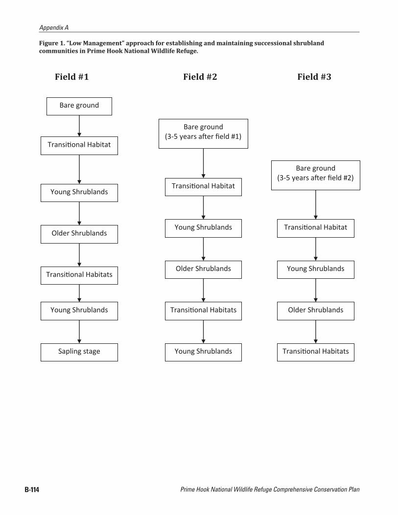
Prime Hook National Wildlife Refuge Comprehensive Conservation Plan
Appendix A
B-114
Figure 1. “Low Management” approach for establishing and maintaining successional shrubland communities in Prime Hook National Wildlife Refuge.
Bare ground
Transi onal Habitat
Young Shrublands
Older Shrublands
Transi onal Habitats
Young Shrublands
Sapling stage
Bare ground (3-5 years a er eld #1)
Transi onal Habitat
Young Shrublands
Older Shrublands
Transi onal Habitats
Young Shrublands
Bare ground(3-5 years a er eld #2)
Transi onal Habitat
Young Shrublands
Older Shrublands
Tran onal Habitats
Field #1 Field #2 Field #3

Appendix A
Appendix B. Habitat Management Plan B-115
Figure 2. “Repeated Management” approach for establishing and maintaining successional shrubland communities in Prime Hook National Wildlife Refuge.
Patch Size Considerations When Creating Shrubland Habitats: Unlike grassland birds that prefer landscapes with larger patch sizes and open vistas, shrubland birds are not deterred by smaller patch sizes (Tefft 2006). An important factor to consider is the width of newly created shrubland habitats. Corridors less than 30 m (100 ft) wide will be occupied by ubiquitous shrubland birds. If managing for ield specialists, then the minimum corridor width should be 50-70 m (165-230 ft) (Peterjohn 2006).
Effects of patch size on occupancy vary among shrubland bird species. Ubiquitous species require only enough suitable habitat to support their breeding territories. Patch sizes of 1-2 ha (2.5-5.0 acres) are suf icient to support most breeding pairs. However, ields smaller than 2 ha (5 acres) support few ield
Bare ground
Every 2-4 years
Bare ground
Tran onal Habitat
Young Shrublands
Hand removal of saplings to maintain shrubs
Chemical treatment of stumps and sprouts
Every 3-5 years
Tran onal Habitat
Young Shrublands
Older Shrublands
Bare ground
Hand removal of saplings to retain open canopy
Chemical treatment of stumps and sprouts
Every 2-4 years
Field #1 Field #2 Field #3
Tran onal Habitat
Burning &/or mowingDisking/chopping to
expose bare soil

Prime Hook National Wildlife Refuge Comprehensive Conservation Plan
Appendix A
B-116
specialists. While available data on patch size preferences of these birds is still sparse, the few studies conducted to date indicate minimum sizes of 4-5 ha (10-12 acres) are required to attract most ield specialists, assuming these habitats are at least 50-70 m (165-230 ft) wide. Patch sizes up to 20 ha (50 acres) is suf icient to attract breeding shrubland birds (Peterjohn 2006)
Prescribed Burning: Fire can either suppress or encourage any given plant species, but great care should be taken to understand the ecosystem and the life histories of the native and invasive plants of the site before using this tool. Prescribed ire as a habitat management tool is most effective when it is used to mimic natural ire regimes. Traditionally, spring and fall burns are usually conducted that are low in severity and intensity in the dormant seasons for most plants in early successional habitats. However, historical ires had no such constrains and ire effects were likely more severe than prescribed burn effects are now (Simmons 2006)
Many rare loral and faunal species depend on the effects of severe and intense burns. One way to achieve better ecological results is to apply growing season ires to achieve objectives in the long term by balancing growing season burns with habitat needs of breeding animals. In most early successional habitats, the timing, frequency, and size of ires can be adjusted so minimal damage is in licted on populations of rare plants and animals.
Burning is more costly and requires greater planning efforts than mechanical treatments such as logging, brush hogging, mowing, and disking, which all perform well as disturbance agents capable of creating required habitat conditions in a particular habitat objective. However, ire performs some functions that these other tools cannot. Fire removes dead vegetation and recycles it into ash, smoke, and steam, and provides nutrients that are immediately available to plants.
Dead grass, thatch, and leaf litter are often completely consumed and serve to carry ire across an entire habitat patch. The removal of thatch, and leaf litter allows greater sunlight penetration to the ground surface and prepares a seed bed for naturally colonizing or planted native grasses and forbs, while other desirable native seeds require scari ication by ire for germination to occur (Simmons 2006).
Fire has historically been used on Refuges in BCR 30 to maintain early successional habitats for Bobwhite and Woodcock. Prescribed ire can be used to maintain grasslands by increasing grass biomass and eliminating woody shade plants, extend the growing season by removing litter, and buffering soil chemistry and selectively controlling tall forbs or ire-sensitive woody plants (by topkilling or causing mortality), mineralize litter, and increase community diversity (by altering the composition of early-lowering plants.
Grasslands: Prescribed ire is the most effective management tool to maintain and rejuvenate native grasslands. Burns should be conducted between March 1 and April 15, or later in the summer (after September 1) to reduce woody plant invasion. Burning increases forb diversity, promotes vigorous warm-season grass growth, releases nutrients back to the soil, and suppresses invasive competition (Rothbart and Capel 2006). However, cyclic burning removes accumulation of vegetative litter from the ground which would not bene it Henslow sparrows that require thick litter accumulation. Rotational schedules between mowing with periodic burning would be best.
Shrublands: Prescribed ire may also be used to maintain an interspersion of shrub and/or grass-dominated communities attractive to shrubland passerines, by topkilling shrubs in old ields, and allowing them to re-sprout into thickets. Fire may be used to help eradicate exotic, invasive plants from open habitats, in some cases precluding the need to use chemical herbicides (Simmon 2006).
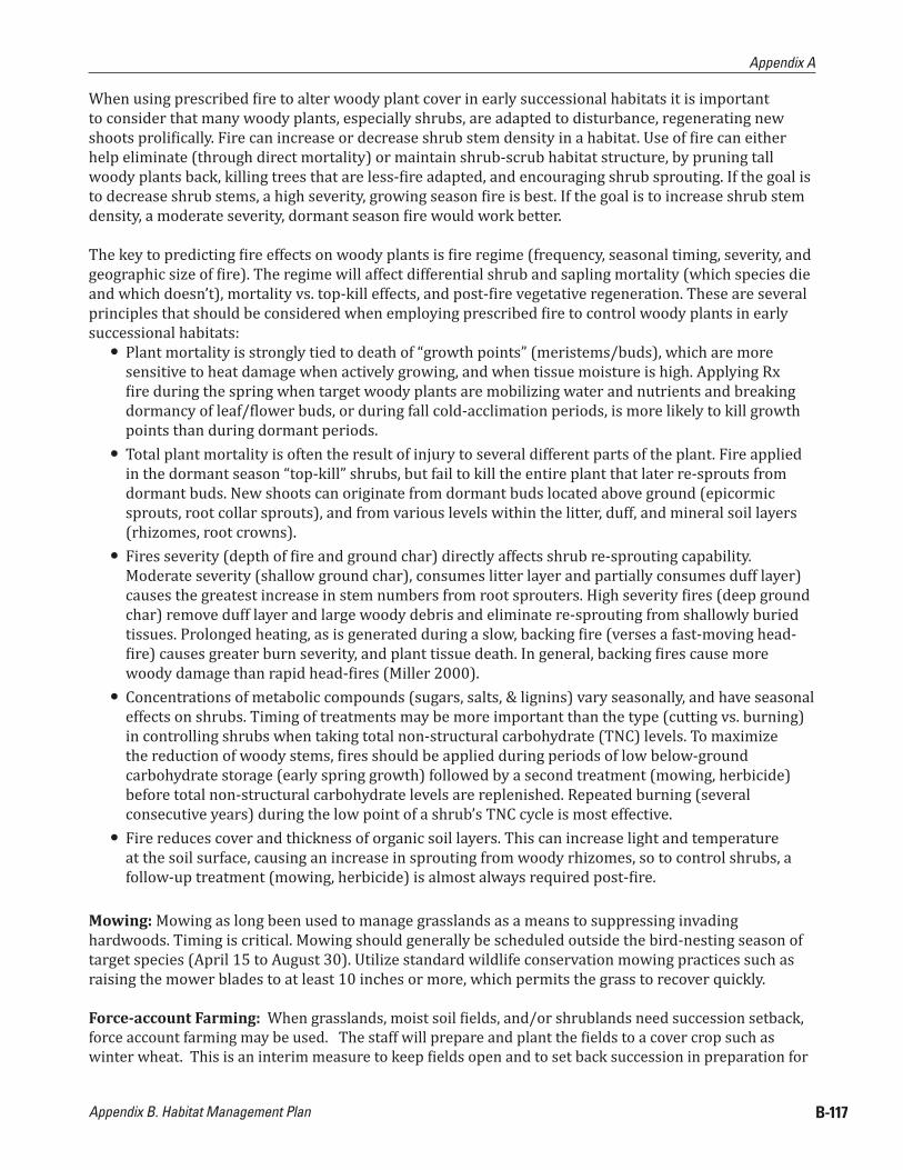
Appendix A
Appendix B. Habitat Management Plan B-117
When using prescribed ire to alter woody plant cover in early successional habitats it is important to consider that many woody plants, especially shrubs, are adapted to disturbance, regenerating new shoots proli ically. Fire can increase or decrease shrub stem density in a habitat. Use of ire can either help eliminate (through direct mortality) or maintain shrub-scrub habitat structure, by pruning tall woody plants back, killing trees that are less- ire adapted, and encouraging shrub sprouting. If the goal is to decrease shrub stems, a high severity, growing season ire is best. If the goal is to increase shrub stem density, a moderate severity, dormant season ire would work better.
The key to predicting ire effects on woody plants is ire regime (frequency, seasonal timing, severity, and geographic size of ire). The regime will affect differential shrub and sapling mortality (which species die and which doesn’t), mortality vs. top-kill effects, and post- ire vegetative regeneration. These are several principles that should be considered when employing prescribed ire to control woody plants in early successional habitats:
● Plant mortality is strongly tied to death of “growth points” (meristems/buds), which are more sensitive to heat damage when actively growing, and when tissue moisture is high. Applying Rx ire during the spring when target woody plants are mobilizing water and nutrients and breaking
dormancy of leaf/ lower buds, or during fall cold-acclimation periods, is more likely to kill growth points than during dormant periods.
● Total plant mortality is often the result of injury to several different parts of the plant. Fire applied in the dormant season “top-kill” shrubs, but fail to kill the entire plant that later re-sprouts from dormant buds. New shoots can originate from dormant buds located above ground (epicormic sprouts, root collar sprouts), and from various levels within the litter, duff, and mineral soil layers (rhizomes, root crowns).
● Fires severity (depth of ire and ground char) directly affects shrub re-sprouting capability. Moderate severity (shallow ground char), consumes litter layer and partially consumes duff layer) causes the greatest increase in stem numbers from root sprouters. High severity ires (deep ground char) remove duff layer and large woody debris and eliminate re-sprouting from shallowly buried tissues. Prolonged heating, as is generated during a slow, backing ire (verses a fast-moving head-ire) causes greater burn severity, and plant tissue death. In general, backing ires cause more
woody damage than rapid head- ires (Miller 2000). ● Concentrations of metabolic compounds (sugars, salts, & lignins) vary seasonally, and have seasonal
effects on shrubs. Timing of treatments may be more important than the type (cutting vs. burning) in controlling shrubs when taking total non-structural carbohydrate (TNC) levels. To maximize the reduction of woody stems, ires should be applied during periods of low below-ground carbohydrate storage (early spring growth) followed by a second treatment (mowing, herbicide) before total non-structural carbohydrate levels are replenished. Repeated burning (several consecutive years) during the low point of a shrub’s TNC cycle is most effective.
● Fire reduces cover and thickness of organic soil layers. This can increase light and temperature at the soil surface, causing an increase in sprouting from woody rhizomes, so to control shrubs, a follow-up treatment (mowing, herbicide) is almost always required post- ire.
Mowing: Mowing as long been used to manage grasslands as a means to suppressing invading hardwoods. Timing is critical. Mowing should generally be scheduled outside the bird-nesting season of target species (April 15 to August 30). Utilize standard wildlife conservation mowing practices such as raising the mower blades to at least 10 inches or more, which permits the grass to recover quickly.
Force-account Farming: When grasslands, moist soil ields, and/or shrublands need succession setback, force account farming may be used. The staff will prepare and plant the ields to a cover crop such as winter wheat. This is an interim measure to keep ields open and to set back succession in preparation for

Prime Hook National Wildlife Refuge Comprehensive Conservation Plan
Appendix A
B-118
conversion to native plants and as a means to provide time to adequately plan the proper establishment of newly converted early successional habitats which would include either grassland, shrubland, or forested patches.
4.3) INVASIVE PLANT MANAGEMENT
Controlling and managing invasive species is a strategy for maintaining the biological integrity and diversity of all habitats. The Ful illing the Promise National Invasive Species Management Strategy Team developed a national strategy for management of invasive species for the National Wildlife Refuge System in 2002. The strategy recommends the following priority order of action for invasive species management:
1) Prevent invasion of potential invaders.2) Eradicate new and/or small infestations.3) Control and/or contain large established infestations.
Potential management strategies for preventing invasive species, prioritizing control efforts for established invasive species, and controlling invasive species are described in detail below. Prior to the initiation of invasive species control efforts, Refuge staff must understand the biology of the species to be controlled. A number of resources are available on the internet to assist with this. Some sources are included below: National Invasive Species Information Center: http://invasivespeciesinfo.gov/index.shtml
● National Biological Information Infrastructure Invasive Species Information Node: http://invasivespecies.nbii.gov/
● The Global Invasive Species Initiative: http://tncweeds.ucdavis.edu/control.html ● USGS Invasive Species Program: http://biology.usgs.gov/invasive/ ● Weeds Gone Wild: http://www.nps.gov/plants/alien/index.htm ● Invasive Species Mapping in Delaware by DNHP:
Refuge Staff should conduct appropriate and applicable pest detection, environmental surveillance, and monitoring before, during and after any management activity to determine whether pest management goals are achieved and whether activity caused any signi icant unanticipated effects. The lowest risk, most targeted approach for managing invasive species should always be utilized.
Early Detection and Rapid ResponseWhere prevention is not possible, early detection and rapid response is the next best strategy. Success will depend in part on participation by all Refuge staff, contractors, volunteers, and visitors in efforts to report and respond to invasions. The Refuge Manager must have access to up-to-date reliable scienti ic and management information on invasives and invasives management. The Delaware Invasive Species Council (DISC) of the Delaware Department of Agriculture (DDA) is an important source for information http://www.delawareinvasives.net.
Prioritizing Invasive Species Control EffortsThe irst step in prioritizing invasive species control efforts is to determine the abundance and distribution of invasive species on the Refuge or management unit. However, control efforts should not be delayed to collect statistically rigorous survey data. Baseline data regarding the location of many invasives on the Refuge already may be available from observations of staff, volunteers, contractors, and Refuge visitors. These observations should be documented and mapped on Refuge GIS. If a more formalized mapping procedure is desired the North American Weed Management Association (http://www.nawma.org) has information on mapping procedures.

Appendix A
Appendix B. Habitat Management Plan B-119
There are a number of ranking tools to assist land managers with the daunting task of prioritizing their invasive plant control efforts. The Ful illing the Promise National Invasive Species Management Strategy Team recommends using the following order of priority to determine appropriate actions:
1) Smallest scale of infestation.2) Poses greatest threat to land management objectives3) Greatest ease of control.
When limited resources prevent the treatment of entire populations, the following order of priority is recommended:
1) Treat the smallest infestations (satellite populations).2) Treat infestations on pathways of spread.3) Treat the perimeter and advancing front of large infestations.
The following ranking systems are available for prioritizing plant species control: ● Morse, L. E. et al 2004. An Invasive Species Assessment Protocol: Evaluating Non-Native Plants for
Their Impact on Biodiversity. Version 1. NatureServe, Arlington, Virigina, Website: http://www.natureserve.org/getData/plantData.jsp
● R.D. Hierbert and J. Stubbendieck, Handbook for Ranking Exotic Plants for Management and Control Natural Resources Report NPS/NRMWRO/NRR-93/08), U.S. National Park Service, Midwest Regional Of ice, Omaha, Nebraska, 1993.
● APRS Implementation Team 2000. Alien plants ranking system version 5.1. Jamestown, ND: Northern Prairie Wildlife Research Center Online. (Version 30 SEP2002). Website: http://www.npwrc.usgs.gov/resource/literatr/aprs
Incorporate Invasive Species Prevention in All Facilities and Construction ProjectsMinimize ground disturbance and restore disturbed areas. Require mulch, sand, gravel, dirt, and other construction materials to be certi ied as free of noxious weed seeds. Avoid stockpiles of weed-infested materials.
To prevent the spread of invasives along transportation corridors, maintain invasive species-free zones along trails, around parking lots and boat launches, and at other related facilities. Inspect these areas often and control new infestations immediately. Minimize the number and size of roads on the refuge. Remove all mud, dirt, and plant parts from all equipment between projects or when equipment is moved from one location to another.
Incorporate Invasive Species Prevention in Impoundment Habitats Minimize infrastructure development in managed wetland units to reduce unnecessary dikes, waterways, and access roads. These often are sources of infestation and pathways of spread. Plant a native cool season grass mix that will establish quickly to stabilize banks and dikes and to prevent the establishment of invasive species. Include in any native grass mix adding annual ryegrass (Lolium perenne) so bare soil is not exposed to erosion or to invasive plant seeds and rhizomes. This non-native plant will establish quickly and then drop out of the mix after one or two years.
Timing water manipulation activities, such as looding and drawdowns, to minimize the germination and spread of invasive plant seeds and encourage the growth of native species. Prolonged looding can be used to stunt the growth of some invasive species. Water level management can also be used to control invasive plants. Robust plants such as Phragmites require air pockets (carbon dioxide) to survive. Flooding the impoundment through all or part of a growing season, particularly after mowing or chemical application, discourages vegetative re-growth of robust invasives like Phragmites.

Prime Hook National Wildlife Refuge Comprehensive Conservation Plan
Appendix A
B-120
Mechanical removal of invasive organisms can be effective against some herbaceous plants, shrubs and saplings, and aquatic organisms. This is particularly effective for plants that are annuals or have a taproot. Care should be taken to minimize soil disturbance to prevent creating conditions ideal for weed seed germination. Repeated cutting over a growing period is needed for effective control of many invasive plant species. Care should be taken to properly remove and dispose of any plant parts that can re-sprout. Treatments should be timed to prevent seed set and re-sprouting. The following methods are available: hand-pulling, pulling with hand tools (weed wrench, etc.), mowing, brush-hogging, weed-eating, stabbing (cutting roots while leaving in place), girdling (removing cambium layer), mulching, tilling, smothering and looding.
The advantages of mechanical treatment are low cost for equipment and supplies and minimal damage to neighboring plants and the environment. The disadvantages are higher costs for labor and inability to control large areas. For many invasive species, mechanical treatments alone are not effective, especially for mature plants or well-established plants. For some invasive plants, mechanical treatments alone exacerbate the problem. Mechanical treatments are most effective when combined with herbicide treatments (like girdle and herbicide treatment).
There are a wide variety of chemicals available to control invasive plants. They may work in different ways and be very target speci ic, or affect a wide range of species. Herbicides may be “pre-emergent,” i.e., applied prior to germination to prevent germination or kill the seedling, or “post-emergent: and have various modes of action (auxin mimic, amino acid inhibitor, mitosis inhibitor, photosynthesis inhibitor, lipid biosynthesis inhibitor). Products may come in granular, pelleted, dust or liquid forms. Common application methods include foliar spray, basal bark, hack and squirt, injection, and cut stump. The timing of applications is critical to achieve good control, as the growth stage at which an invasive plant will be most effectively controlled varies with different species.
The advantages are that the right chemicals, applied correctly, can produce desired results over a large area for a reasonable cost. The disadvantages are that the chemicals may affect non-target species at the site and/or contaminate surface or groundwater. Proper planning includes using the most target-speci ic, least hazardous (humans and the environment), and most effective chemical for the job. Additionally, one should research minimum effective dosage, as the chemical labels often give higher than necessary concentrations. Herbicides often are most effective when used in combination with mechanical methods.
On Refuge lands, all chemicals including adjuvants designed to enhance effectiveness are covered by Service and Departmental regulations. A Pesticide Use Proposal (PUP) is required for all pesticide applications. Attention to protective gear, licensing requirements and other regulations is essential.
Fire is a critical tool to managing ecosystems. It recycles vital nutrients, stimulates growth, provides quality habitat for a variety of species, especially when it is used to destroy invasive plants like Phragmites, when used in conjunction with other techniques like herbicides and mechanical removal. Regular ires, part of nature’s design, also helps check the risk of catastrophic ire by reducing accumulations of hazardous fuels by clearing underbush and dead vegetation.
Over 90 percent of hazardous fuels reduction on PHNWR has been accomplished through strategic use of ire in conjunction with herbiciding to reduce large stands of Phragmites. A comprehensive monitoring plan was established in 2002 with 45 transects spread across all 4 management units as part of the initiation of a large Wildland Urban Interface project conducted in 2002 through 2004 (See WUI Project Maps and Monitoring Plan in Appendix) These established transects will be monitored to continue to track Phragmites control activities and results in relationship to original 2002 treatment sites.

Appendix A
Appendix B. Habitat Management Plan B-121
Biological control is the use of animals or disease organisms that feed upon or parasitize the invasive species target. Usually, the control agent is imported from the invasive species’ home country, and arti icially high numbers of the control agent are fostered and maintained. There are also “conservation” or “augmentation” biological control methods where populations of biological agents already in the environment (native) are maintained or enhanced to target an invasive species. The advantages of this method are that it avoids the use of chemicals and can provide relatively inexpensive and permanent control over large areas. Appropriate control agents do not exist for all invasive species. Petitions are submitted and approved by the USDA Technical Advisory Group on weed biological control before any proposed biological control agent can be released.
4.4) FOREST MANAGEMENT
Regeneration Cutting is the removal of an entire stand of trees in one cutting with reproduction obtained naturally or arti icially (i.e., planting, broadcasting seeding, or direct seeding). Two common methods of regeneration cutting is patch clearcuts and strip clearcuts. These methods are considered to be even-age management. Clearcut size does have an effect on regeneration. As clearcuts increase in size they tend to favor shade intolerant species. As they become smaller they gravitate towards encouraging intermediate tolerant and tolerant species. The size and shape of the clearcut can have an effect on bird species richness as well as in luence herbivore utilization.
● Patch Clearcut: can be many different shapes and sizes depending on management objectives, forest type, terrain, or boundaries. Natural regeneration from the adjacent stands is not heavily relied upon, but can have varying degrees of in luence depending on patch size. All stems 2” dbh and greater should be removed unless some advanced regeneration of desired species exists.
● Strip Clearcut: is used to promote natural regeneration and growth in the harvested strips through the adjacency of the unharvested area. In harvested strips, all stems > 2’ dbh are removed. The unharvested strips act as a seed source and protection for the harvested areas. Concerns related to wind damage are warranted when using this method because of the increased amount of exposed edge. This can be avoided by minimizing the width of the strips being harvested (50-100 feet on stable soil and 30-50 feet on wet soil), ensuring at least one end of the strip is cloed, and harvest as soon as cleared strips are regenerated. Strip clearcuts are more successful when applied to healthy forests found on deep, well-drained soils.
Single Tree Selection is the removal of individual trees uniformly throughout a stand. This technique is used to promote the quality and growth of the remaining trees and can also result in the regeneration of mostly shade tolerant species due to the small canopy openings created during the harvest. Use of this technique, on a continual harvesting cycle, is considered an-even aged management.
Actively managing a stand in un-even ages can result in reducing the stands’ natural ability to resist insect, disease, and other debilitating health issues. Careful extraction of the trees is necessary to help limit residual stand damage, which can create an opportunity for insects and disease to attack otherwise healthy trees. Root damage by soil compaction also needs to be considered. This technique can also be used during even-aged management and when done so is commonly referred to as an intermediate thinning. Single tree selection can be used to mirror a small scale disturbance. When only large trees are selected, the large opening in the canopy will typically be utilized quickly by the crowns of adjacent older trees.
Group Selection is the removal of small groups of trees to maintain an un-even forest. Normally to be considered a group selection, as opposed to a patch clearcut, the size of the harvest group should be less than or equal to twice the height of the adjacent mature trees. This method will encourage regeneration of intermediately tolerant and tolerant species, but some intolerant species can appear towards the center of the harvest areas when the groups are at the maximum size.
Prime Hook National Wildlife Refuge Comprehensive Conservation Plan
Appendix A
B-122
The likelihood of the harvest areas regenerating combined with the ability to schedule continual harvest entries, results in this technique being a method of choice to convert even-aged stands into un-even aged stands when desired. Actively managing a stand in un-even ages can result in reducing the stands natural ability to resist insect, disease, and other debilitating health issues. Careful extraction of the trees is necessary to help limit residual stand damage, which can create an opportunity for insects and disease to enter an otherwise health stand. Root damage by soil compaction also needs to be considered.
A shelterwood System is a series of harvests carried out with the intent of regenerataing a stand utilizing mature trees that are removed at the end of the scheduled rotation. This technique is typically used to regenerate intermediately tolerant (mid-successional) and tolerant (late–successional) species, but in certain instances can be used for intolerant (early-successional) species.
Use of this technique is considered even-aged management, although variations more often found in the irregular shelterwood system can result in a multi-aged stand. In order for a shelterwood system to be considered, a stand should be reasonably well stocked with a moderate to high component of the species desired for regeneration.
Irregular shelterwood system consists of an initial harvest used to encourage regeneration, optional intermediate harvests used to encourage supplemental regeneration, and an overstory removal harvest once regeneration is established. This technique usually results in regeneration with a higher component of intermediately tolerant or tolerant species. This technique differs from other shelterwood systems by introducing the concept of leaving a component of the original stand that can either be removed during subsequent harvests or left throughout the series of harvests and beyond. The long-term residual component can be left singularly or in groups. Harvests can be applied in a variety of fashions including harvesting uniformly, in groups, or strips. The harvest would focus on undesirable species, suppressed, co-dominant, and unhealthy dominant trees. This would provide the greatest potential for seed production and resiliency to windthrow.
Seed tree system is the removal of the majority of a stand while retaining a minority of seed producing trees, left standing to retain some component of the desired species in the regenerating stand. Seed trees can be left singularly and/or in groups, and should be distributed as uniformly as possible throughout the stand. This technique is prescribed when desired species are lacking as a seed source in the overstory (negating shelterwood as an option), or regeneration composition is not a primary objective. This technique could be used to convert species composition to an earlier successional variety while retaining a small component of desired species of mixed hardwoods. Desired species that are healthy, dominant, large crowned, and well-rooted should be targeted to leave standing. The rest of the stand is removed in its entirety (2” dbh and greater). The residual trees/groups can be removed after regeneration is established or may be left to accomplish other stand objectives.
Stand Improvements consist of entering an even or uneven aged stand at any stage of development with the intent of tending to habitat needs through thinning, weeding, cleaning, liberation, sanitation, or other improvement methods. The primary function of this method is to control species composition and reduce an overabundance of stems per acre to a more desired stocking level. This translates into thinning young stands to control species composition, conducting intermediate thinnings in middle aged stands to maintain accelerated growth and remove unwanted vegetation, and control stocking levels of habitat features such as snag trees, cavity trees, den trees, downed wood and other features.
Two techniques are used to bene it wildlife; retain or create snags and the provision of coarse woody debris (CWD). Snags or live trees that fall to the forest loor are known as CWD, which can range in size from branches to bole to entire trees, and adds structural diversity, serving as hiding and thermal cover,

Appendix A
Appendix B. Habitat Management Plan B-123
den sites, foraging substrate, and winter access to subnivean habitats. As the wood decays essential nutrients such as sulphur, phosphorous, and nitrogen are released. The need for creating CWD depends on the forest type, stage of succession, and management history. Allowing snags to fall naturally, felling and leaving live trees, and/or leaving tops, limbs, and other debris during stand improvement operations can augment CWD levels.
Snags play an important ecological role for at least 149 bird species, 73 mammalians, and 93 herpetiles (Thomas 1979). Based on the state of decomposition, snags can be hard (sound sapwood, rotting heartwood) or soft (rotting sapwood and heartwood). There are several ways to “create” snags, or initiate the decomposition process. Each is an effort to damage a healthy tree’s integrity by creating a pathway for fungal infection. These include girdling, topping, branch removal, fungal inoculation, and herbicide injection. The density and size of suitable snags depends on the individual forest types and natural disturbance patterns.
Many treatments and numerous types of equipment are available for mechanically manipulating upland sites from one covertype to another. Selection of the type of mechanical treatment will depend on site habitat objectives. All of these tools can be used with varying degrees of effectiveness, depending on what is being cut. Special consideration needs to be given to ground disturbance when using heavy equipment. Soils may be compacted and rutted which can cause a change in vegetation component of the area. Disturbed soils are also more likely to promote germination of invasive species, an undesirable outcome of any habitat management activity. Examples of shrub and tree cutting equipment include:
● Drum mowers for removal of small trees. ● Geo-Boy to cut trees up to 6-8” dbh. Woody material is reduced to ine chips, often iner then those
resulting from a roller mower. ● Roller Chopper Mower, used to knock down and chop up shrubs and trees. This technique causes
signi icant disturbance to the soil and should be reserved for situations where the area is going to be seeded after treatment.
● Mowing and Brush Hogging: mowing is an appropriate treatment for grass, forbs, and small shrubs and saplings. Vegetation > 4 inches often needs a higher powered machine.
● Girdling: can be appropriate to remove single trees or groups of trees to open up the canopy and/or create snags. It can also cause stump sprouting.
● Chainsaw: can be used to remove single trees or groups of trees to open up the canopy. Stump sprouting may occur.
● CWD Management: different prescriptions will leave differing amounts of woody debris. Objectives will drive the best management technique for dealing with the debris. It can be left to decay on forest loor, however, if conversion to another habitat type is desired (grassland or shrubland), woody debris may be burned or removed. WCD can be chipped and broadcast on site. Depth of chips should not exceed 2-3 inches. Removal from site can be in form of chips, or whole logs and shrubs.
(Maryland PIF Committee. 1997. Habitat Management Guidelines for the bene it of landbirds in Maryland and A Guide to the Conservation of Forest Interior Dwelling Birds in the Chesapeake Bay Critical Area. 2000)
4.5) INTEGRATED PEST MANAGEMENT (IPM)
Integrated pest management (IPM) is de ined as “…a decision-based process involving coordinated use of multiple tactics for optimizing the control of all classes of pests (insects, pathogens, weeds, vertebrates)

Prime Hook National Wildlife Refuge Comprehensive Conservation Plan
Appendix A
B-124
in an ecologically and economically sound manner” (Ehler 2006). The term ‘integrated’ implies incorporation of natural predator levels into decision-making, and use of compatible, non-disruptive tactics to preserve natural predators associated with pest species. IPM is used to avoid the indiscriminate use of pesticides to avoid such problems as pest resistance, target pest resurgence, negative impacts on non-target species and environmental contamination.
On national wildlife refuges (IPM) is an interdisciplinary approach utilizing methods to prevent, eliminate, contain, and/or control pest species in concert with other management activities on Refuge lands and waters to achieve wildlife and habitat management goals and objectives. It is also a scienti ically based, adaptive management process where available scienti ic information and best professional judgment of the Refuge staff as well as other resource experts would be used to identi iy appropriate management strategies that can be modi ied and/or changed over time for effective, site-speci ic management of pest species.
A tolerable pest population (threshold) must be determined before using chemicals. The ecology of pest species will be considered when using one or more control methods that are feasible, ef icacious, and most protective of non-target resources, including native species ( ish, wildlife, and plants) and Service personnel, Service authorized agents, volunteers, and the public. Staff time and available funding would also be considered when determining feasibility/practicality of various treatments.
In accordance with 517 DM 1 and 7 RM 14, an (IPM) approach to all Refuge Management activities must be utilized, where practicable, to eradicate, control, or contain pest and invasive species (herein collectively referred to as pests) on the Refuge. IPM would involve using methods based upon effectiveness, cost, and minimal ecological disruption, which considers minimum potential effects on non-target organisms and biological integrity, diversity, and environmental health of Refuge lands. Pesticides may be used where physical, cultural, and biological methods or combinations thereof, are impractical or incapable of providing adequate control, eradication, or containment.
Furthermore, pesticides would be used primarily to supplement, rather than as a substitute for practical and effective control measures of other types. If a pesticide would be needed or used on the Refuge, the most speci ic (selective) chemical available for the target species would be used unless considerations of persistence or other environmental and/or biotic hazards would preclude it. For example, if larval mosquito monitoring generates action thresholds of species speci ic mosquito larval densities indicative of an increased health risk, Bacillus products would be utilized as the preferred or primary method of mosquito control, due to its greater speci icity to control identi ied mosquito disease vector species, and to minimize negative impacts that other larvicide products have on non-target invertebrate species, migratory birds, amphibians and other wildlife.
4.6) BIOLOGICAL MOSQUITO CONTROL/OPEN MARSH WATER MANAGEMENT:
Open Marsh Water Management (OMWM) is de ined as any type of physical manipulation in the form of pond construction and marsh ditching which alters coastal saltmarsh habitat to accomplish source reduction and biological control of mosquitoes. OMWM evolved as a new ditching technique to replace grid-ditching that had been practiced for thirty plus years from 1930 to 1960s. OMWM is based on the following assumptions: 1) not all parts of a tidal marsh breed mosquitoes; 2) that mosquitoes are greatly reduced or absent from portions of the marsh where tidal action circulates water over the marsh surface and removes excessive water; 3) that biological control in the form of predation of marsh ishes will biologically reduce mosquito populations; and 4) that permanent pools of water on the marsh surface serve as reservoirs for mosquito-eating ishes, which can forage among the grass stems at high tide. The mummichog (Fundulus heteroclitus) is the dominant predator, along with other ishes, on Refuge salt marsh habitats.

Appendix A
Appendix B. Habitat Management Plan B-125
Various marsh excavations and alteration methods are used with the OMWM technique to control mosquitoes. In Delaware OMWM systems are typically blends of open (tidal), sill (semi-tidal), and closed (non-tidal) alterations, using selective excavations of ponds and ditches to treat identi ied mosquito-breeding habitats (Meredith et al 1985). The Service has listed several unacceptable practices in Region 5 which include: OMWM excavations in unditched salt marshes; disturbance of natural pannes; low salt marsh alterations; excessive pond depth (< 30 to 36 inches deep). OMWM excavations on Refuges should be directed to disturbed high marsh areas where mosquito breeding occurs and control is necessary (Taylor 1998).
Spoil management in all OMWM excavations is critical. OMWM best management practices identi ied by Meredith et al (1985) emphasize the need to insure that excavations do not cause the mean subsurface water table to drop more than six inches below local marsh surface elevation. Delaware research data has found that the mean water table of zones of Iva, Baccharis, and robust Phragmites is usually 6 inches or more below local marsh surfaces. This creates a soil condition that is drier and more aerated than soils in salt hay or short-form cordgrass zones, where the water table is much closer to the surface (Meredith, Saveikis, & Stachecki 1983).
Conditions that result in establishing the growth of marsh shrubs and Phragmites, include excessive subsurface drainage and/or excessive spoil deposition, either separately or in combination that will lower water tables. Delaware-OMWM BMPs state that spoil from ditches and ponds should be spread over the marsh surface at initial depths no greater than 3 inches. After a period of spoil settlement, any permanent increase in surface elevation should be less than two inches (Meredith et al 1985).
4.7) CONTROL OF OVER ABUNDANT OR NON NATIVE WATERFOWL POPULATIONS
Controlling invasive or over-abundant waterfowl, such as mute swans, snow geese, and resident Canada geese is a strategy used to protect native water birds and isheries, and prevent the destruction of wetland habitats on Refuges. Control methods include: harassment, egg addling, sterilization, removal, shooting, increased hunting pressure, and modifying historic habitat management practices.
The Atlantic Flyway Council’s (2003), “Atlantic Flyway Mute Swan Management Plan 2003-2013,” (http://www.dnr.state.md.us/wildlife/afcmuteplant) outlines the coordination of state (lead) and federal wildlife agencies “to reduce mute swan populations in the Atlantic Flyway to levels that will minimize negative ecological impacts to wetland habitats and native migratory waterfowl and to prevent further range expansion into unoccupied areas.” Target populations of mute swans vary by state and range from 0 to 500 free- lying birds.
In the fall of 2005, the Service completed an Environmental Impact Statement that included a multi-faceted approach for managing resident Canada geese (http://migratorybirds.fws.gov/issues/cangeese/deis.html). Upon recommendations from the Atlantic Flyway Council, the Service approved the use of special regulations beginning in 2007 to help curb the growth of resident Canada goose populations in the eastern US which included the expansion of hunting methods during September seasons.
The Service released the Final Environmental Impact Statement for Light Goose Management in June 2007 that examined ive alternatives for future management of over-abundant Greater Snow goose populations. The preferred alternative would: 1) expand hunting opportunities within the current migratory bird hunting-season framework; 2) establish a conservation order for expanded hunting methods; and 3) modify habitat management practices on National Wildlife Refuges to decrease the amount of food and sanctuary available for light geese. (http://www.fws.gov/migratorybirds/issues/snowgeese/FINALEIS2007/)

Prime Hook National Wildlife Refuge Comprehensive Conservation Plan
Appendix A
B-126
4.8) PREDATOR CONTROL AND NUISANCE WILDLIFE MANAGEMENT
Predator control and nuisance wildlife management are valuable strategies used to manage and mitigate habitat and/or wildlife damage and protect endangered and threatened species or species of conservation concern and their habitats. A comprehensive predator control and nuisance wildlife refuge program will address a range of management prescriptions from vegetation protection, control and/or nesting habitat enhancement to non-lethal and lethal predator and wildlife control. The most effective, selective, and humane techniques available to deter or remove individual predators or problem species will be used.
For example, control of Refuge problem species like beaver, nutria and muskrats, mute swans and/or resident Canada geese may be required when high concentrations of these species incur deleterious effects on native wetland habitats, aquatic vegetation, or refuge infrastructure. The control of mammalian and/or avian predators such as raccoons, foxes, gulls and crows, may be required that threaten or destroy nesting, breeding, or foraging habitats used by state or federally endangered species or species of special conservation concern. These species include but will not be limited to piping plovers, American oystercatchers, least and common terns, red knots and ruddy turnstones.
Trapping as a Management Strategy: Trapping and lethal control will be two major strategies used to control predators and to manage populations that negatively impact Refuge habitats or habitat infrastructure (like nutria and/or muskrats that burrow and destroy Refuge dikes, etc). Trapping and shooting to control nutria can also be used effectively to achieve desired interspersion of wetland vegetation. Trapping and shooting are important management tools that can be used for the following objectives:
● Habitat management or protection ● State or federally endangered species protection ● Migratory bird protection ● Wildlife Population Management ● Surveys or monitoring of wildlife ● Facilities protection ● Public Safety and health ● Feral Animal Control ● Disease Control
Alternative techniques to trapping and shooting will also be used to accomplish the above objectives. These include the use of electric fences, scare devices, screens and shields, and exclosures to deter predators. Any other new, effective, and selective techniques that become available to help prevent and/or mitigate habitat damage, maintain diverse and healthy wildlife populations, and protect endangered, threatened, and/or species of conservation concern, will also be considered.


![Developing a Wildlife Habitat Management Planweb.mnstate.edu/stockram/WildlifeEcol/4-H-991-W[1].pdfDeveloping a Wildlife Habitat Management Plan WILDLIFE HABITAT EVALUATION CAREER](https://img.dokumen.tips/doc/110x75/5fe7fa3d9f69891190384d11/developing-a-wildlife-habitat-management-1pdf-developing-a-wildlife-habitat-management.jpg)