Embed Size (px)
Citation preview

B. MEASURES FOR FLOODS
B - 6 0
CHAPTER 5 DEVELOPMENT MASTERPLAN
5.1 Introductions
The word “Master Plan” indicates a plan that identifies the guidelines and policies for future development focusing on the main issues to be dealt within 15-25 years ahead.
5.2 Project and Programs (including Flood Forecasting and Warning dissemination)
5.2.1 Master Plan key issues for the flood proofing
Master Planning of the “Rural Development Focusing on Flood Proofing” concerns, among other things, the preparation of guidelines and policies for development and maintenance of flood proofing facilities for the upcoming 25 years. It may also be called a strategic planning, focusing on flood proofing issues, which provides for the frame work of executive planning (5-Year Plan, Annual Development Plan etc) that concerns the implementation of specific investment projects, their maintenance programs and operating principles.
In course of the Study it became clear that the present Master Plan for the flood proofing, as part of the Rural Development, needs to address, inter alia, following major issues through minor structural (or non-structural) measures.
1. Earthfilling to restore the area of village mounds with protection against erosion due to waves.
2. Raising of homesteads to make them flood free.
3. Propagation of awareness for flood preparedness.
4. Provision of multi-purpose Flood Shelters with latrines, hand tubewells etc for people and domestic animals.
5. Establishing effective system of flood forecasting and dissemination of warning by use of telephone/radio communication.
6. Clustering houses on high platforms.

B. MEASURES FOR FLOODS
B-61
5.3 Protection of village mounds in the Haor areas against wave erosion
One or more of the following actions may be required for the protection of village mounds:
5.3.1 Action I: ‘Earth-only’ protection with ‘Chailla’ grass
Every year during monsoon, the windward side slopes of the village mound in the haor area loose earth due to wave action. This happens at least on two sides of the mound from which direction the wind blows. During the next dry season, the lost earth should be replenished. The main problem about the ‘earthwork only’ type of protection is that it is not durable against wave action because soil is mostly non-clayey. The durability may improve with a coating on the side slopes with carried cohesive soil, duly compacted and turfed. A layer of earthfilled synthetic bags on top of filling may also improve durability in a small scale. However, these need further testing for confirmation. Side slope shallower than 1:1.5 may also increase durability by reducing erosion. Indigenous protection by ‘Chailla’ (Hematheria Protensa) may be added before the monsoon.
5.3.2 Action II: Establishing a vegetative protection by ‘Hijal’ and ‘Koroch’
This can help make the whole process of the village mound protection sustainable in the long run, which should be the main tool for an enduring wave protection of the village mounds. However, this may require 10-15 years to become fully effective. A layout of typical vegetative protection is shown in Figure 5.1.. The immediate action that should be started now is the afforestation program of Hijal and Koroch. Once the plantation is established, it will go on reproducing naturally, provided the villagers are motivated and trained to preserve the same. Normally, there is chance of pilferage of grown/semi-grown tree for using as fuel.
5.3.3 Action III: Revetments by brick/concrete block on slope of village mound
The brick/concrete block revetment works will give dependable protection for 25-30 years provided they are well designed, properly constructed and well maintained. This may be considered for both shallow haor and deep haor areas.
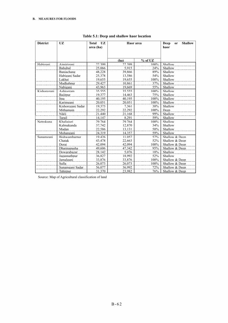
List of UZs in the Study area having deep and/or shallow haor is furnished in the following Table 5.1.
B. MEASURES FOR FLOODS
B - 6 2
Table 5.1: Deep and shallow haor location
Haor area
District UZ Total UZ area (ha)
(ha) % of UZ
Deep or Shallow haor
Habiganj Ajmiriganj 22,399 22,399 100% Shallow Bahubal 25,066 5,915 24% Shallow Baniachang 48,228 39,866 89% Shallow Habiganj Sadar 25,378 13,586 54% Shallow Lakhai 19,655 19,655 100% Shallow Madhabpur 29,427 10,861 37% Shallow Nabiganj 43,963 19,669 55% Shallow Kishoreganj Ashtogram 35,555 35,555 100% Shallow Bajitpur 19,377 14,463 75% Shallow Itna 40,195 40,195 100% Shallow Karimganj 20,051 20,051 100% Shallow Kishoreganj Sadar 19,373 7,361 38% Shallow Mithamain 22,292 22,292 100% Deep Nikli 21,440 21,168 99% Shallow Tarail 14,147 8,291 59% Shallow Netrokuna Khaliajuri 29,764 29,764 100% Shallow Kalmakanda 37,742 12,870 34% Shallow Madan 22,586 13,131 58% Shallow Mohanganj 24,319 14,357 59% Shallow Sunamganj Bishwambarpur 19,426 11,057 57% Shallow & Deep Chatak 43,478 22,663 52% Shallow & Deep Derai 42,094 42,094 100% Shallow & Deep Dharmapasha 49,606 47,342 95% Shallow & Deep Dowarabazar 28,142 5,076 18% Shallow Jagannathpur 36,827 18,992 52% Shallow Jamalganj 33,876 33,876 100% Shallow & Deep Sulla 26,073 26,073 100% Shallow & Deep Sunamganj Sadar 56,077 36,992 72% Shallow & Deep Tahirpur 31,370 23,982 76% Shallow & Deep
Source: Map of Agricultural classification of land


B. MEASURES FOR FLOODS
B - 6 4
5.3.4 Action IV: Provision of masonry/RCC walls in lieu of brick/concrete block revetment
This action will be the most costly, although very much liked by the villagers due to its easy construction procedure and durability. They villagers have seen the different kinds of protection works against wave erosion done by LGED-CARE, NGOs and draw their conclusion in favor of masonry wall structure because of its effectiveness, ease in construction and durability. From the engineering point of view also, this is the most dependable but costlier item. Generally, this calls for minimal maintenance. This may be considered for deep Haor area generally.
5.3.5 Program for the village mound protection
Usually width of a village mound varies from 30 to 70 m and the length varies from 100 to 400 m. The oblong shape of most of the mounds is not optimal for minimizing the length of wall/revetment and hence the cost per unit area of protection. However, this situation may be improved, where possible, by constructing the longer side wall/revetment further away from the existing slope of the mound and filling inside by earth, thus producing more area of the raised mound to accommodate the already homeless/landless families in the areas. This extended area of the raised and protected land may also be used for the Multipurpose Flood Shelters. Average total length of protection of two sides of a mound may be taken 250 m and average height of the revetment above ground level 3.5m including Free Board.
5.3.5.1 Implementation of ‘earth-only’ approach of village mound protection
On average the wave action can cause erosion of 1-2 meters per year on the windward faces of mounds that use only the indigenous protection by ‘Bamboo-Chailla’ combination.. Without the Bamboo-Chailla treatment, the erosion could be more. With average size of 200m x 50m of the mounds, the length of the sides facing wave action may be 250m. Normally the height of the mounds are 3-4m from the average ground level.. Taking an average of 3.5m height, thickness of 1.5m and length 250m, the average volume of earth work comes to 1.5 x 3.5 x 250 = 1,312m3 to be replenished every year per mound. There are in total 5062 no. of mounds in the 4 haor districts under the Study. Nearly 85% of the mounds may have to be replenished with earth to recoup the eroded volume due to wave erosion every year for the first 10 years of the planning period. Hijal/Koroch tree will grow during this period, so thereafter only 10% of the mounds may require such treatment every year for another 5 years. Volume has been calculated as = No. of mounds x (0.85x10 + 0.10 x 5) x 1312 m3.
Table 5.2 shows the total volume of earthwork required in 15 years UZ wise.
Table 5.2: ‘Earth-only’ protection of the village mounds
District UZ No. of village mounds
Total Vol of earth required for 15 years (m3)
Habiganj Ajmiriganj 410 4,841,280 Bahubal 120 1,416,960

B. MEASURES FOR FLOODS
B-65
Baniachang 1150 13,579,200 Habiganj Sadar 120 1,416,960 Lakhai 245 2,892,960 Madhabpur 120 1,416,960 Nabiganj 352 4,156,416
Kishoreganj Ashtogram 90 1,062,720 Bajitpur 2 23,616 Itna 270 3,188,160 Karimganj 50 590,400 Kishoreganj Sadar 120 1,416,960 Mithamain 80 944,640 Nikli 128 1,511,424 Tarail 120 1,416,960
Netrokuna Khaliajuri 181 2,137,248 Kalmakanda 164 1,936,512 Madan 53 625,824 Mohanganj 125 1,476,000
Sunamganj Bishwambarpur 120 1,416,960 Derai 76 897,408 Dharmapashaaa 115 1,357,920 Jagannathpur 120 1,416,960 Jamalganj 158 1,865,664 Sulla 187 2,208,096 Sunamganj Sadar 88 1,039,104 Tahirpur 58 684,864 Chatak 120 1,416,960 Dowarabazar 120 1,416,960 TOTAL: 5062 59,772,096
5.3.5.2 Protection of village mound by vegetative cover (Hijal/Koroch)
In all the village mounds as listed in Table 5.2, afforestation of Hijal/Koroch during the plan period may be carried out by implementing on 90% of the number of mounds in first 5 years of the plan period and 10% in another 2 years. Koroch may be preferred to Hijal as it grows faster than Hijal. Afforestation program should be started immediately.
5.3.5.3 Protection of village mounds by hard material
There are many vulnerable village mounds that call for immediate attention to save them from complete disappearance. They are to be protected by hard material. From the Field Survey, it is seen that about 7% of the mounds require urgent treatment by hard materials, failing which they may be wiped out. After considering different alternatives of the kind of hard materials, it has been found that brick block revetment and masonry wall protection are the most acceptable engineering solution for the respective locations. Out of the approximately 7% of total number of mounds that need hard material protection, 4% could be executed by brick/concrete block revetment on slope in both shallow and deep haor areas and 3% by brick masonry wall where found necessary preferably in deep haor areas.

B. MEASURES FOR FLOODS
B - 6 6
Table 5.3: Planning of protection work by hard materials in Haor area
District UZ No. of village
mounds
Most vulnerable no. of village mounds as obtained from field
surveys 2001
Total length of
protection (m)
Remark
Habiganj Ajmiriganj 410 12 3,000 Shallow haor Bahubal 120 6 1,500 Shallow haor Baniachang 1150 30 7,500 Shallow haor Habiganj Sadar 120 4 1,000 Shallow haor Lakhai 245 20 5,000 Shallow haor Madhabpur 120 0 0 Shallow haor Nabiganj 352 26 6,500 Shallow haor
Kishoreganj Ashtogram 90 12 3,000 Shallow haor Bajitpur 2 0 0 Shallow haor Itna 270 24 6,000 Shallow haor Karimganj 50 2 500 Shallow haor Kishoreganj Sadar 120 14 3,500 Shallow haor Mithamain 80 15 3,750 Deep & Shallow Nikli 128 6 1,500 Shallow haor Tarail 120 6 1,500 Shallow haor
Netrokuna Khaliajuri 181 18 4,500 Shallow haor Kalmakanda 164 26 6,500 Shallow haor Madan 53 6 1,500 Shallow haor Mohanganj 125 14 3,500 Shallow haor
Sunamganj Bishwambarpur 120 10 2,500 Deep & Shallow Derai 76 12 3,000 Deep & Shallow Dharmapashaaa 115 14 3,500 Deep & Shallow Jagannathpur 120 12 3,000 Shallow haor Jamalganj 158 16 4,000 Deep & Shallow Sulla 187 18 4,500 Deep & Shallow Sunamganj Sadar 88 6 1,500 Deep & Shallow Tahirpur 58 8 2,000 Deep & Shallow Chatak 120 6 1,500 Deep & Shallow Dowarabazar 120 6 1,500 Shallow haor
TOTAL: 5,062 349 87,250
The UZ-wise required lengths of protection by hard materials are presented in table 5.3. The lengths are found by multiplying the number of vulnerable mounds by 250, which is considered the average length protection per mound.
Most of the protection works of village mounds by hard materials may be done in the first ten years.. It is expected that from the middle part of the plan period, from around year 2012 for example, protective works by hard materials will not be needed to a large extent, as by that time the vegetative protection by Hijal and Koroch will grow up. However, a nominal provision of protection by hard materials may be kept for the period beyond 2012 to meet exigencies if any.
5.3.5.3.1 Protection by brick/CC block revetment
As indicated in Table 5.3, total number of vulnerable village mound that require hard material

B. MEASURES FOR FLOODS
B-67
protection is 349. Nearly 200 of them may be protected by brick CC block revetment laid on slope. The tentative size of the brick block for revetment may be 45cm x 45cm x 22.5cm, laid on filter/geo-textile on a slope of 1:2. As stated earlier, this is not very popular amongst the villagers. In the past, revetment works were done in some places, which did not prove very stable in position. The most important part of this kind of works is its requirement of periodic O&M, which is generally lacking particularly in rural areas. Therefore, adequate O&M through institutional arrangement has to be secured. It is considered that this kind of protection will be provided for the 4% of total number of village mounds during the entire period of the master plan. The general problems with the stability of the brick blocks experienced earlier were probably due to their smaller size (hence weight) than that required by a proper design as also the lack of compaction, filter/geo-textile and adequate flat slope.
5.3.5.3.2 Protection of village mounds by RCC/Masonry wall
The most vulnerable mounds in the deep haor areas, as also in some shallow haor areas, should get this kind of protection, where other modes, e.g. slope revetment, is not effective due to more severe hydro-meteorological condition.
The cost of the masonry wall will be higher than that of the CC or brick block revetment. By the same consideration as in the revetment, it is considered that the total length of the masonry wall in an average village mound will be 250 meters. It is considered that this kind of costly but definite protection will be provided for the 3% of the total village mounds during the entire period of the master plan. The indicative height of the RCC/masonry wall be 3-4 m.
Out of total 349 village mounds that need hard materials protection as shown in Table 5.3, 149 mounds may be provided with masonry/RCC walls. Villagers prefer masonry wall to any other kind of protective measures.

B. MEASURES FOR FLOODS
B - 6 8
5.4 Raising of households/Village Mounds by earthworks
Homesteads lose earth from the top surface and the side slopes due to rainfall and by the occasional inundation. Also the earth mounds settle over time. Generally the mounds loose 150 mm/year due to rainfall and when overtopped by floodwaters, it looses a further 50 mm yearly (Source FAP 6 report). When inundated, the house plinth and the related structure start to disintegrate. Houses start to sink into the platform, walls fall apart and the walling materials and bamboo supports start to rot. Therefore, it is necessary to recoup the lost earth due to rainfall and normal flooding every year for a flood free housing. Instead of raising the room(s) only, the present Study favors raising the homestead with courtyard so that flood stricken people can at least do some household works without getting confined in rooms for months together during flood. The indicative calculations of earthwork volumes required for initial raising the homesteads above the design flood level are shown in the following Table 5.4 and Table 5.5. The indicative calculations are based on the average homestead with courtyard of the char areas as 0.01 hectare (100m2) and the average village mounds in the haor areas have 1 to 2 ha. In the calculation of the earthwork, however, the actual areas of the village mounds, as collected during the survey have been used.
Table 5.4: Calculation of earthwork for raising homestead in Char area
% of homesteads where court yards were
inundated in 1998 by
No.of Homestead to be raised by this height
including 30 cm Free Board
Taking average household area as 0.01 ha, volume of
earth work for the three category
of filling, (1000 x m3)
District CHAR AREA
UZ
Char area (%) of
total UZ
Area of
char (ha)
Population of char area 2001
No. of house-hold in
char area 2001
30cm
30-100 cm. Av 65 cm
100-150 cm. Av 125 cm.
Av. 60 cm
Av. 95 cm
Av. 155 cm
Av. 60
cm
Av. 95
cm
Av. 155 cm
Total earth work for
raising homestead (1000x m3)
Fulchari 87% 26,631 91,547 15,128 3 87 9 454 13,161 1,362 27 1,250 211 1,489Gaibandha Sadar
21% 6,657 24,029 4,412 0 91 9 0 4,015 397 0 381 62 443
Shaghata 38% 8,557 61,133 12,324 19 74 7 2,342 9,120 863 140 866 134 1,141
Gaibandha
Sundarganj 20% 8,533 24,321 1,821 0 90 10 0 1,639 182 0 156 28 184Dewanganj 78% 20,888 148,392 28,998 11 80 8 3,190 23,198 2,320 191 2,204 360 2,755Islampur 34% 11,611 66,132 12,924 22 70 7 2,843 9,047 905 171 859 140 1,170Madarganj 45% 10,097 74,161 15,053 3 88 8 452 13,247 1,204 27 1,258 187 1,472
Jamalpur
Sharishabari 39% 10,164 88,442 10,682 4 86 8 427 9,187 855 26 873 132 1,031Char Rajibpur
87% 9,694 47,550 9,110 11 75 8 1,002 6,833 729 60 649 113 822
Chilmari 83% 18,607 51,029 10,275 2 85 8 206 8,734 822 12 830 127 969Kurigram Sadar
28% 7,650 20,806 3,663 5 86 9 183 3,150 330 11 299 51 361
Nageshwari 51% 21,060 109,223 19,745 5 84 8 987 16,586 1,580 59 1,576 245 1,880Raumari 39% 7,702 45,109 4,974 5 84 8 249 4,178 398 15 397 62 474
Kurigram
Ulipur 41% 20,769 61,573 5,685 0 90 10 0 5,117 569 0 486 88 574Belkuchi 51% 8,315 96,576 17,275 0 90 10 0 15,548 1,728 0 1,477 268 1,745Chauhali 100% 24,367 116,642 21,400 2 87 9 428 18,618 1,926 26 1,769 299 2,093Kazipur 70% 25,836 129,180 24,723 14 78 8 3,461 19,284 1,978 208 1,832 307 2,346Shahjadpur 21% 6,942 63,750 7,573 4 89 6 303 6,740 454 18 640 70 729
Sirajganj
Siragnj Sadar
38% 12,542 79,561 12,735 1 90 9 127 11,462 1,146 8 1,089 178 1,274
Total: 16654 198861 19745 Total: 22,952

B. MEASURES FOR FLOODS
B-69
Table 5.5: Calculation of earthwork for raising homestead in Haor area % of homesteads where court yards were inundated in 1998 by
No. of village mounds to be raised including 50 cm Free Board
With respect to the average area of village mound, volume of earth work for the three category of filling, in thousand m3
Total earth work (1000x m3)
District Haor Area UZ
Haor area (%) of total UZ
Area of Haor (ha)
Popu- lation of Haor area 2001
No. of village mounds in Haor area 2001
Total area of village mounds (ha)
Average area of a village mound (ha)
30 cm
30 -60 cm. Av 45 cm
60 -90 cm. Av 75 cm.
Av. 80 cm
Av. 95 cm
Av. 125 cm
Av. 80 cm
Av. 95 cm
Av. 125 cm
Ajmiriganj 100% 22,399 101,74 410 397 0.97 23 58 1 93 238 4 718 2,187 50 2956Bahubal 24% 5,915 4,621 120 120 1.00 26 42 1 31 50 1 250 479 15 743Baniachang 83% 39,866 194,73 1150 1243 1.08 21 54 1 240 621 12 2,078 6,377 155 8610Habiganj 54% 13,586 90,750 120 120 1.00 26 42 1 31 50 1 250 479 15 743Lakhai 100% 19,655 134,74 245 246 1.00 30 21 1 73 51 2 587 491 31 1109Madhabpur 37% 10,861 101,23 120 120 1.00 26 42 1 31 50 1 250 479 15 743
Habiganj
Nabiganj 45% 19,669 90,259 352 316 0.90 31 32 1 108 113 4 778 961 40 1778Ashtogram 100% 35,555 167,70 90 753 8.37 26 66 2 23 59 2 1,552 4,721 188 6462Bajitpur 75% 14,463 153,78 2 2 1.00 35 60 1 1 1 0 6 11 0 17Itna 100% 40,195 154,90 270 324 1.20 35 12 1 93 32 3 897 369 41 1307Karimganj 100% 20,051 281,52 50 94 1.88 26 41 1 13 21 1 196 366 12 573Kishoreganj S d
38% 7,361 142,55 120 120 1.00 26 41 1 31 49 1 250 467 15 732Mithamain 100% 22,292 141,78 80 142 1.78 21 19 1 17 15 1 237 256 18 511Nikli 99% 21,168 124,10 128 202 1.58 4 72 2 5 92 3 58 1,382 51 1490
Kishoreganj
Tarail 59% 8,291 88,585 120 120 1.00 34 15 1 41 18 1 330 171 15 516Khaliajuri 100% 29,764 83,649 181 405 2.24 0 96 4 0 174 7 0 3,694 203 3896Kalmakanda 34% 12,870 63,992 164 265 1.62 24 56 2 39 92 3 509 1,410 66 1985Madan 58% 13,131 61,208 53 86 1.62 37 23 1 19 12 1 253 188 11 452
Netrokuna
Mohanganj 59% 14,357 62,714 125 126 1.01 36 40 1 45 50 1 359 479 16 854Bishwambar 57% 11,057 56,936 120 120 1.00 29 43 1 35 52 1 278 490 15 784Derai 100% 42,094 207,11 76 81 1.07 28 53 1 21 40 1 180 408 10 598Dharmapash 95% 47,342 158,77 115 135 1.17 27 46 1 31 53 1 295 590 17 902Jagann 52% 18,992 76,507 120 120 1.00 29 43 1 35 52 1 278 490 15 784Jamalganj 100% 33,876 123,11 158 274 1.73 32 43 1 50 68 2 699 1,119 34 1852Sulla 100% 26,073 113,68 187 201 1.07 33 32 1 62 60 2 533 611 25 1169Sunamganj
d66% 36,992 193,64 88 102 1.16 29 43 1 26 38 1 237 417 13 666
Tahirpur 76% 23,982 96,548 58 54 0.93 26 47 1 15 27 1 111 241 7 359
Sunamganj
Chatak 52% 22,663 128,93 120 120 1.00 29 43 1 35 52 1 278 490 15 784 Dowarab 18% 5,076 28,568 120 120 1.00 29 43 1 35 52 1 278 490 15 784
Total: 1280 2282 60 12723 30313 1120 44157
5.4.1 Implementation plan for raising homestead level
The homestead raising in the attached and unprotected mainland should get preferential execution during the first 5 years. The island chars may be taken up for raising the homesteads after the first 5 years. Stability of chars should be considered while taking up works of homestead raising in char areas. The chars, which are less than 7 years of age, should not be considered for homestead raising.
In the Haor area, the work may be initiated from the shallow part of the haor in order to focus on more promising implementation possibility. The haor area having agricultural land type F4

B. MEASURES FOR FLOODS
B - 7 0
(>3.0m inundation) has been defined as ’deep haor’. And areas of the other land types, such as the F2, F3, have been termed as ‘shallow haor’.
5.4.1.1 Borrowpit fishery and duck farming in haor area
While executing the earthwork for raising the homestead level in the haor areas manually, planning should envisage to develop the borrow pits in large tanks, say 50m by 30m in size with raised boundaries which could be used for fishery and other profitable purpose like duck farming.