Embed Size (px)
Citation preview

Chapter 23: Estuary Management Plans 1. Index 1.1. Large estuaries • Diep River Estuary Management Plan • Zandvlei Estuary Management Plan
1.2. Small estuaries • Eerste River Estuary Management Plan • Hout Bay River Estuary Management Plan • Lourens River Estuary Management Plan • Silvermine River Estuary Management Plan • Sir Lowry’s Pass River Estuary Management Plan • Zeekoevlei Estuary Management Plan

C.A.P.E. Estuaries Programme
Estuary Management Plan
for the Diep Estuary
JANUARY 2011
Prepared by Coastal & Environmental Consulting

Estuary Management Plan: Diep Estuary
Coastal & Environmental Consulting 2
Acknowledgements
The original edition of this plan was completed under the auspices of Peak Practice. The proposals made therein were based on a series of discussions and workshops involving numerous individuals and organizations from relevant government agencies, to research institutions, non-governmental organizations and representatives of the local resident’s associations. The proposals in this second edition of the plan have similarly involved many stakeholders through bilateral discussions and participation in the meetings of the EMP Forum (Rietvlei Management Working Group). The active and enthusiastic participation in the process augurs well for the successful implementation of this plan and the rehabilitation of the estuary and we would like to express our appreciation to everyone who has contributed. . The Coastal & Environmental Consulting Team Lynn Jackson (CEC: Project Manager) Julian Conrad (GEOSS) Marilie Carstens (GEOSS)
Estuary Management Plan: Diep Estuary
Coastal & Environmental Consulting 3
TABLE OF CONTENTS 1. INTRODUCTION ................................................................................................ 4
1.1 The management of estuaries in South Africa................................. 4 1.2 The management of the Diep Estuary ................................................ 4 1.3 The Diep Estuary Management Plan and Action Plan ................... 6
2. VISION AND STRATEGIC OBJECTIVES..................................................... 7 3. OPERATIONAL OBJECTIVES ....................................................................... 8
3.1 Long-term objectives: ............................................................................. 8 3.2 Objectives for Action Plan: 2011 - 2015 ............................................. 8
3.2.1 Land-use and Infrastructure Development ............................... 8 3.2.2 Water Quantity and Quality ......................................................... 10 3.2.3 Sediment quality............................................................................. 14 3.2.4 Conservation and sustainable use ............................................ 15
4 ZONATION IN THE RIETVLEI WETLANDS RESERVE .......................... 17 4.1 City of Cape Town Guidelines ............................................................ 17 4.2 Visitor Use Zones in the Rietvlei Wetlands Reserve .................... 19
4.2.1 Closed areas or sanctuaries ....................................................... 19 4.2.2 Low intensity Use........................................................................... 19 4.2.3 Medium Intensity Use Areas ...................................................... 19 4.2.4 High Intensity Use areas .............................................................. 20
5 MANAGEMENT STRATEGIES ..................................................................... 21 5.1 Management of water quantity and quality ..................................... 21
5.1.1 Water quantity ................................................................................. 21 5.1.2 Water quality ................................................................................... 26 5.1.3 Sediment quantity and quality .................................................... 32 5.1.4 Monitoring ........................................................................................ 33
5.2 Conservation, Planning and Sustainable Use ................................ 33 5.2.1 Legal status of the Reserve ........................................................ 33 5.2.2 Urban Development and Planning............................................. 34 5.2.3 Conservation and ecotourism development .......................... 34 5.2.4 Biological research and monitoring ......................................... 35 5.2.5 Rehabilitation and habitat restoration ...................................... 35 5.2.6 Invasive species ............................................................................. 36 5.2.7 Resource Utilisation ...................................................................... 37
5.3 Education and awareness ................................................................... 37 6 RESOURCE REQUIREMENTS .................................................................... 39
6.1 Staffing ...................................................................................................... 39 6.2 Finances ................................................................................................... 39
7 ACTION PLAN ................................................................................................. 40 7.1 Revised List of Priority Actions ......................................................... 40 7.2 Detailed Action Plan: 2011 - 2015 ...................................................... 43
8. FRAMEWORK FOR IMPLEMENTATION ................................................... 54 9. AUDITING AND EVALUATION ...................................................................... 55 10 REFERENCES ............................................................................................... 56 Annex I: List of Acronyms: .................................................................................. 60 Annex II: Catchment Management Strategy for the Diep Estuary ............ 61

Estuary Management Plan: Diep Estuary
Coastal & Environmental Consulting 4
1. INTRODUCTION
The management of estuaries in South Africa The term estuary refers to the body of water which forms the interface between a river and the sea into which it flows. Estuaries may be permanently or periodically open to the sea. When open, they are characterized by fluctuations in water levels related to the tides, and by salinities which are measurably higher than freshwater as a result of seawater intrusion. Estuaries are generally highly productive ecosystems, and provide a range of goods and services ranging from nursery areas for juvenile fish, to stopovers for migrant birds, and recreational opportunities for local inhabitants. Their productivity, combined with their natural beauty and the shelter they provide also means that they are highly sensitive and vulnerable to development, with many towns and cities, ports and harbours being deliberately located in and around them. As a result, many estuaries have been seriously degraded. South Africa has approximately 260 estuaries, of which 62 are located within the Cape Floristic Region. Despite the fact that their value – particularly from a biodiversity perspective – has long been recognized, there has been a lack of effective management, largely due to the fact that they did not fit clearly within the mandate of any one government Department. This was highlighted during the recent development of a National Biodiversity Strategy and Action Plan, and has been addressed through the inclusion of relevant provisions in the National Environmental Management: Integrated Coastal Management Act, 2008. Amongst other things, the Integrated Coastal Management Act introduces a requirement for Estuary Management Plans. In parallel with the development of the legislation, the C.A.P.E. Estuaries Programme has provided funding for the development of Estuary Management Plans for a number of priority estuaries in the Cape Floristic Region, including the Diep. The management of the Diep Estuary The Diep River has its origins in the Riebeek Kasteel Mountains north-east of Malmesbury, and flows for about 65 kilometres south-west towards Cape Town, before entering the sea at Milnerton, some 5 kms north of the Port of Cape Town. It has one major tributary – the Mosselbank – which drains the northern slopes of the Durbanville Hills. Other tributaries include the Swart, Groen, Klein, and Riebeeck, with the Klapmuts being a tributary of the Mosselbank. The total size of the catchment is 1,495 km2 or 154,347 ha. Before entering the sea, the Diep River flows through the Rietvlei wetland and the Milnerton Lagoon, which together cover an area of approximately 900 hectares. These two features together have generally been considered to comprise the “estuary”. More specifically, for purposes of the Estuary Management Plan, the estuary is defined as the area from the estuary mouth, to the Blaauwberg Bridge at

Estuary Management Plan: Diep Estuary
Coastal & Environmental Consulting 5
the upper end of Rietvlei, with the lateral boundaries being the 5 metre mean sea level contour. These boundaries, as well as the 1:100 year floodline are shown in Figure 1. below.
Figure 1: The Diep Estuary comprising Rietvlei and the Milnerton Lagoon.

Estuary Management Plan: Diep Estuary
Coastal & Environmental Consulting 6
The catchment of the Diep River has a relatively flat topography, making it suitable for both agriculture and urban development. This, together with its proximity to Cape Town has meant that it has become highly developed, with agricultural activities going back to van Riebeeck’s time, and the establishment of an outpost by the Dutch East India Company. Urbanisation around the estuary began in earnest following the founding of Milnerton Estates Limited in 1897, and has continued to gain momentum, with the area to the north of Rietvlei today being the fastest growing in Cape Town. The Diep River, and particularly its lower reaches, has therefore been significantly modified over the past few centuries. Rietvlei is considered as the most important area for waterbirds in the region and is recognized as an Important Bird Area by Birdlife International. Official recognition of its importance to biodiversity by the South African government was first afforded in 1984, when a Nature Reserve was established. This was followed by its declaration as a Protected Natural Environment in 1989, and the establishment of the Rietvlei Wetland Reserve in 1993. The first formal Management Plan for the reserve was developed in 1994, and this served to guide management activities until the publication of the first edition of this plan in 2008. Despite these initiatives, development has continued to encroach into the margins of the estuary, the hydrodynamics of the system has been altered, water quality has seriously deteriorated, and the area has been invaded by a number of alien and indigenous species. A fish kill in December, 2006 highlighted these problems, and led to the inclusion of the Diep Estuary in the C.A.P.E. Estuaries Programme. 1.3 The Diep Estuary Management Plan and Action Plan As per the requirements of the C.A.P.E. Estuaries Programme, the original edition of this management plan was developed in two phases: i) a Situation Assessment; and ii) the Estuary Management Plan (EMP) and Action Plan. The latter was developed through a consultative process including public meetings, the development of a Vision and Strategic Objectives, and the establishment of Technical Working Groups comprising experts and public representatives. This updated version of the EMP and Action Plan was produced in consultation with the EMP Forum and should be read in conjunction with the Situation Assessment. It takes into account the progress that has been made in implementation of the Action Plan over the past two years, and now covers the period 2011 – 2015.

Estuary Management Plan: Diep Estuary
Coastal & Environmental Consulting 7
2. VISION AND STRATEGIC OBJECTIVES
The Vision for the C.A.P.E. Estuaries Programme as a whole is: “Our estuaries are beautiful, rich in plants and animals, they attract visitors, sustain our livelihoods and uplift our spirits.” In this context, the following more specific Vision and Strategic Objectives for the Diep Estuary were adopted at a public meeting in September, 2008. Vision: The Diep River, Rietvlei and Milnerton Lagoon are natural assets, beautiful and rich in biodiversity, and a part of our heritage. They should be restored, enhanced and protected for sustainable use and appreciation by current and future generations. Management Objectives Overall Objective: “To manage the Diep River, Rietvlei, the Milnerton Lagoon and their environs in a manner that is sustainable, and compatible with the conservation of an ecosystem of international significance for biological diversity”. Key management objectives:
To develop a mechanism to manage the hydrodynamics of the system in a manner which simulates as far as possible the natural condition and which:
- alleviates the dust problem - protects property against flooding - reduces siltation
- optimises flows from and through the various components of the system - establishes optimum conditions at the estuary mouth.
To prevent, reduce or minimise pollution from all sources so as to be able to restore the water quality to a standard suitable for supporting natural resources and human recreation.
To ensure that any relevant future planning and development decisions
acknowledge the socio-economic value and conservation significance of the estuary.
To promote and manage recreation, education and eco-tourism in the estuary
in a manner compatible with its conservation status.
To create conditions suitable for the restoration and ongoing protection of the Diep Estuary ecosystem and its biodiversity, including: - creating an appropriate buffer between the estuary and the surrounding urban areas;
- controlling and removing key invasive alien species; - improving water quality; - promoting sustainable use of natural resources.

Estuary Management Plan: Diep Estuary
Coastal & Environmental Consulting 8
3. OPERATIONAL OBJECTIVES
3.1 Long-term objectives:
3.1.1 Rietvlei should function optimally as a wetland with the pans
undergoing seasonal cycles, and the lagoon should have appropriate tidal flows and salinity levels.
3.1.2 Water quantity and quality should meet Resource Quality Objectives to be developed through a reserve determination, with water quality standards being based on the guidelines for recreation and freshwater and marine ecosystems as appropriate.
3.1.3 Biological communities should be restored to as close to natural species composition and structure as possible.
3.1.4 There should be an appropriate balance between conservation and sustainable use of the system.
3.1.5 The system should comply with South Africa’s obligations under relevant international agreements such as the Ramsar Convention, the Convention on Migratory Species (Bonn Convention) and the associated Agreement on the Conservation of African-Eurasian Migratory Waterbirds (AEWA).
3.2 Objectives for Action Plan: 2011 - 2015 This management plan includes an Action Plan for the period 2011 – 2015 (see section 7). Since a number of the long-term objectives will not necessarily be achievable within this period, more detailed specific objectives which are intended to be met by 2015, if not before, are set out below.
3.2.1 Land-use and Infrastructure Development For purposes of this plan, the Diep Estuary is defined as including the river from the mouth to the Blaauwberg Bridge, with the lateral boundaries being the 5 meter countour above sea level. While the majority of this falls within the Rietvlei Nature Reserve, there are, unfortunately some areas within the 5m contour which have already been developed. On the other hand, there are still some undeveloped portions of land – many of which are currently considered as Public Open Space – lying between the Reserve boundaries and the 5 m contour. These, as well as the Dolphin Beach ponds and a stretch of coastline between Dolphin Beach and Sunset Beach, should be formally included into the Reserve to ensure the best possible protection for the estuary in future. See Fig. 2 below. Furthermore, subject to discussions with the City’s Roads Planning Department, it is proposed to incorporate all City-owned land between Blaauberg Bridge and the railway bridge into the reserve, with a view to establishing a corridor between the Blaauberg Conservation Area and Rietvlei/Milnerton Lagoon.

Estuary Management Plan: Diep Estuary
Coastal & Environmental Consulting 9
In addition:
The wetland should be delineated using the guidelines developed for South African wetlands;
There should be no further developments within the boundaries of the reserve or the estuary [apart from approved conservation-related structures].
Facilities within the reserve must be designed to promote conservation objectives, including effective management of the reserve, education, awareness-raising and non-consumptive uses.
There must be secure boundary conditions around the entire reserve, and where appropriate, between different zones within the reserve.
Stringent environmental conditions should be included in approvals for rezoning and future development in areas nearby the reserve and with potential to impact on the estuary (eg. on water quality).
Fig. 2. Proposed new boundaries for the Rietvlei Nature Reserve (excluding area upstream of
Blaauberg Bidge).

Estuary Management Plan: Diep Estuary
Coastal & Environmental Consulting 10
3.2.2 Water Quantity and Quality
Over the years, there have been significant changes to the volumes and quality of water and associated sediments flowing into the Diep Estuary. In combination with physical developments (such as roads and bridges) these changes mean that the system will never function as a completely natural system again and, at present is seriously degraded. At the same time, the estuary remains highly valuable from both a conservation and socio-economic perspective. The primary objective is therefore to develop a management regime which will restore the flows to, from and within the system and the water quality to the extent possible, with a view to maintaining and enhancing its current value. Water Quantity and Circulation At present there is insufficient information available to set specific objectives in relation to the management of water quantity. The initial objective must therefore be to obtain a better understanding of the water requirements, hydrodynamics and other aspects of the system. Nevertheless, in the interim, there are a number of more general objectives which can be used as a guide to begin the process of rehabilitation over the next few years. These interim objectives include: Salinity
As a consequence of the various changes to the system, the estuary is currently fresh-water dominated. A salinity regime more typical of an estuarine system, with tidal effects and saline penetration up to at least the Otto du Plessis Bridge needs to be re-established. From a biological perspective, the salinity regime should be such that it facilitates the rehabilitation of estuarine communities - such as Callianassa - in those areas which they previously occupied. Mouth conditions Historically the mouth closed periodically during the summer months of low-rainfall years. More recently, the discharge of sewage effluent into the system has maintained flows at levels which have precluded the closing of the mouth with a variety of consequences (including the drop in salinity). Optimum conditions should therefore be re-established at the estuary mouth. In the longer term, this would imply the mouth closing in late summer at least in some years, and then opening again after a few months. It is noted that in the short-term – until water quality conditions have been improved – it is probably preferable that that the mouth does not close, or that it closes for very short periods only. Water levels The water levels in the vlei should be managed such that they fluctuate on a seasonal basis, thereby allowing the pans to maintain the ecological characteristics which make them attractive to wading birds. At the same time, the period during which they are allowed to dry out completely should be limited to the shortest time
Estuary Management Plan: Diep Estuary
Coastal & Environmental Consulting 11
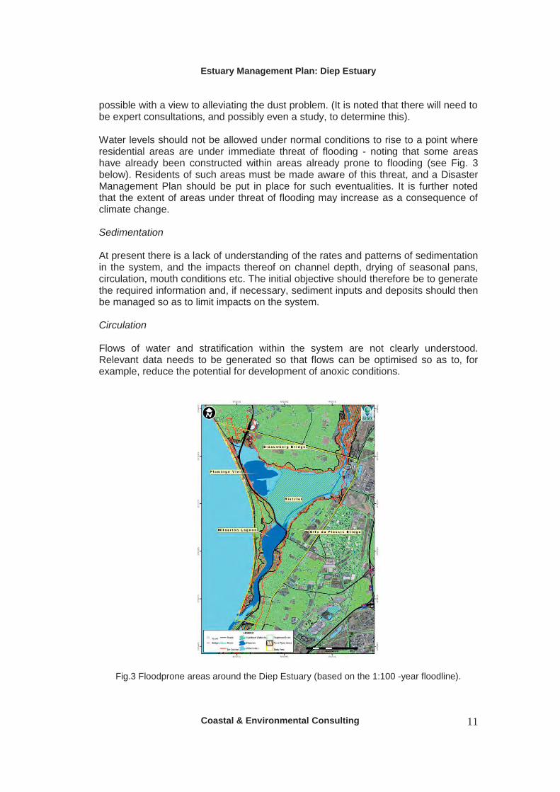
possible with a view to alleviating the dust problem. (It is noted that there will need to be expert consultations, and possibly even a study, to determine this). Water levels should not be allowed under normal conditions to rise to a point where residential areas are under immediate threat of flooding - noting that some areas have already been constructed within areas already prone to flooding (see Fig. 3 below). Residents of such areas must be made aware of this threat, and a Disaster Management Plan should be put in place for such eventualities. It is further noted that the extent of areas under threat of flooding may increase as a consequence of climate change. Sedimentation At present there is a lack of understanding of the rates and patterns of sedimentation in the system, and the impacts thereof on channel depth, drying of seasonal pans, circulation, mouth conditions etc. The initial objective should therefore be to generate the required information and, if necessary, sediment inputs and deposits should then be managed so as to limit impacts on the system. Circulation Flows of water and stratification within the system are not clearly understood. Relevant data needs to be generated so that flows can be optimised so as to, for example, reduce the potential for development of anoxic conditions.
Fig.3 Floodprone areas around the Diep Estuary (based on the 1:100 -year floodline).

Estuary Management Plan: Diep Estuary
Coastal & Environmental Consulting 12
Water quality The long term objective should be for the water quality to meet Resource Quality Objectives to be developed in terms of the National Water Act (1998) specifically for the Diep Estuary and covering i) the freshwater inflow from the river; and ii) the estuary itself. These will be based on socio-economic requirements and existing guidelines for freshwater or marine ecosystems and/or full contact recreation as appropriate. Interim targets for parameters of particular concern are outlined below. These will be reviewed halfway through the 5-year period of the Action Plan. Supplementary objectives are:
o that the number of accidental discharges of wastewater per year (i.e. sewage overflows from sewerage bockages and sewage pump stations) should be reduced through monitoring, maintenance and appropriate capital investment;
o to obtain a better understanding of the relative contributions of the different sources of pollution, in particular the stormwater drains.
Bacteriological targets
The Resource Quality Objectives for bacteriological parameters should be based on those for full contact recreation (especially given the high prevalence of HIV in the country, and the consequential lowered immune system of a substantial proportion of the population). The most important of these is E.coli, with others being Faecal coliforms and Enterococci as follows:
o E. coli – which are more specific to warm-bodied animals and show a high correlation with swimming-related gastric illness - with a target range of 0 – 130 counts (based on the DWAF South African Water Quality Guidelines: Recreational Use (2nd Edition, 1996)). To meet the target, the range should not be exceeded by the geometric mean of fortnightly samples over a three-month period.
o Faecal coliforms (including E.coli) – which are used as an indicator of general faecal contamination - for which the target range should be between 0 – 100 counts per 100 ml (based on the 1995 South African Water Quality Guidelines for Coastal Marine Waters). To meet this target, 80% of samples taken from the water body should fall within this range (i.e. less than 100 counts); and 95% of samples should be below 2,000 counts.
o Enterococci – there are currently no guidelines for South Africa, but guidance is obtainable from the Blue Flag Programme and/or World Health Organisation recommendations.
The bacteriological standards should be met in the northern section of Flamingo Vlei (which is zoned for recreational use) within 3 years (i.e. by the end of 2011).
There should be an improvement in the bacteriological quality of the water in the Milnerton Lagoon (also zoned for recreational use) over the next 3 years (to end of 2013) as follows: At present, only around 10% of the faecal coliform samples are < 100 counts/ 100 ml, while about 60% of the samples are < 2,000 counts/ 100ml. By 2013, 95% of the samples should be < 2,000 counts/100ml; and 50% of the samples should be < 100 counts/ 100ml.

Estuary Management Plan: Diep Estuary
Coastal & Environmental Consulting 13
Nutrient targets Target values need to be established for the Diep Estuary as part of the reserve determination process, and once there is greater clarity on the discrepancy between target and current actual values, a time-frame can be developed for the achievement of the target values. In the interim, the following targets are proposed:
The current guideline on dissolved inorganic nutrients for marine aquatic ecosystems is: “Waters should not contain concentrations of dissolved nutrients that are capable of causing excessive or nuisance growth of algae or other aquatic plants or reducing oxygen concentrations below the target range..”(see below).
The Coastal Water Quality Guidelines provide a more specific guideline for Total Ammonia-N – namely 600 ug/l - while the freshwater guideline for unionized ammonia (NH3) is < 7 ug/l (DWAF, 1996). More recent guidelines developed through the Reserve Determination methodology suggest that values of 0.015 – 0.058 mg/l (or 15 – 58 ug/l) are good.1 It is therefore proposed that this be adopted as the target range for the Diep Estuary.
The DWAF Water Quality Guidelines: Aquatic Ecosystems provide a guideline for inorganic nitrogen (NH3 + NH4 + NO2 + NO3) which states that i) concentrations should not deviate by more than 15% from that of the local water body; ii) the trophic status of the water body should not be increased; and iii) that the amplitude and frequency of natural cycles should not be changed. The Guidelines also state that concentrations below 0.5 mg/l are indicative of oligotrophic conditions, 0.5 – 2.5 mg/l mesotrophic, and 2.5 – 10 mg/l, eutrophic. However, according to Taljaard (pers. comm..) although only limited data is available for estuaries in South Africa, concentrations of 1 – 2 mg/l were sufficient to stimulate dense macrophyte growth in the Sundays River. Moreover, recent guidelines developed through the Reserve Determination methodology equate values of 0.25 – 1 mg/l with good conditions, and it is proposed that this be adopted as the target range for the Diep Estuary.
Phosphorus occurs in a number of forms, of which Soluble Reactive Phosphate (SRP) or orthophosphate is immediately available to aquatic biota. The recent guidelines developed through the Reserve Determination methodology suggest that values of between 0.005 – 0.025 mg/l (or 5 – 25 ug/l) indicate good conditions, and it is proposed that these be adopted as the target value for the Diep Estuary.
Dissolved oxygen The current guideline on dissolved oxygen for marine aquatic ecosystems is: “For the east coast, the dissolved oxygen level should not fall below 10% of the established natural variation. For the south and east coasts the dissolved oxygen should not fall below 5 mg/l 99% of the time, and below 6 mg/l 95% of the time.” The recent guidelines developed through the Reserve Determination methodology suggest that
1 Information on the guidelines from the Reserve Determination process provided by Candice Haskins.

Estuary Management Plan: Diep Estuary
Coastal & Environmental Consulting 14
values of between 6 – 8 mg/l are good, and it is proposed that these be used as the general target range for the Diep Estuary. For the north and south lakes (Flamingo Vlei), which reach a depth of around 10 metres in places, and where there is likely to be stratification in the water body, it is recommended that a target of 6 mg/l to a depth of 2 metres for 100% of the time be adopted. Salinity Target values for salinity also need to be determined for critical species. For example, Callianassa requires a salinity of at least 17 ppt to breed successfully. Soil salinities, together with inundation, are also important for macrophyte growth. Sarcocornia perennis, for example, has been found to grow best in water-saturated soil at salinities between 0 and 15 ppt (Adams and Bate, 1994). Biological criteria In general, the water quality should be sufficient to support all biological communities. More specifically, it should allow for:
The re-establishment of primary producers (such as Zostera) and benthic invertebrates such as Callianassa in the lagoon;
Improved water quality and the recovery of the benthos (which are a food source for fish) should also see the juveniles of species such as the White steenbras and Cape stumpnose re-entering the estuary.
In the south lake, water quality should be sufficient to support Galaxius zebratus.
At the same time 2:
Chlorophyll a levels (which are a measure of phytoplankton growth/eutrophication) should not create nuisance conditions or produce surface scums. Mean annual concentrations should be < 15 ug/l (DWAF Water Quality Guidelines).
Cyanobacteria (toxic blue-green algae) should be at levels < 6 blue-green units3 (DWAF WQ Guidelines), and < 10 ug/l of cyanobacterial toxins (microcystin toxin) (WHO recreational guidelines).
3.2.3 Sediment quality
A number of previous reports have referred to erosion in the catchment and siltation in the lagoon and other parts of the system. More recently there have also been reports of significant accumulations of organic material on or near the bottom. Apart from possible impacts on circulation, mouth conditions etc, sediments tend to be a
2 Candice Haskins and Robert Siebritz – pers. comm.. 3 This refers to the number of blue-green units (colonies and filaments) counted in a two-minute scan of 0.5 mR of water at x 200 magnification.
Estuary Management Plan: Diep Estuary
Coastal & Environmental Consulting 15
sink for contaminants with consequential impacts on bottom-dwelling organisms. It is therefore also important to quantify and manage sediment quality. The following objectives are proposed for sediment quality:
Sediment quality objectives should be developed and implemented. These should be based on current international practice (see guidelines developed under BCLME), and should include bacteriological parameters.
The sediments should be restored as far as possible to their original condition (eg. particle size distribution, organic content etc).
Bacteriological loads in the sediments should not pose a threat to human health.
From a biological perspective, the sediment quality in the lagoon should be sufficient to allow the re-establishment of benthic invertebrates such as Callianassa.
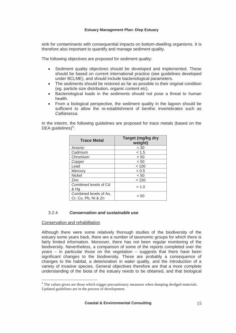
In the interim, the following guidelines are proposed for trace metals (based on the DEA guidelines)4:
Trace Metal Target (mg/kg dry weight)
Arsenic < 30 Cadmium < 1.5 Chromium < 50 Copper < 50 Lead < 100 Mercury < 0.5 Nickel < 50 Zinc < 150 Combined levels of Cd & Hg < 1.0
Combined levels of As, Cr, Cu, Pb, Ni & Zn < 50
3.2.4 Conservation and sustainable use Conservation and rehabilitation Although there were some relatively thorough studies of the biodiversity of the estuary some years back, there are a number of taxonomic groups for which there is fairly limited information. Moreover, there has not been regular monitoring of the biodiversity. Nevertheless, a comparison of some of the reports completed over the years – in particular those on the vegetation – suggests that there have been significant changes to the biodiversity. These are probably a consequence of changes to the habitat, a deterioration in water quality, and the introduction of a variety of invasive species. General objectives therefore are that a more complete understanding of the biota of the estuary needs to be obtained, and that biological
4 The values given are those which trigger precautionary measures when dumping dredged materials. Updated guidelines are in the process of development.

Estuary Management Plan: Diep Estuary
Coastal & Environmental Consulting 16
communities should be restored to as close to original species composition and structure as possible, noting that this may not always i) be possible to determine (given that the system has been compromised over a period of > 300 years); and ii) be practical in the current urban context. More specific objectives include:
The restoration of Strandveld in relevant parts of the reserve. The stabilization of the shorelines of the central pans and the north lake. Restoration of primary producers, benthic invertebrates (Callianassa
communities) and fish in the lagoon. The development and implementation of an invasive species management
plan for the reserve covering the eradication of alien species where possible, and where this is not possible, their control. The plan should also include provisions for the control of invasive indigenous species as appropriate.
Human use of the estuary/ reserve
The Diep Estuary is important from both conservation and socio-economic perspectives, the latter primarily due its aesthetic value and the recreational opportunities it affords in an area close to the City centre. Management initiatives must take account of both aspects, with objectives being:
An appropriate balance between conservation and sustainable use of the system.
Use of the estuary and adjacent terrestrial areas within the reserve for non-consumptive purposes such as recreation should not further compromise the biological integrity of the system, and should be limited to specific zones.
Resource exploitation Consumptive use of resources within the estuary is relatively limited. Nevertheless, the exploitation of natural resources that does occur – for example, fishing and bait collection – should be limited to specific zones and seasons to ensure that such exploitation is sustainable. Education and awareness-raising Public awareness is essential for the effective implementation of environmental programmes, and the Rietvlei Education Centre offers an ideal opportunity to build awareness of a variety of environmental issues, in particular, the role of wetlands and estuaries. Existing programmes should be expanded and facilities upgraded.

Estuary Management Plan: Diep Estuary
Coastal & Environmental Consulting 17
4 ZONATION IN THE RIETVLEI WETLANDS RESERVE Rietvlei was first designated as a Nature Area in 1984, later becoming a Protected Natural Environment under the Environment Conservation Act (1989) and then the NEM: Protected Areas Act (2003). This was largely on the strength of its regional importance as a habitat for waterbirds ranking in the top ten of South Africa’s largest estuaries. It is listed as an Important Bird Area by Birdlife International, and consideration has been given to applying for Ramsar status for the area with the wetland being of international importance for at least four bird species. At the same time:
Development of the surrounding areas has continued to encroach into areas which fall within the 100-year floodline of the estuary; and historical records show that parts of the estuary have been utilized for
recreational purposes for over a century, and today there is a well-established aquatic club on the north lake, as well as a canoeing club on the lagoon. Its establishment as a Nature Reserve, and the construction of an Education Centre and related facilities, has also encouraged walking, bird-watching, picnicking etc. In addition, there is limited bait collection and fishing. The objectives of this management plan therefore include:
the prevention of any further inappropriate development/land-use within the reserve; and the achievement of an appropriate balance between conservation and
sustainable use of the Nature Reserve and estuary. An important tool in achieving these objectives is zonation. This term can be applied to the designation of particular areas or zones for specific developmental or land-use purposes or to the delineation of different zones for specific visitor uses. Both of these approaches have been applied to the reserve/estuary and are discussed further below.
4.1 City of Cape Town Guidelines The City of Cape Town has recently developed Guidelines for Land Use Zoning for Nature Reserves and Conservation Areas.5 These guidelines make provision for the following land-use zones and associated conservation objectives:
Primary Conservation: Natural areas should be kept intact in order to protect habitat required to meet biodiversity targets for various vegetation types and to provide undisturbed habitat for a range of species. Where possible degraded areas should be rehabilitated.
Conservation: Natural areas should be kept intact in order to protect habitat required to meet biodiversity targets for various vegetation types and to provide
5 The name of the current Table is actually Guidelines for Visitor Use Zoning, but according to Arne Purves this should be corrected.

Estuary Management Plan: Diep Estuary
Coastal & Environmental Consulting 18
undisturbed habitat for a range of species. Where possible degraded areas should be rehabilitated.
Low Intensity Leisure: Although some areas will be impacted by a range of activities and limited infrastructure, most areas should be kept largely intact and ecological processes should remain functioning. Where possible degraded areas should be rehabilitated.
High Intensity Use: The activities and infrastructure in these areas should be managed to minimize impacts on biodiversity and visitor experience in other zones. Where feasible, non-crucial infrastructure should over time be removed from the reserve and the sites rehabilitated.
Utility Zones: The activities and infrastructure in these areas should be managed to minimize impacts on biodiversity and visitor experience in other zones. Where feasible, non-crucial infrastructure should over time be removed from the reserve and the sites rehabilitated.
Based on these, the City has proposed the following zones for the Rietvlei Wetlands Reserve:
Fig. 4: Developmental/land-use zones in the Rietvlei Wetlands Nature Reserve

Estuary Management Plan: Diep Estuary
Coastal & Environmental Consulting 19
As can be seen from the map, the majority of the area of the reserve is designated for conservation. High intensity use is restricted to the northern part of Flamingo Vlei where there are facilities which support boating, educational and other recreational activities.
4.2 Visitor Use Zones in the Rietvlei Wetlands Reserve The City guidelines make recommendations on the type of activities, frequency of use, group size, sophistication and type of facilities, user movement/transport and roads and footpaths which are considered appropriate to each category. The specific details however, may vary from one reserve to the next, and the activities allowed in the various different parts of the Rietvlei Wetlands Reserve are outlined below and in Fig. 5.
4.2.1 Closed areas or sanctuaries These are areas where no human disturbance is permitted, and includes the southern part of Flamingo Vlei and the seasonal pans, both of which are important as sanctuaries for birds. This area comprises 357.94 ha or 44% of the total area of the estuary.
4.2.2 Low intensity Use In these areas only low impact activities such as bird-watching and walking are allowed. They include the entire upper lagoon, as well as a number of strips bordering the sanctuary thus providing some sort of buffer between parts of the sanctuary and developed areas. This covers 128.69 ha, or 15.9 % of the total area.
4.2.3 Medium Intensity Use Areas Within the reserve, there are 3 different types of low intensity use areas, based on the characteristics of the area and/or use:
a) The terrestrial areas along the eastern bank of north lake, and the western bank of the river just below Blaauberg Bridge. Activities in these areas include picnicking, bird-watching, walking and fishing.
b) The lower lagoon (below the wooden bridge), where canoeing, bait collection and swimming are allowed – the latter only when water quality permits.
c) The area within the Sanctuary just to the east of Otto du Plessis Drive (and adjacent to Sunset Beach) which is used for model aircraft flying. It is noted that this zone is temporary, and will be discontinued in 2014 when the permit expires, at which time this will be incorporated into the sanctuary area.
Together these make up 30.97 ha or 3.8% of the total.

Estuary Management Plan: Diep Estuary
Coastal & Environmental Consulting 20
Fig. 5. Visitor Use Plan for the Diep Estuary.
4.2.4 High Intensity Use areas High intensity use is limited to the north lake of Flamingo Vlei, where power-boating, water-skiing, and sailing are allowed. Limited fishing is also allowed on specifically designated open days. The lake covers 54.51 ha, or 6.73 of the total area.
Estuary Management Plan: Diep Estuary
Coastal & Environmental Consulting 21
5 MANAGEMENT STRATEGIES
5.1 Management of water quantity and quality The prevailing national strategy for managing the water quantity and quality requirements of aquatic ecosystems is through the determination of Reserves and Resource Quality Objectives. These are provided for in the National Water Act (Act 36 of 1998) and the National Water Resource Strategy, and are intended to be implemented through Catchment Management Strategies and Agencies. However, neither the Reserve, nor Resource Quality Objectives have as yet been determined for the Diep River or Estuary. Nor has a Catchment Management Strategy been developed. National policies on pollution and waste management are also pertinent to water quality. The policies of both DEA and DWA are intended to promote the precautionary approach and a hierarchy of management steps starting from pollution prevention and minimisation. Moreover, the operational policy for the disposal of wastewater derived from land (adopted by DWAF in 2004) espouses a Receiving Water Quality Objectives Approach rather than one based on effluent standards. The policy further states that:
i) the disposal of wastewater into sensitive areas (such as estuaries) will not be considered, except in exceptional circumstances;
ii) wastewater discharges that were existing on 31 May, 2004 (when the policy was adopted) should be re-evaluated during a 5-yearly licence-review process;
iii) revisions can also be motivated on the grounds of negative impact on the environment and non-compliance with licence conditions.
These policies have not yet been applied to the management of water quality in the Diep Estuary. In fact, despite the serious deterioration of water quality in the system, the Western Cape Department of Environmental Affairs and Development Planning (DEA & DP) on the 3rd August, 2010 issued a Record of Decision giving their approval for the further expansion of the Potsdam Wastewater Treatment Works without placing any specific restrictions on disposal of the effluent. While disposal of the effluent would be regulated by a permit from DWA , this raises an urgent need to investigate alternative options for such disposal (other than discharge into the estuary).
5.1.1 Water quantity There is general consensus that given the history of changes to and around the Diep Estuary caused by historical and ongoing urbanization, the system will never be able to function naturally and there is therefore a need for management interventions to ensure that there is an appropriate balance between runoff from the catchment, inflow from other sources, drainage from the system, and evaporation. There is also general agreement that increasing the salinity in the system – which is now freshwater dominated as a consequence of the changes - could have a number of benefits, and that this must be taken into account in developing a management regime. At the same time, the information available on the system is insufficient to develop a comprehensive and effective water quantity management strategy. There

Estuary Management Plan: Diep Estuary
Coastal & Environmental Consulting 22
is therefore an urgent need for a number of studies to, amongst other things, properly quantify the inputs and losses to and from the system, and to determine the ecological reserve for the estuary. Information requirements Of the studies proposed, only the topographic survey and development of a Digital Elevation Model (DEM) have been completed, with the following still being required:
i) A study of the hydrology of the estuary needs to be undertaken in order to
get a clear understanding of the water balance in the system, including any seasonal variations therein. This will require an accurate determination of all flows into (from the river, groundwater, stormwater and effluent) and out of the system. The data will be obtained from:
o Existing DWA flow stations; o Planned and completed studies on stormwater which include an
assessment of flows; o A determination of the groundwater contribution to the river base
flow; o Water level and salinity recorders in the lagoon (at the
Woodbridge Island Bridge), to supplement the existing ones in Rietvlei and at the Otto du Plessis Bridge.
All recorders must be properly maintained, and data downloaded on a regular basis. Once complete, the study should be able to recommend an optimal water balance.
ii) A study of the geohydrology of the estuary is required to determine groundwater flow directions, groundwater gradients, groundwater depths and seasonal fluctuation, as well as groundwater quality variation. The groundwater underpins the surface hydrology dynamics and plays a crucial role in the management of the desiccation of the central pans in summer. The geohydrological study will require the installation of at least 8 piezometers throughout the study area. The piezometers should be equipped with water level and water quality data loggers which then need to be read at regular intervals. The piezometer water level data will also provide valuable input into assisting with the understanding of surface water dynamics. (At certain times of the year the piezometers may well be flooded).
iii) A study of the patterns of stratification in the deep water lakes needs to be undertaken so as to have a better understanding of their contribution to the development of anoxic conditions.
iv) A study of the quantity and quality of sediments and the rate of sedimentation needs to be undertaken (including core sampling of sediments) with a view to determining their impact on drainage patterns and the dust problem, as well as on the environmental health of the system. Sediments act as a sink for pollutants which can be re-released into the water column under certain conditions.
v) GIS based mapping of all historical aerial photos to measure possible changes in the extent and duration of the drying of the seasonal pans.
vi) A study on the ecology of the central pans – and especially those species which are the main food sources of the wading birds – to determine

Estuary Management Plan: Diep Estuary
Coastal & Environmental Consulting 23
optimal seasonal cycles from an ecological perspective. In particular, the requirements of the Palearctic waders must be taken into account.
vii) Ultimately, a comprehensive reserve determination in terms of Chapter 3, Parts 2 and 3 of the National Water Act (1998) needs to be undertaken, noting that some of the above studies will contribute to this process.
viii) The above data needs to be compiled and collated so that a hydrodynamics model can be established to optimize the various management options available.
Interim management measures In parallel with the above-mentioned studies, it is proposed to implement some interim measures to alleviate current problems until longer-term solutions can be found. These include: Reduction/manipulation of flows from Potsdam Since the establishment of the channel along the east bank of Rietvlei(1991/92), the estuary has become increasingly freshwater dominated, as can be seen by comparing the salinities at Otto du Plessis Bridge in 1988 and 2001/02 (Fig. 6 below). In summer, with the river effectively drying up, the flow is made up predominantly of the effluent from Potsdam. Amongst other things, this has to a large extent eliminated the seasonal fluctuations in flow into the lagoon, and as a result, the mouth no longer closes. This is probably exacerbated by the increased sedimentation in the lower lagoon which further limits tidal penetration.
CSIR 1988 survey- summer
01020304050
N7 Bridge
Blaauw
berg
Bridge
Potsda
m
Theo M
arais
MAC Jetty
Baysid
e Cana
l
Otto du P
lessis
Woodbri
dge Is
land
Mouth
Series1
Salinities at Otto du Plessis Bridge 2001/02
00.5
11.5
22.5
33.5
Nov
Dec Ja
n
Feb
Mar
ch
Apr
il
May
June
July
Aug
Sep
t
Oct
Series1
Figs 6 a and b: (a) Salinities in the Diep Estuary during a CSIR survey in the summer of 1988;
and (b) Salinities at Otto du Plessis Bridge in 2001/02. The capacity of Potsdam has recently been increased from 32 to 47 Ml/day and would be further increased to 100 Ml/day should the most recent proposal go ahead. At the same time, an increasing amount of the effluent is now being re-used – up to 20 Ml/day over the summer months since January 2006 (see Fig. 7 below). During those periods, the effluent discharge to the estuary is at times reduced to around 15 Ml/day. However, a monitoring programme undertaken between January and March, 2010 – which looked at the correlation between daily volumes of effluent discharged, salinity at two points in the estuary, and tidal height – suggested that discharges would need to be reduced to at least 10 Ml/day in order to achieve a significant increase in salinity in the estuary. Even then, the ingress of salt water is only likely to reach the Otto du Plessis Bridge at high spring tides. While the monitoring

Estuary Management Plan: Diep Estuary
Coastal & Environmental Consulting 24
programme was of limited duration, the conclusions are supported by the study done by WAM Technology in 2004, which suggested that flows from Potsdam could be reduced to 8 Ml/day before the mouth would be affected.
POTSDAM WWTW - Monthly inflow and reuse
0
10
20
30
40
50
60
Jan-
03
Apr
-03
Jul-0
3
Oct
-03
Jan-
04
Apr
-04
Jul-0
4
Oct
-04
Jan-
05
Apr
-05
Jul-0
5
Oct
-05
Jan-
06
Apr
-06
Jul-0
6
Oct
-06
Jan-
07
Apr
-07
Jul-0
7
Oct
-07
Jan-
08
Apr
-08
Jul-0
8
Oct
-08
Ml/d
Average DAILY inflow Average Daily Reuse Balance to Diep River
Fig. 7. Average daily flows of effluent from the Potsdam WWTW. It is therefore proposed that a programme for the further reduction of effluent discharges from Potsdam be developed in collaboration with Water and Sanitation Services. Initially this should focus on trying to achieve such reductions on dates coinciding with high spring tides of the summer months. The necessity for these measures may fall away should an alternative disposal option be identified and implemented. Flows from the catchment The flow-guaging station at Vissershok, which was operational between May 1967 and May 1982 recorded a Mean Annual Runoff of 44.4 million m3. This was replaced by the guage at Adderley, which has been operational since 1998, and has recorded a Mean Annual Runoff of 40.17 million m3. Both show significant variations from year to year, as well as between seasons(see Figure 8 below) Of significance for the estuary, and the proposed management of flows, is that flows from the river during the summer months are effectively zero.

Estuary Management Plan: Diep Estuary
Coastal & Environmental Consulting 25
Total annual flows (million m3) at Adderley on Diep River
020406080
100120
1999 2000 2001 2002 2003 2004 2005 2006 2007
Fig. 8 (a) Variations in annual flow from the Diep River.
Average monthly volumes (million m3) Diep River at Adderley 1998 - 2008
0
5
10
15
20
Jan Feb Mar April May June July Aug Sept Oct Nov Dec
Fig. 8 (b) Seasonal fluctuations in the flow in the Diep River.
Although not immediately apparent from the above graphs, there have been suggestions that the runoff from the catchment has been reduced in recent years as a result of an increasing number of farm dams amongst others. The capacity of such dams, and their impact on flows, needs to be investigated as part of a Catchment Management Strategy. Other measures to be included in such a strategy include:
Clearing of alien plants along the river channel, especially gum trees The promotion of appropriate agricultural practices to reduce infestation of
invasive alien species.
Stormwater flows The Stormwater Master Plan for the areas north of Rietvlei is in line with the City’s Policy on Minimising the Impact of Stormwater from Urban Development on Receiving Waters, and promotes measures which facilitate the retention and infiltration of stormwater close to source. This should be implemented with a view to reducing stormwater flows into the estuary.

Estuary Management Plan: Diep Estuary
Coastal & Environmental Consulting 26
Management of water levels Dust problem While there is insufficient data at this stage to prove it, there have been suggestions from a variety of sources (including a specialist study conducted during the development of the 1994 Rietvlei Management Plan) that the construction and ongoing maintenance of the bypass channel along the east bank in 1991/92 has increased the rate of drainage of Rietvlei during the dry summer months by lowering the water table. This is further exacerbated by the channels which have been dug at a number of the stormwater discharge points along the boundaries of the vlei. And although the central pans have always dried out – and indeed need to go through seasonal changes in water levels to maintain their ecological function – the extent of this phenomenon may have been altered. Whether this is true or not, the dust emanating from the dry pans is a problem to residents in the area. It is therefore proposed that measures be introduced to manage the water table with a view to limiting the rate and extent of drainage from the vlei, BUT within the constraints of the ecological requirements of the wetland (which still need to be determined). Once the ecological requirements have been established, a mechanism which will allow management of the water table will be developed and implemented. As far as possible, this should be based on natural, sustainable solutions (i.e. costly engineering solutions to be avoided), and may include the partial or complete filling in of the Potsdam bypass and stormwater channels. In the interim, it is proposed:
i) that the maintenance excavations of these channels be discontinued, at least in certain sections; and
ii) the pumping of water from the northern lake onto the pans when they start to dry out in January should continue until a more permanent solution is found.
Flooding Residents in areas which fall within the 1:100 -year floodline must be made aware of this fact, and a Disaster Management Plan must be put in place to facilitate response during a major storm event.
5.1.2 Water quality The data from the City’s water quality monitoring programme shows that the water quality for most of the system – with the possible exception of the Flamingo Vlei area – is unacceptably poor in comparison with existing guidelines, particularly with regards to bacteriological contamination and nutrients. Fig. 9 below for example, shows that the water in Milnerton Lagoon has not been suitable for contact recreation since at least 2001, while Fig. 10 shows that the majority of Total Nitrogen samples at the Otto du Plessis Bridge are at levels indicative of eutrophic or hypertrophic conditions. This suggests that current management efforts are ineffective.

Estuary Management Plan: Diep Estuary
Coastal & Environmental Consulting 27
Woodbridge Island: % of samples with faecal coliforms < 100 and < 2,000
01020304050607080
2001 2002 2003 2004 2005 2006 2007 2008 2009
% < 100% < 2,000
Fig. 9. Bacteriological quality of water at Woodbridge Island.
Nutrient levels (mg/l) at Otto du Plessis Bridge
0
5
10
15
20
25
30
1999
2000
2001
2002
2003
2004
2005
2006
2007
2008
2009
NoxNH3Total NHypertrophic Eutrophic
Fig. 10. Levels of nitrates and nitrites (Nox), Ammonia (NH3) and Total Nitrogen in mg/l at
Otto du Plessis Bridge. Values for Total Nitrogen > 2.5 are indicative of eutrophic conditions, and > 10 are indicative of hypertrophic conditions.
This situation needs to be addressed by the development of Resource Quality Objectives specific to the system, and the application of pollution prevention/ minimisation measures to each of the sources of pollution with a view to achieving these objectives. The sources include:
Inflow from the river (which carries pollution from a variety of sources in the catchment)
Potsdam and related infrastructure Stormwater Informal settlements and low-cost housing areas
The relative contribution of each of these sources also needs to be determined so that prevention efforts can be prioritized. Setting of Resource Quality Objectives The development of Resource Quality Objectives is provided for in Chapter 3, Parts 2 and 3 of the National Water Act (1998). The RQO should include target values for i) the freshwater inflow from the river; and ii) the estuary itself. These will be based
Estuary Management Plan: Diep Estuary
Coastal & Environmental Consulting 28
on existing guidelines for natural environments and/or recreation and, where appropriate, should elaborate interim targets for parameters of particular concern and a timeline for their achievement. Pollution Prevention/ minimisation Although the monitoring programme being undertaken by the City has provided an insight into the water quality of the estuary, many of the various sources of pollution still need to be properly quantified so as to obtain a better understanding of their relative contributions to the overall pollution load. This requires expanding and improving data collection on flows and contaminant levels, especially for stormwater drains. To date, the only in depth study which has been conducted on stormwater has been on the Bayside Canal, although a study of those on the East Bank was initiated in 2009 and is nearing completion. In the interim, steps should also be taken to start reducing or, where possible, preventing the pollution at source.
i) Potsdam
During the summer months, when there is little or no flow from the river or stormwater drains, Potsdam is the primary source of water in the estuary. Thus the quality of the Potsdam effluent has a significant influence on water quality in the estuary during summer, if not the whole year round. The effluent standards for Potsdam are set out in a permit issued by the Department of Water Affairs and Forestry in 2000 (and which effectively expired in 2004). A new permit is currently being processed by DWA as part of the current Potsdam expansion from a capacity of 32 Ml/day to 47 Ml/day, and could include a tightening of standards, although according to the DWA operational policy, they should, in fact, be moving to a management regime based on Receiving Water Quality Objectives. The latter have, however, yet to be determined for the Diep Estuary, although interim objectives have been proposed in this document (see Section 3.2.2). The current permit requires the effluent to meet the General Standard for most parameters. It is also required to meet the Special Standard for Phosphate (Section 21 (1)(a) of the National Water Act. Exceptions are made for Nitrate/Nitrite as Nitrogen, which is set at 10 mg/l, and Faecal coliforms, which are set at 1000 counts/100 ml. Given that during the summer months there is effectively no dilution of the effluent, and the permitted levels exceed the water quality guidelines, any improvement in the situation would require a significant reduction in the permitted levels in the new permit. On top of this, over the past few years – during the expansion process – Potsdam has not been able to meet many of these standards. For E. coli, for example, although the situation appeared to improve considerably in the latter half of 2008 and 2009, the effluent still regularly exceeds the standard and is, in fact, again showing an upward trend (see Figs 11(a) and (b) below).

Estuary Management Plan: Diep Estuary
Coastal & Environmental Consulting 29
E. coli counts in Potsdam effluent
0
10,000
20,000
30,000
40,000
50,000
2006 2007 2008 2009
E. coli counts
Fig. 11 (a) Average annual E.coli counts in Potsdam effluent.
1000008705 - CCT-POTSDAM-JOINT DISCHARGE FROM ACT SLUDGE & BIO PLANTS
ESCHERICHIA COLI For Monitor WC-DWAF-BERG-WQM/WRM2009-02-25 to 2010-04-22
Real Data Trend (order=1)
2010-03-232010-01-222009-11-232009-09-242009-07-262009-05-272009-03-28
8,0007,5007,0006,5006,0005,5005,0004,5004,0003,5003,0002,5002,0001,5001,000
5000
Fig. 11 (b) E.coli counts in Potsdam effluent for 2009/10 (provided by DWA).
This is of particular concern given the recent developments in relation to the investigation into WW Treatment expansion options for the broader Blaauwberg area, namely the Record of Decision issued by DEA & DP to further increase the capacity of Potsdam to 100 Ml/day. Such an expansion, with an associated increase in the volumes of effluent being discharged into Rietvlei, would lead to a further significant deterioration in the water quality. On the other hand, such an expansion combined with an alternative disposal system (i.e. one which does not involve discharging the Potsdam effluent into Rietvlei), could ultimately see a significant improvement in the water quality of the estuary. It is therefore critical, since this was not addressed in the EIA, that alternative disposal options for the effluent from Potsdam be investigated before any final decisions are taken.
ii) Sewerage infrastructure in the Milnerton/ Blaauberg area. There have been a number of accidental spills of sewage into the estuary
via the stormwater system which have had serious consequences for the biodiversity (and have health implications). These are the result of either blockages in the sewerage infrastructure in the catchment area or

Estuary Management Plan: Diep Estuary
Coastal & Environmental Consulting 30
malfunction of the sewage pump stations. The following actions are proposed to address these problems:
Sewerage blockages
The causes of these blockages are varied but in many cases are illegal discharges into the sewerage system. A system of recording and managing these blockages is being developed with a view to instituting preemptive maintenance and thereby a reduction of sewerage blockages.
Pump stations
All pump stations are monitored via a telemetry system and pump station malfunctions are generally expeditiously attended to without significant spillages. However, there have been significant spillages when telemetry systems fail and power outages occur. All the major pump stations adjacent to the estuary have therefore been equipped with standby generator sets. Minor pump stations will be serviced by mobile generators.
Reporting and response to spillages
Any significant spillages from either blockages or pump station malfunctions should immediately be reported to the Reserve Manager. They should then be treated and cleaned up using appropriate methodologies in consultation with Reserve staff.
iii) Stormwater drains. The City’s policy on minimizing impacts of stormwater on receiving waters
– based on the concepts of Water Sensitive Urban Design and Sustainable Urban Drainage Systems - needs to be implemented. This includes the development of structural and non-structural best management practices for stormwater – such as retention ponds, vegetated swales, infiltration basins, bioretention cells, education, stormwater master planning etc, which are implemented at site or regional level as appropriate.
In addition, the flows and pollution loads of all existing stormwater
discharges into the estuary need to be quantified and those having the greatest impact should be addressed. As mentioned above, the study on the stormwater drains along the eastern bank of the estuary is nearing completion, following which the recommended solutions should be implemented.
Following an earlier study, a number of proposals were made for managing the stormwater in the Bayside Canal – including the construction of an off-channel riparian reedbed for the treatment of stormwater low flows (chiefly suspended solids and attached pollutants) in undeveloped land immediately south of Parklands Main (Link) Road,

Estuary Management Plan: Diep Estuary
Coastal & Environmental Consulting 31
structural changes to increase the capacity of the canal and the introduction of litter management structures and practices. While implementation of these proposals was initiated during 2009/10, as of September 2010, these had not yet been completed. This needs to happen as soon as possible, following which they should be properly maintained.
Stormwater management systems on sites supporting industrial activities
need to be inspected on a regular basis, and the policing of illegal discharges into stormwater drains needs to be improved.
Litter traps need to be placed on all stormwater discharges unless there is
a strong chance of serious backflooding They should then be properly maintained to prevent litter, especially plastics, from entering the system.
iv) Informal settlements and low-cost housing areas
There are a number of informal settlements and low-cost housing areas in
the area – some between the Blaauberg and N7 bridges – which have a significant impact on water quality via stormwater or direct runoff. These include Doornbach, Du Noon, Joe Slovo and Phoenix. The problem in low-cost housing areas is a consequence of both malfunctioning plumbing and the presence of backyard shacks without plumbing.
Doornbach is near Killarney and is right on the bank of the river. There
are some chemical toilets on the edge of the area, but they are seldom used. Moreover, there are no roads and so it would not be possible to service toilets further into the settlement. Pressure needs to be put on relevant authorities to upgrade the area to a formal settlement – and in doing so, create a buffer zone along the river bank.
Stormwater from the Du Noon area discharges to the river above the
Blaauberg Bridge, while Joe Slovo and Phoenix drain via the Erica Road stormwater drain, reaching the estuary opposite the tennis courts at Milnerton High. These have been addressed as part of the project on stormwater drains along the east bank.
It is also proposed to have an education/awareness-raising campaign
emphasizing the health related problems around water and sanitation. This will be implemented in collaboration with the Department of Water Affairs, which has significant experience in this area.
v) Pollution sources in the river catchment There are a variety of sources of pollution in the catchment, including:
Waste-water treatment works (eg. Fisantekraal, Malmesbury) – and it is noted that the Malmesbury WWTW is currently not meeting the required standards.

Estuary Management Plan: Diep Estuary
Coastal & Environmental Consulting 32
Stormwater from urban areas (formal and informal – eg. on the Mosselbank)
Agriculture ( runoff of fertilizers, pesticides etc, as well as discharges and runoff from eg. dairy farms). Many farms allow cattle to drink from the river which results in significant trampling, erosion and also contributes to pollution due to fouling of the water by cattle manure.
Mining.
These all affect the water quality of the inflow from the river to the estuary, and need to be addressed as part of a Catchment Management Plan.
Mitigation measures Reed beds act as sinks, and can be used to reduce nutrients in flows entering aquatic environments. However, this is not necessarily true for all situations. Moreover, their effectiveness tends to reduce over time, and the reedbeds therefore need to be managed – eg. harvested and removed for composting, burned etc. The reedbeds in the Diep Estuary have expanded significantly in recent years, and are a nuisance in some areas. A proper plan for their management needs to be developed and implemented. Aerators could be used in emergency situations to prevent anoxic conditions from developing. They would need to be used in combination with an appropriate monitoring system which would provide early warning of such conditions.
5.1.3 Sediment quantity and quality While it is generally agreed that there have been and are considerable amounts of sediment entering the estuary from the catchment and other sources, this has not been quantified. It is therefore proposed that a series of sediment cores across the system should be taken to determine rates and quantities of sediment input from the catchment and other sources. These could also be used to determine historical patterns of salinity in the system. In the interim, some preliminary work has been done in the catchment on guidelines for setback distances/conservation corridors with a view to reducing the silt load entering the estuary as a result of poor agricultural practices. These guidelines need to be further developed and implemented as part of a Cathcment Management Strategy. Until relatively recently there had also not been any studies on the quality of the sediments or levels of bioaccumulation into the biota in the estuary since the work by Taljaard et al in 1992. However, in 2009, Jackson et al published a report on an investigation into levels of a range of metals in water and sediment samples from the Plankenburg and Diep Rivers which indicated high levels in both, with those for water exceeding the DWAF Water Quality Guidelines. In 2009/2010, DEA & DP funded a survey of heavy metal concentrations in the sediments and biota of the Diep and Berg estuaries, with biota including fish and invertebrate species. The results
Estuary Management Plan: Diep Estuary
Coastal & Environmental Consulting 33
indicated that trace metal concentrations in sediments from both the Diep and Berg estuaries exceeded relevant South African and international sediment quality guidelines at many stations – a significant increase over the levels found by Taljaard et al (1992). The concentrations of trace metals in biota (fish and invertebrates) were also high in most of the samples analysed and exceeded the South African legal limits for foodstuffs for a number of species commonly consumed by locals, including mullet (Liza richardsonii), Mozambique Tilapia (Oreochromis mossambicus), Banded Tilapia (Tilapia sparrmanii) and carp (Cyprinus carpio). Some 8 tonnes of fish are estimated to be harvested from the Rietvlei/Diep system annually, and it is important that those communities who might be consuming this fish are made aware of the potential health impacts. It is also recommended that surveys of heavy metals – and other potential contaminants – in the sediments and biota are conducted on a regular basis.
5.1.4 Monitoring
The City’s water quality monitoring programme – funded by the Catchment, Stormwater and River Management Branch - should be supplemented with annual surveys (or at least, every second year) of heavy metal levels in sediments and biota. If possible, these surveys should include a broader array of toxic constituents as well as bacteriology. The biological monitoring should include indicator species such as the sandprawn, other invertebrates, fish and wading birds. This would provide a good measure of overall ecosystem health, and help track the recovery of the system and progress towards the achievement of the Water Quality Objectives. It is noted that the analytical techniques which are currently being utilized by Scientific Services, and which are suitable for freshwater, will need to be re-evaluated once tidal ingress to the estuary increases. In addition, some of the more variable and key parameters need to be measured more regularly (eg. oxygen, ammonia, temperature and salinity). This should preferably be done on site from a small lab to be included in the new building. Amongst other things, it should be designed to provide an early warning system for anoxic conditions which could then trigger appropriate management interventions – for example, deployment of aerators during low oxygen conditions. Current monitoring is limited to surface samples, but when these samples show a drop in oxygen of below the target value (6 mg/l), additional samples should be taken lower down in the water column to determine the extent of the problem and need for intervention.
5.2 Conservation, Planning and Sustainable Use
5.2.1 Legal status of the Reserve The overarching management strategy for the area to date has been its declaration as a protected area since 1984 – initially as a Nature Area, and then as a Protected Natural Environment in terms of the Environment Conservation Act (1989) and then the NEM: Protected Areas Act (2003). This was successful in as much as it led to

Estuary Management Plan: Diep Estuary
Coastal & Environmental Consulting 34
the acquisition of the land (with WWF as the landowner), the establishment of an Advisory/Management Committee, and the development of a Management Plan in 1994. Currently, however, the proclaimed boundaries of the reserve are not in line with the area which is currently being managed. This is being addressed as part of a new application to CapeNature by the City to have the reserve declared a Contract Nature Reserve. The formal submission of this application should be completed as soon as possible.
5.2.2 Urban Development and Planning
While there are no further opportunities for significant developments along the boundaries of the estuary itself, the west coast area to the north of Rietvlei is amongst the fastest growing in the City. The Integrated Zoning Scheme and the Spatial Development Plan for the City – currently under development – must ensure that any further rezoning for urban development in areas upstream and/or likely to impact on the estuary must be subject to stringent environmental conditions. These should include:
o the establishment of biodiversity corridors and buffer zones; o installation of stormwater drainage in line with the Policy on Minimising the
Impact of Stormwater from Urban Development on Receiving Waters; o retention of existing natural wetlands on the site and incorporation into the
development; o restrictions on the construction of overhead transmission lines in the vicinity
of the estuary; o establishment of Environmental Liaison Committees to oversee compliance
with the environmental conditions of the approvals.
5.2.3 Conservation and ecotourism development
A conservation development framework needs to be developed for the Northern District – which includes the Diep Estuary (cf that developed for the Southern District). Issues to be addressed include:
o The development of an on-site management facility, including office space for reserve staff and a small laboratory to facilitate the management of water quality;
o The erection of fencing or construction of berm and channel boundaries around the entire reserve.
o The establishment and/or upgrading of links to the Blaauberg Conservation Area, Potsdam Outspan, and Zoarvlei;
o Additional bird hides and other bird viewing facilities should be erected, and screened walkways for the existing ones constructed, possibly using reeds;
o Breeding features for birds should be established, particularly in and around the south lake (for example, an island at the tip of the Peninsula);
o Walking trails to be developed;

Estuary Management Plan: Diep Estuary
Coastal & Environmental Consulting 35
o Plans to relocate the model aircraft site in 2014 (when their permit expires) need to be finalized.
o A corridor between Vissershok and Atlantis needs to be provided for in the Catchment Management Strategy.
5.2.4 Biological research and monitoring Despite the fact that the area has been a Nature Reserve since 1984, there are a number of taxonomic groups which have not been studied in any detail. At the same time, as a consequence of the physical and chemical changes to the system, there have been changes to the biodiversity. It is therefore recommended that a structured programme be put in place to fill these gaps in knowledge through projects undertaken by the Nature Conservation students, and in collaboration with tertiary institutions6. This should include the identification of any threatened species present within the area. Biological monitoring using indicator species should also be put in place, and a photographic record of changes to the reserve vegetation should be kept based on aerial photos (especially for historical changes) and fixed-point photography (cf. the MCA system).
5.2.5 Rehabilitation and habitat restoration Rehabilitation of the estuary must necessarily include issues of water quantity and quality. However, since these have already been addressed in earlier sections of this plan, this section is focused primarily on the biological aspects. A rehabilitation plan covering both aquatic and terrestrial areas needs to be developed. This should include:
- The re-introduction of primary producers (such as Zostera) and benthic invertebrates, such as sandprawns into the lagoon7. However, these should not be attempted until the water and sediment quality have improved to suitable levels;
- Salt marsh vegetation (Sarcocornia) – although there is not much experience in propagating this.
- The establishment of sand plain fynbos in the Milnerton Ridge area..
Prior to this, there needs to be groundtruthing of the terrestrial vegetation which was originally low-lying strandveld and sand plain fynbos. It is noted that the shoreline areas around parts of the vlei have been transformed, and the substrate is no longer the same. In these areas, therefore, consideration could be given to bringing in plants which would specifically enhance bird habitat – for example, to promote the establishment of a heronry. Although there was not a heronry historically, this issue should be looked at in regional terms. For example, since the number of breeding
6 It is noted that during 2010, a student project was completed on frogs in the reserve. 7 It is noted that sandprawns have now returned to the lower lagoon, although it is not certain in what quantities.

Estuary Management Plan: Diep Estuary
Coastal & Environmental Consulting 36
pairs of herons at Century City has been reduced from 1,200 to 250 pairs, Rietvlei could provide opportunities to increase numbers in the region. There was also a suggestion that consideration be given to “shallowing” the edges of the south lake to recreate pans, and possibly even to construct an island, to provide additional habitat for wading birds. However, there was concern over the possible impacts on indigenous fish species in the lake (eg. Galaxius zebratus) which require a minimum average depth of 50 cm. This proposal therefore needs further discussion. Another area which needs attention is the erosion on the shores of north lake. These need to be stabilized.
5.2.6 Invasive species Initial work on an invasive alien species management plan for the Nature Reserve has consolidated existing information on invasive species, including:
Aquatic and semi-aquatic plants – at least 9 species reported although some of these have yet to be verified; Grasses – at least 5 species reported, with Paspalum and Pennisetum
(Kikuyu) being of greatest concern. Paspalum or vleigrass, was recorded as far back as 1985, and was reported by Withers et al (2002) to cover an area of some 78.54 ha (27% of the area studies – essentially Rietvlei). It is outcompeting the indigenous sedgeland species and is encroaching onto the Open Pans – the primary habitat for wading birds (see Fig. below). Other terrestrial plants – these have been the focus of initial work on invasive
species in the area and the woody species at least are now largely under control; A variety of alien fish, mostly deliberately introduced; Mallard ducks – mainly in the lagoon area; Indigenous invasives such as Typha and Phragmites which only occurred in
localized areas prior to 1967, but which have expanded their distribution significantly as a result of the increased nutrient levels.
Fig. 12 Paspalum vaginatum encroaching onto the pans at Rietvlei

Estuary Management Plan: Diep Estuary
Coastal & Environmental Consulting 37
A comprehensive invasive alien species management plan for the reserve needs to be completed as soon as possible. This should be in line with relevant national, provincial and city-wide policies and strategies with first steps including:
o The identification and GIS mapping of invasive species from all taxa; o Assessment of the impacts of the IAS on conservation goals and
management objectives; o The identification of pathways/vectors for their introduction and dispersal; o Prioritisation of species and pathways; o Development and implementation of species-specific management strategies
for priority species; o Development and implementation of management strategies for priority
pathways; o Establishment of an early detection and rapid response strategy and an
ongoing monitoring and evaluation system to determine the effectiveness of management interventions;
o Identification of needs and gaps in information and management capacity. A plan to manage the reedbeds (Phragmites and Typha) also needs to be developed. In developing the plan, consideration needs to be given to the various management options which are available, including:
Mechanical harvesting The manipulation of salinity to manage, for example, the Typha
capensis problem in the Dolphin Beach ponds Herbicides Burning.
5.2.7 Resource Utilisation
Fishing in the reserve is limited to recreational fishermen with appropriate permits and even then, only on specific days and/or sites, although there is thought to be a significant amount of illegal fishing. The exploitation of bait organisms is, however, allowed and catches have historically included mainly the sandprawn (Callianassa), harder and springer. However, the Callianassa population has suffered a significant reduction in recent years as a result of water quality problems, and even though they appear to be returning now it is suggested that future exploitation should be controlled through the introduction of closed areas and seasons.
5.3 Education and awareness Public awareness around the role and importance of estuaries and wetlands is crucial for the effective implementation of management programmes. Some specific proposals for improving the education and awareness activities around the Diep Estuary include:
In the longer term, there should be a bigger public education and information centre, and consideration should be given to expanding the existing one.

Estuary Management Plan: Diep Estuary
Coastal & Environmental Consulting 38
There should be displays on wetlands function and other interpretive material, including signage and a brochure on the rehabilitation programme.
The information should include a component on water quality. The programme with school groups should be expanded and consideration
should be given to having trained Xhosa-speaking bird-guides (cf. Intaka). Links should be established with the Two Oceans, the Wetland Forum and
WESSA, especially in relation to opportunities for teacher training. A DVD documenting the rehabilitation of the Diep Estuary system should be
produced. The Film Academy should be approached to do this as a student project/s. Another option would be to approach 50/50.
A Catchment-to-Coast brochure highlighting the importance of landcare in protecting the Diep Estuary should be developed and distributed, especially to farmers in the catchment.
There should be a specific initiative to make all relevant departments within the City aware of the current efforts to rehabilitate the Diep Estuary so as to ensure that decisions of such departments do not undermine the rehabilitation programme.
Estuary Management Plan: Diep Estuary
Coastal & Environmental Consulting 39
6 RESOURCE REQUIREMENTS
6.1 Staffing The current level of staffing at the Nature Reserve is insufficient to cope with the additional work which will be required for full implementation of this Action Plan. Since the City does not have any additional posts available, other options for boosting the human resource capacity therefore need to be investigated. These include raising funds and appointing staff in partnership with relevant NGO’s and other organizations. In addition, there should be two students and an intern.
6.2 Finances Many of the proposed actions can be undertaken by existing staff in the relevant organizations, and within existing budgets – for example, costs associated with the ongoing water quality monitoring programme and the pumping of water during the summer from the north lake onto the central pans. However, there are a number of new activities which have been proposed and for which funding has not yet been secured. These include:
A number of projects which fall clearly within the mandate of the competent authorities, but for which funds have not as yet been secured because of competing priorities (eg. the Reserve Determination/s which is estimated to require R 1.2 million);
Projects which have been recommended by studies funded by the City, but for which funds have not yet been secured (eg. the recommendations on source reduction measures arising from the study on the East Bank stormwater drains).8
Project proposals which have arisen during the EMP development process and which at present are not covered by the budget of any particular department and for which funds have not been forthcoming despite the fact that some of them are critical to the effective management of the estuary.
The costs for the latter category of projects are estimated to be in the order of R 1.5 million. These could be covered by the Rietvlei Trust Fund which currently stands at around R 5 million. It is therefore recommended that the issues around accessing these funds be resolved as soon as possible so that at least some of the priority projects can be implemented. Other potential sources of funds should also be investigated.
8 It is understood that these are likely to amount to several hundred million rand, and it is unclear as to whether/when they will be implemented.

Estuary Management Plan: Diep Estuary
Coastal & Environmental Consulting 40
7 ACTION PLAN The Situation Assessment (2008) highlighted significant problems in the Diep Estuary, with the following being identified as priorities:
Water quantity and hydrodynamics Water quality Changes to biodiversity Conservation and legal status.
During the development of the Estuary Management Plan (EMP) a large number of proposals aimed at addressing these issues emerged. These were captured in the Action Plan 2009 – 2013 set out in Section 7 of the first edition of the Estuary Management Plan (2008). Since then, some of the proposed actions have been completed, while new proposals have emerged. This second edition of the EMP therefore includes a revised version of the Action Plan covering the period 2011 – 2015 in Section 7.2 below. There is also an updated list of those considered the highest priority in 7.1 below.
7.1 Revised List of Priority Actions The status of the initial list of priorities is summarized in the table below, while a list of the acronyms used here and in subsequent tables can be found in Annex I:
Action Status Constraints 1 Preliminary Determination of
Ecological Reserve & Resource Quality Objectives
Some low confidence reserve determinations have been completed for parts of the catchment.
This is a DWA responsibility, & the Diep is not high priority at the national level of the Department, so funding has not been available.
2 Studies on the hydrology & geohydrology of the estuary
TOR in place but study not initiated. Partial funding available from TMF.
There have been difficulties in accessing the Rietvlei Trust Fund.
3 Topographic survey & DEM Completed 4 Study on East bank stormwater In progress but behind
schedule
5 Field trials around salinity regime/ effluent management
Modified study implemented and completed
Infrastructural limitations prevented further reduction of Potsdam effluent within the time-frame.
6 Expansion of water quality monitoring programme to include sediments & biota
Once-off survey of heavy metals in sediments & biota funded by DEA & DP
Insufficient capacity at the City’s Scientific Services & existing Service Contract.
7 On-site water quality monitoring capacity
Incorporated into plans for on-site office block
Building plans on track for completion in 2011.
8 IAS management plan Preliminary draft completed, new proposals tabled.
Insufficient funds for work required (comprehensive assessment of
9 Formalisation of new reserve boundaries
In progress Coordination with submissions for other reserves.
10 Assistant Reserve Manager No posts available.

Estuary Management Plan: Diep Estuary
Coastal & Environmental Consulting 41
During the first two years of the implementation of the EMP, a Record of Decision (ROD) was issued giving initial approval for the expansion of Potsdam from 47 to 100 MgL/day. Since the EIA did not investigate alternative disposal options for the effluent, this appears to assume that the additional effluent will be discharged into Rietvlei. This will undermine the achievement of many of the operational objectives of this plan and alternatives need to be investigated as a matter of urgency. Based on the above, the updated list of priorities is as follows:
i) Investigation into alternative options for the disposal of effluent from Potsdam, including recycling, re-use and disposal to sea;
ii) Sourcing of funding for a Comprehensive Determination of the Ecological Water Requirements and Resource Quality Objectives for the Estuary;
iii) Sourcing of funding for studies on the hydrology and geohydrology of the estuary possibly by resolving the issues around the use of funds from the Rietvlei Trust Fund;9
iv) Installation of a permanent salinity recorder/s; v) Implementation of source reduction measures for the stormwater inputs
along the East Bank of the estuary as per recommendations of the study underway;
vi) Institution of regular (at least every 5 years, and preferably every two years) surveys of heavy metals and other toxic contaminants in sediments and biota;
vii) Compilation of leaflet/brochure on potential health impacts of consumption of fish for distribution in surrounding communities;
viii) Construction of the on-site administrative block, including facilities for on-site monitoring capacity for key water quality parameters;
ix) Completion and implementation of the invasive species management plan;
x) Conclusion of an MoU with the Department of Agriculture Forestry and Fisheries (DAFF) regarding fish surveys.
In addition, while the catchment is beyond the scope of this plan, it is recommended that riverine buffer zones be implemented on a pilot basis in the catchment as per the study undertaken by GEOSS.10
9 The results of this study would contribute to the reserve determination. Moreover, if it is implemented, it will include the installation of salinity recorders, in which case the next point will fall away. 10 Conrad, J. and Carstens, M (2010) A methodology and guideline for improved hydrological functioning due to poor agricultural practices in the Diep River catchment, Western Cape. GEOSS Report No: G2010/08-06

Estuary Management Plan: Diep Estuary
_______________________________________________ Coastal & Environmental Consulting
43
7.2 Detailed Action Plan: 2011 - 2015
WATER QUANTITY MANAGEMENT Steps Date Responsibility Estimated Budget Indicator
Objective A: Re-establishment of a regime more typical of an estuarine system 1. Comprehensive Ecological Reserve Determination for the estuary.
2011- 2013 DWA + Manager ERMD R 1.2 million (including det. of resource quality
objectives)
Target value for water quantity in place.
2. Investigation into alternative options for the disposal of Potsdam effluent
2011 Manager: WSS TBD Alternative options identified, assessed & costed, but implementation likely to be beyond the time-frame of this Action Plan.
3. Development & implementation of a programme for the reduction of discharges from Potsdam during the summer months to 10 MgL/day or below (at least at high spring tides).
2011 - 2015 Manager: WSS (Potsdam, Water Demand
Management Committee, Reticulation)
+ Manager: ERMD
TBD Achievement of optimal salinity regime and mouth conditions (closes late summer for a short period).
Objective B : Management of water levels, flood risk and seasonal drying 1. Pumping of water from north lake onto the central pans during summer months as required (until an alternative solution has been determined).
January- April
annually
Manager: ERMD (BM and E & H)
+ Manager: Roads & Stormwater (Operational
Division)
R 200,000/ year Reduction in complaints about dust.
2. Maintenance excavations of the bypass channel from below the Potsdam outlet to be discontinued.
Ongoing Manager: ERMD + Manager: Roads &
Stormwater, (Operational Division)
N/A11 Channel depth reduced.
3. Sourcing of funds to undertake study of hydrology & geohydrology of the estuary + execution of study.
2011/2013 Manager: ERMD: BM & Chair: Rietvlei MWG
R 375,000 Improved understanding of water balance in the system, and therefore capacity to manage it.
11 N/A in relation to budget implies that the work will be done in-house and can be accomplished by existing staff and within normal running costs.

Estuary Management Plan: Diep Estuary
_______________________________________________ Coastal & Environmental Consulting
44
4. Development of a hydro-dynamics model based on the above data to support management decisions.
2013/14 ERMD: Manager: BM & Chair: Rietvlei MWG
TBD Improved capacity to manage hydrodynamics.
5. Based on the hydrodynamics model, implement alternative solution.
2014 onwards
Manager: ERMD (BM and E & H)
TBD Effective management of water levels, especially in the central pans during summer.
6. Ongoing monitoring of water levels, salinity etc. at stations established during hydrology study. (Could be done in-house, or by consultant).
2013 - 2015 Regional Director: DWA + Manager: Catchment, Stormwater & River
Management Branch (CSRM)
R 5,000 per sampling run (if done by
consultant).
Database to support management of hydrodynamics.
7. Study of the sediments – rates of sedimentation & source of sediments. Should include a bathymetric survey of the bypass channel every second year to assess fill rates.
2011/2012 Manager: ERMD: BM & Chair: Rietvlei MWG
TBD Improved understanding of sedimentation + management proposals.
8. Development of a Disaster / Flood Management Plan, including the installation of an early warning system at the mouth.
2011 Manager: CSRM, Head: Disaster Management
+ Regional Director: DWA
TBD Plan in place and water level recorder + extras in place.
9. Implement riverine buffer zones/set-back lines in the catchment
2011/12 Department of Agriculture N/A Reduction in sediment loads in the estuary

Estuary Management Plan: Diep Estuary
_______________________________________________ Coastal & Environmental Consulting
45
ESTUARINE ENVIRONMENTAL QUALITY MANAGEMENT
Steps Date Responsibility Estimated Budget Indicator Objective C : Establishment of binding Resource Quality Objectives 1. Determination of Resource Quality Objectives using Rapid Determination methodology
2011 Regional Director: DWA R 250,000 Resource Quality Objectives in place + requirements for Potsdam.
2. Gazetting of Resource Quality Objectives.
2011 Regional Director: DWA N/A Binding Resource Quality Objectives in place.
3. Sediment quality guidelines based on international practice.
2011/2012 DEA (Oceans & Coasts) N/A RSA sediment quality guidelines in place.
Objective D : To meet interim and longer-term water quality objectives 1. Investigation into alternative options for the disposal of Potsdam effluent (see also A2).
2011 Manager: Water and Sanitation Services
TBD Alternative options identified, assessed and costed, but implementation likely to be beyond the time-frame of this Action Plan.
2. Review of Potsdam permit standards and stormwater quality objectives should water quality in the receiving waters not improve.
January 2013
Manager: ERMD (BM and E & H)
Regional Director: DWA, & DEA (Marine Pollution)
N/A Revised permit conditions for Potsdam effluent and revised stormwater quality objectives.
3. Implementation of source reduction measures for contaminants in stormwater (as recommended in study).
2011 – 2015 & beyond
Manager:CSRM TBD Stormwater complies with recommended quality objectives.
4. Institution of regular surveys of toxic contaminants in sediments & biota (preferably every second year)
From 2012 Managers: CSRM/ ERMD TBD Improved information on trends in contamination.
5. Mapping and assessment of stormwater drains along the western and northern banks of the estuary.
2011 Manager: CSRM TBD Inclusion of all stormwater outlets on GIS map, and report on quantity and quality of flows.
6. Comparative assessment of pollution loads from various sources.
2012 Manager: CSRM TBD Comprehensive understanding of pollution sources to the estuary.

Estuary Management Plan: Diep Estuary
_______________________________________________ Coastal & Environmental Consulting
46
Steps Date Responsibility Estimated Budget Indicator Objective E : Reduction in accidental discharges to the estuary 1. Development of system for recording & managing blockages through preemptive maintenance
2011
Manager: Water and Sanitation Services:
(Reticulation)
N/A Reduction in blockages..
2. Install back-up generators (fixed or mobile) to cater for power outages.
2011/2012
Manager: Water and Sanitation Services:
(Reticulation)
TBD Reduction in frequency of accidental discharges as a result of pump station failures.
3. Inclusion of Reserve Management in incident reporting system, & development of a Response Plan.
2011/2012
Manager: Water and Sanitation Services:
Reticulation + Manager: ERMD
N/A Improved communications around and response to accidental spills.
Objective F : To reduce inputs from informal settlements 1. Development of a community health & sanitation awareness programme
2011 – 2012
Regional Director: DWA + Manager: ERMD
R 50,000 Increased utilization of sanitation facilities.
Objective G : To manage short-term fluctuations in critical water quality parameters 1. Establish on-site monitoring of key parameters.
2012 Reserve Management TBD Early warning of potential water quality problems eg. low oxygen events.
2. Develop response plan in the event of changes to critical parameters eg. aerators in the case of low oxygen.
2012 Reserve Management TBD Effective response to low oxygen and pollution events.

Estuary Management Plan: Diep Estuary
_______________________________________________ Coastal & Environmental Consulting
47
BIODIVERSITY MANAGEMENT Steps Date Responsibility Estimated Budget Indicator
Objective H : To improve understanding of the ecological requirements of the central pans (wading birds) 1. Review of relevant literature & expert consultation.
2011 Manager: ERMD (BM and E & H)
R 20,000
Recommendations on ecological requirements in management of water levels in central pans.
Objective I : To improve knowledge of the biology of the estuary 1. Identify gaps in the knowledge base and prioritise taxonomic groups, species, habitats etc.
2011
Reserve Manager & Chair: Rietvlei MWG
N/A List of priority biological studies.
2. Develop a programme to address priorities, through student projects.
2011 – 2015
Reserve Manager & Chair: Rietvlei MWG
N/A Structured programme in place to address priority knowledge gaps.
3. Approach tertiary institutions for possible involvement in this programme.
2011
Reserve Manager & Chair: Rietvlei MWG
TBD Externally funded projects involving tertiary institutions.
4. MoU in place with DAFF on fish surveys
2011 CapeNature/DAFF/Reserve Manager
N/A Improved understanding of the fish populations in the estuary.
Objective J : Invasive species management 1. Development of an invasive species management plan for the RWNR (terrestrial and aquatic).
2011 Reserve Management + City’s Invasive Species Unit
(ISU)
R 60,000 Integrated approach to addressing invasive species in the estuary/Nature Reserve.
2. Ongoing maintenance clearing of terrestrial invasives (woody plants) in and near the reserve.
Ongoing Reserve Management R 100,000 for 2010/11
Priority areas cleared of woody plants.
3. Development & implementation of plan on invasive grasses (esp. Paspalum)
2011-2013 Reserve Management + City’s ISU
TBD Reduction of extent of invasive grasses
4. Development & implementation of programme on aquatic invasives.
2012- 2014 Reserve Management + City’s ISU
TBD Reduction in aquatic invasives.
5. Annual surveys with EDRR/SANBI for emerging species (eg. Lythrum) + establishment of volunteer network.
2011 - 2013 Reserve Management + EDRR + ISU
N/A Early detection & removal of potential invasives

Estuary Management Plan: Diep Estuary
_______________________________________________ Coastal & Environmental Consulting
48
Steps Date Responsibility Estimated Budget Indicator Objective K : Rehabilitation of biodiversity 1. Rehabilitation of sand plain fynbos in Milnerton Ridge area.
2011 - 2015
Reserve Management TBD Sand plain fynbos re-established.
2. Rehabilitation of aquatic areas (once water quality has improved).
2013 Reserve Management TBD Aquatic biodiversity restored.
3. Rehabilitation of salt marsh vegetation.
2013 Reserve Management TBD Salt marsh vegetation restored.
4. Annual discussions with Working for Wetlands on priorities for wetland rehabilitation.
2011/2015 Reserve Management + Working for Wetlands
TBD Partnership with Working for Wetlands & funding for agreed priorities.

Estuary Management Plan: Diep Estuary
_______________________________________________ Coastal & Environmental Consulting
49
CONSERVATION AND PLANNING INITIATIVES
Steps Date Responsibility Estimated Budget Indicator Objective L : Development and upgrading of Reserve infrastructure 1. Appointment of building contractors
2011/12 Reserve Management + City Planners/Works
Approx. R 4 million Construction of office block completed.
2. Development of a detailed assessment of fencing requirements, including budget and motivation.
February, 2011
Reserve Manager TBD Submission of budget request for at least priority fencing requirements.
3. Installation of fencing in priority areas
2012
Reserve Management + City Works
TBD Priority areas fenced & reduction in wildlife kills.
Objective M : Conservation & ecotourism development 1. A Conservation Development Framework for the North District – which includes the estuary - should be put in place (links, bird hides, breeding features, walking trails etc).
2011
Manager: ERMD + SDI & GIS + Reserve Manager
N/A Structured approach to development of appropriate facilities, features etc in the reserve.
2. Implementation of the CDF. 2011 - 2015 Reserve Management TBD Facilities, features etc. in place.

Estuary Management Plan: Diep Estuary
_______________________________________________ Coastal & Environmental Consulting
50
LEGAL/POLICY MEASURES
Steps Date Responsibility Estimated Budget Indicator Objective N : to formalize the expanded boundaries of the reserve 1. Formal submission of application for Contract Nature Reserve status – including expanded reserve boundaries to the Province (has been approved in principle).
2011 Manager: ERMD: BM
N/A
Rietvlei recognized as a Contract Nature Reserve with expanded boundaries.
Objective O : to formalize the Estuary Management Plan 1. The EMP – including the Zonation Plan – to be formalised according to the National Protocol (to be finalized in March, 2011)
2011 Manager: ERMD: BM & Chair: Rietvlei MWG
N/A Estuary Management Plan formally adopted.
Objective P : to improve protection of the reserve from encroachment of private gardens and invasive plants 1. Make submission to City’s IAS policy process on possible development of an appropriate by-law or other mechanism to facilitate this.
2011 Manager: ERMD: BM, Chair: Rietvlei MWG,
City ISU
N/A By-law approved and implementation initiated.

Estuary Management Plan: Diep Estuary
_______________________________________________ Coastal & Environmental Consulting
51
EDUCATION AND AWARENESS-RAISING
Steps Date Responsibility Estimated Budget Indicator Objective Q : To improve public awareness on the importance of wetlands in general and the Diep Estuary in particular 1. Update and improve displays, posters brochures etc. To include socio-economic value, link to River Health Programme etc.
2011 Reserve Manager + Environmental
Communications + Friends of Rietvlei
R 50,000 Updated material available for distribution.
2. Establish contact with Intaka re Xhosa-speaking guides.
2011 Reserve Manager + Avifauna Advisor
N/A Xhosa-speaking guides available for school programme
3. Establish links with Two Oceans, the Wetland Forum etc re teacher training opportunities.
2011 Reserve Manager + Friends of Rietvlei
N/A Teacher training programmes include material on wetlands
4. Develop a Catchment-to-Coast brochure to promote understanding of the links to catchment activities.
2011 Reserve Manager + Department of Agriculture
(Landcare)
R 25,000 Brochure available for distribution to farmers, miners etc in the catchment.
Objective R : To promote awareness of and compliance with the Estuary Zonation Plan 1. Displays, posters and brochures showing the zoning
July, 2012 Reserve Manager + ERMD (Communications)
+ Friends of Rietvlei
R 25,000 Awareness of Zonation Plan.
Objective S : To document and promote awareness of the rehabilitation initiative 1. Investigate options for the production of a DVD.
2011 Reserve Manager + ERMD (Communications)
+ Friends of Rietvlei
TBD Partnership with relevant institution.
2. Implement 2011 - 2015 Reserve Manager + ERMD (Communications)
+ Friends of Rietvlei
DVD documenting rehabilitation process, with clips aired on 50/50 & other relevant programmes
Objective T : To promote awareness of health & sanitation issues around the estuary 1. Develop brochure in relevant languages
2011 Reserve Manager + Environmental
Communications + DWA
R 25,000 Brochure available for use in community education programme.
2. Meetings with community leaders 2011-2012 Regional Director: DWA N/A Support of community leaders for educational programme.

Estuary Management Plan: Diep Estuary
_______________________________________________ Coastal & Environmental Consulting
52
3. Compilation of a leaflet/brochure on potential health impacts of consumption of fish from Rietvlei & distribution in surrounding communities
2010/11 DEA & DP TBD Community awareness of potential health impacts of fish from Rietvlei.
Objective U : To promote and market the Reserve 1. Improve signage in line with new policy
2011 Reserve Manager + Roads Department
TBD Increased number of visitors
2. Brochures provided to Cape Town Tourism
2010 (ongoing)
Reserve Manager N/A Increased number of visitors

Estuary Management Plan: Diep Estuary
_______________________________________________ Coastal & Environmental Consulting
53
RESOURCE REQUIREMENTS
Steps Date Responsibility Estimated Budget
Indicator
Objective V : To increase capacity of human resources 1. Training in estuaries management (C.A.P.E. Training)
2011/2012 Manager: ERMD R 10,000 Staff capacity increased.
Objective W : To improve availability of financial resources to implement the Action Plan 1. Investigate mechanisms to access the funds from the Rietvlei Trust Fund and/or have the funds transferred to Friends of Rietvlei
2011 Manager: ERMD/ Rietvlei Management WG
N/A Funds available to implement relevant aspects of the EMP/Action Plan.
2. Identify and target additional potential sources of funding
2011 ongoing
ERMD/ Rietvlei Management WG
N/A Funds available to implement relevant aspects of the EMP/Action Plan.

Estuary Management Plan: Diep Estuary
_______________________________________________ Coastal & Environmental Consulting
54
8. FRAMEWORK FOR IMPLEMENTATION A Management Committee for the Rietvlei Nature Reserve has been in existence since the establishment of the reserve, and has taken on the responsibility for overseeing the implementation of the EMP. The original committee has been expanded to include a number of additional members, although it is noted that not all members are active. Members of the committee include:
City of Cape Town (various different divisions) Department of Water Affairs Cape Nature WWF Chevron Friends of Rietvlei Milnerton Aquatic Club Bird expert Department of Environmental Affairs (DEA – Oceans & Coasts (Estuaries &
Pollution Divisions) Department of Agriculture (Landcare) Department of Environmental Affairs and Development Planning (W.Cape) Ratepayers
In addition, there should be two Technical Working Groups to continue providing guidance to the implementation of relevant aspects of the plan.
Diep Estuary Management Forum
TWG: Water quality & quantity TWG: Conservation & Planning
City Estuary Management Forum

Estuary Management Plan: Diep Estuary
_______________________________________________ Coastal & Environmental Consulting
55
9. AUDITING AND EVALUATION The Situation Assessment which preceded the development of this Estuary Management Plan should be regarded as the first of 5-yearly Evaluations in an ongoing cycle of planning for the management of the estuary as shown in the diagram below.
However, particularly in the initial 5-year period, it is recommended that progress on the implementation of the EMP is audited on a more regular basis as follows:
There should be quarterly meetings of the Diep Estuary Management Forum (Rietvlei Management Working Group), with the minutes of these meetings being made available to the City Estuary Management Forum, CapeNature, the Provincial Coastal Committee, and other relevant bodies.
There should be annual report backs to a open Public Meeting on progress in terms of implementation of the EMP/Action Plan. The report should be made on the basis of an annual “mini-audit” of progress by an external consultant, with the appointment of the consultant being facilitated by the Forum.
In the case of this first 5-year period, where a number of the actions in the second half of the period are dependant on the outcome of studies or other actions scheduled for the first two years, it is also proposed that a more thorough audit take place at the mid-point of the 5-year period, as well as at the end. This would be accompanied by revisions and/or refinements to the current EMP and Action Plan.
Objective-setting Phase:
Vision, Objectives,
Management Strategies
Implementation Phase: Action
Plans & Monitoring
Auditing Phase:
Situation Assessment &
Evaluation
5-year Planning Cycle

Estuary Management Plan: Diep Estuary
_______________________________________________ Coastal & Environmental Consulting
56
10 REFERENCES Adams, J.B. and Bate,G.C. (1994) The effect of salinity and inundation on the estuarine macrophyte Sarcocornia perennis (Mill.) Aquatic Botany 47 (3-4): 341 - 348. Botes, 2004. Milnerton Estuary: An assessment of the effects fro reduced flows from the Potsdam WWTW. A consultancy report compiled by WAMTechnology. Braune, M.J., Sim, M.J. and Engelsman,B. (2001). Diep River Flood Warning System and Floodline Study. SRK Report No. 275314/1 prepared for the Cape Metropolitan Council. CCA Environmental and Ninham Shand (2006). Proposed extension and upgrading of wastewater treatment and associated infrastructure in the Blaauwberg area: Final Scoping Report. Report prepared for the City of Cape Town. City of Cape Town: Catchment, Stormwater and River Management Branch (2008). Policy on Minimising the Impact of Stormwater from Urban Development on Receiving Waters. July, 2008 Draft 1 for comment. 14 pp. City of Cape Town: Catchment, Stormwater and River Management Branch (2008). Floodplain Management Policy. July, 2008. Draft 2 for comment. 15 pp. City of Cape Town (2010). City of Cape Town Nature Reserves and Conservation Areas: Visitor Use Zoning – Desired State and Experiential Qualities. (Table provided by Arne Purves). Clark, B.M. (1998). Human Utilisation of the Diep River Estuary with an Assessment of the Intensity and Impact of Bait Collecting on the Ecology of the Estuary. Report by Anchor Environmental Consultants for the Blaauberg Municipality, WWF-SA and Friends of Rietvlei. 36pp. Conrad, J. and Carstens,M. (2010). A methodology and guideline for improved hydrological functioning due to poor agricultural practices in the Diep River catchment, Western Cape. GEOSS Report # G2010/08-06 prepared for CapeNature. 14pp. CSIR, 2000. Investigation of the dust problem from the central pan of the Rietvlei Wetland reserve. Consultancy report prepared for the Blaauwberg Municipality by the CSIR. CSIR Report number: ENV-S-C 2000 057. CSIR, 2001. Solutions for the dust problem at Rietvlei. Consultancy report prepared for the Blaauwberg Municipality by the CSIR. CSIR Report number: ENV-S-C 2001 045. CSIR (undated). Proposed Water and Sediment Quality Guidelines for BCLME. Available at www.bclme.org

Estuary Management Plan: Diep Estuary
_______________________________________________ Coastal & Environmental Consulting
57
Department of Water Affairs and Forestry (1995). South African Water Quality Guidelines for Coastal Marine Waters. Volume 1: Natural Environment. Volume 2: Recreation. Volume 3: Industrial Use. Volume 4: Mariculture. Pretoria, South Africa. Department of Water Affairs and Forestry (1996) South African Water Quality Guidelines: Volume 7: Aquatic Ecosystems. DWAF, Pretoria. 159 pp. Department of Water Affairs and Forestry (1996) South African Water Quality Guidelines: Volume 2: Recreational Water Use. 2nd Edition. DWAF, Pretoria. Department of Water Affairs and Forestry (2002) Water Resources Management Plan in the Diep River Catchment: A Situation Assessment. Institute for Water Quality Studies Report # N/G210/REQ/1200. 150 pp. Department of Water Affairs and Forestry : River Health Programme (2003). State of Rivers Report: Diep, Hout Bay, Lourens and Palmiet Systems. Department of Water Affairs and Forestry (2004). Water resource protection and assessment policy implementation process. Resource directed measures for protection of water resources: Methodology for the determination of the ecological water requirements for estuaries. Version 2. DWAF, Pretoria. Department of Water Affairs and Forestry (2004). Water quality management series Sub-series Nos. MS 13.2, 13.3 & 13.4. Operational policy for the disposal of land-derived water containing waste to the marine environment of South Africa. DWAF, Pretoria. (www.dwaf.gov.za/Documents ). Department of Water Affairs and Forestry : River Health Programme (2005). State of Rivers Report: Greater Cape Town’s Rivers. Grindley,J.R. and Dudley, S. (1988). Estuaries of the Cape Part II: Synopses of Available Information on Individual Systems. Report No. 28: Rietvlei (CW 24) and Diep (CW 25). CSIR Research Report 427. Stellenbosch, South Africa. 91 pp. Harding, W.R. (2008) Upgrading of the Bayside Canal (Tableview) Catchment and Water Quality Assessment. Report to BKS (Pty) Ltd / City of Cape Town. Huizinga, P. (1993). The Hydrology and Dynamics of the Rietvlei System. Specialist Study for the Rietvlei Management Plan Report. CSIR, Stellenbosch. Hutchings, K. and Clark, B.M (2010). Assessment of the Effects of Heavy Metal Accumulation from Land-based Sources on the Diep River Estuary. Report # EADP/14 prepared by Anchor Environmental for DEA & DP. Pp. 1 – 89. Jackson, V.A., Paulse, A.N., Odendaal, J.P. and Khan, W (2009). Investigation into the metal contamination of the Plankenburg and Diep Rivers, Western Cape, South Africa. Water SA 35 (3): 289 – 300. Available from www.wrc.org.za
Estuary Management Plan: Diep Estuary
_______________________________________________ Coastal & Environmental Consulting
58
Kaletja, B. and Allan, D.G. (1993). Avifauna specialist study. IN Lochner,P., Barwell, L. And Morant, P. Caltex Rietvlei Wetland Reserve – Appendices Report. CSIR Report. EMAS-C93072 ( C) . Kaletja-Summers, B., Allan, D.G. and Longrigg,T.D. (2001). Long-term trends, seasonal abundance and energy consumption of waterbirds at Rietvlei, Western Cape, South Africa, 1950 – 1997. Ostrich 72 (1 & 2): 63 – 79. Keyser, J. (2003) Analysis of Waterbird Census Data at the Rietvlei Wetland Reserve. Report compiled for Diploma in Nature Conservation. Lamberth,S.J. and Turpie,J.K. (2003). The role of estuaries in South African fisheries: economic importance and management implications. African Journal of Marine Science 25: 131 – 157. Lochner,P., Barwell, L. And Morant, P. (1994) Caltex Rietvlei Wetland Reserve: Management Plan Report. CSIR Report EMAS-C93072 (B) 68 pp. Midgley D.C., Pitman W.V., and Middleton B.J., (1994). Surface Water Resources of South Africa 1990 – Volume IV: Drainage Regions E,G,H,J,K,L Western Cape. Water Research Commission Report No. 298/4.1/94. Millard, N.A.H. and Scott,K.M. (1953). The ecology of South African estuaries. Part VI. Milnerton estuary and the Diep River, Cape. Transactions of the Royal Society of South Africa 34 : 279 – 324. Peak Practice (2008) Situation Assessment for the Diep Estuary. Report prepared for the C.A.P.E. Estuaries Programme. Pp. 1 – 67. Peak Practice (2008) Estuary Management Plan for the Diep Estuary. Edition 1 prepared for the C.A.P.E. Estuaries Programme pp. 1 – 60. Pitman, W.V., Potgieter,D.J., Middleton,B.J. and Midgely, D.C. (1981). Surface water resources of South Africa Vol. IV. Drainage regions E,G,H,J,K,L: the Western Cape. Part 2 (Appendices). Hydrological Research Unit Report 13/81. Richards C & Dunn P 1994. Hydrology of the Diep River basin. Report to DWAF by Ninham Shand Inc. in association with BKS Inc. DWAF Report No. P G000/00/3593. Taljaard, S., de Villiers, S., Fricke, A.H. and Kloppers, W.S. (1992). Water quality status of the Rietvlei/Milnertong Lagoon system (Diep River Estuary) – 1988-89. CSIR Data Report EMAS-D 92007. Turpie, J.K. (1995). Prioritising South Africa estuaries for conservation: a practical example using waterbirds. Biological Conservation 74: 175 – 185. Turpie,J. and Clark, B. (2007). Development of a Conservation Plan for Temperate South African Estuaries on the Basis of Biodiversity Importance, Ecosystem Health and Economic Costs and Benefits. Report prepared for the C.A.P.E. Estuaries Programme. Pp. 1 – 109.

Estuary Management Plan: Diep Estuary
_______________________________________________ Coastal & Environmental Consulting
59
WAM Technology (2004). Milnerton Estuary: An assessment of the effects for reduced flows from the Potsdam WWTW. Report PW56/CMC/Milnerton_01 compiled for the City of Cape Town. Western Cape Department of Environmental Affairs and Development Planning (2010). Record of Decision on the Proposed Extension and Upgrading of Wastewater Treatment Facilities and Associated Infrastructure for the Blaauwberg Area. Letter issued to the City of Cape Town Ref:E/12/2/1-540-Erf 1474. Available from www.ccaenvironmental.co.za Withers, M.J., Boucher, C. and Harding, W.R. (2002). A management orientated vegetation survey of Rietvlei, Western Cape Province, South Africa. Ecological Research Report No. 68. Department of Botany, University of Stellenbosch.

Estuary Management Plan: Diep Estuary
_______________________________________________ Coastal & Environmental Consulting
60
Annex I: List of Acronyms:
BM Biodiversity Management Branch (City)
EIA Environmental Impact Assessment
CSRM Catchment, Stormwater & River Management Branch (City)
EMP Estuary Management Plan
DAFF Department of Agriculture, Forestry and Fisheries
ERMD Environmental Resource Management Department (City)
DEA Department of Environment Affairs (National)
IAS Invasive alien species
DEA & DP Department of Environmental Affairs & Development Planning ( W.Cape)
TBD To be determined
DEM Digital Elevation Model TMF Table Mountain Fund DWA Department of Water Affairs
(National) WSS Water & Sanitation Services
(City) E & H Environment & Heritage Branch
(City)

Estuary Management Plan: Diep Estuary
_______________________________________________ Coastal & Environmental Consulting
61
Annex II: Catchment Management Strategy for the Diep Estuary
In order to effectively manage the Diep Estuary, activities in the catchment which affect the estuary must be addressed through a Catchment Management Strategy. Issues to be covered include:
A more accurate determination of the base flow of the river, and factors impacting the flow such as:.
the capacity of farm dams (registered and unregistered), clearing of alien plants along the river channel, especially gum trees the promotion of appropriate agricultural practices to reduce
infestation of invasive alien species.
Pollution sources in the river catchment including:
Waste-water treatment works (eg. Fisantekraal, Malmesbury) – and it is noted that the Malmesbury WWTW is currently not meeting the required standards.
Waste disposal sites eg. Vissershok. Stormwater from urban areas (formal and informal – eg. on the
Mosselbank) Agriculture (runoff of fertilizers, pesticides etc, as well as discharges
and runoff from eg. dairy farms). Many farms allow cattle to drink from the river which results in significant trampling, erosion and also contributes to pollution due to fouling of the water by cattle manure.
Mining.
Sources of sediment:
Erosion as a result of poor agricultural practices. Mining.


oo
oo
Callianassa


o
oo

o
o
o


o
o
o
o
o

o

o

o
ooo


o
o
o
oo


.


o
o

oo


o
o


o
o


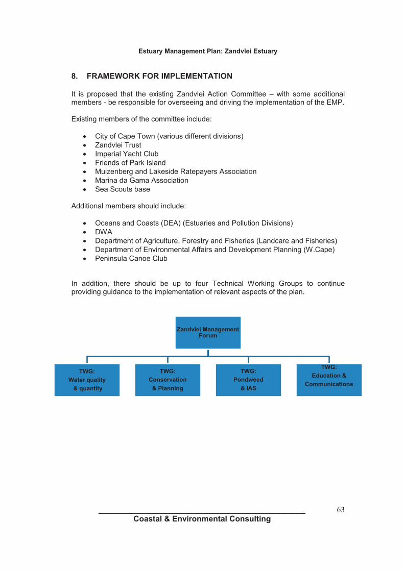


1
ESTUARY MANAGEMENT PLAN:
EERSTE RIVER ESTUARY
1. VISION The Vision for the C.A.P.E. Estuaries Programme as a whole is: “Our estuaries are beautiful, rich in plants and animals, they attract visitors, sustain our livelihoods and uplift our spirits.” The Eerste River Estuary is part of an extensive urban environment and as such the vision for the estuary is: “To manage the estuary and its catchment in such a manner as to reduce and minimise urban influence and pollutants on the estuary, where possible allow free and natural movement of the estuary mouth, manage alien invasive species, continuously work towards achieving high standards of water quality, recognise the estuary as an important marine nursery and biodiversity habitat and monitor the estuary in such a manner so as to intervene when urban influences have compromised the natural functioning of the estuary” 2. SITUATION ASSESSMENT AND CONTEXT
Figure 1: Eerste River Estuary The Eerste River Estuary meets the ocean at Macassar Beach on the False Bay coastline. The Eerste River Estuary mouth forms the western boundary of the Helderberg Marine Protected Area (MPA) and as such must be considered a core component to the marine conservation objectives of the MPA.
The estuary is typified by a broad back ponding area with a highly mobile estuary mouth. The mouth is not canalised or fixed and is highly influenced by the prevailing coastal dynamics of a wind driven sand system as well as altered flow due to urban and farming impacts on the greater catchment area. There are no residential properties located near the estuary, but a large sewage treatment facility (Macassar Wastewater Treatment Works) is located adjacent to the back ponding area and discharges final treated effluent directly into the estuary (see Figure 1). Some distance upstream is the suburb of Macassar which includes both residential and rural farming / small holding components. To the east of the estuary is the site of

2
the former AECI facility; redevelopment plans for this site are in the early phases, and it is not yet clear whether or how the site may be redeveloped. The Eerste River is joined by the Kuils River approximately 4km upstream of the estuary. The latter river also receives treated effluent from a number of Wastewater Treatment Works (WWTW) located in the Kuils River catchment area. It is noteworthy that the Kuils River forms the backbone of the Kuils River Corridor which aims to connect CapeNature’s Driftsands Nature Reserve with Macassar Dunes and the Coast. The flow of the river at the mouth is persistent as a net seawards flow. This is partly due to the wastewater discharge contribution, which has the effect of keeping the mouth generally open. While wind-blown sands generally encroach from the east, the longshore sediment supplies from wave action vary from west to east and therefore the location of the estuary mouth is inherently unstable. It is anticipated that climate change effects will result in greater instability of this system due to sea level rise and possible changes in wind dynamics. Significant meandering of the mouth to the west has been recorded leading to damage to an inappropriately located pump station and parking area in 2010/11. Due to the fact that this system has a significant component of treated sewage effluent, the natural estuarine characteristics have been permanently altered. The objectives for managing such a system should therefore focus on protection of infrastructure while allowing beach and dune processes to function as naturally as possible. 2.1 WATER QUALITY OF ESTUARY The condition of the estuary is highly influenced by the Greater Eerste-Kuils Catchment Area which chiefly results in the following: • Altered seasonality and flow dynamics due to increased volumes as a result of urban run-off and
discharge of wastewater effluent; • Poor water quality due to litter, urban pollutants and wastewater effluent. • Unplanned emergency overflow of untreated wastewater from the Macassar Wastewater Treatment Works
Comprehensive water quality monitoring is undertaken on a monthly basis by the City of Cape Town’s Scientific Services Laboratory since 1989, and results indicate that the catchment as a whole has been significantly impacted by a range of urban land-uses and activities including the presence of several WWTWs, industrial areas, extensive high density formal and informal residential settlements and a major road network. The condition of the estuary itself is thus influenced by these upstream impacts and also more specifically by the presence of the Macassar WWTW within the estuarine environment.
Figure 2: Water Quality Sampling Points

3
Water quality monitoring points in the vicinity of Eerste River Estuary include:
• Eerste River (EK12) • Eerste River estuary (EK17) • Moddergatspruit – Macassar Road (EK18) • Macassar Beach (XCS19) The water quality of the Eerste River estuary is of concern, as it opens across a beach used for recreational purposes, as well as its influence on the Helderberg MPA. 2.2 SPECIES RECORDED IN THE CATCHMENT
The City of Cape Town’s Alien Invasive Unit have recorded the following invasive species in the Eerste River Catchment (2012-2013):
Nasturtium officinale Watercress Commelina diffusa Climbing dayflower Lamium purpureum Red deadnettle Eichhornia crassipes Water hyacinth Ricinus communis Castor bean Acacia saligna Port Jackson Paraserianthes lophantha Stinkbean Canna indica Indian shot Persicaria decipiens Slender knot-weed Sagittaria platyphylla Delta arrowhead Melia azedarach Syringa Echium vulgare Common Viper's Bugloss Arundo donax Giant reed Lemna spp. Duckweed Various herbaceous species
The Department of Agriculture, Forestry and Fisheries have recorded the following marine and freshwater species in the Eerste River Catchment (2013):
Marine Species Gilchristella aestuaria Estuarine round herring Atherina breviceps Cape silverside Psammogobius knysnaensis Knysna sandgoby Lichia amia Leervis Monodactylus falciformis Cape moony Mugilcephalus Flathead mullet Lithognathus lithognathus White steenbras Galeichthys feliceps White sea catfish Liza dumerilii Groovy mullet Liza tricuspidens Striped mullet Heteromycterus capensis Cape sole Solea bleekeri Blackhand sole Liza richardsonii Harder Pomatomus saltatrix Elf Rhabdosargus globiceps White stumpnose Etrumeus whiteheadi Redeye round herring Amblyrhynchotes honckenii Blaasop Anguilla bengalenis African mottled eel Anguilla marmorata Madagascan mottled eel Anguilla mossambica Longfin eel

4
Freshwater Species Clarias gariepinus Sharptooth catfish (invasive) Cyprinus carpio Carp (invasive) Oncorhynchus mykiss Rainbow trout (invasive) Galaxias zebratus Cape galaxias
2.3 RECREATION
Recreation in the estuary is minimal and is confined to occasional limited local recreational swimming. No commercial fishing is permitted however limited recreational fishing occurs. The size and scale of the estuary does not facilitate broader recreational use such as boating or sailing.
3. MANAGEMENT PLAN
The Eerste River Estuary has to date not had a specific management plan or long term objectives assigned to it, nor have specific roles and responsibilities been previously defined. As part of its new Integrated Coastal Management approach, the City has prioritised the management of small and large estuaries. Based on the situation assessment and the available information a number of management objectives have been defined. For each of these management objectives, a specific operational protocol has been developed. These specific management protocols are intended to clearly define actions as well as responsibilities across City line departments. As implementation takes place and new information is gathered and understood, operational protocols may be amended and additional objectives and associated protocols added. Estuary management within an urban environment is seen as a long term approach following a principle of striving towards ongoing improvement in both the quality and management of our estuaries. 3.1 MANAGEMENT OBJECTIVES
The City has the following management objectives for the Eerste River Estuary: A. Allow the estuary mouth to function naturally as part of the local coastal dynamic processes and intervene
only under specific defined and documented circumstances B. Reduce and minimise all sources of urban pollutants to the estuary C. Regulation and development of infrastructure in or adjacent to the estuary D. Allow the natural circulation and fluctuation in estuary water quantity to be determined by seasonal rainfall
patterns, whenever possible E. Monitor estuary dynamics and intervene if required F. Monitor estuary water quality and work towards a high standard of water quality acceptable for public
recreation and ecological functioning G. Remove alien invasive species from the estuary H. Appropriately regulate all recreational use of the estuary I. Provide public awareness and education through a range of media J. Undertake annual monitoring and sampling of the estuary’s biodiversity K. Implement an Estuary Emergency Contingency Plan in the event of a flooding, significant pollution event,
oxygen depletion or other emergency events L. Establish an estuary task team with relevant stakeholders M. Regulate events and filming in the estuarine environment

5
OBJECTIVE A: Allow the estuary mouth to function naturally as part of the local coastal dynamic processes and intervene only under specific defined and documented circumstances LEGISLATION/STANDARDS: Estuary mouth manipulation falls within the National Environmental Management Act (NEMA) Regulations in so far as mouth manipulation involves movement of sand and therefore triggers Activity 18 (Listing Notice 1). As such mouth manipulation may be undertaken either: a) In terms of a “management plan agreed to by the relevant environmental authority” b) In an emergency situation followed by notification to Department of Environmental Affairs and Development
Planning (DEADP)
MANAGEMENT PROTOCOLS: Due to the presence of the WWTW and the large volumes of effluent discharged into the estuary, it is likely that the mouth remains open for most of the year. However, lateral migration along the coast has been problematic in previous years, and it is therefore essential that protocols for opening and straightening of the river mouth are in place. The following management protocols will be applied: 1) Risk of inland flooding • The mouth of the estuary may be straightened and opened in the event that high rainfall prediction is
indicative of a possible inland flooding event. • Determination of this need as well as the responsibility for carrying out the action resides with the City’s
Catchment, Stormwater and River Management Branch. 2) Pollution or toxic event • In the event of a toxic event in the estuary or catchment, the mouth may be mechanically opened to
facilitate flushing of the estuary during high tide or high water levels. This action may also require the trapping of sea water in the estuary through the physical closing of the mouth for a short duration.
• Determination of this need resides with the City’s Catchment, Stormwater and River Management Branch in consultation with the C.A.P.E. Estuary Programme Manager as well as the National Departments of Environmental Affairs (DEA) and Agriculture, Fisheries and Forestry (DAFF). Responsibility for carrying out the action resides with the City’s Catchment, Stormwater and River Management Branch
3) Potential undermining of infrastructure or critical dune systems by estuary mouth movement. • Where the estuary mouth moves or meanders in such a manner that it threatens critical dune systems or
City infrastructure the mouth may be mechanically straightened or re-aligned. • Determination of this need as well as the responsibility for carrying out the action resides with the City’s
Environmental Resource Management Department’s Coastal Management Unit in consultation with the Helderberg district environmental office
RECORDS:
• All mouth manipulation, the reason, action and completion will be recorded in the City’s Coastal
Management Monitoring and Database System • DEA, DAFF, DEADP and the C.A.P.E Estuary Programme will be informed of all mouth manipulation
events by the City’s Coastal Management Unit

6
MACHINE ACCESS FOR MOUTH MANIPULATION: • In all circumstances listed within this management objective, access points and traverse routes for
machinery to be used for mouth manipulation will be determined by the Environmental Resource Management Department
• As much as possible, access and traverse routes must adhere to existing road surfaces or previously disturbed areas.
• These access and traverse routes will be strictly adhered to at all times
OBJECTIVE B: Reduce and minimise all sources of urban pollutants to the estuary LEGISLATION/STANDARDS: Pollution in the form of industrial waste, human waste, domestic waste and material waste is governed by a wide range of National Legislation and Standards. • National Environmental Management Act (NEMA) • National Water Act (NWA) • National Waste Act • Integrated Coastal Management Act (ICMA)
However, for practical reasons recognition must be given to the fact that both the catchment that feeds the estuary, the estuary itself as well as the marine environment with which the estuary interacts are all subject to various pollutant sources common within a highly developed and populated urban environment. As such, all means to reduce pollution into the estuary that are practical, cost effective and reasonable will be employed but targeting zero pollution within an urban environment is neither practical nor realistic. MANAGEMENT PROTOCOLS: To minimise and reduce all forms of pollution the following management protocols will be applied: 1) Regular and systematic litter removal from the general Eerste River Catchment area by the City’s Solid
Waste Management Department. 2) Monthly monitoring of water quality along the river by the City’s Scientific Services Branch. 3) If deemed necessary, installation, clearing and maintenance of litter traps by the City’s Operations and
Assets Branch of the Roads and Stormwater Department. 4) On an ongoing basis and as required, implement interventions to reduce water pollution at source, through
the application of the City’s Water Quality Improvement Strategy and Implementation Plan. 5) On an ongoing basis, coordinating and liaising with the Winelands Municipality with regards to holistic
management across the entire catchment RECORDS:
1) All major pollution events to be recorded in the City’s Coastal Monitoring Database. A major pollution event
is defined as any pollution event deemed to be significantly greater than the level of background pollution present in the system. This may be determined either through water quality monitoring (i.e. a set of results that shows a significant spike in pollution, or through observation of an event (e.g. sewer overflow).

7
GENERAL • In the event of major water based pollution events, the pollution event will be managed in accordance with
the management protocol as set out in OBJECTIVE A. • In the event of increased levels of litter within the catchment system a litter trap may be established at the
most northern end of the back pond to reduce and minimise litter into the estuary
OBJECTIVE (C) : Regulation of development of infrastructure in or adjacent to the estuary LEGISLATION/STANDARDS:
Development of or building of any infrastructure within or adjacent to the estuary is regulated by the following: a) National Environmental Management Act b) City Zoning Scheme c) Integrated Coastal Management Act d) Coastal Edge and Setback Line e) Floodplain and River Corridor Management Policy f) Management of Urban Stormwater Impacts Policy
MANAGEMENT PROTOCOLS: a) All development proposals must comply with relevant legislation and policies b) Development proposals falling within the Coastal Edge/Setback Line or 1 in 50 year flood line should not
be supported c) The building or construction of any permanent or temporary structures that do not trigger NEMA
regulations, but are adjacent to or within the estuary, require additional written permission from the City’s Environmental Resource Management Department’s Integrated Coastal Management Unit or the Helderberg district environmental office
RECORDS: • Any written permission granted for a permanent or temporary structure to be recorded in the City’s Coastal
Monitoring Database GENERAL: • As the Eerste River Estuary forms part of the Helderberg MPA, construction of any permanent or
temporary structures will in general not be supported unless strong rationale is provided with measurable benefits

8
OBJECTIVE (D): Allow the natural circulation and fluctuation in estuary water quantity to be determined by seasonal rainfall patterns, whenever possible. LEGISLATION/STANDARDS: • National Water Act MANAGEMENT PROTOCOLS: a) At no time should the mouth of the estuary be impeded, diverted, blocked or altered unless under the
specific conditions as defined in OBJECTIVE A b) The estuary mouth may never be canalised or fixed c) No water abstraction to be permitted from the back pond or estuary mouth d) Water abstraction from the Eerste River Catchment to conform to all relevant legislation with strict permit
conditions e) On an ongoing basis, strive for improvement in wastewater discharge from the Macassar WWTW works to
comply with permit conditions f) On an ongoing basis, encourage the re-use of treated effluent from the various WWTWs in the greater
catchment area RECORDS: • Permitted water abstraction from the Eerste River Catchment as well as permit conditions to be recorded in
the City’s Coastal Monitoring Database • Cases and outcomes of any illegal water extraction in the Eerste River Catchment to be recorded in the
City’s Coastal Monitoring Database GENERAL: • In the event of major flow alteration, the City’s Catchment, Stormwater and River Management Branch in
conjunction with the Helderberg district environmental office to conduct an investigation to determine cause of flow change and make recommendations to rectify and restore flow regime
OBJECTIVE (E) : Monitor estuary dynamics and intervene if required LEGISLATION/STANDARDS: • National Environmental Management Act MANAGEMENT PROTOCOLS: 1) The City’s Environmental Resource Management Department will develop an estuary dynamics monitoring
programme based on aerial photography, including the establishment of baseline data, with the aim of annual assessment to determine whether changes in dynamics are taking place over time.

9
2) If the changing dynamics of the estuary are determined to be posing a management problem, the City’s Catchment, Stormwater and River Management Branch in conjunction with the City’s Environmental Resource Management Department will investigate and attempt to determine the cause. Areas of concern which may require intervention include, but are not limited to, increased rates of sedimentation and significant migration of the estuary or river mouth.
3) If it is determined that changes pose a management problem, the City will:
a) Inform DAFF, DEA and the C.A.P.E. Estuary Programme Manager b) In consultation with DAFF, DEA and the C.A.P.E. Estuary Programme Manager determine the most
appropriate plan of action c) Ensure compliance to NEMA if remedial action requires environmental authorisation
RECORDS: • Changes in estuary dynamics to be monitored and recorded in the City’s Coastal Management Monitoring
and Database System.
GENERAL: • Recognise that changes in estuary dynamics may form part of the natural variation in the estuary and as
such retain a principle of least interference
OBJECTIVE F: Monitor estuary water quality and work towards a high standard of water quality acceptable for public recreation and ecological functioning LEGISLATION/STANDARDS: • Water quality guidelines (DWA and DEA). MANAGEMENT PROTOCOLS: • Standardised water quality monitoring to be undertaken at one location within the estuary (EK17) and at
various sites in the greater catchment area once per month (temperature, dissolved oxygen, conductivity/salinity, pH, total suspended solids, total phosphorus, orthophosphate, total nitrogen, soluble ammonia, nitrite & nitrate, faecal coliforms, Escherichia coli and enterococcus)
• ERMD to liaise with the Wastewater Department to ensure that data from the monitoring of the final effluent quality from Macassar Wastewater Treatment Works (and other relevant WWTWs) is provided to the Coastal Management Monitoring and Database System on a quarterly basis
• In the event that excessive poor water quality results are measured that threaten the estuary the
management protocols established in OBJECTIVE A may be followed to restore improved water quality conditions
RECORDS: • All water quality results will be recorded within Scientific Services’ Laboratory Information Management
System (LIMS) and the monthly Certificate of Analysis will be added to the City’s Coastal Management Monitoring and Database System.

10
• All final effluent quality results obtained from the Wastewater department will be logged in the City’s Coastal Management Monitoring and Database System
GENERAL: • Estuary water quality management to be implemented in accordance with the Water and Sanitation
Department’s, and Catchment, Stormwater and River Management Branch’s City-wide work programme, resources and priorities.
OBJECTIVE (G): Remove alien invasive species from the estuary LEGISLATION/STANDARDS: • Conservation of Agricultural Resources Act, 43 of 1983 (CARA) • National Environmental Biodiversity Act (NEMBA), 10 of 2004 MANAGEMENT PROTOCOLS: The City’s Invasive Species Unit to prepare an invasive species management plan for the estuary, to include, where relevant: • Control of established invasive plants • Control and management of invasive alien birds and animals where necessary • Control and management of invasive alien fish, if deemed necessary • Re-introduction of indigenous species where feasible • Implementation of an early detection and rapid response programme to address new and emerging
invasive alien species RECORDS: • The invasive species management plan will be appended to this Estuary Management Plan as Annexure
A. GENERAL: • The estuary invasive species management plan to be implemented in accordance with the Invasive
Species Unit city-wide work programme, resources and priorities.
• An integrated invasive species management approach will be followed in partnership with relevant stakeholders

11
OBJECTIVE (H): Regulate all recreational use of the estuary LEGISLATION/STANDARDS: • DAFF Commercial Fishing Regulations • DAFF Recreational Fishing Regulations • DWA, Recreational Water Quality Standards • Integrated Coastal Management Act • City’s Municipal Coastal Management Plan
MANAGEMENT PROTOCOLS: • Only recreational fishing will be permitted, with a valid recreational fishing permit, available from the Post
Office. This will be communicated through appropriate signage. • No motorised water-craft of any kind permitted in the estuary or estuary mouth • City’s Marine and Coastal Law Enforcement Unit in conjunction with DAFF Fishery Control Officers to
monitor, enforce and regulate • Due to the close proximity of the WWTW, no swimming is permitted in the estuary. Signage to this effect
will be installed. RECORDS: • Any non-compliance to regulations will be recorded in the City’s Coastal Management Monitoring and
Database System GENERAL: • The estuary recreational use management plan to be implemented in accordance with the Sport,
Recreation and Amenities Department‘s City-wide work programme, resources and priorities.
• Appropriate recreation to be supported in line with the City’s Social Development Strategy
OBJECTIVE (I): Provide public awareness and education through a range of media LEGISLATION/STANDARDS: • None MANAGEMENT PROTOCOLS: Public education and awareness on the Eerste River Estuary may be provided in the following ways: 1) General catchment and estuary education and awareness through the City’s Youth Environmental Schools
(YES) Programme 2) General estuary education and awareness as part of the City’s Educator Training Programme 3) General estuary education and awareness through the City’s Nature Reserve Environmental Education

12
Programme 4) General City communication programmes focusing on awareness raising and education about pollution, its
impact on human health and freshwater ecosystems 5) The installation of relevant and appropriate informative signage at the estuary
RECORDS: • All signs and their locations to be recorded in the City’s Coastal Management Monitoring and Database
System.
GENERAL: • All signage, regulatory and informative, must comply with the City’s Coastal Signage Protocol • The estuary public awareness and education management plan to be implemented in accordance with the
Environmental Resource Management Department’s city-wide work programme, resources and priorities.
OBJECTIVE J: Undertake annual monitoring and sampling of the estuary’s biodiversity LEGISLATION/STANDARDS: • None MANAGEMENT PROTOCOLS: ERMD in partnership with DAFF to undertake annual estuary biodiversity surveys through: • Fish sampling through annual seine netting • Bird counts • Benthic sampling
RECORDS: • All sampling results to be recorded in the City’s Coastal Management Monitoring and Database System GENERAL: • Biodiversity sampling programme and schedule to be determined by DAFF • The sampling programme is contingent on sufficient resources being made available for this programme

13
OBJECTIVE (K): Implement an Estuary Emergency Contingency Plan in the event of a flooding, significant pollution event, oxygen depletion or other emergency events LEGISLATION/STANDARDS: • National Environmental Management Act MANAGEMENT PROTOCOLS: The following will be considered an Estuary Emergency requiring the Emergency Contingency Protocols to be implemented: 1) A land based (catchment) pollution event 2) Marine oil or pollution spill in False Bay 3) Rapid oxygen depletion 4) Marine / estuarine life die-off within the estuary
Emergency Contingency Protocols: 1) In the event of an emergency the estuary, estuary mouth and beach area (200m either side of the mouth)
will be closed to the public and enforced by City Law Enforcement 2) The City’s Coastal Co-ordinators will notify officials from DAFF, DEA and the C.A.P.E. Estuary programme
manager 3) Where a land based pollution event is contaminating the estuary, the protocol established in OBJECTIVE
A will be followed 4) Where there is a marine oil or pollution event, the estuary mouth will be boomed off and the Official Oil
and Pollution Contingency Plan as per the City’s Municipal Coastal Management Plan will become effective
5) In the event of a rapid oxygen depletion event, the estuary mouth will be breached and opened at low tide to allow high tide ocean water into the estuary, as per OBJECTIVE A.
6) In the event of significant marine life die-off, samples of dead marine life will be provided to DAFF and DEA for analysis. All remaining dead marine life will be recovered from the estuary by the City’s Solid Waste Management department and disposed of at Vissershok Landfill site in accordance with City waste management procedures
7) The Estuary, estuary mouth and associated beach area will only be re-opened to public access once it is deemed safe
RECORDS: • All estuary emergency events as well as the action taken will be recorded in the City’s Coastal
Management Monitoring and Database System • DEA and DAFF to make any sampling results from a marine life die off available to the City GENERAL: • An emergency will only be declared if it is determined that the scale of the problem is such that it threatens
the long term viability of the estuary as a functional ecosystem, or if it threatens the integrity of the Helderberg Marine Protected Area.
• This determination will be made by the City’s Catchment, Stormwater and River Management Branch, in conjunction with the Environmental Resource Management Department. In the event of a biodiversity related emergency, ERMD will be the lead department in terms of decision-making.

14
OBJECTIVE (L): Establish an estuary task team with relevant stakeholders
LEGISLATION/STANDARDS: • Integrated Coastal Management Act
MANAGEMENT PROTOCOLS: • Task team to be established as part of a city-wide Small Estuaries Task Team, which will include all
estuaries except for the Zandvlei and Diep estuaries. • Small Estuaries Task Team to meet on a quarterly basis RECORDS: • Action minutes of all meetings to be maintained as part of the City’s Coastal Monitoring Database GENERAL: • Small Estuaries Task Team will function as a working group consisting of officials who are involved in
management work related to the relevant estuaries • Public engagement will be facilitated through the existing Sub-Council structure
OBJECTIVE M: Regulation of Events and Filming LEGISLATION/STANDARDS: • City Filming and Events Policy • MANAGEMENT PROTOCOLS: Any organisation or individual who wishes to hold, host or undertake a commercial or non-profit event or commercial filming of any kind on the estuary, or within the coastal edge surrounding the estuary must: • Submit a formal application to the City’s Events and Filming Office • The application must be circulated to the Environmental Resource Management Department, Catchment,
Stormwater and River Management Branch and Sport, Recreation and Amenities Department for consideration
• Officials from these departments will advise the Events and Filming Office on the suitability of the application and if supported the conditions attached to such support
• If approved, the final event or filming permit with attached conditions must be circulated to the Environmental Resource Management Department, Catchment Stormwater and River Management Branch and Sport, Recreation and Amenities Department at least 48 hours prior to the event or filming taking place

15
RECORDS: • Events and Film Office to retain records of all applications, permits and conditions as well as any reported
non-compliance GENERAL: • Event and filming applications for the estuary must demonstrate meaningful benefit

1
ESTUARY MANAGEMENT PLAN:
Hout Bay River Estuary
1. VISION The Vision for the C.A.P.E. Estuaries Programme as a whole is: “Our estuaries are beautiful, rich in plants and animals, they attract visitors, sustain our livelihoods and uplift our spirits.” The Hout Bay River (also known as the Disa River) Estuary is part of an extensive urban environment and as such the vision for the estuary is: “To manage the estuary and its catchment in such a manner as to reduce and minimise urban influence and pollutants on the estuary, where possible allow free and natural movement of the estuary mouth whilst ensuring that all risks to life and property are avoided, manage alien invasive species, continuously work towards achieving high standards of water quality, recognise the estuary as an important marine nursery and biodiversity habitat and monitor the estuary in such a manner so as to intervene when urban influences have compromised the natural functioning of the estuary” 2 SITUATION ASSESSMENT AND CONTEXT
Figure 1: Hout Bay River Estuary
The Hout Bay River Estuary connects with the ocean at Hout Bay Beach. The estuary is an intermittently open system that opens when the Hout Bay River is in spate, but generally closes during summer. The river outlet is therefore not considered to be a true estuary with associated estuarine dependant species. Reduction in natural flows due to retention of water in upper catchment dams, increase in urban stormwater flows, urban development, bank stabilisation and flood levees, sedimentation, litter from informal settlements, and stormwater discharges all impact the estuary and its contributing river. This has led to the alterations in the estuary’s condition, water quality and depth.
Furthermore, the estuary is no longer in its natural state and tends to meander, effectively compromising efforts for dune rehabilitation. A Management and Rehabilitation Plan for the Hout Bay Dunes (Low, A B. and van Eeden J.D., Management and Rehabilitation plan for the Hout Bay Dunes. Volume 2. Vula Environmental Service, Vredenburg) has been compiled which points to sand accumulations on Hout Bay Beach contributing

2
to the unpredictable meandering of the river mouth. With the continuous accumulation of sand and no sand, estuary, or river management plan in place, the river embankment below the river mouth will continue to erode. A number of developments are below the 1:50 flood line of the Hout Bay River and are therefore exposed to the effects of coastal dynamics, especially erosion.
2.1 WATER QUALITY OF ESTUARY The condition of the estuary is highly influenced by the Hout Bay Catchment Area which chiefly results in the following: • Altered seasonality and flow dynamics • Poor water quality due to litter, urban pollutants and sewage. • Occasional unplanned overflow of untreated sewage from the sewage reticulation network due to
breakdown or damage Comprehensive water quality monitoring has been undertaken on a monthly basis by the City’s Scientific Services Laboratory since 1991, and results indicate that the upper reaches of the catchment are virtually pristine. However as the river traverses the increasingly dense residential area and adjacent informal settlement area of Imizamo Yethu the condition of the river deteriorates. Sporadically high bacterial contamination levels are of concern in the lower river reaches and outlet. Dog walkers need to be vigilant about removing pet waste; however the resident bird populations and horse riders also contribute to the bacterial load. Water quality in the estuary can be of concern due to the fact that beachgoers (particularly children) sometimes enter the warmer waters in the river outlet. Stagnation of the water and concentration of pollutants when the mouth is closed means that there is potentially increased risk. Signage to warn about the potentially contaminated condition of the river outlet is in place.
Figure 2: Water quality monitoring points in the vicinity of Hout Bay River Estuary Water quality sample collection points within the Hout Bay catchment area (arranged from the extreme upper catchment down towards the sea): • Hout Bay near Princess St (DR02) - not estuarine

3
• Hout Bay at Victoria Road (DR01) • Hout Bay River estuary (DR05) • Hout Bay beach (XCN10) - not estuarine The water quality of the Hout Bay River estuary is potentially of concern as the mouth of the river opens across a recreational beach.
2.2 SPECIES RECORDED IN HOUT BAY RIVER CATCHMENT AREA The City of Cape Town’s Alien Invasive Unit have recorded the following invasive species in the Hout Bay River Catchment (2012-2013):
Invasive Species Nasturtium officinale Watercress Commelina diffusa Climbing dayflower Canna indica Canna Arundo donax Giant reed Ceratophyllum demersum Hornwort Lantana spp. Lantana Lemna spp. Duckweed Various herbaceous species
The Department of Agriculture, Forestry and Fisheries have recorded the following marine and freshwater species in the Hout Bay River Catchment (2013):
Marine Species Psammogobius knysnaensis Knysna sandgoby Liza richardsonii Harder Anguilla mossambica Longfin eel
Freshwater Species Sandelia capensis Cape kurper Oreochromis mossambicus Mozambique tilapia Tilapia sparrmanii Banded tilapia Gambusia affinis Mosquitofish Galaxias zebratus Cape galaxias
2.3 RECREATION
Recreation in the estuary is minimal and is confined to local recreational swimming, dog walking / paddling in the back ponding area and in the estuary mouth. No commercial fishing is permitted. The size and scale of the estuary does not facilitate broader recreational use such as boating or sailing.

4
3) MANAGEMENT PLAN
The Hout Bay River Estuary has to date not had a specific management plan or long term objectives assigned to it, nor have specific roles and responsibilities been previously defined. As part of its new Integrated Coastal Management approach, the City has prioritised the management of small and large estuaries. Based on the situation assessment and the available information a number of management objectives have been defined. For each of these management objectives, a specific operational protocol has been developed.
These specific management protocols are intended to clearly define actions as well as responsibilities across City line departments. As implementation takes place and new information is gathered and understood, operational protocols may be amended and additional objectives and associated protocols added. Estuary management within an urban environment is seen as a long term approach following a principle of striving towards ongoing improvement in both the quality and management of our estuaries. 3.1 MANAGEMENT OBJECTIVES The City has the following management objectives for the Hout Bay River Estuary: A. Allow the estuary mouth to function naturally as part of the local coastal dynamic processes and
intervene only under specific defined and documented circumstances B. Reduce and minimise all sources of urban pollutants to the estuary C. Regulation and development of infrastructure in or adjacent to the estuary D. Allow the natural circulation and fluctuation in estuary water quantity to be determined by seasonal
rainfall patterns, whenever possible E. Monitor estuary dynamics and intervene if required F. Monitor estuary water quality and work towards a high standard of water quality acceptable for public
recreation and ecological functioning G. Remove alien invasive species from the estuary H. Appropriately regulate all recreational use of the estuary I. Provide public awareness and education through a range of media J. Undertake annual monitoring and sampling of the estuary’s biodiversity K. Implement an Estuary Emergency Contingency Plan in the event of a flooding, significant pollution
event, oxygen depletion or other emergency events L. Establish an estuary task team with relevant stakeholders M. Regulate events and filming in the estuarine environment

5
OBJECTIVE A : Allow the estuary mouth to function naturally as part of the local coastal dynamic processes and intervene only under specific defined and documented circumstances LEGISLATION/STANDARDS: Estuary mouth manipulation falls within the National Environmental Management Act Regulations. As such mouth manipulation must be done as either: a) In terms of a “management plan agreed to by the relevant environmental authority” b) In an emergency situation followed by notification to Department of Environmental Affairs and
Development Planning (DEADP) MANAGEMENT PROTOCOLS: The following management protocols will be applied: 1) Risk of inland flooding
• The mouth of the estuary may be straightened and opened in the event that high rainfall prediction is
indicative of a possible inland flooding event. • Determination of this need as well as the responsibility for carrying out the action resides with the City’s
Catchment, Stormwater and River Management Branch. 2) Pollution or toxic event • In the event of a toxic event in the estuary or catchment, the mouth may be mechanically opened to
facilitate flushing of the estuary during high tide or high water levels. This action may also require the trapping of sea water in the estuary through the physical closing of the mouth for a short duration.
• Determination of this need resides with the City’s Catchment, Stormwater and River Management Branch in consultation with the C.A.P.E. Estuary Programme Manager as well as the National Departments of Environmental Affairs (DEA) and Agriculture, Fisheries and Forestry (DAFF). Responsibility for carrying out the action resides with the City’s Catchment, Stormwater and River Management Branch
3) Potential undermining of infrastructure or critical dune systems by estuary mouth movement. • Where the estuary mouth moves or meanders in such a manner that it threatens City infrastructure or
sensitive environmental components such as the dune system, the mouth may be mechanically straightened or re-aligned.
• Determination of this need as well as the responsibility for carrying out the action resides with the City’s Environmental Resource Management Department’s Coastal Management Unit in consultation with the Southern district environmental office
RECORDS:
• All mouth manipulation, the reason, action and completion thereof will be recorded in the City’s Coastal
Management Monitoring and Database System • DEA, DAFF, DEADP and the C.A.P.E Estuary Programme will be informed by the City’s Coastal
Management Unit of all mouth manipulation

6
MACHINE ACCESS FOR MOUTH MANIPULATION: • In all circumstances listed within this management objective, access points and traverse routes for
machinery to be used for mouth manipulation will be determined by the Environmental Resource Management Department
• As much as possible, access and traverse routes must adhere to existing road surfaces or previously disturbed areas.
• These access and traverse routes will be strictly adhered to at all times
OBJECTIVE B : Reduce and minimise all sources of urban pollutants to the estuary LEGISLATION/STANDARDS: Pollution in the form of industrial waste, human waste, domestic waste and material waste is governed by a wide range of National Legislation and Standards. • National Environmental Management Act (NEMA) • National Water Act (NWA) • National Waste Act • Integrated Coastal Management Act (ICMA)
However, for practical reasons recognition must be given to the fact that both the catchment that feeds the estuary, the estuary itself as well as the marine environment with which the estuary interacts are all subject to various pollutant sources common within a highly developed and populated urban environment. As such, all means to reduce pollution into the estuary that are practical, cost effective and reasonable will be employed but targeting zero pollution within an urban environment is neither practical nor realistic. MANAGEMENT PROTOCOLS: To reduce all forms of pollution the following management protocols will be applied: 1) Regular and systematic litter removal from the general Hout Bay Catchment area by the City’s Solid
Waste Management Department 2) Monthly monitoring of water quality along the river by the City’s Scientific Services Branch. 3) If deemed necessary, installation, clearing and maintenance of litter traps by the City’s Operations and
Assets Branch of the Roads and Stormwater Department. 4) On an ongoing basis and as required, implement interventions to reduce water pollution at source,
through the application of the City’s Water Quality Improvement Strategy and Implementation Plan.
RECORDS:
1) All major pollution events to be recorded in the City’s Coastal Monitoring Database. A major pollution
event is defined as any pollution event deemed to be significantly greater than the level of background pollution present in the system. This may be determined either through water quality monitoring (i.e. a set of results that shows a significant spike in pollution, or through observation of an event (e.g. sewer overflow).

7
GENERAL • In the event of major water based pollution events, the pollution event will be managed in accordance
with the management protocol as set out in OBJECTIVE A. • In the event of increased levels of litter within the catchment system a litter trap may be established at the
most northern end of the back pond to reduce and minimise litter into the estuary
OBJECTIVE C : Regulation of development of infrastructure in or adjacent to the estuary LEGISLATION/STANDARDS: Development or building of any infrastructure within or adjacent to the estuary is regulated by the following: a) National Environmental Management Act b) City of Cape Town Integrated Zoning Scheme c) Integrated Coastal Management Act d) Coastal Edge and Setback Line e) Floodplain and River Corridor Management Policy f) Management of Urban Stormwater Impacts Policy
MANAGEMENT PROTOCOLS: a) All development proposals must comply with relevant legislation and policies b) Development proposals falling within the Coastal Edge/Setback Line or 1 in 50 year flood line should not
be supported c) The building or construction of any permanent or temporary structures that do not trigger NEMA
regulations, but are adjacent to or within the estuary, require additional written permission from the City’s Environmental Resource Management Department’s Integrated Coastal Management Unit or the Southern district environmental office
RECORDS: • Any written permission granted for a permanent or temporary structure to be recorded in the City’s
Coastal Monitoring Database GENERAL: • Construction of any permanent or temporary structures will in general not be supported unless strong
rationale is provided with measurable benefits
8
OBJECTIVE (D): Allow the natural circulation and fluctuations in estuary water quantity to be determined by seasonal rainfall patterns, whenever possible. LEGISLATION/STANDARDS: • National Water Act
MANAGEMENT PROTOCOLS: a) At no time should the mouth of the estuary be impeded, diverted, blocked or altered unless under the
specific conditions as defined in OBJECTIVE A b) The estuary mouth may never be canalised or fixed c) No water abstraction to be permitted from the back pond or estuary mouth d) Water abstraction from the Hout Bay River Catchment to conform to all relevant legislation with strict
permit conditions
RECORDS: • Permitted water abstraction from the Hout Bay River Catchment as well as permit conditions to be
recorded in the City’s Coastal Monitoring Database • Cases and outcomes of any illegal water extraction in the Hout Bay River Catchment to be recorded in the
City’s Coastal Monitoring Database GENERAL: • In the event of major flow alteration, the City’s Catchment, Stormwater and River Management Branch in
conjunction with the Southern district environmental office to conduct an investigation to determine cause of flow change and make recommendations to rectify and restore the flow regime
OBJECTIVE (E) : Monitor estuary dynamics and intervene if required LEGISLATION/STANDARDS: • National Environmental Management Act MANAGEMENT PROTOCOLS: 1) The City’s Environmental Resource Management Department will develop an estuary dynamics monitoring
programme based on aerial photography, including the establishment of baseline data, with the aim of annual assessment to determine whether changes in dynamics are taking place over time.
2) If the changing dynamics of the estuary are determined to be posing a management problem, the City’s
Catchment, Stormwater and River Management Branch in conjunction with the City’s Environmental Resource Management Department will investigate and attempt to determine the cause. Areas of concern

9
which may require intervention include, but are not limited to, increased rates of sedimentation and significant migration of the estuary or river mouth.
3) If it is determined that changes pose a management problem, the City will:
a) Inform DAFF, DEA and the C.A.P.E. Estuary Programme Manager b) In consultation with DAFF, DEA and the C.A.P.E. Estuary Programme Manager determine the most
appropriate plan of action c) Ensure compliance to NEMA if remedial action requires environmental authorisation
RECORDS: • Changes in estuary dynamics to be monitored and recorded in the City’s Coastal Management Monitoring
and Database System.
GENERAL: • Recognise that changes in estuary dynamics may form part of the natural variation in the estuary and as
such retain a principle of least interference
OBJECTIVE (F): Monitor estuary water quality and work towards a high standard of water quality acceptable for public recreation and ecological functioning LEGISLATION/STANDARDS: • Water quality guidelines (DWA and DEA). MANAGEMENT PROTOCOLS: • Standardised water quality monitoring to be undertaken at one location within the estuary (DR05) and at
various sites in the greater catchment area once per month (temperature, dissolved oxygen, conductivity/salinity, pH, total suspended solids, total phosphorus, orthophosphate, total nitrogen, soluble ammonia, nitrite & nitrate, faecal coliforms, Escherichia coli and enterococcus)
• In the event that excessive poor water quality results are measured that threaten the estuary the
management protocols established in OBJECTIVE A may be followed to restore improved water quality conditions
RECORDS: • All water quality results will be recorded within Scientific Services’ Laboratory Information Management
System (LIMS)

10
GENERAL: • Estuary water quality management to be implemented in accordance with the Catchment, Stormwater and
River Management Branch City-wide work programme, resources and priorities.
OBJECTIVE (G): Remove alien invasive species from the estuary LEGISLATION/STANDARDS: • Conservation of Agricultural Resources Act, 43 of 1983 (CARA) • National Environmental Biodiversity Act (NEMBA), 10 of 2004 MANAGEMENT PROTOCOLS: The City’s Invasive Species Unit to prepare an invasive species management plan for the estuary, to include, where relevant: • Control of established invasive plants • Control and management of invasive alien birds and animals where necessary • Control and management of invasive alien fish, if deemed necessary • Re-introduction of indigenous species where feasible • Implement an early detection and rapid response programme to address new and emerging invasive alien
species RECORDS: • The invasive species management plan will be appended to this Estuary Management Plan as Annexure A. GENERAL: • The estuary invasive species management plan to be implemented in accordance with the Invasive Species
Unit city-wide work programme, resources and priorities.
• An integrated invasive species management approach will be followed in partnership with relevant stakeholders

11
OBJECTIVE (H): Regulate all recreational use of the estuary LEGISLATION/STANDARDS: • DAFF commercial fishing regulations • DAFF recreational fishing regulations • DWA, Recreational water quality standards • Integrated Coastal Management Act • City’s Municipal Coastal Management Plan MANAGEMENT PROTOCOLS: • Only recreational fishing will be permitted, with a valid recreational fishing permit, available from the Post
Office. This will be communicated through appropriate signage. • No motorised water-craft of any kind permitted in the estuary or estuary mouth • City’s Marine and Coastal Law Enforcement Unit in conjunction with DAFF Fishery Control Officers to
monitor, enforce and regulate • City Health Department, in conjunction with Catchment, Stormwater and River Management, to determine
recreational safety based on water quality results and to inform the public accordingly. RECORDS: • Any non-compliance to regulations will be recorded in the City’s Coastal Management Monitoring and
Database System GENERAL: • The estuary recreational use management plan to be implemented in accordance with the Sport,
Recreation and Amenities Department‘s City-wide work programme, resources and priorities.
• Appropriate recreation to be supported in line with the City’s Social Development Strategy
OBJECTIVE (I): Provide public awareness and education through a range of media LEGISLATION/STANDARDS: • None MANAGEMENT PROTOCOLS: Public education and awareness on the Hout Bay River Estuary may be provided in the following ways: 1) General catchment and estuary education and awareness through the City’s Youth Environmental Schools
12
(YES) Programme 2) General estuary education and awareness as part of the City’s Educator Training Programme 3) General estuary education and awareness through the City’s Nature Reserve Environmental Education
Programme 4) General City communication programmes focusing on awareness raising and education about pollution, its
impact on human health and freshwater ecosystems 5) The installation of relevant and appropriate informative signage at the estuary
RECORDS: • All signs and their locations to be recorded in the City’s Coastal Management Monitoring and Database
System.
GENERAL: • All signage, regulatory and informative, must comply with the City’s Coastal Signage Protocol • The estuary public awareness and education management plan to be implemented in accordance with the
Environmental Resource Management Department city-wide work programme, resources and priorities.
OBJECTIVE J: Undertake annual monitoring and sampling of the estuary’s biodiversity LEGISLATION/STANDARDS: • None MANAGEMENT PROTOCOLS: In partnership with DAFF undertake annual estuary biodiversity surveys through: • Fish sampling through annual seine netting • Bird counts • Benthic sampling
RECORDS: • All sampling results to be recorded in the City’s Coastal Management Monitoring and Database System,
and the City’s Biodiversity Database GENERAL: • Biodiversity sampling programme and schedule to be determined by DAFF • The sampling programme is contingent on sufficient resources being made available for this programme

13
OBJECTIVE (K): Implement an Estuary Emergency Contingency Plan in the event of a flood, significant pollution event, oxygen depletion or other emergency events LEGISLATION/STANDARDS: • National Environmental Management Act MANAGEMENT PROTOCOLS: The following will be considered an Estuary Emergency requiring the Emergency Contingency Protocols to be implemented: 1) A major land based pollution event 2) Marine oil or pollution spill in Hout Bay 3) Rapid oxygen depletion 4) Marine life die-off Emergency Contingency Protocols: 1) In the event of an emergency the estuary, estuary mouth and beach area (200m either side of the mouth)
will be closed to the public and enforced by City Law Enforcement 2) The City’s Coastal Co-ordinators will notify officials from DAFF, DEA and the C.A.P.E. Estuary programme
manager 3) Where a land based pollution event is contaminating the estuary, the protocol established in OBJECTIVE A
will be followed 4) Where there is a marine oil or pollution event, the estuary mouth will be closed and the Official Oil and
Pollution Contingency Plan as per the City’s Municipal Coastal Management Plan will become effective 5) In the event of a rapid oxygen depletion event, the estuary mouth will be opened at low tide to allow the
coming high tide to bring ocean water into the estuary, as per OBJECTIVE A. 6) In the event of significant marine life die-off, samples of dead marine life will be provided to DAFF and DEA
for analysis. All remaining dead marine life will be recovered from the estuary by the City’s Solid Waste Management department and disposed of at Vissershok Landfill site in accordance with City waste management procedures
7) The estuary, estuary mouth and associated beach area will only be re-opened to public access once it is deemed safe
RECORDS: • All estuary emergency events as well as the action taken will be recorded in the City’s Coastal Management
Monitoring and Database System • DEA and DAFF to make any sampling results from a marine life die off available to the City GENERAL: • An emergency will only be declared if it is determined that the scale of the problem is such that it threatens
the long term viability of the estuary as a functional ecosystem • This determination will be made by the City’s Catchment, Stormwater and River Management Branch, in
conjunction with the Environmental Resource Management Department. In the event of a biodiversity related emergency, ERMD will be the lead department in terms of decision-making.

14
OBJECTIVE (L): Establish an estuary task team with relevant stakeholders
LEGISLATION/STANDARDS: • Integrated Coastal Management Act MANAGEMENT PROTOCOLS: • Task team to be established as part of a city-wide Small Estuaries Task Team, which will include all
estuaries except for the Zandvlei and Diep estuaries. • Small Estuaries Task Team to meet on a quarterly basis RECORDS: • Action minutes of all meetings to be maintained as part of the City’s Coastal Monitoring Database
GENERAL: • Small Estuaries Task Team will function as a working group consisting of officials who are involved in
management work related to the relevant estuaries • Public engagement will be facilitated through the existing Sub-Council structure
OBJECTIVE M: Regulation of Events and Filming LEGISLATION/STANDARDS: • City Filming and Events Policy • Coastal events and filming Protocol MANAGEMENT PROTOCOLS: Any organisation or individual who wishes to hold, host or undertake a commercial or non-profit event or commercial filming of any kind on the estuary, or within the coastal edge surrounding the estuary must: • Submit a formal application to the City’s Events and Filming Office • The application must be circulated to the Environmental Resource Management Department, Catchment,
Stormwater and River Management Branch and Sport, Recreation and Amenities Department for consideration
• Officials from these departments will advise the Events and Filming Office on the suitability of the application and if supported the conditions attached to such support
• If approved, the final event or filming permit with attached conditions must be circulated to the Environmental Resource Management Department, Catchment, Stormwater and River Management Branch and Sport, Recreation and Amenities Department at least 48 hours prior to the event or filming taking place

15
RECORDS: • Events and Film Office to retain records of all applications, permits and conditions as well as any reported
non-compliance GENERAL: • Event and filming applications for the estuary must demonstrate meaningful benefit
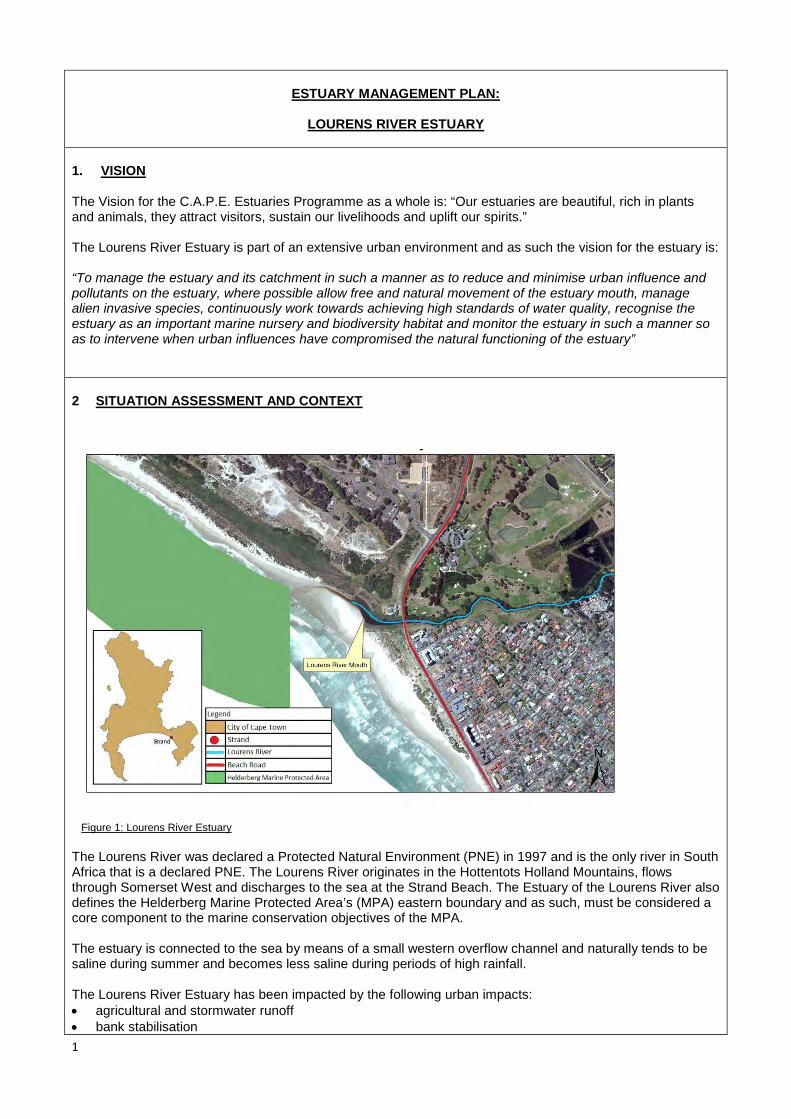
1
ESTUARY MANAGEMENT PLAN:
LOURENS RIVER ESTUARY
1. VISION The Vision for the C.A.P.E. Estuaries Programme as a whole is: “Our estuaries are beautiful, rich in plants and animals, they attract visitors, sustain our livelihoods and uplift our spirits.” The Lourens River Estuary is part of an extensive urban environment and as such the vision for the estuary is: “To manage the estuary and its catchment in such a manner as to reduce and minimise urban influence and pollutants on the estuary, where possible allow free and natural movement of the estuary mouth, manage alien invasive species, continuously work towards achieving high standards of water quality, recognise the estuary as an important marine nursery and biodiversity habitat and monitor the estuary in such a manner so as to intervene when urban influences have compromised the natural functioning of the estuary” 2 SITUATION ASSESSMENT AND CONTEXT
Figure 1: Lourens River Estuary The Lourens River was declared a Protected Natural Environment (PNE) in 1997 and is the only river in South Africa that is a declared PNE. The Lourens River originates in the Hottentots Holland Mountains, flows through Somerset West and discharges to the sea at the Strand Beach. The Estuary of the Lourens River also defines the Helderberg Marine Protected Area’s (MPA) eastern boundary and as such, must be considered a core component to the marine conservation objectives of the MPA. The estuary is connected to the sea by means of a small western overflow channel and naturally tends to be saline during summer and becomes less saline during periods of high rainfall. The Lourens River Estuary has been impacted by the following urban impacts: • agricultural and stormwater runoff • bank stabilisation

2
• sewage pump station failures • alien fish • changes in run off due to urbanisation and surface hardening Consequently, this has led to the decrease in the estuary’s water quality. The overall condition of the Lourens River is generally regarded as fair. The Strand Beach Road crosses the estuary approximately 100m from the high water mark of the sea, on the south of Beach Road. The estuary is abutted by the Lourens River Pump Station to the west and a recreational area to the east. North of Beach Road the estuary is abutted by the Strand Golf Course to the West and the residential properties to the east.
2.1 WATER QUALITY OF ESTUARY
The quality of the estuary is highly influenced by the Lourens River Catchment which mainly results in the following: • Reduction in seasonal and natural water flow • Increased water flow as a result of increased urban run-off • Urban pollutants including litter, runoff from agricultural areas: Vergelegen, Morgenster and Lourensford
Estate
Comprehensive water quality monitoring is undertaken on a monthly basis by the City’s Scientific Services Laboratory since 2000 and results indicate that the overall condition of the Lourens River is fair both in terms of nutrient and bacterial levels. It is rated amongst the top three in terms of water quality compared to other rivers in the City. The estuary mouth is however moderately more impacted.
Figure 2: Water quality monitoring points in the vicinity of Lourens River Estuary Water quality sample collection points in the Lourens River catchment: • Lourens in P.O.S Hillcrest Road (LOU02) • Lourens at Broadway Road (LOU04) • Lourens on Beach Road (LOU05)

3
2.2 SPECIES RECORDED IN ESTUARY
The City of Cape Town’s Alien Invasive Unit have recorded the following invasive species in the Lourens River Catchment (2012-2013):
Nasturtium officinale Watercress Ricinus communis Castor bean Acacia saligna Port Jackson Canna indica Canna Arundo donax Giant reed Eucalyptus spp. Various herbaceous species
The Department of Agriculture, Forestry and Fisheries have recorded the following marine and freshwater species in the Lourens River Catchment (2013):
Marine Species Gilchristella aestuaria Estuarine round herring Atherina breviceps Cape silverside Psammogobius knysnaensis Knysna sand goby Lichia amia Leervis Monodactylus falciformis Cape moony Mugil cephalus Flathead mullet Lithognathus lithognathus White steenbras Galeichthys feliceps White sea catfish Liza richardsonii Harder Pomatomus saltatrix Elf Rhabdosargus globiceps White stumpnose Sandelia capensis Cape kurper Anguilla bengalensis labiata African mottled eel Anguilla marmorata Madagascan mottled eel Anguilla mossambica Longfin eel
Freshwater Species Galaxias zebratus Cape galaxias Lepomis macrochirus Bluegill sunfish Micropterus punctulatus Spotted bass Micropterus salmoides Largemouth bass Tilapia sparrmanii Banded tilapia Cyprinus carpio Carp Tinca tinca Tench Perca fluviatilis Perch Oncorhynchus mykiss Rainbow trout
2.3 RECREATION
There is no access to the Lourens river mouth for recreation as the beach area is fenced off due to the operations of the SOMCHEM/DENEL site to the west.

4
3 MANAGEMENT PLAN
The Lourens River Estuary has to date not had a specific management plan or long term objectives assigned to it, nor have specific roles and responsibilities been previously defined. As part of its new Integrated Coastal Management approach, the City has prioritised the management of small and large estuaries. Based on the situation assessment and the available information a number of management objectives have been defined. For each of these management objectives, a specific operational protocol has been developed.
These specific management protocols are intended to clearly define actions as well as responsibilities across City line departments. As implementation takes place and new information is gathered and understood, operational protocols may be amended and additional objectives and associated protocols added. Estuary management within an urban environment is seen as a long term approach following a principle of striving towards ongoing improvement in both the quality and management of our estuaries.
3.1 MANAGEMENT OBJECTIVES
The City has the following management objectives for the Lourens River Estuary: A. Allow the estuary mouth to function naturally as part of the local coastal dynamic processes and
intervene only under specific defined and documented circumstances B. Reduce and minimise all sources of urban pollutants to the estuary C. Regulation and development of infrastructure in or adjacent to the estuary D. Allow the natural circulation and fluctuation in estuary water quantity to be determined by seasonal
rainfall patterns, whenever possible E. Monitor estuary dynamics and intervene if required F. Monitor estuary water quality and work towards a high standard of water quality acceptable for public
recreation and ecological functioning G. Remove alien invasive species from the estuary H. Appropriately regulate all recreational use of the estuary I. Provide public awareness and education through a range of media J. Undertake annual monitoring and sampling of the estuary’s biodiversity K. Implement an Estuary Emergency Contingency Plan in the event of a flood, significant pollution event,
oxygen depletion or other emergency events L. Establish an estuary task team with relevant stakeholders M. Regulate events and filming in the estuarine environment

5
OBJECTIVE (A) : Allow the estuary mouth to function naturally as part of the local coastal dynamic processes and only intervene under specific defined and documented circumstances LEGISLATION/STANDARDS: Estuary mouth manipulation falls within the National Environmental Management Act Regulations and Lourens River Protected Natural Environment P.N. 161/1997 as such, mouth manipulation must be done as either: a) Part of a pre-approved management plan with authorisation from the Department of Environmental
Affairs and Development Planning (DEADP) b) In an emergency situation followed by DEADP notification c) With Protected Natural Environmental (PNE) approval from the City of Cape Town Environmental &
Heritage Management Branch MANAGEMENT PROTOCOLS: The following management protocols will be applied: 1) Risk of inland flooding
• The mouth of the estuary may be straightened and opened in the event that high rainfall prediction is
indicative of a possible inland flooding event. • Determination of this need as well as the responsibility for carrying out the action resides with the City’s
Catchment, Stormwater and River Management Branch. 2) Pollution or toxic event • In the event of a toxic event in the estuary or catchment, the mouth may be mechanically opened to
facilitate flushing of the estuary during high tide or high water levels. This action may also require the trapping of sea water in the estuary through the physical closing of the mouth for a short duration.
• Determination of this need resides with the City’s Catchment, Stormwater and River Management Branch in consultation with the C.A.P.E. Estuary Programme Manager as well as the National Departments of Environmental Affairs (DEA) and Agriculture, Fisheries and Forestry (DAFF). Responsibility for carrying out the action resides with the City’s Catchment, Stormwater and River Management Branch
3) Potential undermining of infrastructure or critical dune systems by estuary mouth movement. • Where the estuary mouth moves or meanders in such a manner that it threatens City infrastructure or
sensitive environmental components the mouth may be mechanically straightened or re-aligned. • Determination of this need as well as the responsibility for carrying out the action resides with the City’s
Environmental Resource Management Department’s Coastal Management Unit in consultation with the Helderberg district environmental office
RECORDS:
• All mouth manipulation, the reason, action and completion will be recorded in the City’s Coastal
Management Monitoring and Database System • DEA, DAFF, DEADP and the C.A.P.E Estuary Programme will be informed of all mouth manipulation
events

6
MACHINE ACCESS FOR MOUTH MANIPULATION: • In all circumstances listed within this management objective, access points and traverse routes for
machinery to be used for mouth manipulation will be determined by the Environmental Resource Management Department
• As much as possible, access and traverse routes must adhere to existing road surfaces or previously disturbed areas.
• These access and traverse routes will be strictly adhered to at all times
OBJECTIVE (B) : Reduce and minimise all sources of urban pollutants to the estuary LEGISLATION/STANDARDS: Pollution in the form of industrial waste, human waste, domestic waste and material waste is governed by a wide range of National Legislation and Standards. • National Environmental Management Act • National Water Act • National Waste Act • Integrated Coastal Management Act • Protected Natural Environment legislation - P.N. 161/1997
However, for practical reasons recognition must be given to the fact that both the catchment that feeds the estuary, the estuary itself as well as the marine environment with which the estuary interacts are all subject to various pollutant sources common within a highly developed and populated urban environment. As such, all means to reduce pollution into the estuary that are practical, cost effective and reasonable will be employed but targeting zero pollution within an urban environment is neither practical nor realistic. MANAGEMENT PROTOCOLS: To minimise and reduce all forms of pollution the following management protocols will be applied: 1) Regular and systematic litter removal from the greater Lourens River Catchment area by the City’s Solid
Waste Management Department 2) Monthly monitoring of water quality along the river by the City’s Scientific Services Branch. 3) If deemed necessary, installation, clearing and maintenance of litter traps by the City’s Operations and
Assets Branch of the Roads and Stormwater Department. 4) On an ongoing basis and as required, implement interventions to reduce water pollution at source,
through the application of the City’s Water Quality Improvement Strategy and Implementation Plan. 5) Promoting the implementation of Sustainable Urban Drainage Systems in new development applications
to limit the direct input of stormwater into the Lourens River (Management of Urban Stormwater Impacts Policy - 2009)
RECORDS:
1) All major pollution events to be recorded in the City’s Coastal Monitoring Database. A major pollution
event is defined as any pollution event deemed to be significantly greater than the level of background pollution present in the system. This may be determined either through water quality monitoring (i.e. a set of results that shows a significant spike in pollution), or through observation of an event (e.g. sewer overflow).

7
GENERAL • In the event of major water based pollution events, the pollution event will be managed in accordance
with the management protocol as set out in OBJECTIVE A. • In the event of increased levels of litter within the catchment system a litter trap may be established at
the most northern end of the back pond to reduce and minimise litter into the estuary
OBJECTIVE (C) : Regulation of development of infrastructure in or adjacent to the estuary LEGISLATION/STANDARDS: Development or building of any infrastructure within or adjacent to the estuary is regulated by the following: a) National Environmental Management Act b) City of Cape Town Integrated Zoning Scheme c) Integrated Coastal Management Act d) Coastal Edge and Setback Line e) Floodplain and River Corridor Management Policy f) Management of Urban Stormwater Impacts Policy g) Protected Natural Environment legislation - P.N 161/1997
MANAGEMENT PROTOCOLS: a) All development proposals must comply with relevant legislation and policies b) Development proposals falling within the Coastal Edge/Setback Line or 1 in 50 year flood line should
not be supported c) The building or construction of any permanent or temporary structures that do not trigger NEMA
regulations, but are adjacent to or within the estuary, require additional written permission from the City’s Environmental Resource Management Department’s Integrated Coastal Management Unit or the Helderberg district environmental office
RECORDS: • Any written permission granted for a permanent or temporary structure to be recorded in the City’s
Coastal Monitoring Database GENERAL: • Construction of any permanent or temporary structures will in general not be supported unless strong
rationale is provided with measurable benefits

8
OBJECTIVE (D): Allow the natural circulation and fluctuations in estuary water quantity to be determined by seasonal rainfall patterns, whenever possible. LEGISLATION/STANDARDS: • National Water Act
MANAGEMENT PROTOCOLS: a) At no time should the mouth of the estuary be impeded, diverted, blocked or altered unless under the
specific conditions as defined in OBJECTIVE A b) The estuary mouth may never be canalised or fixed c) No water abstraction to be permitted from the back pond or estuary mouth d) Water abstraction from the Lourens River Catchment to conform to all relevant legislation with strict
permit conditions RECORDS: • Permitted water abstraction from the Lourens River Catchment as well as permit conditions to be
recorded in the City’s Coastal Monitoring Database • Cases and outcomes of illegal water extraction in the Lourens River Estuary Catchment to be recorded in
the City’s Coastal Monitoring Database GENERAL: • In the event of major flow alteration, the City’s Catchment, Stormwater and River Management Branch in
conjunction with the Helderberg district environmental office to conduct an investigation to determine cause of flow change and make recommendations to rectify and restore the flow regime
OBJECTIVE (E) : Monitor estuary dynamics and intervene if required LEGISLATION/STANDARDS: • National Environmental Management Act MANAGEMENT PROTOCOLS: 1) The City’s Environmental Resource Management Department will develop an estuary dynamics
monitoring programme based on aerial photography, including the establishment of baseline data, with the aim of annual assessment to determine whether changes in dynamics are taking place over time.
2) If the changing dynamics of the estuary are determined to be posing a management problem, the City’s
9
Catchment, Stormwater and River Management Branch in conjunction with the City’s Environmental Resource Management Department will investigate and attempt to determine the cause. Areas of concern which may require intervention include, but are not limited to, increased rates of sedimentation and significant migration of the estuary or river mouth.
3) If it is determined that changes pose a management problem, the City will:
a) Inform DAFF, DEA and the C.A.P.E. Estuary Programme Manager b) In consultation with DAFF, DEA and the C.A.P.E. Estuary Programme Manager determine the most
appropriate plan of action c) Ensure compliance to NEMA if remedial action requires environmental authorisation
RECORDS: • Changes in estuary dynamics to be monitored and recorded in the City’s Coastal Management
Monitoring and Database System. GENERAL: • Recognise that changes in estuary dynamics may form part of the natural variation in the estuary and as
such retain a principle of least interference
OBJECTIVE F: Monitor estuary water quality and work towards a high standard of water quality acceptable for public recreation and ecological functioning LEGISLATION/STANDARDS:
• Water quality guidelines (DWA and DEA). MANAGEMENT PROTOCOLS: • Standardised water quality monitoring to be undertaken at one location within the estuary (LOU05) and at
various sites in the greater catchment area once per month (temperature, dissolved oxygen, conductivity/salinity, pH, total suspended solids, total phosphorus, orthophosphate, total nitrogen, soluble ammonia, nitrite & nitrate, faecal coliforms, and Escherichia coli
• In the event that excessive poor water quality results are measured that threaten the estuary the
management protocols established in OBJECTIVE A may be followed to restore improved water quality conditions
RECORDS: • All water quality results will be recorded within Scientific Services’ Laboratory Information Management
System (LIMS)

10
GENERAL
• The estuary water quality management plan to be implemented in accordance with the Catchment, Stormwater and River Management Branch City-wide work programme, resources and priorities.
OBJECTIVE (G): Remove alien invasive species from the estuary LEGISLATION/STANDARDS: • Conservation of Agricultural Resources Act, 43 of 1983 (CARA) • National Environmental Biodiversity Act (NEMBA), 10 of 2004 MANAGEMENT PROTOCOLS: The City’s Invasive Species Unit to prepare an invasive species management plan for the estuary, to include, where relevant: • Control of established invasive plants • Control and management of invasive alien birds and animals where necessary • Control and management of invasive alien fish, if deemed necessary • Re-introduction of indigenous species where feasible • Implementation of an early detection and rapid response programme to address new and emerging
invasive alien species RECORDS: • The invasive species management plan will be appended to this Estuary Management Plan as Annexure
A. GENERAL: • The estuary invasive species management plan to be implemented in accordance with the Invasive
Species Unit city-wide work programme, resources and priorities.
• An integrated invasive species management approach will be followed in partnership with relevant stakeholders

11
OBJECTIVE (H): Regulate all recreational use of the estuary LEGISLATION/STANDARDS: • DAFF commercial fishing regulations • DAFF recreational fishing regulations • DWA, Recreational water quality standards • Integrated Coastal Management Act • City’s Municipal Coastal Management Plan • Protected Natural Environment - P.N. 161/1997 MANAGEMENT PROTOCOLS: • Although the estuary is small and the estuary mouth is fenced off, access is possible slightly upstream.
Little to no recreation takes place in the surrounding area. • Only recreational fishing will be permitted, with a valid recreational fishing permit, available from the Post
Office. This will be communicated through appropriate signage. • No motorised water-craft of any kind permitted in the estuary or estuary mouth • City’s Marine and Coastal Law Enforcement Unit in conjunction with DAFF Fishery Control Officers to
monitor, enforce and regulate • City Health Department, in conjunction with Catchment, Stormwater and River Management, to
determine recreational safety based on water quality results and to inform the public accordingly.
RECORDS: • Any non-compliance to regulations will be recorded in the City’s Coastal Management Monitoring and
Database System
OBJECTIVE (I): Provide public awareness and education through a range of media LEGISLATION/STANDARDS: • None MANAGEMENT PROTOCOLS: Public education and awareness on the Lourens River Estuary may be provided in the following ways: 1) General catchment and estuary education and awareness through the City’s Youth Environmental
Schools (YES) Programme 2) General estuary education and awareness as part of the City’s Educator Training Programme 3) General estuary education and awareness through the City’s Nature Reserve Environmental Education
Programme 4) General City communication programmes focusing on awareness raising and education about pollution,
its impact on human health and freshwater ecosystems 5) The installation of relevant and appropriate informative signage at the estuary

12
RECORDS: • All signs and their locations to be recorded in the City’s Coastal Management Monitoring and Database
System GENERAL: • All signage, regulatory and informative, must comply with the City’s Coastal Signage Protocol • The estuary public awareness and education management plan to be implemented in accordance with
the Environmental Resource Management Department city-wide work programme, resources and priorities.
OBJECTIVE J: Undertake annual monitoring and sampling of the estuary’s biodiversity LEGISLATION/STANDARDS: • None MANAGEMENT PROTOCOLS: In partnership with DAFF and the Biodiversity Management Branch undertake annual estuary biodiversity surveys through: • Fish sampling through annual seine netting • Bird counts • Benthic sampling
RECORDS: • All sampling results to be recorded in the City’s Coastal Management Monitoring and Database System GENERAL: • Biodiversity sampling programme and schedule to be determined by DAFF • The sampling programme is contingent on sufficient resources being made available for this programme
OBJECTIVE (K): Implement an Estuary Emergency Contingency Plan in the event of a flood, significant pollution event, oxygen depletion or other emergency events LEGISLATION/STANDARDS:

13
• National Environmental Management Act MANAGEMENT PROTOCOLS: The following will be considered an Estuary Emergency requiring the Emergency Contingency Protocols to be implemented: 1) A major land based pollution event 2) Marine oil or pollution spill in the surrounding area 3) Rapid oxygen depletion 4) Marine life die-off Emergency Contingency Protocols: 1) In the event of an emergency the estuary, estuary mouth and beach area (200m either side of the
mouth) will be closed to the public and enforced by City Law Enforcement 2) The City’s Coastal Co-ordinators will notify officials from DAFF, DEA and the C.A.P.E. Estuary
programme manager 3) Where a land based pollution event is contaminating the estuary, the protocol established in
OBJECTIVE A will be followed 4) Where there is a marine oil or pollution event, the estuary mouth will be closed and the Official Oil and
Pollution Contingency Plan as per the City’s Municipal Coastal Management Plan will become effective 5) In the event of a rapid oxygen depletion event, the estuary mouth will be opened at low tide to allow the
coming high tide to bring ocean water into the estuary, as per OBJECTIVE A. 6) In the event of significant marine life die-off, samples of dead marine life will be provided to DAFF and
DEA for analysis. All remaining dead marine life will be recovered from the estuary by the City’s Solid Waste Management department and disposed of at Vissershok Landfill site in accordance with City waste management procedures
7) The beach will only be re-opened to public access once it is deemed safe RECORDS: • All estuary emergency events as well as the action taken will be recorded in the City’s Coastal
Management Monitoring and Database System • DEA and DAFF to make any sampling results from a marine life die off available to the City GENERAL: • An emergency will only be declared if it is determined that the scale of the problem is such that it
threatens the long term viability of the estuary as a functional ecosystem • This determination will be made by the City’s Catchment, Stormwater and River Management Branch, in
conjunction with the Environmental Resource Management Department. In the event of a biodiversity related emergency, ERMD will be the lead department in terms of decision-making.
OBJECTIVE (L): Establish an estuary task team with relevant stakeholders LEGISLATION/STANDARDS:
14
• Integrated Coastal Management Act MANAGEMENT PROTOCOLS: • Task team to be established as part of the city-wide “Small Estuaries Task Team”, which will include all
estuaries except for the Zandvlei and Diep estuaries. • Small Estuaries Task Team to meet on a quarterly basis RECORDS: • Minutes of all meetings to be maintained as part of the City’s Coastal Monitoring Database GENERAL: • Small Estuaries Task Team will function as a working group consisting of officials who are involved in
management work related to the relevant estuaries • Public engagement will be facilitated through the existing Sub-Council structure and the existing Lourens
River PNE Management Advisory Committee
OBJECTIVE (M): Regulation of Events and Filming LEGISLATION/STANDARDS: • City Filming and Events Policy MANAGEMENT PROTOCOLS: Any organisation or individual who wishes to hold, host or undertake a commercial or non-profit event or commercial filming of any kind on the estuary, or within the coastal edge surrounding the estuary must: • Submit a formal application to the City’s Events and Filming Office • The application must be circulated to the Environmental Resource Management Department,
Catchment, Stormwater and River Management Branch and Sport, Recreation and Amenities Department for consideration
• Officials from these departments will advise the Events and Filming Office on the suitability of the application and if supported the conditions attached to such support
• If approved, the final event or filming permit with attached conditions must be circulated to the Environmental Resource Management Department, Catchment, Stormwater and River Management Branch and Sport, Recreation and Amenities Department at least 48 hours prior to the event or filming taking place
RECORDS: • Events and Film Office to retain records of all applications, permits and conditions as well as any
reported non-compliance GENERAL: • Event and filming applications for the estuary must demonstrate meaningful benefit

ESTUARY MANAGEMENT PLAN:
SILVERMINE ESTUARY
1. VISION The Vision for the C.A.P.E. Estuaries Programme as a whole is: “Our estuaries are beautiful, rich in plants and animals, they attract visitors, sustain our livelihoods and uplift our spirits.” The Silvermine Estuary is part of an extensive urban environment and as such the vision for the estuary is: “To manage the estuary and its catchment in such a manner as to reduce and minimise urban influence and pollutants on the estuary, where possible allow free and natural movement of the estuary mouth, manage alien invasive species, continuously work towards achieving high standards of water quality, recognise the estuary as an important marine nursery and biodiversity habitat and monitor the estuary in such a manner so as to intervene when urban influences have compromised the natural functioning of the estuary” 2 SITUATION ASSESSMENT AND CONTEXT
Figure 1: Silvermine River Estuary
Fish Hoek Bay’s north-eastern corner is home to the Silvermine River Estuary. It is considered to be a small confined estuary, and is spanned by road and rail bridges providing vital connectivity between the river and coastline. The mouth of the estuary is generally closed during the dry season and occasionally open during winter. The estuary’s ability to effectively function as an ecological corridor has been threatened by rubble within the river channel and beneath the bridges, informal dwelling taking place under the bridge, stormwater drainage, and overflows from the sewage pump station.
The estuary act as a focal point on the beach for recreational activities, however those coming into contact with

the estuary’s water expose themselves to possible health risks as the water quality of the estuary is considered to be poor due to stagnation of the water .
2.1 WATER QUALITY OF ESTUARY The quality of the estuary is highly influenced by the Silvermine River Catchment which mainly results in the following: • Reduction in seasonal and natural water flow • Increased water flow as a result of increased urban run-off • Urban pollutants including litter and other contaminants
Figure 2: Water quality monitoring points in the vicinity the Silvermine Estuary Water quality sampling points:
• SIL02: Silvermine River at footbridge on wetland near Clovelly Beach • SIL04: Silvermine River West Stormwater • SIL06: Silvermine River at Bridge on Main Rd, Clovelly • XCS17: Silvermine River Mouth
2.2 SPECIES RECORDED IN ESTUARY
The City of Cape Town’s Alien Invasive Unit have recorded the following invasive species in the Silvermine River Catchment (2012-2013):
Nasturtium officinale Watercress Schinus terebinthifolius Brazilian Pepper Tree Myoporum montanum Waterbush Pittosporum undulatum Victorian Box Echium plantagineum Purple Viper's Bugloss Acacia saligna Port Jackson Persicaria lapathifolia Willow Weed Rapistrum rugosum Turnipweed

The Department of Agriculture, Forestry and Fisheries have recorded the following marine and freshwater species in the Silvermine River Catchment (2013):
Marine Species Psammogobius knysnaensis Knysna sand goby Monodactylus falciformis Cape moony Mugil cephalus Flathead mullet Lithognathus lithognathus White steenbras Liza richardsonii Harder
Freshwater Species Lepomis macrochirus Bluegill sunfish Micropterus dolomieu Smallmouth bass Tilapia sparrmanii Banded tilapia Galaxias zebratus Cape Galaxias
2.3 RECREATION
Recreation in the estuary is minimal and is confined to local recreational swimming and paddling in the back ponding area and in the estuary mouth. No commercial fishing is permitted. The size and scale of the estuary does not facilitate broader recreational use such as boating or sailing.
3 MANAGEMENT PLAN
The Silvermine River Estuary has to date not had a specific management plan or long term objectives assigned to it, nor have specific roles and responsibilities been previously defined. As part of its new Integrated Coastal Management approach, the City has prioritised the management of small and large estuaries. Based on the situation assessment and the available information a number of management objectives have been defined. For each of these management objectives, a specific operational protocol has been developed. These specific management protocols are intended to clearly define actions as well as responsibilities across City line departments. As implementation takes place and new information is gathered and understood, operational protocols may be amended and additional objectives and associated protocols added. Estuary management within an urban environment is seen as a long term approach following a principle of striving towards ongoing improvement in both the quality and management of our estuaries. 4 MANAGEMENT OBJECTIVES
The City has the following management objectives for the Silvermine River Estuary:
A. Allow the estuary mouth to function naturally as part of the local coastal dynamic processes and intervene
only under specific defined and documented circumstances B. Reduce and minimise all sources of urban pollutants to the estuary C. Regulation and development of infrastructure in or adjacent to the estuary D. Allow the natural circulation and fluctuation in estuary water quantity to be determined by seasonal rainfall
patterns, whenever possible E. Monitor estuary dynamics and intervene if required F. Monitor estuary water quality and work towards a high standard of water quality acceptable for public
recreation and ecological functioning G. Remove alien invasive species from the estuary

H. Appropriately regulate all recreational use of the estuary I. Provide public awareness and education through a range of media J. Undertake annual monitoring and sampling of the estuary’s biodiversity K. Implement an Estuary Emergency Contingency Plan in the event of a flooding, significant pollution event,
oxygen depletion or other emergency events L. Establish an estuary task team with relevant stakeholders M. Regulate events and filming in the estuarine environment
OBJECTIVE (A) : Allow the estuary mouth to function naturally as part of the local coastal dynamic processes and intervene only under specific defined and documented circumstances LEGISLATION/STANDARDS: Estuary mouth manipulation falls within the National Environmental Management Act (NEMA) Regulations in so far as mouth manipulation involves movement of sand and therefore triggers Activity 18 (Listing Notice 1). As such mouth manipulation may be undertaken either: a) In terms of a “management plan agreed to by the relevant environmental authority” b) In an emergency situation followed by notification to Department of Environmental Affairs and Development
Planning (DEADP) MANAGEMENT PROTOCOLS: The following management protocols will be applied: 1) Risk of inland flooding • The mouth of the estuary may be straightened and opened in the event that high rainfall prediction is
indicative of a possible inland flooding event. • Determination of this need as well as the responsibility for carrying out the action resides with the City’s
Catchment, Stormwater and River Management Branch. 2) Pollution or toxic event • In the event of a toxic event in the estuary or catchment, the mouth may be mechanically opened to
facilitate flushing of the estuary during high tide or high water levels. This action may also require the trapping of sea water in the estuary through the physical closing of the mouth for a short duration.
• Determination of this need resides with the City’s Catchment, Stormwater and River Management Branch in consultation with the C.A.P.E. Estuary Programme Manager as well as the National Departments of Environmental Affairs (DEA) and Agriculture, Fisheries and Forestry (DAFF). Responsibility for carrying out the action resides with the City’s Catchment, Stormwater and River Management Branch
3) Potential undermining of infrastructure or critical dune systems by estuary mouth movement. • Where the estuary mouth moves or meanders in such a manner that it threatens critical dune systems or
City infrastructure the mouth may be mechanically straightened or re-aligned. • Determination of this need as well as the responsibility for carrying out the action resides with the City’s
Environmental Resource Management Department’s Coastal Management Unit in consultation with the Southern district environmental office

RECORDS:
• All mouth manipulation, the reason, action and completion will be recorded in the City’s Coastal
Management Monitoring and Database System • DEA, DAFF, DEADP and the C.A.P.E Estuary Programme will be informed of all mouth manipulation
events by the City’s Coastal Management Unit MACHINERY ACCESS FOR MOUTH MANIPULATION: • In all circumstances listed within this management objective, access points and traverse routes for
machinery to be used for mouth manipulation will be determined by the Environmental Resource Management Department
• As much as possible, access and traverse routes must adhere to existing road surfaces or previously disturbed areas.
• These access and traverse routes will be strictly adhered to at all times
OBJECTIVE (B) : Reduce and minimise all sources of urban pollutants to the estuary LEGISLATION/STANDARDS: Pollution in the form of industrial waste, human waste, domestic waste and material waste is governed by a wide range of National Legislation and Standards. • National Environmental Management Act (NEMA) • National Water Act (NWA) • National Waste Act • Integrated Coastal Management Act (ICMA)
However, for practical reasons recognition must be given to the fact that both the catchment that feeds the estuary, the estuary itself as well as the marine environment with which the estuary interacts are all subject to various pollutant sources common within a highly developed and populated urban environment. As such, all means to reduce pollution into the estuary that are practical, cost effective and reasonable will be employed but targeting zero pollution within an urban environment is neither practical nor realistic. MANAGEMENT PROTOCOLS: To minimise and reduce all forms of pollution the following management protocols will be applied: 1) Regular and systematic litter removal from the general Silvermine River Catchment area by the City’s
Solid Waste Management Department. 2) Monthly monitoring of water quality along the river by the City’s Scientific Services Branch. 3) If deemed necessary, installation, clearing and maintenance of litter traps by the City’s Operations and
Assets Branch of the Roads and Stormwater Department. 4) On an ongoing basis and as required, implement interventions to reduce water pollution at source,
through the application of the City’s Water Quality Improvement Strategy and Implementation Plan.

OBJECTIVE (C) : Regulation of development of infrastructure in or adjacent to the estuary LEGISLATION/STANDARDS: Development of the building of any infrastructure within or adjacent to the estuary is regulated by the following: a) National Environmental Management Act b) City Zoning Scheme c) Integrated Coastal Management Act d) Coastal Edge and Setback Line e) Floodplain and River Corridor Management Policy f) Management of Urban Stormwater Impacts Policy
MANAGEMENT PROTOCOLS: a) All development proposals must comply with relevant legislation and policies b) Development proposals falling within the Coastal Edge/Setback Line or 1 in 50 year flood line should not
be supported c) The building or construction of any permanent or temporary structures that do not trigger NEMA
regulations, but are adjacent to or within the estuary, require additional written permission from the City’s Environmental Resource Management Department’s Integrated Coastal Management Unit or the Southern district environmental office
RECORDS: • Any written permission granted for a permanent or temporary structure to be recorded in the City’s Coastal
Monitoring Database GENERAL: • Construction of any permanent or temporary structures will in general not be supported unless strong
rationale is provided with measurable benefits
RECORDS:
1) All major pollution events to be recorded in the City’s Coastal Monitoring Database. A major pollution event is defined as any pollution event deemed to be significantly greater than the level of background pollution present in the system. This may be determined either through water quality monitoring (i.e. a set of results that shows a significant spike in pollution, or through observation of an event (e.g. sewer overflow).
GENERAL • In the event of major water based pollution events, the pollution event will be managed in accordance with
the management protocol as set out in OBJECTIVE A. • In the event of increased levels of litter within the catchment system a litter trap may be established at the
most northern end of the back pond to reduce and minimise litter into the estuary

OBJECTIVE (D): Allow the natural circulation and fluctuation in estuary water quantity to be determined by seasonal rainfall patterns, whenever possible. LEGISLATION/STANDARDS: • National Water Act
MANAGEMENT PROTOCOLS: a) At no time should the mouth of the estuary be impeded, diverted, blocked or altered unless under the
specific conditions as defined in OBJECTIVE A b) The estuary mouth may never be canalised or fixed c) No water abstraction to be permitted from the back pond or estuary mouth d) Water abstraction from the Silvermine River Catchment to conform to all relevant legislation with strict
permit conditions RECORDS: • Permitted water abstraction from the Silvermine River Catchment as well as permit conditions to be
recorded in the City’s Coastal Monitoring Database • Cases and outcomes of any illegal water extraction in the Silvermine River Catchment to be recorded in
the City’s Coastal Monitoring Database GENERAL: • In the event of major flow alteration, the City’s Catchment, Stormwater and River Management Branch in
conjunction with the Southern district environmental office to conduct an investigation to determine cause of flow change and make recommendations to rectify and restore flow regime
OBJECTIVE (E) : Monitor estuary dynamics and intervene if required LEGISLATION/STANDARDS: • National Environmental Management Act MANAGEMENT PROTOCOLS: 1) The City’s Environmental Resource Management Department will develop an estuary dynamics monitoring
programme based on aerial photography, including the establishment of baseline data, with the aim of annual assessment to determine whether changes in dynamics are taking place over time.
2) If the changing dynamics of the estuary are determined to be posing a management problem, the City’s
Catchment, Stormwater and River Management Branch in conjunction with the City’s Environmental

Resource Management Department will investigate and attempt to determine the cause. Areas of concern which may require intervention include, but are not limited to, increased rates of sedimentation and significant migration of the estuary or river mouth.
3) If it is determined that changes pose a management problem, the City will:
a) Inform DAFF, DEA and the C.A.P.E. Estuary Programme Manager b) In consultation with DAFF, DEA and the C.A.P.E. Estuary Programme Manager determine the most
appropriate plan of action c) Ensure compliance to NEMA if remedial action requires environmental authorisation
RECORDS: • Changes in estuary dynamics to be monitored and recorded in the City’s Coastal Management Monitoring
and Database System. GENERAL: • Recognise that changes in estuary dynamics may form part of the natural variation in the estuary and as
such retain a principle of least interference
OBJECTIVE F: Monitor estuary water quality and work towards a high standard of water quality acceptable for public recreation and ecological functioning LEGISLATION/STANDARDS: • Water quality guidelines (DWA and DEA). MANAGEMENT PROTOCOLS: • Standardised water quality monitoring to be undertaken at one location within the estuary (XCS17) and at
various sites in the greater catchment area once per month (temperature, dissolved oxygen, conductivity/salinity, pH, total suspended solids, total phosphorus, orthophosphate, total nitrogen, soluble ammonia, nitrite & nitrate, faecal coliforms, Escherichia coli and enterococcus)
• In the event that excessive poor water quality results are measured that threaten the estuary the management protocols established in OBJECTIVE A may be followed to restore improved water quality conditions
RECORDS: • All water quality results will be recorded within Scientific Services’ Laboratory Information Management
System (LIMS) and the monthly Certificate of Analysis will be added to the City’s Coastal Management Monitoring and Database System.
GENERAL: • Estuary water quality management to be implemented in accordance with the Catchment, Stormwater and
River Management Branch’s City-wide work programme, resources and priorities.

OBJECTIVE (G): Remove alien invasive species from the estuary LEGISLATION/STANDARDS: • Conservation of Agricultural Resources Act, 43 of 1983 (CARA) • National Environmental Biodiversity Act (NEMBA), 10 of 2004 MANAGEMENT PROTOCOLS: The City’s Invasive Species Unit to prepare an invasive species management plan for the estuary, to include, where relevant: • Control of established invasive plants • Control and management of invasive alien birds and animals where necessary • Control and management of invasive alien fish, if deemed necessary • Re-introduction of indigenous species where feasible • Implementation of an early detection and rapid response programme to address new and emerging
invasive alien species RECORDS: • The invasive species management plan will be appended to this Estuary Management Plan as Annexure
A. GENERAL: • The estuary invasive species management plan to be implemented in accordance with the Invasive
Species Unit city-wide work programme, resources and priorities.
• An integrated invasive species management approach will be followed in partnership with relevant stakeholders
OBJECTIVE (H): Regulate all recreational use of the estuary LEGISLATION/STANDARDS: • DAFF Commercial Fishing Regulations • DAFF Recreational Fishing Regulations • DWA, Recreational Water Quality Standards • Integrated Coastal Management Act • City’s Municipal Coastal Management Plan

MANAGEMENT PROTOCOLS: • Only recreational fishing will be permitted, with a valid recreational fishing permit, available from the
Post Office. This will be communicated through appropriate signage. • No motorised water-craft of any kind permitted in the estuary or estuary mouth • City’s Marine and Coastal Law Enforcement Unit in conjunction with DAFF Fishery Control Officers to
monitor, enforce and regulate RECORDS: • Any non-compliance to regulations will be recorded in the City’s Coastal Management Monitoring and
Database System GENERAL: • The estuary recreational use management plan to be implemented in accordance with the Sport,
Recreation and Amenities Department‘s City-wide work programme, resources and priorities.
• Appropriate recreation to be supported in line with the City’s Social Development Strategy
OBJECTIVE (I): Provide public awareness and education through a range of media LEGISLATION/STANDARDS: • None MANAGEMENT PROTOCOLS: Public education and awareness on the Silvermine Estuary may be provided in the following ways: 1) General catchment and estuary education and awareness through the City’s Youth Environmental
Schools (YES) Programme 2) General estuary education and awareness as part of the City’s Educator Training Programme 3) General estuary education and awareness through the City’s Nature Reserve Environmental Education
Programme 4) General City communication programmes focusing on awareness raising and education about
pollution, its impact on human health and freshwater ecosystems 5) The installation of relevant and appropriate informative signage at the estuary
RECORDS: • All signs and their locations to be recorded in the City’s Coastal Management Monitoring and Database
System
GENERAL: • All signage, regulatory and informative, must comply with the City’s Coastal Signage Protocol • The estuary public awareness and education management plan to be implemented in accordance with
the Environmental Resource Management Department’s city-wide work programme, resources and priorities.
OBJECTIVE J: Undertake annual monitoring and sampling of the estuary’s biodiversity LEGISLATION/STANDARDS: • None MANAGEMENT PROTOCOLS: In partnership with DAFF undertake annual estuary biodiversity surveys through: • Fish sampling through annual seine netting • Bird counts • Benthic sampling RECORDS: • All sampling results to be recorded in the City’s Coastal Management Monitoring and Database System GENERAL: • Biodiversity sampling programme and schedule to be determined by DAFF • The sampling programme is contingent on sufficient resources being made available for this programme
OBJECTIVE (K): Implement an Estuary Emergency Contingency Plan in the event of a flooding, significant pollution event, oxygen depletion or other emergency events LEGISLATION/STANDARDS: • National Environmental Management Act

MANAGEMENT PROTOCOLS: The following will be considered an Estuary Emergency requiring the Emergency Contingency Protocols to be implemented: 1) A land based (catchment) pollution event 2) Marine oil or pollution spill in False Bay 3) Rapid oxygen depletion 4) Marine / estuarine life die-off within the estuary
Emergency Contingency Protocols: 1) In the event of an emergency the estuary, estuary mouth and beach area (200m either side of the
mouth) will be closed to the public and enforced by City Law Enforcement 2) The City’s Coastal Co-ordinators will notify officials from DAFF, DEA and the C.A.P.E. Estuary
programme manager 3) Where a land based pollution event is contaminating the estuary, the protocol established in
OBJECTIVE A will be followed 4) Where there is a marine oil or pollution event, the estuary mouth will be boomed off and the Official Oil
and Pollution Contingency Plan as per the City’s Municipal Coastal Management Plan will become effective
5) In the event of a rapid oxygen depletion event, the estuary mouth will be breached and opened at low tide to allow high tide ocean water into the estuary, as per OBJECTIVE A.
6) In the event of significant marine life die-off, samples of dead marine life will be provided to DAFF and DEA for analysis. All remaining dead marine life will be recovered from the estuary by the City’s Solid Waste Management department and disposed of at Vissershok Landfill site in accordance with City waste management procedures
7) The Estuary, estuary mouth and associated beach area will only be re-opened to public access once it is deemed safe
RECORDS: • All estuary emergency events as well as the action taken will be recorded in the City’s Coastal
Management Monitoring and Database System • DEA and DAFF to make any sampling results from a marine life die off available to the City GENERAL: • An emergency will only be declared if it is determined that the scale of the problem is such that it
threatens the long term viability of the estuary as a functional ecosystem. • This determination will be made by the City’s Catchment, Stormwater and River Management Branch, in
conjunction with the Environmental Resource Management Department. In the event of a biodiversity related emergency, ERMD will be the lead department in terms of decision-making.

OBJECTIVE (L): Establish an estuary task team with relevant stakeholders LEGISLATION/STANDARDS: • Integrated Coastal Management Act MANAGEMENT PROTOCOLS: • Task team to be established as part of a city-wide Small Estuaries Task Team, which will include all
estuaries except for the Zandvlei and Diep estuaries. • Small Estuaries Task Team to meet on a quarterly basis RECORDS: • Action minutes of all meetings to be maintained as part of the City’s Coastal Monitoring Database
GENERAL: • Small Estuaries Task Team will function as a working group consisting of officials who are involved in
management work related to the relevant estuaries • Public engagement will be facilitated through the existing Sub-Council structure
OBJECTIVE M: Regulation of Events and Filming LEGISLATION/STANDARDS: • City Filming and Events Policy MANAGEMENT PROTOCOLS: Any organisation or individual who wishes to hold, host or undertake a commercial or non-profit event or commercial filming of any kind on the estuary, or within the coastal edge surrounding the estuary must: • Submit a formal application to the City’s Events and Filming Office • The application must be circulated to the Environmental Resource Management Department,
Catchment, Stormwater and River Management Branch and Sport, Recreation and Amenities Department for consideration
• Officials from these departments will advise the Events and Filming Office on the suitability of the application and if supported the conditions attached to such support
• If approved, the final event or filming permit with attached conditions must be circulated to the Environmental Resource Management Department, Catchment Stormwater and River Management Branch and Sport, Recreation and Amenities Department at least 48 hours prior to the event or filming taking place

RECORDS: • Events and Film Office to retain records of all applications, permits and conditions as well as any
reported non-compliance GENERAL: • Event and filming applications for the estuary must demonstrate meaningful benefit

1
ESTUARY MANAGEMENT PLAN:
SIR LOWRY’S PASS RIVER ESTUARY
1. VISION The Vision for the C.A.P.E. Estuaries Programme as a whole is: “Our estuaries are beautiful, rich in plants and animals, they attract visitors, sustain our livelihoods and uplift our spirits.” The Sir Lowry’s Pass River Estuary is part of an extensive urban environment and as such the vision for the estuary is: “To manage the estuary and its catchment in such a manner as to reduce and minimise urban influence and pollutants on the estuary, where possible allow free and natural movement of the estuary mouth, manage alien invasive species, continuously work towards achieving high standards of water quality, recognise the estuary as an important marine nursery and biodiversity habitat and monitor the estuary in such a manner so as to intervene when urban influences have compromised the natural functioning of the estuary” 2 SITUATION ASSESSMENT AND CONTEXT
Figure 1: Historic extent of the Sir Lowry’s Pass River Estuary The Sir Lowry’s Pass River Estuary is located on the western side Gordon’s Bay. The estuary is confined by Hendon Park Resort to the west, Beach Road Bridge to the north, and Hendon Park recreational braai area to the east (see Figure 1). The Sir Lowry’s Pass River originates on the slopes of the Hottentots Holland mountains. Much of the lower part of the river is contained between earth banks stabilised by vegetation, and is partially canalised in places. Flow in the lower channel is sporadic consisting almost entirely of runoff from the local residential area.

2
An artificial diversion channel which splits the river at the Gordon’s Bay Wastewater Treatment Works (WWTW) and delivers the bulk of river flows and treated effluent from the WWTW to the sea at a location west of Harbour Island. Due to this significant change in the hydrology of the original river, few of the original estuarine characteristics remain. The river mouth thus opens only periodically depending on the season. The estuary has aesthetic and marginal recreational value due to its close proximity to resorts and recreational areas, and as such, the water quality of the estuary must be maintained at a level suitable to facilitate low levels of intermediate contact recreation (wading / walking through the water). 3 WATER QUALITY OF ESTUARY
The quality of the estuary (historic channel) is highly influenced by the Sir Lowry’s Pass River Catchment, particularly the residential developments in the extreme lower end of the catchment which mainly results in the following: • Reduction in seasonal and natural water flow • Urban pollutants including litter and contaminants Comprehensive water quality monitoring is undertaken on a monthly basis by the City’s Scientific Services Laboratory since 2002, and results indicate the condition of the estuary and the portion of river flowing in the historic channel is fair from a water quality perspective but moderately to highly impacted in terms of ecological functioning. Water quality in the artificial diversion canal is impacted by the discharge of final effluent from the WWTW.
Figure 2: Water quality monitoring points in the vicinity of the Sir Lowry’s Pass River catchment and Estuary (historic river channel)
Water quality sample collection points in the Sir Lowry’s Pass River catchment: • Sir Lowry’s at Hibiscus Road (SIR07) – diversion canal • Sir Lowry’s at Dolphin Rd (SIR04) – historic channel • Sir Lowry’s at Hendon Park (SIR05) – historic channel
3
3.1 SPECIES RECORDED IN ESTUARY
Invasive Species • No Records Marine Species • No Records Freshwater Species • No Records
4 RECREATION
Recreation in the estuary (historic river outlet) is minimal, as the size and scale of the estuary does not support any recreational activities. As the Sir Lowry’s Pass River is diverted upstream this estuary receives minimal quantities of water. The estuary is located in an intensively used recreational area (camp site and beach) and thus it is the water quality and condition of the estuary has a vital role to play in the health and aesthetics of the area. Recreation in or at the outlet of the artificial diversion canal is not advisable since it conveys treated effluent to the sea.
5 MANAGEMENT PLAN
The Sir Lowry’s Pass River Estuary has to date not had a specific management plan or long term objectives assigned to it, nor have specific roles and responsibilities been previously defined. As part of its new Integrated Coastal Management approach, the City has prioritised the management of small and large estuaries. Based on the situation assessment and the available information a number of management objectives have been defined. For each of these management objectives, a specific operational protocol has been developed.
These specific management protocols are intended to clearly define actions as well as responsibilities across City line departments. As implementation takes place and new information is gathered and understood, operational protocols may be amended and additional objectives and associated protocols added. Estuary management within an urban environment is seen as a long term approach following a principle of striving towards ongoing improvement in both the quality and management of our estuaries. MANAGEMENT OBJECTIVES
The City has the following management objectives for the Sir Lowry’s Pass River Estuary:
A. Allow the estuary mouth to function naturally as part of the local coastal dynamic processes and
intervene only under specific defined and documented circumstances B. Reduce and minimise all sources of urban pollutants to the estuary C. Regulation and development of infrastructure in or adjacent to the estuary D. Allow the natural circulation and fluctuation in estuary water quantity to be determined by seasonal
rainfall patterns, whenever possible E. Monitor estuary dynamics and intervene if required F. Monitor estuary water quality and work towards a high standard of water quality acceptable for public
recreation and ecological functioning G. Remove alien invasive species from the estuary H. Appropriately regulate all recreational use of the estuary I. Provide public awareness and education through a range of media

4
J. Undertake annual monitoring and sampling of the estuary’s biodiversity K. Implement an Estuary Emergency Contingency Plan in the event of a flood, significant pollution event,
oxygen depletion or other emergency events L. Establish an estuary task team with relevant stakeholders M. Regulate events and filming in the estuarine environment
OBJECTIVE (A) : Allow the estuary mouth to function naturally as part of the local coastal dynamic processes and intervene only under specific defined and documented circumstances LEGISLATION/STANDARDS: Estuary mouth manipulation falls within the National Environmental Management Act Regulations. As such mouth manipulation must be done as either: a) Part of a pre-approved management plan authorisation from Department of Environmental Affairs and
Development Planning (DEADP) b) In an emergency situation followed by DEADP notification
MANAGEMENT PROTOCOLS: The following management protocols will be applied: 1) Risk of inland flooding
• Inland flooding is unlikely due to the small amount of water present in the river. However, in the event
that a high rainfall prediction is indicative of a possible inland flooding event, the mouth of the estuary may be straightened and opened to address this.
• Determination of this need as well as the responsibility for carrying out the action resides with the City’s Catchment, Stormwater and River Management Branch
2) Pollution or toxic event • In the event of a toxic event in the estuary or catchment, the mouth may be mechanically opened to
facilitate flushing of the estuary during high tide or high water levels. This action may also require the trapping of sea water in the estuary through the physical closing of the mouth for a short duration.
• Determination of this need resides with the City’s Catchment, Stormwater and River Management Branch in consultation with the C.A.P.E. Estuary Programme Manager as well as the National Departments: Department of Environmental Affairs (DEA) and Department of Agriculture, Fisheries and Forestry (DAFF). Responsibility for carrying out the action resides with the City’s Catchment, Stormwater and River Management Branch
3) Potential undermining of infrastructure or critical dune systems by estuary mouth movement. • Where the estuary mouth moves or meanders in such a manner that it threatens critical dune systems or
City infrastructure the mouth may be mechanically straightened or re-aligned. • Determination of this need as well as the responsibility for carrying out the action resides with the City’s
Environmental Resource Management Department’s Coastal Management Unit in consultation with the Helderberg district environmental office
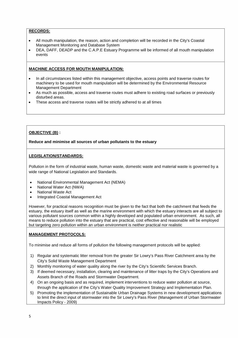
5
RECORDS:
• All mouth manipulation, the reason, action and completion will be recorded in the City’s Coastal Management Monitoring and Database System
• DEA, DAFF, DEADP and the C.A.P.E Estuary Programme will be informed of all mouth manipulation events
MACHINE ACCESS FOR MOUTH MANIPULATION: • In all circumstances listed within this management objective, access points and traverse routes for
machinery to be used for mouth manipulation will be determined by the Environmental Resource Management Department
• As much as possible, access and traverse routes must adhere to existing road surfaces or previously disturbed areas.
• These access and traverse routes will be strictly adhered to at all times
OBJECTIVE (B) : Reduce and minimise all sources of urban pollutants to the estuary LEGISLATION/STANDARDS: Pollution in the form of industrial waste, human waste, domestic waste and material waste is governed by a wide range of National Legislation and Standards. • National Environmental Management Act (NEMA) • National Water Act (NWA) • National Waste Act • Integrated Coastal Management Act
However, for practical reasons recognition must be given to the fact that both the catchment that feeds the estuary, the estuary itself as well as the marine environment with which the estuary interacts are all subject to various pollutant sources common within a highly developed and populated urban environment. As such, all means to reduce pollution into the estuary that are practical, cost effective and reasonable will be employed but targeting zero pollution within an urban environment is neither practical nor realistic MANAGEMENT PROTOCOLS: To minimise and reduce all forms of pollution the following management protocols will be applied: 1) Regular and systematic litter removal from the greater Sir Lowry’s Pass River Catchment area by the
City’s Solid Waste Management Department 2) Monthly monitoring of water quality along the river by the City’s Scientific Services Branch. 3) If deemed necessary, installation, clearing and maintenance of litter traps by the City’s Operations and
Assets Branch of the Roads and Stormwater Department. 4) On an ongoing basis and as required, implement interventions to reduce water pollution at source,
through the application of the City’s Water Quality Improvement Strategy and Implementation Plan. 5) Promoting the implementation of Sustainable Urban Drainage Systems in new development applications
to limit the direct input of stormwater into the Sir Lowry’s Pass River (Management of Urban Stormwater Impacts Policy - 2009)
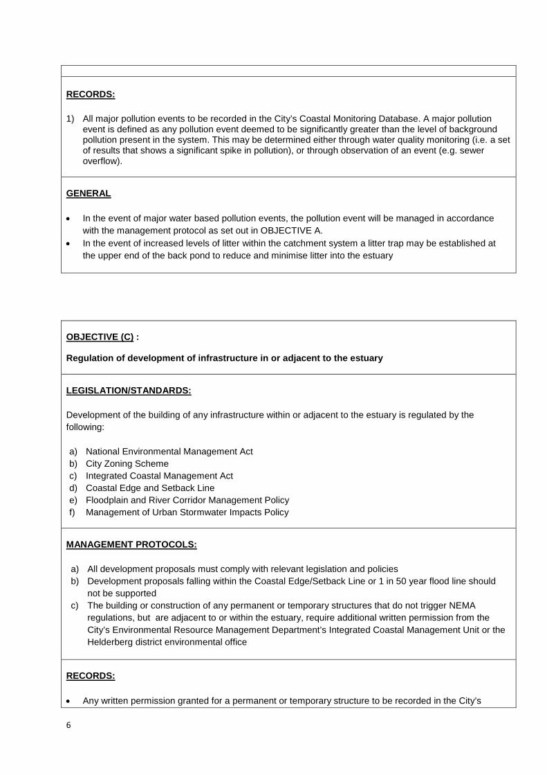
6
RECORDS:
1) All major pollution events to be recorded in the City’s Coastal Monitoring Database. A major pollution
event is defined as any pollution event deemed to be significantly greater than the level of background pollution present in the system. This may be determined either through water quality monitoring (i.e. a set of results that shows a significant spike in pollution), or through observation of an event (e.g. sewer overflow).
GENERAL • In the event of major water based pollution events, the pollution event will be managed in accordance
with the management protocol as set out in OBJECTIVE A. • In the event of increased levels of litter within the catchment system a litter trap may be established at
the upper end of the back pond to reduce and minimise litter into the estuary
OBJECTIVE (C) : Regulation of development of infrastructure in or adjacent to the estuary LEGISLATION/STANDARDS: Development of the building of any infrastructure within or adjacent to the estuary is regulated by the following: a) National Environmental Management Act b) City Zoning Scheme c) Integrated Coastal Management Act d) Coastal Edge and Setback Line e) Floodplain and River Corridor Management Policy f) Management of Urban Stormwater Impacts Policy
MANAGEMENT PROTOCOLS: a) All development proposals must comply with relevant legislation and policies b) Development proposals falling within the Coastal Edge/Setback Line or 1 in 50 year flood line should
not be supported c) The building or construction of any permanent or temporary structures that do not trigger NEMA
regulations, but are adjacent to or within the estuary, require additional written permission from the City’s Environmental Resource Management Department’s Integrated Coastal Management Unit or the Helderberg district environmental office
RECORDS: • Any written permission granted for a permanent or temporary structure to be recorded in the City’s

7
OBJECTIVE (D): Allow the natural circulation and fluctuations in estuary water quantity to be determined by seasonal rainfall patterns, whenever possible. LEGISLATION/STANDARDS: • National Water Act
MANAGEMENT PROTOCOLS: a) At no time should the mouth of the estuary be impeded, diverted, blocked or altered unless under the
specific conditions as defined in OBJECTIVE A b) The estuary mouth may never be canalised or fixed c) No water abstraction to be permitted from the back pond or estuary mouth d) Water abstraction from the Sir Lowry’s Pass River Catchment to conform to all relevant legislation with
strict permit conditions e) Encourage the re-use of treated effluent from the WWTW RECORDS: • Permitted water abstraction from the Sir Lowry’s Pass River Catchment as well as permit conditions to be
recorded in the City’s Coastal Monitoring Database
• Cases and outcomes of an illegal water extraction in the Sir Lowry’s Pass River Catchment to be recorded in the City’s Coastal Monitoring Database
GENERAL: • In the event of major flow alteration, the City’s Catchment, Stormwater and River Management Branch in
conjunction with the Helderberg district environmental office to conduct an investigation to determine cause of flow change and make recommendations to rectify and restore the flow regime
OBJECTIVE (E) :
Coastal Monitoring Database GENERAL: • Construction of any permanent or temporary structures will in general not be supported unless strong
rationale is provided with measurable benefits

8
Monitor estuary dynamics and intervene if required LEGISLATION/STANDARDS: • National Environmental Management Act MANAGEMENT PROTOCOLS: 1) The City’s Environmental Resource Management Department will develop an estuary dynamics
monitoring programme based on aerial photography, including the establishment of baseline data, with the aim of annual assessment to determine whether changes in dynamics are taking place over time.
2) If the changing dynamics of the estuary are determined to be posing a management problem, the City’s
Catchment, Stormwater and River Management Branch in conjunction with the City’s Environmental Resource Management Department will investigate and attempt to determine the cause. Areas of concern which may require intervention include, but are not limited to, increased rates of sedimentation and significant migration of the estuary or river mouth.
3) If it is determined that changes pose a management problem, the City will:
a) Inform DAFF, DEA and the C.A.P.E. Estuary Programme Manager b) In consultation with DAFF, DEA and the C.A.P.E. Estuary Programme Manager determine the most
appropriate plan of action c) Ensure compliance to NEMA if remedial action requires environmental authorisation
RECORDS: • Changes in estuary dynamics to be monitored and recorded in the City’s Coastal Management
Monitoring and Database System. GENERAL: • Recognise that changes in estuary dynamics may form part of the natural variation in the estuary and as
such retain a principle of least interference
OBJECTIVE F: Monitor estuary water quality and work towards a high standard of water quality acceptable for public recreation and ecological functioning LEGISLATION/STANDARDS: • Water quality guidelines (DWA and DEA). MANAGEMENT PROTOCOLS:

9
• Standardised water quality monitoring to be undertaken at one location within the estuary (SIR05) and at various sites in the greater catchment area once per month (temperature, dissolved oxygen, conductivity/salinity, pH, total suspended solids, total phosphorus, orthophosphate, total nitrogen, soluble ammonia, nitrite & nitrate, faecal coliforms, and Escherichia coli
• ERMD to liaise with the Wastewater Department to ensure that data from the monitoring of the final
effluent quality from the Gordon’s Bay Wastewater Treatment Works is provided to the Coastal Management Monitoring and Database System on a quarterly basis
• In the event that excessive poor water quality results are measured that threaten the estuary the
management protocols established in OBJECTIVE A may be followed to restore improved water quality conditions
RECORDS: • All water quality results will be recorded within Scientific Services’ Laboratory Information Management
System (LIMS) GENERAL • The estuary water quality management plan to be implemented in accordance with the Catchment,
Stormwater and River Management Branch City-wide work programme, resources and priorities.
OBJECTIVE (G): Remove alien invasive species from the estuary LEGISLATION/STANDARDS: • Conservation of Agricultural Resources Act, 43 of 1983 (CARA) • National Environmental Biodiversity Act (NEMBA), 10 of 2004
MANAGEMENT PROTOCOLS: The City’s Invasive Species Unit to prepare an invasive species management plan for the estuary, to include, where relevant: • Control of established invasive plants • Control and management of invasive alien birds and animals where necessary • Control and management of invasive alien fish, if deemed necessary • Re-introduction of indigenous species where feasible • Implementation of an early detection and rapid response programme to address new and emerging
invasive alien species
RECORDS:

10
• The invasive species management plan will be appended to this Estuary Management Plan as Annexure A.
GENERAL: • The estuary invasive species management plan to be implemented in accordance with the Invasive
Species Unit city-wide work programme, resources and priorities.
• An integrated invasive species management approach will be followed in partnership with relevant stakeholders
OBJECTIVE (H): Regulate all recreational use of the estuary LEGISLATION/STANDARDS: • DAFF commercial fishing regulations • DAFF recreational fishing regulations • DWA, Recreational water quality standards • Integrated Coastal Management Act • City’s Municipal Coastal Management Plan
MANAGEMENT PROTOCOLS: • Although the estuary is small, there is the possibility for limited recreation to take place. • Only recreational fishing will be permitted, with a valid recreational fishing permit, available from the Post
Office. This will be communicated through appropriate signage. • No motorised water-craft of any kind permitted in the estuary or estuary mouth • City’s Marine and Coastal Law Enforcement Unit in conjunction with DAFF Fishery Control Officers to
monitor, enforce and regulate • City Health Department, in conjunction with Catchment, Stormwater and River Management, to
determine recreational safety based on water quality results and to inform the public accordingly.
RECORDS: • Any non-compliance to regulations will be recorded in the City’s Coastal Management Monitoring and
Database System GENERAL: • The estuary recreational use management plan to be implemented in accordance with the Sport,
Recreation and Amenities Department‘s City-wide work programme, resources and priorities.
• Appropriate recreation to be supported in line with the City’s Social Development Strategy OBJECTIVE (I):

11
Provide public awareness and education through a range of media LEGISLATION/STANDARDS: • None
MANAGEMENT PROTOCOLS: Public education and awareness on the Sir Lowry’s River Estuary will be provided in the following ways: 1) General catchment and estuary education and awareness through the City’s Youth
Environmental Schools (YES) Programme 2) General estuary education and awareness as part of the City’s Educator Training Programme 3) General estuary education and awareness through the City’s Nature Reserve Environmental
Education Programme 4) General City communication programmes focusing on awareness raising and education about
pollution, its impact on human health and freshwater ecosystems 5) The installation of relevant and appropriate informative signage at the estuary
RECORDS: • All signs and their locations to be recorded in the City’s Coastal Management Monitoring and
Database System GENERAL: • All signage, regulatory and informative, must comply with the City’s Coastal Signage Protocol • The estuary public awareness and education management plan to be implemented in accordance
with the Environmental Resource Management Department city-wide work programme, resources and priorities.
OBJECTIVE (J): Undertake annual monitoring and sampling of the estuary’s biodiversity LEGISLATION/STANDARDS: • None MANAGEMENT PROTOCOLS: In partnership with DAFF undertake annual estuary biodiversity surveys through: • Fish sampling through annual seine netting • Bird counts

12
• Benthic sampling RECORDS: • All sampling results to be recorded in the City’s Coastal Management Monitoring and Database
System GENERAL: • Biodiversity sampling programme and schedule to be determined by DAFF
OBJECTIVE (K): Implement an Estuary Emergency Contingency Plan in the event of a flood, significant pollution event, oxygen depletion or other emergency events LEGISLATION/STANDARDS: • National Environmental Management Act
MANAGEMENT PROTOCOLS: The following will be considered an Estuary Emergency requiring the Emergency Contingency Protocols to be implemented: 1) A major land based pollution event 2) Marine oil or pollution spill in the surrounding area 3) Rapid oxygen depletion 4) Marine life die-off Emergency Contingency Protocols: 1) In the event of an emergency the estuary, estuary mouth and beach area (200m either side of
the mouth) will be closed to the public and enforced by City Law Enforcement 2) The City’s Coastal Co-ordinators will notify officials from DAFF, DEA and the C.A.P.E. Estuary
programme manager 3) Where a land based pollution event is contaminating the estuary, the protocol established in
OBJECTIVE A will be followed 4) Where there is a marine oil or pollution event, the estuary mouth will be closed and the Official
Oil and Pollution Contingency Plan as per the City’s Municipal Coastal Management Plan will become effective
5) In the event of a rapid oxygen depletion event, the estuary mouth will be opened at low tide to allow the coming high tide to bring ocean water into the estuary, as per OBJECTIVE A.
6) In the event of significant marine life die-off, samples of dead marine life will be provided to DAFF and DEA for analysis. All remaining dead marine life will be recovered from the estuary by the City’s Solid Waste Management department and disposed of at Vissershok Landfill site in

13
accordance with City waste management procedures 7) The beach and estuary area will only be re-opened to public access once it is deemed safe
RECORDS: • All estuary emergency events as well as the action taken will be recorded in the City’s Coastal
Management Monitoring and Database System • DEA and DAFF to make any sampling results from a marine life die off available to the City GENERAL: • An emergency will only be declared if it is determined that the scale of the problem is such that it
threatens the long term viability of the estuary as a functional ecosystem • This determination will be made by the City’s Catchment, Stormwater and River Management
Branch, in conjunction with the Environmental Resource Management Department. In the event of a biodiversity related emergency, ERMD will be the lead department in terms of decision-making.
OBJECTIVE (L): Establish an estuary task team with relevant stakeholders LEGISLATION/STANDARDS: • Integrated Coastal Management Act
MANAGEMENT PROTOCOLS: • Task team to be established as part of the city-wide “Small Estuaries Task Team”, which will
include all estuaries except for the Zandvlei and Diep estuaries. • Small Estuaries Task Team to meet on a quarterly basis RECORDS: • Minutes of all meetings to be maintained as part of the City’s Coastal Monitoring Database
GENERAL: • Small Estuaries Task Team will function as a working group consisting of officials who are
involved in management work related to the relevant estuaries • Public engagement will be facilitated through the existing Sub-Council structure
OBJECTIVE (M):

14
Regulation of Events and Filming LEGISLATION/STANDARDS: • City Filming and Events Policy
MANAGEMENT PROTOCOLS: Any organisation or individual who wishes to hold, host or undertake a commercial event or commercial filming of any kind on the estuary, or within the coastal edge surrounding the estuary must: • Submit a formal application to the City’s Events and Filming Office • The application must be circulated to the Environmental Resource Management Department,
Catchment, Stormwater and River Management Branch and Sport, Recreation and Amenities Department for consideration
• Officials from these departments will advise the Events and Filming Office on the suitability of the application and if supported the conditions attached to such support
• If approved, the final event or filming permit with attached conditions must be circulated to the Environmental Resource Management Department, Catchment, Stormwater and River Management Branch and Sport, Recreation and Amenities Department at least 48 hours prior to the event or filming taking place
RECORDS: • Events and Film Office to retain records of all applications, permits and conditions as well as any
reported non-compliance GENERAL: • Event and filming applications for the estuary must demonstrate meaningful benefit

ESTUARY MANAGEMENT PLAN:
ZEEKOEVLEI ESTUARY
1. VISION The Vision for the C.A.P.E. Estuaries Programme as a whole is: “Our estuaries are beautiful, rich in plants and animals, they attract visitors, sustain our livelihoods and uplift our spirits.” The Zeekoevlei Estuary is part of an extensive urban environment and as such the vision for the estuary is: “To manage the estuary and its catchment in such a manner as to reduce and minimise urban influence and pollutants on the estuary, where possible allow free and natural movement of the estuary mouth, manage alien invasive species, continuously work towards achieving high standards of water quality, recognise the estuary as an important marine nursery and biodiversity habitat and monitor the estuary in such a manner so as to intervene when urban influences have compromised the natural functioning of the estuary”
2.1 SITUATION ASSESSMENT AND CONTEXT
Figure 1: Historical extent of the Zeekoevlei Estuary
The Zeekoevlei River Estuary is the outlet of the Zeekoevlei Catchment drainage area which encompasses the Big and Little Lotus Rivers and Zeekoevlei. The outlet channel extends from the Zeekoevlei weir to the sea (a distance of approximately 3km). The channel also receives final sewage effluent from the Cape Flats Waste Water Treatment Works (WWTW) and, as such, it forms an important component of the City’s urban drainage system. The outlet channel is surrounded by City infrastructure - the Coastal Park landfill site to the north and the Cape Flats WWTW to the east. In addition, Baden Powell – a major east-west transport artery - crosses the Zeekoevlei outlet channel a short distance upstream of its entry point to the sea. The Zeekoevlei Catchment and its associated aquatic ecosystems have over many decades become significantly impacted and nutrient enriched and unfortunately do not support any endemic or threatened species.
The Zeekoevlei River mouth, as with all river mouths, is subject to considerable movement. While interventions

have been put in place in the past to prevent the eastward migration of the river mouth, the river is still subject to significant westward migration. This migration is not limited to the east-west plain, but may also move in a northerly direction due to erosion. The rate of this erosion is dependent on other factors such as rainfall events, storm surges and tides. The north-westerly erosion caused by the river’s migration poses a significant threat to Baden Powell Drive and therefore requires management intervention to protect this key infrastructure. While the City is mindful of not interfering with dynamic coastal processes, the potential implications of not managing these dynamics within the context of an already altered environment are serious. It is highly unlikely that this system retains any true estuarine characteristics due to the significant alteration of the flow regime and channel, and the impact of discharges from the WWTW. 2.2 WATER QUALITY OF ESTUARY
The condition of the estuary is influenced mainly by the nearby Cape Flats WWTW and, to a lesser extent, by the Zeekoevlei Catchment. Limited overflows from the upstream Zeekoevlei down the channel towards the sea outlet occur mainly in winter – the flow in the Zeekoevlei estuary is thus overwhelmingly dominated by the discharge from the WWTW. The condition of the estuary is thus influenced by the following: • Alteration of natural water flow patterns • Increased water flow as a result of discharge from the Cape Flats WWTW • Urban pollutants including litter, contaminants and treated waste water from the neighbouring Cape Flats
WWTW Comprehensive water quality monitoring has been undertaken on a monthly basis by the City’s Scientific Services Laboratory since 1981 on the Zeekoevlei waterbody itself but not within the outlet channel. Fortnightly microbiological monitoring takes place at various coastal locations along the False Bay shoreline.
Figure 2: Water quality sampling points in the vicinity of the Zeekoevlei outlet

2.3 SPECIES RECORDED IN THE CATCHMENT
The City of Cape Town’s Alien Invasive Unit have recorded the following invasive species in the Zeekoevlei Catchment (2012-2013):
Acacia cyclops Rooikrans Acacia saligna Port Jackson Eucalyptus cladocalyx Sugar Gum Layatera arborea Tree Mallow Ipomoea violacea Beach Moonflower Myoporum tenuifolium subsp. montanum Manatoka
The Department of Agriculture, Forestry and Fisheries have recorded the following marine and freshwater species in the Zeekoevlei Catchment (2013):
Freshwater Species
Clarias gariepinus Sharptooth catfish Cyprinus carpio Carp Micropterus salmoides Largemouth bass Tilapia rendalli Redbreast tilapia Tilapia sparrmani Banded tilapia Tilapia zillii Redbelly tilapia Gambusia affinis Mosquitofish
Marine Species
Mugil cephalus Flathead Mullet Myxus capensis Freshwater mullet Lithognathus lithognathus White steenbras Liza richardsonii Harder Anguilla mossambica Longfin Eel
2.4 RECREATION
Recreation in the estuary is minimal. Recreational swimming in the back ponding area and in the estuary mouth is not allowed due to the discharge of treated sewage effluent. No commercial fishing is permitted, however limited recreational fishing occurs. The size and scale of the estuary does not facilitate broader recreational use such as boating or sailing.
3 MANAGEMENT PLAN
The Zeekoevlei Estuary has to date not had a specific management plan or long term objectives assigned to it, nor have specific roles and responsibilities been previously defined. As part of its new Integrated Coastal Management approach, the City has prioritised the management of small and large estuaries. Based on the situation assessment and the available information a number of management objectives have been defined. For each of these management objectives, a specific operational protocol has been developed. These specific management protocols are intended to clearly define actions as well as responsibilities across City line departments. As implementation takes place and new information is gathered and understood, operational protocols may be amended and additional objectives and associated protocols added. Estuary management within an urban environment is seen as a long term approach following a principle of striving

towards ongoing improvement in both the quality and management of our estuaries. 3.1. MANAGEMENT OBJECTIVES
The City has the following management objectives for the Zeekoevlei Estuary: A. Allow the estuary mouth to function naturally as part of the local coastal dynamic processes and intervene
only under specific defined and documented circumstances B. Reduce and minimise all sources of urban pollutants to the estuary C. Regulation and development of infrastructure in or adjacent to the estuary D. Allow the natural circulation and fluctuation in estuary water quantity to be determined by seasonal rainfall
patterns, whenever possible E. Monitor estuary dynamics and intervene if required F. Monitor estuary water quality and work towards a high standard of water quality acceptable for public
recreation and ecological functioning G. Remove alien invasive species from the estuary H. Appropriately regulate all recreational use of the estuary I. Provide public awareness and education through a range of media J. Undertake annual monitoring and sampling of the estuary’s biodiversity K. Implement an Estuary Emergency Contingency Plan in the event of a flooding, significant pollution event,
oxygen depletion or other emergency events L. Establish an estuary task team with relevant stakeholders M. Regulate events and filming in the estuarine environment

OBJECTIVE (A) : Allow the estuary mouth to function naturally as part of the local coastal dynamic processes and intervene only under specific defined and documented circumstances LEGISLATION/STANDARDS: Estuary mouth manipulation falls within the National Environmental Management Act (NEMA) Regulations in so far as mouth manipulation involves movement of sand and therefore triggers Activity 18 (Listing Notice 1). As such mouth manipulation may be undertaken either: a) In terms of a “management plan agreed to by the relevant environmental authority” b) In an emergency situation followed by notification to Department of Environmental Affairs and
Development Planning (DEADP) MANAGEMENT PROTOCOLS: Due to the presence of the WWTW and the large volumes of effluent discharged into the estuary, it is likely that the mouth remains open for most of the year. However, migration along the coast has been problematic in previous years, and it is therefore essential that protocols for opening and straightening of the river mouth are in place. The following management protocols will be applied: 1) Risk of inland flooding • The mouth of the estuary may be straightened and opened in the event that high rainfall prediction is
indicative of a possible inland flooding event. • Determination of this need as well as the responsibility for carrying out the action resides with the City’s
Catchment, Stormwater and River Management Branch. 2) Pollution or toxic event • In the event of a toxic event in the estuary or catchment, the mouth may be mechanically opened to
facilitate flushing of the estuary during high tide or high water levels. This action may also require the trapping of sea water in the estuary through the physical closing of the mouth for a short duration.
• Determination of this need resides with the City’s Catchment, Stormwater and River Management Branch in consultation with the C.A.P.E. Estuary Programme Manager as well as the National Departments of Environmental Affairs (DEA) and Agriculture, Fisheries and Forestry (DAFF). Responsibility for carrying out the action resides with the City’s Catchment, Stormwater and River Management Branch
3) Potential undermining of infrastructure or critical dune systems by estuary mouth movement. • Where the estuary mouth moves or meanders in such a manner that it threatens critical dune systems or
City infrastructure the mouth may be mechanically straightened or re-aligned. • Determination of this need as well as the responsibility for carrying out the action resides with the City’s
Environmental Resource Management Department’s Coastal Management Unit in consultation with the Southern district environmental office
RECORDS: • All mouth manipulation, the reason, action and completion will be recorded in the City’s Coastal
Management Monitoring and Database System • DEA, DAFF, DEADP and the C.A.P.E Estuary Programme will be informed of all mouth manipulation
events by the City’s Coastal Management Unit
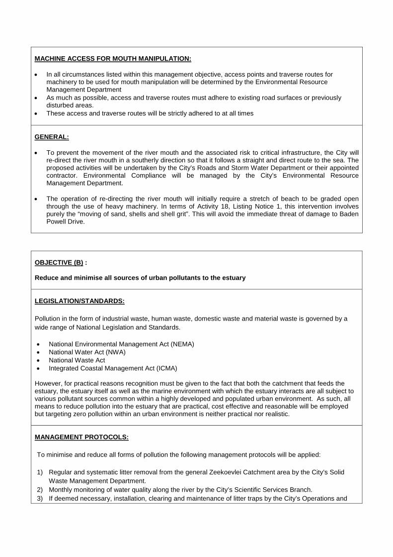
MACHINE ACCESS FOR MOUTH MANIPULATION: • In all circumstances listed within this management objective, access points and traverse routes for
machinery to be used for mouth manipulation will be determined by the Environmental Resource Management Department
• As much as possible, access and traverse routes must adhere to existing road surfaces or previously disturbed areas.
• These access and traverse routes will be strictly adhered to at all times GENERAL: • To prevent the movement of the river mouth and the associated risk to critical infrastructure, the City will
re-direct the river mouth in a southerly direction so that it follows a straight and direct route to the sea. The proposed activities will be undertaken by the City’s Roads and Storm Water Department or their appointed contractor. Environmental Compliance will be managed by the City’s Environmental Resource Management Department.
• The operation of re-directing the river mouth will initially require a stretch of beach to be graded open through the use of heavy machinery. In terms of Activity 18, Listing Notice 1, this intervention involves purely the “moving of sand, shells and shell grit”. This will avoid the immediate threat of damage to Baden Powell Drive.
OBJECTIVE (B) : Reduce and minimise all sources of urban pollutants to the estuary LEGISLATION/STANDARDS: Pollution in the form of industrial waste, human waste, domestic waste and material waste is governed by a wide range of National Legislation and Standards. • National Environmental Management Act (NEMA) • National Water Act (NWA) • National Waste Act • Integrated Coastal Management Act (ICMA)
However, for practical reasons recognition must be given to the fact that both the catchment that feeds the estuary, the estuary itself as well as the marine environment with which the estuary interacts are all subject to various pollutant sources common within a highly developed and populated urban environment. As such, all means to reduce pollution into the estuary that are practical, cost effective and reasonable will be employed but targeting zero pollution within an urban environment is neither practical nor realistic. MANAGEMENT PROTOCOLS: To minimise and reduce all forms of pollution the following management protocols will be applied:
1) Regular and systematic litter removal from the general Zeekoevlei Catchment area by the City’s Solid
Waste Management Department. 2) Monthly monitoring of water quality along the river by the City’s Scientific Services Branch. 3) If deemed necessary, installation, clearing and maintenance of litter traps by the City’s Operations and

OBJECTIVE (C) : Regulation of development of infrastructure in or adjacent to the estuary LEGISLATION/STANDARDS: Development of or building of any infrastructure within or adjacent to the estuary is regulated by the following: a) National Environmental Management Act b) City Zoning Scheme c) Integrated Coastal Management Act d) Coastal Edge and Setback Line e) Floodplain and River Corridor Management Policy f) Management of Urban Stormwater Impacts Policy
MANAGEMENT PROTOCOLS: a) All development proposals must comply with relevant legislation and policies b) Development proposals falling within the Coastal Edge/Setback Line or 1 in 50 year flood line should not
be supported c) The building or construction of any permanent or temporary structures that do not trigger NEMA
regulations, but are adjacent to or within the estuary, require additional written permission from the City’s Environmental Resource Management Department’s Integrated Coastal Management Unit or the Southern district environmental office
RECORDS: • Any written permission granted for a permanent or temporary structure to be recorded in the City’s
Coastal Monitoring Database
Assets Branch of the Roads and Stormwater Department. 4) On an ongoing basis and as required, implement interventions to reduce water pollution at source,
through the application of the City’s Water Quality Improvement Strategy and Implementation Plan.
RECORDS:
1) All major pollution events to be recorded in the City’s Coastal Monitoring Database. A major pollution event
is defined as any pollution event deemed to be significantly greater than the level of background pollution present in the system. This may be determined either through water quality monitoring (i.e. a set of results that shows a significant spike in pollution, or through observation of an event (e.g. sewer overflow).
GENERAL
• In the event of major water based pollution events, the pollution event will be managed in accordance with
the management protocol as set out in OBJECTIVE A. • In the event of increased levels of litter within the catchment system a litter trap may be established at the
most northern end of Beach Road Bridge to reduce and minimise litter into the estuary
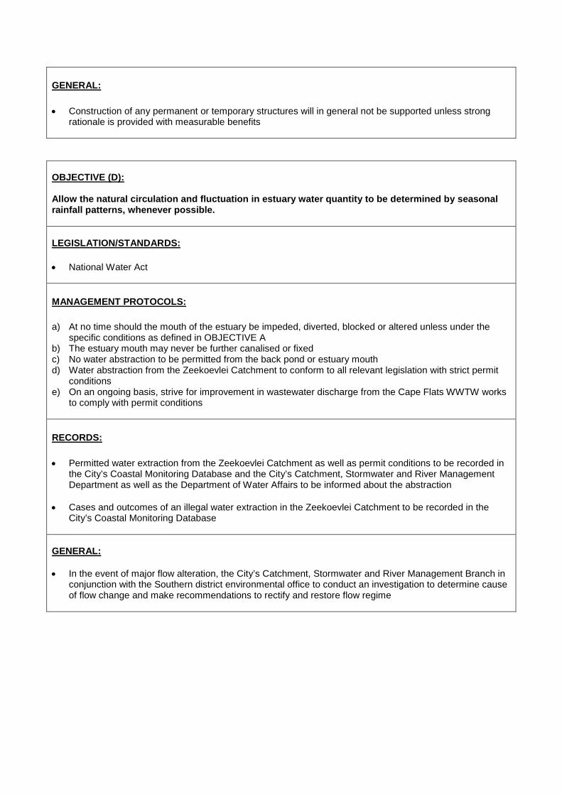
GENERAL: • Construction of any permanent or temporary structures will in general not be supported unless strong
rationale is provided with measurable benefits
OBJECTIVE (D): Allow the natural circulation and fluctuation in estuary water quantity to be determined by seasonal rainfall patterns, whenever possible. LEGISLATION/STANDARDS: • National Water Act
MANAGEMENT PROTOCOLS: a) At no time should the mouth of the estuary be impeded, diverted, blocked or altered unless under the
specific conditions as defined in OBJECTIVE A b) The estuary mouth may never be further canalised or fixed c) No water abstraction to be permitted from the back pond or estuary mouth d) Water abstraction from the Zeekoevlei Catchment to conform to all relevant legislation with strict permit
conditions e) On an ongoing basis, strive for improvement in wastewater discharge from the Cape Flats WWTW works
to comply with permit conditions
RECORDS: • Permitted water extraction from the Zeekoevlei Catchment as well as permit conditions to be recorded in
the City’s Coastal Monitoring Database and the City’s Catchment, Stormwater and River Management Department as well as the Department of Water Affairs to be informed about the abstraction
• Cases and outcomes of an illegal water extraction in the Zeekoevlei Catchment to be recorded in the City’s Coastal Monitoring Database
GENERAL: • In the event of major flow alteration, the City’s Catchment, Stormwater and River Management Branch in
conjunction with the Southern district environmental office to conduct an investigation to determine cause of flow change and make recommendations to rectify and restore flow regime

OBJECTIVE (E) : Monitor estuary dynamics and intervene if required LEGISLATION/STANDARDS: • National Environmental Management Act MANAGEMENT PROTOCOLS: 1) The City’s Environmental Resource Management Department will develop an estuary dynamics
monitoring programme based on aerial photography, including the establishment of baseline data, with the aim of annual assessment to determine whether changes in dynamics are taking place over time.
2) If the changing dynamics of the estuary are determined to be posing a management problem, the City’s
Catchment, Stormwater and River Management Branch in conjunction with the City’s Environmental Resource Management Department will investigate and attempt to determine the cause. Areas of concern which may require intervention include, but are not limited to, increased rates of sedimentation and significant migration of the estuary or river mouth.
3) If it is determined that changes pose a management problem, the City will:
a) Inform DAFF, DEA and the C.A.P.E. Estuary Programme Manager b) In consultation with DAFF, DEA and the C.A.P.E. Estuary Programme Manager determine the most
appropriate plan of action c) Ensure compliance to NEMA if remedial action requires environmental authorisation
RECORDS: • Changes in estuary dynamics to be monitored and recorded in the City’s Coastal Management
Monitoring and Database System. GENERAL: • Recognise that changes in estuary dynamics may form part of the natural variation in the estuary and as
such retain a principle of least interference
OBJECTIVE F: Monitor estuary water quality and work towards a high standard of water quality acceptable for public recreation and ecological functioning LEGISLATION/STANDARDS: • Water quality guidelines (DWA and DEA).

MANAGEMENT PROTOCOLS: • Standardised water quality monitoring to be undertaken at one location within the estuarine environment
and at various sites in the greater catchment area once per month (temperature, dissolved oxygen, conductivity/salinity, pH, total suspended solids, total phosphorus, orthophosphate, total nitrogen, soluble ammonia, nitrite & nitrate, faecal coliforms, Escherichia coli and enterococcus)
• ERMD to liaise with the Wastewater Department to ensure that data from the monitoring of the final effluent quality from Cape Flats Wastewater Treatment Works (and other relevant WWTWs) is provided to the Coastal Management Monitoring and Database System on a quarterly basis
• In the event that excessive poor water quality results are measured that threaten the estuary the
management protocols established in OBJECTIVE A may be followed to restore improved water quality conditions
RECORDS: • All water quality results will be recorded within Scientific Services’ Laboratory Information Management
System (LIMS) and the monthly Certificate of Analysis will be added to the City’s Coastal Management Monitoring and Database System.
• All final effluent quality results obtained from the Wastewater department will be logged in the City’s Coastal Management Monitoring and Database System
GENERAL: • Estuary water quality management to be implemented in accordance with the Water and Sanitation
Department’s, and Catchment, Stormwater and River Management Branch’s City-wide work programme, resources and priorities.
OBJECTIVE (F): Remove alien invasive species from the estuary LEGISLATION/STANDARDS: • Conservation of Agricultural Resources Act, 43 of 1983 (CARA) • National Environmental Biodiversity Act (NEMBA), 10 of 2004 MANAGEMENT PROTOCOLS: The City’s Invasive Species Unit to prepare an invasive species management plan for the estuary, to include, where relevant: • Control of established invasive plants • Control and management of invasive alien birds and animals where necessary • Control and management of invasive alien fish, if deemed necessary • Re-introduction of indigenous species where feasible • Implementation of an early detection and rapid response programme to address new and emerging
invasive alien species

RECORDS: • The invasive species management plan will be appended to this Estuary Management Plan as Annexure
A. GENERAL: • The estuary invasive species management plan to be implemented in accordance with the Invasive
Species Unit city-wide work programme, resources and priorities.
• An integrated invasive species management approach will be followed in partnership with relevant stakeholders
OBJECTIVE (H): Regulate all recreational use of the estuary LEGISLATION/STANDARDS: • DAFF commercial fishing regulations • DAFF recreational fishing regulations • DWA, Recreational water quality standards • Integrated Coastal Management Act • City’s Municipal Coastal Management Plan MANAGEMENT PROTOCOLS: • Only recreational fishing will be permitted, with a valid recreational fishing permit, available from the Post
Office. This will be communicated through appropriate signage. • No motorised water-craft of any kind permitted in the estuary or estuary mouth • City’s Marine and Coastal Law Enforcement Unit in conjunction with DAFF Fishery Control Officers to
monitor, enforce and regulate • Due to the close proximity of the WWTW, no swimming is permitted in the estuary. Signage to this effect
will be installed.
RECORDS: • Any non-compliance to regulations will be recorded in the City’s Coastal Management Monitoring and
Database System GENERAL: • The estuary recreational use management plan to be implemented in accordance with the Sport,
Recreation and Amenities Department‘s City-wide work programme, resources and priorities.
• Appropriate recreation to be supported in line with the City’s Social Development Strategy

OBJECTIVE (I): Provide public awareness and education through a range of media LEGISLATION/STANDARDS:
• None MANAGEMENT PROTOCOLS: Public education and awareness on the Zeekoevlei Estuary will be provided in the following ways:
1) General catchment and estuary education and awareness through the City’s Youth Environmental
Schools (YES) Programme 2) General estuary education and awareness as part of the City’s Educator Training Programme 3) General estuary education and awareness through the City’s Nature Reserve Environmental Education
Programme 4) General City communication programmes focusing on awareness raising and education about pollution,
its impact on human health and freshwater ecosystems 5) The installation of relevant and appropriate informative signage at the estuary
RECORDS: • All signs and their locations to be recorded in the City’s Coastal Management Monitoring and Database
System. GENERAL: • All signage, regulatory and informative, must comply with the City’s Coastal Signage Protocol • The estuary public awareness and education management plan to be implemented in accordance with
the Environmental Resource Management Department’s city-wide work programme, resources and priorities.
OBJECTIVE J: Undertake annual monitoring and sampling of the estuaries biodiversity LEGISLATION/STANDARDS: • None MANAGEMENT PROTOCOLS: ERMD in partnership with DAFF to undertake annual estuary biodiversity surveys through: • Fish sampling through annual seine netting

• Bird counts • Benthic sampling
RECORDS: • All sampling results to be recorded in the City’s Coastal Management Monitoring and Database System GENERAL: • Biodiversity sampling programme and schedule to be determined by DAFF • The sampling programme is contingent on sufficient resources being made available for this programme
OBJECTIVE (K): Implement an Estuary Emergency Contingency Plan in the event of a flooding, significant pollution event, oxygen depletion or other emergency events LEGISLATION/STANDARDS: • National Environmental Management Act MANAGEMENT PROTOCOLS: The following will be considered an Estuary Emergency requiring the Emergency Contingency Protocols to be implemented: 1) A land based (catchment) pollution event 2) Marine oil or pollution spill in False Bay 3) Rapid oxygen depletion 4) Marine / estuarine life die-off within the estuary
Emergency Contingency Protocols: 1) In the event of an emergency the estuary, estuary mouth and beach area (200m either side of the
mouth) will be closed to the public and enforced by City Law Enforcement 2) The City’s Coastal Co-ordinators will notify officials from DAFF, DEA and the C.A.P.E. Estuary
programme manager 3) Where a land based pollution event is contaminating the estuary, the protocol established in
OBJECTIVE A will be followed 4) Where there is a marine oil or pollution event, the estuary mouth will be boomed off and the Official Oil
and Pollution Contingency Plan as per the City’s Municipal Coastal Management Plan will become effective
5) In the event of a rapid oxygen depletion event, the estuary mouth will be breached and opened at low tide to allow high tide ocean water into the estuary, as per OBJECTIVE A.
6) In the event of significant marine life die-off, samples of dead marine life will be provided to DAFF and DEA for analysis. All remaining dead marine life will be recovered from the estuary by the City’s Solid Waste Management department and disposed of at Vissershok Landfill site in accordance with City

waste management procedures 7) The Estuary, estuary mouth and associated beach area will only be re-opened to public access once it is
deemed safe RECORDS: • All estuary emergency events as well as the action taken will be recorded in the City’s Coastal
Management Monitoring and Database System • DEA and DAFF to make any sampling results from a marine life die off available to the City GENERAL: • An emergency will only be declared if it is determined that the scale of the problem is such that it
threatens the long term viability of the estuary as a functional ecosystem • This determination will be made by the City’s Catchment, Stormwater and River Management Branch, in
conjunction with the Environmental Resource Management Department. In the event of a biodiversity related emergency, ERMD will be the lead department in terms of decision-making.
OBJECTIVE (L): Establish an estuary task team with relevant stakeholders LEGISLATION/STANDARDS: • Integrated Coastal Management Act MANAGEMENT PROTOCOLS: • Task team to be established as part of a city-wide Small Estuaries Task Team, which will include all
estuaries except for the Zandvlei and Diep estuaries. • Small Estuaries Task Team to meet on a quarterly basis RECORDS: • Action minutes of all meetings to be maintained as part of the City’s Coastal Monitoring Database GENERAL: • Small Estuaries Task Team will function as a working group consisting of officials who are involved in
management work related to the relevant estuaries • Public engagement will be facilitated through the existing Sub-Council structure

OBJECTIVE M: Regulation of Events and Filming LEGISLATION/STANDARDS: • City Filming and Events Policy MANAGEMENT PROTOCOLS: Any organisation or individual who wishes to hold, host or undertake a commercial or non-profit event or commercial filming of any kind on the estuary, or within the coastal edge surrounding the estuary must: • Submit a formal application to the City’s Events and Filming Office • The application must be circulated to the Environmental Resource Management Department,
Catchment, Stormwater and River Management Branch and Sport, Recreation and Amenities Department for consideration
• Officials from these departments will advise the Events and Filming Office on the suitability of the application and if supported the conditions attached to such support
• If approved, the final event or filming permit with attached conditions must be circulated to the Environmental Resource Management Department, Catchment Stormwater and River Management Branch and Sport, Recreation and Amenities Department at least 48 hours prior to the event or filming taking place
RECORDS: • Events and Film Office to retain records of all applications, permits and conditions as well as any reported
non-compliance GENERAL: • Event and filming applications for the estuary must demonstrate meaningful benefit


![NATIONAL ENVIRONMENTAL MANAGEMENT: INTEGRATED COASTAL ... · national environmental management: integrated coastal management act no. 24 of 2008 [view regulation] [assented to 9 february,](https://img.dokumen.tips/doc/110x75/5b63217b7f8b9a687e8b955a/national-environmental-management-integrated-coastal-national-environmental.jpg)