Embed Size (px)
Citation preview

CHAPTER 20
AL HIJ - FLIM ROAD
20 - 1
CHAPTER 20
AL HIJ - FLIM ROAD 20.1 OBJECTIVE OF THE PROJECT
Al Hij - Flim road (Project No. N47-1, Al Wusta Region), which is the only access to Mahawt Island, has unpaved earth surface but the road is passable up to Flim for ordinary passenger car as well as large trucks. This road is expected to support the activation of the fishery industry, as well as promotion of tourism, of the area. Taking into account the importance of this road, the Government intends to improve this Al Hij - Flim road. Meanwhile, design of this road has not been started yet. Therefore, DGR requested the Study Team to carry out the pre-feasibility study of this project. The objectives of the project are:
a) To provide proper all weather road for people who are living in Flim, including Mahawt Island, and
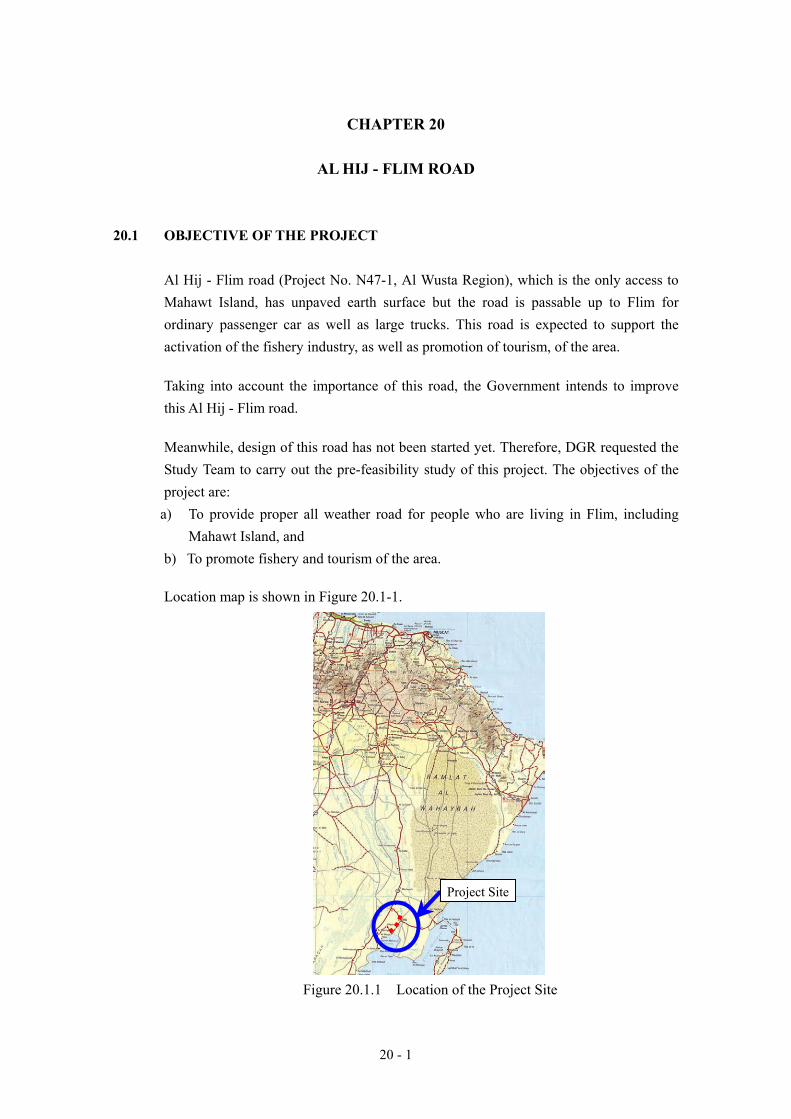
b) To promote fishery and tourism of the area. Location map is shown in Figure 20.1-1.
Figure 20.1.1 Location of the Project Site
Project Site

20 - 2
20.2 ALIGNMENT AND PRELIMINARY DESIGN 20.2.1 Physical Feature of the Project Site
Al Hij - Flim road is the only access for the village of Flim and Mahawt Island. The project road passes through the desert area with several small gravelly hills. Beside of the road, Wadi Halfayn and its offshoots flow down to the sea and across the road many times, but it is difficult to specify the exact stream line due to the flat topography there. The village of Flim is located at low land which experiences the submergence frequently in particular during the spring tide. So the residents of the village banked few hundreds meters in length and about 1 meter in height near the coast line Generally the physical feature of the project site is same and flat for whole stretch.
20.2.2 Existing Road Condition
Al Hij - Flim road starts from the junction in the town of Hij which is connected to NR 32 by a paved road. The paved road continues few hundreds meters beyond the town of Hij towards Flim. Then road becomes earth surface which is kept smooth by the motor grader. The road traverses the large flat area and sometimes passes through a space between small hills. Originally, the area is the gravelly desert and gravel is occasionally seen on the surface of the road, but the gravel does not thickn enough to be called “layer”. It means that the existing road is just an earth road and cannot be called gravel road. At present there are no any drainage facilities, even side ditch. The road has been maintained by scraping the surface. Actually the elevation of the road surface is lower than adjacent land at most of that stretch. It is suspected that the flood stream flow down on the road at some sections. At the most of the wadi crossing, except a few locations, depths of the wadis are very shallow, less than 1 meter. Vehicles can pass such wadi sections as smoothly as ordinary section. At Chainage 13.0 kilometer, the road passes the bottom of a shallowly concave place which may become a pond during flood. From beginning to the end of the project road, the road condition is more or less uniform. The condition of the existing road is shown in Figure 20.2-1.

20 - 3
Figure 20.2-1 Existing Road Condition
Beginning Point 0km
Pass throug small hills 1km
Road side is higher 7km
Wadi Crossing at 15kmBottom of concave place at 13km
Low land at 19kmEnd point 19.3km
10km
Al Hij
Flim

20 - 4
20.2.3 Proposed Road Alignment
Generally, the alignment of the existing road has very little problems. Therefore, the proposed alignment basically follows the existing alignment. Further, if there will be any necessity for improvement of alignment after detailed survey, there will be very little ristriction by the topography and preferable geometric elements can be easily adopted. On the other hand it is necessary to consider the vertical grade as mentioned in the prior paragraph. The road elevation shall be raised up 0.5 meter in average because of the height of the existing road is lower than the adjacent land. At Chainage 13.0 kilometer, the road passes the bottom of a shallow concave place and the road bed needs to be embanked about 1.0 meter in height in order not to be submerged. Also proper cross drainage is required there. From the Chainage 18.5 kilometer to the 19.3 kilometer, the end point of the project road, the road is raised up about 1.5 meters so that the road surface is higher than the high tide level. The proposed road alignment is shown in Figure 20.2-2.

20 - 5
BEGINNINGSTA. 0+000
ENDSTA. 19+300
STA. 10+000
Figure 20.2.2 Proposed Alignment 20.2.4 Preliminary Design
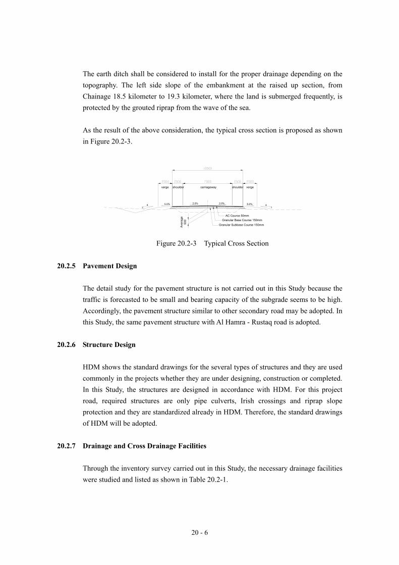
The proposed cross sections follow HDM. As mentioned in HDM, the carriageway of secondary road shall be 7.0 meters and paved shoulder of 1.5 meters in width shall be provided on both sides in this project. In accordance with HDM, the verge of 2.0 meters in width shall be secured on both sides in whole of the stretch.
20 - 6
The earth ditch shall be considered to install for the proper drainage depending on the topography. The left side slope of the embankment at the raised up section, from Chainage 18.5 kilometer to 19.3 kilometer, where the land is submerged frequently, is protected by the grouted riprap from the wave of the sea. As the result of the above consideration, the typical cross section is proposed as shown in Figure 20.2-3.
Figure 20.2-3 Typical Cross Section
20.2.5 Pavement Design
The detail study for the pavement structure is not carried out in this Study because the traffic is forecasted to be small and bearing capacity of the subgrade seems to be high. Accordingly, the pavement structure similar to other secondary road may be adopted. In this Study, the same pavement structure with Al Hamra - Rustaq road is adopted.
20.2.6 Structure Design
HDM shows the standard drawings for the several types of structures and they are used commonly in the projects whether they are under designing, construction or completed. In this Study, the structures are designed in accordance with HDM. For this project road, required structures are only pipe culverts, Irish crossings and riprap slope protection and they are standardized already in HDM. Therefore, the standard drawings of HDM will be adopted.
20.2.7 Drainage and Cross Drainage Facilities
Through the inventory survey carried out in this Study, the necessary drainage facilities were studied and listed as shown in Table 20.2-1.
shoulder shoulderverge vergecarriageway
41
41
AC Cource 50mmGranular Base Course 150mm
Granular Subbase Course 150mm
2.0% 2.0%5.0% 5.0%
Ave
rage
500

20 - 7
Table 20.2-1 List of the Drainage Facilities
Chainage Drainage Chainage Drainage1 0km+700 Pipe 1-900 15 9km+900 Pipe 1-9002 1km+500 Pipe 1-900 16 10km+400 Pipe 1-9003 2km+000 Pipe 1-900 17 11km+200 Pipe 1-9004 2km+200 Pipe 1-900 18 11km+700 Pipe 1-9005 2km+400 Pipe 1-900 19 12km+140 Irish Crossing (80m)6 2km+940 Irish Crossing (80m) 20 12km+500 Pipe 1-9007 3km+115 Irish Crossing (30m) 21 13km+000 Pipe 1-9008 4km+000 Pipe 1-900 22 13km+500 Pipe 1-9009 5km+000 Pipe 1-900 23 13km+700 Pipe 1-900
10 5km+500 Pipe 1-900 24 14km+400 Pipe 1-90011 5km+630 Irish Crossing (60m) 25 15km+025 Irish Crossing (50m)12 7km+200 Pipe 2-900 26 16km+400 Pipe 1-90013 7km+500 Pipe 1-900 27 17km+300 Pipe 1-90014 8km+000 Pipe 1-900 28 19km+300 Pipe 1-900

20 - 8
20.3 Preliminary Cost Estimation 20.3.1 Procedure of Project Cost Estimate
The procedure of project cost estimation is shown in Figure 20.3-1. The estimate is made based on the unit prices of construction material, labor costs and equipment costs which are obtained from the survey of the current market prices. The unit costs of major construction items were decided after comparing the estimated unit cost with latest bid prices. The prices of items needed in the project, but not listed in the table are quoted from those available in Japan and converted to RO using the exchange rate of ; US$ 1.0 = RO 0.385 = JPY 108. Engineering services cost is estimated as the percentage of the construction cost. ROW acquisition cost for new roads and widening are not estimated because there is no necessity of new land acquisition for roads.
Figure 20.3-1 Procedure of Project Cost Estimate
Unit Cost of Major
Construction Items
Latest Bid Prices Unit Price of
- Construction Materials
- Labor Cost
- Equipment Cost
ROW Acquisition Cost
- New Roads
- Widening
Engineering Service
Cost
(% of Construction Cost) Construction
Cost Estimate
Project Cost
Quantity
Estimate
Market
Prices

20 - 9
20.3.2 Unit Price and Cost of Major Construction Items
Unit prices of major construction materials, labor cost and equipment cost, which are determined based on the investigation of the latest market prices, are shown in Tables 20.3-1, 20.3-2 and 20.3-3, respectively. The major construction items are defined from “The Sultanate of Oman, General Specification for Roads, April 1994” and their unit costs of the road is presented in Table 20.3-4.
Table 20.3-1 Average Prices of Major Construction Materials (2004 Prices)
No. Material Description Unit Unit Price (RO) 1 2 3 4 5 6 7 8 9
10 11 12
13
14 15 16 17 18 19 20 21 22 23
Aggregates for granular sub-base course Aggregate for aggregate base course Aggregates for bituminous base course Fine aggregate for concrete Coarse aggregate for concrete Stone for drainage, masonry and slope protection Asphalt cement, grade 60-70 on site Asphalt cement, grade 50-60 on site Emulsified asphalt, grade RS-1 on site Cutback asphalt, MC and RC type on site Portland cement on site Deformed billet steel bars, AASHTO M31 grade 60 (High Yield) of any diameter Deformed billet steel bars, AASHTO M31 grade 40 (High Yield) of any diameter Highway signs Highway sign support Timber plank, on site Timber props, on site Wire mesh gabion, on site Explosive, on site Gas oil, on site Gasoline, Premium Gasoline, Regular Diesel
Cu.m. Cu.m. Cu.m. Cu.m. Cu.m. Cu.m. Ton Ton Ton Ton Ton Ton
Ton
Sq.m.
Nr. Cu.m Cu.m. Ton Kg
Liter Liter Liter Liter
3.0003.0003.0004.0003.5003.000
90.00080.000
100.000100.00025.000
250.000
225.000
50.00025.000
150.000150.000225.00050.0000.5000.1200.1140.102
Source: Study Team Survey
Table 20.3-2 Labor Cost (2004 Prices) No. Labor Category Unit Unit Rate (RO) 1 2 3 4 5 6 7 8 9 10 11 12 13 14
Supervisor Site Surveyor Foreman 1st Class Operator 2nd Class Operator Mechanic Driver Skilled Labor Semi-skilled Labor Mason Painter Carpenter Steel Fixer Electrician
Hour Hour Hour Hour Hour Hour Hour Hour Hour Hour Hour Hour Hour Hour
3.0003.0002.0002.0001.8001.7001.8001.2001.0001.2001.2001.2001.2001.200
Source: Study Team Survey

20 - 10
Table 20.3-3 Hourly Cost of Major Construction Equipments (2004 Prices) No. Construction Equipment Hourly Cost (RO) 1 2 3 4 5 6 7 8 9
10 11 12 13 14 15 16 17 18 19 20 21 22 23 24 25 26 27 28 29 30 31 32 33 34 35 36 37 38 39 40 41 42 43 44 45 46 47 48 49 50 51 52 53 54 55 56 57
Motor grader from 100 HP to 120 HP Motor grader from 120 HP to 150 HP Tractor from 60 HP to 100 HP Bulldozer with ripper from 100 HP to 150 HP Bulldozer with ripper from 150 HP to 200 HP Bulldozer with ripper from 200 HP to 250 HP Bulldozer with ripper from 250 HP to 300 HP Wheel Tractor up to 50 HP Wheel Tractor over 50 HP Motor scraper capacity up to 18 cu.m. Motor scraper capacity 18 to 24 cu.m. Sheeps foot roller from 5 to 10 ton Vibratory compactor with prime mover up to 5 ton Pneumatic compactor with prime mover from 30 to 50 ton Pneumatic self-propelled roller from 15 to 20 ton Tandem roller up to 8 ton Tandem roller from 8 to 12 ton Triaxle roller from 10 to 15 ton Light frog-rammer 0.1 ton Heavy frog-rammer 0.5 ton Wheel loader 1.2 to 1.6 cu.m. Wheel loader 1.6 to 2.5 cu.m. Excavator up to 0.8 cu.m. Excavator from 0.8 to 1.2 cu.m. Bituminous mixing plant with batching apparatus up to 80 ton/hr Bituminous mixing plant with batching apparatus 80 to 150 ton/hr Finisher up to 80 ton/hr Finisher from 80 to 120 ton/hr Bitumen sprayer up to t ton Tanker truck up to 6 cu.m. Dump truck up to 10 ton Dump truck from 10 ton to 15 ton Screening plant from 80 to 100 ton/hr Crushing plant up to 40 ton/hr Crushing plant from 40 to 60 ton/hr Air compressor up to 6000 l/m Air compressor over 6000 l/m Mechanical broom Power water pump Steel cutting machine Steel bending machine Belt conveyor Concrete mixer up to 0.5 cu.m. Concrete mixer over 0.5 cu.m. Automatic concrete batch plant without mixing Transmixer up to 5 cu.m. Concrete vibrators Crane up to 5 ton Crane with boom and jib from 5 to 10 ton Crane with boom and jib over 10 ton Generator 60 ~ 75 Kw Generator 100 Kw Generator 150 ~ 200 Kw Drilling Equipment Gravel strewer Asphalt cutter Vehicle for foreman and surveyor
12.00015.00012.00012.00016.00018.00020.000
8.0009.000
18.00022.000
7.0005.0005.0006.0005.0007.0008.0001.0001.5006.0008.0006.0009.000
20.00030.00010.00012.000
7.5005.5005.0006.000
18.00013.00015.000
2.5004.0004.0001.5001.0001.0002.0002.5004.000
16.00015.000
1.0005.000
10.00015.000
2.5005.0009.000
10.0005.0002.0005.000
Source: Study Team Survey

20 - 11
Table 20.3-4 Unit Cost of Major Construction Items
No. Description Unit Unit Cost(RO)
200 EARTHWORKS203 Earthworks Excavation
Suitable excavation to embankment Cu. m. 1.660 0.882 53% 0.734 44% 0.044 3%Suitable excavation to waste Cu. m. 1.546 0.815 53% 0.690 45% 0.041 3%Borrow excavation to embankment Cu. m. 3.660 1.300 36% 2.295 63% 0.065 2%
206 Excavation and Backfilling for StructuresStructural excavation in soils to a depth of 2m. Cu. m. 1.351 0.713 53% 0.602 45% 0.036 3%Structural excavation in rock to a depth of 2m. Cu. m. 2.665 1.408 53% 1.187 45% 0.070 3%
300 GRANULAR AND STABILIZED SUBBASE, BASECOURSE AND STABILIZED SUBGRADE302 Granular Subbase
Class A Subbase Cu. m. 5.000 2.094 42% 2.801 56% 0.105 2%Class B Subbase Cu. m. 4.000 1.675 42% 2.241 56% 0.084 2%
303 Aggregate BasecourseClass A Basecourse Cu. m. 5.000 2.112 42% 2.783 56% 0.106 2%Class B Basecourse Cu. m. 4.000 1.689 42% 2.226 56% 0.084 2%
400 BITUMINOUS PAVEMENT401 Bituminous Prime Coat and Tack Coat
Prime Coat such as MC70 Kg 0.120 0.078 65% 0.039 32% 0.004 3%Tack Coat such as RC250 Kg 0.150 0.097 65% 0.048 32% 0.005 3%
402 Bituminous BasecourseBituminous Basecourse Cu. m. 17.000 10.893 64% 5.563 33% 0.545 3%
405 Bituminous Wearing CourseBituminous Wearing Course Cu. m. 17.000 10.893 64% 5.563 33% 0.545 3%
500 CONCRETE AND CONCRETE STRUCTURES504 Concrete for Structures
Concrete Class 28/20 Cu. m. 40.000 13.954 35% 25.348 63% 0.698 2%509 Reinforcing Steel
High yield steel bars ton 250.000 153.428 61% 88.901 36% 7.671 3%Mild steel bars ton 250.000 152.690 61% 89.676 36% 7.634 3%
800 DRAINAGE AND SERVICE DUCTS801 Pipe Culverts
Reinforced Concrete Pipe Culvert 600 mm Lin. m. 35.000 18.270 52% 15.817 45% 0.914 3%Reinforced Concrete Pipe Culvert 900 mm Lin. m. 75.000 39.150 52% 33.893 45% 1.958 3%Reinforced Concrete Pipe Culvert 1500 mm Lin. m. 155.000 80.910 52% 70.045 45% 4.046 3%
900 SLOPE PROTECTION AND STABILIZATION901 Rip Rap
Loose stone riprap Class A Cu. m. 6.000 2.477 41% 3.399 57% 0.124 2%Loose stone riprap Class B Cu. m. 6.000 2.477 41% 3.399 57% 0.124 2%Mortared stone riprap Cu. m. 15.000 4.438 30% 10.340 69% 0.222 1%
902 GabionsGabions Cu. m. 13.000 4.977 38% 7.774 60% 0.249 2%
906 Ditch liningDitch lining (150mm thick) Sq. m. 2.000 0.573 29% 1.399 70% 0.029 1%
1200 SIDEWALKS, PAVED AREAS AND CURBS1202 Curbs
Precast concrete curb, Class 28/20 non-mountable type Lin. m. 5.000 1.744 35% 3.169 63% 0.087 2%Precast concrete curb, Class 28/20 mountable type Lin. m. 5.000 1.744 35% 3.169 63% 0.087 2%Precast concrete curb, Class 28/20 lip type Lin. m. 5.000 1.744 35% 3.169 63% 0.087 2%
1300 SAFETY BARRIERS, DELINEATORS AND FENCES1301 Corrugated Steel Beam Safety Barrier
Safety barrier beam (Class B, W-section) Lin. m. 5.000 3.610 72% 1.210 24% 0.180 4%Safety barrier post (Type C) including foundation Nr. 12.000 8.664 72% 2.903 24% 0.433 4%End anchorage (ramp down), including post (Type C) and foundation Nr. 25.000 18.050 72% 6.048 24% 0.902 4%W-beam terminal sectionRe-fixing of safety barrier beam Nr. 15.000 10.830 72% 3.629 24% 0.541 4%Re-fixing of safety barrier post including foundation Lin. m. 0.500 0.361 72% 0.121 24% 0.018 4%Re-fixing of end anchorage (ramp down) including posts Nr. 3.000 2.166 72% 0.726 24% 0.108 4%Re-fixing of W-beam terminal section Nr. 16.000 11.552 72% 3.870 24% 0.578 4%
1302 Concrete safety barrierConcrete safety barrier (Type A) Lin. m. 55.000 19.186 35% 34.854 63% 0.959 2%Concrete safety barrier (Type B) Lin. m. 30.000 10.465 35% 19.011 63% 0.523 2%
1303 Reflectorized Markers for safety barriersReflectorized markers (red) attached to Guardrail Nr. 4.000 2.888 72% 0.968 24% 0.144 4%Reflectorized markers (red) attached to concrete barrier Nr. 3.000 2.166 72% 0.726 24% 0.108 4%
1304 DelineatorsFlexible delineators Nr. 12.000 8.664 72% 2.903 24% 0.433 4%Irish crossing markers Nr. 35.000 25.270 72% 8.467 24% 1.263 4%Irish crossing water depth gauges Nr. 42.000 30.324 72% 10.160 24% 1.516 4%
1400 HIGHWAY SIGNS AND ROAD MARKINGS1401 Highway Signs
Triangular, side 900mm Nr. 25.000 18.050 72% 6.048 24% 0.902 4%Triangular, side 1100mm Nr. 30.000 21.660 72% 7.257 24% 1.083 4%Triangular, side 1200mm Nr. 40.000 28.880 72% 9.676 24% 1.444 4%Circular, diameter 900mm Nr. 30.000 21.660 72% 7.257 24% 1.083 4%Circular, diameter 1200mm Nr. 85.000 61.370 72% 20.562 24% 3.068 4%Rectangular sign Sq.m. 50.000 36.100 72% 12.095 24% 1.805 4%Kilometer post (sign No. 323) Nr. 25.000 18.050 72% 6.048 24% 0.902 4%Sign post support assembly, (Type 1A) Nr. 25.000 18.050 72% 6.048 24% 0.902 4%Sign post support assembly, (Type 1B) Nr. 54.000 38.988 72% 13.063 24% 1.949 4%Sign post support assembly, (Type II) Nr. 68.000 49.096 72% 16.450 24% 2.455 4%Sign post support assembly, (Type IIIA) Nr. 150.000 108.299 72% 36.286 24% 5.415 4%Sign post support assembly, (Type IIIB) Nr. 155.000 111.909 72% 37.495 24% 5.595 4%Re-fixing of removed highway sign (any size with single post) Nr. 20.000 14.440 72% 4.838 24% 0.722 4%Re-fixing of removed highway sign (any size with multiple post) Nr. 25.000 18.050 72% 6.048 24% 0.902 4%
1402 Road MarkingsTraffic lines (mechanically sprayed) Sq. m. 1.600 1.155 72% 0.387 24% 0.058 4%Curb painting (black and yellow) Sq. m. 1.000 0.722 72% 0.242 24% 0.036 4%Reflecting road studs (double face) Nr. 3.500 2.527 72% 0.847 24% 0.126 4%
Foreigncomponent
LocalComponent Taxes

20 - 12
20.3.3 Construction Cost
Estimated construction cost is presented in Table 20.3-5. Detailed cost estimate is shown in Annex 20-1. The construction cost was estimated at RO 1,651,000, composed of 55.5% of a foreign currency component (or RO 916,000), 41.7% of a local currency component (or RO 688,000) and 2.8% of a tax component (or RO 47,000). Indirect costs (contingency) was assumed at 10% of direct cost, referring to the latest bid prices.
Table 20.3-5 Construction Cost (RO 1,000) Foreign Local Tax Total
916 688 47 1,651 Amount (55.5%) (41.7%) (2.8%) (100%)
20.3.4 Engineering Service and Construction Supervision Cost
The engineering services cost covering detailed design (D/D) and construction supervision cost (C/S) is estimated as a certain percent of the project construction cost. The investigation of the recent projects in the Sultanate of Oman shows that the current percents for D/D and C/S are about 3% and 4%, respectively. Estimated engineering services and construction cost is presented in Table 20.3-6.
Table 20.3-6 Engineering Services and Construction Supervision Cost (RO 1,000) Foreign Local Tax Total
40 5 5 50 Detailed Design (80.0%) (10.0%) (10.0%) (100%)
52 7 7 66 ConstructionSupervision (80.0%) (10.0%) (10.0%) (100%)
92 12 12 116 Total (80.0%) (10.0%) (10.0%) (100%)
20.3.5 Summary of Project Costs
Summary of Project Cost is shown in Table 20.3-7.
Table 20.3-7 Summary of Project Cost (RO 1,000) Foreign Local Tax Total
40 5 5 50 Detailed Design (80.0%) (10.0%) (10.0%) (100%)
916 688 47 1,651 Construction(55.5%) (41.7%) (2.8%) (100%)
52 7 7 66 ConstructionSupervision (80.0%) (10.0%) (10.0%) (100%)
1,008 700 59 1,767 Total (57.0%) (39.6%) (3.4%) (100%)

20 - 13
20.4 ENVIRONMENTAL CONSIDERATIONS AND TOR FOR EIA 20.4.1 Environmental Considerations 1) General
The objectives of environmental considerations at the stage of the “Pre-Feasibility Study (Pre-F/S)” are: - To confirm the results of the “Initial Environmental Examination (IEE)”; - To clarify present conditions in the project site and specific environmental impacts
due to proposed road construction project; - To re-evaluate comprehensively proposed project road; and - To provide the “Terms of Reference (TOR)” for EIA in the next “Feasibility Study”.
The examined environmental considerations are examined the following items and procedures:
1. Review of result of the IEE with data and information concerning the project. 2. Environmental investigation at the project site using “Environmental Checklist”
(refer to Table 12.1-1). 3. Analysis of environmental conditions and impacts. 4. Comprehensive evaluation. 5. Provision of TOR for EIA.
The content of the site investigation consists of the following environmental items:
(1) Air pollution (2) Effluent (3) Noise and vibration (4) Land subsidence (5) Topography and geology (6) Soil and soil erosion (7) Hydrology and groundwater (8) Ecosystem, flora and fauna (9) Landscape (including coastal zone) (10) Regional development on the natural environment (11) Hazards (12) Other impacts on the natural environment (13) Wastes (14) Cultural heritage

20 - 14
(15) Regional development on the social environment (16) Other impacts on the social environment
2) Environmental checklist for the project “AL HIJ - FLIM ROAD”
More detailed environmental investigation, analysis and comprehensive evaluation for the road section between Al Hij and Flim were carried out using the environmental checklist. The results of investigation and evaluation are shown in Annex 20-2. Consequently, environmental impacts due to the proposed project are likely to occur on the environmental items of Hydrology and groundwater, Eco-system, Flora and Fauna, and Other Impacts on Social Environment. a. Hydrology and groundwater - Present condition:
There is no current flow along wadi, Wadi Halfayn, in the area. Groundwater is pumped up at near beach and the pumped water is supplied by water tank to the residents at Flim and pipe water is also supplied to Mahawt Island during fishing season.
- Impacts with project:
Slight to moderate impact to groundwater, consisting of lowering of groundwater table, water contamination, is likely to occur due to increase of pumping volume and wastes by increased visitors to the area. Because, the groundwater reserve near beach in the area seems to be limited.
- Evaluation: 1~2:
Slight to moderate impact to groundwater due to increased wastes and traffic volume is evaluated.
b. Eco-system, Flora and Fauna - Present condition:
Flora: Rare vegetation in the area, but small amount of grass and low acacia trees are found in the area. Mangroves are locally found around lagoon and sabkha at Flim and Mahawt Island. Mangroves are very important for fishery and stopping point for migratory birds.

20 - 15
Fauna: Many kind of birds, including migratory birds, stop in beach and mangroves in the area. Several mammals, consisting of Hedgehog, Red Fox, Sand Fox, Wild Cat, caracal, Nubian Ibex, Arabian Gazelle, Cape Hare, etc., are reported to make habitat in the area are.
Fishing: Surroundings of Mahawt Island are rich fishing places. Therefore, many fishermen work in Flim and Mahawt Island.
- Impacts with project:
Not so significant impact with project to the eco-system and fauna in the area is likely, in case of compare with present gravel road. However, increase of visitors as tourism in future might indirectly influence eco-system, flora and fauna along the coastal line, including mangroves.
- Evaluation: 1~2:
Slight to moderate indirect impact to eco-system, flora and fauna due to road construction. It is necessary to carry out detailed investigation concerning eco-system, flora and fauna in the area.
c. Other Impacts on Social Environment - Present condition:
There are several villages and small settlements with farmlands and a number of domestic animals along the route shown as below.
Al Hij village: Residential area, mosque, and workshops. Houses have enough distance, more than 30m, from boundary of the existing road. Mosque keeps about 100m away from the existing road.
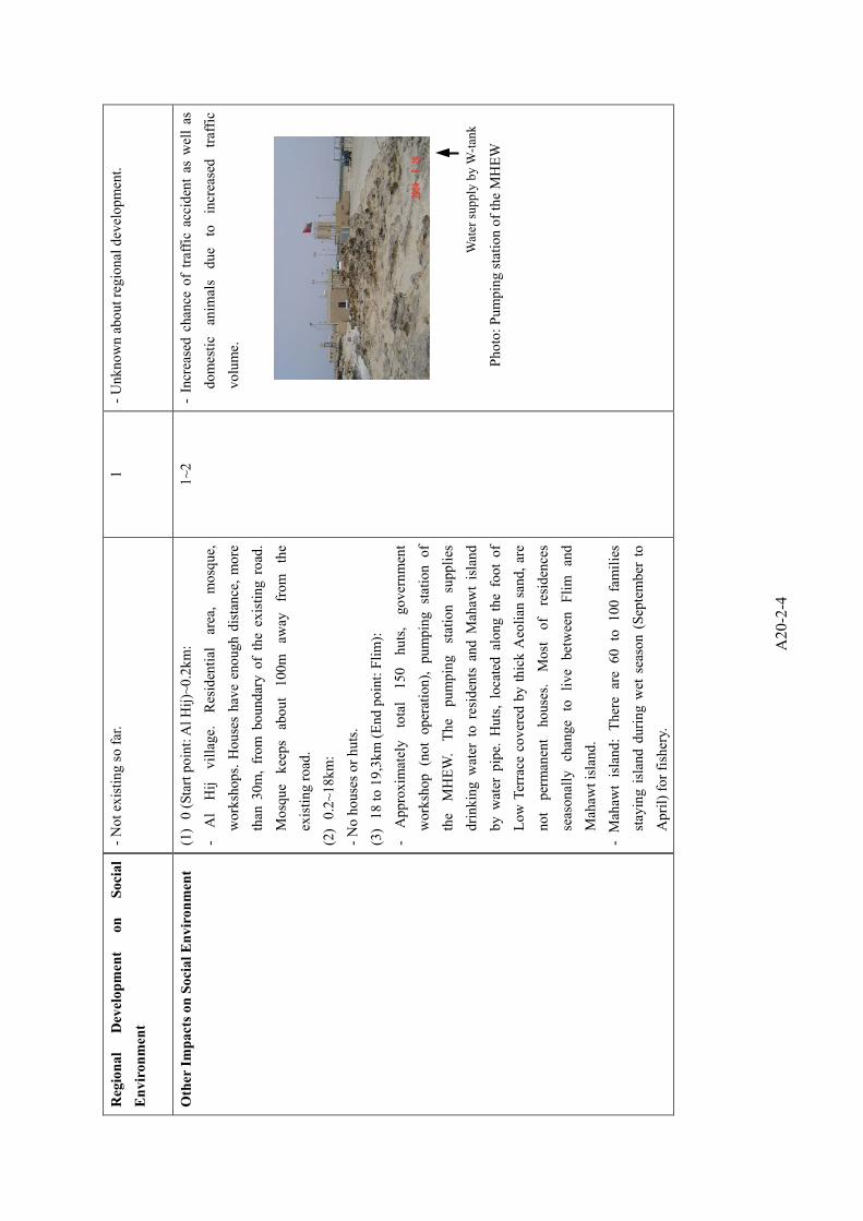
Flim: Approximately total 150 huts, government workshop (not operation), pumping station of the MHEW. The pumping station supplies drinking water to residents and Mahawt Island by water pipe. Huts, located along the foot of Low Terrace covered by thick Aeolian sand, are not permanent houses. Most of residences seasonally change to live between Flim and Mahawt Island.
Mahawt island: There are 60 to 100 families staying island during wet season (September to April) for fishing.

20 - 16
- Impacts with project:
Increased chance of traffic accident due to increased traffic volume. - Evaluation: 1~2:
Slight to moderate impact as increase of chance of traffic accidents to social environment due to road construction.
d. Other environmental items: Not significant impact. 3) Results of IEE
The comprehensive evaluation for the Al Hij - Flim Road is concluded to be 1~2 as impact rating; summarized in Table 20.4-1. Hence, the implementation of EIA before road construction is recommended. Table 20.4-1 Results of IEE on the Al Hij - Flim Road - Hydrology, groundwater 1~2 - Groundwater contamination due to
wastes - Eco-system, Flora and Fauna 1~2 - Damage to mangroves and eco-system - Other Impacts on Social Environment 1~2 - Traffic accidents due to increased traffic- Other items 1
Comprehensive Evaluation 1~2
Recommendations *1 Recommended to carry out partial EIA on assigned items after scoping
Note *1 : Comprehensive Evaluation 1 : None to slight impacts : No need to carry out EIA or need to carry out partial EIA after scoping 1~2 : Small impacts : Recommended to carry out partial EIA on assigned items after
scoping 2 : Moderate impacts : Recommended to carry out EIA 2~3 : Relatively significant impacts: Recommended to carry out EIA 3 : Significant impacts : Recommended to carry out EIA
20.4.2 Terms of Reference for the Project Terms of reference (TOR) on the Environmental Impact Assessment of the Al Hij -
Flim Road, Sultanate of Oman, are shown in Annex 20-3.

20 - 17
20.5 PROJECT EVALUATION
20.5.1 General
Al Hij - Flim road project starts from Al Hij and terminates to Flim in the Wilayah Muhut. This road has total length of about 19.3 kilometers and is classified as secondary road. The objective of this section is to examine viability of the construction plan of Al Hij - Flim road from viewpoint of national economy of Oman. In order to achieve the objective, the following steps are carried out;
・ Step 1: Future socio-economic framework in the influence area of the Project Road
・ Step 2: Traffic demand forecast on the Project ・ Step 3: Estimation of economic benefit based on traffic demand on the Project
Road and unit vehicle operating costs ・ Step 4: Estimation of economic cost based on the estimated financial cost
mentioned in Section 20.3. ・ Step 5: Calculation of economic indicators of the Project Road using the
economic benefit and economic cost. ・ Step 6: Sensitivity analysis to be made by varying factors of influenced to
economic indicators such as the economic benefits, economic costs and discount rate.
・ Step 7: Evaluation from technical and socio-economic view points ・ Step 8: Overall evaluation
Figure 19.5-1 shows procedure for project evaluation.
20.5.2 Traffic Demand Forecast
In the Master Plan, the traffic demand for inter-Wilayah was forecasted in order to formulate nationwide road network development and that demand for intra-Wilayah was not forecasted. However, it is necessary to estimate the traffic demand for intra-Wilayah due to the Project Road being influenced within Wilayah. The traffic demand forecast in this section is made as following steps:

20 - 18
Table 19.5-1(1) Population of
1) Socio-Economic Framework in Influence Area Based on 1993 population census, the socio economic data by towns and villages in Governorates and Regions such as number of household, housing unit, population and town and village location are presented in ‘ Socio-Economic Atlas1’ The socio- economic data in
1 Socio-Economic Atlas: Information & Documentation Center, Ministry of Development, Nov. 1997
Future OD Traffic
w/ and w/o Project
Road Network w/
and w/o Project
Financial Cost of
Project
Unit Vehicle
Operating Cost
Running Cost
Saving
Fixed Cost
Saving
Travel Time
Cost Saving
Elimination of
Transfer Cost
Economic Cost
of Project
Economic Benefit
of Project
Economic Evaluation of Project
by Economic Indicators
- NPV
- B/C Ratio
- EIRR
Sensitivity
Analysis
Evaluation from Other
Aspects
- Technical Aspects
- Socio-economic Aspect
Socio-Economic
Framework
Overall Evaluation
Figure 21.5-1 Procedure for Project Evaluation
Traffic Demand
Forecast on Project

20 - 19
the influence area of the Project Road in 1993 is computed on the basis of these data. Future population, number of workers and private vehicle are applied for these growth rate of Wilayah Muhut as shown in Tables 20.5-1(1), (2) and (3). Table 20.5-1(1) Population of Direct and Indirect Influence Areas by Years ( Person)
19931) 2005 2010 2020 2030 Direct Influence Area 1 Hij 1,841 2,531 2,817 3,233 3,5692 Flim 215 296 329 378 417 Total 2,156 2,827 3,146 3,611 3,152Indirect Influence Area 3 Halibah 122 168 187 214 2364 Tuwailah 42 58 64 74 815 Subgha 34 47 52 60 66 Total 198 273 303 348 383Other Areas 6 Wilayah North 3,393 4,665 5,191 5,983 6,5777 Wilayah South 1,471 2,022 2,251 2,583 2,851 Wilayah – Total 7,369 10,131 11,275 12,939 14,284
Table 20.5-1(2) No of Secondary and Tertiary Workers in Direct and Indirect Influence
Areas by Years (Worker) 2005 2010 2020 2030 Direct Influence Area 1 Hij 380 481 697 9382 Flim 44 56 81 110 Total Indirect Influence Area 3 Halibah 25 32 46 624 Tuwailah 9 11 16 215 Subgha 52 66 95 128 Total Other Areas 6 Wilayah North 700 886 1,284 1,7297 Wilayah South 303 384 557 749 Wilayah – Total 1,520 1,924 2,789 3,754
Table 20.5-1(3) Private Vehicle Ownership of Direct and Indirect Influence Areas (Vehicle)
2005 2010 2020 2030 Direct Influence Area 1 Hij 311 360 461 6062 Flim 36 42 54 71 Total 347 402 515 677Indirect Influence Area 3 Halibah 21 24 31 404 Tuwailah 7 8 11 145 Subgha 6 7 9 11 Total 34 39 51 65Other Areas 6 Wilayah North 572 663 850 1,1167 Wilayah South 248 287 368 484 Wilayah – Total 1,243 1,439 1,845 2,424

20 - 20
2) Trip Production and Generation The trip production rate (number of trips per vehicle per day) is assumed to be 2.5 trips per day in 2005 3.5 in 2030 taking into account daily travel characteristics of Omanie peoples. Therefore, number of trips in Wilayah Muhut is estimated using trip production rate and number of private vehicles as follows; Table 20.5-2 Number of Trips in Wilayah Muhut 2005 2010 2020 2030 Number of Private Vehicles 1,243 1,439 1,845 2,424Trip Production Rate 2.50 3.00 3.25 3.50Total Number of Trips 3,108 4,317 5,996 8,484
Number of trips in whole Wilayah Muhut is expected to increase from 3,108 trips in 2005 to 4,317 trips in 2010, 5,996 trips in 2020, and 8,484 trips in 2030 with an average annual grow rate of 4.1 %. Trip generation and attraction by zones are computed using the same equation as presented in Section 7.2.2 (trip generation and attraction model).
3) OD Distribution OD distribution model is employed as the Gravity model as follows:
Tij = α* Ui * Vj * D ij –γ Where, Tij : Future trip from zone i to zone j Ui / Vj : Trip generation in zone i / trip attraction in zone j
D ij : Travel time or distance between zone i and j
α, γ : Parameters OD tables in 2010 and 2030 are presented in Table 19.3-3(1) and (2).
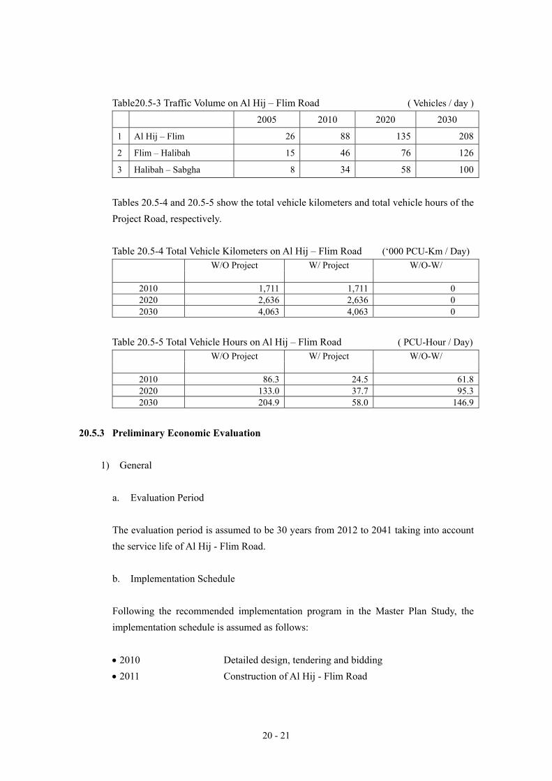
4) Traffic Assignment to Road Network Since road network in the influence area of the Project Road is simple, traffic assign method of ‘all or nothing’ is employed in this Study. As the results, assigned traffic volume on the Project Road can be computed in Table 20.5-3.
20 - 21
Table20.5-3 Traffic Volume on Al Hij – Flim Road ( Vehicles / day )
2005 2010 2020 2030
1 Al Hij – Flim 26 88 135 208
2 Flim – Halibah 15 46 76 126
3 Halibah – Sabgha 8 34 58 100
Tables 20.5-4 and 20.5-5 show the total vehicle kilometers and total vehicle hours of the Project Road, respectively.
Table 20.5-4 Total Vehicle Kilometers on Al Hij – Flim Road (‘000 PCU-Km / Day)
W/O Project W/ Project W/O-W/
2010 1,711 1,711 0 2020 2,636 2,636 0 2030 4,063 4,063 0
Table 20.5-5 Total Vehicle Hours on Al Hij – Flim Road ( PCU-Hour / Day) W/O Project W/ Project W/O-W/
2010 86.3 24.5 61.82020 133.0 37.7 95.32030 204.9 58.0 146.9
20.5.3 Preliminary Economic Evaluation
1) General
a. Evaluation Period The evaluation period is assumed to be 30 years from 2012 to 2041 taking into account the service life of Al Hij - Flim Road. b. Implementation Schedule Following the recommended implementation program in the Master Plan Study, the implementation schedule is assumed as follows: • 2010 Detailed design, tendering and bidding • 2011 Construction of Al Hij - Flim Road

20 - 22
c. Economic Evaluation Method and Economic Indicators The economic evaluation method of the infrastructure project is commonly used by benefit-cost analysis. In this Study, the same benefit-cost analysis method is employed. This method is evaluated as investment efficiency through comparison between benefit and cost derived from the Hij - Flim road project. It is expressed the benefit – cost stream during evaluation period and the economic indicators used in this study are as follows: − Net Present Value (NPV) − Benefit Cost Ratio, (BCR), and − Economic Internal Rate of Return (EIRR)
2) Estimation of Benefit
By implementing Hij - Flim Road project, a variety of benefits is expected such as improvement of comfort and safety, promotion of international and inter-regional trade and promotion of regional development. Among these benefits, tangible benefits of three (3) items of vehicle operating cost are taken into account: a. Saving in running cost (distance related vehicle operating cost), b. Saving in fixed cost (time related vehicle operating cost) and c. Saving in travel time cost.
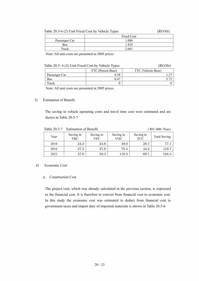
a. Unit Vehicle Operating Cost (VOC) Detailed unit vehicle operating cost is described in Annex A9-2. Table 20.5-6 summarizes the unit VOC on paved and unpaved surface types and for vehicle groups. Table 20.5-6 (1) Unit Running Cost by Vehicle Speed and Surface Type (RO/’000 km)
Paved Surface Unpaved Surface Passenger
Car Bus Truck Passenger
Car Bus Truck
5 km/h 66 109 116 104 177 14320 37 69 76 65 95 9430 34 43 49 53 69 6150 33 41 47 53 66 5870 36 44 50 57 70 6290 41 49 55 64 79 69
Note: All unit costs are presented in 2005 prices
20 - 23
Table 20.5-6 (2) Unit Fixed Cost by Vehicle Types (RO/Hr) Fixed Cost
Passenger Car 1.088 Bus 1.835
Truck 2.661 Note: All unit costs are presented in 2005 prices
Table 20.5- 6 (3) Unit Fixed Cost by Vehicle Types (RO/Hr)
TTC (Person Base) TTC (Vehicle Base) Passenger Car 0.58 1.27Bus 0.47 5.75Truck 0 0
Note: All unit costs are presented in 2005 prices
3) Estimation of Benefit
The saving in vehicle operating costs and travel time cost were estimated and are shown in Table 20.5-7.
Table 20.5-7 Estimation of Benefit ( RO ‘000 /Year)
Year Saving in VRC
Saving in VFC
Saving in VOC
Saving in TCC Total Saving
2010 24.3 24.6 49.0 28.7 77.7 2016 37.5 37.9 75.4 44.2 119.7 2022 57.9 58.3 116.2 68.1 184.3
4) Economic Cost a. Construction Cost
The project cost, which was already calculated in the previous section, is expressed as the financial cost. It is therefore to convert from financial cost to economic cost. In this study the economic cost was estimated to deduct from financial cost to government taxes and import duty of imported materials is shown in Table 20.5-6.

20 - 24
Table 20.5-8 Economic Cost Estimate ( RO ‘000 )
Description Economic Cost Financial Cost
1 Construction Cost 1,604 1,651 1.1 Labor Cost 23 23 1.2 Material Cost 789 816 1.3 Equipment 792 812
2 Consultancy 368 410 2.1 Detailed Design 45 50
2.2 Construction Supervision 59 66
Total 1,708 1,767
b. Maintenance Cost
In this study, the maintenance cost of Al Hij - Flim Road is estimated on the basis of maintenance costs per kilometer applied to the other national roads in Al Wusta. The total amount of maintenance cost is estimated at R.O. 19,354 taking into account unit cost of maintenance per kilometer of similar road in Muhut is 541 km/year.
5) Benefit Cost Analysis
Based on the above mentioned benefits and cost estimations, the economic analysis of the Project was made. Table 20.5-7 show the benefit – cost analysis of Al Hij - Flim Road Construction Project during project life period of 30 years and Table 20.5-8 shows the benefit cost stream. The results of the economic analysis show that a Net Present Value (NPV) of RO – 74,000 and BCR of 0.95 over 30 years life of the Road using discount date of 6 % which is designated by the Ministry of National Economy. The Economic Internal Rte of Return (EIRR) was compiled at 5.5 %.
Table 20.5-9 Economic Indicators of Benefit Cost Analysis
Net Present Value RO - 74,000
BCR 0.95
EIRR 5.5 % Note: 1) Project life is assumed to be 30 years
2) Discount rate is assumed to be 6%
6) Sensitivity Analysis
The sensitivity analysis is conducted under a worse case scenario incorporating increase and/or decrease of the estimation of cost and benefit. Table 20.5-9 shows the results of the sensitivity analysis.

Und
isco
unte
d B
enef
it C
ost S
trea
m
Dis
coun
ted
Ben
efit
Cos
t Str
eam
R
O '000
RO
'000
Sq
Year
Const
ruction C
ost
O &
M C
ost
Cost
Tota
lB
enefit
Cost
-B
enefit
Sq
Year
Dis
counte
d C
onst
ruction C
ost
O &
M C
ost
Cost
Tota
lB
enefit
Cost
-B
enefit
12005
0.0
0.0
0.0
0.0
0.0
12005
1.0
00
0.0
0.0
0.0
0.0
0.0
22006
0.0
0.0
0.0
0.0
0.0
22006
1.0
60
0.0
0.0
0.0
0.0
0.0
32007
0.0
0.0
0.0
0.0
0.0
32007
1.1
24
0.0
0.0
0.0
0.0
0.0
42008
0.0
0.0
0.0
0.0
0.0
42008
1.1
91
0.0
0.0
0.0
0.0
0.0
52009
0.0
0.0
0.0
0.0
0.0
52009
1.2
62
0.0
0.0
0.0
0.0
0.0
62010
45.0
0.0
45.0
0.0
-45.0
62010
1.3
38
33.6
0.0
33.6
0.0
-33.6
72011
1,6
63.0
0.0
1,6
63.0
0.0
-1,6
63.0
72011
1.4
19
1,1
72.3
0.0
1,1
72.3
0.0
-1,1
72.3
82012
0.0
19.4
19.4
84.7
65.3
82012
1.5
04
0.0
12.9
12.9
56.3
43.4
92013
0.0
19.4
19.4
88.4
69.0
92013
1.5
94
0.0
12.1
12.1
55.5
43.4
10
2014
0.0
19.4
19.4
92.4
73.0
10
2014
1.6
89
0.0
11.5
11.5
54.7
43.2
11
2015
0.0
19.4
19.4
96.5
77.1
11
2015
1.7
91
0.0
10.8
10.8
53.9
43.1
12
2016
0.0
19.4
19.4
100.7
81.3
12
2016
1.8
98
0.0
10.2
10.2
53.0
42.8
13
2017
0.0
19.4
19.4
105.2
85.8
13
2017
2.0
12
0.0
9.6
9.6
52.3
42.7
14
2018
0.0
19.4
19.4
109.8
90.4
14
2018
2.1
33
0.0
9.1
9.1
51.5
42.4
15
2019
0.0
19.4
19.4
114.6
95.2
15
2019
2.2
61
0.0
8.6
8.6
50.7
42.1
16
2020
0.0
19.4
19.4
119.6
100.2
16
2020
2.3
97
0.0
8.1
8.1
49.9
41.8
17
2021
0.0
19.4
19.4
125.0
105.6
17
2021
2.5
40
0.0
7.6
7.6
49.2
41.6
18
2022
0.0
19.4
19.4
130.4
111.0
18
2022
2.6
93
0.0
7.2
7.2
48.4
41.2
19
2023
0.0
19.4
19.4
136.3
116.9
19
2023
2.8
54
0.0
6.8
6.8
47.8
41.0
20
2024
0.0
19.4
19.4
142.3
122.9
20
2024
3.0
26
0.0
6.4
6.4
47.0
40.6
21
2025
0.0
19.4
19.4
148.5
129.1
21
2025
3.2
07
0.0
6.0
6.0
46.3
40.3
22
2026
0.0
19.4
19.4
155.1
135.7
22
2026
3.4
00
0.0
5.7
5.7
45.6
39.9
23
2027
0.0
19.4
19.4
162.0
142.6
23
2027
3.6
04
0.0
5.4
5.4
45.0
39.6
24
2028
0.0
19.4
19.4
169.1
149.7
24
2028
3.8
20
0.0
5.1
5.1
44.3
39.2
25
2029
0.0
19.4
19.4
176.6
157.2
25
2029
4.0
49
0.0
4.8
4.8
43.6
38.8
26
2030
0.0
19.4
19.4
184.3
164.9
26
2030
4.2
92
0.0
4.5
4.5
42.9
38.4
27
2031
0.0
19.4
19.4
188.4
169.0
27
2031
4.5
49
0.0
4.3
4.3
41.4
37.1
28
2032
0.0
19.4
19.4
192.5
173.1
28
2032
4.8
22
0.0
4.0
4.0
39.9
35.9
29
2033
0.0
19.4
19.4
196.8
177.4
29
2033
5.1
12
0.0
3.8
3.8
38.5
34.7
30
2034
0.0
19.4
19.4
201.1
181.7
30
2034
5.4
18
0.0
3.6
3.6
37.1
33.5
31
2035
0.0
19.4
19.4
205.5
186.1
31
2035
5.7
43
0.0
3.4
3.4
35.8
32.4
32
2036
0.0
19.4
19.4
210.1
190.7
32
2036
6.0
88
0.0
3.2
3.2
34.5
31.3
33
2037
0.0
19.4
19.4
214.7
195.3
33
2037
6.4
53
0.0
3.0
3.0
33.3
30.3
34
2038
0.0
19.4
19.4
219.5
200.1
34
2038
6.8
41
0.0
2.8
2.8
32.1
29.3
35
2039
0.0
19.4
19.4
224.3
204.9
35
2039
7.2
51
0.0
2.7
2.7
30.9
28.2
36
2040
0.0
19.4
19.4
229.3
209.9
36
2040
7.6
86
0.0
2.5
2.5
29.8
27.3
37
2041
0.0
19.4
19.4
234.3
214.9
37
2041
8.1
47
0.0
2.4
2.4
28.8
26.4
Tota
l1,7
08.0
580.6
2,2
88.6
4,7
58.0
2,4
69.4
Tota
l1,2
05.9
188.1
1,3
94.0
1,3
20.0
-74.0
Dis
count
Rat
e6.0
%N
PV
(R
O '000)
-74.0
B/C
Rat
io
0.9
5
EIR
R5.5
Cost
1B
enefit
1
Tab
le 2
0.5-
10 B
enef
it - C
ost S
trea
m o
f Al H
ij - F
lim R
oad
Con
stru
ctio
n Pr
ojec
t
20 - 25

20 - 26
Table 20.5-9 Sensitivity Analysis regarding Cost and Benefit of AL HIJ - FLIM Road Construction Project
Benefits
20% down Base Case 20% up NPV (RO ‘000) -59.0 205.0 468.7
B/C Ratio 0.95 1.18 1.42 20% down
EIRR (%) 5.5 7.5 9.2 NPV (RO ‘000) -338.0 -74.0 212.2
B/C Ratio 0.76 0.95 1.14 Base Case EIRR (%) 3.7 5.5 7.1
NPV (RO ‘000) -616.2 -352.2 -88.5 B/C Ratio 0.63 0.79 0.95
Costs
20% up EIRR (%) 2.4 4.1 5.5
Note: Project life of the project is assumed to be 30 years
7) Summary of Economic Analysis
The implementation of Al Hij - Flim Road construction project can not be fully justified from view of national economic point since the economic indicators of some cases show less than a discount rate of 6 % in Oman.
20.5.4 Technical Evaluation
The results of the technical analysis of Al Hij - Flim Road show that the construction of the
Project Road is technically feasible. There are no major technical issues at all.
20.5.5 Other Impacts 1) Improvement of Standard Living of Peoples
Construction of the Project Road is expected to contribute improvement of standard living of peoples, especially Omani peoples. At present, it is estimated that 330 peoples in 2010 and 420 peoples in 2030 are living within the influence areas of the Project Road as shown in Table 21.5-12, which can not be accessible without four (4) wheel drive vehicles. After completion of the Project Road, the Project will contribute to
・ More opportunities to access various basic facilities, such as religious facilities, hospitals, markets,

20 - 27
・ Achievement of easier daily travel to offices for employed peoples, and schools for school children,
・ More chances of developing un –utilized potential lands,
・ Contribution to effective land use and a unity of nation
Table 20.5-10 Number of Population, Employed Population and School Children in the Influence Area of Al Hij - Flim Road
2005 2010 2020 2030 Direct Influence Area Population 296 329 378 417No. of Employed Population 44 56 81 110No. of School Children (below 15 ys old)
63 60 66 64
Indirect Influence Area Population 273 303 348 383No. of Employed Population 41 52 75 100No. of School Children (below 15 ys old)
58 55 61 59
(2) Regional Development
Improved road system would greatly contribute to regional development. Travel time reduction, transport cost reduction, accessibility improvement and safe, comfort and reliable means of transportation would be directly and indirectly impact on the following;
a. Fishery industry
Higher fishing prices → higher income for fisherman → Upgrading their living standards → Incentive for fisherman to produce → Regional economic growth
c. Tourism industry
Cheaper transport cost / Easy accessibility to Hotels / Sightseeing spots → More tourists to visit → Regional economic growth
20.5.6 Overall Evaluation
As mentioned above, the implementation of the Al Hij - Flim road construction project can be justified from view of economic, technical, and social impact points.

A20-1-1
Annex 20-1 Detailed cost estimate of Al Hij – Flim Road
Lab. Mat. Equip. For. Local TaxEarthworks
203 Earthworks Excavation203.1 Suitable excavation to embankment Cu. m. 1.660 50,467 83,768 1,340 3,830 78,597 44,489 37,055 2,224203.2 Suitable excavation to waste Cu. m. 1.546 14,970 23,150 306 705 22,139 12,208 10,332 610203.4 Borrow excavation to embankment Cu. m. 3.660 70,942 259,649 1,110 88,788 169,751 92,211 162,828 4,611
206 Excavation and Backfilling for Structures
206.1 Structural excavation in soils to a depth of 2m. Cu. m. 1.351 327 442 11 16 416 234 197 12
206.3 Structural excavation in rock to a depth of 2m. Cu. m. 2.665 4,204 11,204 207 476 10,520 5,919 4,988 296Subbase and Base course
302 Granular Subbase302.1 Class A Subbase Cu. m. 5.000 0 0 0 0 0 0 0 0302.2 Class B Subbase Cu. m. 4.000 41,357 165,429 3,398 36,720 125,310 69,276 92,688 3,464302.3 Class C Subbase Cu. m. 3.000 0 0 0 0 0 0 0 0303 Aggregate Basecourse 0303.1 Class A Basecourse Cu. m. 5.000 0 0 0 0 0 0 0 0303.2 Class B Basecourse Cu. m. 4.000 30,098 120,392 2,517 26,010 91,866 50,847 67,003 2,542303.3 Class C Basecourse Cu. m. 3.000 0 0 0 0 0 0 0 0
Bituminous Pavement401 Bituminous Prime Coat and Tack Coat401.1 Prime Coat such as MC70 Kg 0.120 193,000 23,160 67 22,886 206 14,976 7,435 749401.2 Tack Coat such as RC250 Kg 0.150 0 0 0 0 0 0 0 0405 Bituminous Wearing Course405.1 Bituminous Wearing Course Cu. m. 17.000 19,847 337,398 835 315,474 21,089 216,188 110,400 10,809
Concrete and Concrete Structures504 Concrete for Structures504.1 Concrete Class 28/20 Cu. m. 40.000 412 16,489 1,296 8,282 6,911 5,752 10,449 288504.2 Concrete Class 32/20 Cu. m. 45.000 0 0 0 0 0 0 0 0504.3 Concrete Class 36/20 Cu. m. 50.000 0 0 0 0 0 0 0 0509 Reinforcing Steel509.1 High yield steel bars ton 250.000 20 4,978 196 4,348 434 3,055 1,770 153509.2 Mild steel bars ton 250.000 5 1,319 57 1,143 119 805 473 40
Drainage801 Pipe Culverts801.1 Reinforced Concrete Pipe Culvert 600 mm Lin. m. 35.000 0 0 0 0 0 0 0 0801.2 Reinforced Concrete Pipe Culvert 750 mm Lin. m. 50.000 0 0 0 0 0 0 0 0801.3 Reinforced Concrete Pipe Culvert 900 mm Lin. m. 75.000 336 25,200 907 5,821 18,472 13,154 11,388 658801.4 Reinforced Concrete Pipe Culvert 1050 mm Lin. m. 100.000 0 0 0 0 0 0 0 0801.5 Reinforced Concrete Pipe Culvert 1500 mm Lin. m. 155.000 0 0 0 0 0 0 0 0
Slope Protection901 Rip Rap901.1 Loose stone riprap Class A Cu. m. 6.000 1,722 10,332 286 2,483 7,563 4,265 5,854 213901.2 Loose stone riprap Class B Cu. m. 6.000 0 0 0 0 0 0 0 0901.3 Mortared stone riprap Cu. m. 15.000 1,910 28,653 1,756 15,693 11,204 8,478 19,751 424902 Gabions902.1 Gabions Cu. m. 13.000 0 0 0 0 0 0 0 0906 Ditch lining906.1 Ditch lining (150mm thick) Sq. m. 2.000 0 0 0 0 0 0 0 0
MSCELLANEOUS STRUCTURES(1300 SAFETYBARRIERS, DELINEATORS AND FENCES, 1400HIGHWAY SIGNS AND ROAD MARKINGS, ANDOTHER ITEMS, 10% of SECTION 200 to SECTION
111,156 4,641 85,355 21,160 80,254 26,889 4,013
MEASURED WORKS TOTAL(SECTION 200 to 1900) 1,222,716 18,930 618,029 585,757 622,110 569,500 31,106
SECTION 100 PRELIMINARIES (25% of SECTION200 to SECTION 1800) ------ 305,679 2,526 137,375 165,778 226,108 68,266 11,305
SUB TOTAL 1,528,395 21,456 755,404 751,535 848,218 637,766 42,411
CONTINGENCY (10% of SECTION 200 to SECTION 1800) ------ 122,272
Total 1,650,667
ItemNo. Description Unit Unit Price
(RO) Quantity Cost(RO)
Cost Component
A
20-2
-1
Ann
ex 2
0-2
E
NV
IRO
NM
EN
TAL
CH
EC
KL
IST
(AL
HIJ
TO
FL
IM R
OA
D)
Roa
d Se
ctio
n: F
rom
Al H
ij to
Flim
, Exi
stin
g ro
ad c
ondi
tion:
Tra
ck r
oad
Proj
ect R
oad
No.
: N47
, Pla
nnin
g ro
ad: M
etal
led
2-la
ne r
oad,
Dis
tanc
e: 1
9.3
km
Env
iron
men
tal I
tem
s
Pres
ent e
nvir
onm
enta
l con
ditio
n Im
pact
Rat
ing
1 =
Slig
ht
2 =
Mod
erat
e
3= S
igni
fican
t
Rem
arks
Pred
icte
d tra
ffic
volu
me
in 2
030:
1,00
0 ve
h/da
y
Air
Pol
lutio
n
- A
ir po
llutio
n at
pre
sent
is n
ot s
igni
fican
t exc
ept
dust
. Dus
t occ
asio
nally
occ
urs b
y ca
r.
1 -
Air
pollu
tion
will
be
not
sign
ifica
nt,
beca
use
low
traf
fic v
olum
e of
futu
re is
pre
dict
ed.
- Dus
t will
dec
reas
e du
e to
road
pav
emen
t.
Eff
luen
t and
Wat
er c
onta
min
atio
n
- Pro
ject
road
runs
alo
ng lo
w te
rrac
e an
d lo
w-h
illy
land
and
smal
l wad
i.
1 -P
roje
ct a
rea
is v
ery
low
pre
cipi
tatio
n an
d fla
t
area
. R
ainw
ater
on
th
e ro
ad
surf
ace
will
sm
ooth
ly b
e di
scha
rged
.
Noi
se a
nd V
ibra
tion
- The
pol
lutio
n of
noi
se a
nd v
ibra
tion
is
insi
gnifi
cant
so fa
r. R
esid
entia
l are
a is
lim
ited
at
Al H
ij an
d Fl
im.
1 -
Noi
se a
nd V
ibra
tion:
Slig
ht i
mpa
ct b
y pr
ojec
t ro
ad,
beca
use
low
tra
ffic
volu
me
and
low
re
cept
ors i
n fu
ture
are
pre
dict
ed.
Lan
d Su
bsid
ence
- N
o ex
istin
g so
far.
Soft
grou
nd z
one
(e.g
. Sab
kha
area
, etc
.) is
not
foun
d al
ong
proj
ect r
oad.
1
- Not
exi
stin
g w
ith p
roje
ct.
Topo
grap
hy a
nd G
eolo
gy
(1)
0~7.
0 km
:
- Mid
dle
and
Low
Ter
race
s and
low
hill
y la
nd.
Terr
aces
and
hill
s con
sist
of m
ainl
y En
d-C
reta
ceou
s lim
esto
ne o
f she
lf fa
rcie
s.
And
the
terr
aces
are
mos
tly c
over
ed b
y
cons
olid
ated
gra
vel a
nd sa
nd.
1 -
Not
sig
nific
ant
impa
ct w
ith p
roje
ct,
beca
use
road
al
ignm
ent
will
be
m
ostly
fo
llow
ed
exis
ting
road
alig
nmen
t.

A
20-2
-2
(2)
7.0~
12.8
km
:
- Low
terr
aces
and
wad
i, fla
t zon
e. W
adi i
s m
ostly
fil
led
by a
lluvi
al w
adi
sedi
men
ts,
cons
istin
g of
sand
and
gra
vels
,
(3)
12.8
~19.
3 km
:
- W
adi
and
sand
sho
al, f
lat
zone
. Wad
i al
ong
the
proj
ect r
oad
is s
mal
l trib
utar
y of
Wad
i Hal
fayn
. A
lluvi
al w
adi s
edim
ents
, con
sist
ing
of s
and
and
grav
els,
mos
tly fi
ll w
adi.
- Th
e ar
ea is
wid
ely
cove
red
by th
in A
eolia
n sa
nd
orig
inat
ed fr
om th
e be
ach
sand
. The
san
d lo
cally
fo
rms
smal
l san
d du
nes.
Nea
r end
poi
nt a
t Flim
,
the
exis
ting
road
run
s al
ong
foot
of
the
low
er
terr
ace
besi
de S
abkh
a. B
each
of
Flim
for
ms
shal
low
bea
ch, s
abkh
a an
d la
goon
.
Phot
o: L
ow T
erra
ce a
nd w
adi p
lain
Phot
o: M
ahaw
t Isl
and
and
Wat
er p
ipe
Soil
- Litt
le su
rfac
e so
il is
dev
elop
ed in
the
area
. 1
- Not
sign
ifica
nt im
pact
with
pro
ject
.
Hyd
rolo
gy a
nd g
roun
dwat
er
- Th
ere
is n
o cu
rren
t flo
w a
long
wad
i, W
adi
Hal
fayn
, in
the
area
. - G
roun
dwat
er is
pum
ped
up a
t nea
r bea
ch a
nd th
e
pum
ped
wat
er i
s su
pplie
d by
wat
er t
ank
to t
he
resi
dent
s at
Flim
and
pip
e w
ater
is a
lso
supp
lied
to M
ahaw
t isl
and
durin
g fis
hing
seas
on.
1~2
- Hyd
rolo
gy: N
ot si
gnifi
cant
impa
ct w
ith p
roje
ct.
- G
roun
dwat
er:
Slig
ht t
o m
oder
ate
impa
ct t
o gr
ound
wat
er,
cons
istin
g of
lo
wer
ing
of
grou
ndw
ater
ta
ble,
w
ater
co
ntam
inat
ion,
is
lik
ely
to o
ccur
due
to
incr
ease
of
pum
ping
vo
lum
e an
d w
aste
s by
incr
ease
d vi
sito
rs to
the
area
. B
ecau
se,
the
grou
ndw
ater
res
erve
nea
r be
ach
in th
e ar
ea se
ems t
o be
lim
ited.
Eco
-sys
tem
, Flo
ra a
nd F
auna
-
Ther
e ar
e no
pro
tect
ed a
reas
nea
r th
e ex
istin
g ro
ute.
-
Flor
a: R
are
vege
tatio
n in
the
are
a, b
ut s
mal
l
1~2
- Ec
o-sy
stem
, flo
ra a
nd F
auna
: N
ot s
igni
fican
t im
pact
with
pro
ject
to
the
eco-
syst
em a
nd
faun
a in
the
are
a, i
n ca
se o
f co
mpa
re w
ith

A
20-2
-3
amou
nt o
f gr
ass
and
low
aca
cia
trees
are
fou
nd
in th
e ar
ea. M
angr
oves
are
loca
lly fo
und
arou
nd
lago
on a
nd s
abkh
a at
Flim
and
Mah
awt
isla
nd.
Man
grov
es a
re v
ery
impo
rtant
for
fis
hery
and
st
oppi
ng p
oint
for m
igra
tory
bird
s. -
Faun
a: M
any
kind
of
bird
s, in
clud
ing
mig
rato
ry
bird
s, st
op in
bea
ch a
nd m
angr
oves
in th
e ar
ea.
Seve
ral m
amm
als,
cons
istin
g of
Hed
geho
g, R
ed
Fox,
San
d Fo
x, W
ild C
at, c
arac
al, N
ubia
n Ib
ex,
Ara
bian
Gaz
elle
, Cap
e H
are,
etc
., ar
e re
porte
d to
m
ake
habi
tat i
n th
e ar
ea a
re.
-
Fish
ing:
Sur
roun
ding
s of
Mah
awt i
slan
d ar
e ric
h
fishi
ng p
lace
s. Th
eref
ore,
man
y fis
herm
en w
ork
in F
lim a
nd M
ahaw
t isl
and.
pres
ent
grav
el
road
. H
owev
er,
incr
ease
of
vi
sito
rs a
s to
uris
m i
n fu
ture
mig
ht i
ndire
ctly
in
fluen
ce e
co-s
yste
m, f
lora
and
faun
a al
ong
the
coas
tal l
ine,
incl
udin
g m
angr
oves
.
Phot
o: M
angr
oves
and
Sab
kha
at F
lim
Lan
dsca
pe
- Lo
w te
rrac
e, h
illy
land
, san
d be
ach
and
Mah
awt
isla
nd.
1 - N
ot si
gnifi
cant
impa
ct w
ith p
roje
ct.
Haz
ards
-
Not
exi
stin
g so
far
. B
ut s
and
stor
m a
nd f
og i
n ea
rly m
orni
ng a
nd n
ight
loc
ally
and
sea
sona
lly
occu
r.
1 - N
ot si
gnifi
cant
impa
ct w
ith p
roje
ct.
Reg
iona
l D
evel
opm
ent
on
Nat
ural
E
nvir
onm
ent
- Th
e ar
ea h
as a
pot
entia
l of
dev
elop
men
t fo
r Fi
sher
y an
d to
uris
m.
1 -
The
road
im
prov
emen
t w
ill c
ontri
bute
loc
al
deve
lopm
ent.
Oth
er Im
pact
s on
Nat
ural
env
iron
men
t- N
ot e
xist
ing
so fa
r. 1
- Lik
ely
not s
igni
fican
t im
pact
with
pro
ject
.
Cul
tura
l Her
itage
- U
nkno
wn
so fa
r. 1
- Si
te i
nves
tigat
ion
of c
ultu
ral
herit
age
need
s to
ca
rry
out b
efor
e co
nstru
ctio
n.
Was
tes
- Not
sign
ifica
nt so
far.
1 - A
lthou
gh lo
w tr
affic
vol
ume
is p
redi
cted
, was
tes
alon
g th
e ro
ad a
nd F
lim a
s a
dest
inat
ion
will
ce
rtain
ly in
crea
se d
ue to
incr
ease
d vi
sito
rs.
A
20-2
-4
Reg
iona
l D
evel
opm
ent
on
Soci
al
Env
iron
men
t
- Not
exi
stin
g so
far.
1 - U
nkno
wn
abou
t reg
iona
l dev
elop
men
t.
Oth
er Im
pact
s on
Soci
al E
nvir
onm
ent
(1)
0 (S
tart
poin
t: A
l Hij)
~0.2
km:
- A
l H
ij vi
llage
. R
esid
entia
l ar
ea,
mos
que,
w
orks
hops
. Hou
ses
have
eno
ugh
dist
ance
, mor
e th
an 3
0m,
from
bou
ndar
y of
the
exi
stin
g ro
ad.
Mos
que
keep
s ab
out
100m
aw
ay
from
th
e ex
istin
g ro
ad.
(2)
0.2~
18km
:
- No
hous
es o
r hut
s. (3
) 18
to 1
9,3k
m (E
nd p
oint
: Flim
): -
App
roxi
mat
ely
tota
l 15
0 hu
ts,
gove
rnm
ent
wor
ksho
p (n
ot o
pera
tion)
, pu
mpi
ng s
tatio
n of
th
e M
HEW
. Th
e pu
mpi
ng
stat
ion
supp
lies
drin
king
wat
er t
o re
side
nts
and
Mah
awt
isla
nd
by w
ater
pip
e. H
uts,
loca
ted
alon
g th
e fo
ot o
f Lo
w T
erra
ce c
over
ed b
y th
ick
Aeo
lian
sand
, are
no
t pe
rman
ent
hous
es.
Mos
t of
re
side
nces
seas
onal
ly c
hang
e to
liv
e be
twee
n Fl
im a
nd
Mah
awt i
slan
d.
- M
ahaw
t is
land
: Th
ere
are
60 t
o 10
0 fa
mili
es
stay
ing
isla
nd d
urin
g w
et s
easo
n (S
epte
mbe
r to
A
pril)
for f
ishe
ry.
1~2
- In
crea
sed
chan
ce o
f tra
ffic
acci
dent
as
wel
l as
dom
estic
an
imal
s du
e to
in
crea
sed
traffi
c vo
lum
e.
Wat
er su
pply
by
W-ta
nk
Pho
to: P
umpi
ng st
atio
n of
the
MH
EW

A
20-2
-5
- Hyd
rolo
gy, g
roun
dwat
er
1~2
Gro
undw
ater
con
tam
inat
ion
due
to w
aste
s
- Eco
-sys
tem
, Flo
ra a
nd F
auna
1~
2 D
amag
e to
man
grov
es a
nd e
co-s
yste
m
- Oth
er Im
pact
s on
Soci
al E
nvir
onm
ent
1~2
Traf
fic a
ccid
ents
due
to in
crea
sed
traf
fic
Eva
luat
ion
- Oth
er it
ems
1
Com
preh
ensi
ve E
valu
atio
n 1~
2 R
ecom
men
datio
ns *
1 R
ecom
men
ded
to c
arry
out
EIA
on
assi
gned
item
s
*1 :
Com
preh
ensi
ve E
valu
atio
n
1
: Non
e to
slig
ht im
pact
s.
: No
need
to c
arry
out
EIA
1~2
: Sm
all i
mpa
cts.
: Rec
omm
ende
d to
car
ry o
ut E
IA o
n as
sign
ed it
ems
2
: M
oder
ate
impa
cts.
: R
ecom
men
ded
to c
arry
out
EIA
2~3
: Rel
ativ
ely
sign
ifica
nt im
pact
s. : R
ecom
men
ded
to c
arry
out
EIA
3
: Sig
nific
ant i
mpa
cts.
: R
ecom
men
ded
to c
arry
out
EIA

A20-3-1
Annex 20-3
TERMS OF REFERENCE ON
THE ENVIRONMENTAL IMPCT ASSESSMENT OF
THE AL HIJ – FLIM RORD,
SULTANATE OF OMAN 1. Project Title
"Environmental Impact Assessment of the Al Hij - Flim Road, Sultanate of Oman" (hereinafter referred to as “Study”)
2. Executive Agency
Directorate General of Road, (hereinafter referred to as “DGR”), Ministry of Transport and Communications, Sultanate of Oman.
3. Location of Project Area
Project area is located in the north most part of the Al Wusta Region. The project road joins to road to Sanna at Al-Hij and traverses along tributaty of Wadi Halfain to Flim. Flim is located at coast and connects to Mahawt Island, as shown in Attachment-1.
4. Background of the project
The Al Hij – Flim Road is designated as one of the 7th Plan (2006-2010) proposed roads. This road has an important role of directly connecting main road network to the coastal area Mahawt Island, which is a tourist spots and fishery center.
5. Objectives of the Study The Study should carry out to accord the Royal Decree No. 10/82 and its amendments entitled “Law on Conservation of the Environment and Prevention of Pollution” as well as other relevant regulations, decisions and guidelines.

A20-3-2
The principles of the Study are as follows: - EIA is a process to help decision makers to protect, conserve and manage Oman’s
environment, according to the principles of sustainable development, maintaining human well-being, healthy environment and a sound economy;
- The EIA process should ensure that the individual, company or government agency, proposing a project considers its effect on health, economy and culture of surrounding community as well as its impact on air, land and water;
- The EIA should be applied as early as possible in project’s planning stage and before irrevocable decisions are made; and
- Public information is an important component of an open and balanced EIA process.
And, the specified objectives of the Study are show as below: i) To identify, predict, and assess environmental impacts due to proposed activities
on the physical, biological and social environment; ii) To propose mitigation measures for avoiding and reducing the impacts and
evaluating associated risk; and iii) To submit the Environmental Impact Assessment report and relevant documents.
6. Project Description: The project description of the Al Hij - Flim Road shows as below:
- The project road is located in the north most part of the Al Wusta Region and adjoined to the Ash Sharqiyah Region. The project road area is topographically characterized by alluvial flat plain,
- The project road has important role of connecting main road network to fishery and tourist spots,
- The length of the project road is 19.3 km, - The road hierarchy of the project road is designated to the secondary road that its
right-of-way is 50 m, and - The project road traverses mostly Alluvial flat terrains and along the wadis, as
shown in Annex-2. 7. Scope of the Study:
This project is classified as Roads of the Group five (Service projects) in accordance of the “Guidelines for Obtaining Environmental Permits” (Directorate General of

A20-3-3
Environmental Affaires). In addition, as results of the environmental consideration of the project are recommended that the project should be carried out EIA before project implementation, comprehensive EIA should be required. In order to achieve the objectives mentioned above, the scope of the Study consist of following items: 1) Collect and review the existing data and information relevant to the project - Legislative information, - Topographical, geological and pedological data, - Aero photographs and/or satellite images covered in and around the project area, - Meteorological data around the project, - Hydrological and hydro-geological data relevant to the project, - Biological and ecological data and information, - Information of land use and its history, - Natural scenic spots, national park, etc., - Information of open-air recreation, - Information of natural hazards, - Sociological data and information, - Administrative data and information, - Socio-economic data, - Cultural and historical heritages, - Traffic volume data, and - Other data and information relevant to the traffic, etc. 2) Project description
- Location, - Road design and design criteria,
- Road capacity, - Road section for construction, - Pre-construction activities,
- Construction plans and scheduling, - Staffing and support,
- Associating facilities and services, - Operating procedures and maintenances, - Future traffic volume,
- Land use requirement, and - Alternative alignments, etc.

A20-3-4
3) Site description and its environment (Baseline survey) The content of the baseline study consists of the following environmental items:
(1) Air quality: Measuring points consist of town and settlements as well as start and end points, and number of measuring times is two, i.e. summer and winter seasons, and measuring parameters consist of SO2, TSP, PM10 and fallen-dust,
(2) Water quality: measuring points consist of wells and aflaj water, and number of measuring times is two, i.e. summer and winter seasons, and analysis parameters consist of pH, Electric conductivity (EC), Water temperature, Ca, Mg, Fe, Mn, K, Na, CO3, Hg, Pb, As, Cr, Cd, Se, SO4 and Cl,
(3) Noise and vibration: measuring points consists of town and settlements, and number of measuring times is two, i.e. summer and winter seasons, and measuring parameter is dB(A) on the boundary of ROW,
(4) Topography and geology: Topographical and geological investigation, (5) Soil: Pedological investigation consists of soil sections at the point of every
2 km interval and each villages and farmlands, (6) Surface water and groundwater: Hydrological and hydro-geological
investigations include measurement of pH, EC and Water temperature, (7) Ecosystem, flora and fauna: Number of investigating times is two, i.e.
summer and winter seasons, (8) Landscape, (9) Hazards, (10) Communities, (11) Wastes, (12) Cultural heritage, (13) Resettlement, and (14) Traffic volume and traffic accidents: Traffic census and interviews.
While baseline survey, the proponent should be found stakeholders, related to the project, e.g. residents of local communities in the site, indigenous people, experts from government organizations, local government officer, NGO, etc., and should be collected their opinions in order to get an appropriate agreement and to reflect to the decision-making of the project.
4) Evaluation of project’s impacts
The content of the evaluation of impacts with the project consists of the following items:
A20-3-5
- Cumulative and indirect environmental impacts, likely to result from the project in combination with existing or planned projects or activities,
- Impact on socio-economic conditions, - Impact on physical and cultural heritage, and
- Proposal and evaluation of reasonable alternatives to the project and their impacts.
The evaluation should be carried out to use the environmental standards or guidelines to establish significant of the harmful impacts. A risk assessment can be used when there are no applicable threshold standards or guidelines. The following criteria should be applied to determine significant or adverse impacts:
(1) Magnitude, (2) Frequency and duration, (3) Location and sensitivity of environment, and (4) Irreversibility.
5) Mitigating measures and evaluating associated risks
The following approaches can be used to mitigate likely significant harmful impacts:
- Direct prevention by avoiding sensitive areas, - Reduction by adjusting work schedules, pollution control devices, changes in
design, etc., - Restoration and remediation measures, and - Compensation.
6) Final assessment
The final assessment should be done to evaluate through a net effect analysis. 7) Documentation
Documentation I composed of reference and working documents. The former will contain a detailed record of the work done on the EIA. The latter is the document, which contain the information for action, e.g. the Environmental Impact Statement as well as Summary.
The content of the Environmental Impact Statement should be contained the following items:
- Information describing the EIA,
A20-3-6
- Information describing the project, - Information describing the site and its environment, shown as below:
(1) Physical features (2) Legislative framework (3) Assessment of impacts, shown as below:
a. Impacts on human beings, buildings and man made features, b. Impacts on flora, fauna and geology, c. Impacts on land, d. Impacts on water, e. Impacts on air and climate, f. Other direct and secondary effects associated with the project, g. Environmental management plan – Mitigating measures and risk
assessment, and h. Conclusions and additional information.
8. Study Timetable Tentative study timetable of the project shows in Attachment-3.

A20-3-7
Attachment: Attachment-1 Location Map of the Project Road Attachment-2 Topographic Map of the Project Road Attachment-3 Tentative Study Timetable of the Project

A20-3-8
0 50 100km25
Sur
Muscat
Saudi Arabia
United Arab Emirates
Yemen
Arabian Sea
Salalah
Persian Gulf
Shinas
Dank
IbriNizwa
Hayma
Ad Duqm
Shalim
Al Kahil
SadahTaqah
Thumrayt
Khasab
SahamAl Khaburah
Barka
Ibra
Adam
Al Ghabah
Dawkah
LEGEND
Major road Network
Project site
Attachment-1 Location Map of the Project Road

A20-3-9
0 5 km
Attachment-2 Topographic Map of the Project Area
End point
Start pointN

A20-3-10
Attachment-3 Tentative Study Timetable of the Project
Year 200 - Remarks
Number of month
1 2 3 4 5 6 7 8 9 10 11 12 13 14 -
1. Data collection
2. 1st. Field investigation
Summer/winter
season
3. 2nd. Field investigation
Winter/summer
season
4. Data analysis
5. Reporting 1
△
○
○
○
○
○
○
○
○
○
○
○
○
2
△
3
△
△ 1 : Inception report : Work in the site
2 : Draft Final report : Chemical analysis 3 : Final report ○ : Monthly report


![FLIM Systems for Zeiss LSM-710 / 780 / 880 · [1] FLIM Systems for Zeiss LSM 710 / 780 / 880 family laser scanning microscopes, user handbook. 7th edition (2017), [2] FLIM systems](https://img.dokumen.tips/doc/110x75/611b3f26ede66b1f2323f888/flim-systems-for-zeiss-lsm-710-780-880-1-flim-systems-for-zeiss-lsm-710-.jpg)