Embed Size (px)
Citation preview
Existing Conditions Report
Chapter 2. Land Use and Urban Form

Existing Conditions Report CHAPTER 2: LAND USE AND URBAN FORM
City of Burlingame General Plan and Zoning Ordinance Update 2-2 Final Draft November 2015
2.1 Introduction This chapter reviews the baseline (2015) context for land use planning in the City of Burlingame. It provides a comprehensive overview of how land resources are used and regulated within Burlingame and its immediate surroundings. This report also identifies opportunities and potential challenges related to the long-term growth and development of the city, and analyzes the development potential of Burlingame under existing plans, policies and regulations. Lastly, this report discusses community character, historic and cultural resources, urban form and the plans and policies of other agencies that regulate or influence land use within the city.
This chapter is organized into the following sections:
Introduction (Section 2.1)
Findings (Section 2.2)
Regulatory Setting (Section 2.3)
Planning Boundaries (Section 2.4)
Existing Land Uses (Section 2.5)
Urban Structure and Form (Section 2.6)
Community Character (Section 2.7)
Historic and Cultural Resources (Section 2.8)
Affordable Housing (Section 2.9)
Existing General Plan (Section 2.10)
Existing Zoning Districts (Section 2.11)
Specific Plans (Section 2.12)
Other City Plans and Policies (Section 2.13)
Other Plans and Programs (Section 2.14)

Existing Conditions Report CHAPTER 2: LAND USE AND URBAN FORM
City of Burlingame General Plan and Zoning Ordinance Update 2-3 Final Draft November 2015
2.2 Findings Much of Burlingame is oriented on an axis offset from “true” North. To improve clarity in the findings discussion, El Camino Real will be referenced having a north-south orientation, Broadway and Burlingame Avenue an east-west orientation, and the San Francisco Bay as east of the City of Burlingame.
Planning Area
1. The Burlingame Planning Area defines the area subject to the Burlingame General Plan. The planning area for the updated General Plan aligns with the city limits.
2. The City of Burlingame covers approximately 5.8 square miles. About three-quarters (76%) of the city is considered developable land. The remaining 24% of the planning area consists of San Francisco Bay within the city limits, and the Mills Canyon Preserve.
Existing Land Uses
1. The City of Burlingame is a mature and largely built-out community with well-established residential neighborhoods. Out of all of the urban land use categories, low density residential – consisting primarily of single-family residential – covers the most land within the city. Single-family residential uses cover 48.2% (1,130.5 acres).
2. Industrial uses are located in the northeastern part of Burlingame, adjacent to Highway 101 and Rollins Road. The Rollins Road Industrial Corridor occupies 12.8% (300 acres).
3. Burlingame has two Caltrain stations and is close to San Francisco International Airport. A BART station located just to the north in Millbrae provides additional regional rail access.
4. Commercial uses are generally located within downtown Burlingame, along the Broadway corridor, and in the Burlingame Plaza shopping center. The city also has an auto row located on California Drive.
Urban Structure and Form
1. Burlingame originally developed as settlements focused around the two train stations. The street patterns and land use patterns reflect these beginnings.
2. Burlingame has two main retail streets. The five-block Broadway Business District consists of a range of predominantly independently owned boutiques, gift shops, antique stores and specialty retail. Broadway is one of the main gateways into the city and as a result experiences a high volume of traffic passing though the

Existing Conditions Report CHAPTER 2: LAND USE AND URBAN FORM
City of Burlingame General Plan and Zoning Ordinance Update 2-4 Final Draft November 2015
area to access other parts of the city. Downtown Burlingame is a high-end retail district consisting of a mix of local, regional and national brand stores.
3. Burlingame Plaza is a mid-century automobile-oriented shopping center with a mix of local and national businesses, located at the far north end of the city.
4. El Camino Real and California Drive are the two major north-south thoroughfares that intersect Broadway and Burlingame Avenue. Although these streets are distinguished by sizable Eucalyptus tree groves, functionally they are characterized by high-speed automobile traffic, parking in front of many buildings, and minimal pedestrian and bicycle facilities.
5. The at-grade railroad crossing at Broadway significantly disrupts the movement of people from one side of the tracks to the other, and the tracks from a barrier as well. Caltrain anticipates that the number of trains will increase to more than 220 a day by the year 2040, from 92 trains currently.
6. The majority of Burlingame’s housing stock was developed between the 1890s and 1960s. The city was largely built out by the 1970s.
7. Highway 101 forms a significant visual and physical barrier between the historic town center and development along the bayfront.
Community Character
1. The views to and from the bayfront and the hillsides of Burlingame provide opportunities for residents and visitors to enjoy nature, scenic beauty and natural wildlife. These resources provide scenic vistas of the surrounding San Francisco Bay Area.
2. Often referred to the “City of Trees,” Burlingame has a deep relationship with its tree history dating to 1908, with the adoption of a city ordinance protecting trees. As of May 2011, there were 14,783 city-maintained trees in Burlingame.
3. The bayfront, while home to many successful hotels and industrial businesses, lacks a cohesive and attractive urban character. Several marginal uses exist within the bayfront areas that detract from this waterfront area.
4. Many residential neighborhoods display architectural styles representing different eras of development, including the earliest periods of Burlingame’s history. Homeowners take great pride in home maintenance and neighborhood preservation.
Historical and Cultural Resources
1. Burlingame incorporated in 1908. The original settlement centered around the Burlingame train station, the first permanent structure in the United Sates to be built in the Mission Revival style.

Existing Conditions Report CHAPTER 2: LAND USE AND URBAN FORM
City of Burlingame General Plan and Zoning Ordinance Update 2-5 Final Draft November 2015
2. Burlingame’s population grew slowly until 1906, when the San Francisco earthquake and fires forced hundreds of people to leave the city in search of new homes.
3. A second settlement grew around the Broadway train station, and was ultimately annexed into Burlingame.
4. There are four resources in Burlingame listed on the National Register of Historic Places: Burlingame Railroad Station, Kohl Mansion, Howard-Ralston Eucalyptus Tree Rows, and Severn Lodge Dairy Wallscape.
Affordable Housing
1. The City of Burlingame updated the Housing Element in January 2015. The element, which covers the 2015–2023 planning period, includes policies to address both local and regional demand for affordable and market-rate housing.
Existing General Plan
1. The current City of Burlingame General Plan was adopted in 1969, with an update to the Housing Element for the 2015-2023 period adopted in 2015.
2. The city lies within close proximity to three major faults lines: The San Andreas Fault, the Hayward Fault and the Serra Fault.
3. Burlingame’s Noise Element was one of the first written into a General Plan.
Existing Zoning Districts
1. The City of Burlingame Zoning Ordinance is the primary regulatory mechanism used to implement the Burlingame General Plan. The Zoning Ordinance establishes 23 zoning districts and four special design and land use overlay districts.
Other City Plans and Policies
1. In addition to the General Plan and Zoning Ordinance, the City of Burlingame has adopted a number of plans, policies and guidelines that apply to defined areas of the city or deal with particular issues of concern.
Each of Burlingame’s Specific Plans was developed in the recent past and is consistent with the land use provisions contained in the adopted General Plan.
2. Burlingame has adopted Residential and Commercial Design Guidebooks to direct the design of properties and buildings with the city.
3. The nonbinding Climate Action Plan established a baseline of emissions and sets strategies to reduce emissions by 15% by the year 2020 and 80% by the year 2050.

Existing Conditions Report CHAPTER 2: LAND USE AND URBAN FORM
City of Burlingame General Plan and Zoning Ordinance Update 2-6 Final Draft November 2015
4. The Urban Forest Management Plan sets forth policies and procedures for maintaining urban trees and protecting Burlingame’s reputation as a “City of Trees.”
Other Plans and Policies
1. Burlingame contains one of San Mateo County's Priority Development Areas (PDAs) under the San Mateo County PDA Investment and Growth Strategy. Burlingame's PDA is located along the El Camino Real Corridor and is designated as a "transit town center" in the PDA land use hierarchy.
2. In recognition of the impact of airports on properties in their vicinity, the state legislature passed section 21670 of the California Public Utilities Code, which requires the establishment of an Airport Land Use Commission (ALUC) to develop plans and policies for the orderly growth of airports and their surrounding areas, which includes Burlingame.
2.3 Regulatory Setting
Federal Regulations
Federal Aviation Administration
The Federal Aviation Administration (FAA) establishes height, safety and noise standards for properties located in close proximity to airports. Burlingame is within the impact area of San Francisco International Airport and is subject to FAA standards. The Airport Land Use Compatibility Plan (ALUCP) for San Mateo County was updated in July 2012. California Government Code, Section 65302.3 requires local governments to update their general plans, specific plans and land use regulations to be consistent with the ALUCP. Proposed new and amended general plans, specific plans, land use ordinances, regulations and facility master plans must be submitted to the airport land use commission for review.
National Historic Preservation Act of 1966 (16 U.S.C. 470 et seq.)
This law was enacted to prevent unnecessary harm to historic properties. The National Historic Preservation Act (NHPA) includes regulations that apply specifically to federal land-holding agencies, but also includes regulations (Section 106) that pertain to all projects funded, permitted or approved by any federal agency that has the potential to affect cultural resources. Provisions of NHPA establish a National Register of Historic Places (NRHP) (the National Register is maintained by the National Park Service), the Advisory Council on Historic Preservation, State Historic Preservation Offices and federal grants-in-aid programs.
National Environmental Policy Act of 1969 (16 U.S.C. 4321, and 4331-4335)
The National Environmental Policy Act (NEPA) was established to ensure that the potential impacts of a proposed federal action have been subject to an environmental

Existing Conditions Report CHAPTER 2: LAND USE AND URBAN FORM
City of Burlingame General Plan and Zoning Ordinance Update 2-7 Final Draft November 2015
review process, which includes how alternatives will impact the human and natural environment. These assessments must be made available to the public. NEPA establishes guidelines for a national policy for the protection and maintenance of the environment by providing a process that all agencies must follow. Section 102 in Title I requires agencies to incorporate environmental considerations in their planning and decision-making through a systematic interdisciplinary approach. Specifically, all agencies are to prepare detailed statements assessing the environmental impact of and alternatives to major actions significantly affecting the environment. Importantly, both NEPA and California Environmental Quality Act (CEQA) encourage a joint federal and state review where a project requires both federal and state approvals.
State Regulations
General Plan Law (California Government Code Section 65300)
California Government Code Section 65300 regulates the substantive and topical requirements of General Plans. State law requires each city and county to adopt a General Plan “for the physical development of the county or city, and any land outside its boundaries which bears relation to its planning.” The California Supreme Court has called the General Plan the “constitution for future development.” The General Plan expresses the community’s development goals and embodies public policy relative to the distribution of future land uses, both public and private.
Since the General Plan affects the welfare of current and future generations, state law requires that the plan take a long-term perspective (typically 15 to 25 years). The General Plan projects conditions and needs into the future, and establishes long-term policy for day-to-day decision-making.
Policies of the General Plan are intended to guide most land use decisions. Pursuant to state law, subdivisions, capital improvements, development agreements and many other land use actions must be consistent with the adopted General Plan. In counties and general law cities, zoning regulations and specific plans are required to conform to the General Plan. In addition, by preparing, adopting, implementing and maintaining the General Plan, a city or county puts in place a policy framework that:
Serves to identify the community’s land use, circulation, environmental, economic and social goals and policies as they relate to land use and development
Provides a basis for local government decision-making, including decisions on development approvals and exactions
Provides residents and other community members with opportunities to participate in the planning and decision-making processes of their communities
Informs residents, developers, decision-makers and other cities and counties of the ground rules that guide development within a particular community

Existing Conditions Report CHAPTER 2: LAND USE AND URBAN FORM
City of Burlingame General Plan and Zoning Ordinance Update 2-8 Final Draft November 2015
State law requires General Plans to address seven mandatory elements (or topics): land use, circulation, housing, conservation, open space, noise and safety. Jurisdictions may also adopt additional elements that cover topics outside the seven mandated elements (such as economic development and historic preservation). In addition to including mandatory elements, a General Plan must be internally consistent. As described by state law, internal consistency holds that no policy conflicts can exist, either textual or diagrammatic, between the components of an otherwise complete and adequate General Plan. Different policies must be balanced and reconciled within the plan. The internal consistency requirement has five dimensions:
Equal Status among Elements. All elements of the General Plan have equal legal status.
Consistency between Elements. All elements of a General Plan, whether mandatory or optional, must be consistent with one another.
Consistency within Elements. Each element’s data, analyses, goals, policies and implementation programs must be consistent with and complement one another.
Area Plan Consistency. All principles, goals, objectives, policies and plan proposals set forth in an area or community plan must be consistent with the overall General Plan.
Text and Diagram Consistency. The General Plan’s text and its accompanying diagrams are integral parts of the plan. They must be in agreement.
General Plan Guidelines (California Government Code Section 65301)
Section 65301 of the California Government Code requires a General Plan to address the geographic territory of the local jurisdiction and any other territory outside its boundaries that bears relation to the planning of the jurisdiction. The jurisdiction may utilize judgment in determining what areas outside of its boundaries to include in the planning area. The State of California General Plan Guidelines states that the planning area for a city should include (at minimum) all land within the city limits and all land within the city’s sphere of influence.
Burlingame’s sphere of influence includes the unincorporated residential neighborhood of Burlingame Hills, generally located at the northwest corner of the city adjacent to the town of Hillsborough. Because this neighborhood consists exclusively of large lot, hillside single-family residences, residents of this neighborhood have long expressed their desire not to be part of an incorporated city, and annexation could represent an additional infrastructure maintenance burden, the City of Burlingame has not included the Burlingame Hills neighborhood as part of its General Plan planning area.
Specific Plan Law (California Government Code Section 65451)
California Government Code Section 65451 regulates the substantive and topical requirements of specific plans. A specific plan is a tool for the systematic

Existing Conditions Report CHAPTER 2: LAND USE AND URBAN FORM
City of Burlingame General Plan and Zoning Ordinance Update 2-9 Final Draft November 2015
implementation of the General Plan, similar to zoning regulations, and establishes a link between implementing policies of the General Plan and individual development proposals. A specific plan differs from zoning in that it applies to a defined geographic area and has tailored development regulations. A specific plan may be as general as setting forth broad policy concepts, or as detailed as providing direction on every facet of development, from the type, location and intensity of uses to the design and capacity of infrastructure.
Housing Element Law (California Government Code Article 10.6)
The state has established detailed legal requirements for the General Plan housing element beyond Section 65300. State law requires each city and county to prepare and maintain a current housing element as part of the community's General Plan in order to attain a statewide goal of providing "decent housing and a suitable living environment for every California family." Under state law, housing elements must be updated every five years and reviewed by the State Department of Housing and Community Development.
Local Agency Formation Commission (LAFCO)
The Local Agency Formation Commissions (LAFCOs) are independent regulatory commissions created to control the boundaries of cities and most special districts. The legislative backing for LAFCOs was administered through a complicated series of statutory laws. The three enabling acts included the Knox-Nisbet Act, the Municipal Organization Act and the District Reorganization Act. These Acts were subsequently streamlined into the Cortese-Knox Local Government Reorganization Act of 1985 (detailed below).
LAFCOs have a range of duties but fundamentally exist to function as regulatory bodies to control city and special district boundaries and use their planning powers to influence land use. LAFCOs are restricted to making indirect land use decisions primarily to approve or deny logical and timely boundary changes in local governmental boundaries. LAFCOs are also responsible for conducting special studies to review ways to reorganize, simplify and streamline governmental structure and preparing a sphere of influence for each city and special district within each county.
Cortese Knox Hertzberg Local Government Reorganization Act of 2000 (CKH Act)
The Cortese Knox Hertzberg Local Government Reorganization Act (CKH Act) is the most significant reform to local government reorganization law since the 1963 statute that created a LAFCO in each county. The law established procedures for local government changes of organization, including city incorporation, annexation to a city or special district, and consolidation of cities or special districts. LAFCOs have numerous powers under the CKH Act, but those of prime concern are the power to act on local agency boundary changes and to adopt spheres of influence for local agencies. The law also states that in order to update a sphere of influence, LAFCOs are required first to conduct a review of the municipal services provided in the county.

Existing Conditions Report CHAPTER 2: LAND USE AND URBAN FORM
City of Burlingame General Plan and Zoning Ordinance Update 2-10 Final Draft November 2015
The CKH Act also requires LAFCOs to update spheres of influence for every city and special district every five years. The original deadline was January 2006, five years following the CHK Act becoming state law. That deadline was extended two years to January 2008. Every update must be accompanied by an update of the municipal services review.
California Environmental Quality Act (Public Resources Code 21000 et seq.)
Similar to NEPA, the California Environmental Quality Act was established by the state legislature to set a framework for maintaining “a quality environment for the people of the state now and in the future.” CEQA consists of both the statutory regulations set forth in the Public Resources Code and the CEQA Guidelines. While the primary purpose of environmental review under CEQA is public disclosure, Section 15064.5 of the CEQA Guidelines requires lead agencies to determine whether proposed projects that require discretionary government approval clearly identify ways to avoid or reduce environmental damage through feasible mitigation or project alternatives.
The requirements for CEQA review apply to projects undertaken by governmental agencies, projects with a financing interest from the government or private activities that require approval from a government agency. When proposed projects or actions are presented, it is the agency’s role to determine what level of environmental review is required (including none). If a project is determined to have a significant effect on the environment, then this effect must be mitigated. The three options for environmental review are:
(1) Categorical Exclusion/Categorical Exemption
(2) Initial Study and Finding of No Significant Impact and Negative Declaration (ND) or Mitigated Negative Declaration (MND)
(3) Environmental Impact Report (EIR)
California State Scenic Highways Program
California's Scenic Highway Program was created by the state legislature in 1963. Its purpose is to protect and enhance the natural scenic beauty of California highways and adjacent corridors through special conservation treatment. The state laws governing the Scenic Highways Program are found in the Streets and Highways Code, Sections 260 through 263.
When a city or county nominates an eligible scenic highway for official designation, it must identify and define the scenic corridor of the highway. Scenic corridors consist of land that is visible from the highway right of way, and is comprised primarily of scenic and natural features. Topography, vegetation, viewing distance and/or jurisdictional lines determine the corridor boundaries. The city or county must also adopt ordinances, zoning and/or planning policies to preserve the scenic quality of the corridor, or document such regulations that already exist in various portions of local codes. These ordinances and/or policies make up the Corridor Protection Program.

Existing Conditions Report CHAPTER 2: LAND USE AND URBAN FORM
City of Burlingame General Plan and Zoning Ordinance Update 2-11 Final Draft November 2015
The status of a proposed state scenic highway changes from ‘eligible’ to ‘officially designated’ when the local governing body applies to the California Department of Transportation (Caltrans) for scenic highway approval, adopts a Corridor Protection Program and receives notification that the highway has been officially designated a Scenic Highway.
California State Lands Commission
The California State Lands Commission has authority over all state-owned and sovereign lands, including tidelands, submerged lands, beds of navigable rivers, streams, lakes, bay, estuaries, inlets and straits. The Commission administers surface leasing and other activities on these lands. The State owns several properties within Burlingame.
California Register of Historical Resources
On September 27, 1992, Assembly Bill 2881 was signed into law amending the Public Resources Code as it affects historical resources. This legislation, which became effective on January 1, 1993, also created the California Register of Historical Resources, informally the CRHR. Under CRHR, a historical resource may be determined significant under one or more of the following four criteria:
It is associated with events that have made a significant contribution to the broad patterns of local or regional history, or the cultural heritage of California or the United States; or
It is associated with the lives of persons important to local, California, or national history; or
It embodies the distinctive characteristics of a type, period, region, or method of construction, or represents the work of a master or possesses high artistic values; or
It has yielded, or has the potential to yield, information important to the prehistory or history of the local area, California, or the nation.
Integrity is the authenticity of a historical resource’s physical identity evidenced by the survival of characteristics that existed during the resource’s period of significance. All resources nominated for listing on the CRHR must have integrity. Resources, therefore, must retain enough of their historic character or appearance to be recognizable as historical resources and to convey the reasons for their significance. Integrity is evaluated with regard to the retention of location, design, setting, materials, workmanship, feeling and association. It must also be judged with reference to the particular criteria under which a resource is proposed for eligibility. Alterations over time to a resource or historic changes in its use may themselves have historical, cultural or architectural significance.
It is possible that historical resources may not retain sufficient integrity to meet the criteria for listing in the National Register, but they may still be eligible for listing in the California Register. A resource that has lost its historical character or appearance may

Existing Conditions Report CHAPTER 2: LAND USE AND URBAN FORM
City of Burlingame General Plan and Zoning Ordinance Update 2-12 Final Draft November 2015
still have sufficient integrity for the California Register if it maintains the potential to yield significant scientific or historical information or specific data.
Senate Bill 18 (Chapter 905, amends Section 815.3 California Civil Code “Traditional Tribal Cultural Places”)
Senate Bill 18 requires cities and counties to conduct consultations with Native American tribes before local officials adopt or amend their General Plans. These consultations are for preserving or mitigating impacts to Native American historic, cultural, sacred sites, features and objects located within the city or county. A tribe has 90 days from the date of contact to request a consultation, unless the tribe agrees to a shorter timeframe. Senate Bill 18 also added a new topic that must be addressed in the open space element: open space land for the protection of Native American historic, cultural, sacred sites, features and objects.
San Francisco Bay Conservation and Development Commission
The San Francisco Bay Conservation and Development Commission (BCDC) is responsible for ensuring that any development along San Francisco Bay provides maximum public access to the shoreline. BCDC’s jurisdiction extends 100 feet inland from the highest tide line along all waters that are part of San Francisco Bay. In Burlingame, this includes all creeks draining to San Francisco Bay as far inland as the east side of Old Bayshore Highway, Anza Lagoon, Sanchez Channel, Burlingame Lagoon and the Sanchez Marsh. Approximately 30% of the property in the Bayfront is subject to review by the BCDC. In Burlingame, standards for providing shoreline access have been adopted by both BCDC and the Burlingame City Council. These guidelines define how public access is provided on shoreline properties and establish measureable standards for implementation. Development within BCDC’s jurisdiction is required to conform to the guidelines, including issuance of permits before the development can begin.
The Commission consists of 27 members who represent various interests in the Bay, including members of the public and members appointed by federal, state, regional and local governments.
San Francisco Regional Bay Area Water Quality Control Board
The San Francisco Bay Area Water Quality Control Board (RWQCB) is a state agency whose charge is to protect the quality of the state’s waters. The RWQBC reviews and issues permits required by the Clean Water Act and assigns local regulatory authority to cities and counties. In Burlingame, the Public Works Department has responsibility for ensuring development projects comply with RWQCB regulations.
Local Regulations
City of Burlingame Zoning and Subdivision Ordinances
The Burlingame Zoning and Subdivision Ordinances (Municipal Code Titles 25 and 26, respectively) are the primary tools used to regulate development in the city. They establish how properties can be used, developed and subdivided, and they set forth

Existing Conditions Report CHAPTER 2: LAND USE AND URBAN FORM
City of Burlingame General Plan and Zoning Ordinance Update 2-13 Final Draft November 2015
permitting processes for discretionary project review. The Zoning Ordinance divides the city into zoning districts that roughly correlate to the General Plan land use categories (see discussion in Section 2.11).
City of Burlingame Historic Preservation Ordinance
The City Council adopted the Historic Resource Preservation Ordinance (Municipal Code Title 21.04) on June 16, 2014. The ordinance created the Downtown Burlingame Register of Historic Resources; the geographic extent of eligible areas is limited to the area contained within the boundaries of the 2010 Downtown Specific Plan. Ordinance provisions are voluntary, with the action for listing requiring initiation by the owner of the property. Inclusion on the register involves a historic evaluation by a qualified professional. If the property is accepted, the owner can take advantage of Mills Act tax abatements and other programs that promote the preservation of historic resources.
2.4 Planning Boundaries
Introduction
This section describes the political and geographic boundaries that influence the long-term growth and development of Burlingame.
Existing Conditions
City of Burlingame City Limits
Burlingame is located on the San Mateo Peninsula 16 miles south of San Francisco. The city limits encompass approximately 5.8 square miles, of which 76% (4.4 square miles) is developable. The remaining 24% is made up of water (approximately 1.3 square miles) and the Mills Canyon Preserve (0.15 square miles).
City of Burlingame Sphere of Influence
A city’s sphere of influence refers to adjacent unincorporated areas that receive or may in the future receive services from the city. As noted above, the San Mateo County LAFCO identifies the unincorporated residential neighborhood of Burlingame Hills as within Burlingame’s sphere of influence, but Burlingame Hills will not be addressed in the General Plan for the reasons described above.
Burlingame Planning Area
A General Plan, pursuant to state law, must address all areas within the jurisdiction’s planning area. The planning area for the updated Burlingame General plan includes all of the land within the incorporated city limits as of 2015. Figure 2-1 shows the boundaries of the Burlingame Planning Area.
2.5 Existing Land Uses

Existing Conditions Report CHAPTER 2: LAND USE AND URBAN FORM
City of Burlingame General Plan and Zoning Ordinance Update 2-14 Final Draft November 2015
Introduction
This section describes how properties within the Burlingame Planning Area are currently being used. Geographic Information System (GIS) databases from the City of Burlingame and San Mateo County, combined with field checks, were used to determine land use information presented within this section.

Existing Conditions Report CHAPTER 2: LAND USE AND URBAN FORM
City of Burlingame General Plan and Zoning Ordinance Update 2-15 Final Draft November 2015
Figure 2-1: Burlingame Planning Area

Existing Conditions Report CHAPTER 2: LAND USE AND URBAN FORM
City of Burlingame General Plan and Zoning Ordinance Update 2-16 Final Draft November 2015
Existing Land Use
Figure 2-2 shows how the properties within the Planning Area are designated as being used as of August 2015. The existing land use of a property does not carry any regulatory significance and may or may not be consistent with the current General Plan designation or zoning for the property. In some cases, existing land uses were established prior to adoption of the current General Plan and zoning map.
Table 2.1 Existing Land Use summarizes the existing land uses and the acreage dedicated to each within the planning area.
TABLE 2.1: EXISTING LAND USE
Land Use Type Total Acres % of Total
Commercial Recreation 2.62 0.1%
Commercial Residential 1.3 0.1%
Community 160.6 6.8%
High Density Residential 35.3 1.5%
Hotels/Motels 24.7 1.1%
Industrial & Office Use 299.9 12.8%
Low Density Residential 1,130.5 48.2%
Medium Density Residential 49.9 2.1%
Medium High Density 117.4 5.0%
Office Use 110.3 4.7%
Other 23.2 1.0%
Preserve 97.6 4.2%
Restaurants 28.8 1.2%
School 105.0 4.5%
Sales & Special Service 33.8 1.4%
Shopping & Service 59.2 2.5%
Waterfront Commercial 66.7 2.9%
Total 2,344.11 100.0%
Out of all of the urban land uses, low-density residential occupies the most land area, covering 48.2% (1,130.5 acres). As shown in Figure 2-2, low-density residential land uses are dominant west of El Camino Real. Public facilities are located within multiple types of zones: city hall and the main library are in high density residential zones, the police station is in a mixed-use zone, and fire stations and churches are included in the low-density residential area (as shown in Figure 2-2). Multi-family residential land uses – including medium-, medium-high, and high- density residential – cover 8.6% (206.6 acres). Multi-family uses tend to be located along major corridors and adjacent to commercial areas.

Existing Conditions Report CHAPTER 2: LAND USE AND URBAN FORM
City of Burlingame General Plan and Zoning Ordinance Update 2-17 Final Draft November 2015
Industrial and office uses cover 12.8% (300 acres) and are located primarily in the Rollins Road and Inner Bayshore areas bordered by Old Bayshore Highway to the east, the Caltrain tracks to the west and Broadway to the south. Uses in these areas include manufacturing, office, wholesale uses, sale and service, and airport support services. Along the bayfront, commercial uses predominate, including hotels, offices, and destination restaurants.
Schools cover approximately 4.5% of the land area in Burlingame. The City of Burlingame is also home to two Caltrain stations, which are major transit assets in the community. The city also benefits from its close proximity to San Francisco International Airport (SFO) and the Millbrae Transit Center, located just north of the city in Millbrae. This station is the final stop on the BART line (as of 2015).
Parks and recreation facilities, including the open space areas along the bayfront and smaller neighborhood and community parks, make up 6.8% (160.6 acres). Recreational uses also include the Aquatic Center at Burlingame High School, a recreation center at Washington Park and the Mills Canyon Wildlife Refuge, which provides community members with a hiking trail and views of the Bay. The recreation center at Washington Park is currently undergoing a planning process for expansion.
Burlingame benefits from three distinct commercial districts: Downtown along Burlingame Avenue, Broadway and California Drive. Downtown contains a collection of shops and restaurants that attract shoppers and visitors from a wide region. Smaller office buildings complement the sales/service uses. Broadway supports businesses that have a more local character. California Drive, which connects two smaller-scale shopping corridors and extends south to the San Mateo city limit, is lined with sales and special service uses, including auto dealerships and auto-related uses.
2.6 Urban Structure and Form
Introduction
This section describes the urban form and structure of Burlingame, and provides an overview of the features and development patterns that define the city.
Urban Design and City Structure
Burlingame began as a small settlement around the Burlingame train station. According to information on the city website, “A map, dated March 15, 1897 and titled Map No. 1 of the Town of Burlingame, showed the layout of the town covering the area from El Camino Real to Dwight Road and Peninsular Avenue to Burlingame Avenue. In 1901, the first two stores opened for business on Burlingame Square, across from the train station.” Following the 1906 San Francisco earthquake, many displaced wealthy homeowners moved to Burlingame for safety and attracted by its scenery and climate.

Existing Conditions Report CHAPTER 2: LAND USE AND URBAN FORM
City of Burlingame General Plan and Zoning Ordinance Update 2-18 Final Draft November 2015
Figure 2-2 Existing Land Use

Existing Conditions Report CHAPTER 2: LAND USE AND URBAN FORM
City of Burlingame General Plan and Zoning Ordinance Update 2-19 Final Draft November 2015
Burlingame has grown to be a diverse community. The beautiful residential neighborhoods and shopping districts remain. With its proximity to San Francisco International Airport and adjacency to Highway 101, concentrations of industrial uses and hotels have developed along the freeway corridor. The diverse open space network of tree-lined streets creates a distinctive appearance along major corridors. The city's bayfront location also shapes its urban form, with both open space and waterfront hotels lining the shore. The mix of uses and architectural forms has made Burlingame's urban fabric eclectic and visually attractive.
Residential Patterns and Neighborhood Character
The majority of Burlingame’s housing stock was developed between the 1890s and 1960s. Residential growth occurred as a result of new subdivisions, with large estates divided into smaller lots and developed over time. The older neighborhoods have homes built by individual developers, while later subdivisions along Trousdale Drive have homes built by merchant builders. As a result, the city has a unique character created by the diversity of architectural styles found within its neighborhoods.
Each of Burlingame’s neighborhoods reflects the building styles that were popular during the time of their construction. Houses built between 1890 and 1915 reflect the “classic box” and neoclassic row house styles, while eastern shingle cottages and brown shingle cottages were popular between 1905 and 1920. During the 1915 to 1930s period, bungalows, Craftsman and Prairie School styles were built, as well as provincial styles incorporating Tudor, Gothic and Mediterranean details. Ranch-style homes and Eichler homes were popular from the 1940s to 1960s.
Compared to surrounding areas, the city has a high proportion of multi-family units, which add to the community’s character and offer a range of housing opportunities. Medium and high-density housing is located primarily along El Camino Real and Highway 101 and in the area surrounding the business districts at Broadway and Burlingame Avenue. There is also a pocket of higher-density residential development adjacent to the Mills Peninsula Health Center at the north end of the city.
Downtown Burlingame
Downtown Burlingame is the historic and commercial core of the city. It is generally defined by Oak Grove Avenue on the north, the Caltrain tracks and Anita Road on the east, Peninsula Avenue on the south and the El Camino Real on the west. Commercial uses downtown are focused along Burlingame Avenue and Howard Avenue, with businesses consisting primarily of high-end stores and a mix of local, regional and national brands. There are also numerous restaurants, ranging from casual to formal. Downtown, which grew up around Burlingame Station in the early days of the city, consists of buildings from a wide range of ages and architectural styles, some of which may have historic value. These buildings contribute to the variety and character of the street. Today, downtown is a pedestrian-oriented shopping district which functions as a local and regional destination.

Existing Conditions Report CHAPTER 2: LAND USE AND URBAN FORM
City of Burlingame General Plan and Zoning Ordinance Update 2-20 Final Draft November 2015
Broadway Business District
The Broadway business district occupies a five-block area between California Drive and El Camino Real. Entrance to the area is marked by the Broadway Arch, a sign erected in 1927 after being repurposed from a former amusement park. The Broadway business district is made up of a range of independently owned restaurants, boutiques, gift shops, antique stores and specialty retail, largely oriented to a local market. Broadway is one of the main gateways into the city and as a result experiences a high volume of traffic passing though the area to access other parts of the city.
Circulation and Connections
Burlingame includes a number of important regional transportation corridors that define areas and connect residents to community hubs, shops and services. However, they also act as boundaries or barriers. These corridors include Highway 101, the Caltrain railroad tracks parallel to California Drive and El Camino Real (State Route 82). The Junipero Serra Highway (I-280) runs west of the city, just outside the city limits.
Highway 101, also known as the Bayshore Freeway, bisects the city’s industrial core and separates the bayfront from the rest of the city. The Broadway/Highway 101 interchange is the only full interchange from Highway 101 within city boundaries and is one of Burlingame’s main gateways. Broadway provides both northbound and southbound access into Burlingame, while the nearby Peninsula Avenue and Anza Boulevard interchanges offer access from the northbound direction only. The Broadway interchange is being reconstructed to improve traffic movements and access, accommodate future growth and improve bicycle and pedestrian access.
El Camino Real, which runs from Daly City to downtown San Jose, is one of Burlingame’s central thoroughfares and is an important connection to adjacent communities. As it passes through Burlingame, most of El Camino Real is a four-lane highway lined by eucalyptus trees, in distinct contrast to its character in other communities. However, it is challenging to cross El Camino Real by foot, bicycle or vehicle, and in some places the road lacks sidewalks and curbs. In the northern portion of Burlingame the roadway widens to six lanes.
Other major streets in the city include Peninsula Avenue, Oak Grove Avenue, Carolan Drive, Rollins Road, California Drive, Airport Boulevard and Old Bayshore Highway.
Burlingame has two Caltrain stations. Historic Burlingame Station at Burlingame Avenue experiences a volume of 92 commuter trains on weekdays, with Union Pacific freight trains frequenting the station at night. Caltrain anticipates that the number of trains will increase to more than 220 per day by the year 2040. The Broadway train station currently is only in service on weekends and holidays. Six at-grade railroad crossings exist along the rail corridor at Broadway, Oak Grove Avenue, North Lane, Howard Avenue, Bayswater Avenue and Peninsula Avenue. These contribute to traffic problems. The at-grade crossing at Broadway is currently number 15 on Caltran’s list of grade separation prioritization projects for the state.

Existing Conditions Report CHAPTER 2: LAND USE AND URBAN FORM
City of Burlingame General Plan and Zoning Ordinance Update 2-21 Final Draft November 2015
The nearest BART station to Burlingame is in Millbrae. During the week, a free shuttle carries passengers from the Millbrae Transit Center to parts of Burlingame, including the Bayfront, the Broadway Caltrain station, and El Camino Real. Burlingame is also served by the San Mateo County Transit District (SamTrans), which has four bus and shuttle routes along the major corridors. The Burlingame Trolley provides access from the Bayfront to downtown and is privately managed by participating hotels and the business improvement districts.
Streetscapes and the Pedestrian Environment
Streetscapes define the character of the community and its public realm. As many Burlingame neighborhoods were developed prior to World War II, several local streets reflect the design standards of those times which favored a narrow street profile. Only the hillside neighborhoods on the former Mills Estate, situated around Trousdale Boulevard, feature the wider, more automobile-oriented design standards of the post-war period.
Streets within the city tend to follow a gridded pattern, except in areas where the hillside terrain and topography interrupt this layout. Burlingame has made an effort to make its streets unique through the development of a street tree program which assigns a distinct tree species to 126 of the city’s streets.
Broadway and Burlingame Avenue provide pedestrian-friendly environments with outdoor seating, landscaped bulb-outs, on-street parking and a consistent streetwall of buildings of one to three stories. Burlingame Avenue underwent a major streetscape improvement project in 2014 and has attractive paving patterns, decorative trellises and traffic-calming devices at intersections. California Drive, which intersects both Broadway and Burlingame and parallels the Caltrain tracks, provides a sharp contrast to the pedestrian-friendly environment of downtown. This north-south street is characterized by wide travel lanes, high-speed traffic and gaps in the streetwall punctuated by surface parking lots and gas stations. California Drive creates a pedestrian barrier between downtown neighborhoods and the commuter rail stations.
El Camino Real and California Drive are the principal north-south thoroughfares traversing the city. Both of these roadways were originally built to rural highway standards, and over time became urban arterials. Both have four traffic lanes and relatively high traffic volumes. Sidewalks are not continuous along the lengths of either roadway, and in some instances are uneven and broken, particularly on El Camino Real. However, El Camino Real is lined with very mature eucalyptus tree groves that create a unique street canopy along the road. A segment of California Drive also features a eucalyptus tree grove.
Burlingame has a limited network of marked bicycle routes, paths and lanes. The Bicycling Transportation Master Plan proposes a network of local and regional bicycle routes that connect to local routes in San Mateo, Hillsborough and Millbrae. The majority of these routes are Class III (signed routes with no other improvements).
Currently, the only Class II routes in the city are on Howard Avenue and small portions of Airport Boulevard, Coyote Point Drive and Rollins Road as they connect to or are part of

Existing Conditions Report CHAPTER 2: LAND USE AND URBAN FORM
City of Burlingame General Plan and Zoning Ordinance Update 2-22 Final Draft November 2015
the Bay Trail. In addition, the Bay Trail, a popular recreation amenity for area residents, includes segments that are Class I bikeways, as they are completely separated from the roadway. The Bay Trail is currently incomplete in some areas where it is interrupted by privately owned land. Regardless, it still offers a respite and connections to area residents as well as people working in and visiting Bayfront offices.
Parks, Open Space and Recreation Areas
Burlingame has parks and open spaces that range from small neighborhood parks and playgrounds to larger open spaces and wildlife areas. Over 30 open spaces are distributed throughout the city to serve various community needs. The city has 21 parks and recreation facilities encompassing approximately 96 acres of land. Smaller neighborhood parks range from playgrounds of less than an acre to mid-sized neighborhood parks of five to ten acres, and larger recreation facilities of 18 acres. In 2015, the City initiated a redesign and expansion of the recreation center in Washington Park into a more comprehensive intergenerational community center. Located near the Burlingame Aquatic Center, this new community space will create a recreational focal point for the community. (See Chapter 7, Open Space and Recreation for additional detail.)
Burlingame also boasts sizable natural resources and wildlife preserves. The city's location along San Francisco Bay provides a linear waterfront park area, with green space at Bayfront Park along Old Bayshore Highway, as well as Bayside Park, which contains a dog park, a soccer complex, a golf center and a community garden. In the northwest portion of the city, the 34.5 acre Mills Canyon Wildlife Refuge contains multiple hiking and picnic areas.
Other Community Features
Burlingame Plaza
Located on El Camino Real between Trousdale and Murchison Drives, Burlingame Plaza is a strip retail development that serves the surrounding neighborhoods with a grocery store and other amenities.
Auto Row
Burlingame’s auto row was established in the 1920s when car prices fell, making car ownership possible for a wider range of people. It is located on California Drive from Peninsula Avenue to Howard Avenue. A second cluster of auto dealerships is situated on Broadway between Highway 101 and the Caltrain tracks. Many of the dealerships are long-time family-owned enterprises, with the dealers owning the land.
Bayfront/Hotel Row
The area along San Francisco Bay supports a mix of hotels, restaurants and office and industrial buildings, many of which serve the San Francisco International Airport. The Bayfront also supports a number of open space and recreational opportunities including Bayfront Park, Bayside Fields, Bayside Dog Exercise Park, the Burlingame Golf Center

Existing Conditions Report CHAPTER 2: LAND USE AND URBAN FORM
City of Burlingame General Plan and Zoning Ordinance Update 2-23 Final Draft November 2015
and a community garden. The Bay Trail runs through this area but is incomplete in areas where it needs to cross private lands.
Rollins Road and Inner Bayshore Industrial Corridor
The Rollins Road and Inner Bayshore industrial corridor is a major employment base in the city. Located on Burlingame’s northeastern edge, the area contains a variety of uses, including wholesale outlets, warehouses, professional and administrative offices, and light manufacturing plants, many of which serve the nearby San Francisco International Airport. In more recent years, a number of commercial recreation uses have situated in the area. The industrial area is bisected by Highway 101, with the Rollins Road area extending west to the railroad tracks, and the Inner Bayshore area extending east to Old Bayshore Highway. Highway 101, Broadway and Millbrae Avenue provide access to businesses located in the area.
Mills Peninsula Medical Center
The Mills Peninsula Medical Center is a seven-floor, 214-bed hospital and health center located on the edge of the city near Millbrae on El Camino Real. On the property adjacent to the medical center, the medical district has proposed a combined assisted living facility and geriatric medicine research park.
2.7 Community Character
Introduction
This section describes the visual character of Burlingame in terms of scenic resources, vistas, and amenities.
Existing Conditions
Burlingame’s terrain is relatively flat east of El Camino Real toward San Francisco Bay and hillier west of El Camino Real toward Skyline Boulevard and I-280. North-south connections through the city tend to be fairly flat, while connections through the hillside areas to Skyline Boulevard are fairly steep.
Views and Vistas
Due to Burlingame’s topography, properties in its hillside areas have scenic views of both the city and San Francisco Bay, with the skylines of East Bay cities visible on clear days. The hills can also be seen from the shoreline area on streets perpendicular to the shoreline. Airport Boulevard, which runs along the bayfront, affords unrestricted views of the bay along much of its route, as well as views of the Anza Lagoon. Scenic vistas are also afforded along the Bay Trail, from the Shorebird Sanctuary and along trails in the Mills Canyon Park.
I-280, which runs adjacent to Burlingame’s western border, was designated as a state scenic highway in 1980, in recognition of the beauty of the landscape it passes through.

Existing Conditions Report CHAPTER 2: LAND USE AND URBAN FORM
City of Burlingame General Plan and Zoning Ordinance Update 2-24 Final Draft November 2015
The freeway crosses the peninsula watershed and runs alongside the Burlingame Hills to the east and San Pedro Valley Park to the west. In Burlingame, properties along I-280 abutting the watershed are designated for residential or public uses.
Waterfront and Bayfront
Burlingame includes approximately 2.5 linear miles of frontage along San Francisco Bay. This area is characterized by the open waters of the bay and the adjacent bayfront, which are important recreation and open space resources. The area also supports a number of hotels and destination restaurants which benefit from their proximity to SFO and provide an important economic base for the city. Access to the bayfront is primarily from the Broadway/Highway 101 interchange and via Old Bayshore Highway and Airport Boulevard, which run parallel to Highway 101.
Due to limited access across Highway 101, the Bayfront has developed somewhat independently from the rest of the city. The Bayfront was originally tidal lands and marshland. Fill was added from the 1920s to the 1960s to create the land mass. With the exception of a portion of Bayside Park and the City’s wastewater treatment plant, the area is composed primarily of fill.
The Bay Trail runs along the bayfront, providing a pedestrian and bicycle connection between recreation opportunities and services along the bay. The trail is substantially complete, with gaps occurring where the trail route crosses private lands. The city completed sections of the trail in 1999. Parks along the Bay include Bayfront Park, which is a passive recreation area with trails and benches, and Bayside Park, which has sports fields, a driving range, a tot lot, community garden and dog run. The shorebird sanctuary is located adjacent to Bayfront Park. This section of marshland supports ten to 15 species of migratory birds.
Gateways
Entry and exit points to Burlingame are important character-defining features for the city. The Broadway interchange at Highway 101 provides northbound and southbound access, allowing for access to Downtown, the Broadway business district, the Rollins Road industrial corridor, and recreation and services along the bayfront. As the main gateway into the city, Broadway experiences a high volume of traffic, a situation that is exacerbated by the at-grade crossing with the Caltrain railroad tracks.
El Camino Real provides two gateways into Burlingame. The north entrance at Millbrae is close to the Millbrae Transit Center. Land uses in the area include the Mills Peninsula Health Center and Burlingame Plaza, a neighborhood commercial center. From the south, the entrance from San Mateo is framed primarily by residential uses. Secondary gateways are Peninsula Avenue connecting to Highway 101, as well as Trousdale Drive and Ralston Avenue, both of which connect to I-280.
City of Trees
Burlingame is known as the “City of Trees” due to the significant number of trees within its borders (14,783 trees as of May 2011). Burlingame’s history with trees began in the

Existing Conditions Report CHAPTER 2: LAND USE AND URBAN FORM
City of Burlingame General Plan and Zoning Ordinance Update 2-25 Final Draft November 2015
1800s when elms and eucalyptus were planted along El Camino Real and Easton Drive. Shortly after the city incorporated in 1908, Burlingame passed an ordinance “prohibiting cutting, injuring, or destroying” trees. In 2008, the city established 126 street tree themed blocks, each of which highlights a single tree species. Washington Park, the oldest park in the city, features more than 80 tree species, including some heritage trees and the Centennial Tree planted in 2008 to honor the city’s 100th birthday. The Howard-Ralston Eucalyptus Tree Rows were designated to the National Register of Historic Places in 2012. As a result of the City’s long history and commitment to maintaining its urban forest, Burlingame has received “Tree City USA” status every year since 1979.
2.8 Historic and Cultural Resources
Introduction
This section describes the history of Burlingame and the cultural and historical resources present or potentially present in the city. Significant cultural resources include structures that may be eligible for the NRHP, the CRHR or otherwise listed on the City of Burlingame’s Downtown Inventory of Historic Resources.
Early Settlement
The land that would eventually become Burlingame was once part of the Spanish land grant given by Governor Pio Pico to repay a debt. Eventually, the land was sold to San Francisco-based merchant William Davis Merry Howard and then to William C. Ralston, a prominent banker. Ralston eventually sold part of his land to Anson Burlingame, and named part of the early settlement Burlingame after Anson passed away. The property was later used as a dairy farm to supply the Palace Hotel in San Francisco.
The Burlingame Country Club was founded in 1893, and the train station and post office opened a year later. The station was constructed on a route that extended from San Francisco to San Mateo and is the first permanent structure in the United States that was built in the Mission Revival architecture style. By the turn of the century, the area featured many estates owned by families drawn by the close proximity of San Francisco and the Burlingame Country Club.
The first residential subdivision in the area was completed in 1896 and consisted of 1,000 parcels, each 6,000 square feet in size. The settlement grew slowly until 1906, when the San Francisco earthquake and fires forced many people to leave San Francisco in search of new homes. By 1908, 14 additional subdivisions had been recorded in Burlingame.
Prior to the earthquake, the center of town was Burlingame Square, which consisted of a few businesses that surrounded the train station. Growth after the earthquake encouraged new businesses farther from the train station. A new main street developed one block west of the train tracks on Lorton Avenue, between Burlingame and Bellevue Avenues.
In 1908, the residents in the area voted to incorporate the Town of Burlingame. Between 1912 and 1963, 35 additional subdivisions were recorded and annexed, including Mills

Existing Conditions Report CHAPTER 2: LAND USE AND URBAN FORM
City of Burlingame General Plan and Zoning Ordinance Update 2-26 Final Draft November 2015
Estates, Ray Park and Easton Addition. In 1912, El Camino Real became one of the first streets in the state to be paved. By 1916 Burlingame had a population of 4,209. In 1925, the City enacted its first zoning laws.
Historic Resources Inventory
In 2008, Burlingame prepared an inventory of historic resources as part of the Downtown Specific Plan. The inventory included all parcels that were part of the Downtown Plan area. For each building that appeared to be 50 years old or more, a detailed record of the building type, construction materials, notable features and evident alterations was created. The process identified 23 structures in the plan area that are potentially eligible for the California Register of Historic Resources (CRHR) and National Register of Historic Places (NRHP). The inventory also identified 51 structures that convey important aspects of Burlingame’s history and architectural heritage even though they are unlikely to qualify for the CRHR or NRHP. (See Chapter 6 for additional information on cultural resources.)
Burlingame has four officially designated and historically significant resources, as shown in Table 2.2 below. The first is Burlingame Station, which opened in 1894 and was the original center of Burlingame. In its early days, it was home to the post office, the offices of Wells Fargo Express, Western Union and meetings of the Burlingame’s Woman’s Club. In 1971, the station was listed on the NRHP as the first permanent example of the Mission Revival architecture style. In 1978, the station was listed on the CRHR.
The Kohl Mansion was added to the National Register in 1982. Built between 1912 and 1914, Kohl Mansion was originally the home of Fredrick and Bessie Kohl. The 63-room house was designed to resemble Somerset House, the seat of the Duke of Surrey in England. The house was used as a convent, and in 1931, a high school was also opened on the property.
In 2012, the Howard-Ralston Eucalyptus Tree Rows along El Camino Real were added to the National Historic Register. The historic designation spans 2.2 miles along El Camino Real between Peninsula Avenue and Ray Drive, and is within the State Highway 82 right-of-way belonging to Caltrans. The trees were originally planted between 1873 and 1876 by horticulturalist John McLaren, intended as an ornamental windbreak along the major route.
The Severn Lodge Dairy Wall Advertisement is listed on the CRHR as a State Point of Historical Interest. It dates to 1917, when the Hillsborough-based Severn Lodge Dairy opened a distribution plant at 220 California Drive. The wall advertisement was rediscovered in 2000 when demolition of the adjacent Regan building revealed it. It was restored by the Burlingame Historical Society and listed a point of interest on the California Register in 2004.

Existing Conditions Report CHAPTER 2: LAND USE AND URBAN FORM
City of Burlingame General Plan and Zoning Ordinance Update 2-27 Final Draft November 2015
TABLE 2.2: OFFICIALLY DESIGNATED AND HISTORICALLY SIGNIFICANT RESOURCES
Building Name/Description Address Year Designated
Register
Burlingame Railroad Station 290 California Drive 1971/1978 National/State
Kohl Mansion 2750 Adeline Drive 1982 National
Howard-Ralston Eucalyptus Tree Rows
El Camino Real 2012 National
Severn Lodge Dairy Wallscape 220 California Drive 2004 Point of Interest
2.9 Affordable Housing Housing Element The State of California requires each city and county to develop a comprehensive Housing Element to adequately address existing and projected housing needs by providing opportunities for housing development for all income levels. The City of Burlingame’s Housing Element is current, having been adopted on January 2015 and effective through 2023. The Housing Element contains data on the city’s housing stock, affordability and housing needs, as well as a strategy to address community objectives.
2.10 Existing General Plan General Plan Elements The City of Burlingame General Plan identifies land use, transportation, environmental, economic and social goals and policies as they relate to land use and development. The General Plan provides a framework for decision-making regarding land use, and informs residents, developers, decision-makers and others of the ground rules that guide development within Burlingame. The Land Use and Circulation Elements of Burlingame’s current General Plan were adopted by the City Council on October 20th, 1969. The Open Space and Conservation Elements were adopted in 1973, followed by the Seismic Safety, Safety and Scenic Roads & Highways Elements in 1975, and the Noise Element in 1981. The current Housing Element was adopted on January 5, 2015, and the Circulation Element had a minor update in 2015. The General Plan includes the following elements:
Land Use
Circulation
Housing

Existing Conditions Report CHAPTER 2: LAND USE AND URBAN FORM
City of Burlingame General Plan and Zoning Ordinance Update 2-28 Final Draft November 2015
Open Space
Conservation
Seismic Safety
Safety
Scenic Roads and Highways
Noise
Originally, the 1969 General Plan had a Waterfront Element that called for a more detailed Specific Plan for the Bayfront area that both takes advantage of Burlingame's waterfront location, and acknowledges its planning and circulation limitations along the bay. The Bayfront Specific Plan was adopted in 1981 (and subsequently amended in 2004, 2006 and 2012) as a replacement to the original Waterfront Element.
Land Use
The Land Use Element provides strategies and policies to guide land use development patterns and development intensities. The Land Use Element focuses on residential, institutional, parks, commercial, industrial and circulation uses. It defines general relationships between various uses of land and between land and circulation facilities. The 1969 Land Use Element:
Encourages the development of high-density multi-story residential in close proximity to downtown to take advantage of transit access and proximity to the downtown area
Defines areas for medium-density and high-density development
Recommends medium-density development as a transition between high-intensity and low-intensity uses
Calls for present zoning to be maintained to ensure protection for the useful life of the dwellings
Recommends increasing and preserving open space by adding lands on the southwest side of Mills Creek to Mills Park
Identifies locations for new neighborhood parks
Recommends that industrial uses continue in the then-present pattern, with occupancy by wholesale outlets, professional and administrative offices and light manufacturing plants
Discusses improving transit to the area, and recognizes that the city will be sought for airport-related uses

Existing Conditions Report CHAPTER 2: LAND USE AND URBAN FORM
City of Burlingame General Plan and Zoning Ordinance Update 2-29 Final Draft November 2015
Calls for commercial/residential mixed-use to include retail commercial and multi-family residential uses intended to create a transition between established retail commercial and residential zones so the sense of residential activity is conserved
Circulation
The Circulation Element discusses and analyzes the movement of people and goods through and around the city. It recognizes the issues and opportunities associated with the presence of Highway 101 and the train tracks. The 2004 Bicycle Transportation Plan amended the Circulation Element. The City is implementing projects related to complete streets policies including a Carolan Avenue “Complete Streets” project. This element establishes policies to achieve the following:
Promote the development of a system of regional, rapid and local transit
Connect Burlingame to adjacent communities and the greater Bay Area through an integrated circulation system which reduces the impact of traffic flow on the city
Improve local access and link residential areas to activity centers
Minimize the effect of industrial traffic on the recreational use of Bayfront Park and the waterfront
Improve interchanges at Millbrae Avenue, Broadway and Peninsula Avenue to allow for full directional movement and accommodate traffic growth, particularly from the city’s industrial area
Establish a parkway along the bayfront connecting Burlingame’s Bayside Park with San Mateo County’s Coyote Point Park
Integrate the Southern Pacific Railroad into the city and develop railroad grade separations at major intersections
Improve and expand the network of bicycle routes
Housing
As described in section 2.9 above, the City’s Housing Element is current, having been adopted on January 2015 and effective through 2023.
Open Space
The Open Space Element establishes an action plan for the long-range preservation of open space lands. It is designed to protect important vistas and preserve land ranging from small parcels to areas of regional significance. It aims to:
Provide open space for recreational needs and for the preservation of sites of historical and cultural significance

Existing Conditions Report CHAPTER 2: LAND USE AND URBAN FORM
City of Burlingame General Plan and Zoning Ordinance Update 2-30 Final Draft November 2015
Improve the quality of spaces for pedestrians along roadways so pedestrians can feel safe and comfortable
Increase privacy, amenity and safety, and assure the provision of light and air
Preserve areas that are hazardous to public safety and/or inappropriate for development, including sites with slopes over 30%, unstable areas and floodplains
Protect and maintain open spaces that act as vital wildlife habitat, are necessary to the integrity of natural processes and provide areas of major or unique ecological significance
Encourage new developments to preserve open space to the fullest extent possible
Visually link together open spaces, where possible, to form a system of open spaces
Conservation
The Conservation Element is concerned with both the natural and built environments. It covers the conservation and utilization of natural resources and the enhancement of the aesthetics and usefulness of the built environment. It establishes policies and strategies that:
Protect valuable vegetation cover and encourage additional planning with preference given to indigenous materials
Develop a stronger awareness of conservation though communication with relevant groups and agencies and by developing education programs in local schools and in the community
Maintain and improve the quality of water in San Francisco Bay and in streams and creeks flowing through the city
Study the effects of development on or near the remaining natural areas within the city and monitor all major development through the environmental review process and other procedures
Improve visual quality and protect existing urban areas and structures from deterioration
Where feasible, restore natural features of vegetative covers, streams, marshes and bay area which have been disturbed
Seismic Safety
The Seismic Safety Element responds to Burlingame’s proximity to the San Andreas, Hayward and Serra faults. This element identifies areas of potential seismic risk including
Existing Conditions Report CHAPTER 2: LAND USE AND URBAN FORM
City of Burlingame General Plan and Zoning Ordinance Update 2-31 Final Draft November 2015
inundation, soil stability, landslides and ground shaking. It identifies measures that will reduce unavoidable risk and promotes disaster preparedness. The policies in this element include:
Consider a “balanced risk” policy that relates seismic hazard to acceptable risk by building type and density
Require new development to incorporate seismic hazard mitigation measures to reduce risk to an acceptable level
Institute a continuing program of evaluating existing structures with a high risk rating, a high intensity occupancy and those critical facilities which must survive an earthquake
Reduce risks associated with more dangerous existing buildings through action programs, including renovation and occupancy reduction
Safety
Current state law combines the Seismic Safety and Safety Elements. Burlingame’s exiting Safety Element introduces public safety considerations into the planning process and considers ways in which economic and social disruption may be reduced. Hazards of special concern include fires, floods, landslides, geologic events and the breakdown of essential public services. The Safety Element works to:
Identify natural and man-made safety hazards, and plan for their correction or reduction within the limits of economic acceptability
Increase public understanding of safety issues so unnecessary risk may be avoided
Identify any urgently needed implementation measures or new legislation
Set safety goals that are consistent with other elements of the General Plan
Scenic Roads and Highways
The Scenic Roads and Highways Element defines strategies and policies related to the protection and establishment of scenic highway corridors within the city. Within the city, Skyline Boulevard and I-280 are eligible for the scenic highway designation. Current law does not require inclusion of a Scenic Roads and Highways Element, but the City can elect to include such policies as appropriate in the General Plan. The current element includes these aims:
Where appropriate, median strips, traffic islands and excess highway right of ways should be landscaped
Protect views and utilize plant materials to screen or hide negative views
Integrate hiking and bike riding trails into the scenic road system

Existing Conditions Report CHAPTER 2: LAND USE AND URBAN FORM
City of Burlingame General Plan and Zoning Ordinance Update 2-32 Final Draft November 2015
Noise
The Burlingame General Plan enacted one of the first Noise Elements in North America. The city is impacted by noise from San Francisco International Airport and from five major traffic arterials: Highway 101, the Southern Pacific Railroad line, California Drive, El Camino Real and I-280. The Noise Element sets out to:
Preserve peaceful areas in the city where they exist and achieve a peaceful acoustic environment in areas that will be developed in the future
Reduce annoying levels of noise for all existing situations
Present noise level criteria which can be used by future planning, zoning and building inspection to ensure appropriate development and land use compatibility
General Plan Land Use Designations
The General Plan establishes land use designations for all properties using the following designations:
Low Density: Allows for up to eight dwelling units per acre
Medium Density: Allows for nine to 20 units per acre
Medium-High Density: Allows for 21 to 50 dwelling units per acre
High Density: Allows for 21 to 50 dwelling units per acre
Shopping and Service: Accommodates convenience goods and consumer services to local residents and workers. For example, Burlingame Plaza.
Service and Special Sales: Accommodates convenience goods and consumer services for residents in the general vicinity, including residents of adjoining communities. For example, the Broadway Center and Burlingame Avenue-Park Road Center.
Office Use: Accommodates business service establishments, business and professional offices. The Burlingame Avenue-Park Road Center is an example of a commercial area that contains office uses.
Waterfront Commercial: Areas where commercial uses are limited to activities that either depend on a waterfront location or directly benefit from a location on the waterfront
Commercial Recreation: (not described in the original General Plan)
Hotels/Motels: (not described in the original General Plan)
Restaurants: (not described in the original General Plan)

Existing Conditions Report CHAPTER 2: LAND USE AND URBAN FORM
City of Burlingame General Plan and Zoning Ordinance Update 2-33 Final Draft November 2015
Commercial Residential: Land use composed of retail commercial and multi-family residential uses intended to create a transition between established retail commercial and residential areas. Uses can include only residential or retail commercial with residential above.
Industrial and Office: Land uses include wholesale outlets, professional and administrative offices and light manufacturing plants
Community: Includes parks and open space areas
Preserve: Preserves protect the existing vegetation, steep areas and scenic amenities. Areas indicated as Preserve include the steep hillside along Canyon Drive and areas adjacent to Mills Canyon.
Institutional: The following uses are included in this category: civic buildings, public schools, private schools and churches, and other quasi-public and private institutions.
2.11 Existing Zoning Districts
Introduction
This section describes the zoning regulations that implement the Burlingame General Plan.
Existing Conditions
Zoning is the primary tool used to implement a community’s General Plan. The General Plan sets the policy direction, while the zoning ordinance provides detailed development and use standards for each parcel of land and divides the community into zoning districts, and specifies the uses that are permitted, conditionally permitted and prohibited within each district.
The City of Burlingame Zoning Ordinance was originally adopted in 1954 and amended substantially in 1988. There has not been a comprehensive update since, only piecemeal updates. The Zoning Ordinance is used to regulate the use and development of property within the city. In addition, the City has also adopted Specific Plans, which are planning tools used to regulate the use and development of properties within defined areas of the city; some establish new zoning categories. The current zoning map is shown in Figure 2-3.
Zoning Ordinance
The City of Burlingame Zoning Ordinance (Title 25 of the Municipal Code) establishes 23 zoning districts. Each zoning district has development standards designed to protect and promote the health, safety and general welfare of the community and to implement General Plan policies. These standards also serve to preserve the character and integrity

Existing Conditions Report CHAPTER 2: LAND USE AND URBAN FORM
City of Burlingame General Plan and Zoning Ordinance Update 2-34 Final Draft November 2015
of existing neighborhoods. Within a typical district, regulations relate to land use, lot size and coverage, yards and building heights. The zoning districts established are:
• Residential 1 – Single Family Dwellings (R-1)
• Residential 2 – Duplex Dwellings (R-2)
• Residential 3 – Apartments of Multi-family Dwellings (R-3)
• Residential 4 – Apartments and Other Specified Uses (R-4)
• Commercial 1 (C-1)
• Commercial 2 (C-2)
• Burlingame Avenue Commercial (BAC)
• Howard Mixed Use (HMU)
• Myrtle Road Mixed Use (MMU)
• Bayswater Mixed Use (BMU)
• Donnelly Avenue Commercial (DAC)
• Chapin Avenue Commercial (CAC)
• California Drive Auto Row (CAR)
• Trousdale West of El Camino Real (TW)
• El Camino North (ECN)
• Commercial-Residential (C-R)
• Inner Bayshore (IB)
• Rollins Road (RR)
• Shoreline (SL)
• Tidal Plain (T-P)
• Anza Area (AA)
• Anza Point North (APN)
• Anza Point South (APS)

Existing Conditions Report CHAPTER 2: LAND USE AND URBAN FORM
City of Burlingame General Plan and Zoning Ordinance Update 2-35 Final Draft November 2015
The City has adopted three Specific Plans that establish unique zoning and development regulations for defined areas of the city: the Downtown Specific Plan, Bayfront Specific Plan and North Burlingame/Rollins Road Specific Plan (see Figure 2.4).

Existing Conditions Report CHAPTER 2: LAND USE AND URBAN FORM
City of Burlingame General Plan and Zoning Ordinance Update 2-36 Final Draft November 2015
Figure 2-3 Zoning Map

Existing Conditions Report CHAPTER 2: LAND USE AND URBAN FORM
City of Burlingame General Plan and Zoning Ordinance Update 2-37 Final Draft November 2015
Figure 2-4 Specific Plans

Existing Conditions Report CHAPTER 2: LAND USE AND URBAN FORM
City of Burlingame General Plan and Zoning Ordinance Update 2-38 Final Draft November 2015
In addition to the above zoning districts, the Zoning Ordinance establishes combined districts and overlay zones that apply additional regulations and design standards to certain properties. The standards are intended to ensure that projects respect the desired character for a specific area. The overlay districts are:
Southern Gateway Entrance Overlay
Automobile Sales and Service Overlay Area
Carolan/Rollin Commercial – R4 Overlay Zone
Rollins Road Multiple-Family Subzone-Tonyon Drive to Bloomfield Road
Table 2.3 indicates the total acreage and percent of land in each zoning category.
TABLE 2.3: SUMMARY OF ZONING DISTRICT ACREAGE
Zoning Designation Total Acres % of Total
* Unclassified 217.04 5.87%
AA Anza Area 146.9 3.98%
APN Anza Point North 30.7 0.83%
APS Anza Point South 17.3 0.47%
BAC Burlingame Avenue Commercial 20.7 0.56%
BMU Bayswater Mixed-Use 12.1 0.33%
C1 Commercial 1 29.4 0.79%
C2 Commercial 2 28.1 0.76%
CAC Chaplin Avenue Commercial 8.3 0.22%
CAR California Auto Row 15.4 0.42%
CR Commercial Residential 2.8 0.08%
DAC Donnelly Commercial 5.1 0.14%
DOT Department of Transportation 76.4 2.07%
ECN El Camino North 21.9 0.59%
HMU Howard Mixed-Use 21.5 0.58%
IB Inner Bayshore 132.9 3.59%
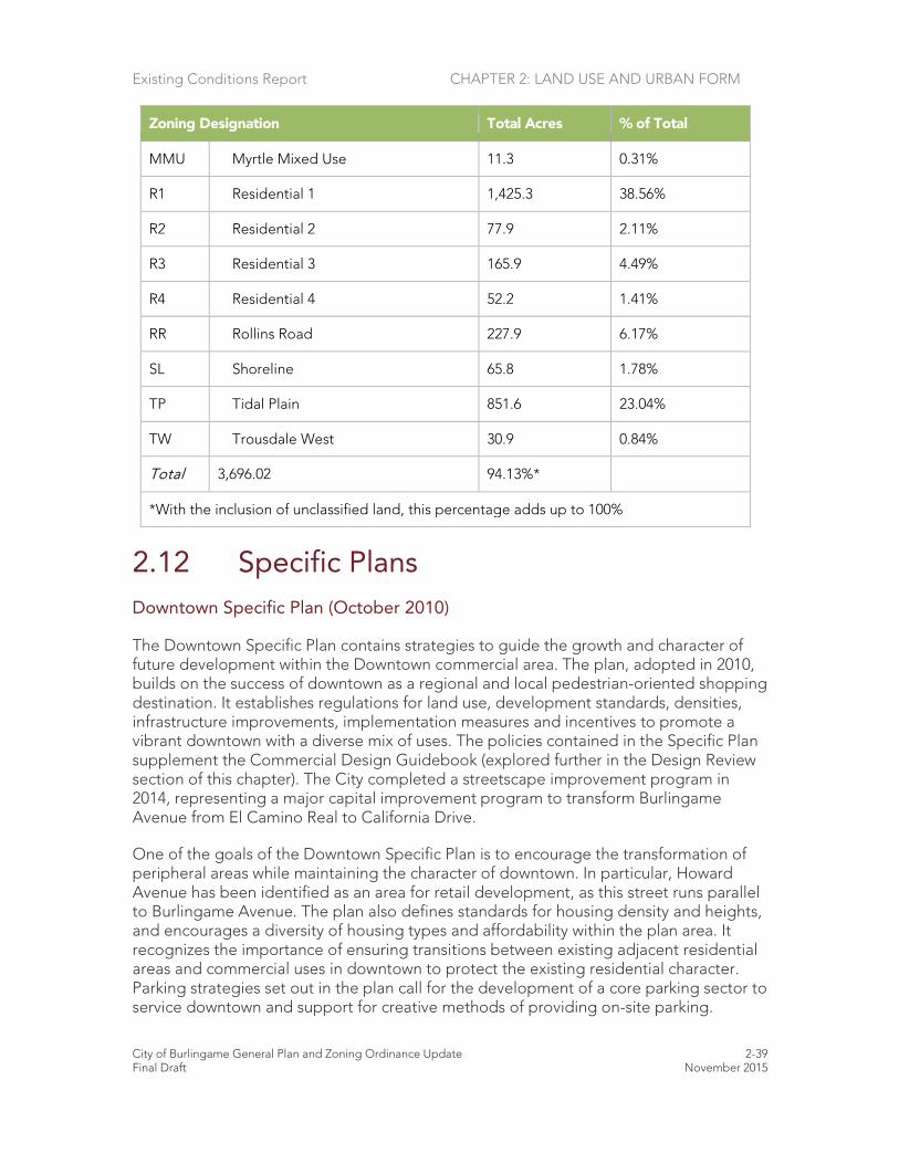
Existing Conditions Report CHAPTER 2: LAND USE AND URBAN FORM
City of Burlingame General Plan and Zoning Ordinance Update 2-39 Final Draft November 2015
Zoning Designation Total Acres % of Total
MMU Myrtle Mixed Use 11.3 0.31%
R1 Residential 1 1,425.3 38.56%
R2 Residential 2 77.9 2.11%
R3 Residential 3 165.9 4.49%
R4 Residential 4 52.2 1.41%
RR Rollins Road 227.9 6.17%
SL Shoreline 65.8 1.78%
TP Tidal Plain 851.6 23.04%
TW Trousdale West 30.9 0.84%
Total 3,696.02 94.13%*
*With the inclusion of unclassified land, this percentage adds up to 100%
2.12 Specific Plans Downtown Specific Plan (October 2010)
The Downtown Specific Plan contains strategies to guide the growth and character of future development within the Downtown commercial area. The plan, adopted in 2010, builds on the success of downtown as a regional and local pedestrian-oriented shopping destination. It establishes regulations for land use, development standards, densities, infrastructure improvements, implementation measures and incentives to promote a vibrant downtown with a diverse mix of uses. The policies contained in the Specific Plan supplement the Commercial Design Guidebook (explored further in the Design Review section of this chapter). The City completed a streetscape improvement program in 2014, representing a major capital improvement program to transform Burlingame Avenue from El Camino Real to California Drive.
One of the goals of the Downtown Specific Plan is to encourage the transformation of peripheral areas while maintaining the character of downtown. In particular, Howard Avenue has been identified as an area for retail development, as this street runs parallel to Burlingame Avenue. The plan also defines standards for housing density and heights, and encourages a diversity of housing types and affordability within the plan area. It recognizes the importance of ensuring transitions between existing adjacent residential areas and commercial uses in downtown to protect the existing residential character. Parking strategies set out in the plan call for the development of a core parking sector to service downtown and support for creative methods of providing on-site parking.

Existing Conditions Report CHAPTER 2: LAND USE AND URBAN FORM
City of Burlingame General Plan and Zoning Ordinance Update 2-40 Final Draft November 2015
Bayfront Specific Plan (June 2012)
The Bayfront Specific Plan applies to the bayfront area east of Highway 101. The plan was originally adopted in 2004 and amended in 2006 and 2012. It provides guidance on how properties in the Bayfront can be developed, including land uses, intensity, roadway and intersection improvements, and guidelines for the design of buildings and amenities. The plan defines five separate sub-areas – Anza Area, Anza Extension Area, Anza Point, Inner Bayshore and the Shoreline Area. This reflects the distinct quality of uses and place types. Land uses allowed include offices, hotels, restaurants, commercial, recreation and light industrial. The plan also considers the unique locational qualities of adjacency to San Francisco Bay, Highway 101 and SFO by balancing the desire for coastal and recreational access with density of development, and the need to support the city’s revenue base.
North Burlingame/Rollins Road Specific Plan (2007)
The North Burlingame/Rollins Road Specific Plan was adopted in 2004 and amended in 2007. The plan was developed to manage potential change and anticipated development interest in the northern part of Burlingame along the El Camino Real and Rollins Road corridors following the opening of the Millbrae Transit Center and the Mills Peninsula Hospital replacement project.
With this context in mind, the plan identifies land use policy and design improvements for the area. It includes goals, proposed land use and zoning changes, circulation improvements, design guidelines, development standards and implementation strategies. The plan establishes two unique sub-areas: Rollins Road and the El Camino Real corridor. The Rollins Road area is a vital industrial center and employment base, while the El Camino Real corridor provides retail, service and health amenities for the surrounding residential neighborhoods. The plan encourages high-density residential and mixed-use opportunities in those areas closest to the Millbrae Transit Center and preserves industrial uses in the Rollins Road area. Two new zoning districts (TW-Trousdale West and ECN – El Camino Real) were created as part of the plan implementation.

Existing Conditions Report CHAPTER 2: LAND USE AND URBAN FORM
City of Burlingame General Plan and Zoning Ordinance Update 2-41 Final Draft November 2015
2.13 Other City Plans and Policies
Introduction
Several other city plans, policies and guidelines regulate land uses locally.
Other City Plans
Bicycle Transportation Plan 2004
The Bicycle Transportation Plan, adopted in 2004, amended the Circulation Element. The plan provides guidance for future bicycle improvements and programs. Its goals include:
Goal A. Provide a framework for improving the existing bicycle route system in Burlingame.
Goal B. Promote bicycle travel as a safe and viable transportation mode and provide a system which connects work, shopping, schools, residential and recreation areas.
Goal C. Establish new connections across Highway 101 to provide access from Burlingame's residential areas to the recreational opportunities along the bayfront and to provide regional connections to the Bay Trail.
The Bicycle Plan identifies regional and local bike routes through Burlingame for commuters, recreational riders and local shopping trips. The routes proposed in the plan include informal routes within the city and connections to routes in the surrounding communities of San Mateo, Hillsborough and Millbrae. The plan is consistent with the San Mateo Comprehensive Bicycle Plan (2006) and the Metropolitan Transit Commission’s (MTC) Regional Bicycle Plan for the San Francisco Bay area. The plan was also certified by the MTC and accepted by Caltrans, which makes the City eligible for state funding opportunities for bicycle projects.
Climate Action Plan (June 2009)
The Climate Action Plan (CAP) adopted in 2009 is a nonbinding guide for identifying methods the City can use to reduce greenhouse gas (GHG) emissions. It serves as an important first step toward meeting the requirements mandated by Bill 32, California’s Global Warming Solutions Act of 2006, which targets that emissions measured at the 2005 level be reduced 15% by the year 2020 and 80% by the year 2050. The CAP identifies a baseline of emissions, sets achievable targets as stipulated by Bill 32 and recommends steps to reduce emissions, increase sustainability and improve quality of life. Transportation, land use, water reduction and recycling, and the promotion of energy efficient and green building strategies for residential and commercial uses are issues discussed in the CAP’s action framework.

Existing Conditions Report CHAPTER 2: LAND USE AND URBAN FORM
City of Burlingame General Plan and Zoning Ordinance Update 2-42 Final Draft November 2015
Urban Forest Management Plan
Burlingame’s Urban Forest Management Plan sets forth design considerations, policies, planting techniques, tree species selection and maintenance guidelines for tree management. It includes policies for incorporating trees into new landscapes and private open space plans. The plan also discusses the economic, political, historical, social and health values of trees in the community, as well as Burlingame’s history as a “City of Trees.”
Design Review
Design Guidebooks
The City of Burlingame has adopted design guidebooks for commercial and residential development. These guidebooks are part of the design review process that began in 1998. The purpose of the guidebooks is to clarify the design review process, to make the process user friendly, and to ensure that new development harmonizes with the existing character and quality of the city. Projects undergoing design review are evaluated by the Planning Commission and assessed for compliance with City zoning and parking regulations.
All new houses, most second story additions, some single-story additions require an application for residential design review. Projects are reviewed by the Planning Commission for compliance with the design guidebook, which contains guidance on appropriate design based on the style of the existing home and the character of the surrounding neighborhood. Consistency with existing architectural patterns is an important part of maintaining neighborhood character.
Commercial design review is required for new construction and major changes to the facades of commercial buildings in the C-1 and C-2 zoning districts. The guidebook is intended for use during the design process to ensure that projects fit in and support the pattern of diverse architectural styles that characterize the existing commercial, industrial and mixed-use areas. Building aesthetics, the interrelationship between uses and parking, mass, bulk, scale and compatibility with transitions where land use changes occur nearby are some of the key issues addressed in the guidebook.

Existing Conditions Report CHAPTER 2: LAND USE AND URBAN FORM
City of Burlingame General Plan and Zoning Ordinance Update 2-43 Final Draft November 2015
2.14 Other Plans and Programs
Introduction
This section discusses the plans, policies and regulations of other agencies that affect growth and development within the Burlingame Planning Area. Understanding the roles and responsibilities of these federal, state and regional agencies is vital to ensure effective interjurisdictional cooperation and coordination.
County and Regional Plans and Programs
Plan Bay Area and the Sustainable Communities Strategy
Plan Bay Area is an integrated long-range transportation and land-use/housing plan for the San Francisco Bay Area. It includes the Bay Area’s Regional Transportation Plan (RTP), which the MTC updates every four years, and the Association of Bay Area Government’s (ABAG) demographic and economic forecast, updated every two years.
Plan Bay Area was adopted in 2013. It includes a Sustainable Communities Strategy, which provides for the coordination of land use, housing and transportation. The goal of the Sustainable Communities Strategy is to reduce greenhouse gas emissions for cars and light-duty trucks in the nine-county region.
Plan Bay Area grew out of the California Sustainable Communities and Climate Protection Act of 2008 (California Senate Bill 375), which requires each of the state’s 18 metropolitan areas to reduce greenhouse gas emissions from cars and light trucks. The law requires that the Sustainable Communities Strategy promote compact, mixed-use commercial and residential development. To meet the goals of SB 375, more future development is planned to be walkable and bikable and close to public transit, jobs, schools, shopping, parks, recreation and other amenities. To this end, Plan Bay Area directs the majority of the regional housing growth to local “Priority Development Areas,” or PDAs.
San Mateo County Priority Development Area Investment and Growth Strategy
In relation to the Bay Area's Sustainable Communities Strategy, the San Mateo County Priority Development Area Investment and Growth Strategy was prepared by the City/County Association of Governments (CCAG) of San Mateo County. The plan is part of the MTC's requirement that each county in the Bay Area provide strategies to guide transportation investments in specific PDAs. PDAs are locally identified places near existing or planned transit service, and are intended to accommodate the majority of the region's projected growth in housing and jobs over the next 30 years. Burlingame is home to one of San Mateo County's 17 PDAs; this PDA extends along the El Camino Real corridor. The El Camino Real PDA is designated as a "Transit Town Center" in the county plan land use hierarchy, and it encompasses a half-mile “bubble” that spans the length of the city along the corridor. The PDA also reaches northeast to include Burlingame Station and downtown Burlingame. The County PDA Investment and
Existing Conditions Report CHAPTER 2: LAND USE AND URBAN FORM
City of Burlingame General Plan and Zoning Ordinance Update 2-44 Final Draft November 2015
Growth Strategy works in conjunction with the City of Burlingame Housing Element, as well as Plan Bay Area's Sustainable Communities Strategy.
Grand Boulevard Initiative
The Grand Boulevard Initiative is a regional collaboration focused on revitalization of the El Camino Real corridor, as it runs through San Mateo and Santa Clara Counties. The purpose of the initiative is to make El Camino Real a better place for the people who live and work along it by encouraging improvements such as sidewalks, crosswalks, more diverse transportation options and residential development.
Comprehensive Airport Land Use Compatibility Plan for the Environs of San Francisco International Airport (2012)
In recognition of the impact of airports on properties in their vicinity, the state legislature passed laws that require establishment of an airport land use commission (ALUC) to develop plans and policies for the orderly growth of airports and their surrounding areas. ALUCs were given the authority to:
• Specify how land near airports is used, based on safety and noise compatibility considerations
• Develop height restrictions for new development to protect the airspace in the vicinity of the airport
• Establish construction standards for new buildings near airports, including sound insulation requirements
The ALUC statute is to protect public health, safety and welfare through the adoption of land use standards that minimize the public’s exposure to excessive noise and safety hazards. They are also concerned with preventing the encroachment of incompatible land uses around airports to preserve the utility of airports well into the future. The ALUC may adopt land use standards which are more restrictive than state law in order to achieve its goals. The ALUC has no jurisdiction over airport operations or existing land uses.
The Airport Land Use Compatibility Plan (ALUCP) for San Francisco International Airport was last updated in 2012. The plan has four primary concerns:
Aircraft Noise Impact Reduction: Reduce the number of people living within the airport vicinity who are exposed to noise from the airport and aircraft operations.
Safety of People on the Ground and in Aircraft in Flight: Minimize the number of future residents and land use occupants who are exposed to hazards related to airport operations and practice.
Height Restrictions and Airspace Protection: Protect navigable airspace around the airport for safe and efficient operation of aircraft in flight.

Existing Conditions Report CHAPTER 2: LAND USE AND URBAN FORM
City of Burlingame General Plan and Zoning Ordinance Update 2-45 Final Draft November 2015
Overflight Notification: Establish areas within which aircraft flights to and from the airport occur frequently enough and at a low enough altitude to be noticeable by sensitive residents. Within these areas, real estate disclosure notices shall be required, pursuant to state law.
The policies and criteria contained in the ALUCP apply to new development in the vicinity of the airport. Existing land uses are exempt from the plan. Cities like Burlingame, which lie in the airport area of influence, are required to update their General Plans and zoning to be consistent with the ALUCP.

Existing Conditions Report CHAPTER 2: LAND USE AND URBAN FORM
City of Burlingame General Plan and Zoning Ordinance Update 2-46 Final Draft November 2015
2.15 Sources
Reports/Publications
Association of Bay Area Governments, Draft Preferred Scenario of the Sustainable Communities Strategy (Jobs-Housing Connection Strategy), adopted and released by ABAG Executive Board and MTC on May 17, 2012.
Association of Bay Area Governments: Regional Housing Need Plan for the San
Francisco Bay Area: 2014-2022, July 2013. Association of San Mateo County Relaters. https://www.samcar.org/market-data.htm,
June 2015. Burlingame Chamber of Commerce. www.burlingamechamber.org. June 2015. Burlingame Historical Society. www.burlingamehistory.org/ . June 2015. Burlingame Trees: http://burlingametrees.org/, 2015. California Department of Transportation Website:
http://www.dot.ca.gov/dist3/departments/mtce/scenic.htm, 2015. California Office of Historic Preservation. http://ohp.parks.ca.gov/. June 2015. California Scenic Highways Website:
http://www.dot.ca.gov/hq/LandArch/scenic_highways/scenic_hwy.htm, 2012. City/County Association of Governments: http://ccag.ca.gov/ , 2015. City of Burlingame. www.burlingame.org. June 2015. City of Burlingame, Bayfront Specific Plan, 2012. City of Burlingame, Bicycle Transportation Plan, 2007. City of Burlingame, Climate Action Plan, 2009. City of Burlingame, Commercial Design Guidebook, 2012. City of Burlingame, Downtown Specific Plan, 2010 City of Burlingame Draft Housing Element, 2015. City of Burlingame. Draft Inventory of Historic Resources. February 2008.
Existing Conditions Report CHAPTER 2: LAND USE AND URBAN FORM
City of Burlingame General Plan and Zoning Ordinance Update 2-47 Final Draft November 2015
City of Burlingame, General Plan, 1969. City of Burlingame, GIS Data, May 2012. City of Burlingame, GIS Data, June 2015. City of Burlingame, Neighborhood Design Guidebook, 2012. City of Burlingame, North Burlingame/Rollins Road Specific Plan, 2007 City of Burlingame, Title 25 Zoning Code Plan, 1969. City of Burlingame. Urban Forest Management Plan, 2009. County of San Mateo, Energy Efficiency Climate Action Plan, 2013. County of San Mateo General Plan, November, 1986. County of San Mateo GIS database, May 2015. County of San Mateo, Zoning Regulations, May 2012 Davey Resource Group. Urban Forest Resource Analysis. May 2011. Garrison, Joanne. Burlingame Centennial1908-2008, 2007. Grand Boulevard Initiative
http://www.grandboulevard.net/community/index.php/activity/547-el-camino-real-priority-development-area, 2015.
Kipen, David. California in the 1930s: The WPA Guide to the Golden State, 2013. Kohl Mansion. www.kohlmansion.com. June 2015. National Park Service. http://www.nps.gov/nr/. June 2015. Plan Bay Area Website:http://onebayarea.org/regional-initiatives/plan-bay-
area.html#.UNX8-He8QVR, 2015. San Francisco Bay Conservation and Development Commission Website:
http://www.bcdc.ca.gov, 2015. San Mateo County LAFCO Website, http://lafco.smcgov.org/burlingame-cityhttp, May
2015. San Mateo County Priority Development Area (PDA) Investment & Growth Strategy, May
2014.

Existing Conditions Report CHAPTER 2: LAND USE AND URBAN FORM
City of Burlingame General Plan and Zoning Ordinance Update 2-48 Final Draft November 2015
State of California, California Government Code, Sections 56000 and 65300, 2012.State of California, Governor’s Office of Planning and Research, General Plan Guidelines, 2003.
Twenty-One Elements: http://21elements.com/, 2015. Zillow: www.zillow.com, June 2015.