Embed Size (px)
Citation preview

1
Chapter 2: Introducing the Case Study, the Asopos River Basin in Greece.
1Koundouri, P.,
2Papandreou, N.
1Stithou, M.,
3Mousoulides, A.,
1Anastasiou, Y.,
1Mousoulidou,
M., 1Antypas, A.,
1Mavrogiorgis, T.,
1Vasiliou, K.
1Athens University of Economics and Business, GREECE
2Andreas G. Papandreou Foundation, GREECE
3Athens University of Economics and Business, GREECE and Intercollege Larnaca, CYPRUS
Abstract The case study area is presented in this chapter. The study area comprises the river and
estuary of Asopos and the lagoon of Oropos northeast of Attica. Along the Asopos river human
activities, mainly agriculture and industrial take place. Industrial and agricultural effluents
pollute the river, the aquifers and the soils of the area, making it a negative example of the
impacts to humans and environment that arise from non sustainable use of natural resources. The
chapter starts by presenting the geographical distribution of the river system and the water bodies
of the catchment. The chapter presents also a review of the related legislation that has
contributed to its current situation. Then the current water status of the catchment is described,
while the pressures and related impacts in the catchment are examined. Afterwards the focus is
on the social and environmental functions and values of Asopos River and Oropos Lagoon.
Identifying the main social, economic and environmental impacts of degradation in the area
provides the background for the analysis that follows in the subsequent chapters.
Keywords Asopos River Basin, Oropos Lagoon, Institutional framework, Water quality, Waste
waters
1. Presentation of the Asopos River Basin
Asopos RB is part of the Water District (07) of East Sterea Ellada (Figure 1). As it has been
reported in MoEPPW (2006, p.81): “Water District (07) of East Sterea Ellada occupies a total

2
area of 12.341 km2 and consists of the Prefecture of Evoia, major parts of the Prefectures of
Fthiotida (83.1%), Voiotia (98.5%) and Fokida (41.9%) and smaller parts of the Prefectures of
Magnisia (14.9%) and Attica (7.2%). The main river basins of Water District (07) are: River
basin of Voiotikos Kifissos River, River basin of Sperchios River and River basin of Asopos
River. Furthermore lakes Iliki and Paralimni are significant water bodies located in the Water
District (07).”
Figure 1: Water District (07) - East Sterea Ellada
(Source: MoEPPW, 2006)
Asopos RB covers a total surface area of 450 km2 (East Attica and Viotia Districts), and extends
to Evoikos Gulf. Its sources are in Elikona but along its flow other streams from the mountains
of Parnitha and Dervenochoria also contribute. Asopos has a total length of 57 km and flows
through Asopia, the plain of Thiva, Oinofita, Schimatari, Sikamino and Oropo and it finally
reaches North Evoikos Gulf. River’s annual runoff is 70 hm3. Figure 2 shows the distribution of
Asopos RB highlighted in blue. A population of approximately 70.575 citizens is residing in the

3
broad river area, which constitutes the largest industrial area in Greece, situated only 60 km
north of Athens.
Administratively in that particular RB there are eleven Towns/Municipalities which belong in
two prefectures, that of Viotia and Attiki. These eleven Towns/Municipalities are the following:
Plataion, Thivon, Tanagras, Dervenochorion, Oinofiton, Schimatariou, Avlona, Oropion,
Erithron, Malakasas and Sikaminou. The last five Towns/Municipalities are a part of Attiki
Prefecture while the rest form part of Viotia Prefecture. The included Towns/Municipalities are
highlighted in pink in Figure 2.
Figure 2: Asopos RB – Administrative borders (Source: Apostolopoulos, 2010)
4
Finally, regarding the geotectonic outline of the Assopos valley in Economou-Eliopoulos et al.
(2011, p.40) it is reported that: “The Neogene Assopos basin is mainly composed of Tertiary and
Quaternary sediments. The uppermost horizons, dominated in the studied area, are continental
sediments consisting of conglomerates with small intercalations of marl, marly limestone,
metaclastic schist, sandstone, clays and flysch. At the lowest parts there are alternations of lake
yellow marls and marl limestones hosting small black lignite horizons.”
2. Related legislation
Before, presenting the water quality related information and the identified pressures in the study
area it is important to present the institutional framework that had its impact on the current
situation. In 1969 with Presidential Decree it was allowed the establishment of industrial units
in the broader area of Oinofita. However, this decision did not foresee their way of operation and
did not specify limits related to the industrial activities. Hence, what characterized the location of
those industries in the region was the lack of any planning and monitoring system for the control
of the area’s industries. Ten years later in 1979, the river was appointed by the Regional
Authorities (Prefectures of Attica and Viotia) as receiver of industrial sewage however, without
establishing any monitoring system for the enforcement of terms and conditions under which the
industries would discharge their waste in the river. Although today these terms are obsolete and
in opposition with more recent laws and regulations, the treaty is still in effect. In addition, more
licenses were granted for the operation of industries in the area of the region where the
construction was forbidden under the 1969 Presidential Decree. As a result, the river and
groundwater have been subject to long-term industrial pollution.
5
Regarding the implications of the related legislation the following are emphasized:
1. According to the Public Health Act/Regulation Ε1b/221/65 the disposal of the treated
waste water and industrial wastes is allowed either in surface water bodies after asking
for Permission by the Prefect or underground (after asking Permission from the Planning
Service of Northern Attiki). This Regulation is rather general and as long as the
underground disposal of the treated industrial wastes are concerned, it is not referred
particularly, to dangerous and toxic substances and it does not set limits for the disposal
of dangerous substances.
2. The legislation for the management/disposal of the toxic-dangerous industrial wastes
according to the law L. 1650/86 includes a plethora of provisions which most of them
concern harmonization of the national Law with successive EU Directives. However,
these provisions do not face with a single and concise way the whole issue since there are
gaps, discontinuities and overlapping. Hence, although there is adequate environmental
legislation relevant to the management/disposal of dangerous industrial wastes, these
issues are still regulated by the Public Health Act/Regulation Ε1b/221/65.
In Greece, the WFD has been transposed into the national legislation with the Law 3199/2003
(MoEPPW, 2003) however, till recently there was neither a Management Plan for the protection
of the Asopos RB nor a Monitoring Program for its waters which should have become
operational the latest until 23-12-2006 according the P.D. 51/2007 in compliance with the
Directive 2000/60/EC.
6
The substantial response of the State regarding Asopos was initiated in the beginning of 2010
where it was presented by the Minister of Environment, Energy and Climate Change a Program
for the management of the environmental crisis in Asopos which aimed at the following
objectives1:
-Ensure safe water
-Institutional safeguard of the broader area
-Effective monitoring of the pollution sources (industrial, agricultural, urban) aiming the
limitation of the discharged loads
-Intensification of the controls
-Exploration of restoration measures of the environmental degradation
-The spatial planning/organization of the area
As far as the institutional and legislative framework is concerned2:
-The Joint Ministerial Decision was issued for the “Establishment of Environmental Quality
Standards in Asopos River and Emission Limit Values for Liquid Industrial Wastes in Asopos
RB”, according to which (i) outdated provisions according to which the industrial units in the
area could dispose their wastes in Asopos were abolished (ii) the Joint Departmental Decision
according to which Asopos was defined as a disposal pipeline of industrial wastes in Evoikos has
been abolished, (iii) the cost of sampling and of the laboratory analysis for the verification of
complying with the relevant legislation was attributed to the controlled activity.
1 http://www.ypeka.gr/Default.aspx?tabid=389&sni%5B524%5D=1561&language=el-GR (in Greek)
2 Op.cit 10.
7
- The Joint Ministerial Decision was issued according to which the Asopos RB is characterized
as area vulnerable to nitrate pollution and an appropriate agri-environmental program is formed
in compliance with the European Directive regarding nitrates from agricultural sources.
-The concept and implementation of criminal liability is reinforced and parallel to the Directive
for environmental liability this framework promotes the concept of the “polluter pays” but also
the principles of prevention and precaution for a more effective protection of the environment
and public health. This action is also translated to the direct adoption of measures to prevent and
remedy environmental damage, the cost of which is transferred to the polluters.
3. Quality of surface and groundwater in Asopos River Basin
3.1 Surface water
Regarding the quality of surface waters according to the monitoring data (MoEPPW, 2006,
p.81): “ nitrates and phosphorus concentrations in Asopos River were high whilst BOD and D.O.
measurements indicated pollution caused by high organic loads due to industrial and urban
wastes as well as agricultural run offs in its catchment area”. According to the same report it is
also noted that concentrations of microorganics, priority substances (Decision No.
2455/2001/EC) and dangerous substances (Directive 76/464/EEC) at Asopos River were lower
than the threshold values set for the water quality objectives by the National Legislation
(Decision 2/1-2-2001).
In the context of a research program of the Hellenic Centre for Marine Research (HCMR)
(Chatzinikolaou, 2009) aiming to assess the ecological condition of the Greek rivers using

8
biological parameters, water samples from Asopos were analyzed. The day of sampling was
chosen so as to reflect the worst situation in terms of surface flow in the river while sampling
took place in three points/sites.
Table 1: Results of sampling 2/8/20083
Source: Chatzinikolaou (2009)
From the above table (Table 1) it is concluded that the ecological quality of waters in the study
area according to the measurements of the HCMR4 is characterized according to the EU
Directive 2000/60 as “bad” in the two stations ASOPOS_DW and THERMIDON and “poor” in
the station ASOPOS_UP. In addition, according to the first results it was found out that in
Asopos water lived only one larva (Largo) of a kind of fly, which can only live under conditions
of zero oxygen.
Furthermore, following the research of the National Technical University of Athens led by
Professor Loizidou for the estimation of the environmental degradation because of the discharge
of industrial outflows in the environment, sampling took place during June 2004, at different
3 Second raw of the table presents the limits/standards set by the Directive 98/93, while the asterisk is referred to
limits/standards of the previous Directive 4 http://www.hcmr.gr/en/

9
points of the area (along the river and at the coastal area of the estuary). The results showed that
waters along the river and at the coastal area are polluted with inorganic and organic load.
3.2 Groundwater quality
Based on the study of the Institute of Geology and Mineral Exploration (Gianoulopoulos, 2008b:
cited in Technical Chambers, 2009, p.22) the qualitative characteristics of the groundwater were
examined and classified into two different categories: the ions and the trace elements. Regarding
the distribution of the main ions the following were concluded that: “(i) In the area between
Avlona, Ag. Thoma and Asopos River there are fresh waters enriched in HCO3-
with a low total
of dissolved salts (TDS). Eastern and at both sides of Asopos river bed the concentrations of
TDS gradually increase and their hydro chemical type advances to Mg-HCO3 and to mixed type
of waters. (ii) The majority of the groundwater is overloaded with nitrates demonstrating
concentrations almost double compared to the 50 mg/L legal limits for drinking water. In
addition, their concentration in Cl- ions is increased while along Asopos it was also observed
increase in PO4 ions. Furthermore, in specific areas there were recorded increased values of
Nitrite and Ammoniacal ions.
Following the same study of the Institute of Geology and Mineral Exploration (Gianoulopoulos,
2008b: cited in Technical Chambers, 2009, p.22): “(i) The source of the nitrates is mainly
agrochemical (nitrogen fertilizers) while the presence of nitrite and Ammoniacal ions is due to
the urban and industrial pollution sources, while (ii) the increased values of Cl- and PO4 ions are
also due to the industrial pollution sources. The increase of the Cl- ions in the alluvial coastal
aquifers of Oropos and Avlida is due to the mechanism of salinization.”
10
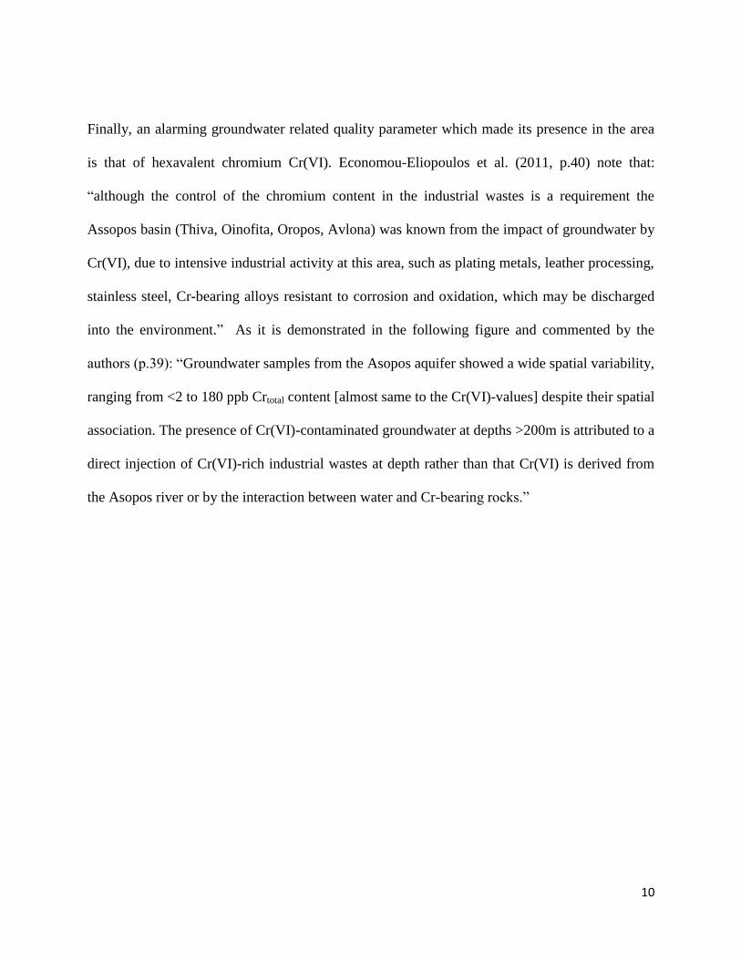
Finally, an alarming groundwater related quality parameter which made its presence in the area
is that of hexavalent chromium Cr(VI). Economou-Eliopoulos et al. (2011, p.40) note that:
“although the control of the chromium content in the industrial wastes is a requirement the
Assopos basin (Thiva, Oinofita, Oropos, Avlona) was known from the impact of groundwater by
Cr(VI), due to intensive industrial activity at this area, such as plating metals, leather processing,
stainless steel, Cr-bearing alloys resistant to corrosion and oxidation, which may be discharged
into the environment.” As it is demonstrated in the following figure and commented by the
authors (p.39): “Groundwater samples from the Asopos aquifer showed a wide spatial variability,
ranging from <2 to 180 ppb Crtotal content [almost same to the Cr(VI)-values] despite their spatial
association. The presence of Cr(VI)-contaminated groundwater at depths >200m is attributed to a
direct injection of Cr(VI)-rich industrial wastes at depth rather than that Cr(VI) is derived from
the Asopos river or by the interaction between water and Cr-bearing rocks.”

11
Figure 3: Location of the groundwater boreholes and distribution of the Crtotal concentration (in
ppb) throughout the Asopos basin. The groundwater samples were classified into tree groups: (a)
lower than 2 ppb Crtotal , (b) lower than 50 ppb Crtotal , and (c) higher than 50 ppb Crtotal .
Source: Economou-Eliopoulos et al. (2011, p.45)
In Vasilatos et al. (2008) study it is documented that (pp 61-62): “Concentrations over the
maximum acceptable level for Crtotal in drinking water (50 Ig/L), according to the EU Directive
(EC, 1998), were found in several groundwater samples from Thiva – Tanagra – Malakasa basin.
The contamination of groundwater by Cr(VI) that was found in the majority of groundwater
samples in the Thiva – Tanagra – Malakasa basin has been related to the widespread industrial
activity for the last 40 years and the usage of hexavalent chromium in various processes. … In
the Asopos River, that crosses the Thiva – Tanagra– Malakasa basin, although total chromium is
up to 13Ig/L, hexavalent chromium less than 5 mg/L and the other toxic element concentrations
12
were relatively low during our research, their values suggest their relation with the industrial
activity in the area.”
“The higher values of Cr total are observed in the area of Avlida (180 ppb) and in the areas of both
sides of Asopos river bed (40-107 ppb) till the broader area of Oropos (17-85 ppb), as well as in
the area Southeast of Asopos till the area of Avlona (20-118 ppb). Increased concentrations were
also observed in a borehole in proximity to Asopos river bed at North of Ag Thomas (163 ppb)”
(Technical Champers, p.23). As commented in the Technical Champers (2009) report in most of
the cases these increased values of Crtotal are the result of industrial pollution, while the
concentrations of Cr(VI)/(Cr6+) demonstrate a similar distribution to that of Crtotal.
4. Pressures and impacts of pollution in Asopos River Basin
As it must be obvious to this point the broad Asopos area is the largest industrial region of
Greece, supporting 1300 industrial facilities such as metal processing agrochemical, and
food/drinks industries among others. Hence, the industrial activity in the area of Asopos, which
started at the end of 1970, and in particular in Oinofita-Schimatari is considerable and increasing.
According to the results of Loizidou (2009) study presented in Table 2, there were reported 378
industrial units in the area of which 23 were closed and the rest 5 were new and under
construction. From the total of the existing units the 130 produce waste waters during their
production function. The total daily produced quantity of waste waters reaches the 9.044 m3/day
of which 84% corresponds to the industrial waste waters. More particularly, the total daily
produced quantity of industrial waste waters from the total of the industrial and artisanal units

13
located in the area reaches the 7.605 m3/day and the total daily quantity of waste waters of the
employed in these units reaches the 1.439 m3/day. The main flow of the produced industrial
waste waters is coming primarily from the sectors of “Textile and leather industries”,
“Metallurgy related industries” and “Industries of Foods and Drinks” at 25%, 21% and 30%
respectively.
Table 2: Industrial units distribution and average daily flow of waste water for
each industrial activity (m3/day)
Industrial Sector # of
industrial
units
average daily
flow of waste
water (m3/day)
Livestock farms 11 539
Food and drink industries 41 2198
Textile and leather industries 20 1925
Woodworking industries 15 2
Pulp and paper industries and printing
industries
17 8
Chemical industries 77 154
Non metallic mineral industries 20 908
Metallurgy related industries 96 1615
Commercial industries 9 -
Warehouses 26 -
Other industries 46 256
Total 378
Closed 28
Total 350 7605
Source: Loizidou (2009)
Loizidou (2009) also offers a disaggregated view of the above industrial activities for each active
industrial unit in Asopos RB as far as wastewater in m3/day is concerned. Table 3 presents the
industrial pollutants (Kg/d) in the current situation (during the research).
Table 3: Industrial pollutants (Kg/d)
BOD 203.8
COD 6279
SS 2275

14
Fats (Λίπη;) 765.5
MBAS 12
NH4+
NO3- 46.95
PO4-3
13.86
SO4-2
2.774
CN- 0.25
Phenols 16.66
AI 3.52
Fe 5.38
Sn
Cr+3
4.3
Cr+6
0.00
Cu 2.94
Cd 0.35
Pb 1.71
Ni 42.27
Zn 2.11
Source: Loizidou (2009)
Loizidou’s (2009) study explores also the potential for the creation of a Central Wastewater
Treatment Plant (CWTP) and of a Central Sewerage Network of the Industries (CSNI). For this
purpose it is important to predict the quantity and quality of the produced waste waters in the
future. Results are presented in the following table giving us an indication of the trend of the
industrial development in the area. Hence, apart from the Textile and Leather industries all the
other sectors demonstrate an increasing activity. Furthermore, in order to assure applicability of
the project even when faced with a higher volume of waste waters than those predicted a 15%
(last column of Table 4) safety factor is added to the calculation of the future loads.
Table 4: Average daily flow of waste water for each industrial activity (m3/day)
Industrial Activity Current 10 years 20 years 20 years
+15%
Livestock farms 539 807,9 1091 1254
Food and drink
industries
2198 3298 4451 5119
Textile and leather 1925 1925 1925 2214

15
industries
Woodworking
industries
2 2,9 3,8 4,4
Pulp and paper
industries and
printing industries
8 12,2 16,4 19
Chemical industries 154 231,2 312,1 359
Non metallic
mineral industries
908 1362 1839 2114,9
Metallurgy related
industries
1615 2422,8 3269,8 3760,3
Other industries 256 384 518,4 596,2
Total 7605 10445 13427 15441
Source: Loizidou (2009)
Regarding water consumption Table 5 shows that the most water demanding sectors are those of
“Metallurgy related industries”, “Food and drinks industries”, “Textile and Leather industries”
and “Chemical industries”.
Table 5: Water consumption per industrial activity
Industrial activity Quantity (m3/year)
Food and drink industries 1.235.336
Livestock farms 35.650
Textile and leather industries 562.228
Woodworking industries 3.480
Pulp and paper industries and printing
industries
4.015
Chemical industries 111.260
Non metallic mineral industries 40.805
Metallurgy related industries 1.240.540
Other 2.425
Total 3.235.739
Source: Loizidou (2009)
As it is also noted in Loizidou (2009) from the total of the industrial and artisanal units that
produce waste waters, that is from the 130 units (37% of the total of the units in operation) the 65
units (that is 50% of these that produce waste water) have a treatment facility for their produced
waste waters. In general, from the total quantity of produced waste waters (industrial and urban

16
waste waters) the 97% is subject to a treatment. As Table 6 shows the existing ways of waste
water disposal in the area are the surface disposal, the underground disposal, the recycling of the
treated out flow (within production activity), the disposal in a municipal wastewater treatment
plant or in an authorized management body and the disposal in the Asopos River or its
tributaries. Finally, some of the industrial units not having an alternative option collect
temporally their wastes which are then managed by an authorized body.
Table 6: Current ways of disposal of waste waters in the study area
Ways of disposal # of
industrial
units
Quantity of
waste water
(m3/day)
Percentage
(%)
Surface disposal 15 454 6
Underground disposal 25 104 1,4
Recycling 22 946 12,4
Temporal collection 2 1 0,01
Municipal wastewater plant 19 95 1,3
Authorized management body 23 19 0,3
Asopos and its tributaries 24 5985 78,7
Total 130 7605 100
Source: Loizidou (2009)
Overall, Loizidou’s (2009) study reports that considering the 350 industrial units that operate in
the area the produced: a daily quantity of industrial waste waters of 7.605,0 m3/day, 1.438,8
m3/day of sewage, 3.458.034 m
3/year total annual water consumption and an annual quantity of
sludge of 15.096 tn/year.
In addition, considering the study of the Agricultural University of Athens which recorded the
industrial and artisanal units in the area it was concluded (Masoura, 2008: cited in Technical
Champers, 2009, p.29) that: (i) North East of the Asopos’ river bed in a stretch of 7 km there is a
big number of industrial and artisanal units (407) which produce a daily volume of waste waters
ranging from 0,3 m3/d to 3000 m
3/d depending on the production procedure that is followed and

17
the size of each industry, and (ii) these waste waters are mainly produced by the textiles-
varnishes-finishing, the food industries, the metallurgic units, the chemical units as well as from
the livestock units.
An additional pressure in the area is also put by the agricultural activity which includes arable
and tree crops. As stated in the Report of the Technical Champers (2009, p.28): “there are
351.400 str. which are cultivated from which the 45% are irrigated and the 55% non-irrigated. In
general, in the area an intense agricultural activity is observed in the upstream of Asopos.” As it
has been demonstrated in the previous section the production of the area is mainly characterized
by hard wheat, pulses, cotton and some categories of fodder and vegetables. Therefore, the
pollution of Asopos surface water from agricultural run offs is expected to aggravate the
problem. Furthermore, in the same report it is noted that there are also natural sources of
pollution apart from the industrial, urban and agricultural activities.
Apart from the obvious environmental impacts in the area there are also worrying human health
impacts due to the presence of the highly toxic heavy metal hexavalent chromium (CrVI) (or
chromium 6) which was traced at high concentrations (ranging from 10 ppbs to 330 ppbs) in both
surface and groundwater samples from the area. As commented also previously the evidence
show that the presence of hexavelent chromium in surface and groundwater is clearly and
indisputably linked to industrial contamination of soils and waters from illegal discharge of
industrial, hazardous waste and sludge. It is regarded that water consumption of high
concentrations of hexavalent chromium harms human organism not only by drinking water but
also by skin contact or the consumption of fruits and vegetables. Current scientific evidence has
shown that hexavelent chromium is absorbed through the gastrointestinal tract and can reach
18
many organs causing serious damages and cancer. Even the inhalation of hexavalent chromium
can cause mainly lung cancer.
Furthermore, it has been noted that apart from the intense, human induced pollution of waters of
Asopos River, which comes from the industrial activities in its catchment, in the coastal wetland
complex the human influence is intense as well mainly due to expansion of settlements, impacts
from traffic during the summer months, and garbage. A number of roads form blocks and the
residential pressure goes up to the coastline. Indeed, the remnants of natural vegetation in some
of the residential blocks indicate that parts of salt meadows have been filled to cross roads.
Within the wetland toward the Oropos area the pressure from the filling and movement of
vehicles is obvious. Part of the area at the mouth of Asopos River has been covered by the
aviation with a variety of antennas and some of the area on both sides of the riverbed has been
fenced.
5. Functions and values of Asopos River and Oropos Lagoon5
This section offers a short overview of the functions and values of the area, based on literature
review and field visits, associated with the wetland complex composed from Asopos River
(including its estuary) and the coastal lagoon of Oropos. It is noted that Chapter 9 summarizes
results of a qualitative evaluation of these wetland functions and related values by
hydrogeomorphological unit.
5 EKBY (2010) (Available at: http://www.aueb.gr/users/koundouri/resees/uploads/envstudyen.pdf

19
The study area (Figure 4) comprises the river and estuary of Asopos and the lagoon of Oropos
northeast of Attica. Along the Asopos river human activities, mainly agriculture and industrial
take place. For at least three decades industrial effluents pollute the river, the aquifers and the
soils of the area, making it a negative example of the impacts to humans and environment that
arise from non sustainable use of natural resources. The mouth of Asopos River and the lagoon
of Oropos (on right hand side of Figure 4) are located at around 2 km distance and are remnants
of a single wetland system in the past associated with coastal marshes. Today, settlements have
expanded in the in-between area. The road is located just few meters from the coast and
halophytic vegetation is only sporadically present, resulting in the interruption of the structural
continuity of the two wetlands.
Figure 4: Satellite picture of Asopos river and mouth, of Oropos lagoon and the wider area
(Date: August 2004, Source: GOOGLE EARTH).
20
Values for humans result from the structural features and functions of wetlands. These are the
goods and services provided or potentially provided to humans as a result of functions that take
place there. A wetland function can benefit humans in many ways, that is, to provide more than
one values. Wetlands differ in the number of functions performed and in the degree to which
they perform them; as a result, the values obtained by humans differ as well. Furthermore, many
wetland values are derived from a combination of functions and a value may depend on one or
more other values.
The functions that were considered necessary to evaluate in the area were: a) water storage, b)
food web support, c) nutrients removal and transformation, d) sediment and toxic trapping, e)
floodwater attenuation, f) groundwater recharge, g) shoreline stabilization. The next sub-section
presents in more detail the above mentioned functions.
5.1.1 Food web support
Wetlands, and especially those with a variety of vegetation units, depth and current velocity, and
considerable vegetation cover, host a variety of habitat types. In the wetland complex of the
estuary of Asopos River and the Oropos lagoon, characteristic vegetation types of the coastal
zone appear, that create a variety of habitats for species and mosaic in physiognomy of the area.
The change in the water depth due to the microtopography from the coast to inland area, also due
to the periodical and seasonal inundation favors the development of vegetation types and the
presence of species. With regard to the vegetation types, in sub sites (mouth of Asopos River and
Oropos lagoon), Mediterranean halophilous scrubs and Mediterranean salt meadows develop
with more than one plant communities.
21
In particular, the Mediterranean halophilus scrubs (Arthrocnemetalia fructicosae) consist of four
plant communities: a) with dominant Sarcocornia fruticosae which occupies the largest surface
area of the scrubs, b) with Halcocnemum strobilaceum as dominant species, c) with
Arthrocnemum macrostachyum as characteristic species and d) with characteristic species the
Aeluropus littoralis. The Mediterranean salt meadows (Juncetalia maritimi) appear with two
plant communities. The one is formed by the species Elytrigia elongata (=Elymus elongates) or
E. Flaccidifolius and Juncus acutus as dominant in salt and wet soils, behind the zone
established by halophilus scrubs, whereas in the other, Juncus maritimus and Arthrocnemum
macrostachyum dominate. Moreover, in the area, depressions between dunes with reeds and
sedge appear, and annual vegetation along the coastline. It is noted that the shallow lagoon of
Oropos is partially connected with Evoikos gulf through a narrow channel and is a priority
habitat type of Community importance (code 1150) according to Directive 92/43/EEC.
With regard to the diversity of animal species, we consider birds as a group of species indicative
of the quality of the function, as it was previously described. In the study area, in total 101 bird
species have been observed (Tzali et al., 2009), being the largest number compared to other
wetlands of Attica region; they comprise raptors, herons, waterfowl present during the winter
(November to February), waders all year round, with their peak during migration in winter.
Important is considered the presence of Larus melanocephalus that is endangered according to
the Red Data Book, among others. It is noted that 19 bird species belong to Annex I to the Birds
Directive, out of which in the area the following reproduce: Charadrius alexandrinus,
Himantopus himantopus, Sterna albifrons and Calandrella brachydactyla. The large number of
bird species during migration shows the importance of the area as a stopover (Tzali et al., 2009,

22
WWF Hellas and Hellenic Ornithological Society 2008 and on site visits 2010). However, with
regard to fish, it is noted that endangered freshwater species such as Pelasgus marathonicus
(Vinciguerra, 1921) and Telestes beoticus (Stephanidis, 1939) have probably been extinct from
Asopos River (Economides and Chrysopolitou 2009a, b). As regards reptiles, only the species
Ablepharus kitaibelii has been observed in an oliveyard near the river, Chalcides ocellatus is also
referred to. Moreover, around a kilometer north east of Oropos lagoon, the snake Malpolon
monspessulanus has been observed (Ioannidis unpublished data 2002) and so its presence in the
study area is probable. As to the mammals, there are no published data; however, it is probable
that certain human acclimatized species such Rattus rattus, whose presence has been recorded in
the study area, are present. It is also probable that some bat species also use the wetlands for
food. In any case, the habitats for most reptiles and mammals are degraded. It is also noted, that
the wetland complex, although small in size (around 100 ha), is the only remnant wetland
between two larger coastal wetlands of the wider area, those of Sperheios and Shinias that belong
to the NATURA 2000 network. As such, it contributes significantly to the conservation of
habitats to the coherence of the network. This role is also acknowledged in article 10 of Directive
92/43/EOK, which encourages member states to conserve and manage those sites as special
landscape features.
Given the above it becomes clear that the wetland complex performs the function Food web
support. But the continuing deterioration of the function is obvious and results mainly from the
expansion of settlements at the expense of wetland area and water pollution of the river Asopos.
The upgrading of this function is directly related to the removal of these two threats. The
expansion of settlements should not be pursued at the expense of wetland area and water quality
of the Asopos must be restored so that the function is upgraded and maintained at a high degree.
23
Furthermore, the development of targeted activities such as environmental information,
education and recreation would probably prevent the degradation of salt meadows adjacent to the
coast from vehicles especially during the summer months (the area is not flooded) and would
encourage the sustainable use of the wetland complex.
5.1.2 Water storage
The storage of surface water is a function that almost all the wetlands can perform. The storage
of water from precipitation and the time required for the gradual discharge of the water varies
between wetlands. The depth of water in a wetland provides a clear picture of the volume of
water that can be stored. The wetlands that have shallow water warm faster than the deeper ones
and have greater water losses due to evaporation. In contrast, wetlands with steep slopes
maintain deep water throughout the area and have less water loss by evaporation. In the case of
the Asopos River, despite the relatively large size of the basin, water is kept only for a minimum
time in the river bed, due to rapid percolation to karstic aquifers in the basin. It therefore appears
that the ability to perform this function is limited along the Asopos River but also in its estuary.
Similarly limited is the extent to which this function is performed in the lagoon of Oropos.
Limiting factors is the shallowness, the existing channel of water and the little inclined regions
upstream of the lagoon, which contribute only little with water runoff.
5.1.3. Nutrients removal and transformation
The water entering a wetland inevitably carries nutrients dissolved in water and adsorbed to soil
particles. The nutrients can come from the fields, villages and industries. Wetlands have the
ability to improve water quality, through the retention of nutrients and their conversion into other
24
forms. The removal is achieved by physico-chemical and biological processes that are performed
in wetlands. The presence of plants favors the function of removal and transformation of
nutrients, because they contribute to both slowing the water flow and absorbing the entering
nitrogen and phosphorus. In addition, plants are the substrate for the growth of microorganisms,
by which many substances are transformed into other forms. The wetland vegetation is
particularly effective in the retention of nutrients. Therefore, the higher the coverage with
vegetation, the more that function is favored. Moreover, this function is favored not only when
there is vegetation in the wetland, but rather when there is a diversity of species. However, as
mentioned above, Asopos River maintains permanent flow only for a limited time. Thus, this
function is severely constrained by lack of water in the riverbed. In the lower reaches, where
large quantities of liquid waste are disposed of, the presence of water is almost permanent, and
despite the existence of wetland vegetation (especially reeds), nutrient concentrations are very
high. Therefore this function seems to be limited along the riverbed and is further degraded in
the section towards the exit to the sea. In terms of the lagoon of Oropos, theoretically there is the
ability to perform this function. However, this is limited by the salinity of the water, which does
not favor this function in general and the more specifically the presence of those plant species
that support some of the processes of removal and transformation of nitrogen and phosphorus.
The presence of plants as they grow around the lagoon, would enhance the degree of this
function.
5.1.4. Sediment and toxic substances trapping
The water runoff, atmospheric precipitation and wind drift within the wetland solid materials.
These materials are trapped temporarily or permanently in the wetland so that the wetland

25
improves the quality of water flowing through it. The sediments may contain nutrients, heavy
metals and pesticides according to the land use of the catchment (agricultural, urban, industrial,
etc.). The processes that trap pollutants entering into the wetlands, are due to slow speed of water
and subsequent retention of nutrients by wetland vegetation, to the decomposition of organic
matter by microorganisms, to the metabolism of plants and animals, and to photosynthesis. In the
wetland of Asopos, the velocity of water is small and therefore there is a great likelihood of
precipitation of particulate material, with subsequent retention and deposition of sediments and
toxic substances within the wetland. The areas with wetland vegetation (especially reeds) reduce
the speed of water in the wetland due to friction, contributing to the rapping of sediments and
preventing re-suspension of sediments. Furthermore, the vegetation contributes to coating of
pollutants and sediments with dead plant material, which is good feature. Also, the shallow
water, contributes to the entrapment of pollutants and toxic substances, because the speed of the
water is low due to friction and facilitates the trapping. The type of substrate determines the
degree of adsorption of contaminants from the wetland soil. The presence of organic substrates
favors the absorption and retention of certain toxic heavy metals and synthetic organic
compounds. Therefore, wetlands with a high proportion of organic soils perform this function.
On this basis it is assumed that there is expression of that function, at the mouth of Asopos.
The lagoon can act as trap of sediment and toxic substances through sedimentation processes and
coating with other materials or through biochemical processes in the water flowing in the lagoon
from runoff from the nearby upstream region. The sediments sometimes carry, by chemical and
physical bonds, toxic substances like heavy metals and pesticides. The site has features that

26
enable it to perform this function to an appreciable extent; however, in practice, this function is
limited because only limited amounts of water runoff flow through the Oropos lagoon.
5.1.5 Floodwater attenuation
The function of amending the flood is very important for humans, due to the slowing of water
velocity and the reduction of the area affected by flood. Wetlands can temporarily store large
amounts of water during floods and mitigate the damage to agriculture and settlements. The
ability of the wetland is to store flood water and gradually recharge, after the flood, thereby
reducing the flood peak. This function is performed at an optimal level in ecosystems found in
higher parts of the catchment, where the floods occur, and in wetland areas that are a recipient of
torrential flow. The factors on which the efficiency of the function depends are: a) the type of
wetland and the morphology of the catchment, b) the location and size of the catchment, c) a
channel of water, d) water movement and e) the vegetation cover.
In the case of Asopos River this function is not considered as particularly important given the
high degree of infiltration of rainwater in the catchment through the carbonate rocks that prevail
in the basin in approximately 50%. It is most likely that underground water from side enters
Asopos River which is moving slowly and not flood peaks from surface water. In the case of the
lagoon of Oropos, this function seems to be performed quite well, protecting the residential area
upstream from the sea water during extreme weather and tide, however limited it is. This is
achieved through its ability to store and halt the rising waters and recharging them again to the
sea through the channel.

27
5.1.6 Groundwater recharge
Wetlands retain large amounts of surface water from the catchment area and they play a valuable
role in the enrichment of underground aquifers, as water retained then flows through the soil
layers to the aquifer, enriching it with water that would be lost otherwise. The enrichment is done
both in the vertical and the horizontal movements of water, especially in cases of shallow
aquifers. Whether a wetland has the potential to enrich the groundwater aquifers is mainly
dependent on the substrate of the wetland that is the main factor in the performance of that
function. If the substrate is practically impermeable, this function is not existent, even if all other
factors are favorable. In the area of the Asopos River, there are two main aquifers; the upper
aquifer of granular deposits and underlying karstic aquifer formations. The movement of
groundwater varies vertically and horizontally between different aquifers and although the bed of
the river in only small parts comes in contact with the karst aquifer, the river Asopos has no
permanent water supply. Thus, it appears that a large volume of runoff water percolates to the
groundwater and therefore the function of the enrichment of groundwater aquifers is performed
widely.
For the Oropos lagoon no analytical data on the permeability of the substrate exist. From hydro-
lithological data of the wider region it comes that formations of medium to low permeability
dominate. Taking into account also the proximity to the sea and the possible entry of
underground salt water, it is estimated that the lagoon does not perform this function.
5.1.7 Shoreline stabilization

28
The stabilization of coasts by wetlands is associated with the retention of soil on the coast (e.g.,
from roots of wetland plants) to prevent the erosive action of waves and currents. The existence
of specialized wetland flora, tolerant of increased salinity in coastal areas, plays a special role in
this direction with their roots. However, resistant to erosion are not only wetlands with
vegetation but also other coastal wetlands that are flat or nearly flat with no vegetation. The
lagoons are a typical case of wetland ecosystems that absorb the energy of waves and currents,
preventing them to enter the land and erode it. The lagoon of Oropos is assumed to perform this
function until today, although the surface has been limited by residential development.
Stabilization of coast is also achieved through the deposition of river delta wetlands. The delta,
first absorb the erosive action of waves and currents and also provide the fine material which
spreads and / or is deposited subsequently by waves, usually in the neighboring coasts, providing
in this way double protection on the latter. Thus the estuary of Asopos River is assumed to
perform this function that needs to be maintained.
With regard to the values it is noted that a value originates from one or more functions, whereas
a function could shape more than one values. Wetland values could be separate, complementary
or even contradictory. Wetlands differ in the number and magnitude of values. In the case of
study area, the following wetland values were evaluated: a) biological, b) scientific, c) education
d) recreational, e) hunting, f) improving of water quality, g) protection against floods, and h)
protection against erosion.
Detailed performance of the hydrogeomorphological units with regard to values is reported in
Chapter 9. However, it is noted that one of the principal values of wetlands is biological value. It
is related to the number of plants and animals, which can be considered rare or protected and

29
their presence is associated with wetlands. The maintenance of high biodiversity contributes to
the enhancement of values, such as scientific and educational. This value is directly affected by
the function of food web support and indirectly from other functions. The study area has a
biological value, since habitat types of Annex I of Directive 92/43/EEC, of which the lagoon is a
priority for protection, are encountered. At the same time, the area has value in terms of birds,
while for the rest of the fauna it appears to be limited because of its conservation status and of
the threats it faces. Furthermore, wetland biodiversity makes them attractive locations for
research from many disciplines. They are living laboratories for the observation and therefore
frequently used for research. The area has vegetation units and plant and animal species that
require scientific research and study (e.g. birds, habitat types of Annex I of Directive
92/43/EEC). The biological value of the region, particularly in the lagoon of Oropos, combined
with the characteristics of the surrounding area make it attractive from a scientific and
educational aspect, but this value is expected to rise following the implementation of
management measures.
Wetlands are also highly valuable in terms of recreation. They offer possibilities for viewing and
enjoying the landscape, observing flora and fauna, sports, excursions, walks and general mental
and physical exaltation and contact with nature. In the case of river Asopos this value is very
limited, whereas in the lagoon of Oropos it is assumed that the area has recreational value,
which, after application of management measures would increase. Finally, wetlands, through the
function of trapping sediment and toxic substances and the transformation and removal of
nutrients, have the capacity to improve the quality of water flowing through them. This value is
very poor especially for Asopos River. The impact of this (social, economic, environmental), is

30
already visible in the catchment of wetlands under study whereas intense are considered the
pressures on the coastal ecosystem of the South Evian Gulf, because of the direct relationship
and proximity to this.
6. Conclusions
Although the impact of the industrial activity on the water use is not that important compared to
other uses (irrigation, water supply), it is observed that some of the industrial units have a
considerable production of waste water of diverse pollutants which depend on the type of
production. Regarding the estimation of the pressures on the water quality due to the industrial
activity, it is necessary to analyze in detail the total amount of polluting material in the area as
well as the part of the polluting material that is related to the industrial activity. In general, it is
observed that the sectors of Basic metals and Foods and Drinks which are of great importance in
the area produce a considerable number of wastes compared to the other sectors of the industrial
activity.
It should be noted that apart from the industrial waste waters which are the byproduct of
production, there are also urban waste waters that come from the employees of the relative units.
The fact that the basin is in close proximity to Athens has played an important role due to the
special conditions of the capital the last years as a result of the population growth, the increase in
land prices, the urbanization of suburban areas. These are some of the factors that made difficult
the establishment of industrial units in close proximity to Athens and indicated the case study
area to be a more attractive option.
31
As it will be also emphasized in Chapters 3 and 9 the agricultural activity in the area is important
for the local economy while at the same time puts a considerable pressure on water use.
Regarding its effect on water quality it is estimated that it plays an important role and is mainly
due to the nitrates run off due to the excessive use of fertilizers. However, the impact of the
sector is even more important regarding water quantity. In order to estimate correctly this impact
it is necessary to record the way of water supply for irrigation purposes as well as the existing
boreholes.
As commented in Loizidou (2009) the considerable industrial activity combined with the lack of
necessary infrastructure results in serious pollution problems in the wider area. In particular, the
lack of a holistic plan for the treatment of the produced liquid, solid and air wastes creates
important environmental problems. A main problem is the uncontrolled disposal treated or not
industrial waste waters in different natural receptor and mainly in Asopos River or its tributaries
leading in the surcharge of the stream. It should be also noted that despite the fact that the
majority of the existing in the area industrial units has a system of waste water collection and
treatment, the problem of the degradation of the water quality of the receptors and in general of
the aquifer of the area remains severe. This fact is due to either the non satisfactory operation of
the wastewater systems because of technical or operational problems or to the small degree of
effectiveness of the existing wastewater treatment systems. All these factors have contributed to
characterize Asopos as one of the most polluted rivers having an impact not only to the areas that
it crosses but also to the coastal area of Chalkoutsi in which it flows into.

32
Biological, scientific, educational, recreational and other different wetland values were evaluated
in the study area. The maintenance of high biodiversity contributes to the enhancement of such
values. This value is directly affected by the function of food web support and indirectly from
other functions. It should be stressed that wetland values could be separate, complementary or
even contradictory.
Finally, as a solution to the problem Loizidou’s (2009) study explores the possibility of the
creation of a management system for wastewater treatment which will involve the collection,
transfer and treatment of the produced wastewaters. It has to be noted that the optimal
management of the waste waters will contribute significantly to the restoration not only of the
Asopos River but also to the environmental enhancement of the area and will decrease the
negative environmental consequences leading to a sustainable development. In addition,
measures are deemed important as a result of the serious impacts of pollution on human health as
well as of the high significance of biological, scientific-educational and recreational values of the
study area.
References
Apostolopoulos, K. 2010. Assessment of the economic importance of water use in the industrial
and agricultural areas of Asopos RB. Athens University of Economics and Business,
Departement of International and European Studies. Available at:
http://www.aueb.gr/users/resees/en/econcharen.html (In Greek)

33
Commission of the European Communities (CEC) 2000 Directive of the European Parliament
and of the Council establishing a framework for Community action in the field of water
policy. 1997/0067 (COD), C5-0347/00.
Chatzinikolaou, G., 2009. Network development and monitoring of the quality of the surface,
transitional and coastal waters of the country - Assessment / classification of their ecological
status, Hellenic Centre for Marine Research (HCMR).
Economidis, P.S. and V. Chrysopolitou. 2009a. Pelasgus marathonicus (Vinciguerra, 1921).
Pages 113 – 115 in: A. Legakis and P. Μaragkou (ed). 2009. The red book of threatened
animals of Greece. Hellenic Zoological Society, Athens, 528 p.
Economidis, P.S. and V. Chrysopolitou. 2009b. Telestes beoticus (Stephanidis, 1939). Pages 122
– 123 in: A. Legakis and P. Μaragkou. (ed). 2009. The red book of threatened animals of
Greece. Hellenic Zoological Society, Athens, 528 p.
Economou-Eliopoulos, M., Megremi, I and C. Vasilatos, 2011. Factors controlling the
heterogeneous distribution of Cr(VI) in soil, plants and groundwater: Evidence from the
Assopos basin, Greece. Chemie Erde – Geochemistry, 71(1), pp.39-52
(doi:10.1016/j.chemer.2011.01.001)
EKBY, 2010. Functions and values of Asopos River and Oropos Lagoon: A preliminary analysis
(Available at: http://www.aueb.gr/users/koundouri/resees/uploads/envstudyen.pdf)
European Communities 2002. Guidance document No. 1, Economics and the environment – the
implementation challenge of the Water Framework Directive. A guidance document.
Common Implementation Strategy for the Water Framework Directive (2000/60/EC).

34
Brussels: European Commission. Available at
http://forum.europa.eu.int/Public/irc/env/wfd/library.
Hellenic Republic. Ministry of Environment Physical Planning and Public Works
(MoEPPW),2003. The law for the management of water resources of Greece, Law N.3199/03.
Athens, Greece.
Hellenic Republic. Ministry of Environment Physical Planning and Public Works (MoEPPW)
2006. Report on the pressures and qualitative characteristics of water bodies in the water
districts of Greece and a methodological approach for further analysis.
Hellenic Republic. Ministry of Environment Physical Planning and Public Works (MoEPPW)-
National Technical University of Athens (NTUA), Department of Water Resources and
Environmental Engineering, 2008. National Programme for the Management and Protection
of Water Resources.
Loizidou, Μ., 2009. Integrated management of industrial wastes and waste waters of the broader
area of Oinofita- Schimatari. National Technical University of Athens, School of Chemical
Engineering. Project assigned by the Hellenic Environmental Inspectorate (HEI) of the
Ministry of Environment, Energy and Climate Change (MoEECC). (In Greek)
Technical Chamber of Greece, 2009. The problem of Asopos River-Suggestions for facing it.
Report, July 2009. (In Greek)
Tzali, M., J. Fric and N. Promponas. 2009. The birds of wetlands in Attiki. Bird Monitoring
Programme on Wetlands of Attiki. Hellenic Ornithological Society, Athens, 56 p.

35
Vasilatos, Megremi,I., M. Economou-Eliopoulos & I. Mitsis, 2008. Hexavalent chromium and
other toxic elements in natural waters in the Thiva - Tanagra - Malakasa Basin, Greece.
Hellenic journal of geosciences, 43, pp 57 - 66
WWF and Hellenic Ornithological Society. 2008. Preliminary study of management, protection
and enhancement of wetland Skala Oropou, Athens, 96 p.