Embed Size (px)
Citation preview

Chapter 12. Environmental watering


Department of Environment, Land, Water and Planning
406 | Chapter 12 Victoria’s North and Murray Water Resource Plan
12. Environmental wateringThis Chapter outlines how Victoria undertakes its environmental watering to achieve the environmental objectives and outcomes under Chapter 8 of the Basin Plan.
The Chapter also outlines how Victoria will manage resources to ensure environmental watering is not compromised by Victoria’s North and Murray Water Resource Plan. It outlines how Victoria will comply with Parts 4 and 6 of Chapter 10 of the Basin Plan.
12.1 Basin Plan requirements for environmental watering
The Basin Plan sets objectives and targets to guide the use of water for the environment. Victoria’s environmental water planning and management framework ensures these targets and objectives will be met. Victorian legislation and subordinate legislative instruments provide catchment management authorities and the Victorian Environmental Water Holder with the functions and powers to manage environmental water in Victoria. State and Commonwealth governments’ monitoring and evaluation programs are used to report progress towards meeting the Basin Plan environmental objectives. Basin Plan requirements for environmental watering have three key components:
• Identification of water available for the environment (under section 10.09 of the Basin Plan), being either held environmental water (entitlements) or planned environmental water (water protected for the environment by rules) (see Section 12.4)
• Management of environmental watering (under Part 6 of Chapter 10 of the Basin Plan) in a way that is
- consistent with Chapter 8 of the Basin Plan (see Section 12.3)
- coordinated (see Section 12.7.4) and
- does not reduce the protection of planned environmental water (see Section 12.4.2.3)
• Management of the resource (under Part 4 of Chapter 10 of Basin Plan) to ensure that the meeting of environmental watering requirements is not compromised (see Section 12.8).
12.2 Victoria’s environmental water planning and management framework
Environmental water management in Victoria’s North and Murray water resource plan area is managed under Victorian and Commonwealth legislation. The Victorian Water Act established the Victorian water entitlement framework which provides the basis for management of Victoria’s water resources (see Chapter 7).
The Victorian Water Act provides for the following key foundations that supports the management of water resources and sets up protections for the environment. These key foundations are:

Department of Environment, Land, Water and Planning
Chapter 12 | 407Victoria’s North and Murray Water Resource Plan
• limits on authorisation for the take and use of water within resource conditions limits
• consideration of environmental impacts and water quality impacts before authorising extraction
• consideration of the impact that additional proposed extraction will have on other users, including environmental water holders
• requirements to maintain the environmental water reserve
• consultation between water corporations and catchment management authorities in management of water across Victoria
Victoria’s environmental water planning and management framework coordinates and defers responsibility for different tasks to different partners (see Section 12.3) to bring about positive environmental results for waterways (rivers, wetlands and floodplains). A key element of the environmental water planning and management framework is effective monitoring and evaluation which allows for adaptive management of environmental water (see Figure 12-7).
The Victorian Water Act and the Commonwealth Water Act, including the Basin Plan, set out the objectives for environmental water management in Victoria.
The Victorian Water Act provides a strong foundation for considering and mitigating environmental impacts of the take and use of water from a system and construction of works related to the take and use of water. Therefore, while the Victorian Water Act pre-dates the Basin Plan, the arrangements for managing environmental water entitlements in the Victorian Water Act closely align with Basin Plan requirements.
The Victorian Water Act establishes the Environmental Water Reserve (EWR) in Victoria. The reserve comprises water that is set aside for the environment as an environmental entitlement or bulk entitlement, and through conditions on bulk entitlements, licences, permits or management plans. The Environmental Water Reserve’s objective is to preserve the environmental values and health of water ecosystems, including their biodiversity, ecological functioning, quality of water and other uses that depend on environmental condition. The EWR must be maintained through the management of the take and use of water for consumptive purposes. Additionally, the Victorian Environmental Water Holder must use its water holdings consistent with the EWR objective.
The Victorian water planning framework is supported by key policy documents which sit beneath the legislation. These documents, among other things, detail how water resources are shared, provide guidance on integrated waterway health management, emphasise shared or multiple benefits of environmental water, and support resource management under climate change.
In the Murray-Darling Basin, environmental watering is further supported by the Basin-wide environmental watering strategy (see Section 12.6.4.1) and the long-term watering plans (see Section 12.6.4.2), developed in accordance with Basin Plan requirements.
Planning, delivery and monitoring of environmental watering is carried out by a range of environmental water partners in Victoria and interstate. These are outlined in Section 12.3 and Section 12.7 and explained further in the long-term watering plans.
Department of Environment, Land, Water and Planning
408 | Chapter 12 Victoria’s North and Murray Water Resource Plan
12.3 How does environmental watering happen?
Water for the environment is managed and delivered through key partnerships and actions:
• DELWP oversees legislation, policy and investment for water resources, waterway health and environmental water across the state
• catchment management authorities (CMAs) are designated waterway managers, and set regional priorities and objectives for waterway health with their local communities, including environmental water
• water corporations manage water storage and delivery to meet entitlements and as a delegate of the Minister manage licences and set local management rules for take in unregulated systems
• the environmental water holders —VEWH and CEWH —manage environmental water holdings
• these Victorian agencies work with upstream and downstream states to plan and deliver coordinated environmental objectives across state borders
The roles of the DELWP, CMAs, water corporations, VEWH and CEWH as the principal managers of environmental water in Victoria are explained further below.
In Victoria the Department of Environment, Land, Water and Planning, catchment management authorities, water corporations, the Victorian Environmental Water Holder and the Commonwealth Environmental Water Holder all play an important role in the delivery of environmental water and supporting environmental outcomes in Victoria’s wetlands and rivers. Long-term planning is critical to achieving environmental outcomes and the Victorian environmental management framework ensures the relevant parties contribute to the long-term planning processes.
Under section 10.26 of the Basin Plan Victoria’s North and Murray Water Resource Plan must ensure environmental watering occurs consistent with Chapter 8 of Basin Plan and long-term watering plans. The accredited text below outlines how Victoria will meet this requirement.
12.3.1 Department of Environment, Land, Water and Planning
The Department of Environment, Land, Water and Planning (DELWP) is responsible for overseeing waterway health and environmental water programs in Victoria, including legislation, policy and investment to ensure on-ground outcomes are achieved. DELWP secures the protection of held environmental water, planned environmental water and other forms of water that add environmental benefit, but are not exclusively committed to the environment, by ensuring there are caps on surface diversions and where required on groundwater allocations.
DELWP prepares long-term watering plans (see Section 12.6.4.2) in accordance with Basin Plan. These documents set out the ecological objectives and targets for priority environmental assets and priority ecosystem functions for each water resource plan area. Long-term watering plans build on the environmental water planning work undertaken at the regional and asset scale catchment management authorities Regional Catchment Strategies, regional waterway strategies and environmental water management plans.
DELWP invests in staff and projects at catchment management authorities to enable local management and delivery of waterway health and environmental water outcomes, including prioritisation of waterways and objective-setting with local communities. DELWP also invests in staff at the Victorian Environmental Water Holder to manage Victoria’s held environmental water.
Department of Environment, Land, Water and Planning
Chapter 12 | 409Victoria’s North and Murray Water Resource Plan
DELWP and the Arthur Rylah Institute also do long-term monitoring of held environmental water in rivers and wetlands under the Victorian Environmental Flows Monitoring and Assessment Program and Wetlands Monitoring and Assessment Program. This monitoring is vital for reporting on outcomes of environmental water use and will be used significantly for Victoria’s first Schedule 12 Matter 8 reporting on environmental outcomes at the asset scale (see Section 15.7.1)
12.3.2 Catchment management authorities
Catchment management authorities (CMAs) are statutory bodies established by the Catchment and Land Protection Act 1994 (Vic), and have functions and powers under Part 10 of the Victorian Water Act for waterway management (see Section 6.4).
CMAs are responsible for the integrated planning and coordination of land, water and biodiversity management in each catchment and land protection region. CMAs are responsible for:
• identifying key environmental assets and related ecosystem functions (known as priority environmental assets and priority ecosystem functions under Basin Plan) (see Section 12.5)
• setting environmental watering objectives for those key environmental sites through Environmental Water Management Plans (see Section 12.6.4)
• develop seasonal watering plans based on regional catchment strategies, waterway strategies and environmental water management plans
See Figure 12-6 for a summary of how Victorian planning instruments align with Basin Plan environmental watering requirements.
Catchment management authorities are designated waterway managers and have operational responsibility for delivering of environmental water in line with direction given by the Victorian Environmental Water Holder. CMAs are responsible for developing seasonal watering proposals to support environmental outcomes for priority environmental assets and priority ecosystem functions. See Section 12.3.4 for discussion of VEWH’s role in the use of its environmental entitlements (held environmental water).
CMAs also work with water corporations and the Victorian Environmental Water Holder to identify how the system can be managed to deliver water to consumptive users and where possible meet some environmental requirements as well.
12.3.3 Rural water corporations
Rural water corporations operate the major water storage and supply infrastructure to provide rural water services such as water supply, irrigation drainage and salinity mitigation services for irrigation and supply water for the environment.
Rural water corporations are regularly the storage manager or operator and/or resource manager for declared systems. This means they have additional responsibilities for managing the system for all entitlement holders, including water accounting, directing releases, reporting obligations and input to or preparation of operating arrangements, metering programs and reviews of entitlements.
12.3.4 Victorian Environmental Water Holder
The Victorian Water Act was amended to establish the Victorian Environmental Water Holder (VEWH) on 1 July 2011 as a statutory body responsible for holding and managing water entitlements used for environmental purposes. Bulk entitlements, environmental entitlements and water shares have been assigned to the VEWH. Collectively these entitlements are called the VEWH water holdings.

Department of Environment, Land, Water and Planning
410 | Chapter 12 Victoria’s North and Murray Water Resource Plan
The objectives of the VEWH set out in section 33DC of the Victorian Water Act are to:
manage the Water Holdings for the purposes of:
a) maintaining the environmental water reserve in accordance with the environmental water reserve objective
b) improving the environmental values of water ecosystems, including their biodiversity, ecological functioning and water quality, and other uses that depend on environmental condition
The functions of the VEWH described in section 33DD of the Victorian Water Act are to:
a) apply and use water in the Water Holdings and otherwise exercise rights in the Water Holdings in accordance with the Water Act
b) acquire and purchase rights and entitlements for the Water Holdings and dispose of and otherwise deal in rights and entitlements in the Water Holdings in accordance with the Water Act
c) plan for the purposes of paragraphs (a) and (b)
d) enter into any agreements for the purposes of paragraphs (a) and (b)
e) enter into any agreements for the purposes of the coordination of the exercise of rights under any water right or entitlement held by another person, including the Commonwealth Environmental Water Holder
f) enter into any agreements with any person for the provision of works by that person to enable the efficient application or use of water in the Water Holdings
The Victorian Water Act also describes the planning and reporting framework in which the VEWH is required to operate.
This includes the requirement to develop:
• a four-year corporate plan
• an annual seasonal watering plan (see Section 12.6.5.2)
• seasonal watering statements as required
• an annual report which is required under the Financial Management Act 1994 (Vic).
The Government’s expectations of the VEWH are outlined in the statutory Ministerial rules relating to the Victorian Environmental Water Resource Holder 2014, issued by the Minister for the Environment. Clause 12.1(c) requires the VEWH to have regard to objectives and requirements of the Basin Plan and any instruments made under it, including Victoria’s North and Murray Water Resource Plan.
12.3.5 Commonwealth Environmental Water Holder
The Commonwealth Environmental Water Holder (CEWH) was established under the Commonwealth Water Act. The CEWH must use the Commonwealth Holdings to protect or restore the environmental assets of the Murray-Darling Basin to give effect to relevant international agreements. The CEWH is obliged to manage holdings to deliver environmental water objectives set through the Basin Plan’s environmental watering plan.
One of the Victorian Environmental Water Holder’s roles is to coordinate with the Commonwealth Environmental Water Holder and the Murray-Darling Basin Authority to authorise use of held environmental water in water resource plan areas and to optimise the benefits of all water for the environment in Victorian waterways. Each year the CEWH transfers water allocations to the VEWH to be used in Victoria and the VEWH takes responsibility for delivering that water in Victoria. However, the responsibility for decision-making and

Department of Environment, Land, Water and Planning
Chapter 12 | 411Victoria’s North and Murray Water Resource Plan
accountability for how the water is used remains vested with the CEWH.
The Victorian Environmental Water Holder works closely with the Commonwealth Environmental Water Holder in areas where Commonwealth water holdings may be used in Victoria. The VEWH and CEWH have an agreement to collaborate and coordinate their activities.
CEWH carries out the long-term intervention monitoring program across the Murray-Darling Basin, including in the Goulburn River in Victoria. This monitoring will be used in reporting on outcomes of environmental water use for Victoria’s first Schedule 12 Matter 8 reporting on environmental outcomes at the asset scale. (see Section 15.7 for more information on reporting under Schedule 12 of the Basin Plan)
12.4 Water that achieves or contributes to environmental outcomes
Across all water resource plan areas, there are three key ways that Victorian water management meets environmental objectives:
1. Environmental water entitlements (bulk entitlements and environmental entitlements) and water shares that are held or managed by the Victorian Environmental Water Holder or Commonwealth Environmental Water Holder (CEWH) (see Section 12.4.2.1).
2. Passing flow requirements specified for environmental purposes under bulk entitlements or water supply protection area water management plans (see Section 12.4.2.2).
3. Other water managed through water system management rules, including passing flows not specified as having an environmental purpose, and unregulated river diversion rules. This includes water which remains in the system after consumptive and environmental entitlements are taken out - referred to as ‘above cap’ water - and water used primarily for consumptive purposes, but which can also have a benefit for the environment (see Section 12.4.3).
12.4.1 How water is managed differently in regulated and unregulated systems and declared and undeclared systems
The management of environmental objectives in Victoria’s surface water systems depends on whether the water resources are unregulated or regulated and whether the system is declared or undeclared. For more information about water resource management in regulated and unregulated and declared and undeclared systems (see Section 4.1).
In northern Victoria, the unregulated systems are tributaries of the larger regulated rivers, or are the sections of the regulated rivers upstream of the reservoirs. There are many unregulated rivers and streams that are important for the environment in the water resource plan areas. As there are no major storages on these rivers and streams, flows in these unregulated systems are largely unmodified.
In unregulated surface water systems there is no held environmental water that can be stored and released from storage to manage for specific and measurable environmental objectives. Environmental objectives in unregulated systems are to protect the existing conditions (habitat), rather than provide a specific flow to meet an environmental objective for example, fish, vegetation or connectivity. No priority environmental assets or priority ecosystem functions have been identified in unregulated surface water systems.
In unregulated surface water systems, the impact on the environment is managed by specifying limitations on the timing and the rate of take in bulk entitlements and take and use licences. The volume of water which can be extracted by consumptive users can be further limited by restricting or banning take for take and use licence holders during times of low flow (see Section 7.2.2.5). Note that the domestic and stock take is still permitted even during bans which apply to use for irrigation and industry (see Section 7.2.1).

Department of Environment, Land, Water and Planning
412 | Chapter 12 Victoria’s North and Murray Water Resource Plan
All unregulated surface water systems are undeclared, but not all undeclared systems are unregulated. Regulated systems that are undeclared include, among others, the Coliban system which is regulated to supply water to Bendigo and surrounding towns and rural customers, and the North East Water Benalla system which includes several small urban storages - Loombah and McCall Say reservoirs - which regulate Ryans Creek to supply drinking water to Benalla. In these systems, the impact on the environment is managed by limiting the volume of take from the system through the relevant urban water corporation bulk entitlements (which may include obligations to provide passing flows which have multiple purposes) and conditions on take and use licences (see Section 7.2.2.2).
In undeclared systems, if it is deemed that the current sharing arrangements are not providing sufficient protection for the environment or the consumptive users, then the Minister may declare a water supply protection area for the protection of surface water, groundwater or both in a defined area. This is not the same as ‘declaring’ a system for the purpose of managing water resources under section 6A of the Victorian Water Act. A legally enforceable Streamflow Management Plan must then be developed for Ministerial release. The aim of these plans is to manage the surface water or groundwater or both resources of the water supply protection area equitably and to ensure the long-term sustainability of the resources. An extensive consultative process is required to prepare the plan.
Improvements and changes to water resource management are possible under the Victorian Water Act and the water entitlement framework provides the processes to protect other users and the environment (see Chapter 7 for more detail).
Regulated systems contain structures such as dams or major diversion weirs which exert significant control over the flow of water in the river for consumptive users. The impact of regulation on the environment will depend upon the size and number of storages and weirs, the level of consumptive use, and the overall volume of flow the river receives. For example, the Ovens system has two relatively small reservoirs, and receives relatively high annual river flows and is sometimes called semi-regulated, while the Goulburn River has two large storages and high consumptive demand, so the impact on the environment from regulation is much less in the Ovens River than in the Goulburn River.
Regulation of river systems has a significant impact on the environmental values of the system. Storages capture water during naturally high flow periods and deliver unnaturally high flow down the river during summer for consumptive use. Storages create barriers to flow connectivity and biota migration. Environmental water is used to lessen the impact of regulation and consumptive uses of water by providing flows for priority environmental assets and priority ecosystem functions (see Section 12.5).
In declared and regulated systems in the water resource plan area, environmental water requirements are met with held environmental water and can also be met through planned environmental water (see Section 12.4.2) and other water (see Section 12.4.3). Other water in the system also supports environmental water outcomes. This includes passing flows requirements that meet multiple objectives, and delivery of water from reservoirs to downstream users, delivery of water from inter-valley trade accounts, or transfers from storages.
Environmental water in both declared and undeclared systems is protected by the Victorian entitlement framework (see Section 7.2.3).
12.4.2 Held and planned environmental water
The Commonwealth Water Act provides for two types of environmental water: held and planned environmental water.
Department of Environment, Land, Water and Planning
Chapter 12 | 413Victoria’s North and Murray Water Resource Plan
Held environmental water is defined under section 4 of the Commonwealth Water Act to mean water available under a water access right, water delivery right or irrigation right for the purposes of achieving environmental outcomes, including water that is specified in a water access right to be for environmental use.
Planned environmental water is defined by section 6 of the Commonwealth Water Act and has three components:
• water committed or preserved by an instrument
• water committed or preserved for the purpose of achieving an environmental outcome or other environmental purposes as specified in an instrument
• water that cannot, to the extent it is committed or preserved, be taken for any other purpose
12.4.2.1 Held environmental water in Victoria
In the Victorian context, held environmental water is any water held under an entitlement for an environmental purpose. This water includes:
• environmental entitlements or bulk entitlements issued to the Victorian Environmental Water Holder (VEWH) to provide water to be used for environmental purposes
• entitlements such as take and use licences or water shares held by the VEWH or CEWH
• a passing flow specifically allocated to the holder in an environmental entitlement for environmental benefit or purpose
This water is considered held environmental water under the Commonwealth definition because it is water specifically committed to environmental purposes under a water access right.
Held environmental water is protected by Victoria’s water entitlement framework which provides security to all entitlement holders, regardless of use. Held environmental water can be equivalent to high-reliability entitlement or low-reliability entitlement, or it can be provisional and have reliability as described in the bulk or environmental entitlements.
Held environmental water is protected by the Victorian entitlement framework (see Section 7.2.2) which provides for:
• secure and enduring entitlements
• the limits on take through sustainable diversion limits and permissible consumptive volumes
• the clear consultative process for changing entitlements
• the annual process to allocate water to entitlements
• the ability to trade
• Ministerial intervention only during extreme events to ensure supplies for critical human water needs
• a regime for compliance and enforcement
All entitlements in Victoria are recorded on the Victorian Water Register (see Section 7.3.2 and Section 15.3.4). Information about the holder of the entitlement, where the water may be taken and used, and the volumes authorised by the entitlement, are described in this register.
Section 12.3 outlines how environmental watering objectives are achieved through the use of held environmental water and supported by planned environmental water or water not otherwise allocated in the system, including minimum passing flows for system water. Protection and rules for passing or minimum flow obligations are outlined in the respective bulk or environmental entitlement instrument for each system.

Department of Environment, Land, Water and Planning
414 | Chapter 12 Victoria’s North and Murray Water Resource Plan
The use of held environmental water is often closely integrated with other types of water use. The VEWH works closely with catchment management authorities and storage managers and, where practical, seeks opportunities to adjust the timing and route for delivering consumptive water to achieve environmental objectives efficiently. This can include ‘piggy-backing’ delivery of environmental water on the delivery of consumptive water or passing flow obligations to maximise ecological outcomes (see Section 12.4.3).
Held environmental water in the Victorian Murray and Northern Victoria water resource plan areas, including water held for the Snowy River, is listed here in (Table 12-1) and in more detail in Table 3 in Appendix E.
Table 12-1: Summary of environmental water holding as at 30 April 2019 excluding any entitlement volumes for NVIRP entitlements
Water Resource Plan area Volume (ML) Reliability Holder
Victorian Murray 89,395 High VEWH
112,167 Low VEWH
149,300 Provisional(a) VEWH
362,307 High CEWH
35,413 Low CEWH
Northern Victoria 131,534 High VEWH
196,166 Low VEWH
100 Provisional(a) VEWH
328,060 High CEWH
43,393 Low CEWH
a. Provisional entitlements have special rules about when they are made available and where they can be used. For more detail see relevant bulk and environmental entitlements on the Victorian Water Register
12.4.2.2 Planned environmental water in Victoria
Section 10.09(1) of the Basin Plan requires the identification of planned environmental water. A review of Victoria’s bulk entitlements and statutory management plans in Victoria’s North and Murray water resource plan area was undertaken to determine where planned environmental water was in northern Victoria. The review looked for water which had the following conditions:
• water is committed or preserved
• the commitment or preservation is specifically set aside for achieving environmental outcomes either for a specific environmental purpose or environmental purposes more generally
• the water that is committed or preserved cannot be taken for another purpose because it is protected from other forms of take or use

Department of Environment, Land, Water and Planning
Chapter 12 | 415Victoria’s North and Murray Water Resource Plan
It is difficult to align Victoria’s arrangements to the Commonwealth definition of planned environmental water with its exclusive preservation requirements because:
• minimum passing flows that appear in some bulk entitlements are generally not preserved exclusively for an environmental purpose or outcomes as specified in section 6 of the Commonwealth Water Act. Passing flow requirements tend to serve multiple outcomes as shared benefits and are rarely identified as being for an environmental purpose
• where water is committed or preserved, or required to exist within the system such as a minimum passing flow, for a specified environmental purpose or to meet a specific environmental outcome, the Commonwealth definition deems that committed or preserved water cannot be taken for any other purpose. In Victoria, this requirement cannot be met where a person has a right to take water for domestic and stock purposes and it is not accounted for in measuring for passing flow
There are instances in Victoria’s North and Murray water resource plan area where instruments meet the Basin Plan definition of planned environmental water as described here. These are:
• minimum passing flows available under the Bulk Entitlement (Broken System – Goulburn-Murray Water) Conversion Order 2004
• minimum passing flows available under the Bulk Entitlement (Ovens System – Goulburn-Murray Water) Order 2004
• minimum passing flows available under the Upper Ovens River water supply protection area
• Water management plan (GMW 2011)
Planned environmental water in Victoria’s North and Murray water resource plan area is protected in two ways. Planned environmental water is protected through the instruments that establish planned environmental water and the instruments that regulate water resource management in Victoria under the Victorian Water Act. Also the provision of planned environmental water is also supported by measures under the Victorian Water Act such as the Environmental Water Reserve and offences for taking water without authorisation. These are considered ‘rules and arrangements’ relating to the planned environmental water and are identified in Table 2 of Appendix E for the purposes of section 10.09(1) of the Basin Plan.
12.4.2.3 No net reduction of planned environmental water
Section 10.28 of the Basin Plan requires that there is no net reduction in the protection of planned environmental water from the protection provided under state law immediately before the commencement of the Basin Plan.
Of the three identified cases of planned environmental water identified in Victoria’s North and Murray water resource plan area, there have been no changes to instruments or rules for the water in the Ovens system.
There was a change to the instrument Bulk Entitlement (Broken System - Goulburn-Murray Water) Conversion Order 2004 (Broken BE) for the Broken system in 2017 which altered the arrangements to provide flexibility to manage extreme events. The provision provides the ability for the Authority (Goulburn-Murray Water) and the waterway manager (Goulburn-Broken CMA) to agree to a reduction in minimum flows or an increase in maximum passing flows. The two parties would also need to consider the period required for the change and any necessary monitoring or mitigation. This could occur because of extreme dry conditions, or because of maintenance works or other unforeseen events. A change to reduce the passing flows in a period of extreme dry conditions would have the positive impact of enabling the Authority to run the system for longer.
The change to the rule relating to planned environmental water in the Broken system has not had an effect of causing a net reduction in the protection of the planned environmental water.

Department of Environment, Land, Water and Planning
416 | Chapter 12 Victoria’s North and Murray Water Resource Plan
As there has been no net reduction in the protection of PEW on the following basis:
• while the change introduces an additional discretion as to how the requirement for a minimum passing flow is implemented, the discretion does not reduce the obligation to provide for the passing flow
• the long-term average volume of the planned environmental water is maintained as any change that causes a reduction in the passing flow will result in the environmental passing flow to be delivered over a longer period of time during extreme dry events
• the rule maintains the requirement to meet the environmental objectives through the requirement to mitigate any impact of the exercise
Further the rule below adds additional protections as it requires Goulburn-Murray Water to:
a) keep a record of the modifications made to the volume of water passed as environmental flows in accordance with clause 12.4 of the Broken BE;
b) keep a record of the total volume of water which would have been passed in accordance with the rules in the bulk entitlement (which constitutes the planned environmental water) over a rolling 2-year period;
c) calculate the difference between the modified volume that is passed and the volume of water that would otherwise have been passed in accordance with the rules in the Broken BE;
d) make the volume calculated as set out in paragraph c) available for release as agreed with the waterway manager
This means the volume forgone in extreme dry conditions is made available to the catchment management authority to release when conditions improve and mitigate the impact of the reduction. If extreme dry conditions extend beyond two years then the accumulated flow also extends beyond the two year period, but the Authority must continue to account for the reduction and must make the water available when the extreme dry conditions end.
1. The protection of the planned environmental water identified in this Index in response to section 10.09(1) of the Basin Plan is provided by the relevant bulk entitlement or management plan that specifically provides for the commitment or preservation of that water for environmental purposes. There has been no change to the rules relating to planned environmental water since 2012 in the following instruments:
a) Bulk Entitlement (Ovens System - Goulburn-Murray Water) Order 2004
b) Upper Ovens River Water Supply Protection Area Water Management Plan (2011)
2. As there has been no change to the instruments that protect the identified planned environmental water there has been no net reduction in the protection of planned environmental water. Nothing in Victoria’s North and Murray Water Resource Plan lessens the protection of planned environmental water.
3. The Bulk Entitlement (Broken System-Goulburn-Murray Water) Conversion Order 2004 was amended in 2017 to provide for an extreme events measure under clause 12.4 of that Order in accordance with requirements under Part 13 of Chapter 10 of the Basin Plan. To temporarily reduce minimum environmental flows, the entitlement holder (Goulburn-Murray Water) must first agree with the waterway manager (Goulburn Broken Catchment Management Authority): the reduction sought; the period to which it will apply; monitoring; and any mitigation which is required. This is not considered to be a reduction in the protection of planned
Basin Plan s10.28

Department of Environment, Land, Water and Planning
Chapter 12 | 417Victoria’s North and Murray Water Resource Plan
environmental water as the total long-term average volume of the planned environmental water would be maintained.
4. To ensure there is no net reduction in the protection of planned environmental water, in exercising its discretion under clause 12.4 of the Bulk Entitlement (Broken System-Goulburn-Murray Water) Conversion Order 2004 (Broken BE) Goulburn-Murray Water must
a) keep a record of the modifications made to the volume of water passed as environmental flows in accordance with clause 12.4 of the Broken BE;
b) keep a record of the total volume of water which would have been passed in accordance with the rules in the bulk entitlement (which constitutes the planned environmental water) over a rolling two-year period;
c) calculate the difference between the modified volume that is passed and the volume of water that would otherwise have been passed in accordance with the rules in the Broken BE;
d) make the volume calculated as set out in paragraph available for release as agreed with the waterway manager.
5. The waterway manager, in agreeing to the volume and timing of release in accordance with (4)(d) must do so in accordance with the relevant Environmental Water Management Plan that establishes the long-term environmental objectives that will be supported by the planned environmental water.
6. The two-year period under (4)(b) does not apply where extreme dry conditions, which prohibit the ability to deliver accumulated flows, exist beyond the two-year period. Goulburn-Murray Water must account for the reduction during the extreme dry period and make the volume calculated in accordance with (4)(c) above for that period available as per (4)(d) and (5) above.
7. For the purposes of (6) above the extreme dry period ends when water availability increases so that passing flows can be restored, and the accumulated amount calculated under (4)(c) above can be made available.
<<end of accredited text for s10.28 of the Basin Plan>>
12.4.3 Other water that contributes to the environment
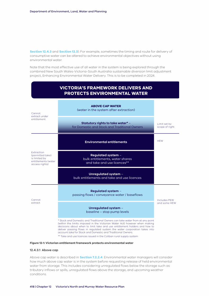
Under the Basin Plan it was expected by the MDBA that a large portion of system water and/or above cap water would be identified as planned environmental water. Section 12.4.2.2 explains what planned environmental water is, and is not, and why not all above cap or system water can be identified as planned environmental water under Victoria’s framework (see Figure 12-1).
In Victoria this water is considered to have ‘shared benefits’ and can contribute to environmental objectives for priority environmental assets and ecosystem functions, and other environmental values in Victoria’s North and Murray water resource plan area. Water for Victoria (2016) outlines Victoria’s position on achieving shared benefits to meet a maximum amount of uses from limited water resources. Victoria aims to use water to maximise the benefit achieved from environmental water and to meet the objectives of key groups in the community, including Traditional Owners, recreational users, domestic and stock users, and the environment.
Environmental water managers work with river operators to identify how all types of water can be best utilised to meet multiple objectives, including those for the environment. They coordinate the delivery of held environmental water with above cap and system water, as well as planned environmental water and consumptive water en route, to meet environmental objectives (see
Department of Environment, Land, Water and Planning
418 | Chapter 12 Victoria’s North and Murray Water Resource Plan
Section 12.4.3 and Section 12.3). For example, sometimes the timing and route for delivery of consumptive water can be altered to achieve environmental objectives without using environmental water.
Note that the most effective use of all water in the system is being explored through the combined New South Wales-Victoria-South Australia sustainable diversion limit adjustment project, Enhancing Environmental Water Delivery. This is to be completed in 2024.
VICTORIA’S FRAMEWORK DELIVERS AND PROTECTS ENVIRONMENTAL WATER
ABOVE CAP WATER (water in the system after extraction)
Statutory rights to take water* – for Domestic and Stock and Traditional Owners
Environmental entitlements
Regulated system – bulk entitlements, water shares
and take and use licences**
Unregulated system – bulk entitlements and take and use licences
Regulated system – passing flows / conveyance water / baseflows
Unregulated system – baseline – stop pump levels
* Stock and Domestic and Traditional Owners can take water from at any point (within the limits imposed in the Victorian Water Act) however when making decisions about when to limit take and use entitlement holders and how to deliver passing flows in regulated system the water corporation takes into account take for Stock and Domestic and Traditional Owners.
** Take and use licences issued in the Coliban rural supply system
Cannot extract under entitlement
Limit set by scope of right
HEW
Includes PEW and some HEW
Cannot extract
Extraction (permitted take) is limited by entitlements (water access rights)
Figure 12-1: Victorian entitlement framework protects environmental water
12.4.3.1 Above cap
Above cap water is described in Section 7.2.2.4. Environmental water managers will consider how much above cap water is in the system before requesting release of held environmental water from storage. This includes considering unregulated flows below the storage such as tributary inflows or spills, unregulated flows above the storage, and upcoming weather conditions.

Department of Environment, Land, Water and Planning
Chapter 12 | 419Victoria’s North and Murray Water Resource Plan
Unregulated flows occur naturally in a waterway, generally after heavy rainfall and when storages spill. Heavy rainfall resulting in unregulated flows may naturally meet an environmental objective, so delivery of held environmental water is not needed. Held environmental water may also be used to extend the length of natural unregulated flow. Above cap water can contribute to environmental objectives for priority environmental assets (see Section 12.5.1) and priority ecosystem functions (see Section 12.5.2) by requiring the use of less held environmental water than would otherwise be needed if the above cap water was not present.
12.4.3.2 System water
System water is all the water that is described in the bulk entitlements which is not for environmental or consumptive use (see Section 7.2.2.4). It is managed through obligations on the instruments, in particular entitlement holders’ compliance with the conditions of their entitlements.
Environmental water managers consider what system water is in the system when requesting the release of held environmental water from storage. Environmental water managers work together with system operators to identify opportunities to use system water to achieve environmental outcomes. System water can contribute to environmental objectives for priority environmental assets and priority ecosystem functions by requiring the use of less held environmental water than would otherwise be needed if the system water was not present.
12.4.3.3 Consumptive water en route
Where possible, environmental water managers work with storage managers to seek environmental outcomes from the delivery of consumptive water. This includes timing delivery of consumptive water en route to provide an environmental benefit, or piggybacking held environmental water on consumptive water to increase the flow for an environmental benefit.
For example, in 2018, the Victorian Environmental Water Holder traded 1,000 ML into the Broken system and worked with Goulburn Broken Catchment Management Authority and the storage operator to release an autumn fresh to improve habitat for waterbugs, aquatic plants and to provide fish passage. The held environmental water (from the trade) was combined with system water in the form of a delivery of water from the inter valley trade account. By working with the storage managers, environment water managers were able to align the timing of environmental releases with the normal of delivery of the inter valley trade account which meant that less environmental water needed to be used to achieve the environmental flow objectives of the autumn fresh.
12.4.4 Protection of water that contributes to environmental objectives
While above cap water and system water, including many passing flows in the bulk entitlements, are not identified as planned environmental water for the purposes of the Basin Plan, these forms of water are protected under Victoria’s entitlement framework. See Section 7.2.2.4.
They are protected by:
• limiting the volume of water that may be taken from the system through entitlements such as water access rights, and setting permissible consumptive volumes and the sustainable diversion limit to make sure decision makers do not authorise the take of water above a sustainable volume
• establishing clear rules about when a person can and cannot take water from the system, including the time, place and rate of take to ensure passing flows in the system are maintained. This is particularly important in unregulated systems
• passing flows being described in bulk and environmental entitlements
Department of Environment, Land, Water and Planning
420 | Chapter 12 Victoria’s North and Murray Water Resource Plan
In the Murray and Goulburn systems, early reserve rules mean that system operations water is very secure in these systems. This was recognised in the Risk Assessment (Appendix B) for Victoria’s North and Murray water resource plan area which identified this system water as having high reliability and being less susceptible to variations in availability.
In undeclared systems, if the existing water resource management rules offer insufficient protection, the Minister may declare a water supply protection area under section 27 of the Victorian Water Act to address local risks to a water resource or the environment. The declaration of a water supply protection area requires the development of a management plan to establish additional rules to manage the resources in the declared area to address the local risks. For example, the Upper Ovens River water supply protection area water management plan (GMW, 2012) provides for environmental minimum flows to address risks to the environment. The water management plan provides for restrictions on take and rules for trade.
Water supply protection areas are also used to manage risks to the structural integrity of aquifers or impacts on water resources where there are significant hydrological connections between surface water and groundwater. This is discussed further in Section 4.4.
12.4.5 Shared cultural and social benefits of environmental water
Environmental water can provide benefits beyond the ecological objectives for native fish, vegetation, waterbirds, amphibians and hydrological connectivity. The strategy Water for Victoria (DELWP, 2016) states that all water management agencies, including catchment management authorities and the Victorian Environmental Water Holder, will consider achieving shared benefits in environmental watering decisions, with the caveat that needs of the environment must not be compromised. Environmental watering in Victoria provides shared benefits through improving the condition of a waterway which benefits other uses of the waterway, for instance cultural outcomes, recreation and amenity. Through considering and planning for shared benefits, water management agencies are able to optimise a limited resource and help meet some objectives of key groups such as Traditional Owners and recreational users (see Chapter 8 and Chapter 13).
Traditional Owner values and uses of water and cultural knowledge are increasingly being recognised in Victoria’s water planning and management frameworks, including regional waterway strategies and sustainable water strategies. Most recently, Chapter 6 of Water for Victoria (DELWP, 2016) outlined actions to improve how the water sector recognises and manages for Aboriginal values and involves Traditional Owners in water management, including environmental watering. For details about how this is being done in northern Victoria, see Chapter 8.
Traditional Owner objectives for water may overlap with environmental water objectives at times, but not in all cases. Consideration of Aboriginal objectives are made in environmental water planning and delivery.
Traditional Owners are increasingly involved in the setting of environmental water objectives through the Victorian environmental water planning process, and through engagement with Victoria’s water resource plans, and are expressing a clear desire for stronger involvement in the future. Until now Traditional Owner involvement in environmental water planning has mainly been through consultation on the environmental objectives set in the planning documents: catchment management authorities have consulted on the watering objectives for priority environmental assets at long-term and annual scales (through Environmental Water Management Plans and Seasonal Watering Proposals respectively), and DELWP has consulted on the collated objectives and targets set for the water resource plan area in the long-term watering plan. Opportunities for greater involvement in the environmental watering objectives will continue to be developed for yearly and long-term planning by catchment management authorities, the Victorian Environmental Water Holder and the Department of Environment, Land, Water and Planning by working with Traditional Owners.

Department of Environment, Land, Water and Planning
Chapter 12 | 421Victoria’s North and Murray Water Resource Plan
12.5 Priority environmental assets and ecosystem functions
Under the Basin Plan Victoria is required to identify priority environmental assets and priority ecosystem functions. Under the Victorian environmental management framework, environmental assets are described by the catchment management authorities in the regional waterway strategies and the seasonal watering proposals.
There is a wide range of aquatic native plants, wildlife and ecosystem processes in Northern Victoria and the Victorian Murray water resource plan areas which rely on healthy wetlands and rivers. Ecosystem functions that support these ecological values include geomorphological condition and hydrological connectivity. For the purposes of Basin Plan, a set of priority ecosystem functions have been identified.
Priority environmental assets and priority ecosystem functions have been identified in accordance with Chapter 8 and Schedule 8 of the Basin Plan. Victoria’s approach to identifying priority environmental assets and priority ecosystem functions has been to focus on wetlands and rivers that can be receive held environmental water, because these are the systems which can be actively managed. Rivers and wetlands which cannot receive environmental water are still managed via land based management actions.
The priority environmental assets and priority ecosystem functions which benefit from environmental water planning and management arrangements are detailed in the Victorian Murray and the Northern Victoria long-term watering plans. These plans set out the ecological objectives and targets for priority environmental assets and the corresponding environmental watering requirement for these objectives. They are available on line at https://www.water.vic.gov.au/waterways-and-catchments/rivers-estuaries-and-waterways/environmental-water/long-term-watering-plans.
12.5.1 Priority environmental assets
The priority environmental assets for the Northern Victoria and Victorian Murray water resource plan areas are water-dependent ecosystems (rivers, wetlands, or floodplains) that support ecological values7 that are significant at Commonwealth and state level, and meet criteria in Schedule 8 of Basin Plan, as outlined in the long-term watering plan.
Under section 8.18 of the Basin Plan basin states must prepare a long-term environmental watering plans for each water resource plan area that contain surface water (see Section 12.6.4.2). These identify the priority environmental assets and priority environmental functions within each water resource plan area. A list of the priority environmental assets is in Table 4 and Table 5 of Appendix E. These assets are also identified in Figure 12-2 and Figure 12-3 in this section. Note that minor updates have been made to the list of priority environmental assets since the 2015 long-term watering plans were completed, including the removal of several assets that cannot be managed with held environmental water. These changes are purely editorial, and do not reflect a change to Victoria’s policy.
In the future, however, the priority environmental assets may change to reflect the latest technical information and prioritisation by catchment management authorities. Some existing assets that currently receive environmental water may not be deemed a priority in the future, or new assets may be identified if they have the potential to be connected to a water source and receive held environmental water. The priority environmental assets will be reviewed and potentially updated further when long-term watering plans are reviewed. The long-term watering plans are due for review in 2020, or when Victoria’s North and Murray Water Resource Plan is accredited.
7 Ecological value is the worth attributed to an organism, ecosystem, product, resource or activity in terms of benefits to the environment.

Department of Environment, Land, Water and Planning
422 | Chapter 12 Victoria’s North and Murray Water Resource Plan
Many more waterways in the Northern Victoria and Victorian Murray water resource plan areas, such as unregulated rivers noted in the long-term watering plans, are not connected to regulated water supply systems and cannot receive held environmental water. For this reason, these environmental assets are not identified by Victoria as priority environmental assets for the purposes of Basin Plan.
Swan Hill
WangarattaShepparton
0 50 10025
Kilometres
Priority Environmental Assets - Rivers
Catchment Management AuthorityMallee
North Central
Goulburn Broken
North East
Priority Environmental Assets - Wetlands
Victorian Murray water resource plan area (surface water)
Northern Victoria water resource plan area (surface water)
Murray-Darling Basin water resource plan areas
1 Lindsay, Wallpolla,
Mulcra Islands
2 Merbein Common
3 Johnstons and
Chaffey Bend
4 Lake Hawthorn
5 Koorlong Lakes
6 Cardross Lakes
7 Kings Billabong
8 Woorlong Wetland
9 Sandilong Creek
10 Psyche Bend Lagoon
11 Bottle Bend
12 Karadoc (Inlet Creek)
13 Spence's Bend
14 Hattah Lakes
15 Wemen-Liparoo
16 Carina Bend
17 Pound Bend
18 Bumbang Island
19 Walshes Bend
20 Margooya Lagoon
21 Belsar and Yungera Islands
22 Tata Creek
23 Heywoods Lake
24 Murrumbidgee Junction
25 Piambie
26 Considines*
27 Poyner*
28 Cokum Bushland Reserve*
29 Nyah
30 Vinifera
31 Lake Cullen
32 Lake Elizabeth
33 Wirra-Lo Wetlands
34 Lake Murphy
35 Benwell Forest
36 Guttrum Forest
37 McDonalds Swamp
38 Johnson Swamp
39 Hird Swamp
40 Gunbower Forest
41 Pig Swamp
42 Richardson's Lagoon
Mallee Catchment Management Authority
1 Murray River Lock 6 - 10
2 Murray River Lock 15
3 Burra Creek
Mallee Catchment Management Authority
North Central Catchment Management Authority
43 Barmah Forest
44 Kinnairds Swamp
45 Black Swamp
Goulburn Broken Catchment Management Authority
4 Loddon River (lower)
5 Gunbower Creek
Goulburn Broken Catchment Management Authority
46 Murray floodplain between
Lake Hume and Lake Mulwala**
North East Catchment Management Authority
6 Broken and Nine Mile Creeks
North Central Catchment Management Authority
21
4
23
20
15
24
2
16
7
11
18
12
2517
8
13
22
19
1
11
14
3
6
5
910
1
2
3
Mildura
0 40 8020
Kilometres
Murra
y River
Cam
pasp
e R
iver
Murray River
Broken Creek
Lod
do
n R
iver
Goulburn River
Oven
s River
EAST GOULBURN MAIN CHANNEL
WARANGA WESTERN CHANNEL
4340
46
36
30
31
29
35
38 3934
37
44
32
41
33
45
42
26
28
27
4 5
6
WatercoursesTownsRivers
Channels
*Wetlands which are part of the Wimmera-Mallee wetland complex and sit in the Wimmera-Mallee water resource plan area but source water from the Victorian Murray water resource plan area
**The floodplains of the River Murray source water from the River Murray and are considered part of the Victorian Murray water resource plan area
Figure 12-2: Priority environmental assets in the Victorian Murray water resource plan area

Department of Environment, Land, Water and Planning
Chapter 12 | 423Victoria’s North and Murray Water Resource Plan
EAST GOULBURN MAIN CHANNEL
WARANGA WESTERN CHANNEL
Murray River
Lo
dd
on
Riv
er
Goulburn River
Ovens RiverBroken River
Ca
mp
aspe
Riv
er
Broken Creek
Kin
g R
iver
Mitta Mitta River
Bu
ffalo
River
Tu
llaro
op
Cre
ek
Kie
wa
River
Co
liba
n R
iver
Murray River
5
6
7
9
2
8
4
1
3
8
7
9
10
11
12
13
12
3
2
1
4
5
6
¯ 0 60 12030
Kilometres
LAKE EILDON
LAKE EPPALOCK
WARANGABASIN
CAIRN CURRANRESERVOIR
LAKE HUME
LAKEDARTMOUTH
SheppartonWangaratta
Wodonga
Bendigo
Swan Hill
Murray-Darling Basin water resource plan areas - surface water
Priority Environmental Assets
1 Round Lake
2 Meran Lakes Complex
3 Lake Leaghur
4 Lake Yando
5 Lake Boort
North Central Catchment Management Authority
6 Gaynor Swamp
7 Doctors Swamp
8 Reedy Swamp
9 Moodies Swamp
Goulburn Broken Catchment Management Authority
1 Pyramid Creek
2 Twelve Mile Creek
3 Serpentine Creek
4 Loddon River (Middle and Upper)
5 Tullaroop Creek
6 Birch's (Bullarook) Creek
7 Campaspe River
8 Coliban River
North Central Catchment Management Authority
9 Goulburn River
10 Broken River
Goulburn Broken Catchment Management Authority
11 King River
12 Ovens River
13 Buffalo River
North East Catchment Management Authority
Priority Environmental Assets - Rivers
Catchment Management AuthorityNorth Central
Goulburn Broken
North East
Storages
Priority Environmental Assets - Wetlands
Northern Victoria water resource plan area
WatercoursesTownsRivers
Channels
Figure 12-3: Priority environmental assets in the Northern Victoria water resource plan area
12.5.2 Priority ecosystem functions
Ecosystem functions are the fundamental physical, chemical and biological processes that support environmental assets. These can include the transport of nutrients, organic matter and sediment in rivers, wetting and drying cycles, provision for migration and re-colonisation by plants and animals along rivers and across floodplains (Alluvium, 2010).
The long-term watering plan identified two priority ecosystem functions for the Victorian Murray water resource plan area (see Table 12-2) and three for the Northern Victoria water resource plan area (see Table 12-3). The priority ecosystem functions meet criteria in Schedule 9 of Basin Plan, as outlined in the long- term watering plan. The priority ecosystem functions are important

Department of Environment, Land, Water and Planning
424 | Chapter 12 Victoria’s North and Murray Water Resource Plan
in all waterways and can be supported by all water types including held environmental water, planned environmental water and unregulated flows. For example, planned environmental water in the Ovens system supports longitudinal hydrological connectivity and geomorphic habitat. Priority ecosystem functions were taken into account during the risk assessment. See Appendix B and Appendix E for more information.
Table 12-2: Priority ecosystem functions in the Victorian Murray water resource plan area
Ecosystem Function Schedule 9 criteria
Function characteristics
Lateral hydrological connectivity (between floodplains, anabranches and wetlands)
2 Supports the transportation and dilution of nutrients, organic matter and sediment
4 Provides connections across floodplains, adjacent wetlands and billabongs (lateral connections)
Water quality (that allows for ecosystem processes)
1 Supports the creation and maintenance of vital habitats and populations
2 Supports the dilution of carbon and nutrients from the floodplain to the river system
Source: Long-term watering plan Victorian Murray (DELWP, 2015)
Table 12-3: Priority ecosystem functions in the Northern Victoria water resource plan area
Ecosystem Function Schedule 9 criteria
Function characteristics
Longitudinal hydrological connectivity (between river reaches and the River Murray)
2 Supports the transportation and dilution of nutrients, organic matter and sediment
3 Provides connections along a watercourse (longitudinal connections)
Water quality (that allows for ecosystem processes)
1 Supports the creation and maintenance of vital habitats
2 Supports the dilution of carbon and nutrients from the floodplain to the river system
Geomorphic habitat 1 Supports the creation and maintenance of vital habitats
Source: Northern Victoria Long-term Watering Plan (DELWP, 2015)
12.5.3 Ramsar-listed priority environmental assets
Ramsar sites are recognised for containing representative, rare or unique wetlands, or wetlands that are important for conserving biodiversity. A wetland must satisfy one or more of the criteria for identifying wetlands of international importance to be designated to this list.
The Victorian Murray and Northern Victoria water resource plan areas support four of the Murray-Darling Basin’s Ramsar sites. These are all priority environmental assets and are supported by priority ecosystem functions. Three of the four Ramsar sites are Living Murray Icon sites.
National guidelines are being developed to provide clear guidance on how Ramsar sites must be managed, under both the Ramsar Convention and Commonwealth Environment Protection and

Department of Environment, Land, Water and Planning
Chapter 12 | 425Victoria’s North and Murray Water Resource Plan
Biodiversity Conservation Act 1999. A key component includes monitoring of a site’s ecological character description, which is a baseline of wetland condition at the time of its listing as a wetland of international importance. The ecological character descriptions of all Australia’s Ramsar-listed wetlands are at http://www.environment.gov.au/water/wetlands/publications.
The Basin Plan requirements for states in regard to their Ramsar sites are that:
• declared Ramsar wetlands that depend on Basin water resources maintain their ecological character (section 8.05(2)(a) of the Basin Plan)
• a declared Ramsar wetland is an environmental asset that requires environmental watering (Schedule 8 Criteria for identifying an environmental asset)
• declared Ramsar wetlands have sufficient water quality to maintain the ecological character of those wetlands (section 9.04(1) of the Basin Plan)
There are also water quality targets for declared Ramsar wetlands under Schedule 11 to the Basin Plan – Target values for target application zones. These requirements are fulfilled in Victoria’s North and Murray Water Quality Management Plan (see Appendix A).
Implementation of the Basin Plan contributes to maintaining the ecological character of Ramsar wetlands. Section 5.02 of the Basin Plan is to give effect to international agreements such as the Ramsar Convention; and section 8.05 further specifies Basin States to protect and restore environment assets by ensuring that declared Ramsar wetlands maintain their ecological character. There are various management interventions other than environmental water that contribute to the ecological character of Ramsar wetlands. It is the responsibility of jurisdictions to maintain the ecological character of Ramsar wetlands through various strategies, legislation, investment, partnerships and on-ground actions.
12.5.4 The Living Murray
An intergovernmental program which holds an average of 500,000 ML of environmental water a year for use at six iconic sites along the River Murray. In Victoria the water is held by the VEWH. Annual priorities for use of the Living Murray water portfolio are agreed by representatives of the Victorian, NSW, SA and Commonwealth governments, reflecting the joint nature of the program. The Living Murray program has also invested in works on the ground which help the efficient delivery of environmental water. All or part of four of the six Living Murray icon sites are located in Victoria, including Barmah Forest, Gunbower Forest, Hattah Lakes and Lindsay-Wallpolla Islands.
12.5.5 Snowy Water Initiative
The Snowy Water Initiative was formally established in 2002 to achieve significant improvements in river health by releasing environmental water into the Snowy, upper Murrumbidgee, and upper Murray river systems. The Water for Rivers joint government enterprise recovered water for the environment by water efficiency projects and water purchases in Victoria and New South Wales. These were converted into entitlement or are held as water shares by environmental water holders. On an annual bases these entitlements and water shares receive water allocation which then offsets the volume of water that needs to be released from the Snowy Scheme to the River Murray and can therefore be released to the Snowy River, upper Murrumbidgee, and upper Murray river systems as environmental releases.
12.5.6 Groundwater dependent ecosystems
Groundwater-dependent ecosystems are important environmental features of the Goulburn-Murray water resource plan area. They rely on groundwater for some of their water needs, and include river reaches that receive groundwater discharge (‘gaining reaches’), and wetlands that connect to shallow aquifers.
Department of Environment, Land, Water and Planning
426 | Chapter 12 Victoria’s North and Murray Water Resource Plan
For the purposes of Victoria’s North and the Murray Water Resource Plan, the priority environmental assets known to have a groundwater connection are listed in Appendix E Table 7 to Table 10. While these priority environmental assets rely on groundwater for part of their water needs, their environmental watering requirements are managed with held environmental (surface) water. Protection of the groundwater at these sites is outlined in Section 3.3.
The potential groundwater-dependence of the priority environmental assets across northern Victoria are shown in Figure 12-4 and Figure 12-5. This information is based on the Bureau of Meteorology GDE Atlas (BOM, 2012) and, where in existence, individual river reach assessments. The confidence levels of groundwater-dependency of each priority environmental asset is listed in Table 7 to Table 10 of Appendix E.
For more information about how groundwater-dependent ecosystems are protected see Section 12.8.

Department of Environment, Land, Water and Planning
Chapter 12 | 427Victoria’s North and Murray Water Resource Plan
EAST GOULBURN MAIN CHANNEL
WARANGA WESTERN CHANNEL
Murray River
Lodd
on R
ive
r
Goulburn River
Ovens River
Broken River
Ca
mp
aspe
Riv
er
Broken Creek
Kin
g R
iver
Mitta Mitta River
Bu
ffalo
River
Tu
llaro
op
Cre
ek
Kie
wa
River
Co
liba
n R
iver
Murray River
Serpentine Creek
Birch Creek
Tullah Creek
Pyra
mid
CreekTwelve Mile Creek
Gunbower Creek
89
10 11
21
2224
25
23
26
27
28
29
30
31
3239
5859
6061
66
6762
63
64
6557
5251
50
49
48
47
46 45
44
4342
4140
56
55
5453
68
33
34
35
36
37
38
12
1314
2019171615
18
0 50 10025
Kilometres¯
Shepparton Wangaratta
Wodonga
Bendigo
Swan Hill
12 3 4 5
67
8
Mildura
Swan Hill0 50 10025
Kilometres
Victorian Murray WRPA
Northern Victoria WRPA
1 Murray River Lock 6 - 10 R17
2 Murray River Lock 6 - 10 R16
3 Murray River Lock 6 - 10 R15
4 Murray River Lock 6 - 10 R14
5 Murray River Lock 6 - 10 R13
6 Murray River US of Lock 15 R7
7 Murray River US of Lock 15 R6
8 Loddon River Lower R50
9 Loddon River Lower R1
10 Loddon River Lower R2
11 Pyramid Creek R51
12 Gunbower Creek R38
13 Gunbower Creek R39
14 Tullah Creek R36
15 Broken and Nine Mile R21
16 Broken and Nine Mile R22
17 Broken and Nine Mile R23
18 Broken and Nine Mile R30
19 Broken and Nine Mile R28
20 Broken and Nine Mile R24
21 Loddon River Middle R3
22 Loddon River Middle R4
23 Loddon River Middle R5
24 Twelve Mile Creek
25 Serpentine Creek R11
26 Loddon River Upper R6
27 Loddon River Upper R7
28 Loddon River Upper R8
29 Tullaroop Creek R18
30 Tullaroop Creek R19
31 Birch Creek R21
32 Campaspe River R1
33 Campaspe River R2
34 Campaspe River R3
35 Campaspe River R4
36 Campaspe River R5
37 Coliban River R18
38 Coliban River R19
39 Goulburn River R1
40 Goulburn River R2
41 Goulburn River R3
42 Goulburn River R4
43 Goulburn River R5
44 Goulburn River R6
45 Goulburn River R7
46 Goulburn River R8
47 Goulburn River R9
48 Goulburn River R10
49 Goulburn River R11
50 Goulburn River R12
51 Goulburn River R13
52 Goulburn River R14
53 Broken River R1
54 Broken River R2
55 Broken River R3
56 Broken River R4
57 Broken River R4
58 Ovens River R1
59 Ovens River R2
60 Ovens lower R3
61 Ovens River R3
62 King River R21
63 King River R22
64 King River R23
65 King River R24
66 Ovens River R4
67 Ovens River R4
68 Buffalo River R33
Groundwater Dependent Features (confidence) - Priority Environmental Assets - Rivers
High (field proof)
Moderate
Low
Non-GDE (losing)
Murray-Darling Basin water resource plan areas - groundwater
Priority Environmental Assets - Rivers assessed for groundwater dependency (including confidence)
Goulburn-Murray
Wimmera-Mallee
Murray-Darling Basin water resource plan areas - surface water
Victorian Murray
Northern Victoria
Watercourses
TownsRivers
Channels
Figure 12-4: Confidence levels of groundwater dependence in river priority environmental assets
Source: (Groundwater Logic, 2018)

Department of Environment, Land, Water and Planning
428 | Chapter 12 Victoria’s North and Murray Water Resource Plan
Murray River
Lo
dd
on
Riv
er
Goulburn River
Ovens RiverBroken River
Broken Creek
Kin
g R
iver
Bu
ffalo
River
Co
liba
n R
iver
Ma
ckenzie River
Avo
ca R
iver
Wim
mera River
Ya
rria
mb
iack
Cre
ek
Richa
rdso
n Riv
er
Lindsay,Wallpolla, Mulcra Islands
Nyah
Vinifera
Wirra-Lo
Barmah Forest
Murray floodplainbetween LakeHume and Mulwala
Belsar andYungeraIslands
Hird Swamp
Kings BillabongPsyche Bend Lagoon
Tata Creek
Moodies Swamp
Gunbower
Johnson Swamp
HattahLakes
CardrossLakes
Swan Hill
Bendigo
Wodonga
SheppartonWangaratta
Mildura
0 50 10025
Kilometres
EAST GOULBURN MAIN CHANNEL
WARANGA WESTERN CHANNEL
Groundwater Dependent Features (confidence) – Priority Environmental Assets - Wetlands
High
Moderate
Murray-Darling Basin water resource plan areas - groundwater
Murray-Darling Basin water resource plan areas - surface water
Victorian Murray
Northern Victoria
Wimmera-Mallee (groundwater)
Goulburn-Murray
WatercoursesTownsRivers
Channels
Figure 12-5: Confidence levels of groundwater dependence in wetland priority environmental assets
Source: (Groundwater Logic, 2018)
12.6 State environmental water planning
12.6.1 Overview
This section outlines how environmental water planning occurs in Victoria, and specifically provides context for section 10.26 of the Basin Plan.
Environmental watering is defined under the Commonwealth Water Act as the delivery or use of environmental water to achieve environmental watering outcomes. Environmental water under the Commonwealth Water Act is either held environmental water or planned environmental water. The effect of applying these definitions to Victoria’s framework for determining the content of Victoria’s North and Murray Water Resource Plan is:
• held environmental water (refer to Table 3 of Appendix E) is present only in regulated systems (see Section 12.4.2.1)
• planned environmental water (refer to Table 1 to Table 2 of Appendix E) is present only in the Broken River, the Ovens River, and the Upper Ovens River systems
Other water that supports environmental outcomes, such as above cap and system water, but which does not meet the definition of held environmental water or planned environmental water, is not considered environmental water under the Commonwealth Water Act. These other types of water are therefore not covered by the obligation under section 10.26 of the Basin Plan.
Department of Environment, Land, Water and Planning
Chapter 12 | 429Victoria’s North and Murray Water Resource Plan
Under the Victorian Water Act there are a range of instruments that inform environmental watering objectives and requirements across Victoria’s catchments. Section 12.6 identifies how Victoria’s State based planning integrates with Basin Plan requirements.
12.6.2 Victorian Waterway Management Strategy
The Victorian Waterway Management Strategy (DEPI, 2013) describes the Government’s state-wide objectives and policies for managing waterways. It also outlines the Government’s policies for maintaining and improving the condition of the state’s rivers, estuaries and wetlands to provide environmental, social, cultural and economic value for all Victorians.
The strategy references and makes explicit links to the Basin Plan. Chapter 4 of the strategy sets out the state policies, principles and processes to be followed by catchment management authorities when preparing regional waterway strategies and building Basin Plan considerations into Victoria’s regional waterway strategies.
Water for Victoria policy reiterates actions in the Victorian Waterway Management Strategy and further emphasises Traditional Owner roles and engagement in waterway management.
The strategy outlines the key environmental water planning documents:
• regional waterway strategies
• long-term watering plans
• environmental water management plans
• seasonal watering proposals
• seasonal watering plans
These are explained in this section.
12.6.2.1 Regional catchment strategies
Regional catchment strategies are the primary integrated planning framework for the management of land, water and biodiversity resources in each of the ten catchment and land protection regions in Victoria (Figure 6-4). They seek to integrate community values and regional priorities with state and federal legislation and policies.
Each catchment management authority prepares a regional catchment strategy in partnership with local communities and partners involved in integrated catchment management.
The strategy identifies:
• the region’s land, water and biodiversity resources and how they are used;
• the nature, causes, extent and severity of land degradation of catchments;
• a long-term vision for the region;
• regionally significant land, water and biodiversity assets and landscapes;
• catchment condition objectives; and
• a program of management measures for the life of the strategy.
Regional catchment strategies seek to integrate community values and regional priorities with State and Federal legislation and policies and program priorities. Catchment management authorities are responsible for the coordination of the regional catchment strategies, including the ongoing review and monitoring of their implementation, and identification of priority activities and work programs. Regional catchment strategies are often implemented through regional sub-strategies and action plans that are thematic, issue and/or landscape based.

Department of Environment, Land, Water and Planning
430 | Chapter 12 Victoria’s North and Murray Water Resource Plan
12.6.2.2 Regional waterway strategies
The catchment management authorities use a risk-based approach to identify high value waterways and priority management activities. The regional waterway strategies are required to integrate on-ground works with environmental water management in regulated and unregulated systems and make sure environmental water is managed efficiently and effectively.
For each management unit such as a river reach or wetland these strategies:
• describe the environmental values of waterways
• identify threats to these values
• establish management objectives for the waterways after consultation
• determine priorities for management
• establish targets
• identify activities to achieve targets
• estimate the costs of the activities
The North East, Goulburn Broken, North Central and Mallee regional waterway strategies apply to the Victoria’s North and Murray Water resource plan.
Infrastructure can be used to improve the watering system and environmental watering outcomes. These can enable more efficient use of the water holdings and overcome barriers to the migration of plants and animals. Other on-ground works are also used to improve the biophysical condition or rivers, such as reinstating in-stream woody vegetation habitat or fencing out livestock. These works are considered complementary measures to environmental watering and are as vital as flows to environmental outcomes and condition.
12.6.2.3 Environmental water management plans
Environmental water management plans outline how waterway managers will meet long-term ecological objectives and required watering regimes at each priority environmental asset identified in Long-term watering plans.
Plans are prepared for rivers and wetlands that can be watered from held environmental water. The plans set out:
• long-term environmental flow objectives for held environmental water
• water regimes required to meet these objectives
• constraints on managing flows
• measures to use available water efficiently
• management arrangements and risks to meeting objectives
The plans draw on watering requirements for rivers detailed in environmental flow studies and are prepared using the best available expert information. Flow studies have been prepared for regulated and some unregulated rivers throughout Victoria and are updated regularly. Flow studies for rivers in the Northern Victoria water resource area can be found on the VEWH’s website at http://www.vewh.vic.gov.au/news-and-publications/technical-reports2.
Catchment management authorities prepare environmental water management plans using the best available information. They use a collaborative process involving community members, water holders, Traditional Owners, the Department of Environment, Land, Water and Planning, storage managers, experts and a scientific expert review panel.

Department of Environment, Land, Water and Planning
Chapter 12 | 431Victoria’s North and Murray Water Resource Plan
An environmental water management plan has been prepared for each river and wetland in the Victorian Murray and the Northern Victoria water resource plan areas that receives held environmental water and the plans for these priority environmental assets have been collated in developing the Victorian Murray and Northern Victoria long-term watering plans. Environmental water management plans provide the detailed analysis used by CMAs to prepare seasonal watering proposals each year. All EWMPs can be found at http://www.water.vic.gov.au/waterways-and-catchments/rivers-estuaries-and-waterways/environmental-water.
12.6.3 Integration of state environmental water planning and Basin Plan requirements
The objectives and targets of the Basin Plan have been integrated into Victoria’s environmental water planning in the annual and long-term processes. The Victorian Waterway Management Strategy commits all environmental water managers in the Victorian Murray and Northern Victoria water resource plan areas must comply with Victorian and Basin Plan environmental water planning under state policy and investment.
Each year, Victoria must also demonstrate through annual Basin Plan reporting (Matter 19 of Schedule 12) how its environmental watering is consistent with the environmental watering plan and the Basin-wide environmental watering strategy, including a contribution to the objectives in Part 2 of the environmental watering plan. See Section 15.7 for more information on reporting under Basin Plan.
Figure 12-6 illustrates how planning works at the Basin and state levels.

Department of Environment, Land, Water and Planning
432 | Chapter 12 Victoria’s North and Murray Water Resource Plan
Environmental water planning and management framework in Victoria
Leg
isla
tio
n
Leg
isla
tio
n
Mu
lti Y
ea
r P
lan
nin
g
Mu
lti Y
ea
r P
lan
nin
gA
nn
ua
l Pla
nn
ing
An
nu
al P
lan
nin
g
Commonwealth Water Act 2007
Basin Plan (relates to 10.26(1)(a)(ii) of Basin Plan)
Portfolio Management Plan (CEWH)(relates to 10.26(1)(a)(i)&(ii))
Annual Portfolio Management Plan (CEWO)
Victorian Waterway Strategy
Regional Catchment Strategies (CMA)
Regional Waterway Strategies (CMA)
Environmental Water Management plans (CMA) (relates to 10.26(1)(a)(i)&(ii))
Long Term Watering Plan (DELWP)(relates to 10.26(1)(a)(i)&(ii))
Seasonal watering proposals (CMA)
Seasonal watering statement (VEWH)
Watering Actions (CMA/VEWH)
Seasonal Watering plan (VEWH)(Sets annual environmental watering priorities)
(relates to 10.26(1)(a)(i)&(ii))
Victorian Water Act 1989
Basin-wide Environmental Water Strategy (MDBA)
(relates to 10.26(1)(a)(i)&(ii))
Basin environmental annual water outlook - prepared by MDBA(relates to 10.26(1)(a)(i)&(ii))
Figure 12-6: Environmental water planning and management framework in Victoria at Basin, state and regional scales

Department of Environment, Land, Water and Planning
Chapter 12 | 433Victoria’s North and Murray Water Resource Plan
12.6.4 Environmental watering planning under Basin Plan
Part 8 of the Basin Plan sets out the environmental watering plan for the Basin. The objectives of this framework are stated in section 8.11 of the Basin Plan:
a) coordinate the planning, prioritisation and use of environmental water on both a long- term and an annual basis; and
b) enable adaptive management to be applied to the planning, prioritisation and use of environmental water; and
c) facilitate consultation, coordination and cooperative arrangements between the Authority, the Commonwealth Environmental Water Holder and Basin states
Basin Plan section 8.04 provides that:
The overall environmental objectives for the water-dependent ecosystems of the Murray-Darling Basin are, within the context of a working Murray-Darling Basin:
a) to protect and restore water-dependent ecosystems of the Murray-Darling Basin; and
b) to protect and restore the ecosystem functions of water-dependent ecosystems; and
c) to ensure that water-dependent ecosystems are resilient to climate change and other risks and threats
For water resource plans, section 10.26 of the Basin Plan requires that:
A water resource plan must provide for environmental watering to occur in a way that:
a) is consistent with:
i) the environmental watering plan; and
ii) the Basin-wide environmental watering strategy; and
b) contributes to the achievement of the objectives in Part 2 of Chapter 8
The accredited text below outlines how Victoria will meet this requirement in Victoria’s North and Murray Water Resource Plan.
1. Environmental watering under Water Act 2007 (Cth) is the delivery or use of environmental water to achieve environmental outcomes.
2. Under the Water Act 1989 (Vic) environmental objectives – including contributing to the objectives of Chapter 8 of the Basin Plan - are supported in Victorian regulated and unregulated systems through a whole of system management approach (being more than the use of held environmental water and planned environmental water) which includes:
a) prohibiting the take of water that is “above cap” as it is an offence to take water without authorisation;
b) the issue of entitlements below a resource condition limit or extraction cap that includes consideration of the volume of water to be taken under basic rights;
c) using environmental entitlements held by the Victorian Environmental Water Holder to ensure water is delivered to identified priority environmental assets or for priority ecosystem functions and to support specified flows;
d) waterway management by the relevant catchment management authority in accordance with its functions under Part 10 of the Water Act 1989 (Vic);
Basin Plan s10.26(1)

Department of Environment, Land, Water and Planning
434 | Chapter 12 Victoria’s North and Murray Water Resource Plan
e) management of all entitlements in the system including managing the flow of water and timing of delivery and take of water in systems by water corporations.
3. Under the Victorian environmental framework, environmental benefits are achieved through held environmental water, planned environmental water and other water in the system (including ‘above cap’). Under existing definitions of Basin Plan, it is difficult to align Victoria’s framework with the definition for planned environmental water.
4. The use of held and planned environmental water in Victoria is enhanced through the existence and protection of water in the system otherwise known as “above cap water”.
5. For the purposes of Victoria’s North and Murray Water Resource Plan, “above cap water” is considered to be:
a) water that remains in the system after water is taken under a water access right (excluding basic rights)
b) water that remains in the system by virtue of setting minimum passing flows or establishing baseflows through conditions on a water access right or rules in statutory management plans
c) water that is subject to extraction under a basic right (despite this extraction being considered when determining resource conditions limits for setting caps on other entitlements)
d) water that is subject to extraction for a range of emergency purposes such as firefighting even where it does not meet the definition of “emergency” under statute
e) water that may be subject to other instream uses such as recreational or hydro-generation, but which contributes to the environment including supporting the meeting of environmental objectives under the Basin Plan.
6. This “above cap water” in regulated and unregulated systems provides multiple benefits under Victoria’s framework and includes the following (see also Notes 1 and 6):
a) provides base flows for delivery of water (consumptive and environment) including for instream use by fish farms or electricity generators for example; and
b) provides support for ongoing river health (including managing any water quality issues); and
c) supports environmental values and health of water ecosystems; and
d) provides a baseline which informs the setting of environmental watering objectives and watering requirements which are determined by the catchment management authorities. The availability of this water informs Victorian and Commonwealth environmental water holders’ decisions as to how held environmental water is utilised to meet objectives and requirements in Victoria’s North and Murray water resource plan area; and
e) support for instream use (does not include diversions from the system) by Traditional Owners (in support of outcomes identified in response to Part 14 of the Basin Plan) and recreational users.

Department of Environment, Land, Water and Planning
Chapter 12 | 435Victoria’s North and Murray Water Resource Plan
7. The “above cap water” is protected by Victoria’s water resource management framework in the following way (see also Note 2):
a) the setting of resource condition limits under a permissible consumptive volume (PCV) under section 22A of the Water Act 1989 (Vic) which limits the volume of water that can be issued under entitlements for consumptive use (can apply in regulated and unregulated systems). In Victoria’s North and Murray Water Resource Plan area this process is largely overtaken by the SDLs prescribed under the Basin Plan except where catchment specific limits need to be specified; and
b) requirements to impose conditions relating to the time, place and rate of take on authorisations to take water (applies in regulated and unregulated systems) (see Note 3);
c) requirements under sections 33J (water shares), 40 (bulk entitlements), 53 (take and use licences), of the Water Act 1989 (Vic) to consider the following before issuing a water access right:
i) the permissible consumptive volume, if any;
ii) the existing and projected quality of water;
iii) any adverse effect the allocation or use of water will have on other users or a waterway or aquifer;
iv) the maintenance of the environmental water reserve in accordance with the environmental water reserve objective
v) the need to protect the environment, including the riverine and riparian environment;
vi) the proper management of the waterway and its surrounds or of the aquifer. (See Notes 4 and 7)
d) the setting and protection of minimum passing flows
i) in regulated systems, through requirements to deliver minimum passing flows as a condition of a bulk entitlement under section 43 of the Water Act 1989 (Vic) or through a restriction on the take of water in a statutory management plan approved under section 32A of the Water Act 1989 (Vic) for a water supply protection area declared under section 27 of the Water Act 1989 (Vic)
ii) in unregulated systems, through restrictions on the take of water applied under a take and use licence or a condition of a bulk entitlement or through a restriction on the take of water in a statutory management plan approved under section 32A of the Water Act 1989 (Vic) for a water supply protection area declared under section 27 of the Water Act 1989 (Vic)
e) the establishment of the environmental water reserve under section 4A of the Water Act 1989 (Vic) to ensure that water (including any above cap water identified as part of the environmental water reserve, planned environmental water or any held environmental water) within the reserve is managed to meet the long-term environmental objectives under section 4B of the Water Act 1989 (Vic) (see Note 5);
f) the declaration of a water supply protection area under section 27 of the Water Act 1989 (Vic) where there is an identified risk to surface water or groundwater,

Department of Environment, Land, Water and Planning
436 | Chapter 12 Victoria’s North and Murray Water Resource Plan
the area is then managed through prescriptions under a statutory management plan approved under section 32A of the Water Act 1989 (Vic).
8. To meet the requirements of section 10.26(1) of the Basin Plan, Victoria commits to the following obligations, column 4 of this row identifies the party responsible for meeting the relevant obligation outlined below:
a) the Victorian Environmental Water Holder (VEWH) must, in the performance of its functions and the exercise of its powers, ensure that environmental watering occurs in a way that is consistent with the environmental watering plan and the Basin-wide environmental watering strategy and contributes to the achievement of the objectives in Part 2 of Chapter 8 of the Basin Plan. This does not prevent the VEWH from causing additional environmental watering to occur to meet local and Basin Plan environmental watering objectives.
b) in performance of its functions and the exercise of its powers, the VEWH must have regard the relevant Long-Term Watering Plan for the water resource plan area.
c) the Department must develop or amend the Long-Term Watering Plan for the relevant surface water plan area including establishing or updating environmental watering requirements for identified priority environmental assets and priority ecosystem functions in accordance with Chapter 8 of the Basin Plan and considering both regulated and unregulated surface water systems.
9. In the management of minimum passing flows water corporations consider the take and use of water for domestic and stock purposes under section 8 of the Water Act 1989 (Vic) by:
a) in a regulated system, establishing monitoring points along the system to measure passing flows and adjusting delivery of water to ensure passing flows are maintained after domestic and stock use is extracted;
b) in unregulated systems, assessing the volume of water that might be taken under section 8 of the Water Act 1989 (Vic) in considering any trigger levels for restricting take under a take and use licence;
c) managing authorisations to install works on a waterway under section 67 of the Water Act 1989 (Vic) which may include conditions that pumps are not constructed at a level that would allow extraction below the minimum baseflows required for the system.
10. References to sections of the Water Act 1989 (Vic) provided in response to section 10.26(1) of the Basin Plan do not have the effect of importing the sections referenced into the accredited material.
Note 1: reference to “above cap water” for the purposes of responding to the Basin Plan in Victoria’s North and Murray Index Table refers to water that includes water that remains in the system after meeting entitlements, flows specified in bulk entitlements or environmental entitlements as minimum passing flows which may also be identified as “systems water” and water that remains in the system where water users (see Table A Victoria’s North and Murray Index Table for a list of water access rights relevant to this Plan) have not taken their full volume from the system. It should be noted that risks to “system water” were identified as being lower than the risks to other types of water see Part 2.1 (Northern Victoria water resource plan area) and Part 2.3 (Victorian Murray

Department of Environment, Land, Water and Planning
Chapter 12 | 437Victoria’s North and Murray Water Resource Plan
water resource plan area) of Victoria’s North and Murray Risk Assessment at Appendix B of Victoria’s North and Murray Comprehensive Report.
Note 2: the tools identified in paragraph (5) above are tools that may be utilised under the Victorian framework but are not necessarily used in each catchment or for each resource in Victoria’s North and Murray water resource plan area.
Note 3: see response to section 10.08(2) of the Basin Plan above which requires holders of a water access right (entitlement) to comply with the conditions of that right. See also response to section 10.11(1) of the Basin Plan which sets out rules to prevent actual take does not exceed permitted take.
Note 4: for the process relating to the amendment under the Water Act 1989 (Vic) of bulk entitlements see Figure 7-3 and for environmental entitlements see Figure 7-4, note the conditions on a take and use licence relating to restrictions – must be complied with – note the interaction with the section 10.08(2) of the Basin Plan obligation.
Note 5: the environmental water reserve under 4A of the Water Act 1989 (Vic) and the environmental water reserve objective under section 4B of the Water Act 1989 (Vic) do not have the effect of defining above cap water as planned environmental water for the purposes of section 6 of the Water Act 2007 (Cth) or section 10.09(1) of the Basin Plan. Water may be part of the environmental water reserve for the purposes of the Water Act 1989 (Vic) and will support the environmental objective however, it cannot be characterised as ‘planned environmental water’ as more narrowly defined in section 6 of the Water Act 2007 (Cth) which specifies that planned environmental water is water that cannot be taken or used for any other purpose. Above cap water may be taken and used for multiple purposes, including for example, providing base flows (not just for environmental benefit but for system management reasons) and domestic and stock use. See Section 12.4.2.2 of Victoria’s North and Murray Comprehensive Report for more information about planned environmental water under Victoria’s water resource management framework.
Note 6: for the purposes of paragraph (4) above, sections 33J and section 40 of the Water Act 1989 (Vic) apply to regulated systems and section 40 and section 53 of the Water Act 1989 (Vic) apply to unregulated systems.
Note 7: section 53 of the Water Act 1989 (Vic) as referred to in paragraph (5)(c) above includes the requirement to have regard to the matters in paragraphs (b) to (m) of section 40 of that Act.
The delivery or use of planned environmental water identified in this Index in response to section 10.09(1) of the Basin Plan is consistent with the environmental watering plan and the Basin-wide environmental watering strategy and relates to the objectives outlined in the Basin-wide environmental watering strategy as outlined in Table 1 of Appendix E to Victoria’s North and Murray Comprehensive Report.
The existence of this planned environmental water is protected under section 10.28 of the Basin Plan.
<<end of accredited text for s10.26(1) of the Basin Plan>>

Department of Environment, Land, Water and Planning
438 | Chapter 12 Victoria’s North and Murray Water Resource Plan
12.6.4.1 Basin-wide environmental watering strategy
The Murray-Darling Basin Authority has published the Basin-wide environmental watering strategy to achieve the environmental objectives of the environmental watering plan. These objectives also inform Victoria’s environmental water planning at an asset scale.
The strategy outlines key actions to achieve the objectives of environmental watering in the Basin including:
• harnessing local community land and water knowledge
• managing all water to benefit the environment where possible, such as cooperating to divert consumptive water deliveries through a wetland en route
• managing in harmony with biological cues, including responses to flow, to restore elements of a more natural flow regime —for example, high river flows or flow release into a wetland at times when it would have occurred naturally before river regulation to trigger vegetation, fish or bird reproduction
• coordinating between stakeholders to achieve the best outcomes and target multiple sites with deliveries of water in and between rivers where possible
• managing any risks associated with the delivery of environmental water
• applying the learning from previous experience and learning when planning and prioritising use of environmental water
The strategy also sets out expected outcomes for native fish, vegetation, waterbirds and hydrological connectivity.
The strategy’s actions and expected outcomes are consistent with the requirements of the Victorian Water Act, key state policy and Victoria’s environmental water planning in northern Victoria, as detailed in the long-term watering plans.
12.6.4.2 Long-term watering plans
Long-term watering plans are a state responsibility under the Basin Plan Chapter 8 Environmental watering plan.
Basin states must prepare a long-term watering plan for each water resource plan area that contains surface water and be consistent with the Basin-wide environmental watering strategy. Victoria has developed its long-term watering plans based on existing regional catchment strategies, waterway strategies and environmental water management plans which set out objectives and watering requirements for specific environmental sites. The most significant difference between Victoria’s instruments and Basin Plan requirements is the requirement to identify environmental outcomes and watering requirements in terms of priority environmental assets and priority ecosystem functions.
Victoria has prepared one for the Victorian Murray water resource plan area (DELWP, 2015) and one for the Northern Victorian water resource plan area (DELWP, 2015). The long-term watering plans for the Victorian Murray and Northern Victoria water resource plan areas are available online.
The Victorian Murray and Northern Victoria long-term watering plans collate environmental objectives under the environmental water management plans for the relevant rivers, wetlands and ecosystem functions identified as priority environmental assets for the purposes of Basin Plan
They inform:
• Victoria’s annual watering priorities
• the Basin-wide environmental watering strategy and Basin annual watering priorities

Department of Environment, Land, Water and Planning
Chapter 12 | 439Victoria’s North and Murray Water Resource Plan
• Victoria’s North and Murray Water Resource Plan, particularly environmental watering requirements
Appendix 1 to the long-term watering plans shows how they meet the requirements of the Basin Plan environmental watering plan, including:
• using methods specified for identifying priority environmental assets and ecosystem functions and their water requirements
• having regard to the Basin-wide environmental watering strategy
• being consistent with relevant international agreements
The development of long-term watering plans consistent with Chapter 8 of the Basin Plan forms a component of Victoria’s response to the obligation under section 10.26(1) of the Basin Plan (see accredited text for 10.26(1) above). The requirement outlined as accredited text in Section 12.3 requires the Department to develop its long-term watering plans in a way that is consistent with Chapter 8 of the Basin Plan and also considers regulated and unregulated surface water to ensure that all water that contributes to meeting environmental benefits is considered when setting long term environmental watering requirements in Victoria’s North and Murray water resource plan area.
12.6.5 Annual basin and state watering priorities
Basin states must identify annual priorities for use of environmental water for surface water in each water resource plan area.
Obligations for annual watering priorities are met by Victoria’s seasonal watering plan, which is consistent with the Basin Plan’s environmental watering plan, long-term watering plans and the Basin-wide environmental watering strategy.
12.6.5.1 Seasonal watering proposals
Catchment management authorities prepare seasonal watering proposals each year using the objectives and flow regimes identified in environmental water management plans and through annual community consultation, in line with the VEWH’s guidelines. This ensures that the actions taken are in line with objectives and support outcomes outlined in Chapter 8 of the Basin Plan.
The proposals describe desired watering regimes for different climate-based scenarios and take into account:
• the objectives and flow regimes identified in environmental water management plans
• the actual watering regimes of waterways in recent years and their current condition
• the likely amount of water available at the start of the year
• scenarios for seasonal conditions and water availability over the coming year
• a risk assessment for any proposed watering
CMAs consult with key local stakeholders including storage managers, public land managers, Traditional Owners and local representatives of interest groups such as Environment Victoria, Victorian Recreational Fishing and Field, Game Management Australia and local community members from environmental water advisory groups when preparing seasonal watering proposals. These proposals form the basis for the state-wide seasonal watering plan the VEWH prepares each year.
Seasonal watering proposals for priority environmental assets in the Victorian Murray and Northern Victoria water resource plan areas are available on the relevant CMA websites.

Department of Environment, Land, Water and Planning
440 | Chapter 12 Victoria’s North and Murray Water Resource Plan
12.6.5.2 Seasonal watering plan
The seasonal watering plan prepared by the VEWH previews the potential environmental watering that could be implemented using water available under the water holdings and water held by other environmental water holders. The VEWH in line with requirements of section 10.26(1) of the Basin Plan are required to perform its function to ensure that environmental watering occurs in a way that is consistent with the Basin-wide environmental watering strategy and considers the relevant long-term watering plans.
The catchment management authorities’ seasonal watering proposals inform the seasonal watering plans, along with the MDBA’s annual environmental watering priorities and the CEWH’s portfolio management priorities.
The objectives of the seasonal watering plan are set out in the Victorian Water Act. The plan aims to achieve the objectives by making sure that decisions to use the water holdings are based on a systematic, science-based approach to identify environmental values and desired flow regimes. The plan also sets out the operational priorities for using environmental water allocations.
The VEWH’s seasonal watering plan is prepared for the different water availability scenarios of drought, dry, average and wet. Environmental watering actions are developed for each scenario. The plan informs the real-time operational decisions that are made as the season progresses.
Actions identified in the scenarios are converted to firm environmental watering commitments based on actual conditions and water allocations.
The conditions that emerge over the year can be dynamic and are influenced by:
• weather conditions and forecasts
• catchment conditions
• water availability
• river and system operations such as unregulated flows, catchment inflows, storage levels, other water users’ needs and potential delivery constraints
• ecological or biological factors and triggers such as plant and animal responses to natural flows or temperature
• risks to the environment such as deteriorating water quality
The VEWH engages with state stakeholder representatives when preparing Victoria’s seasonal watering plan.
The current seasonal watering plan is available on the VEWH website at http://www.vewh.vic.gov.au/watering-program/seasonal-watering-plan.

Department of Environment, Land, Water and Planning
Chapter 12 | 441Victoria’s North and Murray Water Resource Plan
12.7 How are Basin Plan environmental watering outcomes achieved?
12.7.1 Overview
As already explained, Basin Plan environmental watering outcomes are achieved through long-term and annual planning, and the delivery of held environmental water combined with other water such as consumptive, above cap, passing flows and system water. Monitoring of environmental watering outcomes informs adaptive management and potential revision of
watering objectives in the planning stage. Complementing this are critical measures, also known as complementary measures, that are necessary to achieve an environmental objective alongside water delivery.
The delivery of environmental water outcomes is managed through the state environmental water planning framework outlined in Section 12.6. Environmental watering in Victoria’s North and Murray water resource plan area is linked to the Basin Plan long-term environmental objectives to:
• protect and restore water-dependent ecosystems of the Murray-Darling Basin
• protect and restore the ecosystem functions of water-dependent ecosystems
• ensure that water-dependent ecosystems are resilient to climate change and other risks and threats
• ensure that environmental watering is coordinated between managers of planned environmental water, owners and managers of environmental assets and holders of held environmental water
Targeted objectives for priority environmental assets and how they relate to Basin Plan objectives are outlined in Table 11 and Table 12 of Appendix E.
When the VEWH is preparing the seasonal watering plan (see Section 12.6.5.2) to ensure it can achieve Basin Plan objectives for connectivity, native vegetation, waterbirds and native fish, it is guided by the CMA’s seasonal watering proposals (see Section 12.6.5.1). These are directed by the long-term objectives in environmental water management plans and long-term watering plans, and influenced by the Basin Annual Environmental Watering Priorities developed by the MDBA.
The VEWH coordinates its activities with other environmental water holders in northern Victoria, New South Wales and South Australia to achieve environmental outcomes at the southern-connected Murray-Darling Basin scale (see Section 12.7.4).
The VEWH uses trade and carryover to support environmental outcomes (see Section 12.7.6) and uses return flows and piggybacking on system water to get the most efficient and effective use from held environmental water, in line with Victorian policy (see Section 12.7.5).
12.7.2 Monitoring, evaluation, reporting and adaptive management
Victoria has two main environmental water monitoring programs, the Victorian Environmental Flows Monitoring and Assessment Program, and the Wetland Monitoring and Assessment Program for environmental water. Both programs include monitoring that relates to the objectives and targets outlined in Victoria’s long-term watering plans, which have direct links to objectives outlined in Victoria’s asset-scale environmental water management plans prepared by Victoria’s CMAs, as well as the objectives listed in both the Basin-wide Environmental Water Strategy and in the Murray-Darling Basin Plan in Chapters 5 and 8, Schedules 7 and 8.
Other programs with monitoring relevant to Basin Plan outcomes include the Living Murray program, Victoria’s Native Fish Report Card, and Commonwealth Long-Term Intervention Monitoring sites located on the Goulburn River.

Department of Environment, Land, Water and Planning
442 | Chapter 12 Victoria’s North and Murray Water Resource Plan
These monitoring programs will be used by Victoria to report on Schedule 12 Matter 8, ‘achievement of environmental outcomes at the asset scale’. DELWP will draft a monitoring, evaluation and reporting strategy to outline how Victoria will report on Matter 8 (see Section 15.7).
The Victorian Environmental Flows Monitoring and Assessment Program was established by the Victorian Government in 2005 to monitor and assess ecosystem responses to environmental watering in priority rivers across Victoria. Results from the program help inform decisions for environmental watering by catchment management authorities and Melbourne Water. Over the past 13 years, the information collected through the assessment program has provided valuable data and informed significant changes to the program. The Victorian Environmental Flows Monitoring and Assessment Program is now in its sixth stage of delivery and includes a strong focus on ‘intervention’ or ‘flow event’ questions for vegetation and fish. The current stage is funded to 2020.
The Wetland Monitoring and Assessment Program for environmental water is a state-wide monitoring program designed to assess ecological responses of vegetation, waterbirds, frogs and fish to water for the environment delivered in Victorian wetlands. Monitoring for this program started in 2017 and the current stage is funded to 2020.
The broad objectives for both monitoring and assessment programs are to:
• build on current knowledge and conceptual models to improve our understanding of the relationship between the delivery of environmental water and ecological responses in Victorian rivers and wetlands
• determine whether current ecological objectives for environmental watering are being met
• inform the management of environmental water
• communicate the ecological outcomes of environmental water delivery to stakeholders
• contribute to Victoria’s reporting requirements for the Basin Plan
The results and learning from the Victorian Environmental Flows Monitoring and Assessment Program and Wetland Monitoring and Assessment Program for environmental water are fed into decisions and management of Victoria’s Basin waterways. Results from monitoring at each site are communicated immediately after surveys to the CMAs’ environmental water reserve managers. Managers can then adjust their planning for the delivery of environmental water as necessary. This cycle is shown in Figure 12-7.

Department of Environment, Land, Water and Planning
Chapter 12 | 443Victoria’s North and Murray Water Resource Plan
Water delivery & management
On-ground outcome
at wetland, floodplain or
river
Evaluation
Reporting
Monitoring
Planning
LONG-TERM (EWMPs LTWPs)
ANNUAL(Seasonal watering proposals & Plan)
Adaptive Management
Cycle
Figure 12-7: Adaptive management cycle for environmental water
Above cap water is reported annually in the Victorian Water Accounts. Victoria will continue to look at ways to improve the monitoring and reporting of above cap water including to identify how it supports Victoria in achieving environmental objectives.
12.7.3 Critical measures - also known as complementary measures
Environmental water is only one component of the activities necessary to achieve the long-term watering plan’s ecological objectives and targets. Critical measures, also known as complementary measures, are vital to support priority environmental assets and priority ecological functions and meet environmental watering objectives. These measures include invasive species management and enhancing fish passage through instream obstructions.
Victoria is currently developing a Critical Measures (Complementary Measures) Business Case to prioritise activities based on cost, critical waterway management actions and risks to meeting environmental watering objectives.
12.7.4 Coordination
Coordination of environmental watering in the surface water systems in Victoria’s North and Murray water resource plan area, and across Victoria’s state borders, is done through cooperative arrangements.
The Victorian Environmental Water Holder leads environmental water planning and coordination for Victorian waterways at a water resource plan area scale, in close consultation with catchment management authorities as the local site managers. The VEWH represents the
Department of Environment, Land, Water and Planning
444 | Chapter 12 Victoria’s North and Murray Water Resource Plan
Victorian priorities and objectives at interstate and Commonwealth environmental watering coordination forums to help align and coordinate objectives and outcomes at the broader Murray-Darling Basin scale.
The Basin Plan environmental management framework objectives (section 8.11) are intended to:
• coordinate the planning, prioritisation and use of environmental water in the Southern Connected Murray-Darling Basin on both a long-term and an annual basis
• enable adaptive management to be applied to the planning, prioritisation and use of environmental water, and
• facilitate consultation, coordination and cooperative arrangements between the Authority, the Commonwealth Environmental Water Holder and Basin states
The Intergovernmental Agreement on Implementing Water Reform in Murray-Darling Basin 2013 states:
• clause 5.1 - The parties agree that their environmental water holders and managers will work collaboratively, in close consultation and where appropriate by Agreement, in exercising their responsibility in accordance with the Basin Plan Environmental Watering Plan and have regard to the Basin annual environmental watering priorities, as prepared by the MDBA
• clause 5.5 - The parties agree to establish mechanisms to coordinate planning, delivery and monitoring of environmental water
The Murray-Darling Basin Plan Implementation Agreement (7 August 2013) is established with Basin states under section 1.12 of the Basin Plan. This establishes the Environmental Water Working Group under the Basin Plan Implementation Committee. The Environmental Water Working Group undertakes advice on policy and planning issues relating to the environmental watering plans, including the Basin-wide watering strategy, long-term watering plans, Basin state annual environmental watering priorities, local engagement, accounting for environmental water use and environmental water delivery.
The Implementation Agreement also states the parties agree to establish an Environmental Water Holders and River Operators Coordination Forum. This forum is now known as the Southern Connected Basin Environmental Watering Committee (SCBEWC), and has these features:
• Purpose: To support the operational coordination of environmental water delivery in the southern-connected Basin in line with the environmental watering plan, the water quality and salinity management plan and the annual environmental watering priorities, so as to achieve the best environmental outcomes. The committee will not be a decision-making body but will be a mechanism to coordinate environmental watering activities to ensure decision makers, namely environmental water holders, managers of planned environmental water and river operators, can act on the best information, in accordance with their statutory responsibilities
• Membership: Environmental water holders and managers of planned environmental water, key river operators and waterway managers
The Southern Connected Basin Environmental Watering Committee (for more information on the Southern Connected Basin see Section 4.1.4) works to coordinate the delivery of all environmental water in the southern-connected Basin and in particular the River Murray system, including the allocation and management of The Living Murray portfolio, consistent with the Basin Plan Environmental Water Plan and its objectives.
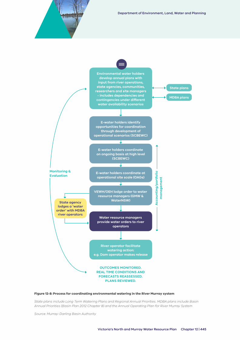
Department of Environment, Land, Water and Planning
Chapter 12 | 445Victoria’s North and Murray Water Resource Plan
Environmental water holders develop annual plans with
input from river operations, state agencies, communities,
researchers and site managers - includes dependencies and
contingencies under different water availability scenarios
E-water holders identify opportunities for coordination
through development of operational scenarios (SCBEWC)
E-water holders coordinate on ongoing basis at high level
(SCBEWC)
E-water holders coordinate at operational site scale (OAGs)
VEWH/OEH lodge order to water resource managers (GMW &
WaterNSW)
Water resource managers provide water orders to river
operators
River operator facilitate watering action:
e.g. Dam operator makes release
State plans
MDBA plans
State agency lodges a ‘water
order’ with MDBA river operators
Acc
ou
nti
ng
/po
rtfo
lio
ma
na
gem
ent
OUTCOMES MONITORED. REAL TIME CONDITIONS AND
FORECASTS REASSESSED. PLANS REVIEWED.
Monitoring & Evaluation
Figure 12-8: Process for coordinating environmental watering in the River Murray system
State plans include Long Term Watering Plans and Regional Annual Priorities. MDBA plans include Basin Annual Priorities (Basin Plan 2012 Chapter 8) and the Annual Operating Plan for River Murray System
Source: Murray-Darling Basin Authority

Department of Environment, Land, Water and Planning
446 | Chapter 12 Victoria’s North and Murray Water Resource Plan
Key responsibilities of the Southern Connected Basin Environmental Watering Committee include:
• coordination of operational planning for the delivery of environmental water consistent with the Basin Plan Environmental Management Framework (section 8.10 of the Basin Plan)
• prioritisation of River Murray Unregulated Flows
• call on River Murray Increased Flows, if resolved to this effect
• input into the development of large scale multi-site environmental watering events and the deviations to river operations that may be required
• convening an annual planning coordination meeting for river operators, state water authorities and environmental water holders for the southern-connected Murray-Darling Basin system
Membership of the Southern Connected Basin Environmental Watering Committee is:
• Australian Government’s Department of Agriculture and Water Resources
• Commonwealth Environmental Water Holder
• Murray-Darling Basin Authority, including River Murray Operations
• NSW Office of Environment and Heritage
• South Australian Department for Environment and Water
• Victorian Department of Environment, Land, Water and Planning
• Victorian Environmental Water Holder
• NSW Department of Industry
The committee’s terms of reference include a requirement for an annual report to be provided to the Ministerial Council which reports on the committee’s work.
The environmental water holders work together to implement joint watering actions in collaboration with river operators and local communities. The high level of cooperation helps to optimise environmental outcomes within the current water management framework.
Participation in the Southern Connected Basin Environmental Watering Committee ensures an understanding of the broader objectives, planning and context of system-wide environmental water objectives and outcomes and provides for coordination between the relevant states for most the efficient and effective use of e-water across the southern-connected Basin. It also allows for alignment between upstream and downstream watering activities.
At a local level, the Victorian Environmental Water Holder hosts or participates in operational advisory groups (OAG) which focus on sites but incorporate relevant multi-site objectives.
Participants include the river operators of Goulburn-Murray Water and/or the Murray-Darling Basin Authority, the CEWH, VEWH and The Living Murray as water holders, catchment management authorities and other stakeholders depending on the site, such as environmental water managers from South Australia or New South Wales and land managers.
The purpose of the operational advisory groups is to provide a forum to share technical and operational information between all environmental water holders, site managers and river managers for efficient operational coordination for environmental outcomes or watering actions. The group enables operations to be adjusted as conditions change, risks to be appropriately managed and successful results of water delivery. Figure 12-9 shows an example of environmental watering as agreed by the relevant state agencies.
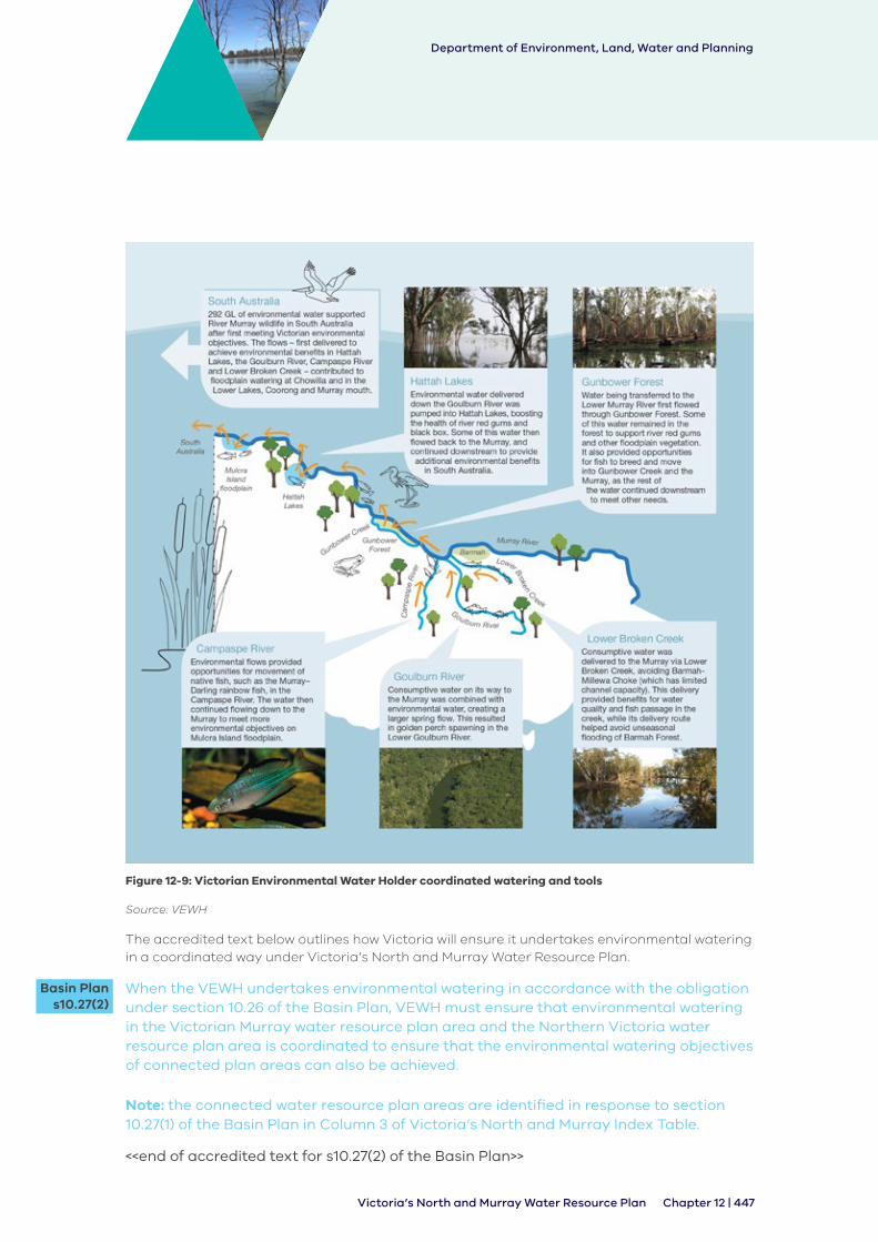
Department of Environment, Land, Water and Planning
Chapter 12 | 447Victoria’s North and Murray Water Resource Plan
Figure 12-9: Victorian Environmental Water Holder coordinated watering and tools
Source: VEWH
The accredited text below outlines how Victoria will ensure it undertakes environmental watering in a coordinated way under Victoria’s North and Murray Water Resource Plan.
When the VEWH undertakes environmental watering in accordance with the obligation under section 10.26 of the Basin Plan, VEWH must ensure that environmental watering in the Victorian Murray water resource plan area and the Northern Victoria water resource plan area is coordinated to ensure that the environmental watering objectives of connected plan areas can also be achieved.
Note: the connected water resource plan areas are identified in response to section 10.27(1) of the Basin Plan in Column 3 of Victoria’s North and Murray Index Table.
<<end of accredited text for s10.27(2) of the Basin Plan>>
Basin Plan s10.27(2)
Department of Environment, Land, Water and Planning
448 | Chapter 12 Victoria’s North and Murray Water Resource Plan
12.7.5 Operational arrangements
The planning outlined in Section 12.6 supports the on-ground delivery of held environmental water.
VEWH issues seasonal watering statements to the catchment management authorities to authorise the use of environmental water holdings. The CMAs have operational management responsibilities for providing the watering regimes determined by the planning processes.
Seasonal watering statements issued to the Goulburn Broken, North Central and Mallee CMAs are available online at http://www.vewh.vic.gov.au/news-and-publications/seasonal-watering- statements.
Catchment management authorities coordinate with storage and land managers to deliver the proposed watering regimes over the year. In practice, local watering decisions are made jointly because the environmental water holder, the storage manager and the land manager, in the case of wetlands, can veto proposed watering actions in some circumstances. By working together, they can also identify opportunities to use system water to support the delivery of environmental objectives.
The VEWH tracks the amount of water used and the return flows that can be used at downstream sites to maximise benefits. It also monitors changes to the operational context over the year and revises or issue new seasonal watering statements to maximise environmental outcomes. Management arrangements need to be tailored to the institutional boundaries of the CMAs and the physical boundaries of waterways to be supplied by particular water holdings because these determine basic accountabilities.
The complexity of decisions increases with the number of:
• governments involved in the decision
• water holders involved in the decision
• waterways that can be watered
• waterway managers
Management actions through the year may vary from the seasonal watering plan for unexpected reasons, like changes to water availability. Every effort is made to inform people that may be affected, including the local community.
12.7.6 Tools for managing environmental water
Environmental water managers use trades and carryover to efficiently and effectively manage environmental water. This is in line with Victorian policy for use of environmental water in the Victorian Waterway Management Strategy (DEPI, 2013) and Water for Victoria.
Water trading allows the environmental water managers to move water to the system where it is needed most, and to smooth out some of the variability in water availability across systems and years. The VEWH’s framework for deciding whether to carry over water is also published in its water allocation trading strategy (VEWH, 2018).
Applications to trade by environmental water holders are subject to the same rules as all other allocation trades. The following types of trades are used to manage the water holdings:
• operational trades of the VEWH, Commonwealth Environmental Water Office (CEWO) and the Living Murray allocations to deliver environmental flows, such as from the Goulburn system to the Murray system
• operational trades to deliver environmental water to South Australia
• operational trades of VEWH Snowy entitlements in the Campaspe, Goulburn and Murray

Department of Environment, Land, Water and Planning
Chapter 12 | 449Victoria’s North and Murray Water Resource Plan
allocations for environmental flows in the Snowy River
• trades of the VEWH, CEWO and the Living Murray allocations to enable carryover of environmental allocations from one season to the next
• buying and selling water allocations on the market
The delivery of environmental water requires either a bulk entitlement, environmental entitlement or water-use registration, and in Victoria these are held by the Victorian Environmental Water Holder. For more information about individual arrangements for access to water see Section 7.2.2. The Commonwealth Environmental Water Holder and the Murray-Darling Basin Authority cannot hold bulk or environmental entitlements because the Victorian Water Act specifies only certain bodies that can hold these.
The VEWH’s bulk and environmental entitlements provide it with a right to a share of water in storage and enable it to:
• Divert water from a waterway – e.g. to water an off-stream wetland
• Use water in-stream – i.e. to deliver in-river and approved overbank environmental benefits.
• Have downstream use offset by authorised re-credits, as a result of environmental return flows from tributaries or sites upstream (see Section 12.7.6)
Water shares provide entitlement holders with a right to a share of the water in storage, but do not provide any right to the delivery of that water. For systems where the VEWH holds a bulk or environmental entitlement water is traded to the VEWH to enable delivery, where there is not a VEWH bulk or environmental delivery is enabled under a water use registration which can be issued to the VEWH in accordance with the Water (Resource Management) Regulations 2017.
This legislative arrangement supports coordinated environmental water delivery by requiring environmental water holders to consolidate resources to maximise environmental outcomes.
Some of the largest trades in the system are the Commonwealth environmental water holdings that are traded to the Victorian Environmental Water Holder to deliver water in Victoria, and unused Commonwealth allocations being traded back to the Commonwealth Environmental Water Holder if they are no longer needed in Victoria.
Water trades carried out by the VEWH and other water holders must comply with trading rules that apply to all water entitlements and allocations.
Environmental water managers’ carryover decisions are made to maximise benefit to the environment:
• to build a reserve for priority watering actions in future years, for example to meet critical environmental needs if conditions are dry or to deliver a large watering
• to enable early season watering the following year, before the full seasonal allocations for that year are available)
• because there is more than enough water available for high-priority watering actions in the current year
Carryover and trade provide flexibility to manage water availability between seasons, and environmental water managers may trade water if they can get better environmental outcomes from projects supported by funds generated from selling water allocation compared with outcomes from having surplus water.
12.7.7 Prerequisite policy measures
Prerequisite policy measures (PPMs) are policy measures designed to maximise the beneficial outcomes of the water recovered for the environment under the Basin Plan. Previously referred

Department of Environment, Land, Water and Planning
450 | Chapter 12 Victoria’s North and Murray Water Resource Plan
to as ‘unimplemented policy measures’, PPMs are defined in section 7.15 of the Basin Plan as measures consisting of a policy to:
• credit environmental return flows for downstream environmental use or
• allow the call of held environmental water from storage during unregulated flow events
PPMs have been enabled for most declared rivers in northern Victoria for close to a decade through provisions in the Victorian Environmental Water Holder’s bulk and environmental entitlements and obligations on GMW in its bulk entitlements. The arrangements have been designed to support the use of environmental water to get the best environmental outcomes without impacting on the security of supply to other entitlement holders. The entitlements enable:
• reuse of return flows (the portion of water that returns to the river or water supply system after an environmental water delivery, and which can be reused for further environmental watering downstream)
• use of consumptive water or system water en route to provide environmental benefit from water on its way through the system; an example is Barmah Choke bypass flows being delivered by way of Lower Broken Creek.
• piggybacking environmental water on consumptive water, system water, or above cap water (i.e. environmental water use is accounted as the additional water on top of other water required to meet flow objectives)
Further details about how Victorian prerequisite policy measures are enduring, fully operable and transparent is outlined in Victoria’s policy document which has been submitted to the MDBA.
12.7.8 Managing risks to environmental water delivery
Effective management of environmental water requires identification and management of any risks. The Victorian Waterway Management Strategy (see Section 12.6.2) outlines state principles for managing risk associated with environmental watering.
These include that:
• risks involved with environmental watering will be identified and managed commensurate with the level of risk and environmental outcome sought
• risk management in environmental watering will consider the range of scenarios in which there may be risks
• the role of each relevant body involved in planning, delivery and facilitating delivery of environmental water will be clearly specified and verified to make sure there is due diligence and the best available information is used to manage any risks to third parties
Victoria has existing annual and longer-term processes in place for managing risks. The system operators also assess risk prior to delivering an environmental water event.
• Annual: Specific risks related to environmental watering are identified and assessed in site- based seasonal watering proposals developed annually by catchment management authorities and documented in the VEWH Seasonal Watering Plan. These proposals draw upon the risks outlined in individual environmental water management plans and identify specific actions to mitigate these risks. The categories of risk covered include reputation, compliance, environmental, human, costs, time and non-achievement of objectives. These risks may be specific to that year or require ongoing or long-term management

Department of Environment, Land, Water and Planning
Chapter 12 | 451Victoria’s North and Murray Water Resource Plan
• Long term: CMAs across Victoria collaborating with communities and agencies identify key risks that may impact on the ability to achieve environmental watering objectives or that may arise in environmental water management plans. Management measures are also identified
The long-term watering plan outlines the types of risks and strategies for management. In addition to the above, Victoria undertook a risk assessment on a water resource plan scale (see Appendix B) to support development of Victoria’s North and Murray Water Resource Plans. These risk are explained in Chapter 5 and summarised in Section 5.3.4 and Section 5.4.4.
12.8 Ensuring environmental watering for priority environmental assets and priority ecosystem functions is not compromised
12.8.1 Overview
Under Basin Plan Victoria is required to ensure that the operation of Victoria’s North and Murray Water Resource Plan does not impact on environmental watering where:
• watering relates to groundwater dependent ecosystems or groundwater dependent assets
• watering relates to resources with a significant connection between groundwater and surface water.
Connectivity between groundwater systems and between groundwater and surface water across Victoria’s North and Murray water resource plan area is discussed in Chapter 4. A discussion of groundwater dependent priority environmental assets and priority ecosystem functions is outlined in Section 12.5. Basin Plan requires Victoria to show how it considers these connections and dependencies when managing the take and use of water from the system. This is to make sure Victoria has the appropriate mechanisms in place to ensure environmental watering for priority environmental assets and priority ecosystem functions is not compromised.
More specifically, Part 4 of Chapter 10 of the Basin Plan requires that water resource plans set out how states facilitate the sustainable use and management of water resources by:
• operation of the water resource plan not compromise the meeting of environmental watering requirements of priority environmental assets and priority ecosystem functions dependent of surface water (section 10.17 of the Basin Plan)
• operation of the water resource plan does not compromise the meeting of environmental watering requirements of priority environmental assets and priority ecosystem functions that depend on groundwater (section 10.18 of the Basin Plan)
• operation of the water resource plan does not compromise the meeting of environmental watering requirements for groundwater that has a significant hydrological connection to surface water (section 10.19 of the Basin Plan)
• there is no structural damage to an aquifer arising from take within the sustainable diversion limit (SDL), and hydraulic relationships and properties between groundwater systems and within groundwater systems are maintained (section 10.20 of the Basin Plan)
The Basin Plan requires that water resource plans be prepared with regard for whether rules are necessary to make sure that environmental watering requirements are met for priority environmental assets and priority ecosystem functions (surface water), priority environmental assets dependent on groundwater, and where there is a significant hydrological connection between groundwater and surface water.
The relationship between groundwater take and use and priority environmental assets dependent on groundwater is a fundamental consideration in groundwater management across Victoria at all levels, including the Victorian Water Act, Ministerial guidelines, statutory management plans and local management plans (see Chapter 7). In responding to Part 4 of

Department of Environment, Land, Water and Planning
452 | Chapter 12 Victoria’s North and Murray Water Resource Plan
Chapter 10 of the Basin Plan regard was had to these existing arrangements.
Any rules included in the Plan in response to Part 4 of Chapter 10 of the Basin Plan must have the effect of ensuring that the operation of Victoria’s North and Murray Water Resource Plan does not compromise the meeting of environmental watering requirements. As is outlined below, Victoria’s North and Murray Water Resource Plan does not contain requirements, obligations, measures or strategies that would cause environmental watering to be compromised. However, in considering whether the Plan should include rules to support environmental watering consideration was given to management of emerging risks to the environment.
Rules have been included in response to sections 10.17, 10.18, 10.19 and 10.20 of the Basin Plan to address potential emerging risks that may arise during the operation of the Plan to support adaptive water resource management. The rules proposed under Victoria’s North and Murray Water Resource Plan in response to sections 10.18, 10.19 and 10.20 are consistent with current arrangements under the Victorian Water Act and relevant statutory management plans approved for declared water supply protection areas in Victoria’s North and Murray water resource plan area (see Section Table 12-4 and Table 12-5 for existing and proposed rules).
The rule in response to section 10.17 of the Basin Plan has been included to reflect the role of storage managers under Victoria’s water resource management framework to support the achievement of environmental watering requirements in the management of the system where environmental watering occurs. As identified above at Section 12.5 environmental watering requirements for priority environmental assets are set out in the relevant environmental water management plan.

Department of Environment, Land, Water and Planning
Chapter 12 | 453Victoria’s North and Murray Water Resource Plan
Table 12-4: Existing rules or measures under Victoria’s water management framework
Existing rule Basin Plan requirement applicable to
Groundwater SDL resource unit/s where the rule applies
How is the rule applied?
Victoria’s licensing framework - take and use licence conditions (Victorian Water Act)
section 10.18
section 10.19
All SDL resource units in the Goulburn-Murray water resource plan area
This rule is applied to all take and use licences across the Goulburn-Murray water resource plan area in accordance with conditions of licences as outlined in section 56 of the Victorian Water Act.
PCV:
PCVs have been declared for all groundwater management units under section 22A of the Victorian Water Act except for the Upper Ovens River WSPA where prescriptions 20-21 and 50 describe the rules in place which take the place of the PCV.
Trade zone limits:
Katunga WSPA:
• Prescription 1: Limit of groundwater licences
Loddon Highlands WSPA
• Prescription 3: Trading between zones
Lower Campaspe WSPA:
• Prescription 2: Trading rules
Upper Ovens River WSPA:
• Prescription 22: Restrictions and prohibitions on issuing take and use licences

Department of Environment, Land, Water and Planning
454 | Chapter 12 Victoria’s North and Murray Water Resource Plan
Existing rule Basin Plan requirement applicable to
Groundwater SDL resource unit/s where the rule applies
How is the rule applied?
Monitoring arrangement:
Katunga WSPA:
• Prescription 5: Groundwater level monitoring
• Prescription 6: Groundwater salinity monitoring
Loddon Highlands WSPA
• Prescription 5: Groundwater monitoring
Lower Campaspe WSPA:
• Prescription 4: Monitoring groundwater levels
• Prescription 5: Monitoring groundwater salinity
Upper Ovens River WSPA
• Prescription 49: Monitoring
Restrictions on groundwater use based on groundwater trigger levels
section 10.18
section 10.19
section 10.20
Parts of GS8b, GS8c, GS8d
Water supply management plans:
Katunga:
• Prescription 2: Restrictions on taking groundwater
Loddon Highlands:
• Prescription 2: Triggers and restriction
Lower Campaspe:
• Prescription 1: Triggers and restrictions
Upper Ovens River:
• Prescriptions 2-11: Restrictions on taking water in Management Zone 1

Department of Environment, Land, Water and Planning
Chapter 12 | 455Victoria’s North and Murray Water Resource Plan
Existing rule Basin Plan requirement applicable to
Groundwater SDL resource unit/s where the rule applies
How is the rule applied?
Conjunctive management1 of surface water and groundwater - groundwater take restricted based on SW availability
section 10.19 Parts of GS8c Upper Ovens River Water Supply Protection Area Water
• Prescriptions 27-28: Transfers within management zone 1
• Prescription 29-30: Transfers between management zones 1 and 2
1: Note that in Victoria conjunctive management means that groundwater and surface water are managed as one unit, that is rules consider both surface water and groundwater availability
Table 12-5: Proposed new rule or measure for Goulburn-Murray water resource plan area
Proposed rule Basin Plan requirement applicable to
SDL resource unit/s where rule applies
Where the rule applies
Minister must undertake a risk assessment for new licences or transfer of existing licences and consider conditions relating to Part 4 Division 3 of the Basin Plan.
section 10.18 and section 10.19
All SDL resource units in the Goulburn-Murray WRP area
All take and use licences across the Goulburn-Murray water resource plan area.
Minister may prepare guidelines for preparing a draft management plan for new areas declared as water supply protection areas. Guidelines will include considerations for prescriptions relating to Basin Plan Part 4 Division 3 of the Basin Plan.
section 10.18, section 10.19 and section 10.20
All SDL resource units in the Goulburn-Murray WRP area
New areas declared as water supply protection areas and existing areas where new plans are prepared.
12.8.2 Groundwater resources and connectivity with surface water
The Goulburn-Murray water resource plan area forms the southern portion of the large saucer- shaped geological formation that is the Murray geological basin. Similar to the morphology of the Murray-Darling drainage basin, all groundwater flows in a general north and westerly direction from the Victorian highlands and the Great Dividing Range. For more information see Chapter 2.
Across the Goulburn-Murray water resource plan area hydraulic connection between groundwater and surface water and groundwater dependent ecosystems is highly variable. There is significant hydraulic connectivity between those groundwater resource units that contain a shallow water table or are directly connected to the water table. Water table aquifers with connections to surface water are primarily the:
a) Goulburn-Murray: Sedimentary Plain SDL resource unit in the Shepparton formation
b) Goulburn-Murray: Shepparton Irrigation Region Shepparton SDL resource unit formation

Department of Environment, Land, Water and Planning
456 | Chapter 12 Victoria’s North and Murray Water Resource Plan
c) Goulburn-Murray: Highlands SDL resource unit including areas where the Calivil formation is shallow and aquitard layers are absent; areas where fractured rock of the New Volcanics aquifer are present in the south of the Loddon and Campaspe catchments; and in the unconfined fractured rock near waterways. For more information on connectivity see Section 4.4
12.8.3 Ensuring environmental watering of groundwater dependent environmental assets and ecosystems is protected (section 10.18 of the Basin Plan)
Victoria’s entitlement framework supports meeting environmental watering requirements as outlined in (see Section 12.4). Section 10.18 of the Basin Plan requires consideration to be given as to whether the Victoria’s North and Murray Water Resource Plan could compromise the meeting of environmental watering requirements for groundwater dependent priority environmental assets and priority ecosystem functions.
There is nothing in Victoria’s North and Murray Water Resource Plan that would have the effect of compromising the ability to meet environmental watering requirements of groundwater dependent priority environmental assets and priority ecosystem functions.
The known groundwater-dependence of priority environmental assets in Victoria’s North and Murray water resource plan areas are provided in Table 7 to Table 10 of Appendix E and Figure 12-4 and Figure 12-5.
In approving a new groundwater licence or a trade regard must be had to the need to protect the riparian and riverine environment under section 40 of the Victorian Water Act. For all licence applications for take and use of groundwater, the Minister or delegate is obliged to have regard to adverse effects on waterways, the environmental water reserve and to protect the environment, and must not approve an application if it is likely to have a significant impact.
To provide guidance to delegates considering these obligations when assessing groundwater take and use licence applications in areas without a management plan the Minister released Guidelines for Groundwater Licensing and the Protection of High-Value Groundwater- Dependent Ecosystems (DELWP, 2015). These guidelines outline the decision-making process when assessing a new groundwater licence or a trade of a groundwater licence to protect groundwater-dependent ecosystems and consider imposing conditions on the groundwater take and use licence to mitigate those impacts. This set out the requirements for assessing the risk posed by a groundwater licence application to high value ecosystems depending on groundwater and takes a risk-based approach to identify where a proposed groundwater take may result in an impact to a groundwater-dependent ecosystem. The application of this policy ensures that the groundwater-dependent ecosystems are not compromised by the taking of groundwater. The Guidelines are outlined below.
Department of Environment, Land, Water and Planning
Chapter 12 | 457Victoria’s North and Murray Water Resource Plan
Ministerial Guidelines for Groundwater Licensing and the Protection of High Value Groundwater Dependent Ecosystems (DELWP, 2015)
The guidelines are used to determine the likelihood and consequence of any proposed groundwater take impacting on high value ecosystems. The decision maker is required to follow these steps:
• STEP 1. Determine the licence application area and identify any high value ecosystems
- Determine whether the aquifer is confined or unconfined. Interactions with groundwater-dependent ecosystems mostly occur with unconfined aquifers, so if the aquifer is confined the assessed risk is low
- Identify any features within that area such as rivers, springs, soaks or terrestrial vegetation containing high value ecosystems
• STEP 2. Determine any likelihood that the proposed groundwater extraction will interact with the feature
• STEP 3. Determine the consequence of the proposed groundwater extraction on the feature
• STEP 4. Determine the risk to the high value ecosystems dependent on groundwater
• STEP 5. Determine how risk will be managed for any groundwater licence applications with a risk assessment of medium or high
Note that these risk mitigations are suggested as examples in the guidelines:
a) altering the area of impact, such as reducing the entitlement volume, locating the bore in a deeper aquifer, re-siting the bore, undertaking investigations to improve information on the local aquifer
b) changing the likelihood, such as increasing the set back distances, modifying the pumping schedule
c) changing the consequence, such as modifying the pumping schedule, developing offsets, developing options for supplementing surface water flows
d) reducing the risk evaluation through licence conditions
e) deciding to undertake further analysis to gain better information and improve the risk analysis
f) providing alternative supply to ‘at-risk’ areas to maintain the high value ecosystem
• STEP 6. Consult with relevant catchment management authority
• STEP 7. Make final decision
Where there is an approved statutory management plan in place for a declared water supply protection area, the Guidelines for Groundwater Licensing and the Protection of High-Value Groundwater-Dependent Ecosystems are not applied as the prescriptions contained in the relevant management plan apply to all licencing decisions in the water supply protection area to which the management plan applies.
For areas declared under section 27 of the Victorian Water Act as a water supply protection area, a statutory management plan is prepared and approved by the Minister. These plans are prepared to regulate the management of water resources in the declared area. To ensure that statutory management plans meet the requirements of section 10.18 of the Basin Plan, Victoria’s North and Murray Water Resource Plan includes a rule that identifies the matters that must be considered when developing prescriptions for a statutory management plan.

Department of Environment, Land, Water and Planning
458 | Chapter 12 Victoria’s North and Murray Water Resource Plan
In order to understand the relationship between priority environmental assets their groundwater dependencies and the protections provided to priority environmental assets under the Victorian framework the Victorian government commissioned a study by Groundwater Logic. This study identified priority environmental assets which have some groundwater dependency, then looked at protections in place in the existing management arrangements within the statutory groundwater management plans and local area plans to identify if there is sufficient protection.
The analysis concluded that most of the priority environmental assets across the Victorian Murray and Northern Victorian water resource plan areas with known or suspected groundwater dependencies are classified as at low risk from excessive pumping or poor resource management.
The study found that no wetlands were classified above a low risk rating and only four river reaches were classified as being moderate to high risk groundwater-dependent ecosystems. These were two Lower Ovens River reaches and two Broken Creek reaches. However, there are management rules in place for the Lower Ovens River which limit trade adjacent to the river, and the Broken Creek reaches are covered by local arrangements in the Shepparton Irrigation Region groundwater management area plan.
This study concluded that ‘no further recommendations for managing effects on groundwater- dependent ecosystems, other than those that are already in place under Victoria’s existing water management framework, are considered necessary’ (Groundwater Logic, 2018).
Therefore it is not considered that Victoria’s North and Murray Water Resource Plan requires would compromise the meeting of environmental watering requirements for groundwater dependent priority environmental assets or priority ecosystem functions. Due to the nature of Victoria’s water resource management framework there is nothing in the Plan that would prevent or have adverse impacts on the meeting of environmental watering requirements.
However, rules have been included to address potential emerging risks that may arise during the operation of the Plan to support adaptive water resource management. The rules in response to section 10.18 of the Basin Plan (as outlined below) contained in Victoria’s North and Murray Water Resource Plan applies to decisions to issue or transfer (trade) a take and use licence for groundwater in the Goulburn-Murray water resource plan area.
As outlined below the proposed rules require the following:
• where no management plan is in place for a declared water supply protection area, to carry out an assessment to determine the existence of medium or high risk that the take of groundwater in relation to a new licence or the transfer of a licence will have an adverse impact on high value ecosystems dependent on the relevant groundwater and manage that risk; and
• where a management plan is being prepared for a declared water supply protection area, to consider whether prescriptions are necessary in a management plan to address any risks to the meeting of environmental watering requirements for priority environmental assets and priority ecosystem functions
The application of the Guidelines for Groundwater Licensing and the Protection of High Value Groundwater-Dependent Ecosystems (DELWP, 2015) which is outlined above is consistent with the proposed rule outlined. The Upper Ovens Case Study provided below in Section 12.8.4 demonstrates how the rules provided in that Plan are consistent with the proposed rules.
The following rule applies to the Northern Victoria water resource plan area and Victorian Murray water resource plan area under Victoria’s North and Murray Water Resource Plan.

Department of Environment, Land, Water and Planning
Chapter 12 | 459Victoria’s North and Murray Water Resource Plan
1. The Minister may prepare guidelines under section 30 of the Water Act 1989 (Vic) for the preparation of a draft management plan for an area declared under section 27 of the Water Act 1989 (Vic) to require the consultative committee to consider the matters in paragraph (4) when developing a draft statutory management under section 31 of the Water Act 1989 (Vic).
2. The guidelines may require the consultative committee to consider whether the draft statutory management plan should include prescriptions for groundwater management having regard to:
a) groundwater dependent priority environmental assets and priority ecosystem functions as identified in the Northern Victoria Long-Term Watering Plan and the Victorian Murray Long-Term Watering Plan;
b) any risks to meeting environmental watering requirements for those groundwater dependent priority environmental assets and priority ecosystem functions as a result of groundwater take in the area.
3. Prescriptions identified in accordance with paragraph (4) may include:
a) a requirement to undertake monitoring;
b) the period and frequency over which the monitoring should occur;
c) the locations at which monitoring should occur;
d) identified trigger levels to reflect when extraction would pose a risk to the aquifer;
e) restrictions that may be applied to the extraction of groundwater under a take and use licence and how the restrictions will be applied;
f) conditions on the transfer of take and use licences within or into the relevant water supply protection area.
4. In considering a draft statutory management plan under section 32A of the Water Act 1989 (Vic), the Minister must consider whether the prescriptions included in the draft plan address the types of risks referred in paragraph (4) if identified for the water supply protection area relevant to the draft plan.
5. The storage manager will manage the system and above cap water in line with the Victorian water management framework described in Victoria’s North and Murray Water Resource Plan in response to section 10.26(1) of the Basin Plan so the environmental watering requirements of PEAs and PEFs identified in relevant environmental water management plans are met, which is the responsibility of the VEWH.
6. References to sections of the Water Act 1989 (Vic) do not have the purpose of including those sections as part of the response but are included for reference only.
Note 1: For environmental watering obligations and requirements see the response in Column 3 to section 10.26 of the Basin Plan in Victoria’s North and Murray Index Table and the supplementary material discussed in Column 5.
Note 2: see response to section 10.26(1) of the Basin Plan in Victoria’s North and Murray Index Table for a discussion of environmental watering arrangements in Victoria.
<<end of accredited text for s10.18(3) of the Basin Plan>>
Basin Plan s10.18(3)

Department of Environment, Land, Water and Planning
460 | Chapter 12 Victoria’s North and Murray Water Resource Plan
The following rule applies to the Goulburn-Murray water resource plan area under Victoria’s North and Murray Water Resource Plan.
1. This rule only applies where a statutory management plan has not been approved under section 32A of the Water Act 1989 (Vic) and groundwater dependent ecosystems have been identified as high value in the Goulburn-Murray water resource plan area:
a) the Minister must undertake a risk assessment to determine whether the issue of a new licence or transfer of an existing licence will have a medium or high risk of having an adverse impact on the groundwater dependent ecosystem;
b) where a medium or high risk under paragraph (1), before issuing a take and use licence or approving the transfer a take and use licence for the take of groundwater the Minister must consider whether conditions should be imposed on the take and use licence to modify:
i) the adverse consequences of the take including pumping schedules, offsets, options for supplementing surface water flows;
ii) the adverse impact of the take including reducing the entitlement volume or location of the bore.
2. Where a water supply protection area has been declared under section 27 of the Water Act 1989 (Vic) the rule under (1) above does not apply.
<<end of accredited text s10.18(3) of the Basin Plan>>
12.8.4 Ensuring environmental watering requirements are met when there is a significant connection between surface water and groundwater
Section 10.19 of the Basin Plan requires consideration to be given as to whether Victoria’s North and Murray Water Resource Plan could compromise the meeting of environmental watering requirements where a significant hydrological connection between surface water and groundwater has been identified.
Surface water and groundwater are connected across the Goulburn-Murray water resource plan area to varying degrees and some of this variation is described in Chapter 4. The hydrologic cycle is evidence that rainfall recharges the groundwater systems and provides streamflow, while groundwater baseflow from the water table sustains streams in between rainfall and runoff events. Many groundwater-dependent ecosystems are also maintained from groundwater resources. The surface water SDL resource units are closely connected to their adjacent groundwater SDL resource units and groundwater planning considers the impact on surface water and groundwater-dependent ecosystems when managing licences and allocations.
Statutory groundwater management plans and local management plans consider the interaction between the surface water and groundwater systems through the application of the Victorian Water Act, regulations and the supporting guidelines. For example, in the Upper Ovens area, the surface water and groundwater resources are managed conjunctively in recognition of the strong degree of connection between the surface water and shallow groundwater systems.
In approving a new groundwater licence or a trade regard must be had to the need to protect the riparian and riverine environment under section 40 of the Victorian Water Act. For all licence applications for take and use, the Minister or delegate is obliged to have regard to adverse effects on waterways, the environmental water reserve and to protect the environment, and
Basin Plan s10.18(3)
Department of Environment, Land, Water and Planning
Chapter 12 | 461Victoria’s North and Murray Water Resource Plan
must not approve an application if it is likely to have a significant impact.
To support consideration of applications for new or transfer of existing licences the Minister released Guidelines for Groundwater Licensing and the Protection of High-Value Groundwater- Dependent Ecosystems (DELWP, 2015) which provide a framework for assessing risks and determining measures to manage those risks where the taking of groundwater will have adverse impacts on surface water flows. The Guidelines for Groundwater Licensing and the Protection of High-Value Groundwater-Dependent Ecosystems (DELWP, 2015) are not applied as the prescriptions contained in the relevant management plan apply to all licencing decisions in the water supply protection area to which the management plan applies. The Guidelines are outlined further in Section 12.8.3.
As discussed, under the Victorian Water Act the Minister can declare a water supply protection area for areas that require intensive management and monitoring because of risks associated with groundwater extraction. There are four water supply protection areas in the Goulburn-Murray water resource plan area these are the Upper Ovens, Katunga, Loddon Highlands and Lower Campaspe Valley water supply protection areas.
These areas have had Water Management Plans prepared and approved by the Minister for Water. The prescriptions in these statutory management plans protect existing users and the environment by setting triggers based on groundwater use or groundwater levels. When the prescribed triggers are met, annual allocations may be announced in accordance with the Water Management Plan that allow users to pump a proportion of their entitlement (see for example the Upper Ovens River Case Study).

Department of Environment, Land, Water and Planning
462 | Chapter 12 Victoria’s North and Murray Water Resource Plan
Case Study – Upper Ovens River Water Supply Protection Area Water Management Plan
The Upper Ovens River Water Supply Protection Area Water Management Plan (GMW, 2012) has been developed to conjunctively manage the surface water and groundwater resources in this area, given the very connected manner of both systems. The Upper Ovens River Water Supply Protection Area Water Management Plan recognises that groundwater in the unconsolidated sedimentary aquifer and surface water resources within the main stream systems are highly connected. The plan has established a water sharing regime with a focus on low flow periods where there are increased risks to the environment and other water users.
The Upper Ovens River Water Supply Protection Area Water Management Plan addresses the impact of groundwater extraction on groundwater-dependent ecosystems. It does this through prescriptions in the Water Management Plan:
• Prescriptions 2-7 - Describe the rules relating to taking surface water or groundwater under an all-year licence while restrictions are in place
• Prescription 18-25 - Describes the rules relating to issuing a new licence
• Prescription 27-30. - Describe rules relating to the transfer of a licence
• Prescription 35- Describes the rules relating to the transfer of a groundwater licence to a surface water licence
• Prescriptions 36 - Describes the rules relating to the transfer of a surface water licence to a groundwater licence
• Prescription 37-38 - Describes the rules relating to any transfers between a surface water licence in Management Zone1 to an all-year groundwater licence in Management Zone 2 and all-year groundwater licence in Management Zone 2 to a surface water licence in Management Zone 1
• Prescription 44-48. Describes how the Corporation must meter take by consumptive users-
• Prescription 49 - Describes how the Corporation must ensure that an appropriate monitoring program is undertaken to ensure that flows in the catchment and groundwater levels are recorded, the water sharing regime is able to be implemented, the relationship between groundwater levels and stream levels can be observed
The extent and types of groundwater-dependent ecosystems in the Upper Ovens River catchment are not completely understood, although freshwater meadows and shallow freshwater marshes are expected to be supported. Given the low levels of current development related to the total water resources in the Upper Ovens catchment, it is expected that groundwater-dependent ecosystems would be relatively undisturbed as far as their water requirements are concerned.
From historic data, groundwater use from the unconsolidated sedimentary aquifer lowers groundwater levels by a small amount (0.25 m), however natural and seasonal variation in groundwater levels is around two to three metres and the impact of extraction on groundwater levels is only an issue in extremely dry years when periods of low flow conditions exist for the river.
As a result, these rules or prescriptions have been established that limit the use of groundwater from the connected groundwater and surface water resources when low flow periods exist. This has been done by linking surface water and groundwater extraction with restrictions on extraction to protect further loss of surface flow. This provides protection to groundwater-dependent ecosystems in and along the river reaches.

Department of Environment, Land, Water and Planning
Chapter 12 | 463Victoria’s North and Murray Water Resource Plan
It is not considered that Victoria’s North and Murray Water Resource Plan would compromise the meeting of environmental watering requirements where significant hydrological connections between surface water and groundwater have been identified. Due to the nature of Victoria’s water resource management framework there is nothing in the Plan that would prevent or have adverse impacts on the meeting of environmental watering requirements. However, rules have been included to address potential emerging risks that may arise during the operation of the Plan to support adaptive water resource management.
The rules in response to section 10.19 of the Basin Plan (see accredited text below) contained in Victoria’s North and Murray Water Resource Plan applies to decisions to issue or transfer (trade) a take and use licence for groundwater in the Goulburn-Murray water resource plan area.
As outlined below the proposed rules require the following:
• where no management plan is in place for a declared water supply protection area, to carry out an assessment to determine the existence of medium or high risk that the take of groundwater in relation to a new licence or the transfer of a licence will have an adverse impact on surface water flows as it relates to environmental ecosystems; and
• where a management plan is being prepared for a declared water supply protection area, to consider whether prescriptions are necessary in a management plan to address any risks to the meeting of environmental watering requirements where a significant hydrological connection between surface water and groundwater has been identified
The application of the Guidelines for Groundwater Licensing and the Protection of High Value Groundwater-Dependent Ecosystems (DELWP, 2015) which is outlined above is consistent with the proposed rule outlined below.
1. This rule only applies where a management plan for a water supply protection area has not been approved under section 32A of the Water Act 1989 (Vic) and where a significant hydrological connection between surface water and groundwater has been identified in the Goulburn-Murray water resource plan area and groundwater extraction has been identified as affecting surface water flow relating to a high value ecosystem:
a) the Minister must undertake a risk assessment to determine whether the issue of a groundwater take and use licence or transfer of groundwater take and use licence will have a medium or high risk of having an adverse impact on the high value ecosystem;
b) where a medium or high risk under paragraph (1) is identified, before issuing or approving the transfer a take and use licence for the take of groundwater the Minister must, in consultation with the relevant catchment management authority, consider whether conditions may be imposed on the take and use licence to modify:
i) the adverse consequences of the take (which may include pumping schedules, offsets, options for supplementing surface water flows);
ii) the adverse impact of the take (which may include reducing the entitlement volume or location of the bore).
2. Where a water supply protection area has been declared under section 27 of the Water Act 1989 (Vic) the rule under (1) above does not apply.
3. Where a water supply protection area has been declared under section 27 of the
Basin Plan s10.19(3)

Department of Environment, Land, Water and Planning
464 | Chapter 12 Victoria’s North and Murray Water Resource Plan
Water Act 1989 (Vic) the Minister may prepare guidelines under section 30 of the Water Act 1989 (Vic) relating to the preparation of a draft statutory management plan for that declared area to require the consultative committee to consider the matters in paragraph (4) when developing a draft statutory management under section 31 of the Water Act 1989 (Vic).
4. The guidelines may require the consultative committee to consider whether the draft statutory management plan should include prescriptions for groundwater management having regard to:
a) any significant hydrological connection between groundwater and surface water; and
b) any risk to meeting environmental watering requirements as a result of groundwater take in the area.
5. Prescriptions identified in accordance with paragraph (4) may include:
a) a requirement to undertake monitoring;
b) the period and frequency over which the monitoring should occur;
c) the locations at which monitoring should occur;
d) identified trigger levels to reflect when extraction would pose a risk to the aquifer;
e) restrictions that may be applied to the extraction of groundwater under a take and use licence and how the restrictions will be applied;
f) conditions on the transfer of take and use licences within or into the relevant water supply protection area.
6. In considering a draft statutory management plan under section 32A of the Water Act 1989 (Vic), the Minister must consider whether the prescriptions included in the draft plan address the types of risks referred in paragraph (4) if identified for the water supply protection area relevant to the draft plan.
7. References to sections of the Water Act 1989 (Vic) do not have the purpose of including those sections as part of the response but are included for reference only.
Note 1: For environmental watering obligations and requirements see the response in Column 3 to section 10.26 of the Basin Plan in Victoria’s North and Murray Index Table and the supplementary material discussed in Column 5.
Note 2: see response to section 10.26(1) of the Basin Plan in Victoria’s North and Murray Index Table for a discussion of environmental watering arrangements in Victoria.
<<end of accredited text for s10.19(3) of the Basin Plan>>
12.8.5 Protecting the productive base of groundwater
Section 10.20 of the Basin Plan requires consideration to be given as to whether the content of

Department of Environment, Land, Water and Planning
Chapter 12 | 465Victoria’s North and Murray Water Resource Plan
Victoria’s North and Murray Water Resource Plan would compromise:
• the structural integrity of an aquifer, whether within or outside the water resource plan area, arising from take within the long-term annual diversion limit for an SDL resource unit and
• hydraulic relationships and properties between groundwater and surface water systems, between groundwater systems and within groundwater systems
Water resources management across the Goulburn-Murray water resource plan area considers the integrity of the aquifer from which the resource is extracted and also the overall hydraulic relationships between groundwater and surface water systems and between and within groundwater systems. This is achieved through the Victorian Water Act, statutory management plans and local management plans that provide for managing the resource sustainably, prevent undue depletion and protect the integrity of the aquifer and the interests of existing water users and the environment.
By preventing undue depletion, such as by restrictions on allocation when water level triggers are met, the magnitude of groundwater level decline is limited and in Victoria such triggers consider both licensed and private rights users, and where identified, the environment and water ways. These preserve aquifer integrity (such as excessive de-pressurisation or de-watering resulting in subsidence and compaction) and hydraulic relationships, such as hydraulic gradients that limits risks of migration of saline groundwater towards fresher groundwater.
These were both considered in the development of the Katunga water supply protection area groundwater management plan (see case study – Kutunga water supply protection area groundwater management plan).
The plans achieve this through the same mechanisms that protect groundwater levels and quality, such as trigger levels, restrictions and regular sampling, testing and monitoring. In all cases, impacts on existing consumptive and environmental users will be detected from the regular sampling and monitoring before there is any impact on the structural integrity of the aquifer.

Department of Environment, Land, Water and Planning
466 | Chapter 12 Victoria’s North and Murray Water Resource Plan
Case Study – Katunga water supply protection area groundwater management plan
The Katunga water supply protection area was declared in 1999. Several iterations of water resources planning have occurred in the years since, with recent amendments in 2017 providing a consolidated groundwater management plan. The Katunga Water Supply Protection Area Groundwater Management Plan was developed to protect the consumptive and environmental users of groundwater across and next to the plan area.
Intensive development and pumping of the Deep Lead aquifer in this region from the mid-1980s resulted in an observed decline of around 10 metres in the potentiometric surface of this aquifer. As well as declining water availability and the potential for bores to run dry, excessive groundwater pumping can lead to increased salinity through induced inter-aquifer flow and aquifer matrix compaction, affecting its structural integrity.
The Katunga water supply protection area groundwater management plan was developed to manage and control the risks that excessive groundwater development could have on the available water and its quality and the overall condition of the aquifer itself. The plan includes rules or ‘prescriptions’ that control the amount of take, or which describe the monitoring or management activities to sustain the resource.
These prescriptions include:
• Prescription 1: A limit on groundwater licences, with a maximum permissible consumptive volume set at 60,577 ML/yr. Zone limits are also set on some highly-developed zones within the water supply protection area
• Prescription 2: Restrictions on taking groundwater, based on review of groundwater levels within State Government groundwater observation bores. Trigger levels are set and varying groundwater allocation percentages are announced based on these levels, ranging from 70 percent to 100 percent allocation
• Prescription 3: Rules governing the transfer of licences to reduce the intensity of groundwater development in specific management zones
• Prescription 4: Metering of licensed take, to provide accurate information on the extent to which entitlements are accessed
• Prescription 5: Regular groundwater level monitoring to understand the impacts of high intensity groundwater pumping on water levels
• Prescription 6: Regular groundwater salinity monitoring, to understand and manage any impacts that may reduce the water quality, from over-pumping or leakage of saline groundwater from adjacent aquifers
• Prescription 7: Annual reporting to make sure that the ongoing resource management for this area is completely transparent and made publicly available

Department of Environment, Land, Water and Planning
Chapter 12 | 467Victoria’s North and Murray Water Resource Plan
These prescriptions have been developed to protect the resource from declining water availability and quality.
In terms of prioritising risks, the risk to aquifer integrity is ranked much lower than the risk of groundwater shortage or of increasing groundwater salinity. This is purely due to the effect that more prominent risks have themselves become indicators that aquifer integrity could be compromised.
The Katunga Water Supply Protection Area Groundwater Management Plan includes prescriptions to protect water quantity and water quality. The monitoring systems put in place and the associated triggers and rules apply to protect the groundwater resource form these quantity and quality impacts. It would take an intensive and prolonged decline in water levels to lead to impacts in the structural integrity of the aquifer, which the currently- prescribed rules and procedures will detect at a very early stage.
Owing to the high levels of development in the area, and the prominence of this plan among the community, actions such as reduced allocations to respond to deteriorations in water levels and quality will also provide protection from any risk to the structural integrity of the aquifer.
The Katunga case study provided is consistent for the other statutory groundwater management plans across the Goulburn-Murray water resource plan area, where management prescriptions are in place to provide early warning and an adaptive response to any critical decline in water levels or any substantial increase in groundwater salinity.
In respect of section 10.20 the Basin Plan requires a rule that provides protection to ensure there is no structural damage to an aquifer arising from groundwater take.
Victoria considers there are no structural risks to the aquifers because the amount of take is limited by the Permissible Consumptive Volumes set for intensive use areas, and this level and prescriptions included in management plans will not cause significant aquifer drawdown and therefore structural risk to the aquifers.
As a result, it is not considered necessary to include rules in Victoria’s North and Murray Water Resource Plan to respond to section 10.20 of the Basin Plan. However, section 10.21 of the Basin Plan requires that a rule to meet the objectives of section 10.20 must be included in a water resource plan that relates to the Goulburn-Murray: Sedimentary Plain SDL resource unit.
The rule identified to meet the objectives of section 10.21 of the Basin Plan for the Goulburn-Murray: Sedimentary Plain SDL resource unit has been applied to the whole Goulburn-Murray water resource plan area by including it as a response to section 10.20(3) of the Basin Plan (as outlined below).
This supports Victoria’s approach to water resource management which is fundamentally consistent across the State, but adaptable enough to respond to localised issues. Therefore, where a risk arises to the structural integrity of an aquifer and the hydraulic relationships within groundwater systems or between groundwater and surface water, the Minister may prepare guidelines that require setting prescriptions in a statutory management plan where a water supply protection area has been declared.
The current statutory management plans in place in the Goulburn-Murray water resource plan area are consistent with the rules to response to section 10.20 of the Basin Plan, see for example the Katunga Case Study outlined above.

Department of Environment, Land, Water and Planning
468 | Chapter 12 Victoria’s North and Murray Water Resource Plan
1. The Minister may prepare guidelines under section 30 of the Water Act 1989 (Vic) for the preparation of a draft statutory management plan for an area declared under section 27 of the Water Act 1989 (Vic) to require the consultative committee to consider the matters in paragraph (2) when developing a draft statutory management under section 31 of the Water Act 1989 (Vic).
2. The guidelines may require the consultative committee to consider whether the draft statutory management plan should include prescriptions for groundwater management having regard to:
a) the risk to the structural integrity of the aquifer because of the level of take in the area;
b) the risk to maintaining the hydraulic relationships and properties between groundwater and surface water systems, between groundwater systems and within groundwater system within the area.
3. Prescriptions identified in accordance with paragraph (2) may include:
a) a requirement to undertake monitoring;
b) the period and frequency over which the monitoring should occur;
c) the locations at which monitoring should occur;
d) identified trigger levels to reflect when extraction would pose a risk to the aquifer;
e) restrictions that may be applied to the extraction of groundwater under a take and use licence and how the restrictions will be applied.
4. In considering a draft statutory management plan under section 32A of the Water Act 1989 (Vic), the Minister must consider whether the prescriptions included in the draft plan address the types of risks referred in paragraph (2) if identified for the water supply protection area relevant to the draft plan.
5. References to sections of the Water Act 1989 (Vic) do not have the purpose of including those sections as part of the response but are included for reference only.
<<end of accredited text for s10.20(3) of the Basin Plan>>
In addition to meet the requirements of section 10.21 of the Basin Plan, measures have also been included in Victoria’s North and Murray Water Resource Plan to ensure that the objectives of section 10.20(2) of the Basin Plan are met. The measures are outined below in the accredited text.
1. Restrictions on taking groundwater and the granting or transfer of licences for the taking of groundwater in the Goulburn-Murray: Sedimentary Plain SDL resource unit must be informed by any resource condition limit specified in a statutory management plan approved under section 32A of the Water Act 1989 (Vic) for a water supply protection area declared under section 27 of the Water Act 1989 (Vic).
2. See also the response to section 10.20(3) of the Basin Plan above for rules that apply to the groundwater resources in the Goulburn-Murray water resource plan area including Goulburn-Murray: Sedimentary Plain SDL.
3. References to sections of the Water Act 1989 (Vic) do not have the effect of importing the sections referenced into the accredited material but are included for reference only.
<<end of accredited text for s10.222 21(2) of the Basin Plan>>
Basin Plan s10.20(3)
Basin Plan s10.21(2)

Department of Environment, Land, Water and Planning
Chapter 12 | 469Victoria’s North and Murray Water Resource Plan
12.9 Addressing risks
Section 10.22 of the Basin Plan requires consideration as to whether rules are necessary in the Goulburn-Murray water resource plan area to address risks identified in the risk assessment. Chapter 5 sets out the current and future risks to the condition and continued availability of water resources. The risk assessment report is at Appendix B.
The risk assessment examined risks for matters identified under Part 4 of Chapter 10 of the Basin Plan.
12.9.1 Surface water related risks
Priority environmental assets and ecosystem functions are identified in Victoria’s long-term watering plans and were assessed under the separate risk category: ‘structural form of surface water resources based on categories that reflect priority assets, namely wetlands and rivers’ (see Section 5.3.4 and Section 5.4.4).
The risks to the assets and the ecosystem function that underpins them was assessed in terms of loss or decline in:
• longitudinal connectivity—barriers to fish passage and other barriers such as vegetation connectivity
• lateral connectivity—in-stream physical habitat such as sedimentation, erosion, loss of large wood
• loss or decline in instream physical habitat
Causes of medium, high and very high risk identified to priority environmental assets and priority ecosystems functions dependent on surface water were:
• climate change
• extreme drought
• timing and location of demands
• earth resource development
• failure to continue to invest in best practice land use initiatives
• pests and weeds
Strategies to address these risk are further explained in Table 4.2.1 of Appendix B.
12.9.2 Groundwater-related risks
The following groundwater-related risks were assessed:
• groundwater requirements for priority environmental assets and ecosystem functions (section
• 10.18 of the Basin Plan) see Part 3.2.6 and Part 3.4.6 of Appendix B
• groundwater and surface water connections (section 10.19 of the Basin Plan) see Part 3.3.6 of Appendix B
• productive base of groundwater and its management (section 10.20 of the Basin Plan) see Part 3.3.6 of Appendix B
• environmental outcomes related to groundwater (sections 10.21 and 10.22(b) of the Basin Plan) see Part 3.3.6 of Appendix B
Risks to the productive base of groundwater systems (section 10.20 of the Basin Plan) were assessed in terms of the ability of the aquifer to provide water for environmental and consumptive purposes in the context of damage to the structural form of the aquifer arising from take across environmental or consumptive users. Based on the previous section describing

Department of Environment, Land, Water and Planning
470 | Chapter 12 Victoria’s North and Murray Water Resource Plan
the productive base of groundwater, no medium or high-level risks were associated with changes to the structural form.
In respect to the matters relevant to sections 10.18, 10.19 and 10.21 of the Basin Plan, these assets were assessed under risk categories in terms of the availability of groundwater for environmental purposes from:
• Goulburn-Murray: Shepparton Irrigation Region SDL resource unit
• Goulburn-Murray: Highlands SDL resource unit
• Goulburn-Murray: Sedimentary Plain SDL resource unit
• Goulburn-Murray: deep SDL resource unit
Climate change was identified as a potential medium or higher-level risk to meeting environmental watering requirements. (see Table 2.2.2 of Appendix B for a full summary of the risks)
Mitigation measures and strategies have been identified in the risk assessment for all medium and high risks. It is not considered appropriate to impose rules to address risks in Victoria’s North and Murray water resource plan area relating to climate change.
Instead the appropriate approach to managing climate change risks is through Victoria’s water resource management framework that includes:
• the periodic review of regional catchment strategies required by the Catchment and Land Protection Act 1994
• regional sustainable water strategies required by the Victorian Water Act
• long-term water resource assessments required by the Victorian Water Act
• regional waterway strategies required by the Victorian Water Act
• planning duties of the Victorian Environmental Water Holder required by the Victorian Water Act
Section 10.22(b) of the Basin Plan requires the inclusion of rules in a water resource plan to respond to risks identified in the risk assessment. No rules have been included in addition to those identified for sections 10.18, 10.19 and 10.20 of the Basin Plan (see above) in Victoria’s North and Murray Water Resource Plan. Victoria’s response to section 10.22(b) of the Basin Plan is outlined in the accredited text below.

Department of Environment, Land, Water and Planning
Chapter 12 | 471Victoria’s North and Murray Water Resource Plan
1. Rules have been included in response to sections 10.18, 10.19, 10.20 and 10.21 of the Basin Plan in response to the requirements of those sections. For the risks identified as medium or high in response to section 10.41(1) of the Basin Plan in respect of the matters identified in sections 10.17, 10.18, 10.19 and 10.20 of the Basin Plan rules have not been included to ensure Victoria’s North and Murray Water Resource Plan can remain adaptable to localised risks and respond to changing conditions over the life of the Plan. Column 5 of Victoria’s North and Murray Index Table in response to those sections sets out why rules have or have not been included.
2. As set out in Column 5 of Victoria’s North and Murray Index Table in response to sections 10.17-10.21 of the Basin Plan, additional rules of the kind listed in Part 4 were not considered necessary because in most cases, the risks referred to in s 10.41(1) are effectively managed to a low rating by the existing rules and management arrangements in place.
3. No rules have been identified to address climate change risks identified in response to section 10.41(1) of the Basin Plan. Strategies to address climate change risks have been identified in Victoria’s North and Murray Risk Assessment Report at Appendix B to Victoria’s North and Murray Comprehensive Report. Rules were not considered necessary to address any low risks identified in Table 2.1.1 (Northern Victoria water resource plan area), Table 2.2.1 (Goulburn-Murray water resource plan area) and Table 2.3.1 (Victorian Murray water resource plan area).
4. The rules identified in response to sections 10.18 and 10.19 are considered sufficient to respond to consequences of risks arising from changes to the timing and location of demand. Additional rules are not considered necessary in addition to the strategies identified in relation to these risks in Victoria’s North and Murray Risk Assessment Report at Appendix B to Victoria’s North and Murray Comprehensive Report.
5. Reference to Column 5 of Victoria’s North and Murray Index Table does not have the effect of importing the sections referenced into the accredited material but are included for reference only.
<<end of accredited text for s10.22(b) of the Basin Plan>>
Basin Plan s10.22(b)