Embed Size (px)
Citation preview
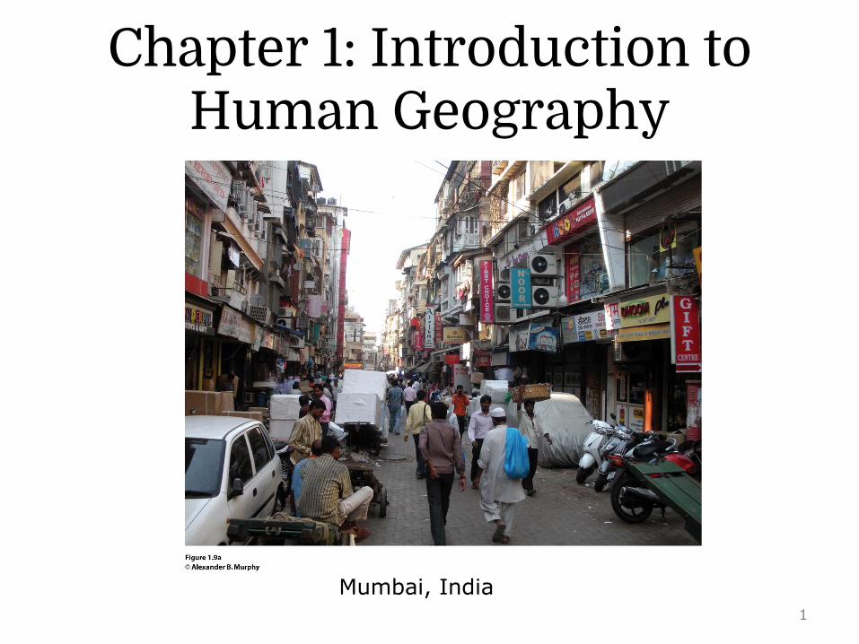
Chapter 1: Introduction to Human Geography
Mumbai, India1

Field Note: Awakening to World Hunger
“Dragging myself out of bed for a 9:00 A.M. lecture, Idecide I need to make a stop at Starbucks. “Grandecoffee of the day, please, and leave room for cream.”I rub my eyes and look at the sign to see where mycoffee was grown. Kenya. Ironically, I am about tolecture on Kenya’s coffee plantations. Just the wake-up call I need. When I visited Kenya in easternAfrica, I drove from Masai Mara to Kericho and Inoticed nearly all of the agricultural fields I could seewere planted with coffee or tea (Fig. 1.1). I also sawthe poor of Kenya, clearly hungry, living insubstandard housing. I questioned, “Why do farmersin Kenya grow coffee and tea when they could growfood to feed the hungry?” Trying to answer such aquestion sheds light on the complexities ofglobalization. In a globalized world, connections aremany and simple answers are few.”
Concept Caching: Kericho, Kenya
2
Key Question
What is human geography?
3

Human GeographyHuman geography focuses on:• How people make places• How we organize space and society• How we interact with each other• How we make sense of ourselves and others
What Is Human Geography?
4

• Advances in communication and transportation technologies are making places and people more interconnected.
• Economic globalization and the rapid diffusion of elements of popular culture, such as fashion and architecture, are making many people and places look more alike.
What Is Human Geography?
5

• Globalization: a set of processes that are increasing interactions, deepening relationships, and accelerating interdependence across national borders.
What Is Human Geography?
Concept Caching:Levi’s in Lucca, Italy
© Jon Malinowski
6

• Geographers employ the concept of scale to understand individual, local, regional, national, and global interrelationships.
• What happens at the global scale affects the local, but it also affects the individual, regional, and national. Similarly, the processes at these scales influence the global.
What Is Human Geography?
7

Imagine and describe the most remote placeon Earth you can think of 100 years ago. Now,describe how globalization has changed thatplace and how the people there continue toshape it and make it the place it is today.
8

Key Question
What are geographic questions?
9
Maps in the Time of Cholera Pandemics
• Medical geography: Mapping the distribution of a disease is the first step to finding its cause.
• Dr. John Snow, a noted anesthesiologist in London, mapped cases of cholera in London’s Soho District in 1854 and found a link to contaminated water.
What Are Geographic Questions?
10

Cholera:• An ancient disease associated with diarrhea
and dehydration• Was confined to India until 1816• Spread to China, Japan, East Africa, and
Mediterranean Europe in the first of several pandemics: worldwide outbreaks
• Second pandemic: 1826–1837: North America• Third pandemic: 1842–1862: England and
North America
What Are Geographic Questions?
11

• Cholera has not been defeated completely.
• We expect to find cholera in places that lack sanitary sewer systems and in places that are flood prone.
What Are Geographic Questions?
12
The Spatial Perspective
• Immanuel Kant: We need disciplines focused not only on particular phenomena (such as economics and sociology) but also on the perspectives of time (history) and space (geography).
• The five themes of geography• Cultural landscape
What Are Geographic Questions?
13

The Five Themes• The National Geographic Society introduced
the five themes of geography in 1986.• The five themes were derived from
geography’s spatial concerns.
What Are Geographic Questions?
14

First theme: Location• Highlights how the geographical position of
people and things on Earth’s surface affects what happens and why
• Helps to establish the context within which events and processes are situated
What Are Geographic Questions?
15

Second theme:Human-environment interactions• A spatial perspective invites consideration of
the relationship between humans and the physical world.
• Asking locational questions often means looking at the reciprocal relationship between humans and environments.
What Are Geographic Questions?
16

Third theme: Region• Features of the Earth’s surface tend to be
concentrated in particular areas, which we call regions.
• Understanding the regional geography of a place allows us to make sense of much of the information we have about places.
What Are Geographic Questions?
17

Fourth theme: Place• People develop a sense of place by infusing
a place with meaning and emotion.• We also develop perceptions of places
where we have never been through books, movies, stories, and pictures.
What Are Geographic Questions?
18

19

20

Fifth theme: Movement• Movement refers to the mobility of people,
goods, and ideas across the surface of the planet.
• Spatial interaction between places depends on:
• The distances among places• The accessibility of places• The transportation and communication
connectivity among places
What Are Geographic Questions?
21

Cultural Landscape• The visible imprint of human activity on the
landscape
What Are Geographic Questions?
22
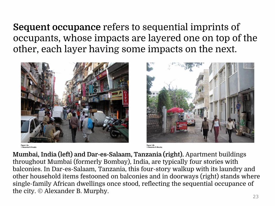
Sequent occupance refers to sequential imprints of occupants, whose impacts are layered one on top of the other, each layer having some impacts on the next.
Mumbai, India (left) and Dar-es-Salaam, Tanzania (right). Apartment buildings throughout Mumbai (formerly Bombay), India, are typically four stories with balconies. In Dar-es-Salaam, Tanzania, this four-story walkup with its laundry and other household items festooned on balconies and in doorways (right) stands where single-family African dwellings once stood, reflecting the sequential occupance of the city. © Alexander B. Murphy.
23
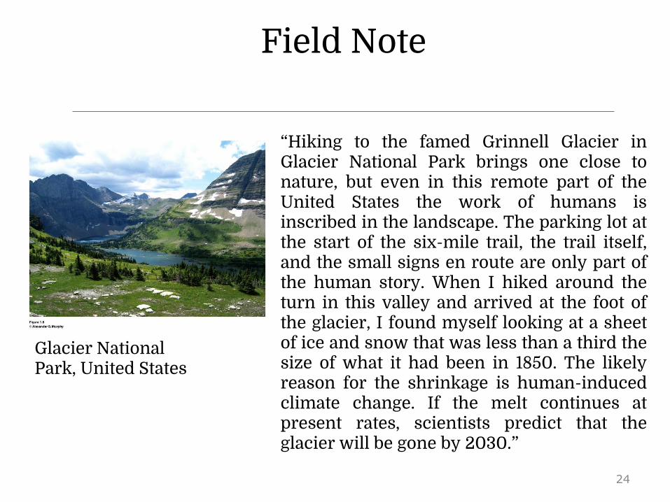
Field Note
Glacier National Park, United States
“Hiking to the famed Grinnell Glacier inGlacier National Park brings one close tonature, but even in this remote part of theUnited States the work of humans isinscribed in the landscape. The parking lot atthe start of the six-mile trail, the trail itself,and the small signs en route are only part ofthe human story. When I hiked around theturn in this valley and arrived at the foot ofthe glacier, I found myself looking at a sheetof ice and snow that was less than a third thesize of what it had been in 1850. The likelyreason for the shrinkage is human-inducedclimate change. If the melt continues atpresent rates, scientists predict that theglacier will be gone by 2030.”
24

Geographers who practice fieldwork keep their eyesopen to the world around them and through practicebecome adept at reading cultural landscapes. Take awalk around your campus or town and try readingthe cultural landscape. Choose one thing in thelandscape and ask yourself, “What is that, and whyis it there?” How might the existence of that thinginfluence the future development of theneighborhood? Take the time to find out theanswers!
25
Key Question
Why do geographers use maps, and what do maps tell us?
26

• Cartography: the art and science of making maps
• Reference maps: show locations of places and geographic features
• Thematic maps: tell stories, typically showing the degree of some attribute or the movement of a geographic phenomenon
Why Do Geographers Use Maps, and What Do Maps Tell Us?
27

• Reference maps focus on accuracy in showing the absolute locations of places, using a coordinate system that allows for the precise plotting of where on Earth something is.
• Satellite-based global positioning system (GPS) allows us to locate things on the surface of Earth with extraordinary accuracy.
• Click here to view a description of NAVSTAR, the system of orbiting satellites designed for Global Positioning.
Why Do Geographers Use Maps, and What Do Maps Tell Us?
28

• Thematic maps: tell stories showing the degree of some attribute or the movement of a geographic phenomenon.
• Relative location: describes the location of a place in relation to other human and physical features
Why Do Geographers Use Maps, and What Do Maps Tell Us?
29
• Absolute locations do not change.• Relative locations are constantly modified
and change over time.
Why Do Geographers Use Maps, and What Do Maps Tell Us?
30

Mental Maps• Mental maps are maps in our minds of
places we have been and places we have merely heard of.
• Activity spaces are those places we travel to routinely in our rounds of daily activity.
• Mental maps include terra incognita, unknown lands that are off limits.
Why Do Geographers Use Maps, and What Do Maps Tell Us?
31

Why Do Geographers Use Maps, and What Do Maps Tell Us?
32
Why Do Geographers Use Maps, and What Do Maps Tell Us?
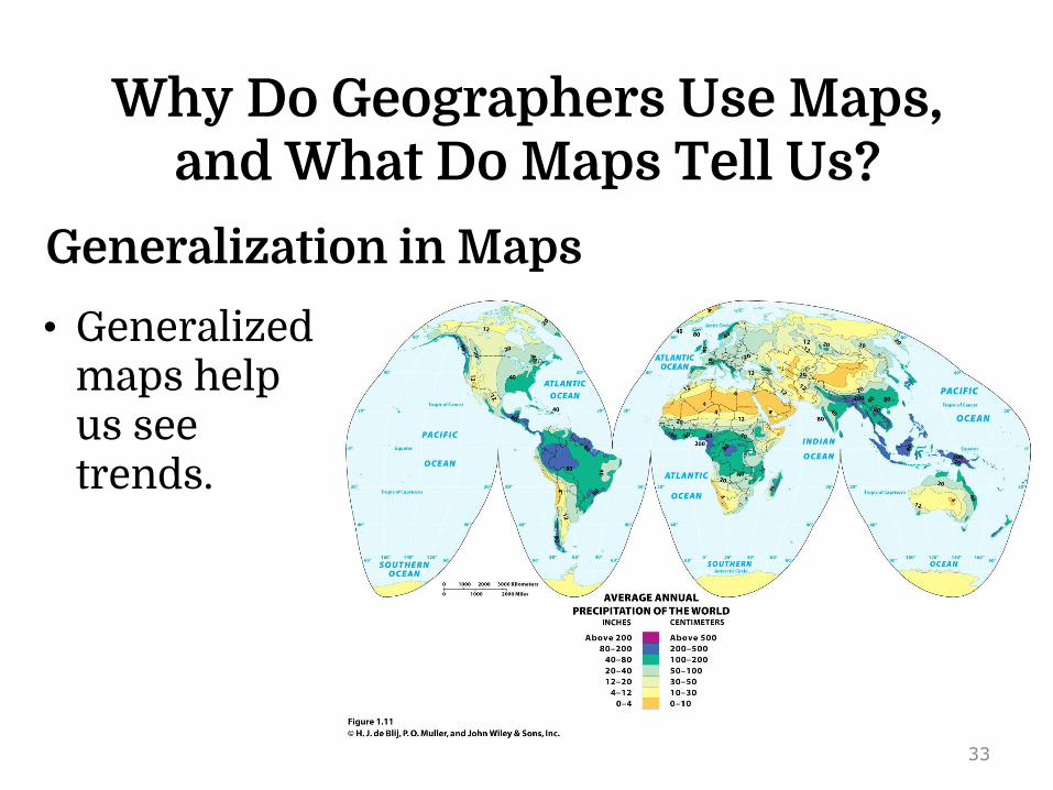
• Generalized maps help us see trends.
Generalization in Maps
33

Remote Sensing and GIS
• Geographers monitor Earth from a distance, using remote sensing technology that gathers data at a distance from Earth’s surface.
• Remotely sensed images can be incorporated in a map, and absolute locations can be studied over time by plotting change in remotely sensed imagery over time.
Why Do Geographers Use Maps, and What Do Maps Tell Us?
34

Figure 1.12 Concepcion, Chile. Satellite image of the cities of Concepcion and Hualpen, Chile hours after an 8.8 magnitude earthquake occurred in 2010. The damage to the city is not noticeable in this satellite image except for the smoke plume from an oil refinery in the lower left corner.
35

• GIS (geographic information systems) compare spatial data by creating digitized representations of the environment, combining layers of spatial data and creating maps in which patterns and processes are superimposed.
Remote Sensing and GIS
Why Do Geographers Use Maps, and What Do Maps Tell Us?
36

• Geographers use GIS to analyze data.
• Geographers use GIS in both human and physical geographic research.
Remote Sensing and GIS
Why Do Geographers Use Maps, and What Do Maps Tell Us?
Click here to view an explanation of GIS and how they are implemented.
37

• The amount of data digestible in a GIS, the power of the location analysis that can be undertaken on a computer platform, and the ease of analysis that is possible using GIS software applications allow geographers to answer complicated questions.
• Geographic information science (GISci) is an emerging research field concerned with studying development and use of geospatial concepts and techniques to examine geographic patterns and processes.
Remote Sensing and GIS
Why Do Geographers Use Maps, and What Do Maps Tell Us?
38

Guest Field Note
Maui, Hawaii
The diffusion of diseases carried by vectors, such as the Aedes mosquito that transmits dengue, is not solely a result of the environmental factors in a place. I use disease ecology to understand the ways in which environmental, social, and cultural factors interact to produce disease in a place.
Through a combination of fieldwork and geographic information systems (GIS) modeling, I studied the environmental habitat of the Aedes mosquito in Hawaii and the social and cultural factors that stimulated the outbreak of dengue in Hawaii. When I went into the field in Hawaii, I observed the diversity of the physical geography of Hawaii, from deserts to rainforests. I saw the specific local environments of the dengue outbreak area, and I examined the puddles in streams (Fig. 1.15A) in which the mosquitoes likely bred during the 2001–2002 dengue outbreak.
39

Figure 1.15B. Total annual precipitation Figure 1.15C. Average June Precipitation
Figure 1.15D. Average February minimum temperature
Figure 1.15E. Dengue potential areas
40

Key Question
Why are geographers concerned with scale and connectedness?
41

Scale has two meanings in geography:1. The distance on a map compared to the
distance on the Earth2. The spatial extent of something
Why Are Geographers Concerned with Scale and Connectedness?
42
• Geographers’ interest in the scale involving the spatial extent of something derives from the fact that phenomena found at one scale are usually influenced by what is happening at other scales.
• The scale of our research matters because we can make different observations at different scales.
Why Are Geographers Concerned with Scale and Connectedness?
43
• The scale at which we study a geographic phenomenon tells us what level of detail we can expect to see.
• Geographers’ concern with scale goes beyond an interest in the scale of individual phenomena to how processes operating at different scales influence one another.
• Geographer Victoria Lawson: Jumping Scale: Politically rescaling activities
Why Are Geographers Concerned with Scale and Connectedness?
44

Regions
• A formal region has a shared cultural or physical trait. Example: French-speaking region of Europe
• In geography, a region constitutes an area that shares similar characteristics.
Why Are Geographers Concerned with Scale and Connectedness?
© Barbara Weightman
45

• A functional region is defined by a particular set of activities or interactions that occur within it. Ex: the City of Chicago
• Perceptual regions are intellectual constructs designed to help us understand the nature and distribution of phenomena in human geography.
Why Are Geographers Concerned with Scale and Connectedness?
46
Concept Caching: Paris, France
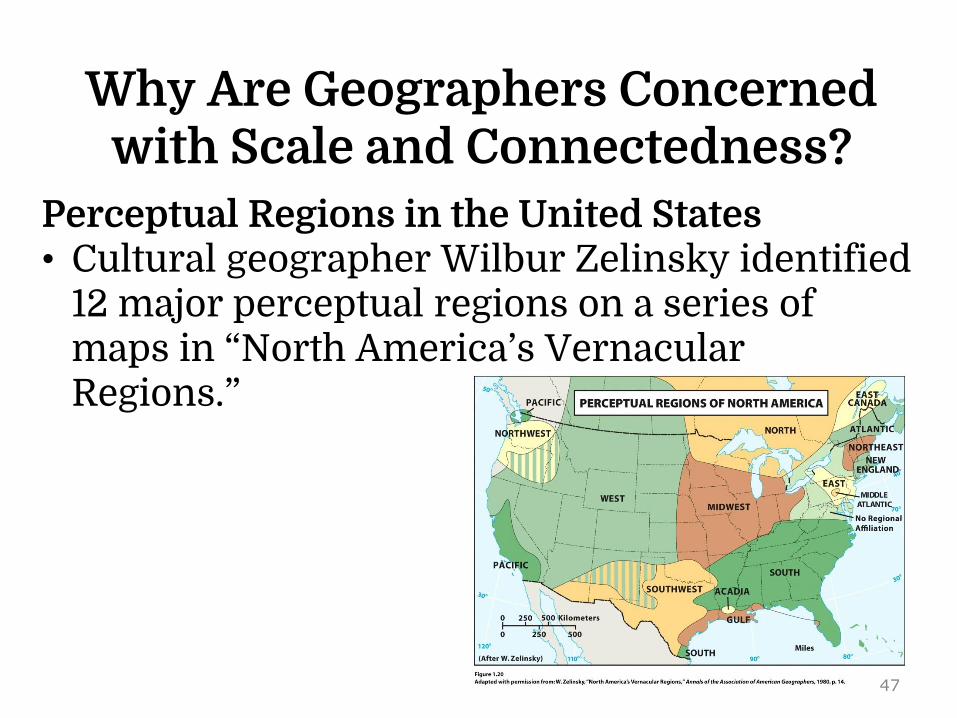
Perceptual Regions in the United States• Cultural geographer Wilbur Zelinsky identified
12 major perceptual regions on a series of maps in “North America’s Vernacular Regions.”
Why Are Geographers Concerned with Scale and Connectedness?
47

Guest Field Note “Located in a predominatelyAfrican American neighborhoodin Montgomery, Alabama, thestreet intersection of Jeff Davisand Rosa Parks is symbolic ofthe debates and disputes in theAmerican South over how thepast is to be commemorated onthe region’s landscape. The CivilWar and civil rights movementare the two most importantevents in the history of theregion.”
Montgomery, Alabama
48

Culture• Culture is an all-encompassing term that
identifies not only the whole tangible lifestyle of peoples but also their prevailing values and beliefs.
• It is closely identified with the discipline of anthropology.
• Cultural geographers identify a single attribute of a culture as a culture trait.
Why Are Geographers Concerned with Scale and Connectedness?
49

Culture• Culture complex: More than one culture may exhibit
a particular culture trait, but each consists of a discrete combination of traits.
• A cultural hearth is an area where cultural traits develop and from which cultural traits diffuse.
• When a cultural trait develops in more than one hearth without being influenced by its development elsewhere, each hearth operates as a case of independent invention.
Why Are Geographers Concerned with Scale and Connectedness?
50

Connectedness through Diffusion• Expansion diffusion: when an innovation or
idea develops in a hearth and remains strong there while also spreading outward.
• Contagious diffusion: a form of expansion diffusion in which nearly all adjacent individuals and places are affected. Ex: Silly Bandz
Why Are Geographers Concerned with Scale and Connectedness?
51
• Hierarchical diffusion is a pattern in which the main channel of diffusion is some segment of those who are susceptible to (or adopting) what is being diffused. Ex: Crocs footwear.
• Stimulus diffusion: Not all ideas can be readily and directly adopted by a receiving population; yet, these ideas can still have an impact.
Why Are Geographers Concerned with Scale and Connectedness?
52

53

Relocation Diffusion• Occurs most frequently through migration• Involves the actual movement of individuals
who have already adopted the idea or innovation, and who carry it to a new, perhaps distant, locale, where they proceed to disseminate it
Why Are Geographers Concerned with Scale and Connectedness?
54

Once you think about different types of diffusion, you willbe tempted to figure out what kinds of diffusion aretaking place for all sorts of goods, ideas, or diseases.Please remember that any good, idea, or disease candiffuse in more than one way. Choose a good, idea, ordisease as an example and describe how it diffused fromits hearth across the globe, referring to at least threedifferent types of diffusion.
55

Key Question
What are geographic concepts, and how are they used in
answering geographic questions?
56

• Geographic concepts: Examples: place, relative location, mental map, perceptual region, diffusion, cultural landscape.
• Geographers use fieldwork, remote sensing, GIS, GPS, and qualitative and quantitative techniques to explore linkages among people and places and to explain differences across people, places, scales, and times.
What Are Geographers Concepts, and How Are They Used in
Answering Geographic Questions?
57

Rejection of Environmental Determinism• Environmental determinism holds that human
behavior, individually and collectively, is strongly affected by, even controlled or determined by, the physical environment.
• Geographers argued that the natural environment merely serves to limit the range of choices available to a culture.
What Are Geographers Concepts, and How Are They Used in
Answering Geographic Questions?
58

Possibilism• Possibilism is the doctrine that the choices
that a society makes depend on what its members need and on what technology is available to them.
• Cultural ecology has been supplemented by interest in political ecology.
What Are Geographers Concepts, and How Are They Used in
Answering Geographic Questions?
59

Possibilism• Cultural ecology: an area of inquiry
concerned with culture as a system of adaptation to and alteration of environment
• Political ecology: an area of inquiry concerned with the environmental consequences of dominant political economic arrangements and understandings
What Are Geographers Concepts, and How Are They Used in
Answering Geographic Questions?
60

Today’s Human Geography• Encompasses many subdisciplines,
including political geography, economic geography, population geography, and urban geography.
• Human geography also encompasses cultural geography, which can be seen as a perspective on human geography as much as a component of it.
What Are Geographers Concepts, and How Are They Used in
Answering Geographic Questions?
61

Choose a geographic concept introduced in this chapter.Think about something that is of personal interest to you(music, literature, politics, science, sports), and considerhow whatever you have chosen could be studied from ageographical perspective. Think about space and location,landscape, and place. Write a geographic question thatcould be the foundation of a geographic study of the itemyou have chosen.
62

Additional ResourcesCareers in Geography
www.aag.orghttp://www.bls.gov/opub/ooq/2005/spring/art01.pdf
Geocachingwww.geocaching.org
Globalization and Geographywww.lut.ac.uk/gawc/rb/rb40.html
John Snow and His Work on Cholerahttp://www.ph.ucla.edu/epi/snow.htmlState of Food Insecurity in the World
www.fao.orgWorld Hungerwww.wfp.orgGoogle Earth
www.googleearth.com63