Embed Size (px)
Citation preview

Changing Land Use Mosaics of (Former) Shifting Cultivatorsin Watersheds of North Thailand
Dr. Plodprasop Suraswadi, Director General, Royal Forest Department, ThailandDr. David E. Thomas, Senior Policy Analyst, ICRAF Chiang Mai, ThailandDr. Komon Pragtong, Forest Research Office, Royal Forest Department, ThailandDr. Pornchai Preechapanya, Forest Research Office, Royal Forest Department, ThailandDr. Horst Weyerhauser, Seconded German Scientist, Chiang Mai University, Thailand
This paper has been submitted as a chapter in a book on the global CGIAR system-wideAlternatives to Slash-and-Burn (ASB) Initiative, being edited by Dr. Pedro Sanchez(ICRAF Director General and Chair of the Global ASB Consortium). The book is to bepublished by the American Society of Agronomy during late 2000.
The ASB research program in northern Thailand seeks to understand processes and dynamics
of land use change important in the mountainous mainland Southeast Asia (MMSEA) ecoregion, and
develop technologies and policies that can improve land use management in the region. MMSEA
includes the large region of hill and mountain terrain that joins the Himalayan mountains in southwest
China, and extends through northern portions of Myanmar, Thailand and Laos, to Vietnam in the east.
Several major river systems flow through or have headwaters in this region, long known for its diverse
ethnic composition and complex patterns of traditional land use that includes shifting cultivation. As
this region also includes most of what remains of mainland Southeast Asia’s rapidly dwindling forest
resources, it is the focus of increasing environmental concern related to water, biodiversity and climate
change at national and international levels.
Given strong and growing concern over water in these river systems, which supports major
lowland populations, and their ‘rice bowl’ production areas and urban-industrial centers, the ASB
program uses watershed units as a major component of its analytical framework. Moreover, particular
focus is on land use in upper tributaries, where many poor and often marginal minority communities
have benefited the least, and sometimes suffered from processes associated with the rapid economic
development that has helped shape the international image of Thailand and the region during recent
decades. We also seek to incorporate relevant lessons from the Asian economic crisis, as well as
constitutional and governance issues emerging in Thai society and the wider region.
This paper focuses on trends of change in mosaic patterns of land use in the northern Thailand
portion of MMSEA, with particular attention to changing land use practices of mountain minority
communities and their impact on environmental services. As one of the more recently established
ASB benchmark sites, much of the data on specific land use systems is still being analyzed for
comparison with other benchmark sites using the ASB framework.

2
Changing Land Use Patterns in Mountain Watersheds
The ASB Thailand research strategy began with review of policy concerns and issues believed
to be associated with changing mosaic patterns of land use in north Thailand, with emphasis on upper
watershed areas [Thomas 1996]. We have also reviewed previous and existing efforts to understand
and address these issues, and sought to identify strategic knowledge gaps, to provide the basis for
selection of an appropriate benchmark site and further program development. Findings from this
process are largely summarized in the following sections, including major characteristics of the 4,000
square kilometer Mae Chaem watershed, selected as the primary ASB benchmark site. Our secondary
focus has been on one ridge of the Mae Taeng watershed, where the Sam Mun Highland Development
Project was able to facilitate significant change in local land use patterns during 1987-94. This and
other pioneering pilot efforts seeking to improve livelihoods and environmental conditions provide
both the points of departure and initial direction for the ASB Thailand research program
Major forest policy concerns
As the vast majority of land in upper watersheds is officially classified as reserved or
protected forest, our first task has been to examine forest policy concerns that focus primarily on
deforestation and watershed deterioration.
Deforestation
Thailand entered its era of rapid economic growth in 1960 with the launching of its first
national 5-year economic and social development plan. While considerable economic development
has been achieved, one cost has been the loss of more than half of our natural forest resources,
resulting in growing concern about loss of biodiversity and contributions to climate change. Table 1
summarizes three aspects of overall land use change since 1960 at the national level and for the
northern region: 1) changes in proportions of land under forest, agriculture and other uses; 2) levels
of each type of area per capita as the population has grown; and 3) the proportion of the population
that has moved to metropolitan areas.
Although dramatic decreases in forest cover began later in northern Thailand than in much of
the rest of the country, major losses occurred at both levels during the 1970’s. Rates of loss appear to
have recently begun to decline, but percentage declines in the north are still above the national
average. Moreover, while most remaining forest is in the north, losses there are already greater than
most portions of the MMSEA eco-region. Types of deforestation found in northern Thailand may be
broken into three major components:
1. Conversion of forest. Initial conversion of forest after 1960 throughout Thailand was primarily
associated with expansion of land for agriculture, as seen in Table 1, both to feed the growing
population and for export crops to fuel the growing economy. Conversion to agriculture was

3
facilitated by heavy logging, and during the late 1970’s, agricultural expansion combined with
political and national security strategies to further encourage clearance of forests. As agriculture
began to expand into increasingly marginal sites, overall population growth rates began to decline, the
economy began structural adjustments emphasizing industrial and service sectors, and urban and
suburban growth began to accelerate, further land use conversion became increasingly associated with
cities, industry, housing, resorts, and more recently for land speculation. As Table 1 indicates,
farmland per capita appears to be slowly decreasing, while the overall proportion of farmland appears
to be stabilizing. Other non-forest land appears to be expanding roughly in proportion to overall
population growth. Some of these non-agricultural land uses, such as resorts and golf courses, can
TABLE 1. Land Use Change in Thailand and North Thailand, 1960-98
YearLand Cover1960 1970 1980 1990 1998
Proportion of total area (percent)
Forest Cover National 54.0 46.0 32.0 27.3 25.3
North 68.8 67.3 53.9 46.4 43.1
Farmland National 20.0 29.0 37.1 41.2 41.5
North 11.0 17.0 24.5 28.0 27.5
Other Non-forest National 26.0 25.0 30.9 31.5 33.2
North 20.2 15.7 21.6 25.6 29.4
Area per capita of total population (hectares)
Forest Cover National 1.06 0.65 0.35 0.25 0.21
North 2.04 1.44 0.95 0.72 0.60
Farmland National 0.39 0.41 0.41 0.38 0.35
North 0.33 0.36 0.43 0.43 0.38
Other Non-forest National 0.51 0.35 0.34 0.29 0.28
North 0.60 0.34 0.38 0.40 0.41
Proportion of total population (percent)
Urban Population National 12.5 14.9 17.6 17.7 18.4
North 6.4 5.8 7.0 7.6 7.4
Sources: Adapted from 1) Charuppat 1998 (Royal Forest Dept.); 2) Center for Agricultural Statistics 1994; 3) Center for Agricultural Information 1998; 4) Institute of Population Studies 2000

4
convert land directly from forest, while others displace agriculture at the periphery of urban or
industrial areas, and may thereby lead to further conversion of forest to agriculture. Note that
substantially more unregistered people actually live in urban areas than reflected in the official figures
in Table 1.
2. Logging of natural forest. Logging helped fuel economic growth initially, but the combination of
huge concession areas overlapping with protected forest areas and local communities, high official and
unofficial harvest rates, low replanting rates, settlement and cultivation of logged areas, and slow
expansion of plantation forests finally proved unsustainable [Pragtong 1990]. Although logging
concessions were stopped in 1989, illegal logging is still a problem in reserved forest and protected
areas. Large illegal operators make various efforts to conceal their operations, frequently including
the hiring of villagers to cut trees for their operations. Forest department policy now emphasizes
forest conservation rather than timber production, including strict enforcement of rules to address this
open frontier mentality.
3. Farmers in the Forest. Issues associated with this component are much more complex and
difficult. In the mountains of north Thailand various ethnic minorities have long lived as ‘farmers in
the forest’, as described in the landmark book of that name [Kunstadter 1978]. A web of sometimes
contested issues is associated with their land use practices, including opium production, shifting
cultivation, rural poverty, and the impact of their land use practices on protected forest areas and
environmental services. This component is the main focus of ASB in Thailand. The 1997 overall
distribution of mountain ethnic minority populations living in the midlands and highlands (above 600
m.a.s.l.) are indicated in Table 2, at both the national and northern region levels, as well as for Chiang
Mai province and the ASB benchmark site (Mae Chaem). In addition, Lowland Thais make up about
16 percent of the total population living above 600 m.a.s.l. at the national level, and about 11 percent
in the ASB benchmark site. While overall proportions of mountain minorities are quite low, they
frequently make up more than half of the population in upper watershed areas.
The grouping of communities into those with highland, midland and lowland traditions
correspond with the altitude zones within which they have been most prevalent, and the types of
agroecosystem management practices they have traditionally employed. Although such groupings are
based on traditional distinctions widely applicable across the MMSEA ecoregion, altitude zones are
approximate, geographic domains of ethnic groups overlap, and conditions change and traditions adapt
over time. Table 3 presents estimates from the ASB benchmark site indicating how ethnic groups now
distribute themselves among altitude zones, and resulting ethnic distributions within each zone. Note
that 27 percent of highland tradition populations (Hmong) are now located in midland and lowland
zones, whereas 42 percent of midland tradition populations (Karen) are located in the highland zone
(usually near its lower boundary), where they outnumber traditional highland groups by a factor of
four.

5
From an environmental point of view, the most important distinctions among traditional
groups relates to their agroecosystem management approaches. Particular attention has usually
focused on shifting cultivation, or ‘swidden’, components of their systems, where highland groups are
associated with ‘pioneer swidden’, midland groups with ‘established swidden’, and lowland groups
with ‘northern Thai swidden’ (T.C. Sheng 1979, unpublished report to FAO). There has never been a
Table 2. Mountain ethnic minority population above 600 m.a.s.l., 1997
National North Chiang Mai Mae ChaemHighland traditionsHmong 126,300 119,768 19,011 3,630
Lahu 85,845 84,262 32,583 -
Akha 56,616 56,157 5,486 -
Yao 48,357 42,561 353 -
Htin 38,823 40,302 - -
Lisu 33,365 31,040 13,201 431
Sub total 389,306 374,090 70,634 4,061
Midland traditionsKaren 353,574 310,909 111,667 29,197
Lua 17,637 16,225 5,473 1,451
Khamu 13,674 10,567 21 -
Mlabri 125 125 - -
Sub total 385,010 337,826 117,161 30,648
Mountain Minorities 774,316 711,916 187,795 34,709
- proportion of total: 100% 92% 24% 9%
Total Population 60,816,227 12,091,337 1,573,757 67,912
- mountain minorities: 1% 6% 12% 51%
Source: adapted from Hilltribe Welfare Division 1998
basis for official recognition of forest fallow fields as a component of agricultural land holdings, and
clearing of fields in a shifting cultivation system are officially viewed as forest destruction. Critics of
these official views claim that when a new field is cleared – especially under ‘established’ or rotational
swidden – an old field is returned to fallow, resulting in no net deforestation. While remote sensing
can provide estimates of the proportion of an area that is cleared of forest at a given point in time,

6
there is still a substantial range of issues and policy questions regarding the impact of changing
‘farmers in the forest’ practices on forest ecosystems.
TABLE 3. Distribution of Ethnic Groups in the ASB Site by Altitude Zone
Distribution of ethnic groups among zones(percent)
Population High peaks Highlands Midlands Lowlands total
Hmong/Lisu 6,192 - 73.19 11.51 15.29 100
Karen/Lua 42,900 - 41.88 47.46 10.66 100
Thai 18,820 - - 3.40 96.60 100
Overall 67,912 - 33.13 31.97 34.90
Ethnic composition of altitude zones(percent)
Population High peaks Highlands Midlands Lowlands
Hmong/Lisu 6,192 - 20.14 3.28 4.00
Karen/Lua 42,900 - 79.86 93.77 19.30
Thai 18,820 - - 2.94 76.70
Total 67,912 - 100 100 100
Source: unpublished ICRAF and Ministry of Interior data
Watershed Deterioration
There are three main aspects of these important issues that are high priorities for ASB-
Thailand:
1. Deteriorating Watershed Services. The northern mountains are the headlands of the Chao Phraya
river system that nourishes Thailand’s key ‘rice bowl’ production areas in the central plains, as well as
the vast urban-industrial complex around Bangkok. Concern about deterioration of mountain area
watershed services began in the 1960’s when a group of academics from the Kasetsart University
Faculty of Forestry began research at three small highland sub-catchments at Doi Pui in northern
Thailand. Findings through 1980 are summarized [Chunkao 1981], and a series of university bulletins
were produced, such as those on effects of clearing hill evergreen forest on soil organic matter
[Lapudomlert 1974], physical properties [Chunkao 1974], chemical properties [Santudgarn 1974], and
sediment [Aksornkoae 1977]. Subsequent research related to opium crop substitution is also
summarized [Chunkao 1983]. Whereas summary documents generally indicate impacts of shifting
cultivation are modest, compared to impacts on stream flow, erosion and water pollution associated
with permanent agricultural fields, road construction and human settlements, bulletins tend to make a

7
more negative assessment of shifting cultivation impacts. Several team members became influential in
shaping basic views – especially in downstream society – related to watershed policies and impacts of
land use in the mountains on watershed services. As environmental interest in society grows, various
of these issues are being further elaborated at a wider range of sites. Forest department researchers led
a team who summarized research findings in Thailand for the watershed component of a proposed
forest sector master plan [Royal Forest Dept., 1993]. An independent case study of water-related
economic issues in an upper tributary of the Ping river broadened analysis of upstream-downstream
issues, and identified several data gaps preventing adequate assessments of policy alternatives
[Vincent 1995] that have yet to be addressed [Kaosa-ard 2000, unpublished WRI report]. While a few
studies have begun comparing effects of practices by different ethnic groups, considerably more work
is required to assess various water use technologies, to assess shifting cultivation impacts on a full-
cycle basis, or to address effects of interactions and lateral flows among mosaic patches at larger
landscape levels. Since one of the most immediate policy concerns in the northern region focuses on
downstream impacts of upland land use on stream flow, reservoirs, and crop yields, such work is a
priority concern.
2. Growing Upstream-Downstream Conflict. Growing environmental awareness and concern with
nature, pollution and sustainability [Hirsch 1997], are converging with increasing demands for water
by agriculture, cities and industry, to increase focus of attention on land use in upper watersheds.
These trends are projected to continue to build in coming years. Moreover, increasing competition for
water resources among a growing range of stakeholders combines with shortages of key data and
limited access to existing knowledge, to fuel debate, conflict and confrontation that is frequently based
more on emotions than reason. Various ‘schools of thought’ are developing, some of which appear to
reject most all notions of ‘scientific’ analysis, while others cannot accept notions of ‘local knowledge’.
What appears to be urgently needed is a widely-acceptable and accessible set of criteria, indicators and
measurement tools, that are based on appropriate calibrations with science and local knowledge, for
empirical assessment and monitoring of watershed and related environmental services. Associated
institutions to manage disputes at various levels also need to be strengthened, along with information
and support services. Meanwhile, since action programs must proceed with less than ideal knowledge
and tools, we need to strengthen systematic learning from such experience to bring improvement to
action programs at each step along the way.
3. Relevance for the Larger Eco-Region. Although the impact of change may be greatest in north
Thailand, processes underlying this change are already in motion elsewhere in the larger MMSEA
Asia eco-region, which includes portions of the Hong (Red), Mekong, Salween, Irawaddy, Yangtze
and Xi Jiang (Pearl) river systems [Revenga 1998; CMU 1996; Kaosa-ard 1995]. As these issues and
processes are also important elsewhere, we hope linkages through the global ASB initiative can
facilitate even wider relevant exchange.

8
Complexities Underlying Forest Policy Issues
In order to more effectively address these types of forest policy concerns, we must develop a
more clear understanding of processes that underlie changing land use patterns, and forces that
determine directions and rates of change. Three major factors contributing to the complexity of these
processes in northern Thailand include: incentives and pressures for land use change, impacts on
traditional mountain land use systems, and the spatial distribution of land use change.
Incentives and Pressures for Land Use Change
The first factor contributing to the complexity of land use issues in northern Thailand is the
convergence of five types of pressures and incentives for change:
1. Demographic change. High population growth rates in mountain ethnic minority communities,
relative to lowland rates, have combined with migration from neighboring countries to increase land
pressure [Rerkasem 1994]. During recent decades, Thailand has been a safe haven and/or an
economic magnet for many people in neighboring countries. Since many ethnic minority communities
in the midlands and highlands are still being integrated into the regular Thai administration system,
they are only included in more recent demographic data. Estimates of mountain minority populations
living above 600 m.a.s.l. in 1997 [Hilltribe Welfare Division 1998] are compared with total
populations in Table 2. Compared with estimates from the same source in 1972 [Kunstadter 1978],
highland groups had an average increase of 10 percent per year, whereas midland groups averaged 2
percent in the north and 3 percent in Chiang Mai province. This compares to an average annual
growth rate of 2.0 percent for total populations in Chiang Mai and north Thailand during this 25 year
period. While some highland may not have been counted in 1972, rapid increase remains clear.
2. Commercial agriculture. Expansion and commercialization of agriculture has followed both from
opium crop replacement efforts in the highlands, and from expansion of lowland agro-industry up hill
slopes from valley bottoms [TDRI 1994]. Work in northern Thailand on replacement of opium with
intensive commercial crops was largely pioneered by projects under the patronage of H.M. the King,
followed by a range of publicly, privately and internationally supported projects in various northern
areas. While some highland production activities, from cabbages to barley, ginger and some fruit
crops, are now conducted through private channels, a range of Royal Project centers specializing in
fruits, vegetables or ornamentals have come together under the umbrella of the Royal Project
Foundation. Activities now even include marketing a range of products under their own Doi Kham
brand name. Lowland-focused Thai agro-industry has been expanding into mountain valley areas,
resulting in expansion of soybean, maize, potatoes, longan, mango, lychee and other crops, up slopes
into the midland zone. While these efforts often have the blessing of government rural development
and poverty reduction programs, investment requirements, risks and profitability have varied
substantially, often in relation to fluctuating environmental and economic conditions. Although a

9
small minority have been successful enough to move out of the lowest income categories, the vast
majority of people in mountain areas remain poor.
3. Government policies. Forest policy has brought forest reserves, national parks, wildlife sanctuaries,
and protected watershed forests, which preclude formal recognition of land use claims in most
mountain areas. In some areas, land has been degazetted from reserved or protected status when local
communities have demonstrated long term residency and met other requirements. The magnitude of
the impact of reserved and protected areas on populations living above 600 m.a.s.l. are indicated in
Table 4. Note that the ASB benchmark site (Mae Chaem) is well placed to study issues associated
with communities living within reserved forest, planned reserves and parks, and de-gazetted areas.
Table 4. Status of land occupied by populations above 600 m.a.s.l., 1997
Land category National North Chiang Mai Mae Chaem
Reserved forest 611,400 589,279 174,224 30,794
National parks 39,421 37,877 15,742 311
Wildlife Sanctuaries 40,600 30,900 6,755 -
No hunting areas 2,001 1,957 1,895 -
De-gazetted areas 283,878 250,104 46,689 3,309
Planned reserves 8,322 8,322 8,322 4,615
Military lands 5,500 - - -
Total 991,122 918,439 253,672 39,029
Source: adapted from Hilltribe Welfare Division, 1998
The perceived importance of watershed issues has prompted another set of policies directly
related to land use in mountainous areas of northern Thailand. A watershed classification system was
developed and implemented throughout the country, initially under the aegis of the National Research
Council, and subsequently under the Ministry of Science, Technology and Environment. Five
categories of watershed classes have been overlaid on 1:50,000 scale topographic maps, and a set of
restrictions on land use associated especially with categories 1 and 2 have official standing under a
resolution of the ministerial cabinet. The distribution of land among these categories at several nested
levels of resolution are indicated in Table 5.

10
While proportions of land in classes with severe restrictions appear modest at the national
level, this changes as one moves to increasingly smaller upstream units. Although only 25 percent of
the country is placed in class 1 and 2, the proportion doubles at levels of the northern region and major
basins like the Ping, and climbs to about 90 percent in the Mae Chaem watershed, a major tributary of
Table 5. Distribution of Land by Watershed Class at Nested Levels of Analysis
Distribution of land by watershed classification(percent)
Class 1 Class 2 class 3 class 4 class 5 water total
Thailand Overall 18.1 8.3 7.7 15.8 49.0 1.1 100
North Overall 32.6 15.0 10.8 9.5 31.8 0.3 100
Ping Basin 38.3 14.2 9.6 8.9 28.3 0.7 100
Mae Chaem Overall 63.9 25.0 8.7 1.8 0.7 - 100
(ASB site) High peaks 100.0 - - - - - 100
Highlands 82.6 14.5 2.9 0.0 - - 100
Midlands 54.7 32.4 10.2 2.7 - - 100
Lowlands 17.7 41.9 28.2 6.0 6.1 - 100
Sources: 1) Chunkeo, 1996; 2) ICRAF unpublished data
the Ping River. Thus, conditions at the ASB site are rather typical of conditions in upper tributaries.
Since downstream environmentalists and other interests are using these maps in calling for severe
restrictions and even relocation of communities out of mountain areas, related watershed policies need
considerable careful analysis and exploration of options. Other forest land zoning exercises associated
with specific policy initiatives have had various further effects on local communities and land use in
the north.
Rural poverty programs in the mountains have largely been conducted through the Public
Welfare Department, various special projects, or by missionaries [Renard 1988]. However, rural
development decision making, is now shifting to elected local governments under the 1997
constitution and associated reforms. Various new provisions, including a community forestry law, are
now being considered by Parliament. All government agencies, including the forest department, must
now reform their policies and programs to conform with the many new mandates involved.
Since mountain areas are also the focus of other concerns, including illegal logging, narcotics
and national security, the government has developed multi-agency development policies, plans and
projects specifically for highland and midland areas. While opium eradication programs have made

11
major progress, problems remain with illegal logging, illegal import of methamphetamine, and
spillover effects of armed conflict in neighboring countries.
4. Infrastructure & services. Programs for opium eradication and national security further increased
efforts to expand road infrastructure in mountain regions. In addition to their direct environmental
impact, roads have brought market access for alternative cash crop production to many remote areas,
as well as access for illicit logging and forest extraction operations. Expansion of services is another
dimension of public policy, including registration of minority communities, as well as education and
health services, electricity and media access, all of which help increase opportunities for integration of
these communities into national society.
5. Urban industrialization and tourism. Expansion of tourism, resorts and recreational facilities are
bringing new claims, pressures and opportunities to mountain areas [Dearden 1996]. Urbanization and
industrialization have also begun affecting various aspects of life and decision making in areas of the
north. These processes have encouraged land speculation in many areas, as perceptions of land shift
from a production input into a financial asset; substantial areas are now in limbo after the Asian
financial crisis.
Impacts on Traditional Mountain Land Use
The second factor adding complexity relates to how these forces affect ethnic groups and land
use within key altitude zones. As a conceptual baseline, Table 6 presents some of the basic features of
altitude zones that are important for understanding distribution of resources, people and activities in
northern Thailand and many parts of the MMSEA ecoregion.
TABLE 6. General Land Use Patterns before 1960 by Altitude Zone
Zone Altitude range Natural Forest Ethnic Groups Traditional Agriculture
m.a.s.l. (approx.)
High peaks > 1,800 Moist temperate(cloud forest)
-none- -none-
1,000 – 1,800 H’mong, Lisu,Akha, etc
Pioneer shifting cultivation(+/- opium)
Highlands
1,000 – 1,200
Hill evergreen& coniferous
Thai, Karen ‘jungle’ tea (in some areas)
Midlands 600 – 1,000 Mixed deciduous Lua, Karen Paddy (limited) +Rotational long fallowshifting cultivation

12
Lowlands < 600 Dry deciduous & swamp
Thai Paddy, gardens (+/- shortfallow shifting cultivation)
Source: ICRAF and Royal Forest Dept. staff
The complex natural ecology associated with mountain terrain in northern Thailand is
reflected in natural forest types, which are strongly associated with altitude, as modified by geology,
aspect, fire, and other factors. In combination with the ethnic complexity of the region, it becomes
apparent that past complex traditional patterns of land use in largely forested landscapes have reflected
both the ecological and cultural diversity of the region. Literature reviews of classic studies on the
range of traditional land use systems are included in research documents by Grandstaff [1976],
Kunstadter [1978] and various others. A recent study by Schmidt-Vogt [1999] includes an updated
bibliography.
Core categories of traditional systems have associated highland traditions with relatively
mobile villages and ‘pioneer’-type long cropping - very long ‘abandoned’ forest fallow that is really
only viable in areas where small populations have access to extensive areas. Midland traditions are
associated with more ‘established’ villages and systematic short cropping - long ‘rotational’ forest
fallow systems that often include paddy land where geography allows, and quite systematic
management of landscape compartments, including areas kept under permanent forest cover. Some
areas include ‘miang’ or ‘jungle tea’ production, where camellia sinensis L. is planted as an understory
tree in hill evergreen forest. Leaves are steamed and sold with or without fermentation, for chewing as
a traditional stimulant by people in the region. Livestock also graze in these systems. Lowland Thai
traditions have largely focused on irrigated paddies and home gardens, sometimes with supplemental
short cropping - short fallow cultivation on nearby lower slopes.
During recent decades, however, incentives and pressures for change have brought changing
mixtures of land use [Thong-Ngam 1996], with substantial loss of mature secondary forest. A basic
summary of some major land use trends and issues is presented in Table 7 by altitude zone.
TABLE 7. Current Land Use Trends and Issues by Altitude Zones
Zone Altitude range Land Use User issues Environment issues
m.a.s.l. (approx.)

13
High peaks > 1,800 -none- n.a. Die-back
1,000 – 1,800 Commercial horticulture,grasslands, (forestplantations)
Crop markets,land security
Deforestation,water use,pollution
Highland
1,000 – 1,200 ‘jungle’ tea (in some areas) Crop markets,land security
Less forest buffer
Midlands 600 – 1,000 Paddy (limited) +Shortened-rotationalshifting cultivation,permanent upland fields
Food security,land security,crop markets
Deforestation,water use,pollution
Lowlands < 600 Paddy, gardens, uplandfield crops, orchards
Crop markets,irrigation water,(land security)
Deforestation,water use,pollution
As a result of such trends, we now see changing land use mixtures in mosaic patterns of each
zone
1) Highlands. Pioneer shifting cultivation and opium have been largely replaced by commercial
vegetable production that is now pushing into the midlands [TDRI 1994]. There is growing
downstream concern about impacts on stream flow, erosion and pesticide pollution.
2) Lowlands. Expansion of field crops, and in some cases orchards, into forested watersheds above
paddies is now pushing into the middle zone from below.
3) Midlands. Pressure from population growth, expanding lowland and highland systems, and
government policy, has reduced land availability, often resulting in much shorter forest fallow cycles,
and some conversion to fixed fields. Even sacred groves in their landscapes are now threatened.
4) Overall. Recently, projects have begun promoting more trees in the landscape in all zones, with
primary emphasis on fruit trees and community forest. In addition to eliminating opium, many
projects now seek to establish or strengthen locally protected forest areas, control fire, and restrict
activity on steep slopes and watershed headlands. There is also renewed interest in ‘jungle tea’
complex agroforests in some lower areas of the highlands, which continue to endure and seem to help
protect at least nearby forest areas.
Spatial Distribution of Land Use Change
The third factor contributing complexity to these issues is that these influences, processes and
patterns of tradition and change are not evenly distributed across major landscape levels. Estimates of
the proportions of land in forest, agriculture and other non-forest categories at levels within which the
ASB-Thailand research site is nested are presented in Table 8. As one moves down the hierarchy from

14
nation to northern region to Mae Chaem watershed, for example, forest cover increases from 27 to 46
to 79 percent, while agriculture decreases from 41 to 28 to 1.5 percent. Within Mae Chaem, roughly
similar trends occur among altitude zones from valley bottoms to mountain peaks. One must be
cautious, however, in interpreting how such data represents midland and highland agricultural
systems. Agricultural land major lowland agricultural zones is associated with quite clearly
recognizable boundaries. In areas such as Mae Chaem, however, estimates from remote sensing
currently limit forest fallow agriculture to cropped clearings after the end of the rainy season –
harvested, uncropped and early fallow land are often seen as ‘other non-forest’, while older fallows are
considered forest. Considerably more work is needed to improve our ability to monitor and assess
traditional and transitional land use systems in these areas.
Another important level of variation occurs among units within watersheds at the level of the
ASB-Thailand site or larger. One useful way to disaggregate the 4,000 sq. km. Mae Chaem watershed
into sectors is to use administrative sub-district (tambon) boundaries. .There are 10 sub-districts that
cover about 90 percent of the watershed and define the domains of elected local government bodies
that are being up-graded under the 1997 national constitution, which includes provisions for local
TABLE 8. Nested Levels of Distribution of Land Cover and Resources per Capita, 1990
Proportion of total area(percent)
Total Forest Agriculture Non-forest
Thailand Overall 100 27.3 41.2 31.5
North Region Overall 100 46.4 28.0 25.6
Mae Chaem (ASB) Overall 100 79.4 1.5 19.0
High peaks 100 98.8 - 1.2
Highlands 100 81.5 0.4 18.1
Midlands 100 74.8 1.6 23.7
Lowlands 100 85.4 7.5 7.1
Sources: Adapted from 1) Charuppat 1998 (Royal Forest Dept.); 2) unpublished ICRAF data
TABLE 9. Sub-Districts in ASB Benchmark Watershed by Altitude Zone
Proportion of total area
percentMae Chaem
Sub-District
Area
hectaresPeaks Highlands Midlands Lowlands
Upland Features
Ban Chan 18,504 - 91.8 8.2 - hi-value horticulture

15
Chaem Luang 24,851 1.9 83.5 14.6 - med-SC, veg., (park)
Pang Hin Fon 24,167 - 75.0 25.0 - short-SC, veg., (park)
Mae Daet 16,453 - 69.5 30.5 - med-SC, veg., [park]
Mae Suk 68,200 - 59.3 37.6 3.0 short-SC, vegetables
Mae Na Chon 72,545 0.6 44.9 51.2 3.3 short-SC, veg., [park]
Ban Tub 40,647 - 35.8 53.2 11.0 short-SC, veg., (park)
Kong Khaek 36,918 0.2 18.0 60.6 21.3 fixed fields, park
Ta Pha 10,672 0.1 24.9 44.8 30.1 fixed fields, park
Chang Koeng 19,961 7.9 19.5 48.7 23.9 town, fixed fields, park
Total 332,917 0.8 50.5 41.3 7.4
Sources: Adapted from 1) unpublished Royal Forest Dept., ICRAF, and Care-Thailand data; 2) unpublished Ministry of Interior data
participation in natural resource management. Table 9 indicates the relative size of these sub-districts,
how their land is distributed among altitude zones, and a few major features of upland land use within
their domain. Note that general effects of changes in altitude zones are modified locally by such
factors as geology and geography, road access, projects and government programs. One current major
challenge is to understand how processes within and across altitude zones interact in influencing
change in mosaic patterns of land use, and the benefits and costs of this change for both local
communities and larger society.
Efforts to Adapt to Changing Conditions
In response to these influences, trends and patterns of change, various innovative farmers and
pilot projects have been seeking ways to improve livelihoods while reducing pressure on forest lands
and protected watersheds. Some of these are very local efforts by individual households or local
leaders, while others are facilitated or promoted by recent or on-going projects of various scales
conducted by government agencies or non-governmental organizations. ASB-Thailand seeks to learn
from, build on, and support such efforts. In addition to learning from the continuing efforts of the
Royal Project Foundation, several projects are providing useful insights regarding organized efforts to
influence patterns of land use change:
Sam Mun Project. One recent project particularly noteworthy in this regard is the 1987-94 Sam Mun
Highland Development Project (hereafter referred to as the Sam Mun Project), an inter-agency project
led by the Royal Forest Department in coordination with the Office of the Narcotics Control Board,
with funding assistance from the United Nations Drug Control Program and the Ford Foundation. The
2,000 sq km project area was located in midland and highland zones of a ridge of mountains beginning
northwest of Chiang Mai city and extending to the Myanmar border. This area, like ridges in the

16
ASB-Thailand benchmark watershed, was once an important opium production area, which in 1988
still totaled over 800 hectares. Although this was one of the last in a series of internationally-
supported projects meant to focus on opium crop substitution, it is generally recognized as the most
effective and the most integrated in its approach. Its Thai leadership made serious efforts to learn
from both the mistakes and successes of previous projects, and even academics usually very critical of
forestry policies and projects have recognized the value of their approach [Ganjanapan 1997, p. 208].
To paraphrase the words of a former project director, the Sam Mun Project focused on
developing and improving the capability of community organizations, so that they could be self reliant
in managing their communities, food resources and other natural resources (soil, water, forest) in a
manner that 1) is appropriate to their lifestyles and values; 2) ensures community stability; and 3)
develops their community and environment in response to both local needs and government policies,
including control of opium production. [Limchoowong 1994, p. 11] The project assumed that people
and forests can live in harmony, and emphasized food self-sufficiency, income generation, reduced
chemical usage, reduced swidden cultivation, forest protection, initiation of watershed management
networks, and tools for local land use planning. Many of the methods and tools pioneered by this
project, such as participatory land use planning [Tan-kim-yong 1994] and 3-dimensional village land
use models, are now being used and further adapted by subsequent projects in Thailand and
neighboring countries. In addition to some of the land use changes mentioned in following sections,
the project also assisted communities in gaining access to health and education services, citizenship,
and infrastructure improvements needed to implement their development plans. In terms of its major
objectives, areas under shifting cultivation were reduced by more than 80 percent, while total forest
are more than doubled [Tan-kim-yong 1994, p. 58]; Figure 1 provides data on areas planted to opium
in the project area, as verified by national and international drug agencies through remote sensing.
FIGURE 1. Opium Poppy reduction under the Sam Mun Highland Development Project

17
Queen Sirikit Reforestation Project (Suan Pah Sirikit). Building on previous smaller-scale efforts,
this interagency project in the Mae Chaem watershed has been conducted under the patronage of H.M.
the Queen of Thailand since 1996 [Suan Pah Sirikit Project 2000]. The Royal Forest Department has a
leading role in implementation through its 10 watershed management units in the area. The project
philosophy is that people can live in harmony with the forest through community participation in
conservation and forest resource development, collaboration among villagers and government
agencies in local land use planning, improving livelihoods and the quality of life in ways that protect
watershed headlands, and coordination of relevant government agencies to facilitate systematic
development. Initial work began in response to rapid deforestation after the end of a foreign funded
project in the late 1980’s, which despite some useful innovations was unable to have a lasting positive
impact on watershed management. The Suan Pah Sirikit project has built on promising innovations,
and adapted several participatory methods and tools used in the Sam Mun Project, along with
experience from various Royal Projects and other sources.
Care-Thailand Integrated Natural Resources Conservation Project. The Integrated Natural
Resources Conservation project sought to conserve watersheds in the northern provinces of Chiang
Mai (Mae Chaem district) and Mae Hong Son degraded by illegal logging, forest fires and expanding
farmlands. During 1994-99, the project worked with local communities to promote sustainable
management of agriculture and fragile watershed forests. Project components included agroforestry,
soil and water conservation, rice paddy and fish pond development and non-farm income generating
activities. Project partners included the Royal Forest Department, other agencies in the Ministry of
Agriculture and Cooperatives, and the local government administration. They also worked closely
with Chiang Mai University to study and implement approaches for promoting community
opium
0
200
400
600
800
1000
Year
hect
ares
opium 744 806.88 458.24 322.4 283.2 254.88 83.04
1988 1989 1990 1991 1992 1993 1994
Source: Limchoowong 1994

18
participation in sustainable land use. The project provided valuable assistance during establishment of
the ASB-Thailand benchmark site, and we have developed a partnership for implementation of their
follow-on project being launched during 2000.
Other Projects. ASB-Thailand is also seeking to learn from the experience of a range of other
previous projects, including the Thai-German Highland Development Project, the Thai-Australian
Highland Development Project, the Thai-USAID Mae Chaem Development Project, and others.
Promising innovations to improve land use technologies
Drawing on experience of these projects, including numerous examples of ideas and
adaptations that came directly from innovative local farmers, we can see that most promising technical
approaches to improving livelihoods while reducing pressure on forest and/or watersheds have focused
either on decreasing the area required for upland rice and/or increasing trees in the landscape.
Meeting food security needs, while decreasing the area required for upland rice
Increased pressure to reduce the total amount of land used to produce upland rice under
shifting cultivation has induced three basic types of response to altering approaches for meeting basic
food security needs. All three are based on the expectation that intensified agricultural production will
reduce pressure on forest components in the landscape.
1. Increasing paddy fields. Preliminary findings indicate that expansion of irrigated paddy land in
areas where terrain and water resources are suitable, often in small pocket areas, can allow
communities to greatly reduce land requirements for upland rice production. Given the greater
productivity per unit area of paddy rice, reductions can be by a factor of 10 to 20, depending on paddy
yields and the length of the swidden fallow cycle. The response of farmers to efforts by the Sam Mun
Project to help them overcome existing barriers to paddy expansion are indicated in Figure 1.
Preliminary data from portions of the ASB benchmark indicate that profitability to farmer
producers of paddy rice is much greater than upland rice as it is currently being produced, largely due
to increased weeding labor requirements and decreased productivity of upland fields [Ekasingh, B,
unpublished data]. Additional data from some other sectors of Mae Chaem appear to verify these
findings [V. Punyawadee, unpublished data]. Initial experiments have also been launched using new
rice varieties to explore the possibility and potential impacts of double cropping of rice in midland
paddies. Since some question expansion of paddy as using too much water [Kaosa-ard 2000,
unpublished World Resources Institute report], water use is also being measured.

19
FIGURE 2. Rice Paddy Expansion under the Sam Mun Highland Development Project
2. Permanent field upland rice. In some areas under the Suan Pah Sirikit Project where terrain does
not allow sufficient expansion of paddy to meet local subsistence needs, innovative farmers developed
a crop rotation system for permanent upland fields, in which upland rice is rotated to soybeans every
third year. This has allowed them to reduce the total area required for upland rice production by a
factor of 3 to 7, and also provides some cash income from the soybeans. Land taken out of upland rice
is converted to permanent community-protected forest. Farmers using this system for 10 years claim
they have not experienced yield reductions. Due to poor soybean prices since the Asian economic
crisis, many farmers are now switching to maize for their rotation crop, and it is not yet clear whether
or how this will affect the sustainability of crop yields. ASB-Thailand is conducting the first known
agronomic and economic studies of this system.
3. Permanent fields of high-value commercial vegetables. This approach involves meeting food
security needs through generation of cash income, primarily in highland areas where the climate
supports production of temperate zone vegetables. One prime example of this approach is found in the
Ban Chan sub-district of Mae Chaem where a project of the Royal Project Foundation has been
operating for many years [Royal Project Staff 1999]. Many villagers are producing high value
specialty vegetables that are largely marketed through the Royal Project. These intensive systems use
much less land than shifting cultivation, but while profits can be quite high, various crops suffer from
periodic severe damage due to pests or climatic variation, or from sometimes drastic fluctuations in
prices. Many villagers are responding to these factors by diversifying their production into two or
more crops [Ekasingh, B, unpublished data], including some fruit trees. Another stabilizing factor in
this area has been expansion of paddy land, which was possible in some fairly large areas of gentle
Source: Limchoowong 1994
0
100
200
300
400
500
600
Year
hect
ares
paddy 177.12 270.08 423.84 500.64 507.2 507.2 507.2
1988 1989 1990 1991 1992 1993 1994

20
terrain. Traditional forms of shifting cultivation are now quite rare in this area, and locally-recognized
land ownership has largely been privatized to households. Several ASB studies are being conducted in
this area on current technologies and historical their development. Diversified cash crop approaches
are also found in other areas of the watershed [V. Punyawadee, unpublished data].
Although highland cabbage production also involves this strategy, it has come under strong
criticism on environmental grounds due to planting on steep slopes and heavy application of
pesticides. Some projects are trying to introduce conservation farming practices and alternative pest
management technologies into these systems, but with little success so far. Our partner pilot projects
in Mae Chaem are continuing to explore alternatives.
Improving local livelihoods, while increasing trees in the landscape
There have generally been three major directions of efforts to increase trees in midland and
highland landscapes.
1. Simple agroforestry. This approach has primarily centered on planting of fruit trees in agricultural
fields, following approaches pioneered in the Royal Project. In highland zones, primary focus is on
temperate zone fruits, such as Chinese apricot, plums, pears, persimmons, and others. In midland
zones emphasis shifts more to sub-tropicals, such as litchee. Results of Sam Mun Project efforts to
encourage fruit tree production are indicated by data in Figure 3 on expansion of planted area. This
data actually understates the full impact, since many trees were also planted around houses, along field
boundaries, or in other ways that did not facilitate calculation of area planted. Further planting has
continued after the end of the project.
A preliminary ASB study of fruit tree agroforestry in Sam Mun Project areas [Withrow-Robinson
1998], found a substantial range of strategies and planting configurations deserving further analysis.
2. Complex agroforests. The primary example of an indigenous complex agroforest in northern
Thailand is the ‘miang’ or ‘jungle tea’ plantations embedded in hill evergreen forest. As mentioned
earlier, this system continues to endure despite concern that its market may be disappearing as young
generations stop the practice of chewing the leaves. The Sam Mun Project encountered some success
in helping Karen producers get out of debt cycles linked to buyers in the market, allowing them to
obtain higher prices and profits. Moreover, prices for ‘miang’ tea appear to have recovered from low
levels of 10 years ago, and many producers now claim their biggest problems are sources of hired
labor and fuelwood required to process the tea. One forestry officer formerly working on the Sam
Mun Project has conducted substantial research on the practices involved [Preechapanya 1996].
FIGURE 3. Fruit Tree Expansion under the Sam Mun Highland Development Project
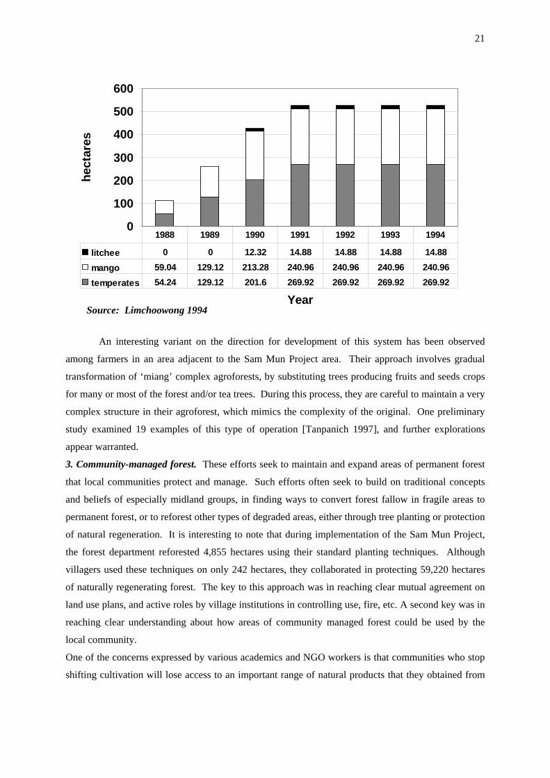
21
An interesting variant on the direction for development of this system has been observed
among farmers in an area adjacent to the Sam Mun Project area. Their approach involves gradual
transformation of ‘miang’ complex agroforests, by substituting trees producing fruits and seeds crops
for many or most of the forest and/or tea trees. During this process, they are careful to maintain a very
complex structure in their agroforest, which mimics the complexity of the original. One preliminary
study examined 19 examples of this type of operation [Tanpanich 1997], and further explorations
appear warranted.
3. Community-managed forest. These efforts seek to maintain and expand areas of permanent forest
that local communities protect and manage. Such efforts often seek to build on traditional concepts
and beliefs of especially midland groups, in finding ways to convert forest fallow in fragile areas to
permanent forest, or to reforest other types of degraded areas, either through tree planting or protection
of natural regeneration. It is interesting to note that during implementation of the Sam Mun Project,
the forest department reforested 4,855 hectares using their standard planting techniques. Although
villagers used these techniques on only 242 hectares, they collaborated in protecting 59,220 hectares
of naturally regenerating forest. The key to this approach was in reaching clear mutual agreement on
land use plans, and active roles by village institutions in controlling use, fire, etc. A second key was in
reaching clear understanding about how areas of community managed forest could be used by the
local community.
One of the concerns expressed by various academics and NGO workers is that communities who stop
shifting cultivation will lose access to an important range of natural products that they obtained from
0
100
200
300
400
500
600
Year
hect
ares
litchee 0 0 12.32 14.88 14.88 14.88 14.88
mango 59.04 129.12 213.28 240.96 240.96 240.96 240.96
temperates 54.24 129.12 201.6 269.92 269.92 269.92 269.92
1988 1989 1990 1991 1992 1993 1994
Source: Limchoowong 1994

22
forest fallow fields during intermediate stages of regeneration. This is yet another area where existing
data is very poor or absent, and further study is urgently needed.
Promising institutional changes and pilot project innovations.
While these changes in technologies can help shift proportions among components within land
use mosaics, there are also important institutional developments. Three major examples include:
1) Land Use Planning. Pilot experiments have shown it is possible to reach mutually-acceptable land
use agreements among villagers and agency officials using participatory methods. Pioneering efforts
under the Sam Mun Project developed what is now a widely accepted approach known as
‘participatory land use planning’ (PLP). In the words of its chief architect: “Participatory land use
planning can be defined as an operational tool or process which creates conditions of frequent
communication and analytical discussions, hence strengthening local organization by generating
common understandings and shared rights and responsibilities among project partners, who carry out
activities that lead to the solving of local forest management problems and other related community
problems” [Tan-kim-yong 1994, p. 6]. The conceptual framework of PLP is conflict resolution
applied to issues of natural resource management and development, and cannot be understood simply
as a method of land use planning. The ability to manage land use comes out of basic changes in the
roles of the stakeholders, with changes occurring as parties come to understand each others’ positions.
Essential to this concept is open access to information on all sides, involvement of a third party, and
presence of long-term community workers. The end goal is to help upland villagers become active
participants in watershed forest protection rather than the unwilling subjects of government control.
Various tools were explored to help facilitate this process and document mutual agreements
that were reached. Particularly useful tools include scale contour maps and scale 3-dimensional
models of the local landscape, which served both as a centerpiece for discussions and negotiations,
and as a clear and accessible record of land use zones established through mutual agreement.
Once basic agreements were reached, villagers articulated their own sets of rules, penalties for
violators, and mechanisms for enforcement. Penalties often included fines substantially higher than
those imposed by lowland law, and communities subsequently proved their willingness and ability to
enforce their rules. And on occasions when violators were outsiders who challenged their rules and
rights to enforce them, local leaders sought assistance from project staff or local authorities.
Variations of this approach and its tools are being further adapted and refined by various next-
generation projects, including those conducted by ASB pilot project partners in Mae Chaem. If these
efforts can provide a basis for land security, a major obstacle will be removed [Shinawatra 1994].
2) Watershed Management Networks. Projects have also experimented with local, multi-village, and
usually multi-ethnic group, watershed management networks to coordinate land use management
across larger sub-watershed landscapes. Building on earlier work, the Sam Mun Project facilitated
establishment of watershed networks, and encouraged them to formulate their own rules, penalties and

23
enforcement mechanisms. The approach was basically an extension of the PLP process to the wider
sub-catchment level, involving communities already familiar with PLP at the village level. With
increased levels of upstream-downstream conflict now being encountered in many areas, various
projects and organizations are promoting watershed management networks, again including those
conducted by our partner pilot projects in Mae Chaem. One recent study indicates they have
considerable potential for continuing after the end of the projects that help facilitate their
establishment [Kaosa-ard 2000, unpublished WRI report].
3) Constitutional and Legal Reform. Under the 1997 constitution and related legal reforms,
opportunities are emerging that may allow arrangements such as those being formulated and mapped
using participatory land use planning to gain formal recognition. Examples include constitutional
provision for local participation in natural resource management, laws and programs to upgrade and
strengthen elected local governments, and community forestry legislation now under consideration by
Parliament (but still opposed by some environmental interests). Yet a range of questions regarding
how to implement such changes remain unresolved, including how to strengthen the still embryonic
sub-district governments frequently found in poor mountain ethnic minority areas, as well as how
agencies such as the forest department can best interact with the thousands of local government bodies
involved. ASB partner pilot projects in Mae Chaem are among those seeking effective ways to
address these issues.
What is ASB-Thailand adding to these efforts?
As we have seen, land use in northern Thailand is in a period of stress and transition.
Although there have been many negative impacts, and conflict is growing among various stakeholders
and segments of society, there is also a growing body of experience that suggests promising
approaches for improving directions and rates of change. Yet, there are numerous major gaps in the
knowledge, methods and tools required to further develop these approaches, and effectively implement
them on a broad scale across a complex range of conditions. The Royal Forest Department has given
a mandate to ASB Thailand to assist the department and other key organizations in addressing these
needs and challenges.
Northern Mountain Region Agroforestry Systems Research and Development Project
In order to facilitate collaboration under ASB-Thailand, the Royal Forest Department has
officially established the ‘Northern Mountain Area Agroforestry Systems Research and Development
Project’. This is an open-ended project with a national steering committee and working-level
administration arrangements. The project interfaces with and facilitates interdisciplinary, multi-
institutional research by the ASB-Thailand Consortium in subject areas of mutual interest in Thailand,
as well as collaboration with international research and information exchange at eco-region, Southeast
Asia and global levels. Our approach seeks to build on existing knowledge and experience, and
24
strengthen ongoing research and development efforts, by identifying and filling strategic gaps in
research and pilot project testing required to improve policies and expand adoption of promising
approaches. Key partners in the Mae Chaem watershed include the Suan Pah Sirikit Project and the
new Collaborative Natural Resources Management Project being launched by Care-Thailand and the
Raks Thai Foundation. Appropriate linkages will also continue to be maintained or established with
other relevant programs or research projects active in the area. There are five areas where we expect
ASB-Thailand consortium to make major contributions:
Measuring and predicting costs, benefits and trade-offs of component land use practices.
One of the key weaknesses of pilot efforts to improve land use technologies has been the lack
of quantitative data on their impact on either local livelihoods or environmental services (watershed
services, biodiversity, climate change), on trade-offs between these factors, or on their prospects for
longer-term sustainability. Yet, this information is critical for formulating and justifying changes in
forest land policies required for their widespread adoption and sustainability. Thus, the first stage of
ASB-Thailand activity is focusing much effort on filling cells of the ASB ‘linkages matrix’ for
component land use practices in north Thailand. Data from initial field work is now being analyzed,
and will be supplemented by continuing and additional studies to further assess complexities and
variation encountered during initial studies, as well as potential new practices such as double-cropped
midland paddy or drip irrigation to replace sprinklers now used in some areas.
Scaling-up to real-world landscapes.
The second major area of activity is directed toward scaling-up these analyses to the level of
landscapes actually found in mountain areas of north Thailand, which relates directly to the ASB
Phase 3 agenda. In addition to combining properties of mosaic pattern components, landscape-level
interactions and emergent properties also need to be studied to assess overall impacts of mosaic land
use patterns. One study of two villages in the Sam Mun Project, for example, found that while
villagers perceive substantial improvement in forest components of their landscape over the last
decade, water and wild animals have become more scarce, and they still have questions about their
food and economic security in the future (Kaosa-ard 2000, unpublished WRI report).
Expanding on earlier pioneering work [Ekasingh 1996], studies in several sub-watersheds of
the ASB site with different mosaic patterns have already been established. One of the next major tasks
will be to identify suitable criteria for assessing livelihood and environmental impacts, as well as site
qualities and potential ‘carrying capacities’ of major types of mosaic land use patterns. These criteria
need to be associated with standards that accurately reflect management goals, and indicators that can
be used to assess current status and progress toward meeting those goals. During this process, we also
seek to understand conditions, constraints, markets, services, institutions and policies that influence
establishment and maintenance of major mosaic land use patterns. Development of a geographic

25
information system for the ASB-Thailand benchmark watershed is already quite advanced, and further
analyses will require linking this system with analytical models and field verification of their
outcomes. We plan to apply these models in assessing impacts of alternative policy scenarios.
Improving technology for local land use planning, watershed networks and local governance.
The third major area of activity is to develop and test improved technology to support local
land use planning, watershed management networks, and associated functions by local institutions and
government agencies. Particular emphasis is to be placed on: a) Criteria for use in negotiating,
establishing and monitoring localized land use agreements developed through participatory land use
planning processes; b) Simple, widely-accepted tools that can be used at local levels to measure land
use impact criteria, helping to resolve local disputes and document local conditions; c) Information
systems for monitoring compliance and providing transparency and accountability in enforcing land
use agreements, as well as helping to monitor the overall status of livelihood development and
environmental conditions. Pilot efforts have already begun to develop a simplified GIS node in Mae
Chaem to help link mapping conducted through participatory land use planning with our GIS system
in Chiang Mai, and to test approaches for both providing support to local planning processes, and for
establishing systems to help increase transparency and accountability of local land use agreements in
upper watershed areas.
Providing technical support for scaling up
The fourth major area will be to provide technical support for formulation and implementation
of larger-scale pilot activities to test ASB findings beyond the benchmark watershed site, in
collaboration with the Royal Forest Department and other implementing organizations. We fully
anticipate that the knowledge and experience gained through collaboration in ASB will be a significant
contribution to forest department efforts to improve the design, implementation and assessment of
appropriate policies and approaches for program and project improvement.
International research collaboration and information exchange
The final major area is to facilitate and support meaningful exchange and collaboration with
organizations and programs conducting related work in neighboring countries of MMSEA, as well as
in other ASB ecoregions around the world. Our vision is to help strengthen Thailand’s ability to
function as a peer-to-peer node, both contributing to and benefiting from the emerging global web of
scientific infrastructure aimed at addressing rural poverty, land use and environmental issues. The
Royal Forest Department is working closely with ICRAF and ASB-Thailand in further developing and
strengthening specific partnerships and activities to accomplish this goal.

26
Conclusion
Land use in upper tributary watersheds in northern Thailand is in a period of transition.
Traditional land use management practices resulted in a complex pattern of fixed and shifting
cultivation components embedded in a forest matrix, reflecting both the ecological and cultural
diversity of these areas. Due to a range of influences converging on the region, these largely officially
unrecognized traditional systems are under stress, land use patterns are changing, and many
communities are among the poorest in the nation. There is also growing concern in downstream
society about the implications of these changes for their own livelihood systems and for the overall
environment. While some pilot development projects are demonstrating the potential effectiveness of
participatory approaches to improved land use management in these areas, there is still inadequate
knowledge to assess the feasibility and implications of efforts to scale-up these approaches, or
mechanisms to monitor and assess their longer-term impact and effectiveness over large areas. ASB
Thailand is seeking to address these issues.
References
Aksornkoae, S. Boonyawat, S., Dhanmanonda, P. 1977. Plant Succession in Relation to Sediment indifferent Areas after Shifting Cultivation at Doi Pui, Chiangmai. Kog-ma WatershedResearch Bulletin No. 31. Faculty of Forestry, Kasetsart University, Bangkok, Thailand [inThai]
Center for Agricultural Statistics. 1994. Land Use for Agriculture. Agricultural Statistics Publication449. Office of Agricultural Economics, Ministry of Agriculture and Cooperatives, Bangkok,Thailand. [in Thai]
Center for Agricultural Information. 1998. Agricultural Statistics of Thailand, Crop Year 1996/97.Agricultural Statistics Publication 18/1998. Office of Agricultural Economics, Ministry ofAgriculture and Cooperatives, Bangkok, Thailand.
Charuppat, T. 1998. Forest Situation of Thailand in the Past 37 Years (1961-1998). Forest ResearchOffice, Royal Forest Department, Bangkok, Thailand. [in Thai]
Chunkao, K. 1996. Principles of Watershed Management. Kasetsart University, Bangkok, Thailand.[in Thai]
Chunkao, K. 1983. Final Report: Research on Hydrological Evaluation of Land Use Factors Relatedto Water Yields in the Highlands as a Basis for Selecting Substitute Crops for Opium Poppy,1980-83. Highland Agriculture Project. Kasetsart University, Bangkok, Thailand.
Chunkao, K., Tangtham, N., Boonyawat, S., Niyom, W. 1981. Watershed Management Research onMountainous Land, 15-Year Tentative Report, 1966-80. Department of Conservation, Facultyof Forestry. Kasetsart University, Bangkok, Thailand. [in Thai]
Chunkao, K., Santudgarn, P., Tangtham, N. 1974. Effects of Shifting Cultivation on some PhysicalProperties of Hill Evergreen Forest Soils. Kog-ma Watershed Research Station Bulletin No.19. Faculty of Forestry, Kasetsart University, Bangkok, Thailand. [in Thai]
CMU. 1996. Montane Mainland Southeast Asia in Transition. Proceedings of a Workshop heldduring 12-16 November 1995. Chiang Mai University, Chiang Mai, Thailand.
Dearden, P. 1996. ‘Trekking in northern Thailand: Impact distribution and evolution over time’. p.204-225. In: Parnwell, M. (ed.). Uneven Development in Thailand. Avebury, AshgatePublishing Ltd., Aldershot, England.

27
Ekasingh, M., Shinawatra, B., Onpraphai, T., Promburom, P., Sangchyoswat, C. 1996. ‘Role ofSpatial Information in Assessing Resources of Highland Communities in Northern Thailand’.p. 402-425. In: CMU. 1996. Montane Mainland Southeast Asia in Transition. Chiang MaiUniversity, Chiang Mai, Thailand.
Ganjanapan, A. 1997. The Politics of Environment in Northern Thailand: Ethnicity and highlanddevelopment programs. p. 202-222. In: Hirsch, P. (ed.) Seeing Forests for Trees:Environment and Environmentalism in Thailand. Silkworm Books, Chiang Mai, Thailand.
Grandstaff, T. 1976. Swidden Society in North Thailand: A diachronic perspective emphasizingresource relationships. Ph.D. diss. University of Hawaii, Honolulu, Hawaii.
Hilltribe Welfare Division. 1998. Highland Communities within 20 Provinces of Thailand, 1997.Technical Reports Vol. 536: 101/1998. Public Welfare Department, Ministry of Labor andSocial Welfare, Bangkok, Thailand [in Thai]
Hirsch, P. (ed.). 1997. Seeing Forests for Trees: Environment and Environmentalism in Thailand.Silkworm Books, Chiang Mai, Thailand.
Institute of Population Studies. 2000. Thailand demographic data. [Online]. Available athttp://www.chula.ac.th/institute/IPS/popdata.htm (verified 14 April 2000). Institute ofPopulation Studies, Chulalongkorn University, Bangkok, Thailand.
Kaosa-ard, M. 1996. Valuation of Natural Resources and Environmental Degradation: A first steptoward conflict resolution. p. 290-287. In: CMU. Montane Mainland Southeast Asia inTransition. Chiang Mai University, Chiang Mai, Thailand.
Kaosa-ard, M, Pednekar, S., Christensen, S., Aksornwong, K., Rala, A.. 1995. Natural ResourcesManagement in Mainland Southeast Asia. Thailand Development Research Institute,Bangkok, Thailand.
Kunstadter, P., Chapman, E., Sabhasri, S. (eds.). 1978. Farmers in the Forest: Economic developmentand marginal agriculture in Northern Thailand. East-West Center Press, Honolulu, Hawaii.
Lapudomlert, P., Santadkarn, P., Chunkao, K. 1974. Changes in Organic Matter after different Periodof Clearing at Doi Pui Hill Evergreen Forest, Chiangmai. Kog-ma Watershed ResearchBulletin No. 18. Faculty of Forestry, Kasetsart University, Bangkok, Thailand. [in Thai]
Limchoowong. S. 1994. Final Report of the Sam Mun Highland Development Project, 1987-1994.Project AD/THAI 86/334-335. United Nations International Drug Control Program, Bangkok,Thailand.
Prachoom, S., Chunkao, K., Tangtham, N. 1974. Deterioration of some Chemical Properties of Soilsafter Clearing of Hill Evergreen Forest. Kog-ma Watershed Research Bulletin No. 20.Faculty of Forestry, Kasetsart University, Bangkok, Thailand. [in Thai]
Pragtong, K., Thomas, D. 1990. ‘Evolving Systems in Thailand’ In: Poffenberger, M. (ed.), Keepersof the Forest: Land Management Alternatives in Southeast Asia. Kumarian Press, WestHartford, Connecticut.
Preechapanya, P. 1996. Indigenous Ecological Knowledge about the Sustainability of Tea Gardens inthe Hill Evergreen Forest of Northern Thailand. Ph.D. diss. University of Wales, Bangor,Wales.
Renard, R., Bhandhachat, P., Robert, G., Roongruangsee, M., Sarobol, S., Prachadetsuwat, N. 1988.Changes in the Northern Thai Hills: An examination of the impact of hill tribe developmentwork, 1957-1987. Research Report 42. Research and Development Center, Payap University,Chiang Mai, Thailand.
Rerkasem, K. Rerkasem, B. 1994. Shifting Cultivation in Thailand: Its current situation anddynamics in the context of highland development. IIED Forestry and Land Use Series No. 4.International Institute for Environment and Development, London, England.
Royal Forest Department. 1993. Thai Forestry Sector Master Plan, Volume 5: Subsectoral Plan forPeople and Forestry Environment. Royal Forest Department, Bangkok, Thailand.
Royal Project Staff. 1999. Annual Implementation Report, 1999. Wat Chan Development Center ofthe Royal Project. Royal Project Foundation, Chiang Mai, Thailand. [in Thai]

28
Schmidt-Vogt, D. 1999. Swidden Farming and Fallow Vegetation in Northern Thailand.Geoecological Research Vol. 8. Franz Steiner Verlag, Stuttgart, Germany.
Shinawatra, B. 1994. “Property Rights, Institutions, and Access to Resources: Impacts on sustainableintensification in northern Thailand”. Agricultural Economics Report 14. Multiple CroppingCentre, Chiang Mai University, Chiang Mai, Thailand.
Suan Pah Sirikit Project. 2000. Summary of Results of Project Implementation during Fiscal Year1999. Suan Pah Sirikit Project, Watershed Conservation Division, Royal Forest Department,Chiang Mai, Thailand. [in Thai]
Tan-kim-yong, U., Limchoowong, S., Gillogly, K. 1994. Participatory Land Use Planning: A methodof implementing natural resource management. Sam Mun Highland Development Project.Watershed Conservation Division, Royal Forest Department, Bangkok, Thailand.
TDRI. 1994. Assessment of Sustainable Highland Agricultural Systems. TDRI Natural Resources andEnvironment Program. The Thailand Development Research Institute, Bangkok, Thailand.
Thomas, D. 1996. “Opportunities and Limitations for Agroforestry Systems in the Highlands of NorthThailand”; p. 126-160. In: Highland Farming: Soil and the Future? Proceedings of a forumDecember 21-22, 1995. MJU - K. U. Leuven Soil Fertility Conservation Project, Mae JoUniversity, Chiang Mai, Thailand.
Thong-ngam, C., Shinawatra, B., Healy, S., Trebuil, G. 1996. ‘Farmer’s Resource Management andDecision-Making in the Context of Changes in the Thai Highlands’. p. 462-487. In: CMU. 1996.Montane Mainland Southeast Asia in Transition. Chiang Mai University, Chiang Mai,Thailand..
Vincent, J., Kaosa-ard, M., Worachai, L. 1995. The Economics of Watershed Management: A CaseStudy of Mae Taeng. Thailand Development Research Institute, Bangkok, Thailand.
Withrow-Robinson, B., D. Hibbs, P. Gypmantasiri, D. Thomas. (1998). “A preliminary classification offruit-based agro-forestry in a highland area of northern Thailand”. Agroforestry Systems 42 (2):pp. 195-205.