Embed Size (px)
DESCRIPTION
Penerbangan
Citation preview

General Information
Location: Singapore SgpIATA Code: SINLat/Long: N01° 21.55' E103° 59.36'Elevation: 22 ft
Airport Use: PublicMagnetic Variation: 0.2°E
Fuel Types: Jet A-1Repair Types: Major Airframe, Major EngineCustoms: YesAirport Type: IFRLanding Fee: NoControl Tower: YesJet Start Unit: NoLLWS Alert: YesBeacon: Yes
Sunrise: 2302 ZSunset: 1110 Z,
Runway Information
Runway: 02CLength x Width: 13123 ft x 197 ftSurface Type: bituTDZ-Elev: 15 ftLighting: Edge, ALS, Centerline, REILStopway: 197 ft
Runway: 02LLength x Width: 13123 ft x 197 ftSurface Type: bituTDZ-Elev: 22 ftLighting: Edge, ALS, Centerline, REIL, TDZStopway: 197 ft
Runway: 20CLength x Width: 13123 ft x 197 ftSurface Type: bituTDZ-Elev: 15 ftLighting: Edge, ALS, Centerline, REIL, TDZStopway: 197 ft
Runway: 20RLength x Width: 13123 ft x 197 ftSurface Type: bituTDZ-Elev: 14 ft
Lighting: Edge, ALS, Centerline, REILDisplaced Threshold: 2428 ftStopway: 197 ft
Communication Information
ATIS 128.6 Singapore Tower 118.25 Singapore Tower 118.6 Singapore Ground Control 124.3 Singapore Ground Control 121.725 Singapore Ground Control 121.85 Changi Ramp/Taxi Control 121.9 Singapore Clearance Delivery 121.65 Singapore Pre-Taxi Clearance 121.65 Singapore Approach Control 124.6 Secondary Singapore Approach Control 120.3 Singapore Arrival Control 119.3 Singapore Radar 124.05 Arrival Service
General Information
Location: Singapore SgpIATA Code: SINLat/Long: N01° 21.55' E103° 59.36'Elevation: 22 ft
Airport Use: PublicMagnetic Variation: 0.2°E
Fuel Types: Jet A-1Repair Types: Major Airframe, Major EngineCustoms: YesAirport Type: IFRLanding Fee: NoControl Tower: YesJet Start Unit: NoLLWS Alert: YesBeacon: Yes
Sunrise: 2302 ZSunset: 1110 Z,
Runway Information
Runway: 02CLength x Width: 13123 ft x 197 ftSurface Type: bituTDZ-Elev: 15 ftLighting: Edge, ALS, Centerline, REILStopway: 197 ft
Runway: 02LLength x Width: 13123 ft x 197 ftSurface Type: bituTDZ-Elev: 22 ftLighting: Edge, ALS, Centerline, REIL, TDZStopway: 197 ft
Runway: 20CLength x Width: 13123 ft x 197 ftSurface Type: bituTDZ-Elev: 15 ftLighting: Edge, ALS, Centerline, REIL, TDZStopway: 197 ft
Runway: 20RLength x Width: 13123 ft x 197 ftSurface Type: bituTDZ-Elev: 14 ft
Airport Information For WSSSPrinted on 10 Apr 2014Page 1(c) JEPPESEN SANDERSON, INC., 2014, ALL RIGHTS RESERVED
jep=JEPPESEN
JeppView for Windows

General Information
Location: Singapore SgpIATA Code: SINLat/Long: N01° 21.55' E103° 59.36'Elevation: 22 ft
Airport Use: PublicMagnetic Variation: 0.2°E
Fuel Types: Jet A-1Repair Types: Major Airframe, Major EngineCustoms: YesAirport Type: IFRLanding Fee: NoControl Tower: YesJet Start Unit: NoLLWS Alert: YesBeacon: Yes
Sunrise: 2302 ZSunset: 1110 Z,
Runway Information
Runway: 02CLength x Width: 13123 ft x 197 ftSurface Type: bituTDZ-Elev: 15 ftLighting: Edge, ALS, Centerline, REILStopway: 197 ft
Runway: 02LLength x Width: 13123 ft x 197 ftSurface Type: bituTDZ-Elev: 22 ftLighting: Edge, ALS, Centerline, REIL, TDZStopway: 197 ft
Runway: 20CLength x Width: 13123 ft x 197 ftSurface Type: bituTDZ-Elev: 15 ftLighting: Edge, ALS, Centerline, REIL, TDZStopway: 197 ft
Runway: 20RLength x Width: 13123 ft x 197 ftSurface Type: bituTDZ-Elev: 14 ft
Lighting: Edge, ALS, Centerline, REILDisplaced Threshold: 2428 ftStopway: 197 ft
Communication Information
ATIS 128.6 Singapore Tower 118.25 Singapore Tower 118.6 Singapore Ground Control 124.3 Singapore Ground Control 121.725 Singapore Ground Control 121.85 Changi Ramp/Taxi Control 121.9 Singapore Clearance Delivery 121.65 Singapore Pre-Taxi Clearance 121.65 Singapore Approach Control 124.6 Secondary Singapore Approach Control 120.3 Singapore Arrival Control 119.3 Singapore Radar 124.05 Arrival Service
Airport Information For WSSSPrinted on 10 Apr 2014Page 2(c) JEPPESEN SANDERSON, INC., 2014, ALL RIGHTS RESERVED
jep=JEPPESEN
JeppView for Windows

JEPPESENWSSS/SIN10-1PCHANGI 16 MAR 12
SINGAPORE, SINGAPORE
FLIGHT AND GROUND PROCEDURES1. LOW VISIBILITY PROCEDURES (LVP) FOR CATEGORY II ILS OPERATIONS
1.1 INTRODUCTION1.1.1 Category II ILS approaches will be made available at Singapore Changi
except during thunderstorms.
1.2 AUTHORIZATION FOR CATEGORY II ILS APPROACHES 1.2.1 Operators who wish to conduct Category II ILS operations at Singapore
Changi Airport are required to submit the following documents to the Airworthiness/Flight Operations Division of the Civil Aviation Authority of Singapore at least one month before the commencement of the operations:
the State of Registry/Operator of the operators:a) Authorization for Category II ILS operations by the relevant authority of
b) Operators' minima for Category II ILS operations; andc) Operators' method of verifying its pilots' Category II qualification and
1.3 CATEGORY II ILS RUNWAYS1.3.1 At Singapore Changi Airport, Category II ILS approaches are available only
on RWY 02L and RWY 20C, which are also equipped with precision approachCategory II lighting system. When required, pilots making Category II ILSapproaches to Singapore Changi Airport should refer to the procedures inthe Instrument Approach Charts WSSS AD 2-101 to WSSS AD 2-119 andthe Precision Approach Terrain Charts for RWY 02L and RWY 20C at WSSSAD 2-43 and WSSS AD 2-45 respectively.
1.4 INITIATION OF CATEGORY II ILS OPERATIONS1.4.1 Preparations will be made to implement LVP for Category II ILS operations
at Singapore Changi Airport during prolonged period of low visibility,
1.4.2 Availability of the Category II ILS approaches will be made known throughNOTAM and ATIS broadcasts as well as air traffic control radiocommunications.
1.4.3 During LVP operations, aircraft will not be cleared for Category II ILS
II requirements. Aircraft will not be cleared for landing if the Touchdown Zone RVR is unserviceable.
1.5 ILS SENSITIVE AREAS1.5.1 Upon landing, pilots shall report to Changi Tower once the aircraft has
cleared the runway and has passed the ILS sensitive areas demarcated by alternate yellow and green lights along the centerlines of Rapid ExitTaxiways and Cross Taxiways.
1.6 TERMINATION OF LVP FOR CATEGORY II ILS OPERATIONS1.6.1 LVP for Category II ILS operations will be terminated when RVR has
well as air traffic control radio communications.operations will be made known through NOTAM and ATIS broadcasts as
2.1 RUNWAY-IN-USE2.1.1 The runway-in-use (Departure/Arrival) is selected by Aerodrome Control
as the optimum for general purposes and to maximize runway utilization.
approach if any of the ILS or approach/runway lights fall below Category
If the assigned runway is unsuitable for a particular operation, the pilotcan obtain permission from ATC to use another runway but shouldanticipate delay.
except during thunderstorms, when the RVR drops below 2625' (800m).
improved above 2625' (800m). Termination of LVP for Category II ILS
Airport to authorized flights during prolonged periods of low visibility,
currency.
2. RUNWAY UTILIZATION
2.2.1 To maximize runway utilization and minimize runway occupancy time,departing aircraft when in receipt of line up clearance must inform ATC ifgreater wake vortex separation will be required behind the proceedingaircraft than that laid down in PANS ATM Doc 4444, else are required tocommence take-off roll as soon as take-off clearance is issued by ATC.Failure to do so may result in additional delay.
Departures text revised. | JEPPESEN, 2011, 2012. ALL RIGHTS RESERVED.
2.2 DEPARTURES - WAKE VORTEX SEPARATION
CHANGES:
.AIRPORT.BRIEFING.

JEPPESENWSSS/SIN10-1P1CHANGI 16 MAR 12
SINGAPORE, SINGAPORE
2.3 CLEARANCE FOR IMMEDIATE TAKE-OFF2.3.1 A pilot receiving the ATC instruction 'cleared for immediate take-off' is
required to act as follows:(a) if waiting clear of the runway, taxi immediately on to it and begin
take-off run immediately without stopping the aircraft;(b) if already lined-up on the runway, take-off without delay;(c) if unable to comply with the instruction, inform ATC immediately.
multiple Rapid Exit Taxiways (RETs). Pilots should vacate via the first2.4.2 To ensure minimum Runway Occupancy Time (ROT), each runway has
by ATC.available RET corresponding to operational requirements, or as instructed
2.4.3 Aircraft vacating the runway-in-use should not stop on the exit taxiwayuntil the entire aircraft has passed the runway holding point.
2.5 LAND AFTER PROCEDURES2.5.1 Normally, only one aircraft is permitted to land or take-off on the
runway-in-use at any one time. However, when the traffic sequence is two successive landing aircraft, the second aircraft may be allowed to landbefore the first aircraft has cleared the runway-in-use provided:(a) the runway is long enough;(b) during daylight hours;(c) the second aircraft will be able to see the first aircraft clearly and
continuously until it is clear of the runway;(d) the second aircraft has been warned.
2.5.2 ATC will provide this warning in the landing clearance as shown in para 2.7.2.5.3 Responsibility for ensuring adequate separation between the two aircraft
rests with the pilot of the second aircraft.2.6 SPECIAL LANDING PROCEDURES
2.6.1 Special landing procedures may be in force at Singapore Changi Airport inconditions shown as follows:(a) When the runway-in-use is temporarily occupied by other traffic,
landing clearance may be issued to an arriving aircraft provided that
the following separation distances will exist:i) Landing following landing - The preceding landing aircraft will be
at the time the aircraft crosses the threshold of the runway-in-use
ii) Landing following departure - The departing aircraft will be
2.6.2 These procedures will be used only under the following conditions:(a) during daylight hours;(b) visibility of at least 5km;(c) cloud ceiling of 1,500ft in the departure/missed approach area;
be able to observe continuously the relevant traffic;(d) ATC is satisfied that the pilot of the next arriving aircraft will
tailwind, windshear, turbulence, etc);(e) no unfavourable surface wind conditions (including significant
no evidence that the braking action may be adversely affected.(f) when the runway is dry and free of all precipitants such that there is
2.7 PHRASEOLOGY2.7.1 When issuing a landing clearance following the application of these
(Designator) cleared to land....(call sign)...after the landing / departing...(Aircraft Type) Runway...
instructions:procedures, ATC will issue the second aircraft with the following
the threshold of the runway-in-use.clear of the runway-in-use or will be at least 8202' (2500m) from
airborne and at least 8202' (2500m) from the threshold of the
from the threshold of the runway-in-use.runway-in-use, or if not airborne, will be at least 8202' (2500m)
2.4 ARRIVALS - MINIMUM RUNWAY OCCUPANCY TIME2.4.1 Arriving aircraft upon landing are reminded that it is imperative to vacate
the runway as quickly as practicable to enable ATC to apply minimum
2.4.4 Between 0830 - 1030 daily estimated delays of 15 minutes can be expectedfor arrivals into Changi Airport.
| JEPPESEN, 2011, 2012. ALL RIGHTS RESERVED.Arrivals text revised.
spacing on final approach and minimize the occurrence of "go-arounds".
CHANGES:
.AIRPORT.BRIEFING.

WSSS/SIN10-1P2
JEPPESEN
CHANGI 14 MAR 14SINGAPORE, SINGAPORE
3.1 In VMC during daylight hours, if total radio communication failure occurs to an aircraft bound for Singapore Changi Airport, the pilot shall maintain VMC to land at the most suitable airfield and report to the appropriate air trafficcontrol unit by the most expeditious means.
shall:3.2 For IFR flights to Singapore Changi Airport, aircraft experiencing radio failure
Singapore ATC, or3.2.1 Proceed according to the last acknowledged clearance received from
Singapore ATC:3.2.2 If no specific instructions or clearance has been received from
thereafter the appropriate transition and STAR for Rwy 02L/02C to SAMKO Holding Area (SHA) except for the following STARS: LAVAX 1A and PASPU 1A shall proceed to SHA after SANAT.
a) Maintain the last assigned altitude or flight level and proceed via airways
b) Commence descent from SHA at or as close as possible to the ETA as
land on Rwy 02L/02C.
indicated on the flight plan.c) Carry out the appropriate instrument approach procedure from SHA to
3.2.3 If unable to effect a landing on:a) Rwy 02L
Carry out missed approach procedure to AKOMA (PU R-356/20DME). Leave AKOMA at 4,000' to NYLON Holding Area (NHA) and execute the appropriate instrument procedure from NHA to land on Rwy 20R or Rwy 20C, as appropriate.
b) Rwy 02CCarry out missed approach procedure to NYLON Holding Area (NHA) and execute the appropriate instrument procedure from NHA to land on Rwy 20R or Rwy 20C, as appropriate.
c) Rwy 20RCarry out missed approach procedure to SAMKO Holding Area (SHA) and execute the appropriate instrument procedure from SHA to land on Rwy 02L or Rwy 02C, as appropriate.
d) Rwy 20C
Carry out missed approach procedure to EXOMO (VTK R-158/22DME). Leave EXOMO at 4,000' to SAMKO Holding Area (SHA) and execute the appropriate instrument procedure from SHA to land on Rwy 02L or Rwy 02C, as appropriate.
4. IDENTIFICATION OF RUNWAY-IN-USE
4.1 ATC will switch on the appropriate approach lights and the ILS serving the runway-in-use to assist the pilot in its identification. If the approach lights for the runway-in-use are sighted but the ILS frequency is not received, the pilot shall assume that the ILS is inoperative and shall proceed to land on the runway on which the approach lights have been sighted.
4.2 If unable to land within 30 minutes of EAT or ETA, if no EAT has been received
5. TOTAL RADIO FAILURE - SPECIAL PROCEDURES - SINGAPORE CHANGI AP - DEPARTURES
5.1 When an aircraft which has been cleared by ATC to an intermediate level experiences total radio communication failure immediately after departure from Singapore Changi Airport and it is deemed unsafe for it to continue to its destination, the pilot will set the aircraft transponder to Mode A/C Code 7600 and adhere to the procedures below.
ARRIVALS
and acknowledged, proceed to cross SAMKO Holding Area (SHA) at 4,000' then
FL 290 if Soekarno-Hatta is the nominated alternate or otherwise proceed at via A457 at FL200 if Kuala Lumpur is the nominated alternate or via B470 at
the planned flight level to other nominated alternate.
3. TOTAL RADIO FAILURE - SPECIAL PROCEDURES - SINGAPORE CHANGI AP -
None. | JEPPESEN, 2013, 2014. ALL RIGHTS RESERVED.CHANGES:
.AIRPORT.BRIEFING.

WSSS/SIN10-1P3
JEPPESEN
CHANGI 14 MAR 14SINGAPORE, SINGAPORE
a) Proceed straight ahead to NYLON Holding Area (NHA) climbing to the last assigned altitude. At NHA, climb/descend to maintain 7,000'.
b) Hold at NHA for 4 minutes and leave NHA on track 203^. At 10 DME north of VTK, turn left for HOSBA Holding Area (HHA) to jettison fuel,maintaining 7,000'.
c) After fuel jettison, proceed to SAMKO Holding Area (SHA) via AWY G580 and SINJON DVOR. Maintain 7,000'. At SHA descend for an instrument approach on Rwy 02L/02C. Identify the runway-in-use in accordance with
a) Proceed straight ahead to SAMKO Holding Area (SHA) climbing to the last assigned altitude. At SHA climb/descend to maintain 7,000'.
5.3 When radio communication failure occurs immediately after the aircraft has departed on Rwy 20R/20C, the pilot shall proceed according to the following procedures:
c) After fuel jettison, proceed to NHA via Airway W401. Maintain 7,000'. On crossing VTK 042R turn right to intercept VTK 023R. At NHA descend to carry out an instrument approach on Rwy 20R/20C.
5.4 ATC action is based on the assumption that the aircraft will take a minimum of 10 min to jettison fuel. An aircraft therefore should not leave earlier than 10 min after arrival at HOSBA Holding Area even if fuel jettison is completed at a shorter time of if jettisoning is not necessary or possible unless circumstances require an immediate return.
5.5 Alternatively, aircraft may jettison fuel between HOSBA and point 90 NM from SJ DVOR/DME on airway G580.
paragraph 4 on 10-1P2.
5.2 When radio communication failure occurs immediately after the aircraft has departed on Rwy 02L/02C, the pilot shall proceed according to the following procedures:
b) Hold at SHA for 4 minutes. Leave SHA for HOSBA Holding Area (HHA) via SJ DVOR and Airway G580 to jettison fuel, maintaining 7,000'.
6. RNAV (GNSS) SID/STAR OPERATIONS
6.1 For RNAV (GNSS) SIDs and STARs operations, the aircraft shall be GNSS-equipped and the navigation systems shall meet ICAO RNP-1 standard of
Precision Area Navigation (P-RNAV).accuracy, or equivalent, such as JAA TGL 10 or FAA AC 90-96A Apendix 2 -
Paragraph 6. | JEPPESEN, 2013, 2014. ALL RIGHTS RESERVED.CHANGES:
.AIRPORT.BRIEFING.

1. Introduction
CHANGES:
WSSS/SINCHANGI
SINGAPORE, SINGAPORE.RNAV.STAR.
CONTINUOUS DESCENT OPERATION (CDO) FOR ARRIVALS
2. Conditions for conducting a CDO
3. Requirements for individual flights
4. Preparations for CDO
5. CDO Execution
C-D-O" "Request
| JEPPESEN, 2011, 2013. ALL RIGHTS RESERVED.
FIR entry point RWY STAR Transition
02L
20R
PASPU 1K
PASPU 1LVEPLI
MELAS02L
20R
PASPU 1K
PASPU 1LMABAL
20R
02L LAVAX 1K
LAVAX 1LTOMAN
02L
20R LAVAX 1L
LAVAX 1KOBDOS
SURGA02L LAVAX 1K
20R LAVAX 1LSURGA
PARDI02L REMES 1K
REMES 1L20R
TAROSBOBAG 1K02L
20R BOBAG 1L
ESPOB, IPRIX,
IGARI
TEGID, KAMIN,
AGOBA
KADAR, BAVUS
1.2 The vertical profile of CDO takes the form of a continuously descending path withminimum level flight segments to enable smooth aircraft deceleration and configuration
2.1 Pilots shall adhere to the instructions as depicted on the CDO RNAV STARs and the conditions for ILS procedures into Changi. In addition, the following conditions must be met:a) Changi Runway 02L/20R is open for landing;b) ILS for the intended runway of landing into Changi is in operation;c) Visibility is greater than or equal to 800m;
e) No other system degradation that may affect a GNSS or ILS operation.
3.1 Flights that fulfill the following requirements can be allowed to conduct a CDO subject to ATC and real-time traffic condition:a) Flight enters Singapore FIR via one of the following waypoints and ATS routes:
b) RNAV-equipped aircraft with FMC capable of:-LNAV and VNAV;
depicted on the charts;-continuing on planned vertical path from RNAV STAR onto ILS of intended runway of landing.
4.1 To ensure that the CDO procedures can be effectively carried out, pilots are
and landing runway-in-use. The landing runway-in-use is available from D-ATIS.
5.1 On first contact with Singapore RADAR, use the following when requesting for a CDO:
-Depending on the situation, Singapore ATC will make an early assessment to approve/disapprove your request accordingly. When it is obvious to ATC that the conduct of CDO flight will not reap any operational benefit, ATC shall disapprove your request and inform you accordingly.
prior to an ILS approach. New CDO RNAV STARs have been constructed in accordance
is facilitated by appropriate instrument flight procedure design and ATC procedures.
1.1 CDO is an aircraft operating technique which enables the pilot to execute anoptimized arrival descent profile utilizing the onboard capability of the aircraft. CDO
Aircraft Operations, to facilitate CDO into Singapore Changi Airport.
IGARI (N-891)
IPRIX (M-753)
ESPOB (L-642)
MELAS (N-892) TEGID (M-767)
KAMIN (B-348)
KADAR (M-774) SURGA (M-635)
PARDI (G-579)
advised to abide by the following:a) Check if conditions for conducting the CDO are met;b) Check if flight meets requirement for executing a CDO; and c) Plan the lateral route in your FMC as shown below based on FIR entry point
-flying Changi RNAV STARs and to abide by all speed and altitude restrictions
10-2JEPPESEN
15 FEB 13
Text.
BAVUS (L-504)
ATETI (G-580) VPK (B-469)
TAROS (R-469)
02L
20R PASPU 1L
PASPU 1KBIKTAVPK
with ICAO Doc 9931 CDO Manual and ICAO Doc 8168 Procedures for Air Navigation,
d) RVR is greater than or equal to 550m for runway-in-use; and

CHANGES:
WSSS/SINCHANGI
SINGAPORE, SINGAPORE.RNAV.STAR.
6. CDO Flight procedures
CONTINUOUS DESCENT OPERATION (CDO) FOR ARRIVALSCONTINUOUS DESCENT OPERATION (CDO) FOR ARRIVALS
"[flight callsign], EXPECT C-D-O and cleared to Singapore via [STAR] Arrival, MAINTAIN [cruising altitude],
report ready for descent"[transition, if any] transition, Runway [runway-in-use].
"Request descent"
"Singapore [ATC sector transferred to], [flight callsign], on C-D-Oto [last cleared altitude by ATC], Runway [runway-in-use]"
| JEPPESEN, 2011, 2013. ALL RIGHTS RESERVED.
5.2 If CDO is approved, Singapore ATC shall reply using the following phraseology:
On receipt of this clearance from Singapore ATC, pilot shall plan the arrival route using the FMC and to report estimated time/distance for Top Of Descent (TOD) once the information is available. CDO RNAV STARs have been designed for arrivals into Runway 02L or Runway 20R and linking up to the ILS of these respective runways. As such, please refrain from requesting for a change in landing runway (i.e. 02C or 20C).
5.3 Prior to reaching TOD, pilot shall make another call to request CDO execution:
Once cleared for descent:
path;
5.4 When transferred to another ATC sector/frequency, always inform the next sector that flight is on CDO upon initial contact:
5.5 Once in contact with Singapore Arrival, ATC shall issue onward clearance to facilitatefinal phase of the CDO flight. Clearance would be in the following form:
-With this clearance, pilot may proceed on remaining route of CDO flight procedure to intercept on the appropriate ILS.
NOTE:
you to an intermediate level which would still facilitate a CDO profile. In doing so,
reaching 3000' from last assigned altitude so as to prevent leveling off.-If CDO flight has commenced and in the course of the CDO execution, Changi changes direction of its runway-in-use, i.e. Rwy 02 to Rwy 20 or vice versa, ATC shall adviseif the CDO flight can resume and issue the necessary re-clearance. Pilot shall thenre-plan arrival route to the revised landing runway and advise ATC if the flight wouldstill be able to meet all the required speed/altitude restrictions.
5.6 Deviation from lateral or vertical path - At times, it may be necessary for ATC to take you off track temporarily or stop descent at an intermediate level due to a change in traffic situation. When instructed, pilot shall comply with ATC instructions until such a time when informed that the CDO flight can resume.
5.7 Termination of a CDO - In the event that traffic complexity reaches a stage where cancellation of the CDO flight becomes necessary, ATC shall issue a clearance to terminate the CDO flight. In doing so, ATC shall use the following phrase to terminate the CDO flight:
6.1 The CDO flight shall track along the CDO RNAV STARs up to the intermediate segment and ILS procedure for the final and missed approaches for the respective runways. The CDO RNAV STARs have been designed as closed approaches into Changi, special provisions have been made herein to facilitate CDO flight joining the ILS Approach from the RNAV STAR.
6.2 In the event that airborne RNAV equipment fails, pilot shall inform ATC as soon as practicable. ATC shall then terminate CDO operation and resume with RADAR vectors to aid pilot in landing into Changi.
6.3 For each set of RNAV STAR, information on distance to threshold has been added to
a) Start descent at the calculated FMC TOD based on the planned lateral and vertical
b) Use lateral and vertical navigation functions of the FMC throughout CDO execution.
"[flight callsign], descend to [altitude], cleared ILS approach
Runway [runway-in-use]"
ATC shall endeavor to issue further descent clearance prior to the CDO flight
"[callsign], [reason for CDO termination], C-D-O is now terminated.[other ATC instructions that may follow]..."
JEPPESEN
10-2A15 FEB 13
-During CDO, standard ATC procedures continue to apply. ATC may at times clear
5.8 Radio Communication Failure - In the event of a radio communication failure, CDOflight is to be terminated immediately and pilot is to apply the radio communication
Radio communication failure text.
between pilot and ATC.aid pilot in CDO planning and execution and to reduce radio voice transmissions
failure procedures.
244^
252^
235^243^
220^
D57.3
D43.6
D38
.6 D24.0
D11.
6
COMMSLOST COMMSLOST COMMSLOST
COMMS
LOST
COMMS
LOST
COMMS
LOST
COMMS
LOST
COMMS
LOST
COMMS LOSTCOMMS LOSTLOST
CHANGES:
WSSS/SINCHANGI
SINGAPORE, SINGAPORE
TEKONG
116.5
VTK
VTK
N01
24.9 E10
4 01
.3
D
2
and p
roceed o
n B
OBAG 1
A t
o S
AMKO.
.RNAV.STAR.
Alt Set: hPa Trans level: FL130 Trans alt: 11000'
2. W
hen c
leare
d v
ia B
OBAG 1
A b
y S
ingapore
ATC:
N01
33.1
E103
05.4
REKO
P(S
J R-
293/
D50
.0)
(VTK
R-2
78/D
56.6
)
147^
141^
083^
083^
ASUNA
N00
59.8
E103
09.9
BO
BA
GN01
02.5
E103
29.9
BO
KIP
(VTK
R-2
21/D
27.0
)N01
04.4
E103
43.9
SA
MKO
N01
05.5
E103
52.9
263^
6000'
- FL1
80
MA
X 2
20 K
T
ARAMA
REKOP
41
39
20
14
9
SINJO
N
113.5
SJSJ
N01
13.4
E103
51.3
D
1. Set
transponder
to M
ode A
/C c
ode 7
600.
appro
priate
landin
g p
rocedure
for
Rwy 0
2 a
s
clo
se a
s p
ossib
le t
o E
AT o
r ETA.
Specia
l Pro
cedure
s f
or
mis
sed a
ppro
ach p
rocedure
.
b. Fro
m S
AMKO c
ommence d
escent
and c
arr
y o
ut
c. If
unable
to e
ffect
a landin
g, re
fer
to S
ingapore
3. No c
leara
nce o
r in
str
uction r
eceiv
ed f
rom
Sin
gapore
ATC:
ARA
MA
(SJ
R-29
8/D
50.0
)(V
TK R
-282
/D55
.5)
Dir
ect
dist
ance
fro
m S
AM
KO
to:
(SJ
R-16
8/D
8.0)
(VTK
R-2
04/D
21.1
)
4000'
- FL1
40
220 K
TM
AX
348^
168^
At
or a
bove
MA
X 2
20 K
T
4000'
EXPE
CT
RAD
AR
vect
ors
for
ILS
appr
oach
Rw
y 02
At
or a
bove
10000'
N01
36.9 E10
3 07
.2
At
or a
bove
6000'
JEPPESEN
| JEPPESEN, 2006, 2013. ALL RIGHTS RESERVED.
10-2B
Changi EAST R
wy 0
2R/20L
is s
ole
ly for
use b
y the
Republic o
f Sin
gapore
Air F
orc
e (RSAF) Aircra
ft
2
1. RADAR required.
22 NOV 13
220 K
TM
AX
250 K
TM
AX
250 K
TM
AX
250 K
TM
AX.A.464.
.A.576.
.R.46
9.
(RWYS 02L/C)
[BOBA1A]
BOBAG ONE ALPHA (BOBAG1A) ARRIVAL
1RO
UTIN
G
Fro
m A
RAMA t
rack 1
47^
to B
OBAG.
Fro
m R
EKOP t
rack 1
41^
to B
OBAG.
1TRA
NSITIO
NS
EXPECT R
ADAR v
ecto
rs f
or
ILS a
ppro
ach R
wy 0
2.
At
BOBAG t
rack 0
83^
to B
OKIP
then t
o S
AMKO. Fro
m S
AMKO,
ARA
MA
(A
-464)
REK
OP
(A
-576)
a. MAIN
TAIN
last
assig
ned f
light
level or
altitude
Cha
ngi
Apt
17
NM
Refe
r to
10-1
P p
ages f
or
radio
communic
ations
failure
pro
cedure
.
2. Non-RNP-1/P-RNAV approved aircraft shall fly this as a basic RNAV (B-RNAV) procedure 1 or EXPECT RADAR vectors from ATC.
090^
180^ 360^
3400
'
2500
'21
00'
090^
180^ 360^
3400
'
2100
'19
00'
MSA
VTK
VO
RM
SA S
J VO
R
Apt Elev
22'D-ATIS
128.6
Airport elevation, lost comms.
NO
T TO
SCA
LE

244^
252^
235^243^
220^
168^
204^
115^
074^055^
047^
033^
D57.3
D43.6
D38
.6 D24.0
D11.
6
D21.1
D8.0
D12.7
D22.5
D11.0 D2
6.2
D30.0
COMMSLOST COMMSLOST COMMSLOST
COMMS
LOST
COMMS
LOST
COMMS
LOST
COMMS
LOST
COMMS
LOST
COMMS LOSTCOMMS LOSTCOMMS LOST
CHANGES:
WSSS/SINCHANGI
SINGAPORE, SINGAPORE
TEKONG
116.5
VTK
VTK
N01
24.9 E10
4 01
.3
D
2
.RNAV.STAR.
2. W
hen c
leare
d v
ia B
OBAG 1
B b
y S
ingapore
ATC:
1RO
UTIN
G
Fro
m A
RAMA t
rack 1
47^
to B
OBAG.
Fro
m R
EKOP t
rack 1
41^
to B
OBAG.
023^
BTM, th
en t
urn
LEFT a
nd t
rack 0
23^
to D
OVAN. Then t
urn
LEFT, tr
ack 3
48^
to
BIP
OP. Fro
m B
IPOP, EXPECT R
ADAR v
ecto
rs f
or
ILS a
ppro
ach R
wy 2
0.
3000'
- FL1
40
MA
X 2
20 K
T
N01
33.1
E103
05.4
REKO
P(S
J R-
293/
D50
.0)
(VTK
R-2
78/D
56.6
)
147^
141^
083^
083^
080^
023^
348^
ASUNA
N00
59.8
E103
09.9
BO
KIP
(VTK
R-2
21/D
27.0
)N01
04.4
E103
43.9
SA
MKO
N01
05.5
E103
52.9
DO
VA
NN01
19.6
E104
12.8
BIP
OP
N01
31.4
E104
10.3
At
or a
bove
MA
X 2
20 K
T
3000'
NYLO
N(V
TK R
-023
/D13
.0)
N01
37.0
E104
06.4
263^
6000'
- FL1
80
MA
X 2
20 K
T
203^
ARAMA
REKOP
41
39
20
14
9
15
1212
SINJO
N
113.5
SJSJ
N01
13.4
E103
51.3
D
BATA
M
*11
6.0
BTM
BTM
N01
08.2 E10
4 08
.0
D
1. Set
transponder
to M
ode A
/C c
ode 7
600.
appro
priate
landin
g p
rocedure
for
Rwy 2
0 a
s
clo
se a
s p
ossib
le t
o E
AT o
r ETA.
Specia
l Pro
cedure
s f
or
mis
sed a
ppro
ach p
rocedure
.
b. Fro
m N
YLON c
ommence d
escent
and c
arr
y o
ut
c. If
unable
to e
ffect
a landin
g, re
fer
to S
ingapore
3. No c
leara
nce o
r in
str
uction r
eceiv
ed f
rom
Sin
gapore
ATC:
ARA
MA
(SJ
R-29
8/D
50.0
)(V
TK R
-282
/D55
.5)
N01
36.9
E103
07.2
Dir
ect
dist
ance
fro
m B
IPO
P to
:
and p
roceed o
n B
OBAG 1
B t
o B
IPOP, th
en d
irect
to N
YLON.
10-2C
090^
180^ 360^
3400
'
2500
'21
00'
090^
180^ 360^
3400
'
2100
'19
00'
MSA
VTK
VO
R
MSA
SJ
VO
R
(RWYS 20C/R)
EXPE
CT
RAD
AR
vect
ors
for
ILS
appr
oach
Rw
y 20
(SJ
R-10
7/D
17.5
)(V
TK R
-158
/D17
.9)
1TRA
NSITIO
NS
At
BOBAG t
rack 0
83^
to B
OKIP
then t
o S
AMKO. Turn
LEFT, tr
ack 0
80^
to
At
or a
bove
7000'
or a
s di
rect
ed b
y A
TC
At
or a
bove
4000'
ARA
MA
(A
-464)
REK
OP (
A-576)
JEPPESEN
| JEPPESEN, 2006, 2013. ALL RIGHTS RESERVED.
Alt Set: hPa Trans level: FL130 Trans alt: 11000'
[BOBA1B]
BOBAG ONE BRAVO
Changi EAST R
wy 0
2R/20L
is s
ole
ly for
use b
y the
Republic o
f Sin
gapore
Air F
orc
e (RSAF) Aircra
ft
2
(BOBAG1B) ARRIVAL
BO
BA
GN01
02.5
E103
29.9
At
or a
bove
10000'
1. RADAR required.
1
22 NOV 13
MA
X 2
20 K
T
MA
X 2
20 K
T
.A.464.
.A.576.
.R.46
9.
250 K
TM
AX
250 K
TM
AX
250 K
TM
AX
Cha
ngi
Apt
15
NM
a. MAIN
TAIN
last
assig
ned f
light
level or
altitude
Refe
r to
10-1
P p
ages f
or
radio
communic
ations
failure
pro
cedure
.
Airport elevation, lost comms.
2. Non-RNP-1/P-RNAV approved aircraft shall fly thisas a basic RNAV (B-RNAV) procedure or EXPECT RADAR vectors fromATC. 3. All SOUTHBOUND flights from the WEST landing at Singapore Changi Apt are to request for the STAR only from Singapore ATC on 133.25or 135.8 when Rwy 20 is in use and within SJ 120 DME. Flight shall remainunder the control of WMKK ATC.
22'Apt ElevD-ATIS
128.6
NO
T TO
SCA
LE

COMMSLOST COMMSLOST COMMSLOST
COMMS
LOST
COMMS
LOST
COMMS
LOST
COMMS
LOST
COMMS
LOST
COMMS LOSTCOMMS LOSTLOST
CHANGES:
WSSS/SINCHANGI
SINGAPORE, SINGAPORE
1
Apt Elev
22'and p
roceed o
n B
OBAG 1
K t
o A
DNIK
.
.RNAV.STAR.
2. W
hen c
leare
d v
ia B
OBAG 1
K b
y S
ingapore
ATC:
083^
ASUNA
N00
59.8
E103
09.9
BO
BA
GN01
02.5
E103
29.9
BO
KIP
N01
04.4
E103
43.9
SA
MKO
20
14
9SINJO
N11
3.5
SJSJ
N01
13.4
E103
51.3
D
1. Set
transponder
to M
ode A
/C c
ode 7
600.
clo
se a
s p
ossib
le t
o E
AT o
r ETA.
Specia
l Pro
cedure
s f
or
mis
sed a
ppro
ach p
rocedure
.
b. Fro
m A
DNIK
commence d
escent
and c
arr
y o
ut
c. If
unable
to e
ffect
a landin
g, re
fer
to S
ingapore
3. No c
leara
nce o
r in
str
uction r
eceiv
ed f
rom
Sin
gapore
ATC:
090^
180^ 360^
3400
'
2500
'
2100
'
MSA
SJ
VO
R
JEPPESEN
Fro
m A
SUNA t
o B
OBAG, to
BOKIP
, to
SAMKO, to
SADET,
RO
UTIN
G
At
or a
bove
6000'
015^023
^
MA
X 2
20 K
T
At
or a
bove
4000'
SA
DET
N01
10.1
E103
54.2
N01
05.5
E103
52.9
ADNIK
N01
16.9
E103
56.9
BOBAG ONE KILO (BOBAG1K) ARRIVAL[BOBA1K](RWY 02L)
5
7
D-ATIS
128.6
to A
DNIK
.
appro
priate
landin
g p
rocedure
for
Rwy 0
2L a
s
Changi EAST R
wy 0
2R/20L
is s
ole
ly for
use b
y the
Republic o
f Sin
gapore
Air F
orc
e (RSAF) Aircra
ft
1
MA
X 2
50 K
T
At
or a
bove
10000'
Alt Set: hPa Trans level: FL130 Trans alt: 11000'
1. RNAV 1.2. RADAR required.
| JEPPESEN, 2011, 2013. ALL RIGHTS RESERVED.
10-2D22 NOV 13
Lost comms.
4. Changi arrivals via ATS route A-464 shall flight plan BOBAG 1A ora. MAIN
TAIN
last
assig
ned f
light
level or
altitude
Refe
r to
10-1
P p
ages f
or
radio
communic
ations
failure
pro
cedure
.
3. RNAV (GNSS) CDO.
BOBAG 1B as STAR route. When traffic permits, BOBAG 1K, BOBAG 1L or LELIB 2B STAR will be issued to pilots.
NO
T TO
SCA
LE
ASUNA -
59.4
NM
BOBAG -
39.4
NM
BOKIP
- 2
5.4
NM
SADET -
11.7
NM
SAMKO -
16.4
NM
ADNIK
- 4
.5 N
M
WA
YPO
IN
T T
O
TH
RESH
OLD
DISTA
NC
E

COMMSLOST COMMSLOST LOST
COMMS
LOST
COMMS
LOST
COMMS
LOST
COMMS
LOST
COMMS
LOST
COMMSCOMMS LOSTCOMMS LOST
CHANGES:
WSSS/SINCHANGI
SINGAPORE, SINGAPORE
TEKONG
116.5
VTK
VTK
N01
24.9 E10
4 01
.3
D
1
.RNAV.STAR.
2. W
hen c
leare
d v
ia B
OBAG 1
L b
y S
ingapore
ATC:
083^
080^
023^
ASUNA
N00
59.8
E103
09.9
BO
BA
GN01
02.5
E103
29.9
BO
KIP
N01
04.4
E103
43.9
SA
MKO
N01
05.5
E103
52.9
DO
VA
NN01
19.6
E104
12.8
BIP
OP
N01
31.4
E104
10.3
20
14
9
15
12
BATA
M*11
6.0
BTM
BTM
N01
08.2 E10
4 08
.0
D
1. Set
transponder
to M
ode A
/C c
ode 7
600.
clo
se a
s p
ossib
le t
o E
AT o
r ETA.
Specia
l Pro
cedure
s f
or
mis
sed a
ppro
ach p
rocedure
.
b. Fro
m I
DURO c
ommence d
escent
and c
arr
y o
ut
c. If
unable
to e
ffect
a landin
g, re
fer
to S
ingapore
3. No c
leara
nce o
r in
str
uction r
eceiv
ed f
rom
Sin
gapore
ATC:
090^
180^ 360^
3400
'
2100
'
1900
'
MSA
VTK
VO
R
At
or a
bove
4000'
JEPPESEN
RO
UTIN
G
BOBAG ONE LIMA (BOBAG1L) ARRIVAL[BOBA1L](RWY 20R)
BIP
AL
N01
33.1
E104
03.9
IDURO
N01
26.7
E104
01.1
285^
203^
At
or a
bove
10000'
MA
X 2
20 K
T
At
or a
bove
3000'
7
7
and p
roceed o
n B
OBAG 1
L t
o I
DURO.
appro
priate
landin
g p
rocedure
for
Rwy 2
0R a
s
348^
12
MA
X 2
50 K
TA
t or
abo
ve7000'
Changi EAST R
wy 0
2R/20L
is s
ole
ly for
use b
y the
Republic o
f Sin
gapore
Air F
orc
e (RSAF) Aircra
ft
1
Apt Elev
22'D-ATIS
128.6
to B
IPOP, to
BIP
AL, to
IDURO.
Fro
m A
SUNA t
o B
OBAG, to
BOKIP
, to
SAMKO, to
BTM, to
DOVAN,
1. RNAV (GNSS) CDO.Alt Set: hPa Trans level: FL130 Trans alt: 11000'
3. RADAR required.2. RNAV 1.
10-2E
| JEPPESEN, 2011, 2013. ALL RIGHTS RESERVED.
22 NOV 13
Lost comms.
4. Changi arrivals via ATS route A-464 shall flight plan BOBAG 1A orBOBAG 1B as STAR route. When traffic permits, BOBAG 1K, BOBAG 1Lor LELIB 2B STAR will be issued to pilots.
a. MAIN
TAIN
last
assig
ned f
light
level or
altitude
Refe
r to
10-1
P p
ages f
or
radio
communic
ations
failure
pro
cedure
.
NO
T TO
SCA
LE
WA
YPO
IN
T T
O
TH
RESH
OLD
DISTA
NC
E
BIP
AL -
11.5
NM
BIP
OP -
18.2
NM
BOBAG -
80.2
NM
BOKIP
- 6
6.2
NM
DOVAN -
30.2
NM
SAMKO -
57.2
NM
ASUNA -
100.2
NM
BTM -
42.2
NM
IDURO -
4.5
NM

COMMSLOST COMMSLOST COMMSLOST
COMMS
LOST
COMMS
LOST
COMMS
LOST
COMMS
LOST
COMMS
LOST
COMMS LOSTCOMMS LOSTCOMMS LOST
096^
D36.2
120^
D30
.0
D8.0168^
CHANGES:
WSSS/SINCHANGI
SINGAPORE, SINGAPORE
TEKONG
116.5
VTK
VTK
N01
24.9 E10
4 01
.3
D
3
1
.RNAV.STAR.
Alt Set: hPa Trans level: FL130 Trans alt: 11000'1. RADAR required.
2. W
hen c
leare
d v
ia L
AVAX 1
A b
y S
ingapore
ATC:
1RO
UTIN
G
1. Set
transponder
to M
ode A
/C c
ode 7
600.
appro
priate
landin
g p
rocedure
for
Rwy 0
2 a
s
clo
se a
s p
ossib
le t
o E
AT o
r ETA.
Specia
l Pro
cedure
s f
or
mis
sed a
ppro
ach p
rocedure
.
b. Fro
m S
AMKO c
ommence d
escent
and c
arr
y o
ut
c. If
unable
to e
ffect
a landin
g, re
fer
to S
ingapore
3. No c
leara
nce o
r in
str
uction r
eceiv
ed f
rom
Sin
gapore
ATC:
Dir
ect
dist
ance
fro
m S
AN
AT
to:
and p
roceed o
n L
AVAX 1
A t
o S
ANAT, th
en d
irect
to S
AMKO.
10-2F
TO
MA
NTra
ck 2
33^
from T
OMAN t
o K
ARTO, tu
rn R
IGHT t
rack 2
69^
to
KEXAS, th
en t
o L
AVAX.
090^
180^ 360^
3400
'
2500
'21
00'
090^
180^ 360^
3400
'
2100
'19
00'
MSA
VTK
VO
R
MSA
SJ
VO
R
SINJO
N11
3.5
SJSJ
N01
13.4
E103
51.3
D
168^
348^
IGNO
N(S
J R-
102/
D22
.2)
(VTK
R-1
44/D
19.8
)N01
08.8
E104
13.0
SA
NA
T(S
J R-
124/
D9.
9)(V
TK R
-186
/D17
.1)
N01
07.8
E103
59.5
At
or a
bove
4000'
266^
14
14
1TRA
NSITIO
NS
At
LAVAX t
rack 2
66^
to I
GNON a
nd t
hen t
o S
ANAT. Fro
m S
ANAT,
EXPECT R
ADAR v
ecto
rs f
or
ILS a
ppro
ach R
wy 0
2.
SA
MKO
(VTK
R-2
04/D
21.1
)N01
05.5
E103
52.9
or EXPECT RADAR vectors from ATC.
MA
X 2
20 K
T
SU
RG
A(M
-635)
JEPPESEN
then t
rack 2
91^
to I
BULA, th
en t
rack 3
35^
to L
AVAX.
Tra
ck 2
79^
from O
BDOS t
o I
KAGO, th
en t
rack 2
79^
to I
KIM
A,
then t
rack 2
91^
to I
BULA. Then t
rack 3
35^
to L
AVAX.
Tra
ck 3
20^
from S
URGA t
o I
KAGO, th
en t
rack 2
79^
to I
KIM
A,
OBD
OS
(L-504/
M-774)
| JEPPESEN, 2006, 2013. ALL RIGHTS RESERVED.
EXPE
CT
RAD
AR
vect
ors
for
ILS
appr
oach
Rw
y 02
4000'
- FL1
40
220 K
TM
AX
(SJ
R-11
7/D
50.2
)(V
TK R
-135
/D48
.7)
279^
291^
335^
233^
269^
21
20
17
46
21
TOMAN
OBDO
S
N01
09.8
E104
27.2
LAVA
XN01
10.3
E104
48.3
(VTK
R-1
07/D
49.2
)
KEXA
S(S
J R-
093/
D57
.2)
N00
50.6
E104
36.0
IBULA
IKIM
A(S
J R-
115/
D70
.5)
(VTK
R-1
28/D
67.9
)N00
43.2 E10
4 55
.0
SURG
A(S
J R-
124/
D19
4)
S00
37.0 E10
6 31
.3(V
TK R
-129
/D19
3)
OBDO
S(S
J R-
105/
D19
1)(V
TK R
-109
/D18
5)N00
25.1
E106
55.9
089^
089^
111^
291^
269^
KA
RTO
(SJ
R-09
1/D
103)
N01
11.4
E105
33.7
(VTK
R-0
98/D
93.5
)
TO
MA
N(S
J R-
086/
D11
7)
N01
21.8
E105
47.3
(VTK
R-0
92/D
106)
SURG
A
97
320^
IKA
GO
(SJ
R-11
0/D
104)
N00
38.3
E105
29.5
(VTK
R-1
18/D
99.8
)
87
.M.635.
.L.504.
.M.774.
3527
9^
2FL1
50 -
FL2
50
MA
X 2
50 K
TFL2
60 -
FL3
10
MA
X 2
80 K
T
27000'
- FL1
40
MA
X 2
20 K
T
(RWYS 02L/C)
LAVAX ONE ALPHA(LAVAX1A) ARRIVAL
[LAVA1A]
7000'
At
or a
bove
or a
s di
rect
edby
ATC
Changi EAST R
wy 0
2R/20L
is s
ole
ly for
use b
y the
Republic o
f Sin
gapore
Air F
orc
e (RSAF) Aircra
ft
3
At
250 K
T
At
or b
elow
FL1
60
At 2
20 K
T
At
250 K
T
At
or b
elow
FL1
80
22 NOV 13
Cha
ngi
Apt
14
NM
a. MAIN
TAIN
last
assig
ned f
light
level or
altitude
Refe
r to
10-1
P p
ages f
or
radio
communic
ations
failure
pro
cedure
.
Airport elevation, lost comms.
2. Non-RNP-1/P-RNAV approved aircraft shall fly this as a basic RNAV (B-RNAV) procedure
Apt Elev
22'D-ATIS
128.6
NO
T TO
SCA
LE

074^
055^03
3^
D22.5
D11.0
D30.0
COMMS
LOST
COMMS
LOST
COMMS
LOST
COMMS
LOST
COMMS
LOST
COMMS LOSTCOMMS LOSTCOMMS LOST
096^
087^
D36.2
D28.6
LOSTCOMMSLOSTCOMMSLOST COMMS
CHANGES:
WSSS/SINCHANGI
SINGAPORE, SINGAPORE
TEKONG
116.5
VTK
VTK
N01
24.9 E10
4 01
.3
D
3
1
.RNAV.STAR.
Alt Set: hPa Trans level: FL130 Trans alt: 11000'1. RADAR required.
2. W
hen c
leare
d v
ia L
AVAX 1
B b
y S
ingapore
ATC:
023^
348^
DO
VA
N
BIP
OP
N01
31.4
E104
10.3
NYLO
N(V
TK R
-023
/D13
.0)
N01
37.0
E104
06.4
203^
12
1. Set
transponder
to M
ode A
/C c
ode 7
600.
appro
priate
landin
g p
rocedure
for
Rwy 2
0 a
s
clo
se a
s p
ossib
le t
o E
AT o
r ETA.
Specia
l Pro
cedure
s f
or
mis
sed a
ppro
ach p
rocedure
.
b. Fro
m N
YLON c
ommence d
escent
and c
arr
y o
ut
c. If
unable
to e
ffect
a landin
g, re
fer
to S
ingapore
3. No c
leara
nce o
r in
str
uction r
eceiv
ed f
rom
Sin
gapore
ATC:
Dir
ect
dist
ance
fro
m B
IPO
P to
:
and p
roceed o
n L
AVAX 1
B t
o B
IPOP, th
en d
irect
to N
YLON.
10-2G
304^
9
8N01
14.9
E104
19.8
RUTO
T(V
TK R
-118
/D21
.0)
3000'
- FL1
40
MA
X 2
20 K
T
SINJO
N
113.5
SJSJ
N01
13.4
E103
51.3
D
(SJ
R-04
7/D
26.2
)
N01
19.6 E10
4 12
.8(V
TK R
-115
/D12
.7)
or EXPECT RADAR vectors from ATC.
4000'
At
or a
bove
JEPPESEN
| JEPPESEN, 2006, 2013. ALL RIGHTS RESERVED.
090^
180^ 360^
3400
'
2500
'21
00'
090^
180^ 360^
3400
'
2100
'19
00'
MSA
VTK
VO
RM
SA S
J VO
R
1RO
UTIN
G
TO
MA
NTra
ck 2
33^
from T
OMAN t
o K
ARTO, tu
rn R
IGHT t
rack 2
69^
to
KEXAS, th
en t
o L
AVAX.
1TRA
NSITIO
NS
SU
RG
A(M
-635)
then t
rack 2
91^
to I
BULA, th
en t
rack 3
35^
to L
AVAX.
Tra
ck 2
79^
from O
BDOS t
o I
KAGO, th
en t
rack 2
79^
to I
KIM
A,
then t
rack 2
91^
to I
BULA. Then t
rack 3
35^
to L
AVAX.
Tra
ck 3
20^
from S
URGA t
o I
KAGO, th
en t
rack 2
79^
to I
KIM
A,
OBD
OS
(L-504/
M-774)
At
LAVAX t
rack 3
04^
to R
UTOT a
nd t
hen t
o D
OVAN. Then t
rack 3
48^
to
BIP
OP. Fro
m B
IPOP, EXPECT R
ADAR v
ecto
rs f
or
ILS a
ppro
ach R
wy 2
0.
(SJ
R-11
7/D
50.2
)(V
TK R
-135
/D48
.7)
279^
291^
335^
233^
269^
21
20
17
46
21
TOMAN
OBDO
S
N01
09.8
E104
27.2
N01
10.3
E104
48.3
(VTK
R-1
07/D
49.2
)
KEXA
S(S
J R-
093/
D57
.2)
N00
50.6
E104
36.0
IBULA
IKIM
A(S
J R-
115/
D70
.5)
(VTK
R-1
28/D
67.9
)N00
43.2 E10
4 55
.0SURG
A(S
J R-
124/
D19
4)
S00
37.0 E10
6 31
.3(V
TK R
-129
/D19
3)
OBDO
S(S
J R-
105/
D19
1)(V
TK R
-109
/D18
5)N00
25.1
E106
55.9
089^
089^
111^
291^
269^
KA
RTO
(SJ
R-09
1/D
103)
N01
11.4
E105
33.7
(VTK
R-0
98/D
93.5
)
TO
MA
N(S
J R-
086/
D11
7)
N01
21.8
E105
47.3
(VTK
R-0
92/D
106)
SURG
A
97
320^
IKA
GO
(SJ
R-11
0/D
104)
N00
38.3
E105
29.5
(VTK
R-1
18/D
99.8
)
87
.M.635.
.L.504.
.M.774.
3527
9^
2FL1
50 -
FL2
50
MA
X 2
50 K
TFL2
60 -
FL3
10
MA
X 2
80 K
T
27000'
- FL1
40
MA
X 2
20 K
T
(RWYS 20C/R)
LAVAX ONE BRAVO(LAVAX1B) ARRIVAL
[LAVA1B]EX
PECT
RAD
AR
vect
ors
for
ILS
appr
oach
Rw
y 20
(VTK
R-1
20/D
30.0
)LA
VA
Xor
as
dire
cted
by A
TC
At
or a
bove
8000'
MA
X 2
20 K
T
At
or a
bove
3000'
Changi EAST R
wy 0
2R/20L
is s
ole
ly for
use b
y the
Republic o
f Sin
gapore
Air F
orc
e (RSAF) Aircra
ft
3
At 2
20 K
TA
t 250 K
T
At
or b
elow
FL1
60
At
or b
elow
At
250 K
T
FL1
80
22 NOV 13
Cha
ngi
Apt
15
NM
a. MAIN
TAIN
last
assig
ned f
light
level or
altitude
Refe
r to
10-1
P p
ages f
or
radio
communic
ations
failure
pro
cedure
.
Airport elevation, lost comms.
2. Non-RNP-1/P-RNAV approved aircraft shall fly this as a basic RNAV (B-RNAV) procedure
Apt Elev
22'D-ATIS
128.6
NO
T TO
SCA
LE

COMMSLOST COMMSLOST LOSTCOMMS
LOST
COMMS
LOST
COMMS
LOST
COMMS
LOST
COMMS
LOST
COMMSCOMMS LOSTCOMMS LOST
CHANGES:
WSSS/SINCHANGI
SINGAPORE, SINGAPORE
1
.RNAV.STAR.
2. W
hen c
leare
d v
ia L
AVAX 1
K b
y S
ingapore
ATC:
1. Set
transponder
to M
ode A
/C c
ode 7
600.
clo
se a
s p
ossib
le t
o E
AT o
r ETA.
Specia
l Pro
cedure
s f
or
mis
sed a
ppro
ach p
rocedure
.
b. Fro
m A
DNIK
commence d
escent
and c
arr
y o
ut
c. If
unable
to e
ffect
a landin
g, re
fer
to S
ingapore
3. No c
leara
nce o
r in
str
uction r
eceiv
ed f
rom
Sin
gapore
ATC:
TO
MA
N
291^
335^
233^
269^
21
20
17
46
21
TOMAN
090^
180^ 360^
3400
'
2500
'
2100
'
N01
09.8
E104
27.2
LAVA
X
N01
10.3
E104
48.3
KEXA
S
N00
50.6
E104
36.0
IBULA
IKIM
A
KA
RTO
TO
MA
N
SINJO
N11
3.5
SJSJ
N01
13.4
E103
51.3
D
IGNO
NN01
08.8
E104
13.0
SA
NA
T
266^
14
14
JEPPESEN
[LAVA1K](RWY 02L)
LAVAX ONE KILO (LAVAX1K) ARRIVAL
MSA
SJ
VO
R
Fro
m T
OMAN t
o K
ARTO, to
KEXAS, to
LAVAX.
OBD
OS
SU
RG
A
TRA
NSITIO
NS
RO
UTIN
G
N00
43.2
E104
55.0
N01
11.4
E105
33.7
N01
21.8
E105
47.3
At
or a
bove
7000'
N01
07.8
E103
59.5
SA
DET
N01
10.1
E103
54.2
ADNIK
N01
16.9
E103
56.9
293^
023^
6
7
appro
priate
landin
g p
rocedure
for
Rwy 0
2L a
s
Fro
m L
AVAX t
o I
GNON, to
SANAT, to
SADET, to
ADNIK
.
and p
roceed o
n L
AVAX 1
K t
o A
DNIK
.
Changi EAST R
wy 0
2R/20L
is s
ole
ly for
use b
y the
Republic o
f Sin
gapore
Air F
orc
e (RSAF) Aircra
ft
1
Apt Elev
22'D-ATIS
128.6
MA
X 2
20 K
T
At
or a
bove
4000'
MA
X 2
50 K
T
At
or b
elow
FL1
40
IKAGO -
121.5
NM
OBDOS -
208.5
NM
SURGA -
218.5
NM
2. RADAR required.1. RNAV 1.
3. RNAV (GNSS) CDO.
Alt Set: hPa Trans level: FL130 Trans alt: 11000'
10-2H
| JEPPESEN, 2011, 2013. ALL RIGHTS RESERVED.
OBDO
SN00
25.1
E106
55.9
IKA
GO
N00
38.3
E105
29.5
SURG
AS0
0 37
.0E1
06 3
1.3
279^
320^
87
97
3527
9^O
BDO
S
SURG
A
Fro
m O
BDOS t
o I
KAGO, to
IKIM
A, to
IBULA, to
LAVAX.
Fro
m S
URGA t
o I
KAGO, to
IKIM
A, to
IBULA, to
LAVAX.
22 NOV 13
a. MAIN
TAIN
last
assig
ned f
light
level or
altitude
Refe
r to
10-1
P p
ages f
or
radio
communic
ations
failure
pro
cedure
.
Lost comms.
NO
T TO
SCA
LE
WA
YPO
IN
T T
O T
HRESH
OLD
DISTA
NC
E
IBULA -
68.2
NM
IGNON -
31.5
NM
IKIM
A -
88.2
NM
ADNIK
- 4
.5 N
M
KARTO -
114.2
NM
KEXAS -
68.2
NM
LAVAX -
47.2
NM
SADET -
11.7
NM
SANAT -
17.6
NM
TOMAN -
131.2
NM
COMMSLOST COMMSLOST COMMSLOST
COMMS
LOST
COMMS
LOST
COMMS
LOST
COMMS
LOST
COMMS
LOST
COMMS LOSTCOMMS LOSTLOST
CHANGES:
WSSS/SINCHANGI
SINGAPORE, SINGAPORE
TEKONG
116.5
VTK
VTK
N01
24.9 E10
4 01
.3
D
1
.RNAV.STAR.
2. W
hen c
leare
d v
ia L
AVAX 1
L b
y S
ingapore
ATC:
348^
DO
VA
N
BIP
OP
N01
31.4
E104
10.3
12
1. Set
transponder
to M
ode A
/C c
ode 7
600.
clo
se a
s p
ossib
le t
o E
AT o
r ETA.
Specia
l Pro
cedure
s f
or
mis
sed a
ppro
ach p
rocedure
.
b. Fro
m I
DURO c
ommence d
escent
and c
arr
y o
ut
c. If
unable
to e
ffect
a landin
g, re
fer
to S
ingapore
3. No c
leara
nce o
r in
str
uction r
eceiv
ed f
rom
Sin
gapore
ATC:
TO
MA
N
304^
9
8
090^
180^ 360^
3400
'
2100
'
1900
'
MSA
VTK
VO
R
N01
14.9
E104
19.8
RUTO
T
N01
09.8
E104
27.2
LAVA
X
21
335^
21
N00
50.6
E104
36.0
IBULA
291^
20
At
or a
bove
8000'
4000'
At
or a
bove
JEPPESEN
(RWY 20R)
[LAVA1L]285^
203^
7
7
BIP
AL
N01
33.1
E104
03.9
Fro
m T
OMAN t
o K
ARTO, to
KEXAS, to
LAVAX.
Fro
m L
AVAX t
o R
UTOT, to
DOVAN, to
BIP
OP, to
BIP
AL, to
IDURO.
TRA
NSITIO
NS
RO
UTIN
G
and p
roceed o
n L
AVAX 1
L t
o I
DURO.
appro
priate
landin
g p
rocedure
for
Rwy 2
0R a
s
IDURO
N01
26.7
E104
01.1
N01
19.6
E104
12.8
LAVAX ONE LIMA (LAVAX1L) ARRIVAL
Changi EAST R
wy 0
2R/20L
is s
ole
ly for
use b
y the
Republic o
f Sin
gapore
Air F
orc
e (RSAF) Aircra
ft
1
Apt Elev
22'D-ATIS
128.6
MA
X 2
50 K
T
At
or b
elow
FL1
40
MA
X 2
20 K
T
At
or a
bove
3000'
IKAGO -
123.2
NM
SURGA -
220.2
NM
OBDOS -
210.2
NM
10-2J
| JEPPESEN, 2011, 2013. ALL RIGHTS RESERVED.
KEXA
SN01
10.3
E104
48.3
46
269^
KA
RTO
N01
11.4
E105
33.7TO
MAN 17233^
TO
MA
NN01
21.8
E105
47.3
OBDO
SN00
25.1
E106
55.9
279^
IKA
GO
N00
38.3
E105
29.5
SURG
AS0
0 37
.0E1
06 3
1.3
320^
87
97
279^
OBDO
S
SURG
A
35
IKIM
AN00
43.2
E104
55.0
OBD
OS
Fro
m O
BDOS t
o I
KAGO, to
IKIM
A, to
IBULA, to
LAVAX.
Fro
m S
URGA t
o I
KAGO, to
IKIM
A, to
IBULA, to
LAVAX.
SU
RG
A
22 NOV 13
a. MAIN
TAIN
last
assig
ned f
light
level or
altitude
Refe
r to
10-1
P p
ages f
or
radio
communic
ations
failure
pro
cedure
.
Lost comms.
2. RADAR required.
Alt Set: hPa Trans level: FL130 Trans alt: 11000'
3. RNAV (GNSS) CDO.
1. RNAV 1.
NO
T TO
SCA
LE
WA
YPO
IN
T T
O T
HRESH
OLD
DISTA
NC
EBIP
AL -
11.5
NM
BIP
OP -
18.2
NM
DOVAN -
30.2
NM
IBULA -
68.2
NM
TOMAN -
131.2
NM
IKIM
A -
88.2
NM
KARTO -
114.2
NM
KEXAS -
68.2
NM
LAVAX -
47.2
NM
RUTOT -
38.2
NM
IDURO -
4.5
NM

COMMSLOST COMMSLOST COMMSLOST
COMMS
LOST
COMMS
LOST
COMMS
LOST
COMMS
LOST
COMMS
LOST
COMMS LOSTCOMMS LOSTCOMMS LOST
282^
274^
298^
296^
355^
326^
007^
033^
023^
D55.5
D36.6
D30.0
D12.9
D17.2
D22.6
D13.2
D30.0
D13.0
VTK
116.5
CHANGES:
WSSS/SINCHANGI
SINGAPORE, SINGAPORE
TEKONG
116.5
VTK
VTK
N01
24.9 E10
4 01
.3
D
2
.RNAV.STAR.
2. W
hen c
leare
d v
ia L
ELIB
2B b
y S
ingapore
ATC:
1RO
UTIN
G
023^
NYLO
NN01
37.0
E104
06.4
203^
1. Set
transponder
to M
ode A
/C c
ode 7
600.
appro
priate
landin
g p
rocedure
for
Rwy 2
0 a
s
clo
se a
s p
ossib
le t
o E
AT o
r ETA.
Specia
l Pro
cedure
s f
or
mis
sed a
ppro
ach p
rocedure
.
b. Fro
m N
YLON c
ommence d
escent
and c
arr
y o
ut
c. If
unable
to e
ffect
a landin
g, re
fer
to S
ingapore
3. No c
leara
nce o
r in
str
uction r
eceiv
ed f
rom
Sin
gapore
ATC:
ARA
MA
(SJ
R-29
8/D
50.0
)
Dir
ect
dist
ance
fro
m B
IDUS
to:
and p
roceed o
n L
ELIB
2B t
o B
IDUS, th
en d
irect
to N
YLON.
10-2K
090^
180^ 360^
3400
'
2500
'21
00'
090^
180^ 360^
3400
'
2100
'19
00'
MSA
VTK
VO
RM
SA S
J VO
R
(RWYS 20C/R)
118^
082^
086^
057^
20
18
7
10
LELI
BN01
27.5
E103
24.8
N01
30.6
E103
49.7
ALF
A
At
or a
bove
6000'
N01
35.9
E103
57.9
BID
US
SINJO
N11
3.5
SJSJ
N01
13.4
E103
51.3
DJAYBE
E
400
JBJ
BN01
30.0
E103
42.7
(SJ
R-33
3/D
18.6
)(V
TK R
-285
/D19
.3)
EXPE
CT
RAD
AR
vect
ors
for
ILS
appr
oach
Rw
y 20
.A464.
N01
36.9 E10
3 07
.2
LELIB TWO BRAVO
At
or a
bove
10000'
At
or a
bove
7000'
At
or a
bove
220 K
TM
AX 3000'
JEPPESEN
3000'
- FL1
40
MA
X 2
20 K
T
Alt Set: hPa Trans level: FL130 Trans alt: 11000'
| JEPPESEN, 2006, 2013. ALL RIGHTS RESERVED.
[LELI2B]
Changi EAST R
wy 0
2R/20L
is s
ole
ly for
use b
y the
Republic o
f Sin
gapore
Air F
orc
e (RSAF) Aircra
ft
2
(LELIB2B) ARRIVAL
1. RADAR required.
At
220 K
T
At
250 K
T
22 NOV 13
turn
LEFT a
nd t
rack 0
57^
to B
IDUS. Fro
m B
IDUS, EXPECT R
ADAR v
ecto
rsfo
r IL
S a
ppro
ach R
wy 2
0.
At
LELIB
, tu
rn L
EFT a
nd t
rack 0
82^
to J
B. Then t
rack 0
86^
to A
LFA, th
en
Cha
ngi
Apt
14
NM
a. MAIN
TAIN
last
assig
ned f
light
level or
altitude
Refe
r to
10-1
P p
ages f
or
radio
communic
ations
failure
pro
cedure
.
Lost comms.
procedure2. Non-RNP-1/P-RNAV approved aircraft shall fly this
as a basic RNAV (B-RNAV) 1 or EXPECT RADAR vectors fromATC. 3. All SOUTHBOUND flights from the WEST landing at SingaporeChangi Apt are to request the STAR only from Singapore ATC on 133.25 or135.8 when Rwy 20 is in use and within 120 DME SJ. Flight shall remainunder the control of WMKK ATC. 4. Changi arrivals via ATS route A-464shall flight plan BOBAG 1A or BOBAG 1B as STAR route. When trafficpermits, BOBAG 1K, BOBAG 1L or LELIB 2B STAR will be issued to pilots.
Apt Elev
22'D-ATIS
128.6
NO
T TO
SCA
LE

347^
355^D90.2
D80.4
069^
D6.9
D9.9
D8.0
124^168^
COMMS
COMMS
LOST
COMMS
LOST
COMMS
LOST
COMMSLOST COMMSLOST COMMSLOST COMMSLOST
COMMSLOST COMMSLOST COMMSLOST COMMSLOST
CHANGES:
WSSS/SINCHANGI
SINGAPORE, SINGAPORE
TEKONG116.5 VTKVTK
N01 24.9 E104 01.3
D
2
1
.RNAV.STAR.
Alt Set: hPa Trans level: FL130 Trans alt: 11000'1. RADAR required.
1 ROUTING
023^
NYLON
1. Set transponder to Mode A/C code 7600.
3. No clearance or instruction received from Singapore ATC:
Direct distance from SANAT to:
10-2L
SANAT. From SANAT, EXPECT RADAR vectors for ILS approach Rwy 02.
090^
180^
360^
3400'
2500'2100'090^
180^
360^
3400'
2100'1900'
MSA VTK VOR MSA SJ VOR
VEPLI
N03 52.4 E104 05.7(VTK R-002/D147)
SINJON
113.5 SJSJN01 13.4 E103 51.3
D
(RWYS 02L/C)
At PASPU track 180^ to NYLON then track 172^ to POSUB. Turn RIGHT and track 203^ to
At BIKTA track 120^ to PIBAP, then turn RIGHT and track 180^ to PASPU.
At VEPLI track 180^ to PIBAP then to PASPU.
At MABAL track 231^ to KILOT, then turn RIGHT to track 258^ to VINIL. Turn LEFT and track 180^ to PIBAP and then to PASPU.
348^
168^
180^180^
231^
258^
120^
172^
203^
4235
57
27
25
31
22
10
21
MABAL
VEPLI
BIKTA
VINIL
MABAL
(VTK R-030/D142)N03 28.4 E105 12.6
KILOT
N03 02.3 E104 40.4
PIBAP
N02 30.4 E104 06.3(VTK R-004/D65.3)(SJ R-011/D78.1)
BIKTAN02 43.6E103 43.1
(VTK R-008/D34.5)(SJ R-018/D48.1)
PASPU
N01 59.3 E104 06.3
N01 37.0 E104 06.4
POSUB
N01 27.4 E104 07.8(SJ R-050/D21.7)
N01 07.8 E103 59.5
SANAT(VTK R-186/D17.1)
At or above4000'
360^360^
(VTK R-003/D89.8)(SJ R-009/D102)
051^
231^
(SJ R-024/D119)(VTK R-022/D105)
FL280 - FL350MAX 300 KT
N02 55.0E104 06.3
180^
203^
(VTK R-023/D13.0)(SJ R-033/D30.0)
SAMKO(VTK R-204/D21.1)
N01 05.5E103 52.9
4000' - FL140 220 KTMAX
3000' - FL140MAX 220 KT
altitude and proceed on PASPU 1A to SANAT, then direct to SAMKO.b. From SAMKO commence descent and carry out appropriate landing procedure for Rwy 02 as close as possible to EAT or ETA.c. If unable to effect a landing, refer to
2. When cleared via PASPU 1A by Singapore ATC:
Singapore Special Procedures for missed approach procedure.
(SJ R-031/D157)
(SJ R-005/D159)
EXPECT RADARvectors for ILS
approach Rwy 02
1 TRANSITIONS
.N892.
.B469..M751.
FL160 - FL260MAX 250 KT
.L642
.
FL280 - FL350MAX 300 KT
At or above6000'
or as directedby ATC
180^
or EXPECT RADAR vectors from ATC.
MAX 220 KT
BIKTA(M-751/B-469)
MABAL(N-892)
VEPLI(L-642)
JEPPESEN
| JEPPESEN, 2006, 2013. ALL RIGHTS RESERVED.
[PASP1A]
Changi EAST Rwy 02R/20Lis solely for use by theRepublic of Singapore
Air Force (RSAF) Aircraft
2
PASPU ONE ALPHA (PASPU1A) ARRIVAL
220 KTAt
At or belowFL210
250 KTAt
At 220 KT
22 NOV 13
Changi Apt 14 NM
a. MAINTAIN last assigned flight level or
Refer to 10-1P pages for radiocommunications failure procedure.
Lost comms.
2. Non-RNP-1/P-RNAV approved aircraft shall fly this as a basic RNAV (B-RNAV) procedure
Apt Elev
22'D-ATIS
128.6
NOT TO SCALE

COMMS
COMMS
LOST
COMMS
LOST
COMMS
LOST
COMMSLOST COMMSLOST COMMSLOST COMMSLOST
COMMSLOST COMMSLOST COMMSLOST COMMSLOST
D90.2
D80.4
347^
355^
CHANGES:
WSSS/SINCHANGI
SINGAPORE, SINGAPORE
TEKONG116.5 VTKVTK
N01 24.9 E104 01.3
D
2
1
.RNAV.STAR.
Alt Set: hPa Trans level: FL130 Trans alt: 11000'1. RADAR required.
1 ROUTING
1. Set transponder to Mode A/C code 7600.
3. No clearance or instruction received from Singapore ATC:
Direct distance from NYLON to:
10-2M
090^
180^
360^
3400'
2500'2100'090^
180^
360^
3400'
2100'1900'
MSA VTK VOR MSA SJ VOR
SINJON113.5 SJSJ
N01 13.4 E103 51.3
D
(RWYS 20C/R)
At BIKTA track 120^ to PIBAP, then turn RIGHT and track 180^ to PASPU.
At VEPLI track 180^ to PIBAP then to PASPU.
At MABAL track 231^ to KILOT, then turn RIGHT to track 258^ to VINIL. Turn LEFT and track 180^ to PIBAP and then to PASPU.
altitude and proceed on PASPU 1B to
b. From NYLON commence descent and carry out appropriate landing procedure for Rwy 20 as close as possible to EAT or ETA.c. If unable to effect a landing, refer to
2. When cleared via PASPU 1B by Singapore ATC:
Singapore Special Procedures for missed approach procedure.
NYLON.
At PASPU track 180^ to NYLON. From NYLON, EXPECT RADAR vectors for ILS approach Rwy 20.
(VTK R-008/D34.5)(SJ R-018/D48.1)
PASPU
N01 59.3 E104 06.3
At or above6000'
NYLON
N01 37.0 E104 06.4(VTK R-023/D13.0)(SJ R-033/D30.0)
VEPLI
N03 52.4 E104 05.7(VTK R-002/D147)
180^
120^
57
27
25
VEPLI
BIKTA
VINILBIKTA
N02 43.6E103 43.1
360^360^
(VTK R-003/D89.8)(SJ R-009/D102)
N02 55.0E104 06.3
180^
(SJ R-005/D159)
.B469..M751.
FL160 - FL260MAX 250 KT
.L642
.
180^
258^35
31
PIBAP
203^
FL280 - FL350MAX 300 KT
231^
MABAL
(VTK R-030/D142)N03 28.4 E105 12.6
051^
231^
FL280 - FL350MAX 300 KT
(SJ R-031/D157)
.N892.42MABA
L
KILOT
N03 02.3 E104 40.4
(SJ R-024/D119)(VTK R-022/D105)
N02 30.4 E104 06.3(VTK R-004/D65.3)(SJ R-011/D78.1)
3000' - FL140MAX 220 KT
023^
22
1 TRANSITIONS
EXPECT RADARvectors for ILS
approach Rwy 20
180^
or EXPECT RADAR vectors from ATC.
At or above3000' 220 KTMAX
or as directed by ATC
BIKTA(M-751/B-469)
MABAL(N-892)
VEPLI(L-642)
JEPPESEN
| JEPPESEN, 2006, 2013. ALL RIGHTS RESERVED.
Changi EAST Rwy 02R/20Lis solely for use by theRepublic of Singapore
Air Force (RSAF) Aircraft
2
PASPU ONE BRAVO (PASPU1B) ARRIVAL[PASP1B]
At 220 KT
At or belowFL210
At 250 KT
22 NOV 13
Changi Apt 17 NM
a. MAINTAIN last assigned flight level or
Refer to 10-1P pages for radiocommunications failure procedure.
Airport elevation, lost comms.
2. Non-RNP-1/P-RNAV approved aircraft shall fly this as a basic RNAV(B-RNAV) procedure
Apt Elev
22'D-ATIS
128.6
NOT TO SCALE

COMMS
COMMS
LOST
COMMS
LOST
COMMS
LOST
COMMSLOST COMMSLOST COMMSLOST COMMSLOST
COMMSLOST COMMSLOST COMMSLOST COMMSLOST
CHANGES:
WSSS/SINCHANGI
SINGAPORE, SINGAPORE
1
.RNAV.STAR.
NYLON
1. Set transponder to Mode A/C code 7600.
3. No clearance or instruction received from Singapore ATC:
090^
180^
360^
3400'
2500'
2100'
MSA SJ VORVEPLI
SINJON113.5 SJSJ
N01 13.4 E103 51.3
D
180^180^
231^
120^
203^
42
35
57
27
25
31
22
21
VEPLI
BIKTA
VINIL
MABAL
KILOT
PIBAP
BIKTAN02 43.6E103 43.1
PASPU
POSUB
SANAT
N02 55.0E104 06.3
180^
altitude and proceed on PASPU 1K to
b. From ADNIK commence descent and carry out appropriate landing procedure for
c. If unable to effect a landing, refer to
2. When cleared via PASPU 1K by Singapore ATC:
Singapore Special Procedures for missed approach procedure.
At or belowFL270
JEPPESEN
[PASP1K](RWY 02L)
258^
N03 52.4E104 05.7
N03 28.4E105 12.6
MABAL
N03 02.3E104 40.4
N02 30.4E104 06.3
N01 59.3E104 06.3
N01 37.0E104 06.4
N01 27.4E104 07.8
N01 07.8E103 59.5
TRANSITIONS
ROUTING
BIKTA
MABAL
VEPLI
ADNIK.
Rwy 02L as close as possible to EAT or ETA.
SADETN01 10.1E103 54.2
ADNIKN01 16.9E103 56.9
293^
023^
6
7
PASPU ONE KILO (PASPU1K) ARRIVAL
Changi EAST Rwy 02R/20Lis solely for use by theRepublic of Singapore
Air Force (RSAF) Aircraft
1
D-ATIS
128.6
MAX 250 KT
At or above6000'
MAX 220 KT
At or above4000'
172^10
3. RNAV (GNSS) CDO.
Alt Set: hPa Trans level: FL130 Trans alt: 11000'1. RADAR required. 2. RNAV 1.
From BIKTA to PIBAP.
From MABAL to KILOT, to VINIL , to PIBAP.
From VEPLI to VINIL, to PIBAP.
From BIPAP to PASPU, to NYLON, to POSUB, to SANAT, to SADET, to ADNIK.
10-2N
| JEPPESEN, 2011, 2013. ALL RIGHTS RESERVED.
Apt Elev
22'
22 NOV 13
a. MAINTAIN last assigned flight level or
Refer to 10-1P pages for radio communications failure procedure.
Airport elevation, lost comms.
NOT TO SCALE
THRESHOLD DISTANCEWAYPOINT TO
BIKTA - 128.6 NMKILOT - 161.6 NMMABAL - 203.6 NMNYLON - 48.6 NMPASPU - 70.6 NM
ADNIK - 4.5 NM
POSUB - 38.6 NMSADET - 11.7 NMSANAT - 17.6 NMVEPLI - 183.6 NM
PIBAP - 101.6 NM
VINIL - 126.6 NM

COMMS
COMMS
LOST
COMMS
LOST
COMMS
LOST
COMMSLOST COMMSLOST COMMSLOST COMMSLOST
COMMSLOST COMMSLOST COMMSLOST COMMSLOST
CHANGES:
WSSS/SINCHANGI
SINGAPORE, SINGAPORE
TEKONG116.5 VTKVTK
N01 24.9 E104 01.3
D
1
.RNAV.STAR.
1. Set transponder to Mode A/C code 7600.
3. No clearance or instruction received from Singapore ATC:
090^
180^
360^
3400'
2100'
1900'
MSA VTK VOR
altitude and proceed on PASPU 1L to
b. From IDURO commence descent and carry out appropriate landing procedure for
c. If unable to effect a landing, refer to
2. When cleared via PASPU 1L by Singapore ATC:
IDURO.
PASPU
NYLON
VEPLI 180^
120^
57
27
25
VEPLI
BIKTA
VINILBIKTA
N02 43.6E103 43.1
N02 55.0E104 06.3 180^
180^
258^35
31
PIBAP
231^
MABAL
42MABA
L
KILOT
22
At or belowFL250
JEPPESEN
PASPU ONE LIMA (PASPU1L) ARRIVAL
(RWY 20R)[PASP1L]
N03 52.4E104 05.7
N03 28.4E105 12.6
BIKTA
MABAL
VEPLI
TRANSITIONS
ROUTING
Rwy 20R as close as possible to EAT or ETA.
N01 37.0E104 06.4
MAX 220 KTAt or above
3000'
BIPALN01 33.1E104 03.9
IDURON01 26.7E104 01.1
N01 59.3E104 06.3
214^
203^
5
7
N03 02.3E104 40.4
N02 30.4E104 06.3
Singapore Special Procedures for missedapproach procedure.
Changi EAST Rwy 02R/20Lis solely for use by theRepublic of Singapore
Air Force (RSAF) Aircraft
1
MAX 250 KT
At or above6000'
3. RNAV (GNSS) CDO.
Alt Set: hPa Trans level: FL130 Trans alt: 11000'1. RADAR required. 2. RNAV 1.
From BIKTA to PIBAP.
From MABAL to KILOT, to VINIL, to PIBAP.
From VEPLI to VINIL, to PIBAP.
From BIPAP to PASPU, to NYLON, to BIPAL, to IDURO.
10-2P
| JEPPESEN, 2011, 2013. ALL RIGHTS RESERVED.
Apt Elev
22'
22 NOV 13
D-ATIS
128.6
a. MAINTAIN last assigned flight level or
Refer to 10-1P pages for radiocommunications failure procedure.
Airport elevation, lost comms.
NOT TO SCALE
THRESHOLD DISTANCEWAYPOINT TO
BIPAL - 11.5 NM
KILOT - 129.1 NMMABAL - 171.1 NMNYLON - 16.1 NM
PIBAP - 69.1 NMVEPLI - 151.1 NM
PASPU - 38.1 NM
BIKTA - 96.1 NM
IDURO - 4.5 NM
VINIL - 94.1 NM

COMMSLOST COMMSLOST COMMSLOST COMMSLOST COMMSLOST
COMMS
LOST
COMMS
LOST
LOSTC
OMMS
COMMS
LOST
COMMS
LOST
CHANGES:
WSSS/SINCHANGI
SINGAPORE, SINGAPORE.RNAV.STAR.
090^
180^
360^
3400'
2500'
2100'
MSA SJ VOR
SINJON113.5 SJSJ
N01 13.4 E103 51.3
D
28
REPOV
REMESN00 43.7E103 57.6
348^
2. When cleared via REMES 1K by Singapore ATC:1. Set transponder to Mode A/C code 7600.
close as possible to EAT or ETA.
Special Procedures for missed approach procedure.
b. From ADNIK commence descent and carry out
c. If unable to effect a landing, refer to Singapore
3. No clearance or instruction received from Singapore ATC:
and proceed on REMES 1K to ADNIK.
22
N01 05.5E103 52.9
SAMKO
N00 16.4E104 03.0
JEPPESEN
[REME1K](RWY 02L)
SADETN01 10.1E103 54.2
ADNIKN01 16.9E103 56.9
015^
023^
5
7
ROUTING
appropriate landing procedure for Rwy 02L as
REMES ONE KILO (REMES1K) ARRIVAL
MAX 220 KT
At or above4000'
From REPOV to REMES, to SAMKO, to SADET, to ADNIK.
1
Changi EAST Rwy 02R/20Lis solely for use by theRepublic of Singapore
Air Force (RSAF) Aircraft
1
D-ATIS
128.6 3. RNAV (GNSS) CDO.
Alt Set: hPa Trans level: FL130 Trans alt: 11000'
At or belowFL250
MAX 250 KT
At or above6000'
1. RADAR required. 2. RNAV 1.
10-2Q
| JEPPESEN 2011, 2013. ALL RIGHTS RESERVED.
22 NOV 13
Apt Elev
22'
a. MAINTAIN last assigned flight level or altitude
Refer to 10-1P pages for radio communicationsfailure procedure.
Airport elevation, lost comms.
NOT TO SCALE
WAYPOINT TO THRESHOLD DISTANCE
REMES - 38.4 NMREPOV - 66.4 NMSADET - 11.7 NMSAMKO - 16.4 NM
ADNIK - 4.5 NM

COMMSLOST COMMSLOST COMMSLOST COMMSLOST COMMSLOST
COMMS
COMMS
LOST
COMMS
LOST
COMMSLOST COMMSLOST COMMSLOST COMMSLOST COMMSLOST
CHANGES:
WSSS/SINCHANGI
SINGAPORE, SINGAPORE
TEKONG116.5 VTKVTK
N01 24.9 E104 01.3
D
1
.RNAV.STAR.
2. When cleared via REMES 1L by Singapore ATC:1. Set transponder to Mode A/C code 7600.
close as possible to EAT or ETA.
Special Procedures for missed approach procedure.
b. From IDURO commence descent and carry out
c. If unable to effect a landing, refer to Singapore
3. No clearance or instruction received from Singapore ATC:
090^
180^
360^
3400'
2100'
1900'
MSA VTK VOR023^
28
27
12
BATAM*116.0 BTMBTM
N01 08.2 E104 08.0
D
REPOV
REMES
DOVANN01 19.6E104 12.8
N01 31.4E104 10.3
BIPOP
348^
023^
N00 16.4E104 03.0
At or above4000'
JEPPESEN
REMES ONE LIMA (REMES1L) ARRIVAL[REME1L](RWY 20R)
MAX 220 KTAt or above
3000'
MAX 250 KTAt or above
7000'
N00 43.7E103 57.6
348^
12
285^
203^
77
BIPALN01 33.1E104 03.9
IDURON01 26.7E104 01.1
At or belowFL270
and proceed on REMES 1L to IDURO.
appropriate landing procedure for Rwy 20R as
ROUTING
From REPOV to REMES, to BTM, to DOVAN, to BIPOP, to BIPAL, to IDURO.
D-ATIS
128.6
Changi EAST Rwy 02R/20Lis solely for use by theRepublic of Singapore
Air Force (RSAF) Aircraft
1
3. RNAV (GNSS) CDO.
Alt Set: hPa Trans level: FL130 Trans alt: 11000'1. RADAR required. 2.RNAV 1.
10-2S
| JEPPESEN, 2011, 2013. ALL RIGHTS RESERVED.
22 NOV 13
Apt Elev
22'
a. MAINTAIN last assigned flight level or altitude
Refer to 10-1P pages for radio communicationsfailure procedure.
Airport elevation, lost comms.
NOT TO SCALE
THRESHOLD DISTANCEWAYPOINT TO
BIPOP - 18.2 NM
DOVAN - 30.2 NM
REMES - 69.2 NMREPOV - 97.2 NM
BIPAL - 11.5 NM
BTM - 42.2 NM
IDURO - 4.5 NM

179^
185^
D41.2
D68.2
204^
D21.1
COMMSLOST COMMSLOST COMMSLOST COMMSLOST COMMSLOST
COMMS
LOST
COMMS
LOST
COMMS
LOST
COMMS COMMSLOST COMMSLOST COMMSLOST COMMSLOST
CHANGES:
WSSS/SINCHANGI
SINGAPORE, SINGAPORE
TEKONG116.5 VTKVTK
N01 24.9 E104 01.3
D
2
1
.RNAV.STAR.
Alt Set: hPa Trans level: FL130 Trans alt: 11000'1. RADAR required.
1 ROUTING
Direct distance from SAMKO to:
10-2T
090^
180^
360^
3400'
2500'2100'090^
180^
360^
3400'
2100'1900'
MSA VTK VOR MSA SJ VOR
(RWYS 02L/C)
SINJON113.5 SJSJ
N01 13.4 E103 51.3
D
FRO
M P
ARDI
348^
51
28
REPOV(SJ R-168/D57.9)
REMESN00 43.7E103 57.6
348^
2. When cleared via REMES 5A by Singapore ATC:1. Set transponder to Mode A/C code 7600.
appropriate landing procedure for Rwy 02 as close as possible to EAT or ETA.
Special Procedures for missed approach procedure.
b. From SAMKO commence descent and carry out
c. If unable to effect a landing, refer to Singapore
3. No clearance or instruction received from Singapore ATC:
and proceed on REMES 5A to SAMKO.
6000' - FL140MAX 220 KT
168^168^
22
168^
(SJ R-168/D30.2)
4000' - FL140MAX 220 KT
EXPECT RADARvectors for ILS
approach Rwy 02
N01 05.5E103 52.9
(SJ R-168/D8.0)SAMKO
FL150 - FL250 250 KTMAX
N00 16.4E104 03.0
RADAR vectors for ILS approach Rwy 02.At PARDI track 348^ to REPOV, then to REMES, then to SAMKO. From SAMKO, EXPECT
or EXPECT RADAR vectors from ATC.
6000'At or above
At or belowFL210
JEPPESEN
REMES FIVE ALPHA (REMES5A) ARRIVAL[REME5A]
| JEPPESEN, 2006, 2013. ALL RIGHTS RESERVED.
Changi EAST Rwy 02R/20Lis solely for use by theRepublic of Singapore
Air Force (RSAF) Aircraft
2
At 220 KT
At 250 KT
MAX 220 KT
At or above4000'
22 NOV 13
.G.579.
Changi Apt 17 NM
a. MAINTAIN last assigned flight level or altitude
Refer to 10-1P pages for radio communicationsfailure procedure.
Airport elevation, lost comms.
2. Non-RNP-1/P-RNAV approved aircraft shall fly this as a basic RNAV (B-RNAV) procedure
Apt Elev
22'D-ATIS
128.6
NOT TO SCALE

COMMSLOST COMMSLOST COMMSLOST COMMSLOST COMMSLOST
COMMS
LOST
COMMS
LOST
COMMS
LOST
179^
185^168^
115^
074^
047^
055^
D26.
2D11.0
D12.7
D22.5
D41.2
D30.2
D68.2
COMMSLOST COMMSLOST COMMSLOST COMMSLOST COMMSLOST
CHANGES:
WSSS/SINCHANGI
SINGAPORE, SINGAPORE
TEKONG116.5 VTKVTK
N01 24.9 E104 01.3
D
2
1
.RNAV.STAR.
Alt Set: hPa Trans level: FL130 Trans alt: 11000'1. RADAR required.
2. When cleared via REMES 6B by Singapore ATC:
1 ROUTING
023^
203^
1. Set transponder to Mode A/C code 7600.
appropriate landing procedure for Rwy 20 as close as possible to EAT or ETA.
Special Procedures for missed approach procedure.
b. From NYLON commence descent and carry out
c. If unable to effect a landing, refer to Singapore
3. No clearance or instruction received from Singapore ATC:
Direct distance from BIPOP to:
10-2U
090^
180^
360^
3400'
2500'2100'090^
180^
360^
3400'
2100'1900'
MSA VTK VOR MSA SJ VOR
(RWYS 20C/R)
SINJON
113.5 SJSJN01 13.4 E103 51.3
D
FRO
M P
ARDI
348^
023^
348^
51
28
27
12
12
BATAM*116.0 BTMBTM
N01 08.2 E104 08.0
D
REPOV(SJ R-168/D57.9)
REMES
DOVANN01 19.6E104 12.8
N01 31.4E104 10.3
BIPOP
NYLON
N01 37.0 E104 06.4
(SJ R-033/D30.0)(VTK R-023/D13.0)
348^
and proceed on REMES 6B to BIPOP, then direct to NYLON.
3000' - FL140MAX 220 KT
6000' - FL140MAX 220 KT
168^168^
FL150 - FL250 250 KTMAX
023^
then to DOVAN. Turn LEFT and track 348^ to BIPOP. From BIPOP, EXPECT RADAR vectors for ILS approach Rwy 20.
EXPECT RADARvectors for ILS
approach Rwy 20
(SJ R-107/D17.5)(VTK R-158/D17.9)
N00 16.4E104 03.0
At PARDI track 348^ to REPOV, then to REMES. Then turn RIGHT and track 023^ to BTM,
or EXPECT RADAR vectors from ATC.
N00 43.7 E103 57.6
At or above7000'
or as directedby ATC
At or above4000'
JEPPESEN
| JEPPESEN, 2006, 2013. ALL RIGHTS RESERVED.
[REME6B]
Changi EAST Rwy 02R/20Lis solely for use by theRepublic of Singapore
Air Force (RSAF) Aircraft
2
REMES SIX BRAVO (REMES6B) ARRIVAL
MAX 220 KTAt or above
3000'
At 220 KT
At 220 KT
250 KTAtAt or below
FL210
22 NOV 13
.G.579.
a. MAINTAIN last assigned flight level or altitude
Changi Apt 15 NM
Refer to 10-1P pages for radio communicationsfailure procedure.
Airport elevation, lost comms.
2. Non-RNP-1/P-RNAV approved aircraft shall fly this as a basic RNAV (B-RNAV) procedure
Apt Elev
22'D-ATIS
128.6
NOT TO SCALE

| JEPPESEN SANDERSON, INC., 1998, 2007. ALL RIGHTS RESERVED.
SINGAPORE, SINGAPORECHANGI
WSSS/SIN JEPPESEN+
MINIMUM CLIMB GRADIENT CRITERIAThe Instrument Departure Procedures are only applicable for aircraft with all enginesoperating. It remains the responsibility of the operator to develop contingency proce-dures for the individual type of aircraft and to conduct the necessary examination ofobstacles throughout the areas concerned in relation to the certificated performance ofthe individual aircraft type. It is also the responsibility of the operator to ensure thatcontingency procedures comply fully with the airplane performance requirements ofAnnex 6.
The specific routes to be followed are depicted in SID Charts pages. Altitude restric-tions at fixes and/or DME specify ATC/airspace requirements. Minimum net climb gra-dient specifies obstacle clearance requirements.
In the event that the minimum net climb gradient cannot be achieved, pilots shallinform ATC and ATC shall hold departures if pilots indicate that they are unable tomeet the required net climb gradient.
RUNWAY 02L
When there are no reports of vessel movement along the northern shipping channel, orwhere the reported vessel height is less than 35m (115 ft) AMSL, the aircraft minimumnet climb gradient shall be at 3.3%.
Where the reported vessel height is 35m (115 ft) AMSL or higher, ATC shall advisedeparting pilots of the vessel height. Pilots, on receipt of this information, shall applythe minimum net climb gradient in accordance with the table below.
After the aircraft has reached or passed the minimum crossing altitude over vessel,the minimum net climb gradient shall be 3.3%.
RUNWAY 02C
When there are no reports of vessel movement along the northern shipping channel, orwhere the reported vessel height is less than 70m (230 ft) AMSL, the aircraft minimumnet climb gradient shall be at 3.3%.
Where the reported vessel height is 70m (230 ft) AMSL or higher, ATC shall advisepilots of the vessel height. Pilots, on receipt of this information, shall apply the mini-mum net climb gradient in accordance with the following table.
Ht of Vessel(meters AMSL)
Gradient (%)
Minimum Crossing Altitude Over Vessel
meters feet
35 3.4 44 142
40 3.9 49 158
50 4.8 59 191
60 5.8 69 224
70 6.8 79 257
80 7.8 89 290
90 8.8 99 322
100 9.7 109 355
110 10.7 119 388
120 11.7 129 421
130 12.7 139 454
140 13.7 149 486
10-326 JAN 07

| JEPPESEN SANDERSON, INC., 1998, 2007. ALL RIGHTS RESERVED.
SINGAPORE, SINGAPORECHANGI
WSSS/SIN JEPPESEN+
MINIMUM CLIMB GRADIENT CRITERIA
After the aircraft has reached or passed the minimum crossing altitude over vessel,the minimum net climb gradient shall be 3.3%.
RUNWAYS 20C/20R
All departures on Runway 20C/20R shall be on a minimum net climb gradient of 5%until reaching or passing 400 ft. Thereafter, the minimum net climb gradient shall be3.3%.
Refer to Standard Instrument Departures for Runways 20C and 20R.
DETERMINATION OF CLIMB GRADIENT BY OPERATORS
The minimum net climb gradients specified above need not apply to operators who wishto calculate their own climb gradients based on actual lift-off point, provided the cal-culation ensures the following:
^ the most penalizing obstacle is taken into account under both all-engines operatingprocedures as well as one-engine-out procedures; and
^ the required minimum obstacle clearance (MOC) is met under all engines operatingprocedures.
For the above calculations, operators shall use the following information:
a. The most penalizing obstacle is a tall vessel which is on the extended center line ofthe runway. (ATC shall advise pilots of the height of the tall vessel.)
b. The required MOC is 0.8% of the distance (d) from the departure end of runway(DER) to the obstacle, in accordance with Volume II of ICAO Doc 8168 - Procedures for Air Navigation Services Operations (PANS-OPS) where, in the caseof Singapore Changi Airport, the DER is defined as the end of the clearway.
c. The distance (d) for departure Runways 02L/02C is measured from the DER to theshipping channel north of Changi. The distance (d) for departure Runways 20C/20R ismeasured from the DER to the boundary of the restricted waters south of Changiwherein tall vessels of height above 49m (161 ft) AMSL are not permitted. The dis-tance (d) for the various departure runways is as follows:
Ht of Vessel(meters AMSL)
Gradient (%)
Minimum Crossing Altitude Over Vessel
meters feet
70 3.4 89 292
80 3.8 99 325
90 4.3 109 358
100 4.7 119 390
110 5.1 129 423
120 5.5 139 456
130 6.0 149 489
140 6.4 159 522
Departure Runway Distance (d)
02L 1020m
02C 2360m
20C 5945m
20R 8370m
10-3A26 JAN 07

COMMSLOST COMMSLOST COMMSLOST COMMSLOSTLOST
COMMSLOST COMMSLOST COMMSLOST COMMSLOST LOSTCOMMS
COMMS
LOST
CHANGES:
WSSS/SINCHANGI
SINGAPORE, SINGAPORE
SID
.RNAV.SID.Trans level: FL130 Trans alt: 11000'
ROUTING
1. Set transponder to Mode A/C code 7600.
2. Communications failure occurs immediately
INITIAL CLIMB
JEPPESEN
022^
023^
001^
001^
266^297^
VIDAX
NUGSI
TOREKN01 43.3 E104 01.6
ADPAXN01 44.0 E103 15.6
2
16
24
30
FL140
FL140
MAA FL240
MAA FL240
ADPAX 1
U
ADPAX 1W
TEKONG116.5 VTKVTK
N01 24.9 E104 01.3
D
N01 31.3E104 06.4
N01 27.4E104 01.4
At or above6000'
after departure on Rwys 02L/C:Proceed straight ahead to Nylon HoldingArea (NHA) climbing to the last assigned
To VIDAX on course 022^.
To VTK on course 023^.
JB (JAYBEE), to ADPAX.
At or aboveFL140
For minimum climb gradient criteria:Rwys 02L/C- See 10-3 and 10-3A.
SINJON113.5 SJSJ
N01 13.4 E103 51.3
D
Changi EAST Rwy 02R/20Lis solely for use by theRepublic of Singapore
Air Force (RSAF) Aircraft
JAYBEE
400 JBJBN01 30.0 E103 42.7
22 NOV 13
| JEPPESEN, 2009, 2013. ALL RIGHTS RESERVED.
DEPARTURES
ADPAX 1UADPAX 1W
[ADPA1U], [ADPA1W]
(RWYS 02L, 02C)
090^
180^
360^
3400'
2100'1900'
MSA VTK VOR
090^
180^
360^
3400'
2500'2100'
MSA SJ VORMAX 220 KT UNTIL PASSING 4000' AND250 KT UNTIL PASSING 10000'
10-3B
RWY
02L
02C
ADPAX 1U
ADPAX 1W
Direct distance from Changi Apt(Rwy 02L) to: VIDAX 6 NM(Rwy 02C) to: VTK 4 NM
Initial climb clearance 3000' or as directed by ATC
To TOREK. Climb on track 001^, at or above 6000' turn RIGHT direct to NUGSI. Then to
altitude. Thereafter refer to 10-1P pages
Airport elevation, lost comms.
for radio communications failure procedure.
1. These SIDs will be assigned during air defense exercises.2. RADAR required. 3. RNAV 1 (GNSS, DME/DME).4. All SIDs include noise preferential routes. 5. Cruising levelswill be issued after take-off by Singapore RADAR. 6. Aircraftunable to fly SID profile shall inform ATC prior to departure andto EXPECT RADAR vectoring, if necessary.
Apt Elev
22'
SPEED:
NOT TO SCALE

COMMSLOST COMMSLOST COMMSLOST COMMSLOSTLOST
COMMS
LOST
COMMSLOST COMMSLOST COMMSLOST COMMSLOST LOST
LOST
CHANGES:
WSSS/SINCHANGI
SINGAPORE, SINGAPORE.RNAV.SID.
Changi EAST Rwy 02R/20Lis solely for use by theRepublic of Singapore
Air Force (RSAF) Aircraft
A
ROUTING
Direct distance from Changi Apt
75 100 150 200 250 300Gnd speed-KT
minimum net climb gradient of 5.0% untilRwys 20C/R: Departures shall be on a
1. Set transponder to Mode A/C code 7600.
2. Communications failure occurs immediately
INITIAL CLIMB
JEPPESEN
A
203^
180^5
N01 17.5E103 58.1
SUDPO
DUNAL
11
271^
28
FL140At or above
SUNVAN01 17.9E103 57.4 20
3^
171^5
180^
N01 01.6E103 58.1
ADPAX 1
V
ADPA
X 1
X
SINJON113.5 SJSJ
N01 13.4 E103 51.3
D
TEKONG116.5 VTKVTK
N01 24.9 E104 01.3
D
326^
344^9
35
MA
A F
L240
FL1
40
MAA FL2
40
FL140
ADPAXN01 44.0E103 15.6
BASIXN01 10.0E103 24.9
after departure on Rwys 20C/R:Proceed straight ahead to Samko HoldingArea (SHA) climbing to the last assigned
To SUNVA on course 203^, then to SUSIN.
To SUDPO on course 203^, then to SUSIN.
1At or above
2000'
At SUSIN to DUNAL, BOBAG, BASIX, ADPAX.
22 NOV 13
DEPARTURES
ADPAX 1VADPAX 1X
[ADPA1V], [ADPA1X]
MAX 220 KT UNTIL PASSING4000' AND 250 KT UNTILPASSING 10000'
| JEPPESEN, 2009, 2013. ALL RIGHTS RESERVED.
090^
180^
360^
3400'
2500'2100'090^
180^
360^
3400'
2100'1900'
MSA VTK VOR MSA SJ VOR
1At or above
2000'
10-3C
(RWYS 20C/R)
SID RWY
20R
20C
ADPAX 1V
ADPAX 1X
(Rwy 20C) to: SUDPO 4 NM(Rwy 20R) to: SUNVA 4 NM
reaching or passing 400'.
5.0% V/V (fpm) 380 506 760 1013 1266 1519
Initial climb clearance 3000' or as directed by ATC
altitude. Thereafter refer to 10-1P pagesfor radio communications failure procedure.
SUSINN01 12.5E103 58.1
BOBAGN01 02.5E103 29.9
Trans level: FL130 Trans alt: 11000'1. These SIDs will be assigned during air defense exercises.
4. 12. RADAR required. 3. RNAV 1 (GNSS, DME/DME). The restriction to crossSUDPO or SUNVA at or above 2000' is applicable between 2301-1100 UTC. Alldeparture aircraft on Runways 20C/R issued with heading instructions by ATC shall
restriction cannot be complied with, the pilot-in-command of an aircraft departing onRunways 20C/R shall inform ATC during the time when the aircraft commences taxiing
6. Cruising levels will be issued after take-off by Singapore RADAR. 7. Aircraft unableto fly SID profile shall inform ATC prior to departure and to EXPECT RADAR
vectoring, if necessary.
Apt Elev
22'
Airport elevation, lost comms.
also cross VTK 8 DME at or above 2000' between 2301-1100 UTC. If the altitude
to the holding point for departure. 5. All SIDs include noise preferential routes.
SPEED:
NOT TO SCALE

083^
057^
059^
097^
195^
150^
D9.4
D23.2
D24.2
D8.0
D6.9
D12.8
COMMSLOST COMMSLOST COMMSLOST LOST
COMMS
COMMS
LOST
COMMS
LOST
LOST
COMMSLOST COMMSLOST COMMSLOST LOST
161^D39.0
138^D34.1
CHANGES:
WSSS/SINCHANGI
SINGAPORE, SINGAPORE
SID
10-3D
A
115^173^
120^
203^
180^
150^
9
22
16
75
17
5
N01 17.5E103 58.1
(VTK R-203/D8.0)SUDPO
N01 12.5E103 58.1
SUSIN
At or above4000'
N01 26.1E104 10.7
DOKTA
.RNAV.SID.
1 INITIAL CLIMB
1 ROUTING
ANITO FIVE ALPHA (ANI5A),
DOSNO
ANITO
N00 48.0 E104 14.2
S00 17.0 E104 52.0
ANIT
O F
IVE A
LPHA
(ANI5A
)
(ANI4B)
ANITO FOUR BRAVO
TOKIM(SJ R-037/D20.1)(VTK R-023/D5.0)
(SJ R-113/D24.0)DOBLU
N01 03.8 E104 13.3
At or belowor as directed by ATC
6000'
Rwy 02C: Proceed straight ahead to Nylon Holding Area (NHA) climbing
Rwy 20C: Proceed straight ahead to Samko Holding Area (SHA) climbing
to the last assigned altitude.
to the last assigned altitude.
7600.1. Set transponder to Mode A/C code
2. Communications failure occurs immediately after departure on:
177^
(VTK R-153/D113)(SJ R-146/D109)
(RWYS 02C, 20C)
22 NOV 13
4000'At or above
JEPPESEN
ANITO FOUR BRAVO (ANI4B) DEPARTURES
N01 29.6 E104 03.3
2At or above
2000'
| JEPPESEN, 2006, 2013. ALL RIGHTS RESERVED.
2000'At or above
75 100 150 200 250 300
Direct distance from Changi Apt
Gnd speed-KT
For minimum climb gradient criteria:
minimum net climb gradient of 5.0% until
Rwy 02C: See 10-3 and 10-3A.
Rwy 20C: Departures shall be on a
.B.470.
At DOSNO turn LEFT and track 150^ to ANITO and join ATS route B-470.
SINJON113.5 SJSJ
N01 13.4 E103 51.3
D
DTEKONG
116.5 VTKN01 24.9 E104 01.3VTK
090^
180^
360^
3400'
2500'2100'090^
180^
360^
3400'
2100'1900'
MSA VTK VOR MSA SJ VOR
MAX 220 KT UNTIL PASSING4000' AND 250 KT UNTILPASSING 10000'
Climb straight ahead to TOKIM, turn RIGHT and track 115^ to DOKTA.Turn RIGHT and track 173^ to DOBLU. Then track 177^ to DOSNO.
Climb straight ahead to SUDPO, turn LEFT and track 180^ to SUSIN.Turn LEFT and track 120^ to DOBLU. Turn RIGHT and track 177^ to DOSNO.
RWY
02C
20C
ANI5A
ANI4B
Apt Elev
22'
Changi EAST Rwy 02R/20Lis solely for use by theRepublic of Singapore
Air Force (RSAF) Aircraft
A
(Rwy 02C) to: TOKIM 9 NM(Rwy 20C) to: SUDPO 4 NM
reaching or passing 400'.
Initial climb clearance 3000' or as directed by ATC
5.0% V/V(fpm) 380 506 760 1013 1266 1519
Thereafter refer to 10-1P pages
Lost comms.
Thereafter refer to 10-1P pages for
procedure.radio communications failure
for radio communications failureprocedure.
Trans level: FL130 Trans alt: 11000'
12
1. RADAR required.
instructions by ATC shall also cross VTK 8 DME at or above 2000' between 2301-1100 UTC. If the altitude restriction cannot be complied with, the pilot-in-commandof an aircraft departing on Runway 20C shall inform ATC during the time when theaircraft commences taxiing to the holding point for departure. 4. All SIDs includenoise preferential routes. 5. Cruising levels will be issued after take-off by Singapore RADAR. 6. On initial contact when requesting ATC, inform ATC of the FLcan cross at ANITO.
2. Non-RNP-1/P-RNAV approved aircraft shall fly this as a basic RNAV (B-RNAV) procedure3.
or EXPECT RADAR vectors from ATC. The restriction to cross SUDPO at or above 2000' is applicable between
2301-1100 UTC. All departure aircraft on Runway 20C issued with heading
SPEED:
023^
NOT TO SCALE

083^
057^
053^
097^
195^
150^161^138^
D9.4
D23.2
D24.2
D39.0D34.1
D7.6
D6.9
D12.8
COMMSLOST COMMSLOST COMMSLOST LOST
COMMSLOST COMMSLOST COMMSLOST LOST
COMMS
COMMS
LOST
COMMS
LOST
LOST
CHANGES:
WSSS/SINCHANGI
SINGAPORE, SINGAPORE10-3E
A
115^173^
120^
203^
172^
177^
9
22
16
17
5
(VTK R-013/D5.1)
TOPOM
N01 17.9E103 57.4
(VTK R-210/D8.0)SUNVA
N01 12.5E103 58.1
SUSIN
At or above4000'
N01 26.1E104 10.7
DOKTA
(SJ R-113/D24.0)DOBLU
.RNAV.SID.
1 ROUTING
Rwy 02L: Proceed straight ahead to Nylon Holding Area (NHA) climbing
Rwy 20R: Proceed straight ahead to Samko Holding Area (SHA) climbing
DOSNON00 48.0 E104 14.2
to the last assigned altitude.
ANIT
O F
IVE E
CHO
(ANI5E)
(ANI4F)
2At or above
2000'
(SJ R-034/D20.0)
DOSNON00 48.0 E104 14.2
75
150^
to the last assigned altitude.
7600.1. Set transponder to Mode A/C code
2. Communications failure occurs immediately after departure on:
N01 03.8 E104 13.3
At or belowor as directed by ATC
6000'
ANITO FOUR
FOXTROT
ANITO(SJ R-146/D109)
S00 17.0 E104 52.0(VTK R-153/D113)
22 NOV 13
JEPPESEN
N01 29.9 E104 02.5
| JEPPESEN, 2006, 2013. ALL RIGHTS RESERVED.
2000'At or above
SINJON113.5 SJSJ
N01 13.4 E103 51.3
D
DTEKONG
116.5 VTKN01 24.9 E104 01.3VTK
75 100 150 200 250 300Gnd speed-KT
For minimum climb gradient criteria:
minimum net climb gradient of 5.0% until
Direct distance from Changi Apt
Rwy 02L: See 10-3 and 10-3A.
Rwy 20R: Departures shall be on a
.B.470.
At DOSNO turn LEFT and track 150^ to ANITO and join ATS route B-470.
4000'At or above
090^
180^
360^
3400'
2500'2100'090^
180^
360^
3400'
2100'1900'
MSA VTK VOR MSA SJ VOR
(RWYS 02L, 20R)ANITO FOUR FOXTROT (ANI4F) DEPARTURES
ANITO FIVE ECHO (ANI5E),
MAX 220 KT UNTIL PASSING4000' AND 250 KT UNTILPASSING 10000'
SID 1 INITIAL CLIMBRWY
02L
20R
ANI5E
ANI4F
Turn RIGHT and track 173^ to DOBLU. Then track 177^ to DOSNO.Climb straight ahead to TOPOM, turn RIGHT and track 115^ to DOKTA.
Turn LEFT and track 120^ to DOBLU. Turn RIGHT and track 177^ to DOSNO.Climb straight ahead to SUNVA, turn LEFT and track 172^ to SUSIN.
Apt Elev
22'
Changi EAST Rwy 02R/20Lis solely for use by theRepublic of Singapore
Air Force (RSAF) Aircraft
A
(Rwy 02L) to: TOPOM 9 NM(Rwy 20R) to: SUNVA 4 NM
reaching or passing 400'.
5.0% V/V(fpm) 380 506 760 1013 1266 1519
Initial climb clearance 3000' or as directed by ATC
Thereafter refer to 10-1P pages
Thereafter refer to 10-1P pages for
Lost comms.
procedure.
procedure.
radio communications failure
for radio communications failure
12
1. RADAR required.
instructions by ATC shall also cross VTK 8 DME at or above 2000' between 2301-1100 UTC. If the altitude restriction cannot be complied with, the pilot-in-commandof an aircraft departing on Runway 20R shall inform ATC during the time when theaircraft commences taxiing to the holding point for departure. 4. All SIDs includenoise preferential routes. 5. Cruising levels will be issued after take-off by Singapore RADAR. 6. On initial contact when requesting ATC, inform ATC of the FLcan cross at ANITO.
2. Non-RNP-1/P-RNAV approved aircraft shall fly this as a basic RNAV (B-RNAV) procedure3.
or EXPECT RADAR vectors from ATC. The restriction to cross SUNVA at or above 2000' is applicable between
2301-1100 UTC. All departure aircraft on Runway 20R issued with heading
Trans level: FL130 Trans alt: 11000'
SPEED:
023^
NOT TO SCALE

COMMSLOST COMMSLOST COMMSLOST
COMMS
LOST
COMMS
LOST
COMMS
LOST
COMMSLOST COMMSLOST COMMSLOST
LOST COMMS
COMMSLOST
LOST
CHANGES:
WSSS/SINCHANGI
SINGAPORE, SINGAPORE10-3F .RNAV.SID.
Trans level: FL130 Trans alt: 11000'
JEPPESEN
22 NOV 13
090^
180^
360^
3400'
2500'2100'
090^
180^
360^
3400'
2100'1900'
MSA VTK VOR
MSA SJ VOR
A
203^
180^5
N01 17.5E103 58.1
SUDPO
SUSIN
TOKIMN01 29.6E104 03.3
342^
342^
332^10
17
(ARO1A
)
SULUG
AKOMAN01 45.4E103 54.7
21
(ARO
1B)
(RWYS 02C, 20C)
ARO
SO 1
BARO
SO 1
A
097^
026^
14 308^
24
AROSON02 08.8E103 24.4
AKMETN01 53.9E103 43.7
11000'At or above
N01 15.6E104 04.4
SAKINN01 12.0E104 02.65
To TOKIM on course 023^, then to AKOMA.
ROUTING
INITIAL CLIMB
7000'At or above
AROSO 1A
75 100 150 200 250 300Gnd speed-KT
Changi EAST Rwy 02R/20Lis solely for use by theRepublic of Singapore
Air Force (RSAF) Aircraft
A
Direct distance from Changi Apt
For minimum climb gradient criteria:
minimum net climb gradient of 5.0% untilRwy 20C: Departures shall be on a
Rwy 02C- See 10-3 and 10-3A.
Rwy 02C: Proceed straight ahead to Nylon Holding Area (NHA) climbing
Rwy 20C: Proceed straight ahead to Samko Holding Area (SHA) climbing
to the last assigned altitude.
to the last assigned altitude.
7600.1. Set transponder to Mode A/C code
2. Communications failure occurs immediately after departure on:
4
1. RADAR required. 12.
SINJON113.5 SJSJ
N01 13.4 E103 51.3
D
DTEKONG
116.5 VTKN01 24.9 E104 01.3VTK
7000'At or above
AROSO 1B1
To SUDPO on course 203^, then to SUSIN, SAKIN, SULUG, VTK, AKOMA.
At AKOMA to AKMET, AROSO.
RWY
20C
02C
SID
AROSO 1A
AROSO 1B
AROSO 1A (ARO1A), AROSO 1B (ARO1B) DEPARTURES
RWY 02C ARO 1A: MAX 220 KT UNTIL 4000'AND 250 KT UNTIL PASSING 10000'RWY 20C ARO 1B: MAX 220 KT UNTIL SAKINAND 250 KT UNTIL PASSING 10000'
4000'At or above
220 KTMAXN01 12.5 E103 58.1
220 KTMAX
2000'At or above
220 KTMAX
2000'At or above
| JEPPESEN, 2012, 2013. ALL RIGHTS RESERVED.
(Rwy 02C) to: TOKIM 9 NM(Rwy 20C) to: SUDPO 4 NM
reaching or passing 400'.
5.0% V/V(fpm) 380 506 760 1013 1266 1519
Initial climb clearance 3000' or as directed by ATC
Thereafter refer to 10-1P pages for
Thereafter refer to 10-1P pages for
Airport elevation, lost comms.
radio communications failureprocedure.
radio communications failureprocedure.
The restriction to cross SUDPO at or above 2000' isapplicable between 2301-1100 UTC. All departure aircraft on Runway 20C issuedwith heading instructions by ATC shall also cross VTK 8 DME at or above 2000'between 2301-1100 UTC. If the altitude restriction cannot be complied with, the pilot-in-command of an aircraft departing on Runway 20C shall inform ATC during the
Apt Elev
22'time when the aircraft commences taxiing to the holding point for departure. 3. All SIDs include noise preferential routes. 4. Cruising levels will be issued after take-off by Singapore RADAR.
SPEED:
023^
NOT TO SCALE

COMMSLOST COMMSLOST COMMSLOST
COMMS
LOST
COMMS
LOST
COMMS
LOST
COMMSLOST COMMSLOST COMMSLOST
LOST COMMS
COMMSLOST
LOST
CHANGES:
WSSS/SINCHANGI
SINGAPORE, SINGAPORE10-3G .RNAV.SID.
Trans level: FL130 Trans alt: 11000'
JEPPESEN
22 NOV 13
090^
180^
360^
3400'
2500'2100'
090^
180^
360^
3400'
2100'1900'
MSA VTK VOR
MSA SJ VOR
A 342^
342^
333^10
17
(ARO1E)
SULUG
AKOMAN01 45.4E103 54.7
21
(ARO
1F)
(RWYS 02L, 20R)
ARO
SO 1
FARO
SO 1
E
097^ 026^
14 308^
24
AROSON02 08.8E103 24.4
AKMETN01 53.9E103 43.7
11000'At or above
N01 15.6E104 04.4
5
4
To TOPOM on course 023^, then to AKOMA.
ROUTING
INITIAL CLIMB
203^
172^5
N01 29.9E104 02.5
TOPOM
7000'At or above
7000'At or above
AROSO 1E
Direct distance from Changi Apt
75 100 150 200 250 300Gnd speed-KT
Changi EAST Rwy 02R/20Lis solely for use by theRepublic of Singapore
Air Force (RSAF) Aircraft
A
For minimum climb gradient criteria:
minimum net climb gradient of 5.0% untilRwy 20R: Departures shall be on a
Rwy 02L- See 10-3 and 10-3A.
N01 17.9E103 57.4
SUNVA
1. RADAR required. 12.
SINJON
113.5 SJSJN01 13.4 E103 51.3
D
DTEKONG
116.5 VTKN01 24.9 E104 01.3VTK
Rwy 02L: Proceed straight ahead to Nylon Holding Area (NHA) climbing
Rwy 20R: Proceed straight ahead to Samko Holding Area (SHA) climbing
to the last assigned altitude.
to the last assigned altitude.
7600.1. Set transponder to Mode A/C code
2. Communications failure occurs immediately after departure on:
To SUNVA on course 203^, then to SUSIN, SAKIN, SULUG, VTK, AKOMA.
At AKOMA to AKMET, AROSO.
RWYSID
AROSO 1E
AROSO 1F
02L
20R
AROSO 1E (ARO1E), AROSO 1F (ARO1F) DEPARTURES
RWY 20R ARO 1F: MAX 220 KT UNTIL SAKINAND 250 KT UNTIL PASSING 10000'
RWY 02L ARO 1E: MAX 220 KT UNTIL 4000'AND 250 KT UNTIL PASSING 10000'
1
2000'At or above
220 KTMAX
SUSINN01 12.5 E103 58.1
220 KTMAX 4000'At or above
220 KTMAX
SAKINN01 12.0E104 02.6
2000'At or above
| JEPPESEN, 2012, 2013. ALL RIGHTS RESERVED.
(Rwy 02L) to: TOPOM 9 NM(Rwy 20R) to: SUNVA 4 NM
reaching or passing 400'.
5.0% V/V(fpm) 380 506 760 1013 1266 1519
Initial climb clearance 3000' or as directed by ATC
Thereafter refer to 10-1P pages for
Thereafter refer to 10-1P pages for
Airport elevation, lost comms.
radio communications failureprocedure.
procedure.radio communications failure
The restriction to cross SUNVA at or above 2000' is applicable between 2301-1100 UTC. All departure aircraft on Runway 20R issued withheading instructions by ATC shall also cross VTK 8 DME at or above 2000' between2301-1100 UTC. If the altitude restriction cannot be complied with, the pilot-in-command of an aircraft departing on Runway 20R shall inform ATC during the time whenthe aircraft commences taxiing to the holding point for departure. 3. All SIDs includenoise preferential routes. 4. Cruising levels will be issued after take-off by SingaporeRADAR.
Apt Elev
22'
SPEED:
023^
NOT TO SCALE

083^
057^
059^
097^
195^
150^
D9.4
D23.2
D24.2
D8.0
D6.9
D12.8
113^
188^
D24.0
D23.4D
13.5
149^
COMMSLOST COMMSLOST COMMSLOST LOST
COMMSLOST COMMSLOST COMMSLOST LOST
COMMS
COMMS
LOST
COMMS
LOST
LOST
COMMS
COMMS
75 100 150 200 250 300
CHANGES:
WSSS/SINCHANGI
SINGAPORE, SINGAPORE10-3H
Gnd speed-KT
A
115^
173^
203^
180^9
225
N01 17.5E103 58.1
(VTK R-203/D8.0)SUDPO
N01 12.5E103 58.1
SUSIN
N01 26.1E104 10.7
DOKTA
N01 03.8E104 13.3
DOBLU
2At or above
2000'
.RNAV.SID.
4000'At or above
Changi EAST Rwy 02R/20Lis solely for use by theRepublic of Singapore
Air Force (RSAF) Aircraft
A
BO
BA
G O
NE A
LPHA
(BOG1A)
TOKIM(SJ R-037/D20.1)(VTK R-023/D5.0)
BOBAG ONE ALPHA (BOG1A),
At or above4000'
N01 01.6E103 58.1
DUNAL
11
BO
BA
G O
NE
(BOG1B)
BRA
VO
262^
272^
1528
BOBAG(SJ R-243/D24.0)
N01 02.5 E103 29.9(VTK R-235/D38.6)
Direct distance from Changi Apt
For minimum climb gradient criteria:
minimum net climb gradient of 5.0% untilRwy 20C: Departures shall be on a
At or below6000'
or as directedby ATC
10000'At or above
Rwy 02C- See 10-3 and 10-3A.
(RWYS 02C, 20C)
22 NOV 13
JEPPESEN
Apt Elev
22'
| JEPPESEN, 2006, 2013. ALL RIGHTS RESERVED.
BOBAG ONE BRAVO (BOG1B) DEPARTURES
N01 29.6 E104 03.3
2000'At or above
2. Communications failure occurs immediately after departure on:
1. Set transponder to Mode A/C code 7600.
SINJON113.5 SJSJ
N01 13.4 E103 51.3
D
DTEKONG
116.5 VTKN01 24.9 E104 01.3VTK
.R.469.
090^
180^
360^
3400'
2500'2100'090^
180^
360^
3400'
2100'1900'
MSA VTK VOR MSA SJ VOR
MAX 220 KT UNTIL PASSING 4000' AND250 KT UNTIL PASSING 10000'
SID 1 INITIAL CLIMB
Climb straight ahead to TOKIM, turn RIGHT and track 115^ to DOKTA.
Climb straight ahead to SUDPO, turn LEFT and track 180^ to SUSIN.
RWY
02C
20C
BOG1A
BOG1B
turn RIGHT and track 173^ to DOBLU. Turn RIGHT and track 262^ to DUNAL,then track 272^ to BOBAG and join ATS route R-469.
Then track 180^ to DUNAL, turn RIGHT and track 272^ to BOBAG and joinATS route R-469.
(Rwy 02C) to: TOKIM 9 NM(Rwy 20C) to: SUDPO 4 NM
reaching or passing 400'.
5.0% V/V(fpm) 380 506 760 1013 1266 1519
Initial climb clearance 3000' or as directed by ATC
Rwy 02C: Proceed straight ahead to NylonHolding Area (NHA) climbing to the last
Rwy 20C: Proceed straight ahead to SamkoHolding Area (SHA) climbing to the last
assigned altitude. Thereafter refer to10-1P pages for radio communications
assigned altitude. Thereafter refer to10-1P pages for radio communications
Airport elevation, lost comms.
failure procedure.
failure procedure.
Trans level: FL130 Trans alt: 11000'
12
1. RADAR required.
instructions by ATC shall also cross VTK 8 DME at or above 2000' between 2301-1100 UTC. If the altitude restriction cannot be complied with, the pilot-in-commandof an aircraft departing on Runway 20C shall inform ATC during the time when theaircraft commences taxiing to the holding point for departure. 4. All SIDs includenoise preferential routes. 5. Cruising levels will be issued after take-off by
2. Non-RNP-1/P-RNAV approved aircraft shall fly this as a basic RNAV (B-RNAV) procedure3.
or EXPECT RADAR vectors from ATC. The restriction to cross SUDPO at or above 2000' is applicable between
2301-1100 UTC. All departure aircraft on Runway 20C issued with heading
Singapore RADAR.
SPEED:
023^
NOT TO SCALE

083^
057^
097^
195^
150^
D9.4
D23.2
D24.2
D6.9
D12.8
113^
188^
D24.0
D23.4D
13.5
149^
053^
D7.6
COMMSLOST COMMSLOST COMMSLOST LOST
COMMSLOST COMMSLOST COMMSLOST LOST
COMMS
COMMS
LOST
COMMS
LOST
LOST
COMMS
COMMS
75 100 150 200 250 300
CHANGES:
WSSS/SINCHANGI
SINGAPORE, SINGAPORE10-3J
Gnd speed-KT
A
173^22
N01 12.5E103 58.1
SUSIN
N01 26.1E104 10.7
DOKTA
.RNAV.SID.
4000'At or above
Changi EAST Rwy 02R/20Lis solely for use by theRepublic of Singapore
Air Force (RSAF) Aircraft
A
(BOG1E)
At or above4000'
11
BO
BA
G O
NE
(BOG1F)
262^
272^
1528
BOBAG(SJ R-243/D24.0)
N01 02.5 E103 29.9(VTK R-235/D38.6)
TOPOM
(VTK R-013/D5.1)(SJ R-034/D20.0)
SUNVA(VTK R-210/D8.0)
203^
172^5
115^
9
BO
BA
G O
NE E
CHO
FO
XTRO
T
At or below6000'
or as directedby ATC
N01 03.8E104 13.3
DOBLU
For minimum climb gradient criteria:
minimum net climb gradient of 5.0% untilRwy 20R: Departures shall be on a
Direct distance from Changi Apt
180^
At or above10000'
Rwy 02L- See 10-3 and 10-3A.
22 NOV 13
2At or above
2000'
2000'At or above
JEPPESEN
N01 01.6E103 58.1
DUNAL
| JEPPESEN, 2006, 2013. ALL RIGHTS RESERVED.
2. Communications failure occurs immediately after departure on:
1. Set transponder to Mode A/C code 7600.
(RWYS 02L, 20R)MAX 220 KT UNTIL PASSING 4000' AND250 KT UNTIL PASSING 10000'
BOBAG ONE FOXTROT (BOG1F) DEPARTURESBOBAG ONE ECHO (BOG1E),
SINJON
113.5 SJSJN01 13.4 E103 51.3
D
DTEKONG
116.5 VTKN01 24.9 E104 01.3VTK
.R.469.
090^
180^
360^
3400'
2500'2100'090^
180^
360^
3400'
2100'1900'
MSA VTK VOR MSA SJ VOR
SID 1 INITIAL CLIMBRWY
02L
20R
BOG1E
BOG1F
(Rwy 02L) to: TOPOM 9 NM(Rwy 20R) to: SUNVA 4 NM
reaching or passing 400'.
5.0% V/V(fpm) 380 506 760 1013 1266 1519
Initial climb clearance 3000' or as directed by ATC
Rwy 02L: Proceed straight ahead to NylonHolding Area (NHA) climbing to the last
Rwy 20R: Proceed straight ahead to SamkoHolding Area (SHA) climbing to the lastassigned altitude. Thereafter refer to
assigned altitude. Thereafter refer to10-1P pages for radio communications
10-1P pages for radio communications
Airport elevation, lost comms.
failure procedure.
failure procedure.
N01 29.9 E104 02.5
N01 17.9 E103 57.4
12
2. Non-RNP-1/P-RNAV approved aircraft shall fly this as
or EXPECT RADAR vectors from ATC. The restriction to cross SUNVA at or above 2000' is applicable between
instructions by ATC shall also cross VTK 8 DME at or above 2000' between 2301-2301-1100 UTC. All departure aircraft on Runway 20R issued with heading
1100 UTC. If the altitude restriction cannot be complied with, the pilot-in-commandof an aircraft departing on Runway 20R shall inform ATC during the time when theaircraft commences taxiing to the holding point for departure. 4. All SIDs includenoise preferential routes. 5. Cruising levels will be issued after take-off by
a basic RNAV (B-RNAV) procedure3.
1. RADAR required.Trans level: FL130 Trans alt: 11000'
Singapore RADAR.
Apt Elev
22'
Climb straight ahead to TOPOM, turn RIGHT and track 115^ to DOKTA.Turn RIGHT and track 173^ to DOBLU. Turn RIGHT and track 262^ toDUNAL, then track 272^ to BOBAG and join ATS route R-469.
Climb straight ahead to SUNVA, turn LEFT and track 172^ to SUSIN. Then track 180^ to DUNAL, then turn RIGHT and track 272^ to BOBAG andjoin ATS route R-469.
SPEED:
023^
NOT TO SCALE
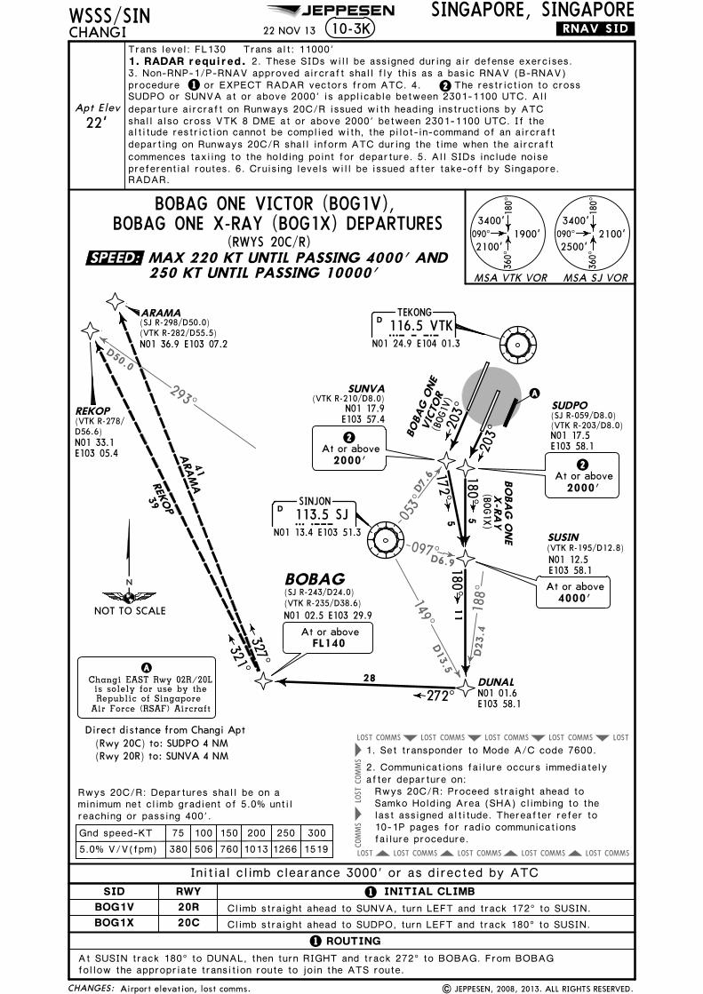
097D6.9
188^
D23.4
D13.5
149^
D7.
6
053^
COMMSLOST COMMSLOST COMMSLOST COMMSLOSTLOST
COMMS
COMMS
LOST
COMMSLOST COMMSLOST COMMSLOST COMMSLOST LOST
293^
D50.0
CHANGES:
WSSS/SINCHANGI
SINGAPORE, SINGAPORE
A
203^
180^5
N01 17.5E103 58.1
(VTK R-203/D8.0)
SUDPO
N01 12.5E103 58.1
SUSIN
.RNAV.SID.
Changi EAST Rwy 02R/20Lis solely for use by theRepublic of Singapore
Air Force (RSAF) Aircraft
A
N01 01.6E103 58.1
DUNAL
11
272^
28
BOBAG(SJ R-243/D24.0)
N01 02.5 E103 29.9(VTK R-235/D38.6)
FL140At or above
22 NOV 13
SUNVA(VTK R-210/D8.0)
N01 17.9E103 57.4
203^
172^5
(SJ R-059/D8.0)
(VTK R-195/D12.8)
(BOG1V
)
BOBAG O
NE
VIC
TOR
(BOG1X
)
2At or above
2000'
2At or above
2000'
At or above4000'
Climb straight ahead to SUDPO, turn LEFT and track 180^ to SUSIN.
Climb straight ahead to SUNVA, turn LEFT and track 172^ to SUSIN.
ROUTING
At SUSIN track 180^ to DUNAL, then turn RIGHT and track 272^ to BOBAG. From BOBAGfollow the appropriate transition route to join the ATS route.
321^327^
41
39
ARAM
AREK
OP
ARAMA
REKOP
N01 33.1E103 05.4
Direct distance from Changi Apt
75 100 150 200 250 300Gnd speed-KT
minimum net climb gradient of 5.0% untilRwys 20C/R: Departures shall be on a
1. Set transponder to Mode A/C code 7600.
2. Communications failure occurs immediatelyafter departure on:Rwys 20C/R: Proceed straight ahead toSamko Holding Area (SHA) climbing to thelast assigned altitude. Thereafter refer to
(SJ R-298/D50.0)
N01 36.9 E103 07.2
1
1
BO
BA
G O
NE
X-R
AY
180^
JEPPESEN
10-3K
| JEPPESEN, 2008, 2013. ALL RIGHTS RESERVED.
(VTK R-282/D55.5)
(VTK R-278/D56.6)
SINJON
113.5 SJSJN01 13.4 E103 51.3
D
DTEKONG
116.5 VTKN01 24.9 E104 01.3VTK
090^
180^
360^
3400'
2500'2100'090^
180^
360^
3400'
2100'1900'
MSA VTK VOR MSA SJ VOR
MAX 220 KT UNTIL PASSING 4000' AND250 KT UNTIL PASSING 10000'
BOBAG ONE X-RAY (BOG1X) DEPARTURESBOBAG ONE VICTOR (BOG1V),
(RWYS 20C/R)
SID INITIAL CLIMBRWY
BOG1V
BOG1X 20C
20R
(Rwy 20C) to: SUDPO 4 NM(Rwy 20R) to: SUNVA 4 NM
reaching or passing 400'.
5.0% V/V(fpm) 380 506 760 1013 1266 1519
Initial climb clearance 3000' or as directed by ATC
10-1P pages for radio communications
Airport elevation, lost comms.
failure procedure.
Trans level: FL130 Trans alt: 11000'
1 2
1. RADAR required. 2. These SIDs will be assigned during air defense exercises.
RADAR.preferential routes. 6. Cruising levels will be issued after take-off by Singapore.
3. Non-RNP-1/P-RNAV approved aircraft shall fly this as a basic RNAV (B-RNAV)procedure or EXPECT RADAR vectors from ATC. 4. The restriction to crossSUDPO or SUNVA at or above 2000' is applicable between 2301-1100 UTC. Alldeparture aircraft on Runways 20C/R issued with heading instructions by ATC
altitude restriction cannot be complied with, the pilot-in-command of an aircraftdeparting on Runways 20C/R shall inform ATC during the time when the aircraftcommences taxiing to the holding point for departure. 5. All SIDs include noise
Apt Elev
22' shall also cross VTK 8 DME at or above 2000' between 2301-1100 UTC. If the
SPEED:
NOT TO SCALE

023^
D13
332^
285^
343^D7
D19D19 00
1^
TEKONG116.5 VTKVTK
N01 24.9 E104 01.3
D
Changi EAST Rwy 02R/20Lis solely for use by theRepublic of Singapore
Air Force (RSAF) Aircraft
A
A
KONG KONG
286 KKKKN01 31.3 E103 59.4
JAYBEE
400 JBJBN01 30.0 E103 42.7
LELIBN01 27.5E103 24.8
NYLONN01 37.0E104 06.4
to LELIB
MAINTAINFL140
At FL140
Passing10000'
090^
180^
360^
3400'
2100'
1900'
MSA VTK VOR
WSSS/SINCHANGI
SINGAPORE, SINGAPORE
Trans level: FL130 Trans alt: 11000'
10-3L .SID.
2. All SIDs include noise preferential routes.3. Cruising levels will be issued after take-off by Singapore
RADAR.
(RWYS 02L/C)
CHANGES:
ROUTING
22 NOV 13
LELIB ONE CHARLIE (LLB1C) DEPARTURE
For minimum climb gradient criteria:
RWY
02L Climb straight ahead.
INITIAL CLIMB
02C Climb straight ahead to VTK.
Rwys 02L/C- See 10-3 and 10-3A.
Direct distance from Changi Apt to:
turn RIGHT and proceed direct to KK. Track 266^ bearing from KK to JB. Track 262^ bearing
1. This SID will be assigned during air defense exercises.
| JEPPESEN, 2004, 2013. ALL RIGHTS RESERVED.
SINJON
113.5 SJSJN01 13.4 E103 51.3
D
JEPPESEN
MAX 220 KT UNTIL PASSING 4000' AND250 KT UNTIL PASSING 10000'
Apt Elev
22'
(Rwy 02C) to: VTK 4 NM
Initial climb clearance 3000' or as directed by ATC
Intercept and proceed on VTK R-001. After passing 10000', turn RIGHT to NYLON. At NYLON,
from JB to LELIB and join airway A-464. MAINTAIN FL140 from NYLON to LELIB
Airport elevation.
SPEED:
266^
262^17
18FL140
FL140
NOT TO SCALE
.A.464.

COMMSLOST COMMSLOST COMMSLOST
COMMS
LOST
COMMS
LOST
COMMS
LOST
COMMSLOST COMMSLOST COMMSLOST
LOST COMMS
COMMSLOST
CHANGES:
WSSS/SINCHANGI
SINGAPORE, SINGAPORE10-3M .RNAV.SID.
Trans level: FL130 Trans alt: 11000'
JEPPESEN
22 NOV 13
090^
180^
360^
3400'
2500'2100'
090^
180^
360^
3400'
2100'1900'
MSA VTK VOR
MSA SJ VOR
A
180^5
TOKIMN01 29.6E104 03.3
342^
342^
332^10
17
(MAS1A
)
SULUG
AKOMAN01 45.4E103 54.7
21
(MAS1B)
(RWYS 02C, 20C)
MASBO 1
BM
ASB
O 1
A
026^
13278^
MASBON02 02.8E102 52.9 AGVAR
N01 47.3E103 41.8
N01 15.6E104 04.4
4
To TOKIM on course 023^, then to AKOMA.
ROUTING
75 100 150 200 250 300Gnd speed-KT
Changi EAST Rwy 02R/20Lis solely for use by theRepublic of Singapore
Air Force (RSAF) Aircraft
A
Direct distance from Changi Apt
For minimum climb gradient criteria:
minimum net climb gradient of 5.0% untilRwy 20C: Departures shall be on a
Rwy 02C- See 10-3 and 10-3A.
Rwy 02C: Proceed straight ahead to Nylon Holding Area (NHA) climbing
Rwy 20C: Proceed straight ahead to Samko Holding Area (SHA) climbing
to the last assigned altitude.
to the last assigned altitude.
7600.1. Set transponder to Mode A/C code
2. Communications failure occurs immediately after departure on:
1
25
27 296^11000'
At or above
SABKAN01 50.9E103 17.2
7000'At or above
MASBO 1A
203^
097^5
N01 17.5E103 58.1
SUDPO
1. RADAR required.
To SUDPO on course 203^, then to SUSIN, SAKIN, SULUG, VTK, AKOMA.
At AKOMA to AGVAR, SABKA, MASBO.
SINJON
113.5 SJSJN01 13.4 E103 51.3
D
DTEKONG
116.5 VTKN01 24.9 E104 01.3VTK
At or above7000'
MASBO 1B
INITIAL CLIMBSID RWY
02C
20C
MASBO 1A
MASBO 1B
MASBO 1A (MAS1A), MASBO 1B (MAS1B) DEPARTURES
RWY 02C MAS 1A: MAX 220 KT UNTIL 4000'AND 250 KT UNTIL PASSING 10000'RWY 20C MAS 1B: MAX 220 KT UNTIL SAKINAND 250 KT UNTIL PASSING 10000'
SAKINN01 12.0E104 02.6
At or above
MAX
4000'
220 KTSUSIN
1
N01 12.5 E103 58.1
220 KTMAX
2000'At or above
220 KTMAX
2000'At or above
| JEPPESEN, 2012, 2013. ALL RIGHTS RESERVED.
(Rwy 02C) to: TOKIM 9 NM(Rwy 20C) to: SUDPO 4 NM
reaching or passing 400'.
5.0% V/V(fpm) 380 506 760 1013 1266 1519
Initial climb clearance 3000' or as depicted by ATC
Thereafter refer to 10-1P pages for
Thereafter refer to 10-1P pages for
Airport elevation, lost comms.
procedure.radio communications failure
procedure.radio communications failure
2. The restriction to cross SUDPO at or above 2000' isapplicable between 2301-1100 UTC. All departure aircraft on Runway 20C issued withheading instructions by ATC shall also cross VTK 8 DME at or above 2000' between2301-1100 UTC. If the altitude restriction cannot be complied with, the pilot-in-
command of an aircraft departing on Runway 20C shall inform ATC during the timewhen the aircraft commences taxiing to the holding point for departure. 3. All SIDsinclude noise preferential routes. 4. Cruising levels will be issued after take-off bySingapore RADAR.
Apt Elev
22'
SPEED:
023^
NOT TO SCALE

COMMSLOST COMMSLOST COMMSLOST
COMMS
LOST
COMMS
LOST
COMMS
LOST
COMMSLOST COMMSLOST COMMSLOST
LOST COMMS
COMMSLOST
CHANGES:
WSSS/SINCHANGI
SINGAPORE, SINGAPORE10-3N .RNAV.SID.
JEPPESEN
22 NOV 13
090^
180^
360^
3400'
2500'2100'
090^
180^
360^
3400'
2100'1900'
MSA VTK VOR
MSA SJ VOR
TEKONG116.5 VTKVTK
N01 24.9 E104 01.3
D
A 342^
342^
333^
10
17
(MAS1E)
SULUG
AKOMAN01 45.4E103 54.7
21
(MAS1F)
(RWYS 02L, 20R)
MASBO 1
FM
ASB
O 1
E
097^ 026^
N01 15.6E104 04.4
5
4
To TOPOM on course 023^, then to AKOMA.
ROUTING
203^
172^5
N01 29.9E104 02.5
TOPOM
7000'At or above
7000'At or above
MASBO 1E
Direct distance from Changi Apt
75 100 150 200 250 300Gnd speed-KT
Changi EAST Rwy 02R/20Lis solely for use by theRepublic of Singapore
Air Force (RSAF) Aircraft
A
For minimum climb gradient criteria:
minimum net climb gradient of 5.0% untilRwy 20R: Departures shall be on a
Rwy 02L- See 10-3 and 10-3A.
N01 17.9E103 57.4
SUNVA
13278^
MASBON02 02.8E102 52.9 AGVAR
N01 47.3E103 41.8
25
27 296^11000'
At or above
SABKAN01 50.9E103 17.2
SINJON113.5 SJSJ
N01 13.4 E103 51.3
D
Rwy 02L: Proceed straight ahead to Nylon Holding Area (NHA) climbing
Rwy 20R: Proceed straight ahead to Samko Holding Area (SHA) climbing
to the last assigned altitude.
to the last assigned altitude.
7600.1. Set transponder to Mode A/C code
2. Communications failure occurs immediately after departure on:
To SUNVA on course 203^, then to SUSIN, SAKIN, SULUG, VTK, AKOMA.
At AKOMA to AGVAR, SABKA, MASBO.
INITIAL CLIMBSID RWY
02L
20R
MASBO 1E
MASBO 1F
MASBO 1E (MAS1E), MASBO 1F (MAS1F) DEPARTURES
RWY 02L MAS 1E: MAX 220 KT UNTIL 4000'AND 250 KT UNTIL PASSING 10000'RWY 20R MAS 1F: MAX 220 KT UNTIL SAKINAND 250 KT UNTIL PASSING 10000'
4000'At or above
220 KTMAXN01 12.5 E103 58.1
220 KTMAX
SUSIN
SAKINN01 12.0E104 02.6
220 KT
1
2000'At or above
MAX
2000'At or above
| JEPPESEN, 2012, 2013. ALL RIGHTS RESERVED.
(Rwy 02L) to: TOPOM 9 NM(Rwy 20R) to: SUNVA 4 NM
5.0% V/V(fpm) 380 506 760 1013 1266 1519
reaching or passing 400'.
Initial climb clearance 3000' or as directed by ATC
Thereafter refer to 10-1P pages for
Thereafter refer to 10-1P pages for
Airport elevation, lost comms.
radio communications failure procedure.
radio communications failure procedure.
Trans level: FL130 Trans alt: 11000'
11. RADAR required. 2. The restriction to cross SUNVA at or above 2000' isapplicable between 2301-1100 UTC. All departure aircraft on Runway 20R issued withheading instructions by ATC shall also cross VTK 8 DME at or above 2000' between2301-1100 UTC. If the altitude restriction cannot be complied with, the pilot-in-
command of an aircraft departing on Runway 20R shall inform ATC during the timewhen the aircraft commences taxiing to the holding point for departure. 3. All SIDsinclude noise preferential routes. 4. Cruising levels will be issued after take-off bySingapore RADAR.
Apt Elev
22'
SPEED:
023^
NOT TO SCALE

COMMSLOST COMMSLOST COMMSLOST
COMMS
LOST
COMMS
LOST
COMMS
LOST
COMMSLOST COMMSLOST COMMSLOST
LOST COMMS
COMMSLOST
75 100 150 200 250 300
CHANGES:
WSSS/SINCHANGI
SINGAPORE, SINGAPORE
TEKONG116.5 VTKVTK
N01 24.9 E104 01.3
D
10-3P
Direct distance from Changi Apt
Gnd speed-KT
For minimum climb gradient criteria:
minimum net climb gradient of 5.0% until
A
180^5
Rwy 20C: Departures shall be on a
.RNAV.SID.
Changi EAST Rwy 02R/20Lis solely for use by theRepublic of Singapore
Air Force (RSAF) Aircraft
A
342^
332^
21
17
(VMR4A
)
356^38
Rwy 02C: Proceed straight ahead to Nylon Holding Area (NHA) climbing
Rwy 20C: Proceed straight ahead to Samko Holding Area (SHA) climbing
to the last assigned altitude.
to the last assigned altitude.
7600.
2. Communications failure occurs immediately after departure on:
(RWYS 02C, 20C)
Rwy 02C- See 10-3 and 10-3A.
22 NOV 13
JEPPESEN
203^
342^10
SULUG
026^
N01 15.6E104 04.4
4
097^5
MER
SING 4
A
MERSIN
G 5
B
(VMR5B)
SINJON113.5 SJSJ
N01 13.4 E103 51.3
D
| JEPPESEN, 2006, 2013. ALL RIGHTS RESERVED.
To TOKIM on course 023^, then to AKOMA.
ROUTING
At AKOMA to VMR.
090^
180^
360^
3400'
2500'2100'
090^
180^
360^
3400'
2100'1900'
MSA VTK VOR
MSA SJ VOR
7000'
MERSING 5B
At or above
To SUDPO on course 203^, then to SUSIN, SAKIN, SULUG, VTK, AKOMA.
MERSING116.8 VMRVMR
N02 23.3 E103 52.3
D
INITIAL CLIMBSID RWY
02C
20C
VMR4A
VMR5B
7000'At or above
MERSING 4A
MERSING 4A (VMR4A), MERSING 5B (VMR5B) DEPARTURES
RWY 02C VMR 4A: MAX 220 KT UNTIL 4000'AND 250 KT UNTIL PASSING 10000'RWY 20C VMR 5B: MAX 220 KT UNTIL SAKINAND 250 KT UNTIL PASSING 10000'
1
2000'At or above
220 KTMAX
SAKINN01 12.0E104 02.6SUSIN
N01 12.5 E103 58.1
220 KTMAX
4000'At or above
220 KTMAX
2000'At or above
(Rwy 02C) to: TOKIM 9 NM(Rwy 20C) to: SUDPO 4 NM
reaching or passing 400'.
5.0% V/V(fpm) 380 506 760 1013 1266 1519
Initial climb clearance 3000' or as directed by ATC
Thereafter refer to 10-1P pages for
Thereafter refer to 10-1P pages for
Airport elevation, lost comms.
radio communications failure procedure.
radio communications failure procedure.
1. Set transponder to Mode A/C code
Trans level: FL130 Trans alt: 11000'
11. RADAR required. 2. The restriction to cross SUDPO at or above 2000' isapplicable between 2301-1100 UTC. All departure aircraft on Runway 20C issued withheading instructions by ATC shall also cross VTK 8 DME at or above 2000' between2301-1100 UTC. If the altitude restriction cannot be complied with, the pilot-in-command of an aircraft departing on Runway 20C shall inform ATC during the timewhen the aircraft commences taxiing to the holding point for departure. 3. All SIDsinclude noise preferential routes. 4. Cruising levels will be issued after take-off bySingapore RADAR. 5. MERSING 4A will also be assigned during air defense exercises.
Apt Elev
22'
AKOMAN01 45.4E103 54.7
TOKIMN01 29.6E104 03.3
SUDPON01 17.5E103 58.1
SPEED:
023^
NOT TO SCALE

COMMSLOST COMMSLOST COMMSLOST
COMMS
LOST
COMMS
LOST
COMMS
LOST
COMMSLOST COMMSLOST COMMSLOST
LOST COMMS
LOST COMMS
75 100 150 200 250 300
CHANGES:
WSSS/SINCHANGI
SINGAPORE, SINGAPORE
TEKONG116.5 VTKVTK
N01 24.9 E104 01.3
D
10-3Q
Direct distance from Changi Apt
Gnd speed-KT
For minimum climb gradient criteria:
minimum net climb gradient of 5.0% until
A
Rwy 20R: Departures shall be on a
.RNAV.SID.
Changi EAST Rwy 02R/20Lis solely for use by theRepublic of Singapore
Air Force (RSAF) Aircraft
A
342^333^
21 17
(VMR4E)
MER
SING
4E
AKOMAN01 45.4E103 54.7
N01 29.9E104 02.5
TOPOM
203^
N01 17.9E103 57.4
SUNVA
At or above7000'
356^38
Rwy 02L: Proceed straight ahead to Nylon Holding Area (NHA) climbing
Rwy 20R: Proceed straight ahead to Samko Holding Area (SHA) climbing
to the last assigned altitude.
to the last assigned altitude.
7600.1. Set transponder to Mode A/C code
2. Communications failure occurs immediately after departure on:
(RWYS 02L, 20R)
090^
180^
360^
3400'
2500'2100'
090^
180^
360^
3400'
2100'1900'
MSA VTK VOR
MSA SJ VOR
Rwy 02L- See 10-3 and 10-3A.
22 NOV 13
JEPPESEN
| JEPPESEN, 2006, 2013. ALL RIGHTS RESERVED.
342^10
SULUGN01 15.6E104 04.4
4026^
5
172^5
097^
To TOPOM on course 023^, then to AKOMA.
ROUTING
Initial climb clearance 3000' or as directed by ATC
At AKOMA to VMR.
MERSIN
G 5
F
(VMR5F)
To SUNVA on course 203^, then to SUSIN, SAKIN, SULUG, VTK, AKOMA.
INITIAL CLIMBSID RWY
02L
20R
VMR4E
VMR5F
7000'At or above
MERSING 4E
MERSING 4E (VMR4E), MERSING 5F (VMR5F) DEPARTURES
MERSING116.8 VMRVMR
N02 23.3 E103 52.3
D
RWY 02L VMR 4E: MAX 220 KT UNTIL 4000'AND 250 KT UNTIL PASSING 10000'RWY 20R VMR 5F: MAX 220 KT UNTIL SAKINAND 250 KT UNTIL PASSING 10000'
SUSINN01 12.5 E103 58.1
220 KTMAX
SAKINN01 12.0E104 02.6
4000'At or above
220 KTMAX
SINJON
113.5 SJSJN01 13.4 E103 51.3
D
1
2000'At or above
220 KTMAX
2000'At or above
(Rwy 02L) to: TOPOM 9 NM(Rwy 20R) to: SUNVA 4 NM
reaching or passing 400'.
5.0% V/V(fpm) 380 506 760 1013 1266 1519
Thereafter refer to 10-1P pages for
Thereafter refer to 10-1P pages for
Airport elevation, lost comms.
radio communications failure procedure.
radio communications failure procedure.
Trans level: FL130 Trans alt: 11000'
11. RADAR required. 2. The restriction to cross SUNVA at or above 2000' isapplicable between 2301-1100 UTC. All departure aircraft on Runway 20R issued withheading instructions by ATC shall also cross VTK 8 DME at or above 2000' between2301-1100 UTC. If the altitude restriction cannot be complied with, the pilot-in-command of an aircraft departing on Runway 20R shall inform ATC during the timewhen the aircraft commences taxiing to the holding point for departure. 3. All SIDsinclude noise preferential routes. 4. Cruising levels will be issued after take-off bySingapore RADAR. 5. MERSING 4E will also be assigned during air defense exercises.
Apt Elev
22'
SPEED:
023^
NOT TO SCALE
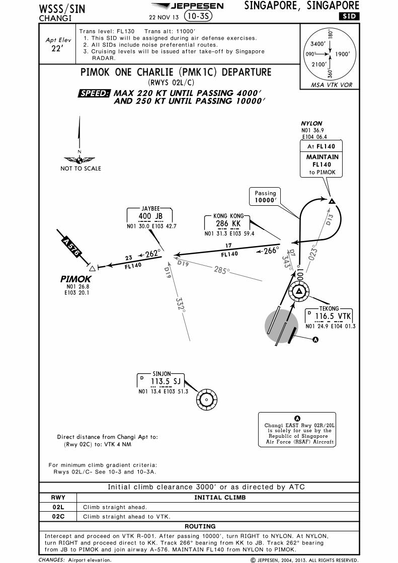
023^
D13
332^
285^
343^D7
D19D19
001^
090^
180^
360^
3400'
2100'
1900'
CHANGES:
MSA VTK VOR
WSSS/SINCHANGI
SINGAPORE, SINGAPORE
TEKONG
116.5 VTKVTKN01 24.9 E104 01.3
D
10-3S .SID.
Changi EAST Rwy 02R/20Lis solely for use by theRepublic of Singapore
Air Force (RSAF) Aircraft
A
A
KONG KONG
286 KKKKN01 31.3 E103 59.4
JAYBEE
400 JBJBN01 30.0 E103 42.7
NYLONN01 36.9E104 06.4
to PIMOK
MAINTAINFL140
At FL140
Passing10000'
22 NOV 13
| JEPPESEN, 2004, 2013. ALL RIGHTS RESERVED.
Apt Elev
22'
Trans level: FL130 Trans alt: 11000'
2. All SIDs include noise preferential routes.3. Cruising levels will be issued after take-off by Singapore
RADAR.
(RWYS 02L/C)
1. This SID will be assigned during air defense exercises.
PIMOK ONE CHARLIE (PMK1C) DEPARTURE
SINJON
113.5 SJSJN01 13.4 E103 51.3
D
ROUTING
RWY
02L Climb straight ahead.
INITIAL CLIMB
02C Climb straight ahead to VTK.
turn RIGHT and proceed direct to KK. Track 266^ bearing from KK to JB. Track 262^ bearing
JEPPESEN
MAX 220 KT UNTIL PASSING 4000'AND 250 KT UNTIL PASSING 10000'
For minimum climb gradient criteria:Rwys 02L/C- See 10-3 and 10-3A.
Direct distance from Changi Apt to:(Rwy 02C) to: VTK 4 NM
Initial climb clearance 3000' or as directed by ATC
Intercept and proceed on VTK R-001. After passing 10000', turn RIGHT to NYLON. At NYLON,
from JB to PIMOK and join airway A-576. MAINTAIN FL140 from NYLON to PIMOK.
Airport elevation.
SPEED:
266^
262^17
FL140
NOT TO SCALE
.A.576.
PIMOKN01 26.8E103 20.1
23
FL140

083^
057^
059^
097^
195^
150^
D9.4
D23.2
D24.2
D8.0
D6.9
D12.8
103^
079^
D23.6
D33.7
COMMSLOST COMMSLOST COMMSLOST LOST
COMMSLOST COMMSLOST COMMSLOST LOST
COMMS
COMMS
LOST
COMMS
LOST
LOST
CHANGES:
WSSS/SINCHANGI
SINGAPORE, SINGAPORE
SINJON113.5 SJSJ
N01 13.4 E103 51.3
D
TEKONG116.5 VTKVTK
N01 24.9 E104 01.3
D
10-3T
A
115^
120^
203^
180^
9
15
17
5
N01 17.5E103 58.1
(VTK R-203/D8.0)SUDPO
N01 12.5E103 58.1
SUSIN
At or above4000'
N01 26.1E104 10.7
DOKTA
2At or above
2000'
.RNAV.SID.
Changi EAST Rwy 02R/20Lis solely for use by theRepublic of Singapore
Air Force (RSAF) Aircraft
A
(TOM1A)
TOKIM(SJ R-037/D20.1)(VTK R-023/D5.0)
(SJ R-113/D24.0)DOBLU
N01 03.8 E104 13.3
4000'At or above
TOMAN ONE ALPHA
035^
089^20
83
N01 19.8E104 24.3
HOSBA
At or above7000'
TOMAN(SJ R-086/D117)
(VTK R-092/D106)N01 21.8 E105 47.3
22 NOV 13
TOMAN ONE ALPHA (TOM1A),
(RWYS 02C, 20C)
| JEPPESEN, 2006, 2013. ALL RIGHTS RESERVED.
JEPPESEN
TOMAN ONE BRAVO (TOM1B) DEPARTURES
At or belowor as directed by ATC
6000'
N01 29.6 E104 03.3
2000'At or above
090^
360^
3400'
2500'2100'090^
360^
3400'
2100'1900'
MSA VTK VOR MSA SJ VOR
180^
180^
TOMAN O
NE
BRAVO
(TOM
1B)
75 100 150 200 250 300
Direct distance from Changi Apt
Gnd speed-KT
For minimum climb gradient criteria:
minimum net climb gradient of 5.0% untilRwy 20C: Departures shall be on a
Rwy 02C- See 10-3 and 10-3A.
MAX 220 KT UNTIL PASSING4000' AND 250 KT UNTILPASSING 10000'
SID 1 INITIAL CLIMB
Climb straight ahead to TOKIM, turn RIGHT and track 115^ to DOKTA,
RWY
02C
20C
then track 115^ to HOSBA. Turn LEFT and track 089^ to TOMAN.
Climb straight ahead to SUDPO, turn LEFT and track 180^ to SUSIN.Turn LEFT and track 120^ to DOBLU. Turn LEFT and track 035^ to HOSBA,then turn RIGHT and track 089^ to TOMAN.
TOM1A
TOM1B
(Rwy 02C) to: TOKIM 9 NM(Rwy 20C) to: SUDPO 4 NM
reaching or passing 400'.
5.0% V/V(fpm) 380 506 760 1013 1266 1519
Initial climb clearance 3000' or as directed by ATC
Rwy 02C: Proceed straight ahead to Nylon Holding Area (NHA) climbing
Rwy 20C: Proceed straight ahead to Samko Holding Area (SHA) climbing
to the last assigned altitude.
to the last assigned altitude.
7600.1. Set transponder to Mode A/C code
2. Communications failure occurs immediately after departure on:
Thereafter refer to 10-1P pages for
Thereafter refer to 10-1P pages for
Airport elevation, lost comms.
radio communications failureprocedure.
radio communications failureprocedure.
Trans level: FL130 Trans alt: 11000'
12
1. RADAR required.
instructions by ATC shall also cross VTK 8 DME at or above 2000' between 2301-1100 UTC. If the altitude restriction cannot be complied with, the pilot-in-commandof an aircraft departing on Runway 20C shall inform ATC during the time when theaircraft commences taxiing to the holding point for departure. 4. All SIDs includenoise preferential routes. 5. Cruising levels will be issued after take-off by
2. Non-RNP-1/P-RNAV approved aircraft shall fly this as a basic RNAV (B-RNAV) procedure3.
or EXPECT RADAR vectors from ATC. The restriction to cross SUDPO at or above 2000' is applicable between
2301-1100 UTC. All departure aircraft on Runway 20C issued with heading
Singapore RADAR.
Apt Elev
22'
SPEED:
023^
NOT TO SCALE

097^
195^
D6.9
D12.8
083^
057^
150^
D9.4
D23.2
D24.2
103^
079^
D23.6
D33.7
053^D7.
6
COMMS COMMSLOST COMMSLOST LOST
COMMSLOST COMMSLOST COMMSLOST LOST
COMMS
LOST
COMMS
LOST
LOST
COMMS
LOST
CHANGES:
WSSS/SINCHANGI
SINGAPORE, SINGAPORE10-3U .RNAV.SID.
SINJON
113.5 SJSJN01 13.4 E103 51.3
D
D
A
120^
N01 12.5E103 58.1
SUSIN
At or above4000'
Changi EAST Rwy 02R/20Lis solely for use by theRepublic of Singapore
Air Force (RSAF) Aircraft
A
TEKONG116.5 VTKVTK
N01 24.9 E104 01.3
15
17
(TOM1E)
(SJ R-113/D24.0)DOBLU
N01 03.8 E104 13.3
4000'At or above
035^
20
N01 26.1E104 10.7
DOKTA
N01 19.8E104 24.3
HOSBA
At or above7000'
089^83
TOMAN(SJ R-086/D117)
(VTK R-092/D106)
203^2
At or above2000'
N01 17.9E103 57.4
(VTK R-210/D8.0)SUNVA
172^5
115^
9
TOMAN ONE ECHO
N01 21.8 E105 47.3
JEPPESEN
| JEPPESEN, 2006, 2013. ALL RIGHTS RESERVED.
22 NOV 13
TOMAN ONE ECHO (TOM1E),
(RWYS 02L, 20R)
TOPOM
(VTK R-013/D5.1)(SJ R-034/D20.0)
N01 29.9 E104 02.5
2000'At or above
At or belowor as directed by ATC
6000'
TOMAN ONE FOXTROT (TOM1F) DEPARTURES090^
180^
360^
3400'
2500'2100'090^
180^
360^
3400'
2100'1900'
MSA VTK VOR MSA SJ VOR
TOMAN O
NE
FOXTR
OT
(TOM
1F)
75 100 150 200 250 300Gnd speed-KT
For minimum climb gradient criteria:
minimum net climb gradient of 5.0% untilRwy 20R: Departures shall be on a
Direct distance from Changi Apt
Rwy 02L- See 10-3 and 10-3A.
MAX 220 KT UNTIL PASSING4000' AND 250 KT UNTILPASSING 10000'
SID 1 INITIAL CLIMBRWY
02L
20R
TOM1E
TOM1F
Climb straight ahead to TOPOM, turn RIGHT and track 115^ to DOKTA,then track 115^ to HOSBA. Turn LEFT and track 089^ to TOMAN.
Climb straight ahead to SUNVA, turn LEFT and track 172^ to SUSIN.
then turn RIGHT and track 089^ to TOMAN.Turn LEFT and track 120^ to DOBLU. Turn LEFT and track 035^ to HOSBA,
(Rwy 02L) to: TOPOM 9 NM(Rwy 20R) to: SUNVA 4 NM
reaching or passing 400'.
5.0% V/V(fpm) 380 506 760 1013 1266 1519
Initial climb clearance 3000' or as directed by ATC
Rwy 02L: Proceed straight ahead to Nylon Holding Area (NHA) climbing
Rwy 20R: Proceed straight ahead to Samko Holding Area (SHA) climbing
to the last assigned altitude.
to the last assigned altitude.
7600.1. Set transponder to Mode A/C code
2. Communications failure occurs immediately after departure on:
Thereafter refer to 10-1P pages for
Thereafter refer to 10-1P pages for
Airport elevation, lost comms.
radio communications failureprocedure.
radio communications failureprocedure.
Trans level: FL130 Trans alt: 11000'
12
1. RADAR required.
instructions by ATC shall also cross VTK 8 DME at or above 2000' between 2301-1100 UTC. If the altitude restriction cannot be complied with, the pilot-in-commandof an aircraft departing on Runway 20R shall inform ATC during the time when theaircraft commences taxiing to the holding point for departure. 4. All SIDs includenoise preferential routes. 5. Cruising levels will be issued after take-off by
2. Non-RNP-1/P-RNAV approved aircraft shall fly this as a basic RNAV (B-RNAV) procedure3.
or EXPECT RADAR vectors from ATC. The restriction to cross SUNVA at or above 2000' is applicable between
2301-1100 UTC. All departure aircraft on Runway 20R issued with heading
Singapore RADAR.
Apt Elev
22'
SPEED:
023^
NOT TO SCALE

COMMS
LOST
COMMS
LOST
LOST
COMMS COMMSLOST COMMSLOST LOST COMMS
COMMSLOST COMMSLOST COMMSLOST LOST
083^
057^
059^
097^
195^
150^D9.4
D23.2
D24.2
D8.0
D6.9
D12.8
LOST
75 100 150 200 250 300
CHANGES:
WSSS/SINCHANGI
SINGAPORE, SINGAPORE10-3V
Direct distance from Changi Apt
Gnd speed-KT
For minimum climb gradient criteria:
minimum net climb gradient of 5.0% until
126^
16
44
Rwy 20C- Departures shall be on a
.RNAV.SID.
1 ROUTING
Changi EAST Rwy 02R/20Lis solely for use by theRepublic of Singapore
Air Force (RSAF) Aircraft
A
DOSNO
VENPA
N00 48.0 E104 14.2
N00 21.7 E104 49.9
(SJ R-113/D24.0)DOBLU
N01 03.8 E104 13.3
Rwy 02C: Proceed straight ahead to Nylon Holding Area (NHA) climbing
Rwy 20C: Proceed straight ahead to Samko Holding Area (SHA) climbing
to the last assigned altitude.
to the last assigned altitude.
7600.1. Set transponder to Mode A/C code
2. Communications failure occurs immediately after departure on:
177^
(SJ R-131/D78.1)
join the ATS route.
(SJ R-138/D34.1)
KADAR
SURGA
097^
105^120^
(VTK R-161/D39.0)
(RWYS 02C, 20C)
Rwy 02C- See 10-3 and 10-3A.
JEPPESEN
[VENP1A]
[VENP1B]
VENPA1A
VENPA1B
(VTK R-142/D79.6)
131
30
87
BAVUS092^
46VENIX
S00 21.9 E106 05.4
(SJ R-125/D164)
SURGA
S00 37.0 E106 31.3
(SJ R-124/D194)
KADAR
ATKAX
N00 05.2 E106 59.8
(SJ R-110/D201)(VTK R-114/D196)
(VTK R-131/D164)
(VTK R-129/D193)
3
At or below6000'
or as directedby ATC
S00 06.8E107 43.7
| JEPPESEN, 2006, 2013. ALL RIGHTS RESERVED.
Turn RIGHT and track 173^ to DOBLU, then track 177^ to DOSNO.
N00 00.0 E109 00.0 TO BAVUS1213
VENPA ONE ALPHA (VENPA1A),
22 NOV 13
VENPA ONE BRAVO (VENPA1B) DEPARTURES
(SJ R-037/D20.1)TOKIM
SINJON113.5 SJSJ
N01 13.4 E103 51.3
D
TEKONG116.5 VTKVTK
N01 24.9 E104 01.3
D
A
115^173^
120^
203^
180^
922
17
5
N01 17.5E103 58.1
(VTK R-203/D8.0)SUDPO
N01 12.5E103 58.1
SUSIN
At or above4000'
VENPA
ONE A
LPHAVENPA ONE BRAVO
(VTK R-023/D5.0)
(VEN
PA1A)
(VENPA1B)
N01 26.1E104 10.7
DOKTA
4000'At or above
2000'At or above
N01 29.6 E104 03.3
2At or above
2000'
090^
180^
360^
3400'
2500'2100'090^
180^
360^
3400'
2100'1900'
MSA VTK VOR MSA SJ VOR
At DOSNO turn LEFT and track 126^ to VENPA and follow the appropriate transition route to
Initial climb clearance 3000' or as directed by ATC
MAX 220 KT UNTIL PASSING 4000' AND250 KT UNTIL PASSING 10000'
SID 1 INITIAL CLIMBRWY
02C
20C
Climb straight ahead to TOKIM, turn RIGHT and track 115^ to DOKTA.
Climb straight ahead to SUDPO, turn LEFT and track 180^ to SUSIN. TurnLEFT and track 120^ to DOBLU, then turn RIGHT and track 177^ to DOSNO.
(Rwy 02C) to: TOKIM 9 NM(Rwy 20C) to: SUDPO 4 NM
reaching or passing 400'.
5.0% V/V(fpm) 380 506 760 1013 1266 1519
Thereafter refer to 10-1P pages for
Thereafter refer to 10-1P pages for
Airport elevation, lost comms.
procedure.radio communications failure
radio communications failureprocedure.
Trans level: FL130 Trans alt: 11000'
12
1. RADAR required.
instructions by ATC shall also cross VTK 8 DME at or above 2000' between 2301-1100 UTC. If the altitude restriction cannot be complied with, the pilot-in-commandof an aircraft departing on Runway 20C shall inform ATC during the time when theaircraft commences taxiing to the holding point for departure. 4. All SIDs includenoise preferential routes. 5. Cruising levels will be issued after take-off by
2. Non-RNP-1/P-RNAV approved aircraft shall fly this as a basic RNAV (B-RNAV) procedure3.
or EXPECT RADAR vectors from ATC. The restriction to cross SUDPO at or above 2000' is applicable between
2301-1100 UTC. All departure aircraft on Runway 20C issued with heading
Singapore RADAR.
Apt Elev
22'
SPEED:02
3^
NOT TO SCALE

083^
057^
097^
195^
150^D9.4
D23.2
D24.2
D6.9
D12.8
053^D7.
6
COMMS
COMMS
LOST
COMMS
LOST
LOST
COMMS COMMSLOST COMMSLOST LOST COMMS
COMMSLOST COMMSLOST COMMSLOST LOST
75 100 150 200 250 300
CHANGES:
WSSS/SINCHANGI
SINGAPORE, SINGAPORE
SID
SINJON
113.5 SJSJN01 13.4 E103 51.3
D
TEKONG116.5 VTKVTK
N01 24.9 E104 01.3
D
10-3W
Gnd speed-KT
A
173^
120^
22
16
17N01 12.5E103 58.1
SUSIN
At or above4000'
N01 26.1E104 10.7
DOKTA
.RNAV.SID.
1 INITIAL CLIMB
1 ROUTING
Changi EAST Rwy 02R/20Lis solely for use by theRepublic of Singapore
Air Force (RSAF) Aircraft
A
177^
join the ATS route.
From DOSNO turn LEFT and track 126^ to VENPA and follow the appropriate transition route to
(VTK R-013/D5.1)
TOPOM(SJ R-034/D20.0)
N01 17.9E103 57.4
(VTK R-210/D8.0)SUNVA
172^5
203^
115^ 9
For minimum climb gradient criteria:
minimum net climb gradient of 5.0% untilRwy 20R: Departures shall be on a
Direct distance from Changi Apt
VENPA
ONE E
CHOVENPA ONE FOXTROT
Rwy 02L- See 10-3 and 10-3A.
JEPPESEN
| JEPPESEN, 2006, 2013. ALL RIGHTS RESERVED.
[VENP1E]VENPA1E
[VENP1F]VENPA1F
Turn RIGHT and track 173^ to DOBLU, then track 177^ to DOSNO.
126^44
DOSNO
VENPA
N00 48.0 E104 14.2
N00 21.7 E104 49.9
(SJ R-131/D78.1)
(SJ R-138/D34.1)
KADAR
SURGA
097^
105^120^
(VTK R-161/D39.0)
(VTK R-142/D79.6)
131
30
87
BAVUS092^
46VENIX
S00 21.9 E106 05.4
(SJ R-125/D164)
KADAR
ATKAX
N00 05.2 E106 59.8
(SJ R-110/D201)(VTK R-114/D196)
(VTK R-131/D164)
3
S00 06.8E107 43.7
At or below6000'
or as directedby ATC
(SJ R-113/D24.0)DOBLU
N01 03.8 E104 13.3
N00 00.0 E109 00.0 TO BAVUS1213
(VEN
PA1E)
(VENPA1F)
22 NOV 13
SURGA
S00 37.0 E106 31.3
(SJ R-124/D194)(VTK R-129/D193)
2000'At or above
N01 29.9 E104 02.5
2At or above
2000'
4000'At or above
090^
180^
360^
3400'
2500'2100'090^
180^
360^
3400'
2100'1900'
MSA VTK VOR MSA SJ VOR
(RWYS 02L, 20R)
VENPA ONE ECHO (VENPA1E),VENPA ONE FOXTROT (VENPA1F) DEPARTURES
MAX 220 KT UNTIL PASSING 4000' AND250 KT UNTIL PASSING 10000'
RWY
02L
20RClimb straight ahead to SUNVA, turn LEFT and track 172^ to SUSIN. Turn LEFT and track 120^ to DOBLU, then turn RIGHT and track 177^ to DOSNO.
Climb straight ahead to TOPOM, turn RIGHT and track 115^ to DOKTA.
(Rwy 02L) to: TOPOM 9 NM(Rwy 20R) to: SUNVA 4 NM
reaching or passing 400'.
5.0% V/V(fpm) 380 506 760 1013 1266 1519
Initial climb clearance 3000' or as directed by ATC
Rwy 02L: Proceed straight ahead to Nylon Holding Area (NHA) climbing
Rwy 20R: Proceed straight ahead to Samko Holding Area (SHA) climbing
to the last assigned altitude.
to the last assigned altitude.
7600.1. Set transponder to Mode A/C code
2. Communications failure occurs immediately after departure on:
Thereafter refer to 10-1P pages for
Thereafter refer to 10-1P pages for
Airport elevation, lost comms.
radio communications failureprocedure.
radio communications failureprocedure.
Trans level: FL130 Trans alt: 11000'
12
1. RADAR required.
instructions by ATC shall also cross VTK 8 DME at or above 2000' between 2301-1100 UTC. If the altitude restriction cannot be complied with, the pilot-in-commandof an aircraft departing on Runway 20R shall inform ATC during the time when theaircraft commences taxiing to the holding point for departure. 4. All SIDs includenoise preferential routes. 5. Cruising levels will be issued after take-off by
2. Non-RNP-1/P-RNAV approved aircraft shall fly this as a basic RNAV (B-RNAV) procedure3.
or EXPECT RADAR vectors from ATC. The restriction to cross SUNVA at or above 2000' is applicable between
2301-1100 UTC. All departure aircraft on Runway 20R issued with heading
Singapore RADAR.
Apt Elev
22'
SPEED:
023^
NOT TO SCALE

Apt Elev
the direction of Twy A7.
104-00103-59
Elev 14'
FOR PARKING POSITIONS
from Twy EP to Twy A7 only. No-entry signs have
Taxiway centerline lights along Twy A2 have beenshielded to provide guidance only from Twy EP in
Twy A2 is a one-way taxiway for aircraft taxiing
been mounted on either side of Twy A2 along Twy A7.
01-20 01-20
01-21
01-22
01-23stands 506, 507 and 508 diverted
Rw
y 0
2R/20LT2
SO
UTH A
PRO
N
Twy WC centerline behind aircraft
SERVICEAPRON
NORTH
SOUTH-EASTREMOTE APRON
APRON
BUDGETTERMINAL
L8
L5
L6
L7
L4
Taxiway centerline along Twy EP
Pilots are advised to applyminimum thrust when turning
T3 SOUTH APRON
| JEPPESEN, 1998, 2013. ALL RIGHTS RESERVED.
1
1
JEPPESEN
SEE 10-9B & 10-9C1
aircraft stands E7 and F36.
202C/20C - (0000 to 1600).For ACFT operating on Rwy
between Twys B1 and B3 offseteastward by 8'
Twy N1 (behind aircraft standsC16 to C19 and between Twy NC2and Twy NC3), Twy N2 and Twy N3 (behind aircraft standsD35 to D38 and between Twy NC2and Twy NC3) can only be usedby aircraft with maximum wingspan of 213' (65m).
eastward by 8' (2.5m) away from
wingspan of 118' (36m).
into Twy WA from Taxilane V6.
Twy NC3 (between Twy WA and Twy A6)is a twy with reduced minimum separationdistances between the twy centerline andobject. Due to the reduced minimum separation distances, pilots are advised to adhere strictly to the twy centerline and to slow down the taxispeed accordingly. Twy NC3 (betweenTwy WA and Twy A6) can only be used by aircraft with a maximum wingspan of 213' (65m).
105' (32m) westward. Pilots to followthe twy centerline while taxiing alongTwy WC.
Taxilane A6 (behind aircraft stands E20 to E24) and taxilane
C6 (behind aircraft stands F50 to F54) can only be used by
aircraft with maximum
pushback exempted).
Pilots are advised to applyspeed limit of 20 Kts when taxiing along twy South Cross 1 and South Cross 2.
wingspan 213' 65m (towing and
stands A18 to A21) can onlybe used by aircraft with
For AIRPORT BRIEFINGrefer to 10-1P pages.
Taxilane U4 (behind aircraft
maximum wingspan of200' (61m).
Pilots are advised to apply minimum thrust when turning intoTwy A1, A3, A4 and taxilane A5 while taxiing either Northwardsor Southwards on taxilane A6, and thereafter when taxiingalong Twy A1 up to and including the Twy A7/A1 junction.This is in view of apron activities at aircraft stands D40, D41, D47, D48, D49, E22, E24, E27 and E28.
5 JUL 13
L9
L10
Twy L5 can only be used byaircraft with maximum
Twys L8, L9, and L10 can onlybe used by aircraft withmaximum wingspan 213' (65m).Pilots are advised to exercise
L5, L8, L9 and L10.caution when taxiing near Twys
VAR 0^
Ramp area added.
oversteering may be required when
Pilots operating aircraft with wheel
shall take note that judgemental
NO
RTH
APR
ON
maneuvering around taxiway turns.
base longer than B747 or 85' (26m)
Bldg Area
N01 21.6 E103 59.4 CHANGI10-922'SINGAPORE, SINGAPORE
CHANGES:
WSSS/SIN
02L
177'
EP
Bldg Area
Elev 17'
E11
E10
E9
E8
E7
197' Stopway
60m
5 min, see 10-9D and 10-9E.
023^
13,123
'40
00m
197'60mStopway
023^
02C
T2 CENTRAL APRON
T2 NORTH APRON
REMOTE APRON
CHANGI EAST(MILITARY ONLY)
C6
E3
E4
EP
279'
WPWA
TERMINAL2
E5
13,123
'400
0m
A4
C3
C1
C2
B2
B1
B3
C7 EP
C1
A5
T1 E
AST
APR
ON
W10
W6
V6W7
V7
V8W8
W9
WA
U2
SC2
SC1
SC1
SC2
20C
Elev 15'
197'60m Stopway
20RElev 13'
243'
164'
WP
EA
EASTCARGOAPRON
WCW3
W2
W1
APRONCARGOWEST
WP
197'60m Stopway
203^
203^
FuelFarm
NC1
SERVICEAPRON
EAST
V3
V4
WP
WA
ARP
CENTRALAPRON
1TERMINAL
E1E2
W4NC2
EA
AIS
MET
A1
A2 A6
A3
NC2
NC1NORTHREMOTE APRON
T1
T1 W
EST
APR
ON
N1N2 N3
N3
N1
NC3W5
VY
VZU1
U1
Feet
Meters
0
0
1000
1000
2000 3000 4000 5000
1500500
A7
A7A3
SC1E6
SC2
NORTH-EAST
A6
EAST REMOTE
T3
U3
Pushback clearance expires in
Control Tower
ENEP
EP
U4
EC
118.252
D-ATIS
128.6
ACARS:D-ATIS
SINGAPORE Delivery (Cpt)
121.65West of Terminal 2
124.3
Ground*East of Terminal 2
121.72 0001Z-1600Z
Tower
118.6

applicable when Runway 20C/02C is unavailable because of maintenance work or for other reasons.Departures on Runway 20R are not permitted between 1600/2200 UTC. However, this restriction is not
| JEPPESEN, 1998, 2013. ALL RIGHTS RESERVED.
JEPPESEN
Runway 02L/20R between 1600/2200 UTC may not exceed idle reverse thrust.Unless it is necessary for operational or safety reasons, when using engine reverse, arrivals on
To maximize runway utilization and minimize runway occupancy time, departing aircraft, wheninstructed to enter the runway, shall commence the maneuver without delay. Pilots are required tocommence take-off roll as soon as take-off clearance is issued by ATC. Arriving aircraft uponlanding shall vacate the runway as quickly as practicable to enable ATC to apply minimum spacingon final approach and minimize the occurence of go-arounds.
None.
5 JUL 13
RWY
ADDITIONAL RUNWAY INFORMATION
ThresholdLANDING BEYOND
USABLE LENGTHS
WIDTHTAKE-OFFGlide Slope
GENERAL
RVR RVR
RVR RVR
02L20R
02C20C
11
1 Angle 3.0^.
Angle 3.0^.
11,998' 197'
197'
3657m
2930m 60m
60m
All Rwys
Eng
3 & 4Eng
TAKE-OFF
All Rwys
AIR CARRIER (FAR 121)
400m
ABCD
2 TDZ RVR
MID RVR
Rollout RVR
RVR
VIS
175m
CL & RCLM
CHANGI10-9A
Due to close proximity of Paya Lebar and Seletar airports, correct approach is vital.
2
2
500m
SINGAPORE, SINGAPORE
any RVR out, Adequate Vis Ref
250m (200m)
200m (150m) 250m
300m
Low-level wind shear alert system.
3662m
3662m12,014'12,014'
other two required
2
Maritime vessels of variable heights off Changi Apt.Birds in vicinity of airport.
3260m 9613'
CHANGES:
HIRL CL ALSF-II TDZ REILHIRL CL HIALS REIL PAPI
HIRL CL ALSF-I REILHIRL CL ALSF-II TDZ REIL PAPI-L
10,696'PAPI
PAPI
RL & CL
400m
RCLM (DAY only)or RL
RCLM (DAY only)or RL
AIR CARRIER (JAA) LVP must be in Force
All RwysAll Rwys
WSSS/SIN
175m175m

JEPPESEN
| JEPPESEN, 1998, 2013. ALL RIGHTS RESERVED.
205
206
207 2
082
09
200
201
202
203
F60
F59
F58
F56
F54
F52
F50
F42
F41
F40
F37
F30
F31
F32
E1
E2
E3
B2
SC1
SC1
E6
EP
E5
C7
C3
C1
F33
F34
F35
F36
E4
E5
E6
E7
B3
B1
B2
EP
E4
A21
A20
A19
A18
A17 A
16A
15 A14
U4
U4
SC2
W10
W9
W8
WP
WA
V8
SC1
A13
A12
A11
A9
A10
A5
A4
A3
A2
A1
V6
V6
W6
W7
WP
WP
WA
WA
V7
B1
B2
B3
B4
B5
B6
B7
B8
B9
B10
C1
C20
WA
WA
W5
VY
VZ
VZ
U1
U1
C22
C23
C24
C25
C26
C11
C13
C15
D30
D32
D34
N2
D35
D36 D37 D
38
C16C
17C
18C
19
300
301
302
303
304
305
306
307
308
309
310N
1
N3
D41
D42
D40
E28
E27
E26
E24
E22
E20
E10
E11
E12
E8
D44
D46
D47
D48 D
49
400
401402
404
403
W4
NC2
NC2
NC1
NC1
NC3
NC3
N1
N3
NC3
NC1
NC2
EAWC
WP
EN
EPEP
EP
A6
A7 EP
E1E2
E3
A7
A1
A1
A2
A3
A4
A4
C1
C3
C6
C6
C2
SC2
EP
A6
A6
A5
A6
TERM
INA
L 1
SO
UTHEA
ST
REM
OTE A
PRO
N
C7
T2 S
OUTH
APRO
N
T2 N
ORTH
APRO
NT1 E
AST
APRO
N
NO
RTHEA
ST
REM
OTE A
PRO
N
T1 W
EST A
PRO
N
T3 N
ORTH
APRO
N
T3 S
OUTH
APRO
N
NO
RTH
REM
OTE
APRO
N
T1 C
ENTRA
LA
PRO
N
T2 C
ENTRA
LA
PRO
N
SC2
EA
ST R
EM
OTE
APRO
N
U2
U3
F52L
F52R
F59L
F59R
F56R
F56L
E24LE
24R
200L200R
25 OCT 13
Pilo
ts t
urni
ng a
ircr
aft
into
bay
A2
or b
ay B
2ar
e ad
vise
d to
wai
t fo
r an
y ai
rcra
ft h
oldi
ngat
tax
ilan
e V6,
at
the
inne
r cu
l-de
-sac
por
tion
of t
he t
erm
inal
bui
ldin
g to
vac
ate
this
port
ion
befo
re t
urni
ng i
nto
bay
A2
or b
ay B
2.
202L202R
202L and 202R added.
RWY 0
2L-2
0R
RWY 0
2C-2
0C
TERM
INA
L 2
TERM
INA
L 3
WSSS/SIN SINGAPORE, SINGAPORE10-9B CHANGI
CHANGES:

N01 21.9 E103 59.4
N01 22.0 E103 59.5N01 22.1 E103 59.5
C18C19
N01 21.9 E103 59.5C15
C16, C17
C26 N01 22.0 E103 59.5
| JEPPESEN, 1998, 2013. ALL RIGHTS RESERVED.
JEPPESEN
304305, 306
307 thru 309
310
N01 22.0 E103 59.7N01 22.1 E103 59.7
N01 22.0 E103 59.8
1
1 For Parking Positions see 10-9C1.
25 OCT 13
202L and 202R added.
CHANGI
PARKING BAY COORDINATES
COORDINATES COORDINATESBAY No.BAY No.
SINGAPORE, SINGAPORE10-9C
CHANGES:
WSSS/SIN
N01 21.0 E103 59.4F42F40, F41
F37 N01 21.0 E103 59.4N01 21.1 E103 59.4
N01 21.2 E103 59.4N01 21.0 E103 59.3
N01 21.0 E103 59.3
F50
T2 South Apron
400
North-East Remote Apron
404
N01 21.6 E103 59.7N01 21.7 E103 59.7N01 21.8 E103 59.7
401 thru 403
South-East Remote Apron
205206 thru 208
209 N01 20.9 E103 59.3N01 20.8 E103 59.3N01 20.7 E103 59.3N01 20.5 E103 59.2103, 104
E11
E8E10
E12E20, E22
T2 North Apron
N01 21.5 E103 59.6
N01 21.4 E103 59.6N01 21.4 E103 59.5
N01 21.5 E103 59.6N01 21.4 E103 59.5
N01 21.5 E103 59.5N01 21.6 E103 59.5E27, E28
N01 21.3 E103 59.4N01 21.3 E103 59.5N01 21.3 E103 59.6N01 21.4 E103 59.6
E1E2 thru E4
E5E6, E7
F34 thru F36
F30, F31 N01 21.2 E103 59.4
N01 21.2 E103 59.5N01 21.1 E103 59.5
T2 Central Apron
F32, F33
T1 East Apron
N01 21.8 E103 59.6N01 21.8 E103 59.8N01 21.9 E103 59.8
N01 21.7 E103 59.6D41, D42, D44D46
D47, D48
N01 21.6 E103 59.5
D49
D40
T1 Central Apron
N01 21.8 E103 59.4C11, C13
D30 N01 21.7 E103 59.5N01 21.8 E103 59.5N01 21.9 E103 59.7D35 thru D38
D32, D34
N01 21.8 E103 59.3C22 N01 21.9 E103 59.3
N01 21.9 E103 59.4C23N01 21.9 E103 59.5
T3 North Apron
N01 22.0 E103 59.4C24C25
N01 21.3 E103 59.0
N01 21.5 E103 59.1
A3, A4
B2 thru B4N01 21.6 E103 59.2
East Remote Apron
N01 20.9 E103 59.2
N01 20.8 E103 59.2
N01 21.2 E103 59.0A10
N01 21.1 E103 59.0A14 N01 21.0 E103 59.0
N01 21.0 E103 58.9A15 thru A17A18 N01 20.9 E103 58.9
N01 20.9 E103 59.0A19, A20
A21 N01 21.0 E103 59.0
N01 21.4 E103 59.1A1, A2
N01 21.3 E103 59.1A5N01 21.2 E103 59.1A9
A11 thru A13
N01 21.4 E103 59.1B1
N01 21.7 E103 59.3B8 thru B10
C1, C20
T3 South Apron
T1 West Apron
North Remote Apron
302, 303300, 301 N01 22.1 E103 59.5
N01 22.1 E103 59.6
N01 22.0 E103 59.9
N01 21.1 E103 59.3
F52L, F52R
B5 thru B7
N01 21.0 E103 59.3F58, F59, F59R
F59L, F60
E24 thru E26
F52, F56R, F56LN01 21.1 E103 59.3F54, F56
N01 20.8 E103 59.2200, 200L, 200R
201
N01 20.9 E103 59.2202, 202L, 202R
203

509 N01 22.7 E103 59.6
505
506
504
503
502
507
508
509
604
603
602
601
606 607
609
JEPPESEN
| JEPPESEN, 2006, 2013. ALL RIGHTS RESERVED.
103 104
12
3456
789
10
E8
L9
L5
L7
L6
L4
SC2 SC2
EP
EP
E7
E6
SC1
E9
EPC7C6
SC1
EA
EA
NC1NC1NC1
NC2 NC2N1 N3
WP
WP
W3
W4
V3
V4
WC
WC
WA
5 JUL 13
EC
611
612
14
131211
L8
L10
101R
101 102
102L
102R
101L
South-East Remote Apron revised, parking spots added.
RWY 0
2L-2
0R
RWY 0
2C-2
0C
CHANGISINGAPORE, SINGAPORE
CHANGES:
WSSS/SIN
West Cargo Apron
503, 504505, 506507, 508
N01 22.4 E103 59.6N01 22.5 E103 59.6N01 22.6 E103 59.6
N01 22.4 E103 59.5502
East Service Apron
606607609
N01 22.2 E103 59.9N01 22.1 E103 59.9N01 22.2 E103 59.9
603601, 602
604
N01 22.3 E103 59.8N01 22.4 E103 59.8N01 22.4 E103 59.9
East Cargo Apron
SERVICEAPRON
EASTCARGOAPRON
APRONCARGOWEST
NORTH
SERVICEAPRON
EAST
10-9C1
PARKING BAY COORDINATES
COORDINATESBAY No. BAY No. COORDINATES
TERMINALAPRON
BUDGET
PARKING BAY COORDINATES
BAY No.
Budget Terminal Apron
31, 2
N01 20.6 E103 59.1
COORDINATES
N01 20.4 E103 59.24 thru 67 thru 11
N01 20.5 E103 59.2
N01 20.4 E103 59.1N01 20.3 E103 59.1
South-East Remote Apron
N01 22.4 E104 00.0611, 612
N01 20.2 E103 59.1N01 20.2 E103 59.0
12, 1314
N01 20.6 E103 59.1N01 20.5 E103 59.2103, 104
101, 101L, 101R102, 102L, 102R

JEPPESEN
| JEPPESEN, 2007, 2013. ALL RIGHTS RESERVED.
5 JUL 13
TAXIING GUIDANCE SYSTEM AT SINGAPORE CHANGI AIRPORT
The taxiing guidance system at Singapore Changi Airport consists of stop bars and
selectable segments of green taxiway centerline lights. The system is designed to providepilots with visual guidance while taxiing during night operations and during periodsof low visibility. It is controlled by the Ground Movement Controller (GMC) at ChangiControl Tower using the Taxiway Lighting Control Panel (TLCP).
Route Selection and Priority
When a taxiing route is selected on the TLCP, corresponding segments of taxiway
centerline lights on the maneuvering area are switched on automatically. When two or
more routes are selected, the system will give priority to the first route and activatered stopbar lights across conflicting routes, as necessary. A segment of the centerlinelights of the conflicting routes that cut across the first route will also be suppressed.The GMC has the option of overriding the taxiing route priority by selecting or deselecting the appropriate stopbar lights.
All taxiing guidance lights on taxiways leading to the runways terminate at the runway
holding positions where, by default, red stopbar lights remain on unless deselected bythe runway controller. When deselected, these stopbar lights will re-activate automatically after 50 seconds.
When following the directional guidance provided by the green taxiway centerlinelights and red stopbar lights, pilots are advised to also navigate their taxi route with
to maintain situational awareness of their whereabouts at all times.
CHANGES: None.
Information and Mandatory Signs/Markings
reference to information and mandatory sign/markings provided at the airport so as
CHANGISINGAPORE, SINGAPOREWSSS/SIN
10-9C2

| JEPPESEN, 2008, 2010. ALL RIGHTS RESERVED.
SINGAPORE, SINGAPORECHANGI
WSSS/SIN JEPPESEN+
ADVANCED- SURFACE MOVEMENT GUIDANCE AND CONTROL SYSTEM
(A-SMGCS)- MULTILATERATION SYSTEM DEPLOYMENT AT SINGAPORE CHANGI AIRPORT
1 Introduction
1.1 The Multilateration System is a new surveillance system which is able to detect and identify all Mode S equipped aircraft and vehicles moving on the airport surface even during bad weather conditions such as heavy rain. It will integrate with the current radar-based ground surveillance system as a part of the Advanced- Surface Movement Guidance and Control System (A-SMGCS) at Singapore Changi Airport. This will enhance the efficiency and safety at the airport.
2 Carriage of Mode-S SSR Transponder
2.1 Carriage and operation of Mode-S transponder is required for all civil aircraft operating at Singapore Changi Airport. The Mode-S transponder shall comply, at least, to the requirements of Level 2 as prescribed in ICAO Annex 10 Volume IV (Amendment 77 or later) Standards and Recommended Practices.
3 Multilateration System Outline
3.1 The Multilateration System uses multiple receivers to pick up ‘‘squitters’’ transmitted by aircraft or vehicle Mode S transponders. It calculates the position of an aircraft or a vehicle by comparing the time its ‘‘squitter’’ arrives at each receiver.
3.2 The system will derive the identity of an aircraft by selectively interrogating its transponder to receive its assigned Mode A code or extracting its aircraft identification (that is, the ICAO callsign used in flight and inserted in the Flight Management System (FMS) or Transponder Control Panel), if available, from its squitter. For transponder equipped vehicles, the system will derive their respective identities from the unique Mode S addresses contained in their squitters.
4 Aircraft Requirements
4.1 The Multilateration System is essentially passive. It relies on aircraft transponders squittering at all times when moving on the airfield. At present, some aircraft checklist procedures instruct pilots to turn off the transponder shortly after leaving the runway on arrival and, not to switch it on until reaching the runway holding point for departure. This is in line with the requirement that Mode A/C transponders should not transmit on the ground, which does not apply to Mode S transmissions.
4.2 For the Multilateration System to work effectively, all aircraft Mode S transponders need to transmit Mode S squitters at all times when moving on the airfield, starting immediately prior to pushback, and for arrival aircraft until they are stationary at the aircraft stands. The Mode S transponders should not respond to All-Call interrogations, but should respond to addressed interrogations.
10-9C330 APR 10

| JEPPESEN, 2008, 2010. ALL RIGHTS RESERVED.
SINGAPORE, SINGAPORECHANGI
WSSS/SIN JEPPESEN+
5 Procedures / Actions Required By Pilots
5.1 The Multilateration System needs to receive squitters and to acquire the Mode A code of a Mode S equipped aircraft at all times when it is on the ground. This is to enable detection and identification of the aircraft (from its Mode A code or ICAO callsign) as soon as it pushes back. Hence, the following actions from pilots are required.
5.2 Pre-Push back / Taxi
a) Pilots will be required to enter an assigned Mode A code at start-up. This code will be either a discrete or non-discrete code (a conspicuity code, e.g. 1000).
b) Pilots shall ensure that the aircraft transponder is operating (that is, XPNDR or the equivalent according to specific installation, AUTO if available, not OFF or STBY) and the assigned Mode A code is selected prior to the request for pushback or taxi, whichever is earlier.
c) Whenever the aircraft is capable of reporting aircraft identification, the aircraft identification must also be entered prior to the request for pushback or taxi, whichever is earlier, through the FMS or the Transponder Control Panel. Flight crew must use the 3-letter ICAO designator of the operator, followed by flight identification number (for example, BAW123, SIA002).
5.3 After Landing
a) Pilots shall ensure that the aircraft transponder is operating (that is, XPNDR or the equivalent according to specific installation, AUTO if available, not OFF or STBY) after landing, and continuously until the aircraft is stationary at the aircraft stand.
b) Pilots shall ensure that the assigned Mode A code is not changed until the aircraft is stationary at the aircraft stand. (The system requires it for identification of the aircraft).
10-9C430 APR 10

CHANGES: | JEPPESEN, 1998, 2013. ALL RIGHTS RESERVED.
WSSS/SINJEPPESEN
10-9DSINGAPORE, SINGAPORE
CHANGI
FLIGHT LEVELS TO DEPARTING AIRCRAFT
GENERAL
b. Assignment of flight levels to departing aircraft is made on a first-come-first-served basis.
Aircraft will normally be assigned the level requested unless an alternate level is offeredafter coordination with the adjacent ATC centers.
3. Additional longitudinal separation as appropriate shall be provided by ATC for the faster aircraft following a slower aircraft on the same route.
4. The first aircraft from either Singapore or Kuala Lumpur to be over GUNIP on N571 orN571/N877, the Kuala Lumpur/Bangkok FIR boundary on M770 or L759 and VPL on P628can expect its requested flight level.
d. To avoid confusion, pilots shall use the correct phraseology as detailed in
PROCEDURES paragraph a. when ready for push back.
PROCEDURES
the following phraseology:
- call sign
- destination
- propsed flight level and alternate level, if any
- parking position
b. On receipt of the 'ready to push back' call, ATC will advise the pilot whether the proposedflight level or other alternate flight level is available and an ATC clearance will be issuedaccordingly. If pre-departure coordination with an adjacent unit or center is required, thepilot will be instructed to standby.
c. Once the fight level is accepted by the pilot and an ATC clearance issued, the aircraftmust be pushed back within 5 minutes from the time the ATC clearance is acceptedunless other ATC restrictions are imposed. The ATC clearance will be cancelled upon expiration of the 5 minute grace period.
PROCEDURES FOR PUSH BACK AND ASSIGMENT OF
N571/N877 or P628 will be cleared as follows:
separation provided there is no closing speed with the preceding aircraft.
a. Aircraft departing Singapore Changi Airport shall adhere to the procedures for push back
d. At the end of the push back, the departing aircraft must have all engines started and beready to taxi immediately, unless otherwise instructed by ATC.
distances between aircraft stands and the departure runway vary. NOTE: The first aircraft to taxi may not necessarily be the first aircraft to take-off as
and assignment of flight levels.
c. Departing flights from Singapore requesting FL280 or FL320 on L759, M770, N571,
1. Aircraft departing Singapore will be cleared to FL280.
2. Succeeding aircraft on the same route will be cleared to FL280 with 10 min longitudinal
a. The pilot shall notify ATC when the aircraft is ready to push back within 5 min using
Note removed.
22 NOV 13

WSSS/SINJEPPESEN
10-9ESINGAPORE, SINGAPORE
CHANGI
| JEPPESEN, 1998, 2013. ALL RIGHTS RESERVED.CHANGES:
Delays may be expected for the second aircraft to push back and to taxi when two or moreaircraft are parked either adjacent to one another or close together. However, it will retainits ATC clearance even if the 5 minutes grace period allowed for under PROCEDURES paragraph c. is exceeded.
DELAY IN TAKE-OFF DUE TO RESTRICTIONS IN THE ATC CLEARANCE
The ATC clearance may require an aircraft to arrive at a reporting point at a specific time
and level or to depart a number of minutes behind a preceding traffic to establishlongitudinal separation. Such a delay will not deprive a departing aircraft of its ATC clearance
even though the 5 minutes grace period would have been exceeded.
DELAY DUE TO OVERFLIGHTS
These are flights operating through Singapore FIR without landing at Changi Airport. Dependingon their positions, a departing aircraft requesting the same level may have to accept an alternate level or may have to delay its departure in order to establish the prescribed
separation.
FLIGHTS EXEMPTED
The above procedures are not applicable to VIP, CASEVAC, SAR and other special tasks
aircraft. ATC shall have full discretion in the conduct of such operations.
a. A departing aircraft may have its ATC clearance cancelled under the following circumstances:
1. on expiry of the 5 minutes grace period under
PROCEDURES
2. after pushing back, the pilot advises that it is returning to blocks; or
3. it develops a technical problem and is unable to continue taxiing.
'(Call sign of aircraft) your ATC clearance is cancelled (reason)'.
normal procedures as if it is the first time they are ready to depart.
paragraph c., it is still unable to push back; or
DELAY IN PUSH BACK AND/OR TAXI DUE TO OTHER AIRCRAFT
b. ATC will inform the aircraft when a clearance is cancelled using the following phraseology:
GATE HOLD PROCEDURES FOR DEPARTING AIRCRAFT
subsequent push backs of departures will be regulated such that the Ground Movement Planner (GMP) on frequency 121.65 will start to issue pilots with Expected Pushback Time (EPT). The determination of EPT will take into account an aircraft's parking stand
as well as taxi time to the Rwy-in-use holding point.
a. Whenever there are about five to seven departing aircraft at the Rwy holding point,
b. When an EPT is issued, pilots will be instructed to either remain on GMP frequencyor to monitor Singapore Ground Control (frequencies 124.3 or 121.72). It should be noted that when instructed to monitor Singapore Ground frequencies, pilots shall not establish contact with the Singapore Ground Control, rather, pilots shall maintain a
listening watch on the assigned Singapore Ground Control frequency and wait for pushback instruction. This is to prevent unnecessary frequency congestion.
c. A flight issued with an EPT but chooses to commence pushback before the assigned time will be allowed to do so. However, the flight should not expect an earlier departure time as the planned departure sequences will be maintained.
d. In a situation when a departing aircraft is occupying a gate that has been assigned
Singapore Ground for pushback for the purpose of better gate utilization.
e. To maximize runway utilization, departure sequence will be planned on the basis of increasing runway throughput so as to enhance overall efficiency.
CANCELLATION OF ATC CLEARANCE/ OBTAINING A FRESH CLEARANCE
c. Pilots who are ready to depart following the cancellation of an ATC clearance will adopt the
GROUND MOVEMENT PLANNER ON VHF 121.65
The frequency shall be used for aircraft pre-flight checks and ATC clearances.
Pilot-in-command to make his initial call from the parked position of the frequency.
to an arriving aircraft, the departing aircraft will be instructed by the GMP to contact
22 NOV 13
None.

JEPPESEN
WSSS/SIN 10-9E1SINGAPORE, SINGAPORE
CHANGI
CHANGES:
6 JUL 12
GROUND MOVEMENT CONTROL ON 124.3
a. This frequency shall be used for aircraft start-up/push-back clearance.
b. Unless otherwise instructed by ATC, the pilot-in-command shall prior to starting engines listen out on the Ground Movement Control frequency on 124.3.
c. The pilot-in-command shall:
1. Request and obtain taxi instructions prior to taxiing;Note: ATC clearance, including the assigned SSR code will normally be issued prior to push back. Pilot shall squawk the SSR code immediately when airborne.
2. Change from Ground Movement Control frequency to the Runway Control frequency (118.6) when nearing the taxiway holding position.
3. Request for take-off clearance on 118.6.
d. The pilot-in-command stopping for a pre-flight check at the taxiway holding position shall change over from 124.3 to 118.6 and request for further clearance before recommencing taxiing.
e. Departing aircraft will be instructed when to change from 118.6 to Singapore Approach frequency of 120.3.
f. In the case of the aircraft having landed, the pilot-in-command shall change from 118.6to 124.3 immediately after clearing the runway. He shall maintain watch on 124.3 for
taxiing and parking instructions until he arrives at his aircraft stand.
TAXIING
a. Taxi clearance given by Ground Movement Control will relate to movement on the maneuvering area, but excluding the marshalling area.
b. Aircraft taxiing on the maneuvering area will be regulated by ATC to avoid or reduce possible conflict and will be provided with traffic information and alerting service.ATC shall apply taxiing clearance limits whenever necessary.
c. The taxiway routes to be used by aircraft after landing or when taxiing for departure
will be specified by ATC. The issuance by ATC of a taxi route to an aircraft does not
relieve the pilot-in-command of the responsibility to maintain separation with other
aircraft on the maneuvering area or to comply with ATC directions intended to regulate aircraft on the maneuvering area.
d. Pilots are reminded to always use minimum power when starting engines, when maneuvering within the apron area or when maneuvering from apron taxiways to other
parts of the aerodrome. It is especially critical when commencing to taxi that
break-away thrusts are kept to an absolute minimum and then be reduced to idle thrusts as soon as possible.
TAKE-OFF AND LANDING
a. Departing aircraft will normally be directed by ATC to use the full length of the runway for take-off. On obtaining an ATC clearance the aircraft shall enter the runway via designated taxiways:
Rwy 02C - Twy E10 or E11
Rwy 02L - Twy W8, W9 OR W10
Rwy 20C - Twy E1, E2Rwy 20R - Twy W1. W2
c. The pilot-in-command shall not run-up on the runway in use unless authorized by Aerodrome Control. Engines run-ups in the holding pan or taxiway holding point clear of the runway in use may be carried out subject to approval by Aerodrome Control.
d. After landing, the pilot-in-command shall vacate the runway by the shortest suitable route and to contact Ground Control who will issue specific taxi route instructions to its assigned aircraft stand.
e. Aircraft with radio communication failure shall vacate the runway and stop on the taxiway and watch for light signals from Aerodrome Control.
ARRIVING AIRCRAFT
The pilot-in-command of an arriving aircraft shall contact the appropriate Approach Control Unit 10 minutes before entering the CTR or ATZ.
| JEPPESEN, 2012. ALL RIGHTS RESERVED.
b. The pilot-in-command shall not take-off or land without a clearance from Aerodrome Control.
Text.

SINGAPORE, SINGAPORECHANGI
WSSS/SIN JEPPESEN+
PROCEDURES FOR START-UP AND PUSHBACK OF AIRCRAFT1. Ground crew must ensure that the area behind an aircraft is clear of vehicles, equip-
ment and other obstructions before the start-up or pushback of aircraft commences.
2. When the pilot is ready for start-up and pushback, he/she shall seek confirmationfrom the ground crew that there is no hazard to the aircraft starting up. The pilotshall then notify the Ground Movement Controller (Callsign: Singapore Ground) thatthe aircraft is ready for pushback. On being informed by Singapore Ground that push-back is approved, the pilot shall coordinate with the ground crew for the start-up andpushback of the aircraft.
3. The following table describes the procedures for the pushback of aircraft from thevarious aircraft stands. When it becomes necessary to vary a procedure to expediteaircraft movements, Singapore Ground will issue specific instructions to the pilot.
APRON/ACFT STANDS PUSHBACK PROCEDURES
PHRASEOLOGY USED BY SINGAPORE
GROUND
T3 WEST
A1 The aircraft shall be pushed back onto Taxilane V6 to face West such that the pushback line is always kept midway between the aircraft main gear until its nosewheel is at the "END OF PUSH (for A1 nose gear)" position. The aircraft shall then be towed forward along the pushback line until its nosewheel is at the "END OF TOW (for A1, A2, B1, B2)" position. The aircraft may breakaway from there. Engine start up is not permitted during standard pushback.
Alternate PushbackThe aircraft (on idle thrust) shall be pushed back onto Taxilane V6 to face East, followed by TWY WA, such that the alternate pushback line is always kept midway between the aircraft main gear until the nose of the aircraft is behind the stopbar behind aircraft stand A3 or B2. The aircraft may breakaway from there. This alternate pushback procedure can only be exercised if the auxiliary power unit of aircraft is unserviceable.
Standard pushback approved.
Pushback approved, to face North (or South) on TWY WA.
A2 The aircraft (on idle thrust) shall be pushed back onto Taxilane V6 to face West such that the pushback line is always kept midway between the aircraft main gear until its main gear is at the intersection of the pushback line and Taxilane V6 centerline and the nosewheel stops at the "END OF PUSH (A2, B2)" position. The aircraft shall then be towed forward along Taxilane V6 centerline until its nosewheel is at the "END OF TOW (for A1, A2, B1, B2)" position. The aircraft may breakaway from there.
Standard pushback approved.
A3 The aircraft (on idle thrust) shall be pushed back onto TWY WA until its nosewheel is at the intersection of the aircraft stand lead-in line and TWY WA centerline. The aircraft may breakaway from there.
Pushback approved, to face North (or South).
A4 The aircraft (on idle thrust) shall be pushed back onto TWY WA to face North (or South) such that the pushback line is always kept midway between the aircraft main gear until its nosewheel is at TWY WA centerline. The aircraft may breakaway from there.
Pushback approved, to face North (or South).
10-9F
| JEPPESEN, 1999, 2009. ALL RIGHTS RESERVED.
12 JUN 09

JEPPESEN
WSSS/SIN SINGAPORE, SINGAPORECHANGI
CHANGES:
10-9F-0
GATE HOLD PROCEDURES
1. Whenever there are about five to seven departing aircraft at the runwayholding point, subsequent push-backs of departures will be regulated such thatthe Ground Movement Planner (GMP) on VHF frequency 121.65 will start toissue pilots with Expected Pushback Time (EPT). The determination of EPT will take into account an aircraft's parking bay as well as taxi time to the runway-in-use holding point.
2. When an Expected Pushback Time (EPT) is issued, pilots will be instructedto either remain on Ground Movement Planner (GMP) frequency or to monitor
Singapore Ground Control (frequencies 124.3 or 121.72). It should be notedthat when instructed to monitor Singapore Ground frequencies, pilots shall not establish contact with the Singapore Ground Control, rather, pilots shall maintain a listening watch on the assigned Signapore Ground Control
frequency congestion.
3. A flight issued with an Expected Pushback Time (EPT) but chooses tocommence pushback before the assigned time will be allowed to do so.
However, the flight should not expect an earlier departure time as the planned departure sequences will be maintained.
MAXIMIZING GATE AND RUNWAY UTILIZATION
4. In a situation when a departing aircraft is occupying a gate that has been
assigned to an arriving aircraft, the departing aircraft will be instructed bythe Ground Movement Planner (GMP) to contact Signapore Ground for pushback for the purpose of better gate utilization.
5. To maximize runway utilization, departure sequence will be planned on thebasis of increasing runway throughput so as to enhance overall efficiency.
| JEPPESEN, 2012. ALL RIGHTS RESERVED.
frequency and await for pushback instruction. This is to prevent unnecessary
8 JUN 12
Introduction paragraph removed.
GATE HOLD PROCEDURES FOR DEPARTING AIRCRAFT

SINGAPORE, SINGAPORECHANGI
WSSS/SIN JEPPESEN+
A5, A9 The aircraft (on idle thrust) shall be pushed back onto TWY U2 to face North such that the pushback line is always kept midway between the aircraft main gear until the nose of the aircraft is behind the stopbar behind aircraft stand A11. The aircraft may breakaway from there. ORThe aircraft (on idle thrust) shall be pushed back onto TWY WA to face South until nose of the aircraft is behind the stopbar behind aircraft stand A4. The aircraft may breakaway from there.
Pushback approved, to face North.
Pushback approved, to face South.
A10 The aircraft (on idle thrust) shall be pushed back onto TWY U2 to face North until the nose of the aircraft is behind the stopbar behind aircraft stand A11. The aircraft may breakaway from there. ORThe aircraft (on idle thrust) shall be pushed back onto TWY WA to face South until the nose of the aircraft is behind the stopbar behind aircraft stand A4. The aircraft may breakaway from there.
Pushback approved, to face North.
Pushback approved, to face South.
A11 The aircraft (on idle thrust) shall be pushed back onto TWY U2 to face North until the nose of the aircraft is at the intersection of the aircraft stand lead-in line and TWY U2 centerline. The aircraft shall then be towed forward until the nose of the aircraft is behind the stopbar behind aircraft stand A11. The aircraft may breakaway from there. ORThe aircraft (on idle thrust) shall be pushed back onto TWY U2 to face South until the nose of the aircraft is at the intersection of the aircraft stand lead-in line and TWY U2 centerline. The aircraft shall then be towed forward until its nosewheel is behind the stopbar behind aircraft stand A12. The aircraft may breakaway from there.
Pushback approved, to face North.
Pushback approved, to face South.
A12 The aircraft (on idle thrust) shall be pushed back onto TWY U2 to face North until the nose of the aircraft is at the intersection of the aircraft stand lead-in line and TWY U2 centerline. The aircraft shall then be towed forward until its nosewheel is behind the stopbar behind aircraft stand 11. The aircraft may breakaway from there. ORThe aircraft (on idle thrust) shall be pushed back onto TWY U2 to face South until its nosewheel is at the intersection of the aircraft stand lead-in line and TWY U2 centerline. The aircraft may breakaway from there.
Pushback approved, to face North.
Pushback approved, to face South.
A13, A14, A15
The aircraft (on idle thrust) shall be pushed back onto TWY WA to face North until the nose of the aircraft is behind the stopbar behind aircraft stand A16. The aircraft may breakaway from there. ORThe aircraft (on idle thrust) shall be pushed back onto TWY U2 to face South until the nose of the aircraft is behind the stopbar behind aircraft stand A12. The aircraft may breakaway from there.
Pushback approved to face North.
Pushback approved, to face South.
A16 The aircraft (on idle thrust) shall be pushed back onto TWY WA until its nosewheel is at the intersection of the aircraft stand lead-in line and TWY WA centerline. The aircraft may breakaway from there.
Pushback approved to face North(or South).
APRON/ACFT STANDS PUSHBACK PROCEDURES
PHRASEOLOGY USED BY SINGAPORE
GROUND
10-9G
| JEPPESEN, 1999, 2009. ALL RIGHTS RESERVED.
12 JUN 09

SINGAPORE, SINGAPORECHANGI
WSSS/SIN JEPPESEN+
A17 Pushback facing WestThe aircraft (on idle thrust) shall be pushed back onto Taxiway V8 to face West until its nosewheel is at the "END OF PUSH" position behind aircraft stand A17. The aircraft may breakaway from there.Pushback facing SouthThe aircraft (on idle thrust) shall be pushed back onto TWY WA to face South until the nose of the aircraft is behind the stopbar behind aircraft stand A16. The aircraft may breakaway from there.
Pushback approved to face West.
Pushback approved to face South.
A18 The aircraft (on idle thrust) shall be pushed back onto Taxiway U4 to face West such that the pushback line is always kept midway between the aircraft main gear until its main gear is aligned with the centerline of Taxiway U4 and the nose of the aircraft is behind the stopbar behind aircraft stand A18. The aircraft may breakaway from there. Pushback to face East is not permitted.
Standard pushback approved.
A19 The aircraft (on idle thrust) shall be pushed back onto Taxiway U4 to face West such that the pushback line is always kept midway between the aircraft main gear until its main gear is aligned with the centerline of Taxiway U4 and the nose of the aircraft is behind the stopbar behind the "END OF PUSH" line. The aircraft may breakaway from there. Pushback to face East is not permitted.
Standard pushback approved.
A20 The aircraft (on idle thrust) shall be pushed back onto Taxiway U4 to face West such that the pushback line is always kept midway between the aircraft main gear until its main gear is aligned with the centerline of Taxiway U4 and the nose of the aircraft is behind the stopbar behind the "END OF PUSH (for A20 nose gear)" position. The aircraft may breakaway from there. Pushback to face East is not permitted.
Standard pushback approved.
A21 The aircraft (on idle thrust) shall be pushed back onto Taxilane U4 to face East such that the pushback line is always kept midway between the aircraft main gear until its nosewheel is at the "END OF PUSH (for A21 nose gear)" position. The aircraft shall then be towed forward to face West until its nose is behind the stopbar behind aircraft stand A18. The aircraft may breakaway from there.
Standard pushback approved.
B1 The aircraft shall be pushed back onto Taxilane V6 to face West such that the pushback line is always kept midway between the aircraft main gear until its nosewheel is at the "END OF PUSH (for B1 nose gear)" position. The aircraft shall then be towed forward along the pushback line until its nosewheel is at the "END OF TOW (for A1, A2, B1, B2)" position. The aircraft may breakaway from there. Engine startup is not permitted during standard pushback.Alternate PushbackThe aircraft (on idle thrust) shall be pushed back onto Taxilane V6 to face East, followed by TWY WA, such that the alternate pushback line is always kept midway between the aircraft main gear until the nose of the aircraft is behind the stopbar behind aircraft stand A3 or B2. The aircraft may breakaway from there. This alternate pushback procedure can only be exercised if the auxiliary power unit of aircraft is unserviceable.
Standard pushback approved.
Pushback approved, to face North (or South) on TWY WA.
APRON/ACFT STANDS PUSHBACK PROCEDURES
PHRASEOLOGY USED BY SINGAPORE
GROUND
10-9H
| JEPPESEN, 1999, 2009. ALL RIGHTS RESERVED.
12 JUN 09

SINGAPORE, SINGAPORECHANGI
WSSS/SIN JEPPESEN+
B2 The aircraft (on idle thrust) shall be pushed back onto Taxilane V6 to face West such that the pushback line is always kept midway between the aircraft main gear until its main gear is at the intersection of the pushback line and Taxilane V6 centerline and the nosewheel stops at the "END OF PUSH (A2, B2)" position. The aircraft shall then be towed forward along Taxilane V6 centerline until its nosewheel is at the "END OF TOW (for A1, A2, B1, B2)" position. The aircraft may breakaway from there.
Standard pushback approved.
B3 The aircraft (on idle thrust) shall be pushed back onto TWY WA until its nosewheel is at the intersection of the aircraft stand lead-in line and TWY WA centerline. The aircraft may breakaway from there.
Pushback approved, to face North (or South).
B4 The aircraft (on idle thrust) shall be pushed back onto TWY WA to face North (or South) such that the pushback line is always kept midway between the aircraft main gear until its nosewheel is at TWY WA centerline. The aircraft may breakaway from there.
Pushback approved, to face North (or South).
B5, B6 The aircraft (on idle thrust) shall be pushed back onto TWY WA to face North until the nose of the aircraft is behind the stopbar behind aircraft stand B4. The aircraft may breakaway from there. ORThe aircraft (on idle thrust) shall be pushed back onto TWY U1 to face South such that the pushback line is always kept midway between the aircraft main gear until the nose of the aircraft is behind the stopbar behind aircraft stand B7. The aircraft may breakaway from there.
Pushback approved, to face North.
Pushback approved, to face South.
B7 The aircraft (on idle thrust) shall be pushed back onto TWY U1 to face South until the nose of the aircraft is behind the stopbar behind aircraft stand B7. The aircraft may breakaway from there. ORThe aircraft (on idle thrust) shall be pushed back onto TWY WA to face North until the nose of the aircraft is behind the stopbar behind aircraft stand B4. The aircraft may breakaway from there.
Pushback approved, to face South.
Pushback approved, to face North.
B8 The aircraft (on idle thrust) shall be pushed back onto TWY U1 to face South until its nosewheel is at the intersection of the aircraft stand lead-in line and TWY U1 centerline. The aircraft may breakaway from there. ORThe aircraft (on idle thrust) shall be pushed back onto TWY U1 to face North until its nosewheel is at the intersection of the lead-in line and TWY U1 centerline. The aircraft shall then be towed forward until its nosewheel is at the intersection of the aircraft stand B9 lead-in line and Twy U1 centerline. The aircraft may breakaway from there.
Pushback approved, to face South.
Pushback approved, to face North.
B9, B10 The aircraft (on idle thrust) shall be pushed back onto TWY U1 until its nosewheel is at the intersection of the aircraft stand lead-in line and TWY U1 centerline. The aircraft may breakaway from there.
Pushback approved to face North (or South).
APRON/ACFT STANDS PUSHBACK PROCEDURES
PHRASEOLOGY USED BY SINGAPORE
GROUND
10-9J
| JEPPESEN, 1999, 2009. ALL RIGHTS RESERVED.
12 JUN 09

| JEPPESEN, 1999, 2014. ALL RIGHTS RESERVED.
JEPPESEN
200, 201, The aircraft (on idle thrust) shall be pushed back onto Twy C6 to face North (or South).
Pushback approved,to face North (orSouth).
The aircraft (on idle thrust) shall be pushed back
205, 206,207, 208
The aircraft (on idle thrust) shall be pushed back onto Twy C7 to face North (or South).
Pushback approved,to face North (orSouth).
Pushback approved,to face North (orSouth).
103, 104
209face North (or South) until its nose wheel is at the intersection of the lead-in line and Twy C7 centerline.
The aircraft (on idle thrust) shall be pushed back
301, 304,
300, 303facing West until its nose wheel is at the intersection of the lead-in line and taxiway centerline.
The aircraft (on idle thrust) shall be pushed back facing East until its nose wheel is at the intersection of the lead-in line and taxiway centerline.
OR
Pushback approved,to face West.
Pushback approved,to face East.
305The aircraft (on idle thrust) shall be pushed back toface East (or West) until its nose wheel is at the
centerline.intersection of the lead-in line and the taxiway
Pushback approved,to face East (orWest).
302, 306
of the lead-in line and taxiway centerline.
OR
Pushback approved,to face East.
Pushback approved,to face West.
The aircraft (on idle thrust) shall be pushed back toface East until its nose wheel is at the intersection
The aircraft (on idle thrust) shall be pushed back toface West until its nose wheel is at the intersection of the lead-in line and Twy A6 centerline.
307, 308, The aircraft (on idle thrust) shall be pushed back toface East (or West) until its nose wheel is at the
centerline.
Pushback approved,to face East (orWest).
309, 310
intersection of the lead-in line and Twy NC2
503, 504,
400, 401
The aircraft (on idle thrust) shall be pushed back to
402, 403404
The aircraft (on idle thrust) shall be pushed back toface North (or South) until its nose wheel is at theintersection of the lead-in line and Twy A6 centerline.
Pushback approved,to face North (orSouth).
The aircraft (on idle thrust) shall be pushed back to Pushback approved,to face North (orSouth).
502face North (or South). The aircraft may breakaway from here. There shall be no simultaneous pushbackof aircraft unless with two aircraft stands separation.
505, 506 face North (or South).Pushback approved,to face North (orSouth).
The aircraft (on idle thrust) shall be pushed back to
The aircraft (on idle thrust) shall be pushed back 200Lonto Twy C6 centerline to face North until its
200L. The acft may breakaway from there.nosewheel is on the end of push behind acft stand
Pushback approved,to face North.
ORThe aircraft (on idle thrust) shall be pushed back Pushback approved,
to face South.onto Twy C6 centerline to face South.
The aircraft (on idle thrust) shall be pushed back Pushback approved,to face North (orSouth).
onto Twy C6 centerline to face North (or South).
202, 203
200R, 202L202R
onto Twy L4 centerline to face East until the aircraft
3 JAN 14
The aircraft may break away from there.
Standard pushback approved
nose is behind the stopbar behind aircraft stand 102.
CHANGISINGAPORE, SINGAPORE
10-9KWSSS/SIN
APRON/ACFTSTANDS
PUSHBACK PROCEDURESPHRASEOLOGY USED
BY SINGAPOREGROUND
EAST REMOTE
SOUTH-EAST REMOTE
NORTH REMOTE
NORTH-EAST REMOTE
WEST CARGO

| JEPPESEN, 1999, 2014. ALL RIGHTS RESERVED.
JEPPESEN
509 Standard pushbackapproved.
face South until its nose wheel is at the intersectionStandard pushbackapproved.
603face South until its nose wheel is at the intersection
Standard pushbackapproved.
The aircraft (on idle thrust) shall be pushed back to
The aircraft (on idle thrust) shall be pushed back to
face South until its nose wheel is at the intersectionThe aircraft (on idle thrust) shall be pushed back to
of the pushback line and Twy WC centerline.
601, 602
aircraft shall then be towed forward along the
"END OF TOW" marking behind aircraft stand 602.
604 Standard pushbackapproved.
The aircraft (on idle thrust) shall be pushed back to face South until its nose wheel is at the positionof "END OF PUSH". The aircraft shall then be towed
nose wheel is on the "END OF TOW" marking behind aircraft stand 602.
Pushback approved,to face North (orSouth).
C1, C20,C22, C23,C24, C25
The aircraft (on idle thrust) shall be pushed backonto Twy U1 to face North (or South).
C26
ORThe aircraft (on idle thrust) shall be pushed back Pushback approved,
to face South.
The aircraft (on idle thrust) shall be pushed back onto Twy WA to face North. The aircraft may breakaway from there.
onto Twy WA to face South until its nose wheel is at the intersection of the aircraft stand lead-in line
The aircraft (on idle thrust) shall be pushed backC11such that the pushback line is always kept midway between the aircraft main gear until the nose wheel of the aircraft is at the "EOP 21" position. The aircraft shall then be towed forward until its nose wheel is at the "EOT 22A" position.
Standard pushbackapproved.
of the lead-in line and taxilane EA centerline.
of the lead-in line and taxilane EA centerline. The
centerline of taxilane EA until its nose wheel is on the
forward along the centerline of taxilane EA until its
Pushback approved,to face North.
Standard pushbackapproved.
611, 612
towed forward along the centerline of the taxilane EC and turn left onto the centerline of taxilane EA until its nose wheel is at the "END OF TOW" marking behind aircraft stand 602.
The aircraft shall be pushed back to face North untilits nosewheel is at the "END OF PUSH" position.The aircraft shall then be towed forward along thecenterline of taxilane EC and turn Left onto thecenterline of taxilane EA until its nosewheel is onthe "END OF TOW" marking behind stand 602. Theaircraft may breakaway from there. Engine start upis not permitted during standard push back.
ORThe aircraft shall be pushed back to face North untilits nosewheel is at the "END OF PUSH" position.Engine start up is permitted only on the port engine.The aircraft shall then be towed forward along thecenterline of taxilane EC and turn Left onto thecenterline of taxilane EA until its nosewheel is on the"END OF TOW" marking behind stand 602. Theaircraft may breakaway from there. This alternatepushback procedure can only be exercised if theAuxiliary Power Unit of the aircraft is unserviceable.
Alternate pushbackapproved.
The aircraft (on idle thrust) shall be pushed back to Standard pushbackapproved.
507, 508face South.
3 JAN 14 CHANGISINGAPORE, SINGAPORE
10-9LWSSS/SIN
APRON/ACFTSTANDS
PUSHBACK PROCEDURESPHRASEOLOGY USED
BY SINGAPOREGROUND
EAST CARGO
T1 WEST
T1 CENTRAL

JEPPESEN
| JEPPESEN, 2007, 2012. ALL RIGHTS RESERVED.
8 JUN 12
C13
OR
The aircraft (on idle thrust) shall be pushed back to face North such that the pushback line is always kept midway between the aircraft main gear until its nose wheel is at the "END OF PUSH (Stopbar 22)" position. The aircraft shall be towed forward until its nose wheel is at the "END OF TOW (Stopbar 22A)" position.
Standard pushbackapproved.
Alternate Pushback ProcedureThe aircraft (on idle thrust) shall be pushed back
ORAlternate Pushback Procedure
onto Twy N2 to face South followed by Twy N3 until the nose of the aircraft is behind the stopbar line
The aircraft (on idle thrust) shall be pushed back onto Twy N2 to face South followed by Twy N1 until the nose of the aircraft is behind the stopbar line
Pushback approved,onto Twy N3 toface South.
Pushback approved,onto Twy N1 toface South.
behind the aircraft stand D35. The aircraft may break away from there.
behind the aircraft stand C16. The aircraft may break away from there.
D32
OR
The aircraft (on idle thrust) shall be pushed back to face North such that the pushback line is always kept midway between the aircraft main gear until its nose wheel is at the "END OF PUSH (Stopbar 22)" position. The aircraft shall be towed forward until its nose wheel is at the "END OF TOW (Stopbar 22A)" position.
Standard pushbackapproved.
Alternate Pushback ProcedureThe aircraft (on idle thrust) shall be pushed back
ORAlternate Pushback Procedure
onto Twy N2 to face South followed by Twy N3 until the nose of the aircraft is behind the stopbar line
The aircraft (on idle thrust) shall be pushed back onto Twy N2 to face South followed by Twy N1 until the nose of the aircraft is behind the stopbar line
Pushback approved,onto Twy N3 toface South.
Pushback approved,onto Twy N1 toface South.
behind the aircraft stand D35. The aircraft may break away from there.
behind the aircraft stand C16. The aircraft may break away from there.
OR
The aircraft (on idle thrust) shall be pushed back Standard pushbackapproved.
Alternate Pushback ProcedureThe aircraft (on idle thrust) shall be pushed back
ORAlternate Pushback Procedure
onto Twy N2 to face South followed by Twy N3 until the nose of the aircraft is behind the stopbar line
The aircraft (on idle thrust) shall be pushed back onto Twy N2 to face South followed by Twy N1 until the nose of the aircraft is behind the stopbar line
Pushback approved,onto Twy N3 toface South.
Pushback approved,onto Twy N1 toface South.
behind the aircraft stand D35. The aircraft may break away from there.
behind the aircraft stand C16. The aircraft may break away from there.
facing North until its nose wheel is at the intersection of the lead-in line and Twy N2 centerline.
C15, D34
C16, C17face North (or South) until its nose wheel is at the
Pushback approved,to face North (orSouth).
The aircraft (on idle thrust) shall be pushed back
The aircraft (on idle thrust) shall be pushed back
C18to face North until its nose wheel is at the intersection of the lead-in line and Twy N1 centerline.
Standard pushbackapproved.
Standard pushbackapproved.
C19to face North along Twy N1 until the "END OF PUSHBACK" position.
The aircraft (on idle thrust) shall be pushed back to
intersection of the lead-in line and Twy N1 centerline.
CHANGISINGAPORE, SINGAPORE
10-9L1WSSS/SIN
APRON/ACFTSTANDS
PUSHBACK PROCEDURESPHRASEOLOGY USED
BY SINGAPOREGROUND

JEPPESEN
| JEPPESEN, 2007, 2012. ALL RIGHTS RESERVED.
8 JUN 12
The aircraft (on idle thrust) shall be pushed back to D40, D41,D42, D44,D46, D47,D48, D49
face North (or South) until its nose wheel is at the
centerline.intersection of the lead-in line and Twy A6
Pushback approved,to face North (orSouth).
E1 The aircraft (on idle thrust) shall be pushed back such that the pushback line is always kept midway between the aircraft main gear until its nose wheel is at Stopbar 12. This is marked as "END OF PUSHBACK" on the ground. The aircraft shall then be towed forward to Stopbar 9. this is marked as "END OF TOW" on the ground.
Standard pushbackapproved.
The aircraft (on idle thrust) shall be pushed back such that the pushback line is always kept midway between the aircraft main gear until its nose wheel
Standard pushbackapproved.
D30
of the aircraft is at the "END OF PUSH (Stopbar 20)"position. the aircraft shall then be towed forwarduntil its nose wheel is at the "END OF TOW (Stopbar 22A)" position.
D35, D36 The aircraft (on idle thrust) shall be pushed backto face North (or South) until its nose wheel is atthe intersection of the lead-in line and Twy N3centerline.
The aircraft (on idle thrust) shall be pushed back to Standard pushbackapproved.
D37face North until its nose wheel is at the intersectionof the lead-in line and Twy N3 centerline.
Pushback approved,to face North (orSouth).
The aircraft (on idle thrust) shall be pushed back to Standard pushbackapproved.
D38face North along Twy N3 until the "END OF PUSHBACK" position.
E2 The aircraft (on idle thrust) shall be pushed back Standard pushbackapproved.until its nose wheel is at the intersection of the
lead-in line and Twy B2 centerline. The aircraft shall then be towed forward to Stopbar 9. This is marked as "END OF TOW" on the ground.
E3 The aircraft (on idle thrust) shall be pushed back Standard pushbackapproved.until its nose wheel is at Stopbar 9. This is marked
as "END OF TOW" on the ground.
E4 The aircraft (on idle thrust) shall be pushed back Standard pushbackapproved.
OR
The aircraft (on idle thrust) shall be pushed back OR
The aircraft (on idle thrust) shall be pushed back
Pushback approved,to pushback ontoTwy B3.
Pushback approved,to pushback ontoTwy B1.
The aircraft (on idle thrust) shall be pushed back Standard pushbackapproved.
E7 The aircraft (on idle thrust) shall be pushed back Standard pushbackapproved.until its nose wheel is at Stopbar 13. This is marked
as "END OF TOW" on the ground.
E5, E6until its nose wheel is at the intersection of the lead-in line and Twy B1 centerline. The aircraft shall then be towed forward to Stopbar 13. This is marked as "END OF TOW" on the ground.
until its nose wheel is at "END OF PUSHBACK" 8 position.
onto Twy B1 until its nose wheel is at "END OFPUSHBACK" 13A position.
onto Twy B3 until its nose wheel is at "END OF
PUSHBACK" 7A position.
CHANGISINGAPORE, SINGAPORE
10-9L2WSSS/SIN
APRON/ACFTSTANDS
PUSHBACK PROCEDURESPHRASEOLOGY USED
BY SINGAPOREGROUND
T1 EAST
T2 CENTRAL

| JEPPESEN, 2007, 2013. ALL RIGHTS RESERVED.
JEPPESEN
F30 Standard pushbackapproved.
F31 Standard pushbackapproved.
Standard pushbackapproved.
F36 Standard pushbackapproved.
1 FEB 13
The aircraft (on idle thrust) shall be pushed back such that the pushback line is always kept midway in between the aircraft main gear until its nose wheel is at Stopbar 11. This is marked as "END OF PUSHBACK" on the ground. The aircraft shall then betowed forward to Stopbar 9. This is marked as "END OF TOW" on the ground.
The aircraft (on idle thrust) shall be pushed back until its nose wheel is at Stopbar 10. This is marked as "END OF PUSHBACK" on the ground. The aircraft shall then be towed forward to Stopbar 9. This is marked as "END OF TOW" on the ground.
F32 Standard pushbackapproved.
The aircraft (on idle thrust) shall be pushed back until its nose wheel is at Stopbar 9. This is marked
The aircraft (on idle thrust) shall be pushed back Standard pushbackapproved.until its nose wheel is at Stopbar 8. This is marked
ORThe aircraft (on idle thrust) shall be pushed back
ORThe aircraft (on idle thrust) shall be pushed back
Pushback approved,to pushback ontoTwy B3.
Pushback approved,to pushback ontoTwy B1.
F33
as "END OF PUSHBACK" on the ground.
as "END OF PUSHBACK" on the ground.
onto Twy B1 until its nose wheel is at Stopbar 13A.
onto Twy B3 until its nose wheel is at Stopbar 7A.
F34, F35 The aircraft (on idle thrust) shall be pushed backuntil its nose wheel is at the intersection of the lead-in line and Twy B3 centerline. The aircraft shall then be towed forward to Stopbar 7. This is marked as "END OF TOW" on the ground.
The aircraft (on idle thrust) shall be pushed back until its nose wheel is at Stopbar 7. This is marked as "END OF PUSHBACK" on the ground.
The aircraft (on idle thrust) shall be pushed back until its nose wheel is at Stopbar 14. This is marked as "END OF PUSHBACK" on the ground. The aircraft
marked as "END OF TOW" on the ground.
Standard pushbackapproved.
E8
shall then be towed forward to Stopbar 15. This is
The aircraft (on idle thrust) shall be pushed back Standard pushbackapproved.
E10
The aircraft (on idle thrust) shall be pushed back: Standard pushbackapproved.
OR
OR
E11- with the main gear mid-point following the main gear pushback line onto Twy A6 centerline. The aircraft shall then be towed forward to Stopbar 16 on Twy A5. This is marked as "END OF TOW" on theground.
- with the main gear mid-point following the main gear pushback line until its body is aligned with Twy A6 centerline.
Pushback approved,onto Twy A6.
Alternate Pushback Procedure for aircraft wingspanof more than 213ft (65M):The aircraft (on idle thrust) shall be pushed backwith the main gear mid-point following the main gear pushback line until its nose wheel is at the "END OF PUSH 19A" position behind aircraft Stand E24. The aircraft shall then be towed forward to"END OF TOW 18B" behind aircraft Stand E26.
Pushback approved,onto Twy A6.
with the main gear mid-point following the pushbackline until its nose wheel is at position EOP 19.
CHANGISINGAPORE, SINGAPORE
10-9L3WSSS/SIN
APRON/ACFTSTANDS
PUSHBACK PROCEDURESPHRASEOLOGY USED
BY SINGAPOREGROUND
T2 NORTH

| JEPPESEN, 2009, 2013. ALL RIGHTS RESERVED.
JEPPESEN
Standard pushbackapproved.
1 FEB 13
E12
OR
The aircraft (on idle thrust) shall be pushed back:- until its nose wheel is at the intersection of the lead-in line and Twy A5 centerline. The aircraft shallthen be towed forward to Stopbar 16. This is marked as "END OF TOW" on the ground.
- onto Twy A6 until its nose wheel is at the intersection of Twy A5 and A6 centerline.
Pushback approved,to pushback ontoTwy A6.
E20 Standard pushbackapproved.
The aircraft (on idle thrust) shall be pushed backwith the main gear mid-point following the main gear pushback line until its nose wheel is at Stopbar 17. The aircraft shall then be towed forward to "END OF TOW" Stopbar 18A. Aircraft may breakaway from here.
E22 Standard pushbackapproved.
The aircraft (on idle thrust) shall be pushed backwith the main gear mid-point following the main gear pushback line until its nose wheel is at Stopbar 19. This is marked as "END OF PUSHBACK" on the ground. The aircraft shall then be towed forward to
ground.Stopbar 18. This is marked as "END OF TOW" on the
The aircraft (on idle thrust) shall be pushed back Standard pushbackapproved.
E26 The aircraft (on idle thrust) shall be pushed back to face North until its body is aligned with Twy A6 centerline.
The aircraft (on idle thrust) shall be pushed back to Pushback approved,to face North (orSouth).
E27, E28face North (or South) until its body is aligned with Twy A6 centerline.
Standard pushbackapproved.
Standard pushbackapproved.
OR
F37 The aircraft (on idle thrust) shall be pushed backwith the main gear following the main gear pushback
"END OF TOW (EOP)" Stopbar 4 behind aircraft Stand F42.
The aircraft (on idle thrust) shall be pushed backwith the main gear following the main gear pushback
gear pushback line, until its nose wheel is on the
gear pushback line, until its nose wheel is on the"END OF TOW (EOP)" Stopbar 5 on Twy C1.
Pushback approved,to face East onTwy C1
The aircraft (on idle thrust) shall be pushed back until its nose wheel is at Stopbar 2. This is marked as "END OF PUSHBACK" on the ground. The aircraft shall then be towed forward to Stopbar 3. This is marked as "END OF TOW" on the ground.
F40, F52 Standard pushbackapproved.
OR
lead-in line and Twy C2 centerline. The aircraft shallthen be towed forward to Stopbar 4. This is marked
Pushback approved,to pushback ontoTwy C6.
Standard pushbackapproved.
F41, F42 The aircraft (on idle thrust) shall be pushed backuntil its nose wheel is at the intersection of the
as "END OF TOW 4" on the ground.
The aircraft (on idle thrust) shall be pushed backonto Twy C6 until its nose wheel is at the intersection of Twy C2 and Twy C6 centerline.
ORAlternate Pushback Procedure for aircraft wingspanof more than 213ft (65M):The aircraft (on idle thrust) shall be pushed back
F42 Pushback approved,to pushback ontoTwy C6.
until its nose wheel is at the "END OF PUSH 4A" position. The aircraft shall then be towed forward towith its nose wheel following the towed forward line until its nose wheel is on the "END OF TOW 4B" position behind aircraft Stand F59.
E24, E24L/Rfacing North until its body is aligned with Twy A6centerline. Aircraft may breakaway from there.
CHANGISINGAPORE, SINGAPORE
10-9L4WSSS/SIN
APRON/ACFTSTANDS
PUSHBACK PROCEDURESPHRASEOLOGY USED
BY SINGAPOREGROUND
T2 SOUTH

| JEPPESEN, 2009, 2013. ALL RIGHTS RESERVED.
JEPPESEN
F50 The aircraft shall be pushed back with the main gearfollowing the main gear pushback line, facing Southuntil its nosewheel is on the "END OF PUSH" Stopbar1 marking painted on the ground behind aircraft standF50. The aircraft shall then be towed forward withthe nosewheel following the tow-forward line untilits nosewheel is on the "END OF TOW" Stopbar 3marking painted on the ground behind aircraft stand F52.
Standard pushbackapproved.
F52Lface South until its nosewheel is at the intersectionof the aircraft push back line and Taxilane C6.
Standard pushbackapproved.
F52Rface South until its nosewheel is at the intersectionof the aircraft push back line and Taxilane C6. The
nosewheel is on the "END OF TOW" position.
Standard pushbackapproved.
F54 The aircraft (on idle thrust) shall be pushed backuntil its nosewheel is at a point on Twy C6 inline with the mid-point of aircraft stands F52 andF54. It shall breakaway from this position.
Standard pushbackapproved.
The aircraft (on idle thrust) shall be pushed back Standard pushbackapproved.
The aircraft (on idle thrust) shall be pushed back to Pushback approved,to face North (orSouth).
1, 2 The aircraft (on idle thrust) shall be pushed back to face West onto Twy L7 until its nosewheel is at thestopbar marked "END OF PUSH" behind aircraft stand2. The aircraft may breakaway from there.
ORThe aircraft (on idle thrust) shall be pushed backonto Twy L5 to face North until its nosewheel isbehind the stopbar behind aircraft stand 3. The
Pushback from aircraft stands 1 and 2 to face Southis not permitted.
Pushback approved,to face West.
Pushback approved,to face North.
3, 4, 5, 6, 7, 8, 9, 10
The aircraft (on idle thrust) shall be pushed backonto Twy L5 to face North or South until itsnosewheel is at the intersection of the aircraft standlead-in line and the centerline of Twy L5. Theaircraft may breakaway from there. There shall beno simultaneous pushback of aircraft unless thereis at least one aircraft stand separation.
The aircraft (on idle thrust) shall be pushed back to
The aircraft (on idle thrust) shall be pushed back to
face North (or South), on Twy C6 centerline.
The aircraft (on idle thrust) shall be pushed back to
aircraft shall then be towed forward until its
11,12,13 The aircraft (on idle thrust) shall be pushed backonto Twy L5 to face North or South until itsnosewheel is at the "END OF PUSH (EOP)" positionand the centerline of Twy L5. The aircraft maybreakaway from there. There shall be no simultaneouspushback of aircraft unless there is at least one
Pushback approved,to face North or South.
aircraft stand separation.
14 The aircraft (on idle thrust) shall be pushed back Pushback approved,to face North.
unless there is at least one aircraft stand separation.
onto Twy L5 to face North until its nosewheel is atthe "END OF PUSH (EOP)" position and the centerlineof Twy L5. The aircraft may breakaway from there.There shall be no simultaneous pushback of aircraft
Pushback approved,to face North (or South).
Simultaneous pushback is not permitted for aircraft stands 1, 2 and 3.
aircraft may breakaway from there. Simultaneouspushback is not permitted for aircraft stands1, 2 and 3.
Simultaneous pushback is not permitted for aircraftstands 1, 2 and 3.
15 FEB 13
Pushback approved,to face North.
F56, F56L,F56R to face South until its nosewheel is at the
OR
The aircraft (on idle thrust) shall be pushed back Pushback approved,to face South.
nosewheel is abeam stand F56.
F58, F60
F59, F59L,
F59R
intersection of the aircraft pushback line and taxilane C6. The aircraft shall then be towed forward until its
face North on taxilane C6 centerline until its nosewheel is abeam Bay F60.
to face South on taxilane C6 centerline.
Pushback procedures for F56 and F59 aircraft stands.
CHANGISINGAPORE, SINGAPORE
10-9L5
CHANGES:
WSSS/SIN
APRON/ACFTSTANDS
PUSHBACK PROCEDURES PHRASEOLOGY USEDBY SINGAPORE
GROUND
BUDGET TERMINAL

Apt ElevJEPPESEN
AERO
DRO
ME A
DVIS
ORY C
HA
RT
Adv
isor
y
Air
craf
t ta
xiin
g on
Tw
y W
A a
re n
otcl
ear
of a
ircr
aft
push
back
fro
m a
ircr
aft
stan
ds A
9, A
10,
A13
, A
14,
A15
, A
16 &
A17
unti
l at
end
of
push
back
.
Adv
isor
y
Air
craf
t ta
xiin
g on
Tw
y W
A a
re n
otcl
ear
of a
ircr
aft
push
back
fro
m a
ircr
aft
unti
l at
end
of
push
back
.
Adv
isor
y
Air
craf
t ta
xiin
g on
Tw
y W
A a
re n
otcl
ear
of a
ircr
aft
push
back
fro
m a
ircr
aft
Adv
isor
y
clea
r of
air
craf
t pu
shba
ck f
rom
air
craf
tA
dvis
ory
Air
craf
t ta
xiin
g on
Tw
y EP
are
not
clea
r of
air
craf
t pu
shba
ck f
rom
air
craf
t
unti
l at
end
of
push
back
.
Adv
isor
y
Air
craf
t ta
xiin
g on
Tw
y C1
are
not
clea
r of
air
craf
t pu
shba
ck f
rom
air
craf
t
Adv
isor
y
clea
r of
air
craf
t pu
shba
ck f
rom
air
craf
tst
ands
A2,
A3,
A4,
A5,
B2,
B4,
B5
& B
6
of p
ushb
ack.
stan
ds C
24,
C25
& C
26 u
ntil
at
end
Air
craf
t ta
xiin
g on
Tw
y N
C3
are
not
stan
d C26
unt
il a
t en
d of
pus
hbac
k.
stan
ds F
37 &
F42
unt
il a
t en
d of
pus
hbac
k.st
ands
E6/
F35
(Cod
e E)
& E
7/F3
6
Air
craf
t ta
xiin
g on
Tw
y N
C3
are
not
Rwy
02L/
20R
Rwy
02C/2
0C
stan
d D
49 u
ntil
at
end
of p
ushb
ack.
None. | JEPPESEN, 2009, 2013. ALL RIGHTS RESERVED.
15 FEB 13N01 21.6 E103 59.4 CHANGI22'
SINGAPORE, SINGAPORE
CHANGES:
WSSS/SIN10-9L6

JEPPESEN
C6
C3
C1
C7
E5
EP
B3
B2
E4
B1
203
F60
F59
F58
F58
F56
F54
F52
F50
F40
F41
F42
F37
F36
F35
F34
F33
F32F31
F30
E1 E2 E3
E4
11
10
9 8
7
5
4
32
1
12
3A
7A
T2 C
ENTR
AL
APR
ON
T2 S
OUTH
APR
ON
C2
13A
F52L
F52R
8 JUN 12
SOUT
H E
AST
PIE
R
TERM
INA
L 2
CHANGES:
SINGAPORE, SINGAPORECHANGI
10-9L7
PUSHBACK PROCEDURES
WSSS/SIN
| JEPPESEN, 2008, 2012. ALL RIGHTS RESERVED.Pushback and tow forward lines behind F33 and E4 revised.

JEPPESEN
D40
E28
E27
E26
E24
E22
E20
18 18A
17
19
E10
E11
E12
E8A
7
16
14
15
E7
E6
E5
E4
E3E2E1F3
0
F31
F32 F3
3
11
12
10 9 8
A6
T2 N
ORT
H A
PRO
N
T2 N
ORT
H A
PRO
N
T2 C
ENTR
AL
APRO
N
EP
7A
B1
B3
B2
E4
A5
A4
A3 E3
13
13A
8 JUN 12
NO
RTH
EAST
PIE
R
TERM
INA
L 2
CHANGES:
SINGAPORE, SINGAPORECHANGI
10-9L8
PUSHBACK PROCEDURES
WSSS/SIN
| JEPPESEN, 2008, 2012. ALL RIGHTS RESERVED.Pushback and tow forward lines behind F33 and E4 revised.

JEPPESEN
WSSS/SIN 10-9M SINGAPORE, SINGAPORECHANGI
.PARKING.
| JEPPESEN, 1998, 2011. ALL RIGHTS RESERVED.
SAFEGATE AIRCRAFT DOCKING GUIDANCE SYSTEM - SAFEDOCK1. INTRODUCTION
1.1 The Safegate Aircraft Docking Guidance System - SAFEDOCK is a fully
2. DESCRIPTION OF SYSTEM
lateral and longitudinal position of the aircraft. This 3D technique allows thesystem to recognize the incoming aircraft and check it against the oneselected by the operator to ensure that the pilot is provided with the correctstop indication for the aircraft.
aircraft is to be marshalled into the stand manually.2.2 The system is operated only in Automatic Mode. When the system fails, the
2.3 Azimuth guidance, continuous closing rate information, aircraft type, etc., areshown to the pilot on a single display clearly visible for both pilot andco-pilots. Figure A shows the Display and Laser Scanning Unit mounted on the
B7679 M
Aircraft Type
Lead-in line
B7673. DOCKING PROCEDURES
3.2 Follow the lead-in line.
B767
B7679M
automatic aircraft docking guidance system installed at the fixed gates in
2.1 The system is based on a laser scanning technique and it tracks both the
CHANGES: Text, graphic.
23 DEC 11
Terminals 1, 2, and 3 of Singapore Changi Airport. There are two types of
ADGS in Singapore Changi Airport, Safedock Type 1 (T1) ADGS and
Safedock Type 2 (T2) ADGS.
B7679 M
LED DISPLAY AND LASER SCANNING UNIT
Safedock Type 1 (T1) Safedock Type 2 (T2)
LED Closing Rate Field
Azimuth Guidance
Digital Countdown
B767
3.3 When the solid yellow closing rate field appears, the aircraft has been caught by the scanning unit. The scanning unit now checks that the aircraft is the correct type and the display provides azimuth guidanceinformation (see figure 2).
B767
3.4 Look for the flashing red arrow and solid yellow arrow which provide azimuth guidance information. The flashing red arrow shows which direction to steer, while the solid yellow arrow gives an indication of how far the aircraft is off the centerline(see figures 2 and 3).
System tracking
for aircraft.
( depicts flashing red arrow.)
Acft tracked andsystem identifying
( or depictssolid yellow arrow.)
B767LED closing ratefield starts diminishing whenthe acft is 15m from stopbar at onerow for every 0.5mthat the acft movesforward.
terminal or pole in front of the aircraft stand.
acft.
9M
3.1 Check that the correct aircraft type is displayed. The scrollingarrows indicate that the system isactivated (see figure 1).
Figure A
Figure 1
Figure 2
Figure 3
Safedock Type 1 (T1)
Safedock Type 2 (T2)

JEPPESEN
WSSS/SIN 10-9N SINGAPORE, SINGAPORECHANGI
.PARKING.
Figure 4B767
Figure 5STOP
Figure 6
Figure 7
Figure 8
Figure 9
SLOW
LED closingrate field
moves nearer
pilot thateverything
Indicates thatthe acft hasgone beyondthe stopbar.Pilot tocheck withgroundengineer on
move.the next
Pilot to holdacft and waitfor otherinstructionsfrom thedisplay.
Figure 10
'STOP' mayappearsuddenly inthe processof docking.Pilot to stopimmediatelyand wait forfurtherinstructions.
Figure 11
speed is toofast. Pilot toslow downthe speed.
4. SAFETY MEASURES
1.8M
OK
WAIT
DOWN
| JEPPESEN, 1998, 2011. ALL RIGHTS RESERVED.
Informs thepilot that theacft traveling
SAFEDOCK-Continued.
CHANGES: Text, graphic.
23 DEC 11
gettingshorteras acft
to stopbar.
B7671.8M
STOP Pilot to stopacft when "STOP" is displayed.
OKInforms the
is in orderand he can shutdownengine.
(see figure 6).
TOO FAR
TOO FAR
3.8 If the aircraft has gone past the correct stopposition, the display will show "TOO FAR"(see figure 7).
3.10 The aircraft must be identified at least 12m
WAIT
STOPSTOP
ID
IDFAIL
STOP
4.3 To avoid overshooting, pilots are advised to
failed to
Indicates the system
identify the acft.
FAIL
SLOW1.8M
3.5 When the aircraft is 15m from the stop
"Distance to go" is indicated by turning off one row of LEDs (Laser Electronic Displays) for every half meter that the aircraftadvances towards the stop position. From 15m to the stop position, a digital displaywill indicate the distance from the stop
will be off, the word "STOP" will appear in the display. For Safedock TI ADGS, the word "STOP" will be displayed in red with red border. For Safedock T2 ADGS, the word
red, rectangular fields will light in the azimuth guidance area of the display(see figure 5).
"OK" will be displayed after a few seconds3.7 If the aircraft stops in the correct position,
3.9 If some object is blocking the view towards the approaching aircraft or the detected aircraft is lost before 12m to the correctstop position, the system will show "WAIT"(see figure 8).
before the correct stop position. Otherwise, the display will show "WAIT", "STOP" and
4.1 Pilot should not turn an aircraft into theparking stand if the docking system is not
displayed on the system.activated or on seeing a wrong aircraft type
4.2 When using the docking system, pilots are to taxi into the aircraft stand at minimum speed. The system will display "SLOW
taxiing speed is too fast (see figure 11).DOWN: to inform the pilot if the aircraft's
approach the stop position slowly and observe the closing rate information displayed. Pilots should stop the aircraft
aircraft marshaller.display or when given the stop sign by the
4.4 Pilot should stop the aircraft immediately if the display goes black during the docking
the stand manually. process. The aircraft is to be marshalled into
"STOP" will be displayed in yellow and two
"ID FAIL" (see figures 8, 9 and 10).
immediately when seeing the "STOP"
all of the LEDs for the closing rate field 3.6 When the correct stop position is reached,
position for every 1m. At 3m from the stop
distance from the stop position for every
position, closing rate information is given.
position, the display will indicate the
0.2m (see figures 3 and 4).
SafedockType 1 (T1)
SafedockType 2 (T2)

WSSS/SIN 10-9P SINGAPORE, SINGAPORECHANGI
.PARKING.JEPPESEN
| JEPPESEN, 2004, 2012. ALL RIGHTS RESERVED.CHANGES:
Aircraft types that can be parked at stands (o) are as follows:
23 NOV 12
B788 aircraft stands C18 and C24 revised.
B757
B74S
B747
B737
B717
B707
A380
A346
A345
A343
A342
A333
A321
A319
B763
B762
A332
AircraftType C11 C13 C15 C16 C17 C18 C19 C20 C22 C23 C24 C25 C26
B772
MD80
MD11
L101
IL96
IL62
F100
DC9
DC10
B773
MD88
MD82
C1
TERMINAL 1 AIRCRAFT STANDS
A300
A310
A320
B727
B773ER
BA146
IL86
B788

WSSS/SIN 10-9Q SINGAPORE, SINGAPORECHANGI
.PARKING.JEPPESEN
| JEPPESEN, 2004, 2012. ALL RIGHTS RESERVED.CHANGES:
Aircraft types that can be parked at stands (o) are as follows:
23 NOV 12
B788 stand D47 revised.
B757
B74S
B747
B737
B717
B707
A380
A346
A345
A343
A342
A333
A321
A319
B763
B762
A332
AircraftType D30 D32 D34 D35 D36 D37 D38 D40 D41 D42 D44 D46 D47 D48 D49
YK42
MD88
MD82
L101
IL96
IL86
IL62
F100
DC9
DC10
B773
TERMINAL 1 AIRCRAFT STANDS (contd)
A300
A310
A320
B727
B772
B773ER
BA146
MD11
MD80
B788

WSSS/SIN 10-9R SINGAPORE, SINGAPORECHANGI
.PARKING.JEPPESEN
| JEPPESEN, 2004, 2013. ALL RIGHTS RESERVED.CHANGES:
Aircraft types that can be parked at stands (o) are as follows:
15 MAR 13
B788 added.
MD88
MD87
MD82
MD80
MD11
L101
IL96
IL86
IL62
F100
F70
DC9
DC10
B773ER
B773
B772
B763
B762
B757
B74S
B747
B737
B727
B707
A380
A346
A345
A343
A342
A333
A332
A321
A320
A319
A310
A300
AircraftType
E1 E2 E3 E4 E5 E6 E7 E8 E10 E11 E12 E20 E22 E24 E26 E27 E28
TERMINAL 2 AIRCRAFT STANDS
F30E24LE24R
B788

WSSS/SIN 10-9R1 SINGAPORE, SINGAPORECHANGI
.PARKING.JEPPESEN
| JEPPESEN, 2004, 2013. ALL RIGHTS RESERVED.CHANGES:
DC8
Aircraft types that can be parked at stands (o) are as follows:
B788
15 MAR 13
B788 parking stand revised.
MD87
MD11
L101
F70
DC9
DC10
B773ER
B773
B772
B763
B762
B757
B74S
B747
B737
B727
B707
A380
A346
A345
A343
A342
A333
A332
A320
A319
A310
A300
AircraftType F40 F41 F42 F50 F52 F54 F56 F58 F59F31 F32 F33 F34 F35 F36 F37 F60
TERMINAL 2 AIRCRAFT STANDS (contd)
F52L/R
A321
F59L/RF56L/R

WSSS/SIN 10-9R2 SINGAPORE, SINGAPORECHANGI
.PARKING.JEPPESEN
| JEPPESEN, 2004, 2014. ALL RIGHTS RESERVED.CHANGES:
Aircraft types that can be parked at stands (o) are as follows:
14 MAR 14
B788 added.
B772
B744
B737
A380
A346
A345
A1
A300, A310, A319, A320, A321
B757, B767
B773, B773ER
A2 A3 A4 A5 A9 A10 A11 A12
B737
A380
A346
A345
A300, A310, A319, A320, A321
A332
A333, A343
B757, B767
B772
B773, B773ER
A13 A14 A15 A16 A17 A18 A19 A20 A21
A332, A333, A343
B744
B737
B707
A300, A310, A319, A320, A321
B773, B773ER
B1
A332, A333, A343, A345
A346, A380
B772
B2 B3 B4 B5 B6 B7 B8 B9 B10
B757, B767
B744
TERMINAL 3 Aircraft Type / Stands
TERMINAL 3 (contd) AircraftType / Stands
TERMINAL 3 (contd) AircraftType / Stands
B74S
B74S
B74S
B788
B788
B788

WSSS/SIN 10-9R3 SINGAPORE, SINGAPORECHANGI
.PARKING.JEPPESEN
| JEPPESEN, 2004, 2014. ALL RIGHTS RESERVED.CHANGES:
REMOTE STANDS - Aircraft types that can be parked at stands (o) are as follows:
REMOTE STANDS - Aircraft types that can be parked at stands (o) are as follows:
14 MAR 14
BUDGET TERMINAL - Aircraft types that can be parked at stands (o) are as follows:
Budget stands added.
1 2 3 4 5 6 7 8 9 10
A319, A320, AT72, B737, DHC7
11 12 13 14
L101
F70
DC8
DC10
B747
B737
B727
MD11
L101
IL62
F70
DHC7
DC10
DC8
B757
A380
103 104 200 201 202 203 205 206 207 208 209
AT72
MD11
B773ER
B707
A343, A345
A319, A320
A300, A310
300 301 302 303 304 305 306 307 308 309 310 400 401 402 403 404
AT72
Aircraft Type / Stands
Acft TypeStands
B74S, B788
B767, B772, B773, B773ER
B737
B707, B727
A300, A310
A319, A320
A321
A330, A342, A343, A345
B747, B74S, B788
B748
202L/R200L/R
A330, A342
B757, B767
B772, B773
A321
Aircraft Type / Stands

WSSS/SIN 10-9R4 SINGAPORE, SINGAPORECHANGI
.PARKING.JEPPESEN
| JEPPESEN, 2004, 2013. ALL RIGHTS RESERVED.CHANGES:
MARS STANDS - Aircraft types that can be parked at stands (o) are as follows:
22 NOV 13
None.
B773
B757
B748
B747
B737
A342
A320
101 101L 101R 102 102L 102R
A321
Aircraft Type / Stands
A300
A310
A319
A332
A333
A343
A380
B772
B763
B762
B773ER
B787-8
A345

WSSS/SIN 10-9R5 SINGAPORE, SINGAPORECHANGI
.PARKING.JEPPESEN
CHANGES:
Aircraft types that can be parked at stands (o) are as follows:
| JEPPESEN, 2013. ALL RIGHTS RESERVED.
22 NOV 13
A330 cargo stands.
B757
B74S
B747
B737
B707
A380
A346
A345
A343
A342
A333
B767
A332
AircraftType 502 503 504 505 506 507 508 509 601 602 603 604 611 612
L101
IL86
IL62
DC10
B773
A300
A310
B727
B772
B773ER
MD11
CARGO STANDS
B748
DC8
A306
A330
B744
B753
B752
B763
B762
B772LR
B777F

JEPPESEN
MALAYSIA
INDONESIA
168^
INDONESIASINGAPORE356^
356^PU
115.1
WS(P)-3
WS(P)-24
WS(P)-36
WM(P)-228
WS(R)-2
WS(R)-31
WS(R)-38
WS(D)-4
WS(D)-34WS(D)-35
WS(D)-5Seletar
Paya Lebar
Hang Nadim
SINGA-PORE
MALAYSIA
WS(D)-33WS(D)-1
637'
942'
500'
DSINJON
113.5 SJS J
SAMKO
ILS DME
023^ 110.9 ICWI C WANUMA
1 D16.6 ICW
023^
4000
3500023^
D8/14
1
SINGAPORE, SINGAPOREILS DME Rwy 02L
Ground
124.3
MISSED APCH:
CHANGI 11-1SINGAPORE Approach (R) SINGAPORE Arrival (R)
128.6 119.3LOC
110.9ICW
FinalApch Crs023^
GS
(3478')
ILSDA(H)
222'3500'
120.3SINGAPORE Tower
118.6
(200')
PA
NS O
PS
D-ATIS
Alt Set: hPa Rwy Elev: 1 hPa Trans level: FL 130 Trans alt: 11000'
(GS out)ICW DMELOC 2.04.0
1290'
WSSS/SIN
348^
168^
FMS required forholding during SJ VOR
01-10
103-50 104-00 104-10
ALTITUDE
outage.
Air Force (RSAF) Aircraft
3.0
CAUTION: Changi East Rwy02R/20L is solely for use bythe Republic of Singapore
D116.5 VTKTEKONG
V T K
D11.1 ICW
AKIPOD7.8 ICW
ADNIKD4.6 ICW
ABVOND0.7 ICW
D16.0 ICWAPIPA
Gnd speed-Kts
REILPAPI PAPI
GS 3.00^FAF to MAP 3.9
MAP at ABVON/D0.7 ICW1
70 90 100 120 140 160
3:21 2:36 2:20 1:57 1:40 1:28
A
B
C
D
ILS
FULL ALS out
1200m
LOC (GS out)
ALS out
ALSF-II
1 Timing not authorized when GS inop.
CIRCLE-TO-LAND
NA
A
B
C
D
660'970'
ANUMA
Climb to 1000', then climbing LEFT turn to 4000' via
335^hdg
AKOMA
356^
176^
D20.0 PU
4000
BRIE
FIN
G S
TRIP
TM0
55
1015
20
hdg
335^1000'
LT
4000'
STRAIGHT-IN LANDING RWY02L
RVR 550mVIS 800m
RVR 720mVIS 800m
or CL outTDZDA(H) 222'(200') MDA(H) 420'(398')
RVR 720mVIS 800m
1200m
RVR 1500mVIS 1600m
RVR 1800mVIS 2000m
APCH FIXMISSED
360^
090^
3400'
2100'
180^
1900'
MSA VTK VOR
directed by ATC.heading 335^ and PU R-356 to AKOMA (PU R-356/D20.0) and hold or as
01-20
3500'
3.3 3.2 3.9
TCH 58'
Rwy 02L 22'1500'
ANUMAD11.1 ICW AKIPO
ADNIKABVON
D7.8 ICW
D4.6 ICWD0.7 ICW2500'
0.5
023^
PAPA UNIFORM115.1 PUPUD
4.9
via
3500
D8.0 SJ/R-168
25 NOV 11
| JEPPESEN, 1998, 2011. ALL RIGHTS RESERVED.
372 478 531 637 743 849
Tower frequency.
1. RADAR required. 2. Simultaneous approaches authorized with Rwy 02R or 02C. 3. ILS DME co-located with glideslope. 4. Maritime vessels of variable heights in water north and south of Rwy.
Rwy 02L 22'22'Apt Elev
WS(P)-49
535'
620'
436'
656'
680'
630'
440'
550'
611'
602'
437'
1017'
CHANGES:
523'

JEPPESEN
MALAYSIA
INDONESIA
168^
INDONESIASINGAPORE356^
356^PU
115.1
WS(P)-3
WS(P)-24
WS(P)-36
WM(P)-228
WS(R)-2
WS(R)-31WS(R)-38
WS(D)-4
WS(D)-34WS(D)-35
WS(D)-5Seletar
Paya Lebar
Hang Nadim
SINGA-PORE
MALAYSIA
WS(D)-33WS(D)-1
ILS DME Rwy 02L CAT II
CAT II ILS
637'
942'
500'
DSINJON
113.5 SJS J
SAMKO
ILS DME
023^ 110.9 ICWI C WANUMA
1 D16.6 ICW
023^
4000
3500023^
D8/14
1
SINGAPORE, SINGAPORE
MISSED APCH:
CHANGI
LOC
110.9ICW
FinalApch Crs023^
GS
(3478')3500'
PA
NS O
PS
Alt Set: hPa Rwy Elev: 1 hPa Trans level: FL 130 Trans alt: 11000'
WSSS/SIN
348^
168^
FMS required forholding during SJ VOR
01-10
103-50 104-00 104-10outage.
Air Force (RSAF) Aircraft
CAUTION: Changi East Rwy02R/20L is solely for use bythe Republic of Singapore
D116.5 VTKTEKONG
V T K
D11.1 ICW
D16.0 ICWAPIPA
Gnd speed-Kts
REILPAPI PAPI
GS 3.00^70 90 100 120 140 160 ALSF-II
ANUMA
Climb to 1000', then climbing LEFT turn to 4000' via
335^hdg
AKOMA
356^
176^
D20.0 PU
4000
BRIE
FIN
G S
TRIP
TM
hdg
335^1000'
LT
4000'
APCH FIXMISSED
360^
090^
3400'
2100'
180^
1900'
MSA VTK VOR
directed by ATC.heading 335^ and PU R-356 to AKOMA (PU R-356/D20.0) and hold or as
01-20
3500'
10.9
TCH 58'
Rwy 02L 22'
ANUMAD11.1 ICW
023^
PAPA UNIFORM115.1 PUPUD
11-1A
DA(H) 122'(100')
STRAIGHT-IN LANDING RWY
DA(H) 127'(105')
350m
02L
4.9
via
3500
D8.0 SJ/R-168
25 NOV 11
3. Simultaneous approaches authorized with Rwy 2R or 2C. 4. ILS DME co-located withglideslope. 5. Maritime vessels of variable heights in water north and south of Rwy.
05
510
1520
1. Special Aircrew and Acft Certificaton Required. 2. RADAR requried.
| JEPPESEN, 1998, 2011. ALL RIGHTS RESERVED.
350m
Ground
124.3SINGAPORE Approach (R) SINGAPORE Arrival (R)
128.6 119.3120.3SINGAPORE Tower
118.6D-ATIS
372 478 531 637 743 849
CAT A B C CAT D
Refer toMinimums
Tower frequency.
Rwy 02L 22'22'Apt Elev
WS(P)-49
535'
620'
436'
656'
680'
630'
440'550'
611'
602'
437'
1017'
CHANGES:
523'
RA 112'CAT II ILS
RA 131'
RVRRVR

JEPPESEN
SINGAPORE
INDONESIA
MALAYSIA
168^SJ
113.5
023^
VTK
116.
5
WS(D)-34
WS(R)-38
Paya Lebar
Seletar
WS(P)-36
Hang Nadim
LOC(GS out)
348^
168^
023^1.8
023^
SAMKO
4000
4500 436'
440'
D8/14
ALT
LOC
(GS out)
611'
DSINJON
113.5 SJS J
TEKONG116.5 VTKV T KD
ICE DME
ILS DME
023^ 108.3 ICEI C E
680'
4.0
1290' 970'
3.0
LEPNA
D15.6 ICED8.0 SJ
MISSED APCH:
SINGAPORE, SINGAPORECHANGI ILS DME Rwy 02C
LOC
108.3ICE
FinalApch Crs023^
GS
4500'(4485')
ILSDA(H)
215'(200')
Apt Elev 22'Rwy 02C 15'
SINGAPORE Approach (R) SINGAPORE Arrival (R) SINGAPORE Tower Ground
128.6 120.3 119.3 118.6 124.3
1200m
ILS LOC (GS out)
ALS outALS outALS outFULL
1200m2800m
3200m2400m
NOT TOSCALE
1017'
1
1
11-2
Alt Set: hPa Rwy Elev: 1 hPa Trans level: FL 130 Trans alt: 11000'
01-20
104-00 104-10
WSSS/SIN
PA
NS O
PS
D-ATIS
CAUTION: Changi East Rwy02R/20L is solely for use bythe Republic of Singapore Air Force (RSAF) Aircraft
203^
023^
3000
D13
/19
25 NOV 11
LEPNA
Climb to 3000' via heading 023^ and VTK R-023 to NYLON(VTK R-023/D13.0) and hold or as directed by ATC.
023^
hdg
NYLOND13.0 VTK
MISSEDAPCH FIX
co-located with glide slope. 4. Maritime vessels of variable heights in water north and south
LELOND7.8 ICE
LASIND4.6 ICE
LUXOLD2.0 ICE
D0.7 ICELAGUS
D14.2 ICE
LIDVAD16.0 ICE
4500'
6.4 3.2 1.3
TCH 59'
Rwy 02C 15'
2500'
0.5
023^D0.7 ICE
D2.0 ICE
LASIND4.6 ICE
LELOND7.8 ICE
LEPNAD14.2 ICE
2.6
Gnd speed-KtsGS
FAF to MAP 3.9MAP at LAGUS/D0.7 ICE1
70 90 100 120 140 160
3:21 2:36 2:20 1:57 1:40 1:28 PAPIREIL
PAPI
ALSF-I VTK
R-023116.5via and
3000'
1 Timing not authorized when GS inop.
CIRCLE-TO-LAND
NA
With LUXOL/D2.0 ICE Without LUXOL/D2.0 ICE
A
B
C
D
A
B
C
D
MDA(H) 420'(405') MDA(H) 660'(645')
LAGUSLUXOL
05
510
BRIE
FIN
G S
TRIP
TM
hdg
023^
MSA VTK VOR
3400'
090^
180^
360^
1900'
2100'
RVR
VIS 800m
720mRVRVIS 800m
720m RVR 1500mVIS 1600m 800mVIS
RVR 720m RVR 1500mVIS 1600m
1800m2000mVIS
RVR
DA(H) 215'(200')
2000mRVR 1800mVIS
STRAIGHT-IN LANDING RWY02C
FMS required for holdingduring SJ VOR outage.
4500
01-10
*118.25
of Rwy.
Tower frequency, notes. | JEPPESEN, 1998, 2011. ALL RIGHTS RESERVED.
372 478 531 637 743 8493.00^
1. RADAR required. 2. Simultaneous approaches authorized with Rwy 2R or 2L. 3. ILS DME
CHANGES:
523'
1500'

JEPPESEN
SINGAPO
RE
MALA
YSIA
INDONESIA
SIN
GAPORE
MALA
YSIA
158^VTK
116.5
023^
VTK
116.
5
Seletar
Paya Lebar
WS(P)-36
WS(R)-38
WS(D)-34
158^VTK116.5
627'
440'
611'
602'
203^
PA
NS O
PS
920'
D 116.5 VTKTEKONG
V T K
I C C ILS DME
203^ 109.7 ICC
680'
573'
MISSED APCH:
SINGAPORE, SINGAPORECHANGI ILS DME Rwy 20C11-3
LOC
109.7ICC
FinalApch Crs203^
GS
4500'(4485')
ILSDA(H)
215'(200')
ESLUX (1000' or above) turn LEFT heading 130^ to intercept VTK R-158
Alt Set: hPa Rwy Elev: 1 hPa Trans level: FL 130 Trans alt: 11000'
01-20
01-30
WSSS/SIN
500'
CAUTION: Changi East Rwy02R/20L is solely for use bythe Republic of Singapore Air Force (RSAF) Aircraft
co-located with glide slope. 4. Maritime vessels of variable heights in water north and south
22 JUL 11
ELALU
Climb to 4000' via VTK R-203 to ESLUX (D6.7 VTK). At
to EXOMO (VTK R-158/D22.0) and hold or as directed by ATC.
1. RADAR required. 2. Simultaneous approaches authorized with Rwy 20L or 20R. 3. ILS DME
ELBEBD7.8 ICC
ELMIN
D0.7 ICCESBIT
NYLOND16.7 ICCD13.0 VTK
1.8
4500203^ 023^
3000
D13
/19
203^
ELALUD14.2 ICC
EGORAD16.0 ICC
05
510
BRIE
FIN
G S
TRIP
TM
RWY 20C 15'22'Apt Elev
(GS out)LOC
ALTITUDEICC DME
650'2.0
970'3.0
1290'4.0
MISSEDAPCH FIX
104-10
EXOMOD22.0 VTK
338^
4000158^
104-00
PAPIREIL
ELALUD14.2 ICCELBEB
D7.8 ICC
6.43.23.9
TCH 58'
15'1500'
2500'
0.5
203^ 4500'ELMIN
D0.7 ICCESBIT
Gnd speed-KtsGS 3.00^
FAF to MAP 3.9MAP at ESBIT/D0.7 ICC1
70 90 100 120 140 160
3:21 2:36 2:20 1:57 1:40 1:28
A
B
C
D
ILS
FULL ALS out
1200m
LOC (GS out)
ALS out
1 Timing not authorized when GS inop.
CIRCLE-TO-LAND
NA
A
B
C
D
4000'
R-203
VTK
116.5via ESLUX
ALSF-II
STRAIGHT-IN LANDING RWY20C
DA(H) 215'(200') MDA(H) 420'(405')
1200m RVR 1800mVIS 2000m
RVR 720mVIS 800m
RVR 1500mVIS 1600m
090^
180^
360^
1900'
2100'
3400'
MSA VTK VOR
NOT TOSCALE
130^hdg
RWY 20C
ESLUXD6.7 VTK
VIS 800mRVR 720m
TDZ or CL out
RVR 550mVIS 800m
4500
D4.6 ICC
D4.6 ICC
Ground
124.3SINGAPORE Approach (R) SINGAPORE Arrival (R)
119.3120.3SINGAPORE Tower
118.6D-ATIS
*118.25128.6
Tower communications, aircraft speed restriction note removed.
of Rwy.
| JEPPESEN, 1998, 2011. ALL RIGHTS RESERVED.
372 478 531 637 743 849
CHANGES:
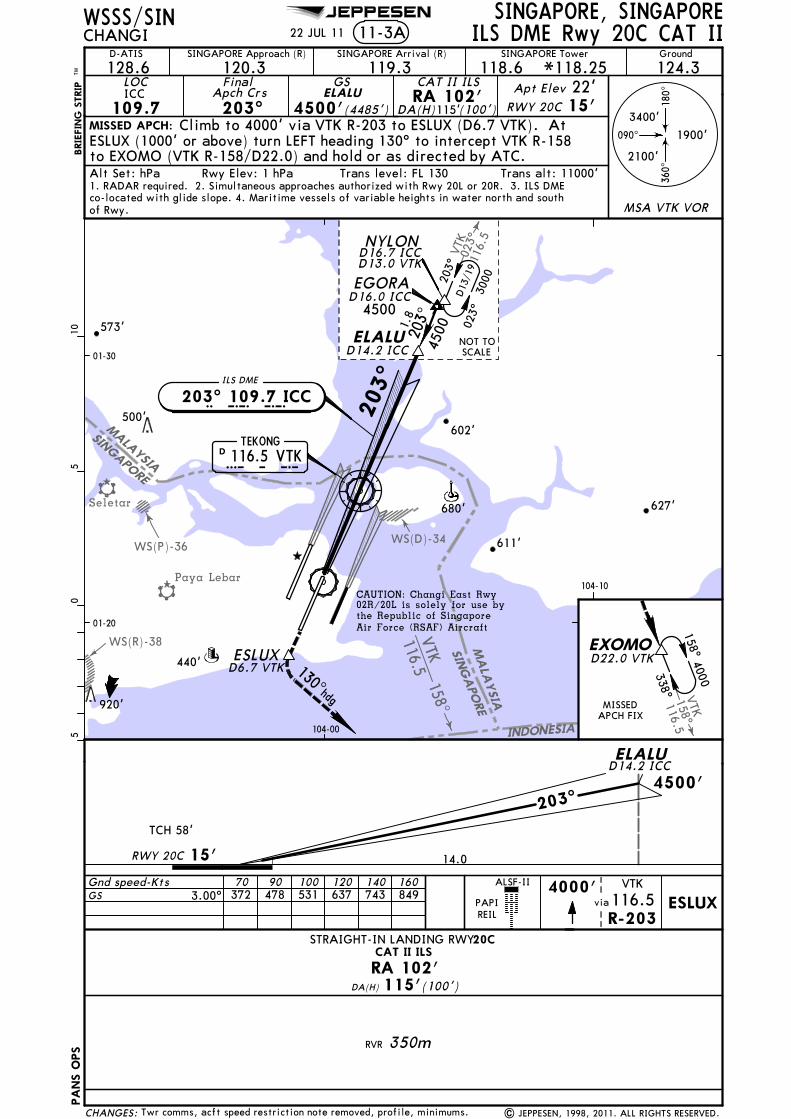
JEPPESEN
SINGAPO
RE
MALA
YSIA
INDONESIA
SING
APORE
MALA
YSIA
158^VTK
116.5
023^
VTK
116.
5
Seletar
Paya Lebar
WS(P)-36
WS(R)-38
WS(D)-34
158^VTK116.5
CAT II ILSRA 102'
ILS DME Rwy 20C CAT II
4500'
14.0
203^
627'
440'
611'
602'
203^
PA
NS O
PS
920'
D 116.5 VTKTEKONG
V T K
I C C ILS DME
203^ 109.7 ICC
680'
573'
MISSED APCH:
SINGAPORE, SINGAPORECHANGI
LOC
109.7ICC
FinalApch Crs203^
GS
4500'(4485')
ESLUX (1000' or above) turn LEFT heading 130^ to intercept VTK R-158
Alt Set: hPa Rwy Elev: 1 hPa Trans level: FL 130 Trans alt: 11000'
01-20
01-30
WSSS/SIN
500'
CAUTION: Changi East Rwy02R/20L is solely for use bythe Republic of Singapore Air Force (RSAF) Aircraft
co-located with glide slope. 4. Maritime vessels of variable heights in water north and south
22 JUL 11
ELALU
Climb to 4000' via VTK R-203 to ESLUX (D6.7 VTK). At
to EXOMO (VTK R-158/D22.0) and hold or as directed by ATC.
1. RADAR required. 2. Simultaneous approaches authorized with Rwy 20L or 20R. 3. ILS DME
NYLOND16.7 ICCD13.0 VTK
1.8
4500203^ 023^
3000
D13
/19
203^
ELALUD14.2 ICC
EGORAD16.0 ICC
05
510
BRIE
FIN
G S
TRIP
TM
RWY 20C 15'22'Apt Elev
MISSEDAPCH FIX
104-10
EXOMOD22.0 VTK
338^
4000158^
104-00
PAPIREIL
ELALUD14.2 ICC
TCH 58'
15'
Gnd speed-KtsGS 3.00^
70 90 100 120 140 160 4000'
R-203
VTK
116.5via ESLUX
ALSF-II
090^
180^
360^
1900'
2100'
3400'
MSA VTK VOR
NOT TOSCALE
130^hdg
RWY 20C
ESLUXD6.7 VTK
11-3A
115'(100')DA(H)
STRAIGHT-IN LANDING RWY20C
115'DA(H) (100')
350m
4500
| JEPPESEN, 1998, 2011. ALL RIGHTS RESERVED.
Ground
124.3SINGAPORE Approach (R) SINGAPORE Arrival (R)
128.6 119.3120.3SINGAPORE Tower
118.6D-ATIS
*118.25
of Rwy.
Twr comms, acft speed restriction note removed, profile, minimums.
372 478 531 637 743 849
CHANGES:
CAT II ILS
RA 102'
RVR

JEPPESEN
Seletar
VTK
023^
116.
5
JS168^SJ113.5
146^
113.5SJJSWS(P)-36
WS(R)-38
WS(D)-34
WM(D)-230
MALA
YSIA
Paya Lebar Aero
SINGAPORE
MALAYSIA
SINGAPORE
203^
TEKONG
116.5 VTKDV T K
ILS DME
203^ 108.9 ICHI C H
(GS out) ALTITUDE 650' 970' 1290'
PA
NS O
PS
4.03.02.0ICH DMELOC
2100'
090^
180^
360^
3400'
1900'MISSED APCH:
SINGAPORE, SINGAPORECHANGI ILS DME Rwy 20R11-4
LOC
108.9 ICH
FinalApch Crs203^
GS
3500'(3487')
ILSDA(H)
213'(200')
Apt Elev 17'Rwy 20R 13'
MSA VTK VOR
SINGAPORE Approach (R) SINGAPORE Arrival (R) SINGAPORE Tower Ground
128.6 120.3 119.3 118.6 124.3
FMS required for holdingduring SJ VOR outage.
1
Rwy Elev: 1 hPa Trans level: FL 130 Trans alt: 11000'
01-20
01-30
104-00
104-10
WSSS/SIN
D-ATIS
CAUTION: Changi East Rwy02R/20L is solely for use bythe Republic of Singapore Air Force (RSAF) Aircraft
Alt Set: hPa
co-located with glide slope. 4. Maritime vessels of variable heights in water north and south
IGULA
Climb straight ahead to 5000'. On crossing SJ R-146,proceed direct SAMKO holding area and hold or as directed by ATC.
IDUNAD0.8 ICH
IDUROD4.6 ICH
IDVASD7.8 ICH
IGULAD11.1 ICH
05
510
BRIE
FIN
G S
TRIP
TM
NYLOND16.2 ICHD13.0 VTK
203^
023^
3000
D13
/19
D16.0 ICHIPNAK
203^
3500
NOT TO SCALE
348^
SAMKOD8.0 SJ1
5000168^
MISSEDAPCH FIX
1200m
ILS LOC (GS out)
ALS outALS outFULL
1200m
Gnd speed-KtsGS 3.00^
FAF to MAP 3.9MAP at IDUNA/D0.8 ICH1
70 90 100 120 140 160372 478 531 637 743 8493:21 2:36 2:20 1:57 1:40 1:28
1 Timing not authorized when GS inop.
CIRCLE-TO-LAND
NARVR
VIS 800m
720mRVRVIS 800m
720m RVR 1500mVIS 1600m
ABCD 2000m
RVR 1800mVIS
ABCD
5000'PAPIREIL
PAPIR-146
SJ
113.5 SAMKODoncrossing
DA(H) 213'(200')
3500'
3.33.2
2500'
0.6
203^
3.8
TCH 57'
Rwy 20R 13'
IDUNAD0.8 ICH
IDUROD4.6 ICH
IGULAD11.1 ICHIDVAS
D7.8 ICH
STRAIGHT-IN LANDING RWY20R
4.9
3500
D8/14
8 JUN 12
| JEPPESEN, 1998, 2012. ALL RIGHTS RESERVED.
HIALS
MDA(H) 420'(407')
680'
440'
761'
611'
500'
621'
*118.25
of rwy.
1. RADAR required. 2. Simultaneous approaches authorized with Rwy 20L or 20C. 3. ILS DME
Communications, rwy and apt elevation, notes, lighting.CHANGES:
1500'

JEPPESEN
168^
356^
356^PU
115.1
Seletar
Hang Nadim
SINGAPORE
INDONESIA
MALAYSIA
WS(P)-3
WS(P)-24
WS(P)-36
WM(P)-228
WS(R)-2
WS(R)-38
WS(D)-4
WS(D)-35
WS(D)-5
INDONESIASIN
GAPORE
WS(R)-31
Paya Lebar Aero
MALAYSIA
[TCH 50']
[3.00^]
0.4 NMto SAPAX
DSINJON
113.5 SJS J
SAMKO
023^
4000
SINGAPORE, SINGAPORE
Ground
124.3
MISSED APCH:
CHANGI 12-1SINGAPORE Approach (R) SINGAPORE Arrival (R)
128.6 119.3
RNAVFinal
Apch Crs023^ (2483')
DA(H)530'2500'
120.3SINGAPORE Tower
118.6
(513')
PA
NS O
PS
D-ATIS
Alt Set: hPa Rwy Elev: 1 hPa Trans level: FL 130 Trans alt: 11000'
WSSS/SIN
348^
168^
01-10
104-00 104-10
Air Force (RSAF) Aircraft
CAUTION: Changi East Rwy02R/20L is solely for use bythe Republic of Singapore
D116.5 VTKTEKONG
V T K
Gnd speed-Kts
REILPAPI PAPI
70 90 100 120 140 160
A
B
C
D
ALS out
2800m
ALS out
ALSF-II
CIRCLE-TO-LAND
NA
A
B
C
D
C~2LF
Climb to 1000', then climbing LEFT turn to 4000' via
335^hdg
AKOMA
356^
176^
D20.0 PU
4000
01-20
4.4 2.6 5.0 Rwy 02L 17'
SAPAXC~2LF
C~2LSRW~2L
1000'
023^
PAPA UNIFORM115.1 PUPUD
via
STRAIGHT-IN LANDING RWY02L
Rwy 02L 17'17'Apt Elev
RNAV (GNSS) Rwy 02L
R-356/D20.0) and hold or as directed by ATC.heading 335^ and outbound PU VOR R-356 to AKOMA (PU VOR
LNAV/VNAV
LNAV/VNAV LNAVDA(H) 530'(513') MDA(H) 580'(563')
MAP at RW~2L7.6 6:31 5:04 4:34 3:48 3:15 2:51
SAPAX(IAF)
(IAF)
(IF)
SANAT
C~2LF
C~2LS
Descent angle [3.00^] 372 478 531 637 743 849
05.07.612.0
RW~2L
2. Maritime vessels of variable heights in water north and south of runway.1. Minimum temperature for which Baro-VNAV operations are authorized: 15^C.
D14.0SJ
1
11 Max IAS 220 Kts.
Procedure Alt
2500'3900'
MDA
290^
013^
C~2LF to MAP
RVR 1500mVIS 1600m
2800m
2400m
RVR 720mVIS 800m
RVRVIS 1600m
1500m
RVRVIS 2000m
1800m
3900
3900
5.9
4.5
2000m
01-00
4000
4000
BRIE
FIN
G S
TRIP
TM0
55
1015
20
hdg
335^1000'
LT
4000'
APCH FIXMISSED
360^
090^
3400'
2100'
180^
1900'
MSA VTK VOR
660'2000'
4000'SANATSAMKO
| JEPPESEN, 2007, 2012. ALL RIGHTS RESERVED.
1670'
*118.25
31 AUG 12
Hold designation revised.
436'
620'
637'920'
538'
942'
656'
500' 621'
611'
WS(P)-49
WS(D)-34
CHANGES:
535'
620'

JEPPESEN
MALAYSIA
168^
146^
SJ
SJ
113.5
113.5
SJ
SJINDONESIA
MALAYSIA
Paya Lebar
WM(R)-229
WM(D)-230
WM(D)-231
WS(R)-31
WS(D)-34
SINGAPORE
Aero
WM(D)-8
[TCH 50'][3.00^]
4.5 NMto C2~RF3.2 NM
to C2~RF
SINGAPORE, SINGAPORE
Ground
124.3
MISSED APCH:
CHANGI 12-2SINGAPORE Approach (R) SINGAPORE Arrival (R)
128.6 119.3
RNAVFinal
Apch Crs203^ (1987')
DA(H)530'2000'
120.3
SINGAPORE Tower
118.6
(517')
PA
NS O
PS
D-ATIS
Alt Set: hPa Rwy Elev: 0 hPa Trans level: FL 130 Trans alt: 11000'
WSSS/SIN
Air Force (RSAF) Aircraft
CAUTION: Changi East Rwy02R/20L is solely for use bythe Republic of Singapore
REILPAPI PAPI
A
B
C
D
ALS out
2800m
ALS out
CIRCLE-TO-LAND
NA
A
B
C
D
C2~RF
6.06.0Rwy 20R 13'
NOMAKC2~RF
RW2~R
1500'
203^
STRAIGHT-IN LANDING RWY20R
Rwy 20R 13'17'Apt Elev
RNAV (GNSS) Rwy 20R
LNAV/VNAV
LNAV/VNAV LNAV
DA(H) 530'(517') MDA(H) 580'(567')
MAP at RW2~R
Descent angle [3.00^] 372 478 531 637 743 849
0 6.0 12.0
2. Maritime vessels of variable heights in water north and south of runway.1. Minimum temperature for which Baro-VNAV operations are authorized: 15^C.
Procedure Alt
2000'
MDA
C2~RF to MAP
RVR 1500mVIS 1600m
2800m
2400m
RVR 720mVIS 800m
RVRVIS 1600m
1500m
RVRVIS 2000m
1800m
2000m
Climb STRAIGHT AHEAD to 5000'. On crossing SJ VORR-146, proceed direct to SAMKO holding area and hold or as directedby ATC.
5000'cross
SJ
113.5R-146
SAMKO6.0 5:09 4:00 3:36 3:00 2:34 2:15
TO DISPLACED THR
3400'
3000'
TEKONG116.5 VTKVTKD
RW2~R
C2~RF
NOMAK BIPOP
BIDUS
NYLON(IAF)
(IAF)
(IAF)(IF)
203^
023^
D19.0VTK
3000
SAMKO348^
168^
D14.0SJ
MISSEDAPCH FIX
203^
110^
290^216^6.5 4.
16.7
300030
00
3400
5000D8.0 SJ
1
1
1
1 Max IAS 220 Kts.
3400
3000
3000
01-20
01-30
01-40
103-50
104-00 104-10 104-20
BRIE
FIN
G S
TRIP
TM0
55
1015
20
360^
090^
3400'
2100'
180^
1900'
MSA VTK VOR
BIDUS
BIPOPNYLON2000'
Gnd speed-Kts 70 90 100 120 140 160
| JEPPESEN, 2007, 2012. ALL RIGHTS RESERVED.
*118.25
HIALS
31 AUG 12
None.
620'
611'
468'
573'
500'
627'
621'
CHANGES:

JEPPESEN
SINGAPORE
INDONESIA
MALAYSIA
Paya Lebar
168^
Seletar
WS(D)-34WS(P)-36
WS(R)-38
D8
SJ
113.5
Hang Nadim
023^
VTK
116.
5
348^
023^
023^
(IF)
168^
2500
4000D
8/14
436'
440'
611'
D116.5 VTKTEKONG
V T K
D 113.5 SJS JSINJON
680'
10.0 9.0 8.011.0VTK DME
1470' 1150' 830'1790'
SAMKO
70 90 100 120 140 160
A
B
C
D
PA
NS O
PS
STRAIGHT-IN LANDING RWY 02C
With D8.0 VTK Without D8.0 VTK
RVRVIS 1600m
1500m
VIS 1600mRVR 1500m
MDA(H) 410'
ALS out ALS out
MDA(H)
1500m1600mVIS
RVRRVR 720m
800mVIS
RVR 720m800mVIS
(395')
RVRVIS
660'
2800m
3200m
1800m2000m
MAP at D6.0 VTK
(645')
RVRVIS
1800m2000m 2400m
Gnd speed-Kts
VTKD16.6
D6.0VTK
NOT TOSCALE
VTKD13.3
MISSED APCH:
SINGAPORE, SINGAPORECHANGI VOR DME Rwy 02C13-1
VOR
116.5VTK
FinalApch Crs
023^
Minimum Alt
2500'(2485')
MDA(H)
410'(395')
Apt Elev 22'Rwy 02C 15'
(CONDITIONAL)
090^
180^
360^
2100'
3400'
1900'
MSA VTK VOR
SINGAPORE Approach (R) SINGAPORE Arrival (R) SINGAPORE Tower Ground
128.6 120.3 119.3 118.6 124.3
2500'
2.0
2500'023^
0.4 15'Rwy 02C3.3 5.3660'
D16.6 VTK D13.3 VTKD8.0VTK D6.0
VTK
1
1
1017'
D13.3 VTK
01-10
01-20
104-00 104-10
WSSS/SIN
D-ATIS
ALTITUDE
05
510
BRIE
FIN
G S
TRIP
TM
203^
023^
3000
D13
/19
NYLOND13.0 VTK
MISSEDAPCH FIX
Climb to 3000' via heading 023^ and VTK R-023 to NYLON(VTK R-023/D13.0) and hold or as directed by ATC.
D8.0VTK
Descent Gradient 5.2% 369 474 527 632 737 843
FAF to MAP 7.3 6:15 4:52 4:23 3:39 3:08 2:44
12.02100'
13.02420'
NYLONPAPIREIL
ALSF-I
PAPI
VTK
R-023116.5via and
3000'
hdg
023^
25 NOV 11
4.4
FMS required for holdingduring SJ VOR outage.
023
hdg
VTKVOR
VTK R-203D21.0 VTK
Air Force (RSAF) Aircraftthe Republic of Singapore 02R/20L is solely for use byCAUTION: Changi East Rwy
*118.25
1. Maritime vessels of variable heights in water north and south of Rwy. Alt Set: hPa Rwy Elev: 1 hPa Trans level: FL 130 Trans alt: 11000'
| JEPPESEN, 1998, 2011. ALL RIGHTS RESERVED.Tower frequency.CHANGES:
523'

JEPPESEN
MALA
YSIA
SINGAPO
RE
INDONESIA
SIN
GA
PO
RE
MALA
YSIA
Seletar
WS(D)-34
WS(R)-38
WS(P)-36
158^VTK116.5
116.5VTK
158^
Paya Lebar
V T K
203^
(IF)
627'
440'
611'
602'
920'
3000
023^
203^
2000
D13
/19
203^
NYLOND13.0 VTK
680'
VTKD9.1
VTKD2.62
03^
D3.0VTK
MISSED APCH:
SINGAPORE, SINGAPORECHANGI VOR DME Rwy 20C13-2
SINGAPORE Approach (R) SINGAPORE Arrival (R) SINGAPORE Tower Ground
128.6 120.3 119.3 118.6 124.3VOR
116.5 VTK
FinalApch Crs203^
Minimum Alt
2000'(1985')
MDA(H)
580'(565')Apt Elev 22'Rwy 20C 15'
D2.6 VTK
090^
180^
360^
1900'
2100'
3400'
MSA VTK VOR
MAP at D3.0 VTK
PA
NS O
PS
20C
A
B
C
D
STRAIGHT-IN LANDING RWYMDA(H) 580'(565')
ALS out
1500mRVRVIS 1600m
2400m
2800m
RVR 720m800mVIS
RVR1500m1600mVIS
RVRVIS 2000m
1800m
Gnd speed-Kts 70 90 100 120 140 160
PAPIREIL
VTK DME D1.0 AFTER VTK860' 1820'
D2.0 BEFORE VTK
573'
D116.5 VTKTEKONG
ALTITUDE
01-20
01-30
104-00
WSSS/SIN
D-ATIS
500'
Alt Set: hPa Rwy Elev: 1 hPa Trans level: FL 130 Trans alt: 11000'
05
510
ALSF-II
BRIE
FIN
G S
TRIP
TM
MISSEDAPCH FIX
EXOMOD22.0 VTK
338^
4000158^
104-10
ESLUX130^hdg
1180'VTK D1.0 BEFORE VTK
1500'
Descent Gradient 5.2% 369 474 527 632 737 843
FAF to MAP 5.6 4:48 3:44 3:22 2:48 2:24 2:06
4000'
R-203
VTK
116.5via ESLUX
25 NOV 11
Climb to 4000' via VTK R-203 to ESLUX (D6.7 VTK).
directed by ATC.
At ESLUX (1000' or above) turn LEFT heading 130^ to intercept
3.9
NOT TOSCALE
Rwy 20C 15' 3.0 2.6
2000'
6.5
203^ 2000'203^
0.5
1180'
VTKD3.0 VTK
D2.6VTK
D9.1
Air Force (RSAF) Aircraftthe Republic of Singapore 02R/20L is solely for use byCAUTION: Changi East Rwy
VTK R-023
VTK R-158 to EXOMO (VTK R-158/D22.0) and hold or as
D6.7 VTK
*118.25
1. Maritime vessels of variable heights in water north and south of Rwy.
Tower frequency, notes. | JEPPESEN, 1998, 2011. ALL RIGHTS RESERVED.CHANGES:
VOR


![Managing Changi Airport - Eurocontrol · PDF fileManaging Changi Airport [date] Name of Presenter Designation Section/Unit Changi A-CDM: Aiming for Sustainable First Class Airside](https://img.dokumen.tips/doc/110x75/5ab74e0d7f8b9ad3038b7134/managing-changi-airport-eurocontrol-changi-airport-date-name-of-presenter-designation.jpg)