Embed Size (px)
Citation preview
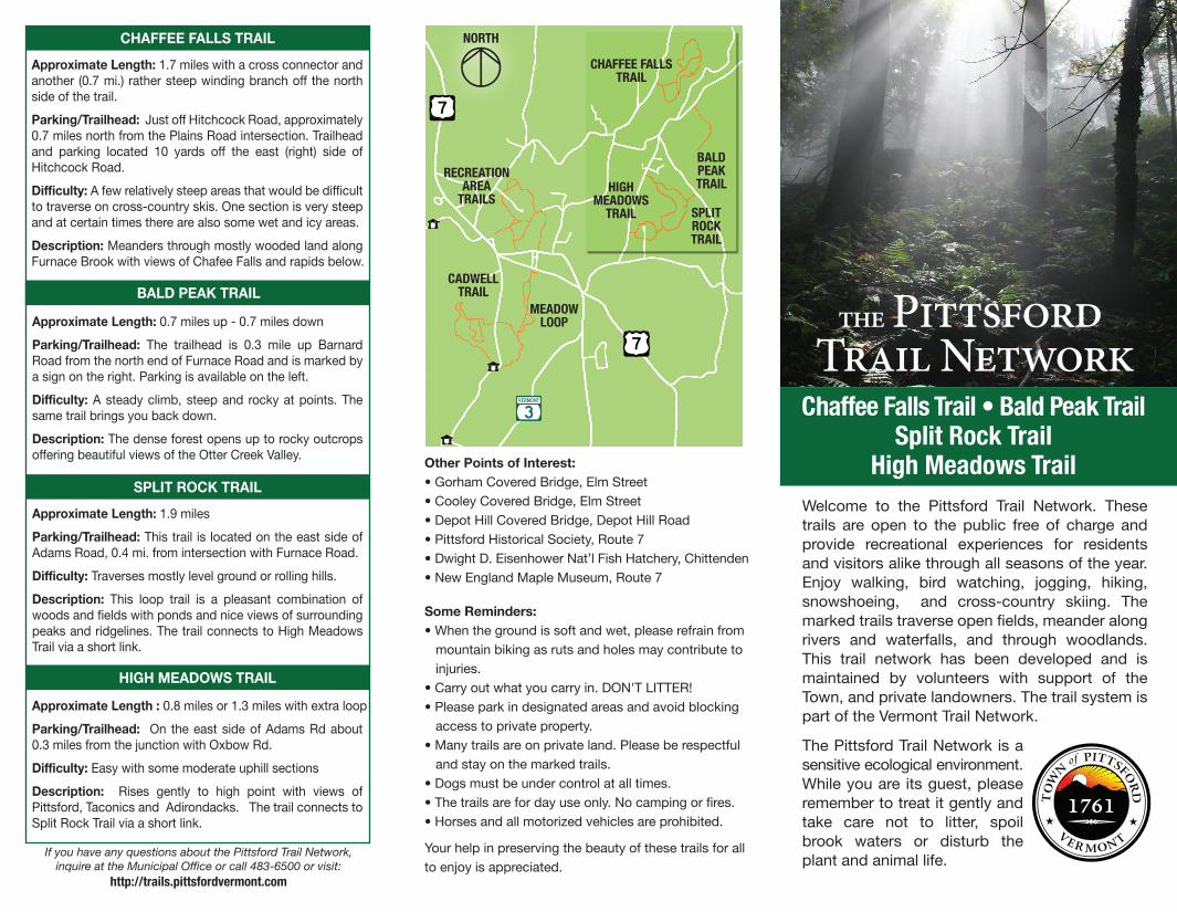
Other Points of Interest:• Gorham Covered Bridge, Elm Street• Cooley Covered Bridge, Elm Street• Depot Hill Covered Bridge, Depot Hill Road• Pittsford Historical Society, Route 7• Dwight D. Eisenhower Nat’l Fish Hatchery, Chittenden• New England Maple Museum, Route 7
Some Reminders:• When the ground is soft and wet, please refrain from mountain biking as ruts and holes may contribute to injuries.• Carry out what you carry in. DON'T LITTER!• Please park in designated areas and avoid blocking access to private property.• Many trails are on private land. Please be respectful and stay on the marked trails.• Dogs must be under control at all times.• The trails are for day use only. No camping or fires.• Horses and all motorized vehicles are prohibited.
Your help in preserving the beauty of these trails for all to enjoy is appreciated.
Approximate Length: 1.7 miles with a cross connector and another (0.7 mi.) rather steep winding branch off the north side of the trail.
Parking/Trailhead: Just off Hitchcock Road, approximately 0.7 miles north from the Plains Road intersection. Trailhead and parking located 10 yards off the east (right) side of Hitchcock Road.
Difficulty: A few relatively steep areas that would be difficult to traverse on cross-country skis. One section is very steep and at certain times there are also some wet and icy areas.
Description: Meanders through mostly wooded land along Furnace Brook with views of Chafee Falls and rapids below.
CHAFFEE FALLS TRAIL
Approximate Length: 0.7 miles up - 0.7 miles down
Parking/Trailhead: The trailhead is 0.3 mile up Barnard Road from the north end of Furnace Road and is marked by a sign on the right. Parking is available on the left.
Difficulty: A steady climb, steep and rocky at points. The same trail brings you back down.
Description: The dense forest opens up to rocky outcrops offering beautiful views of the Otter Creek Valley.
BALD PEAK TRAIL
SPLIT ROCK TRAIL
Approximate Length: 1.9 miles
Parking/Trailhead: This trail is located on the east side of Adams Road, 0.4 mi. from intersection with Furnace Road.
Difficulty: Traverses mostly level ground or rolling hills.
Description: This loop trail is a pleasant combination of woods and fields with ponds and nice views of surrounding peaks and ridgelines. The trail connects to High Meadows Trail via a short link.
If you have any questions about the Pittsford Trail Network, inquire at the Municipal Office or call 483-6500 or visit:
http://trails.pittsfordvermont.com
HIGH MEADOWS TRAIL
Approximate Length : 0.8 miles or 1.3 miles with extra loop
Parking/Trailhead: On the east side of Adams Rd about 0.3 miles from the junction with Oxbow Rd.
Difficulty: Easy with some moderate uphill sections
Description: Rises gently to high point with views of Pittsford, Taconics and Adirondacks. The trail connects to Split Rock Trail via a short link.
the Pittsford Trail Network
Welcome to the Pittsford Trail Network. These trails are open to the public free of charge and provide recreational experiences for residents and visitors alike through all seasons of the year. Enjoy walking, bird watching, jogging, hiking, snowshoeing, and cross-country skiing. The marked trails traverse open fields, meander along rivers and waterfalls, and through woodlands. This trail network has been developed and is maintained by volunteers with support of the Town, and private landowners. The trail system is part of the Vermont Trail Network.
The Pittsford Trail Network is a sensitive ecological environment. While you are its guest, please remember to treat it gently and take care not to litter, spoil brook waters or disturb the plant and animal life.
Chaffee Falls Trail • Bald Peak TrailSplit Rock Trail
High Meadows Trail
CADWELLTRAIL
MEADOWLOOP
RECREATIONAREA
TRAILS
CHAFFEE FALLSTRAIL
BALDPEAKTRAIL
SPLITROCKTRAIL
HIGHMEADOWS
TRAIL
NORTH
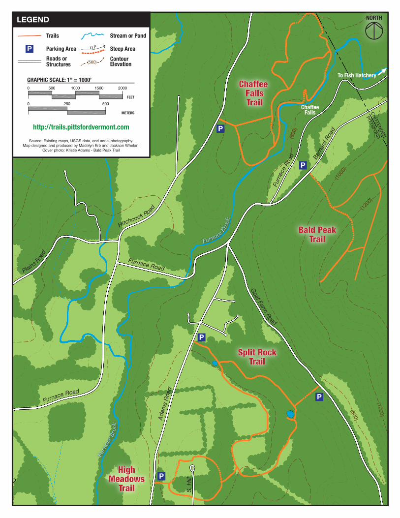
NORTHLEGEND
Trails Stream or Pond
GRAPHIC SCALE: 1” = 1000’
FEET
METERS
Roads or Structures
Contour Elevation(560)
P Parking Area Steep Area
Source: Existing maps, USGS data, and aerial photography.Map designed and produced by Madelyn Erb and Jackson Whelan.
Cover photo: Kristie Adams - Bald Peak Trail
http://trails.pittsfordvermont.com
HighMeadows
Trail
Bald PeakTrail
Chaffee FallsTrail
Split RockTrail
P
P
P
P
P
Goat Farm Road
Adam
s Ro
ad
Furnace Road
Plains Roa
d
Hitchcock Road
Furnace Road
Barn
ard R
oad
Furn
ace R
oad
S. H
ill
Furn
ace B
rook
Furnace Bro
ok
ChaffeeFalls CHITTENDEN
PITTSFORD
To Fish Hatchery
(1000
)
(1200
)
(800
)
(1000)
(800)